catchment area n 3 and pendragon castle · 3 mallerstang “let uther pendragon do what he can the...
TRANSCRIPT

a walk along an ancient green highway with mountains, an iconic sculpture, a deep gorge, a waterfall, the Settle/Carlisle railway, and the infant river Eden
Mallerstang, Wildboar Fell and Pendragon Castle
Lake Distict NatioNaL Park
North PeNNiNes
aoNB
Scottish Border
Howgills
M6
soLway Firth
River EdenCatchment Area
© Crown copyright. All rights reservedLicence no. 10000 5056 (2006)
Carlisle
appleby
penrith
KirKbystephen
brampton
armathwaite
little salKeld
shap brough
N
2
3
4
5
6
7
8 9
1
River Eden
writ
ten
an
d d
esig
ne
d b
y EC
CP
te
l: 01
228
5616
0108
/07/
2k

sunset over Howgills from Wild Boar Fell

2
Pendragon Castle

3
Mallerstang
“Let Uther Pendragon do what he canThe river Eden will run where it ran.’’
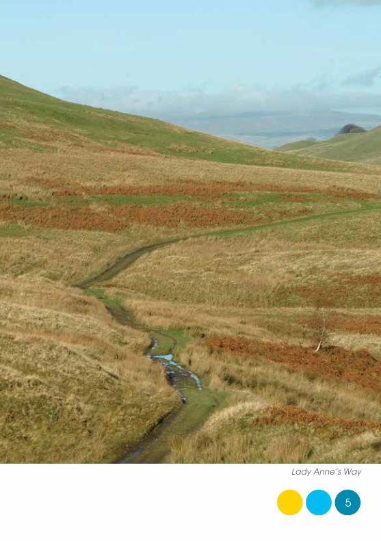
Mallerstang is a spectacularly beautiful dale. The river Eden starts its journey high up on the eastern side of the dale and flows briefly south west, before turning north along the valley bottom. Dominated by Mallerstang Edge to the east and Wild Boar Fell to the west, Mallerstang belongs geologically to the limestone country of the Yorkshire Dales.
Our walk starts at Boggle Green where there is a limited car parking space by the road just south of a house called The Thrang.

4
Go through the field gate and follow the wide track.
This is known as Lady Anne Clifford’s Highway. On a clear day you will see you are heading towards what appear to be two standing stones high up on the hill in the distance. This is a sculpture, erected in 1997, called ‘Water Cut’ by the Scottish sculptor, Mary Bourne.
Lady Anne Clifford was a remarkable 17th century landowner who regularly travelled along this ancient road from Skipton via Wensleydale to visit the Westmorland estates she inherited when she was 60 years old. Despite her advancing years, she devoted the rest of her life, until she was 86, restoring Pendragon, Brough, Appleby and Brougham castles, which had fallen into disrepair. Reclining precariously in a horse litter, which was rather like a
stretcher on long poles slung between two horses at the front and rear, her journeys must have been incredibly demanding. She was always accompanied by a large retinue of companions and servants in carriages and on horseback, with a cart, probably pulled by oxen, carrying her bed.
Lady Anne on her litter, lino print for bronze panel
5
Lady Anne’s Way

6
As you continue, you may see a passenger train or two going up and down on the Settle/Carlisle railway, a rather more comfortable way to travel. However, at the time the line was constructed (1869 to 1875) between Dent and Kirkby Stephen, the workforce of six thousand navvies suffered appalling hardship and deprivation. It’s difficult to imagine the sprawling shanty towns that were built to accommodate these workers and their families in what is now such a remote and tranquil valley. They must have had a devastating impact on the local farming community.
Carry on up the track until you reach the sculpture.
What was previously a very rough track along this section has been improved substantially since it became part of the officially-designated Pennine Bridleway.
‘Water Cut’ by Mary Bourne

7
With its two high, sweeping sides, rising to virtually identical heights of just over 700 metres, Mallerstang is a glacial valley where the dominant rocks are a horizontally lying carboniferous limestone capped on the tops with broken gritstone escarpments.
‘Water Cut’ is one of ten sculptures called Eden Benchmarks, commissioned by East Cumbria Countryside Project and situated at various locations along the entire length of the river Eden. Made from Salterwath limestone, like a huge split milestone, it is dramatically expressive of the river’s powerful historic journey through the landscape. It also provides a suitably majestic throne on which to rest and admire the magnificent view.
8
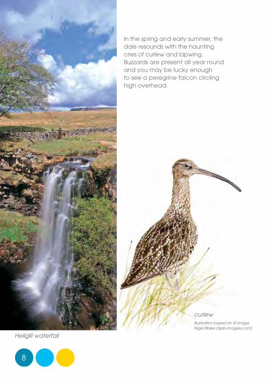
In the spring and early summer, the dale resounds with the haunting cries of curlew and lapwing. Buzzards are present all year round and you may be lucky enough to see a peregrine falcon circling high overhead.
Hellgill waterfall
curlew illustration based on © image Nigel Blake (rspb-images.com)

9
Once rested, continue along what is now a much grassier and level track, a proper ‘green road’, until you arrive at Hell Gill Bridge. Our route turns right here, immediately before the bridge and down the hill into the valley, but its worth pausing for a while on the bridge.
As you will see, the infant river Eden runs under the bridge along the bottom of a deep and narrow ravine called Hell Gill. The word ‘Hell’ is often associated with watercourses coming out of caves or gorges and may be a reference to Hel or Hela, the Norse goddess of the underworld, realm of the dead. Many of the place-names in Mallerstang originate from the time when Viking settlers lived in the dale. The words ‘fell’, ‘gill’, ‘mire’ and ‘tarn’ are Norse.
Four kilometres up the hill from here, three modest springs, named Red Gill, Slate Gutter and Little Grain, ooze out of a boggy area called Black Fell Moss and combine to form the beginning of the river Eden.
Lady Anne Clifford’s Way was an important trading route hundreds of years ago and was almost certainly frequented by highway robbers. Legend has it that during a violent storm, which had destroyed the bridge, the infamous highwayman Dick Turpin escaped the clutches of pursuing policemen by leaping across the gorge on his horse, Black Bess.
10
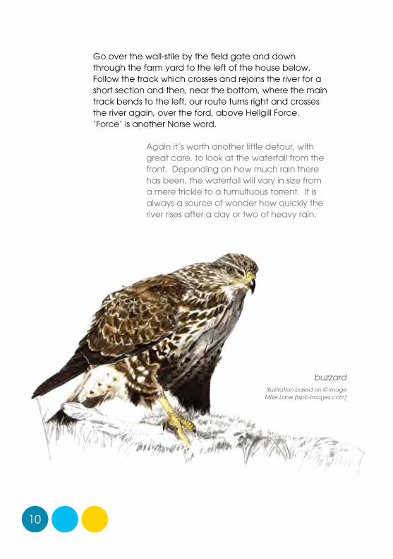
Go over the wall-stile by the field gate and down through the farm yard to the left of the house below. Follow the track which crosses and rejoins the river for a short section and then, near the bottom, where the main track bends to the left, our route turns right and crosses the river again, over the ford, above Hellgill Force. ‘Force’ is another Norse word.
Again it’s worth another little detour, with great care, to look at the waterfall from the front. Depending on how much rain there has been, the waterfall will vary in size from a mere trickle to a tumultuous torrent. It is always a source of wonder how quickly the river rises after a day or two of heavy rain.
buzzard illustration based on © image
Mike Lane (rspb-images.com)

11
Hellgill waterfall in winter

12
lime-kiln
13
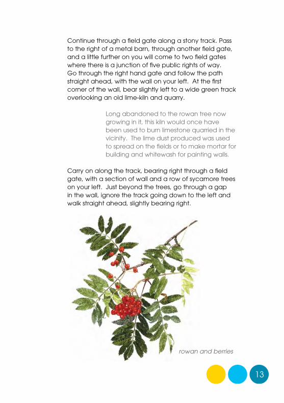
Continue through a field gate along a stony track. Pass to the right of a metal barn, through another field gate, and a little further on you will come to two field gates where there is a junction of five public rights of way. Go through the right hand gate and follow the path straight ahead, with the wall on your left. At the first corner of the wall, bear slightly left to a wide green track overlooking an old lime-kiln and quarry.
Long abandoned to the rowan tree now growing in it, this kiln would once have been used to burn limestone quarried in the vicinity. The lime dust produced was used to spread on the fields or to make mortar for building and whitewash for painting walls.
Carry on along the track, bearing right through a field gate, with a section of wall and a row of sycamore trees on your left. Just beyond the trees, go through a gap in the wall, ignore the track going down to the left and walk straight ahead, slightly bearing right.
rowan and berries
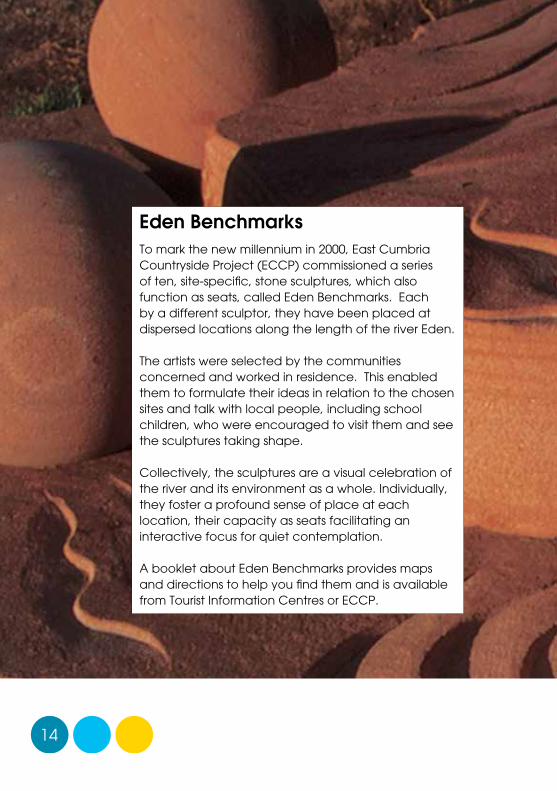
Eden BenchmarksTo mark the new millennium in 2000, East Cumbria Countryside Project (ECCP) commissioned a series of ten, site-specific, stone sculptures, which also function as seats, called Eden Benchmarks. Each by a different sculptor, they have been placed at dispersed locations along the length of the river Eden.
The artists were selected by the communities concerned and worked in residence. This enabled them to formulate their ideas in relation to the chosen sites and talk with local people, including school children, who were encouraged to visit them and see the sculptures taking shape.
Collectively, the sculptures are a visual celebration of the river and its environment as a whole. Individually, they foster a profound sense of place at each location, their capacity as seats facilitating an interactive focus for quiet contemplation.
A booklet about Eden Benchmarks provides maps and directions to help you find them and is available from Tourist Information Centres or ECCP.
14

Hideo Furuta working on ‘Towards the Sea’
15
‘Red River’ by Victoria Brailsford (near Temple Sowerby)

16
When you arrive at the next gate, go through and bear left down a clearly defined track to a stone barn situated on the other side of the wall.
The flora on this route is typical of limestone country. Flowers such as yellow tormentil, heath bedstraw, fairy flax, carline thistle and wild thyme are common.
This field barn, like many in the area, was built with two floor levels, so that hay cut in the summer could be stored upstairs and fed directly to cattle housed downstairs in the winter. Most of these field barns are now obsolete because tractors have enabled farmers to centralise their activities. It is, perhaps, sad to think that as the barns gradually become derelict a characteristic component of the traditional dales landscape will disappear.
Go through the metal gate, still on a well-defined track, with a field boundary wall on your left and a derelict wall on your right. Bear right behind Hanging Lund, a group of farm houses and out- buildings on your left, then down to the left over a stone slab bridge and sharp right again, a little way up the other side of the waterfall. The path turns left from here and follows the wall on your left.
yellow tormentil

17
field barn

18
Thrang Bridge

19
Continue along this path, through a wooden bridleway gate and then between two walls, to another bridleway gate at the end of the right hand wall, which takes you out onto an area of rough pasture. Continue uphill by a derelict wall and building, across the field, descending gradually to a curved wall behind Cooper Hill Farm. Continue across the field through a metal gate, down to the road, through Elmgill Farm.
Public rights of way follow some awkward routes, from a recreational point of view, but they are all part of a historic network that once made perfect sense when there were no motor vehicles and local people walked everywhere. Most of the paths in Mallerstang connect with the houses and there is almost no riverside access. In very early times, the valley bottom would have been marshy woodland and the linear ‘village’ pattern of dispersed farmstead houses built on the higher slopes is typical of the Viking heritage.
When you arrive at the road, turn right, walk along the side of the road for a short distance and then turn left, crossing the road with great care, along the farm track, over the Eden. This track is the Pennine bridleway which traverses the fells to Stennerskeugh. Our route, however, turns to the right before you get to the farm yard, through a pedestrian gate, and follows the wall on your left to the other side of the field, through a second pedestrian gate, where it bears slightly right across the middle of three more fields with stiles, to a footbridge. Follow the track to the right, crossing the Eden again over an elegant stone arched bridge, and up to the road by The Thrang.

20
Outhgill
Outhgill is a hamlet of seven or eight houses, which once included a public house, a blacksmith’s, a community hall, a shop and post office and a school, all now gone.
A replica of a stone pillar called the Jew’s Stone was installed on the village green in 1989. The original pillar was erected near the source of the river Eden in 1850 but destroyed by vandals twenty years later.
There is also one of Andy Goldsworthy’s pinfold cones located here, up the road behind a house beyond the village green.
The little church was built in the 14th Century and lay in ruins for many years until Lady Anne Clifford came along and restored it.
Jew’s Stonestandards

21
Pinfold cone by Andy Goldsworthy , Outhgill
22
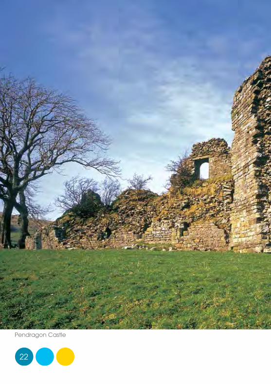
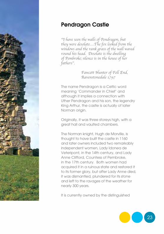
Pendragon Castle
23
Pendragon Castle
‘’I have seen the walls of Pendragon, but they were desolate….The fox looked from the windows and the rank grass of the wall waved round his head. Desolate is the dwelling of Pembroke; silence is in the house of her fathers’’.
Fawcett Hunter of Fell End, Ravenstonedale 1797
The name Pendragon is a Celtic word meaning ‘Commander in Chief’ and although it implies a connection with Uther Pendragon and his son, the legendry King Arthur, the castle is actually of later Norman origin.
Originally, it was three storeys high, with a great hall and vaulted chambers.
The Norman knight, Hugh de Morville, is thought to have built the castle in 1160 and later owners included two remarkably independent women, Lady Idonea de Veteripont, in the 14th century, and Lady Anne Clifford, Countess of Pembroke, in the 17th century. Both women had acquired it in a ruinous state and restored it to its former glory, but after Lady Anne died, it was dismantled, plundered for its stone and left to the ravages of the weather for nearly 300 years.
It is currently owned by the distinguished

24
naturalist and local landowner, Juliet Frankland. Juliet’s late husband Raven Frankland had the walls consolidated and pointed to prevent their further deterioration.
Pendragon Castle and Outhgill
The Thrang
Carlisle – Settle railway
Outhgill
Pendragon Castle
Castlethwaite
Mallerstang Common
layby

other paths
footpathbridleway
layby
‘Discover Eden’ is a countryside recreation and interpretation programme being managed by East Cumbria Countryside Project in partnership with the Eden Rivers Trust supported by the Heritage Lottery Fund.
Fourteen circuital routes at dispersed locations throughout East Cumbria provide an opportunity to explore the great scenic diversity associated with the Eden catchment landscape.
Each route is well way-marked with arrows and the distinctive ‘Discover Eden’ kingfisher logo. Watch out for a series of small bronze panels etched with motifs depicting aspects of human and natural heritage. Rubbings can be taken from these using paper and crayon.
By walking all routes you can eventually collect rubbings of eighty four images.
Brief route details:Parking: Limited, in layby just after The Thrang (see map) Length: 5¾ miles 9 kilometres 4 – 5 hoursGrade: moderate to strenuous with some up hill walking,
boggy ground and stilesRoute: The Thrang – ‘Water Cut’ sculpture – Hell Gill bridge
– Hellgill Force – Hanging Lund – The ThrangClothing: boots and outdoor clothing; paths can be wet
Please leave gates as you find them, leave no litter and keep dogs under close control.
Pendragon Castle and the tiny village of Outhgill can be visited by car before or after you do your walk.
images by Barry Stacy, Val Corbett and ECCP inside flap1. River Eamont 2. Mayburgh Henge 3. Red River benchmark near Temple Sowerby4. Mosedale near Calbeck 5. Haaf netting in Solway 6. Ravenstonedale7. Appleby horse fair 8. River Eden near Wetheral 9. Pendragon Castle
N
Eden Benchmark‘Water Cut’
by Mary Bourne
Hell Gill Bridge
Cooper Hill Farm
Boggle Green
Lady Anne’s Way
Hell Gill Force
The Thrang
River Eden
Black Fell Moss
Hanging Lund
Elmgill Farm
B6259
Carlisle – Settle railwayCumpston Hill
Stirk House
to Hawes
Reproduced from 1923 Ordnance Survey map with the kind permission of the Ordnance Survey © East Cumbria Countryside Project 2007
Originally published by East Cumbria Countryside Project (c/o Carlisle City Council)
Eden Rivers Trust: Dunmail Building, Newton Rigg College, Penrith. Cumbria CA11 0AH tel: 01768 866788
email: [email protected]
website: edenriverstrust.org.uk
Scale0 1km
0 ½ mile
Hellgillwaterfalls
bronze motifs by Pip Hall
LOO
K O
UT
for
6 b
ron
ze m
oti
fs •
La
dy
An
ne
on
he
r lit
ter
• ‘
Wa
ter
Cu
t’ •
a h
igh
wa
yma
n •
lim
e k
iln •
steam train • Pendragon Castle