cartographer ros documentation...chapter 2 running cartographer ros on a demo bag now that...
TRANSCRIPT
Cartographer ROS Documentation
The Cartographer Authors
Dec 17, 2018

Contents
1 Compiling Cartographer ROS 31.1 System Requirements . . . . . . . . . . . . . . . . . . . . . . . . . . . . . . . . . . . . . . . . . . 31.2 Building & Installation . . . . . . . . . . . . . . . . . . . . . . . . . . . . . . . . . . . . . . . . . . 3
2 Running Cartographer ROS on a demo bag 52.1 Deutsches Museum . . . . . . . . . . . . . . . . . . . . . . . . . . . . . . . . . . . . . . . . . . . . 52.2 Pure localization . . . . . . . . . . . . . . . . . . . . . . . . . . . . . . . . . . . . . . . . . . . . . 52.3 Static landmarks . . . . . . . . . . . . . . . . . . . . . . . . . . . . . . . . . . . . . . . . . . . . . 62.4 Revo LDS . . . . . . . . . . . . . . . . . . . . . . . . . . . . . . . . . . . . . . . . . . . . . . . . 62.5 PR2 . . . . . . . . . . . . . . . . . . . . . . . . . . . . . . . . . . . . . . . . . . . . . . . . . . . . 72.6 Taurob Tracker . . . . . . . . . . . . . . . . . . . . . . . . . . . . . . . . . . . . . . . . . . . . . . 7
3 Running Cartographer ROS on your own bag 93.1 Validate your bag . . . . . . . . . . . . . . . . . . . . . . . . . . . . . . . . . . . . . . . . . . . . . 93.2 Create a .lua configuration . . . . . . . . . . . . . . . . . . . . . . . . . . . . . . . . . . . . . . . . 93.3 Create .launch files for your SLAM scenarios . . . . . . . . . . . . . . . . . . . . . . . . . . . . . . 113.4 Try your configuration . . . . . . . . . . . . . . . . . . . . . . . . . . . . . . . . . . . . . . . . . . 12
4 Algorithm walkthrough for tuning 134.1 Overview . . . . . . . . . . . . . . . . . . . . . . . . . . . . . . . . . . . . . . . . . . . . . . . . . 144.2 Input . . . . . . . . . . . . . . . . . . . . . . . . . . . . . . . . . . . . . . . . . . . . . . . . . . . 144.3 Local SLAM . . . . . . . . . . . . . . . . . . . . . . . . . . . . . . . . . . . . . . . . . . . . . . . 164.4 Global SLAM . . . . . . . . . . . . . . . . . . . . . . . . . . . . . . . . . . . . . . . . . . . . . . 18
5 Tuning methodology 215.1 Built-in tools . . . . . . . . . . . . . . . . . . . . . . . . . . . . . . . . . . . . . . . . . . . . . . . 215.2 Example: tuning local SLAM . . . . . . . . . . . . . . . . . . . . . . . . . . . . . . . . . . . . . . 215.3 Special Cases . . . . . . . . . . . . . . . . . . . . . . . . . . . . . . . . . . . . . . . . . . . . . . . 225.4 Still have a problem ? . . . . . . . . . . . . . . . . . . . . . . . . . . . . . . . . . . . . . . . . . . 24
6 Exploiting the map generated by Cartographer ROS 256.1 Sample Usage . . . . . . . . . . . . . . . . . . . . . . . . . . . . . . . . . . . . . . . . . . . . . . 256.2 Configuration . . . . . . . . . . . . . . . . . . . . . . . . . . . . . . . . . . . . . . . . . . . . . . . 266.3 First-person visualization of point clouds . . . . . . . . . . . . . . . . . . . . . . . . . . . . . . . . 27
7 Going further 297.1 More input . . . . . . . . . . . . . . . . . . . . . . . . . . . . . . . . . . . . . . . . . . . . . . . . 29
i
7.2 Localization only . . . . . . . . . . . . . . . . . . . . . . . . . . . . . . . . . . . . . . . . . . . . . 297.3 IMU Calibration . . . . . . . . . . . . . . . . . . . . . . . . . . . . . . . . . . . . . . . . . . . . . 307.4 Multi-trajectories SLAM . . . . . . . . . . . . . . . . . . . . . . . . . . . . . . . . . . . . . . . . . 307.5 Cloud integration with gRPC . . . . . . . . . . . . . . . . . . . . . . . . . . . . . . . . . . . . . . 30
8 Getting involved 31
9 Lua configuration reference documentation 33
10 ROS API reference documentation 3510.1 Cartographer Node . . . . . . . . . . . . . . . . . . . . . . . . . . . . . . . . . . . . . . . . . . . . 3510.2 Offline Node . . . . . . . . . . . . . . . . . . . . . . . . . . . . . . . . . . . . . . . . . . . . . . . 3710.3 Occupancy grid Node . . . . . . . . . . . . . . . . . . . . . . . . . . . . . . . . . . . . . . . . . . 3810.4 Pbstream Map Publisher Node . . . . . . . . . . . . . . . . . . . . . . . . . . . . . . . . . . . . . . 38
11 Public Data 3911.1 2D Cartographer Backpack – Deutsches Museum . . . . . . . . . . . . . . . . . . . . . . . . . . . . 3911.2 3D Cartographer Backpack – Deutsches Museum . . . . . . . . . . . . . . . . . . . . . . . . . . . . 4311.3 MiR . . . . . . . . . . . . . . . . . . . . . . . . . . . . . . . . . . . . . . . . . . . . . . . . . . . . 4411.4 PR2 – Willow Garage . . . . . . . . . . . . . . . . . . . . . . . . . . . . . . . . . . . . . . . . . . 4411.5 Magazino . . . . . . . . . . . . . . . . . . . . . . . . . . . . . . . . . . . . . . . . . . . . . . . . . 46
12 Frequently asked questions 4712.1 Why is laser data rate in the 3D bags higher than the maximum reported 20 Hz rotation speed of the
VLP-16? . . . . . . . . . . . . . . . . . . . . . . . . . . . . . . . . . . . . . . . . . . . . . . . . . 4712.2 Why is IMU data required for 3D SLAM but not for 2D? . . . . . . . . . . . . . . . . . . . . . . . . 4712.3 How do I build cartographer_ros without rviz support? . . . . . . . . . . . . . . . . . . . . . . . . . 4812.4 How do I fix the “You called InitGoogleLogging() twice!” error? . . . . . . . . . . . . . . . . . . . 48
ii

Cartographer ROS Documentation
Cartographer is a system that provides real-time simultaneous localization and mapping (SLAM) in 2D and 3D acrossmultiple platforms and sensor configurations. This project provides Cartographer’s ROS integration.
Contents 1

Cartographer ROS Documentation
2 Contents
CHAPTER 1
Compiling Cartographer ROS
1.1 System Requirements
The Cartographer ROS requirements are the same as the ones from Cartographer.
The following ROS distributions are currently supported:
• Indigo
• Kinetic
• Lunar
• Melodic
1.2 Building & Installation
In order to build Cartographer ROS, we recommend using wstool and rosdep. For faster builds, we also recommendusing Ninja.
sudo apt-get updatesudo apt-get install -y python-wstool python-rosdep ninja-build
Create a new cartographer_ros workspace in ‘catkin_ws’.
mkdir catkin_wscd catkin_wswstool init srcwstool merge -t src https://raw.githubusercontent.com/googlecartographer/cartographer_→˓ros/master/cartographer_ros.rosinstallwstool update -t src
Install cartographer_ros’ dependencies (proto3 and deb packages). The command ‘sudo rosdep init’ will print an errorif you have already executed it since installing ROS. This error can be ignored.
3
Cartographer ROS Documentation
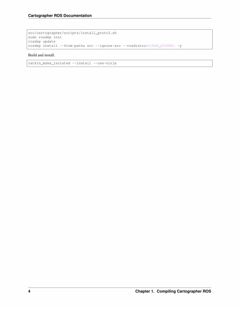
src/cartographer/scripts/install_proto3.shsudo rosdep initrosdep updaterosdep install --from-paths src --ignore-src --rosdistro=${ROS_DISTRO} -y
Build and install.
catkin_make_isolated --install --use-ninja
4 Chapter 1. Compiling Cartographer ROS
CHAPTER 2
Running Cartographer ROS on a demo bag
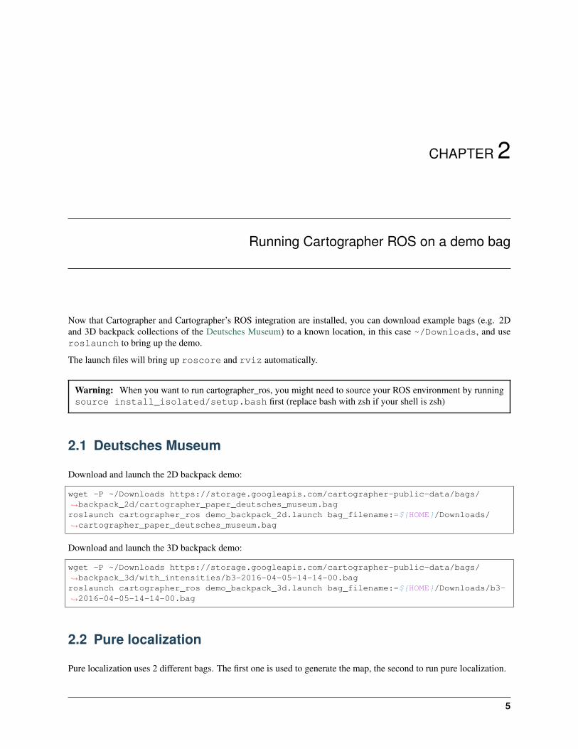
Now that Cartographer and Cartographer’s ROS integration are installed, you can download example bags (e.g. 2Dand 3D backpack collections of the Deutsches Museum) to a known location, in this case ~/Downloads, and useroslaunch to bring up the demo.
The launch files will bring up roscore and rviz automatically.
Warning: When you want to run cartographer_ros, you might need to source your ROS environment by runningsource install_isolated/setup.bash first (replace bash with zsh if your shell is zsh)
2.1 Deutsches Museum
Download and launch the 2D backpack demo:
wget -P ~/Downloads https://storage.googleapis.com/cartographer-public-data/bags/→˓backpack_2d/cartographer_paper_deutsches_museum.bagroslaunch cartographer_ros demo_backpack_2d.launch bag_filename:=${HOME}/Downloads/→˓cartographer_paper_deutsches_museum.bag
Download and launch the 3D backpack demo:
wget -P ~/Downloads https://storage.googleapis.com/cartographer-public-data/bags/→˓backpack_3d/with_intensities/b3-2016-04-05-14-14-00.bagroslaunch cartographer_ros demo_backpack_3d.launch bag_filename:=${HOME}/Downloads/b3-→˓2016-04-05-14-14-00.bag
2.2 Pure localization
Pure localization uses 2 different bags. The first one is used to generate the map, the second to run pure localization.
5
Cartographer ROS Documentation
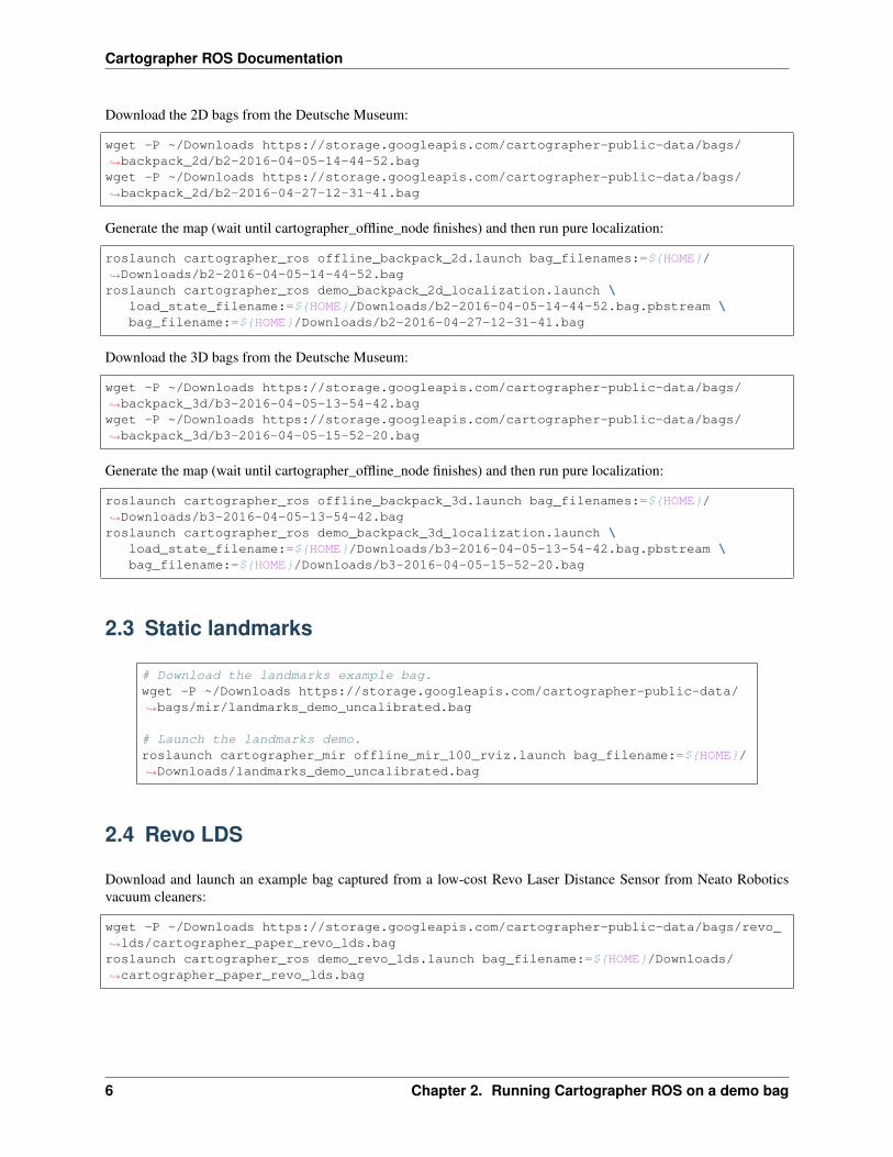
Download the 2D bags from the Deutsche Museum:
wget -P ~/Downloads https://storage.googleapis.com/cartographer-public-data/bags/→˓backpack_2d/b2-2016-04-05-14-44-52.bagwget -P ~/Downloads https://storage.googleapis.com/cartographer-public-data/bags/→˓backpack_2d/b2-2016-04-27-12-31-41.bag
Generate the map (wait until cartographer_offline_node finishes) and then run pure localization:
roslaunch cartographer_ros offline_backpack_2d.launch bag_filenames:=${HOME}/→˓Downloads/b2-2016-04-05-14-44-52.bagroslaunch cartographer_ros demo_backpack_2d_localization.launch \
load_state_filename:=${HOME}/Downloads/b2-2016-04-05-14-44-52.bag.pbstream \bag_filename:=${HOME}/Downloads/b2-2016-04-27-12-31-41.bag
Download the 3D bags from the Deutsche Museum:
wget -P ~/Downloads https://storage.googleapis.com/cartographer-public-data/bags/→˓backpack_3d/b3-2016-04-05-13-54-42.bagwget -P ~/Downloads https://storage.googleapis.com/cartographer-public-data/bags/→˓backpack_3d/b3-2016-04-05-15-52-20.bag
Generate the map (wait until cartographer_offline_node finishes) and then run pure localization:
roslaunch cartographer_ros offline_backpack_3d.launch bag_filenames:=${HOME}/→˓Downloads/b3-2016-04-05-13-54-42.bagroslaunch cartographer_ros demo_backpack_3d_localization.launch \
load_state_filename:=${HOME}/Downloads/b3-2016-04-05-13-54-42.bag.pbstream \bag_filename:=${HOME}/Downloads/b3-2016-04-05-15-52-20.bag
2.3 Static landmarks
# Download the landmarks example bag.wget -P ~/Downloads https://storage.googleapis.com/cartographer-public-data/→˓bags/mir/landmarks_demo_uncalibrated.bag
# Launch the landmarks demo.roslaunch cartographer_mir offline_mir_100_rviz.launch bag_filename:=${HOME}/→˓Downloads/landmarks_demo_uncalibrated.bag
2.4 Revo LDS
Download and launch an example bag captured from a low-cost Revo Laser Distance Sensor from Neato Roboticsvacuum cleaners:
wget -P ~/Downloads https://storage.googleapis.com/cartographer-public-data/bags/revo_→˓lds/cartographer_paper_revo_lds.bagroslaunch cartographer_ros demo_revo_lds.launch bag_filename:=${HOME}/Downloads/→˓cartographer_paper_revo_lds.bag
6 Chapter 2. Running Cartographer ROS on a demo bag
Cartographer ROS Documentation
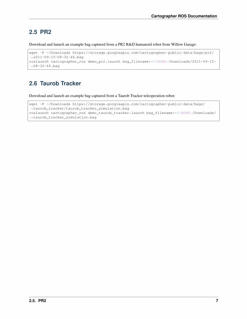
2.5 PR2
Download and launch an example bag captured from a PR2 R&D humanoid robot from Willow Garage:
wget -P ~/Downloads https://storage.googleapis.com/cartographer-public-data/bags/pr2/→˓2011-09-15-08-32-46.bagroslaunch cartographer_ros demo_pr2.launch bag_filename:=${HOME}/Downloads/2011-09-15-→˓08-32-46.bag
2.6 Taurob Tracker
Download and launch an example bag captured from a Taurob Tracker teleoperation robot:
wget -P ~/Downloads https://storage.googleapis.com/cartographer-public-data/bags/→˓taurob_tracker/taurob_tracker_simulation.bagroslaunch cartographer_ros demo_taurob_tracker.launch bag_filename:=${HOME}/Downloads/→˓taurob_tracker_simulation.bag
2.5. PR2 7

Cartographer ROS Documentation
8 Chapter 2. Running Cartographer ROS on a demo bag
CHAPTER 3
Running Cartographer ROS on your own bag
Now that you’ve run Cartographer ROS on a couple of provided bags, you can go ahead and make Cartographer workwith your own data. Find a .bag recording you would like to use for SLAM and go through this tutorial.
Warning: When you want to run cartographer_ros, you might need to source your ROS environment by runningsource install_isolated/setup.bash first (replace bash with zsh if your shell is zsh)
3.1 Validate your bag
Cartographer ROS provides a tool named cartographer_rosbag_validate to automatically analyze datapresent in your bag. It is generally a good idea to run this tool before trying to tune Cartographer for incorrect data.
It benefits from the experience of the Cartographer authors and can detect a variety of mistakes commonly found inbags. For instance, if a sensor_msgs/Imu topic is detected, the tool will make sure that the gravity vector hasnot been removed from the IMU measurements because the gravity norm is used by Cartographer to determine thedirection of the ground.
The tool can also provide tips on how to improve the quality of your data. For example, with a Velodyne LIDAR, it isrecommended to have one sensor_msgs/PointCloud2 message per UDP packet sent by the sensor instead ofone message per revolution. With that granularity, Cartographer is then able to unwarp the point clouds deformationcaused by the robot’s motion and results in better reconstruction.
If you have sourced your Cartographer ROS environment, you can simply run the tool like this:
cartographer_rosbag_validate -bag_filename your_bag.bag
3.2 Create a .lua configuration
Cartographer is highly flexible and can be configured to work on a variety of robots. The robot configurationis read from a options data structure that must be defined from a Lua script. The example configurations
9
Cartographer ROS Documentation
are defined in src/cartographer_ros/cartographer_ros/configuration_files and installed ininstall_isolated/share/cartographer_ros/configuration_files/.
Note: Ideally, a .lua configuration should be robot-specific and not bag-specific.
You can start by copying one of the example and then adapt it to your own need. If you want to use 3D SLAM:
cp install_isolated/share/cartographer_ros/configuration_files/backpack_3d.lua→˓install_isolated/share/cartographer_ros/configuration_files/my_robot.lua
If you want to use 2D SLAM:
cp install_isolated/share/cartographer_ros/configuration_files/backpack_3d.lua→˓install_isolated/share/cartographer_ros/configuration_files/my_robot.lua
You can then edit my_robot.lua to suit the needs of your robot. The values defined in the options block definehow the Cartographer ROS frontend should interface with your bag. The values defined after the options paragraphare used to tune the inner-working of Cartographer, we will ignore these for now.
See also:
The reference documentation of the Cartographer ROS configuration values and of the Cartographer configurationvalues.
Among the values you need to adapt, you probably have to provide the TF frame IDs of your environment and robotin map_frame, tracking_frame, published_frame and odom_frame.
Note: You can either distribute your robot’s TF tree from a /tf topic in your bag or define it in a .urdf robotdefinition.
Warning: You should trust your poses! A small offset on the link between your robot and IMU or LIDAR canlead to incoherent map reconstructions. Cartographer can usually correct small pose errors but not everything!
The other values you need to define are related to the number and type of sensors you would like to use.
• num_laser_scans: Number of sensor_msgs/LaserScan topics you’ll use.
• num_multi_echo_laser_scans: Number of sensor_msgs/MultiEchoLaserScan topics you’lluse.
• num_point_clouds: Number of sensor_msgs/PointCloud2 topics you’ll use.
You can also enable the usage of landmarks and GPS as additional sources of localization using use_landmarksand use_nav_sat. The rest of the variables in the options block should typically be left untouched.
However, there is one global variable that you absolutely need to adapt to the needs of yourbag: TRAJECTORY_BUILDER_3D.num_accumulated_range_data or TRAJECTORY_BUILDER_2D.num_accumulated_range_data. This variable defines the number of messages required to construct a fullscan (typically, a full revolution). If you follow cartographer_rosbag_validate’s advices and use 100 ROSmessages per scan, you can set this variable to 100. If you have two range finding sensors (for instance, two LIDARs)providing their full scans all at once, you should set this variable to 2.
10 Chapter 3. Running Cartographer ROS on your own bag
Cartographer ROS Documentation
3.3 Create .launch files for your SLAM scenarios
You may have noticed that each demo introduced in the previous section was run with a different roslaunch com-mand. The recommended usage of Cartographer is indeed to provide a custom .launch file per robot and type ofSLAM. The example .launch files are defined in src/cartographer_ros/cartographer_ros/launchand installed in install_isolated/share/cartographer_ros/launch/.
Start by copying one of the provided example:
cp install_isolated/share/cartographer_ros/launch/backpack_3d.launch install_isolated/→˓share/cartographer_ros/launch/my_robot.launchcp install_isolated/share/cartographer_ros/launch/demo_backpack_3d.launch install_→˓isolated/share/cartographer_ros/launch/demo_my_robot.launchcp install_isolated/share/cartographer_ros/launch/offline_backpack_3d.launch install_→˓isolated/share/cartographer_ros/launch/offline_my_robot.launchcp install_isolated/share/cartographer_ros/launch/demo_backpack_3d_localization.→˓launch install_isolated/share/cartographer_ros/launch/demo_my_robot_localization.→˓launchcp install_isolated/share/cartographer_ros/launch/assets_writer_backpack_3d.launch→˓install_isolated/share/cartographer_ros/launch/assets_writer_my_robot.launch
• my_robot.launch is meant to be used on the robot to execute SLAM online (in real time) with real sensorsdata.
• demo_my_robot.launch is meant to be used from a development machine and expects a bag_filenameargument to replay data from a recording. This launch file also spawns a rviz window configured to visualizeCartographer’s state.
• offline_my_robot.launch is very similar to demo_my_robot.launch but tries to execute SLAMas fast as possible. This can make map building significantly faster. This launch file can also use multiple bagfiles provided to the bag_filenames argument.
• demo_my_robot_localization.launch is very similar to demo_my_robot.launch but expectsa load_state_filename argument pointing to a .pbstream recording of a previous Cartographer ex-ecution. The previous recording will be used as a pre-computed map and Cartographer will only performlocalization on this map.
• assets_writer_my_robot.launch is used to extract data out of a .pstream recording of a previousCartographer execution.
Again, a few adaptations need to be made to those files to suit your robot.
• Every parameter given to -configuration_basename should be adapted to point to my_robot.lua.
• If you decided to use a .urdf description of your robot, you should place your description ininstall_isolated/share/cartographer_ros/urdf and adapt the robot_description pa-rameter to point to your file name.
• If you decided to use /tf messages, you can remove the robot_description parameter, therobot_state_publisher node and the lines statring with -urdf.
• If the topic names published by your bag or sensors don’t match the ones expected by Cartographer ROS, youcan use <remap> elements to redirect your topics. The expected topic names depend on the type of rangefinding devices you use.
Note:
• The IMU topic is expected to be named “imu”
3.3. Create .launch files for your SLAM scenarios 11
Cartographer ROS Documentation
• If you use only one sensor_msgs/LaserScan topic, it is expected to be named scan. If you have more,they should be named scan_1, scan_2 etc. . .
• If you use only one sensor_msgs/MultiEchoLaserScan topic, it is expected to be named echoes. Ifyou have more, they should be named echoes_1, echoes_2 etc. . .
• If you use only one sensor_msgs/PointCloud2 topic, it is expected be named points2. If you havemore, they should be named points2_1, points2_2, etc. . .
3.4 Try your configuration
Everything is setup! You can now start Cartographer with:
roslaunch cartographer_ros my_robot.launch bag_filename:=/path/to/your_bag.bag
If you are lucky enough, everything should already work as expected. However, you might have some problems thatrequire tuning.
12 Chapter 3. Running Cartographer ROS on your own bag
CHAPTER 4
Algorithm walkthrough for tuning
Cartographer is a complex system and tuning it requires a good understanding of its inner working. This page tries togive an intuitive overview of the different subsystems used by Cartographer along with their configuration values. Ifyou are interested in more than an introduction to Cartographer, you should refer to the Cartographer paper. It onlydescribes the 2D SLAM but it defines rigourously most of the concepts described here. Those concepts generallyapply to 3D as well.
W. Hess, D. Kohler, H. Rapp, and D. Andor, Real-Time Loop Closure in 2D LIDAR SLAM, in Robotics and Automa-tion (ICRA), 2016 IEEE International Conference on. IEEE, 2016. pp. 1271–1278.
13
Cartographer ROS Documentation
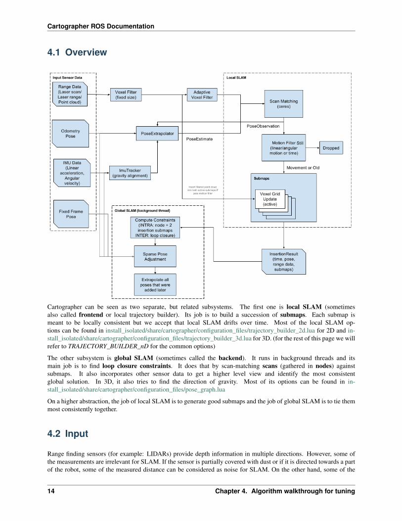
4.1 Overview
Cartographer can be seen as two separate, but related subsystems. The first one is local SLAM (sometimesalso called frontend or local trajectory builder). Its job is to build a succession of submaps. Each submap ismeant to be locally consistent but we accept that local SLAM drifts over time. Most of the local SLAM op-tions can be found in install_isolated/share/cartographer/configuration_files/trajectory_builder_2d.lua for 2D and in-stall_isolated/share/cartographer/configuration_files/trajectory_builder_3d.lua for 3D. (for the rest of this page we willrefer to TRAJECTORY_BUILDER_nD for the common options)
The other subsystem is global SLAM (sometimes called the backend). It runs in background threads and itsmain job is to find loop closure constraints. It does that by scan-matching scans (gathered in nodes) againstsubmaps. It also incorporates other sensor data to get a higher level view and identify the most consistentglobal solution. In 3D, it also tries to find the direction of gravity. Most of its options can be found in in-stall_isolated/share/cartographer/configuration_files/pose_graph.lua
On a higher abstraction, the job of local SLAM is to generate good submaps and the job of global SLAM is to tie themmost consistently together.
4.2 Input
Range finding sensors (for example: LIDARs) provide depth information in multiple directions. However, some ofthe measurements are irrelevant for SLAM. If the sensor is partially covered with dust or if it is directed towards a partof the robot, some of the measured distance can be considered as noise for SLAM. On the other hand, some of the
14 Chapter 4. Algorithm walkthrough for tuning
Cartographer ROS Documentation
furthest measurements can also come from undesired sources (reflection, sensor noise) and are irrelevant for SLAMas well. To tackle those issue, Cartographer starts by applying a bandpass filter and only keeps range values between acertain min and max range. Those min and max values should be chosen according to the specifications of your robotand sensors.
TRAJECTORY_BUILDER_nD.min_rangeTRAJECTORY_BUILDER_nD.max_range
Note: In 2D, Cartographer replaces ranges further than max_range by TRAJECTORY_BUILDER_2D.missing_data_ray_length. It also provides a max_z and min_z values to filter 3D point clouds into a 2Dcut.
Note: In Cartographer configuration files, every distance is defined in meters
Distances are measured over a certain period of time, while the robot is actually moving. However, distances are deliv-ered by sensors “in batch” in large ROS messages. Each of the messages’ timestamp can be considered independentlyby Cartographer to take into account deformations caused by the robot’s motion. The more often Cartographer getsmeasurements, the better it becomes at unwarping the measurements to assemble a single coherent scan that couldhave been captured instantly. It is therefore strongly encouraged to provide as many range data (ROS messages) byscan (a set of range data that can be matched against another scan) as possible.
TRAJECTORY_BUILDER_nD.num_accumulated_range_data
Range data is typically measured from a single point on the robot but in multiple angles. This means that close surfaces(for instance the road) are very often hit and provide lots of points. On the opposite, far objects are less often hit andoffer less points. In order to reduce the computational weight of points handling, we usually need to subsample pointclouds. However, a simple random sampling would remove points from areas where we already have a low density ofmeasurements and the high-density areas would still have more points than needed. To address that density problem,we can use a voxel filter that downsamples raw points into cubes of a constant size and only keeps the centroid of eachcube.
A small cube size will result in a more dense data representation, causing more computations. A large cube size willresult in a data loss but will be much quicker.
TRAJECTORY_BUILDER_nD.voxel_filter_size
After having applied a fixed-size voxel filter, Cartographer also applies an adaptive voxel filter. This filter tries todetermine the optimal voxel size (under a max length) to achieve a target number of points. In 3D, two adaptive voxelfilters are used to generate a high resolution and a low resolution point clouds, their usage will be clarified in LocalSLAM.
TRAJECTORY_BUILDER_nD.*adaptive_voxel_filter.max_lengthTRAJECTORY_BUILDER_nD.*adaptive_voxel_filter.min_num_points
An Inertial Measurement Unit can be an useful source of information for SLAM because it provides an accuratedirection of gravity (hence, of the ground) and a noisy but good overall indication of the robot’s rotation. In orderto filter the IMU noise, gravity is observed over a certain amount of time. If you use 2D SLAM, range data can behandled in real-time without an additional source of information so you can choose whether you’d like Cartographerto use an IMU or not. With 3D SLAM, you need to provide an IMU because it is used as an initial guess for theorientation of the scans, greatly reducing the complexity of scan matching.
TRAJECTORY_BUILDER_2D.use_imu_dataTRAJECTORY_BUILDER_nD.imu_gravity_time_constant
4.2. Input 15
Cartographer ROS Documentation
Note: In Cartographer configuration files, every time value is defined in seconds
4.3 Local SLAM
Once a scan has been assembled and filtered from multiple range data, it is ready for the local SLAM algorithm. LocalSLAM inserts a new scan into its current submap construction by scan matching using an initial guess from the poseextrapolator. The idea behind the pose extrapolator is to use sensor data of other sensors besides the range finder topredict where the next scan should be inserted into the submap.
Two scan matching strategies are available:
• The CeresScanMatcher takes the initial guess as prior and finds the best spot where the scan match fitsthe submap. It does this by interpolating the submap and sub-pixel aligning the scan. This is fast, but cannotfix errors that are significantly larger than the resolution of the submaps. If your sensor setup and timing isreasonable, using only the CeresScanMatcher is usually the best choice to make.
• The RealTimeCorrelativeScanMatcher can be enabled if you do not have other sensors or you donot trust them. It uses an approach similar to how scans are matched against submaps in loop closure (de-scribed later), but instead it matches against the current submap. The best match is then used as prior for theCeresScanMatcher. This scan matcher is very expensive and will essentially override any signal from othersensors but the range finder, but it is robust in feature rich environments.
Either way, the CeresScanMatcher can be configured to give a certain weight to each of its input. The weight is ameasure of trust into your data, this can be seen as a static covariance. The unit of weight parameters are dimensionlessquantities and can’t be compared between each others. The bigger the weight of a source of data is, the more emphasisCartographer will put on this source of data when doing scan matching. Sources of data include occupied space (pointsfrom the scan), translation and rotation from the pose extrapolator (or RealTimeCorrelativeScanMatcher)
TRAJECTORY_BUILDER_3D.ceres_scan_matcher.occupied_space_weightTRAJECTORY_BUILDER_3D.ceres_scan_matcher.occupied_space_weight_0TRAJECTORY_BUILDER_3D.ceres_scan_matcher.occupied_space_weight_1TRAJECTORY_BUILDER_nD.ceres_scan_matcher.translation_weightTRAJECTORY_BUILDER_nD.ceres_scan_matcher.rotation_weight
Note: In 3D, the occupied_space_weight_0 and occupied_space_weight_1 parameters are related,respectively, to the high resolution and low resolution filtered point clouds.
The CeresScanMatcher gets its name from Ceres Solver, a library developed at Google to solve non-linear leastsquares problems. The scan matching problem is modelled as the minimization of such a problem with the motion (atransformation matrix) between two scans being a parameter to determine. Ceres optimizes the motion using a descentalgorithm for a given number of iterations. Ceres can be configured to adapt the convergence speed to your own needs.
TRAJECTORY_BUILDER_nD.ceres_scan_matcher.ceres_solver_options.use_nonmonotonic_stepsTRAJECTORY_BUILDER_nD.ceres_scan_matcher.ceres_solver_options.max_num_iterationsTRAJECTORY_BUILDER_nD.ceres_scan_matcher.ceres_solver_options.num_threads
The RealTimeCorrelativeScanMatcher can be toggled depending on the trust you have in your sensors.It works by searching for similar scans in a search window which is defined by a maximum distance radius and amaximum angle radius. When performing scan matching with scans found in this window, a different weight can bechosen for the translational and rotational components. You can play with those weight if, for example, you know thatyour robot doesn’t rotate a lot.
16 Chapter 4. Algorithm walkthrough for tuning
Cartographer ROS Documentation
TRAJECTORY_BUILDER_nD.use_online_correlative_scan_matchingTRAJECTORY_BUILDER_nD.real_time_correlative_scan_matcher.linear_search_windowTRAJECTORY_BUILDER_nD.real_time_correlative_scan_matcher.angular_search_windowTRAJECTORY_BUILDER_nD.real_time_correlative_scan_matcher.translation_delta_cost_weightTRAJECTORY_BUILDER_nD.real_time_correlative_scan_matcher.rotation_delta_cost_weight
To avoid inserting too many scans per submaps, once a motion between two scans is found by the scan matcher, itgoes through a motion filter. A scan is dropped if the motion that led to it is not considered as significant enough. Ascan is inserted into the current submap only if its motion is above a certain distance, angle or time threshold.
TRAJECTORY_BUILDER_nD.motion_filter.max_time_secondsTRAJECTORY_BUILDER_nD.motion_filter.max_distance_metersTRAJECTORY_BUILDER_nD.motion_filter.max_angle_radians
A submap is considered as complete when the local SLAM has received a given amount of range data. Local SLAMdrifts over time, global SLAM is used to fix this drift. Submaps must be small enough so that the drift inside them isbelow the resolution, so that they are locally correct. On the other hand, they should be large enough to be distinct forloop closure to work properly.
TRAJECTORY_BUILDER_nD.submaps.num_range_data
Submaps can store their range data in a couple of different data structures: The most widely used representation iscalled probability grids. However, in 2D, one can also choose to use Truncated Signed Distance Fields (TSDF).
TRAJECTORY_BUILDER_2D.submaps.grid_options_2d.grid_type
Probability grids cut out space into a 2D or 3D table where each cell has a fixed size and contains the odds of beingobstructed. Odds are updated according to “hits” (where the range data is measured) and “misses” (the free spacebetween the sensor and the measured points). Both hits and misses can have a different weight in occupancy probabilitycalculations giving more or less trust to occupied or free space measurements.
TRAJECTORY_BUILDER_2D.submaps.range_data_inserter.probability_grid_range_data_→˓inserter.hit_probabilityTRAJECTORY_BUILDER_2D.submaps.range_data_inserter.probability_grid_range_data_→˓inserter.miss_probabilityTRAJECTORY_BUILDER_3D.submaps.range_data_inserter.hit_probabilityTRAJECTORY_BUILDER_3D.submaps.range_data_inserter.miss_probability
In 2D, only one probability grid per submap is stored. In 3D, for scan matching performance reasons, two hybridprobability grids are used. (the term “hybrid” only refers to an internal tree-like data representation and is abstractedto the user)
• a low resolution hybrid grid for far measurements
• a high resolution hybrid grid for close measurements
Scan matching starts by aligning far points of the low resolution point cloud with the low resolution hybrid grid andthen refines the pose by aligning the close high resolution points with the high resolution hybrid grid.
TRAJECTORY_BUILDER_2D.submaps.grid_options_2d.resolutionTRAJECTORY_BUILDER_3D.submaps.high_resolutionTRAJECTORY_BUILDER_3D.submaps.low_resolutionTRAJECTORY_BUILDER_3D.high_resolution_adaptive_voxel_filter.max_rangeTRAJECTORY_BUILDER_3D.low_resolution_adaptive_voxel_filter.max_range
Note: Cartographer ROS provides an RViz plugin to visualize submaps. You can select the submaps you want to seefrom their number. In 3D, RViz only shows 2D projections of the 3D hybrid probability grids (in grayscale). Options
4.3. Local SLAM 17
Cartographer ROS Documentation
are made available in RViz’s left pane to switch between the low and high resolution hybrid grids visualization.
TODO: Documenting TSDF configuration
4.4 Global SLAM
While the local SLAM generates its succession of submaps, a global optimization (usually refered to as “the optimiza-tion problem” or “sparse pose adjustment”) task runs in background. Its role is to re-arrange submaps between eachother so that they form a coherent global map. For instance, this optimization is in charge of altering the currentlybuilt trajectory to properly align submaps with regards to loop closures.
The optimization is run in batches once a certain number of trajectory nodes was inserted. Depending on how fre-quently you need to run it, you can tune the size of these batches.
POSE_GRAPH.optimize_every_n_nodes
Note: Setting POSE_GRAPH.optimize_every_n_nodes to 0 is a handy way to disable global SLAM and concentrateon the behavior of local SLAM. This is usually one of the first thing to do to tune Cartographer.
The global SLAM is a kind of “GraphSLAM”, it is essentially a pose graph optimization which works by building con-straints between nodes and submaps and then optimizing the resulting constraints graph. Constraints can intuitivelybe thought of as little ropes tying all nodes together. The sparse pose adjustement fastens those ropes altogether. Theresulting net is called the “pose graph”.
Note: Constraints can be visualized in RViz, it is very handy to tune global SLAM. One can also togglePOSE_GRAPH.constraint_builder.log_matches to get regular reports of the constraints builder format-ted as histograms.
• Non-global constraints (also known as inter submaps constraints) are built automatically between nodes that areclosely following each other on a trajectory. Intuitively, those “non-global ropes” keep the local structure of thetrajectory coherent.
• Global constraints (also referred to as loop closure constraints or intra submaps contraints) are regularly searchedbetween a new submap and previous nodes that are considered “close enough” in space (part of a certain searchwindow) and a strong fit (a good match when running scan matching). Intuitively, those “global ropes” introduceknots in the structure and firmly bring two strands closer.
POSE_GRAPH.constraint_builder.max_constraint_distancePOSE_GRAPH.fast_correlative_scan_matcher.linear_search_windowPOSE_GRAPH.fast_correlative_scan_matcher_3d.linear_xy_search_windowPOSE_GRAPH.fast_correlative_scan_matcher_3d.linear_z_search_windowPOSE_GRAPH.fast_correlative_scan_matcher*.angular_search_window
Note: In practice, global constraints can do more than finding loop closures on a single trajectory. They can alsoalign different trajectories recorded by multiple robots but we will keep this usage and the parameters related to “globallocalization” out of the scope of this document.
To limit the amount of constraints (and computations), Cartographer only considers a subsampled set of all close nodesfor constraints building. This is controlled by a sampling ratio constant. Sampling too few nodes could result in missed
18 Chapter 4. Algorithm walkthrough for tuning
Cartographer ROS Documentation
constraints and ineffective loop closures. Sampling too many nodes would slow the global SLAM down and preventreal-time loop closures.
POSE_GRAPH.constraint_builder.sampling_ratio
When a node and a submap are considered for constraint building, they go through a first scan matcher called theFastCorrelativeScanMatcher. This scan matcher has been specifically designed for Cartographer and makesreal-time loop closures scan matching possible. The FastCorrelativeScanMatcher relies on a “Branch andbound” mechanism to work at different grid resolutions and efficiently eliminate incorrect matchings. This mechanismis extensively presented in the Cartographer paper presented earlier in this document. It works on an exploration treewhose depth can be controlled.
POSE_GRAPH.constraint_builder.fast_correlative_scan_matcher.branch_and_bound_depthPOSE_GRAPH.constraint_builder.fast_correlative_scan_matcher_3d.branch_and_bound_depthPOSE_GRAPH.constraint_builder.fast_correlative_scan_matcher_3d.full_resolution_depth
Once the FastCorrelativeScanMatcher has a good enough proposal (above a minimum score of matching),it is then fed into a Ceres Scan Matcher to refine the pose.
POSE_GRAPH.constraint_builder.min_scorePOSE_GRAPH.constraint_builder.ceres_scan_matcher_3dPOSE_GRAPH.constraint_builder.ceres_scan_matcher
When Cartographer runs the optimization problem, Ceres is used to rearrange submaps according to multiple residuals.Residuals are calculated using weighted cost functions. The global optimization has cost functions to take into accountplenty of data sources: the global (loop closure) constraints, the non-global (matcher) constraints, the IMU accelerationand rotation measurements, the local SLAM rough pose estimations, an odometry source or a fixed frame (such as aGPS system). The weights and Ceres options can be configured as described in the Local SLAM section.
POSE_GRAPH.constraint_builder.loop_closure_translation_weightPOSE_GRAPH.constraint_builder.loop_closure_rotation_weightPOSE_GRAPH.matcher_translation_weightPOSE_GRAPH.matcher_rotation_weightPOSE_GRAPH.optimization_problem.*_weightPOSE_GRAPH.optimization_problem.ceres_solver_options
Note: One can find useful information about the residuals used in the optimization problem by togglingPOSE_GRAPH.max_num_final_iterations
As part of its IMU residual, the optimization problem gives some flexibility to the IMU pose and, by default, Ceres isfree to optimize the extrinsic calibration between your IMU and tracking frame. If you don’t trust your IMU pose, theresults of Ceres’ global optimization can be logged and used to improve your extrinsic calibration. If Ceres doesn’toptimize your IMU pose correctly and you trust your extrinsic calibration enough, you can make this pose constant.
POSE_GRAPH.optimization_problem.log_solver_summaryPOSE_GRAPH.optimization_problem.use_online_imu_extrinsics_in_3d
In residuals, the influence of outliers is handled by a Huber loss function configured with a certain a Huber scale. Thebigger the Huber scale, the higher is the impact of (potential) outliers.
POSE_GRAPH.optimization_problem.huber_scale
Once the trajectory is finished, Cartographer runs a new global optimization with, typically, a lot more iterations thanprevious global optimizations. This is done to polish the final result of Cartographer and usually does not need to bereal-time so a large number of iterations is often a right choice.
4.4. Global SLAM 19

Cartographer ROS Documentation
POSE_GRAPH.max_num_final_iterations
20 Chapter 4. Algorithm walkthrough for tuning
CHAPTER 5
Tuning methodology
Tuning Cartographer is unfortunately really difficult. The system has many parameters many of which affect eachother. This tuning guide tries to explain a principled approach on concrete examples.
5.1 Built-in tools
Cartographer provides built-in tools for SLAM evaluation that can be particularly useful for measuring the local SLAMquality. They are stand-alone executables that ship with the core cartographer library and are hence independent,but compatible with cartographer_ros. Therefore, please head to the Cartographer Read the Docs Evaluationsite for a conceptual overview and a guide on how to use the tools in practice.
These tools assume that you have serialized the SLAM state to a .pbstream file. With cartographer_ros, youcan invoke the assets_writer to serialize the state - see the Exploiting the map generated by Cartographer ROSsection for more information.
5.2 Example: tuning local SLAM
For this example we’ll start at cartographer commit aba4575 and cartographer_ros commit 99c23b6 andlook at the bag b2-2016-04-27-12-31-41.bag from our test data set.
At our starting configuration, we see some slipping pretty early in the bag. The backpack passed over a ramp in theDeutsches Museum which violates the 2D assumption of a flat floor. It is visible in the laser scan data that contradictinginformation is passed to the SLAM. But the slipping also indicates that we trust the point cloud matching too muchand disregard the other sensors quite strongly. Our aim is to improve the situation through tuning.
If we only look at this particular submap, that the error is fully contained in one submap. We also see that over time,global SLAM figures out that something weird happened and partially corrects for it. The broken submap is brokenforever though.
Since the problem here is slippage inside a submap, it is a local SLAM issue. So let’s turn off global SLAM to notmess with our tuning.
21
Cartographer ROS Documentation
POSE_GRAPH.optimize_every_n_nodes = 0
5.2.1 Correct size of submaps
The size of submaps is configured through TRAJECTORY_BUILDER_2D.submaps.num_range_data. Look-ing at the individual submaps for this example they already fit the two constraints rather well, so we assume thisparameter is well tuned.
5.2.2 Tuning the CeresScanMatcher
In our case, the scan matcher can freely move the match forward and backwards without impacting the score. We’dlike to penalize this situation by making the scan matcher pay more for deviating from the prior that it got. The two pa-rameters controlling this are TRAJECTORY_BUILDER_2D.ceres_scan_matcher.translation_weightand rotation_weight. The higher, the more expensive it is to move the result away from the prior, or in otherwords: scan matching has to generate a higher score in another position to be accepted.
For instructional purposes, let’s make deviating from the prior really expensive:
TRAJECTORY_BUILDER_2D.ceres_scan_matcher.translation_weight = 1e3
This allows the optimizer to pretty liberally overwrite the scan matcher results. This results in poses close to the prior,but inconsistent with the depth sensor and clearly broken. Experimenting with this value yields a better result at 2e2.
Here, the scan matcher used rotation to still slightly mess up the result though. Setting the rotation_weight to4e2 leaves us with a reasonable result.
5.2.3 Verification
To make sure that we did not overtune for this particular issue, we need to run the configuration againstother collected data. In this case, the new parameters did reveal slipping, for example at the beginning ofb2-2016-04-05-14-44-52.bag, so we had to lower the translation_weight to 1e2. This setting isworse for the case we wanted to fix, but no longer slips. Before checking them in, we normalize all weights, since theyonly have relative meaning. The result of this tuning was PR 428. In general, always try to tune for a platform, not aparticular bag.
5.3 Special Cases
The default configuration and the above tuning steps are focused on quality. Only after we have achieved good quality,we can further consider special cases.
5.3.1 Low Latency
By low latency, we mean that an optimized local pose becomes available shortly after sensor input was received, usu-ally within a second, and that global optimization has no backlog. Low latency is required for online algorithms, suchas robot localization. Local SLAM, which operates in the foreground, directly affects latency. Global SLAM buildsup a queue of background tasks. When global SLAM cannot keep up the queue, drift can accumulate indefinitely, soglobal SLAM should be tuned to work in real time.
22 Chapter 5. Tuning methodology
Cartographer ROS Documentation
There are many options to tune the different components for speed, and we list them ordered from the recommended,straightforward ones to the those that are more intrusive. It is recommended to only explore one option at a time,starting with the first. Configuration parameters are documented in the Cartographer documentation.
To tune global SLAM for lower latency, we reduce its computational load until is consistently keeps up with real-timeinput. Below this threshold, we do not reduce it further, but try to achieve the best possible quality. To reduce globalSLAM latency, we can
• decrease optimize_every_n_nodes
• increase MAP_BUILDER.num_background_threads up to the number of cores
• decrease global_sampling_ratio
• decrease constraint_builder.sampling_ratio
• increase constraint_builder.min_score
• for the adaptive voxel filter(s), decrease .min_num_points, .max_range, increase .max_length
• increase voxel_filter_size, submaps.resolution, decrease submaps.num_range_data
• decrease search windows sizes, .linear_xy_search_window, .linear_z_search_window, .angular_search_window
• increase global_constraint_search_after_n_seconds
• decrease max_num_iterations
To tune local SLAM for lower latency, we can
• increase voxel_filter_size
• increase submaps.resolution
• for the adaptive voxel filter(s), decrease .min_num_points, .max_range, increase .max_length
• decrease max_range (especially if data is noisy)
• decrease submaps.num_range_data
Note that larger voxels will slightly increase scan matching scores as a side effect, so score thresholds should beincreased accordingly.
5.3.2 Pure Localization in a Given Map
Pure localization is different from mapping. First, we expect a lower latency of both local and global SLAM. Second,global SLAM will usually find a very large number of inter constraints between the frozen trajectory that serves as amap and the current trajectory.
To tune for pure localization, we should first enable TRAJECTORY_BUILDER.pure_localization = trueand strongly decrease POSE_GRAPH.optimize_every_n_nodes to receive frequent results. With thesesettings, global SLAM will usually be too slow and cannot keep up. As a next step, we strongly decreaseglobal_sampling_ratio and constraint_builder.sampling_ratio to compensate for the largenumber of constraints. We then tune for lower latency as explained above until the system reliably works in realtime.
If you run in pure_localization, submaps.resolution should be matching with the resolution of thesubmaps in the .pbstream you are running on. Using different resolutions is currently untested and may not workas expected.
5.3. Special Cases 23
Cartographer ROS Documentation
5.3.3 Odometry in Global Optimization
If a separate odometry source is used as an input for local SLAM (use_odometry = true), we can also tune theglobal SLAM to benefit from this additional information.
There are in total four parameters that allow us to tune the individual weights of local SLAM and odometry in theoptimization:
POSE_GRAPH.optimization_problem.local_slam_pose_translation_weightPOSE_GRAPH.optimization_problem.local_slam_pose_rotation_weightPOSE_GRAPH.optimization_problem.odometry_translation_weightPOSE_GRAPH.optimization_problem.odometry_rotation_weight
We can set these weights depending on how much we trust either local SLAM or the odometry. By default, odometryis weighted into global optimization similar to local slam (scan matching) poses. However, odometry from wheelencoders often has a high uncertainty in rotation. In this case, the rotation weight can be reduced, even down to zero.
5.4 Still have a problem ?
If you can’t get Cartographer to work reliably on your data, you can open a GitHub issue asking for help. De-velopers are keen to help, but they can only be helpful if you follow an issue template containing the result ofrosbag_validate, a link to a fork of cartographer_ros with your config and a link to a .bag file re-producing your problem.
Note: There are already lots of GitHub issues with all sorts of problems solved by the developers. Going through theclosed issues of cartographer_ros and of cartographer is a great way to learn more about Cartographer and maybe finda solution to your problem !
24 Chapter 5. Tuning methodology
CHAPTER 6
Exploiting the map generated by Cartographer ROS
As sensor data come in, the state of a SLAM algorithm such as Cartographer evolves to stay the current best estimate ofa robot’s trajectory and surroundings. The most accurate localization and mapping Cartographer can offer is thereforethe one obtained when the algorithm finishes. Cartographer can serialize its internal state in a .pbstream file formatwhich is essentially a compressed protobuf file containing a snapshot of the data structures used by Cartographerinternally.
To run efficiently in real-time, Cartographer throws most of its sensor data away immediately and only works with asmall subset of its input, the mapping used internally (and saved in .pbstream files) is then very rough. However,when the algorithm finishes and a best trajectory is established, it can be recombined a posteriori with the full sensorsdata to create a high resolution map.
Cartographer makes this kind of recombination possible using cartographer_assets_writer. The assetswriter takes as input
1. the original sensors data that has been used to perform SLAM (in a ROS .bag file),
2. a cartographer state captured while performing SLAM on this sensor data (saved in a .pbstream file),
3. the sensor extrinsics (i.e. TF data from the bag or an URDF description),
4. and a pipeline configuration, which is defined in a .lua file.
The assets writer runs through the .bag data in batches with the trajectory found in the .pbstream. The pipeline canbe can be used to color, filter and export SLAM point cloud data into a variety of formats. There are multiple of suchpoints processing steps that can be interleaved in a pipeline - several ones are already available from cartographer/io.
6.1 Sample Usage
When running Cartographer with an offline node, a .pbstream file is automatically saved. For instance, with the3D backpack example:
wget -P ~/Downloads https://storage.googleapis.com/cartographer-public-data/bags/→˓backpack_3d/b3-2016-04-05-14-14-00.bagroslaunch cartographer_ros offline_backpack_3d.launch bag_filenames:=${HOME}/→˓Downloads/b3-2016-04-05-14-14-00.bag (continues on next page)
25
Cartographer ROS Documentation
(continued from previous page)
Watch the output on the commandline until the node terminates. It will have written b3-2016-04-05-14-14-00.bag.pbstream which represents the Cartographer state after it processed all data and finished all optimizations.
When running as an online node, Cartographer doesn’t know when your bag (or sensor input) ends so you need to usethe exposed services to explicitly finish the current trajectory and make Cartographer serialize its current state:
# Finish the first trajectory. No further data will be accepted on it.rosservice call /finish_trajectory 0
# Ask Cartographer to serialize its current state.# (press tab to quickly expand the parameter syntax)rosservice call /write_state "{filename: '${HOME}/Downloads/b3-2016-04-05-14-14-00.→˓bag.pbstream', include_unfinished_submaps: 'true'}"
Once you’ve retrieved your .pbstream file, you can run the assets writer with the sample pipeline for the 3Dbackpack:
roslaunch cartographer_ros assets_writer_backpack_3d.launch \bag_filenames:=${HOME}/Downloads/b3-2016-04-05-14-14-00.bag \pose_graph_filename:=${HOME}/Downloads/b3-2016-04-05-14-14-00.bag.pbstream
All output files are prefixed with --output_file_prefix which defaults to the filename of the first bag. Forthe last example, if you specify points.ply in the pipeline configuration file, this will translate to ${HOME}/Downloads/b3-2016-04-05-14-14-00.bag_points.ply.
6.2 Configuration
The assets writer is modeled as a pipeline of ‘PointsProcessor‘_s. ‘PointsBatch‘_s flow through each processor andthey all have the chance to modify the PointsBatch before passing it on.
For example the assets_writer_backpack_3d.lua pipeline uses min_max_range_filter to remove points that areeither too close or too far from the sensor. After this, it saves “X-Rays” (translucent side views of the map), thenrecolors the PointsBatchs depending on the sensor frame ids and writes another set of X-Rays using these newcolors.
The available PointsProcessors are all defined in the cartographer/io sub-directory and documented in theirindividual header files.
• color_points: Colors points with a fixed color by frame_id.
• dump_num_points: Passes through points, but keeps track of how many points it saw and output that on Flush.
• fixed_ratio_sampler: Only let a fixed ‘sampling_ratio’ of points through. A ‘sampling_ratio’ of 1. makes thisfilter a no-op.
• frame_id_filter: Filters all points with blacklisted frame_id or a non-whitelisted frame id. Note that you caneither specify the whitelist or the blacklist, but not both at the same time.
• write_hybrid_grid: Creates a hybrid grid of the points with voxels being ‘voxel_size’ big.‘range_data_inserter’ options are used to configure the range data ray tracing through the hybrid grid.
• intensity_to_color: Applies (‘intensity’ - min) / (max - min) * 255 and color the point grey with this value foreach point that comes from the sensor with ‘frame_id’. If ‘frame_id’ is empty, this applies to all points.
• min_max_range_filtering: Filters all points that are farther away from their ‘origin’ as ‘max_range’ or closerthan ‘min_range’.
26 Chapter 6. Exploiting the map generated by Cartographer ROS
Cartographer ROS Documentation
• voxel_filter_and_remove_moving_objects: Voxel filters the data and only passes on points that we believe areon non-moving objects.
• write_pcd: Streams a PCD file to disk. The header is written in ‘Flush’.
• write_ply: Streams a PLY file to disk. The header is written in ‘Flush’.
• write_probability_grid: Creates a probability grid with the specified ‘resolution’. As all points are projectedinto the x-y plane the z component of the data is ignored. ‘range_data_inserter’ options are used to cofnigurethe range data ray tracing through the probability grid.
• write_xray_image: Creates X-ray cuts through the points with pixels being ‘voxel_size’ big.
• write_xyz: Writes ASCII xyz points.
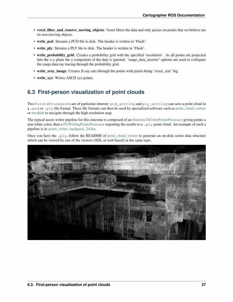
6.3 First-person visualization of point clouds
Two PointsProcessors are of particular interest: pcd_writing and ply_writing can save a point cloud ina .pcd or .ply file format. These file formats can then be used by specialized software such as point_cloud_vieweror meshlab to navigate through the high resolution map.
The typical assets writer pipeline for this outcome is composed of an IntensityToColorPointsProcessor giving points anon-white color, then a PlyWritingPointsProcessor exporting the results to a .ply point cloud. An example of such apipeline is in assets_writer_backpack_2d.lua.
Once you have the .ply, follow the README of point_cloud_viewer to generate an on-disk octree data structurewhich can be viewed by one of the viewers (SDL or web based) in the same repo.
6.3. First-person visualization of point clouds 27

Cartographer ROS Documentation
28 Chapter 6. Exploiting the map generated by Cartographer ROS
CHAPTER 7
Going further
Cartographer is not only a great SLAM algorithm, it also comes with a fully-featured implementation that brings lotsof “extra” features. This page lists some of those less known functionalities.
7.1 More input
If you have a source of odometry (such as a wheel encoder) publishing on a nav_msgs/Odometry topic and wantto use it to improve Cartographer’s localization, you can add an input to your .lua configuration files:
use_odometry = true
The messages will be expected on the odom topic.
A GPS publishing on a sensor_msgs/NavSatFix topic named fix can improve the global SLAM:
use_nav_sat = true
For landmarks publishing on a cartographer_ros_msgs/LandmarkList (message defined in cartogra-pher_ros) topic named landmarks:
use_landmarks = true
7.2 Localization only
If you have a map you are happy with and want to reduce computations, you can use the localization-only mode ofCartographer which will run SLAM against the existing map and won’t build a new one. This is enabled by runningcartographer_node with a -load_state_filename argument and by defining the following line in yourlua config:
29
Cartographer ROS Documentation
TRAJECTORY_BUILDER.pure_localization_trimmer = {max_submaps_to_keep = 3,
}
7.3 IMU Calibration
When performing the global optimization, Ceres tries to improve the pose between your IMU and range findingsensors. A well chosen acquisition with lots of loop closure constraints (for instance if your robot goes on a straightline and then back) can improve the quality of those corrections and become a reliable source of pose correction.You can then use Cartographer as part of your calibration process to improve the quality of your robot’s extrinsiccalibration.
7.4 Multi-trajectories SLAM
Cartographer can perform SLAM from multiple robots emiting data in parallel. The global SLAM is able to detectshared paths and will merge the maps built by the different robots as soon as it becomes possible. This is achievedthrough the usage of two ROS services start_trajectory and finish_trajectory. (refer to the ROS APIreference documentation for more details on their usage)
7.5 Cloud integration with gRPC
Cartographer is built around Protobuf messages which make it very flexible and interoperable. One of the advantagesof that architecture is that it is easy to distribute on machines spread over the Internet. The typical use case wouldbe a fleet of robots navigating on a known map, they could have their SLAM algorithm run on a remote powerfulcentralized localization server running a multi-trajectories Cartographer instance.
TODO: Instructions on how to get started with a gRPC Cartographer instance
30 Chapter 7. Going further
CHAPTER 8
Getting involved
Cartographer is developed in the open and allows anyone to contribute to the project. There are multiple ways to getinvolved!
Twice a month, the project hosts “Open House Hangouts” sessions that are essentially meetings open to everyone tojoin in. The call typically recaps the recent and ongoing development around Cartographer and Cartographer ROS.The developers are then open to questions from the community, this is a great time to ask about contribution ideas. Ifyou don’t feel like talking or being seen, you are free to join anyway and skulk! The slides are also made availableafter each session but there is no video recording.
If you want to stay tuned with announcements (such as new major releases or new open house sessions), you can jointhe Cartographer mailing list although you can not interact with this mailing list anymore.
If you think you’ve found an issue in Cartographer, you are welcome to open a GitHub issue but don’t forget to providea way to reproduce your bug! Typically, join a .bag and a link to a fork of the cartographer_ros repositorycontaining your configuration and launch files.
If you have an idea of a significant change that should be documented and discussed before finding its way intoCartographer, you should submit it as a pull request to the RFCs repository first. Simpler changes can also be discussedin GitHub issues so that developers can help you get things right from the first try.
If you want to contribute code or documentation, this is done through GitHub pull requests. However, make sure youhave signed (online) the Contributor License Agreement first!
31

Cartographer ROS Documentation
32 Chapter 8. Getting involved
CHAPTER 9
Lua configuration reference documentation
Note that Cartographer’s ROS integration uses tf2, thus all frame IDs are expected to contain only a frame name(lower-case with underscores) and no prefix or slashes. See REP 105 for commonly used coordinate frames.
Note that topic names are given as base names (see ROS Names) in Cartographer’s ROS integration. This means it isup to the user of the Cartographer node to remap, or put them into a namespace.
The following are Cartographer’s ROS integration top-level options, all of which must be specified in the Lua config-uration file:
map_frame The ROS frame ID to use for publishing submaps, the parent frame of poses, usually “map”.
tracking_frame The ROS frame ID of the frame that is tracked by the SLAM algorithm. If an IMU is used, it shouldbe at its position, although it might be rotated. A common choice is “imu_link”.
published_frame The ROS frame ID to use as the child frame for publishing poses. For example “odom” if an“odom” frame is supplied by a different part of the system. In this case the pose of “odom” in the map_framewill be published. Otherwise, setting it to “base_link” is likely appropriate.
odom_frame Only used if provide_odom_frame is true. The frame between published_frame and map_frame to beused for publishing the (non-loop-closed) local SLAM result. Usually “odom”.
provide_odom_frame If enabled, the local, non-loop-closed, continuous pose will be published as the odom_framein the map_frame.
publish_frame_projected_to_2d If enabled, the published pose will be restricted to a pure 2D pose (no roll, pitch,or z-offset). This prevents potentially unwanted out-of-plane poses in 2D mode that can occur due to the poseextrapolation step (e.g. if the pose shall be published as a ‘base-footprint’-like frame)
use_odometry If enabled, subscribes to nav_msgs/Odometry on the topic “odom”. Odometry must be provided inthis case, and the information will be included in SLAM.
use_nav_sat If enabled, subscribes to sensor_msgs/NavSatFix on the topic “fix”. Navigation data must be providedin this case, and the information will be included in the global SLAM.
use_landmarks If enabled, subscribes to cartographer_ros_msgs/LandmarkList on the topic “landmarks”. Land-marks must be provided in this case, and the information will be included in SLAM.
33
Cartographer ROS Documentation
num_laser_scans Number of laser scan topics to subscribe to. Subscribes to sensor_msgs/LaserScan on the “scan”topic for one laser scanner, or topics “scan_1”, “scan_2”, etc. for multiple laser scanners.
num_multi_echo_laser_scans Number of multi-echo laser scan topics to subscribe to. Subscribes to sen-sor_msgs/MultiEchoLaserScan on the “echoes” topic for one laser scanner, or topics “echoes_1”, “echoes_2”,etc. for multiple laser scanners.
num_subdivisions_per_laser_scan Number of point clouds to split each received (multi-echo) laser scan into. Sub-dividing a scan makes it possible to unwarp scans acquired while the scanners are moving. There is a corre-sponding trajectory builder option to accumulate the subdivided scans into a point cloud that will be used forscan matching.
num_point_clouds Number of point cloud topics to subscribe to. Subscribes to sensor_msgs/PointCloud2 on the“points2” topic for one rangefinder, or topics “points2_1”, “points2_2”, etc. for multiple rangefinders.
lookup_transform_timeout_sec Timeout in seconds to use for looking up transforms using tf2.
submap_publish_period_sec Interval in seconds at which to publish the submap poses, e.g. 0.3 seconds.
pose_publish_period_sec Interval in seconds at which to publish poses, e.g. 5e-3 for a frequency of 200 Hz.
trajectory_publish_period_sec Interval in seconds at which to publish the trajectory markers, e.g. 30e-3 for 30milliseconds.
rangefinder_sampling_ratio Fixed ratio sampling for range finders messages.
odometry_sampling_ratio Fixed ratio sampling for odometry messages.
fixed_frame_sampling_ratio Fixed ratio sampling for fixed frame messages.
imu_sampling_ratio Fixed ratio sampling for IMU messages.
landmarks_sampling_ratio Fixed ratio sampling for landmarks messages.
34 Chapter 9. Lua configuration reference documentation
CHAPTER 10
ROS API reference documentation
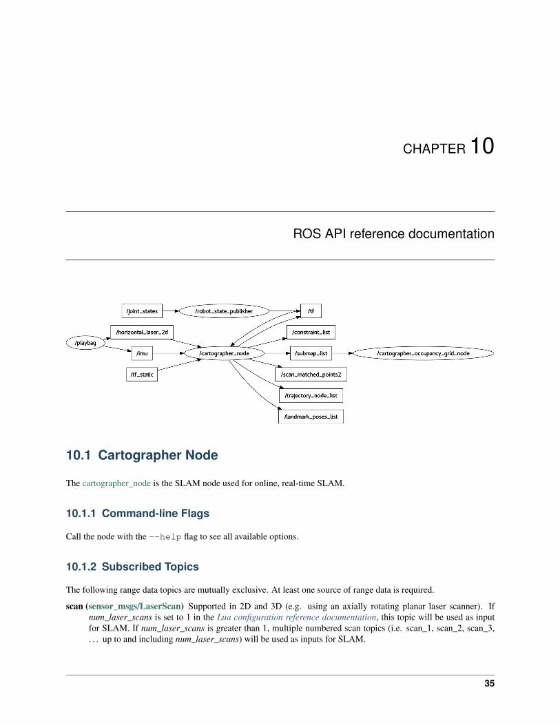
10.1 Cartographer Node
The cartographer_node is the SLAM node used for online, real-time SLAM.
10.1.1 Command-line Flags
Call the node with the --help flag to see all available options.
10.1.2 Subscribed Topics
The following range data topics are mutually exclusive. At least one source of range data is required.
scan (sensor_msgs/LaserScan) Supported in 2D and 3D (e.g. using an axially rotating planar laser scanner). Ifnum_laser_scans is set to 1 in the Lua configuration reference documentation, this topic will be used as inputfor SLAM. If num_laser_scans is greater than 1, multiple numbered scan topics (i.e. scan_1, scan_2, scan_3,. . . up to and including num_laser_scans) will be used as inputs for SLAM.
35
Cartographer ROS Documentation
echoes (sensor_msgs/MultiEchoLaserScan) Supported in 2D and 3D (e.g. using an axially rotating planar laserscanner). If num_multi_echo_laser_scans is set to 1 in the Lua configuration reference documentation, thistopic will be used as input for SLAM. Only the first echo is used. If num_multi_echo_laser_scans is greaterthan 1, multiple numbered echoes topics (i.e. echoes_1, echoes_2, echoes_3, . . . up to and includingnum_multi_echo_laser_scans) will be used as inputs for SLAM.
points2 (sensor_msgs/PointCloud2) If num_point_clouds is set to 1 in the Lua configuration reference documen-tation, this topic will be used as input for SLAM. If num_point_clouds is greater than 1, multiple numberedpoints2 topics (i.e. points2_1, points2_2, points2_3, . . . up to and including num_point_clouds) will be used asinputs for SLAM.
The following additional sensor data topics may also be provided:
imu (sensor_msgs/Imu) Supported in 2D (optional) and 3D (required). This topic will be used as input for SLAM.
odom (nav_msgs/Odometry) Supported in 2D (optional) and 3D (optional). If use_odometry is enabled in the Luaconfiguration reference documentation, this topic will be used as input for SLAM.
10.1.3 Published Topics
scan_matched_points2 (sensor_msgs/PointCloud2) Point cloud as it was used for the purpose of scan-to-submapmatching. This cloud may be both filtered and projected depending on the Lua configuration reference docu-mentation.
submap_list (cartographer_ros_msgs/SubmapList) List of all submaps, including the pose and latest version num-ber of each submap, across all trajectories.
10.1.4 Services
All services responses include also a StatusResponse that comprises a code and a message field. For consis-tency, the integer code is equivalent to the status codes used in the gRPC API.
submap_query (cartographer_ros_msgs/SubmapQuery) Fetches the requested submap.
start_trajectory (cartographer_ros_msgs/StartTrajectory) Starts another trajectory by specifying its sensortopics and trajectory options as an binary-encoded proto. Returns an assigned trajectory ID. Thestart_trajectory executable provides a convenient wrapper to use this service.
finish_trajectory (cartographer_ros_msgs/FinishTrajectory) Finishes the given trajectory_id’s trajectory by run-ning a final optimization.
write_state (cartographer_ros_msgs/WriteState) Writes the current internal state to disk into filename. The filewill usually end up in ~/.ros or ROS_HOME if it is set. This file can be used as input to the assets_writer_mainto generate assets like probability grids, X-Rays or PLY files.
get_trajectory_states (cartographer_ros_msgs/GetTrajectoryStates) Returns the IDs and the states of the trajec-tories. For example, this can be useful to observe the state of Cartographer from a separate node.
read_metrics (cartographer_ros_msgs/ReadMetrics) Returns the latest values of all internal metrics of Cartogra-pher. The collection of runtime metrics is optional and has to be activated with the --collect_metricscommand line flag in the node.
36 Chapter 10. ROS API reference documentation
Cartographer ROS Documentation
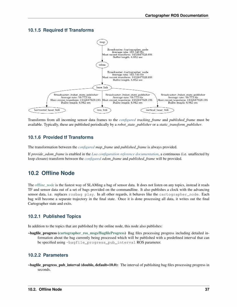
10.1.5 Required tf Transforms
Transforms from all incoming sensor data frames to the configured tracking_frame and published_frame must beavailable. Typically, these are published periodically by a robot_state_publisher or a static_transform_publisher.
10.1.6 Provided tf Transforms
The transformation between the configured map_frame and published_frame is always provided.
If provide_odom_frame is enabled in the Lua configuration reference documentation, a continuous (i.e. unaffected byloop closure) transform between the configured odom_frame and published_frame will be provided.
10.2 Offline Node
The offline_node is the fastest way of SLAMing a bag of sensor data. It does not listen on any topics, instead it readsTF and sensor data out of a set of bags provided on the commandline. It also publishes a clock with the advancingsensor data, i.e. replaces rosbag play. In all other regards, it behaves like the cartographer_node. Eachbag will become a separate trajectory in the final state. Once it is done processing all data, it writes out the finalCartographer state and exits.
10.2.1 Published Topics
In addition to the topics that are published by the online node, this node also publishes:
~bagfile_progress (cartographer_ros_msgs/BagfileProgress) Bag files processing progress including detailed in-formation about the bag currently being processed which will be published with a predefined interval that canbe specified using ~bagfile_progress_pub_interval ROS parameter.
10.2.2 Parameters
~bagfile_progress_pub_interval (double, default=10.0): The interval of publishing bag files processing progress inseconds.
10.2. Offline Node 37
Cartographer ROS Documentation
10.3 Occupancy grid Node
The occupancy_grid_node listens to the submaps published by SLAM, builds an ROS occupancy_grid out of themand publishes it. This tool is useful to keep old nodes that require a single monolithic map to work happy until newnav stacks can deal with Cartographer’s submaps directly. Generating the map is expensive and slow, so map updatesare in the order of seconds. You can can selectively include/exclude submaps from frozen (static) or active trajectorieswith a command line option. Call the node with the --help flag to see these options.
10.3.1 Subscribed Topics
It subscribes to Cartographer’s submap_list topic only.
10.3.2 Published Topics
map (nav_msgs/OccupancyGrid) If subscribed to, the node will continuously compute and publish the map. Thetime between updates will increase with the size of the map. For faster updates, use the submaps APIs.
10.4 Pbstream Map Publisher Node
The pbstream_map_publisher is a simple node that creates a static occupancy grid out of a serialized Cartographerstate (pbstream format). It is an efficient alternative to the occupancy grid node if live updates are not important.
10.4.1 Subscribed Topics
None.
10.4.2 Published Topics
map (nav_msgs/OccupancyGrid) The published occupancy grid topic is latched.
38 Chapter 10. ROS API reference documentation
CHAPTER 11
Public Data
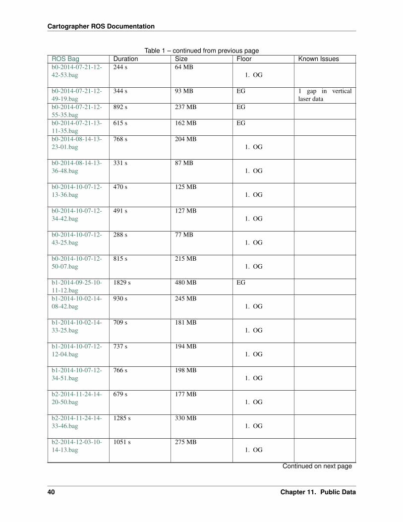
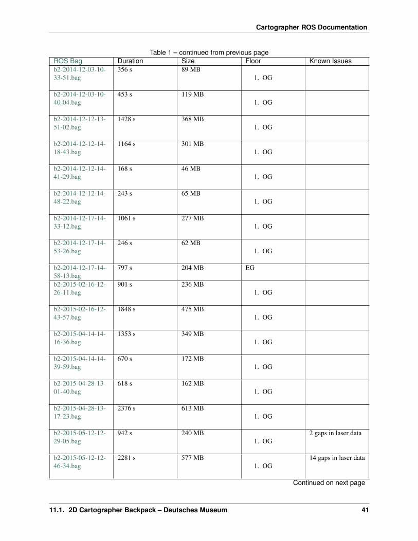
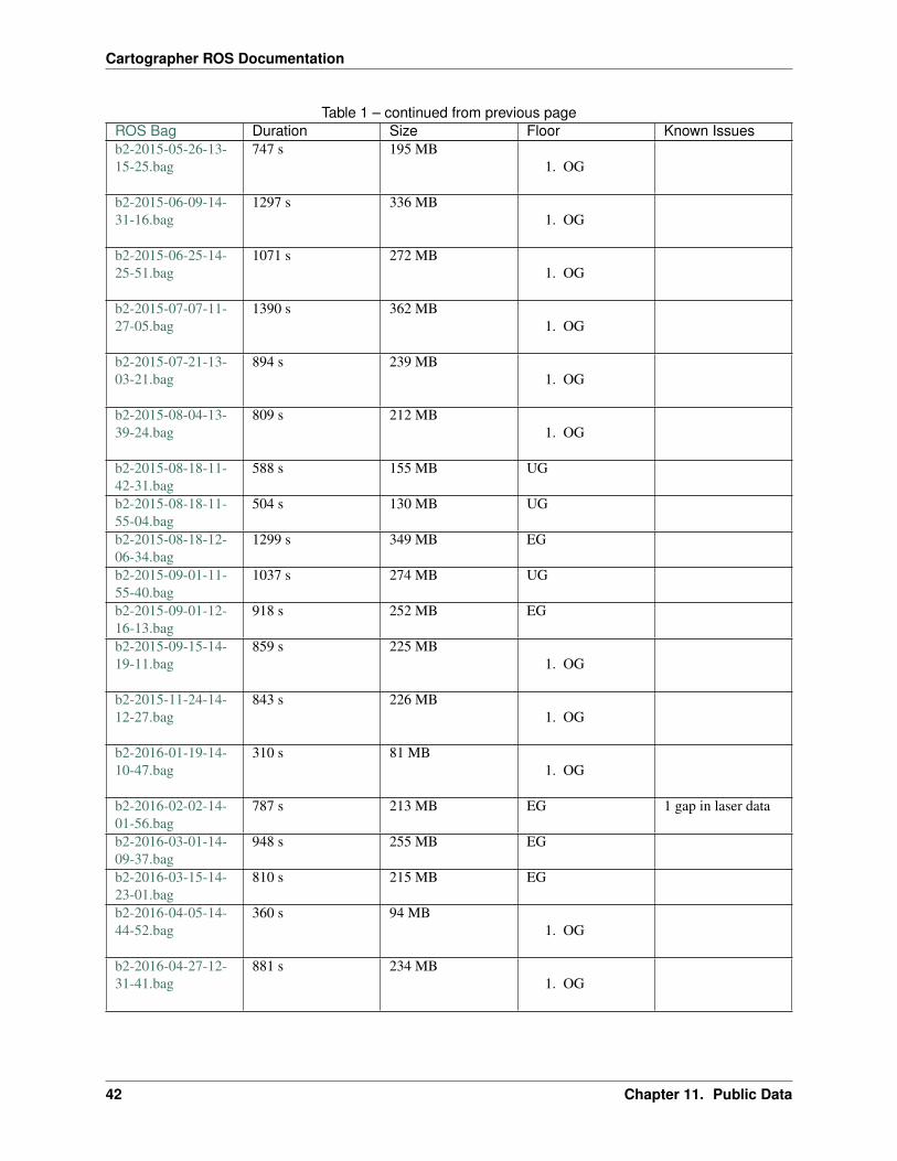
11.1 2D Cartographer Backpack – Deutsches Museum
This data was collected using a 2D LIDAR backpack at the Deutsches Museum. Each bag contains data from an IMU,data from a horizontal LIDAR intended for 2D SLAM, and data from an additional vertical (i.e. push broom) LIDAR.
11.1.1 License
Copyright 2016 The Cartographer Authors
Licensed under the Apache License, Version 2.0 (the “License”); you may not use this file except in compliance withthe License. You may obtain a copy of the License at
http://www.apache.org/licenses/LICENSE-2.0
Unless required by applicable law or agreed to in writing, software distributed under the License is distributed on an“AS IS” BASIS, WITHOUT WARRANTIES OR CONDITIONS OF ANY KIND, either express or implied. See theLicense for the specific language governing permissions and limitations under the License.
11.1.2 Data
ROS Bag Duration Size Floor Known Issuesb0-2014-07-11-10-58-16.bag
149 s 38 MB1. OG
b0-2014-07-11-11-00-49.bag
513 s 135 MB1. OG
Continued on next page
39
Cartographer ROS Documentation
Table 1 – continued from previous pageROS Bag Duration Size Floor Known Issuesb0-2014-07-21-12-42-53.bag
244 s 64 MB1. OG
b0-2014-07-21-12-49-19.bag
344 s 93 MB EG 1 gap in verticallaser data
b0-2014-07-21-12-55-35.bag
892 s 237 MB EG
b0-2014-07-21-13-11-35.bag
615 s 162 MB EG
b0-2014-08-14-13-23-01.bag
768 s 204 MB1. OG
b0-2014-08-14-13-36-48.bag
331 s 87 MB1. OG
b0-2014-10-07-12-13-36.bag
470 s 125 MB1. OG
b0-2014-10-07-12-34-42.bag
491 s 127 MB1. OG
b0-2014-10-07-12-43-25.bag
288 s 77 MB1. OG
b0-2014-10-07-12-50-07.bag
815 s 215 MB1. OG
b1-2014-09-25-10-11-12.bag
1829 s 480 MB EG
b1-2014-10-02-14-08-42.bag
930 s 245 MB1. OG
b1-2014-10-02-14-33-25.bag
709 s 181 MB1. OG
b1-2014-10-07-12-12-04.bag
737 s 194 MB1. OG
b1-2014-10-07-12-34-51.bag
766 s 198 MB1. OG
b2-2014-11-24-14-20-50.bag
679 s 177 MB1. OG
b2-2014-11-24-14-33-46.bag
1285 s 330 MB1. OG
b2-2014-12-03-10-14-13.bag
1051 s 275 MB1. OG
Continued on next page
40 Chapter 11. Public Data
Cartographer ROS Documentation
Table 1 – continued from previous pageROS Bag Duration Size Floor Known Issuesb2-2014-12-03-10-33-51.bag
356 s 89 MB1. OG
b2-2014-12-03-10-40-04.bag
453 s 119 MB1. OG
b2-2014-12-12-13-51-02.bag
1428 s 368 MB1. OG
b2-2014-12-12-14-18-43.bag
1164 s 301 MB1. OG
b2-2014-12-12-14-41-29.bag
168 s 46 MB1. OG
b2-2014-12-12-14-48-22.bag
243 s 65 MB1. OG
b2-2014-12-17-14-33-12.bag
1061 s 277 MB1. OG
b2-2014-12-17-14-53-26.bag
246 s 62 MB1. OG
b2-2014-12-17-14-58-13.bag
797 s 204 MB EG
b2-2015-02-16-12-26-11.bag
901 s 236 MB1. OG
b2-2015-02-16-12-43-57.bag
1848 s 475 MB1. OG
b2-2015-04-14-14-16-36.bag
1353 s 349 MB1. OG
b2-2015-04-14-14-39-59.bag
670 s 172 MB1. OG
b2-2015-04-28-13-01-40.bag
618 s 162 MB1. OG
b2-2015-04-28-13-17-23.bag
2376 s 613 MB1. OG
b2-2015-05-12-12-29-05.bag
942 s 240 MB1. OG
2 gaps in laser data
b2-2015-05-12-12-46-34.bag
2281 s 577 MB1. OG
14 gaps in laser data
Continued on next page
11.1. 2D Cartographer Backpack – Deutsches Museum 41
Cartographer ROS Documentation
Table 1 – continued from previous pageROS Bag Duration Size Floor Known Issuesb2-2015-05-26-13-15-25.bag
747 s 195 MB1. OG
b2-2015-06-09-14-31-16.bag
1297 s 336 MB1. OG
b2-2015-06-25-14-25-51.bag
1071 s 272 MB1. OG
b2-2015-07-07-11-27-05.bag
1390 s 362 MB1. OG
b2-2015-07-21-13-03-21.bag
894 s 239 MB1. OG
b2-2015-08-04-13-39-24.bag
809 s 212 MB1. OG
b2-2015-08-18-11-42-31.bag
588 s 155 MB UG
b2-2015-08-18-11-55-04.bag
504 s 130 MB UG
b2-2015-08-18-12-06-34.bag
1299 s 349 MB EG
b2-2015-09-01-11-55-40.bag
1037 s 274 MB UG
b2-2015-09-01-12-16-13.bag
918 s 252 MB EG
b2-2015-09-15-14-19-11.bag
859 s 225 MB1. OG
b2-2015-11-24-14-12-27.bag
843 s 226 MB1. OG
b2-2016-01-19-14-10-47.bag
310 s 81 MB1. OG
b2-2016-02-02-14-01-56.bag
787 s 213 MB EG 1 gap in laser data
b2-2016-03-01-14-09-37.bag
948 s 255 MB EG
b2-2016-03-15-14-23-01.bag
810 s 215 MB EG
b2-2016-04-05-14-44-52.bag
360 s 94 MB1. OG
b2-2016-04-27-12-31-41.bag
881 s 234 MB1. OG
42 Chapter 11. Public Data
Cartographer ROS Documentation
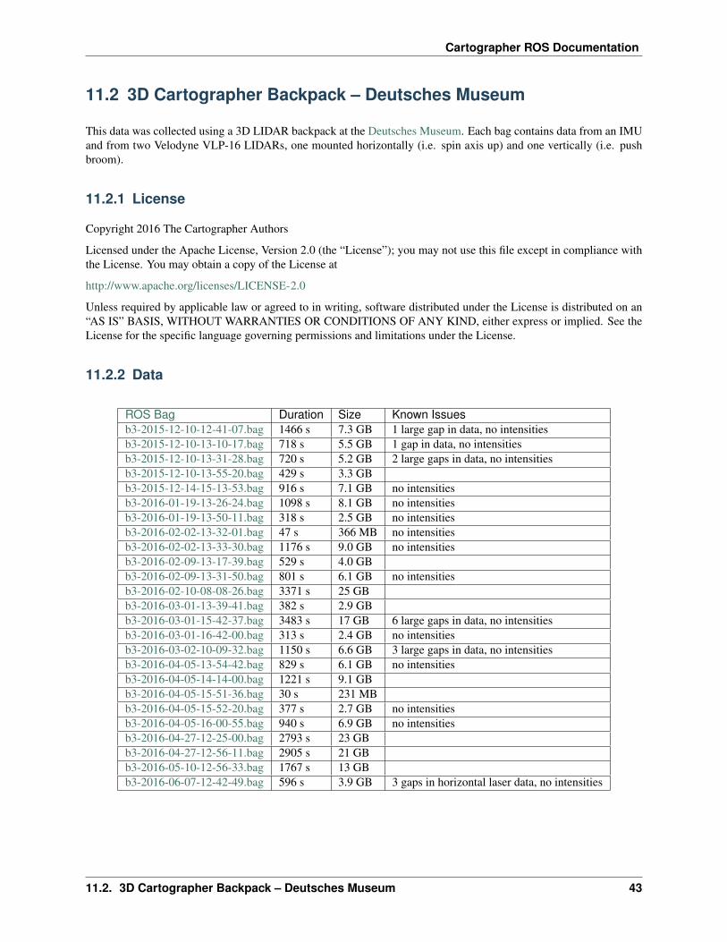
11.2 3D Cartographer Backpack – Deutsches Museum
This data was collected using a 3D LIDAR backpack at the Deutsches Museum. Each bag contains data from an IMUand from two Velodyne VLP-16 LIDARs, one mounted horizontally (i.e. spin axis up) and one vertically (i.e. pushbroom).
11.2.1 License
Copyright 2016 The Cartographer Authors
Licensed under the Apache License, Version 2.0 (the “License”); you may not use this file except in compliance withthe License. You may obtain a copy of the License at
http://www.apache.org/licenses/LICENSE-2.0
Unless required by applicable law or agreed to in writing, software distributed under the License is distributed on an“AS IS” BASIS, WITHOUT WARRANTIES OR CONDITIONS OF ANY KIND, either express or implied. See theLicense for the specific language governing permissions and limitations under the License.
11.2.2 Data
ROS Bag Duration Size Known Issuesb3-2015-12-10-12-41-07.bag 1466 s 7.3 GB 1 large gap in data, no intensitiesb3-2015-12-10-13-10-17.bag 718 s 5.5 GB 1 gap in data, no intensitiesb3-2015-12-10-13-31-28.bag 720 s 5.2 GB 2 large gaps in data, no intensitiesb3-2015-12-10-13-55-20.bag 429 s 3.3 GBb3-2015-12-14-15-13-53.bag 916 s 7.1 GB no intensitiesb3-2016-01-19-13-26-24.bag 1098 s 8.1 GB no intensitiesb3-2016-01-19-13-50-11.bag 318 s 2.5 GB no intensitiesb3-2016-02-02-13-32-01.bag 47 s 366 MB no intensitiesb3-2016-02-02-13-33-30.bag 1176 s 9.0 GB no intensitiesb3-2016-02-09-13-17-39.bag 529 s 4.0 GBb3-2016-02-09-13-31-50.bag 801 s 6.1 GB no intensitiesb3-2016-02-10-08-08-26.bag 3371 s 25 GBb3-2016-03-01-13-39-41.bag 382 s 2.9 GBb3-2016-03-01-15-42-37.bag 3483 s 17 GB 6 large gaps in data, no intensitiesb3-2016-03-01-16-42-00.bag 313 s 2.4 GB no intensitiesb3-2016-03-02-10-09-32.bag 1150 s 6.6 GB 3 large gaps in data, no intensitiesb3-2016-04-05-13-54-42.bag 829 s 6.1 GB no intensitiesb3-2016-04-05-14-14-00.bag 1221 s 9.1 GBb3-2016-04-05-15-51-36.bag 30 s 231 MBb3-2016-04-05-15-52-20.bag 377 s 2.7 GB no intensitiesb3-2016-04-05-16-00-55.bag 940 s 6.9 GB no intensitiesb3-2016-04-27-12-25-00.bag 2793 s 23 GBb3-2016-04-27-12-56-11.bag 2905 s 21 GBb3-2016-05-10-12-56-33.bag 1767 s 13 GBb3-2016-06-07-12-42-49.bag 596 s 3.9 GB 3 gaps in horizontal laser data, no intensities
11.2. 3D Cartographer Backpack – Deutsches Museum 43
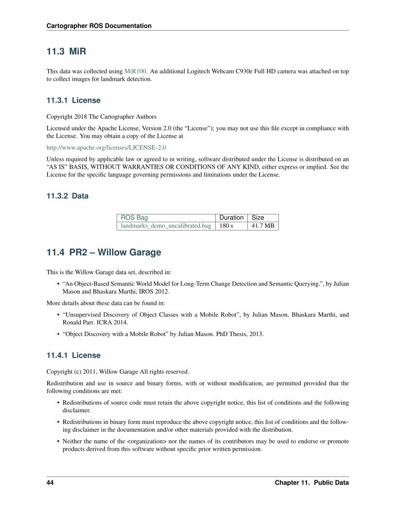
Cartographer ROS Documentation
11.3 MiR
This data was collected using MiR100. An additional Logitech Webcam C930e Full HD camera was attached on topto collect images for landmark detection.
11.3.1 License
Copyright 2018 The Cartographer Authors
Licensed under the Apache License, Version 2.0 (the “License”); you may not use this file except in compliance withthe License. You may obtain a copy of the License at
http://www.apache.org/licenses/LICENSE-2.0
Unless required by applicable law or agreed to in writing, software distributed under the License is distributed on an“AS IS” BASIS, WITHOUT WARRANTIES OR CONDITIONS OF ANY KIND, either express or implied. See theLicense for the specific language governing permissions and limitations under the License.
11.3.2 Data
ROS Bag Duration Sizelandmarks_demo_uncalibrated.bag 180 s 41.7 MB
11.4 PR2 – Willow Garage
This is the Willow Garage data set, described in:
• “An Object-Based Semantic World Model for Long-Term Change Detection and Semantic Querying.”, by JulianMason and Bhaskara Marthi, IROS 2012.
More details about these data can be found in:
• “Unsupervised Discovery of Object Classes with a Mobile Robot”, by Julian Mason, Bhaskara Marthi, andRonald Parr. ICRA 2014.
• “Object Discovery with a Mobile Robot” by Julian Mason. PhD Thesis, 2013.
11.4.1 License
Copyright (c) 2011, Willow Garage All rights reserved.
Redistribution and use in source and binary forms, with or without modification, are permitted provided that thefollowing conditions are met:
• Redistributions of source code must retain the above copyright notice, this list of conditions and the followingdisclaimer.
• Redistributions in binary form must reproduce the above copyright notice, this list of conditions and the follow-ing disclaimer in the documentation and/or other materials provided with the distribution.
• Neither the name of the <organization> nor the names of its contributors may be used to endorse or promoteproducts derived from this software without specific prior written permission.
44 Chapter 11. Public Data
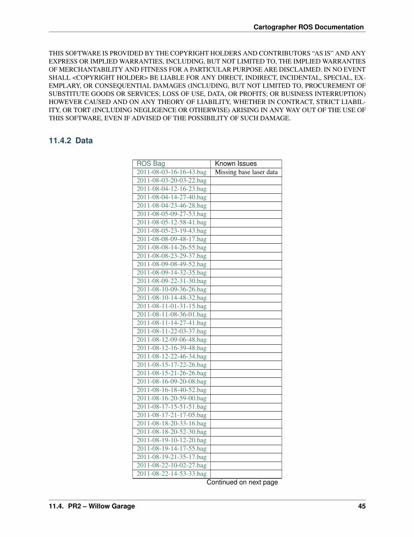
Cartographer ROS Documentation
THIS SOFTWARE IS PROVIDED BY THE COPYRIGHT HOLDERS AND CONTRIBUTORS “AS IS” AND ANYEXPRESS OR IMPLIED WARRANTIES, INCLUDING, BUT NOT LIMITED TO, THE IMPLIED WARRANTIESOF MERCHANTABILITY AND FITNESS FOR A PARTICULAR PURPOSE ARE DISCLAIMED. IN NO EVENTSHALL <COPYRIGHT HOLDER> BE LIABLE FOR ANY DIRECT, INDIRECT, INCIDENTAL, SPECIAL, EX-EMPLARY, OR CONSEQUENTIAL DAMAGES (INCLUDING, BUT NOT LIMITED TO, PROCUREMENT OFSUBSTITUTE GOODS OR SERVICES; LOSS OF USE, DATA, OR PROFITS; OR BUSINESS INTERRUPTION)HOWEVER CAUSED AND ON ANY THEORY OF LIABILITY, WHETHER IN CONTRACT, STRICT LIABIL-ITY, OR TORT (INCLUDING NEGLIGENCE OR OTHERWISE) ARISING IN ANY WAY OUT OF THE USE OFTHIS SOFTWARE, EVEN IF ADVISED OF THE POSSIBILITY OF SUCH DAMAGE.
11.4.2 Data
ROS Bag Known Issues2011-08-03-16-16-43.bag Missing base laser data2011-08-03-20-03-22.bag2011-08-04-12-16-23.bag2011-08-04-14-27-40.bag2011-08-04-23-46-28.bag2011-08-05-09-27-53.bag2011-08-05-12-58-41.bag2011-08-05-23-19-43.bag2011-08-08-09-48-17.bag2011-08-08-14-26-55.bag2011-08-08-23-29-37.bag2011-08-09-08-49-52.bag2011-08-09-14-32-35.bag2011-08-09-22-31-30.bag2011-08-10-09-36-26.bag2011-08-10-14-48-32.bag2011-08-11-01-31-15.bag2011-08-11-08-36-01.bag2011-08-11-14-27-41.bag2011-08-11-22-03-37.bag2011-08-12-09-06-48.bag2011-08-12-16-39-48.bag2011-08-12-22-46-34.bag2011-08-15-17-22-26.bag2011-08-15-21-26-26.bag2011-08-16-09-20-08.bag2011-08-16-18-40-52.bag2011-08-16-20-59-00.bag2011-08-17-15-51-51.bag2011-08-17-21-17-05.bag2011-08-18-20-33-16.bag2011-08-18-20-52-30.bag2011-08-19-10-12-20.bag2011-08-19-14-17-55.bag2011-08-19-21-35-17.bag2011-08-22-10-02-27.bag2011-08-22-14-53-33.bag
Continued on next page
11.4. PR2 – Willow Garage 45
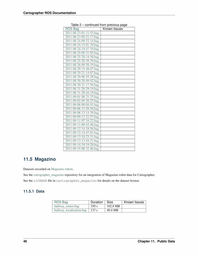
Cartographer ROS Documentation
Table 2 – continued from previous pageROS Bag Known Issues2011-08-23-01-11-53.bag2011-08-23-09-21-17.bag2011-08-24-09-52-14.bag2011-08-24-15-01-39.bag2011-08-24-19-47-10.bag2011-08-25-09-31-05.bag2011-08-25-20-14-56.bag2011-08-25-20-38-39.bag2011-08-26-09-58-19.bag2011-08-29-15-48-07.bag2011-08-29-21-14-07.bag2011-08-30-08-55-28.bag2011-08-30-20-49-42.bag2011-08-30-21-17-56.bag2011-08-31-20-29-19.bag2011-08-31-20-44-19.bag2011-09-01-08-21-33.bag2011-09-02-09-20-25.bag2011-09-06-09-04-41.bag2011-09-06-13-20-36.bag2011-09-08-13-14-39.bag2011-09-09-13-22-57.bag2011-09-11-07-34-22.bag2011-09-11-09-43-46.bag2011-09-12-14-18-56.bag2011-09-12-14-47-01.bag2011-09-13-10-23-31.bag2011-09-13-13-44-21.bag2011-09-14-10-19-20.bag2011-09-15-08-32-46.bag
11.5 Magazino
Datasets recorded on Magazino robots.
See the cartographer_magazino repository for an integration of Magazino robot data for Cartographer.
See the LICENSE file in cartographer_magazino for details on the dataset license.
11.5.1 Data
ROS Bag Duration Size Known Issueshallway_return.bag 350 s 102.8 MBhallway_localization.bag 137 s 40.4 MB
46 Chapter 11. Public Data
CHAPTER 12
Frequently asked questions
12.1 Why is laser data rate in the 3D bags higher than the maximumreported 20 Hz rotation speed of the VLP-16?
The VLP-16 in the example bags is configured to rotate at 20 Hz. However, the frequency of UDP packets the VLP-16sends is much higher and independent of the rotation frequency. The example bags contain a sensor_msgs/PointCloud2per UDP packet, not one per revolution.
In the corresponding Cartographer configuration file you see TRAJECTORY_BUILDER_3D.num_accumulated_range_data= 160 which means we accumulate 160 per-UDP-packet point clouds into one larger point cloud, which incorporatesmotion estimation by combining constant velocity and IMU measurements, for matching. Since there are twoVLP-16s, 160 UDP packets is enough for roughly 2 revolutions, one per VLP-16.
12.2 Why is IMU data required for 3D SLAM but not for 2D?
In 2D, Cartographer supports running the correlative scan matcher, which is normally used for finding loop closureconstraints, for local SLAM. It is computationally expensive but can often render the incorporation of odometry orIMU data unnecessary. 2D also has the benefit of assuming a flat world, i.e. up is implicitly defined.
In 3D, an IMU is required mainly for measuring gravity. Gravity is an attractive quantity to measure since it does notdrift and is a very strong signal and typically comprises most of any measured accelerations. Gravity is needed for tworeasons:
1. There are no assumptions about the world in 3D. To properly world align the resulting trajectory and map, gravityis used to define the z-direction.
2. Roll and pitch can be derived quite well from IMU readings once the direction of gravity has been established. Thissaves work for the scan matcher by reducing the search window in these dimensions.
47
Cartographer ROS Documentation
12.3 How do I build cartographer_ros without rviz support?
The simplest solution is to create an empty file named CATKIN_IGNORE in the cartographer_rviz package directory.
12.4 How do I fix the “You called InitGoogleLogging() twice!” error?
Building rosconsole with the glog back end can lead to this error. Use the log4cxx or print back end, selectable via theROSCONSOLE_BACKEND CMake argument, to avoid this issue.
48 Chapter 12. Frequently asked questions