an american cartographer in egypt
DESCRIPTION
I visit Egypt to learn about its cultural geography and to see disputed islands in the Red Sea.TRANSCRIPT
38 ACSM BULLETIN JUNE 2008
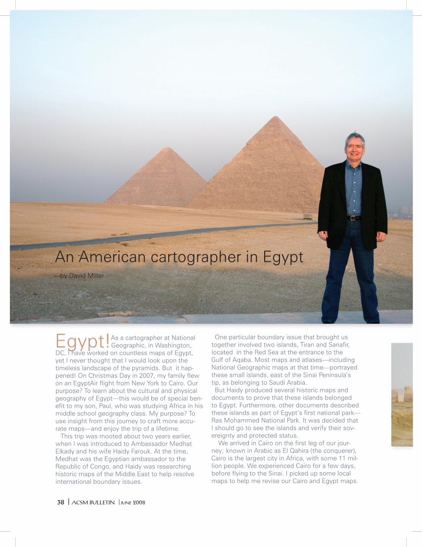
Egypt! As a cartographer at National Geographic, in Washington,
DC, I have worked on countless maps of Egypt, yet I never thought that I would look upon the timeless landscape of the pyramids. But it hap-pened! On Christmas Day in 2007, my family flew on an EgyptAir flight from New York to Cairo. Our purpose? To learn about the cultural and physical geography of Egypt—this would be of special ben-efit to my son, Paul, who was studying Africa in his middle school geography class. My purpose? To use insight from this journey to craft more accu-rate maps—and enjoy the trip of a lifetime. This trip was mooted about two years earlier, when I was introduced to Ambassador Medhat Elkady and his wife Haidy Farouk. At the time, Medhat was the Egyptian ambassador to the Republic of Congo, and Haidy was researching historic maps of the Middle East to help resolve international boundary issues.
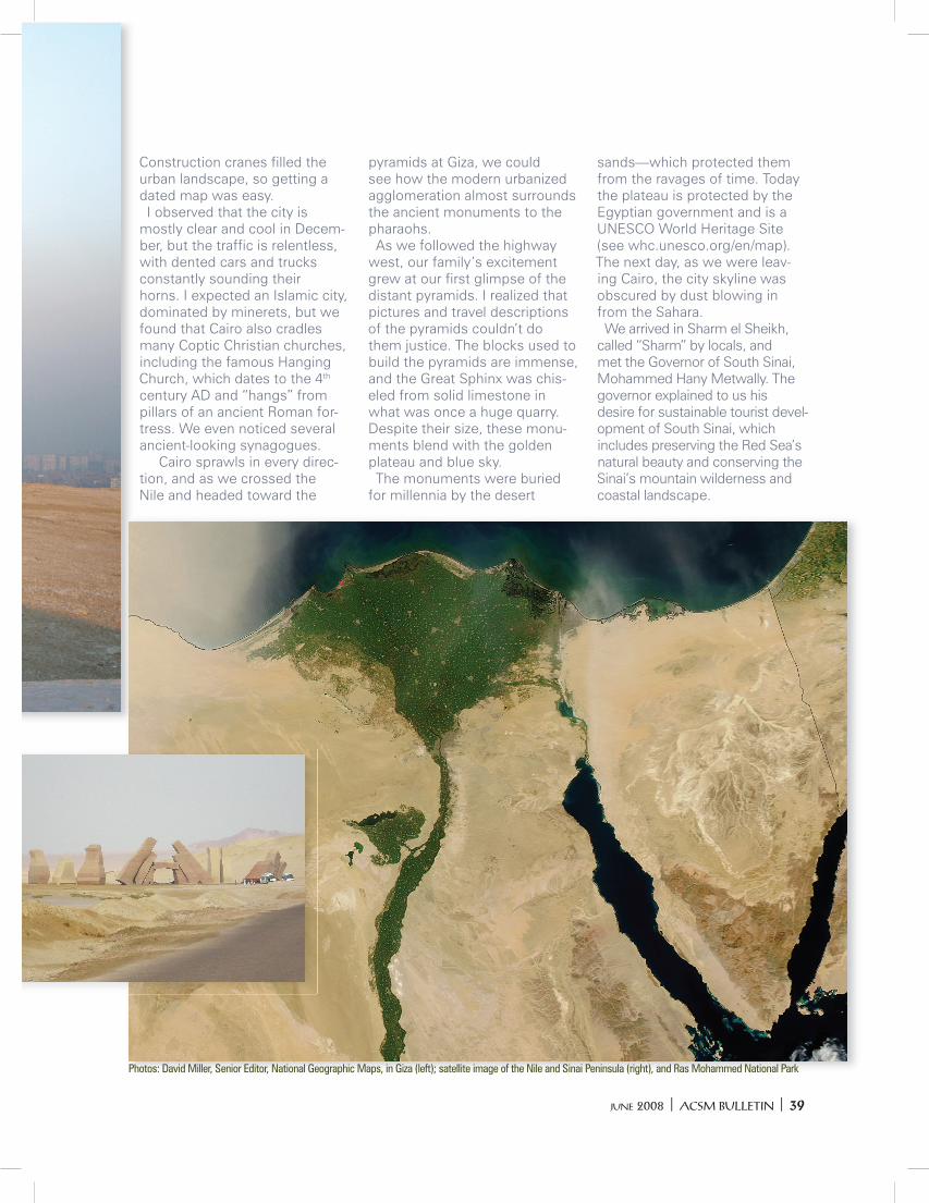
One particular boundary issue that brought us together involved two islands, Tiran and Sanafir, located in the Red Sea at the entrance to the Gulf of Aqaba. Most maps and atlases—including National Geographic maps at that time—portrayed these small islands, east of the Sinai Peninsula’s tip, as belonging to Saudi Arabia. But Haidy produced several historic maps and documents to prove that these islands belonged to Egypt. Furthermore, other documents described these islands as part of Egypt’s first national park—Ras Mohammed National Park. It was decided that I should go to see the islands and verify their sov-ereignty and protected status. We arrived in Cairo on the first leg of our jour-ney; known in Arabic as El Qahira (the conquerer), Cairo is the largest city in Africa, with some 11 mil-lion people. We experienced Cairo for a few days, before flying to the Sinai. I picked up some local maps to help me revise our Cairo and Egypt maps.
An American cartographer in Egypt —by David Miller
JUNE 2008 ACSM BULLETIN 39
Construction cranes filled the urban landscape, so getting a dated map was easy. I observed that the city is mostly clear and cool in Decem-ber, but the traffic is relentless, with dented cars and trucks constantly sounding their horns. I expected an Islamic city, dominated by minerets, but we found that Cairo also cradles many Coptic Christian churches, including the famous Hanging Church, which dates to the 4th century AD and “hangs” from pillars of an ancient Roman for-tress. We even noticed several ancient-looking synagogues. Cairo sprawls in every direc-tion, and as we crossed the Nile and headed toward the
pyramids at Giza, we could see how the modern urbanized agglomeration almost surrounds the ancient monuments to the pharaohs. As we followed the highway west, our family’s excitement grew at our first glimpse of the distant pyramids. I realized that pictures and travel descriptions of the pyramids couldn’t do them justice. The blocks used to build the pyramids are immense, and the Great Sphinx was chis-eled from solid limestone in what was once a huge quarry. Despite their size, these monu-ments blend with the golden plateau and blue sky. The monuments were buried for millennia by the desert
sands—which protected them from the ravages of time. Today the plateau is protected by the Egyptian government and is a UNESCO World Heritage Site (see whc.unesco.org/en/map). The next day, as we were leav-ing Cairo, the city skyline was obscured by dust blowing in from the Sahara. We arrived in Sharm el Sheikh, called “Sharm” by locals, and met the Governor of South Sinai, Mohammed Hany Metwally. The governor explained to us his desire for sustainable tourist devel-opment of South Sinai, which includes preserving the Red Sea’s natural beauty and conserving the Sinai’s mountain wilderness and coastal landscape.
Photos: David Miller, Senior Editor, National Geographic Maps, in Giza (left); satellite image of the Nile and Sinai Peninsula (right), and Ras Mohammed National Park
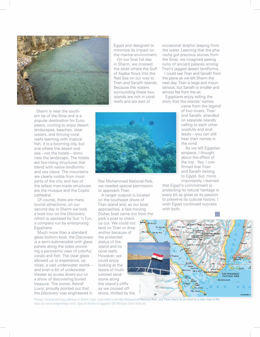
occasional dolphin leaping from the water. Learning that the pha-raohs got precious stones from the Sinai, we imagined seeing ruins of ancient palaces among Tiran’s jagged desert landforms. I could see Tiran and Sanafir from the plane as we left Sharm the next day. Tiran is large and moun-tainous, but Sanafir is smaller and almost flat from the air. Egyptians enjoy telling the story that the islands’ names
came from the legend of two lovers, Tiran and Sanafir, stranded on separate islands calling to each other woefully and end-lessly—you can still hear their names in the wind. As we left Egyptian airspace, I thought about the effect of the trip. Yes, I con-firmed that Tiran and Sanafir belong to Egypt, but, more importantly, I learned
that Egypt’s commitment to protecting its natural heritage is every bit as great as its passion to preserve its cultural history. I wish Egypt continued success with both.
Photos: Coral-protecting walkway in Sharm (top), coral reefs in the Ras Mohammed National Park, and Tiran island as an inset on a new map of the Sinai [at www.natgeomaps.com]. Special thanks to Egyptian GIS Minister Omar Soliman.
Sharm is near the south-ern tip of the Sinai and is a popular destination for Euro-peans, coming to enjoy desert landscapes, beaches, clear waters, and thriving coral reefs teeming with tropical fish. It is a booming city, but one where the desert and sea—not the hotels—domi-nate the landscape. The hotels are low-rising structures that blend with native landforms and sea views. The mountains are clearly visible from most parts of the city, and two of the tallest man-made structures are the mosque and the Coptic cathedral. Of course, there are many tourist attractions; on our second day in Sharm we took a boat tour on the Discovery, which is operated by Sun ‘n Fun, a company run by enterprising Egyptians. Much more than a standard glass bottom boat, the Discovery is a semi-submersible with glass panels along the sides provid-ing a panoramic view of colorful corals and fish. The clear glass allowed us to experience, up close, a vast underwater world—and even a bit of underwater theater as scuba divers put on a show of discovering buried treasure. The owner, Ashraf Luxor, proudly pointed out that the Discovery was engineered in
Egypt and designed to minimize its impact on the marine environment. On our final full day in Sharm, we crossed the strait where the Gulf of Aqaba flows into the Red Sea on our way to Tiran and Sanafir islands. Because the waters surrounding these two islands are rich in coral reefs and are part of
Ras Mohammed National Park, we needed special permission to approach Tiran. A ranger outpost is located on the southeast shore of Tiran island and, as our boat approached, a fast-moving Zodiac boat came out from the park’s post to check us out. We could not land on Tiran or drop anchor because of the protected status of the island and its coral reefs. However, we could enjoy looking at the layers of multi-colored sand-stone along the island’s cliffs as we cruised off-shore, thrilled by the
Photos: Coral-protecting walkway in Sharm (top), coral reefs in the Ras Mohammed National Park, and Tiran island as an inset on a new map of the