carlo fezzi and ian j. bateman cserge school of ...ageconsearch.umn.edu/bitstream/51423/2/land use...
TRANSCRIPT

1
Structural Agricultural Land Use Modelling
Carlo Fezzi and Ian J. Bateman CSERGE
School of Environmental Sciences,
University of East Anglia, Norwich, NR4 7TJ, UK.
[email protected] , [email protected]
Contributed Paper prepared for presentation at the International Association of
Agricultural Economists Conference, Beijing, China, August 16-22, 2009
Copyright 2009 by Carlo Fezzi and Ian J. Bateman. All rights reserved. Readers may make
verbatim copies of this document for non-commercial purposes by any means, provided that
this copyright notice appears on all such copies.

2
Abstract
This paper develops a structural econometric model of agricultural land use and production based on
the joint multi-output technology representation introduced by Chambers and Just (1989). Starting
from a flexible specification of the farm profit function we derive land use allocation, input
applications, crops yield and livestock number equations in a joint and theoretically consistent
framework. We present an empirical application using fine-scale spatial data covering the entirety of
England and Wales and including the main economic, policy and environmental drivers of land use
change in the past 40 years. To account for the presence of censored observations in this micro-level
data we estimate the model as a system of two-limits Tobit equations via Quasi-Maximum
Likelihood. We finally compare the forecasting ability of our approach against an established
benchmark: the land use share logit model.
JEL classification: Q15, Q53, C34.
Keywords: Land Use, Structural Econometric Modelling, Agro-Environmental Policy, System of
Censored Equations, Multivariate Tobit, Quasi-Maximum Likelihood.

3
Quantifying the response of agricultural land use and production to changes in market conditions,
policies and environmental factors has fundamental economic and policy relevance. Agricultural land
use decisions, whilst private, have often significant public implications, generating both external
costs, such as non-point pollution, changes to wildlife habitats, deforestation and wetland degradation,
and external benefits, like the provision of recreational opportunities and biodiversity. The study of
the causes of agricultural land use change and its effect on the environment have motivated a wide
spectrum of applied economic analyses, encouraging the development of empirical land use models
estimated on spatially explicit data (for recent reviews see Irwin and Geoghegan, 2001; Plantinga and
Irwin, 2006). The framework proposed here diverges from previous econometric models of land use.
Rather than developing a reduced form, empirical approach to investigate land use allocation choices,
the present paper places agricultural land use decisions in a theoretically consistent, econometric
structure including also crop and livestock production, input applications and profits. In doing so it
builds upon the dual multi-product profit function approach introduced in Chambers and Just (1989).
Previous econometric land use models
According to the underpinning assumptions and the data required for estimation, econometric land use
models can be classified into two broad categories: (a) parcel models and (b) share models.1 Parcel
models (e.g. Chomitz and Gray, 1996; Wu et al., 2004; Lubowski et al., 2006; Langpap et al. 2008)
require data on the contiguous spatial pattern of land use, typically sampled through geographic
information system (GIS) techniques. Adopting the classic Von Thünen (1826) assumption that land
will be put to the use that maximizes profits, the addition of an appropriate error structure allows
empirical specification as a discrete choice model. This approach considers the decision-making in
each parcel (land data point) as an independent optimization problem. For this reason parcel models
are best suited to the appraisal of broad land use categories, distinguishing, for example, between
agriculture, forestry and urban areas. However, they are less appropriate for analyzing more refined
agricultural land use types, (e.g. modelling choices amongst diverse types of arable crops) where
interdependencies between cultivation decisions in neighbouring fields cannot be ignored. Indeed,
pressures concerning crop rotation, efficient allocation of machinery and labor and the presence of
fixed but allocatable inputs imply that agricultural activities are typically joint in production
(Shumway et al., 1984; Ball, 1988; Chambers and Just, 1989).
Joint production decisions have been investigated via land use share models, introduced by
Lichtenberg (1989) and Wu and Segerson (1995) and further developed by Plantinga (1996),
1 Econometric modelling is only one of the strategies proposed in the literature to analyze land use change. For a
comprehensive review, including also other methodological approaches, see Irwin and Geoghegan (2001).

4
Plantinga et al. (1999), Plantinga and Ahn (2002) and Chakir (2009) amongst others. These
approaches analyze the proportions of different agricultural land uses using data aggregated over
regions or counties. Assuming constant returns to scale allows the researcher to model production
decisions by treating these large areas as unique, macro-farms. In the resulting specification, typically
based on a logistic function, land use shares depend on the environmental and climatic characteristics
of the region and on the prices of all possible outputs and inputs.
These studies have identified the main drivers of agricultural land allocation decisions, capturing that
spatial dimension which is critical to adequately assess the economic and environmental
consequences of land use change (for a review see Plantinga and Irwin, 2006). However, as explicitly
acknowledged in most of these contributions, both parcel and share models are essentially empirical
frameworks, which cannot be related to farm profits or welfare. Furthermore, as they focus solely
upon switches between land use types, they cannot encompass changes in land use intensity, such as
alterations in crop output levels, input application rates (e.g. fertilizer use) and, in particular, changes
in livestock numbers which, if included in the analysis, are considered in a completely separate model
(e.g. Chomitz and Thomas, 2003; Seo and Medelsohn, 2008). However, as emphasized within the
conceptual framework for modelling agro-environmental policies proposed by Just and Antle (1990),
both extensive and intensive margin elasticities are of considerable policy and stakeholder interest
(Arnade and Kelch, 2007) and critical to assess the impact of agricultural production on the
environment. This paper addresses these issues developing a theoretically consistent structural
framework and presenting an empirical application concerning policies to reduce diffuse agricultural
pollution using fine-scale spatial data covering the entirety of England and Wales.
Distinguishing features of this analysis
Compared with the approaches outlined previously, which directly model the land allocation
equations and leave the farm profit function un-specified, this study is distinguished by underpinning
all the analysis on a flexible specification of the profit function itself. As shown in Section 2, this
allow us to derive, in a coherent and structural framework, not only land use decisions, but also input
and output intensities (including both crop yields and livestock numbers) and welfare measures. In
doing so, we build upon farm modelling theory, and in particular on the dual joint (in-inputs) multi-
outputs profit function introduced by Chambers and Just (1989). Our approach is very flexible, and
can be implemented on different types of data, including farm cross-section or panel data, regional
aggregated data, or data sampled at fine-scale spatial resolutions. Approaches based on a flexible
specification of the farm multi-output profit function have been already implemented to model
agricultural production and land allocation decisions (Guyomart et al., 1996; Oude Lansink and

5
Peerlings, 1996; Ball et al., 1997; Sckokai and Moro, 2005; Arnade and Kelch, 2007). However, these
prior contributions are based either on national or on farm level data and, therefore, cannot address the
spatial nature of land use change or include those refined climatic and physical factors which are
crucial in determining the observed pattern of land use and its impact on the environment.
In contrast, our empirical analysis is highly spatially explicit, being implemented on a large panel of
2km2 grid square data covering the entirety of England and Wales, which is discussed in detail in
Section 3. This micro-level data is essential to capture the diversity of climatic and economic drivers
influencing land use change and to adequately assess its environmental consequences (e.g. Just and
Antle, 1990; Chomitz and Thomas, 2003; Wu et al. 2004; Chakir, 2009). The disadvantage of using
such a detailed spatial resolution is that no information on profits is available at this fine-scale. For
this reason, in the present empirical analysis we do not include welfare considerations, focusing
instead upon those equations included in the structural model which deal with land use and livestock
numbers. Since these are the two main determinants of farms’ environmental impact, our empirical
illustration is both a policy relevant analysis and an effective yardstick to compare our strategy against
established, empirically-driven land use modelling approaches.2
Such a fine-scale spatial analysis requires an estimation technique which deals with the presence of
censored observations: a distinguishing feature of micro-level data arising from corner solutions in the
production decisions. Recent contributions have addressed this issue within the analysis of household
demand systems (e.g. Yen et al., 2003; Dong et al., 2004; Meyerhoefer et al., 2005) but, to our
knowledge, censored systems of equations have never been implemented to model land use decisions.
Section 4 presents our empirical model, the estimation technique and the results, comparing the
forecasting performance with that of the established land use share model. Section 5 concludes.
2 As showed, for example, in Arnade and Kelch (2007), whilst an aggregated dataset allows the estimation of
profit and yield equations, it would also reduce the empirical analysis to a mere illustration. Our chosen
approach, therefore, conforms to the exhortations of Just (2000), who advocates using micro-level data in
applied agricultural economic analyses, “rather than continue to demonstrate points and methodology with
aggregate data simply because they are available”.

6
2. The economic framework
The theoretical model
This section illustrates the theoretical framework underpinning our structural land use modelling
strategy, which builds upon the farm profit maximization problem in the presence of fixed allocatable
inputs illustrated by Chambers and Just (1989). For simplicity we consider land to be the only fixed
allocatable input. Furthermore, we indicate with y the vector of m outputs, with r the vector of n
inputs, with p the vector of strictly positive output prices, with w the vector of strictly positive input
prices, with l the vector of h land use allocations, with L the total land available and with z the vector
of k other fixed factors (which may include physical and environmental characteristics, policy
incentives and constraints, etc.). Since we are also considering livestock outputs, we generalize
Chambers and Just (1989) framework allowing the number of possible land uses h to be different
from the number of possible outputs m. The multi-output profit function, given a fixed land allocation
can be written as:
(1) )},...,,,(:max{),...,, 11 hh llYll,,( zryrw'yp'zwp ∈−=π
where Y (r, z, l1, ..., lh) indicates the producible output set for a given land allocation3. This profit
function is positively linearly homogenous and convex in input and output prices. In such a
framework, one can derive the profit maximizing input demand and output supply given a fixed land
allocation via the Hotelling’s lemma (Chambers and Just, 1989). Furthermore, the profit function
associated with the optimal land allocation can be written as:
(2) }:),...,,,,({max),,,(11
,...,1
∑ ===
h
i hhll
LlllLh
zwpzwp ππ .
The farm profit maximization problem can be expressed, without any loss of generality, in terms of
profit maximization per unit of land. Indicating with s the h land use shares corresponding to the land
use allocations l, and with πL(.) the profits per unit of land, we can re-write the optimal land use
allocation problem as:
3 This framework assumes the farmers to be risk neutral. However, empirical analyses (e.g. Chavas and Holt,
1990; Pope and Just, 1991) show that farmers decisions may present some degree of risk aversion. The approach
outlined in this paper is, however, flexible enough to allow departures from risk neutrality. These could be
encompassed following, for instance, Coyle (1999) or Skokai and Moro (2005).

7
(3) }1:),...,,,,,({max),,,(11
,...,1
∑ ===
h
i hh
L
ss
LsssLL
h
zwpzwp ππ .
This expression, whilst written in terms of land use share and profit per area, is equivalent to (2) and
does not assume constant returns to scale. In fact, profit per area is a function of L and, therefore, the
profit-maximizing shares depend on the total land available. Since the profit per area function is
positively linearly homogenous and strictly convex in input and output prices, using the Hotelling’s
lemma one can derive the output supply (yL) and input demand (r
L) per area (hereafter we will refer to
these quantities as input and output intensities) as:
(4.a) i
h
L
i
LL
ip
ssL
p
LLy
∂=
∂
∂=
),...,,,,,(),,,(),,,( 1zwpzwp
zwpππ
, and
(4.b) j
h
L
j
LL
jw
ssL
w
LLr
∂=
∂
∂=
),...,,,,,(),,,(),,,( 1zwpzwp
zwpππ
,
where the superscript on s indicates the optimal shares, i.e. the shares that satisfy (3). The equations
describing the optimal land allocations can be derived by recognizing that land is allocated to the
different uses in order to equalize their marginal rent or shadow prices4. In terms of optimal land use
shares this can be written as:
(5) 0),...,,,,,( 1 =
∂
∂
i
h
L
s
ssLzwpπ, for i = 1,..., h.
When these equations are linear in the optimal land allocations, including the constraint that the sum
of the shares need to be equal to one leads to a linear system of h equations in h unknowns which can
be solved to obtain the optimal land allocation as a function of p, w, z and L.5 For empirical
estimation, these relations can be translated into a unifying framework encompassing land use share
allocation, input and output intensities and profits per area by directly specifying the profit function
per area as one of the flexible functional forms available in the literature (for some examples see
Chambers, 1988).
4 Even if corner solutions arise, this condition still holds for all land uses receiving a non-zero allocation (see
Chambers and Just, 1989). 5 More precisely, these results are valid also if the equations are linear in a monotonic transformation of the
optimal land use shares (e.g. the logarithm transformation). This is true if profit per area is specified as a
quadratic function of this monotonic transformation, as in most established flexible functional form such as the
translog and the normalized quadratic. However, prices and other fixed factors can enter the profit function and
the derived land allocation equations in any desired functional form.

8
The empirical specification
We specify the profits per area as a Normalized Quadratic (NQ) function. This functional form has
been widely applied in agricultural economics for modelling joint (in input) multi-output production
processes (Moore et al. 1994, Oude Lansink and Peerlings 1996, Guyomard et al. 1996, Sckokai and
Moro 2005, Arnade and Kelch 2007). Some of the desirable properties of the NQ profit function are
that it is locally flexible, self dual and its Hessian is a matrix of constants (i.e. convexity holds
globally). Furthermore, it allows negative profits (losses) which cannot be included in other
specifications, such as the translog. Defining with wn the numeraire good, indicating with x = (p/wn,
w/wn) the vector of normalized input and output (netput) prices and with z*=(z, L) the vector of fixed
factors including policy and environmental drivers and also the total land available L, the NQ profit
function can be written as:
(6) ++++++= ∑∑ ∑∑∑ ∑∑+
=
−
=
−
=
−
=
−+
=
−+
=
−+
=
1
1
*1
1
1
1
1
1
1
1
1
1
1
102
1
2
1 k
i ii
h
i
h
j jiij
h
i ii
nm
i
nm
j jiij
nm
i ii
Lzsssxxx γββαααπ
∑ ∑∑ ∑∑ ∑∑ ∑−
=
+
=
−+
=
+
=
−+
=
−
=
+
=
+
=++++
1
1
1
1
*1
1
1
1
*1
1
1
1
1
1
1
1
**
2
1 h
i
k
j jiij
nm
i
k
j jiij
nm
i
h
j jiij
k
i
k
j jiij zszxsxzz ϕφδγ ,
where Lπ = π /wn is the normalized profit per unit of land. This profit function is linearly
homogeneous by construction, and symmetry can be ensured by imposing αij = αji, βij = βji and γij =
γji. Only h–1 land use shares appear in the profit function since the last one can be computed by
difference and it is therefore redundant. Input and output intensities can be derived as in (4.a) and
(4.b). For instance, if xi is a normalized output price, the corresponding output intensity can be written
as:
(7) ∑∑∑+
=
−
=
−+
=+++==
∂
∂ 1
1
*1
1
1
1
k
j jij
h
j jij
nm
j jiji
L
i
i
L
zsxyx
φδααπ
,
which contains the same structural parameters of the profit function. Furthermore, optimal land use
shares can be derived by solving the following system of h–1 equations:
(8) 01
1
*1
1
1
1=+++=
∂
∂∑∑∑
+
=
−
=
−+
=
k
j jij
h
j jij
nm
j jiji
i
L
zsxs
ϕβδβπ
(for i = 1,..., h–1), with
11
=∑ =
h
j js .

9
This system contains (h–1) (m + n + k + h/2 + 1) structural parameters that are also included in the
profit function. Solving the system for the optimal land use shares leads to h reduced form equations:
(9) ∑∑+
=
−+
=++=
1
1
*1
1
k
j jji
nm
j jjiii zxs ηθθ , for i = 1,...,h,
with θθθθ and ηηηη being the vectors of the parameters to be estimated, which are non linear combinations
of the structural parameters in (8). This reduced form system contains h (m + n + k + 1) parameters
and m + n + k + 1 restrictions:
11
=∑ =
h
i iθ ;
∑ ==
h
i ji10θ , 1,...,1 −+= nmj ;
∑ ==
h
i ji10η , 1,...,1 += kj ;
which need to be satisfied to ensure that the sum of the shares equals one. This leaves only (h–1) (m +
n + k + 1) free reduced form parameters, which are not enough to recover all the structural parameters
in (10). However, equations (9) represent a flexible specification embedded in the structural economic
model, in which optimal land use shares depend upon all the netput prices and all the fixed factors
quantities, including the physical and environmental characteristics of the farm. Depending on the
available data and on the objective of the empirical analysis, one can estimate the complete model or
focus solely on particular equations. If data on profits, input and output quantities and land use areas
are available, the full model consisting of equations (6), (7) and (9) can be jointly estimated. Given
the lack of high resolution profit data and our interest on the environmental and hence spatial aspects
of land use, in the subsequent empirical analysis we focus on the land use and livestock number
equations, while maintaining the model’s structural foundation and its clear underpinning assumptions
3. Data, sources and descriptive statistics
In order to correctly assess the financial, policy and environmental drivers of land use change, this
analysis employs a unique database, which integrates multiple sources of information dating back to
the late 1960s. The resulting data, collected on a 2km2 grid square (400ha) basis, cover the entirety of
England and Wales and encompass, for the past 40 years: (a) land use shares and livestock number,

10
(b) environmental and climatic determinants, (c) input and output prices, (d) policy and other drivers.
However, as already mentioned, we do not include yield and profits data, since the necessary
information is simply not available at the disaggregated level required by this analysis. The different
data sources are described in detail throughout the remainder of this section.
Agricultural land use data. Data on agricultural land use hectares and livestock numbers, derived
from the June Agricultural Census (JAC) on a 2km2 (400 ha) grid square resolution are available on-
line from EDINA (www.edina.ac.uk), which aggregates information collected by the Department of
Environment, Food and Rural Affairs (DEFRA), and the Welsh Assembly. These data cover the
entirety of England and Wales for seventeen, unevenly spaced, years between 1969 and 2006 (in years
2005 and 2006 only Welsh data is available). This yields roughly 38,000 grid-square records each
year.
Regarding livestock numbers, we distinguish between dairy cows, beef cows and sheep. Dairy cows
also include those heifers less than 2 years old which are not in milk production, but are classified as
being part of the dairy herd in the JAC statistics, whereas with the term beef cows we refer to all cattle
not classified as dairy. Concerning agricultural land use types, we explicitly model cereals (including
wheat, barley, oats, etc.), oilseed rape, root crops (potatoes and sugar beet), temporary grassland
(grass being sown every 3 to 5 years and typically part of an arable crop rotation), permanent
grassland (grassland maintained perpetually without reseeding) and rough grazing. These six land use
types together cover more than 88% of the total agricultural land within the country. We include the
remaining 12% in an “other” land category encompassing horticulture, other arable crops, woodland
on the farm, set-aside, bare, fallow and all other land (ponds, paths, etc.). As described on the EDINA
web-site, grid square land use estimates are derived from parish summaries or DEFRA estimates,
taking into account potential land use capability. These statistics can sometimes overestimate or
underestimate the amount of agricultural land within an area since their collection is based on the
location of the main farm house. For example, when a farm’s agricultural land belongs to more than
one parish, all the land use is assigned to that parish in which the main farm is registered.6 For this
reason the recorded areas of certain extensive land uses, in particular rough grazing and permanent
grassland, can sometimes exceed the total amount of land within a grid square (400 ha). We correct
this feature by rescaling the sum of the different agricultural land use areas assigned to each grid
square to match with the total agricultural land derived from the Agricultural Land Classification
6 For a more detailed description see http://edina.ac.uk/agcensus/agcen2.pdf (accessed on the 7
th April 2009).

11
(ALC) system published by DEFRA and the Welsh Assembly.7 This rescaling process, while ensuring
consistency, has no direct influence on the model estimation, which is based on share data.
[TABLE 1 about here]
Descriptive statistics, land uses (ha) and livestock numbers (heads) per 2km2 grid square
Descriptive statistics for the agricultural land use types and livestock numbers are reported in Table 1
for three illustrative years and for the total dataset. These figures refer only to grid squares in which
there is at least some land classified as agriculture according to the ALC. As shown in the Table,
whereas the total land devoted to farming has only changed slightly over the last 40 years, its
allocation between the different agricultural land uses has transformed considerably. In particular, the
area of oilseed rape has increased substantially, driven by the soaring prices and the targeted support
payments included in various reforms of the European Union (EU) Common Agricultural Policy
(CAP). In contrast, root crop shares have been decreasing somewhat, as their relative prices have
fallen. However, because of their relatively higher revenues, their cultivation continues to be
primarily limited by soil and climatic factors. Cereals are consistently the main arable crops in the
country, although changes in technology, prices and area payments have induced variability in their
area allocations. Temporary grassland has been steadily decreasing, whereas the areas devoted to
rough grazing and permanent grassland have remained fairly constant. Land included in the category
“other” has significantly increased, particularly since the 1990s because of the introduction of set-
aside and various grants encouraging farm woodland. In contrast, the last 15 years have seen a
decline of the livestock sector with challenges such as the outbreak of the Bovine Spongiform
Encephalopathy (BSE) disease and decreasing prices, leading to a considerable reduction in stocking
rates. Finally, with concerns regarding the empirical specification in mind, it is important to note all
variables are obviously censored from below at zero while the most extensive land uses (e.g.
grassland) are also censored from above at the grid square size (400ha).
Physical environment and climatic data. For each 2km2 grid square we consider a detailed
specification of the environmental determinants influencing farmers’ decision making. These small
size aggregation units allow us to fully represent the heterogeneity which characterizes the UK
7 This data is described in detail at http://www.defra.gov.uk/farm/environment/land-use/pdf/alcleaflet.pdf
(accessed on the 7th
April 2009). It is based on a series of surveys carried on from the late 1960s to the late
1980s and distinguishes agricultural land from urban and other non-agricultural lands. To account for urban area
increases since the last survey, we augment this data using Land Cover Map 2000 information (Centre of
Ecology and Hydrology, http://www.ceh.ac.uk/sections/seo/lcm2000_home.html, 7th
April 2009). However, in
the United Kingdom the growth of urban areas has been relatively modest, while the total amount of land
devoted to agriculture has remained fairly constant over the last two decades (see DEFRA statistics at
http://www.defra.gov.uk/environment/statistics/land/alltables.htm, 7th
April 2009).

12
farming system. For each grid square, we extract, from the National Soil Resources Institute LandIS
database8: average annual rainfall (denoted aar), autumn machinery working days (mwd, a measure of
the suitability of the soil for arable cultivation), mean potential evapotranspiration (pt, indicating the
amount of water that, if available, can be evaporated and transpired), median duration of field
capacity (fc, reflecting water abundance in the soil), total number of degree days in the growing
season (dd, from April to September) and mean elevation (alt). We also include the share of
agricultural land with slope higher than 6 degrees (smore6) derived via GIS analysis from the
Ordnance Survey, Digital Terrain Model9. The descriptive statistics, reported in Table 2, highlight the
significant spatial variability which characterizes these variables.
[TABLE 2 about here]
Descriptive statistics, environmental and climatic determinants
Agricultural inputs and outputs price data. The analysis requires detailed information regarding the
main agricultural output and input prices during the past 40 years. There is not a unique source which
supplies such a comprehensive database for the United Kingdom. Therefore, we produce our database
by extracting time series data from a variety of different sources, linked by using data in the common
years. Cereals price is based on the simple average of wheat, barley and oats prices, derived from
DEFRA (2006), MAFF (1982) and Mitchell (1988). Root crops price is given by the average of
potatoes and sugar beet prices, extracted from DEFRA (2006), MAFF (1982) and Office of National
Statistics (ONS, 1974-85), the same sources being used for the oilseed rape price. Milk, dairy cows,
beef meat (per cow) and lamb meat (per sheep) prices are based on DEFRA (2006) and ONS (1974-
85). Fertilizer price is derived from Defra (2006) and ONS (1974-85), oil price from the British
Petroleum Statistical Review of Word Energy10
and milk quota (leased) prices from Ian Potters
Associates (www.ipaquotas.com). Crop and livestock prices incorporate subsidies and levies,
including arable area payments. Input prices are on a national level, whereas output prices are
converted to a regional level using the agricultural output regional price statistics extracted from the
UK Farm Business Survey for years 1982-2000.11
8 For more details see http://www.landis.org.uk/gateway/ooi/intro.cfm (7
th April 2009).
9 For details see http://www.ordnancesurvey.co.uk/oswebsite/ (7
th April 2009).
10 See http://www.bp.com/productlanding.do?categoryId=6929&contentId=7044622 (7
th April 2009).
11 The Farm Business Survey (FBS) provides detailed information regarding the financial performance and
physical and economic characteristics of UK farming enterprises. Its sampling covers more than 2000 farms per
year and is designed to inform policy decisions on matters affecting farm businesses and enable analysis of
policy impacts. The main publication from the FBS data analysis is the report on Agriculture in the United
Kingdom (DEFRA, 2009).

13
Policy and other determinants. Policy changes, and in particular the several reforms which the CAP
has undergone, have shaped the UK rural environment, influencing significant changes in farming
practices, cultivation and livestock management. Apart from the subsidies directly linked to specific
crop or livestock productions (e.g. arable area payments, intervention prices, beef premium) which are
already included in the output prices, we also consider the compulsory rate of set-aside and more
general and spatially heterogeneous policy measures. In particular, we calculate the share of each grid
square designated as National Park, Nitrate Vulnerable Zone (NVZ) and Environmentally Sensitive
Area (ESA).12
NVZs, established in 1996 and extended in 2003 and 2008, have been designed to
reduce surface and groundwater nitrate contamination in compliance with the EU Nitrate Directive
(European Council, 1991). The range of measures enforced in NVZs does not go beyond good
agricultural practice and, therefore, while being mandatory and uncompensated, these are not
expected to significantly change agricultural land use shares. ESAs, introduced in 1987 and
undergone various extensions in subsequent years, were launched to safeguard and enhance areas of
particularly high landscape, wildlife or historic value. Participation in ESA schemes is voluntary, and
farmers receive monetary compensation for engaging in environmentally friendly farming practices,
such as converting arable land to permanent grassland, establishing hedgerows, etc. Finally, we
include in the model the distance to the closest sugar beet factory, to capture transportation costs, and
the share of urban area within a square.
4. The agricultural land use model for England and Wales
Estimation
The model presented in Section 2 is estimated using the England and Wales 2km2 grid square panel
database introduced in the previous section. Effectively, we model each 2km2 grid square as a single
farm. Since the average farmed land in each square is roughly 300ha and the average size of a full-
time cropping or mixed farm in the United Kingdom is about 150ha and increasing steadily over time,
this assumption does not appear unreasonable. To address the possibility of spatial autocorrelation in
the residuals we estimate the model using only a fraction of the data, defined by sampling one grid
square every four along both the latitude and longitude axes, leaving a sub-sample comprising of
roughly 6% of the original data. Recalling the discussions of Section 3, we further omit squares in
which rescaling would be too substantial, defined as cases were (a) the difference between the sum of
the agricultural land use areas from the JAC and the total agricultural area according to the ALC
12
Digital boundaries at a field level for National Parks, NVZs and ESAs have been downloaded from MAGIC
(www.magic.gov.uk).
14
system is higher than 400ha, and (b) the ratio of these two agricultural areas is higher than 4 or
smaller than 1/4. This corresponds to roughly 7% of the remaining observations, leaving about 2,200
grid cells in each year which correspond to approximately 30,000 observations in total.
For the model estimation we consider the seven agricultural land use shares and three livestock types
illustrated in Table 1. Regarding the x vector of exogenous netput prices, we include those for cereals,
oilseed rape, root crops, milk, dairy cows, beef meat, lamb meat, fertilizer, milk quota and energy (oil)
described in Section 2, with the latter as the numeraire. Since the land use decisions taken by farmers
are based on their expectations on the output prices for the forthcoming year, for estimation we
substitute the actual output prices with the prices predicted by an autoregressive model with trend.13
The vector of fixed factors z includes a trend to represent technological change and variation in
husbandry practice across years (we allow the trend to change after 1988, the year corresponding to
the outbreak of the BSE), the rate of compulsory set-aside, the spatially targeted policy drivers (shares
of each grid square included into National Parks, NVZs and ESAs) and the environmental and
climatic determinants illustrated previously in Table 2, embedded in a full quadratic specification (i.e.
squared terms and interactions) to model non-linear effects. In a preliminary analysis we also
observed how permanent grassland is rapidly replaced by rough grazing in upland areas. To model
this highly non-linear relation, within just these two land use equations we allow the effect of
elevation to change after a threshold altitude of 200m. Finally, the distance to the closest sugar beet
factory and the share of urban area within a grid square are also included in z.
In absence of corner solutions (censoring), the livestock intensities and land use shares equations (7)
and (9) can be specified with additive, normal disturbances. Under this assumption, the livestock
equations can be estimated jointly via Generalized Least Squares (GLS) or Maximum Likelihood
(ML), imposing the symmetry restrictions implied by the profit function (6). However, this approach
cannot be implemented for the estimation of the h equations included in the land use share system. In
fact, in each square, shares must sum to one and, therefore, error terms must sum to zero, implying
that the residual covariance matrix is singular. The solution is simply to drop one equation and
estimate the system with ML, obtaining estimates which are invariant to which equation is dropped
(Barten, 1969).
However, observed shares are also bounded between zero and one. If this feature can be safely
ignored with data aggregated on a national or regional level, it creates a significant amount of
13
Several approaches have been used to estimate farmers’ expected prices. Some examples are provided in Wu
et al. (2004). Our strategy corresponds to the one implemented by Wu and Segerson (1995) and De Pinto and
Nelson (2009).

15
censored observations on micro-level data (as shown previously in Table 1). In such a case, assuming
normal disturbances and implementing ML leads to inconsistent estimates (Amemiya, 1973). This
issue can be addressed specifying a Tobit model (Tobin, 1958), in which the latent shares si* are
defined as in (9) plus additive normal residuals, and observed shares are: si = 0 if si* ≤ 0, si = 1 if si
* ≥
1 and si = si* otherwise. This framework can be interpreted by recalling that agricultural land is
allocated to different uses according to their associated shadow prices. Therefore, in each grid square,
censoring from below (above) implies that the corresponding land use shadow price is lower (higher)
than those of alternative uses. One concern arising from this specification is that, though the adding-
up restriction holds for the latent equations, it is not satisfied for the observed shares. We address this
issue following Pudney (1989), who suggests treating one of the shares as a residual category, defined
by the identity:
(10) ∑−
=−=
1
11
h
j jh ss ,
and estimating the remaining h – 1 equations as a joint system. This approach has been implemented
in applied demand analysis for the estimation of censored system of equations using household data
(Yen and Huang, 2002; Yen et al., 2003). In our study, the share of land devoted to “other”
agricultural uses arises naturally as the obvious choice for the residual category, this being a
composite bundle of highly heterogeneous and marginal land uses.14
When the number of equations is higher than three the ML estimation of a Tobit system requires the
evaluation of multiple Gaussian integrals which is computationally extremely intensive. The recent
literature on censored demand system estimation has proposed various approaches to address this
issue: two-step estimation (Shonkwiler and Yen, 1999), minimum distance estimation (Perali and
Chavas, 2000), simulated maximum likelihood (Yen and Huang, 2002; Yen et al., 2003), maximum
entropy (Dong et al., 2004) and generalized method of moments (Meyerhoefer et al., 2005). In this
paper we follow the practical and computationally feasible solution proposed by Yen et al. (2003),
who suggest approximating the multivariate Tobit with a sequence of bivariate models, deriving a
consistent Quasi Maximum Likelihood (QML) estimator. Considering two equations i and j, and
observation t, indicating with qt = [xt ; z*t] the vector of explanatory variables, with δδδδi and δδδδj the
vectors of parameters to be estimated, with σi,t and σj,t the residual standard errors of the latent
14
The resulting parameter estimates are not invariant to which equation is dropped. This is not a significant
problem for our analysis, since the exclusion of the category “other” is the logical choice according to the land
use shares definition. When parameter invariance is a crucial issue, other estimation techniques can be
implemented (e.g. Dong et al., 2004; Meyerhoefer et al., 2005).

16
variables, and defining ei,t = (si,t – δδδδi’qt) / σi,t and ej,t = (sj,t – δδδδj
’qt) / σj,t, the likelihood of the bivariate
Tobit model censored between 0 and 1 can be written as:
(10) ×−−ΨΨ===<<<<−−== )0;1(
,,
)10;10(
,,
1
,
1
,
)0;0(
,,,,
,,,,,, )];;([)];;([)];;([ tjtitjtitjti eeI
ijtjti
eeI
ijtjtitjti
eeI
ijtjtitji eeeeeeL ρρψσσρ
×−−Φ−−Ψ<<<−== )0;10(5.02
,,,
1
,
)1;0(
,,,,,, ])1/()[()([)];;([ tjtitjti eeI
ijtiijtjtiti
eeI
ijtjti eeeee ρρφσρ
)10;0(5.02
,,,
1
,,,])1/()[()([
<<<− −−Φ tjti eeI
ijtjijtitjtj eee ρρφσ ,
where φ(.) and Φ(.) indicate the density and the distribution function of the standard
normal, ψ(. ; . ; .) and Ψ(. ; . ; ) the density and the distribution function of the standard bivariate
normal and I(.) is an indicator function assuming value 1 when the argument condition is satisfied and
0 otherwise. In Tobit specifications un-modelled heteroskedasticity is a serious problem, causing all
parameter estimates to be biased. Therefore, we account for possible heteroskedasticity in the error
term allowing the standard errors to vary across observations as a function of a vector of exogenous
variables v (which include: total amount of agricultural land within the square, trend, elevation,
machinery working days and dummies identifying the region in which the grid square is located) and
a vector of parameters ζζζζ. Specifically, for observation t and equation i:
(11) )'exp( ,, tiitj νζ=σ .
Considering the land use share system which excludes the hth land use share, the likelihood
maximized by the QML estimator can be written as:
(12) tji
h
ij
h
i
T
t
LL ,,
1
1
1
11ΠΠΠ
−
+=
−
==
= ,
with T = total number of observations within the sample. This QML estimator is consistent, allows the
estimation of cross-equation correlations and the imposition of cross-equation restrictions. However,
since the quasi-likelihood is different from the likelihood of the true model, the parameters covariance
matrix needs to be estimated using the robust procedure introduced by White (1982). The same QML
approach can be implemented to estimate the system of livestock equations (7), but clearly neither
discarding one of the equations nor applying any censuring from above.
Results and forecasting performance

17
We implement the QML approach (12) to estimate two censored Tobit systems: the 3 livestock
intensity (dairy cows, beef cows, sheep) equation system (7) and the 6 land use shares (cereal, oilseed
rape, root crops, temporary grassland, permanent grassland, rough grazing) system (9). Selecting as
starting values the parameter estimates of univariate, heteroskedastic Tobit models, and using the
Newton-Raphson method as the maximization algorithm, the QML approach converges in a
convenient length of time for both systems.15
We discard from the model the non-significant
normalized price parameters (but always retain the own price and fertilizer price) to improve the
estimates of the remaining ones, since the agricultural price variables in our sample, as in most
studies, are characterized by a high degree of correlation.
[TABLE 3 about here]
Land use share equations parameter estimates
Table 3 reports the final parameter estimates of the land use share equations. The sign and magnitude
of the coefficients are consistent with our expectations. In particular, focusing on the economic
determinants, in the upper part of the table, the own output price effects are always positive and the
cross-price effects negative. Considering potential policies to address diffuse pollution, an increase in
fertilizer price decreases the optimal shares of nutrient-intensive crops, in particular oilseed rape and
cereals, which are converted into more extensive land uses such as temporary grassland and rough
grazing. On the other hand, there is no significant effect on root crops, which are profitable even with
high fertilizer prices, their cultivation being restricted primarily by environmental determinants.
Considering other policy drivers, as expected, significant conversion out of arable land follows an
increase in the rate of set aside. Similarly, ESA payments encourage significant switching from arable
land to extensive grassland types (permanent grassland and rough grazing), but are typically not high
enough to foster conversion of root crops. In National Parks, the optimal shares devoted to arable land
and to grassland receiving fertilizer applications are also reduced, being replaced by land in the
“other” category (e.g. woodland) and rough grazing. Considering the environmental determinants of
land use, reported in the lower part of the Table, favourable conditions for crop growth (e.g. more
machinery working days, flatter land, etc.) increase the share of arable land, in particular of root
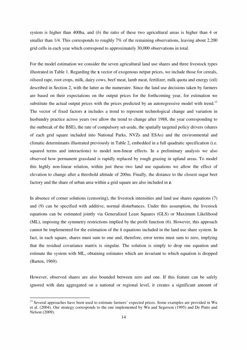
crops. However, effects are highly non-linear, as highlighted in Figure 1, which represents the
relationship between the land use shares predicted by our model and machinery working days, with all
other variables held constant at their 2004 sample mean values. The non-linear effects are particularly
noticeable for the cereals share, which peaks at around 120 mwd and then slowly declines, being
15
We estimate the model using the function ml in Stata 10.1 and a 1.86 GHz Intel Core 2 Duo processor, with
2GB RAM. The 6 equations land use shares system converges in about 372 minutes, whereas the 3 equations
livestock system requires only 10 minutes.
18
replaced by more profitable crops, such as potatoes and sugar beet. Finally, the parameters of the
variance equations (not reported in Table 3 to preserve space) are highly significant, suggesting a
heteroskedastic residual component, which, if ignored, would have biased parameter estimates.
[FIGURE 1 about here]
Relationships among predicted land use shares and machinery working days
The estimated coefficients of the livestock intensity equations are reported in Table 4.16
Again, own
price effects are always positive and significant, whereas cross-price effects, in particular between
beef and sheep, are negative. Interestingly, the coefficient of milk quota price is significantly higher
(in absolute value) than the one of milk price in the dairy cow equation. This suggests the presence of
significant transaction costs and uncertainties associated with the milk quota market (for a detailed
analysis of the inefficiencies in the EU quota system sees, for example, Boots et al., 1997).
Furthermore, different grassland types are associated with very diverse optimal numbers of livestock.
Again model estimates confirms prior expectations: dairy cows are reared primarily on intensive
grasslands, beef enterprises are located on all types of pasture and sheep are grazed mainly on less
improved land, such as permanent grassland and rough grazing. In addition, an increase in the price of
fertilizer, which is strongly related to grass growth and animal intake, reduces the intensity of all the
livestock enterprises considered. Also the share of land under special designation (NVZs, ESAs,
National Parks, etc.) influences to some extent the average stocking density, both directly and by
changing the proportions of land uses. Finally, the strong impact of the BSE outbreak on the whole
industry emerges in the estimates, with the trend in each livestock equation (particularly that for beef
cows) decreasing significantly after 1988.
[TABLE 4 about here]
Livestock intensity equations parameter estimates
We evaluate the fit and predictive ability of our structural model by comparing its forecasting
performance against that of an established benchmark: the logit land use share model introduced by
Lichtenberg (1989), Wu and Segerson (1995) and Plantinga (1996) and applied extensively thereafter.
16
Note that in the livestock equations the land use shares are modelled as exogenous, assuming that farmers
maximize profits in a two-step process and, therefore, treat land use allocations as fixed factors in the netput
equations. This is the same approach employed by Arnade and Kelch (2007) and stems directly from the
Chambers and Just (1989) profit function maximization. Using univariate Tobit models we empirically compare
two estimation approaches: the standard ML which assumes that the land use shares are exogenous and a ML
with instrumental variables to model land use shares as endogenous. The first strategy provides significantly
superior out-of-sample performance for each of the three livestock equations. This suggests that, at least in our
sample, land use allocation choices are planned on a longer run basis and can be considered as fixed when
evaluating livestock intensity decisions.

19
Table 5 reports the Mean Absolute Error (MAE) statistics for the land use share and the livestock
equations calculated as the mean absolute value of the difference between the predictions and the
actual JAC data, for the whole England and Wales in 2004, this being this the most recent years for
which we have JAC data covering the entire country.17
Despite the constraints placed upon our model
due to its structural underpinnings, our approach still yields results which are superior for cereals,
oilseed rape, root crops and temporary grassland shares. The logit model performs slightly better for
permanent grassland and rough-grazing. However, JAC data is very noisy for these two land use
categories, particularly in the recent years, because of the parish level data collection approach and the
grid square assignation methodology. Therefore, the resultant forecasting comparisons have to be
interpreted cautiously. The logit only clearly outperforms the structural model with respect to the
“other” category. This is not surprising since in our approach this class is not directly modelled but
estimated as a difference, as shown in equation (10). Overall, these results indicate how the predictive
ability of the structural model is comparable or even moderately superior to the one of the benchmark.
This is somewhat unexpected, as the logit share model is an empirical-driven approach, specifically
designed to describe and predict land use shares. In contrast, our model is based on a flexible
specification for the farm profit function, from which not only land use equations but also input and
output intensities are derived in a coherent framework. This ensures a comprehensive and
theoretically consistent representation which, as shown but these results, does not sacrifice empirical
predictive accuracy. Furthermore, in this application the obvious drawback of the logit approach is
that it cannot include livestock numbers and, therefore, cannot consider one of the most significant
sources of agricultural pollution.
[TABLE 5 about here]
Forecasting performance (MAE): structural model and logit share model
[FIGURE 2 about here]
Cereals in 2004: JAC data and model predictions
In order to analyze the spatial forecasting ability of our model, Figure 2 maps actual and predicted
shares of cereals in 2004. The model performance is highly satisfactory with the two maps showing
essentially the same spatial patterns of land use. However, some minor differences can be seen (e.g. in
the South of England and in the West Midlands) and the actual data results in being somehow blockier
than the predicted ones, with some grid squares with high cereal shares shown right next to grid
17
Since only 6% of the 2004 data are used to estimate the model, this consists of mainly out-of-sample
forecasting. Therefore it is an appropriate yardstick to compare models performances avoiding the risk of
preferring an over-fitted specification.

20
squares with very low shares. This is not likely to be a shortcoming of the model, but is more
probably a drawback of the raw JAC data, resulting from the parish level record allocation and
collection procedure and the subsequent grid square conversion procedure. This feature is even more
evident in extensive land use types, such as grasslands, as showed in Figure 3. Whilst the patter of
land use is essentially the same in the predicted and actual data, the predicted temporary grassland is
much smoother than the one in the JAC records.
[FIGURE 3 about here]
Temporary grassland in 2004: JAC data and model predictions
5. Concluding remarks
The approach proposed in this paper diverges from existing spatially explicit, econometric land use
models since, instead of focusing only on reduced form, land use allocation equations, it develops a
structural approach encompassing agricultural land use decisions, livestock numbers, crops yields,
inputs applications and profits in a coherent and unifying framework. The underpinning theoretical
model builds upon the joint multi-output profit function introduced by Chambers and Just (1989) and
is translated into an empirically tractable system of equations by directly specifying the profit function
as one of the flexible functional forms available in the literature. The resulting applied specification is
very flexible, and can be implemented on different types of data, ranging from aggregated national or
regional data to farm-level information.
In our empirical application estimates the model using a 2km2 grid square panel dataset covering the
entirety of England and Wales for the past 40 years, including all the major policy, market and
environmental drivers of agricultural land use. The fine-scale nature of this data allows us to include a
detailed specification of the physical environment determinants, which is critical to assess the
economic and environmental consequences of land use change. Whilst this micro-level data are
necessary to capture the relevant spatial heterogeneity, they are also characterized by the presence of
censored observations, which considerably complicate the econometric estimation. In this paper we
address this issue by extending to land use modelling the QML estimator recently developed by Yen
et al. (2003) for systems of censored demand equations.
The findings of this research could be extended in several directions. First, in the empirical
application we did not estimate all the structural parameters of the model and, therefore, did not
derive the welfare implications of land use change. Farm-level data on profits and yield could be used

21
to address this limitation and jointly estimate the entire system of equations (6), (7) and (9). The
obvious drawback of this approach would be loss of the spatial dimension of the analysis, which could
be at least partially maintained by knowing the location of the farms and linking it to the
environmental characteristics. Secondly, our approach is general enough to be implemented in a
variety of empirical contexts. Given the refined specification of the climatic variables, an obvious
candidate is the prediction of the effects of global warming on agriculture. Finally, our framework is
essentially static: an important extension would be to formulate a dynamic econometric specification
to investigate the inter-temporal aspects of agricultural production decisions.
7. References
Amemiya, Takeshi (1973) Regression analysis when the dependent variable is truncated normal,
Econometrica, vol. 41, pp. 997–1016.
Arnade C., Kelch D. (2007) Estimation of area elasticities from a standard profit function, American
Journal of Agricultural Economics, vol. 89, pp. 727-737.
Ball A.P. (1988) Modeling Supply Response in a Multiproduct Framework, American Journal of
Agricultural Economics, vol. 70, pp. 813-825.
Ball E.V., Bureau J-C., Eakin K., Somwaru A. (1997) Cap reform: modelling supply response subject
to the land set-aside, Agricultural Economics, vol. 17, pp.277-288.
Barten A.P. (1969) Maximum likelihood estimation of a complete system of demand equations,
European Economic Review, vol. 1, pp. 7-73.
Boots M., Oude Lansink A., Peerlings J. (1997) Efficiency loss due to distortion in Dutch milk quota
trade, European Review of Agricultural Economics, vol. 24, pp. 31-46.
Chakir R. (2009) Spatial downscaling of agricultural land-use data: an econometric approach using
cross-entropy, Land Economics, vol. 85, pp. 238-251.
Chambers R.G., Just R.E. (1989) Estimating multioutput technologies, American Journal of
Agricultural Economics, vol. 71, pp. 980-995.

22
Chavas J.P., Holt M.T. (1990) Acreage decisions under risk, the case of corn and soybeans, American
Journal of Agricultural Economics, vol. 72, pp. 529-538.
Chomitz K.M., Gray D.A. (1996) Roads, land use, and deforestation: a spatial model applied to
Belize, World Bank Economic Review, vol. 10, pp. 487-512.
Chomitz K.M., Thomas T.S. (2003) Determinants of land use in Amazonia: a fine-scale spatial
analysis, American Journal of Agricultural Economics, vol. 85, 2003, pp. 1016-1028.
Coyle B.T. (1999) Risk aversion and yield uncertainty in duality models of production: a mean
variance approach, American Journal of Agricultural Economics, vol. 81, pp. 553-567.
DEFRA (2004) Updating the estimates of the source apportionment of N to UK waters, Phase 2,
report by WRc plc, accessed on line: http://www.fwr.org/defrawqd/wqd0002.htm (9th April 2009).
DEFRA (2009) Agriculture in the United Kingdom 2008, DEFRA, SEERAD, DARD (NI) and
WAGTDEPC report, accessed on line: https://statistics.defra.gov.uk/esg/publications/auk/default.asp
(9th April 2009).
Dong D., Gould B.W., Kaiser H.M. (2004) Food demand in Mexico: an application of the Amemiya-
Tobin approach to the estimation of a censored food system, American Journal of Agricultural
Economics, vol. 84, pp. 1094-1107.
De Pinto A., Nelson G.C. (2009) Land Use Change with Spatially Explicit Data: A Dynamic
Approach, Environmental and Resource Economics (forthcoming).
European Council (1991) Directive 91/676/EEC (Nitrates Directive), Official Journal L 375, 31st
December.
European Commission (2000) Directive 2000/60/EC (Water Framework Directive), Official Journal,
22 December 2000.
Guyomard H., Baudry M., Carpentier A. (1996) Estimating crop supply response in the presence of
farm programmes: application to the CAP, European Review of Agricultural Economics, vol. 23, pp.
401-420.

23
Irwin E.G., Geoghegan J. (2001) Theory, data, methods: developing spatially-explicit economic
models of land use change, Journal of Agriculture, Ecosystems and Environment, vol. 85, pp. 7-24.
Just R.E. (2000) Some guiding principle for empirical production research in agriculture, Agricultural
and Resource Economics Review, vol. 29, pp. 138-158.
Just R.E., Antle J.M. (1990) Interactions between agricultural and environmental policies: a
conceptual framework, American Economic Review, vol. 80, pp. 197-202.
Langpap C., Hascic I., Wu J. (2008) Protecting watershed ecosystems through targeted local land use
policies, American Journal of Agricultural Economics, vol. 90, pp. 684-700.
Lichtenberg E. (1989) Land quality, irrigation development, and cropping patterns in the Northern
High Plains, American Journal of Agricultural Economics, vol. 71, pp. 187-194.
Lubowski R.N., Plantinga A.J., Stavins R.N. (2006) Land-use change and carbon sinks: econometric
estimation of the carbon sequestration supply function, Journal of Environmental Economics and
Management, vol. 51, pp. 135-152.
MAFF (1986) Agricultural Statistics in the United Kingdom, HMSO, London.
Meyerhoefer C.D., Ranney C.K., Sahn D.E. (2005) Consistent estimation of censored demand
systems using panel data, American Journal of Agricultural Economics, vol. 87, pp. 660-672.
Mitchell B.R. (1988) British Historical Statistics, Cambridge University Press, Cambridge.
Moore M.R., Gollehon N.R., Carey M.B. (1994) Multicrop production decisions in western irrigated
agriculture: the role of water price, American Journal of Agricultural Economics, vol. 76, pp. 859-
874.
ONS (1974-85) Annual Abstract of Statistics, HMSO, London.
Oude Lansink A., Peerlings J. (1996) Modelling the new EU cereals and oilseeds regime in the
Netherlands, European Review of Agricultural Economics, vol. 23, pp. 161-178.

24
Perali F., Chavas J.P. (2000) Estimation of censored demand equations from large cross-sectional
data, American Journal of Agricultural Economics, vol. 82, 1022-1037.
Plantinga A.J. (1996) The effect of agricultural policies on land use and environmental quality,
American Journal of Agricultural Economics, vol. 78, pp. 1082-1091.
Plantinga, A.J., Ahn S. (2002) Efficient policies for environmental protection: an econometric
analysis of incentives for land conversion and retention, Journal of Agricultural and Resource
Economics, vol. 27, pp. 128-145.
Plantinga A.J, Irwin E.G. (2006) Overview of empirical methods, in (Ed: K.B. Bell, K.J. Boyle, J.
Rubin) Economics of rural land-use change, Ashgate Publishing, Aldershot.
Plantinga A.J, Mauldin T., Miller D.J. (1999) An econometric analysis of the costs of sequestering
carbon in forests, American Journal of Agricultural Economics, vol. 81(4), pp. 812-824.
Pope R.D., Just R.E. (1991) On testing the structure of risk preferences in agricultural supply analysis,
American Journal of Agricultural Economics, vol. 73, pp. 743-748.
Pudney S. (1989) Modelling individual choice: the econometrics of corners, kinks and holes,
Blackwell Publishers, Cambridge.
Seo S.N, Medelsohn R.O. (2008) Measuring impacts and adaptations to climate change: a structural
Ricardian model of African livestock management, Agricultural Economics, vol. 38, pp. 151-165.
Shonkwiler J.S., Yen S.T. (1999) Two-step estimation of a censored system of equation, American
Journal of Agricultural Economics, vol. 81, pp. 972-982.
Shumway C.R., Pope R.D., Nash E.K. (1984) Allocatable fixed inputs and jointness in agricultural
production: implications for economic modelling, American Journal of Agricultural Economics, vol.
66, pp. 72-78.
Tobin J. (1958) Estimation for relationships with limited dependent variables, Econometrica, vol. 26,
pp. 24–36.

25
Von Thünen J.H. (1826) Von Thünen’s Isolated State, translated by C.M. Wartenberg, edited by Peter
Hall, 1966, Pergamon Press, New York.
Yen S.T., Huang C.L. (2002) Cross-sectional estimation of U.S. demand for beef products: a censored
system approach, Journal of Agricultural and Resource Economics, vol. 27, pp. 320-334.
Yen S.T., Lin B.H. (2002) Beverage consumption among US children and adolescents: full-
information and quasi maximum-likelihood estimation of a censored system, European Review of
Agricultural Economics, vol. 29, pp. 85-103.
Yen S.T., Lin B.H., Smallwood D.M. (2003) Quasi- and simulated-likelihood approaches to censored
demand systems: food consumption by food stamp recipients in the United States, American Journal
of Agricultural Economics, vol. 85, pp. 458-478.
White H. (1982) Maximum likelihood estimation of misspecified models, Econometrica, vol. 50, pp.
1-25.
Wu J., Adams R.M., Kling C.L., Tanaka K. (2004) From microlevel decisions to landscape changes:
an assessment of agricultural conservation policies, American Journal of Agricultural Economics, vol.
81, pp. 26-41.
Wu J., Segerson K. (1995) The impact of policies and land characteristics on potential groundwater
pollution in Wisconsin, American Journal of Agricultural Economics, vol. 77, pp. 1033-1047.
Zellner A., Lee T.H. (1965) Joint estimation of relationships involving discrete random variables,
Econometrica, vol. 33, pp. 382-394.

26
Appendix: Tables and Figures
TABLE 1
Descriptive statistics, land uses (ha) and livestock numbers (heads) per 2km2 grid square
1969 1988 2004 Total
x x x
x )(ˆ xs Min max
Cereals 87.8 94.6 76.4 83.0 77.4 0 347.2
Oilseed Rape 0.1 8.5 13.3 6.9 12.3 0 124.7
Root crops 10.1 9.5 7.5 9.1 18.7 0 186.8
T. grassland 41.1 28.8 22.6 29.3 28.7 0 349.5
P. grassland 116.7 115.6 112.7 113.0 97.0 0 400
Rough grazing 47.1 39.6 40.5 44.0 100 0 400
Other 22.8 26.6 45.7 37.8 45.6 0 400
Tot. land 325.6 323.2 318.7 323.1 96.9 1.25 400
Dairy 87.1 71.5 62.0 74.1 99.1 0 1128
Beef 151.4 149.8 89.9 144.9 123.8 0 1221
Sheep 472.2 784.1 323.8 693.6 899.0 0 11289
Notes: only grid squares containing some agricultural land (according to the ALC) are considered, x indicates
the sample mean, )(ˆ xs the sample standard deviation.

27
TABLE 2
Descriptive statistics, environmental and climatic determinants
Units x )(ˆ xs min max
aar mm 888.4 360.5 509 3980
mwd days 53.0 37.2 0 143
pt mm 507.8 52.3 240 608
fc days 114.7 21.7 80 230
dd oC 2290 169.2 1410 2641
alt m 120.4 113.7 0 860
smore6 % 19.2 0.25 0 100
Notes: x indicates the sample mean, )(ˆ xs the sample standard deviation.

28
TABLE 3 Land use share equations parameter estimates
Cereals Oilseed rape Root crops Temp. Grassland Perm. Grassland Rough grazing
Pcereals 0.134 *** -- -- -0.044 ** -- --
Prape -- 0.148 **** -- -- -- --
Prootcrops -- -- 0.027 * -- -- --
Pfertilizer -0.111 *** -0.283 **** -0.017 * 0.067 *** -0.018 0.036 *
Set aside rate -0.425 **** -0.114 *** 0.003 -0.009 -0.030 -0.025 *
ESA share -0.033 **** -0.008 *** 0.000 0.000 0.031 *** 0.032 ***
Park share -0.019 *** -0.006 -0.003 *** -0.018 *** -0.067 *** 0.041 ***
Urban share -0.028 ** -0.003 -0.002 0.000 0.061 *** 0.010 *
smore6 -0.087 *** -0.018 *** 0.000 -0.005 0.131 *** 0.052 ****
coast -0.357 -0.505 * -0.156 1.316 *** -0.536 1.473 ***
alt 14.170 **** 3.048 *** -2.693 **** -0.787 # #
atl2 6.333 *** 1.337 ** -0.494 ** -0.834 * # #
alt < 200m # # # # -0.057 **** 0.004
alt > 200m # # # # 0.085 ** -0.156 ***
I(alt > 200m) # # # # -25.55 *** 21.96 **
mwd 4.174 **** 0.079 1.619 **** 0.956 *** -8.455 **** -0.582
mwd2 -1.283 *** -0.416 *** 0.681 **** 0.147 -1.346 *** 0.271 **
pt 6.727 *** 1.594 * 0.331 * -3.419 *** -23.95 *** 12.46 ***
pt2 -2.773 ** -1.919 ** 0.720 ** 3.401 *** 3.969 * -7.191 ***
fc -4.794 * -7.374 *** -1.856 *** 0.482 7.165 * 4.394 *
fc2 16.670 *** -6.521 *** 2.896 *** -7.498 *** -22.22 *** 5.000 ***
dd -4.228 *** 1.653 *** -4.801 **** 4.271 *** 35.45 **** -6.285 ***
dd2 2.571 ** -0.233 1.592 **** -1.506 ** -3.071 * -1.179 *
aar -3.726 -11.57 **** 6.056 **** 3.950 *** -5.000 9.738 ***
aar2 -1.269 -7.177 *** 1.701 **** 3.935 *** -4.537 * 7.246 ***
Trend 0.015 0.282 **** -0.015 *** -0.155 **** -0.101 *** 0.045 ***
Const 38.04 **** -17.61 **** 6.677 **** 13.34 **** 36.18 **** -0.884
Notes: to preserve space the residual correlations, the parameters corresponding to the variance equations, to the interactions of the environmental factors are not reported in
the Table, but are available under request from the Authors. “--“ = parameters non significant and therefore removed, “#” = parameter not included in the equation, “*” = t-
stat > 2, “**” = t-stat > 3, “***” = t-stat > 4, “****” = t-stat > 10. All variables defined as in Table 1.

29
TABLE 4 Livestock intensity equations parameter estimates
Dairy cows Beef cows Sheep
stemp.grassland 1.427 **** 1.234 **** 1.814 ****
sperm.grassland 0.438 **** 0.763 **** 2.400 ****
srough.grazing 0.041 ** 0.296 *** 1.167 ****
Pmilk 2.208 *** -- --
Pquota -3.034 *** -- --
Pdairy cows 0.003 -- --
Pbeef meat -- 0.084 *** -0.209 **
Psheep meat -- -0.209 ** 3.244 **
Pfertilizer -0.261 ** -0.297 ** -1.090 *
ESA share -0.047 *** -0.169 * 0.091 *
NVZ share -0.004 0.008 * -0.147 ***
Park share -0.007 -0.011 -0.282 ***
Urban share 0.077 *** 0.195 **** -0.383 ***
L 0.013 *** 0.009 * 0.212
smore6 -0.113 **** -0.067 *** 0.947 ***
coast -1.480 * 1.460 11.52 **
alt -12.99 *** 0.023 -41.38 ****
atl2 -9.720 *** 4.566 ** -13.16
mwd -1.574 ** 1.116 ** -5.129 *
mwd2 -2.089 *** -2.735 *** -11.01 ***
pt 9.334 *** -21.79 **** -73.98 ***
pt2 -1.736 27.22 **** 14.42
fc -5.250 -5.526 * 105.5 ***
fc2 -6.054 -12.79 *** 32.97 *
dd -5.263 *** -14.68 *** -15.59 *
dd2 -1.155 2.709 * 0.445
aar 5.615 * -6.729 *** 8.889
aar2 3.534 * 0.930 68.08 ***
Trend 0.336 ** 0.385 ** 2.463 ***
TrendBSE -0.344 ** -0.895 *** -2.542 ***
Const -25.07 *** 19.02 *** 32.55 ****
DummyBSE 4.469 ** 10.47 *** 60.89 ****
ρρρρi,j
Dairy cows 1
Beef cows 0.238 **** 1
Sheep -0.201 **** 0.186 **** 1
Notes: to preserve space the parameters corresponding to the variance equations and to the interactions of the
environmental factors are not reported in the Table, but are available under request from the Authors. “--“ =
parameters non significant and therefore removed, “*” = t-stat > 2, “**” = t-stat > 3, “***” = t-stat > 4, “****”
= t-stat > 10. All variables defined as in Table 1.

30
TABLE 5
Forecasting performance (MAE): structural model and logit share model
Structural
model Logit
Land use (ha)
Cereals 24.5 25.7
oilseed rape 8.5 9.7
root crops 5.7 6.0
temporary grassland 12.1 12.6
permanent grassland 41.1 40.9
rough grazing 19.0 18.1
other 24.3 19.7
Livestock (heads)
dairy 47.0 --
beef 61.4 --
sheep 375.7 --
Notes: MAE for England and Wales in year 2004, total number of
observations equal to 33283 (outliers excluded). Logit model specified
including the same explanatory variables of the structural model and
estimated following Zellner and Lee (1965).

31
FIGURE 1
Relationships among predicted land use shares and machinery working days
Notes: predicted shares and asymptotic 95% confidence intervals, all explanatory variables fixed at
their average levels in year 2004.

32
FIGURE 2
Cereals in 2004: JAC data and model predictions

33
FIGURE 3
Temporary grassland in 2004: JAC data and model predictions