caribbean geology - an introduction
TRANSCRIPT

Caribbean Geology
An Introduction
Edited by
Stephen K. Donovan
and
Trevor A. Jackson

Copyright ©1994 The Authors
Published by The University of the West Indies Publishers' Association (UWIPA)
P.O. Box 42, Mona, Kingston 7, Jamaica W.I. Cover design by Annika C. Lewinson
ISBN 976-41-0033-3
Printed in Jamaica

Contents
Introduction............................................................................................................................ 1 STEPHEN K. DONOVAN and TREVOR A. JACKSON
Chapter 1: Geologic Provinces of the Caribbean Region ................................................................. 3 GRENVILLE DRAPER, TREVOR A. JACKSON and STEPHEN K. DONOVAN
Chapter 2: Evolution of the Gulf of Mexico and the Caribbean........................................................ .13 JAMES L. PINDELL
Chapter 3: The Caribbean Sea Floor...........................................................................................41 THOMAS W. DONNELLY
Chapter 4: Cuba .....................................................................................................................65 GRENVILLE DRAPER and J. ANTONIO B ARROS
Chapter 5: The Cayman Islands.................................................................................................87 BRIAN JONES
Chapter 6: Jamaica ……………………………………………………………………………………. .1ll EDWARD ROBINSON
Chapter 7: Hispaniola .......................................................................................................... ..129 GRENVILLE DRAPER, PAUL MANN and JOHN F. LEWIS
Chapter 8: Puerto Rico and the Virgin Islands ........................................................................ ..151 DAVID K. LARUE
Chapter 9: The Lesser Antilles ............................................................................................ ..167 GEOFFREY WADGE
Chapter 10: Barbados and the Lesser Antilles Forearc................................................................ ..179 ROBERT C. SPEED
Chapter 11: Tobago............................................................................................................. ..193 TREVOR A. JACKSON and STEPHEN K. DONOVAN
Chapter 12: Trinidad …………………………………………………………………………………...209 STEPHEN K. DONOVAN
Chapter 13: Northern South America...................................................................................... ..229 STEPHEN K. DONOVAN
Chapter 14: The Netherlands and Venezuelan Antilles ............................................................... ..249 TREVOR A. JACKSON and EDWARD ROBINSON
Chapter 15: Northern Central America.................................................................................... ..265 BURKE BURKART
Index ................................................................................................................................ ..285
iii


Caribbean Geology: An Introduction U.W.I. Publishers' Association, Kingston
© 1994 The Authors
Introduction
STEPHEN K. DONOVAN and TREVOR A. JACKSON
Department of Geology, University of the West Indies, Mona, Kingston 7, Jamaica
THE LITERATURE of the geology of the Caribbean region is widely dispersed through a number of primary sources. Apart from numerous research papers in international and regional scientific journals, there are also the transactions that have arisen from the various Caribbean, Latin American and Central American Geological Conferences (for refer-ences, see Draper and Dengo), plus various smaller, often more specialized meetings, particularly in Jamaica and Trinidad. To this burgeoning list can be added various review volumes, newsletters and unpublished reports.
Various general works have been published which re-view this enormous literature, the most recent examples being edited by Nairn and Stehli (now almost 20 years old) and Dengo and Case1. These volumes are generally excel-lent, but are intended mainly as specialist references and are generally too expensive, and often too advanced or special-ized, for student readers. This is particularly unfortunate for any undergraduate taking an advanced course in Caribbean geology or, for that matter, any new graduate student start-ing research in the region. Caribbean Geology: An Intro-duction has been produced to help fill the need for a cheap, but comprehensive, text on Caribbean geology. The 15 chapters have been written by the editors and a group of invited authors who are experts in particular aspects of the geology of the region. While we have attempted to be as comprehensive as possible, it is hoped that the text is pitched at a level that is both intelligible and informative to the student as well as the expert.
We are pleased to acknowledge the financial support that has made publication of this book possible. Printing was financed by a repayable grant from the Research and Publi-cations Fund of the University of the West Indies (UWI). Typesetting was supported by the Research and Publica-tions Fund of Mona Campus, UWI.
We also make a particular point of thanking the numer-
ous reviewers who have given their time and energies in helping us to assess the various contributions to this volume. In alphabetical order, we acknowledge the contributions of I.E. Case (U.S. Geological Survey), T.W. Donnelly (State University of New York at Binghamton), J.F. Dewey (Uni-versity of Oxford), G. Draper (Florida International Univer -sity), N.T. Edgar (U.S. Geological Survey), G.S. Home (Wesleyan University, Connecticut), V. Hunter (Laso Inc., Florida), B. Jones (University of Alberta), R.D. Liska (Houston, Texas), P. Mann (University of Texas at Austin), J.D. Mather (Royal Holloway and Bedford New College, London), F. Nagle (University of Miami), R.K. Pickerill (University of New Brunswick, Fredericton), M.J. Roobol (Directorate General of Mineral Resources, Saudi Arabia), E. Robinson (U.W.L, Mona), K. Rodrigues (Trinidad and Tobago Oil Company Limited), R. Shagam (Rider College, New Jersey), P.W. Skelton (The Open University), A.W. Snoke (University of Wyoming at Laramie), R. Torrini, Jr. (Woodward-Clyde Consultants), G. Wadge (University of Reading) and G.K. Westbrook (University of Birmingham). T.A.J. also acted as a reviewer for two chapters.
Thanks, too, to Annika Lewinson and Annie Paul of the University of the West Indies Publishers' Association, who undertook the daunting task of typesetting this volume. Our fellow authors endured entreaties by letter, fax, cable and telephone, as well as patiently suffering delays at the Mona end, but we trust that any feeling of persecution is forgotten now that the book is published. The Department of Geology at UWI provided invaluable logistic support.
REFERENCES
1 Dengo, G. & Case, J.E. (eds). 1990. The Geology of North America, Volume H, The Caribbean Region. Geologi-
1

Introduction
cal Society of America, Boulder, Colorado, 528 pp. America, Boulder, Colorado. 2Draper, G.& Dengo, G. 1990. History of geological inves- 3Nairn, A.E.M. & Stehli, F.G. (eds). 1976. The Ocean
tigation in the Caribbean region: in Dengo, G. & Case, Basins and Margins. 3. The Gulf of Mexico and the J.E. (eds), The Geology of North America, Volume H, Caribbean. Plenum, New York, 706 pp. The Caribbean Region, 1-14. Geological Society of
2

Caribbean Geology: An Introduction U.W.I. Publishers' Association, Kingston
©1994 The Authors
CHAPTER 1
Geologic Provinces of the Caribbean Region
GRENVILLE DRAPER1, TREVOR A. JACKSON2
and STEPHEN K. DONOVAN2
1Department of Geology, Florida International University, Miami, Florida 33199, U.SA. 2Department of Geology, University of the West Indies, Mona, Kingston 7, Jamaica
INTRODUCTION
THE CARIBBEAN is a geologically complex region that displays a variety of plate boundary interactions including subduction in the Lesser Antilles and Central America, transcurrent (strike-slip) motions on the northern and southern boundaries, and sea floor spreading in the Cayman Trough. The central Caribbean is a lithospheric plate con-sisting mainly of an anomalously thick, oceanic plateau situated between two major continental regions and therein lies its geological importance. Classic studies of the Alps, Himalayas and Appalachians have documented the effects of major continent-continent collisions. The Caribbean pro-vides the opportunity to study the nature of the geological evolution of island arcs, and the tectonic interaction between anomalously thick oceanic crust and continental crust.
The purpose of this chapter is to introduce the physiog-raphy and geology of the Caribbean region. Although de-tailed analysis of tectonostratigraphic terranes has been published previously11, in the present account we attempt to outline the features of the major geologic provinces that make up the Caribbean and to provide a framework for the more detailed descriptions which follow in this volume.
PHYSIOGRAPHIC PROVINCES
The Caribbean region is comprised of several major marine and terrestrial physiographic and geologic provinces, the geographic relationships of which are illustrated in Figure 1.1. Geographically and bathymetrically, the Caribbean Sea is bound to the north by the Gulf of Mexico, the Yucatan Platform, the Florida-Bahamas Platform and the Puerto Rico Trench, and to the south by the northern part of the
South American continent. The western boundary com-prises Central America and the Isthmus of Panama, and the eastern limits are defined by the Lesser Antilles archipelago. Within these boundaries there are several deeper water regions; the Yucatan Basin, the Cayman Trough, the Colom-bian Basin, the Venezuelan Basin and the Grenada Basin. These are separated by several more or less linear ridges and rises; by the Cayman Ridge, the Nicaraguan Rise, the Beata Ridge and the Aves Ridge, respectively. The physiographic units correspond in part to the different crustal provinces that make up the Caribbean and in part to the active tectonic elements that make up the present Caribbean Plate.
PRESENT PLATE CONFIGURATION
The location and nature of plate boundaries in the Carib-bean, as elsewhere, are determined by the location of earth-quake hypocentres; by use of the sense of slip from first motion studies on seismogenic faults; from detailed bathymetric, magnetic and seismic profiling studies of ma-rine areas; and from detailed mapping of recent, on-land structures if the plate boundary happens to be exposed onshore.
These studies show that the boundaries of the Carib-bean Plate (Fig. 1.1 A), as defined by the distribution of earthquake epicentres53, run approximately from Guate-mala along the trend of the Cayman Trough, through His-paniola and Puerto Rico, south through the Lesser Antilles, and along the northern South America continental margin (although this boundary is poorly defined between Trinidad and the Meridional Andes) and the west coast of Central America. First motion solutions7,28 indicate left- lateral strike slip at the northern boundary and right-lateral strike
3

Geologic Provinces of the Caribbean Region
slip at the southern boundary, indicating that these are left lateral and right lateral transform boundaries, respectively. Thrust fault solutions, typical of the upper part of convergent plate boundaries, are found in both the western and eastern margins of the plate. The depth of the hypocentres and their position relative to island arc volcanoes indicates Wadati-Benioff Zones dipping eastward beneath Central America and westward beneath the Lesser Antilles. Detailed marine and terrestrial studies have considerably refined this general picture, although there are considerable differences of opin-ion about the details of the present direction and rate of movement of the Caribbean Plate relative to its neighbours. The Caribbean Plate is moving eastwards with respect to both North and South America31 at a rate of about 1 to 2 cm yr-1. The northern and southern boundaries of the plate are thus transform fault systems dominated by left-lateral and right-lateral strike-slip motions, respectively. Unlike transform fault systems in oceanic crust, where the move-ment is accommodated in single, discrete fault zones, the movements in the Caribbean are distributed on several ac-tive fault zones to produce broad, active seismic zones about 200 km wide. As it is difficult to pinpoint the precise plate boundary, the north and south Caribbean Plate boundaries are best characterised as plate boundary zones 8,28.
The Motagua, Polochic and other fault zones form the eastern extension of the Northern Caribbean Plate Boundary Zone in Central America. A left lateral step-over in the boundary between the Caribbean and North America has resulted in a crustal-scale pull-apart basin, the Cayman Trough, in which a 100 km long spreading ridge segment has been produced. This ridge is bounded by two extensive transform faults, the Swan Island Transform Fault and the Oriente (previously Bartlett) Transform Fault. East of Cuba, left lateral displacement may be accomodated on several fault zones in northern Hispaniola and offshore. Left lateral displacement has also been documented south of the Cayman Trough in Jamaica and southern Hispaniola 8,29,30, and forms the southern boundary of a microplate 44.
The eastward movement of the Caribbean Plate has resulted in subduction of the Atlantic Ocean crust under the eastern margin of the Caribbean, producing the Lesser Antilles island arc system. Eastward motions of the Pacific and Cocos Plates with respect to the Caribbean and North America are equally rapid, which has resulted in subduction of these plates beneath the western margin of the Caribbean, that is, under Central America.
GEOLOGIC PROVINCES—CARIBBEAN SEA
Seismic reflectors A”and B” Persistent seismic reflector horizons A" and B" are
important geophysical features of the Caribbean Sea floor. The B" horizon marks the boundary between igneous sills and overlying Upper Turonian to Coniacian sedimentary strata. This reflector has been traced from the lower Nicara-guan Rise eastwards through the Venezuelan Basin . The A" horizon is considered to mark the boundary between Lower to Middle Eocene oozes and chalks, and underlying Upper Cretaceous chertiferous limestones. This reflector extends from the lower Nicaraguan Rise in the west to the Grenada Basin in the east. Borehole data from Deep Sea Drilling Project Leg 15 indicates that the B" horizon consists of the uppermost layers of a large oceanic basalt plateau with a crustal thickness of between 15 and 20 km. This plateau was produced by a significant oceanic flood basalt event that occurred during the late Cretaceous14 (Donnelly, Chapter 3, herein).
Colombian Basin The Colombian Basin is defined by the Hess Escarp-
ment to the north, and the continental margin of Panama and Colombia to the south. The Colombian Plain, extending to depths of 4000 to 4400 m, is the largest abyssal plain in the Caribbean region and is located in the northeast part of the basin. This plain extends north to Hispaniola, south to the Magdelana Fan and east to the southern corner of the Beata Ridge22. Both the Magdelana and the Panama-Costa Rica Fans introduce significant quantities of sediment into the basin along its southern and western edges. The North Panama and South Caribbean Deformed Belts are under -thrust margins to this basin.
Beata Ridge The Beata Ridge is a structural high that extends south-
west from Cape Beata, Hispaniola, for about 400 km. The ridge has a relief of about 2000 m and is comprised of a series of north-south trending subsidiary ridges which be-come less pronounced towards the south, where it converges on the South Caribbean Deformed Belt11,26. Initial uplift of the ridge occurred during the late Cretaceous and coincided with structural disturbances that affected the northern Colombian Basin and the Hess Escarpment23. Subsequent tectonic events have led to the tilting of the ridge and to deformation along its southern margin.
Venezuelan Basin The Venezuelan Basin is the deepest and largest of the
Caribbean basins. The interior of the basin includes less than 200 m of relief, having been 'smoothed' by the accumulated sediments. The basin is deepest at its northern (Muertos Trough) and southern (Venezuelan Plain) boundaries, where it converges with the North and South Caribbean Deformed Belts, respectively11. Most of the sediment in the
4

G. DRAPER, T.A. JACKSON and S.K. DONOVAN
Figure 1.1. (A) Map of the Caribbean region showing the relative positions of plates, physiographic regions and major islands (redrawnafter Jackson24). Direction of subduction shown by solid triangles. (B) Geologic provinces of the Caribbean region, as defined in the present chapter (simplified after Case and Dengo10; Case et al.12).
Key: AP=Anegada Passage; AR=Aves Ridge; BeR=Beata Ridge; BP=Bahamas Platform; BR-Barbados Ridge and Lesser Antilles Deformed Belt; C=Cuba; C A=Colombian Andes; CB=Chortis Block; ChB=Choco Block; CO=Cuban Orogenic Belt; CoB=Colombian Basin; CT=Cayman Trough; CtB=Chorotega Block; EPFZ=E1 Pilar Fault Zone; GA=Greater Antilles; GAOB=Greater Antilles Orogenic Belt; GB=Grenada Basin; GM=Gulf of Mexico; H=Hispaniola (Haiti+Dominican Republic); J=Jamaica; LA=Lesser Antilles; MPFZ=Motagua-Polochic Fault Zone; NP=Nazca Plate; NPD=North Panama Deformed Belt; NR=Nicaraguan Rise; OTF=Oriente Transform Fault; PR=Puerto Rico; SCD=South Caribbean Deformed Belt; SITF=Swan Island Transform Fault; VB=Venezuelan Basin; VBo=Venezuelan Borderland; YB=Yucatan/Maya Block; YBa=Yucatan Basin.
5

Geologic Provinces of the Caribbean Region
basin was derived from the eastern margin, marked by the Aves Apron that extends westwards from the Aves Ridge. GEOLOGIC PROVINCES—CENTRAL AMERICA
Yucatan/Maya Block The Yucatan, or Maya, Block is located on the North
American Plate and is separated from the Chortis Block by the Motagua-Polochic fault system. The (pre-Carbonifer-ous) basement of the Yucatan Block is exposed in its southern extremity, near the Motagua suture, and occurs in various wells in the subsurface. It is composed of schists, marbles, quartzites and granitoids of unknown age. These rocks are unconformably overlain by Upper Carboniferous to Permian sedimentary and volcanic rocks 15.
The Palaeozoic sedimentary rocks are unconformably overlain by a Jurassic 'red bed' sequence (Todos Santos Group) and thick, Cretaceous dolomitic limestones. In the southern part of the block, Upper Cretaceous to Tertiary olistostromes and immature sandstones of the Sepur Group overlie the carbonate platform rocks. The Chicxulub Crater in the middle of the Yucatan carbonate platform is the probable candidate for the Cretaceous/Tertiary boundary impact crater21.
Chortis Block The northern boundary of the Chortis Block on the
Caribbean Plate is defined by the Motagua-Polochic fault system (at present, an active strike-slip fault zone, but this was previously a suture zone formed by the late Cretaceous collision of the Chortis and Yucatan Blocks), which is also the boundary between the Caribbean and North America Plates. The southwestern boundary is the Middle America Trench, which separates the block from the Cocos Plate. However, the southern and eastern boundaries are less well defined.
The basement of the Chortis Block consists of pre-Mesozoic (probably Palaeozoic) metamorphic rocks and associated Mesozoic plutons which outcrop in the northern and central parts of the block. The Mesozoic sequence is generally similar to that of the southern part of the Yucatan Block to the north, but less well documented15. A Jurassic to Lower Cretaceous 'red bed' sequence (correlated with the Todos Santos Group of the Yucatan Block) overlies the basement rocks. These are in turn overlain by massive Lower Cretaceous limestones. A major Upper Cretaceous 'red bed' sequence (Valle de Angeles Formation) sits on these limestones. A major unconformity separates the Mesozoic sequence from extensive Cenozoic volcanic de-posits.
Chorotega and Choco Blocks Geographically, this province comprises Costa Rica,
Panama and northwestern Colombia. The Choco Block, west of and overridden by the Cordillera Occidental of the Colombian Andes, comprises a sequence of uplifted Upper Cretaceous to Paleogene oceanic crust and magmatic arc rocks. The Choco Block abuts deep forearc basins to the west containing up to 10,000 m of pelagic, turbiditic and marginal marine sediments and sedimentary rocks 11. East-ern Panama (Choco Block) is a raised block with a basement of late Cretaceous or older oceanic crust, topped by seismic reflector BM (see above), and overlain by Upper Cretaceous pelagic sedimentary rocks9. Panama became attached to South America and nuclear Central America during the late Miocene or Pliocene13.
The Chorotega Block is essentially the northern exten-sion of the Choco terrane and comprises a series of belts parallel to the Pacific coast developed by subduction of the Cocos Plate and subsequent accretion of terranes on the western seaboard. Reversal and repetition of the forearc ridge and basin occur in the east of Panama1 . The overlying Middle America volcanic province is a northwest-southeast trending belt in western Panama consisting of Miocene to Holocene calc-alkaline volcanics and related deposits. This volcanism is related to subduction at the Middle America Trench11.
GEOLOGIC PROVINCES—NORTHERN
CARIBBEAN
Gulf of Mexico The northern margin of the GuIf of Mexico is underlain by a broad zone of stretched and thinned continental crust, as is the southern part (see Maya/Yucatan Block, above). The central part of the GuIf of Mexico is underlain by Upper Jurassic to Lower Cretaceous oceanic crust. This structure is the result of the rifting of the Maya/Yucatan Block from North America38,39,46, which resulted from approximately northwest-southeast continental extension that took place from the Triassic to the late middle Jurassic. This was followed by sea floor spreading until the earliest Cretaceous.
The continental basement on the northern and southern margins of the Gulf of Mexico is overlain by Triassic and Jurassic 'red beds' and Jurassic evaporites (Louann and Campeche provinces, respectively). Uppermost Jurassic sedimentary rocks comprise shallow-water limestones on the margins of the Gulf, with deep-water carbonate facies in the central regions. A similar pattern persisted through the Cretaceous and produced thick carbonate sequences. These limestones are overlain in the western and central Gulf of Mexico by terrigenous clastic sedimentary rocks derived as
6

G. DRAPER, T. A. JACKSON and S.K. DONOVAN
a result of late Cretaceous orogenic uplift in western North America and Mexico.
Florida and Bahamas platforms The Florida and Bahamas carbonate platforms (here
taken to include the regions underlying the Turks and Caicos Islands) lie to the north of both the Cuban Orogenic Belt and the Hispaniola segment of the Greater Antilles Orogenic Belt The Florida and Bahamas platforms consist of a con-tinuous sequence of Middle Jurassic to Recent carbonate sedimentary rocks which are over 6,000 to 7,000 m thick in southern Florida and over 10,000 m thick in the Bahamas 48. The accumulation of these limestones resulted from the subsidence accompanying the rifting that formed the Atlan-tic Ocean and Gulf of Mexico. In Florida, the northward thinning carbonate accumulations unconformably overlie Triassic to Lower Jurassic arkoses and volcaniclastic sedi-mentary rocks, which in turn rest on Palaeozoic basement. The situation is similar in the western Bahamas, under the Great Bahama Bank, but east of New Providence island the basement consists of Jurassic oceanic crust48.
Cuban Orogenic Belt Western and central Cuba form a major orogenic belt,
characterized by northwardly-directed thrusting of Creta-ceous island arc volcanic rocks, with associated oceanic crust, over a sequence of continental shelf to slope, Jurassic to Lower Cretaceous limestones and mature clastic sedi-mentary rocks. It was previously thought that this orogenic belt resulted from the collision of an island arc with the Florida-Bahama continental margin in the late Cretaceous to early Tertiary20. The Campanian ages of olistostromes deposited at the front of advancing thrust sheets, and Cam-panian metamorphism of continental margin sedimentary rocks in southern Cuba indicate that the Cuban orogeny comprised a middle Cretaceous, and an early Cenozoic, orogenic events41 (Draper and Barros, chapter 4, herein).
Cuba is the only region in the Greater Antilles where Precambrian age rocks occur. Grenville age (approximately 1,000 Ma) metamorphic rocks outcrop in Las Villas prov-ince in north central Cuba42,50. These rocks may represent an exposed fragment of the basement underlying the sedi-mentary rocks of the continetal margin.
Southeastern Cuba contains rocks formed in a Paleo-cene island arc which has a geological history distinct from western and central Cuba.
Greater Antilles Orogenic Belt The Greater Antilles orogenic belt comprises His-
paniola, Puerto Rico, the Virgin Islands and southeastern Cuba. This province differs from that of the orogenic belt of western and central Cuba in style of deformation, although
deformation occurred earlier in the west. The islands consist of a Jurassic oceanic basement (exposed in central His-paniola and southwest Puerto Rico) overlain by Lower Cretaceous (Aptian-Albian or possibly older) to Paleogene island arc deposits (volcanic and epiclastic deposits with associated immature clastic and carbonate sedimentary rocks). Although there is some evidence for Cretaceous deformation events16,17,33,34, which may have a similar age to those in Cuba, the major tectonic deformation in these islands was usually later. Late Cretaceous to early Paleogene deformation was associated with an oblique collision of the Greater Antilles arc with the Florida-Bahamas platform, but which did not appear to produce the extensive thrusting otherwise seen in Cuba. In contrast, in Jamaica (see Nicara-guan Rise, below), the early Paleogene was a period of crustal extension and resulted in deposition of rift facies sediments. From the post-Oligocene to the present, the islands have experienced another major orogenic phase due to sinistral transpression caused by the eastward motion of the Caribbean Plate relative to North America. These transcurrent movements produced a series of strike-slip related, clastic -filled basins. In adjacent areas, moderate subsidence coupled with eustatic sea level changes pro-duced carbonate build-ups.
Nicaraguan Rise The Nicaraguan Rise extends northeastwards from
Honduras and Nicaragua in Central America to Jamaica and southern Haiti2. It is bounded on the northern edge by the Cayman Trough and along the southern margin by the northeast-southwest trending Hess Escarpment. The Nica-raguan Rise is a broad, topographically complex feature of shallow to intermediate depth (0-3000 m) along which there is an upper (less than 1200 m water depth) and lower (greater than 1200 m water depth) rise22. The lower Nicaraguan Rise is separated from the upper part by the Pedro Bank escarp-ment or Pedro Bank Fracture Zone11 and from the Colom-bian Basin by the Hess Escarpment. The lower, or southern11, Nicaraguan Rise is comprised of a series of faults, troughs and volcanoes. This is particularly evident along the northeast and southwest margins, where there are prominent rifts (the Morant and San Andres Troughs, re-spectively). Closely associated with these troughs is a series of seamounts and islands formed from late Cenozoic vol-canic rocks57.
Lower rise strata vary in thickness between 500 m and 1000 m, whereas the upper rise, which is mainly a carbonate platform, is underlain by over 5000 m of strata11. Emergent portions of the upper rise include Jamaica, as well as several carbonate banks to the south of the island. The known stratigraphy of the upper rise, determined from various sources 23,36,37 (Robinson, chapter 6, herein), suggests that
7
Geologic Provinces of the Caribbean Region
a basement of Upper Jurassic(?) to Lower Cretaceous oce-anic oust (with continental oust in the west) is overlain by predominatly stratified Upper Cretaceous volcanic rocks and Tertiary limestones. Geophysical data show the maxi-mum thickness of the rise to be about 22 km1,2.
Cayman Trough The Cayman Trough is approximately 1600 km in
length, 120 km in width and 5 km deep. It comprises a floor of thin oceanic crust (less than 7 km) partly overlain by a veneer of younger sediments37. The trough extends west-wards from the Windward Passage to the Gulf of Honduras and separates the Cayman Ridge from the Nicaraguan Rise. The Cayman Ridge may be a fragment of the Nicaraguan Rise which became separated by the opening of the Cayman Trough.
The approximately east-west trending Oriente and Swan Island Transform Faults are connected by the north-south trending Mid-Cayman Rise. The last is the site of east-west seafloor spreading and hence the trough is essen-tially a crustal-scale pull-apart basin30. Therefore, the Cay-man Trough is an important tectonic feature, as the rate of spreading on the Mid-Cayman Rise must be equal to the relative rate of movement of the Caribbean, with respect to the North American Plate.
The timing of the opening of the Cayman Trough remains unresolved. MacDonald and Holcombe27 con-tended that the Cayman Trough is no older than Miocene, whereas Rosencrantz and Sclater 45 recognised magnetic anomalies that trace the opening back to the mid Eocene. This also has implications regarding spreading rates. Mac -Donald and Holcombe27 considered that spreading rates were 2 cm yr-1 for 0 to 2.4 Ma and 4 cm yr"1 for 2.4 to 6 Ma, whereas Rosencrantz and Sclater postulated rates of 1.5 cm yr-1 for 0 to 30 Ma and 3 cm yr-1 before then. Recent GLORIA and SeaMARC II sidescan mapping18,44 has re-vealed a more complex spreading history punctuated by intervals of rise jumping.
Yucatan Basin The Yucatan Basin is bounded to the south by the
Cayman Ridge, to the west by the Yucatan Peninsula of Mexico, and to the north by western and central Cuba Rosencrantz43 divided the basin and its borderlands into nine domains based on seismic reflection studies and surface topography. These domains occur on three distinct types or blocks of crust. In the west, the eastern shelf of the Yucatan Peninsula is characterized by northnortheast-southsouth-west trending extensional faults and grabens. This Yucatan borderland is flanked by a rectangular deep that occupies the western third of the basin. The floor of the eastern two thirds of the basin is topographically heterogeneous, but is domi-
GEOLOGIC PROVINCES —EASTERN CARIBBEAN
Lesser Antilles The Lesser Antilles volcanic arc is comprised of a series
of islands stretching from Grenada in the south to the Anegada Passage in the north, a distance of 850 km. It is separated from the Barbados Ridge in the south by the Tobago Trough, a forearc basin, and from the Aves Ridge by the Grenada Basin.
The area has been described as a double arc system" In the southern half of the chain the two arcs are superimposed on one another to form the islands of Grenada, the Grenadines, St. Vincent, St. Lucia and Martinique. These islands contain volcanic and sedimentary rocks that range in age from the middle Eocene to the Holocene35. North of Martinique the arc bifurcates into an older outer ridge and a younger inner ridge (the Limestone Caribees, inactive for the past 28 Myr, and Volcanic Caribees, respectively). The Volcanic Caribees have a history of late Tertiary and Quaternary volcanism (Wadge, chapter 9, herein).
Most of the volcanic activity in the Lesser Antilles is subaerial, as recorded by the eruptions in St Kitts, Guade-loupe, Martinique, St. Lucia and St. Vincent during historic times49. Sea-going surveys6 have shown that the only active submarine volcano in the region is Kick-'em-Jenny, which is located just north of Grenada in the Grenadines.
Barbados Ridge The Barbados Ridge is a forearc ridge that emerges
above sea level at Barbados, an island capped with Pleisto-cene limestones and underlain by deformed Tertiary sedi-mentary rocks (Speed, Chapter 10, herein). The ridge is divided into an inner (=arcward) zone and an outer (=ocean-ward) region51, and forms part of the western margin of the Lesser Antilles accretionary prism25, which is over 300 km wide.
The inner zone of the Barbados Ridge consists of rocks and structures similar to those of the Paleogene basal com-plex of Barbados, including turbidites, olistostromes and volcaniclastic sedimentary rocks. The thickness of this low density rock sequence may be as much as 20 km. Rocks of similar compos ition occur in the outer (eastern) region of the Barbados Ridge, but here consist of recently accreted, fault-bounded packets51.
Accretion may have commenced in the Eocene during the early growth of the Lesser Antilles island arc. The
nated by the Cayman Ridge, a subsided volcanic arc devel-oped on pre-Cenozoic oceanic(?) crust. In the east this crustal block dips northeast beneath the Cuban margin.
-32
8

G. DRAPER, T.A. JACKSON and S.K. DONOVAN
differing structures of both the inner and outer zones may reflect two discrete accretionary events. Speed51 suggested that the inner zone developed above a lithospheric slab descending to the northwest, while the outer zone was formed above a slab descending to the west. From the commencement of accretion (about 50 Ma) to the present the Barbados Ridge has been rising as a result of the growth, thickening and backthrusting of the accretionary com-plex25,54
.
Aves Ridge The Aves Ridge is located 200 km west of the Lesser
Antilles arc and extends in a north-south direction for about 500 km. It is a plateau between 50 and 150 km in width that includes several steep-sided, north-south trending pedestals, one of which rises above sea level to form Aves Island56. The rocks underlying the ridge comprise a basement of Cretaceous to Paleocene basalts, andesites and granites, that are overlain by about 1500 m of pelagic and shallow-water Tertiary sedimentary rocks 11. The crustal character and composition of the rocks of the Aves Ridge suggest that the area represents the site of an extinct magmatic arc5,23,40,52.
Grenada Basin The Grenada Basin separates the southern portions of
the Aves Ridge from the Lesser Antilles arc. In the south the basin attains depths of about 3000 m, but to the north the water depth decreases, and the Aves Ridge and Grenada Basin merge into a single platform called the Saba Bank. Major lithospheric changes in the north and south of the basin occur between latitudes 14°N and 15°N. To the south the lithosphere is typical of a back-arc basin, composed of anomalously thick, two-layer oceanic crust similar to that of the nearby Venezuelan Basin40. This crust is overlain by about 6 km of Tertiary volcaniclastic and pelagic sedimen-tary rocks 47. North of 15°N the basement is disturbed and is overlain by about 2 km of sediments and sedimentary rocks11. The consensus of opinion is that the Grenada Basin is an intra-arc basin created by the splitting of a mature arc during the early Paleogene into the Aves Ridge and the Lesser Antilles arc39. Alternately, the Grenada Basin may be thinned forearc crust that became isolated during an eastward migration of the subduction zone to its present site23.
GEOLOGIC PROVINCES-NORTHERN SOUTH AMERICA
Venezuelan borderland The Venezuelan borderland forms part of a broad oro-
genic belt of Mesozoic and Cenozoic rocks that mark the boundary zone of the Caribbean with the South American
Plate. The emergent parts of the belt comprise the Caribbean Mountain System of northern Venezuela and the southern Antllean island chain of Aruba, Bonaire and Curaçao. The central part of this island chain is separated from the main-land by the 2000 m deep Bonaire basin. The Curaçao Ridge is a bathymetric high located north of the Netherlands An-tilles and separated from it by the Los Roques Trough. This area represents a zone of intense deformation and accretion, and is an eastward extension of the South Caribbean De-formed Belt that contains about 10 km of Paleogene(?) and Neogene pelagic and turbiditic deposits11,23,26. The La Or-chila Basin, a northwest-southeast trending graben, sepa-rates the Venezuelan Antillean islands of Los Aves, Los Roques and La Qrchila from La Blanquilla, Los Hermanos, Margarita, Los Frailes and Los Testigos to the east.
The South Caribbean Island Chain comprises islands of the Netherlands and Venezuelan Antilles which extend from Los Monjes in the west, eastward to Los Testigos. These islands are located on an east-west structural high and ap-pear to be genetically related to one another 3 (Jackson and Robinson, Chapter 14, herein). The Netherlands and Vene-zuelan Antilles consist of weakly metamorphosed Creta-ceous volcanic and sedimentary rocks which were intruded by late Cretaceous granitoid bodies of various sizes, and are capped by late Cenozoic sedimentary rocks.
The Caribbean Mountain System is an east-west trend-ing belt that extends from Sierra Nevada de Santa Marta in the west to the island of Tobago in the east4. Six thrust-bounded nappes outcrop discontinuously along the north coast of Venezuela These nappes consist of Cretaceous sequences that have been emplaced southward onto Paleo-gene sedimentary rocks in a foreland basin setting.
Colombian Andes The major tectonic blocks included within the Colom-
bian Andes19 are, approximately from west to east, the Cordillera Occidental, the Cordillera Central, the Cordillera Oriental, the Sierra Nevada de Santa Marta, the Sierra de Perija and the Cordillera de Mérida, with associated sedi-mentary basins (Donovan, chapter 13, herein).
The Cordillera Occidental is a fault-bounded block consisting of a Mesozoic eugeosynclinal sequence devel-oped on oceanic crust and intruded by Tertiary granitoid plutons. It is separated from the Cordillera Central, which has a basement of continental crust, by the Romeral Fault Zone, which is characterised by a melange of oceanic and continental fragments beneath a Tertiary cover sequence. The Cordillera Central is a polydeformed metamorphic complex consisting of rocks from Precambnan to Creta-ceous, or uncertain, age55. A Precambnan to Palaeozoic crystalline core includes a metamorphosed Lower Palaeo-zoic island arc sequence, and is overlain by Mesozoic to
9

Geologic Provinces of the Caribbean Region
Cenozoic marine and continental deposits that have been intruded by plutons. The Sierra Nevada de Santa Marta to the north, a pyramidal, fault-bounded massif in isostatic disequilibrium, includes a similar sequence to the Cordillera Central. The Cordillera Oriental, Sierra de Perija and Cordillera de Merida (=Venezuelan Andes) have broadly similar stratigraphies and structures, with Precambrian to Palaeozoic crystalline basement overlain by Palaeozoic to Cenozoic, mostly continental sedimentary and volcanic sequences. The Cordillera Oriental has been autochthonous on nuclear South America since the Jurassic.
ACKNOWLEDGEMENTS—We thank Paul Mann (University of Texas at Austin) and Kirton Rodrigues (Trintoc, Pointe-a-Pierre) for making constructive review comments on this typescript
REFERENCES
1 Arden, D.D., Jr. 1969. Geologic history of the Nicaraguan Rise. Transactions of the Gulf Coast Association of Geological Societies, 19, 295-309.
2Arden, D.D., Jr. 1975. Geology of Jamaica and the Nicara-guan Rise: in Nairn, A.E.M. & Stehli, F.G. (eds), The Ocean Basins and Margins. Volume 3. The Gulf of Mexico and the Caribbean, 617-661. Plenum, New York.
3Beets, D.J., Maresch, W.V., Klaver, G.T., Mottana, A., Bocchio, R., Beunk, F.F. & Monen, H.P. 1984. Mag-matic rock series and high-pressure metamorphism as constraints on the tectonic history of the southern Car-ibbean. Geological Society of America Memoir, 162, 95-130.
4Bellizzia, A. & Dengo, G. 1990. The Caribbean Mountain system, northern South America: a summary: in Pengo, G. & Case, J.E. (eds), The Geology of North America. Volume H. The Caribbean Region, 167-175. Geological Society of America, Boulder.
5Bouysse, P., Andrieff, P., Richard, M., Baubron, J.C., Mascle, A., Maury, R.C. & Westercamp, D. 1985. Aves Swell and northern Lesser Antilles ridge: rock-dredging results from ARCANTE 3 cruise: in Mascle, A. (ed.), Geodynamique des Caraibes, 65-76. Technip, Paris.
6Bouysse, P. & Sigurdsson, H. 1982. The "Hodder Phe-nomenon" of 1902: no active volcano off St. Lucia (Lesser Antilles). Marine Geology, 50, 1-2,1129-1136.
7Burke, K., Cooper, C., Dewey, J.F., Mann, P. & Pindell, J.L. 1984. Caribbean tectonics and relative plate mo -tions. Geological Society of America Memoir, 162, 31-63.
8Burke, K., Grippi, J. & Sengor, A.M.C. 1980. Neogene structures in Jamaica and the tectonic style of the North-
ern Caribbean Plate Boundary. Journal of Geophysical Research, 83,375-386.
9Case, J.E. 1974. Oceanic crust forms basement of eastern Panama. Geological Society of America Bulletin, 85, 645-652.
10Case, J.E. & Dengo, G. 1982. The Caribbean region: in Palmer, A.R. (ed.), Perspectives in Regional Geological Synthesis: Planning for the Geology of North America. Geological Society of America DNAG Special Publication, 1,163-170.
11Case, J.E., Holcombe, T.L. & Martin, R.G. 1984. Map of geologic provinces in the Caribbean region. Geological Society of America Memoir, 162, 1-30. 12Case, J.E., MacDonald, W.D. & Fox, P.J. 1990. Caribbean crustal provinces: seismic and gravity evidence: in Dengo, G. & Case, J.E. (eds), The Geology of North America. Volume H. The Caribbean Region, 15-36. Geological Society of America, Boulder. 13Collins, L.S. & Coates, A.G. 1992. Timing and rates of emergence of the northwestern Panama microplate: Caribbean effects of Cocos Ridge subduction? Geo- logical Society of America Abstracts with Programs, 24(7), A64.
14Donnelly, T.W. 1973. Circum-Caribbean explosive vol- canic activity: evidence from Leg 15 sediments: in Edgar, N.T. & Saunders, J. (eds), Initial Reports of the Deep Sea Drilling Project, 15, 969-988. 15Donnelly, T.W., Home, G.S., Finch, R.C. & Lopez-Ra- mos, E. 1990. Northern Central America: the Maya and Chortis Blocks: in Dengo, G. & Case, J.E. (eds), The Geology of North America. Volume H. The Caribbean Region, 37-76. Geological Society of America, Boul- der. 16Draper, G. & Lewis, J.F. 1982. Petrology and structural
development of the Duarte complex, central Dominican Republic; a preliminary account and some tectonic implications: in Snow, W., Gil, N., Llinas, R., Ro-driguez-Torres, R., Seaward, M. & Tavares, I. (eds), Transactions of the Ninth Caribbean Geological Con-ference, Santo Domingo, Dominican Republic, August
16th-20th, 1980,1, 53-64. 17Draper, G. & Lewis, J.F. 1992. Metamoiphic belts in
central Hispaniola. Geological Society of America Special Paper, 262,29-45.
18Edgar, N.T., Dillon, W.P., Jacobs, C., Parsons, L.M., Scanlon, K.M. & Holcombe, T.L. 1990. Structure and spreading history of the central Cayman Trough: in Larue, D.K. & Draper, G. (eds), Transactions of the Twelth Caribbean Geological Conference, St. Croix, U.S.V.L, August 7th-l1th, 1989,33-42.
19Gansser, A. 1973. Facts and theories on the Andes. Journal of the Geological Society of London, 129,93-131.
10

G. DRAPER, T. A. JACKSON and S.K. DONOVAN
20Gealey, W.K. 1980. Ophiolite obduction mechanisms: in Ophiolites: Proceedings of the International Ophiolite Symposium, Cyprus, 1979, 243-247. Cyprus Geologi-cal Survey Department, Nicosia.
21Hildebrand, A.R., Penfield, G.T., Kring, D. A., Pilkington, M., Camargo Z., A., Jacobsen, S.B. & Boynton, W.V. 1991. Chicxulub Crater: a possible Cretaceous/Tertiary boundary impact crater in the Yucatan Peninsula, Mex-ico. Geology, 19, 867-871.
22Holcombe, T.L. 1977. Caribbean bathymetry and sedi-ments: in Weaver, J.D. (ed.), Geology, Geophysics and Resources of the Caribbean: Report of the IDOE Work -shop on the Geology and Marine Geophysics of the Caribbean region and its Resources, Kingston, Ja-maica, February 17-22, 1975,27-62.
23Holcombe, T.L., Ladd, J.W., Westbrook, G., Edgar, N.T. & Bowland, C.L. 1990. Caribbean marine geology: ridges and bas ins of the plate interior: in Dengo, G. & Case, I.E. (eds), The Geology of North America. Vol-ume H. The Caribbean Region, 231-260. Geological Society of America, Boulder.
24Jackson, T. A. 1994. The marine geology and the non-living resources of the Caribbean Sea: an over- view. Caribbean Marine Studies, 2 (for 1991), 10-17. 25Ladd, J.W., Holcombe, T.L., Westbrook, G. & Edgar, N.T. 1990. Caribbean marine geology: active margins of the plate boundary: in Dengo, G. & Case, J.E. (eds), The Geology of North America. Volume H. The Carib bean Region, 261-290. Geological Society of America, Boulder. 26Ladd, J.W., Truchan, M., Talwani, M., Stoffa, P.L., Buhl,
P., Houtz, R., Mauffret, A. & Westbrook, G. 1984. Seismic reflection profiles across the southern margin of the Caribbean. Geological Society of America Mem-oir, 162, 153-159.
27MacDonald, K.C. & Holcombe, T.L. 1978. Inversion of magnetic anomalies and sea floor spreading in the Cayman Trough. Earth and Planetary Science Letters,
40,407-414. Mann, P. & Burke, K. 1984. Neotectonics of the Carib-
bean. Reviews of Geophysics and Space Physics, 22, 309-362.
29Mann, P., Draper, G. & Buike, K. 1985. Neotectonics of a strike slip restraining bend system, Jamaica: in Bid -die, K.T. & Christie-Blick, N. (eds), Strike Slip Defor-mation, Basin Formation, and Sedimentation. Society of Economic Paleontologists and Mineralogists Spe-cial Publication, 37,211-226.
30Mann, P., Hempton, M., Bradley, D. & Burke, K. 1983. Development of pull-apart basins. Journal of Geology, 91,529-554.
31Mann, P., Schubert, C. & Buike, K. 1990. Review of
Caribbean neotectonics: in Dengo, G. & Case, J.E. (eds), The Geology of North America. Volume H. The Caribbean Region, 307-338. Geological Society of America, Boulder.
32Martin-Kaye, P.H.A. 1969. A summary of the geology of the Lesser Antilles. Overseas Geology and Mineral Resources, 10, 172-206.
33Mattson, P.H. 1960. Geology of the Mayaguez area, Puerto Rico. Geological Society of America Bulletin, 71, 319-362.
34Mattson, P.H. & Pessagno, E.A., Jr. 1979. Jurassic and early Cretaceous radiolarians in Puerto Rican ophiolite - tectonic implications. Geology, 7,440-444. 35Maury, R.C., Westbrook, G.K., Baker, P.E., Bouysse, P. & Westercamp, D. 1990. Geology of the Lesser An- tilles: in Dengo, G. & Case, J.E. (eds), The Geology of North America. Volume H. The Caribbean Region, 141-166. Geological Society of America, Boulder.
36Meyerhoff, A. A. & Kreig, E.A. 1977. Petroleum potential of Jamaica. Special Report, Ministry of Mining and Natural Resources, Mines and Geology Division, Ja-
maica, 131 pp. Perfitt, M.R. & Heezen, B.C. 1978. The geology and
evolution of the Cayman Trench. Geological Society of America Bulletin, 89, 1155-1174.
38Pindell, J.L. 1985. Alleghenian reconstruction and the subsequent evolution of the Gulf of Mexico, Bahamas and Proto-Caribbean Sea. Tectonics, 4,1-39. 39Pindell, J.L. & Barrett, S.F. 1990. Geological evolution of
the Caribbean region; a plate-tectonic perspective: in Dengo, G. & Case, J.E. (eds), The Geology of North America. Volume H. The Caribbean Region, 405-432. Geological Society of America, Boulder.
40Pinet, B., Lajat, D., Le Quellec, P. & Bouysse, P. 1985. Structure of the Aves Ridge and Grenada Basin from multichannel seismic data: in Mascle, A. (ed.), Geody-namique des Caraibes, 53-64. Technip, Paris.
41Pszczolkowski, A. & Flores, R. 1986. Fases tectonicas del Cretacico y del Paleogeno en Cuba occidental y central. Bulletin of the Polish Academy of Sciences, 34, 95-111.
42Renne, P.R., Martinson, J.M., Hatten, C.W., Somin, M.L., Onstott, T.C., Millan, G. & Linares, E. 1989.40Ar/39Ar and U-Pb evidence for late Proterozoic (Grenville-age) continental crust in north-central Cuba and regional tectonic implications. Precambrian Research, 42,325-341.
43Rosencrantz, E. 1990. Structure and tectonics of the Yu -catan Basin, Caribbean Sea as determined from seismic reflection studies. Tectonics, 9,1037-1059.
44Rosencrantz, E. & Mann, P. 1991. SeaMARC II mapping of transform faults in the Cayman Trough. Geology, 19, 690-693.
28
37
11

Geologic Provinces of the Caribbean Region
45Rosencrantz, E. & Sclater, J.G. 1986. Depth and age of the Cayman Trough. Earth and Planetary Science Let-ters, 79,133-144.
46Ross, M.I. & Scotese, C. 1988. A hierarchial tectonic model of the Gulf of Mexico and Caribbean region. Tectonophysics, 155,139-168. 47Sigurdsson, H., Sparks, R.S.J., Carey, S. & Huang, T.C.
1980. Volcanic sedimentation in the Lesser Antilles arc. Journal of Geology, 88,523-540.
48Sheridan, R.E, Muffins, H.T., Austin, J.A., Ball, M.M. & Ladd, J.W. 1988. Geology and geophysics of the Baha-mas: in Sheridan, R.E. & Grow, J. A. (eds), The Geology of North America. Volume 1-2. The Atlantic Continental Margin, 329-364. Geological Society of America,
Boulder. 49Simkin, T., Siebert, L., McClelland, L., Bridge, D., Ne -
whall, C. & Latter, J.H. 1981. Volcanoes of the World. Smithsonian Institution, Washington D.C. & Hutchin- son Ross, Stroudsburg, viii+232 pp.
50Somin, M.L. & Millan, G. 1977. Sobre laedad de las rocas metamorficas Cubanas. Academia de Ciencias de Cuba, Informe Cientifico-Tecnico, 2 , 1-11.
51Speed, R.C. 1986. Cenozoic tectonics of the southeastern Caribbean and Trinidad: in Rodrigues, K. (ed.), Trans- actions of the First Geological Conference of the Geo- logical Society of Trinidad and Tobago, Port-of Spain,
July 10th-l2th, 1985,270-280. 52Tomblin, J.F. 1975. The Lesser Antilles and Aves Ridge:
in Nairn, A.E.M. & Stehli, F.G. (eds), The Ocean Basins and Margins. Volume 3. The Gulf of Mexico and the Caribbean, 467-500. Plenum, New York.
53McCann, W.R. & Pennington, W.D. 1990. Seismicity, large earthquakes, and the margin of the Caribbean Plate: in Dengo, G. & Case, I.E. (eds), The Geology of North America. Volume H. The Caribbean Region, 291-306. Geological Society of America, Boulder.
54Torrini, R., Jr. & Speed, R.C. 1989. Tectonic wedging in the forearc basin-accretionary prism transition, Lesser Antilles forearc. Journal ofGeophysical Research, 94, 10549-10584.
55Toussaint, J.F. & Restrepo, J. J. 1982. Magmatic evolution of the northwestern Andes of Colombia. Earth-Science Reviews, 18,205-213.
56Uchupi, E. 1975. The physiography of the Gulf of Mexico and the Caribbean Sea: in Nairn, A.E.M. & Stehli, F.G. (eds), The Ocean Basins and Margins. Volume 3. The Gulf of Mexico and the Caribbean, 1-64. Plenum, New York.
57Wadge, G. & Wooden, J.L. 1982. Cenozoic alkaline vol-canism in the northwestern Caribbean: tectonic setting and Sr characteristics. Earth and Planetary Science Letters, 57,35-46.
12

13
Caribbean Geology: An Introduction U.W.I. Publishers' Association, Kingston
© 1994 The Authors
CHAPTER 2
Evolution of the Gulf of Mexico and the Caribbean
JAMES L. PINDELL
Department of Earth Sciences, Fairchild Center, Dartmouth College, Hanover, New Hampshire 03755, U.S.A.
INTRODUCTION
FIXIST AND mobilist views of the evolution of Caribbean region have both been proposed. Strictly fixist views63 are difficult to entertain in light of the very well-documented opening history of the Atlantic Ocean and the fairly accurate Pangean continental assemblies, both of which show that little or no Gulf of Mexico and Caribbean region existed between the larger continents during the Triassic, Jurassic and early Cretaceous14,48,49,65,70,81. Mobilist views all accept significant amounts of eastward Caribbean migration relative to the Americas, but are split between models which generate the lithosphere of the Caribbean Plate between the Americas 6,29,42,48,82 and models which generate that litho-sphere in the Pacific27,30,69,72. Pindell67 listed cogent arguments for the plate's Pacific origin, but definitive proof will only come when the deep interior, and not just the rims, of the Caribbean Plate is shown to be pre-Aptian in origin, as plate reconstructions dictate that the Caribbean Plate could not have fitted between the America's until well after that time (see below). However, I note that the recent identifica-tion of a Jurassic boreal or austral radiolarian fauna in Hispaniola, Puerto Rico, and La Desirade62 also attests to the Pacific origin, as the Proto-Caribbean Seaway of Pin-dell65 developed essentially within the Jurassic palaeo-equatorial zone.
Important elements of (1) the methodology required for regional analysis, and (2) the actual history of the Caribbean inter-plate realm (Fig. 2.1), were outlined in progressively more detail by, among others, Ladd , Pindell and Dewey , Mann and Burke55, Pindell65, Buffler and Sawyer14, Dewev and Pindell26, Klitgord and Schouten48, Pindell et al.70, Rosencrantz et al.79, Burke16, Rowley and Pindell81, Pindell and Barrett69 (and other papers in Dengo and Case22), Rosencrantz78, Pindell68 and Pindell et al76. These papers
discussed:
(A) The reconstructions of Pangea, including the restoration of syn-rift extension along passive margins during con tinental breakup; the bulk shape changes due to transcurrent and convergent faulting in northern South America during Andean orogenesis; and the removal of Mesozoic-Cenozoic accreted arc terranes from northern South America for times prior to accretion.
(B) Atlantic opening kinematics and implications for North- South America motion.
(C) Mesozoic kinematic significance of the Equatorial At- lantic reconstruction.
(D) The opening history of the Gulf of Mexico. (E) The eastward migration of the Caribbean Plate from the
Pacific, independent of Cayman Trough magnetics, by tracing the timing of overthrusting of circum-Caribbean foredeep basins by Caribbean terranes.
(F) The occurrence of magmatic arcs, and their periods and polarities of associated subduction.
(G) Arc-continent collision suture zones marking the sites of former oceans/basins, and their timing and vergence of closure.
(H) The opening histories of the Cayman Trough, Grenada Basin and Yucatan Basin.
(I) Plate boundary zone development in the northern and southern Caribbean.
The present paper is a summary of an evolved plate tectonic model for the Gulf of Mexico and Caribbean region by Pindell et al76. The summary utilizes many of the above elements without repeating them, except where appropriate. The summary of the model is supported with a limited amount of local detail to point out how various aspects of local geology are explained by the model. Geographic areas

14

15
JAMES L. PINDELL
Figure 2.2. Plate kinematic history between North and South America, Triassic to present (after Pindell et al.70) Vectors denote flowlines travelled by points on South America relative to North Americ a.
where commonly accepted data are discordant to the model can be considered as candidates for future research, to either reassess those data or to modify the general model. Ulti-mately, constraints derived by the deductive (tectonic mod-els) and inductive (interpretation of field data) approaches of assessment should merge and agree in the future to produce a common interpretation of the region's plate tec-
tonic and palaeogeographic evolution.
PLATE KINEMATIC CONSTRAINTS
Atlantic Ocean Magnetics Interpretations of the geologic evolution of the Carib-
Figure 2.1. (opposite) General location and basin map of the Caribbean region and sites mentioned in text (after Pindell68).
Key to Proto-Caribbean/Caribbean episutural foredeep basins: 1, Sepur foredeep basin (and Chiapas foldbelt), Guatemala and Belize; 2, Cuba-Bahamas foredeep basin; 3, Maracaibo foredeep basin, Colombia and Venezuela; 4, Eastern Venezuelan/Trinidad foredeep basin.
Key to rift and pull-apart basins: 5, Yucatan basins (lithospheric rift); 6, Grenada basin (lithospheric rift); 7, Eastern Belize margin basins; 8, Cayman Trough basin (lithospheric rift); 9, Nicaraguan Rise basins (probably upper crustal grabens); 10, Falcon basin (lithospheric? rift); 11, Sambu Basin, Panama; 12, South America borderlands basins (Baja Guajira, Triste, Cariaco, Bonaire, La Vela, Carupano, Leeward Antilles inter-island basins) (probably upper crustal grabens, but Bonaire basin probably had Oligocene lithospheric extension like Falcon).
Key to accretionary prism/forearc basins: 13, Barbados Ridge and Tobago Trough basins; 14, South Carib-bean/Panama/Sinu-San Jacinto foldbelts and Lower Magdalena Basin; 15, San Juan-Azua-San Pedro-Enriquillo Basin, Dominican Republic; 16, Nicoya complex, Costa Rica.
Key to arc-flank and other basins: 17, Limon basin, Costa Rica; 18, North Puerto Rican basin; 19, South Cuban shelf; 20, Cibao basin; 21, Cesar basin, Colombia; 22, Saba Bank platform. Oil fields shown as blobs.
16
The Gulf of Mexico and the Caribbean
NOAM - SOAM SPREADING HISTORY
Figure 2.3. Rates of relative motion for North-South American displacement, from data shown in Figure 2.2 and discussed in text. The two rates after the Eocene for Maracaibo and Trinidadian portions of northern South America are due to clockwise rotation of that plate relative to North America for that time.
bean must be set in the framework of the former relative positions and motions of the encompassing North and South American Plates. This is made especially poignant by Permo-Triassic reconstructions of North America, South America and Africa which show that the Caribbean region did not exist at that time. The Caribbean must therefore have evolved as a co-development of the dispersal of these con-tinents. Relative plate motion studies, as measured by mag-netic anomalies and fracture zone traces, are accurate for each palaeoposition to a few tens of kilometres. In contrast, attempts to define the Caribbean framework by assessments of the latitudinal component of motion between North and South America, measured by onshore determinations of palaeo-inclination through time, are less accurate by at least an order of magnitude. The kinematic framework in which Caribbean evolution took place is shown in Figures 2.2 and 2.370. The poles determined for the construction of Figure 2.2 fall within error estimates of more recent pole determi-nations85.
An accurate reconstruction of pre-Mesozoic continen-tal fragments for Permo-Triassic time, with the Atlantic
Ocean closed, is, therefore, the natural starting point for models of evolution of the Caribbean region. During the late Triassic-Jurassic rifting and subsequent drifting, the history of seafloor spreading in the oceans defines the size and shape at any instant of the Caribbean inter-plate realm. Three segments of the Atlantic, the central north, the south and the equatorial, are important for determination of the Caribbean kinematic framewoik. Marine magnetics and fracture zones of the central north Atlantic between the U.S.A. and north-west Africa/South America define the history of separation of North America from Gondwana (two-plate system only) from the late Triassic to the Aptian. It was during this stage that Yucatan rotated from its Triassic, Pangean location to its present position to form the Gulf of Mexico by or just after anomaly M-16 (Berriasian) time, which is the first time at which overlap with South America can be avoided65. Also, wfthin the Neocomian, spreading began in the south Atlantic, but significant motion through the equatorial At-lantic appears to have been delayed until the Aptian. Prior to this the early south Atlantic motions were manifested northward into the Central African rift system rather than

17
JAMES L.PINDELL
the equatorial Atlantic 70'72. Therefore, early south Atlantic motions do not appear to have significantly affected Carib-bean kinematic history.
Unfortunately, the Cretaceous magnetic quiet period prevents resolution of detailed kinetics for Aptian to San-tonian times. Opening poles for the central north and south Atlantic Ocean show that by the early Campanian and until the Eocene (anomaly 34 to anomaly 21, that is, 84-49 Ma), little or no motion was occurring between North and South America, and it is likely that no significant plate boundary existed between them for that interval70. An important un-certainty is the exact time at which seafloor spreading actu-ally ceased in the Proto-Caribbean. It certainly had ceased by anomaly 34 time (as shown by the dashed portion of the curve in Fig. 2.3). I suggest that the exceedingly rapid Albian-Cenomanian transgression of cratonic areas (for ex-ample, in Venezuela37) and drowning of carbonate plat-forms was aided by loss of in-plane stress as a result of the death of the ridge71,76. This is supported by the occurrence of oceanic crust west of anomaly 34 immediately east of the Lesser Antilles in the western Atlantic, which has the same fabric orientation as that to the east of anomaly 3489, imply-ing that any adjustments in orientation associated with the death of the ridge (reorganization to a two-plate system again) had already taken place well before anomaly 34 time (late Albian?). If this is the case, then the period over which the African and North and South American plates behaved as a three-plate system was limited to the Aptian-Albian interval. This indicates that the opening history of both the central north and south Atlantic were essentially co-polar (that is, one greater American Plate) from the ?Albian to the Eocene, although some minor degree of wrenching probably occurred at Atlantic fracture zones, possibly along those extending to the Bahamas.
Since the middle Eocene, very slow north-south con-vergence (dextrally oblique relative to pre-existing fracture zones) occurred, with the magnitude of convergence in-creasing westward away from the North America-South America pole of rotation to the east of the Lesser Antilles (Figs 2.2,2.3). It is not yet known whether this convergence was accommodated only by descent, and maintenance of north-south slab distance, of Atlantic lithosphere into the Benioff zone beneath the eastward migrating Caribbean Plate, or if lithospheric shortening at an overthrust zone east of the migrating Caribbean Plate was also required, possibly along northern South America75.
Origin of the Caribbean Plate Within the above framework, there are two possibilities
for the origin of the lithosphere of the Caribbean Plate. Either it was generated by seafloor spreading between Yu-catan and South America and, therefore, represents litho-
sphere of the arm of the Atlantic called the Proto-Caribbean Seaway by Pindell65; or it was generated in the Pacific (Farallon Plate lithosphere?), such that Proto-Caribbean crust which was already formed by the separation of the Americas was then subducted beneath the Upper Cretaceous to Cenozoic arc systems of the Caribbean Plate during the westward drift to the Americas from Africa, thus producing a reactive east-west migration history of the Caribbean Plate between the Americas. In either case, westward drift of the Americas across the mantle was mainly responsible for east-west Caribbean relative motion. In the case of a Pacific origin, northerly and southerly extensions of Farallon litho-sphere were probably subducted beneath the North and South American Cordilleras, respectively, thereby produc-ing the condition of tectonic rafting of Caribbean lithosphere into the Proto-Caribbean Seaway between the Americas.
The primary difference of these two interpretations lies in the magnitude of the relative east-west migration of Caribbean and American lithospheres. Therefore, this dif-ference suggests different locations for much of the Carib-bean region's Jurassic and Cretaceous magmatism, sediment deposition, deformation and metamorphism. In models for a Pacific origin, early Caribbean stratigraphies and tectonism must have developed in the Pacific prior to the relative eastward migration, and are thus essentially part of 'Cordilleran' evolution. In Proto-Caribbean models of Caribbean Plate origin, such developments are strictly 'Car-ibbean', and should have involved the Yucatan, Bahamian, and northern South American cratonic margins.
Pindell67 outlined several independent arguments fa-vouring a Pacific origin. Briefly, these are (see Fig. 2.4):
1. Eastern Caribbean Volcanism. The Aves Ridge and Lesser Antilles volcanic arc complexes (Fig. 2.1) collec tively possess an Upper Cretaceous (about 90 Ma) to Recent record of intermediate arc magmatism. Polarity of subduc- tion for the Eocene-Recent Lesser Antilles arc has been eastward facing with westward dipping subduction, as was probably the case for the Cretaceous-Eocene Aves Ridge arc as suggested by its slightly convex shape and absence of an accretionary prism along it west flank. Assuming a 90 million year period of west-dipping subduction of Atlantic crust beneath the eastern Caribbean even at only slow con vergence rates suggests a minimum relative plate movement of circa 1000 km.
2. Cayman Trough, seismic tomography, and northern Caribbean strike-slip basins. Assessments of the develop ment of the Cayman Trough79,93, the Tabera and northern San Juan Basins in Hispaniola28,56, the 'Eocene Belt' of Puerto Rico36, and the Cibao Basin and north coastal area of Hispaniola34,73 (Fig.2.4) indicate late Eocene to Recent, east-west, sinistral strike-slip motion between the Caribbean

18
The Gulf of Mexico and the Caribbean
Figure 2.4. Summary of arguments for a Pacific origin of the Caribbean Plate, after Pindell67. Light lines denote approximate present-day general boundary configuration. Heavy lines denote approximate boundary (suture zones that formed during Caribbean evolution) between the allochthonous Caribbean arc/oceanic rocks, and the autochthonous and para-autochthonous Proto-Caribbean passive margin/foredeep basin rocks. Eastern Caribbean volcanism in Aves Ridge and Lesser Antilles (argument 1) shown with Vs. Post-Middle Eocene strike-slip basins (argument 2) shown as A (Cayman Trough), B (San Juan Basin), C (Tabera Basin), D (Eocene Belt). General stratigraphic differences of Caribbean and Proto-Caribbean rock suites (argument 3) shown in in-set. Aptian position of South American outline and shelf relative to North America, showing small separation be-tween the Americas at that time (argument 4) labeled 'Aptian So Am'. Sequential migrated positions of the Chortis block and the trench-trench-transformed (TIT) triple junction relative to Mexico (argument 5) shown by outlines southwest of Mexico: mainly Paleogene and Neogene/Quaternary arcs shown in ‘v’s. Division between pre-Campanian Pacific and Proto-Caribbean faunal realms (argument 6) nearly matches suture zones outlined in heavy lines. Foredeep basins that developed ahead of the relatively eastwardly migrating Caribbean Plate shown by dotted areas, where SF=Sepur Foredeep (late Cretaceous); CF=Cuban Foredeep (early Paleogene); MF= Maracaibo Foredeep (Eocene); EVF=Eastern Venezuelan or Maturin Foredeep (Miocene).
and North American plates (northern PBZ). Offset of about 100 km since the Eocene is indicated from the length of the deep oceanic portion of the Cayman Trough, and from reconstructions of Cuba, Hispaniola, Puerto Rico and the Aves Ridge arc fragments into a single, pre-middle Eocene Greater Antilles arc69. Seismicity61 and seismic tomogra-phy39 show a distinct west-dipping Atlantic Benioff zone extending at least 1,200 km beneath the eastern Caribbean, suggesting a similar minimum magnitude of displacement as the Cayman Trough. If this much motion has occurred since the Eocene, a much larger value for the total relative motion must have occurred as indicated by the late Creta-ceous period of arc activity of the Aves Ridge.
3. Caribbean vs. Proto-Caribbean stratigraphic suites. Cretaceous portions of the stratigraphies of two distinct suites of rock in the Caribbean region (Figs 2.4, 2.5) are genetically incompatible as presently juxtaposed across cir-cum-Caribbean ophiolite belts interpreted to be suture zones (Fig.2.4). The 'Caribbean suite' occurs 'Caribbeanward' of the suture zones, whereas the 'Proto-Caribbean suite' occurs 'Americanward' of the sutures. The Caribbean suite's Cre-taceous, tuff-dominated stratigraphy differs dramatically from the Proto-Caribbean suite's coeval Cretaceous, non-volcanogenic, passive shelf sediments. Spatial separation during deposition of these distinct suites of rock appears necessary for the Proto-Caribbean to contain no record of

19
JAMES L. PINDELL
Caribbean volcanism. As this difference extends from around the Caribbean Sea to the Santa Marta massif of Colombia and to Chiapas, Mexico, it is unlikely that the Caribbean arcs were situated any farther east than these locations for most of the Cretaceous.
4. Pre-Aptian geometrical incompatibility, Caribbean Plate and Proto-Caribbean Seaway. Numerous faunal and isotopic ages from the basements of most Caribbean arcs are pre-Aptian, and seismic sections of the Colombian and Venezuelan Basin90, particularly the basement continuity from the Jurassic rocks of Costa Rica to the Colombian Basin, suggest that the crust of the internal Caribbean plate is pre-Aptian (probably Jurassic) as well. However, plate separation between North and South America was insuffi cient (Fig. 2.4) to house a pre-Aptian Caribbean Plate until the late Cretaceous, probably the Albian. Thus, the Carib bean Plate must have formed outside the present Caribbean area, much farther west than the 1100 km of displacement indicated by the Cayman Trough and seismic tomography, and its migration history must have began well before the Eocene, probably in the early late Cretaceous as suggested by Aves Ridge subduction-related volcanism and by the Albian to early Tertiary ‘Antillean phase’ of magmatism in the Greater Antilles.
5. Truncation and uplift of the southwestern margin of Mexico. Structural trends and the Paleogene arc of south west Mexico have been truncated46 either by subduction erosion or by strike-slip removal of arc and forearc areas. Paleogene arc rocks in Mexico are largely restricted to the Sierra Madre Occidental; the Trans-Mexican Volcanic Belt arc is mainly Neogene in age, with volcanism commencing earlier in the west than in the east, implying an eastward migration of arc inception (Fig. 2.4). In the Chortis Block of Central America, evidence for Paleogene arc activity is abundant, with volcanism extending back into the Creta ceous. The Paleogene arc sequences were probably continu ous from western Mexico into Chortis, prior to eastward strike-slip offset of Chortis to its present position and pro gressive development of volcanism in the Trans-Mexican Volcanic Belt93. In addition, Precambrian rocks of the southwest margin of Mexico46 yield cooling ages that indi- cate uplift and erosion since Oligocene time, younging eastwards21. This probably occurred as a function of an intra-continental, strike-slip fault zone (between Mexico and Chortis) progressively becoming a Neogene subduction margin as Chortis migrated to the east, with associated uplift of the hanging wall (Mexico). Thus, it appears that Chortis has migrated with the Caribbean crust during Cenozoic time frpm a more westerly position72,93.
6. Faunal provinciality: Pacific versus Proto-Caribbean Realm. Two differing Cretaceous faunal realms exist across the Mexican-Caribbean region that remained distinct until
Campanian time44, suggesting spatial separation of shal-low-water organisms prior to that time. The areas of occur-rence for the two realms closely match the areas of the Caribbean and Proto-Caribbean stratigraphic suites. The Campanian initiation of faunal merging of the realms relates to the onset of tectonic juxtaposition of the shelfal areas they occupied, presumably during relative eastward migration of the Caribbean Plate between the Americas. Further, Montgomery et al62 identified cold water forms of Upper Jurassic radiolarians in the Puerto Plata Basement Complex of Hispaniola73, the Bermeja complex of Puerto Rico59, and on La Desirade, which can only be explained by a Pacific, non-Tethyan, original for the basements of those localities.
The above arguments collectively indicate that the crust of the Caribbean Plate and the Chortis block was situated west of the Cretaceous shelf sections of Yucatan, the Baha-mas, and northern South America prior to the later Creta-ceous (Campanian). Seafloor spreading between North and South America had ceased, probably in the Albian, leaving a Proto-Caribbean oceanic arm of the Atlantic to subside thermally in the absence of plate boundaries. In addition to understanding regional evolution, acknowledgement of the existence of this Proto-Caribbean Seaway, with the Carib-bean Plate situated to the west, is critical to the hydrocarbon story of the circum-Caribbean region because it was along this seaway's margins that the region's best source rocks were deposited, from Albian to Campanian time68.
In light of these arguments, the concept of the present-day Caribbean lithosphere representing a piece of the Proto-Caribbean Seaway is difficult to entertain. The implication is that the entire Caribbean Plate is allochthonous relative to the Americas and has migrated from well over 200 km to the west, and that (what are now) adjacent portions of the Mesozoic Caribbean and America (Proto-Caribbean) strati-graphic suites should not be correlated due to the large spatial separation during original deposition. Deep drilling within the interior of the Caribbean Plate would likely return an undeformed stratigraphic sampling of the eastern Pa-cific's Upper Jurassic(?) and Lower Cretaceous section, which elsewhere is only poorly preserved.
Merging the relative motions between North and South America (Fig.2.2) with a Jurassic or early Cretaceous Pacific origin of the Caribbean lithosphere implies a very simple history of Caribbean evolution that can be described generally by two phases. The first phase was Triassic to mid Cretaceous, northwest-southeast relative separation of North and South America, and the opening of the Proto-Car-ibbean Atlantic-type seaway bounded by passive margins along the Bahamas, eastern Yucatan and northern South America. The second phase involved the Albian to Recent subduction of that Proto-Caribbean lithosphere beneath arcs along the eastern Caribbean border, during westward drift

20
The Gulf of Mexico and the Caribbean
Figure 2.5. Generalized stratigraphic columns for portions of the Proto-Caribbean passive margins versus the central portion of the Caribbean Plate (after Pindell8).
of the America's from Africa. Eastwardly progressive de-struction of the Proto-Caribbean passive margins by the relative motion of the Caribbean Plate would be recorded by foredeep basin development above the pre-existing Proto-Caribbean shelf sections. Figure 2.4 shows four large basins formed by this process whose eastwardly-younging ages of foredeep loading are: Sepur, Guatemala (Campanian-Maas-trichtian); Cuban (early Paleogene); northern Maracaibo (Eocene); and Eastern Venezuelan (Miocene).
The often-cited Cretaceous orogenesis along northern South America9,10,19,57 does not fit the simple scenario of Caribbean-South American interaction26'66 implied by the above kinematics, and this discrepancy has been the subject of much recent study. No Cretaceous orogenesis affected Trinidad1-3. Similarly, passive margin conditions prevailed across northern South America until the Tertiary 74,75. An implication of these concepts is that all rocks in northern South America affected by metamorphism in the Cretaceous are Caribbean-derived and allochthonous. Flysch units con-taining South American shelf debris, once believed to be Cretaceous in age on the basis of clasts, are now known to have Tertiary matrices (Gaitapata and Paracotos Forma-tions), in keeping with the simple, two-phase tectonic model. A second important implication is that the belts of Cretaceous metamorphic rocks are not viable markers for
assessing total Tertiary strike-slip displacements, because they were not in place at the onset of the strike-slip disloca-tions. In the simple two-phase model, the emplacement of allochthons occurs as a direct consequence of mainly Terti-ary, Caribbean-South American relative motion. Therefore, most of the Caribbean-South American transcurrent offset occurred along the basal thrusts of the allochthons. The high angle strike-slip faults within the orogen, which are secon-dary in magnitude of offset, thus record only a minor portion (less than 150 km) of the total relative motion which is in excess of 1,000 km in the vicinity of Guajira Peninsula. However, it is apparent that as one heads east, the actual total offset between South American and Caribbean terranes becomes progressively less, because the Caribbean-South America plate boundary did not exist until progressively younger times toward the east.
CARIBBEAN EVOLUTION: PHASE 1; NORTH AND SOUTH AMERICA DRIFT STAGE
The following discussion on regional Caribbean evolution is adapted from a full synthesis by Pindell et al.76. The first phase of evolution (Triassic to Albian) was primarily asso-ciated with the development of the Proto-Caribbean Sear way. The second phase (Albian to Recent) involved the

21
JAMES L.PINDELL
progressive consumption of Proto-Caribbean crust beneath Caribbean arcs during westward drift of the Americas across the mantle, leading to the present plate configuration.
Late Triassic-Jurassic The western Pangean reconstruction of Figure 2.6a is
modified after Pindell65 and Rowley and Pindell81. The total closure pole for Yucatan/North America relative to North America is latitude 28.4, longitude -82.1, angle -47.781 and lies in northern Florida. The Atlantic closure poles are after Pindell et al.70. The Chiapas Massif is not included with the Yucatan Block. Andean deformations in northwest South America have been restored in a similar (but more rigorous) way to that of Dewey and Pindell26. Mexican terranes have been displaced by the minimum amount necessary to avoid overlap with South America. Chortis is not included along western Colombia as it is in some reconstructions because the Central Cordillera of Colombia possessed a Triassic - Ju-rassic arc axis and must have been adjacent to the Pacific lithosphere.
In late Triassic to early Jurassic time, North America began to rift from Gondwana along widespread, poorly-de-fined zones of intracontinental block-faulting, redbed depo-sition and dyke emplacement (Fig. 2.6a, b). In the southern U.S.A. , north-south extension77 produced an extension gra- ben system filled with Eagle Mills redbeds. Along the eastern U.S.A., redbeds, dykes and sills of the Newark Group and its equivalents were deposited and emplaced in a belt of grabens paralleling the coast from the Piedmont out to the continental shelf. The Eagle Mills and Newark systems are lithologically and tectonically equivalent. These systems relate to hanging wall collapse of pre-existing thrust faults of the Alleghanian Orogen, as the latter went into extension. Judging from subsidence history, in which post-rift thermal re-equilibration is lacking, these basins are upper crustal detachments rather than true lithospheric rifts. The true lithospheric rifts developed farther south and east, respectively, during the Jurassic.
Drift between Africa and North America was underway in the middle Jurassic (Fig. 2.6b). The Punta Alegre and Exuma Sound(?) salt of the Bahamas might correlate with the portions of the Louann and Campeche in the Gulf of Mexico, but these units are probably older and appear to relate to the opening of the central north Atlantic rather than to the Gulf of Mexico. Such is the case with the Senegal Basin and Guinea Plateau salt deposits43 which opposed the Bahamas at that time. The Blake Spur Magnetic Anomaly (BSMA; Fig. 2.6b) can be symmetrically correlated about the mid-Atlantic Ridge with the western margin of Africa, but internal stretching within the Blake Plateau accounts for divergence between North America and Africa until the time when the BSMA formed to the north (approximately 170
Ma). The crust to the north of the Blake Plateau that was created by seafloor spreading prior to formation of the BSMA produced the central north Atlantic's asymmetry with respect to the present ridge axis. An early ridge appar-ently was abandoned as the spreading centre jumped to the site of the BSMA86,92.
The northeastern Gulf of Mexico, Florida, the western Florida Shelf, the Blake Plateau and the western Bahamas is a complex region of continental blocks14,47,65. Sinistral motion along the Jay Fault began such that continental hosts (Sabine, Monroe, Wiggins, Middle Grounds or Florida El-bow, and Tampa or Sarasota Arches) became separated by rifts along the northeastern Gulf Coast margin. Extension was far greater south of the Jay than it was to the north, requiring a sinistral component of displacement in addition to normal offset at essentially a transfer zone. Total offset, which continued into the Jurassic, increased southwards relative to North America (differential shear) and perhaps was as much as 100 to 150 km between the Sarasota Arch and the Ouachitas, the latter of which serves as a fixed, North America reference frame. Thus, the North Louisiana and Mississippi Salt Basins (although no salt was yet deposited), the Northeast Gulf Basin and the Florida Elbow Basin between the aforementioned highs came into existence. Pindell65 noted that there is (a) sufficient overlap between the present day limit of continental crust in the Bahamas and that in the Guinea Plateau of western Africa during Pangean closure, and (b) an unfilled gap in the eastern Gulf of Mexico during closure, to warrant the suggestion that a fault zone in addition to the Jay exists between the Florida Elbow and Sarasota Arches (Florida Elbow Basin) along which crust of south Florida and the Bahamas migrated eastwards during Gulf opening. Although the Guinea overlap could be ex-plained also by magmatic addition during crustal stretching in the South Florida Volcanic Belt, this still does not satisfy the Gulf gap problem, suggesting that one or more faults cross Florida to allow the marginal offset between the Ba-hamas and the Blake Plateau. Buffler and Thomas 15 showed faulted basement at the west flank of the Florida Elbow Basin which could coincide with the Florida Elbow Fault zone of Pindell65, but the strike of the faults is not clear. In any case, it is noted that assessments of relative motion between North America and the Yucatan Block based on structural or tectonic style cannot be made in the eastern Gulf during the period over which the blocks south of the Jay Fault, including the Sabine and Wiggins Arches, were moving, because the blocks were independent, intervening terranes with their own relative motion65.
To the west, the Yucatan Block began to migrate south-wards along the eastern flank of the Tamaulipas Arch, producing the arcuate shear zone along eastern Mexico (Tamaulipas-Golden Lane-Chiapas transform fault of Pin-

22
The Gulf of Mexico and the Caribbean
dell65, not a rifted margin) which helps define the North America-Yucatan pole of rotation in Florida (Fig. 2.6b, c). This shear zone truncates any faults entering the Gulf from Mexico, including hypothetical extensions of the Mojave-Sonora trace, and therefore must have remained active longer. The absence of a major marginal offset (about 700 km6,48) on basement isopach maps of eastern Mexico15
precludes the possibility that a Mojave-Sonora fault zone entered the Gulf of Mexico during rifting, and renders unlikely all tectonic models which open the Gulf by moving Yucatan along Atlantic flowlines.
The question is, then, how did the terranes of Mexico get into the South American overlap position after rifting? One possibility is that strike slip systems such as the Mo-jave-Sonora and the Nacimiento may have been active dur-ing the Jurassic toward the northwest, but, rather than entering the Gulf of Mexico to the east, they instead trended more southwards to the west of the Tamaulipas Arch. Un-fortunately, this area has been overthrust by the Sierra Madre Oriental so that this hypothesis is not easily tested. However, the suggestion would provide a logical mecha-nism for the production of the deeper water depocentre of the section now comprising the Sierra Madre. I suggest that the southward trace of the fault system(s) became transten-sional in central Mexico, creating a Mexican backarc trough. This trough may have formed in order to maintain the subduction zone outboard of Mexico. In the southwest U.S.A., sinistrally transpressive Nevadan orogenesis oc -cured at this time due to migration of North America from Gondwana, but the margin presumably became progres -sively more oblique toward the south along Mexico (Fig. 2.6c). Backarc extens ion may have been driven by subduc-tion zone rollback at the trench, and a significant component in the backarc basin is predicted in order to help maintain trench-normal subduction at the trench. In this way, the terranes of Mexico could have migrated southwards, but in a more extensional direction relative to the Atlantic flowli-nes. Later, during late Cretaceous-Eocene shortening in the Sierra Madre thrustbelt, which was directed essentially to-ward the eastnortheast, the terranes encroached upon the Gulf of Mexico. The net travel path of southward transten-sion followed by eastnortheast thrusting (two sides of a triangle) may have produced an apparent transcurrent offset (third side of the triangle) along the hypothetical southeast-ward extension of the Mojave-Spnora trace. This suggested history would: explain basement offsets in northwest Mex-ico and southwest U.S.A. along the Mojave-Sonora and other faults6; provide a mechanism for Mexican terranes to migrate into the South American overlap position in Pangean reconstructions; account for Sierra Madre shorten-ing; avoid predictions of a large and missing marginal offset along the eastern Mexican margin; suggest a mechanism for
Legend for Caribbean Evolutionary Maps LEGEND FOR CARIBBEAN
EVOLUTIONARY MAPS
deeper water deposition across central Mexico, the depocen-tre for the Sierra Madre section; and fit very well into our perception of plate kinematics of the region at that time. The proposed basin probably began its formation in the Cal-lovian, concurrent with the earliest known marine spills into the Gulf of Mexico in the area (Tepexic Formation? in southern Mexico). Depending on the degree and variability of the obliquity of opening, the basin could have had vari-able water depths, with limited basaltic intrusion or produc-tion of oceanic basement.
In northern South America, rifting, igneous intrusion and redbed deposition occurred over Triassic -Jurassic times. Rifts can be divided between those east of Maracaibo (Takatu, Espino, Uribante/Tachira, Cocinas?), which are due to continental breakup from Yucatan/Florida-Bahamas, and those west of Maracaibo (Machiques, Cocinas?, Bo-gota/Cocuy, Santiago, Payande), which are Andean backarc basins with arc-related volcanism, as well as rift-related volcanism, in or adjacent to them. The Machiques, Uribante/Tachira and Bogota/Cocuy rifts would become the sites of Andean uplift during Neogene times (Perija, Merida, Eastern Cordillera, respectively) '41. The continental mar -
23
JAMES L. PINDELL
NORTH AMERICA
Figure 2.6a. Palaeogeography, late Triassic -early Jurassic.
Figure 2.6b. Palaeogeography, Bathonian.
24
The Gulf of Mexico and the Caribbean
gin to the north also formed at this time, as late and possibly middle Jurassic marine, passive margin sediments were deposited from Guajira to Trinidad3,37.The platform areas between these rifts behaved as basement highs during sub-sequent late Jurassic and early Cretaceous thermal subsi-dence. The backarc marginal trough predicted for Mexico (see above) is also predicted for offshore Colombia Triassic to Jurassic arc magmatism ceased in this area by the end of the Jurassic and all of autochthonous Colombia became a part of the northern South American passive margin74. The plate vector circuit for North America, South America and Cordilleran Mexico can be satisfied by a single RRR triple junction within the backarc basinal area, connecting the Mexican, Colombia and Proto-Caribbean zones of displace-ment (Fig. 2.6c, d). This allowed continuity of the Cordille-ran arc systems in an outboard position away from passive margin elements of Colombia and eastern Mexico: the back arc systems would collapse during the late Cretaceous Sevier-Peruvian orogenesis after Aptian-Albian onset of westward drift of South America from Africa and plate re-organization in the eastern Pacific.
By the middle Oxfordian, intra-continental extension in the Gulf of Mexico had reached a point (constrained South America divergence rate) where it had opened enough to accommodate the entire extent of the Louann and Campeche evaporite basin, but salt deposition may have been in the Callovian or earlier. Oxfordian salt deposition is supported by seismic studies which show no erosion of the salt below the Oxfordian Norphlet and Smackover Formations, sug-gesting very little time between the deposition of the two units . In most places, the salt appears to cover or mark the breakup unconformity around the Gulf: elevation and expo-sure of the surface across the Gulf Basin prior to salt deposition was probably controlled by the ratio of crustal to lithospheric thickness until a critical value24 was reached during continued extension. The salt often marks the onset of thermal subsidence which led to establishment of open marine conditions around most of the Gulf, but isolated pockets may have been well below sea level during the Oxfordian advance of the seas, resulting in rapidly deepen-ing conditions. Two likely entrances for marine waters into the Gulf during the Callovian-Oxfordian times are between Florida and Yucatan, as DSDP leg 77 documented Jurassic extension and marine sedimentary rocks83, and the southern Mexican Isthmus, where Callovian marine rocks of the Tepexic Formation occur.
During the entire late Jurassic, seafloor spreading was occurring in the Gulf of Mexico where it separated the salt basin into halves, and also in the Proto-Caribbean Sea (Fig. 2.6c). The crust of southern Florida/Bahamas may have been mobile relative to North America as well, by faulting along the Florida Elbow Fault Zone. The three components
of motion must have approximately summed to match the opening rate and azimuth of the central Atlantic Ocean. By Oxfordian times, rifting appears to have ceased between the blocks south of the Jay Fault, such that Gulf of Mexico marine magnetics and structural trends west, but not south-east, of the Florida Elbow Arch probably define Yucatan-North America motion. Hall et al38 suggested a pole for this time based on magnetics that is farther south in Florida than my total closure pole defined earlier, and it may be that crustal stretching during the rift stage in the Gulf Coast was northwest-southeast directed, followed by more north-south rotational seafloor spreading. If so, the two stages of opening may sum match the total closure pole. Given, among other things, the slight bend to the northwest in basement structure contours in the Burgos Basin area at the north end of the Tamaulipas Arch15, this two stage model appears to be justified58. To the north of the migrating junction be-tween the Tamaulipas-Golden Lane-Chiapas fault zone (TGLC) and the central Gulf ridge system, the TGLC evolved as a fracture zone separating regions of differential subsidence. The abrupt topographic low, or freeboard, east of TGLC has received enormous volumes of sediment through time (for example, Burgos Basin east of Monterrey, Mexico46). As strike-slip motion ceased along the Tamaulipas Arch after passage of the ridge system, it thermally subsided and eventually was onlapped by uppermost Jurassic and Cretaceous carbonates. In Chiapas, deposits of the Todos Santos 'rift facies' are younger (late Jurassic -early Cretaceous) than those in the northern Gulf. This is prob-ably because shear along the active TGLC continued longer in the south, well into the thermal subsidence stage of the north.
The whereabouts of the Chortis Block relative to North America during the Jurassic and early Cretaceous is un-known. However, by Aptian times the carbonate units of southern Mexico and Chortis became very similar, and it could be argued that the Cretaceous magmatic rocks of Chortis formed a southerly extension of the Cretaceous Mexican arc as well. For simplicity, I do not show the Chortis Block in the reconstructions until the Valanginian.
To the east, the juvenile Proto-Caribbean continued to open, fanlike, between Yucatan and Venezuela. The mid-ocean ridge in this basin must have been joined in some way with the plate boundary separating the Florida/Bahamas and Yucatan Blocks, which in turn have been connected to the Central North Atlantic system by a long transform along the south side of the Bahamas. A single triple junction is por-trayed connecting these plate boundaries in the northern Proto-Caribbean, for simplicity, but late Cretaceous to Pa-leogene subduction of this crust has eliminated direct evi-dence for this proposition. The crust east of Yucatan and south of the Bahamas may have had a rough bathymetric

25
JAMES L. PINDELL
Figure 2.6c. Palaeogeography, late Oxfordian.
Figure 2.6d. Palaeogeography, Valanginian.

26
The Gulf of Mexico and the Caribbean character (stretched continental blocks or raised oceanic fracture zones?), such that a complex pattern of carbonate highs and lows developed into the Cretaceous. Sediments originally deposited in the northern Proto-Caribbean depo-centre is now represented in the Cuban thrust belt north of and underneath the Cuban ophiolite/arc belt. Siliciclastic sands in those sections were probably derived laterally from Yucatan rather than the Bahamas. Hence, sedimentary evi-dence in Cuba for the Cuba-Bahamas collision appears older (late Cretaceous) than it actually was (Paleogene).
The opening of the Gulf of Mexico was achieved prob-ably within the Berriasian, when sufficient room existed between North and South America to avoid overlap between Yucatan and South America (anomaly M-16). At that time, the Yucatan block became part of the North America Plate (NOAM) as spreading ceased in the Gulf of Mexico, and a Neocomian circum-Gulf carbonate bank was established. Starting in the Berriasian, North America-Gondwana plate separation occurred solely within the Proto-Caribbean Sea, an arm of the Central North Atlantic (Fig. 2.6d). Most margins of the Proto-Caribbean Sea had been formed by rifting, and carbonate and terrigenous shelf deposits accu-mulated on the subsiding shelves throughout the Creta-ceous. The Proto-Caribbean ridge system connected the central North Atlantic ridge system to plate boundaries in the Pacific realm, presumably the backarc spreading centres of central Mexico and offshore Colombia.
Early Cretaceous and Aptian-Albian Cordilleran orogenesis
Plate separation continued between North and South America in the Proto-Caribbean, whose passive margin sections (Fig. 2.5) continued to develop during thermal subsidence (Fig. 2.6d, e). However, tectonically driven up-lift of unknown magnitude in northeastern South America may have been caused at the end of the Jurassic and earliest Cretaceous by a transient shift in the central North Atlantic spreading centre between M-21 and M-1035 . Also at this time, the eastern Bahamas was elevated to sea level so that a carbonate bank developed there, either by tectonism re-lated to the shift in the Atlantic spreading65 or by igneous extrusion which may have been associated with a hot spot trace extending from the Jurassic Florida Volcanic Belt.
Along the Cordillera, the Mexican (Sierra Madre) and Colombia backarc extensional zones probably continued to expand as divergence between North and South America continued. Deep water sedimentation has been suggested from rocks of central Mexico, and ophiolitic rocks occur in the Juarez Terrane east of Oaxaca18, but it is difficult to suggest the width of the basin. In continental portions of Colombia and northern Ecuador, there is no record of arc magmatism during the early and middle Cretaceous, sug-
gesting that the trenches of whatever arc systems existed west of the Proto-Caribbean area did not intersect the South America Andes until southern Ecuador. I speculate that an evolving and lengthening intra-oceanic arc system from Chortis/Mexico to southern Ecuador would form the roots to the Greater Antilles and Aves Ridge arcs of the Caribbean and the Amaime-Chaucha terrane of Colombia/Ecuador, although at this point the arc was westward facing. Subduc-tion of Pacific (Farallon?) lithosphere at this speculative arc configuration may have been accompanied by accretion of Jurassic ophiolitic fragments and cold water cherts now found in Dominican Republic, Puerto Rico, and La Desirade62. The relative velocity triangles of Figure 2.6d describe the relative plate motions at this time.
By the Barremian/Aptian (Fig. 2.6e), a plate boundary reorganization in at least the eastern portion of the Proto-Caribbean is required to accommodate the onset of opening in the equatorial Atlantic. The trace of the fracture zone which originally existed along the Guyana margin must have shifted north, possibly as a result of the kinematic adjustments made during the M-21 to M-10 kink in Atlantic fracture zones. Final development of the eastern Bahamas basement uplift also probably was associated with this reor-ganization.
Other important plate boundary reorganizations were also about to take place. Engebretson33 suggested that Far -allon crust may have begun to converge in a more northeast direction relative to North America during Aptian-Albian times, which would have relieved the sinistral component of strain along the Mexican Cordillera. The opening of the equatorial Atlantic was presumably well underway by the Albian, as evidenced by Albian marine inundation of all equatorial Atlantic rift basins, such that for the first time the South American lithosphere accelerated westward across the mantle. The Proto-Caribbean spreading ridge probably ceased to exist in the late Albian (Figs 2.2, 2.3), but the spreading rate in the central Atlantic increased dramatic ally during the Cretaceous Quiet Period48. Thus, South America accelerated from Africa faster in order to 'catch up' with North America, but in fact both American plates must have accelerated westward across the mantle. This would drive the Cordilleran arc systems into a compressional arc con-figuration in the sense of Dewey23, in which the overriding plate was actively thrust across the trace of the pre-existing trench(es). This process was a chief cause of Sevier and Peruvian orogenesis in the continental arc portions of the Cordillera, which involved Cordilleran uplift, reduction of the subduction angle, a general eastward shift in the axis of volcanism, and backthrusting and associated foredeep basin development.
However, the Aleutian-like Antillean-Amaime intra-oceanic arc between Chortis/Mexico and southern Ecuador

27
JAMES L. PINDELL
Figure 2.6e. Palaeogeography, Barremian.
appears to have flipped its polarity (Fig. 2.6f, g), possibly by the evolution of backthrusting taken to the extreme by the creation of a new Benioff zone. Aptian/Albian metamor-phic ages, often from high-pressure minerals, are common around the Antilles, Tobago, the Villa de Cura complex of Venezuela, the Ruma zone of northern Colombia and the Amaine terrane of Colombia, and possibly relate to the orogenesis pertaining to the flip and/or to the onset of west-dipping subduction (possible mechanism to elevate blueschists toward the surface) on the east side to the arc74. Albian metamorphic ages, such as from the Villa de Cura of Venezuela10, probably pertain to terranes which were pre-served at relatively shallow levels after the flip, such that the metamorphic age was preserved. Other terranes, such as the rocks of the northern Cordillera de la Costa Belt of central Venezuela8, probably remained deeper in the forearc or the trench setting such that they continued to develop metamorphic fabrics and ages at younger times and at progressively lesser depths. In some locations, the magmatic axis of the arc itself shifted during the Albian, for example in the Dominican Republic from the Los Ranchos area to the Central Cordillera, possibly as a result of the reversal.
The polarity reversal theoretically should have trans-formed the configuration of the intra-oceanic arc from con- vex to the west, to generally convex to the east. Given that
the arc was probably over 2,000 km long, the structural disruption within the arc as it changed convexity could have been intense: the arc may have been first shortened (uplift) and then extended (subsistence with much rifting) during the flip. Most of the arc's pre-Albian palaeogeographic elements were probably rendered beyond recognition, with many 'new' areas of the arc infilling gaps (such as larger batholiths) between older rearranged fragments. Likewise, seismic sections of the internal Caribbean Sea's lithosphere indicate that it underwent significant deformation in mid-Cretaceous times, including extrusion and intrusion of ba-salts and dolerites (seismic horizon B") onto and into, pre-existing Pacific-derived sediments and crust of probable early Cretaceous and ?Jurassic age. It has been suggested that the arrival from the Pacific of buoyant B" lithosphere at the west-facing arc helped to cause the flip in polarity51, and this may be so, but the age of the B" material (approximately Albian? to Coniacian) suggests that its extrusion may be a result, rather than a cause, of the flip.
Although many details of this event remain to be worked out, I will assume here that the well-known late Albian to Eocene phase of magmatic activity in many Car-ibbean arc terranes with Aptian-Albian, possibly amalga-mated, metamorphic basements is due to subduction of Proto-Caribbean and Colombian backarc oceanic crust be-
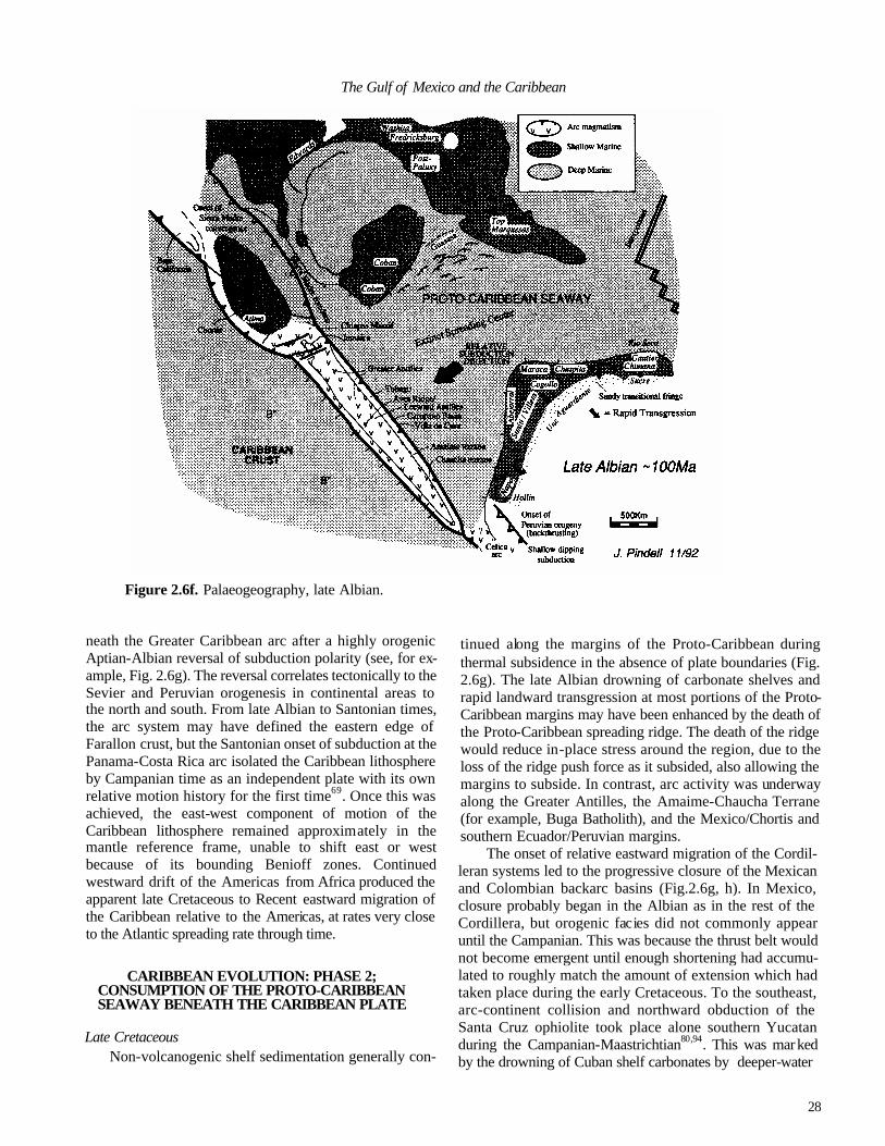
28
The Gulf of Mexico and the Caribbean
Figure 2.6f. Palaeogeography, late Albian.
neath the Greater Caribbean arc after a highly orogenic Aptian-Albian reversal of subduction polarity (see, for ex-ample, Fig. 2.6g). The reversal correlates tectonically to the Sevier and Peruvian orogenesis in continental areas to the north and south. From late Albian to Santonian times, the arc system may have defined the eastern edge of Farallon crust, but the Santonian onset of subduction at the Panama-Costa Rica arc isolated the Caribbean lithosphere by Campanian time as an independent plate with its own relative motion history for the first time69. Once this was achieved, the east-west component of motion of the Caribbean lithosphere remained approximately in the mantle reference frame, unable to shift east or west because of its bounding Benioff zones. Continued westward drift of the Americas from Africa produced the apparent late Cretaceous to Recent eastward migration of the Caribbean relative to the Americas, at rates very close to the Atlantic spreading rate through time.
CARIBBEAN EVOLUTION: PHASE 2; CONSUMPTION OF THE PROTO-CARIBBEAN SEAWAY BENEATH THE CARIBBEAN PLATE
Late Cretaceous Non-volcanogenic shelf sedimentation generally con-
tinued along the margins of the Proto-Caribbean during thermal subsidence in the absence of plate boundaries (Fig. 2.6g). The late Albian drowning of carbonate shelves and rapid landward transgression at most portions of the Proto-Caribbean margins may have been enhanced by the death of the Proto-Caribbean spreading ridge. The death of the ridge would reduce in-place stress around the region, due to the loss of the ridge push force as it subsided, also allowing the margins to subside. In contrast, arc activity was underway along the Greater Antilles, the Amaime-Chaucha Terrane (for example, Buga Batholith), and the Mexico/Chortis and southern Ecuador/Peruvian margins.
The onset of relative eastward migration of the Cordil-leran systems led to the progressive closure of the Mexican and Colombian backarc basins (Fig.2.6g, h). In Mexico, closure probably began in the Albian as in the rest of the Cordillera, but orogenic facies did not commonly appear until the Campanian. This was because the thrust belt would not become emergent until enough shortening had accumu-lated to roughly match the amount of extension which had taken place during the early Cretaceous. To the southeast, arc-continent collision and northward obduction of the Santa Cruz ophiolite took place alone southern Yucatan during the Campanian-Maastrichtian80,94. This was marked by the drowning of Cuban shelf carbonates by deeper-water

29
JAMES L. PINDELL
Figure 2.6g. Palaeogeography, Turonian.
Campur carbonates and eventually Sepur Formation fore-deep flysch derived largely from the arc. Similar flysch sequences probably flowed eastwards along the Cuban trench to be accreted to the Cuban thrust belt during its journey toward the Bahamas. In the Antillean segment of the arc, subduction of Proto-Caribbean crust continued throughout the late Cretaceous, but the Campanian was a time of uplift, erosion and deformation (for example, in Hispaniola12), probably related to plate interactions accom-modating the Proto-Caribbean bottleneck between Yucatan and Colombia.
In Colombia, the Amaime-Chaucha Terrane had been diachronously accreted by eastward-vergent thrusting onto the Central Cordilleran passive margin by the end of the Campanian, which (1) thermally reset many older radio-genic systems in the Central Cordillera, producing the ap-pearance of Cretaceous magmatism there, and (2) drove foredeep basinal subsidence (Colon, Umir Formations) east of the Central Cordillera by tectonic loading from the west74. Toward the end(?) of the Campanian, continued convergence began to occur at an east-dipping trench out-board of the Amaime Terrane, leading to the progressive accretion of Caribbean B" and other sedimentary materials into the Western Cordillera Belt during Maastrichitian and early Paleogene times (Fig. 2.6h).
Eastward-dipping subduction began in the Panama-Costa Rican arc along the Pacific side of B"-affected crust in the Santonian, as indicated by rapid uplift and the onset of Campanian volcanogenic sandstone and shallow-water carbonate deposition53. The formation of this arc at this particular time was required in order to take up the rapidly accelerating Farallon-North America convergence rate of about 150 mm/yr33. The Caribbean proceded to move at about 30 mm/yr70, so that the new arc, which defined the Caribbean Plate for the first time, took up the difference of over 100 mm/yr. I suggest that the arc stretched from west of Chortis, southeastwards to southern Ecuador. The Ecua-dorian site for the trench-trench-transform fault (TTT) triple junction is indicated by the boundary between voluminous and nearly absent Andean volcanism at this time to the south and north, respectively: to the north, Caribbean plate con-vergence with the Andes was only approximately 20 mm/yr, whereas to the south the Farallon Plate's convergence rate with the Andes was over 100 mm/yr. During the remainder of the Cretaceous and into the Tertiary, the triple junction appears to have migrated northwards and eventually into southern Colombia (Fig. 2.6i, j, k), at the rate of the north-ward component of motion in this area between the Carib-bean and South American plates, with a corresponding increase in magmatism in the wake. However, this level of

30
The Gulf of Mexico and the Caribbean
Figure 2.6h. Palaeogeography, Campanian. detail cannot be stated with confidence without further work.
Finally, in regard to the Cretaceous, the problem of having both the Chortis Block as well as the Caribbean Plate move synchronously eastwards relative to the Americas still appears to be best solved by northward underthrusting or subduction along the Lower Nicaraguan Rise69. The char -acter of the Rise is not unlike a submarine, oceanic crust-bearing accretionary prism22 and volcanism in the Upper Nicaraguan Rise to the north continued at least into the Paleocene. The Chortis Block must have moved relatively eastwards, while the Caribbean must have moved eastnorth-east, thereby producing convergence between the two at the Nicaraguan Rise.
Cenozoic The Caribbean Plate continued migration relatively
eastnortheastwards, subducting oceanic crust of the Proto-Caribbean. The Yucatan Basin opened by intra-arc spread-ing and extreme attenuation of Greater Antilles arc crust78
in a three-plate system (Fig. 2.6j, vector inset) between Cuba, the Cayman Ridge and North America69. The bulk of the Cuban portion of the Greater Antilles magmaiic arc is split between the basement of the Cayman Ridge and Cuba's southern arc belt. The Cretaceous volcanic assemblages of
onshore Cuba may represent mainly the forearc complex if rifting occurred nearly along the arc axis. A possible reason that Cuba lacks latest Cretaceous -Paleogene magmatic rocks is that the presently subaerial portion of Cuba was too close to the former trench: the arc-trench gap should have been greater, and plutons and volcanics of that age may exist offshore to the south. The opening of the Yucatan basin is defined by the three-plate system (NOAM-Caribbean-Cuba); trends and magnitudes of the relative motions may be calculated by vector completion69. Collision between the Greater Antilles and the Bahamas began in the Paleocene, although subduction accretion packages occur onshore Cuba which formed during the late Cretaceous and included late Cretaceous orogenic sediments probably derived from Yucatan, confusing the definition of the exact age of the onset of the Cuba-Bahamas collision.
A Paleogene age is also generally accepted for the opening of the Grenada Basin89. North-south extension best explains the east-west magnetic pattern and orientation of normal faults in and around the basin, as well as the sharp southeast boundary of the Aves Ridge (transform faulted?). Dextral oblique subduction of the Proto-Caribbean crust, dextral transform drag along South America, and subduc-tion zone rollback of the Jurassic oceanic crust along the northern South America passive margin may have combined
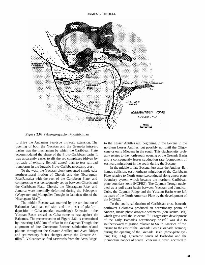
31
JAMES L. PINDELL
Figure 2.6i. Palaeogeography, Maastrichtian.
to drive the Andaman Sea-type intra-arc extension. The opening of both the Yucatan and the Grenada intra-arc basins was the mechanism by which the Caribbean Plate accommodated the shape of the Proto-Caribbean basin. It was apparently easier to rift the arc complexes (driven by rollback of existing Benioff zones) than to tear railroad transforms in the Jurassic Proto-Caribbean oceanic crust.
To the west, the Yucatan block prevented simple east-northeastward motion of Chortis and the Nicaraguan Rise/Jamaica with the rest of the Caribbean Plate, and compression was consequently set up between Chortis and the Caribbean Plate. Chortis, the Nicaraguan Rise, and Jamaica were internally deformed during the Paleogene (Wagwater and Montpelier Troughs in Jamaica; rifts of the Nicaraguan Rise54).
The middle Eocene was marked by the termination of Bahamian-Antillean collision and the onset of platform deposition in Cuba (overlap assemblage). Extension in the Yucatan Basin ceased as Cuba came to rest against the Bahamas. The reconstruction of Figure 2.6k is constrained by: restoring 1,050 km of offset in the Cayman Trough; the alignment of late Cretaceous-Eocene, subduction-related plutons throughout the Greater Antilles and Aves Ridge; and sedimentary facies changes across the Greater An-tilles69. Volcanism shifted eastwards from the Aves Ridge
to the Lesser Antilles arc, beginning in the Eocene in the northern Lesser Antilles, but possibly not until the Oligo-cene or early Miocene in the south. This diachroneity prob-ably relates to the north-south opening of the Grenada Basin and a consequently lesser subduction rate (component of eastward migration) in the south during the Eocene.
In the middle to late Eocene, just after the Antilles-Ba-hamas collision, east-northeast migration of the Caribbean Plate relative to North America continued along a new plate boundary system which became the northern Caribbean plate boundary zone (NCPBZ). The Cayman Trough nucle-ated as a pull-apart basin between Yucatan and Jamaica. Cuba, the Cayman Ridge and the Yucatan Basin were left as apart of the North American Plate by the development of the NCPBZ.
To the south, subduction of Caribbean crust beneath northwest Colombia produced an accretionary prism of Andean, Incaic phase orogenic sediments (San Jacinto Belt) which grew until the Miocene31,32. Progressive development of the early Barbados accretionary prism88 was due to southeastward migration relative to South America of the terrane to the east of the Grenada Basin (Grenada Terrane) during the opening of the Grenada Basin (three-plate sys-tem; Fig. 2.6j). Quartzose sands of Barbados and the Piemontine nappes of central Venezuela were accreted to

32
The Gulf of Mexico and the Caribbean
Figure 2.6j. Palaeogeography, Paleocene. the complex in the Eocene prior to emplacement onto the shelf. These probably originated from western and central Venezuela, where Precambrian acidic massifs were exposed at that time, and from the peripheral bulge ahead of the Venezuela foredeep basin.
Post-Eocene subduction of Proto-Caribbean crust is indicated by subduction-related magmatism in the Lesser Antilles. In the NCPBZ, the Cayman Trough progressively opened by seafloor spreading at the Mid-Cayman Spreading Centre, which linked transform faults connecting to the Middle America and Lesser Antilles subduction zones (Fig. 2.6j, k). These transforms have changed location through time, forming anastomosing fault systems across central Guatemala in the west and across Hispaniola/Puerto Rico in the east. Large-offset transcurrent motions between blocks of Hispaniola are indicated by incompatible Tertiary sedi-mentary facies which are presently juxtaposed across fault zones. The primary offset during the late Eocene and Oligo-cene occurred along faults of the northern San Juan Basin, juxtaposing the San Juan block with the Cordillera Central-Massif du Nord arc by the early Miocene, as indicated by the flooding of arc-derived elastics into the San Juan Basin at that time20,60. Motion on eastward extensions of this fault system separated Puerto Rico from central Hispaniola, and may have brought the Bermeja area of southwest Puerto
Rico into contact with central Puerto Rico along the 'Eocene Tectonic Belt'.
In the developing southern Caribbean plate boundary zone (SCPBZ)11,87, eastward migration of the Caribbean Plate progressively lengthened the zone of Caribbean-South American interaction (Fig. 2.61). Nappes have been em-placed southeastwards onto the Venezuela margin since the Paleocene; initiation of thrusting upon the autochthon be-comes progressively younger to the east. Subsidence of the Venezuela shelf near Maracaibo was Paleocene-early Eo-cene95 and subsidence in the Eastern Venezuela Basin was Miocene-Pliocene91. A transform fault between the Carib-bean Plate and the obducted terranes on South America basement developed progressively after thrust emplace-ment, and assisted with continuing strike-slip offset of the Caribbean, but not the obducted terranes, after emplace-ment. The Falcon64 and Cariaco84 Basins are two examples of Oligocene-early Miocene and Miocene-Recent, respec-tively, transtensional basins that developed in previously overthrust areas. I note that both opened only after the development of the Grenada Basin, when the relative mo-tion vector was extremely oblique.
Motion through Hispaniola during the early to middle Miocene (Fig. 2.6m) continued along the northern San Juan Basin, and possibly along the south flank of Sierra Neiba,
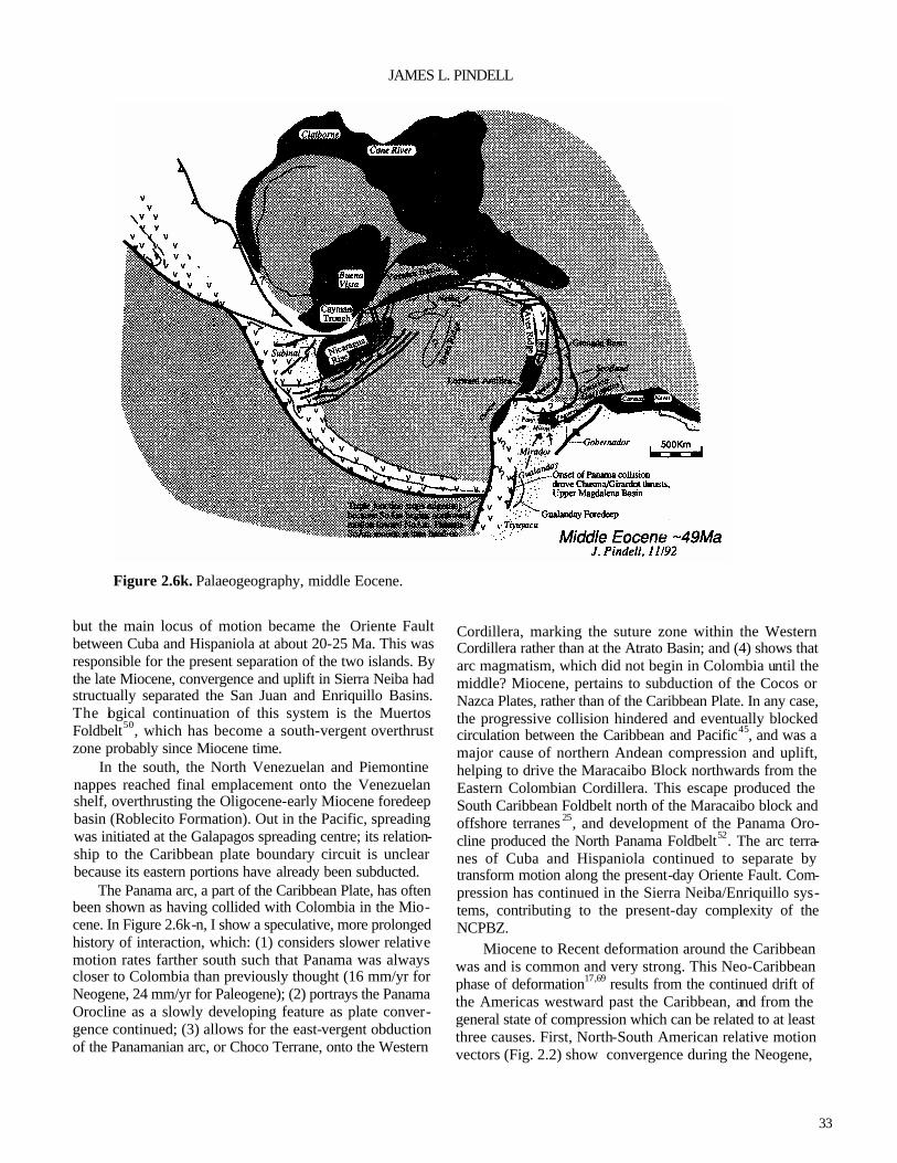
33
JAMES L. PINDELL
Figure 2.6k. Palaeogeography, middle Eocene.
but the main locus of motion became the Oriente Fault between Cuba and Hispaniola at about 20-25 Ma. This was responsible for the present separation of the two islands. By the late Miocene, convergence and uplift in Sierra Neiba had structually separated the San Juan and Enriquillo Basins. The logical continuation of this system is the Muertos Foldbelt50, which has become a south-vergent overthrust zone probably since Miocene time.
In the south, the North Venezuelan and Piemontine nappes reached final emplacement onto the Venezuelan shelf, overthrusting the Oligocene-early Miocene foredeep basin (Roblecito Formation). Out in the Pacific, spreading was initiated at the Galapagos spreading centre; its relation-ship to the Caribbean plate boundary circuit is unclear because its eastern portions have already been subducted.
The Panama arc, a part of the Caribbean Plate, has often been shown as having collided with Colombia in the Mio-cene. In Figure 2.6k-n, I show a speculative, more prolonged history of interaction, which: (1) considers slower relative motion rates farther south such that Panama was always closer to Colombia than previously thought (16 mm/yr for Neogene, 24 mm/yr for Paleogene); (2) portrays the Panama Orocline as a slowly developing feature as plate conver-gence continued; (3) allows for the east-vergent obduction of the Panamanian arc, or Choco Terrane, onto the Western
Cordillera, marking the suture zone within the Western Cordillera rather than at the Atrato Basin; and (4) shows that arc magmatism, which did not begin in Colombia until the middle? Miocene, pertains to subduction of the Cocos or Nazca Plates, rather than of the Caribbean Plate. In any case, the progressive collision hindered and eventually blocked circulation between the Caribbean and Pacific45, and was a major cause of northern Andean compression and uplift, helping to drive the Maracaibo Block northwards from the Eastern Colombian Cordillera. This escape produced the South Caribbean Foldbelt north of the Maracaibo block and offshore terranes 25, and development of the Panama Oro-cline produced the North Panama Foldbelt52. The arc terra-nes of Cuba and Hispaniola continued to separate by transform motion along the present-day Oriente Fault. Com-pression has continued in the Sierra Neiba/Enriquillo sys-tems, contributing to the present-day complexity of the NCPBZ.
Miocene to Recent deformation around the Caribbean was and is common and very strong. This Neo-Caribbean phase of deformation17,69 results from the continued drift of the Americas westward past the Caribbean, and from the general state of compression which can be related to at least three causes. First, North-South American relative motion vectors (Fig. 2.2) show convergence during the Neogene,

34
The Gulf of Mexico and the Caribbean
Figure 2.6l. Palaeogeography, early Oligocene.
which constricts the Caribbean Plate. Second, the restrain-ing bend in the Oriente-Puerto Rico Trench transform fault northeast of the Dominica Republic 13 constricts the east-ward migration of the north-central Caribbean and is respon-sible for much transpression in Hispaniola. The eastern part of Hispaniola, which has already passed this bend, has subdued topography relative to the western part. Third, the northeastward migration, relative to the Guyana Shield, of the Andean Cordilleran Terranes has induced a compression upon the Caribbean Plate to the northnorthwest, because the Caribbean Plate possesses an eastward component of mo-tion relative to the Guyana Shield that is slightly greater than that of the Cordilleran Terrane26. In the southeast Carib-bean, where the Caribbean and South American plates nearly come into contact, the relative motion of the two has been slightly north of east since the late Miocene4, but was more convergent (transpressional to the eastsoutheast) in the early and middle Miocene. A fourth cause, which pertains mainly to Colombia, is that the crust of the Caribbean Plate is buoyant and resists subduction, as attested to by the Andean orogenesis which has occurred in the absence of volcanism throughout the Cenozoic.
ACKNOWLEDGEMENTS—I thank John Dewey, Walter Pitman, Edward Robinson, Sam Algar and Johan Erikson for their input on various elements of this review.
REFERENCES
1 Algar, S.T. 1993. Structural, stratigraphic, and thermo-chronologic evolution of Trinidad. Unpublished Ph.D. thesis, Dartmouth College, Hanover.
2Algar, S.T. & Pindell, J.L. 199la. Structural development of the Northern Range of Trinidad, and implications for the tectonic evolution of the southestera Caribbean: in Gillezeau, K. A. (ed.), Transactions of the Second Geo-logical Conference of the Geological Society ofTrin-dad and Tobago, Port-of-Spain, Trinidad, April 3-8, 1990, 6-22.
3Algar, S.T. & Pindell, J.L. 1991b. Stratigraphy and sedi-mentology of the Toco region of the Northern Range of Trinidad: in Gillezeau, K.A. (ed.), Transactions of the Second Geological Conference of the Geological Society ofTrindad and Tobago, Port-of-Spain, Trinidad, April 3-8, 1990,56-69.
4Algar, S.T. & Pindell, J. 1993. Structure and deformation history of the Northern Range of Trinidad and adjacent areas. Tectonics, 12, 814-829.
5Anderson, T.H., Burkart, B., Clemons, R.E., Bohnenber-ger, O.K. & Blount, D.N. 1973. Geology of the Cuchu-mantanes, northwestern Guatemala. Geological Society of America Bulletin, 84, 805-826.

35
JAMES L. PINDELL
Figure 2.6m. Palaeogeography, early Miocene.
6Anderson, T.H. & Schmidt, V.A. 1983. The evolution of Middle America and the Gulf of Mexico-Caribbean Sea region during Mesozoic time. Geological Society of America Bulletin, 94, 941-966.
7Ave Lallemant, H.G. & Oldow, J.S. 1988. Early Mesozoic southward migration of Cordilleran transpressional ter-ranes. Tectonics,7,1057-1075.
8Ave Lallemant, H.G. & Sisson, V.B. 1993. Caribbean-South Americ an interactions: constraints from the Car-ibbean de la Costa Belt, Venezuela: in Pindell, J.L. (ed.), Mesozoic and Early Cenozoic Development of the Gulf of Mexico Caribbean Region. Transactions of the 13th Annual Research Conference, Gulf Coast Section, SEPM Foundation, 211-220.
9Barr, K.W. 1963. The Geology of the Toco District, Trini-dad, W.L Overseas Geological Surveys, HMSO, Lon-don.
10Beets, DJ., Maresch, W.V., Klaver, G.Th., Mottana, A., Bocchk), R., Beunk, F.F. & Monen, H.P. 1984. Mag-matic rock series and high-pressure metamorphism as constraints on the tectonic history of the southern Car-ibbean. Geological Society of America Memoir, 162, 95-130.
11Biju-Duval, B, Mascle, A., Rosales, H. & Young, G. 1983. Episutural Oligo-Miocene basins along the north
Venezuela margin. American Association of Petroleum Geologists Memoir, 34, 347-358.
12Bowin, C. 1975. The geology of Hispaniola: in Nairn, A.E.M. & Stehli, F.G. (eds), The Ocean Basins and Margins. Volume 3. The Gulf of Mexico and the Carib- bean, 501-550. Plenum, New York. 13Bracey, D.R. & Vogt, P.R. 1970. Plate tectonics in the Hispaniola area. Geological Society of America Bulle- tin, 81,2855-2860. 14Buffler, R.T. & Sawyer, D.S. 1985. Distribution of crust
and early history, Gulf of Mexico Basin. Transactions of the Gulf Coast Association of Geological Societies, 35,333-344.
15Buffler, R.T. & Thomas, W. (in press). Crustal structural and tectonic evolution of the southeastern margin of North America and the Gulf of Mexico basin: in Speed, R. (ed.), The geology of North America, Volume CTV-1, Phanerozoic Evolution of North American Continent-Ocean Transition. Geological Society of America, Boulder.
16Burke, K. 1988. Tectonic evolution of the Caribbean. Annual Review of Earth and Planetary Sciences, 16, 201-230.
17Burke, K., Grippi, J. & Sengor, A.M.C. 1980. Neogene structures in Jamaica and the tectonic style of the north-

36
The Gulf of Mexico and the Caribbean
Figure 2.6n. Palaeogeography, late Miocene. ern Caribbean plate boudary zone. Journal of Geology, 88,375-386.
18Campa, M. & Coney, PJ. 1983. Un modelo tectonic de Mexico y sus relaciones con America del Norte, Amer-ica del Sur y el Caribe. Revista del Instituto Mexicano delPetroleo,15,6-l5.
19Chevalier, Y., Stephan, J.-F., Darboux, J-R., Gravelle, M., Bellon, H., Bellizzia, A. & Blanchet, R. 1988. Obduc-tion et collision pre-Tertiaire dons les internes de la Chain Caraibe venezuelienne, sur le transect fle de Margarita-Pennisule d'Araya. Compte Rendu de la Academie des Sciences de Paris, serie II, 307, 1925-1932.
20Cooper, J.C. 1983. Geology of the Fondo Negro Basin and adjacent areas, Dominican Republic. Unpublished M.S. thesis, State University of New York at Albany. Damon, P. & Coney, P. 1983. Rate of movement
of nuclear Central America along the coast of Mexico during the last 90 Ma. Geological Society of America, Abtracts with Programs, 15, 553. Dengo, G. & Case, J.E. (eds). 1990. The Geology of North America, Volume H, The Caribbean region. Geological Society of America, Boulder. Dewey, J.F. 1980. Episodicity, sequence and style at
convergent plate boundaries: in Strangway, D.W. (ed.),
The continental crust and its mineral deposits. Special Paper of the Geological Association of Canada, 20, 553-573.
24Dewey, J.F. 1982. Plate tectonics and the evolution of the British Isles. Journal of the Geological Society of Lon-don, 129,371-412.
25Dewey, J.F. & Pindell, J.L. 1985. Neogene block tectonics of Turkey and northern South America: continental applications of the finite difference method. Tectonics, 4,71-83.
26Dewey, J.F. & Pindell, J.L. 1986. Neogene block tectonics of Turkey and northern South America: continental applications of the finite difference method—reply. Tectonics, 5, 703-705.
27Dickinson, W.R & Coney, PJ. 1980. Plate tectonics constraints on the origin of the Gulf of Mexico: in Pilger, R.H. (ed.), The Origin of the Gulf of Mexico and the Early Opening of the Central Atlantic, 27-36. Lou-isiana State University, Baton Rouge,
28Dolan, J.F., Mann, P., Monechi, S., de Zoeten, R., Heubeck, C., & Shiroma, J. 1991. Sedimentologic, stratigraphic, and tectonic synthesis of Eocene-Mio-cene sedimentary basins, Hispaniola and Puerto Rico. Geological Society of America Special Paper, 262, 217-240.
21
22
23

37
JAMES L. PINDELL
29Donnelly, T.W. 1989. Geologic history of the Caribbean and Central America: in Bally, A.W. & Palmer, A.R. (eds), The Geology of North America—An Overview, 299-321. Geological Society of Americ a, Boulder.
30Duncan, R A. & Hargraves, R.B. 1984. Plate tectonic evolution of the Caribbean region in the mantle refer-ence frame. Geological Society of America Memoir, 162, 81-84.
31Duque-Caro, H. 1979. Major structural elements and evo- lution of northwest Colombia. American Association of Petroleum Geologists Memoir, 29, 329-351.
32Duque-Caro, H. 1984. Structural style, diapirism, and accretionary episodes of the Sinu-San Jacinto Terrane, southwestern Caribbean borderland. Geological Soci- ety of America Memoir, 162,303-316. 33Engebretson, D.C. 1982. Relative motions between oce- anic and continental plates in the Pacific basin. Un-
published Ph.D. thesis, Stanford University, California. 34Erikson, J.P. 1992. Northeastern Venezuela's Jurassic
through Eocene passive margin, Hispaniola's Neogene Cibo Basin, and their histories and causes of evolution. Unpublished Ph.D. thesis, Dartmouth College, Hano- ver.
35Erikson, J.P. & Pindell, J.L. (in press). Cretaceous-Eocene passive margin relative sea level history, sequence stra-tigraphy, and the tectonic eustatic causes of strati-graphic development in northeastern Venezuela SEPM Special Publication.
36Erikson, J., Pindell, J.L. & Larue, D.K. 1990. Mid-Eo-cene-early Oligocene sinistral transcurrent faulting in Puerto Rico associated with formation of the northern Caribbean plate boundary zone. Journal of Geology,
98,365-384. 37Gonzalez de Juana, C., Arozena, J.A. & Picard Cardillat, X. 1980. Geologiade Venezuela y sus Cuencas Petro- liferas. Ediciones Foninzes, Carcas.
38Hall, S.A., Najmuddin, I. & Buffler, R.T. (in press). Contraints on the tectonic development of the Gulf of Mexico provided by magnetic anomaly data over the deep Gulf. Journal of Geophysical Research.
39Hilst, R.D. van der. 1990. Tomography with P, PP and pP delay-time data and the three-dimension mantle struc-ture below the Caribbean region. Geological Ultraiecu-tina, Mededelingenvan de Faculteit Aardwetenschap-pen der Rijksuniversiteit te Utrecht, 67, 250pp.
40Imlay, R.W. 1980. Jurassic paleobiogeography of the conterminous United States in its continental setting. U.S. Geological Survey, Professional Paper, 1062, 1-134.
41Irving, E.M. 1975. Structural evolution of the north-ernmost Andes, Colombia. U.S. Geological Survey, Professional Paper, 846, 1-47.
42James, K. 1990. The Venezuelan Hydro habitat: in Brooks, J. (ed.), Classic Petroleum Provinces. Geologi cal Society of London Special Publication, 50, 9-36. 43Jansa, L.F. & Weidmann, J. 1982. Mesozoic-Cenozoic development of the eastern North American and north west African continental margins: a comparison: in von Rad, U., Hinz, K., Sarnthein, M. & Siebold, E. (eds), Geology of the Northwest African Margin, 215-269. Springer-Verlag, New York. 44Johnson, C.C. & Kauffman, E.G. 1989. Cretaceous radis- tid paleobiogeography of the Caribbean Province. Ab- stracts, 12th Caribbean Geological Conference. St. Croix, U.S. Virgin Islands, 7th-llth August, 85. 45Keigwin, L.D., Jr. 1978. Pliocene closing of the Isthmus of Panama, based on biostratigraphic evidence from nearby Pacific Ocean and Caribbean sea cores. Geol-
ogy, 6, 630-634. King, P.B. 1969. Tectonic Map of North America, scale
1:5,000,000. United States Geological Survey, Reston, Virginia. Klitgord, K.D., Popenhoe, P. & Schouten, H. 1984. Florida:
a Jurassic transform plate boundary. Journal of Geophysical Research, 89, 7753-7772. Klitgord, K. & Schouten, H. 1986. Plate kinematics of the
central Atlantic: in Tucholke, B.E. & Vogt, P.R. (eds), The Geology of North America, Volume M, The Western Atlantic Region, 351-378. Geological Society of
America, Boulder. Ladd, J.W. 1976. Relative motion of South America with
respect to North America and Caribbean tectonics. Geological Society of America Bulletin, 87, 969-976. 50Ladd, J.W. & Watkins, J.S. 1978. Tectonic development of trench-arc complexes on the northern and southern margins of the Venezuelan Basin: in Watkins, J.S., Montadert, L. & Dickerson, P.W. (eds), Geological and Geophysical Investigations of Continental Margins. American Association of Petroleum Geologists Mem- oir, 29, 363-371.
51Livacarri, R.F., Burke, K. & Sengor, A.M.C. 1981. Was the Laramide Orogeny related to subduction of an oce- anic plateau? Nature, 189,276-278.
52Lu, R.S. & McMillen, K.J. 1983. Multichannel seismic survey of the Colombia Basin and adjacent margin: in Watkins, J.S. & Drake, C.L. (eds), Studies in Continental Margin Geology. American Association of Petro-
leum Geologists Memoir, 34, 395-410. Lunberg, N. 1983. Development of forearcs of intrao-
ceanic zones. Tectonics, 2, 51-61. 54Mann, P. & Burke, K. 1984a. Cenozoic rift formation in the northern Caribbean. Geology, 12,732-736. 55Mann, P. & Burke, K. 1984b. Neotectonics of the Caribbean. Reviews of Geophysics and Space Physics, 22,
46
47
48
49
53
38
The Gulf of Mexico and the Caribbean
309-362. 56Mann, P., Burke, K. & Matumoto, T. 1984. Neotectonics
of Hispaniola: plate motion, sedimentation, and seis-micity at a restraining bend. Earth and Planetary Sci-ence Letters, 70,311-324.
57Maresch, W.V. 1974. Plate tectonics origin of the Carib-bean mountain system of northern South America: dis-cussion and proposal. Geological Society of America Bulletin, 85, 669-682.
58Marton, G. & Buffler, R.T. 1993. The southern Gulf of Mexico in the framework of the opening of the Gulf of Mexico Basin: in Pindell, J.L. (ed.), Mesozoic and Early Cenozoic Development of the Gulf of Mexico Caribbean Region. Transactions of the 13th Annual Research Conference, Gulf Coast Section, SEPM Foundation, 51-68.
59Mattson, P.H. & Pessagno, E.A., Jr. 1979. Jurassic and early Cretaceous radiolarians in Puerto Rican ophiolite; tectonic implications. Geology, 7,440-444.
60Michael,R.C. 1979. Geology of the south-central flank of the Cordillera Central and the adjacent portions of the San Juan Valley between Rio San Juan and Rio Yaca-hueque, Dominican Republic. Unpublished M.S. thesis, George Washington University, Washington D.C.
61Molnar, P. & Sykes, L.R. 1969. Tectonics of the Carib-bean and Middle America regions from focal mecha-nisms and seismicity. Geological Society of America
Bulletin, 80, 1639-1684. Montgomery, H., Pessagno, E.A., Jr. & Munoz, I.M.
1992. Jurassic (Tithonian) radiolaria from La Desirade (Lesser Antilles): preliminary paleontology and tec tonic implications. Tectonics, 11,426-432.
63 Morris, A.E., Taner, I., Meyerhoff, H.A. & Meyerhoff, A. A. 1990. Tectonic evolution of the Caribbean region; alternative hypothesis: in Dengo, G. & Case, J.E. (eds), The Geology of North America. Volume H. The Carib bean Region, 433-457. Geological Society of America, Boulder. 64Muessig, K.W. 1984. Structure and Cenozoic tectonics of the Falcon Basin, Venezuela and adjacent areas. Geo logical Society of America Memoir, 162, 217-230. 65Pindell, J.L. 1985a. Alleghenian reconstruction and the subsequent evolution of the Gulf of Mexico, Bahamas and Proto-Caribbean Sea. Tectonics, 4,1-39. 66Pindell, J.L. 1985b. Plate-tectonic evolution of the Gulf of Mexico and Caribbean Region. Unpublished Ph.D. the
sis, University of Durham, Durham. Pindell, J.L. 1990. Arguments for a Pacific origin of the
Caribbean Plate: in Larue, D.K. & Draper, G. (eds), Transactions of the 12th Caribbean Geological Con ference, St. Croix, U.S. Virgin Islands, 7th-llth August, 1989, 1-4. Miami Geological Society, Florida.
68Pindell, J.L. 1991. Geological rationale for hydrocarbon exploration in the Caribbean and adjacent regions. Journal of Petroleum Geology, 14, 237-257.
69Pindell, J.L. & Barrett, S.F. 1990. Geologic evolution of the Caribbean region: a plate-tectonic perspective: in Dengo, G. & Case, J.E. (eds), The Geology of North America, Volume H, The Caribbean Region, 405-432. Geological Society of America, Boulder.
70Pindell, J.L., Cande, S.C., Pitman, W.C., Rowley, D.B., Dewey, J.F., LaBrecque, J. & Haxby, W. 1988. A plate-kinematic framework for models of Caribbean evolution. Tectonophysics, 155, 121-138. 71Pindell, J.L., Drake, C.L. & Pitman, W.C. 1991. Prelimi-
nary assessment of a Cretaceous to Paleogene Atlantic passive margin, Serrania del Interior and Central Ranges, Venezuela/Trinidad. Abstracts, American Association of Petroleum Geologists Annual Meeting, Dallas, 190.
72Pindell, J.L. & Dewey, J.F. 1982. Permo-Triassic recon-struction of western Pangea and the evolution of the Gulf of Mexico/Caribbean region. Tectonics, 1, 179-212.
73Pindell, J.L. & Draper, G. 1991. Stratigraphy and tectonic development of the Puerto Plata area, northern Domini-can Republic. Geological Society of America Special Paper, 262, 97-114.
74Pindell, J.L. & Erikson, J.P. (in press). The Mesozoic passive margin of northern South America: in Vogel, A. (ed.), Cretaceous Tectonics in the Andes. Vieweg
Publishing, Weisbaden. Pindell, J.L., Erikson, J. & Algar, S. 1991. The relation-
ship between plate motions and sedimentary basin de-velopment in northern South America: from a Mesozoic passive margin to a Cenozoic eastwardly-progressive transpressional orogen: in Gillezeau, K.A. (ed.), Transactions of the Second Geological Confer-ence of the Geological Society of Trinidad and Tobago, Port-of-Spain, Trinidad, April 3-8, 1990, 191-202.
76Pindell, J.L., Robinson, E. & Dewey, J.F. (in press). Paleogeographic evolution of the Gulf of Mexico/
Caribbean Region. SEPM Special Publication. Rodgers, D.A. 1984. Mexia and Talco fault zones, east
Texas: comparison of origins predicted by two tectonic models: in Presley, M.W. (ed.), The Jurassic of East Texas. Transactions of the East Texas Jurassic Explo- ration Conference, 23-31. East Texas Geological Soci-
ety, Tyler. Rosencrantz, E. 1990. Structure and tectonics of the Yu-
catan Basin, Caribbean Sea, as determined from seis -mic reflection studies. Tectonics, 9, 1037-1059.
79Rosencrantz, E., Ross, M. & Sclater, J.G. 1988. Age and spreading history of the Cayman Trough as determined
62
67
75
77
78
39
JAMES L. PINDELL
from depth, heat flow, and anomalies. Journal of Geo- physical Research, 93, 2141-2157. 80Rosenfeld, J.H. 1993. Sedimentary rocks of the Santa Cruz ophiolite, Guatemala—a Proto-Caribbean his- tory: in Pindell, J.L. (ed.), Mesozoic and Early Ceno- zoic Development of the Gulf of Mexico Caribbean Region. Transactions of the 13th Annual Research Conference, Gulf Coast Section, SEPM Foundation, 173-180. 81Rowley, D.B. & Pindell, J.L. 1989. End Paleozoic -early
Mesozoic western Pangean reconstruction and its im-plications for the distribution of Precambrian and Pa-leozoic rocks around Meso-America. Precambrian Research, 42, 411-444.
82Salvador, A. & Green, A.G. 1980. Opening of the Carib- bean Tethys, geology of the Alpine chain born of the Tethys. Memoir of the 26th International Geological Congress. Bureau de Recherches Geological et Min- erologie, 115, 224-229. 83Schlager, W. et al 1984. Deep Sea Drilling Project, Leg 77, southeastern Gulf of Mexico. Geological Society of America Bulletin, 95, 226-236. 84Schubert, C. 1982. Origin of Car iaco Basin, southern Caribbean Sea. Marine Geology, 47, 345-360. 85Shaw, P.R. & Cande, S.C. 1990. High-resolution inver- sion for South Atlantic plate kinematics using joint altimeter and magnetic anomaly data. Journal of Geo- physical Research, 95, B2625-B2644.
86Sheridan, R.E., Crosby, J.T., Kent, K.M., Dillon, W.P. & Paull, C.K. 1981. The geology of the Blake Plateau and Bahamas. Canadian Society of Petroleum Geologists Memoir, 1, 487-502.
87Silver, E.A., Case, J.E. & Macgillavry, H.J. 1975. Geo- physical study of the Venezuelan boreland. Geological Society of America Bulletin, 86, 213-226. 88Speed, R.C. 1985. Cenozoic collision of the Lesser An- tilles Arc and continental South America and origin of the El Pilar Fault. Tectonics, 4, 40-70. 89Speed, R.C. etaL 1984. Lesser Antilles Arc and adjacent terranes. Ocean Margin Drilling Program, Regional Atlas Series, Atlas 10. Marine Science International, Woods Hole. 90Stoffa, P.L., Mauffret, A., Truchan, M. & Buhl, P. 1981. "Sub-B" layering in the southern Caribbean: the Aruba gap and Venezuela Basin. Earth and Planetary Science Letters, 53, 131-146. 91Vierbuchen, R.C. 1984. The geology of the El Pilar fault zone and adjacent areas in northeastern Venezuela. Geological Society of America Memoir, 162,189-212. 92Vogt, P.R., Anderson, C.N. & Bracey, D.R. 1971. Mesozoic magnetic anomalies, seafloor spreading, and geomagnetic reversals in the southwestern north Atlantic. Journal of Geophysical Research, 76,4796- 4823. 93Wadge, G. & Burke, K. 1983. Neogene Caribbean plate
rotation and associated Central American tectonic evolution. Tectonics, 2, 633-643.
94Wilson, H.H. 1974. Cretaceous sedimentation and oro- geny in nuclear Central America. American Associa- tion of Petroleum Geologists Bulletin, 58, 1348-1396. 95Zambrano, E., Vasquez, E. , Duval, B., Latreille, M. & Coffinieres, B. 1972. Paleogeographic and petroleum synthesis of western Venezuela. Editions Technip, Paris.

40
41
Caribbean Geology: An Introduction U.W.I. Publishers’ Association, Kingston
©1994 The Authors
CHAPTER 3
The Caribbean Sea Floor
THOMAS W. DONNELLY
Department of Geological Sciences and Environmental Studies, State University of New York at Binghamton, P.O. Box 6000, Binghamton, New York 13902-6000, U.SA.
INTRODUCTION
THE FLOOR of the Caribbean Sea (Figs 3.1,3.2) is essen-tially oceanic. It consists of several basinal areas (from west to east, the Yucatan, Colombian and Venezuelan Basins), separated by shallower areas (the Nicaraguan Rise and Beata Ridge). The Cayman Trough is a narrow, very deep linear basin immediately north of the Nicaraguan Rise and is notable for being the site of contemporary sea-floor spreading. The Caribbean sea floor has been extensively described in the recent "Caribbean Region" volume of the Geological Society of America's Decade of North American Geology series 9. Papers in that volume which are especially pertinent to the present discussion include chapters 27, 932 , 1041 and 1316. Extensive reference is also made here to the results of the Deep Sea Drilling Project (DSDP), notably Leg 15 (1970-197120).
The floor of the main part of the Caribbean—that is, the Venezuelan and Colombian Basins—is underlain by a vast plateau basalt which is not typical of oceanic crust, but which has close analogues elsewhere in the world ocean. The origin and evolution of this basalt is central to the history of the Caribbean region and will be the main focus of this chapter.
MORPHOLOGY OF THE CARIBBEAN BASINS
The following passage briefly describes the morphological units of the Caribbean from east to west. Figures 3.1 and 3.2 locate these features.
Aves Ridge The Aves Ridge is a complex elevated submarine area
with a virtually straight north-south western margin and an eastern margin that merges with the curved volcanic inner
arc of the Lesser Antilles. The depth of water on the western margin ranges from zero (Aves Island) to a more repre-sentative 1-2 km. In the southern half of the ridge the Grenada Basin is a basinal area with a water depth of nearly 3km.
The origin of the Aves Ridge is obscure, but rocks of island-arc affinity have been dredged and drilled at several places. Donnelly13 speculated that the ridge represents two extinct island arcs of late Cretaceous to Paleogene age, one on the western margin facing west and one on the eastern margin facing east These arcs have been sundered by late Cretaceous to Paleogene eastward movement of the Carib-bean plate. The Neogene Lesser Antilles island arc is built upon diverse sundered fragments of these older arcs.
Venezuelan Basin The Venezuelan Basin is the easternmost, the most
thoroughly studied, and the simplest of the basinal areas of the Caribbean. Because it has been studied more completely than the other basins, and also because it was drilled in several places during DSDP Legs 4 and 15, it will be useful to consider it in some detail before proceeding to the remain-ing areas of the Caribbean.
The Venezuelan Basin is mainly between 4 and 5 km deep. It is slightly shallower in the centre than on the northern and southern margins, where it is bounded by narrow troughs with turbidite plains. The trough on the north is called the Muertos Trough; the one on the south is less well defined and has no commonly accepted name. The northern and southern boundaries show clear evidence of young subduction41 of the crust of the basin beneath the adjacent land areas.
On the east the Venezuelan Basin is bounded by the Aves Ridge. The tectonic nature of this boundary has not been clarified, because the nature and history of the Aves

42
The Caribbean Sea Floor
Figure 3.1. (A) Map of the Caribbean showing major named features within the basinal portion. Filled circles with numbers are drilling sites (DSDP Leg 15) that reached the basaltic crust; open circles are DSDP sites not reaching basement. Line shows crustal cross section of (B). (B) East-west crustal cross-section at 15° latitude, bent to cross Central America at about S45°W. The 'Caribbean basalt/sediment layer' is the upper part of the thickened Caribbean crust; the sediment portion of this layer is conjectured. This figure has been adapted, with minor interpretive revisions, from Case et al7.
Ridge is not fully clear. Near the boundary there is a pattern of magnetic anomalies which are fairly shallow and are parallel to the boundary. These probably represent the mag-netic expression of high-angle faults which are parallel to the boundary. The supra-crust sediment thickens dramati-cally approaching the ridge51. For these reasons, and be-cause there are Cretaceous-Paleogene rocks of apparent
island-arc affinity from the western margin of the ridge, Donnelly13 suggested that the eastern margin of the Vene-zuelan Basin is a zone at which basinal crust had been subducted beneath the Aves Ridge during the Cretaceous and Paleogene.
One of the most important attributes of the Venezuelan Basin is the presence of a widespread seismic reflector

43
THOMAS W. DONNELLY
called horizon B". This reflector occurs between 0.5 to 1.5 km depth, which is appropriate for normal ocean crust. The horizon is also a very efficient acoustic reflector, which is typical for basalt beneath sediment. However, the reflector appears to be far smoother in profile than typical oceanic crust. Horizon B" was found during deep-sea drilling (Leg 15) to correspond with the upper surface of what was subsequently identified as a plateau basalt.
The Venezuelan Basin shallows to the west; its western boundary is called the Beata Ridge, which is a highly asymmetric topographic feature with a steep western face and a very shallow eastern face. The western boundary is not a simple submerged cliff edge. Instead, there are several horsts and grabens parallel to the western edge, but located within 100 km of the ridge itself.
Beata Ridge The Beata Ridge represents the western edge of the
uptilted Venezuelan Basin and is somewhat accentuated by horsts and grabens running parallel to the western escarp-ment. The ridge is the western boundary of a basalt escarp-ment which shallows gradually to the faulted edge. The face of the ridge must contain the outcrop of horizon B", but this has not been directly observed. Fox and Heezen27 reported the dredging of basaltic rock at depths of 2500 to 3200 m on the western wall of the ridge; this must represent sub-B" basalt. This discovery parallels the recovery of basalt at DSDP Site 15120, on the crest of the ridge, at a depth of 2400 m below sea level. The western face has slopes of 8° to 15°.
Colombian Basin The Colombian Basin is narrower and topographically
more complex than the Venezuelan Basin. On the east its boundary with the Beata Ridge is sharp and has the appear-ance of a normal-faulted escarpment. On the west it is separated from the lower Nicaraguan Rise by the low Hess Escarpment. There is no apparent difference in crustal type between the Colombian Basin and the Nicaraguan Rise based on seismic information, and the reason for the fault boundary separating the two domains is not understood.
The Colombian Basin is occupied in the centre and northern part by a wide and evidently thick turbidite plain which has hampered geophysical techniques and which would prevent drilling. On the southwestern end the basin terminates against a somewhat shallower (water depths shal-lower than 3 km) deformed belt on the Caribbean side of Panama and Costa Rica.
Nicaraguan Rise The shallow portions of the Nicaraguan Rise appear to
be the offshore extensions of the continental structure of the Chortis Block (Honduras, southeastern Guatemala, El Sal-
vador, northern Nicaragua; see Burkart, chapter 15, this volume), which have a presumed Precambrian/Palaeozoic basement overlain by more or less thick Cretaceous and early Cenozoic sedimentary rocks. This crustal material is submerged over much of the northern part of the Nicaraguan Rise. The dominant topographic features of the northern Nicaraguan Rise are vast, shallow banks of young carbonate sediment evidently lying on continental crust. These banks are essentially unexplored, except for some exploratory, petroleum holes on the western margin that have encoun-tered Eocene conglomerates and sandstones32. The nature of the buried boundary zone between the Nicaraguan Rise and the island of Jamaica remains totally enigmatic.
The deeper portion of the Nicaraguan Rise is an up-stepped extension of the Colombian Basin across the Hess Escarpment. A continuation of the B" horizon (defined for the Venezuelan Basin) west of this scarp was demonstrated by drilling at DSDP Site 152, in the eastern portion of the rise. The nature of the boundary between the clearly oceanic and plausibly continental portions of the rise is completely unknown.
Cayman Trough The Cayman Trough is the deepest (at least two regions
are deeper than 6 km) part of the entire Caribbean. It is bounded on the north and south sides by steep walls, which have the morphology of steep fault scarps, with a strong overall resemblance to a transform fault. However, all other known transform faults are interruptions of the mid-ocean ridge system, and no traces of such a ridge can be found on either side of the Cayman Trough. However, the pattern of earthquake distribution and the first motions of the stronger earthquakes reinforce the view that this trough does indeed have a transform origin. The seismicity extends along the northern wall westward from Cuba to the middle of the trough, then steps across the trough along anorth-south axial zone, and then continues westward on the south side of the trough. The first motions of the quakes along the northern and southern walls are right lateral, which is appropriate for a transform origin for this narrow basin.
The bathymetry within the deep Cayman Trough is chaotic, apparently consisting of poorly defined north-south ridges, which are most conspicuous in the central (axial) part of the trough. The seismic axial zone corresponds with the shallowest (about 3.5 km) depths in the trough, deepening
Figure 3.2. (Next page) Map of the Caribbean showing depth contours in km. The lowest con-tours of closed basins are hachured. Turbidite plains are shown by a stipple pattern.

44
The Caribbean Sea Floor

45
THOMAS W. DONNELLY
towards the flanks of the axial high. There are also some ridges and secondary troughs more or less parallel to the north and south walls of the Cayman Trough; these evi-dently represent fault slices parallel to the major bounding strike-slip faults of the trough margin.
Yucatan Basin The Yucatan Basin is smaller than the Venezuelan or
Colombian Basins. It is slightly shallower in the southern half, where it merges with a poorly defined ridge on the north side of the Cayman Trough (Cayman Ridge). In the northern half of the basin, and mainly in the western part, it is floored with a large turbidite plain. The northern margin with Cuba is of indeterminate origin in most places, but is probably convergent in the northeast55. The margin on the western side, against Belize and Mexico, is steep and highly faulted. It has the appearance of a transform margin, possi-bly related to the opening of the basin in a northnortheast-southsouthwest direction and the northern movement of Cuba during the early Cenozoic.
GEOPHYSICAL INVESTIGATIONS OF THE CARIBBEAN CRUST
Introduction Water-covered portions of the Earth are not accessible
to the sort of observations with which ‘classical’ geologists are familiar. The difficulty of making observations on an ocean floor itself (which averages nearly 4 km in depth) is actually the smallest part of the problem. The more serious part of the predicament is that the oceans are the site of continual sedimentation almost entirely unrelieved by epi-sodes of erosion. Whereas continental and island areas are being continually subjected to erosive processes which strip off the younger cover and exposes older rocks from which geological deductions can be made, the ocean floor exposes virtually no rock or sediment which is not Holocene in age.
Our understanding of oceanic geology only began in very recent years, when 'remote sensing' techniques be-came available for detecting and defining the physical prop-erties of these doubly hidden older rocks and sediments. These techniques, which mainly use acoustic sensing, are referred to as ‘geophysical surveying’. So successful have they been that they have virtually created a new field of geology in the last few decades: marine geology. The infor-mation that they provided and the questions that they raised were followed in 1968 by deep-sea drilling, which has enabled geologists to obtain cores of sediment and igneous rock beneath the ocean floor, and thus to provide tangible proof of geophysical inferences.
Because of its location and calm waters, the Caribbean
was the site for the development and testing of many geo-physical techniques. Thus, many of the geophysical surveys within the Caribbean were carried out at very early stages of their technical development, and the history of Caribbean marine geophysics is very nearly a history of marine geo-physics itself. These early studies had the advantage of bringing to the geological world knowledge of the Carib-bean crust at a very early time. The attendant disadvantages were that this information could not be placed in a world- wide context until surveys of other areas were made, and that techniques were commonly improved after their early Caribbean trials, but the improved techniques were infre-quently applied at a later time to the Caribbean itself
Bathymetry The earliest, and in many ways the most important,
technique was simply the exercise of surveying the depths of water of the oceans ('bathymetry'). On land this is a simple exercise, and surveyors began producing numerous detailed topographic maps of the land surface in the mid 1800s. The same exercise is very difficult in the oceans, where man cannot venture far beneath the surface, and where light cannot penetrate more than about 100 m in any case. The invention of the sonic depth finder in the 1920s introduced a method which was not immediately used for general surveys, but which produced detailed depth profiles along the tracks followed by ships, which tend to follow the same shortest-distance tracks between ports. It was not until the late 1930s that general surveys were attempted. The Caribbean was the site of one of the first surveys, and the contour map which was published in 1939 (U.S. Naval Oceanographic Chart of the Caribbean) was one of the first such maps in the entire world. The difficulties of persuading ship's captains to follow circuitous paths for surveying purposes were overcome in the Caribbean in part by Franklin Roosevelt's love of deep sea fishing. It is said that several of his fishing trips were used also for surveying, because the fish were as good in one place as another , and he didn't care where the ship went!
Gravity Other early geophysical efforts in the Caribbean in-
cluded submarine gravity surveys using a technique devised by F.A. Vening Meinesz of the Netherlands. Until the late 1950s, submarines had to be used for marine gravity surveys because the motion of the waves made surface ships unsuit-able for a technique that requires a very quiet platform for the gravity meter. The major result of the surveys in the vicinity of the Caribbean was to show that the east-west trending gravity minimum of the Puerto Rico Trench, which has a large mass deficiency because the great depth of sea water (which is less than half the density of oceanic sedi-

46
The Caribbean Sea Floor
Figure 3.3. Map of the Caribbean crust showing thickness of the solid crust Contour interval 5 km. This is based mainly on the results of seismic refraction surveying. Redrawn from Case et al.7.
ment and about a third that of crust), bends south and parallels the Lesser Antilles island arc. This mass deficiency is now explained as resulting from subduction of the Atlan-tic crust beneath the Lesser Antilles. The subduction process drags (at the rate of only a few cm per year) a mass of sediment westward and downward beneath the Lesser An-tilles. Compression of this sediment thickens and deforms the sediment mass, and part of the deformed sediment pile has been raised above the ocean as the island of Barbados. The surveyed axis of maximum mass deficiency passes very close to this island.
Seismic Refraction The earliest geophysical technique which yielded
geologically useful information within the Caribbean itself was two-ship seismic refraction. Following the develop-ment of the seismic refraction technique in the western Atlantic in the later 1940s, mar ine geophysicists at Lament Geological Observatory and Woods Hole Oceanographic Institution turned their attention to the Caribbean and Gulf of Mexico. In the two-ship technique one ship remained stationary in the water with a sensitive hydrophone deployed and recorded the arrivals of sound pulses generated by the other as it steamed away (over distances of several hundred km) setting off large explosions of TNT in the water. At the end of its run the 'shooting' ship stopped dead in the water and deployed a similar hydrophone, becoming the recording ship as the first ship steamed towards the first, and became the shooting ship. For each shot the time of explosion is
transmitted by radio and recorded on the same record on which the water transmitted pulses are recorded. Thus the records show travel times of sonic phases, each of which has travelled through a different stratified acoustic medium (the shallowest layer is the ocean itself). If the media are of constant acoustic velocity and stratified such that velocity increases step-wise in a downward direction, a successful survey will enable geophysicists to calculate the depth of the top of each sediment or rock layer at the ends of the profile, as well as its seismic velocity. The two-ship seismic refrac-tion technique was highly useful in obtaining gross crustal velocities and finding the depth to the MOHO (the acoustic horizon which separates the earth's crust from the mantle). The technique is much less useful for obtaining variations in velocity within individual layers, and it is only marginally useful in obtaining velocities of the shallow pelagic sedi-ment cover.
This method was widely used from the late 1940s (when large quantities of surplus World War II explosives were available at no cost) until the 1960s. The improvement of acoustic systems which could detect much smaller signals (an air-gun using a large air compressor is used presently), plus geometrically elaborate hydrophone arrays which could be deployed from a single ship, have made the two-ship method obsolete, but its results had a profound effect on the course of study of the ocean basins in general and in the Caribbean in particular.
47
THOMAS W. DONNELLY
Seismic Reflection Another technique, which has become the most com-
monly employed, is seismic reflection. This technique is similar to refraction except that the shot point and sound detector are located nearly side by side. Thus, any sound received is reflected and not refracted. The reflection tech-nique was developed mainly during the 1950s, although the first sub-bottom acoustic reflections had been recorded be-fore World War II. The earlier applications were mainly in shallow water and used a variety of sound sources31. The application of the seismic profiling method to deep water26 can be said to have been born in the Caribbean: the earliest published deep-sea seismic reflection profiles in the world are in the Yucatan Basin and Gulf of Mexico.
The seismic -reflection technique became possible when repetitive sound sources with sufficient energy to penetrate the sea floor became available in the 1960s. The earliest sound sources were electrical sparks (which have low energy) and half-pound blocks of TNT, which are hazardous. The present sound source of choice is the air gun, which emits a pulse of sound every ten seconds or so while profiling. The returned sound reflections are sensed by a linear array (called a 'string') of receivers (hydrophones) whose relative position strengthens the sound signal coming from directly beneath the array and minimizes sound trav-elling from other directions (such as the ship itself). The received sound is filtered to remove unwanted frequencies, particularly those resulting from the noise of the ship mov-ing through the water. Recent applications of computer processing have resulted in the acquisition of seismic profile records of exceptional detail, and the rate of improvement of the technique is still rising. Modern computing tech-niques are capable of displaying not only an image of the acoustically distinguishable layers beneath the sea floor, but can also provide seismic velocity and other sorts of acoustic information about individual layers.
Whereas the objective of seismic refraction is determin-ing the acoustic velocities and thicknesses of the relatively deep crustal layers, the seismic -reflection technique is most useful in depicting intricacies of the layering of the overly-ing pelagic sediment cover. The earliest seismic profiling had as its objective only the imaging of sedimentary layer-ing. However, the technique quickly evolved into a hybrid refraction/reflection method capable of measuring acoustic velocities, especially of the shallower layers. In this later version of the technique, a hydrophone and radio for trans -mission of the received sound was attached to a float and left stationary in the water as the ship steamed away and continuing to emit sound pulses with an air gun. When the float was close to the sound source (that is, at the beginning of the run), the received sound was purely reflected. As the distance between the sound source and receiver increased,
the reflected sound took longer to arrive. The sound re-flected from the sea floor and sub-bottom reflecting hori-zons took increasingly longer to reach the hydrophone, and the trace of the reflectors on the recorder resembled hyper-bolas. As the distance increased beyond a certain point, reflected sound was no longer detected, because of critical reflection (which is analogous with a familiar optical phe-nomenon), and the received sound was entirely refracted. The utility of this technique is that it yields sediment layer velocities during a normal reflection profile. This technique was first known under the name 'sonobuoy' (which is the name for a disposable floating hydrophone-radio combina-tion). The sonobuoy technique is especially valuable for obtaining acoustic velocities of the supra-crustal sediment, but it often reveals the acoustic velocity of the uppermost basement layers.
The sonobuoy method has evolved more recently into a number of specialized techniques using arrays of hydro-phones towed by the ship at varying distances from the sound source. The results of these new techniques are often described under the general and not highly descriptive term of 'seismic stratigraphy'. As detection devices (mainly to sort out faint sound signals from a high ambient noise level) and computational techniques have improved, the new tech-niques now yield more information than was obtained dec -ades ago with expensive and dangerous two-ship seismic refraction.
The interpretation of sedimentary layering from seis-mic reflection is a relatively new and rapidly evolving geological exercise. Sound reflections in layered sediments (or igneous rocks) result from contrasts in acoustic imped-ance of the layers. Basically, acoustic impedance is the product of the density and acoustic velocity of the materials. In most cases acoustic impedance contrasts results from lithologic changes and thus record the stratigraphic layering directly. These changes may be dramatic (a basalt layer beneath pelagic ooze; a turbidite layer within pelagic ooze) or they may be more subtle (varying carbonate content in a pelagic ooze). The earlier surveys gave relatively crude results and identified only a few 'horizons', as the reflecting interfaces were known. More recent surveys display com-plex layering with detailed velocity information.
Magnetic Surveying The method of magnetic surveying is an additional
technique which was pivotal in oceanic research in unrav-eling the complexities of sea-floor spreading, but which has yielded very little useful information on the Caribbean crust. This technique employs a sensor which detects differing intensities of the ambient magnetic field ('magnetometer'). This sensor has to be towed far behind a ship, because the magnetic field of the ship would interfere with the survey.

48
The Caribbean Sea Floor
Figure 3.4. Map of the Caribbean showing small topographic lineaments (solid lines) and small scarps (solid lines with hachure marks on the downthrown side) mapped on the sea floor. This map is adapted from Case and Holcombe6. The location of the earthquake studied by Kafka and Weidener37 is shown by the letter 'E'. The line- aments are interpreted as neotectonic responses to the continuing internal deformation of the Caribbean plate. In the Venezuelan Basin they parallel the magnetic anomaly pattern (not shown), and the isopachs of sediments of the B"-A" interval as well as the post-A" interval19. The existence of recognizable lineaments on the turbidite plains emphasizes the young age of these small tectonic features.
Alternatively, the sensor can be mounted in or behind an airplane. (Few people remember that the famous Reykjanes Ridge survey in the early 1960s was made with an air-borne magnetometer flown a few hundred feet above the ocean surface). The magnetic intensity in the main ocean was found to consist of the ambient Earth's field with either a small addition or subtraction caused by oceanic crust per-manently magnetized either parallel or anti-parallel to the earth's field axis (a so-called reversal). The spatial pattern of these reversals was found to correlate with the temporal history of reversals of the Earth's field, which was the major conceptual hurdle to deciphering the story of sea-floor spreading.
REGIONAL GEOPHYSICAL CHARACTER OF THE CARIBBEAN
The following account summarizes knowledge of the Car -ibbean crust and pelagic sediment cover made initially through seismic refraction and reflection techniques, which was later refined with the results of deep-sea drilling. Be-cause I will concentrate on the Caribbean crust itself, I will omit several excellent papers covering the borderlands40,60, as well as most of the material in Biju Duval et al.2 ,Ladd et al.44 and Ladd and Watkins42.
Venezuelan, Colombian and Yucatan Basins The Early Years
Refraction surveys in the Caribbean have provided the most important geophysical evidence bearing on the prob- lem of the origin and nature of the Caribbean crust. It is difficult to realize that all of the published surveys were undertaken in the interval of only a few years. (Two earlier refraction lines by Sutton in the Venezuelan Basin have evidently not been published, in spite of references suggesting the contrary.) Ironically, the first published Caribbean seismic refraction line (executed in 1953), which was in the Yucatan Basin, remains the only line in this basin to the present date! In 1955 there were separate surveys in the Venezuelan50 and Colombian Basins, Nicaraguan Rise, and Cayman Trough23,24. In 1956 there was a further survey in the Venezuelan Basin51, and in 1957 another survey along the South American borderland and across the Beata Ridge and eastern Colombian Basin18. These were the last two-ship seismic refraction profiles obtained in this area, but the density of refraction information remains one of the highest for the entire world ocean.
Edgar et a/.18 presented the final results of this tech-nique and summarized the state of knowledge (mainly thick-ness of crust) obtained from these methods. The most startling revelation is that the crust of the Caribbean is
49
THOMAS W. DONNELLY
oceanic in character, but much thicker than 'normal' oceanic crust (Fig. 3.3). Whereas normal oceanic crust has a thick-ness of about 5-6 km (which, along with 0.5 to 1 km of sediment cover, means a depth to the MOHO (lower bound-ary of the crust) of about 6-7 km), in the Caribbean this depth was commonly greater than 10 km and in the Beata Ridge areaabout20kmdeep. Officer et a/.50 speculated that "...the entire Caribbean area may have been extensively intruded by large bodies of primary basalt magma...". This was one of the most prescient and significant discoveries in the history of Caribbean geology.
Ewing et a/.25 summarized several years of early seis-mic reflection profiling in the Caribbean and recognized two prominent reflection horizons. They named these the A" and B" horizons; the identification and elucidation of these have subsequently been pivotal in Caribbean marine geological and geophysical research. The A" horizon was a persistent and widespread acoustic reflector which was located at about half the total thickness of the sediment layer, and the B" horizon was the acoustic basement. After the initial description of these reflectors, their explanation became a major problem of Caribbean marine geology. The A" reflec-tor obviously represented an important lithological break between two contrasting sediment types, but several plausi-ble sedimentary contrasts might yield similar reflectors, and the acoustic record could not choose among the possibilities. The B" horizon resembled 'normal' oceanic crust in that it is several hundred metres below the sea floor and is a highly efficient reflector, letting very little sound through. How-ever, it was far smoother in profile than normal oceanic crust, which has a characteristic hummocky appearance. Almost from its first appearance on seismic profiles it was considered to be something other than normal oceanic crust.
Deep Sea Drilling Project
The development of the seismic profiling technique came fortunately only a few years before the initiation of the Deep Sea Drilling Project, which is arguably the single most important geological research project in this century. One of the first aims of the project was the identification through recovery by drilling of the lithologies which corresponded to the reflection horizons found in seismic reflection profil-ing. In the Caribbean there were two drilling legs (Leg 4, February-March, 1969; Leg 15, November 1970-January 1971) devoted in part (Leg 4) and completely (Leg 15) to the Caribbean (Fig. 3.la). A later site (DSDP Site 502, Leg 68, August 1979), in the Colombian Basin, was drilled in part as a follow-up of a hole drilled during Leg 15 and also as the refinement of a new drilling technique. I will discuss only the five holes (all on Leg 15) that penetrated the sediment cover and reached the basement of the Caribbean crust. One of the first discoveries of drilling on Leg 4 was that
Ewing's horizon A" was found to be Middle Eocene cherts at the top of a sedimentary sequence rich in radiolaria. Horizon B" was identified on Leg 15 as the top of a wide-spread basalt sequence of late Turonian (in the east) to early Campanian (west) age. The main aim of Caribbean marine geophysical investigations since Leg 15 has been to inves-tigate the implications of the B" horizon, which was recog-nized immediately as not representing normal oceanic crust. Modern Geophysical Surveying
Subsequent marine geophysical investigations have re-flected changing techniques in seismic surveying. There have been three notable sonobuoy studies in the Caribbean. Ludwig et al.46 presented the results of a 1970 cruise in the Colombian and Venezuelan Basins, showing that the sedi-ment and crustal acoustic velocities along this east-west line matched the velocities of the drilled materials recovered at DSDP Sites 146 and 151 (Leg 15). Later cruises in the Colombian Basin36 and southern Venezuelan Basin62 em-phasized seismic reflection, but included extensive sonobuoy observations. These cruises showed that the acoustic velocities of the Caribbean crust and supra-crustal sediments were more variable than suggested by the results of Ludwig et al.46
There also exists an extensive body of recent studies which have employed seismic reflection profiling to image the sediment layering, and from which important geological inferences could be drawn through construction of isopach maps and similar techniques. Edgar et al19 presented a profiler study of the Venezuelan Basin, for which a more complete data set was published by Matthews and Hoi-combe47. Recognition of the A" and B" horizons enabled the thicknesses of the post-A" and A"-B" intervals to be determined rapidly, so that they could be plotted along the lines of the seismic profiles. These profile records showed that the thickness of these two sediment layers changed abruptly along the survey lines.
Variable thicknesses of these layers can be interpreted in several ways. First, there might have been an original difference in sedimentation rate (rate of production of bio-logical sediment; rate of accumulation of fine-grained clas-tic sediment from the land areas). However , these differences are not expected to be abrupt along a given line. A second possibility is that the differences in sediment layer thickness record subsequent erosion in response to bottom currents. These are referred to as hiatuses in sedimentation. Evidence that this has been the case is found in drilled sediment sections in the southern Venezuelan Basin (espe-cially site 150, Leg 15, which found several stratigraphic hiatuses). These, however, are not expected to be abrupt along a line. Third, vertical faulting during sedimentation might result in erosion of the sediment cover over the up-thrown fault block, as a result of sediment erosion caused
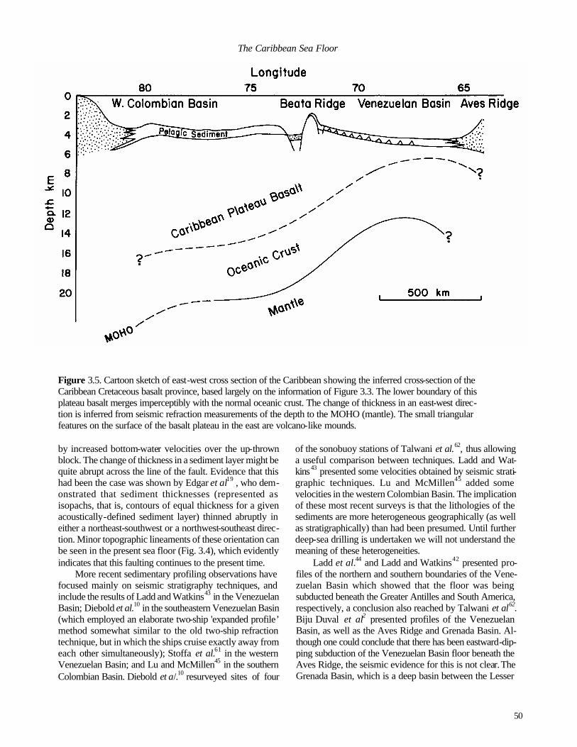
50
The Caribbean Sea Floor
Figure 3.5. Cartoon sketch of east-west cross section of the Caribbean showing the inferred cross-section of the Caribbean Cretaceous basalt province, based largely on the information of Figure 3.3. The lower boundary of this plateau basalt merges imperceptibly with the normal oceanic crust. The change of thickness in an east-west direc- tion is inferred from seismic refraction measurements of the depth to the MOHO (mantle). The small triangular features on the surface of the basalt plateau in the east are volcano-like mounds.
by increased bottom-water velocities over the up-thrown block. The change of thickness in a sediment layer might be quite abrupt across the line of the fault. Evidence that this had been the case was shown by Edgar et al19 , who dem-onstrated that sediment thicknesses (represented as isopachs, that is, contours of equal thickness for a given acoustically-defined sediment layer) thinned abruptly in either a northeast-southwest or a northwest-southeast direc-tion. Minor topographic lineaments of these orientation can be seen in the present sea floor (Fig. 3.4), which evidently indicates that this faulting continues to the present time.
More recent sedimentary profiling observations have focused mainly on seismic stratigraphy techniques, and include the results of Ladd and Watkins43 in the Venezuelan Basin; Diebold et al.10 in the southeastern Venezuelan Basin (which employed an elaborate two-ship 'expanded profile’ method somewhat similar to the old two-ship refraction technique, but in which the ships cruise exactly away from each other simultaneously); Stoffa et al.61 in the western Venezuelan Basin; and Lu and McMillen45 in the southern Colombian Basin. Diebold et a/.10 resurveyed sites of four
of the sonobuoy stations of Talwani et al.62, thus allowing a useful comparison between techniques. Ladd and Wat-kins43 presented some velocities obtained by seismic strati-graphic techniques. Lu and McMillen45 added some velocities in the western Colombian Basin. The implication of these most recent surveys is that the lithologies of the sediments are more heterogeneous geographically (as well as stratigraphically) than had been presumed. Until further deep-sea drilling is undertaken we will not understand the meaning of these heterogeneities.
Ladd et al.44 and Ladd and Watkins42 presented pro-files of the northern and southern boundaries of the Vene-zuelan Basin which showed that the floor was being subducted beneath the Greater Antilles and South America, respectively, a conclusion also reached by Talwani et al62. Biju Duval et al2 presented profiles of the Venezuelan Basin, as well as the Aves Ridge and Grenada Basin. Al-though one could conclude that there has been eastward-dip-ping subduction of the Venezuelan Basin floor beneath the Aves Ridge, the seismic evidence for this is not clear. The Grenada Basin, which is a deep basin between the Lesser

51
THOMAS W. DONNELLY
Antilles and the Aves Ridge in the southeast comer of the Caribbean, remains enigmatic and in need of modern sur-veying techniques. It may be a 'pull apart' basin, as sug-gested by its thick sediment fill.
Bowland and Rosencrantz4 presented profiles of the western Colombian Basin with rock units identified, but, in the absence of velocity or similar information, the identifi-cations are problematic. Similarly, Rosencrantz55 presented detailed profiles of the Yucatan Basin, again lacking velocity information. Because these latter areas have not been drilled, even the approximate ages and lithologies of the layers are unknown, and the age and nature of the basement is elusive. The thickness of supra-basement sediment is much thicker in the Colombian Basin than in the Venezuelan Basin. Part of the explanation probably lies in greater depo-sition of pelagic carbonate-rich sediment during the late Cretaceous and early Tertiary, but an additional part of this thickness might be clastic debris shed from Central Ameri-can as it rose during the late Miocene to Recent.
Cayman Trough
The Cayman Trough is a special portion of the Carib-bean crust which has been the focus of studies aimed at an understanding of this very deep, linear trough. Bowin3
summarized the results of his gravity observations with the earlier seismic refraction results of Ewing et al.23 to produce a structural model of the trough, finding, among other things, that a thin crust and correspondingly shallow MOHO required by isostatic compensation is indeed found in the axis of this trough. Heat flow values22 were found to be high compared with average world-wide oceanic values (which average 1.6 x 10⁻⁶ cal cm-2 s-1), suggesting young oceanic crust. A major breakthrough came with a paper by Hol- combe et al.34, who showed that the axial topography, and especially the exponential deepening away from a shallow axial zone, led to the conclusion that this trough was the site of modem sea-floor spreading. Holcombe and Sharman33
and Rosencrantz and Sclater57 refined these observations and showed a complex spreading pattern.
There is little doubt that the Cayman Trough represents more or less normal, but very thin, oceanic crust formed at an abnormally great water depth in a narrow basin. Dredged rocks 8 include a disproportionate fraction of gabbros, sug-
gesting either a somewhat abnormal crustal section or the vagaries of dredging in a topographically restricted and complex place. If the crustal layers were horizontal and uncomplicated, it would be concluded that the diving results show a very thin basalt layer above gabbro. However, the recovered rocks probably are from faulted slivers and do not represent simple horizontal layering. While the Holocene age and Neogene opening of the trough has not been in serious doubt since the original exposition by Holcombe et a/.34, the total history of opening remains undetermined.
The central zone, extending about 150 km either side of an axial high (for a total width of about a third of the entire trough) deepens exponentially on either side of the axial high. Holcombe et al.34 fitted thermal subsidence models to the bathymetry and concluded that the best fit of these two curves implies a total spreading rate of 2.2 cm yr-1. A problem is that the depth at the mid-trough ridge is about 3.5 km, which is about 1 km deeper than normal mid-ocean ridges. The narrowness of the Cayman Trough implies that the heat loss must be accommodated in lateral as well as vertical dissipation, allowing a probably higher loss rate and higher subsidence (that is, greater water depth over the ridge axis). However, the applicability of a modified mid-ocean model is necessarily somewhat in doubt under these extreme conditions.
Rosencrantz et al.56 have presented the most refined model for the opening of the Cayman Trough to date. They propose four ridge positions since marine magnetic anomaly 20 (middle Eocene) and three ridge jumps to the present position. The magnetic data is much less convincing than for most other ridge systems, including several large anoma- lies that are disregarded in their analysis. Heat flow values along the trough do not show the expected exponential decay trends. While the overall conclusion of Neogene spreading transverse to a spreading axis is convincing, largely on purely bathymetric grounds, further inferences about earlier spreading histories, with several ridge jumps, are not so convincing. The age of opening of the trough and the history of opening rates remains enigmatic. Geological problems with a 1000 km opening during the Eocene and extending westward to Guatemala have been discussed by Donnelly13,15, who suggested that much of the opening might have taken place concomitant with internal spreading
Figure 3.6. (Next page) Magnetic total intensity profiles across features of the Caribbean. (A) DSDP Site 145, northern Venezuelan Basin (from Raff54). (B) Air-borne magnetic profile of the southern peninsula of Haiti showing magnetic signature of the Dumisseau Formation. Computed and plotted from original project MAGNET records. Both profiles show the distinctive pattern of remnant magnetization with a nearly horizontal vector, which is characteristic of the mid-late Cretaceous magmatic bodies in the Caribbean.

52
The Caribbean Sea Floor

53
THOMAS W. DONNELLY
of the Chortis block.
CHARACTER OF THE CARIBBEAN CRUST
As recently as 1954, the Caribbean was considered by some to be continental crust converted to oceanic in relatively young geological time65. Ironically the first seismic refract-tion observations in the Caribbean had already been made; these showed definitively that the crust of the Caribbean was undoubtedly oceanic 23,30,51. However, these same surveys also showed that the oceanic crust was abnormally thick for much of the Caribbean, an observation that was not fully appreciated until later drilling.
One of the most important results of DSDP Leg 15 was the discovery of late Cretaceous basalt in five drill holes in the central Caribbean20. This material was quickly identified to be of the same age and character as numerous basalt occurrences on land areas surrounding the Caribbean, and the Caribbean was identified as the site of widespread ‘flood’ basalt eruptions11,17. Geophysical character of the Caribbean crust
Ewing et al25 designated the deeper of two seismic reflection horizons in the Venezuelan Basin as B", which they compared to the previously-named horizons B in the Atlantic and B' in the Pacific. Horizon B" appeared to be far smoother than oceanic crust and it was not interpreted as this material. The material underlying this horizon was the crus- tal material found in earlier seismic refraction sur-veys23,50,51. The occurrence of the basalt drilled during Leg 15 matched seismic refraction survey results18, in which a crustal or quasi-crustal material with velocities greater than 5 km s-1 occurred at this level. Thus, the top of the abnor-mally thick Caribbean crust was identified.
During DSDP Leg 15, horizon B" was penetrated in five drillholes (the deepest only 16 m into the basement) and the material which provided the large acoustic impedance con-trast for the seismic horizon was found to be basalt and dolerite20. Unlike the normal basalt of the sea floor, this was somewhat coarse-grained and not pillowed. Furthermore, there was no iron-enriched sediment above the basalt, an observation not fully appreciated at the time because so few penetrations to the crust had been made by the end of 1970. In two sites the basalt included limestone inclusions, and the interpretation made on board the ship was that the basalt had been emplaced as shallow sills in pelagic sediment. The age of the sediment immediately above the basalt was latest Turonian in three localities (DSDP Sites 146,150,153), that age or slightly younger at DSDP Site 151, at which recovery had been poor, and early Campanian in the westernmost DSDP Site (152). Thus, there was a suggestion that magma-
tism at the eastern sites ended contemporaneously, but con-tinued for an additional few million years in the west.
Ludwig et al.46, whose sonobuoy survey line passed close to drilled site 146 (coincidentally their sonobuoy station 146 was closest to this drill site), found that the total crustal thickness was shallower in the east and not very different from normal ocean crust. Conversely, workers in the western Venezuelan Basin and Colombian Basin36,61 have continued to point out the great thickness of the crust there. It is now appreciated (Fig. 3.5) from a variety of observations that the excessive thickness of the Caribbean crust diminishes to the east.
The smoothness of the B" horizon in profile had been emphasized in the earlier papers. Later refinements (higher source energy, improved signal to noise ratio) in the seismic profiling technique have revealed a rougher texture than was formerly apparent. Relatively modern surveys have found small reflection hyperbolas on B", showing some topography on the layer. (Unfortunately, Talwani et al.62 penned these in heavily on their profiles, thus robbing their readers of the opportunity of making this judgment for themselves.) Nevertheless, the contrast between fairly smooth B" and typical, rough, oceanic crust remains apparent throughout the surveyed areas. From this it is concluded that the basalt was erupted either in sheets which spread great distances ('flood basalts') or which intruded the shallow pelagic sediments which covered the basin floor. The density of liquid basalt (around 2.9 g cm-3) is much higher than water -rich pelagic sediment (density about 1.5 g cm-3, but variable). It would be physically impossible for a dense liquid to rise through a low-density, strengthless sediment layer. Thus, erupting basalt in a basin floored with pelagic sediment would have to be intrusive.
One interesting feature of the B" horizon is the occur-rence of a few buried sea mounts in the northern Venezuelan Basin. One of these was to have been drilled by the DSDP (site 145), but the drilling was aborted because of mechanical problems. This site has the magnetic signature of basalt of the age of the recovered B" material; that is, it shows a strong permanent magnetization with a low-inclination (Cretaceous) vector54 (Fig. 3.6a). The magnetization profile is similar to that seen in the on-land Dumisseau basalt of Haiti (Fig. 3.6b), which has been interpreted as an obducted fragment of the Caribbean crust49. Similar sea mounts are shown as circular low-thickness isopachs of the sediment layer between B" and A" in the maps of Edgar et al.19 and Matthews and Holcombe47. The clearest seismic reflection record of one of these sea mounts is shown by Ladd and Watkins43 (their figure 4, line VB-3-NB). The size (about 15 km across) of this mound and its morphology (height about 750 m, slopes about 5°) agree well with a volcano. The failure to drill DSDP Site 145 remains a sad memory.
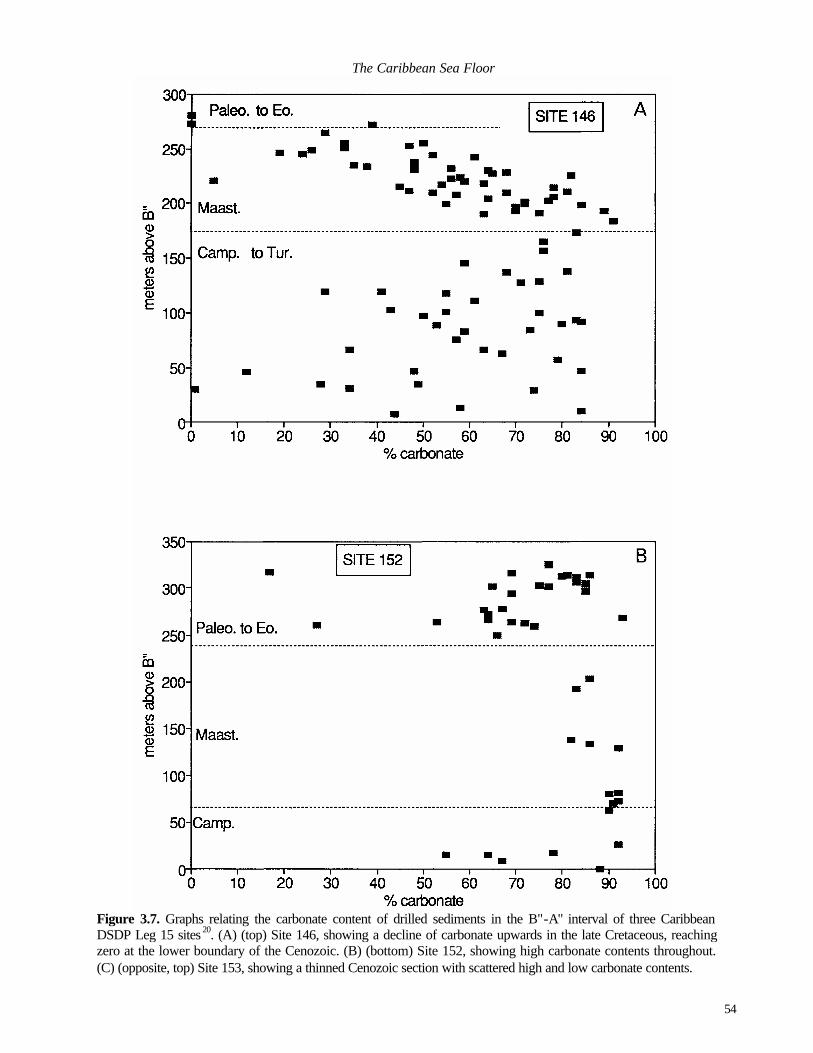
54
The Caribbean Sea Floor
Figure 3.7. Graphs relating the carbonate content of drilled sediments in the B"-A" interval of three Caribbean DSDP Leg 15 sites 20. (A) (top) Site 146, showing a decline of carbonate upwards in the late Cretaceous, reaching zero at the lower boundary of the Cenozoic. (B) (bottom) Site 152, showing high carbonate contents throughout. (C) (opposite, top) Site 153, showing a thinned Cenozoic section with scattered high and low carbonate contents.

55
THOMAS W. DONNELLY
In the Colombian Basin the identification of B", or
acoustic basement, has been more difficult. Instead of a very smooth reflector, commonly the reflecting horizon is rough, or highly faulted, or too deeply buried to register clearly on reflection profiles. One of the drill sites (DSDP Site 152) penetrated the B" horizon in the foot of the eastern Nicara-guan Rise close to its boundary with the Colombian abyssal plain. Unfortunately, this leaves virtually all of the remain-ing Colombian Basin and lower Nicaraguan Rise with no proof that the basement reflector represents the same basalt horizon as was found in the Venezuelan Basin. However, Bowland and Rosencrantz4 extended the designation of this horizon throughout the western Colombian Basin.
Seismic refraction results show that the entire crustal section is thicker in the Colombian Basin than in the Vene-zuelan Basin. Figure 3.5 shows that the crust of the entire Colombian Basin-Beata Ridge area (including the plateau basalt) exceeds 15 km, and in the western Colombian Basin thickens to beyond 25 km at about the point where the superincumbent sediment begins to thicken sharply (see Lu and McMillen45, Fig. 7, for sediment thickness).
The crust of the Yucatan Basin has not been identified. Ewing et al.23 showed, in an end-to-end seismic refraction profile, that it has the velocities of and a thickness only slightly greater than typical oceanic crust. Rosencrantz55
stated that the basement seismic reflection is smoother than that of typical ocean floor and suggested that it might be similar to B" of the Venezuelan and Colombian Basins. Hall and Yeung29 interpreted heat flow values21,22 as consistent with a late Cretaceous crust. They also presented an inter-
pretation of magnetic anomalies consistent with this age and suggested an age of opening as late Cretaceous to Paleogene. Rosencrantz55 presented a tectonic model which would have produced magnetic anomalies at approximately right angles to those of Ha ll and Yeung, which emphasizes the difficulty of mapping the faint magnetic lineations in this basin.
Magnetic anomalies and structural lineaments in the Venezuelan Basin
The discovery of magnetic anomalies in the Venezue-lan Basin12 led several workers to interpret these as sea-floor spreading anomalies. Ghosh et al.28 found a symmetry in the anomaly pattern and fitted them to a sea-floor spreading sequence of Jurassic to early Cretaceous age. The symmetry of the anomaly lines and the excellence of the fit is not as apparent to many workers as it evidently is to these authors. Also, there are serious problems with their interpretation. The inferred spreading rate (about 1 cm yr -1) is about half the inter-American divergence rate for this period and an addit ional spreading centre to make up this deficit has not been identified. Also, at least one of the original anomalies was inferred, on the basis of its similar magnitude at differ-ent elevations (3 km elevation (air-borne) and sea surface) to come from a source too deep to correspond to the Carib-bean crust12. For example, the sea-floor spreading anoma-lies across the mid-Atlantic Ridge are rarely visible in 3 km air-borne surveys of the same project, except for the strong axial anomaly.
An additional observation which causes difficulty for a
56
The Caribbean Sea Floor simple sea-floor spreading explanation for the magnetic anomalies is the parallelism between the anomalies and the conjugate northeast-southwest and northwest-southeast structural pattern seen in the topographic lineaments (Fig. 3.4) as well as the isopach maps mentioned above. This pattern is aneotectonic record of modern deformation of the plate. Burke et al.5 likened this pattern to a 'Prandtl cell'; that is, a plastic body deformed by being squeezed on three sides and being allowed to extrude in the direction of the fourth side. Thus, the lineaments are a conjugate set of small strike-slip faults within the deforming body. They suggested that the lineament pattern resulted from the Caribbean crust spreading eastward. Kafka and Weidner37 studied an earth-quake (MB 4.7, depth 18 km, 14th August, 1972) within the plate and found a first motion corresponding to sinistral movement on a northwest-southeast lineament. They said that this contradicted the sense of motion postulated by Burke et al5, but stated that perhaps an earlier fault had been reactivated by modern east-west compression and is now undergoing a re verse sense of motion. Figure 3.4 shows the proximity of the earthquake to an appropriate (northwest-southeast) linear element of the surface lineament pattern.
The surface lineament pattern is also parallel to sedi-ment isopach contours shown by both Edgar et al.19 and Matthews and Holcombe 47. Both of these papers referred to the same data set, but the latter paper displays the isopachs over a larger area. These isopach contours show that both the pre-A" and post-A" sediment (that is, 85-50 Myr and 50*0 Myr ago). Thus, during the last 85 Myr, the Venezuelan Basin has been riven by faults which apparently remain active today. There is little doubt that the lineament pattern results from deformation similar to the 'Prandtl cell' model of Burke et al.5. Because the grain of the magnetic anomaly pattern is parallel to these faults, I consider that these mag-netic anomalies most probably originate subsequent to the formation of the crust and do not represent sea-floor spread-ing anomalies.
The origin of the magnetic anomalies is still enigmatic. Their apparent depth (based on a faulted slab or reversed polarity block model) still poses a major problem. The magnitude of the anomalies (100 to 200 gammas) makes it difficult to find an appropriate faulted-slab model that will explain them, considering that they would have to lie at a depth well below B". They may result from another phe-nomenon, with a different model signature. A possibility is a dyke swarm orientated to one or the other of the fault directions of the conjugate set found in the Venezuelan Basin. The notion that they are older crust (late Jurassic?) buried beneath a kilometre or more of late Cretaceous basalt seems unsupportable.
Sub-B" acoustic reflections and the physical character of the plateau basalt
Hopkins35 reported a faint seismic reflection beneath B". Saunders et al 58, in the same volume, reported addi-tional examples, but Stoffa et al.61 dismissed one of these as a multiple internal reflection. However, Stoffa et a/.61, Ladd and Watkins43 and Biju Duval et al.2 have all reported these reflections and there is little doubt that they exist. The reported reflections all have a low dip (if they were parallel to B" it is doubtful that they would have been noticed), but not in a consistent direction. Most of these reports come from the southwestern Venezuelan Basin and the dips are to the south or to the north, with a minor eastward component. The depths of the reflectors are variable, ranging from very close to B” to about 0.5 s (2.5 km at 5 km s"1) beneath B". Although there must be a contrast in acoustic impedance in order to have a reflector, there is no clear lithological expla-nation for this contrast. Buried sediments are possible, but layered hyaloclastics are equally plausible, and a textual change in layered basalt itself cannot be dismissed.
Additional evidence for the character of the sub-B" may be inferred from the velocity structure of the entire supra-MOHO section. Earlier two-ship seismic refraction veloci-ties showed velocities between 6 and 7 km s-1 for deeper parts of this layer, but these velocities are themselves not very revealing. Diebold et al.10 have shown velocity profiles that are not unlike oceanic crust, but with widely differing thicknesses of layers. More intriguing are the lower (4-5 km s-
1) velocities found by Ludwig et al.46 in the shallower portion of the basement, especially in the central Venezue-lan Basin. The depth of these layers places them squarely in the depth range of sub-B" materials, but the velocities seem too low to match the drilled materials recovered in Leg 15. They could be hyaloclastic basalt or they could represent included sedimentary layers within the upper part of the sub-B" layer. The normal oceanic crust has similarly low velocities near the ridge crest where cementation has not yet filled in the velocity-lowering fractures which are abundant in young basalt. Nowhere in oceanic crust of Cretaceous age elsewhere in the world is there a clear counterpart of these velocities and the identification of this lower -velocity ma-terial must await future drilling.
Lithological and petrological character of the plateau basalt
Our knowledge of the sub-B" material comes not only from five shallow drill penetrations, but from extensive occurrences of correlative obducted ophiolite. One of the unusual features of the Caribbean is the widespread occur-rences of basaltic (=ophiolitic) complexes of Cretaceous age found on land in the general tectonic context of thrust sheets with more or less abundant serpentine. These are summa-

57
THOMAS W. DONNELLY rized in Donnelly et al.16. These have the appropriate age, lithology, and associated sedimentary rocks to make their identification with sub-B" material inescapable. The identi-fication of the sub-B" material in the Venezuelan Basin by its relationship with obducted ophiolitic material (which is especially clear in Curasao, Aruba, Venezuela and His-paniola, and slightly less so in Puerto Rico and Trinidad) can be extended westward to land areas adjacent to the western basins, even though the westernmost drilled occur-rence of this material is far removed to the northeast (DSDP site 152 on the eastern lower Nicaraguan Rise). The finest exposures in the west of this basaltic material are in Costa Rica, but extensive outcrops can be found also in Panama, Colombia and Jamaica. Similar material, of similar age, is found in Guatemala and Cuba; its identification with any of the presently named Caribbean basins would be highly certain except for the fact that the Chortis Block (continental crust of Honduras and adjacent regions) now intervenes between these northern outcrops and the bulk of the southern occurrences.
Prior to the drilling of Leg 15 it was not apparent what these vast on-land basalt-serpentine masses signified. A major result of the drilling was to show the unity of the entire assemblage as a vast Caribbean flood basalt province11. The stratigraphic level of the supra-basalt sediments on the land correlates with, as nearly as complex structural environ-ments allow, the stratigraphic level found for the termina-tion of the event in basinal occurrences.
These on-land occurrences are dominantly pillow ba-salt, but include massive basalt, as well as locally thick hyaloclastic beds. The availablity of on-land examples has enabled the study of these rocks in far greater detail than if research was confined to the recovered materials in five drill holes. An account of the petrology of this basalt complex was given in Donnelly et al.16 . In summary, this basalt is thick (1 OOs of m or a few km) in on-land occurrences. Most of the basalt has the chemical (major and minor elements) attributes of normal, ridge-generated sea-floor basalt (mid-ocean ridge basalt or 'MORB'), but one of the drilled (DSDP Site 151, Beata Ridge) and several on-land (Hispaniola, Costa Rica) occurrences are of a basalt enriched in the incompatible elements, including the light rare earths. Near the base at one locality (Curasao) and possibly in the same stratigraphic position at an isolated, insular site off the west coast of Colombia is a picritic basalt (called 'komatiite' at the latter locality) which has a high magnesium content unparalleled among Phanerozoic basalts. Similar, but slightly less magnesian, basalts are found in Costa Rica This high-Mg basalt has a special significance. Basaltic melts of this composition require a high degree of melting and are erupted at particularly high temperatures. They were erupted abundantly during the Archaen, but are virtually
absent from Phanerozoic terrains. Their appearance in the Caribbean indicates that the melting within the mantle acheived a very high temperature which implies a vast amount of excess heat at depth.
It is safe to conclude, on the basis of seismic reflection, drilled occurrences and obducted mafic igneous complexes, that the entire Caribbean Cretaceous basalt province once occupied nearly the entire Venezuelan Basin, Beata Ridge and Colombian Basin, extending an unknown distance onto the Nicaraguan Rise. A possible northern extension or equivalent has remains on Cuba and Guatemala
Conclusions regarding the plateau basalt Donnelly11,13 concluded that the sub-B" layer of the
Caribbean represents a flood basalt province of vast original size (possibly about 1.2 km2), ranking it among the world's great Phanerozoic flood-basalt provinces. The age of termi-nation of this event was about 85 Myr in the east and was apparently younger, but not well-defined, in the west. In Costa Rica, where the western equivalents are best exposed on land, there seems to have been a severe decrease in eruptive activity in the early Campanian, but minor magma-tism continued to the Paleogene. Nowhere on land is there a clear indication of the beginning of the event. Late middle Albian ammonites have been found within the basalt on Curacao64, which remains one of the firmest dates within the eruptive dates itself. There are numerous finds of am-monites, radiolarians and foraminifers16 in sedimentary rocks which are arguably related to some stage of the erup-tive history for on-land occurrences, but in most cases some doubts can be raised that thes e do not place a firm age constraint on the associated basalts.
One of the major elusive questions is the age at which basaltic magmatism began in the Caribbean. The well-ex-posed and well-studied rocks of Costa Rica appear to pro-vide important evidence. In the Nicoya Complex of western Costa Rica a radiolarian chert sequence appears to lie be-neath the upper Nicoya complex (which is equivalent to the basinal basalt) and the lower Nicoya basaltic complex. However, even this excellently exposed sequence places surprisingly few constraints on the basalt eruptive history, because many, and perhaps all, of the contacts with the lower complex are probably intrusive. The lower complex has been considered to be older than the chert, whose earliest age is Callovian or older. However, the lower complex is dominantly intrusive and could even be interpreted as a coeval intrusive equivalent of the upper complex. Dozens of geologists labouring for several decades have not been able to solve the problem of the ages of the upper and lower complex.
Thus, several major questions remain unanswered. What is the thickness and volume of erupted material? At

58
The Caribbean Sea Floor
what age did the enq>tion begin? What was the average and maximum rate of eruption (cubic kilometres per million years, or some other measure)? Is there clearly defined older crust beneath the basalt event elsewhere in the Caribbean? It is of considerable interest, but little help, to note that there are other, similar and possibly coeval basalt occur-rences elsewhere in the world. The Ontong- Java plateau of the western Pacific has perhaps the highest similarity, but there are others, also during the Cretaceous, which should be considered. Evidently the basalt magmatic activity of the entire world was exceptionally high during this time period.
SUPRA-CRUSTAL PELAGIC SEDIMENTS
Virtually all that is known of the pelagic sediments of the Caribbean comes from drilling DSDP Legs 41, 1520 and 6853 (which sampled only sediment down to Upper Mio-cene). Complete descriptions of these sediments may be found in these volumes. In only four sites (DSDP Sites 30 and 148 on the Aves Ridge, and 154 and 570 in the western Colombian Basin) are there, appreciable thicknesses of hemipelagic sediment deposited close to a continental area In the remainder of the sites the sediments are typical pelagic sediments similar to those encountered far distant from continental areas. There are only a few good occurrences of on-land sediments arguably correlative with these pelagic sediments (Haiti49, Costa Rica59), compared with the larger number of occurrences of the underlying basalt.
The persistence of a prominent acoustic reflector (A") in the Venezuelan Basin enables us to divide the sedimen-tary section into a post-A" upper part and B"-A" lower part. The pelagic sedimentary section is highly diverse beneath reflector A", and more homogeneous above this level.
Sediments of the B" -A " interval As noted above, B" is latest Turonian, or about 85
million years old, in the Venezuelan Basin and somewhat younger in the Colombian Basin. Horizon A" is slightly time transgressive, being middle Eocene (about 50 Myr) in the east, but late Paleocene (about 58 Myr) in the west.
The pelagic sediment sequence in this interval is domi-nantly calcareous, but with a strong siliceous component. This interval shows great vertical thickness and variability, suggesting deposition within a topographically rugged area Occurrences of intercalated radiolarian turbidites and vol-caniclastic sands suggest contemporaneous erosion from higher areas.
There are two notable occurrences to Turonian to San-tonian carbon-rich sediment (DSDP Sites 146 and 153). Carbonaceous sediments of this age are otherwise unknown in the world ocean, with the exception of a site western
tropical Atlantic (DSDP Site 144 on the foot of the Demarara Rise encountered carbonaceous pelagic sediments of late Turonian to Santonian age30). The unusual age and character of these sediments appears to link the Caribbean (espe-cially Site 153) and Atlantic sites. To the extent that carbonaceous sedimentation requires anoxic bottom waters which in turn implies geographic restriction, these occur-rences provide an obstacle to the view that the Caribbean basalt might occurred in the Pacific Ocean distant from a land mass.
The importance of the B"-A" interval is largely for the information it reveals on the mode of formation of the sub-B" layer, the Caribbean Cretaceous basalt event. We have two sorts of information; the drilling results of DSDP Leg 15 and seismic reflection studies, including sonobuoy. Leg 15 drilling found a 350 m-thick section between B" and A" at DSDP Sites 146 in the Venezuelan Basin and 152 in the lower Nicaraguan Rise. The correlative section at the more southerly DSDP Site 153 (southwest Venezuelan Ba-sin) was only 200 m thick. The remaining two penetrations (DSDP Sites 151 on the Beata Ridge and 150, south-central Venezuelan Basin) found highly thinned sections, with thicknesses of about 30 and 35 m, respectively.
One of the most important questions for the early Car-ibbean is the determination of palaeodepth of the water A normal ridge-generated oceanic crust subsides as the square root of time following crustal generation at the ridge axis. This relationship (which explains most of the bathymetry of normal oceanic crust) is called the "Sclater-Francheteau curve" and is explained as resulting from thermal contrac -tion resulting from the dissipation of excess (magmatic) heat brought to the ridge axis during sea-floor spreading. The Caribbean evidently formed not as a normal ridge, but as a vast basalt plateau. It is theorized that the water was shal-lowest over the approximate centre of the province, where the basalt was thickest. However, the entire province should have subsided with time, as the original heat was dissipated.
The thickness of the basalt and the time interval over which it was erupted are unknown. However, the history of thermal subsidence of the body can place some constraints on these values. As crust subsides it reaches a water depth below which sinking calcareous debris (biogenic fossils) are dissolved. This horizon, the CCD (=Carbonate Compensa-tion Depth), varies from place to place and time to time, but in a relatively small part of the world ocean and in a brief interval it can be taken as a flat plane. Calcareous debris falling on a surface beneath this depth will be more or less dissolved, and resulting sediment will be both thinner and less calcareous compared to that accumulated during the same interval at shallower depth. Thus, the thickness and calcium carbonate content of sediment above the crust are critical to an interpretation of the original bathymetry of the

59
THOMAS W. DONNELLY basalt mass.
The present depths of the B" are an approximation of the relative palaeodepths at the time of cessation of the igneous event, that is, at the beginning of the post-B" sedi-mentation. It is not possible to correct these depths to the true depth, because the post-igneous event thermal subsi-dence history is unknown and likely to be considerably different from 'normal' oceanic crust. Further, DSDP Site 151 lies close to a fault scarp and would have to be adjusted to take the faulting into account. Three sites have nearly identical depths to B": 146,4700m; 153,4690m; and 150, 4710m. DSDP Site 152 is shallower, 4380m. DSDP Site 151, on the Beata Ridge, has a depth of 2410m to B". If the relative order of these present depths are not very different from the palaeodepths, then 146,150, and 153 are deep, and might reflect original positions on the flanks of a swollen basalt plateau. DSDP Site 152 would be positioned closer to the summit. DSDP Site 151 is positioned even closer to the summit. As shown on Figure 3.la, the locations of the drilling sites with respect to the thickness of solid crust largely support these conclusions, with 146, 150, and 153 located over thinner crust, 152 intermediate, and 151 located where the crust is much thicker.
The variable carbonate contents of the supra-B" sedi-ment in these sections reveal a similar variability in the inferred palaeodepths. DSDP Sites 146 and 153 have the lowest carbonate content in the Cretaceous portion of the section (Fig. 3.7). DSDP Site 152 has higher carbonate, suggesting a shallower palaeodepth. DSDP Site 150 (not shown) has a highly thinned section with low carbonate content. DSDP Site 151 (Beata Ridge; not shown) is highly thinned, but has a high carbonate content. Drilling at this site found two hard grounds (basal Paleocene, Santonian); be-cause of poor recovery of much of the section there may have been more that were missed. These are thinned, cherty sediments that seem to have originated near the crest of a topographic elevation, where normally slow ocean currents speed up passing over the crest and cause increased erosion. The thinning of the B"-A" section at DSDP Site 151 was probably due to that section being located near the summit of the plateau, and therefore it suffered extensive post-erup-tion sediment thinning by currents passing over the summit. Of further interest is the regular decline with time of the carbonate content at DSDP Site 146 during the Cenozoic. This decrease appears to indicate a steady increase in water depth on the flank, probably resulting from heat loss from the cooling plateau basalt.
As mentioned above, the thickness of the B"-A" inter-vals at the five DSDP sites were very different. Very likely these differences of thickness resulted in part from bottom currents, which either prevented the deposition of sediment or removed sediment previously deposited, but not yet lithi-
fied These currents can potentially tell us of the overall environment of deposition for the Caribbean basalt prov-ince. The thinness of sediment at Site 151 (Beata Ridge) can be explained by its probable original shallow water depth at the approximate eruptive centre of the plateau. Bottom currents increase their velocity if the flow is constricted above a topographic rise, and the thinned section at 151 is probably a good example. Saunders et al.58 discussed the thinning of the remaining southern Venezuelan Basin sec-tions (150 and 153) and attributed it largely to syn- or post-depositional currents which were more erosive closer to the South American continental mass. This observation is pertinent to the location of the basalt plateau at the time of its formation. One theory for the original location52 is that the basalt plateau was formed in the Pacific Ocean. If it was located in the open ocean, then it would not ordinarily be affected by water currents on the flanks of one side. Alter-nately, if the basalt plateau was close to South America at the time of cessation of magmatism (late Cretaceous), then it might be expected that the effect of erosion water currents close to this land mass could be detected (as Saunders et al.58 suggested), and the hiatuses in the B"-A" section can be explained by these currents. If the plateau were located far from any continental land mass in the Pacific, then this effect would not be plausible.
Differing lithologies of the B"-A" interval are also reflected in differing acoustic velocities. Thus, Ludwig et al.46 found that the velocities of the B"-A" interval were tightly grouped at 2.70 ± 0.13 km s-1 for the central Vene-zuelan Basin. Diebold et al.10 found consistently higher velocities in the southern Venezuelan Basin: arranging their five stations north to south these are 2.5,3.7,3.4,3.8, and 3.5 km s-1. Stoffa et al.61 found velocities of 3.0 to 3.2 km s-1 for the above mentioned line approaching DSDP Site 153. Sediments with a lower content of carbonate from DSDP Site 146 were found to have a lower acoustic velocity. Thus, velocity might be a proxy measurement for carbonate content and, indirectly, for palaeodepth.
In summary, the present depth, thickness, carbonate content (where known) and velocity of the B"-A" interval all support the following synthesis for the sedimentary environment of the Caribbean following the eruption of the plateau basalt. Sediments deposited to the west were depos-ited near the eruptive centre (possibly near the Beata Ridge) and highest topography, and are carbonate-rich. Flank sedi-ments, to the east and southeast of the Beata ridge, are carbonate poor, as found by drilling and by lower acoustic velocity. At DSDP Site 146 subsidence, pos sibly as the result of heat loss, is recorded as a regularly declining carbonate content in the late Cretaceous, reaching zero in the early Cenozoic, roughly 20 Myr after cessation of mag-matism (Fig. 3.7a). At the shallowest site (151), which lies
60
The Caribbean Sea Floor
over the thickest crust, the sediment was further severely thinned by bottom currents, resulting in hiatuses and local hardground formation. Post-A" sediments
The sedimentary section of Eocene age is notably sili-ceous, as are coeval sections throughout tropical oceans elsewhere. The explanation for the silica content is the prodious productivity of siliceous organisms at that time, which must, in turn, be related to high silica input to the oceans. During the middle-late Eocene the world experi-enced the maximum rate of siliceous deposition (and, thus, supply of silica to the oceans by rivers) in the Cenozoic and, possibly, in the Phanerozoic. The recrystallization of these siliceous oozes produced the excellent acoustic reflector which came to be known as A in the Atlantic, A' in the Pacific, and A" in the Caribbean. A high silica content has been noted in correlative on-land strata around the Carib-bean, notably on Puerto Rico48. However, their interpreta-tion of this silica as volcanogenic is clearly not likely in the face of such abundant biological silica in the oceanic basins.
The thickness and inferred lithology of the sediments lying above horizon A", as well as the physical character of the horizon itself, provides information on the palaeodepth of the Caribbean. Horizon A" is identified reliably only in the Venezuelan Basin, and workers have been reluctant to carry the correlation into the Colombian Basin. As noted above, A" was identified by drilling at DSDP Site 152 on the tower Nicaraguan Rise. The further extrapolation of this horizon further west and south in the Colombian Basin is not confirmed. In the Yucatan Basin Rosencrantz did not find a reflector that plausibly even resembles A". In the Venezuelan Basin, mainly in the southern half, and in the southern Colombian Basin there are numerous records of a horizon that resembles A" and might be considered correla-tive. The disappearance of A" to the west might result from shallower palaeodepths, at which abundant calcareous re-mains were mixed with siliceous debris. Under these cir-cumstances, the later history of the radiolarian opal might have been to form microscopic chert nodules in a calcareous section, which would not have the high acoustic reflectivity of a pure chert layer.
Drilling recovery of the interval close to A" was poor. Much of this section consists of alternating very hard and relatively soft beds, and successful recovery of (billed sedi-ment is very difficult in these cases. The post-A" interval is virtually entirely unlithified. It has yielded a clear sedimen-tary history at the two sites (29 and 149) where it was cored completely, and correlative bits and pieces of sedimentary history at the remaining sites where it was spot-cored.
Several studies of pelagic sediment on opposite sides of the Central American isthmus document its gradual
shoaling. These studies use pelagic sediment sections (ob-tained by deep-sea drilling) as records of the palaeoenviron-ments of the oceans on either side of the isthmus. As the isthmus shoaled during the later Cenozoic, waters of succes-sively shallower depths were isolated on either side. For example, Caribbean sediments record a decreasing supply of biological silica from the Eocene to the middle Miocene, whereas eastern Pacific sediments record a continuing high supply of biological silica14. This observation is explained as a decreasing supply of deep and intermediate high-silica waters from the Pacific to the Caribbean and, thus, the gradual rising of the Central American isthmus. The cessa-tion of siliceous productivity at about 15 Myr represents a relatively deep (perhaps about 1000 m) palaeodepth for the isthmus. Keigwin38 examined the oxygen isotopes of foraminiferal oozes from eastern Pacific and Caribbean sites. The isotopic ratios reflect the character of surface oceanic water and their divergence upwards, beginning at 4.2 Myr, shows that the Caribbean surface waters became more saline than the Pacific at this time. This implies a palaeodepth shallow enough to prevent extensive surface water exchange across the isthmus. Keller et al.39 studied the microfossils of sediments at similar sites. Their studies show faunal and floral contrasts which they similarly inter-pret as shoaling events at 6.2,2.4 and 1.8 Myr, each of which implied successively shallower palaeodepths. The conclu-sions of these studies reinforce the view that the Central American isthmus gradually shoaled and closed vertically, and did not close horizontally (as a door), such as was postulated by Wadge and Burke63.
At the present day the Caribbean is effectively isolated from the Atlantic, with the deepest sill about 1600 m. The Caribbean has distinctive deep water, which differs in char-acter from North Atlantic deep water. Pelagic sediments carry a built-in record of one of the most important attributes of the ocean; the depth of the CCD, below which calcite dissolves and calcareous sediments do not accumulate. This depth depends on the chemistry of the water column and presently is at about 5000 m in the north Atlantic. Through-out the Atlantic, pelagic sediments record a relatively sudden deepening of the CCD at about the Miocene-Pliocene boundary. Caribbean pelagic sediments record this same event14; at the time of the Miocene-Pliocene boundary (about 5 Myr), the Caribbean was evidently broadly con-nected to the Atlantic at depths approaching 5000 m. The present relatively shallow sill depth between the Caribbean and the Atlantic must have formed in the last 5 Myr, possibly by compression in a north-south direction across the Carib-bean.

61
THOMAS W. DONNELLY
SUMMARY
The bulk of our knowledge of the Caribbean crust comes from geophysical studies, but has been confirmed in part by deep-sea drilling in 1970 and 1971. This body of knowledge is about 40 years old, making it one of the latest regions of the Caribbean for which important geological knowledge has been obtained
The Caribbean oceanic crust is one of the largest Phanerozoic igneous provinces (plateau basalts) in the world. Its site is more or less astride the Jurassic mid-ocean ridge which separated the north Atlantic continental land masses. Why it formed where and when it did (its absolute location remains uncertain) is unknown. There are several other, similar occurrences in the world (several are in the western Pacific) of this approximate age (Aptian or Albian to Turoman). At the moment our only firm conclusion is that this period of earth history recorded immense mantle melt-ing over a wide area. It might be sugges ted that the ancestral Caribbean was located adjacent to one of the western Pacific plateau basalts of about this age, such as the Ontong-Java Plateau, but there is no good evidence for this idea.
The Caribbean oceanic crust unifies the geologic his-tory of the entire province. Without consideration of the crust, one can hardly relate the geologies of, say, Hispaniola and Curasao, or Puerto Rico and Costa Rica. When one places the Caribbean crust in a broader context, the unity of the entire region becomes evident. Most of the Caribbean island, and possibly some of the continental areas (espe-cially northern South America) formed peripherally to the vast basalt plateau that dominated this area in the late Cretaceous. Whether this plateau formed well out in the Pacific, close to the 'jaws' of Central America, or was already close to its present, enclosed position is not at all clear, but there are two types of evidence from the supra-crustal sediment cover that the plateau was not located far from the continent. The first is the occurrence of high-carbon sediments, which imply local restriction ofbottom waters producing anoxia. The second is the record of hiatuses at sites 150 and 153, implying that deep currents flowing close to the South American continental slope attained a higher velocity due to topographic constrictions, and in turn eroded much of the sediment cover or prevented its accumulation in the first place.
Post-A" sediment records the closure through shoaling of the Central America isthmus and, with it, the closure of the broad oceanic connection between the Atlantic and Pacific Oceans. The consequences of this closure have been felt elsewhere, as in the invasion of land mammal faunas from South to North America and, more spectacularly, vice versa. Still largely unexplored are the potentially immense palaeoclimatic implications of a major diversion of the north
equatorial current of the tropical Atlantic to its present northerly direction, giving us our present Gulf Stream.
REFERENCES
1Bader, R.G. et al 1970. Initial Reports of the Deep Sea Drilling Project, VolumeIV. U.S. Government Printing Office, Washington, D.C., 753 pp.
2Biju Duval, B., Mascle, A., Montadert, L. & Wanneson, J. 1978. Seismic investigations in the Colombia, Vene-zuela, and Grenada basins, and on the Barbados Ridge for future IPOD drilling. Geologie en Mijnbouw, 57, 106-116.
3Bowin, C.O. 1968. Geophysical study of the Cayman Trough. Journal of Geophysical Research, 73, 5159-5173.
4Bowland, C.L. & Rosencrantz, E. 1988. Upper crustal structure of the western Colombian Basin, Caribbean Sea. Geological Society of America Bulletin, 100, 534-546.
5Burke, K.P., Fox, P.J. & Sengor, A.M.C. 1978. Buoyant ocean floor and the evolution of the Caribbean. Journal of Geophysical Research, 83, 3949-3954.
6Case, J.E. & Holcombe, T.L. 1980. Geologic -tectonic map of the Caribbean region, scale 1:2,500,000. U.S. Geo-logical Survey Miscellaneous Investigations, Map I-1100.
7Case, J.E., MacDonald, W.D. & Fox, PJ. 1990. Caribbean crustal provinces; seismic and gravity evidence: in Dengo, G. & Case, I.E. (eds), The Geology of North America, Volume H, The Caribbean Region, 15-36. Geological Society of America, Boulder.
8CAYTROUGH, 1977. Geological and geophysical inves-tigations of the Mid Cayman Rise spreading center: initial results and observations: in Talwani, M., Harri-son, C.G. & Hayes, D.E. (eds), Deep Drilling Results in the Atlantic Ocean: Ocean Crust, 66-93. American Geophysical Union, Washington, D.C.
9Dengo, G. & Case, J.E. (eds). 1990. The Geology of North America, Volume H, The Caribbean Region. Geological Society of America, Boulder, 528 pp.
10Diebold, J.B., Stofla, P.L, Buhl, P. & Truchan, M. 1981. Venezuelan Basin crustal structure. Journal of Geo- physical Research, 86, 7901-7923. 11Donnelly, T.W. 1973a. Late Cretaceous basalts from the Caribbean, apossible flood basalt province of vast size. EOS, 54,1004. 12Donnelly, T.W. 1973b. Magnetic anomaly observations in the eastern Caribbean Sea: in Edgar, N.T., Saunders, J.B. et al (eds), Initial Reports of the Deep Sea Drilling Project, Volume XV, 1023-1030. U.S. Government

62
The Caribbean Sea Floor
Printing Office, Washington, D.C.
13Donnelly, T.W. 1989. Geologic history of the Caribbean and Central America: in Bally, A.W. ft Palmer, A.R. (eds), The Geology of North America, Volume A, The Geology of North America—An Overview, 299-321. Geological Society of America, Boulder.
14Donnelly, T.W. 1990a. Pelagic sediment, deep water chemistry, and tectonics: an application of the history of biological sediment accumulation on the tectonic history of the Caribbean. Rivistaltaliana di Paleontolo-gia e Stratigrafia, 96,143-164.
15Donnelly, T.W. 1990b. Caribbean biogeography: geo-logical considerations on the problem of vicariance vs dispersal: in Azarolli, A. (ed.), Biogeographical As-pects of Insularity. Accademia Nazionale dei Lincei, Atti dei Convegni Lincei, 85, 595-609.
16Donnelly, T.W., Beets, D., Carr, M.J., Jackson, T., Klaver, G., Lewis, J., Maury, R., Schellekens, H., Smith, A.L., Wadge, G. ft Westercamp, D. 1990. History and tec -tonic setting of Caribbean magmatism: in Dengo, G. & Case, J.E. (eds), The Geology of North America, Vol-ume H, The Caribbean Region, 339-374. Geological Society of America, Boulder.
17Donnelly, T.W., Melson, W., Kay, R. & Rogers, J.J.W. 1973. Basalts and dolerites of late Cretaceous age from the Central Caribbean: in Edgar, N.T., Saunders, J.B. et al. (eds), Initial Reports of the Deep Sea Drilling Pro-ject, VolumeXV, 989-1012. U.S. Government Printing Office, Washington, D.C.
18Edgar, N.T., Ewing, J.I. ft Hennion, J. 1971. Seismic refraction and reflection in the Caribbean Sea Ameri-can Association of Petroleum Geologists Bulletin, 55, 833-870.
19Edgar, N.T., Holcombe, T.L., Ewing, J.I. ft Johnson, W. 1973. Sedimentary hiatuses in the Venezuelan Basin: in Edgar, N.T., Saunders, J.B. et al. (eds), Initial Re-ports of the Deep Sea Drilling Project, Volume XV, 1051-1062. U.S. Government Printing Office, Wash-ington, D.C.
20Edgar, N.T., Saunders, J.B. et al. (eds). 1973. Initial Reports of the Deep Sea Drilling Project, Volume XV. U.S. Government Printing Office, Washington, D.C., 1137 pp.
21Epp, D., Grim, P J. ft Langseth, M.G. 1970. Heat flow in the Caribbean and Gulf of Mexico. Journal of Geo- physical Research, 75, 5655-5669. 22Erickson, A.J., Helsey, C.E. & Simmons, G. 1972. Heat flow and continuous seismic profiles in the Cayman Trough and Yucatan Basin. Geological Society of America Bulletin, 83, 1241-1260. 23Ewing, J.I., Antoine, J. & Ewing, M. 1960. Geophysical
measurements in the western Caribbean Sea and in the
Gulf of Mexico. Journal of Geophysical Research, 65, 4087-4126.
24Ewing, J.I., Edgar, N.T. & Antoine, J. 1970. Structure of the Gulf of Mexico and Caribbean Sea: in Hill, M.N. (ed.), The Sea, Volume 4,321-358. Wiley, New York. 25Ewing, J.I., Talwani, M., Ewing, M. & Edgar, N.T. 1967. Sediments of the Caribbean. Studies in Tropical Ocean- ography, 5, 88-102. 26Ewing, J.I. & Tirey, G.B. 1961. Seismic profiler. Journal
of Geophysical Research, 66, 2917-2927. 27Fox, P.J. & Heezen, B.C. 1985. Geology of the Caribbean crust: in Nairn, A.E.M. & Stehli, F.G. (eds), The Ocean Basins and Margins, Volume 3, The Gulf of Mexico and Caribbean, 421-466. Plenum, New York. 28Ghosh,N., Hall, S.A. & Casey, J.F. 1984. Seafloor spreading anomalies in the Venezuelan Basin. Geological Society of America Memoir, 162, 65-80. 29Hall, S.A. & Yeung, T. 1980. A study of magnetic anomalies in the Yucatan Basin: in Snow, W., Gil, N., Llinas, R., Rodriguez-Torres, R., Seaward, M. & Tavares, I. (eds), Transactions of the Ninth Caribbean Geological Conference, Santo Domingo, Dominican Republic, Au- gust 16th-20th, 1980, 2, 519-526. 30Hayes, D.E., Pimm, A.C. etal. (eds). 1972. Initial Reports of the Deep Sea Drilling Project, Volume XIV. U.S. Government Printing Office, Washington, D.C., 975 pp. 31Hersey, J.B. 1963. Continuous seismic profiling: in Hill, M.N. (ed.), The Sea, Volume 3, 47-72. Wiley, New York. 32Holcombe, T.L., Ladd, J.W., Westbrook, G., Edgar, N.T. & Bowland, C.L. 1990. Caribbean marine geology; ridges and basins of the the plate interior: in Dengo, G. & Case, J.E. (eds), The Geology of North America, Volume H, The Caribbean Region, 231-260. Geological Society of America, Boulder. 33Holcombe, T.L. & Sharman, G.F. 1983. Post-Miocene Cayman Trough evolution: a speculative model. Geol- ogy, 11, 714-717. 34Holcombe, T.L., Vogt, P.R., Matthews, J.E. & Murchin-
son, R.R. 1973. Evidence for sea-floor spreading in the Cayman Trough. Earth and Planetary Science Letters, 20,357-371.
35Hopkins, H.R. 1973. Geology of the Aruba Gap abyssal plain near DSDP site 153: in Edgar, N.T., Saunders, J.B. et al. (eds), Initial Reports of the Deep Sea Drilling Project, Volume XV, 1039-1050. U.S. Government Printing Office, Washington, D.C.
36Houtz, R.E. & Ludwig, W.J. 1977. Structure of the Co-lombian Basin, Caribbean Sea. Journal of Geophysical Research, 82, 4861-4867.
37Kafka, A.L. & Weidner, D.J. 1979. The focal mechanisms

63
THOMAS W. DONNELLY
and depths of small earthquakes as determined from Rayleigh-wave patterns. Seismological Society of America Bulletin, 69, 1379-1390.
38Keigwin, L.D., Jr. 1979. Pliocene closing of the Isthmus of PanaMyr based on biostratigraphic evidence from nearby Pacific Ocean and Caribbean Sea cores. Geol-ogy, 6,630-634.
39Keller, G., Zenker, C.E. & Stone, S.M. 1989. Late Neo-gene history of the Pacific-Caribbean gateway. Journal of South American Earth Sciences 2, 73-108.
40Kolla, V., Buffler, R.T. & Ladd, J.W. 1984. Seismic stratigraphy and sedimentation of the Magdelana Fan, southern Colombian Basin, Caribbean Sea. American Association of Petroleum Geologists Bulletin, 68, 316-332.
41Ladd, J.W., Holcombe, T.L., Westbrook, O.K. & Edgar, N.T. 1990. Caribbean marine geology: active margins of the plate boundary: in Dengo, G. & Case, J.E. (eds), The Geology of North America, Volume H, The Carib-bean Region, 261-290. Geological Society of America, Boulder.
42Ladd, J.W. & Watkins, J.S. 1978. Active margin struc-tures within the north slope of the Muertos Trench. Geologie en Mijnbouw, 57,255-260.
43Ladd, J.W. & Watkins, J.S. 1980. Seismic stratigraphy of the western Venezuelan Basin. Marine Geology, 35, 21-41.
44Ladd, J.W., Worzel, J.L. & Watkins, J.S. 1977. Multifold seismic reflection records from the
northern Venezuelan Basin and the north slope of the Muertos Trench: in Talwani, M. & Pitman, W.C., III (eds), Island Arcs, Deep-Sea Trenches and Back-Arc Basins, 41-56. American Geophysical Union, Washington, D.C.
45Lu, R.S. & McMillan, K.J. 1982. Multichannel seismic survey of the Colombian Basin and adjacent margins: in Watkins, J.S. & Drake, C.L. (eds), Studies in Continental Margins. American Association of Petroleum Geologists Memoir, 34, 395-410.
46Ludwig, W.J., Houtz, R.E. & Ewing, J.I. 1975. Profiler-Sonobuoy measurements in Colombian and Venezuelan Basins, Caribbean Sea. American Association of Petroleum Geologists Bulletin, 59, 115-121.
47Matthews, J.E. & Holcombe, T.L. 1976. Regional geo-logical/geophysical study of the Caribbean Sea (Navy Ocean areaNA-9); 1, geophysical maps of the eastern Caribbean, scale 1:2,000,000. U.S. Naval Oceanographic Office, Reference Publication RP3.
48Mattson, P., Pessagno, E.A., Jr. & Helsey, C.E. 1972. Outcropping layer A and A" correlatives in the Greater Antilles. Geological Society of America Memoir, 132, 57-66.
49Maurrasse, F.J.-M., Husler, J., Georges, G., Schmitt, R. &
Damond, P. 1979. Upraised Caribbean sea floor below acoustic reflector B" at the southern margin of Haiti. Geologie en Mijnbouw, 58, 71-83.
50Officer, C.B., Ewing, J.I., Edwards, R.S. & Johnson, H.R. 1957. Geophysical investigations in the eastern Carib-bean; Venezuelan Basin, Antilles island arc, and Puerto Rico trench. Geological Society of America Bulletin, 68, 359-378.
51Officer, C.B., Ewing, J.I., Hennion, J.F., Haikrider, D.G. & Miller, D.E. 1959. Geophysical investigations in the eastern Caribbean: summary of 1955 and 1956 cnisies: in Ahrens, L.H., Press, F., Rankama, K. & Runcorn, S.K. (eds), Physics and Chemistry of the Earth, Volume 3, 17-109. Pergamon, New York.
52Pindell, J.L. & Barrett, S.F. 1990. Geologic evolution of the Caribbean region; a plate tectonic perspective: in Dengo, G. & Case, J.E. (eds), The Geology of North America, Volume H, The Caribbean Region, 405-432. Geological Society of America, Boulder.
53Prell, W.L.,Gardner, J.V. et al. (eds). 1982. Initial Reports of the Deep Sea Drilling Project, Volume LXVIII. U.S. Government Printing Office, Washington, D.C., 495 pp.
54Raff, A.D. 1973. Site 145: in Edgar, N.T., Saunders, J.B. et al. (eds), Initial Reports of the Deep Sea Drilling Project, Volume XV, 1063-1066. U.S. Government Printing Office, Washington, D.C.
55Rosencrantz, E. 1990. Structure and tectonics of the Yucatan Basin, Caribbean Sea, as determined from seismic reflection studies. Tectonics, 9, 1037- 1059.
56Rosencrantz, E., Ross, M.I. & Sclater, J.G. 1988. Age and spreading of the Cayman Trough as determined from depth, heat flow, and magnetic anomalies. Journal of Geophysical Research, 93, 2141-2157.
57Rosencrantz, E. & Sclater, J.G. 1986. Depth and age in the Cayman Trough. Earth and Planetary Science Letters, 79,133-144.
58Saunders, J.B., Edgar, N.T., Donnelly, T.W. & Hay, W.W. 1973. Cruise synthesis: in Edgar, N.T., Saunders, J.B. et al. (eds), Initial Reports of the Deep Sea Drilling Project, Volume XV, 1077- 1111. U.S. Government Printing Office, Washington, D.C.
59Schmidt-Effing, R. 1979. Alter und Genese des Nikoya-Komplexes, einer ozeanischen Palaokruste, Oberjura bis Eozan, im Siidlichen Zentralamerika. Geologische Rundschau, 68,457- 494.
60Silver, E.A., Case, J.E. & MacGillavry, H.J. 1975. Geophysical study of the Venezuelan borderland. Geological Society of America Bulletin, 86, 213-226.
61Stoffa, P.L., Mauffret, A., Truchan, M. & Buhl, P. 1981. Sub-B" layering in the southern Caribbean: the Aruba gap and Venezuelan Basin. Earth and Planetary Sci-

64
The Caribbean Sea Floor
ence Letters, 53, 131-146.
62Talwani, M, Windisch, C.C., Stoffa, P.L., Buhl, P. & Houtz, R.E. 1977. Multi-channel seismic study in the Venezuelan Basin and the Curasao Ridge: in Talwani, M. & Pitman, W.C., III (eds), Island Arcs, Deep-Sea Trenches and Back-Arc Basins, 83-98. American Geo-physical Union, Washington, D.C.
63Wadge, G. & Burke, K. 1983. Neogene Caribbean plate rotation and associated Central American tectonic evo-lution. Tectonics, 2, 633-643.
64Weidmann, J. 1978. Ammonites from the Curacao lava formation, Curasao, Caribbean. Geologie en Mijnbouw, 57,361-364.
65Woodring, W.P. 1954. Caribbean land and sea through the ages. Geological Society of America Bulletin, 65, 710-732.
NOTE ADDED IN PROOF
Subsequent to the preparation of this chapter, Bowland66 published a more complete account of the seismic stratigra-phy and inferred geological history of the western Colom-bian Basin. In this account there is discussion of the seismic velocity of some sediment layers.
REFERENCE
Bowland, C.L. 1993. Depositional history of the western Colombian Basin, Caribbean Sea, revealed by seismic stratigraphy. Geological Society of America Bulletin, 105, 1321-1345.

65
Caribbean Geology: An Introduction U.W.I. Publishers' Association, Kingston
© 1994 The Authors
CHAPTER 4
Cuba
GRENVILLE DRAPER and J. ANTONIO BARROS
Department of Geology, Florida International University, Miami, Florida 33199, U.SA.
INTRODUCTION
THE CUBAN archipelago consists of some 4,194 islands and cays, including the main island of Cuba and the Isla de la Juventud (previously the Isla de los Pinos—the Isle of Pines), covering a total of 110,922 square km (the main island making up some 105,007 square km). The archipel-ago is the only part of the Greater Antilles situated on the North American Plate.
Modern geological investigations in Cuba were initi-ated in the 1950s by oil company geologists11,25. Much of this work remains unpublished, but several review papers were published in the 1960s and 1970s16,18,33, including summaries of the accomplishments of petroleum geolo-gists9,19,26. Since 1959, much new knowledge has been added by Cuban geologists aided by eastern European col-leagues. There is now a large literature concerning the geology of the island, including geologic, tectonic and met-allogenic maps at a scale of 1:500,000, and a new geologic map at a scale of 1:250,00024 With the exception of the papers by Pardo26 and Lewis17, few of the general descrip-tions of the island's geology are available in English. The purpose of this chapter, therefore, is to give a broad over -view of modern interpretations of Cuba's geology for an English speaking audience. The main text is supplemented by two appendices, explaining the map symbols used in the Cuban geological literature (Appendix 1) and the sub-Upper Eocene stratigraphy of the structural facies zones of the four principal structural blocks (Appendix 2).
GEOGRAPHY
The major geographic features of Cuba are shown in Figures 4.1 and 4.2. The Cuban literature often refers to the political
provinces in which geological features occur, and these are shown in Figure 4.1. Figure 4.1a shows the provinces prior to 1959 (as referred to in the older literature), and Figure 4.1b shows how they were re-arranged following the revo-lution.
The physiographic relief of most of Cuba (Fig. 4.2) is relatively subdued compared to other islands in the Greater Antilles, and mountainous areas are found only in the west-ern province of Pinar del Rio, the Escambray region in the centre of the island and in the eastern province of Oriente. The last contains Pico Turquino in the Sierra Maestra which, at 1,972 m, is the archipelago's highest peak.
BASIC COMPONENTS OF CUBAN GEOLOGY
The geology of Cuba differs significantly from that of other areas of the Greater Antilles in several respects. Cuba con-tains Precambrian rocks (900 Ma metamorphic rocks in Santa Clara province; Fig. 4.1b) and extensive outcrops of continental margin, sedimentary rocks of Jurassic to Creta-ceous age. It is structurally characterized by large thrust and nappe structures, which are not present in the other islands of the northern Caribbean.
Cuba can be divided into two broad geological prov-inces (Fig. 4.3):
1. Western and central Cuba constitute a complexly deformed orogen resulting from the collision of amid to late Cretaceous island arc with the late Jurassic to late Creta-ceous sedimentary rocks of the Florida-Bahamas plat-form10,34. This event occurred in the late Cretaceous, producing both the obduction of the Cuban ophiolite belt and a large, northward-verging, fold and thrust belt. Some of these structures were reactivated by a second orogenic
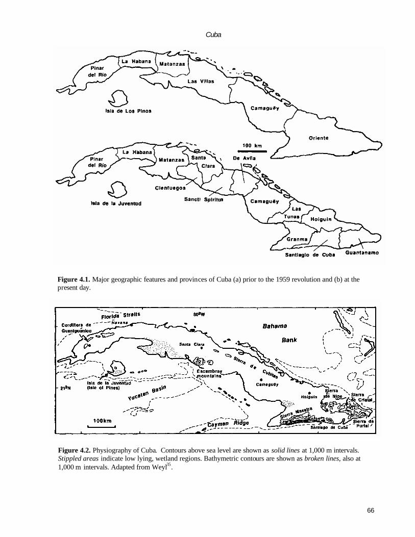
66
Cuba
Figure 4.1. Major geographic features and provinces of Cuba (a) prior to the 1959 revolution and (b) at the present day.
Figure 4.2. Physiography of Cuba. Contours above sea level are shown as solid lines at 1,000 m intervals. Stippled areas indicate low lying, wetland regions. Bathymetric contours are shown as broken lines, also at 1,000 m intervals. Adapted from Weyl35.

67
G. DRAPER and J. A.. BARROS
Figure 4.3. Main structural blocks and structural-facies zones of Cuba; Pinar del Rio Block (Fig. 4.4), Isla de la Juventud Block (Fig. 4.5), Central Cuba Block (Fig. 4.6), Camaguey Block (Fig. 4.9), and Oriente Block (Fig. 4.10). Note especially the Jurassic ophiolites, which lie at the base of the Cretaceous island arc rocks, both of which are thrust over the Jurassic to Cretaceous, passive margin, sedimentary rocks that form the northernmost structural facies zones of Cuba.
phase in the Paleocene to early Eocene28. This later defor-mation seems to have been diachronous and becomes pro-gressively younger to the east . The precise plate tectonic configurations that gave rise to this orogen are still hotly debated. These orogenically deformed rocks are overlain by relatively undeformed, post-orogenic sedimentary rocks.
2. Eastern Cuba (southeast of the Cauto basin) is char-acterized by a Cenozoic (Paleocene-Middle Eocene) vol-canic-plutonic arc complex of the Sierra Maestra. North and east of the Sierra Maestra, ophiolitic and arc rocks of the Mesozoic orogen occur, overlain by Paleogene sedimentary rocks and tuffs. Although the older rocks have similarities to those in central Cuba, they are different in the sense that continental margin rocks are rarer. In contrast to western and central Cuba, Tertiary sedimentation related to tectonism persisted until the Oligocene.
STRUCTURAL GEOLOGY OF OROGENICALLY
DEFORMED ROCKS OF CUBA The orogenically deformed rocks of Cuba (that is, pre-Mid-dle Eocene in the west and central part of the island; pre-Oligocene in the east) can be conveniently divided into five major geologic -structural segments or blocks17,19. These are, from east to west (Fig. 4.3):
1. Pinar del Rio block (located west of Havana). 2. Isla de la Juventud block. 3. Central Cuba block (located between Havana and the La
Trocha fault zones). 4. Camaguey block (between the La Trocha and Cauto fault
zones). 5. Oriente block (south and east of the Cauto fault zone).
It is important to note that this division is slightly different from that used by previous authors, especially in our distinction between the central Cuban and Camaguey blocks. However, it is considered that there are sufficient structural, if not stratigraphic, differences between these two regions to justify this distinction.
Within these structural blocks, the geology is further sub-divided into what Cuban investigators have called structural-facies zones. The structural-facies zones can be identified, partially or completely, in each of the blocks and are fault bounded belts or nappes, which have distinctive stratigraphic, metamorphic and/or palaeogeographic char-acteristics. The original concept was introduced by Pardo25, after which it was adopted and refined by numerous authors8,11,26. Hatten et al. have gone so far as to label these zones in central Cuba as tectonostratigraphic terranes, a concept that is still controversial. The structural-facies

68
Cuba
Figure 4.4. Structural facies zones of the Pinar del Rio Block of western Cuba Stippled area represents the Zaza zone (island arc rocks and basal ophiolites) which extend west of Havana
zone concept is nonetheless usefiil in describing the major features of the geology of Cuba and is adopted in the following account. A thorough terrane analysis of Cuba awaits further investigation.
PINAR DEL RIO BLOCK
Western Cuba consists of five structural facies zones (Fig. 4.4). The northernmost, which is poorly exposed, is the Esperanza zone. To the south, three of the zones (the Sierra de Rosario in the north, the Sierra de los Organos in the south and the Cangre zone, also in the south) form the Cordillera de Guaniguanico (Fig. 4.2). The Cangre zone forms a thin sliver on the southernmost flanks of the Cordillera de Guaniguanico and is separated from the San Diego de los Banos zone by the Pinar del Rio fault.
Esperanza zone The Esperanza zone outcrops as a thin belt in the
northernmost part of western Cuba The rocks of the region are poorly exposed and most of the useful information on the zone comes from subsurface studies. The rocks of this belt consist of Upper Jurassic to Lower Cretaceous eva-porites, dolomites and limestones similar to those found in
the Cayo Coco and Los Remedios zones of central Cuba (see below). These rocks are deformed by thrust faulting into at least three nappes. Subsurface information suggests that they structurally overlie Upper Cretaceous to Paleocene flysch-like sandstones and shales.
Sierra del Rosario zone The rocks of the Sierra del Rosario form an antiformal
arrangement of three nappes, each of which is composed of Jurassic to Upper Cretaceous ophiolitic rocks and (mainly) carbonate sedimentary rocks. The Bahia Honda sub-zone is the northernmost, and structurally highest, unit of the Sierra del Rosario zone and consists of ophiolitic rocks. The struc-turally lowermost units of the sub-zone consist of mafic and intermediate lavas, siliceous slates and well-laminated lime-stones, whereas the uppermost units consist of basalts, gab-bros and ultramafic rocks. These relations have led some investigators23 to conclude that the sequence is overturned. Instead, we suggest that these outcrop patterns are more likely to be due to duplication by imbricate thrusting.
The Quinones tectonic sub-zone structurally underlies the Bahia Honda sub-zone and is separated from it by a north dipping thrust fault. The Quinones sub-zone consists of Lower Cretaceous to Maastrictian limestones organized into three thrust sheets, each of which is associated with an

69
G. DRAPER and J. A. BARROS
Figure 4.5. Structural and metamorphic facies map of the Isla de la Juventud terrane.
olistostrome unit.
The Cinco Pesos tectonic sub-zone forms the south-ward dipping, southern limb of the Rosario antiform. It consists of thrust sheets of Jurassic to Lower Cretaceous carbonates with Upper Cretaceous flysch-like clastic sedi-mentary rocks, and Jurassic deltaic sandstones (San Cayetano Formation). The southern limit is bounded by the eastern extremity of the Pinar fault.
Sierra de los Organos zone The Sierra de los Organos contains the largest exposure
of Jurassic rocks in Cuba. These are the deltaic sandstones, siltstones, and micaceous and carbonaceous shales of the Middle Jurassic (Bajocian) San Cayetano Formation. This formation has been metamorphosed and finer grained li-thologies have been converted to well-developed phyllites. The San Cayetano Formation is overlain by a thick sequence of Oxfordian to Tithonian shallow water lime-stones of the Jagua, and the lowermost member of the Guasasa (previously Vinales) Formations. However, the post-Tithonian members of the Guasasa Formation are com-posed of pelagic limestones and cherts, and thus record a

70
Cuba
Figure 4.6. Structural facies zones of the Central Cuba Block. Stippled area represents the Zaza zone (basal Jurassic ophiolites and Cretaceous island arc rocks). Teeth on thrust fault are on the upper plate (hanging wall) of the fault.
sudden deepening of the basin27. These in turn are (?con-formably) overlain by Upper Cretaceous to Paleocene con-glomerates and sandstones.
Structurally, the Sierra de los Organos sequence is sliced into a series of nappes. In the northwestern Sierra Guaniguanico the San Cayetano Formation is thrust (north verging and north dipping) over the younger Cretaceous carbonates. In the southeastern part of the Sierra, the San Cayetano Formation structurally overlies the limestones and is separated from them by a southward-dipping thrust. The carbonates are thus exposed as a tectonic window in the central part of the Sierra.
Cangre zone The Cangre belt forms a narrow, wedge-shaped belt on
the southern boundary of the Guaniguanico massif. It is composed of quartzose meta-arenites, mica phyllites and occasional graphitic phyllites. According to Millan and Somin , these rocks are metamorphosed equivalents of the San Cayetano Formation. The metamorphic grade is diffi- cult to estimate, but sills of metadolerite and gabbro found
in the formation have glaucophane-pumpellyite assem-blages that indicate a high pressure/low temperature meta-morphic environment20.
San Diego de los Banos (Zaza) zone The San Diego de los Banos (SDB) zone occurs south
of the Cangre belt and is separated from the latter by the Pinar fault. As the SDB zone consists of a thick Tertiary basin, and lies topographically lower than the Cordillera Guaniguanico, this suggests a considerable dip-slip compo-nent of displacement on the Pinar fault, although aleft lateral strike slip component has also been suggested.
Limited outcrop of pre-Tertiary rocks adjacent to the Pinar fault expose Cretaceous strata with tuffaceous and epiclastic layers. The presence of these rocks suggests that the basement of the San Diego de los Banos basin is corre-latable with the Cretaceous island arc rocks (Zaza zone) of central Cuba13.

71
G. DRAPER and J. A. BARROS
Figure 4.7. Schematic cross section across central Cuba (after Lewis17). See Figure 4.3 for approximate location.
ISLA DE LA JUVENTUD (ISLA DE
PINOS) BLOCK Most of the Isla de la Juventud consists of metamorphosed Mesozoic sedimentary rocks (Fig. 4.5). The lower part of the protolith sequence (Canada Formation) incorporates intercalations of micaceous and graphitic pelites with quartzose psammites. The middle part of the sequence (Agua Santa Formation) contains similar lithologies, but is characterized by increasing quantities of marble and calc -silicate beds. The upper part (Gerona Group) consists almost entirely of black to dark grey dolomitic marbles. A scarce and poorly preserved fauna indicates a Jurassic age and, therefore, the rocks may be correctable with the Jurassic San Cayetano and Cangre zone of the Cordillera de Guaniguanico (G. Millan, personal communication, 1990). Overall, the metamorphism of the Jurassic rocks of Isla de la Juventud is of high temperature/medium pressure type, which contrasts with that of the Escambray and Purial regions (see below). Millan20 divided the rocks of the ter -rane into 5 metamorphic zones, which are, in order of increasing metamorphic grade: greenschist (biotite zone) facies; staurolite-, kyanite- and garnet-bearing schists; staurolite and kyanite schists with occasional andalusite; garnet, kyanite and biotite schists with occasional silliman-ite, and scapolite-bearing marbles; and sillimanite, garnet, pottassium-feldspar gneisses andmigmatites. Potassium-ar-gon ages from muscovite indicate that the time of metamor-phism of the Isla de la Juventud massif was about 55-66 Ma (late Cretaceous to early Tertiary32).
Some small plutons of unknown age intrude the meta-morphic rocks in the northern part of the island. A small area of poorly exposed (and poorly dated) Cretaceous volcanic rocks outcrops in the northwest. Pliocene to Quaternary deposits compose the low-lying southern third of the island.
CENTRAL CUBA BLOCK
Central Cuba is divided into several structural facies zones (Fig. 4.6). Although most authors agree on the geology that occurs in these zones, several nomenclatural schemes have been proposed which has led to some confusion in the literature. Here we use the scheme of Meyerhoff and Hat-ten19 and Hatten et al.12. Figure 4.7 shows schematic cross sections across central Cuba and illustrates the broad struc-tural relations between the zones. The first four of the zones described below are composed mainly of continental mar-gin, continental slope and pelagic sedimentary deposits.
Cayo Coco zone The Cayo Coco zone has very limited exposure and
most of the information concerning this zone comes from subsurface data derived from petroleum exploration wells. The oldest unit penetrated consists of Lower to Upper Jurassic evaporites of the Punta Allegre Formation (these evaporites have developed diapiric structures at several localities in north central Cuba). The evaporite sequence is overlain by Upper Jurassic to Cretaceous (Albian) shallow
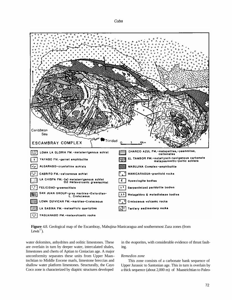
72
Cuba
Figure 4.8. Geological map of the Escambray, Mabujina-Manicaragua and southernmost Zaza zones (from Lewis17).
water dolomites, anhydrites and oolitic limestones. These are overlain in turn by deeper water, intercalated shales, limestones and cherts of Aptian to Coniacian age. A major unconformity separates these units from Upper Maas-tnchtian to Middle Eocene marls, limestone breccias and shallow water platform limestones. Structurally, the Cayo Coco zone is characterized by diapiric structures developed
in the evaporites, with considerable evidence of thrust fault-ing.
Remedios zone This zone consists of a carbonate bank sequence of
Upper Jurassic to Santonian age. This in turn is overlain by a thick sequence (about 2,000 m) of Maastrichtian to Paleo-

73
G. DRAPER and J. A.. BARROS
Figure 4.9. Structural facies zones of the Camaguey block. Stippled area indicates Jurassic ophiolite and Cretaceous andesitic rocks of the Zaza zone.
cene limestone breccias and shallow water limestones simi-lar to those of the Cayo Coco zone. A clastic unit consisting of Lower Eocene greywackes also occurs. High angle thrust faults, often with a right lateral strike slip component, cut through the limestones of the Remedios zone. Camajuani (Zulueta) zone
The lower part of the sedimentary sequence of the Camajuani zone (Zulueta zone of Hatten et al ) consists of a continuous sequence of Upper Jurassic to low Upper Cretaceous, deep-water limestones with intercalations of clastic limestones. These clastic limestones contain a shal-low-water fauna and were presumably washed in from a nearby shallow carbonate bank (probably the Remedios zone).
An angular unconformity separates the lower sequence from an overlying Maastrichtian to Middle Eocene sequence of polymictic olistostromic conglomerates. Clasts are de-rived from the pelagic limestones of the Las Villas zone as well as shallow-water clasts from the Remedios zone (the latter make up about 70% of the clasts). The conglomerate is overlain in turn by a thinner sequence of Middle Eocene calcarenite and coquina beds. The final unit represented is a
thick sequence of olistostromic conglomerates ('wild-flysch') considered to be upper Middle Eocene. Most Cuban geologists consider this deposit to mark the final movements of the Cuban orogeny. The deformation in the Camajuani zone is intense, consisting of tight, often steeply plunging folds. Both thrust and belt orthogonal tear faults are present.
Placetus (Las Villas) zone The Placetus zone (Las Villas zone of Hatten et al12)
occurs as sporadic outcrops from near Havana (the Martin Mesa tectonic window) to central Camaguey and often occupies tectonic windows beneath the allochthonous ophiolites of the Zaza zone. There are many lateral vari-ations in the deposits of this belt. In some places, the base of the sedimentary sequence consists of quartzose and ark-osic sandstones and conglomerates which are possibly Up-per Jurassic; in others the base consists of Tithonian (Upper Jurassic) radiolarian, pelagic limestones. Overlying this is a series of Lower Cretaceous pelagic cherts, limestones and shales. Maastrichtian breccias were disconformably(?) de-posited on the Lower Cretaceous pelagics.
Ophiolitic rocks occur in parts of the zone, and some controversy exists concerning the age and nature of these

74
Cuba
Figure 4.10. Structural facies zones of eastern Cuba. Stippled area indicates Jurassic ophiolitic and Cretaceous andesitic rocks of the Zaza zone. Metamorphic and magmatic zones of the Cretaceous Purial and Sierras Maestra zones (respectively) are also shown.
units. Some ophiolitic rocks are clearly part of the Zaza zone (see below), and are cut by dykes and granitoid stocks that have an island arc geochemical signature12. However, some authors have suggested that a second basaltic sequence that is not cut by granitoids may occur beneath the Jurassic sedimentary sequence. This has been interpreted as the basaltic portion of ocean crust. J.A.B. is doubtful of the existence of this sec ond proposed basaltic occurrence.
A remarkable metamorphic, pre-Mesozoic basement is exposed in at least three areas of the Placetas zone, and consists of marbles, mylonitic schists and granitoids. Somin and Millan33 reported controversial K-Ar mica ages of 910 and 945 Ma from schists near to the village of Sierra Morena. However, these Precambrian ages were confirmed by Renne et al.29, who obtained 40Ar/39Ar ages of 903 Ma from phlogopite in marbles of the Socorro Complex situated in the northwestern part of the Placetas zone. These very old rocks are intruded by granitoid plutons of early Cretaceous age29,33. Deformation within the Placetas zone is complex and is characterized by tight isoclinal folds and repetition of sequences by steeply dipping thrust faults.
Zaza zone In contrast to the continental margin or 'miogeosyncli-
nal’ deposits of the structural-facies zones of north-central Cuba (see above), the Zaza zone contains Jurassic to mid-Cretaceous igneous rocks of oceanic and island arc ('eugeo-synclinaT) origin. Although originally defined for central Cuba, many Cuban geologist use the term Zaza zone to refer to all pre-middle Cretaceous igneous rocks throughout Cuba.
The lowest structural unit recognized in the Zaza zone outcrops its the northern margin, adjacent to the Las Villas thrust (which separates the Zaza zone from the Placetas zone). This unit is a highly sheared serpentinite melange containing high pressure/low temperature schists and eclo-gites. Lying above it is an interlayered serpentinite, gabbro and dolerite complex. Somin and Millan33 reported a K-Ar age of 160 Ma (middle Jurassic) from an anorthosite in this complex. These two units are part of the Cuban ophiolite belt which characterizes northern Cuba. We interpret this unit as the oceanic basement of the overlying island arc volcanic sequence.
Overlying the mafic and ultramafic rocks is a pile of porphyritic, basaltic and andesitic lavas (occasionally pil-lowed), overlain in turn by a sequence of tuffs and epiclastic sedimentary rocks with interbedded pelagic and shallow-water rudist limestones. The age of this volcanic -sedimen-tary sequence is Aptian-Albian to Campanian4,26. This interval represents the period of island arc magmatism in the Zaza zone thoughout Cuba. Uppermost Cretaceous to Pa-leogene sedimentary rocks overlie the volcanic sequence in the Zaza zone, and are composed mainly of flyschoid grey-wackes and calcarenites with localized conglomerate and breccia deposits.
Mabujina-Manicaragua zone The Mabujina complex, a large mass of amphibolite
which is intruded by numerous granitoid bodies, lies to the north of the Escambray complex (Fig. 4.8). In addition, Mabujina amphibolites also occur at the southwestern rim of the Trinidad dome and the eastern part of the Sancti
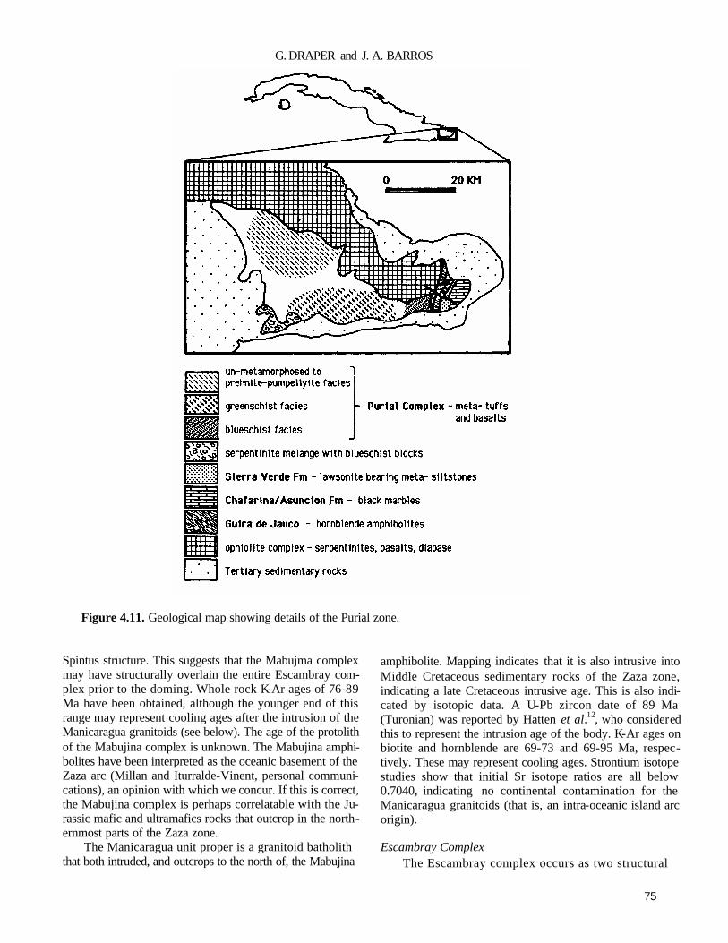
75
G. DRAPER and J. A. BARROS
Figure 4.11. Geological map showing details of the Purial zone.
Spintus structure. This suggests that the Mabujma complex may have structurally overlain the entire Escambray com-plex prior to the doming. Whole rock K-Ar ages of 76-89 Ma have been obtained, although the younger end of this range may represent cooling ages after the intrusion of the Manicaragua granitoids (see below). The age of the protolith of the Mabujina complex is unknown. The Mabujina amphi-bolites have been interpreted as the oceanic basement of the Zaza arc (Millan and Iturralde-Vinent, personal communi-cations), an opinion with which we concur. If this is correct, the Mabujina complex is perhaps correlatable with the Ju-rassic mafic and ultramafics rocks that outcrop in the north-ernmost parts of the Zaza zone.
The Manicaragua unit proper is a granitoid batholith that both intruded, and outcrops to the north of, the Mabujina
amphibolite. Mapping indicates that it is also intrusive into Middle Cretaceous sedimentary rocks of the Zaza zone, indicating a late Cretaceous intrusive age. This is also indi-cated by isotopic data. A U-Pb zircon date of 89 Ma (Turonian) was reported by Hatten et al.12, who considered this to represent the intrusion age of the body. K-Ar ages on biotite and hornblende are 69-73 and 69-95 Ma, respec-tively. These may represent cooling ages. Strontium isotope studies show that initial Sr isotope ratios are all below 0.7040, indicating no continental contamination for the Manicaragua granitoids (that is, an intra-oceanic island arc origin).
Escambray Complex The Escambray complex occurs as two structural

76
Cuba
Figure 4.12. Sketch section from the eastern Sierra Maestra to the Mayari-Moa-Baracoa zone (after Cobiella, personal communication). See Figure 4.3 for approximate location. Not to scale.
Figure 4.13. Oblique, sinsistral rifting of North and South America occurred in the middle Jurassic to form the Cuban passive margin on the southern boundary of North America.
domes or 'cupulas' (Fig. 4.8), that is, the western Trinidad dome and the eastern Sancti Spiritus. Lithologically, the complex consists of pelitic and psammitic schists and mar -bles, which represent a metamorphosed terrigenous carbonate terrane. Exotic lenses and pods of serpentinized peridotite, eclogite and garnet blueschist occur within the sedimentary rocks around the margins of both domes. Am-monite and radiolarian faunas discovered in less deformed parts of the Escambray complex indicate a late Jurassic (Oxfordian) age for the sedimentary protolith of the com-plex, that is, about the same age as the San Cayetano Formation of western Cuba (Millan, personal communica-tion). Granitoid intrusions do not occur in the central parts of Hie Escambray complex.
The metamorphism of the Escambray complex is in-verted and pre-dated the doming of the complex22, and therefore a concentric pattern was produced by the zoning. Thus, the lowest grade rocks are also structurally the lowest and are found at the centre of the domes, with the highest grades being encountered at the margin.
A mica K-Ar age of 80 Ma22 from a pegmatite cutting the complex gives a minimum age for metamorphism, and
Halten et al.12 reported an 85 Ma age from an eclogite (but give no details of the determination). Metamorphism seems to have taken place sometime during the Turonian to Cam-panian interval.
CAMAGUEY BLOCK—EAST CENTRAL CUBA
The Camaguey block is bounded on the west by the La Trocha fault and the east by the Cauto Fault (Figs 4.3, 4.9). Although there are similarities with the geology of central Cuba, there are also some significant differences. For example, the Escambray, Manicaragua-Mabujina, Camajuani and Placetas zones do not have significant outcrops in Cam-aguey (although the Camajuani and Placetas zones are en-countered in windows in the ophiolite and in the subsurface), and the width of outcrop of the Zaza zone is much greater than in central Cuba.
Cayo Coco and Remedios zones The Cayo Coco and Remedios zones outcrop in the
Sierra de las Cubitas in northern Camaguey and the strati-

77
G. DRAPER and J. A. BARROS
Figure 4.14. Tectonic model of the collision of a north-facing island arc (Zaza zone) with the Cuban passive margin, (a) The Cuban passive continental margin in the late Jurassic -early Cretaceous, (b) The approach of the island arc in the middle Cretaceous, (c) Approximate configuration after the late Cretaceous -early Tertiary collision.
In this model, the Zaza zone is considered totally allochthonous and overrides the passive margin; the Cuban ophiolite belt is interpreted as the forearc and/or oceanic basement of the arc.
graphy of the zones is essentially the same as in central Cuba. The main difference between the two areas is the age of the Cenozoic deformation. In central Cuba, this deformation began in the early Eocene, but in Camaguey it was initiated in the middle Eocene.
Zaza zone The Zaza zone is separated from the continental
margin sedimentary rocks to the north by a serpentinite melange, as in central Cuba. The stratigraphic range of the volcanic units is essentially the same as for central Cuba. However, the outcrop of both the ophiolitic and arc parts of the Zaza zone in Camaguey are broader than in central Cuba. Another major difference of Camaguey is the presence of several large plutons which intrude the volcanic rocks in northern
and southern belts. The northern belt contains bi- modal plutons of early Cretaceous age, but the southern belt ranges in age from Coniacian to late Campanian (Stanek, personal communication).
Paleogene Orogen The El Cobre Group is a sequence of Paleocene to
Middle Eocene andesitic volcanic and sedimentary rocks that outcrop extensively in the Sierra Maestra of southeast-ern Cuba Extensive outcrops of the El Cobre Formation also occur in the southern part of the Camaguey block. According to Mossakovsky et al 24, the largest area is occu-pied by the limestones and clastic sedimentary rocks, which are distal to the main volcanic locus and are probably also equivalent to the upper part of the group of the Sierra

78
Cuba
Figure 4.15. Tectonic model of the collision of the Escambray terrane with an initially south-facing island arc, followed by emplacement of the back arc and arc onto the Cuban passive margin, (a) The approach of the Escambray terrane in the mid Cretaceous, (b) Collision and attempted subduction of the Escambray terrane with the Zaza arc in Campanian time, causing high pressue metamorphism of the former. The collision may have blocked the subduction zone and initiated a short period of underthrusting of the back arc basin beneath the arc which finally resulted in (c) the emplacement of the arc and ophiolite on the passive margin.
In this model, the Cuban ophiolite belt is interpreted as part of the back arc basin and/or the oceanic basement of the rear of the arc.
Maestra. The lower, volcanic part of the sequence is found only in the easternmos t part of Camaguey.
ORIENTE BLOCK
The geology of Oriente differs from central Cuba in three major respects: except for a small outcrop of metamorphic rocks, no rocks of continental provenance are known; in addition to rocks of the Mesozoic orogen, eastern Cuba also contains rocks formed in a Paleogene island arc setting, which is here called the Paleogene orogen (Iturralde-Vinent, personal communication); and diastrophism and diastrophi-cally controlled sedimentation may have continued to the Oligocene or younger.
For the purposes of this discussion we have divided the
geology of the area into three structural-facies zones (Fig. 4.10), the first two of which form part of the Mesozoic orogen, and because of their dominantly igneous nature might be regarded as part of the Zaza zone2.
Purial zone The Purial zone consists of three units of regionally
metamorphosed rocks that outcrop in the eastern part of Cuba and is made up of several units (Fig. 4.11). In the extreme east, a complex of black marbles and sericite schists occurs. On the basis of their lithology, these rocks have been correlated with those of the Escambray region; conse-quently, a protolith age of Jurassic -early Cretaceous has been suggested for them, but no direct evidence has yet been discovered for this date. A major fault separates the marble-schist complex from the Purial Complex to the west. A small

79
G. DRAPER and J. A. BARROS
Figure 4.16. Palaeogeography of Cuba in the Miocene to Pliocene.
complex of garnet-amphibolites, ultramafics, gabbros and dolerites occurs to the west of the fault, and may compose part of the Purial Metamorphic Complex proper.
The Purial Metamorphic Complex consists of a large area of high-pressure, low-temperature blueschist and greenschist facies rocks. Most of the protolith consists of
lavas, tuffs and volcanogenic sedimentary rocks with occa-sional limestones. Microfossils in the sedimentary rocks indicate a Campanian age. Rocks in the eastern and north-eastern part of the complex are barely metamorphosed, and metamorphic grade generally increases toward the south-west. Unmetamorphosed Maastnctian age rocks of the Rio

80
Cuba
Cana Formation unconformably overlie the Purial rocks, suggesting that burial, metamorphism and subsequent un-roofing of the complex must all have occurred in the Cam-panian to Maastrictian, an interval of less than 20 million years.
The Sierra del Convento melange, at the southwest corner of the Purial complex, is a serpentinite matrix me-lange and contains blocks of blueschist and amphibolite. The blocks have not been dated and their age is unknown.
Mayari-Moa-Baracoa zone This zone outcrops in the northern part of Oriente
province and is dominated by the two large ophiolite bodies of Nipe-Cristal and Moa-Baracoa (Figs 4.10, 4.12). Neither of these bodies exhibits a complete ophiolite sequence as they consist mainly of serpentized harzburgite (with minor Iherzolites and wherlites) with gabbros and dolerite. The age of these bodies is not known, but they are thought to be Upper Jurassic to Lower Cretaceous. The Nipe-Cristal body is associated with a high pressure/low temperature ser -pentinite melange which outcrops to the south of the ophiolite (Cobiella, personal communication).
The oldest Cretaceous rocks in this zone are poorly dated Albian?-Turonian mafic volcanic rocks of the Santo Domingo Formation. These are considered by many Cuban geologists to be equivalents of the weakly metamorphosed part of the Purial Complex.
Upper Campanian to Maastrichtian serpentinite con-glomerates (La Picota Formation) overlie the volcanic se-quence, and these are thought to have been deposited as olistostromes in front of the northward advancing Nipe-Cristal ophiolite thrust sheets; they therefore time the age of emplacement of the ophiolite. The conglomerates interdigi-tate with, and are ultimately overlain by, Upper Campanian to Maastrichtian (possibly lowermost Paleocene), rhythmi-cally-bedded sandstones and siltstones (Micara Formation). The rocks overlying the Micara Formation are pyroclas tic and sedimentary rocks are associated with the Paleogene orogen.
Paleogene Orogen—Sierra Maestra zone The Sierra Maestra was the locus of Paleocene to mid-
dle Eocene island arc magmatism. Island arc magmatism ceased at the end of the Campanian elsewhere in Cuba, and in this sense the geology of southern Oriente is more like that of northern Hispaniola, where island arc magmatism also persisted until the middle Eocene.
The single most important unit in this zone is the El Cobre Group (previously Cobre Formation) which consists of a thick sequence of waterlain tuff and agglomerate depos-its with subordinate lavas and sedimentary rocks. The upper part of the El Cobre Group consists of greywackes (San Luis
Formation) and pelagic to neritic limestones (Puerto Boni-ato Formation). On the south coast of Oriente, the lower part of the El Cobre Group is intruded by low potassium grani-toids (Fig. 4.11). K-Ar ages of 46 and 58 Ma indicate an early to middle Eocene intrusive age.
TECTONIC EVOLUTION OF CUBA
An understanding of the tectonic evolution of Cuba in terms of the plate dynamics of the northern Caribbean is obviously crucial to any explanation of the tectonic evolution of the Caribbean region as a whole. Despite progress in under-standing the timing of events, many aspects of the tectonic evolution of Cuba, especially the geometry and kinetics of the various crustal movements, remain elusive.
It is clear from the above discussion that Cuba com-prises five major components:
(1) A Jurassic to Lower Cretaceous continental margin and slope sequence deposited on both continental and oce anic crust (western Cuba, Cayo Coco/Remedios/Zu- lueta/Placetas zones of central Cuba and Camaguey).
(2) A Lower to low Upper Cretaceous island arc complex built upon a Jurassic oceanic basement (Zaza zone throughout the island).
(3) Jurassic continental slope deposits that outcrop south of the island arc complex (Escambray and Isla de la Juven- tud).
(4) A Paleogene island arc complex (Sierra Maestra). (5) Middle Eocene to Recent, post-orogenic sedimentary
deposits.
Any explanation of the tectonic evolution of Cuba must explain the origin and present structural states of these units.
The Mesozoic Orogen—-western and central Cuba Continental margin deposits began to accumulate in
Cuba during the subsidence resulting from the rifting of South from North America during the Jurassic (the earliest deposits were probably the deltaic sediments of the San Cayetano Formation). The age of the basement of this passive margin is uncertain. The Socorro complex29 is Grenville in age (approximately 1,000 Ma, the same as that of a large area of the North American continent east of the present Appalachian mountain chain) and this may suggest that at least part of the Cuban basement is Grenvillian. Alternatively, the contintental basement may have a Pan-African age (400-500 Ma) as suggested by the age of base-ment encountered at the base of an ODP hole drilled in the Gulf of Mexico northeast of Cuba.
Further lithospheric extension between North and

81
G. DRAPER and J. A. BARROS
South America resulted in the formation of oceanic crust between the two continents (the ‘Proto-Caribbean' of Pin-dell, Chapter 2, this volume). On the northern boundary, a passive continental margin sequence developed. Carbonate banks accumulated on the subsiding, stretched continental crust and deeper water, continental slope deposits probably prograded southward onto oceanic crust.
In the early Cretaceous, an island arc system (Zaza zone) began to develop somewhere south or west of the continental margin, possibly in the Pacific realm (Pindell, Chapter 2, this volume). In about the Campanian this arc system collided with the continental margin and began to create the Cuban orogen. The evidence for this comes from the Campanian metamorphic ages of the Escambray (and possibly the Purial) metamorphics, and the presence of clasts of volcanic rock in Cenomanian passive margin sedi-mentary rocks. However, the exact geometry of this colli-sion is obscure and two possible scenarios have been proposed:
1. The arc faced north (that is, the suduction zone dipped south), and ocean floor was subducted between the passive margin and the arc (Fig. 4.13,4.14). When all of the ocean had been subducted, the arc collided with the passive margin, and completely overode it. In this scenario, the Zaza zone is completely allochthonous, and the Escambray re gion represents the structurally imbricated edge of the pas sive margin whose inverted metamorphism resulted when the arc overode the complex. The Isla de la Juventud would presumably have been overridden in the same event. The ophiolites of central and western Cuba would represent fragments of the oceanic basement beneath the arc and/or the Proto-Caribbean ocean crust.
There are several problems with this model. It fails to explain the location, metamoiphism (high temperature/low pressure) and plutonism in the Isla de la Juventud. More-over, an entire island arc would have to be detached and thrust over 200 km (a hypothesis that G.D. feels is mechani-cally unreasonable). The tectonic provenance and metamor-phism of the Purial Complex also remains unresolved in this model.
2. In the second scenario (Fig. 4.15), the arc was south- facing and a small ocean basin separated it from the passive margin30 (Iturralde-Vinent, personal communication). The collision event would have resulted when buoyant (unsub- ductable) ocean crust, represented by the Escambray and Isla de la Juventud blocks, entered the subduction zone. As a result the Escambray (and Purial?) rocks were metamor phosed to blueschist fac ies under the fore-arc, the ocean basin behind the arc was thrust onto the passive margin, and subduction ceased. In this scenario the Cuban ophiolites represent fragments of the basement beneath the arc and/or the small, marginal bas in, but not the major Proto-Caribbean
ocean floor. As with the first model, there are problems. The model
implies that the Isla de Juventud and Escambray are separate continental fragments, and while this may be the case, their tectonic provenance and evolution is unclear. There is little evidence of volcanic material in the sedimentary rocks of the northern passive margin sequences before the Cenoma-nian27, which is at least 20 Ma after the beginning of arc activity. It is also difficult to explain the presence of high pressure/low temperature metamorphism in the Cangre zone.
Paleogene Orogen—eastern Cuba Subduction-related magmatic activity apparently
ceased with this Campanian collisional event, as no evi-dence of Maastrichtian magmatism is known in Cuba. Mag-matic activity resumed in the Paleocene, but only in eastern Cuba, where the locus of activity was the Sierra Maestra, although some pyroclastic deposits are found in the south-eastern Camaguey and northern Oriente. The Paleogene magmatic terrane terminates abruptly at the Cayman fault (the northernmost fault of the northern Caribbean plate boundary zone—NCPBZ) on the southeastern coast of Cuba. This has led to the speculation by several authors1,3,5-7 that the Paleogene arc of Cuba was related to, and contigu-ous with, similar rocks in Hispaniola, and that latest Paleogene to Neogene left-lateral strike-slip on the NCPBZ has subsequently separated the two regions (that is, dis-persed the Paleogene terrane).
An explanation of the Paleogene arc (orogen) remains an outstanding problem of plate geometry and kinematics. The Paleogene arc was deposited upon the Mesozoic oro-genic rocks of Oriente which seem to have been already attached to the southern margin of the North American plate. To produce arc activity means the subduction of significant quantities of ocean crust. Since there is only continental crust to the north, then a south-dipping subduction zone seems an unlikely explanation. Equally there appears to be no evidence of a Paleogene, north-dipping subduction zone (major accetionary complex or blueschist complex) south of Cuba or in Hispaniola. The only possible candidate might be the Trois Rivieres-Peralta belt of Hispaniola (see Draper et al., Chapter 7, this volume).
The plate kinematic cause of the early Eocene (second phase) deformation in central Cuba also remains obscure, but may have been associated with the movement of the Caribbean plate into the meso-American region and the opening of the Yucatan basin (although this was an exten-sional, not a compressional, event).
Mid-Eocene to Recent From the middle Eocene to the present, much of Cuba

82
Cuba
has been (relatively) tectonically quiescent. By examining later Paleogene and Neogene sedimentary deposits, Ittu-ralde-Vinent14,15 determined that post-orogenic Cuba con-sists of a series of differentially subsiding horsts and grabens (Fig. 4.16). Subsidence was most rapid and widespread during the late Eocene and Oligocene, but continued through the Miocene and Pliocene in several areas. Pleisto-cene to Recent sedimentation was of moderate extent.
The major, post-orogenic tectonic activity was, and is, south of Oriente on the Oriente transform fault system that separates Cuba from the present Caribbean plate. As men-tioned above, several authors consider that southeastern Cuba and northern Hispaniola were once continuous, al-though the precise palaeogeography is still uncertain. It is also unclear as to when this separation began. Extensive clastic sedimentation, probably related to rapid uplift and erosion, began in the middle to late Eocene in both south-eastern Cuba and northern Hispaniola. We suggest here that this was the time of initiation of the separation of the two areas. Extrapolation of the spreading rates in the Cayman Trough31 also suggests that major motion on the Cayman transform fault also began at this time5-7. Motion continues on this fault and the region is seismically active.
ACKNOWLEDGEMENTS—We thank all of our Cuban and eastern Euro-pean colleagues who have taught us much about the geology of Cuba. In particular, we would like to thank Jose Francisco Albear, Karoli Brezsny-ansky, Mario Campos, Jorge Cobiella, Jose Diaz-Duque, Gustavo Echavar-ria, Rafael Guardada, Margarita Hernandez, Manuel Itturalde-Vinent, Guillermo Millan, Yurek and Kristina Piotrowska, Andre Pszczolkowski and Felix Quintas, all of whom have corresponded copiously, showed us outcrops in the field and generously shared unpublished data and reports. Outside of Cuba, animated discussions with Charles Hatten, Mark Hemp-ton, John Lewis, Paul Mann, Paul Renne and Eric Rosencrantz have also helped stimulate our interest in, and clarify ideas about, Cuban geology.
REFERENCES
1Barros, J.A. 1987. Stratigraphy, structure and paleo- geography of the Jurassic-Cretaceous passive margin in western and central Cuba. Unpublished M.S. thesis, University of Miami, Florida.
2Cobiella, J.L. 1984a Curso degeologia de Cuba. Editoral Pueblo y Education, La Habana, 114 pp.
3Cobiella, J.L. 1984b. Position de Cuba Oriental en la geologia del Caribe. Revista Mineria y Geologia, 2, 65-92.
4Dilla, M. & Garcia, L.1985. Nuevos datos sobre la estar - tigrafia de las provincias de Cienfuegos, Villa Clara y Sancti. Espiritus serie Geologica, 5, 54-77.
5Draper, G. 1989a. Terrane accretion and re-shuffling in Hispaniola. Geological Society of America Abstracts with Programs, 21(1), 9.
6Draper, G. 1989b. Comparison of late Cretaceous -Paleo-
gene age rocks of northern Hispaniola and southeastern Cuba: implications for the tectonic evolution of the Greater Antilles. Primer Congreso Cubano de Geolo-gia, Resumenes y Programa, La Habana, 211.
7Draper, G. & Barros, J.A. 1988. Tectonic reconstruction of N. Hispaniolaand S.E. Cuba: dissection of a Cretaceous island arc. Geological Society of America Abstracts with Programs, 20 (7), A60.
8Ducloz C. & Vaugnat, M. 1962. A propos de 1'age des serpenitites de Cuba. Archives de Science Societe de Physique et Histoire Naturell de Geneve, 15, 309-332.
9Furrazola-Bermudez, G. et al. 1964. Geologia de Cuba. Ministerio de Industrias, Institute Cubano Recursos Minerales, La Habana, 239 pp.
10Gealey, W. K. 1980. Ophiolite obduction mechanisms: in Panayiotou, A. (ed.), Ophiolites: Proceedings, Interna-tional Ophiolite Symposium, Nicosia, Cyprus, 1979, 228-243. Geological Survey Department, Cyprus.
11Hatten, C., Schooler, C.H., Giedt, N.R. & Meyerhoff, A. A. 1958. Geology of central Cuba and western Cam-aguey provinces. Unpublished Report, Chevron U.S.A., 220 pp.
12Hatten, C., Somin, M., Millan, G., Renne, P.R., Kistler, R.W. & Mattinson, J.M. 1987. Tectonostratigraphic units of central Cuba: in Barker, L. (ed.), Transactions of the Eleventh Caribbean Geological Conference, Dover Beach, Barbados, 20th-25th July, 1986, 38:1-38:13.
13Herrara, N.M. 1961. Contribution a la estratigrafia de la Provincia de Pinar del Rio. Revista Cubana de la So-ciedad de Ingenieros, 61, 2-24.
14Itturalde-Vinent, M. 1977. Los movimientos tectonicos de la etapa de desarollo plataformico en Cuba. Academia de Ciencias de la Tierra, Informe Cientifico-Tecnico, 20, 24pp.
15Itturalde-Vinent, M. 1978. Los movimientos tectonicos de la etapa de desarollo plataformico en Cuba. Geologie en Mijnbouw, 57, 205-212.
16Khudoley, K.M. 1967. Principal features of Cuban geol-ogy. American Association of Petroleum Geologists Bulletin, 51, 789-791.
17Lewis, J.F. 1990. Cuba [in Lewis, J.F. & Draper, G. Geological and tectonic evolution of the northern Car -ibbean margin]: in Dengo, G. & Case, J.E. (eds), The geology of North America, Volume H, The Caribbean region, 77-140. Geological Society of America, Boul-der.
18Mattson, P. 1974. Cuba: in Spencer, A.M. (ed.), Meso-zoic-Cenozoic Orogenic Belts. Geological Society of London Special Publication, 4, 625-638.
19Meyerhoff, A. A. & Hatten, C. 1968. Diapiric structures in

83
G. DRAPER and J. A. BARROS central Cuba. American Association of Petroleum Geologists Memoir, 8, 315-357. 20Millan, G. 1981. Geologia del macizo metamorfico de la
Isla de la Juventud. Ciencias de la Tierray Espacio, 3, 5-22.
21Millan, G. & Somin, M. 1976. Agunas consideraciones sobre la metamorfitas cubanas. Academia de Ciencias de Cuba, serie geologica, 27, 21 pp.
22Millan, G. & Somin, M. 1981. Litologia, estratigrafta, tectonica y metamorfismo del macizo del Escambray. Academia de Cienias de Cuba, Habana, 104 pp.
23Mossakovsky, A. & Albear, J.F. 1978. Nappe structure of western and northern Cuba and its history in the light of the study of olistostromes and mollases. Geotectonics, 12, 225-236.
24Mossakovsky, A. et al. 1988. Mapa geologico de Cuba,escala 1:250,000. Academia de Ciencias de Cuba, editado por el institute de Geologia de Ciencias de URSS H-2111.
25Pardo, G. 1954. Geologic exploration in central Cuba. Unpublished Report, Cuban Gulf, 79 pp.
26Pardo, G. 1975. Geology of Cuba: in Nairn, A.E.M. & Stehli, F.G. (eds), The Ocean Basins and Margins. Volume 3. The Gulf of Mexico and the Caribbean, 553-615. Plenum, New York.
27Pzczowlkowski, A. 1978. Geological sequences of the Cordillera de Guaniguanico in western Cuba: their li- thostratigraphy,facies development and paleogeogra-
phy. Acta Geologica Polonica, 28, 1-96.
28Pszczolkowski, A. & Flores, R. 1985. Fases tectonicas del Cretacicos y del Paleogeno de Cuba occidental y cen-tral. Serie Geologica, 20.
29Renne, P.R. et al. 1989. 40Ar/39Ar and U-Pb evidence for late Proterozoic (Grenville age) continental crust in north-central Cuba and regional tectonic implications. Precambrian Research, 42, 325-341.
30Rosencrantz, E. & Barros, J.A. 1989. Structural and chronological discontinuity in late Cretaceous-Eocene tectonic events in Cuba. Geological Society of America Abstracts with Programs, 21(1), 39.
31Rosencrantz, E. & Sclater, J.G. 1986. Depth and age in the Cayman Trough. Earth and Planetary Science Letters, 79, 133-144.
32Somin, M.L. & Millan, G. 1977. Sobre la edad de las rocas metamorficas Cubanas. Informe Cientifico-Tecnico, 2, llpp.
3 3 Somin, M.L. & Millan, G. 1981. Geology of the metamor- phic complexes of Cuba. Nauka, Moscow, 218 pp.
34Wassal, H. 1956. The relationship of oil and serpentinites in Cuba: in Transactions of the 20th International Geological Congress, 65-77.
35Weyl, R. 1966. Geologic der Antillen: in Martini, H.J. (ed.), Band 4, Beitrage zur Regionalen Geologie der Erde: 1-410. Gebriider Bomtrager, Berlin.

84
Cuba
APPENDIX 1
Map symbols used in Cuban literature Many maps, sections, columns and diagrams of Cuban geology use a
different notation for the ages of rocks than is otherwise used in the literature of the Caribbean and North and South America. The notation principally derives from a system developed in eastern Europe. It is presented here for those readers who may wish to delve deeper into the Cuban literature.
System
Series
Stage
Quaternary (Q)
Holocene (Q2)
Pleistocene (Q1)
Neogene (N)
Paleogene (P)
Pliocene (N2)
Miocene (N1)
Oligocene (P3)
Eocene (P2)
Paleocene (P2)
Cretaceous (Upper) (K2)
Cretaceous (Lower) (K1)
Maastrichtian (K2m)
Campanian (K2cp)
Santonian (K2st)
Coniacian (K2cn)
Turonian (K2t)
Cenomanian (K2c)
Albian(K1al)
Aptian (K1ap)
Barremian (K1bm)
Hauterivian (K1h)
Valanginian (K2v)
Berrasian (K1b)
Jurassic (Upper) (J3)
Jurassic (Middle) (J2)
Tithonian (J3t)
Kimmeridgian (J3k)
Oxfordian (J30x)
Callovian (J2ca)
Bathonian (J2bt)
Bajocian (J2bj)
Series and stages can be further subdivided by adding superscripts to the symbols. For example, Lower, Middle and Upper Eocene rocks would be denoted as P2
1, P2
2 and P23, respectively.
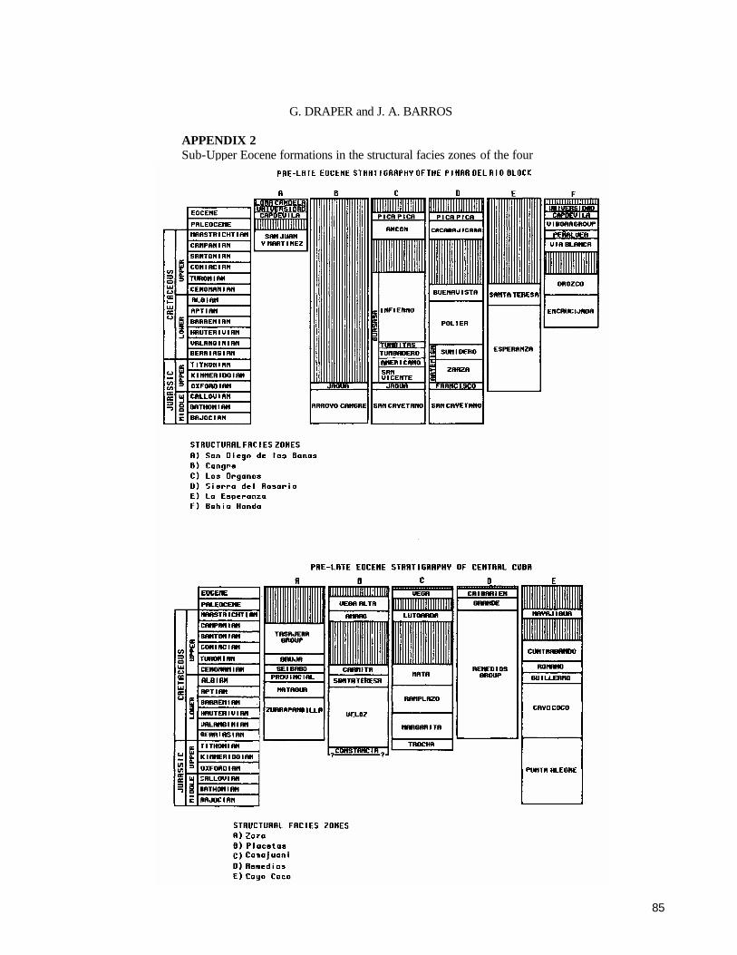
85
G. DRAPER and J. A. BARROS APPENDIX 2 Sub-Upper Eocene formations in the structural facies zones of the four main structural blocks of Cuba.

86
Cuba

87
Caribbean Geology: An Introduction U.W.I. Publishers’ Association, Kingston
©1994 The Authors
CHAPTER 5
The Cayman Islands
BRIAN JONES
Department of Geology, University of Alberta, Edmonton, Alberta, Canada T6G 2E3
INTRODUCTION
GRAND CAYMAN, Cayman Brae, and Little Cayman, collectively known as the Cayman Islands, are located on the Cayman Ridge in the central Caribbean Sea (Figs. 5.1, 5.2). Matley55 named the Bluff Limestone for the hard, resistant carbonates that formed the core of each island and the Ironshore Formation for the overlying softer limestones (Fig. 5.3). This stratigraphic scheme is deceptively simple because it embodies subtle complexities which denote im-portant events in the geological evolution of the islands. An understanding of the evolution of the Cayman Islands can only be obtained by a fully integrated investigation of their geology.
TECTONIC SETTING OF THE CAYMAN ISLANDS
The three Cayman Islands are situated on the Cayman Ridge (Figs. 5.1, 5.2) which forms the northern margin of the Cayman Trench that is 100-150 km wide51, 81 and reaches depths in excess of 6000 m51. The Mid-Cayman Rise is located to the southwest of Grand Cayman at about 82° W (Fig. 5.1). The Oriente Transform Fault forms the northern boundary of the Cayman Trench to the east of the rise whereas the Swan Island Transform Fault forms the south-ern boundary of the Cayman Trench to the west (Fig. 5.1). These transform faults are characterized by the left-lateral motion of the North America Plate relative to the Caribbean Plate19,51,65. Seismic activity along the Mid-Cavman Rise (Fig. 5.1) and adjoining transform faults74,78,79 indicates that the spreading centre is still active51.
The Cayman Ridge appears to be an uplifted fault block10,13,52,65 that rises 1500-2000 m above the surrounding seafloor and is bounded by fault planes dipping at 30°
or more3,13. Perfit and Heezen65 suggested that the present day Cayman Trench was initiated in Eocene times. The Cayman Ridge was predominantly a shallow water carbon-ate bank until Miocene times when it began to subside65. As subsidence continued, at 60 to 100 mm per 1000 years12,65, areas of shallow water carbonate accumulation and reef development were progressively restricted to the higher parts of the ridge. Following middle Miocene times, local-ized uplift elevated Central America and raised Swan Island, the Cayman Islands, Jamaica and most of southern Cuba above sea level65. The fact that Oligocene-Miocene carbon-ates of the Cayman Islands are now exposed above sea-level clearly records the change from subsidence and deposition to uplift and erosion. The differential uplift of these islands led to the suggestion that the Cayman Ridge is divided into discrete blocks by northeast-southwest trending faults, each island being on a separate block55,76. Horsfield20 pointed out that there is a general tectonic tilt to the west such that the islands become progressively lower in that direction.
The three Cayman Islands are pinnacles (Fig. 5.2) rising up from the depths of the ocean. Each island appears to be based on a foundation of granodiorite which occurs at depths between 600 and 3400 m on the Oriente Slope to the south of Grand Cayman12,76. The granodiorite is succeeded by a cap of basalt76 and then by Tertiary carbonates. The thick-ness of the carbonate cap on Grand Cayman is not known. Two wells drilled in the central part of the island, however, were still penetrating Oligocene carbonates at depths of 401 m (1315 feet) and 159 m (520 feet), respectively, when the wells were capped
THE BLUFF FORMATION
Introduction Matley55 originally named the Bluff Limestone for

88
The Cayman Islands
Figure 5.1. Map of central and northern part of the Caribbean Sea showing the positions of the Cayman Islands relative to the major tectonic features of the area.
Figure 5.2. East-west and north-south cross-sections across the Caribbean Sea showing the general setting of the Cayman Islands.
poorly-bedded, white to cream coloured, hard, microcrys-talline, porous carbonates that formed the core of each island (Fig. 5.3). The idea that this formation was formed entirely of limestone persisted 2,5,6,53,54,55,71,15,76,89,92,93 until it was demonstrated 39,48,66,68 that it is formed almost entirely of dolostone. Consequently, Jones and Hunter33 renamed this unit as the Bluff Formation (Fig. 5.4) in order to overcome the problems caused by the lithological connotation attached to the term Bluff Limestone.
Jones and Hunter33 divided the Bluff Formation into the Cayman and the Pedro Castle Members, and designated a succession in the northwest corner of the quarry near Pedro
Castle (Fig. 5.3 A) as the type section (Fig. 5.5). The Cayman Member is separated from the overlying Pedro Castle Mem-ber by a disconformity (Fig. 5.5).
The Cayman Member Boundaries
The lower boundary of the Cayman Member is not exposed on any of the Cayman Islands. The upper boundary is placed at the disconformity which is well-exposed in the quarry near Pedro Castle (Fig. 5.5). The type section, as presently defined, only covers the upper 5 m of the member.

89
BRIAN JONES Lithology At its type section, Jones and Hunter33 divided the Cayman Member into units I and II (Fig. 5.5). Unit I (3 m thick) is a white, hard, microcrystalline dolostone that was originally a packstone to grainstone. Scattered colonial (Montastrea, Leptoceris, Agathiphyllia, Favia, Diploria, and Diploastrea crassolameletta) and branching (Stylo- phora and Porites) corals, gastropods (including conch shells), and rare bivalves occur throughout the unit. Most of these fossils are now represented by moulds because the original aragonite was removed by leaching. Moulds of the corals, gastropods and bivalves commonly contain casts of borings (such as Entobia, Trypanites, Uniglobites)66,67. Skeletal components (foraminifers, red algae fragments, echinoid plates and spines) originally formed of high mag-nesium calcite are well-preserved. Unit I is characterized by high porosity (up to 25%) and permeability. All cavities are lined with two generations of dolomite cement39. Some cavities are filled or partly filled with caymanite (white, red, and black laminated dolostone29,50,71). Unit II (1 .75 m thick) is a white, microcrystalline dolos-tone that contains abundant branching corals (Stylophora and Porites), bivalves, gastropods, rare complete echinoids, rare colonial corals, and foraminifers33. The fossils are embedded in a mudstone to wackestone (Fig. 5.5). As in unit I, the corals, bivalves, and gastropods have been leached, and are now represented by moulds. Many cavities are partly or completely filled with white caymanite and, more rarely, red and black caymanite. Age Jones and Hunter33 suggested that the fauna in the Cayman Member exposed on Grand Cayman was of early late Oligocene age. This is in general agreement with the late Oligocene age that Vaughan82 suggested for equivalent strata on Cayman Brae. This age is for the upper beds of the member because only the upper part of the member is exposed on the islands. The age of the lower part of the member is not known because it is not exposed on Grand Cayman. Distribution On Grand Cayman, the Cayman Member crops out on the eastern part of the island where it is exposed in outcrops up to 17 m above sea level (Fig. 5.3 A). The formation also forms a narrow ridge on the south and north coasts of the island (Fig. 5.3A). Isolated outcrops of this member occur to the south of George Town and at Hell (Fig. 5.3 A). On Little Cayman (Fig. 5.3B) the exposed strata belong to the Cayman Member of the Bluff Formation. As with its sister islands, the Bluff Formation forms the core of the island. Like Grand Cayman, Little Cayman is characterized by a subdued topography with maximum elevations no more than 12 m above sea level. The exposures are poor and it is
impossible to obtain good sections through the formation. On Cayman Brae (Fig. 5.3C) the Bluff Formation ap-pears to be formed entirely of the Cayman Member. The Cayman Member forms vertical cliffs that rise up to 50 m above sea level at the northeast end of the island. Indeed, the term Bluff was originally used by Matley55 to denote the bluff-forming characteristics of the formation on Cayman Brac. Although the cliff faces are largely inaccessible, good exposures of the formation can be seen along road cuts and in quarries. The Pedro Castle Member Boundaries The lower boundary of this member is placed at the disconformity which is exposed in the quarry near Pedro Castle (Fig. 5.5). The upper boundary is the unconformity with the overlying Ironshore Formation. In most areas the present-day erosion surface cuts down into the Pedro Castle Member. Lithology This member is 2.5 m thick at the type section (Fig. 5.5). It is formed of off-white to cream coloured, relatively soft (compared to the Cayman Member), rubbly-weathering dolostone that contains numerous large free-living corals (including Trachyphyllia, Thysanus, Teliophyltia and Antil-locyathus), abundant well-preserved foraminifers (mainly miliolids), rare fragments of red algae, rare colonial corals, echinoid fragments, and bivalves. Rhodolites, up to 5 cm in diameter, are common in the basal bed of the member. As in the Cayman Member, the corals, gastropods, and bivalves are represented by moulds because the aragonite has been removed by leaching. Some cavities in the Pedro Castle Member are filled or partly filled with unconsolidated terra rossa that has been derived from the overlying soil (Fig. 5.5). Unlike the Cay-man Member, the pores and cavities are not lined with dolomite cements. White caymanite and dolomitized foraminiferal grainstones are rare in the cavities of this member. Age Determining the age of the Pedro Castle Member is difficult because of the lack of biostratigraphically significant fossils. Jones and Hunter33 suggested, however, that the corals were probably indicative of a Miocene age (possibly Middle Miocene). Distribution The Pedro Castle Member is restricted to the area around Pedro Castle on Grand Cayman (Fig. 5.3A). It has not been identified on Little Cayman or Cayman Brae. On Grand Cayman, it is well-exposed in the quarry near Pedro Castle, and along the coastline between Pedro Castle and Spots Bay (Fig. 5.3A). Although present in the area

90
The Cayman Islands
Figure 5.3. Maps of (A) Grand Cayman, (B) Little Cayman and (C) Cayman Brae, showing the distribution of the Bluff and Ironshore Formations.
around Savannah, it can only be seen when house founda-tions are being dug or in small pinnacles that occur in some of the swamp areas to the north. The Pedro Castle Member was present in the northeast corner of the airport (locality ARP in Fig. 5.3A) prior to its removal during excavations associated with runway extension.
Comparison of Cayman and Pedro Castle Members At its type section, the Cayman Member is distin-
guished from the Pedro Castle Member (Figs. 5.5,5.6,5.7) because (i) it is massive and hard, rather than rubbly and relatively soft; (ii) it is off-white to light grey, rather than
white to cream, in colour; (iii) its cavities contain a wide variety of cements rather than no cements; and (iv) it con-tains branching and massive corals rather than large, free-living corals33.
Contact between the Cayman and Pedro Castle members At the type section, the contact between the Cayman
and Pedro Castle members is marked by adisconformity that dips at about 2° to the northwest33. Locally, the disconfor-mity is encrusted with red algae. The upper surface of the Cayman Member was extensively bored by sponges, worms, and bivalves prior to deposition of the Pedro Castle

91
BRIAN JONES
Member. These borings indicate that the Cayman Member must have been lithified prior to deposition of the Pedro Castle Member.
THE IRONSHORE FORMATION
Introduction Matley55 defined the Ironshore Formation and noted
that it contained abundant well-preserved corals. Corals from the upper part of the formation have yielded ages of 124,000±8000 years93. The formation was not described in detail until Brunt et al5 divided it into (1) reef, (2) back-reef, (3) lagoonal, (4) oolitic, and (5) shoal facies. Woodroffe et al.92 subsequently examined the lagoonal facies in the northwest part of Grand Cayman and demonstrated that it encompassed a series of patch reefs surrounded by lagoonal deposits. Jones and Pemberton44,45 demonstrated that many corals from the patch reefs in the Ironshore Formation were extensively bored by Lithophaga.. Recent work21,22,31,46,64
has shown that the formation contains a complex array of facies that varies both laterally and vertically.
Jones and Hunter34 showed that the upper part of the Ironshore Formation records a shallowing-upward se-quence. The limestones in this part of the formation were deposited in a complex array of depositional environments in a large lagoon which Hunter and Jones21,34 called the Ironshore Lagoon (Fig. 5.8).
Palaeogeographic framework The palaeogeographic framework of the Ironshore For-
mation was largely controlled by the rugged karst topogra-phy that developed on the Bluff Formation during middle Miocene to late Pleistocene times22,34. Although the main area of deposition was in the Ironshore Lagoon that covered most of the western half of Grand Cayman, there were small embayments along the south, east, and north coasts which were akin to the sounds that occur around the modem shoreline. According to Hunter and Jones 21,34, the north and south margins of the Ironshore Lagoon were delineated by narrow ridges of the Bluff Formation (Fig. 5.7B). The western margin of the lagoon was marked by a barrier reef (Fig. 5.8C). Facies in the Ironshore Formation have been defined in many different ways 5,21,22,31,46,64,92 because dif- ferent studies have emphasized different aspects of the rocks. Many schemes named the facies with respect to their depositional setting and thus relied heavily on interpretation. Such problems are avoided by usin g a non-genetic classification based on lithology, sedimentary structures, fossil content and ichnology23,34. The scheme outlined herein (Table 5.1) is a combination of the schemes used by Hunter and Jones 23,34.
Bivalve facies This mudstone to wackestone contains a well-pre-
served, abundant, diverse mollusc fauna8,9,69,70, that is de-veloped in the eastern part of the Ironshore Lagoon. The molluscan fauna, which includes 83 species of bivalves and 90 species of gastropods, is dominated by burrowing bi-valves8,9. Corals are rare (Table 5.1). Locally, foraminifera and fragments of red algae are common. Hunter and Jones 21,22,34 suggested that this facies developed in shallow water in the landward portion of the Ironshore Lagoon. The nature of the mollusc fauna led Jones and Hunter34 to suggest that the muddy seafloor was covered with Thalas- sia.
Coral A facies This floatstone is dominated by a well-preserved, abun-
dant and diverse coral fauna (Table 5.2) along with lesser numbers of bivalves and gastropods (Table 5.1). This facies occurs in rounded to elliptical areas that are generally less than 100 m in diameter (maximum 200 m long). Dominant corals include Montastrea annularis, M. cavernosa, Diploria strigosa, D. labyrinthiformis, and Siderastrea siderea (Table 5.2). Associated with the corals are numerous bivalves that either nestled between the corals or cemented themselves to the solid substrates8,9. Many corals in these areas suffered considerable bioerosion through the activity of boring bivalves44, sponges, worms, algae, and fungi22,34.
The aerial restriction of the corals and the nature of the fauna has led to the suggestion 21,34,92 that they represented patch reefs. Corals in these patch reefs were capable of sediment rejection21,34.
Coral B facies This floatstone contains an abundant, diverse coral
fauna (Table 5.2) with many corals still in growth position. It is separated from coral facies A because it is not aerially restricted into patch reefs. In addition to the corals that occur in coral facies A, this facies also contains abundant Acro-pora palmata, A. cervicornis, Dendrogyra cyclindrus and Podllopora sp. Unlike the corals in the Coral A facies, these corals are not bored. This facies occurs on the northwest, west and southwest coasts of Grand Cayman (Fig. 5.8). The composition of the coral fauna is highly variable between localities (Hunter, 1990, personal communication).
Interpretation of the coral communities suggests that they lived in a back-reef setting rather than on the reef crest22,34. In contrast to the patch reefs, many corals in this facies could not reject sediment.
Laminated to highly burrowed grainstone facies This facies (Table 5.1) includes both skeletal and ooid
grainstones, and occurs between the patch reefs. The skele-

92
The Cayman Islands
Figure 5.4. Schematic stratigraphic section for the Cayman Islands. Inset shows stratigraphy of internal sedi-ments which fill cavities in the Cayman Member of the Bluff Formation.
tal grainstones commonly contain a diverse bivalve fauna8,9,92, whereas the oolitic grainstones contain only a few bivalves. Burrowing46,64 (Table 5.1) destroyed most original sedimentary structures. The occurrence of this fa-cies between the patch reefs suggests that it accumulated in a shallow, lagoonal setting.
Rudstone facies This facies (Table 5.1), that only occurs south of Salt
Creek on the west coast of North Sound (locality SC in Fig. 5.8A), is formed of lithoclasts (up to 0.1 m x 0.1 m x 0.1 m) of oolitic grainstone cemented by equant spar calcite, or bioclasts (corals and bivalves) in an oolitic grainstone ma-trix. This facies, which rests on an erosional surface, records a high energy event such as a storm or hurricane34,46.
Multidirectional, high-angle cross-bedded grainstone f acies
This facies (Table 5.1) is well exposed at localities BQ, LSC, SC, PBQ, PBA, SBA, and ACH (Fig. 5.8A). Near localities SC and LSC this facies overlies an erosional surface46 on which tabular lithoclasts (up to 0.3 m x 0.3 m x 0.1 m) rest. The presence of Ophiomorpha and Conichnus shows that this facies accumulated in subtidal conditions64. Jones and Hunter34 suggested that it represents an upper shoreface (surf zone) setting.
Unidirectional, high-angle cross-bedded grainstone facies This facies (Table 5.1), which only occurs at locality SC (Fig. 5.8A), overlies an erosional surface that has large, tabular lithoclasts resting on it. Woodroffe91 attributed a subaerial origin to this facies. However, Jones and co-work-ers34,46,64 argued that it originated in subtidal conditions because it is restricted to a channel and contains an ichno-fossil assemblage that could only have developed in a sub-tidal environment.
Laminated to low angle cross-bedded grainstone facies This facies (Table 5.1) is best exposed at localities BQ,
LSC, PBQ, PBA, and SBA (Fig. 5.8A). Interpretation of the lithotypes, sedimentary structures, and ichnofossils led Jones and Hunter34 to suggest that it recorded deposition in a swash zone. This succession is comparable to similar facies in the Pleistocene of the Yucatan Peninsula which are considered indicative of that zone84,85.
Sea level during deposition of the Ironshore Formation Although Woodroffe91 argued that sea level was only
2 to 3 m above present-day sea level at the time when the Ironshore Formation was deposited, Jones and Hunter 34
demonstrated that it was actually at about 6 m. This estimate of the sea level is in agreement with that generally given for this age of deposits throughout the Caribbean4,7,1 7,56,60.

93
BRIAN JONES
Vertical facies succession It is impossible to determine the vertical facies succes-
sion for the entire thickness of the Ironshore Formation because most of it is below sea level. Consequently, the vertical facies succession documented herein focuses on the upper 7 m of the formation that is exposed at various localities on the western part of Grand Cayman (Fig. 5.9).
The upper part of the Ironshore Formation on Grand Cayman records a shallowing-upward succession (Fig. 5.9). The lower part of the sequence, which formed in the Iron-shore Lagoon, ranges from the lagoonal deposits (bivalve facies) in the east to the patch reefs (coral A facies), inter-reef grainstones (laminated to highly burrowed grain-stones), and reef tract (coral B facies) deposits in the west (Fig. 5.8). Locally, as near Salt Creek, these lagoonal depos-its were cut by large tidal channels34,46. Some channels have rudstones or isolated clasts resting on their floors34,46.
As sea level dropped, the lagoon became progressively shallower and a complex array of facies formed in response. Thus, overlying the lagoonal deposits are a succession of cross-bedded grainstones and laminated grainstones that record the transition from the lagoon through the lower shoreface to the upper shoreface34. Valuable insights into the nature of the last stages of the regression were obtained from an analysis of a community replacement sequence35. This sequence involved the death of corals, boring of the coral fragments, coating of the coral fragments by red algae and foraminifers to form rhodolites, and, finally, binding of micrite by microbes to form microbialites35.
The Ironshore Formation on Cayman Brae and Little Cayman
The stratigraphy and sedimentology of the Ironshore Formation on Cayman Brae and Little Cayman is poorly known because few studies have been done on the relatively poor exposures through the formation on those islands.
On Cayman Brae the limestones of the Ironshore For-mation appear to have accumulated in narrow lagoons that fringed steep cliffs of the Bluff Formation. A well-devel-oped, wave-cut notch at about 6 m above present day sea level34,93 delineates the position of the late Pleistocene sea level. Near Pollard Bay, the lagoonal deposits are characterized by numerous corals that are still in life position. It appears that coastal erosion was active during that time because there is evidence of sea-cliff collapse caused by undercutting of the dolostone cliffs42.
Small pits near the airport on Cayman Brae cut through the upper 5 m of the Ironshore Formation and show a sequence which records deposition from the lower to upper shoreface43. The succession is capped by a well-developed caliche unit that has been extensively bored by a wide variety of plant roots26.
On Little Cayman there are few exposures through the Ironshore Formation. Stoddart76 briefly described and illus-trated a sequence near Salt Rocks that is akin to that on Grand Cayman because it encompasses a shallowing-up-ward succession34. A quarry on the south-central coast demonstrates that the Ironshore Formation is capped by a thick caliche unit similar to that on Cayman Brae.
BOUNDARY BETWEEN THE BLUFF AND IRONSHORE FORMATIONS
Determining the profile of unconformity between the Bluff and Ironshore Formations is difficult because much of it is below sea level and buried by the Ironshore Formation. Nevertheless, the sparse information that is available sug-gests that the unconformity has considerable relief on it. This is amply demonstrated by the fact that isolated patches of the Bluff Formation protrude through the Ironshore For-mation at Hell, south of George Town and at various loca-tions along the north and south coasts (Fig. 5.3A). This is also shown by the fact that the unconformity is essentially horizontal at Newlands, but vertical at Spots Bay (locality SBJ in Fig.5.8A).
DIAGENETIC FABRICS IN THE BLUFF FORMATION
The Bluff Formation includes a vast array of diagenetic fabrics that reflect the complex history of this formation since middle Miocene times. Despite its relatively young age, the rocks of this formation have been subjected to pervasive dolomitization, numerous cycles of karst devel-opment, numerous phases of dissolution, cement precipita-tion and deposition of internal sediment. Locally, diagenesis has obscured the original depositional fabrics. Porosity and permeability is generally high in the Bluff Formation be-cause of the vast array of diagenetic processes that have affected the rocks63. An understanding of the diagenetia fabrics is important because they are the only record of the conditions and processes that occurred following deposi-tion.
Dolomitization Pervasive dolomitization is the most obvious change
that the rocks of the Bluff Formation underwent. Despite dolomitization, the original fabrics of the rocks were largely retained and the nature of the original sediments can still be determined. For example, fossils originally formed of high-magnesium calcite (for example, red algae, foraminifers and echinoids) have retained their original skeletal structure.
Despite extensive study, the conditions responsible for

94
The Cayman Islands
Figure 5.5. Summary of depositional and diagenetic features in the type section of the Bluff Formation at Pedro Castle Quarry (modified after Jones and Hunter33; Jones et al.36).
the dolomitization of the Bluff Formation are not fully understood. The geographic isolation of the Cayman Islands as well as the geological framework of the Bluff Formation means that many of the standard dolomitization models cannot be used to explain the dolomitization. Thus, Pley-dell66 and Pleydell et al69 suggested that dolomitization of the Bluff Formation was mediated by 'normal' seawater or by mixed seawater and freshwater.
The dolostones in the Cayman and Pedro Castle Mem-bers are petrographically and geochemically similar. For example, the dolostones of these two members have similar C, O, and Sr isotope signatures68. These similarities have led to the suggestion that the Bluff Formation had only undergone one phase of dolomitization. However, Ng62 argued that the Bluff Formation had been subjected to two phases of dolomitization, the first following deposition of the Cayman Member, but before the deposition of the Pedro Castle Member, and the second following deposition of the Pedro Castle Member. According to Ng62, the second phase
of dolomitization reset the chemical signature of the rocks in the Cayman Member and thus gives the false impression of a uniform signature. Although a viable possibility, there are no textures or geochemical signatures that support the contention of more than one phase of dolomitization. Inter-pretation of the 87Sr/86Sr ratios from the dolostones led Pleydell et al.68 to suggest that dolomitization of the Bluff Formation was probably caused by 'normal' seawater 2 to 5 million years ago. The reasons why dolomitization oc-curred during that time are not yet understood.
Dedolomitization In some parts of the Bluff Formation there are soft,
porous, 'chalky' zones that contrast sharply with the hard dolostones which usually characterize the Bluff Formation. Such zones occur along joints, fractures and bedding planes which allow easy passage of various waters47,61. These rocks are formed of hollow dolomite rhombs47 which re-sulted from the cores of dolomite crystals eing preferen-
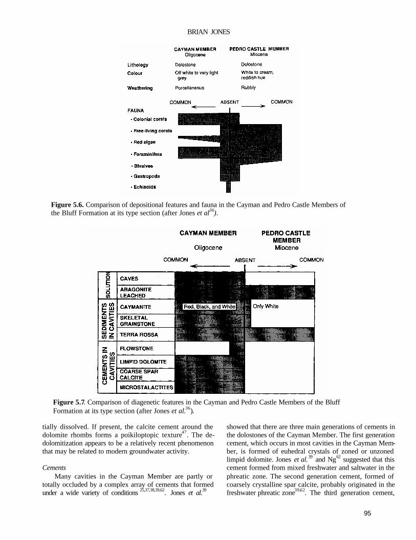
95
BRIAN JONES
Figure 5.6. Comparison of depositional features and fauna in the Cayman and Pedro Castle Members of the Bluff Formation at its type section (after Jones et al36). Figure 5.7. Comparison of diagenetic features in the Cayman and Pedro Castle Members of the Bluff Formation at its type section (after Jones et al.36).
tially dissolved. If present, the calcite cement around the dolomite rhombs forms a poikiloptopic texture47. The de-dolomitization appears to be a relatively recent phenomenon that may be related to modern groundwater activity. Cements
Many cavities in the Cayman Member are partly or totally occluded by a complex array of cements that formed under a wide variety of conditions 25,37,38,39,62. Jones et al.39
showed that there are three main generations of cements in the dolostones of the Cayman Member. The first generation cement, which occurs in most cavities in the Cayman Mem-ber, is formed of euhedral crystals of zoned or unzoned limpid dolomite. Jones et al.39 and Ng62 suggested that this cement formed from mixed freshwater and saltwater in the phreatic zone. The second generation cement, formed of coarsely crystalline spar calcite, probably originated in the freshwater phreatic zone39,62. The third generation cement,

96
The Cayman Islands
formed of microstalactites with alternating bands of calcite and dolomite, developed while the rocks were in the vadose zone. The three generations of cement record the passage of the rocks in the Cayman Member through the mixed-water phreatic, freshwater phreatic, and vadose zones. Cavities in the dolostones of the Pedro Castle Member are not lined with limpid dolomite33. This suggests that the limpid dolo-mites in the Cayman Member formed before deposition of the Pedro Castle Member. Locally, cavities in the Pedro Castle Member are partly or totally occluded by spar calcite.
Internal sediments Many caves and cavities in the Bluff Formation are
filled or partly filled with caymanite, dolomitized foraminif-eral grainstone, unlithified and lithified terra rossa, breccia, and/or terrestrial oncoids.
Caymanite is a red, black, and white (or any shade between these colours), laminated, cryptocrystalline dolos-tone that derives its name from the fact that the local people use it for making jewellery71. Lockhart50 demonstrated that the colour was due to trace amounts of Fe (red) and Mn (black). Folk and McBride14 and Lockhart50 suggested that the coloured caymanite was formed when transgressing seas washed swamp deposits through the karst system into the caves and caverns. Jones 29 demonstrated that caymanite was formed by sediments from numerous sources (marine, ponds, swamps and soils) being washed into the subterra-nean cavities by water draining from the surface of the karst terrain. The colours and sedimentary structures which char-acterize caymanite formed in response to a complex set of interrelated variables29.
Some cavities and caves in the Cayman Member ex-posed in the quarry near Pedro Castle contain a dolomitized grainstone that has high mouldic porosity. The presence of foraminifers and fragments of red algae indicates that the sediment was of marine origin.
Many cavities in the Cayman and Pedro Castle Mem-bers are partly or completely filled with lithified and unlithi-fied terra rossa. The terra rossa was washed into the cavities from the soils which occur on the surface of the Bluff Fonnation in many parts of the island1. The terra rossa has not been dolomitized. Locally, the cavities are filled with a breccia formed of angular fragments of white dolostone (derived from the Bluff Formation) held in a terra rossa matrix.
Many sinkholes, which are up to 30 m (average 6 m) deep, are filled or partly filled with breccias. Although some of the breccias contains dolostone clasts25 derived from the Bluff Formation, others contain clasts formed of many different lithologies 37,48. Of particular interest is the fact that many clasts are formed of limestones that have no surface counterparts37. As such they provide a record of
surface successions that have since been removed by ero-sion. Some cavities and sinkholes in the Bluff Formation are partly or completely filled with terrestrial oncoids 28. These ovate, coated grains, which are generally less than 5 mm long, formed through the action of a diverse array of micro-organisms.
Joints In many areas the Bluff Formation is transected by
well-developed joints48,71. Ng62 suggested that lineaments visible on air photographs are surface expressions of these joint sets. The joints are important because they act as conduits by which seawater penetrates into the central part of the island. Many joints are partly or totally filled with a complex array of precipitates and internal sediments48. For example, in the area near Blowholes, the joints are filled with caymanite, terra rossa and terra rossa breccia48. Lo-cally, the walls of the joints are lined with flowstone48. The fact that the flowstone and terra rossa are not dolomitized suggests that these fills, and possibly the joints, were formed after dolomitization.
Karst development The present day surface of the Bluff Formation is
characterized by a rugged karst terrain that includes jagged surfaces, potholes and solution-widened joints11,15,27,83. Indeed, the exposure of the Bluff Formation at Hell repre-sents the type locality of phytokarst as described by Folk et al.15. In addition to the surface features, there is a well-de-veloped subterranean karst system with numerous caves that commonly contain a diverse array of stalactites, stalagmites, and various other speleothems40,41,48.
The Bluff Formation has undergone numerous phases of karst development. Study of outcrops in the quarry near Pedro Castle over the last ten years has yielded important information concerning karst development relative to the disconformity that separates the Cayman and Pedro Castle Members. Prior to 1984, the south wall of the quarry in-cluded a vertical section through a cave (22 m long and up to 4.5 m high) that was filled with a wide variety of internal sediments and speleothems48,50. The floor of that cave lay 9 m below the disconformity that separates the Cayman and Pedro Castle Members (Fig. 5.10). During successive years, progressive blasting of the quarry wall meant that the cave could be traced in the third dimension to the southwest. This showed that the original cave was part of an extensive cave and tunnel system. In 1989, the exposure provided a section through a sinkhole that was filled with dolomitized internal sediment (predominantly white and beige caymanite). That sinkhole and its fill was truncated by the disconformity (Fig. 5.10). Furthermore, at the disconformity the internal sedi-ment that filled the sinkhole was bored by the same assem-

97
BRIAN JONES

98
The Cayman Islands
blage of organisms that bored the upper surface of the surrounding Cayman Member. This clearly indicates that the Cayman Member was lithified, karstified and had caves filled prior to deposition of the Pedro Castle Member.
Important clues regarding the history of karst on the Grand Cayman comes from the internal sediments and precipitates that occur in many of the caves, cavities and joints. Examination of hundreds of cavities and caves in the Bluff Formation on Grand Cayman shows that the cayman-ite and grainstones are always dolomitized whereas the terra rossa and flowstones are never dolomitized. If all four cavity-fills are present in a single cave or cavity, the strati-graphic order is always from caymanite to dolomitized grainstone (or interbedded) to flowstone or terra rossa. Although most cavities and caves contain only one or two of these fills, no cavity has been found with a sequence that would contradict the above order. This suggests that some cavities were open and receiving internal sediments both before and after dolomitization. The caves that contain only flowstones, stalactites, stalagmites and terra rossa probably formed after dolomitization. This suggestion is supported by the fact that the floors of such caves on Cayman Brae can be traced laterally into the wave-cut notch that formed in association with the sea level highstand approximately 125,000 years ago.
DIAGENETIC FABRICS IN THE IRONSHORE FORMATION
The term ironshore was originally coined because these limestones characteristically form hard outcrops in coastal areas24,86. In many ways this is a misleading term because the Ironshore Formation is composed mainly of friable and poorly lithified limestones. The hardness of these lime-stones in the coastal settings is a reflection of diagenetic processes that have occurred as a consequence of their exposure to sea water and freshwater.
The limestones of the Ironshore Formation contain a wide array of fabrics that record diagenesis in the marine, freshwater phreatic and vadose realms (Table 5.3). Vadose diagenetic fabrics are common, and usually dominate over the marine and freshwater phreatic cements (Table 5.3). In many places the limestones of the Ironshore Formation are capped by a well-developed calcrete crust that is up to 6 cm
thick.
Weathered surfaces of the Ironshore Formation, like those on the Bluff Formation, are typically black in colour. The scalloped nature of these weathered surfaces, as well as colour, can be attributed to the diverse array of epilithic and endolithic microbes that occur on them27. Tree roots also have a significant effect on the surface exposures of the limestones in the Ironshore Formation. The result of tree roots penetrating the limestone is largely a function of the hardness of that limestone. Roots that penetrate friable, poorly-consolidated limestones usually have well-devel-oped rhizoliths around them43. Such rhizoliths developed because of the preferential formation of a wide array of cements around the roots63. Roots that penetrate hard, well-lithified limestones produced large borings that became the site of intense microbial activity26. Various organisms, such as mites, springtails, collembolas and worms are responsible for the formation of peloids in living plant roots that occur in the limestones of the Ironshore Formation49.
HOLOCENE SWAMP DEPOSITS
Much of Grand Cayman is covered with swamps that formed in response to a Holocene transgression88,90. Swamp deposits around Governor's Harbour (Fig. 5.3 A) on the West Peninsula of Grand Cayman, studied in detail by Woodroffe88,90 and Woodroffe et al.92, are ideal for char -acterizing these deposits (Fig. 5.11). Woodroffe88,89 di-vided the swamp sediments into mangrove peat, orange plastic mud and green plastic mud. The distribution and thickness of the black mangrove peat, which is formed of decaying organic matter derived from the plants, is related to the distribution of the vegetation. The orange plastic mud has a low organic content, a relative low moisture content (51-85%), and a wet pH of 6.3 to 7.1. Woodroffe88 sug-gested that this mud formed on dry ground as a subaerial soil beneath a low herbaceous vegetation. The green plastic mud, which is non-fibrous with a low organic content and relative low moisture content (70-80%), usually occurs in the lower part of the swamp succession.
The area to the south of Governor's Harbour (Fig. 5.3 A) is covered by a relatively thick (0.5 to 3.0 m) blanket of mangrove peat that developed beneath the Rhizophora scrubs of the area88. The thinnest cover occurs near the West
Figure 5.8. (previous page) (A) Localities on Grand Cayman where outcrops of the Ironshore Formation occur (modified after Jones and Hunter36, in which a full list of outcrops appears). (B) Occurrence of facies in the Iron-shore Formation on Grand Cayman (from Hunter and Jones 23). Lack of outcrop in some areas precludes more de-tailed mapping. (C) Palaeogeographic map of Grand Cayman approximately 125,000 vears ago, when the limestones of the Ironshore Formation were being deposited (from Jones and Hunter34).

99
BRIAN JONES
Facies Lithology Sedimentary Structures
Fossils Dominant Minor
Ichnology Ichnogenera Burrowing
Bivalve
Mudstone to wackestone
None
Bivalves Gastropods Corals, Algae Foraminifera
None
---
Coral A Floatstone None Corals Bivalves Gastropods
Gastrochaenolites Entobia, Trvpanites
---
Coral B Floatstone to rudstone
None Corals Bivalves Gastropods
None ---
Laminated to highly burrowed grainstone
Grainstone (ooids or skeletal sand)
Horizontal laminae Small cross-laminae
None Bivalves Skolithos Ophiomorpha Conichnus Polvkladichnus
1 to 10
Laminated to low angle cross-bedded grainstone
Grainstone (ooids or skeletal sand)
Horizontal laminae Low angle (<5°) cross-bedding
None None None ---
Rudstone Bioclasts or lithoclasts in grainstone matrix
Locally horizontal laminae or high-angle cross-bedding
None Bivalves Corals
Qphiomorpha Polvkladichnus Conichnus Skolithos
4 t o 10
Multidirectional high-angle cross-bedded grainstone
Grainstone (ooids)
High angle (25-30°) cross-bedding Multidirectional
None Bivalves Conichnus Ophiomorpha
2 t o 3
Unidirectional high-angle cross-bedded grainstone
Grainstone (ooids)
High-angle (30°) cross bedding Unidirectional
None None Bergaueria Psilonichnus
1 t o 3
Table 5.1. Characteristic features of facies present in the Ironshore Formation on Grand Cayman (based on Jones and Hunter34; burrowing scale as used in Jones and Pemberton46).
Bay Road where thicknesses of less than 1 m are common. Even in this area, however, ther e are pockets of peat over 2 m thick (Fig. 5.12). To the east, there is an extensive area of thick (3 m or more) peat cover.
Sediment distribution is more complicated to the north of Governor's Harbour where mangrove peat occurs with orange and green plastic muds (Fig. 5.11). Most mud is located close to the 'dry cays' that are formed where the Pleistocene bedrock comes to the surface (Fig. 5.11). The mangrove peat of this area is generally less than 1 m thick, although there are isolated pockets up to 2 m thick (Fig. 5.11). The thickness of the peat and muds, which varies throughout the area, is a function of the amount of relief developed on the bedrock prior to the development of the swamps (Fig. 5.11). Cores from various parts of the swamp show that the swamp sediments are relatively consistent throughout their depth (Fig. 5.12). The orange and green plastic muds, which are confined to the lower parts of the successions, are overlain by mangrove peat (Fig. 5.12). If the muds are absent, the mangrove peat rests directly on top of the underlying Ironshore Formation (Fig. 5.12).
GEOLOGICAL HISTORY OF THE CAYMAN ISLANDS
A cursory inspection of the geological maps of the Cayman Islands showing the Bluff and Ironshore Formations (Fig. 5.3) could easily lead to the conclusion that their geological evolution was relatively straightforward and thus easy to interpret. Such a conclusion would be erroneous because the simple lithostratigraphic divisions of the strata disguise the true picture. Any consideration of the geological history of these islands must centre around the fact that they have gone through four phases of deposition, each depositional phase being separated by a period of subaerial exposure. In addi-tion, any model of this type must allow for the dolomitiza-tion of the Bluff Formation and the differential uplift of the three islands. A major difficulty in any attempt to synthesize the geological history of these islands lies in the problem of accurately dating the strata, the tuning of the dolomitization and the timing of tectonic activity. For the purposes of this discussion, the geological evolution of the Cayman Islands has been divided into six distinct stages.

100
The Cayman Islands
FACIES CORAL A CORAL B LOCATION SB SH DP TF BT CD F MH B K SD I Stephanocoenia michelini R Acropora palmata S A A S Acropora cervicornis S A A C C Pocillopora sp. C R Agaricia agaricites S S S S C S R S S R Agaricia fragilis R S R R Leptoseris cucullata R Siderastrea siderea S C S C C C S C Siderastrea radians S S Porites astreoides S S S S S S C S S S Porites porites A C C A C A C S C A S A Favia fragum S S S S S S S S S S Diploria clivosa C C S S Diploria strigosa C C C C C C C A C C Diploria labyrinthiformis S S S C S S C C C S Manicina areolata S S R R S S S R S S S S Colpophyllia natans S S S S S C Montastrea annularis A A A A A A C A A A A C Montastrea cavernosa S C C S C R C Oculina diffusa R R Meandrina meandrites R R R Dichocoenia s tokesi R R R R Dendrogvra cylindrus C C R S Mussa angulosa R Scolymia cubensis R R R Isophvllastrea rigida R R R R R Isophvllia sinuosa R R R R R Mycetophvllia spp R S S C S R S Eusmilia fasti giata R R R R R R
Table 5.2. Occurrence of corals at various localities in the Ironshore Formation on Grand Cayman (see Fig. 5.8A). Key: A=abundant; C=common; S=scarce; R=rare.
Stage I The oldest strata exposed on the Cayman Islands belong to
the Cayman Member of the Bluff Formation (Fig. 5.13). Coirelation of this member with other Oligocene strata in the Caribbean suggests that sedimentation terminated in the late middle Oligocene33. Indirect evidence suggests that this was about 30 Ma ago33.
There is no evidence of reefs in the Cayman Member. Indeed, most corals occur as isolated heads or as thickets of branching corals. Interpretation of the depositional fabrics and faunal components suggests that the Cayman Member originated as carbonates that accumulated on a bank that was probably akin to the Twelve Mile Bank which presently exists 16 km west of Grand Cayman87. As such, a relatively quiet-water setting with depths of 25 to 40 m is envisaged for most of these deposits. However, in some areas there are indications of shallower water and higher energy conditions. For example, preliminary work on the Cayman Member of Cayman Brae has shown that it includes beds formed of rhodoids and coral rubble that probably formed in relatively shallow water and high energy conditions. Thus, it is possible that the Cayman Member encompasses a broader spectrum of depositional settings than presently suspected.
Stage II The upper boundary of the Cayman Member is marked
by a disconformity that is a record of the subaerial period which followed deposition of the Cayman Member. Dating of the Cayman Member and the overlying Pedro Castle Member led Jones and Hunter33 to suggest that this period of exposure lasted for approximately 16 Ma.
During this period, limestones of the Cayman Member became fully lithified and extensive leaching of the arago-nitic fossils occurred. In addition, large-scale dissolution led to the formation of large caves and passages, the best exam-ple occurring in the quarry near Pedro Castle. Such cave systems were subsequently filled with a complex array of sediments (Fig. 5.10). On a smaller scale, cavities were lined with limpid dolomite crystals, probably as a result of their residence in the mixed-water zone.
Stage III A transgression in middle Miocene times led to the
incursion of the sea over the lithified strata of the Cayman Member. The extent of that transgression and the resultant deposits is not known because subsequent weathering stripped most of the Pedro Castle Member from Grand Cayman. Although Jones and Hunter 33 originally thought that the Pedro Castle Member was restricted to a small area around Pedro Castle, subsequent fieldwork has shown that it covers a broader area (Fig. 5.3 A).
The middle Miocene transgression led to marine ero-
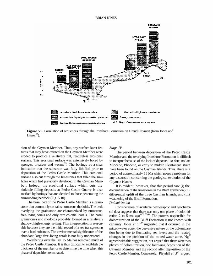
101
BRIAN JONES
Figure 5.9. Correlation of sequences through the Ironshore Formation on Grand Cayman (from Jones and Hunter34).
sion of the Cayman Member. Thus, any surface karst fea-tures that may have existed on the Cayman Member were eroded to produce a relatively flat, featureless erosional surface. This erosional surface was extensively bored by sponges, bivalves and worms33. The borings are a clear indication that the substrate was fully lithified prior to deposition of the Pedro Castle Member. This erosional surface also cut through the limestones that filled the sink-holes which had previously developed in the Cayman Mem-ber. Indeed, the erosional surface which cuts the sinkhole-filling deposits at Pedro Castle Quarry is also marked by borings that are identical to those penetrating the surrounding bedrock (Fig. 5.10).
The basal bed of the Pedro Castle Member is a grain-stone that commonly contains numerous rhodoids. The beds overlying the grainstone are characterized by numerous free-living corals and only rare colonial corals. The basal grainstones and rhodoids probably formed in a relatively shallow, high-energy setting. This interpretation is reason-able because they are the initial record of a sea transgressing over a hard substrate. The environmental significance of the abundant, large free-living corals is not fully understood.
Weathering over the last 15 Ma has removed much of the Pedro Castle Member. It is thus difficult to establish the thickness of the member or to determine the time when this phase of deposition terminated.
Stage IV The period between deposition of the Pedro Castle
Member and the overlying Ironshore Formation is difficult to interpret because of the lack of deposits. To date, no late Miocene, Pliocene, or early to middle Pleistocene strata have been found on the Cayman Islands. Thus, there is a period of approximately 15 Ma which poses a problem for any discussion concerning the geological evolution of the Cayman Islands.
It is evident, however, that this period saw (i) the dolomitization of the limestones in the Bluff Formation; (ii) differential uplift of the three Cayman Islands; and (iii) weathering of the Bluff Formation. Dolomitization
Consideration of available petrographic and geochemi-cal data suggests that there was only one phase of dolomiti-zation 2 to 5 ma ago33,39,66,68. The process responsible for dolomitization of the Bluff Formation is not known with certainty. Jones et al.39 suggested that it occurred in the mixed-water zone; the pervasive nature of the dolomitiza-tion being due to fluctuating sea levels and the related changes in the position of the mixed-water zone. Ng62
agreed with this suggestion, but argued that there were two phases of dolomitization, one following deposition of the Cayman Member and the second after deposition of the Pedro Castle Member. Conversely, Pleydell et al6S argued

102
The Cayman Islands
Figure 5.10. Schematic diagrams showing cave that was present in the southwest wall of the quarry near Pedro Castle (see Fig. 5.3 A). Inset map shows the position of the quarry wall in 1983, 1989 and 1990. (A) Cross-section in 1983 showing through a cave that was filled with caymanite, dolomitized grainstone, flowstone and terra rosa (modified after Lockhart j. (B) Cross-section in 1989 after wall of quarry had been excavated about 20 m southwest from the 1983 position. The cave shown in this diagram is the southwest extension of the cave shown in (A).
that natural sea water was probably responsible for dolomi-tization of the Bluff Formation.
If seawater is deemed responsible for dolomitization of the Bluff Formation, then there must have been a period when each of the Cayman Islands were submerged. Inter -pretation of the Sr isotope data indicates that this submer-
gence would have occurred 2 to 5 ma ago. There is, however, no physical evidence of such submergence because there are no strata of that age. This may reflect that (i) this was a period of submergence, but non-deposition; (ii) such strata were deposited and subsequently removed by erosion; or (iii) such strata are present but have not yet been recognized.

103
BRIAN JONES
Figure 5.11. Distribution of swamp deposits in the area north of Governor's Harbour (West Peninsula, Grand Cayman). Note lateral variation in the thickness of the swamp deposits that are related to the topography devel-oped on the underlying Ironshore Formation (compiled and modified from information in Woodroffe88).
If the idea of dolomitization by seawater is rejected then this process must be related to the mixed-water zone because the geological setting of these islands precludes the use of any other dolomitization model. Differential uplift of the Cayman Islands
Grand Cayman and Little Cayman are similar in terms of their surface topography and elevation above sea level. However, Cayman Brae is notably different because it rises to nearly 50 m at its northeastern end. The strata on that island appear to dip to the southwest. Dating the uplift of the Cayman Brae relative to the other islands is constrained by two considerations. First, uplift must have postdated dolomitization because even the highest strata on Cayman Brae are dolomitized, and yield the same petrographic and geochemical signatures as the dolostones of this formation on Grand Cayman and Little Cayman. Secondly, on Cayman Brae there is a distinct wave-cut notch at 6 m above sea level which is cut into the dipping strata of the Bluff Formation. This wave-cut notch, which correlates with a similar wave-cut notch on Grand Cayman, formed 125,000 years ago when the limestones of the Ironshore Formation were being
deposited. Uplift of Cayman Brae must have occurred after dolomitization of the Bluff Formation, but prior to the late Pleistocene highstand 125,000 years ago. Weathering of the Bluff Formation
During the period between the deposition of the Pedro Castle Member and the Ironshore Formation there was extensive subaerial weathering of the Cayman Islands. As -sessment of this weathering is hindered because it is difficult to segregate its effects from more recent weathering. Nev-ertheless, it is evident that this phase of erosion led to the removal of the Pedro Castle Member from large areas of Grand Cayman and the formation of a rugged karst terrain on the rocks of the Bluff Formation.
The topography developed on the Bluff Formation prior to deposition of the Ironshore Formation is evident from the relief that presently exists on the unconformity that sepa-rates the two formations. In some areas the unconformity is essentially horizontal (for example, Newlands and south of George Town) whereas in other areas it is vertical or sub-vertical (such as Spots). Locally, the relief on the unconfor-mity appears to be as much as 30 m34 . It is difficult,

104
The Cayman Islands
Cement Type Abundance Environment
Isopachous aragonite Common in cavities in fossils, common
in some grainstones Marine Peloids Common in cavities in corals Marine Blocky spar calcite Common in some grainstones Freshwater
phreatic Meniscus cement Common in grainstones Vadose Needle-fibre cement Common in cavities in fossils;
in root borings Vadose Microstalactites Rare Vadose Grain coating needle mats
Common in some grainstones Vadose Calcified algae/fungi Common in root borings; common in some grainstones Vadose Calcified root hairs Common Vadose Calcified bacteria Common Mostly vadose Pyrite framboids Very rare Vadose?
Table 5.3. Summary of diagenetic fabrics present in the Ironshore Formation on Grand Cayman.
however, to accurately map the topography on the uncon-formity because it is largely buried and below present-day sea level.
Stage V This stage, which occurred about 125,000 years ago,
involved deposition of the limestones (Ironshore Forma-tion) when sea level rose to approximately 6 m above that of the present-day34. The palaeogeography at that time was controlled by the topography previously developed on each of the islands and the position of sea level.
On Grand Cayman, deposition occurred in a large lar goon (Ironshore Lagoon23) that covered much of the west-ern half of the island (Fig. 5.8B), and in small lagoons that occurred around the south, east and north coasts of the island (Fig. 5.8B). Analysis of the limestones in the Ironshore Formation showed that the Ironshore Lagoon incorporated a bivalve facies, a belt of patch reefs and a barrier reef across its western entrance (Fig. 5.8B).
On Cayman Brae, limestones of the Ironshore Forma-tion were deposited in narrow lagoons and shelves that fringed the upstanding block of the Bluff Formation. Asso-ciated with the well-developed wave-cut notch which occurs around the island are numerous caves.
The extent to which the Sangamon (125,000 ma ago) highstand submerged Little Cayman is difficult to evaluate because subsequent erosion has removed much of the se-quence. Nevertheless, it would appear that the situation on Little Cayman largely paralleled that on Grand Cayman.
Stage VI Over the last 125,000 years, the topography of each of
the Cayman Islands has been modified by weathering75
which has accentuated the karst topography on the Bluff and Ironshore Formations. Although the amount of rock re-moved by weathering is difficult to evaluate, it is probably substantial. For example, in most areas of Grand Cayman and Little Cayman, weathering has removed the old cliff lines and the wave-cut notches that formed during the last highstand.
Approximately 50% of Grand Cayman is presently covered by mangrove swamps90. The sediments beneath these swamps, which includes peat layers up to 6 m thick, are the record of Holocene submergence of the island90. Radiocarbon dates from the lower parts of the peat layers suggest that this transgression was initiated approximately 2100 years ago89.
Present-day reefs and carbonate sedimentation occur in the shallow-water sounds and on narrow shelves around each of the Cayman Islands. Various aspects of the modern sedimentation patterns have been documented18,32,59,71,72,
73,77,80. Beachrock, which is common at many localities around the coast of Grand Cayman, has been described by Moore57,58 and Jones and Goodbody30.
ACKNOWLEDGEMENTS—-The research on which this paper is based would have been impossible without the financial support provided by the Natural Science and Engineering Research Council of Canada (grant No. A67090), and the logistical assistance given by Mr. Richard Beswick, Director, Water Authority, Cayman Islands and Dr. J. Davies, Director, Mosquito Research Control Unit, Cayman Islands. I am indebted to these organizations for their support. I am grateful to my graduate students, Cheryl Squair, Blair Lockhart, Suzanne Pleydell, Duncan Smith, Jill Rehman, Sam Ng and Ian Hunter, who have all allowed me to use information gathered during their studies of the Cayman Islands. I am also indebted to these students for their help in the field. SamNg and Ian Hunter critically reviewed, and Elsie Tsang helped me prepare, this manuscript. Two anonymous reviewers also posed many questions that forced clarifi-cation of certain points.

105
BRIAN JONES
Figure 5.12. Sediment sequences in swamp deposits in the area north of Governor's Harbour (modified after Woodroffe88).
REFERENCES
1 Ahmad, N. & Jones, R.L. 1969. Occurrence of aluminous lateritic soils (bauxites) in the Bahamas and Cayman Islands. Economic Geology, 64, 804-808.
2Beckmann, J.P., Butterlin, J., Cederstnom, D.J., Christman, R.A., Chubb, L.J., Hoffstetter, R., Kugler, H.G., Mar-tin-Kaye, P.H.A., Maxwell, J.C., Mitchell, R.C., Ramirez, R., Versey, H.R., Weaver, J.D., Westermann, J.H. &Zans, V.A. 1956. LexiqueStratigraphique Inter-national, Volume 5. Amerique Latine, 2b, Antilles. CNRS, Paris, 495 pp.
3Bowin, C.O. 1968. Geophysical study of the Cayman Trough. Journal of Geophysical Research, 73, 5159-5173.
4Brasier, M. & Donahue, J. 1985. Barbuda—an emerging reef and lagoon complex on the edge of the Lesser Antilles island arc. Journal of the Geological Society, London, 142, 1101-1117.
5Brunt, M.A., Giglioli, M.E.C., Mather, J.D., Piper, D.J.W.
& Richards, H.G. 1973. The Pleistocene rocks of the Cayman Islands. Geological Magazine, 110, 209-221.
6Bugg, S.F. & Lloyd, J. W. 1976. A study of freshwater lens configuration in the Cayman Islands using resistivity methods. Quarterly Journal of Engineering Geology, 9, 291-302.
7Carew, J.L. 1984. Estimates of late Pleistocene sea level high stands from San Salvador, Bahamas: in Mylroie, J. (ed.), Proceedings of the Second Symposium on the Geology of the Bahamas, 17th~22nd June, 153-177. Bahamian Field Station, Fort Lauderdale.
8Cenidwen, S.A. 1989. Paleoecology of Pleistocene Mol-luscafrom the Ironshore Formation, Grand Cayman, B. W.I. Unpublished M.Sc. thesis, University of Alberta, 271pp.
9Cerridwen, S.A. & Jones, B. 1991. Distribution of bivalves and gastropods in the Pleistocene Ironshore Formation, Grand Cayman, British West Indies. Caribbean Journal of Science, 27, 97-116.
10Dillon, W.P., Vedder, J.G. & Graf, R.J. 1972. Structural

106
The Cayman Islands
Figure 5.13. Stratigraphic columns showing correlation of the Bluff Formation with other sequences of similar age in the Caribbean region (modified after Jones and Hunter 33).
profile of the northwestern Caribbean. Earth and Planetary Science Letters, 17, 175-180.
11Doran, E. 1954. Landforms of Grand Cayman Island, British West Indies. Texas Journal of Science, 6,360-377.
12Emery, K.O. & Milliman, J.D. 1980. ShaUow-water lime-stones from slope off Grand Cayman Island Journal of Geology, 88, 483-488.
13Fahlquist, D.A. & Davies, D.K. 1971. Fault-block origin
of western Cayman Ridge, Caribbean Sea. Deep-Sea Research, 18, 243-253.
14Folk, R.L. & McBride, E.F. 1976. The Caballos Novacu- lite revisited—part 1: origin of novaculite members. Journal of Sedimentary Petrology, 46, 659-669.
15Folk, R.L., Roberts, H.H. & Moore, C.H. 1973. Black phytokarst from Hell, Cayman Islands, British West
JAMAICA ANGUILLA- GRAND NORTH/ CLARENDON ANTIGUA CAYMAN CENTRAL BLOCK BANK

107
BRIAN JONES
Indies. Geological Society of America Bulletin, 84, 2351-2360.
16Frost, S.H. & Langenheim, R.L. 1974. Cenozoic reef biofacies. Tertiary larger Foraminifera and scleract-inian corals from Chiapas, Mexico. Northern Illinois University Press, Dekalb, 388 pp.
17Harmon, R.S., Land, L.S., Mitterer, R.M., Garrett, P., Schwarcz,H.P, & Larson, GJ. 1981. Bermuda sea level during the last interglacial. Nature, 289, 481-483.
18Hernandez-Avila, M.L. & Roberts, H.H. 1977. Hurricane-generated waves and coastal boulder rampart forma-tion: in Taylor, D.L. (ed.). Proceedings of the Third International Coral Reef Symposium, University of Mi-ami, Miami, May, 71-78. University of Miami, Miami.
19Holcombe, P.R.V., Matthews, J.E. & Murchison, R.R. 1973. Evidence for sea-floor spreading in the Cayman Trough. Earth and Planetary Science Letters, 20, 357-371.
20Horsfield, W.T. 1975. Quaternary vertical movements in the Greater Antilles. Geological Society of America Bulletin, 86, 933-938.
21Hunter,I.G. & Jones, B. 1988. Corals and paleogeography of the Pleistocene Ironshore Formation on Grand Cay-man, B.W.I.: in Choat, J.H. et al. (eds.), Proceedings of the Sixth International Coral Reef Symposium, Towns-ville, Australia, 8th-J2th August, 3,431-435. 6th ICRS Executive Committee, Townsville.
22Hunter. I.G. & Jones, B. 1989. Sedimentology of the late Pleistocene Ironshore Formation on Grand Cayman. Abstracts, Twelfth Caribbean Geological Conference
St Croix, U.S. Virgin Islands, 7th-llth August, p. 78. 23Hunter, I.G. & Jones, B. 1990. Sedimentology of the late
Pleistocene Ironshore Formation on Grand Cayman: in Lame, D.K. & Draper, G. (eds), Transactions of the Twelth Caribbean Geological Conference, St. Croix, U.S. Virgin Islands, 7th-11th August, 1989,104-114.
24Idyll, C.P. 1966. The Ironshore. Sea Frontiers, 12, 328-339.
25Jones, B. 1987. The alteration of sparry calcite crystals in a vadose setting, Grand Cayman Island. Canadian Journal of Earth Sciences, 24, 2292-2304.
26Jones, B. 1988. The influence of plants and micro-organ-isms on diagenesis in caliche: example from the Pleistocene Ironshore Formation on Cayman Brae, British West Indies. Bulletin of Canadian Petroleum Geology, 36,191-201.
27Jones, B. 1989. The role of micro-organisms in phytokarst development on dolostones and limestones, Grand Cayman, British West Indies. Canadian Journal of Earth Sciences, 26, 2204-2213.
28Jones, B. 1991. Genesis of terrestrial oncoids, Cayman Islands, British West Indies. Canadian Journal of
Earth Sciences, 28, 382-397. 29Jones, B. 1992. Caymanite—a cavity filling deposit in the
Oligocene-Miocene Bluff Formation of the Cayman Islands. Canadian Journal of Earth Sciences. 29, 720-736.
30Jones, B. & Goodbody, Q.H. 1982. The geological signifi-cance of endolithic algae in glass. Canadian Journal of Earth Sciences, 19, 671-678.
31Jones, B. & Goodbody, Q.H. 1984. Biological factors in the formation of quiet water ooids. Bulletin of Cana-dian Petroleum Geology, 32, 190-199.
32Jones, B. & Goodbody, Q.H. 1985. Oncolites from a shallow water lagoon, Grand Cayman Island. Bulletin of Canadian Petroleum Geology, 32, 254-260.
33Jones, B. & Hunter, I.G. 1989. The Oligocene-Miocene Bluff Formation on Grand Cayman. Caribbean Journal of Science, 25, 71-85.
34Jones, B. & Hunter, I.G. 1990. Pleistocene paleogeogra-phy and sea levels on the Cayman Islands, British West Indies. Coral Reefs, 9, 81-91.
35Jones, B. & Hunter, I.G. 1991. Corals to rhodolites to microbialites—a community replacement sequence in-dicative of regressive conditions. Palaios, 6, 54-66.
36Jones, B., Hunter, I.G. & Ng, K.C. 1990. Geological evolution of the Oligocene-Miocene Bluff Formation, Grand Cayman: in Lame, D.K. & Draper, G. (eds), Transactions of the Twelth Caribbean Geological Con-ference, St. Croix, U.S. Virgin Islands, 7th-llth August, 1989, 125-132.
37Jones, B. & Kahle, C.F. 1985. Lichen and algae: agents of biodiagenesis in karst breccia from Grand Cayman Island. Bulletin of Canadian Petroleum Geology, 33, 446-461.
38Jones, B. & Kahle, C.F. 1986. Dendritic calcite crystals formed by calcification of algal filaments in a vadose environment. Journal of Sedimentary Petrology, 56, 217-227.
39Jones, B., Lockhart, E.B. & Squair, C. 1984. Phreatic and vadose cements in the Tertiary Bluff Formation of Grand Cayman Island, British West Indies. Bulletin of Canadian Petroleum Geology, 32, 382-397.
40Jones, B. & MacDonald, R.W. 1989. Micro-organisms and crystal fabrics in cave pisoliths from Grand Cay-man, British West Indies. Journal of Sedimentary Pe-trology, 59, 387-396.
41Jones, B. & Motyka, A. 1987. Biogenic structures and micrite in stalactites from Grand Cayman Island, Brit-ish West Indies. Canadian Journal of Earth Sciences, 24,1402-1411.
42Jones, B. & Ng, K.C. 1988a. Anatomy and diagensis of a Pleistocene carbonate breccia formed by the collapse of a seacliff, Cayman Brae, British West Indies. Bulletin

108
The Cayman Islands
of Canadian Petroleum Geology, 36,9-24. 43Jones, B. & Ng, K.C. 1988b. The structure and diagenesis
of rhizoliths from Cayman Brae, British West Indies. Journal of Sedimentary Petrology, 58, 457-467.
44Jones, B. & Pemberton, S.G. 1988a. Bioerosion of corals byLithophaga: example from the Pleistocene Ironshore Formation of Grand Cayman, B.W.I. Proceedings of the Sixth International Coral Reef Symposium, Towns-ville, Australia, 8th-12th August, 3,437-440.6th ICRS Executive Committee, Townsville.
45Jones, B. & Pemberton, S.G. 1988b. Lithophaga borings and their influence on the diagenesis of corals in the Pleistocene Ironshore Formation of Grand Cayman Is-land, British West Indies. Palaios, 3, 3-21.
46Jones, B. & Pemberton, S.G. 1989. Sedimentology and ichnology of a Pleistocene unconformity-bounded, shallowing upward carbonate sequence: the Ironshore Formation, Salt Creek, Grand Cayman. Palaios, 4, 343-355.
47Jones, B, Pleydell, S.A, Ng, K.C. & Longstaffe, F.J. 1989. Formation of poikilotopic calcite-dolomite fab-rics in the Oligocene-Miocene Bluff Formation of Grand Cayman, British West Indies. Bulletin of Cana-dian Petroleum Geology, 37, 255-265.
48Jones, B. & Smith, D.S. 1988. Open and filled karst features on the Cayman Islands: implications for the recognition of paleokarst. Canadian Journal of Earth Sciences, 25, 1277-1291.
49Jones, B. & Squair, C.A. 1989. Formation of peloids in plant rootlets, Grand Cayman, British West Indies. Journal of Sedimentary Petrology, 59, 1002-1007.
50Lockhart, E.B. 1986. Nature and genesis ofcaymanite in the Oligocene-Miocene Bluff Formation of Grand Cayman, British West Indies. Unpublished M.Sc. thesis, University of Alberta, 111 pp.
51MacDonald, K.C. & Holcombe, T.L. 1978. Inversion of magnetic anomalies and sea-floor spreading in the Cay-man Trough. Earth and Planetary Science Letters, 40, 407-414.
52Malin, P.E. & Dillon, W.P. 1973. Geophysical reconnais-sance of the western Cayman Ridge. Journal of Geo-physical Research, 78, 7769-7775.
53Mather, J.D. 1972. The geology of Grand Cayman and its control over the development of lenses of potable groundwater. in Petzall, C. (ed.), Transactions of the Sixth Caribbean Geological Conference, Margarita Island, Venezuela, 6th-14thJuly, 1971,154-157.
54Matley, C.A. 1925. A reconnaissance geological survey of the Cayman Islands, B.W.I. Report of the British Association for the Advancement of Science, Toronto, 1924, 392-393.
55Matley, C.A. 1926. The geology of the Cayman Islands
(British West Indies) and their relation to the Bartlett Trough. Quarterly Journal of the Geological Society, London, 82, 352-387.
56Matthews, R.K. 1973. Relative elevation of late Pleisto-cene high sea level stands. Quaternary Research, 3, 147-153.
57Moore, C.H. 1971. Beach rock cements, Grand Cayman Island, B.W.I.: in Bricker, O.E. (ed.), Carbonate Ce-ments. Johns Hopkins University Press, Baltimore, 9-12.
58Moore, C.H. 1973. Intertidal carbonate cementation, Grand Cayman, West Indies. Journal of Sedimentary Petrology, 43, 591-602.
59Murray, S.P., Roberts, H.H., Conlon, D.M. & Rudder, G.M. 1977. Nearshore current fields around coral is-lands: control on sediment accumulation and reef growth: in Taylor, D.L. (ed.), Proceedings of the Third International Coral Reef Symposium, University of Mi-ami, Miami, May, 54-59. University of Miami, Miami.
60Neumann, A. & Moore, W.S. 1975. Sea level events and Pleistocene ages in the northern Bahamas. Quaternary Research, 5, 215-224.
61Ng, K.C. 1985. Geological aspects of ground water ex-ploitation in Grand Cayman. United Nations Interre-gional Seminar on Development and Management of Island Groundwater Resources, 2nd-6th December, 6.1-6.29. Government of Bermuda, Hamilton.
62Ng, K.C. 1990. Diagenesis of the Oligocene-Miocene Bluff Formation of the Cayman Islands—a pet-rographic and hydrogeochemical approach. Unpub-lished Ph.D. thesis, University of Alberta, 344 pp.
63Ng, K.C. & Jones, B. 1990. Porosity and permeability development in the Oligocene-Miocene BluffForma-tion, Grand Cayman: in Larue, D.K. & Draper, G. (eds), Transactions of the Twelth Caribbean Geological Con-ference, St. Croix, U.S. Virgin Islands, 7th- llth August, 1990,115-124.
64Pemberton, S.G. & Jones, B. 1988. Ichnology of the Pleistocene Ironshore Formation, Grand Cayman Is-land, British West Indies. Journal of Paleontology, 62, 495-505.
65Perfit, M.R. & Heezen, B.C. 1978. The geology and evolution of the Cayman Trench. Geological Society of America Bulletin, 89, 1155-1174.
66Pleydell, S.M. 1987. Aspects of diagenesis and ichnology in the Oligocene-Miocene BluffFormation of Grand Cayman Island, British West Indies. Unpublished M.Sc. thesis, University of Alberta, 209 pp.
67Pleydell, S.M. & Jones, B. 1988. Boring of various faunal elements in the Oligocene-Miocene BluffFormation of Grand Cayman, British West Indies. Journal of Paleontology, 62, 348-367.

109
BRIAN JONES
68Pleydell, S.M., Jones, B., Longstaffe, FJ. & Baadsgaard, H. 1990. Dolomitization of the Oligocene-Miocene Bluff Formation on Grand Cayman, British West In-dies. Canadian Journal of Earth Sciences, 27, 1098-1110.
69Rehder, H.A. 1962. The Pleistocene mollusks of Grand Cayman Island, with notes on the geology of the island. Journal of Paleontology, 36, 583-585.
70Richards, H.G. 1955. The geological history of the Cay-man Islands. Notulae Naturae of the Academy of Natu-ral Sciences of Philadelphia, 284, 1-11.
71Rigby, J.K. & Roberts, H.H. 1976. Geology, reefs and marine communities of Grand Cayman Island, B.W.I. Geology Studies of Brigham Young University, Special Publication, 4,122 pp.
72Roberts, H.H. 1971. Environments and organic commu-nities of North Sound, Grand Cayman, B.W.I. Carib-bean Journal of Science, 2, 67-79.
73Roberts, H.H. 1977. Field Guidebook to the Reefs and Geology of Grand Cayman Island, B. W.L Third Inter-national Coral Reef Symposium, University of Miami, Miami, 41 pp.
74Rosencrantz, E., Ross, M.I. & Sclater, J.G. 1988. Age and spreading history of the Cayman Trough as determined from depth, heat flow, and magnetic anomalies. Journal of Geophysical Research, 93, 2141-2157.
75Spencer, T. 1985. Weathering rates on a Caribbean reef limestone: results and implications. Marine Geology, 69, 195-201.
76Stoddart, D.R. 1980. Geology and geomorphology of Little Cayman. Atoll Research Bulletin, 241, 11-16.
77Suhayda, J.N. & Roberts, H.H. 1977. Wave action and sediment transport on fringing reefs: in Taylor, D.L. (ed), Proceedings of the Third International Coral Reef Symposium, University of Miami, Miami, May, 65-70. University of Miami, Miami.
78Sykes, L.R., McCann, W.R. & Kafka, A.L. 1982. Motion of Caribbean Plate during the last 7 million years and implications for earlier Cenozoic movements. Journal of Geophysical Research, 87, 10656-10676.
79Taber, S. 1922. The Great Fault Troughs of the Antilles. Journal of Geology, 30, 89-114.
80Tongpenyai, B. & Jones, B. 1991. Application of image analysis for delineating modern carbonate facies changes through time: Grand Cayman, western Carib-bean Sea. Marine Geology, 96, 85-101.
81Uchupi, E. 1975. Physiography of the Gulf of Mexico and Caribbean Sea: in Nairn, A.E.M. & Stehli, F.G. (eds), The Ocean Basins and Margins. 3. The Gulf of Mexico and the Caribbean. Plenum, New York, 1-64.
82Vaughan, T.W. 1926. Species of Lepidocyclina and Car-
pentaria from the Cayman Islands and their geological significance. Geological Magazine, 82, 388-400.
83Vilas, H.A. & Spencer, T. 1983. Phytokarst, blue-green algae and limestone weathering: in Paterson, K. & Sweeting, M.M. (eds), New Directions in Karst: Proceedings of the Anglo-French Karst Symposium, September 1983, 115-140.
84Ward, W.C. 1985. Quaternary geology of northwestern Yucatan Peninsula: in Ward, W.C., Weidie, A.E. & Back, W. (eds), Geology and Hydrogeology of the Yucatan and Quaternary Geology ofNortheastem Yucatan Peninsula, 23-95. New Orleans Geological Society, New Orleans.
85Ward, W.C. & Brady, M.J. 1979. Strandline sedimenta-tion of carbonate grainstones, Upper Pleistocene, Yucatan Peninsula, Mexico. American Association of Petroleum Geologists Bulletin, 63,362-369.
86Warthin, A.S. 1959. Ironshore in some West Indian is-lands. Transactions of the New York Academy of Science, 21, 649-652.
87Wells, S.M. 1988. Coral Reefs of the World. Volume 1: Atlantic and eastern Pacific. United Nations Environmental Programme (UNEP), International Union for Conservation of Nature and Natural Resources (IUCN),
88Woodroffe, C.D. 1979. Mangrove swamp stratigraphy and Holocene transgression, Grand Cayman Island, West Indies. Unpublished Ph.D. thesis, University of Cambridge, 611 pp.
89Woodroffe, C.D. 1981. Mangrove swamp stratigraphy and Holocene transgression, Grand Cayman Island, West Indies. Marine Geology, 41, 271-294.
90Woodroffe, C.D. 1982. Geomorphology and development of mangrove swamps, Grand Cayman Island, West Indies. Bulletin of Marine Science, 32, 381-398.
91Woodroffe, C.D. 1988. Vertical movements of isolated oceanic islands at plate margins. Zeitschrift fir Geo-morphologie, 69, 17-37.
92Woodroffe, C.D., Stoddart, D.R. & Giglioli, M.E.C. 1980. Pleistocene patch reefs and Holocene swamp morphol-ogy, Grand Cayman, West Indies. Journal of Bio-geography, 7, 103-113.
93Woodroffe, C.D., Stoddart, D.R., Harmon, R.S. & Spencer, T. 1983. Coastal morphology and late Quater-nary history, Cayman Islands, West Indies. Quaternary Research, 19, 64-84.
94Zans, V.A, Chubb, L.J, Versey, H.R., Williams, J.B., Robinson, E. & Cooke, D.L. 1963. Synopsis of the geology of Jamaica. Bulletin of the Geological Survey Department, Jamaica, 4 (for 1962), 72 pp.

110

111
Caribbean Geology: An Introduction U.W.I. Publishers' Association, Kingston
© 1994 The Authors
CHAPTER 6
Jamaica
EDWARD ROBINSON
Department of Geology, University of the West Indies, Mona, Kingston 7, Jamaica
INTRODUCTION
JAMAICA, THE third largest of the Greater Antillean is-lands, with an area of 11,264 square km, plus some 9,600 square km of offshore banks and shoals, lies at the eastern end of the Nicaraguan Rise, a topographic extension of northern Central America. To the north it is bordered by the Cayman Trough, at 7,200 m the deepest spot in the Carib-bean. To the south is the Colombian Basin (Fig. 6.1).
Some aspects of Jamaica's geology are like those of the other Greater Antillean islands though, as the easternmost point on the Nicaraguan Rise, it also possesses some geo-logical characteristics in common with that region. Jamaica may be regarded as the emergent, uplifted, easterly tip of the Nicaraguan Rise, dissected to display geological features which elsewhere on the Rise are submerged beneath the sea and buried beneath a cover of Quaternary carbonate sedi-ments and rocks (Fig. 6.1).
The island's interior is mountainous. In the east a string of peaks, the Blue Mountains, rises up to as much as 2,255 m in altitude. Over the rest of the island, an extensively dissected limestone plateau reaches a height of over 900 m and displays a rugged karst scenery, the most spectacular being the famed Cockpit Country101. Along its northern flank this plateau descends abruptly to the coast, in a series of steps controlled by east-west faults and by raised marine terraces. These steps continue steeply offshore down into the Cayman Trough. The southerly slopes of the plateau are less steep and are bounded by more or less extensive alluvial plains, while south of the central part of the island a shallow marine platform extends up to a maximum of 30 km off-shore.
Following the first geological investigation of Jamaica by de la Beche7, many geologists have examined various aspects of Jamaican geology and the literature is exhaus -
tive. The earlier work of the present Geological Survey was reported by Zans et al117 . An extensive bibliography through 1974 was published by Kinghorn63. Geological mapping on a scale of 1:50,000 covers most of the island and a 1:250,000 scale map of the whole island has been published74. A general text on the island's rocks, minerals and geological history is available81, as is a commentary on geological features of local interest, written for the non-spe-cialist80. Other recent geological summaries include those by Meyerhoff and Krieg76, emphasizing petroleum pros-pects; Draper31, covering tectonic evolution; and a volume on the biostratigraphy of Jamaica115. Papers and transact- tions of professional meetings on Jamaica's geology are published regularly by the Geological Society of Jamaica (such as Ahmad1). Data from the CIDA/GOJ Minerals Project includes several geophysical, structural and geo-chemical maps of the island20.
MORPHOTECTONIC FEATURES
The morphotectonic features of Jamaica are defined today by two main sets of onshore faults. An east-west set, on which sinistral strike-slip offsets have been measured or inferred, intersects a northnorthwest-southsoutheast trend-ing set, particularly evident over the karst uplands of central Jamaica49,107. From east to west, this second set of faults defines three positive morphotectonic units, the Blue Moun-tains, Clarendon and Hanover Blocks, which consist of Cretaceous rocks, mainly of volcanic derivation, covered by relatively thin, undeformed Tertiary limestones. They are separated by the Wagwater and Montpelier-Newmarket Belts that contain thicker sequences of deformed Tertiary sedimentary rocks. A third belt, the John Crow Mountains Belt, borders the eastern side of the Blue Mountains Block,

112
Jamaica
Figure 6.1. Simplified geological map of Jamaica (modified from Donovan26).
along the east coast of Jamaica. These units are truncated to the north by the North Coast
Belt, where the east-west set of faults is dominant (Duanvale Fault System), and along the south coast of the island by the South Coast Fault System (Fig. 6.2). In the extreme south-west of the island, the Negril - Savanna-la-Mar Belt has also been recognised76. In eastern Jamaica the Wagwaler Belt is continued into the southeast corner of the island, south of the Yallahs-Plantain Garden Fault System. Eva and McFarlane34 reviewed the geological setting of the blocks and belts in Jamaica.
These structural units, defined by faulting which partly controlled and partly post-dated deposition of most of the Tertiary rocks, are superimposed on a Cretaceous substrate that can be examined in outcrop within twenty seven inliers, exposed through erosion of the Tertiary cover. The substrate is divisible into a western part, dominated by volcaniclastic rocks with minor limestones; a central, volcanic region with substantial lava flows, pyroclastic deposits and plutons; and an eastern region containing metamorphic and ophiolitic slices within a thick, volcanogenic sequence. These three regions have been interpreted as representing, respectively, a back-arc basin22,33, a central, volcanic arc, and an eastern, fore-arc basin which has been complexly faulted, with ele-
ments indicative of a subduction complex30. Offshore to the south, the block and belt structure,
defined by the Tertiary onshore fault sets, is at least partly replaced by a fracture pattern in which northeasterly trends are dominant51,91. The trends are similar to those perceived on a regional scale for the Nicaraguan Rise16. Although the boundary between the two sets of trends is marked by the South Coast Fault System, the orientation of magnetic anomalies over central Jamaica30 indicates a northeastward continuation of the Nic araguan Rise trend into the onshore Cretaceous, also evident from SEASAT radar imagery107.
STRATIGRAPHY
The stratigraphy of Jamaica is simple in outline, but com-plex in detail. The Cretaceous succession is dominated by volcanogenic rocks, locally including flows, with lime-stones playing a subordinate role in the Aptian-Albian and the late Campanian and Maastrichtian. The early Cretaceous carbonates are associated with volcanic piles of submarine origin. The late Cretaceous carbonates mainly represent transitional facies in the infilling of the back-arc basin to the west.

113
EDWARD ROBINSON
The Tertiary succession is marked by basal terrigenous elastics, representing erosion of an apparently widespread Maastrichtian-Paleocene land area in the central and west-ern parts of the island. In the east these are associated with thick, coarse-grained clastic accumulation, keratophyric flows and syntectonic faulting within a possible interarc basin55.
There is transition upsection to an island-wide lime-stone sequence. In central and western Jamaica, and con-tinuing into the western part of the Nicaraguan Rise90, the transition is seen in the Middle Eocene Yellow Limestone Group (Fig. 6.1). In the John Crow Mountains Belt this transition takes place in Paleocene rocks. Carbonate rocks (White Limestone Supergroup; Fig. 6.1) make up the bulk of the Tertiary section, but are progressively replaced, from the Middle Miocene, by the mixed carbonate and clastic Coastal Group (Fig. 6.1), outcropping on the margins of the island. Minor pillowed volcanic flows are seen at one locality (Low Layton; Fig. 6.3) in rocks of Miocene age106 and volcanics of possibly similar age have been dredged off the southeastern tip of the island96 (Fig. 6.3). Over the central uplands the White Limestone is succeeded by superficial deposits of terra rossa, in most places sufficiently rich in aluminium minerals to be mined as bauxite46,116.
CRETACEOUS
Knowledge of the Cretaceous geology of Jamaica is derived from observations of exposures in twenty seven inliers, together with information from nine onshore and two off-shore exploration wells. Figure 6.4 is a simplified correla-tion diagram for the Cretaceous rocks of the major inliers. Correlation is complicated by the variations in the largely volcanogenic facies.
Blue Mountains Block The Blue Mountains Block extends over much of the
eastern third of Jamaica, with about 500 square km of Cretaceous rocks being exposed in the Blue Mountains-Sunning Hill Inlier. The block is faulted along most of its eastern, southern and western margins, but, along most of the northern flank, Tertiary strata dip northwards off the Cretaceous rocks of the Inlier.
Overall the structure of the block is antiformal with major vertical displacement along the Plantain Garden Fault associated with an outcropping belt of metamorphic rocks along the southern edge of the inlier (Figs 6.1, 6.2). The maximum positive bouguer gravity anomaly exceeds 155 mgal, occurring over blueschists, part of the dense, metamorphic belt. A two dimensional model, proposed to explain the gravity anomaly, emphasizes the vertical dis -placement on the Plaintain Garden Fault108. The structu-
rallly isolated metamorphic rocks are juxtaposed against Upper Cretaceous volcanic and sedimentary sequences ex-hibiting facies contrasts between ophiolitic rocks in the southeast of the inlier, and calc -alkaline volcanics, intruded by granodiorite, over the rest of the inlier110.
The small extension of the inlier south of the Plantain Garden Fault (Sunning Hill district; SU on Fig. 6.3) contains Upper Cretaceous rocks resembling the calc -alkaline vol-canic sequence of the main part of the inlier, rather than the ophiolitic complex, but the total thickness is much less109. About 2 to 3 km of downthrow are required on the Plantain Garden Fault System for the Cretaceous structural offsets.
The metamorphic rocks along the southern margin of the Blue Mountains consist of mafic blueschists, green-schists and rocks of amphibolite facies29,32,62 (Mt. Hibernia and Westphalia schists; Fig. 6.4 herein). These have gener-ally been considered as the oldest rocks in the inlier and by some76 as the oldest rocks in the island. Lewis et al.76
reported isotopic (K/Ar) ages of 76.5 ±2.1 Ma on horn-blende and 48.8 ± 1.3 and 52.9 ± 1.4 Ma on mica from the amphibolite facies rocks, which Draper29,31 interpreted as being consistent with the thermal evolution of rocks which crystallized originally in an early Cretaceous subduction complex.
The oldest, palaeontologically-dated rocks in the Blue Mountains Inlier are Upper Cretaceous and form part of the Back Rio Grande Group64 (Fig. 6.4). In this unit volcano-genic sandstone and conglomerate are associated with lime-stone and calcareous shale containing the rudist bivalve Barrettia monilifera and the larger benthic foraminifer Pseudorbitoides trechmanni, which elsewhere occur with Middle Campanian calcareous nannofossils 58. These rocks are overlain by the Belleview Group, a thick sequence of volcanogenic sedimentary rocks, associated with flows and pyroclastics, in turn overlain by the shallow-water, rudist-bearing carbonates of the Rio Grande Limestone (uppermost Campanian? to Lower Maastrichtian).
In the Sunning Hill district, calcalkaline volcanogenic sedimentary units similar to those of the Back Rio Grande and Belleview Groups also contain B. monilifera, together with middle Campanian inoceramid bivalves109 (Bon Hill and Thornton Formations). In contrast, the ophiolitic suite in the southeastern Blue Mountains consists of a basal complex of pillowed tholeiitic basalt, gabbro and radiolarian chert, overlain by mudstone and cherty limestone with planktic foraminifers and reworked larger foraminifers. This was deposited during the Campanian to early Maas-trichtian, but in bathyal to abyssal environments, possibly at as much as 4 km water depth55 (Bath-Dunrobin Complex; Fig. 6.4).
Volcaniclastic shales and sandstones, at least partly turbiditic in origin (Cross Pass Shales), apparently overlie

114
Jamaica
Figure 6.2. Simplified structural map and rose diagram of fault traces of Jamaica (modified from Draper30). Stippled areas are blocks, unornamented areas are belts. Numbered fault systems are; l=Spur Tree; 2=Crawle River, 3=Duanvale; 4=Wagwater; 5=South Coast; 6=Plantain Garden. The rose diagram is of fault traces from the geological map of McFarlane74.
both the calcalkaline and ophiolitic suites, and are succeeded gradationally by massive polymict conglomerates (Bowden Pen Conglomerate). The ages of these formations are based on the rare occurrence of Pseudorbitoides sp. and double-keeled Globotruncana sp. (Campanian-Maastrichtian), and on nannofossils of similar antiquity. The Bowden Pen Con-glomerate includes fragments reworked from the Rio Grande Limestone or its equivalent64. Both the Cross Pass Shales and Bowden Pen Conglomerate are in mainly faulted contact with Paleocene shales of the John Crow Mountains Belt (Moore Town shales58). The Clarkes River Formation of the Sunning Hill district (Fig. 6.4) is probably equivalent to the Cross Pass Shales, Well-carbonized phytoclastic ma-terial occurs within both units109.
Granitoid intrusives occurring in the Blue Mountain Inlier have been discussed by Isaacs and Jackson54, who showed that the easternmost plutons have tholeiitic affini-ties, and are apparently the oldest (80 ± 5 Ma110), while the others are calcalkaline.
Clarendon Block The Clarendon Block was named by Versey104, who
introduced the concept of blocks and belts, separated by
synsedimentary faults. The Clarendon Block is distin-guished morphologically by extensive upland areas, cov-ered by rugged karst terrain, but numerous faults have broken up the landscape. Several, such as the Spur Tree Fault, have produced spectacular escarpments and record relatively young movements, post-dating the formation of the major bauxite deposits, developed on Miocene lime-stones in the area87.
A number of Cretaceous inliers (Fig. 6.3) expose rocks ranging in age from pre-Barremian to Maastrichtian, to-gether with a single outcrop, at the west side of Kingston Harbour (Green Bay Schists; Fig. 6.4), of amphibolites, identical to the Westphalia Schist of the southwestern Blue Mountains62.
The Benbow Inlier (Fig. 6.3) contains the oldest, pa-laeontologically-dated rocks on the island (early Creta-ceous), but older rocks may occur in the Above Rocks Inlier, to the south. In the Above Rocks Inlier calcalkaline grani-toids, dated isotopically at 63 ± 3 Ma19,42, are intrusive into undated, northward-dipping, volcanogenic and siliceous sedimentary rocks, now hornfelsed83.
Within the Benbow Inlier Burke et al.11 distinguished some 4000 m of volcanic flows, volcanogenic conglomer-

115
EDWARD ROBINSON
Figure 6.3. Major Cretaceous inliers, Cretaceous and Cenozoic volcanic centres and petroleum exploration wells of Jamaica.
Key to Cretaceous inliers: l=Lucea; 2=Jerusalem Mountain; 3=Grange; 4=Marchmont; 5=Mocho; 6=Maldon; 7=Sunderland; 8=Nottingham; 9=Central; 10=St Anns Great River; ll=Benbow; 12=Above Rocks; 13=Gibla- tore; 14=Blue Mountain.
Key to volcanic centres: black spots=Cretaceous volcanic centres; stars=Paleocene-Eocene dacite centres (NE is Newcastle); crosses=Paleocene-Eocene basalt centres (HA is Halberstadt, NU is Nutfield); triangles=late Neo- gene basalt centres (LO is Low Layton, MO is offshore Morant Point):
Key to sites of petroleum exploration wells, open circles: A=Pedro Bank (inset); B=Arawak (inset); C=west Ne-gril; D=Negril Spots; E=Hertford; F=Content; G=Retrieve; H=Cockpit; J=Santa Cruz; K=Portland Ridge; L=Windsor. Other localities: RH=Round Hill; KN=Kingston; MB=Montego Bay; SU=Sunning Hill.
Key to geological ornament: diagonal lines=formations of Coastal Group; Wawfc=White Limestone Supergroup and Yellow Limestone Group; cross-hatch=early Tertiary rocks of Wagwater Belt; stipple=Cretaceous rocks.
ates, sandstones and shales, and rudist limestones, which extend from the Lower (pre-Barremian) to Upper Creta-ceous (Turonian). The oldest rocks (Devils Race Course Group) are hydrothermally altered andesitic lavas, suc -ceeded by mixed volcanogenic rocks and shallow water limestones (pre-Barremian to Aptian; Copper, Jubilee and Benbow Limestone Members). These are overlain by pillow lavas of island arc tholeiitic affinity55 and the Albian Seafield Limestone Member. This succession is overlain by volcanogenic sandstones and shales. These are commonly
turbiditic and poor in fossils, but include Turonian calcare-ous nannofossil assemblages 58 (Rio Nuevo Formation).
The 300 square km of Cretaceous rocks in the Central Inlier (Fig. 6.3) form an east-west trending antiformal struc-ture cut by axially situated sinistral wrench faults (Crawle River Fault System; Fig. 6.2). The exposed sequence ranges from Santonian or older to Paleocene, overlain with angular unconformity by an early Tertiary transitional to shallow marine clastic and carbonate succession.
Geographically and stratigraphically there is a broad

116
Jamaica
division into a middle Cretaceous, volcanogenic, possibly hydrothermally altered province, concentrated in the eastern and central parts of the inlier, and a Campanian to Maas -trichtian/Paleocene, clastic/carbonate sequence in the cen-tral and western parts of the Inlier, unaffected by contact or hydrothermal metamorphism. General accounts of these rocks have been written by Porter79 (eastern end), Coates21
(central portion), Robinson and Lewis 93, Kauffman and Sohl61 flate Cretaceous carbonates of the western end), and Roobol95 (Upper Cretaceous-Paleocene volcanics). The presence of pervasive low grade metamorphism in Jamaican Cretaceous rocks in general was discussed by Meloche75.
The eastern volcanics consist of poorly-stratified vol-caniclastic rocks associated with amygdaloidal basalts, por-phyritic basaltic andesites and flow-banded lavas, intruded by a granodiorite stock. Flanking the stock to the southwest is a 200 m wide belt of 'porphyry-copper type' altered rocks. Contact metamorphism has produced a narrow, but well-de-fined, aureole of pyroxene and hornblende hornfels. The whole sequence is invaded by mafic intrusives as a dyke swarm. The 1000+ m thick Arthur's Seat Formation to the west is also dominated by poorly-bedded, unsorted, vol-canic (laharic to epiclastic) conglomerates and breccias associated with subordinate laminated, feldspathic, sand-stones and shales, and, more rarely, lava flows. Low grade (zeolite facies) metamorphism has affected the entire forma-tion. The granodiorite intrusion has been isotopically dated at 72.7 ±2.0 Ma67.
Epiclastic volcanics flanking the area of the stock are overlain by rudist-bearing limestone, siltstone and shale with a fauna including oysters, the rudist Barrettia, corals and the inoceramid Platyceramus (I.) cycloides, indicative of the Middle Santonian to Middle Campanian interval. Immediately to the west, the 400 m thick Peters Hill Forma-tion is lithologically similar, consisting of mudstone and siltstone with subordinate sandstone, and with a conspicu-ous limestone at the base (Fig. 6.4). This contains a rich fauna of solitary and compound corals, nerineid gastropods and rudist bivalves. This unit is Middle to Upper Santonian, based on species Inoceramus and calcareous nannofossils in the shales58,60.
In the central part of the inlier the Bullhead/Main Ridge Volcanics consist of poorly-bedded and poorly-sorted feld-spathic grits, sandstones, conglomerates and breccias, asso-ciated with porphyritic andesite and basalt, and aphyric basalt flows. Total thickness is variable between 750 and 1000 m, and the sequence has been intruded by numerous dykes of aphyric and porphyritic hornblende basalt, basaltic andesite and pyroxene-rich andesite. There is extensive, though variable, low grade (zeolitic) hydrothermal altera-tion. Although contacts are mainly faulted, the Bull-head/Main Ridge Volcanics apparently overlie the Peters
Hill Formation conformably, the latter unit having locally suffered contact metamorphism.
The western part of the inlier exposes basal redbeds and volcanogenic siltstones (Slippery Rock Formation), uncon-formable on the Bullhead/Main Ridge Volcanics, and pass-ing up into the Guinea Corn Formation, locally crowded with rudists, including very large forms, such as Titanosar-colites giganteus. The marine part of this section is Upper Campanian to Lower Maastrichtian58.
The overlying Summerfield Formation interdigitates with the top of the Guinea Corn Formation and marks a reversion to volcanic activity in the region. Formerly re-garded as uppermost Cretaceous, this unit is now thought to be at least partly of Paleocene to early Eocene age (see below).
The Sunderland, Marchmont and most of the other, smaller inliers in the western part of the Clarendon Block lack the altered volcanic suites of the Central Inlier, and contain only Santonian to Maastrichtian sedimentary se-quences. In the Sunderland Inlier, the lowest horizons are of conglomerates and shales (Johns Hall, Sunderland and Newmans Hall Formations), of late Santonian to middle Campanian age58, succeeded by Barettia-bearing limestone (Stapleton Formation), redbeds and Titanosarcolites limestones similar to those of the Central Inlier (Shepherds Hall to Vaughnsfield Formations; Fig. 6.4). In the Marchmont Inlier only the higher part of the sequence is present. Weathered tuffs and possible flows occur only in the Nottingham Inlier (Fig. 6.3), resembling the lithology of the Arthur's Seat or Main Ridge/Bullhead Formations. Else-where along the south side of the Cockpit Country minor exposures of Summerfield Formation-like lithology are seen.
Off the northern edge of the Clarendon Block, in the North Coast Belt, the small St. Ann's Great River Inlier (Figs 6.3, 6.4) exposes a section of volcanogenic rocks of Coniacian to Campanian age76.
Hanover Block Four inliers in the Hanover Block contain Santonian to
Maastrichtian sedimentary rocks. In the largest, the Lucea Inlier, Grippi40 distinguished fourteen units in three small blocks, separated by two east-west faults. In the largest, central block, a 4000 m sequence of volcaniclastic sand-stones and shales ranges in age from Santonian to Middle Campanian, and includes a minor limestone (Clifton Lime-stone). The smaller northern block exposes Campanian vol-caniclastics, while the southern block contains Santonian-age sandstones. Part of the sequence in the inlier has been interpreted as being formed within a submarine canyon complex with conglomerate channel fill cutting across the main underlying sequence41. Schmidt's97 revi-

117
EDWARD ROBINSON
sion of the geology reduced the number of recognized formations to six (Fig. 6.4) and suggested that they were deposited as a submarine fan complex.
The other inliers are much smaller, and collectively contain a succession similar to, but thicker than that of, the western part of the Clarendon Block. Campanian marine shales (Dias Formation), followed by a locally developed limestone horizon with the rudists Barrettia and Paras-troma (Green Island Formation), pass up through redbeds (Morelands beds) into shallow-water, rudist limestones with Titanosarcolites (Thicket River and Jerusalem limestones). Overlying the limestones is a redbed sequence (Masemure Formation), stratigraphically the equivalent of the Summer -field Formation of central Jamaica76. Subsurface Cretaceous Rocks
Of the eleven wells drilled for petroleum onshore and offshore (Fig. 6.3), eight penetrated rocks of Cretaceous age, three in the Negril - Savanna-la-Mar Belt34, three on the Clarendon Block, one in the North Coast Belt, and one on Pedro Bank76,82. In the Negril - Savanna-la-Mar Belt, the Negril Spots-1 and West Negril-1 encountered an Upper Cretaceous volcaniclastic section below Tertiary lime-stones. The Hertford-1 well reached Santonian volcaniclas-tics82.
On the Clarendon Block, Cretaceous rocks in the Cock-pit-1 well are similar to those outcropping in the western part of the Central Inlier. Retrieve-1 was drilled entirely in Cretaceous volcaniclastics down to a possible Turonian age horizon82. Santa Cruz-1 drilled through a thick Tertiary carbonate sequence (White and Yellow Limestone Groups) to penetrate, at 1966 m, a green to grey and brown siliceous, conglomeratic sandstone, 18 m thick. Drilling continued through 425 m of andesitic flows and ?sills or dykes, meta-morphosed to zeolite facies. Below this, to total depth (2,662 m), metamorphosed amphibolitic rocks were reported. These rocks may correspond to some part of the Arthur's Seat Formation or the older volcanics from the east end of the Central Inlier76.
In the St Ann's Great River Inlier, the Windsor-1 well spudded in Coniacian strata and drilled through a volcani-clastic section into Lower Cretaceous rocks similar to those of the northern part of the Benbow Inlier82. Offshore, Pedro Bank-1 drilled a Tertiary carbonate sequence underlain by granitoid rocks similar to those of the Clarendon Block76. Arawak-1 penetrated a much thicker section of Tertiary carbonates59.
EARLY TERTIARY
Although the Tertiary succession of Jamaica is dominated
by limestones, important terrigenous clastic sedimentation occurred in the Paleocene to middle Eocene, and again from late Miocene times onward (Figs 6.5,6.6).
John Crow Mountains Belt Paleocene marine strata are confined to the region east of
the Wagwater Fault (Fig. 6.2). The thickest marine se-quence, dated by planktic foraminifera and calcareous nannofossils 58,98, occurs in the John Crow Mountains Belt (Fig. 6.2), where Lower Paleocene shales and subordinate turbiditic sandstones and conglomerates, up to 4000 m thick, were deposited, at least in part, at bathyal depths (Moore Town shales). They are succeeded by Upper Paleocene, impure bioclastic (algal) and micritic limestones and cal-careous mudstones, also at least partly bathyal (Nonsuch Limestone). Detailed field relationships are still obscure, with mainly faulted contacts, but the Moore Town shales are underlain by Upper Cretaceous to possible Paleocene con-glomerates (Bowden Pen Formation) and shales58,64,102
(Cross Pass Shales and Providence Shales). It is likely that basinal sedimentation was more or less continuous from the Cretaceous to the Paleocene. The Paleocene rocks of the John Crow Mountains Belt are overlain unconformably by a middle Tertiary carbonate sequence58 (White Limestone Supergroup).
Blue Mountains Block Upper Paleocene shallow water carbonates (Chepstow
Limestone) border the northern and western margins of the Cretaceous Blue Mountain Inlier92. At Chepstow this unit overlies Upper Cretaceous volcanics and granodiorite. The Chepstow Limestone is succeeded by Lower Eocene silici-clastics (Richmond Formation) and Middle Eocene impure limestone (Yellow Limestone Group) described more fully below.
Wagwater Belt The early Tertiary succession in the Wagwater Belt
consists of at least 5.6 km of coarse-grained, terrigenous, dominantly terrestrial strata, confined to a relatively narrow zone in the belt, overlain by about 1.2 km of upward-fining marine rocks occupying a much larger region, encompass-ing the northern, western and southern flanks of the Blue Mountains Block, as well as the Wagwater Belt itself70.
The lower, coarse-grained unit39,70 (Wagwater Forma-tion) is dominated by redbeds and contains evaporites in its lower part5,47 (Brooks Gypsum), but also includes minor limestones with oysters, small corals, ostracodes and algae (Woodford Limestone of Chubb17; Halberstadt Limestone of Matley73). Its Paleocene age is inferred by its strati-graphic position below beds in the upper part of the forma-tion, correlated with Upper Paleocene beds elsewhere in

118
Jamaica
Figure 6.4. Correlation of main Cretaceous to ?Lower Paleocene lithostratigraphic units of Jamaica. eastern Jamaica6. The Wagwater Belt has been interpreted as representing deposition within a fan delta and proximal submarine fan complex111.
The upper, laterally more extensive, Richmond Forma-tion contains marine body and trace fossils indicative of an early Eocene age and deposition at sublittoral to bathyal depths 58,77. Westcott and Etheridge111 interpreted the unit as representing accumulation mainly as distal submarine fan deposits. Mann and Burke70 have recognised a number of smaller units, of member rank, within the Wagwater and Richmond Formations, in addition to those indicated in Figure 6.5 herein.
The Wagwater Formation is intercalated with mainly extrusive, calcalkaline, dacitic flows of the Newcastle Vol-canics from, perhaps, three centres within the Wagwater Belt56 (Figs 6.3, 6.5). Isotopic dates range in the interval 45-35 Ma2, but stratigraphic considerations favour a Paleocene to possibly early Eocene age70,92.
Other volcanic rocks occur as flows from local centres (Fig. 6.3). In the lower part of the Wagwater Formation the Halberstadt tholeiitic pillow basalts were probably extruded in water depths of about 300 m55,94. At the northern end of the Wagwater Belt pillow basalts and dacites of the Nutfield Volcanics were intruded and extruded as part of the Rich-mond Formation94 (Fig. 6.5).
Over the region of the Wagwater Belt and Blue Moun-
tains Block the siliciclastics of the Richmond Formation are succeeded by impure, bioclastic strata and planktonic foraminiferal marls of the Font Hill Formation (Yellow Limestone Group). In the northern part of the Wagwater Belt the conformable transition from the Richmond Formation to the Font Hill Formation occurs just above the base of the Middle Eocene, the foraminiferal faunas of the latter unit being indicative of deposition in outer sublittoral to bathyal palaeodepths. In the southern Wagwater Belt the Font Hill Formation occurs as mixed planktic foraminiferal marls, bioclastic turbidites, and slumped and olistostromic units of Middle Eocene age12. In the central part of the Wagwater Belt, and over most of the Blue Mountains Block, beds of this age are missing, presumably because of subsequent erosion. On the north flank of the Blue Mountains the Yellow Limestone Group is represented by shallow water carbonates, similar to those of central Jamaica92. Central and Western Jamaica
In central and western Jamaica volcanigenic, pyroclas-tic and epiclastic strata (Figs 6.4,6.5) overlie Maastrichtian shallow marine carbonates. The Summerfield Formation consists of grey- to lilac-coloured volcaniclastics, including prominent pumiceous layers, and two ignimbrite hori-
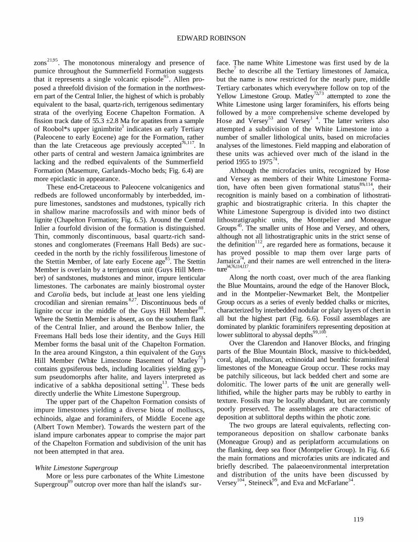
119
EDWARD ROBINSON zons21,95. The monotonous mineralogy and presence of pumice throughout the Summerfield Formation suggests that it represents a single volcanic episode95. Allen pro-posed a threefold division of the formation in the northwest-ern part of the Central Inlier, the highest of which is probably equivalent to the basal, quartz-rich, terrigenous sedimentary strata of the overlying Eocene Chapelton Formation. A fission track date of 55.3 ±2.8 Ma for apatites from a sample of Roobol*s upper ignimbrite3 indicates an early Tertiary (Paleocene to early Eocene) age for the Formation, rather than the late Cretaceous age previously accepted76,117. In other parts of central and western Jamaica ignimbrites are lacking and the redbed equivalents of the Summerfield Formation (Masemure, Garlands-Mocho beds; Fig. 6.4) are more epiclastic in appearance.
These end-Cretaceous to Paleocene volcanigenics and redbeds are followed unconformably by interbedded, im-pure limestones, sandstones and mudstones, typically rich in shallow marine macrofossils and with minor beds of lignite (Chapelton Formation; Fig. 6.5). Around the Central Inlier a fourfold division of the formation is distinguished. Thin, commonly discontinuous, basal quartz-rich sand-stones and conglomerates (Freemans Hall Beds) are suc-ceeded in the north by the richly fossiliferous limestone of the Stettin Member, of late early Eocene age85. The Stettin Member is overlain by a terrigenous unit (Guys Hill Mem-ber) of sandstones, mudstones and minor, impure lenticular limestones. The carbonates are mainly biostromal oyster and Carolia beds, but include at least one lens yielding crocodilian and sirenian remains 8,27. Discontinuous beds of lignite occur in the middle of the Guys Hill Member88. Where the Stettin Member is absent, as on the southern flank of the Central Inlier, and around the Benbow Inlier, the Freemans Hall beds lose their identity, and the Guys Hill Member forms the basal unit of the Chapelton Formation. In the area around Kingston, a thin equivalent of the Guys Hill Member (White Limestone Basement of Matley73) contains gypsiferous beds, including localities yielding gyp-sum pseudomorphs after halite, and layers interpreted as indicative of a sabkha depositional setting13. These beds directly underlie the White Limestone Supergroup.
The upper part of the Chapelton Formation consists of impure limestones yielding a diverse biota of molluscs, echinoids, algae and foraminifers, of Middle Eocene age (Albert Town Member). Towards the western part of the island impure carbonates appear to comprise the major part of the Chapelton Formation and subdivision of the unit has not been attempted in that area.
White Limestone Supergroup
More or less pure carbonates of the White Limestone Supergroup89 outcrop over more than half the island's sur-
face. The name White Limestone was first used by de la Beche7 to describe all the Tertiary limestones of Jamaica, but the name is now restricted for the nearly pure, middle Tertiary carbonates which everywhere follow on top of the Yellow Limestone Group. Matley72'73 attempted to zone the White Limestone using larger foraminifers, his efforts being followed by a more comprehensive scheme developed by Hose and Versey53 and Versey1 4. The latter writers also attempted a subdivision of the White Limestone into a number of smaller lithological units, based on microfacies analyses of the limestones. Field mapping and elaboration of these units was achieved over much of the island in the period 1955 to 197574.
Although the microfacies units, recognized by Hose and Versey as members of their White Limestone Forma-tion, have often been given formational status89'114, their recognition is mainly based on a combination of lithostrati-graphic and biostratigraphic criteria. In this chapter the White Limestone Supergroup is divided into two distinct lithostratigraphic units, the Montpelier and Moneague Groups 45. The smaller units of Hose and Versey, and others, although not all lithostratigraphic units in the strict sense of the definition112, are regarded here as formations, because it has proved possible to map them over large parts of Jamaica74, and their names are well entrenched in the litera-ture34,76,114,117.
Along the north coast, over much of the area flanking the Blue Mountains, around the edge of the Hanover Block, and in the Montpelier-Newmarket Belt, the Montpelier Group occurs as a series of evenly bedded chalks or micrites, characterized by interbedded nodular or platy layers of chert in all but the highest part (Fig. 6.6). Fossil assemblages are dominated by planktic foraminifers representing deposition at lower sublittoral to abyssal depths99,100.
Over the Clarendon and Hanover Blocks, and fringing parts of the Blue Mountain Block, massive to thick-bedded, coral, algal, molluscan, echinoidal and benthic foraminiferal limestones of the Moneague Group occur. These rocks may be patchily siliceous, but lack bedded chert and some are dolomitic. The lower parts of the unit are generally well-lithified, while the higher parts may be rubbly to earthy in texture. Fossils may be locally abundant, but are commonly poorly preserved. The assemblages are characteristic of deposition at sublittoral depths within the photic zone.
The two groups are lateral equivalents, reflecting con-temporaneous deposition on shallow carbonate banks (Moneague Group) and as periplatform accumulations on the flanking, deep sea floor (Montpelier Group). In Fig. 6.6 the main formations and microfacies units are indicated and briefly described. The palaeoenvironmental interpretation and distribution of the units have been discussed by Versey104, Steineck99, and Eva and McFarlane34.

120
Jamaica
Figure 6.5. Correlation of main Lower Tertiary lithostratigraphic units of Jamaica.
LATE TERTIARY AND QUATERNARY
Middle Miocene to Quaternary sedimentary rocks of Ja-maica form the Coastal Group. They outcrop as discontinu-ous strata along the margins of the island and incorporate a wide range of lithologies. The lower, pre-Quatemary part of the Coastal Group, like the underlying White Limestone Supergroup, is divisible into two broad units, representing deposition in contrasting paleoenvironments (Fig. 6.6).
Along the south coast, just east of Kingston18,7 3 and at Round Hill, parish of Clarendon28 (Fig. 6.3), a mixed se-quence of terrigenous conglomerates and sandstones, im-pure limestones, coral-block conglomerates, marls and calcareous siltstones constitute the August Town Forma-tion. This unit contains a variety of fossils of shallow marine derivation, from pebble beaches, coral reefs and oyster banks. Although probably deposited at shelf depths for the most part, similar modern, coarse-grained clastic sediments, evidently redeposited from the rivers and beaches adjacent to Kingston, have been dredged from bathyal depths south of Kingston10 (Robinson, unpublished observations). In contrast, along the north and east coasts of Jamaica, the
lower Coastal Group consists mainly of planktic foraminif-eral marls86 (Buff Bay and Bowden Formations, and San San Beds) deposited at outer sublittoral to bathyal depths99.
The marine Quaternary rocks of the upper Coastal Group consist of a lower unit (Manchioneal Formation) of foraminiferal and coral/mollusc-rich marls, locally with a significant brachiopod fauna43,86,103, found mainly along the northeastern coast of the island. The dolomitised coral limestone of the Hope Gate Formation of the north coast is probably of similar age65, as are the marginal marine, mixed siliciclastics and marls of the Harbour View Formation near Kingston9. The higher part of the upper Coastal Group is represented principally as a series of raised marine terrace deposits. In places the terrace sequences reach altitudes of 200 m15. The lowest terrace group, containing the Falmouth Formation (Fig. 6.6), has been dated at 0.13 Ma15. Within the terrace containing the Falmouth Formation, facies in-dicative of reef and lagoonal depositional environments have been distinguished at several localities 15,35,66,84.
Non-marine Quaternary deposits include extensive de-velopment of alluvium across the coastal plain along the southern margin of the island, alluvium related to the poljes

121
EDWARD ROBINSON
of the karst limestone areas, and fanglomerates associated with fault scarps. The largest of these is the fan (Liguanea Formation) on which the city of Kingston is built36,73. The bauxite deposits of the interior are mainly confined to areas underlain by the shallow water carbonate units of the White Limestone Supergroup (Moneague Group of this chapter). The relationship of these deposits to the bedrock has been the subject of numerous papers (for example, in Lyew-Ayee68).
TECTONIC EVOLUTION
The tectonic evolution of Jamaica is conveniently divided into four phases, following Draper31; a Cretaceous island arc phase, a Paleocene to middle Eocene transitional phase, a middle Tertiary period of relative tectonic quiescence, and a late Neogene to Recent phase of renewed tectonic activity.
Cretaceous Island Arc It is generally agreed that subduction, with a west
dipping component, was taking place throughout the Creta-ceous, associated with a volcanic arc, of which Jamaica formed a part30,31,52,78. In Jamaica the arc rocks are represented by the calcalkaline volcanogenic assemblages, while subduction is indicated by the amphibolites of the metamor-phic complex of the Blue Mountains Inlier31.
Jackson et al.57 showed that geochemical variations among statistically selected major, minor and trace elements in Upper Cretaceous volcanic and plutonic rocks could be interpreted as cross-arc trends and used to infer differences in palaeo-crustal thicknesses over a subduction zone. The trends suggest that the volcanics of eastern Jamaica (Blue Mountains Inlier) formed over a shallower subduction zone and thinner (25-30 km depth) crust than volcanics of similar age and composition further west. As post-Cretaceous tec -tonic rotation of Jamaica is believed to have amounted to only some 10° of counterclockwise motion37,38, these con-clusions lend support to tectonic models postulating a west dipping component in a late Cretaceous subduction zone.
Draper30 proposed a southeastwards shift in the posi-tion of the subduction zone during the Cretaceous, to ac-count for the juxtaposition of the early Cretaceous subduction complex metamorphics of southeast Jamaica against the late Cretaceous volcanic arc suite.
Early Tertiary Transition The mechanism for the transition from Cretaceous sub-
duction to early Tertiary horst and graben formation is still not fully understood. This early Tertiary phase was marked by northwest-southeast trending fracturing of the Jamaican region, initiating formation of the Wagwater Belt in the
Paleocene and extending to form the Montpelier-Newmar-ket Belt by the late middle Eocene33,69. These movements produced the block and belt features (Fig. 6.2) which were to control sedimentation patterns over the island for the remainder of the Tertiary.
Redbeds, associated with plateau type tholeiites, eva-porites and local very shallow marine incursions charac-terized the early development of the narrow graben of the Wagwater Belt70. In the John Crow Mountains Belt, early Paleocene, deep marine, flysch sedimentation, possibly con-tinuous from the Cretaceous, resembles sedimentary pat-terns seen in southwestern Haiti105 and southern Belize25 (Sepur Group). Over the remainder of the island this transi-tional period was marked by subaenal andesitic volcanic activity (Summerfield Formation and Masemure Beds).
During the late Paleocene, a more extensive shallow marine transgressive phase produced the carbonates (Chep-stow Limestone) fringing the Blue Mountains Block and similar, but deeper-water, depositional systems extended over the John Crow Mountains Belt (Nonsuch Limestone). In the Wagwater Belt extrusion of the Newcastle Volcanics was taking place.
By the early Eocene the narrow, Wagwater graben had evolved into a broader area of siliciclastic deposition70 (Richmond Formation). This area encompassed much of eastern Jamaica (except, possibly, the John Crow Mountains Belt, where early Eocene strata have not yet been identified) and the newly forming North Coast Belt. Palaeocurrent directions are either transverse to or parallel to the axis of the Wagwater Belt14. By late early Eocene times marine transgression extended over parts of central and western Jamaica (Stettin Limestone).
Several alternative mechanisms have been suggested to explain the changes in tectonic style at this time. They include back-arc basin development in response to west or southwest directed subduction56, localized extension result-ing from movement of the Nicaraguan Rise past the Yucatan block of Central America69, and pull-apart basin formation during a brief period of right-lateral shear in the Nic araguan Rise region30.
Middle Tertiary Quiescence Between the middle Eocene and middle Miocene, dif-
ferential subsidence allowed as much as 2.75 km of exclu-sively carbonate platform deposits to accumulate over the blocks31. Probably no part of the island region was more than a few metres above sea level at any time. The structural trends developed in the early Tertiary, and bounding the blocks and belts, now served to maintain topographic dif-ferences between shallow water platform deposition on the blocks and periplatform accumulation in the basins between the blocks34. Within these basins, particularly those fronting

122
Jamaica
Figure 6,6. Correlation of Middle Eocene to Quaternary lithostratigraphic units of Jamaic a.
the Cayman Trough, water depths reached as much as 2 km99,100. During the early and middle Miocene, southward tilting of the Jamaican region is implied by the southward thickening, wedge-shaped geometry of the Newport Forma-tion113.
Late Cenozoic Activity Evidence for the unroofing of parts of the Jamaican
middle Tertiary carbonate platform is found in the non-car-bonate detritus shed into the Coastal Group from the end of the middle Miocene87. Activity on east-west, left lateral transcurrent faults, northeast-southwest normal faults, and northwest-southeast trending reverse and scissors faults, and folds, which dominate the present structural pattern of Jamaica, has been discussed by Draper31. The Wagwater Fault, intiated as a normal fault in the Paleocene, reversed its movement to become a high-angle thrust fault71, with associated deformation including local overturning of the Pliocene August Town Formation.
Late Cenozoic uplift of Jamaica accompanied this tec-tonic activity and was particularly intensive in the east, with late Miocene Coastal Group strata in the northeast being elevated as much as 2000 m100 and early Pleistocene units raised some 200 m or more. Late Pleistocene raised marine terraces, mainly along the north coast, document differential uplift and faulting, continuing to the Holocene15,48,50. The Holocene rise in sea level drowned parts of the island's margins, leading to the development of the modem wetlands of the south and west coastal areas 44.
Indirect evidence for volcanic activity in the region surrounding Jamaica, especially in the late Cenozoic, has been proposed through the suggestion that much, if not most, of the superficial cover of bauxite over the limestones of central Jamaica is derived from weathering of Tertiary ashfall deposits, some of which are still preserved as ash beds in the deep water limestones of the Montpelier Group23,24.

123
EDWARD ROBINSON
ACKNOWLEDGEMENTS—This chapter includes the results of numer-ous discussions over thirty years with the geological frat ernity of Jamaica, past and present. I do not wish to make special mention of any one or more persons who have provided ideas and discussed data with me, but the names of most of them are to be found in the list of references below. I also thank two anonymous reviewers of this chapter for their instructive comments.
REFERENCES
1 Ahmad, R. (ed.). 1987. Proceedings of a Workshop on the Status of Jamaican Geology. Geological Society of Jamaica, Special Issue, 342 pp.
2Ahmad, R. & Jackson, T.A. 1989. Pre-Quatemary geo-chronological studies in Jamaica: a review (abstract). Journal of the Geological Society of Jamaica, 25,38.
3Ahmad, R., Lai, N. & Sharma, P.K. 1988. Fission-track age of ignimbrite from Summerfield Formation, Jamaica Caribbean Journal of Science, 23, 444-448.
4Allen, L., 1985. Lithofacies of the Summerfield Formation, northwestern Central Inlier, Jamaica. Abstracts, Work-shop on Recent Advances in Jamaican Geology, Geo-logical Society of Jamaica, Kingston, 2.
5Allen, L. & Neita, M. 1987. Geology of the north Bull Bay sulphate occurrence zone: in Ahmad, R. (ed.), Proceed-ings of a Workshop on the Status of Jamaican Geology. Geological Society of Jamaica, Special Issue, 282-298.
6Armour-Brown, A. 1967. Buff Bay Quadrangle. Annual Report of the Geological Survey Department, Jamaica, for 1966,9-10.
7Beche, H.T. de la. 1827. Remarks on the geology of Ja-maica. Transactions of the Geological Society of Lon-don, series 2,2, 143-194.
8Berg, D.E. von. 1969. Charactosuchus kugleri, eine neue Krokodilart aus dem Eozan von Jamaica. Eclogae Geologicae Helvetiae, 62, 731-735.
9Bold, W. A. van den. 1971. Ostracoda of the Coastal Group of formations of Jamaica. Transactions of the Gulf Coast Association of Geological Societies, 21, 325-348.
10Burke, K. 1966. The Yallahs Basin: a sedimentary basin southeast of Kingston, Jamaica. Marine Geology, 5, 45-60.
11Burke, K., Coates, A.G. & Robinson, E., 1968. Geology of the Benbow Inlier and surrounding areas: in Saunders, J.B. (ed.), Transactions of the 4th Caribbean Geological Conference, Port -of-Spain, Trinidad, 28th March-12th April, 1965, 299-307.
12Burke, K. & Robinson, E. 1965. Sedimentary structures in the Wagwater Belt, eastern Jamaica. Journal of the Geological Society of Jamaica, 7,1-10.
13Burne, R.V. 1972. Supra-tidal evaporites from the Grants Pen Clay: evidence of drier conditions in the Jamaican
Eocene. Journal of the Geological Society of Jamaica, 12,1-6.
14Cambray, F.W. & Jung, P. 1970. Provenance of the Rich-mond Formation from sole marks. Journal of the Geological Society of Jamaica, 11,13-18.
15Cant, R.V. 1972. Jamaica's Pleistocene reef terraces. Journal of the Geological Society of Jamaica, 12, 13-17.
16Case, J.E. & Holcombe, T.L. 1980. Geologic -tectonic map of the Caribbean region. U.S. Geological Survey Miscellaneous Investigations Series, Map I-1100.
17Chubb, L.J. 1956. A subsidence in the mountains of Jamaica. Colonial Geology and Mineral Resources,3, 127-132.
18Chubb, L.J. 1958. The higher Miocene of south-eastern Jamaica. Geonotes, 2, 26-31.
19Chubb, L.J. & Burke, K. 1963. Age of the Jamaica grano-diorite. Geological Magazine, 100, 524-532.
20CIDA/GOJ. [Siriunas, J.M.] 1992. Geochemical map of Jamaica. CIDA/GSD no. 504/12713-142061 Metallic Mineral Survey of Jamaica, Phase II, Open File Report, 1.
21Coates, A.G. 1968. The geology of the Cretaceous Central Inlier around Arthur's Seat, Clarendon, Jamaica: in Saunders, J.B. (ed.), Transactions of the 4th Caribbean Geological Conference, Port-of-Spain, Trinidad, 28th March-12th April, 1965, 309-315.
22Coates, A.G. 1977. Jamaican coral-rudist frameworks and their geological setting: in Frost, S.H., Weiss, M.P. & Saunders, J.B. (eds), Reefs and Related Carbonates in Ecology and Sedimentology. American Association of Petroleum Geologists, Studies in Geology, 4, 83-91.
23Comer, J.B. 1974. Genesis of Jamaican bauxite. Economic Geology, 69,1251-1264.
24Comer, J.B., Naeser, C.W. & McDowell, F.W. 1980. Fission-track ages of zircon from Jamaican bauxite and terra rossa. Economic Geology, 75, 117-121.
25Donnelly, T.W., Home, G.S., Finch, R.C. & Lopez-Ra-mos, E. 1990. Northern Central America; the Maya and Chortis blocks: in Dengo, G. & Case, J.E. (eds), The Geology of North America, Volume H, The Caribbean Region, 37-76. Geological Society of America, Boulder, Colorado.
26Donovan, S.K. 1993. Geological excursion guide 9: Ja-maica. Geology Today, 9,30-34.
27Donovan, S.K., Domning, D.P., Garcia, F.A. & Dixon, H.L. 1990. A bone bed in the Eocene of Jamaica. Journal of Paleontology, 64,660-662.
28Donovan, S.K., Jackson, T.A. & Littlewood, D.T.J. 1989. Report of a field meeting to the Round Hill region of southern Clarendon, 9 April, 1988. Journal of the Geo-logical Society of Jamaica, 25, 44-47.

124
Jamaica
29Draper, G. 1986. Blueschists and associated rocks in eastern Jamaica and their significance for Cretaceous plate-margin development in the northern Caribbean. Geological Society of America Bulletin, 97, 48-60.
30Draper, G. 1987. A revised tectonic model for the evolution of Jamaica: in Ahmad, R. (ed.), Proceedings of a
Workshop on the Status of Jamaican Geology. Geological Society of Jamaica, Special Issue, 120-150.
31Draper, G. 1990. Jamaica. (In Draper, G. & Lewis, J.F. Geology and tectonic evolution of the northern Caribbean margin): in Dengo, G. & Case, J.E. (eds), The Geology of North America, Volume H, The Caribbean Region, 120-127. Geological Society of America, Boulder, Colorado.
32Draper, G., Harding, R.R., Horsfield, W.T., Kemp, A.W. & Tresham, A.E. 1976. Low-grade metamorphic belt in Jamaica and its tectonic implications. Geological Society of America Bulletin, 87, 1283-1290.
33Eva, A.N. 1980. Petroleum potential of Jamaica: a case study of part of an ancient island arc. UN ESCAP, CCOP/SOPAC Technical Bulletin, 3, 143-151.
34Eva, A.N. & McFarlane, N.A. 1985. Tertiary to early Quaternary carbonate facies relationships in Jamaica: in Transactions of the 4th Latin American Geological Conference, Port-of-Spain, Trinidad, 7th-15th July, 7979,1, 210-219.
35Gordon, C.M. & Donovan, S.K. 1992. Disarticulated echi- noid ossicles in paleoecology and taphonomy: the last interglacial Falmouth Formation of Jamaica. Palaios, 7,157-166.
36Goreau, T.F. & Burke, K. 1966. Pleistocene and Holocene geology of the island shelf near Kingston, Jamaica. Marine Geology, 4, 207-225.
37Gose, W. A. 1985. Caribbean tectonics from a paleomag- netic perspective: in Stehli, F.G. & Webb, S.D. (eds), The Great American Interchange, 285-301. Plenum Press, New York.
38Gose, W.A. & Testamarta, M.M.1983. Paleomagnetic results from sedimentary rocks in Jamaica: initial results. Journal of the Geological Society of Jamaica, 22, 16-24.
39Green, G.W. 1977. Structure and stratigraphy of the Wag-water Belt, Kingston, Jamaica. Overseas Geology and Mineral Resources, 48, 1-21.
40Grippi, J. 1980. Geology of the Lucea Inlier, western Jamaica Journal of the Geological Society of Jamaica, 19, 1-24.
41Grippi, J. & Burke, K. 1980. Submarine canyon complex among Cretaceous island arc sediments, western Ja-maica. Geological Society of America Bulletin, 91, 179-184.
42Harland, W.B., Smith, A.G. & Wilcock, B. (eds). 1964.
The Phanerozoic Time Scale, a Symposium. Geological Society of London Special Publication, 1, 458 pp.
43Harper, D.A.T. & Donovan, S.K. 1990. Fossil brachi-opods of Jamaica Journal of the Geological Society of Jamaica, 27, 27-32.
44Hendry, M.D. & Digerfeldt, G. 1989. Palaeogeography and palaeoenvironments of a tropical coastal wetland and offshore shelf during Holocene submergence, Ja-maica. Palaeogeography, Palaeoclimatology, Pa-laeoecology,73,1-10.
45Hill, R.T. 1899. The geology and physical geography of Jamaica: a study of a type of Antillean development. Bulletins of the Museum of Comparative Zoology, Har-vard, 34, 1-256.
46Hill, V.G. 1973. The bauxites of Jamaica: in Hill, V.G. (ed.), Proceedings of Bauxite Symposium II. Journal of the Geological Society of Jamaica, Special Issue, 1-5.
47Holliday, D.W. 1971. Origin of Lower Eocene gypsum-anhydrite rocks, southeast St. Andrew, Jamaica. Trans-actions of the Institute of Mining and Metallurgy,80, B305-B315.
48Horsfield, W.T. 1972. A late Pleistocene sealevel notch, and its relation to block faulting on the north coast of Jamaica. Journal of the Geological Society of Jamaica, 12, 18-22.
49Horsfield, W.T. 1974. Major faults in Jamaica Journal of the Geological Society of Jamaica, 14, 1-4.
50Horsfield, W.T. 1975. Quaternary vertical movements in the Greater Antilles. Geological Society of America Bulletin, 86, 933-988.
51Horsfield, W.T. & Robinson, E. 1976. Marine geology of the Jamaica Passage: in Causse, R. (ed.), Transactions of the 7th Caribbean Geological Conference, Guade-loupe, 30th June-I2th July, 1974,107-113.
52Horsfield, W.T. & Roobol, M.J. 1974. A tectonic model for the evolution of Jamaica. Journal of the Geological Society of Jamaica, 14, 31-38.
53Hose, H.R & Versey, H.R. 1956. Palaeontological and lithological divisions of the lower Tertiary limestones of Jamaica. Colonial Geology and Mineral Resources; 6,19-39.
54Isaacs, M.C. & Jackson, T.A. 1987. The mineralogy and geochemistry of plutonic rocks from Jamaica: in Ah-mad, R. (ed.), Proceedings of a Workshop on the Status of Jamaican Geology. Geological Society of Jamaica, Special Issue, 95-106.
55Jackson, T.A. 1987. The petrology of Jamaican Creta-ceous and Tertiary volcanic rocks and their tectonic significance: in Ahmad, R. (ed.), Proceedings of a Workshop on the Status of Jamaican Geology. Geological Society of Jamaica, Special Issue, 69-94.
56Jackson, T.A. & Smith, T.E. 1979. Tectonic significance

125
EDWARD ROBINSON
of basalts and dacites in the Wagwater Belt, Jamaica Geological Magazine, 116, 365-374.
57Jackson, T.A., Smith, T.E. & Isaacs, M.C 1989. The significance of geochemical variations in the Creta-ceous volcanic and plutonic rocks of intermediate and felsic composition from Jamaica. Journal of the Geo-logical Society of Jamaica, 26, 33-42.
58Jiang, M.-J. & Robinson, E. 1987. Calcareous nannofos-sils and larger foraminifera in Jamaican rocks of Creta-ceous to early Eocene age: in Ahmad, R. (ed.), Proceedings of a Workshop on the Status of Jamaican Geology. Geological Society of Jamaica, Special Issue, 24-51.
59Kashfi, M.S. 1983. Geology and hydrocarbon prospects of Jamaica. American Association of Petroleum Geolo-gists Bulletin, 67, 2117-2124.
60Kauffinan, E.G. 1966. Notes on Cretaceous Inoceramidae (Bivalvia) of Jamaica. Journal of the Geological Soci-ety of Jamaica, 8, 37-40.
61Kaufmann, E.G. & Sohl, N.F. 1974. Structure and evolu-tion of Antillean Cretaceous rudist frameworks. Ver-handlungen Naturforschenden Gesellschaft in Basel, 84, 399-467.
62Kemp, A. W. 1971. The geology of the south-western flank of the Blue Mountains, Jamaica. Unpublished Ph.D. thesis, University of the West Indies, Mona.
63Kinghom, M. 1977. Bibliography of Jamaican Geology. Geo Abstracts, Norwich, 150pp.
64Krijnen, J.P. & Lee Chin, A.C. 1978. Geology of the northern central and southestera Blue Mountains, Ja-maica, with a provisional compilation of the entire inlier. Geologie en Mijnbouw, 57, 243-250.
65Land, L.S. 1991. Some aspects of the late Cenozoic evo-lution of north Jamaica as revealed by strontium isotope study. Journal of the Geological Society of Jamaica, 28, 45-48.
66Larson, D.C. 1983. Depositional facies and diagenetic fabrics in the late Pleistocene Falmouth Formation of Jamaica. Unpublished M.S. thesis, University of Oklahoma, Norman.
67Lewis, J.F., Harper, C.T., Kemp, A.W. & Stipp, J.J. 1973. Potassium-argon retention ages of some Cretaceous rocks from Jamaica. Geological Society of America Bulletin, 84, 335-340.
68Lyew-Ayee, A. (ed.). 1982. Proceedings of Bauxite Symposium V. Journal of the Geological Society of Jamaica, Special Issue, 7, 328 pp.
69Mann, P. & Burke, K. 1984. Cenozoic rift formation in the northern Caribbean. Geology, 12, 732-736.
70Mann, P. & Burke, K. 1990. Transverse intra-arc rifting: Paleogene Wagwater Belt, Jamaica. Marine and Petroleum Geology, 7, 410-427.
71Mann, P., Draper, G. & Burke, K. 1985. Neotectonics and sedimentation at a strike-slip restraining bend system, Jamaica: in Riddle, K. (ed.), Strike-slip Deformation, Basin Formation, and Sedimentation. Society of Eco-nomic Paleontologists and Mineralogists Special Pub-lication, 37,211-226.
72Matley, C.A. 1925. Recent geological work in Jamaica. Report to the British Association (Toronto), 1924, 391-392.
73Matley, C.A. 1951. The Geology and Physiography of the Kingston district, Jamaica (ed. F. Raw). Institute of Jamaica; published by the Crown Agents, London, 139 pp.
74McFarlane, N.A. (compiler). 1977. Geological map of Jamaica, 1:250,000. Ministry of Mining and Natural Resources, Kingston.
75Meloche, J.D. 1987. Regional thermal alteration of Creta-ceous strata, Jamaica: fact or fiction?: in Ahmad, R. (ed.), Proceedings of a Workshop on the Status of Jamaican Geology. Geological Society of Jamaica, Special Issue, 69-94.
76Meyerhoff, A. A. & Krieg, E.A. 1977. Petroleum potential of Jamaica. Special Report for the Ministry of Mining and Natural Resources, Kingston, 131 pp.
77Pickerill, RK. & Donovan, S.K. 1991. Observations on the ichnology of the Richmond Formation of eastern Jamaica. Journal of the Geological Society of Jamaica, 28, 19-35.
78Pindell, J.L. & Barrett, S.F. 1990. Geological evolution of the Caribbean region; a plate tectonic perspective: in Dengo, G. & Case, J.E. (eds), The Geology of North America, Volume H, The Caribbean Region. Geologi-cal Society of America, Boulder, Colorado.
79Porter, A.R.D. 1970. Geology of the Ginger Ridge grano-diorite stock and associated rocks. Unpublished M.Sc. thesis, University of the West Indies, Mona.
80Porter, A.R.D. 1990. Jamaica: a Geological Portrait. Institute of Jamaica, Kingston, 152 pp.
81Porter, A.R.D., Jackson, T.A. & Robinson, E. 1982. Min-erals and Rocks of Jamaica. Jamaica Publishing House, Kingston, 174pp.
82Poulton, D. 1987. Petroleum source rock potential in Jamaica: in Ahmad, R. (ed.), Proceedings of a Work-shop on the Status of Jamaican Geology. Geological Society of Jamaica, Special Issue, 310-330.
83Reed, A.J. 1966. Geology of the Bog Walk Quadrangle, Jamaica. Geological Survey Department, Jamaica. Bulletin, 6, 54 pp.
84Robinson, E. 1960. Observations on the elevated and modern reef formations of the St. Ann coast. Geonotes. 3,18-22.
85Robinson, E. 1969a. Stratigraphy and age of the Dump

126
Jamaica
limestone lenticle, central Jamaica. Eclogae Geologi-cae Hehetiae, 62, 737-743.
86Robinson, K 1969b. Geological field guide to Neogene sections in Jamaica West Indies. Journal of the Geo-logical Society of Jamaica, 10, 1-24.
87Robinson, E. 1971. Observations on the geology of Jamaican bauxite; in Bauxite/Alumina Symposium. Journal of the Geological Society of Jamaica, Special Issue, 3-9.
88Robinson, E. 1976. Lignite in Jamaica. Ministry of Min-ing and Natural Resources, Kingston, 63 pp.
89Robinson, E. 1988. Late Cretaceous and early Tertiary sedimentary rocks of the Central Inlier, Jamaica. Jour-nal of the Geological Society of Jamaica, 24, 49-67.
90Robinson, E. 1993. Some imperforate foraminifera from the Paleogene of Jamaica and the Nicaragua Rise. Jour-nal ofForaminiferal Research, 23, 47-65.
91Robinson, E. & Cambray, F.W. 1971. Physiography of the sea floor south east of Jamaica: in Symposium on Inves-tigations and Resources of the Caribbean Sea and Adjacent Regions, Curacao, 1968. UNESCO-FAO, Paris, 285-289.
92Robinson, E. & Jiang, M.M.-J. 1990. Paleogene calcare-ous nannofossils from western Portland, and the ages and significance of the Richmond and Mooretown For-mations of Jamaica. Journal of the Geological Society of Jamaica, 27,17-24.
93Robinson, E. & Lewis, J.F. 1970. Field guide to aspects of the geology of Jamaica: in Donnelly, T.W. (ed.), International Field Institute Guidebook to the Carib-bean Island Arc System. American Geological Institute, Washington, D.C., 48 pp.
94Roobol, MJ. 1972. The volcanic geology of Jamaic a: in Petzall, C. (ed.), Transactions of the 6th Caribbean Geological Conference, Margarita, Venezuela, 6th-14th July, 1971, 100-107.
95Roobol, M.J. 1976. Post-eruptive mechanical sorting of pyroclastic material—an example from Jamaica. Geo-logical Magazine, 113, 429-440.
96Roobol, M.J. & Horsfield, W.T. 1976. Sea floor lava outcrop in the Jamaica Passage. Journal of the Geologi-cal Society of Jamaica, 15, 7-10.
97Schmidt, W. 1988. Stratigraphy and depositional environ-ment of the Lucea Inlier, western Jamaica. Journal of the Geological Society of Jamaica, 24, 15-35.
98Scott, W. 1987. Age and provenance of the Richmond Formation of the Rio Grande valley, eastern Jamaica: in Ahmad, R (ed.), Proceedings of a Workshop on the Status of Jamaican Geology. Geological Society of Jamaica, Special Issue, 69-94.
99Steineck, P.L. 1974. Foraminiferal paleoecology of the Montpelier and lower Coastal Groups (Eocene - Mio-
cene), Jamaica, West Indies. Paleogeography, Palaeo-climatology, Paleoecology, 16,217-242.
100Steineck, P.L. 1981. Upper Eocene to Middle Miocene ostracode faunas and paleo-oceanography of the north coastal belt, Jamaica, West Indies. Marine Micropa-leontology, 6,339-366.
101Sweeting, M.M. 1958. The karstlands of Jamaica. Geo-graphical Journal, 124,184-199.
102Trechmann, C.T. 1927. The Cretaceous shales of Ja-maica. Geological Magazine, 64, 27-65.
103Trechmann, C.T. 1930. The Manchioneal Beds of Ja-maica. Geological Magazine, 67,199-218.
104Versey, H.R. 1957. The White Limestone of Jamaica and thepalaeogeography governing its deposition. Unpublished M.Sc. thesis, University of Leeds.
105Vila, J.-M., Amilcar, H., Amilcar, H.C., Boisson, D. & Feinberg, H., 1990. Un evenement tectono-sedimen-taire Danian dans le sud d'Haiti (riviere Gosseline, Grandes Antilles): consequences sur 1'extension et la mise en place de la nappe de Macaya. Bulletin de la Societe Geologique de France, series 8, 6, 349-359.
106Wadge, G. 1982. A Miocene submarine volcano at Low Layton, Jamaica. Geological Magazine, 119,193-199.
107Wadge, G. & Dixon, T. 1984. A geologic interpretation of SEASAT-SAR imagery of Jamaica. Journal of Ge-ology, 92, 561-581.
108Wadge, G., Draper, G. & Robinson, E. 1982. Gravity anomalies in the Blue Mountains, eastern Jamaica: in Snow, W., Gil, N., Llinas, R, Rodriguez-Torres, R., Seaward, M. & Tavares, I. (eds), Transactions of the 9th Caribbean Geological Conference, Santo Dom-ingo, Dominican Republic, 16th-20th August, 1980, 467-474.
109Wadge, G. & Eva, A.N. 1978. The geology and tectonic significance of the Sunning Hill Inlier. Journal of the Geological Society of Jamaica, 17, 1-15.
110Wadge, G., Jackson, T.A., Isaacs, M.C. & Smith, T.E. 1982.Ophiolitic Bath-Dunrobin Formation, Jamaica; significance for the Cretaceous plate margin evolution in the northwestern Caribbean. Journal of the Geologi-cal Society of London, 139, 321-333.
111Westcott, W. & Etheridge, F.G. 1983. Eocene fan delta-submarine fan deposition in the Wagwater trough, east-central Jamaica. Sedimentology, 30, 235-247.
112Whittaker, A. and 11 others. 1991. A guide to strati-graphic procedure. Journal of the Geological Society of London, 148, 813-824.
113Wright, R.M. 1971. Tertiary biostratigraphy of central Jamaica: tectonic and environmental implications: in Mattson, P. (ed.), Transactions of the 5th Caribbean Geological Conference, St. Thomas, Virgin Islands, lst-5th July, 1968,129.

127
EDWARD ROBINSON
114Wright, R.M. (ed.). 1974. Field Guide to Selected
Jamaican Geological Localities. Ministry of Mining and Natural Resources, Mines and Geology Division, Kingston, Special Publication, 1, 57 pp.
115Wright, R.M. & Robinson, E. (eds). 1993. Biostratigra-phy of Jamaica. Geological Society of America Memoir, 182, 492 pp.
116Zans, V.A. 1952. Bauxite resources of Jamaica and their development. Colonial Geology and Mineral Re-sources, 3,307-333
117Zans, V.A., Chubb, L.J., Versey, H.R., Williams, J.B., Robinson, E. & Cooke, D.L. 1963. Synopsis of the geology of Jamaica. Geological Survey of Jamaica Bulletin, 4, 72 pp.

128

129
Caribbean Geology: An Introduction U.W.I. Publishers’ Association, Kingston
© 1994 The Authors
CHAPTER 7
Hispaniola
GRENVILLE DRAPER1, PAUL MANN2 and JOHN F. LEWIS3
1 Department of Geology, Florida International University, Miami, Florida 33199, U.S.A. 2Institute for Geophysics, University of Texas at Austin, Austin, Texas 78759, U.S.A.
3Department of Geology, George Washington University, Washington, D. C., 20052, U.S.A.
INTRODUCTION
HISPANIOLA, WHICH is divided politically between the countries of the Dominican Republic and Haiti, has an area of about 80,000 square km, making it the second largest island in the Greater Antilles. Physiographically, the island is composed of a four rugged, westnorthwest-eastsoutheast trending mountain ranges separated by three lower lying valleys (Fig. 7.1). The twin peaks of Pico Duarte and La Pelona (3087 m) form the highest elevation in the Greater Antilles. The steep topography of the island hints as to its recent tectonic (neotectonic) activity and, indeed, the island has many recently active faults and uplifted areas, and is seismically active (Fig. 7.264). Major earthquakes have been experienced in 1751, 1770, 1842, 1887, 1911, 1946, 1948 and 195375.
Besides being a critical area for studies of the neotec-tonics (Miocene and younger crustal movements) of the northern Caribbean plate, Hispaniola also records part of the Cretaceous-early Tertiary island arc and late Tertiary strike-slip history of the region18. Despite its geological impor-tance, the details of the geology of many regions in Hispaniola were known only sketchily before the 1980s. Numerous studies during the 1980s have increased our knowledge of the geology and tectonics of the island. Much of the new work in the Dominican part of the island is summarized in arecent volume of collected papers66. Other summaries of the geology of Hispaniola can found in Bowin10, Lewis56, Lewis and Draper57, Lidz and Nagle61, and Maurrasse70.
OUTLINE OF GEOLOGY
Hispaniola comprises a Cretaceous-early Eocene substrate
which forms the basement for late Tertiary sedimentary basins. The overall geology is illustrated in Fig. 7.2.
The Cretaceous-early Tertiary rocks, whose outcrop covers about 30% of the area of the island, formed as aresult of the interactions on the plate boundary that separated the proto-Caribbean and North American Plates. Two major groups of rocks occur.
(1) In the northern part of the island there is an early Cretaceous-Eocene island arc assemblage of rocks. This assemblage, or collage, has components of the fore-arc, magmatic arc, the oceanic basement of the arc, a possible closed back arc basin of late Cretaceous age and a later Cretaceous-Eocene back-arc basin and rem nant arc.
(2) A late Cretaceous oceanic plateau forms the basement of the southwestern part of the island and is the uplifted edge of crust that underlies much of the Caribbean Sea
Rocks of late Eocene and younger age consist mainly of clastic and carbonate rocks deposited in sedimentary basins which formed as a result of extensive east-west, left lateral strike-slip tectonics that have affected and continue to affect the island. Pliocene to Pleistocene alkaline volcanic rocks that occur in the Cordillera Central are also related to strike-slip tectonic activity.
TERRANES AND MORPHOTECTONIC ZONES IN HISPANIOLA
Definition of terranes A characteristic of the geology of Hispaniola is that it
is made up of several fault-bounded blocks, or geological

130
Hispaniola
Figure 7.1. Map showing physiographic provinces and locations in Hispaniola (modified from Weyl103, Lewis and Draper57).
provinces, each of which has a distinct geological history that differs from that of adjacent blocks. How the geological evolution of one block relates to that of an adjacent block is not always intuitively obvious. In the North American Cor-dillera, which has similar characteristics, these provinces are known as tectonostratigraphic terranes. Therefore, we fol-low Mann et al.67 in describing the components of His-paniola's geology in terms of 12 distinct terranes (Fig. 7.3a; Table 7.1)
We define Hispaniola's terranes using the criteria of Howell et al.49: "A tectonostratigraphic terrane is a fault-bounded package of rocks of regional extent characterized by a geologic history which differs from that of neighboring terranes. Terranes may be characterized internally by a distinctive stratigraphy, but in some cases ametamorphic or tectonic overprint is the most distinctive characteristic.... In general, the basic characteristic of terranes is that the present spatial relations are not compatible with the inferred geo-logic histories... Terranes can be grouped into three catego-ries: stratigraphic, disrupted, and metamorphic."
It is important to point out that herein we define the terranes of Hispaniola purely descriptively. There is no implication that the terranes we describe are neccessarily far-travelled, or 'suspect', to use the jargon of the terranolo-gists.
In the following description of individual terranes, it can be seen that Hispaniola is comprised of stratigraphic , metamorphic and disrupted terranes. These terranes are typically much longer than they are wide and are bounded by high-angle faults, with strike-slip and/or reverse compo-nents. In addition, we have attempted to indicate the tectonic
origin of each terrane as either oceanic, fore-arc, magmatic arc or back arc. Several of the terrane boundaries are either completely or partially covered by thick, clastic sedimentary basins formed during a late Miocene to Recent transpres-sion. In Table 7.2, we speculate on the identity of the terranes underlying these transpressional basins.
Morphotectonic zones of Hispaniola Earlier descriptions of the geology of Hispaniola56,57
divided the island into 10 morphotectonic zones (Fig. 7.3b; Table 7.2). This division preceded the application of the terrane concept and should not be confused with it. The morphotectonic zones correspond to the physiographic provinces of the island and, therefore, are the fault bounded blocks and basins produced by Neogene tectonic activity. The strong, but not complete, correspondence of terranes with morphotectonic zones results from reactivation of pre-existing terrane boundaries66.
Northern Hispaniola: Samand metamorphic terrane (fore-arc)
The terranes are described in the order encountered traversing the island from northeast to southwest (Figs. 7.2, 7.3a). The basement rocksof the Samanapeninsula consists mainly of a coherent metamorphic terrane characterized by the presence of lawsonite and/or pumpellyite. Lithologi-cally, most of the Cretaceous rocks of the rocks of Samana consist of intercalated mica schists and marble bands50,51. In the southeastern margin of the terrane, a 2 x 10 km region (the PuntaBalandrazone) contains blueschist, eclogite50,79, calc -silicate gneisses and calcite-siderite metasomatites .

131
G. DRAPER, P. MANN and J.F. LEWIS
Figure 7.2. Generalized geological map of Hispaniola (modified from Lewis and Draper 57).

132
Hispaniola
The last occur as lenses and layers intercalated with the mica schists and also as blocks in a small, melange-like body34. Metre-scale slivers of serpentinite also occur50,51. Joyce51
estimated that prograde recrystallization of blueschist and eclogite assemblages took place at 400-500°C and 10 Kb. Sm-Nb and K-Ar whole rock ages from the eclogite in the melange body suggest that the high pressure assemblages equilibrated in the late Cretaceous, but that the blocking temperature of the mica was not reached until late Eo-cene51,86.
Metamorphic rocks of the Samana terrane are uncon-formably overlain by Middle to Upper Miocene shallow-water limestones.
Northern Hispaniola: Rio San Juan/Puerto Plata/Pedro Garcia disrupted terrane (fore-arc)
This terrane consists of a heterogeneous assemblage of igneous and metamorphic rocks which outcrop in three main inliers along the Atlantic coast of the island. It is likely that more detailed studies will further sub-divide the heteroge-neous rocks of these three widely separated inliers (Fig. 7.2). The Rio San Juan-Puerto Plata-Pedro Garcia terrane is faulted against the Altamira terrane (see below) along the Rio Grande fault zone24. The eastern inlier, near the town of Rio San Juan, contains four major units: blueschist-eclo- gite melanges with serpentinite matrix; fine-grained cohrent greenschist-blueschist facies rocks; coarse-grained amphi-bolite facies rocks; and a gabbroic intrusive complex34-36. Draper and Nagle35 suggested that the northern part of this area was the result of subduction zone metamorphism, while the southern part represents the basement of the Hispaniola forearc. The terrane was covered by Upper Eocene to Mio-cene clastic marine sedimentary rocks following the cessation of subduction in the middle Eocene.
The basal rocks of the western inlier of the terrane near Puerto Plata consist of serpentinite, gabbro, and volcanic rocks80,88. Large gabbroic and dioritic blocks are common inclusions in the serpentinite, which was intruded by dykes of rodingitized gabbro in other areas. Andesite flows, spilitic pillow basalts (associated with Lower Cretaceous radiolari-ans in sediment between pillows; H. Montgomery and E. Pessagno, personal communication), hyaloclastites and tuffs of the Los Canos Formation are associated with the serpentinite-gabbro complex. Overlying these rocks is a 1 km thick section of interbedded conglomerates, sandstones and white, dacitic tuffs of the Imbert Formation. Some thin chert and limestone beds have yielded fossils which indicate a Paleocene-Early Eocene age.
The basal rocks of the Pedro Garcia inlier consist of tuff and mafic amygdaloidal lava which is intruded by basaltic dykes and a small tonalite stock24,85. Bowin and Nagle11
reported a Maastrichtian whole rock K-Ar age of 72 Ma for
a basaltic flow.
Northern Hispaniola: Altamira stratigraphic terrane (magmatic arc)
The oldest exposed rocks of this terrane consist of biomicritic limestones interbedded with minor amounts of volcaniclastic rocks, tuffaceous siltstones and mudstones containing an Upper Paleocene through Lower Eocene mi-crofauna (Los Hidalgos Formation24). The biomicrites are intruded by porphyritic dykes and sills (Palma Picada For-mation78). An angular unconformity marked by an Upper Eocene basal conglomerate truncates both the Los Hidalgos and Palma Picada Formations.
Both the Rio San Juan/Puerto Plata/Pedro Garcia and Altamira terranes are overlain by Upper Eocene to Lower Miocene marine conglomerates and turbididtic sandstones of the Mamey Group. De Zoeten and Mann24 identified four separate formations in this group, each of which seems to have been deposited in a separate basin. The famous amber of the Dominican Republic are largely from turbiditic sand-stones of the Mamey Group. Unconformably overlying the Mamey Group are Upper Miocene marls and Upper Mio-cene to Pliocene reefal limestones (Villa Trina Formation).
Eastern Hispaniola: Seibo stratigraphic terrane (magmatic arc)
The Seibo terrane in the Cordillera Oriental of the eastern Dominican Republic includes some of the oldest reliably dated rocks in the island. These are the hydrother-mally metamorphosed volcanic rocks of the Los Ranchos Formation7,9,54 that include pillowed and non-pillowed basalts, dacites, keratophyres, rhyolites, andesites, tuffs and volcanic breccias. Chemically, they have compositions characteristic of the primitive island arc (PIA) series27,28,55. The upper part of the Los Ranchos Formation appears to have been emergent in the final phases of volcanism91, possibly because they accumulated on a shallow substrate of previously thickened crust.
The Los Ranchos Formation is the host of rich gold mineralization. The mineable reserves are formed of resid-ual (weathered) deposits of hydrotheimally altered black shales of the lower Los Ranchos Formation. Until recently, the Pueblo Viejo mine was the largest gold mine in the western hemisphere and the largest open-pit gold mine in the world.
The basal volcanic and plutonic section of the eastern Seibo terrane is truncated by an erosional unconformity. The unconformity is overlain byplatform carbonates, containing a rich Aptian- Albian fauna , which in turn are overlain by Upper Cretaceous volcaniclastic marine sedimentary rocks, tuffs, potassium-rich basalt flows and pelagic limestones containing Upper Cenomanian to Lower Turonian fossils55.
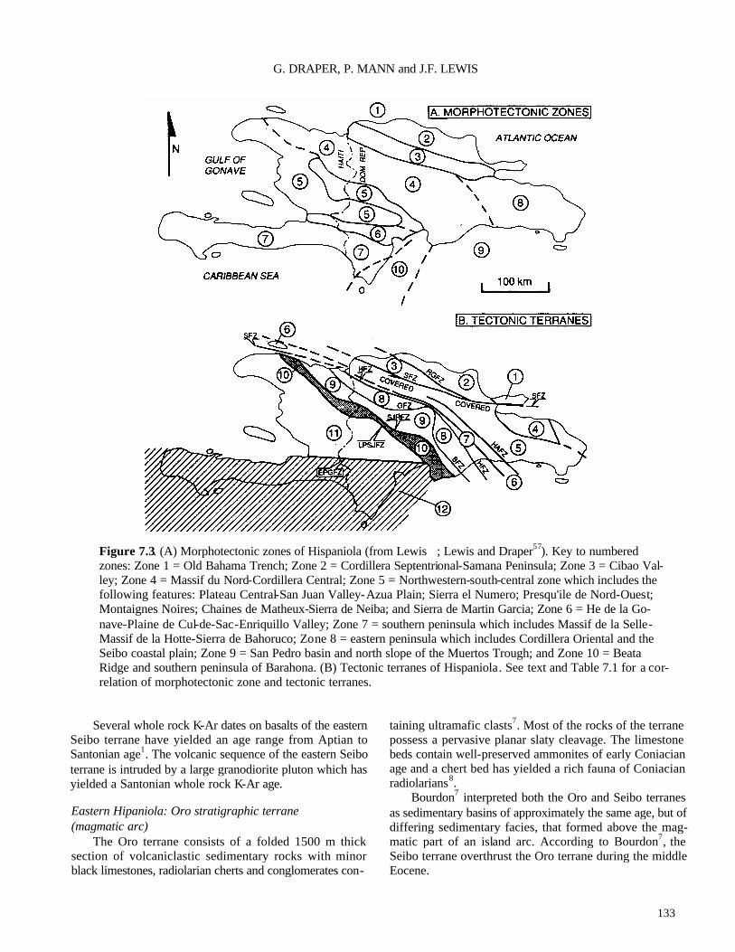
133
G. DRAPER, P. MANN and J.F. LEWIS
Figure 7.3. (A) Morphotectonic zones of Hispaniola (from Lewis ; Lewis and Draper57). Key to numbered zones: Zone 1 = Old Bahama Trench; Zone 2 = Cordillera Septentrional-Samana Peninsula; Zone 3 = Cibao Val-ley; Zone 4 = Massif du Nord-Cordillera Central; Zone 5 = Northwestern-south-central zone which includes the following features: Plateau Central-San Juan Valley-Azua Plain; Sierra el Numero; Presqu'ile de Nord-Ouest; Montaignes Noires; Chaines de Matheux-Sierra de Neiba; and Sierra de Martin Garcia; Zone 6 = He de la Go-nave-Plaine de Cul-de-Sac-Enriquillo Valley; Zone 7 = southern peninsula which includes Massif de la Selle-Massif de la Hotte-Sierra de Bahoruco; Zone 8 = eastern peninsula which includes Cordillera Oriental and the Seibo coastal plain; Zone 9 = San Pedro basin and north slope of the Muertos Trough; and Zone 10 = Beata Ridge and southern peninsula of Barahona. (B) Tectonic terranes of Hispaniola. See text and Table 7.1 for a cor-relation of morphotectonic zone and tectonic terranes.
Several whole rock K-Ar dates on basalts of the eastern
Seibo terrane have yielded an age range from Aptian to Santonian age1. The volcanic sequence of the eastern Seibo terrane is intruded by a large granodiorite pluton which has yielded a Santonian whole rock K-Ar age.
Eastern Hipaniola: Oro stratigraphic terrane (magmatic arc)
The Oro terrane consists of a folded 1500 m thick section of volcaniclastic sedimentary rocks with minor black limestones, radiolarian cherts and conglomerates con-
taining ultramafic clasts7. Most of the rocks of the terrane possess a pervasive planar slaty cleavage. The limestone beds contain well-preserved ammonites of early Coniacian age and a chert bed has yielded a rich fauna of Coniacian radiolarians8.
Bourdon7 interpreted both the Oro and Seibo terranes as sedimentary basins of approximately the same age, but of differing sedimentary facies, that formed above the mag-matic part of an island arc. According to Bourdon7, the Seibo terrane overthrust the Oro terrane during the middle Eocene.

134
Hispaniola
Central Hispaniola—the Median Belt: Tortue-Amina-Maimon metamorphic terrane (magnetic arc)
This terrane consists of a long (300 km), narrow (5-15 km) outcrop of metamorphic rocks extending diagonally across central Hispaniola from northwest to southeast. Three main areas of outcrop occur: Tortue Island off of the north coast of Haiti81,101; the Amina area on the northern flank of the Cordillera Central of the Dominican Repub-lic31,33; and the Maimon area of the eastern Cordillera Central31,33,53.
On the Ile de la Tortue, the metamorphic rocks are well-foliated meta-tuffs and meta-rhyolites (quartz-albite-epidote-chlorite schists) intercalated with white marbles 81. The calcareous schists, which contain a Cenomanian to Campaman microfauna101, are unconformably overlain by Paleocene-Eocene limestones. In the Amina and Maimon areas the terrane consists mainly of meta-igneous rocks of basaltic to quartz keratophyric composition and meta-sedi-mentary lithologies which include quartzite, metaconglom-erate, graphitic schist, and marble. Draper and Lewis31,33
concluded that the rocks of this assemblage are metasedi-mentary rocks of probable volcanogenic origin that may have formed in the magmatic part of an island arc. In the Amina area, the internal structure is characterised by tight northeast-verging folds 31, and recent investigations in the Maimon area (Draper and Lewis, unpublished data, summer 1991) have revealed northeast-verging fold and thrust struc-tures of probable Cretaceous age.
The southern boundary of the terrane consists of high-angle faults, at least one of which is overlain by Upper Miocene clastic sedimentary rocks33,8 4. In the Maimon area the terrane is separated from the Seibo terrane by the south-east dipping Hatillo thrust9, but it is not clear how far the Amina segment extends beneath Neogene sedimentary rocks of the Cibao Valley (Fig. 7.3B).
Central Hispaniola—the Median Belt: Loma Caribe/Tavera ophiolitic(?) terrane (oceanic)
The Loma Caribe-Tavera terrane consists of a 150 km long by 5-15 km wide fault-bounded belt that diagonally crosses central Hispaniola from northwest to southeast and forms the centre line of the Median Belt of Bowin9. (The median belt also includes the flanking metamorphic belts of the Duarte and Amina-Maimon-Tortue terrenes.) The ter -rane is formed of two Upper Cretaceous basalt units and a serpentinized harzburgite/dunite body that together outcrop along the eastern flank of the Cordillera Central.
The faults bounding the serpentinite dip inward, making the body narrower at depth than at the surface. The serpentinite was probably initially exposed and weathered in the Miocene45,59. Uplift may have initiated in the Oligo-cene and was possibly related to strike-slip movement along
the Hispaniola fault zone9,25. The serpentinite is in contact with massive, unfoliated
basalt (Peralvillo Formation) and basalt with a large fraction of hyaloclastic material (Siete Cabezas Formation). The latter formation also contains chert which has yielded Cenomanian-Santonian age radiolarians5,26. Because of faulting, the stratigraphic relationship between the basaltic and ultramafic lithologies is unknown.
The Loma Caribe serpentinite was interpreted by Lewis and Jimenez59 to be serpentinized harzburgitic oceanic man-tle, which was confirmed by geochemical studies39. The basaltic and ultramafic rocks can thus be interpreted as forming part of a dismembered ophiolite complex. Until recently, it appeared that the extensive gabbroic component present in most ophiolite complexes was absent in the Loma Caribe terrane, but recent fieldwork by Draper and Lewis (unpublished data, summer 1991) indicates that the area east of the serpentinite belt, mapped as 'Duarte Formation' by Bowin9, consists mainly of an assemblage of gabbroic rocks that we have informally named the Rio Verde complex (Fig. 7.2)
The northwestern part of the Loma Caribe/Tavera ter-rane, which runs along the northern flank of the Cordillera Central, consists of folded and faulted Oligocene-Lower Miocene conglomerates and turbidites of the Tavera Group that outcrop in a narrow 60 km long by 5-15 km wide sedimentary basin25,44,84. Although the exposed contact with the ophiolitic rocks is faulted, we interpret the Oligocene-Lower Miocene sedimentary basin as originally having been deposited above the ultramafic and basaltic basement rocks. The basin most probably developed as a pull-apart trough in response to Oligocene-early Miocene left-lateral strike-slip movement25.
The southern contact of the Loma Caribe-Tavera ter-rane with the Duarte terrane is a high-angle fault that is locally covered by the Oligocene Moncion Limestone84. The northern contact with the Amina-Maimon-Tortue ter-rane is also a high-angle fault which is onlapped by an Upper Miocene basal conglomerate.
Central Hispaniola—the Median Belt: Duarte metamorphic terrane (oceanic)
The Duarte terrane outcrops along the northern flank of the Cordillera Central in the Dominican Republic and con-sists of massive, locally schistose meta-volcanic rocks of mafic to ultramafic composition which are regionally meta-morphosed to grades ranging from prehnite-pumpellyite to amphibolite facies32,33,59.
Draper and Lewis33 and Lewis and Jimenez59 have divided the Duarte terrane into two units: a lower unit of greenschist facies mafic, high magnesian lava flows and sills; and an upper unit of thin flows, pillow basalts and

135
G. DRAPER, P. MANN and J.F. LEWIS
Figure 7.4. Map showing topography and major Neogene faults of Hispaniola (modified from Mann et al.65) and lines of regional cross sections shown in Figure 7.6. Numbers identify major faults and fault-related features: 1 = Camu Fault Zone; 2 = Maimon Graben; 3 = Rio Grande Fault Zone; 4 = Septentrional Fault Zone; 5 = San Francisco Ridge; 6 = South Samana Fault Zone; 7 = Yabon Fault Zone; 8 = Hatillo Thrust Fault; 9 = Bonao Fault Zone; 10 = San Jose-Restauracion Fault Zone; 11 = Banilejo Fault Zone; 12 = Los Pozos -San Juan Fault Zone; 13 = Sierra de Neiba Fault Zone; 14 = Yayas-Constanza Plio-Pleistocene basalt province; 15 = Beata Fault Zone; 16 = Muertos Trench; 17 = Enri-quillo-Plantain Garden Fault Zone; 18 = Port-au-Prince Graben. Wavy lines indicate zone of late Neogene subduction accretion along the Muertos Trench.
_____________________________________________________________________________________________
Figure 7.5. (next page) Regional cross sections (not balanced) across central and eastern Hispaniola (Dominican Repub-lic) showing the relation between morphotectonic zones and tectonic terranes. Cross sections have no vertical exaggera-tion and are based on geologic data plotted on 1:100,000 compilation maps included as enclosures in Mann et al66. Tadpole symbols indicate measured bedding dips in the line of the cross section. The interpretation of structure below the uppermost several km is speculative. Key to abbreviations of lithologic formations: K1c-d = Cretaceous La Cienaga-Dumisseau Formation; Tsr = Paleocene-Lower Eocene San Rafael Formation; Tn = Middle-Upper Eocene Neiba For-mation; Tj-1 = Lower-Middle Oligocene Jeremie-Lemba Formation; Ts = Lower to Middle Miocene Sombrerito Formation; Tt = Upper Miocene-Lowermost Pliocene Trinchera Formation; Tab = Lower-Middle Pliocene Arroyo Blanco Formation; Tim = Pleistocene Las Matas Formation; TV = Vallejuelo Formation; Tve = Lower -Middle Eocene Ventura Formation; Tj = Middle Eocene Jura Formation; Ten = Middle-Upper Eocene El Numero Formation; Kt = Santonian Tireo Formation; D = Duarte Complex; Am = Amina schist; Tc = Cercado Formation; Tg = Gurabo Forma-tion; Tm = Mao Formation; Qa = Quaternary alluvium; KTlh = Upper Cretaceous-Middle Eocene Los Hidalgos Forma-tion; Kca = Cretaceous Cuaba amphibolites; Krb = Cretaceous Rio Boba intrusive suite; Keg = Cretaceous El Guineal Schists; Kjc = Upper Cretaceous Jagua Clara melange; S = serpentinite; Tcb = Upper Eocene-Lower Oligocene Canada Bonita Member of the Altamira Formation; Kpg = Upper Cretaceous Pedro Garcia Formation; Kxb = Puerto Plata base-ment complex; Tsm = post-Middle Miocene San Marcos Formation; Klg = Upper Cretaceous Las Guajabas Formation; Klgs = Upper Cretaceous siliceous horizons of the Las Guajabas Formation; Kc = Upper Cretaceous Rio Chavon For-mation; Kb = Upper Cretaceous Bejucalito Formation; Krc = Upper Cretaceous Rio Cuaron Formation. Key to fault abbreviations: BAFZ = Baharona fault zone; EPGFZ = Enriquillo-Plantain Garden fault zone; SJLPFZ = San Juan-Los Pozos fault zone; BFZ = Bonao fault zone; HFZ = Hispaniola fault zone; SFZ = Septentrional fault zone; GFZ = Guacara fault zone; RGFZ = Rio Grande fault zone; CFZ = Camu fault zone; San Jos e-Restauracion fault zone.

136

137
G. DRAPER, P. MANN and J.F. LEWIS
intrusive dolerites intercalated with tuffaceous and sedi-mentary rocks of prehnite-pumpellyite facies. The foliation in the Duarte terrane, although not always well-developed, is generally steeply inclined and parallel to the outcrop of theterrane.
Based on the association of mafic lavas, pillow lavas, hyaloclastites and pelagic sedimentary rocks, Bowin10 and Palmer84 suggested that the Duarte terrane may be a fragment of metamorphosed oceanic floor. However, trace element analyses indicate that the Duarte terrane formed as part of a seamount or ocean island32,59 that was later intruded and overlain by late Cretaceous-Eocene island arc magmatic rocks. Radiolarian fossils recovered from meta-cherts in the upper Duarte sequence indicate a late Jurassic age for the deposition of the Duarte Complex (H. Montgomery and E. Pessagno, pers. comm., 1992).
The several granitoid batholiths and stocks that intrude the Duarte terrane were emplaced between the Albian and late Eocene21,54.
Central Hispaniola: Tireo stratigraphic terrane (magmatic arc)
The Tireo terrane forms a 290 km belt of Upper Creta-ceous volcanic and epiclastic rocks which underlie the central mountain chain of Hispaniola and forms a roughly triangular area bounded on the north by the the Bonao-Gua-cara fault zone and on the south by the San Jose-Re-stauracic n fault zone.
Lewis et al.58 divided the rocks of the Tireo terrane into two units. The lower Tireo Group in the Massif du Nord of Haiti and the Cordillera Central of the Dominican Republic consists of thick (about 4000 m) of mafic tuffs and high TiO2 basalts intercalated with mudstones, siltstones, cherts and limestones. Microfossil age determinations from the lower Tireo Group are imprecise, but indicate an age in the range Turonian to ?Campanian9. Rocks of the lower Tireo Group correlate with andesites, tuffs, agglomerates, mudstones and basalts of the Terrier Rouge series of the Massif du Nord of Haiti82,83. The upper Tireo Group consist of an unknown thickness of lavas, volcanic breccias and tuffs of dacitic, rhyolitic and keratophyre composition. Felsic volcanic plugs occur along the southern margin of the Tireo terrane. Microfossil age determinations from intercalated sediments indicate that the upper Tireo was probably deposited in the late Santonian to early-mid Campanian. 40Ar/39Ar dating has yielded a Campanian age for the volcanic rocks in the upper Tireo Group. In the Massif du Nord of Haiti, rocks of the upper Tireo Group correlate with dacite flows and stocks, crystal-lithic tuffs, and pyroclastic and volcaniclas -tic rocks of the La Mine Series 82,83.
In the south-central part of the terrane, the upper Tireo Group pass conformably into Middle Campanian-Maas-
trichtian marine sedimentary rocks of the Trois Rivieres-Peralta Group (see below). As with the Duarte terrane, several large, unfoliated granitoid stocks and batholiths intruded the Tireo terrane up to the late Eocene53.
Central Hispaniola: Trois Rivieres-Peralta stratigraphic terrane (back arc basin)
This terrane, which extends 320 km from northern Haiti to the south-central Dominican Republic, consists of pack- ets of marine turbiditic sandstones, siltstones and lime-stones, ranging in age from Coniacian to Pleistocene. The terrane is separated to the southeast from the Presqu'ile du Nord-Ouest terrane by the San Juan-Los Pozos fault zone and to the northwest from the Tireo terrane by the San Jose-Restauracion fault zone25. The belt can be divided into four distictive stratigraphic/structural packages.
The oldest rocks in the terrane are highly faulted and folded slivers of Coniacian through Danian micritic lime-stones, tuffs, cherts, turbiditic sandstones and siltstones, and cherts of the Trois Rivieres Formation, which are found in scattered outcrops in northwestern Haiti6. These rocks ex-tend into the Dominican Republic, where similar Cam-panian to low Upper Eocene lithologies have been mapped25,40,58,60. Some of the rocks have been metamor- phosed to slates and are deformed into chevron folds with axial planar cleavage (Draper, unpublished observations).
Detailed studies by Dolan et al.25 have subdivided the stratigraphy of the southeastern end of the the Trois Rivieres-Peralta terrane into three packages consisting of: (1) the Paleocene-low Upper Eocene Peralta Group; (2) the Middle Eocene to Lower Miocene Rio Ocoa Group; and (3) the Lower Miocene to Pleistocene Ingenio Caei Group. Each group is separated from more deformed, underlying group by major angular unconformities or faults46,47. Witschard and Dolan104 and Dolan et al.25 interpreted the terrane as a back-arc basin modified into an accretionary prism during oblique Eocene northeastward underthrusting of southwest- ern Hispaniola beneath central Hispaniola.
Southwestern Hispaniola: Presqu'ile de Nord-Ouest Neiba terrane (magmatic arc)
In the northwestern part of this terrane (Presqu'ile du Nord-Ouest of Haiti), small inliers in the Tertiary cover expose Upper Cretaceous intermediate volcanic rocks in-truded by small, Upper Cretaceous to Lower Eocene plu-tons 19,52. The Cretaceous rocks are unconformably overlain by Middle Eocene limestones with localized intercalations of basaltic lava flows. These are in turn overlain by Oligo-cene-Miocene clastic sediments of the Crete Formation.
Cretaceous igneous rocks are not apparently exposed in the regions to the southwest of the Presqu'ile du Nord (that is, in the Plateau Central, Montagnes Noires, Chaines des

138
Hispaniola
Figure 7.6. Tectonic model illustrating possible Campanian choking of a northward dipping subduction zone. Closure of a back arc basin to form the Median Belt ophiolite and reversal of subduction polarity and the reversal of polarity of subduction are a consequence of this plateau-arc collision (from Draper and Lewis33). Key to abbreviations: T=Tireo Group; D=Duarte Complex, SC=Siete Cabezas basalts; AM=Amina-Maimon Schists, LR=Los Ranches Formation; RSJ=Rio San Juan Complex; t=tonalite and other granitoid intrusions.

139
G. DRAPER, P. MANN and J.F. LEWIS
Matheux and Sierra de Neiba), although some Upper Creta-ceous pelagic limestones occur in the Montagnes Noires100. Most of the Montagnes Noires-Chaine de Matheux-Sierra de Neiba consists of Eocene limestones and argillites inter -calated with andesitic breccias, tuffs and rare basalts. The Eocene rocks are overlain by Oligocene chalky and siliceous limestones of the Madame Joie-Sombrerito Formation.
The northern part of the terrane is occupied by the Plateau Central-San Juan Valley which contains more than 7600 m of Lower Eocene to Pliocene sedimentary rocks. In the extreme southeast of the belt, these rocks are folded and thrust in a southwesterly direction. Biju-Duval et al.2 have suggested that these structures form the leading edge of an accretionary prism structure which extends offshore into the San Pedro basin and Muertos Trough, and was formed by the underthrusting of the Caribbean Sea floor under south-eastern Hispaniola.
Southwestern Hispaniola: Hotte-Selle-Bahoruco stratigraphic terrane (oceanic—Uplifted Caribbean sea floor, B")
The oldest (basement) rocks of this 350 km long terrane consist of Upper Cretaceous basalts intercalated with pe-lagic sedimentary rocks which have been correlated with the rocks of the Caribbean Sea floor73. From west to east, the largest exposures of these rocks occur in the cores of three breached en echelon anticlines that correspond to major mountain ranges on the southern peninsula of Hispaniola From west to east, these ranges axe the Massif de la Hotte and Massif de la Selle in Haiti, and the Sierra de Bahoruco in the Dominican Republic (Fig. 7.2). The Hotte-Selle-Ba-horuco terrane is separated from the Presqu'ile du Nord-Ouest terrane to the north by the left- lateral Enriquillo-Plantain Garden fault zone. The southern bound-ary of the terrane is formed by fault zones offshore of the southern margin of the peninsula43.
The oldest rocks of the Massif de la Hotte are mainly highly folded and fractured pelagic limestones and cherts ranging from Coniacian to Maastrichtian (Macaya Forma-tion16). These rocks are similar in lithology and age to pelagic limestones recovered from deep-sea drilling sites in the Colombian and Venezuelan basins38. The limestone section is faulted against outcrops of pillowed and non-pil-lowed basalt whic h have yielded whole-rock K-Ar ages from Maastrichtian to Paleocene16. The Macaya Formation and these basalts are overlain unconformably by a Lower Paleocene conglomerate (Riviere Glace and Baraderes For-mations;. In general this unconformity marks the end of basaltic volcanism in the Massif de la Hotte, although scat-tered outcrops of alkalic volcanic rocks are interbedded in Upper Paleocene to Middle Eocene sedimentary rocks17.
In the Massif de la Selle, the oldest rocks consist of a
1500 m thick section of interbedded pillowed and non-pil-lowed basalts, dolerites, pelagic limestones, cherts, sili-ceous siltstones and volcanogenic sandstones (Dumisseau Formation73). Foraminifera and radiolaria recovered from sedimentary interbeds yield ages from the late early Creta-ceous to Turonian. K/Ar whole rock age determinations on samples of basalt and dolerite range in age from Albian to Maastrichtian1,93,96. The seismic reflector B” underlying much of the Caribbean Sea is composed of tholeiitic basalts and dolerite sills intercalated with and overlain by pelagic sedimentary rocks of Coniacian and Campanian age . Be-cause of the geochemical similarity of these rocks with the basalts of the Dumisseau Formation, Maurrasse et al.73 and Sen et al.94 suggested that is an uplifted piece of the Carib-bean sea floor. Trace element and isotopic data from the Massif de la Selle basalts further suggest a combined spread-ing ridge and hotspot origin for the magmatism94.
The oldest rocks of the Sierra de Bahoruco of the Dominican Republic consist of small, highly faulted out-crops of pillowed and non-pillowed basalts which have yielded Maastrichtian K-Ar whole rock ages 96. The geo-chemistry of these rocks indicates that, like those in Haiti, they are non-orogenic tholeiites similar to those drilled at Caribbean DSDP sites 42. Late Cretaceous and Cretaceous/Tertiary boundary sequence
In some parts of the Massif de la Selle an erosional unconformity truncates the Dumisseau Formation22,99 and marks the end of basaltic volcanism in the area The rocks above the unconformity surface are composed of Lower to Middle Maastrichtian conglomerates and sandstones. How-ever, in other areas of the Massif de la Selle, carbonate sedimentation spans the Cretaceous-Tertiary boundary71. Like other Cretaceous -Tertiary boundary sites this one has the high indium anomaly which has been attributed to a large meteorite impact. Moreover, it has been suggested that an arenaceous layer at the boundary in the Massif de la Selle, which contains abundant shocked quartz, may be an impact surge deposit and thus may indicate that the impact site may have been in the Caribbean4,48,72,74.
Pelagic limestone and chert of Albian to Maastrichtian age also outcrops in the Sierra de Bahoruco (Rio Arriba Formation62), but the stratigraphic relation of this sedimentary section to the underlying basalt is unknown. Tertiary succession
The Paleocene-Miocene section of the Hotte-Selle-Ba-haruco terrane is characterized by gradually deepening car-bonate environments . Paleocene-Eocene carbonate rocks of the Siena Martin Garcia are similar to those in the Sierra de Bahoruco and are included as part of the Hotte-Selle-Ba-horuco terrane20 (Fig. 7.2). Rapid facies changes in carbon- ate environments during middle Miocene time are

140
Hispaniola
Figure 7.7. Terrane correlation chart and summary of tectonic events in Hispaniola. See text for explanation.
interpreted by Maurrasse et al.73 and Bizon et al3 as dating the initiation of uplift of the terrane and accompanying block and/or strike-slip faulting. By the Pliocene, most of the terrane was emergent with continental deposition in small, strike-slip fault-controlled basins68.
REGIONAL STRUCTURE
The present-day structure of Hispaniola records the super -position of various Cretaceous to Recent tectonic events affecting its various terranes. In order to illustrate the overall structure in Hispaniola, we present a series of four cross sections through the central and eastern parts of the island (Figs 7.4,7.5).
In northeastern and central Hispaniola, the most promi-nent structural effects seen in the cross sections are due to the middle to late Eocene collision between Hispaniola and the Bahama Platform. In southwestern Hispaniola, however, the major structural and topographic features visible on the cross sections are the result of both early Miocene oblique collision between the oceanic plateau of the Presqu'ile du Sud-Bahuroco terrane and the central and northern part of the island, and the continuing transpressional strike-slip faulting across Hispaniola. Structural expressions of postu-
lated Cretaceous deformational events are not clear on the cross sections as they are obscured by Cenozoic deforma-tion.
The cross sections illustrate several important features about the structural history of the island:
(1) The most prominent folding and thrusting event in south-central Hispaniola was late Miocene and younger in age, and verges southward. This south vergence is reflected in the asymmetric topographic profile of the Massif du Nord-Cordillera Central mountain range which has steeper slopes along its southwestern flank (Fig. 7.5).
(2) The three major valleys of Hispaniola are either ‘fore- land' basins, due to oblique thrusting on one side of the basin (Cibao valley), or are 'ramp' basins caused by late Miocene and younger oblique thrust or reverse faults on both sides of the basin (San Juan-Azua, Enriquillo valleys).
(3) Island arc terranes of the northern and central part of the island are topographically high-standing and deeply eroded; the oceanic plateau terrane of the southern part

141
G. DRAPER, P. MANN and J.F. LEWIS
of the island is relatively low-standing and less deeply eroded.
(4) The prominent (Eocene) folding and thrusting event in eastern Hispaniola verges northeast7.
Interpretation of the regional scale structure of Hispaniola
We propose that island arc and back-arc basin terranes of northern and central Hispaniola form the hanging wall of a large thrust plate or 'crustal flake' which obliquely over-thrusts the oceanic plateau terrane of southwestern His-paniola (Fig. 7.5). Matsumoto et al.69 and McCann and Sykes76 described intermediate depth earthquakes below the topographically highest part of the Cordillera Central which we suggest may be a manifestation of northeastward underthrusting of the Selle-Hotte-Bahoruco terrane beneath the Cordillera Central.
This geometry is consistent with the high elevation and topographic asymmetry of the Massif du Nord-Cordillera Central range, and the topographic and structural asymme-try of the Sierra de Neiba. We consider that the major structural manifestation of this tectonic activity is the fault which outcrops at the southern edge of the Sierra de Neiba range. This fault both juxtaposes island arc and oceanic plateau terranes, and exhibits the greatest vertical displace-ment of any fault on the island. Furthermore, we suggest that the southeast verging thrusts of the southern boundaries of the Presqu'ile du Nord-Neiba and Trois Rivieres-Peralta terranes root in subhorizontal decollements that are at depths of 10 to 15 km.
Northeast-verging thrust and reverse faults along the northern edge of the Sierra de Bahoruco (Bahoruco fault zone) and the northern edge of the Sierra de Neiba (North Sierra de Neiba fault zone) are interpreted as back-thrusts. A minimum age of thrusting is given approximately by the middle to late Miocene age of the oldest clastic rocks in the ramp basins of central Hispaniola.
The southern edge of the Cibao Basin, adjacent to the northern edge of the Cordillera Central, appears to be a flexural boundary and this observation is consistent with the proposed northeastward underthrusting of the Cordillera Central beneath the terranes of northern Hispaniola. In other words, uplift of the southern edge of the Cordillera Septen-trional and subsidence of the Cibao basin appears to be driven by transpressional fault movement along the Septen-trional fault zone24. The early Miocene angular unconfor-mity along the southern flank of the basin dates the initial compressional loading of the basin.
The structure and topography of the eastern part of the island contrasts markedly with that of western and central Hispaniola. Eastern Hispaniola exhibits much less topo-
graphic relief and less extensive evidence of recent faulting. Bourdon7 mapped large folds and faults in Cretaceous to Middle Eocene strata which we interpret as a thin-skinned, northeast-verging fold and thrust belt (Fig. 7.5 D-D'). Bour-don7 constrained the age of deformations as middle Eocene or younger, because the youngest deformed rocks are of middle Eocene age. This Eocene deformation may correlate with late Eocene deformation in the Cordillera Septentrional described by de Zoeten and Mann24, which is interpreted as the result of attempted subduction of the southern edge of the Bahama platform beneath eastern and northern His-paniola (see below).
TECTONIC PHASES AFFECTING TERRANES OF HISPANIOLA
Stratigraphic and structural correlation between the eleven island arc terranes of northern Hispaniola suggest four to five main tectonic phases.
Early Cretaceous-middle Eocene arc construction phase The arc construction phase is recorded by the stratigra-
phy of terranes exposed over the northern two-thirds of the island of Hispaniola. The basal part of the island arc se-quence is represented by the Duarte terrane32,33,59. Draper and Lewis32,33 interpreted the Duarte terrane as a seamount structure and suggested that it is the preserved portion of the seamount-ocean floor basement upon which the island arc edifice of Hispaniola was built. That the arc was built on an elevated (that is, shallower than abyssal ocean floor) sub-strate is supported by the emergent nature of the upper part of the 3000 m thick Los Ranchos Formation. The Upper Cretaceous to Middle Eocene calc-alkaline volcanic and related rocks of the Amina-Maimon-Tortue, Seibo, Oro and Tireo terranes are thus interpreted as volcanic and sedimen-tary accumulations above the older, oceanic Duarte terrane.
There is some evidence for a regional tectonic event or events in the early or middle Cretaceous which affected the island arc terranes of central and eastern Hispaniola (Fig. 7.4). However, the overprinting effects of Cenozoic colli-sional and strike-slip deformation obscure many of the manifestations of earlier deformatonal events. Two possi-bilities have been suggested, both of which invoke apolarity reversal of the arc. ?Pre-Aptian event
This event is documented in the Seibo terrane by a major erosional unconformity that separates the Los Ran-chos Formation from the overlying shallow-water, Aptian-Albian Hatillo limestone9. Calc -alkaline andesites, tuffs, and limestones (Las Lagunas Formation of Bowin9; Loma La Veca volcanics of Lebron55) overlie the limestone. Le-bron interpreted the unconformity and accompanying

142
Hispaniola
Figure 7.8. Schematic model for the amalgamation of oceanic plateau and arc terranes to the island arc nucleus of Hispaniola within the broad, 250 km-wide strike-slip plate boundary zone. See text for discussion.
transition from primitive island arc to calc-alkaline volcan-ism as due to a reversal in subduction polarity from north-dipping to south-dipping. ?Campanian event
Draper and Lewis 33 outlined an alternative model for collision and consequent subduction reversal from a south-facing to north-facing arc in the Campanian (Fig. 7.6). The effect of this collision would have been to thrust rocks of the Tireo and Duarte terranes northeast over rocks of the Loma Caribe-Tavera and Tortue-Amina-Maimon terranes. North-ward thrusting produced northeast-verging isoclinal folds and regional metamorphism of the Tortue-Amina-Maimon tenane. Draper and Lewis argued that as the Cenomanian-Coniacian (97-87 Ma) rocks are involved in the deforma-tion, and as late Campanian (80-75 Ma) tonalites are unaffected, that the event must have taken place in the early to middle Campanian. This estimate also coincides with the ages of blueschists in the northern terranes of Hispaniola The event may correlate with a Campanian deformation and uplift event which affected the island arc rocks of central and western Cuba89. This date also coincides with the time of the initial entry of B" oceanic plateau into the Caribbean as predicted in some tectonic models87.
Middle Eocene arc collision phase The collision of the Hispaniola segment of the Greater
Antilles Arc with the Bahama Platform, and subsequent cessation of north facing subduction, is thought to have occurred in the middle to early late Eocene. This age is inferred from cessation of calc alkaline volc anism in central Hispaniola; uplift and cooling ages of metamorphic rocks of the Samana terrane51; age of thrusting in the Seibo and QIC terranes7; and thrusting in the Trois Riviferes-Peralta terrane along the southern flank of the Cordillera Central25,47,104.
In contrast to Cuba, no rocks of the Bahama Platform appear to occur in Hispaniola. It is therefore suggested that the southern extension of the platform which collided with Hispaniola has a much thinner crust (about 15 km) than the segment that collided with Cuba (20-30 km) and was simply over-ridden by the Hispaniola arc. Alternatively, the colli-sion may have been highly oblique and did not involve a significant amount of thin-skinned style of folding and thrusting102.
Late Eocene-early Miocene strike-slip phase Calc-alkaline magmatism terminated after the middle
Eocene collision. Subsequent volcanism on Hispaniola pro-

143
G. DRAPER, P. MANN and J.F. LEWIS
Table 7.1. Correlation of morphotectomc zones and tectonic terranes in Hispaniola.
_____________________________________ Morphotectonic Zone Tectonic Terrane
Zone 1 Old Bahama Trench (offshore)
Zone 2 Cordillera Septentrional-Samana Peninsula
Zone 3 Cibao Valley
Zone 4 Massif du Nord-Cordillera Central
Zone 5 Northwestern-south-central zone (includes Plateau Central, San Juan Valley, Azua Plain, Sierra de Ocoa, Presqu'ile du Nord-Ouest)
Zone 6 Cul-de-Sac Plain; Enriquillo Valley
Zone 7 Southern Peninsula; Massif de la Selle; Massif de la Hotte; Sierra de Bahoruco
Zone 8 Eastern Peninsula; Cordillera Oriental; Seibo coastal plain
Zone 9 San Pedro basin and north slope of the Muertos Trench
Zone 10 Beata Ridge and Southern Peninsula
Puerto Plata-Pedro Garcia-Rio San Juan; Samana
One or more of the three following terranes may be in the subsurface of Zone 3: Altamira;
Tortue-Amina-Maimon; Seibo
Tortue-Amina-Maimon; Loma Caribe-Tavera; Duarte; Tireo; Trois Rivieres-Peralta
Presqu'ile du Nord-Ouest-Neiba
Selle-Hotte-Bahoruco terrane appears to underlie most of the subsurface of Zone6
Selle-Hotte-Bahoruco
Seibo; Oro
One or more of the three following terranes may be in the subsurface of the San Pedro basin: Loma Caribe-Tavera; Tortue-Amina-Maimon; Seibo Selle-Hotte-Bahoruco
duced scattered occurrences of alkalic and calc -alkalic vol-canic flows and plugs that appear to be related to movement along strike-slip or strike-slip-related secondary faults98. Evidence for strike-slip offset across terrane boundaries in Hispaniola is mainly indirect or based on regional con-straints: the Cayman Trough, a major pull-apart basin along the extension of strike-slip faults passing through His- paniola, exhibits at least 1100 km of left-lateral offset90; terrane boundaries in Hispaniola are linear fault zones which juxtapose rocks of widely varying composition and meta-morphic grade (Fig. 7.3B33); and elongate late Eocene-Oli-gocene clastic sedimentary basins in Hispaniola appear to have formed along strike-slip faults25. Several tectonic models have been proposed which attempt to explain how large-offset strike-slip offset faults affected the Cretaceous-Eocene island arc and oceanic plateau rocks of His- paniola14,29,87,95.
Early Miocene-Recent transpressional phase The collision of north-central and southern Hispaniola
occurred in the early Miocene47, culminating in major uplift and erosion across Hispaniola by the late middle Mio-cene24,37,77. This suturing event initiated the transpressional phase of the island's history which has culminated in the present-day morphotectonic units of the island (Fig. 7.3A). Pleistocene indentation of the southern margin of Hispaniola by the Beata Ridge has contributed to the recent deformation and uplift of central Hispaniola47.
TECTONIC EVENTS AFFECTING THE OCEANIC PLATEAU TERRANE OF
SOUTHERN HISPANIOLA
The tectonic history of the Selle-Hotte-Bahoruco oceanic plateau terrane of southern Hispaniola was quite distinct from the tectonic history of the island arc terranes of north-

144
Hispaniola ern and central Hispaniolauntil the early Miocene, when the two terranes were sutured together. We recognize four major tectonic events in the history of the Selle-Hotte-Bahoruco terrane. Late Cretaceous oceanic plateau construction phase
Radiometric and fossil dates of the Selle-Hotte-Baho-ruco oceanic plateau terrane of southern Hispaniola suggest a Santonian-Campanian age of formation. The geochemistry of the igneous rocks suggest they are similar to basalts drilled on the Caribbean seafloor and formed in a hotspot or oceanic environment94. The age of the oceanic crust beneath the Upper Cretaceous basalt flows in Hispaniola and on the Caribbean seafloor is unknown, but may be much older Jurassic crust12,41. Latest Cretaceous deformation and uplift
A major erosional unconformity above Maastrichtian and older Cretaceous rocks marks the end of significant igneous activity on the Selle-Hotte-Bahoruco terrane. De-formed rocks beneath the unconformity record northward overthrusting and slumping99. This deformation may be related to collision of the terrane with Central America prior to large-scale left-lateral offset across the northern Carib- bean87. Paleocene-early Miocene subsidence and strike-slip faulting
The Paleocene-early Miocene history of the Hotte-Selle-Bahoruco terrane is characterized by strike-slip fault-ing, accompanying carbonate sedimentation and scattered occurrences of alkaline volcanism (Fig. 7.43). Early Miocene-Recent transpressional phase
Carbonate sedimentation terminated in late Miocene to Pliocene and post-dated the end of the early to middle Miocene carbonate sedimentation on the Presqu'ile de Nord-Ouest-Neiba terrane to the northwest (Fig. 7.4). Re-gional folding of the southern terrane accompanied uplift and erosion and was coeval with folding of the terrane to the north. By the late Miocene, clastic sediments derived from the erosion of the uplifted Tireo, Trois Riv&res-Peralta and Presqu'ile du Nord-Ouest island arc terranes had onlapped the Selle-Hotte-Bahoruco terrane, and signified the docking of the island arc terranes and the oceanic plateau77.
DISCUSSION
Model for terrane amalgamation in Hispaniola
Based on the terrane correlation chart of Figure 7.7, we present a model for terrane amalgamation, or the complete assembly history of terranes in Hispaniola (Fig. 7.8). This
model involves the accretion or welding of forearc/accre-tionary prism terranes of northern Hispaniola and an oceanic plateau terrane of southern Hispaniola to a magmatic island arc nucleus in central Hispaniola The timing of accretionary events can be established by three main criteria: overlap assemblages that depositionally overlie two distinctive, jux-taposed stratigraphic sequences; the sudden appearance of detritus in one terrane derived from a dissimilar neighbour; and welding together of unlike sequences by intrusions.
From the terrane correlation chart (Fig. 7.7), it can be seen from overlap assemblages that terrane amalgamation mainly occurred in the Cenozoic with most amalgamation occurring in Miocene to Recent time. Key stratigraphic relationships which document the age of terrane accretion include: (1) late Cretaceous and Paleocene-middle Eocene clastic overlap assemblages of the Trois Rivieres-Peralta terrane that depositionally overlie the Tireo terrane2,58; (2) possible welding of the Duarte and Tireo terranes by the late Cretaceous Loma de Cabrera batholith (Fig. 7.221); (3) welding of the Tortue-Maimon-Amina and Seibo terranes no later that Eocene, as demonstrated by an Eocene pluton intruded into the terrane boundary9; (4) a late Oligocene carbonate overlap assemblage (Velazquitos Formation of the Loma Caribe-Tavera terrane) that depositionally overlies the Duarte terrane25,84; (5) a late Miocene clastic overlap sequence (Trinchera Formation) derived from the Tireo tenane that depositionally overlies the Presqu'ile du Nord-Ouest-Neiba terrane and the Selle-Hotte-Bahoruco ter -rane77,92; (6) a late Miocene clastic overlap sequence (Bulla/Cercado Formation) derived from the Duarte and Loma Caribe-Tavera terranes that depositionally overlies the Amina terrane84 and some fault strands of the Hispaniola fault zone23,25; (7) a late Miocene-early Pliocene shallow-water carbonate overlap sequence (Villa Trina Formation) that depositionally overlies three terranes along the north coast of the island (Samana, Rio San Juan/Puerto Plata/Pedro Garcia, Altamira); and (8) welding of the Selle-Hotte-Bahoruco, Trois Rivieres-Peralta and Tireo terranes by Plio-Pleistocene basaltic intrusions related to strike-slip movement67,98.
These relationships suggest that the older amalgama-tion events occurred closer to the magmatic island arc nu-cleus of central Hispaniola (for example, Cretaceous welding of Duarte and Tireo terranes; Oligocene overlap between the Loma Caribe-Tavera and Duarte terranes) aid the younger accretion events involving the oceanic plateau of southern Hispaniola and forearc/accretionary prism ter-ranes of northern Hispaniola occurred in a more outboard position (Fig. 7.8). Because lateral movements associated with North America-Caribbean motion were at a low angle to the 'structural grain’ or strike, the extinct island arc structure approximately maintained its original cross sec-

145
G. DRAPER, P. MANN and J.F. LEWIS
tional profile with forearc/accretionary prism terranes in northern Hispaniola, a magmatic nucleus in central His-paniola, and a back-arc basin in southern and central His-paniola. More detailed studies of offsets across major Neogene faults are needed before realistic pre-Eocene cross sections of the Hispaniola island arc can be drawn. Terrane dispersal versus terrane accretion and the northern Caribbean offset problem
Strike-slip faulting can produce terrane dispersion, or the breakup of larger terranes into smaller pieces49. The late Eocene and younger tectonic history of Hispaniola appears to be an example of strike-slip faulting associated with simultaneous terrane accretion and dispersion29. Our expla-nation for this phenomenon lies in the fact that the island arc nucleus of Hispaniola has constituted a restraining bend segment in a major transcurrent plate boundary zone65. The initiation of the restraining bend seems to coincide with the early Miocene suturing of the oceanic plateau of southern Hispaniola to the island arc nucleus of central Hispaniola From this time, the bend area was progressively widened by terrane accretion, probably at the expense of terrane 'disper-sion' of along-strike segments of the island arc in the Cuba and Puerto Rico-Virgin Islands portions of the island arc chain (Fig. 7.8).
The model of terrane amalgamation at a strike-slip restraining bend helps to explain the ‘northern Caribbean offset problem', or the discrepancy between the 1100 km offset caused by the opening of the Cayman Trough and the apparently much smaller offsets seen in on-land faults in Central America and the Greater Antilles13,15,30,63. We suggest that the offset discrepancy may reflect the transfor-mation of a large strike-slip offset along straight faults in the Cayman Trough to smaller strike-slip offsets with greater vertical motions along curved, restraining bend fault seg-ments in the Central America and Hispaniola The offset in the restraining bend areas is absorbed by either by under -thrusting of one terrane beneath another (Selle-Hotte-Baho-ruco terrane beneath island arc terranes of central Hispaniola), or by large-scale rotation of terranes about vertical axes such as the post-Eocene counterclockwise rotation of the Tireo terrane97, and/or by splaying of the strike-slip faults into several different strands at the restraining bends with small amounts of offset being accommodated by each fault splay87. Additional offset may be absorbed on unrecognized strike- or oblique-slip faults, or by internal deformation of fault blocks.
Eocene. The terranes can be classified variously as: (1) fragments of the forearc/accretionary prism of an island arc; (2) fragments of the magmatic part of an island arc; (3) fragment of a back-arc basin; and (4) fragments of oceanic crust.
(2) The structure and stratigraphy of the island arc terranes record four main tectonic phases: (1) early Cretaceous to middle Eocene island arc volcanism magmatism (this arc construction phase may have been interrupted by one or two poorly known deformation events in the pre-Aptian and Campanian); (2) middle-late Eocene collision and uplift of the arc with the southern edge of the North America plate (southeastern Bahama carbon ate platform) resulting in the abrupt termination of island arc activity; (3) late Eocene to early Miocene east-west strike-slip faulting at a low angle to the strike of the extinct island arc; and (4) early Miocene tran- spression resulting from oblique collision ('docking') of the southern oceanic plateau terrane with the nucleus of Hispaniola.
(3) The oceanic plateau terrane of southwestern Hispaniola experienced four main tectonic phases, the first three of which are distinct from the rest of Hispaniola: (1) formation in an intraplate hotspot or oceanic island setting from at least the Santonian until the Maas- trichtian.; (2) Maastrichtian deformation, rapid uplift and erosion; (3) strike-slip faulting, subsidence, and formation of a carbonate platform and basin from Pa- leocene through early Miocene time; and (4) transpres- sion resulting from early Miocene oblique collision with the island arc terranes of central Hispaniola.
(4) Some of the terrane boundaries separating island arc and oceanic plateau terranes were reactivated or obliquely cut by large oblique-slip faults during the early Miocene to Recent convergence between the island arc and the southern oceanic plateau terranes to form nine mor- photectonic provinces consisting of elongate, fault- bounded mountain ranges and ramp basins.
ACKNOWLEDGEMENTS—The authors acknowledge continued fiscal support from their respective institutions in their field investigations in Hispaniola. Substantial grants were also received from other organizations (National Science Fountation EAR-83061452, EAR-8509542, Latin American and Caribbean Center of FIU grants to Draper; National Science Foundation EAR-8608832, Petroleum Research Fund of the American Chemical Society 17068-AC2, Tenneco and Pecten International to Mann; National Science Foundation and the United Nations Revolving Fund for Natural Resources Exploration to Lewis). We greatly appreciate the con-tinued cooperation and field assistance of government and university officials in the Dominican Republic and Haiti.
SUMMARY AND CONCLUSIONS
(1) Hispaniola consists of an amalgamation of twelve terra- nes which range in age from Early Cretaceous to late

146
Hispaniola
REFERENCES
1Bellon, H., Vila, J.-M. & Mercier de Lepinay, B. 1985. Chronologic 40K-39Ar et affinites des manifestations magmatiques ail Cretace et au Paleogene dans Tile d'Hispaniola: in Mascle, A. & Biju-Duval, B. (eds), Geodynamique des Caribes. Editions Technip, Paris, 329-340.
2Biju-Duval, B., Bizon, G., Mascle, A. & Muller, C. 1983. Active margin processes: field observations in southern Hispaniola. American Association of Petroleum Geolo-gists Memoir, 34, 325-346.
3Bizon, G. Bizon, J.J., Calmus, T., Miiller, C. & van den Berghe, B. 1985. Stratigraphie du Tertiaire du sud d'Hispaniola (Grandes Antilles): influence de la tec-tonique decrochante sur lapaleogeographie et 1'histoire sedimentaire: in Mascle, A. & Biju-Duval, B. (eds), Geodynamique des Caribes. Editions Technip, Paris, 371-380.
4Bohor, B. & Sietz, R. 1990. Cuban K/T catastrophe. Na-ture, 344, 593.
5Boisseau, M. 1987. Leflac nord-est de la Cordillere Central dominicaine (Hispaniola, Grandes Antilles): un edifice de Nappes Cretace polyphase. Unpublished Ph.D. thesis, Universite Pierre y Marie Curie, Paris.
6Boisson, D. 1987. Etude geologique du Massif du Nord d'Haiti (Hispaniola-Grandes Antilles). Unpublished Ph.D. thesis (3rd cycle), Universite Marie et Pierre Curie, Paris.
7Bourdon, L. 1985. La Cordillere Orientale Dominicaine (Hispaniola, Grandes Antilles): un arc insulaire Cretace polystructure. Unpublished Ph.D. thesis, Universite Pierre et Marie Curie, Paris.
8Bourdon, L., Geyssant, J.R., Mercier de Lepinay, B. & Vila, J.-M. 1984. Interets paleontologique, chronolo-gique et tectonique de la decouverte de Peroniceras (Ammonoidea, Collignoniceratidae) dans le Coniacien inferieur de la Cordillere orientale de Republique Dominicaine (Hispaniola, Grandes Antilles). Comptes Rendus de Academie des Sciences, 298, 287-292.
9Bowin, C.O. 1966. Geology of the central Dominican Republic—& case history of part of an island arc. Geo-logical Society of America Memoir, 98, 11-84.
10Bowin, C.O. 1975. The geology of Hispaniola: in Nairn, A.E.M. & Stehli, F.G. (eds), The Ocean Basins and Margins. 3. The Gulf of Mexico and the Caribbean. Plenum, New York, 500-552.
11Bowin, C.O. & Nagle, F. 1982. Igneous and metamorphic rocks of northern Dominican Republic: an uplifted subduction zone complex: in Snow, W., Gil, N., Llinas, R., Rodriguez-Torres, R., Seaward, M. & Tavares, I. (eds), Transactions of the 9th Caribbean Geological
Conference, Santo Domingo, Dominican Republic, 16th-20th August, 1980, 39-50.
12Bowland C.L. & Rosencrantz, E. 1988. Upper crustal structure of the western Colombian Basin, Caribbean Sea. Geological Society of America Bulletin, 100, 534-546.
13Burkart, B., Deaton, B.C., Dengo, C. & Moreno, G. 1987. Tectonic wedges and offset Laramide structures along the Polochic fault of Guatemala and Chiapas, Mexico: reaffirmation of large Neogene displacement. Tecton-ics, 6, 411-422.
14Burke, K. 1988. Tectonic evolution of the Caribbean. Annual Review of Earth and Planetary Sciences, 16, 201-230.
15Calais, E. & de Lepinay, B.M. 1990. Tectonique et paleogeographie de la cote sud de I'Oriente cubain: nouvelles contraintes pour 1'evolution geodynamique de la limite de plaques decrochante nore-caraibe de 1'Eocene a 1'actuel. Comptes Rendus de la Academie des Sciences, 310, 293-299.
16Calmus, T. 1983. Contribution a Vetude geologique du massif de Macaya (sud-ouest d'Haiti, Grandes An-tilles): sa place dans I 'evolution de I 'orogene nord-caraibe. Unpublished Ph.D. thesis, Universite Pierre et Marie Curie, Paris.
17Calmus, T. 1987. Etudes geochimiques des volcanismes Cretace et Tertiaire du massif de Macaya (presqu'ile du Sud d'Haiti): leur place dans 1'evolution tectonique de laregionnord-caraibe. Comptes Rendus de la Academie des Sciences, 304, 981-986.
18Case, I.E., Holcombe, T.L. & Martin, R.G. 1984. Map of geologic provinces in the Caribbean region. Geological Society of America Memoir, 162,1-30.
19Cheilletz, A., Kachrillo, J. J., Sonet, J. & Zimmerman, J.L., 1978. Petrographie et geochronologie de deux com-plexes intrusifs aporphyres cupriferes d'Haiti. Contri-bution a la connaiscance de la province cuprifere laramienne de 1'arc insulaire de Grande Antilles. Bul-letin de la Societe Geologique de France, series 7, 20, 107-114.
20Cooper, J.C. 1983. Geology of the Fondo Negro region, Dominican Republic. Unpublished M.S. thesis, State University of New York, Albany.
21Cribb, J.W., Jimenez, J., Lewis, J.F. & Sutter, J. F. 1989. 40Ar/39Ar ages from Loma de Cabrera batholith: impli-cations for timing of tectonic events in northern His-paniola. Geological Society of America Abstracts with Programs, 21 (7), A267.
22de Lepinay, B.M., Labesse, B., Sigal, J. & Vila, J.M. 1979. Sedimentation chaotique et tectonique tangentielle Maestrichtiennes dans la presqu'ile du sud d'Haiti (lie d'Hispaniola, Grandes Antilles). Comptes Rendus de la

147
G. DRAPER, P. MANN and J.F. LEWIS
Academie des Sciences Paris, series D, 187, 887-890.
23de Riemer, V.W. 1978. Results of geological investiga-tions in the northwestern part of the Dominican Repub-lic. Neues Jahrbuch Jur Geologie und Paleontologie Monatshefte, 35,162-172.
24de Zoeten, R. & Mann, P. 1991. Structural geology and Cenozoic tectonic history of the central Cordillera Sep-tentrional, Dominican Republic. Geological Society of America Special Paper, 262,265-279.
25Dolan, J., Mann, P., de Zoeten, R., Heubeck, C., Shiroma & Monechi, S. 1991. Sedimentologic, stratigraphic, and tectonic synthesis of Eocene-Miocene sedimentary basins, Hispaniola and Puerto Rico. Geological Society of America Special Paper, 262, 217-263.
26Donnelly, T.W. 1989. Geologic history of the Caribbean and Central America: in Bally, A.W. & Palmer, A.R. (eds), The Geology of North America. Volume A. An Overview, 299-321. Geological Society of America, Boulder.
27Donnelly, T. W., Beets, D., Carr, M. J., Jackson, T., Klaver, G., Lewis, J., Maury, R., Shellenkens, H., Smith, A.L., Wadge, G. & Westercamp, D. 1990. History and tec-tonic setting of Caribbean magmatism: in Dengo, G. & Case, J.E. (eds), The Geology of North America. Vol-ume H. The Caribbean Region, 339-374. Geological Society of America, Boulder.
28Donnelly, T.W. & Rogers, J.J.W. 1978. The distribution of igneous rock suites throughout the Caribbean. Geologie en Mijnbouw, 57,151-162.
29Draper, G. 1989. Terrane accretion and re-shuffling in Hispaniola. Geological Society of America Abstracts with Programs, South-Central Section, 21, 9.
30Draper, G. & Barros, J.A. 1988. Tectonic reconstruction of N. Hispaniola and S.E. Cuba: dissection of an Cretaceous island arc. Geological Society of America Abstracts with Programs, 20 (7), A60.
31Draper, G. & Lewis, J.F. 1982. Petrology, deformation, and tectonic significance of the Amina Schist, northern Dominican Republic: in Snow, W., Gil, N., Llinas, R., Rodriguez-Torres, R., Seaward, M. & Tavares, I. (eds), Transactions of the Ninth Caribbean Geological Conference, Santo Domingo, Dominican Republic, 16th-20th August, 1980, 53-64.
32Draper, G. & Lewis, J.F. 1989. Petrology and structural development of the Duarte complex, central Dominican Republic: a preliminary account and some tectonic implications: in Duque-Caro, H. (ed.), Transactions of the Tenth Caribbean Geological Conference, Cartagena, Colombia, 14th-20th August, 1983, 103-112.
33Draper, G. & Lewis, J.F. 1991. Metamorphic belts in central Hispaniola. Geological Society of America Spe-
cial Paper, 262, 29-45. 34Draper, G. & Nagle, F. 1988. Geological setting and
characteristics of blueschist and eclogite bearing me-langes in northern Hispaniola: in Barker, L. (ed.), Transactions of the Eleventh Caribbean Geological Conference, Dover Beach, Barbados, 20th-26th July, 1986,33:1-33:9.
35Draper, G. & Nagle, F. 1991. Geology, structure and tectonic development of the Rio San Juan Complex, northern Dominican Republic. Geological Society of America Special Paper, 262, 77-95.
36Eberle, W., Hirdes, W., Muff, R. & Peaez, M. 1982. The geology of the Cordillera Septentrional (Dominican Republic): in Snow, W., Gil, N., Llinas, R., Rodriguez-Torres, R., Seaward, M. & Tavares, I. (eds), Transac-tions of the Ninth Caribbean Geological Conference, Santo Domingo, Dominican Republic, 16th-20th Au-gust, 1980, 619-632.
37Edgar, N.T. 1991. Structure and geologic development of the Cibao Valley, northern Hispaniola. Geological Society of America Special Paper, 262, 281-299.
38Edgar, N.T. et al 1973. Initial Reports of the Deep Sea Drilling Project, Volume XV. U.S. Government Printing Office, Washington, D.C., 1137 pp.
39Espaillat, J., Bloise, G., Lewis, J.F. & Macveigh, J.G. 1990. Petrography and geochemistry of mafic rocks of the Peralvillo Formation in the Sabana Potrero area, central Dominican Republic: in Larue, D.K. & Draper, G. (eds), Transactions of the Twelth Caribbean Geological Conference, St. Croix, Virgin Islands, 7th-llth August, 1989,190-199.
40Garcia, E. & Haims, F. 1989. Informe del mapageologico de la Republica Dominicana, San Juan (5972). Secre-taria de Industria y Comercio, Direction General de Mineria, Santo Domingo, 97 pp.
41Ghosh, N., Hall, S.A. & Casey J.F. 1984. Seafloor spreading magnetic anomalies in the Venezeulan Basin. Geological Society of America Memoir, 162, 65-80.
42Girard, D., Beck, C., Stephan, J.F., Blanchet, R. & Maury, R. 1982. Petrologie, geochimie et signification geodyn-maique de quelques formations volcaniques cretacees peri-caraibes. Bulletin de la Societe Geologique de France, series 7, 24,535-544.
43Goreau, P. 1981. The tectonic evolution of the north central Caribbean plate margin. Unpublished Ph.D. thesis, Massachusetts Institute of Technology.
44Groetsch, G.J. 1982. Resedimented conglomerates and turbidites of the Upper Tavera Group, Dominican Re-public: in Snow, W., Gil,N.,Llinas, R.,Rodriguez-Torres, R., Seaward, M. & Tavares, I. (eds), Transactions of the Ninth Caribbean Geological Conference, Santo Domingo, Dominican Republic, 16th-20th August,

148
Hispaniola
1980, 191-198. 45Haldemann, E.G., Brouwer, S.B., Blowes, J.H. & Snow,
W. E. 1980. Lateritic nickel deposits at Bonao Falcon-bridge Dominicana C. por A. Field Guide, Ninth Car-ibbean Geological Conference, Santo Domingo, Dominican Republic, 69-78.
46Heubeck, C. 1988. Geology of the southeastern termina-tion of the Cordillera Central, Dominican Republic, Greater Antilles. Unpublished M.A. thesis, University of Texas at Austin.
47Heubeck, C., Mann, P., Dolan, J. & Monechi, S. 1991. Diachronous uplift and recycling of sedimentary basins during Cenozoic tectonic transpression, Hispaniola Sedimentary Geology, 7,1-32.
48Hildebrand, A.R. & Boynton, W.V. 1990. Proximal Cre-taceous-Tertiary boundary impact deposits in the Car-ibbean. Science, 248, 843-847.
49Howell, D., Jones, D. & Schermer, E. 1985. Tectonostra-tigraphic terranes of the circum-Pacific region: in How-ell, D. (ed.), Tectonostratigraphic terranes of the Circum-Pacific. Circum-Pacific Council for Energy and Mineral Resources, Earth Science Series, 1, 3-30.
50Joyce, J. 1985. High pressure-low temperature metamor-phism and tectonic evolution of the Samana Peninsula, Dominican Republic (Greater Antilles). Unpublished Ph.D. thesis, Northwestern University.
51Joyce, J. 1991. Blueschist metamorphism and deformation of the Samana peninsula—a record of subduction and collision in the Greater Antilles. Geological Society of America Special Paper, 262, 47-76.
52Kesler, S.E. 1971. Petrology of the Terre-Neuve Igneous province, northern Haiti. Geological Society of 'America Memoir, 130, 119-137.
53Kesler, S.E., Russell, N., Reyes, C. Santos, L., Rodriguez, A. & Fondeur, L. 199la. Geology of the Maimom Formation, Dominican Republic. Geological Society of America Special Paper, 262, 173-185.
54Kesler, S.E., Russell, N., Polanco, J., McCurdy, K. & Cummin, G.L. 199 Ib. Geology and geochemistry of the early Cretaceous Los Ranchos Formation, central Do-minican Republic. Geological Society of America Spe-cial Paper, 262, 187-201.
55Lebron, M.C. 1989. Petrochemistry and tectonic signifi-cance of late Cretaceous, calc-alkaline volcanic rocks, Cordillera Oriental, Dominican Republic. Unpublished M.S. thesis, University of Florida.
56Lewis, J.F. 1980. Resume of the geology of Hispaniola. Field Guide, Ninth Caribbean Geological Conference, Santo Domingo, Dominican Republic, 5-31.
57Lewis, J.F. & Draper, G. 1990. Geology and tectonic evolution of the northern Caribbean margin: in Dengo, G. & Case, J.E. (eds), The Geology of North America.
Volume H. The Caribbean Region, 77-140. Geological Society of America, Boulder.
58Lewis, J.F., Amarante, A., Blaise, G., Jimenez, G. & Dominguez, H.D. 1991. Lithology and stratigraphy of Upper Cretaceous volcanic and volcaniclastic rocks of the Tireo Group, Dominican Republic, and correlations with the Massif du Nord in Haiti. Geological Society of America Special Paper, 262,143-163.
59Lewis, J.F. & Jimenez, J.G. 1991. Duarte Complex in the La Vega-Janico area, central Hispaniola geological and geochemical features of the sea floor during early stages of arc evolution. Geological Society of America Special Paper, 262, 115-141.
60Lewis, J.F., Vespucci, P., Robinson, E., Jiang, M. & Bryant, A. 1989. Paleogene stratigraphy of the Padre Las Casas and adjacent areas in the southeast Cordillera Central, Dominican Republic: in Duque-Caro, H. (ed.), Transactions of the Tenth Caribbean Geological Con-ference, Cartagena, Colombia, 14th-20th August, 1983, 229-237.
61Lidz, B. & Nagle, F. (eds). 1979. Hispaniola: tectonic focal point of the northern Caribbean. Miami Geologi-cal Society, Miami, 96p.
62Llinas, R.A. 1972. Geologia del area Polo-Duverge, Cuenca de Enriquillo. Publication of Colegio Domini-cana de Ingenieros, Arquitectosa y Agrimensores, Codia. Part 1 in no. 3,55-65; part 2 in no. 32, 40-53.
63Malfait, B.T. & Dinkelman, M.G. 1972, Circum-Carib-bean tectonic and igneous activity and the evolution of the Caribbean plate. Geological Society of America Bulletin, 83, 250-272.
64Mann, P. & Burke, K. 1984. Neotectonics of the Carib-bean. Reviews of Geophysics and Space Physics, 22, 309-362.
65Mann, P., Burke, K. & Matsumoto, T. 1984. Neotectonics of Hispaniola: plate motion, sedimentation, and seis-micity at a restraining bend. Earth and Planetary Sci-ence Letters, 70, 311-324.
66Mann, P., Draper, G. & Lewis J. F. (eds). 1991. Geologic and tectonic studies the North American Caribbean Plate Boundary in Hispaniola. Geological Society of America Special Paper, 262, 401 pp.
67Mann, P., Draper, G. & Lewis, J.F. 1991. Overview of the geology of Hispaniola. Geological Society of America Special Paper, 262, 1-28.
68Mann, P, Hempton, M., Bradley, D. & Burke, K. 1983. Development of pull-apart basins. Journal of Geology, 91, 529-554.
69Matsumoto, T., Rabb, L., Perez, M.J., Luciano, F. Sanchez, J. & Pennington, W. 1981. Seismology in the Dominican Republic as inferred from a local network. EOS, 62, 324.
149
G. DRAPER, P. MANN and J.F. LEWIS
70Mauirrasse, FJ.-M. 1981. New data on the stratigraphy of
the southern peninsula of Haiti: in Maurrasse, F. J.-M., ed., Transactions du ler Colloque sur la Geologie d'Haiti, Port-au-Prince, Haiti, Ministre des Mines et des Resources Energftiques, 184-198.
71Maurrasse, F.J.-M.R (ed.). 1981. Transactions du ler colloque sur la geologied'Haiti, Port-au-Prince, Haiti. Ministre des Mines et des Resources Energetiques, Port-au-Prince, 286 pp.
72Maurrasse, F.J-M.R. 1990. Stratigraphic correlation for the circum-Caribbean Region: in Dengo, G. & Case, I.E. (eds), The Geology of North America. Volume H. The Caribbean Region, plate 4. Geological Society of America, Boulder.
73Maurrasse, FJ.-M., Husler, J., Georges, G., Schmitt, R. & Damond, P. 1979. Upraised Caribbean sea-floor below acoustic reflector B" at the southern peninsula of Haiti. Geologie en Mijnbouw, 58, 71-83.
74Maurrasse, FJ-M.R. & Sen, G. 1991. Impacts, tsunamis and the Haitian Cretaceous boundary layer. Science, 252,1690-1693.
75McCann, W.R. & Pennington, W.D. 1990. Seismicity, large earthquakes, and the margin of the Caribbean Plate: in Dengo, G. & Case, I.E. (eds.), The Geology of North America. Volume H. The Caribbean Region, 291-306. Geological Society of North America, Boul-der.
76McCann, W.R. & Sykes, L.R. 1984. Subduction of aseis-mic ridges beneath the Caribbean plate; implications for the tectonics and seismic potential of the north-eastern Caribbean. Journal of Geophysical Research, 89, 4493-4519.
77McLaughlin, P.P., van den Bold, W.A. & Mann, P. 1991. Geology of the Azua and Enriquillo basins, Dominican Republic, 1: Neogene lithofacies, biostratigraphy, bio-facies and paleogeography. Geological Society of America Special Paper, 262, 337-366.
78Muff, R. & Hernandez, M. 1986. The hydrothermal altera-tion and pyrite-galena-sphalerite mineralization of a prophyrite intrusion at Palma Picada in the Cordillera Septentrional, Dominican Republic. Natural Resources and Development, 26, 83-94.
79Nagle, F. 1974. Blueschist, eclogite paired metamorphic belts and the early tectonic history of Hispaniola. Geo-logical Society of America Bulletin, 85, 1461-1466.
80Nagle, F. 1979. Geology of the Puerto Plataarea, Domini-can Republic: in Lidz, B. & Nagle, F. (eds), Hispaniola: tectonic focal point of the northern Caribbean, 1-28. Miami Geological Society, Miami.
81Nagle, F., Wassail, H., Tarasiewicz, G. & Tarasiewicz, E. 1982. Metamorphic rocks and stratigraphy of central Tortue Island, Haiti: in Snow, W., Gil, N., Llinas, R.,
Rodriguez-Torres, R., Seaward, M. & Tavares, I. (eds), Transactions of the Ninth Caribbean Geological Con-ference, Santo Domingo, Dominican Republic, 16th-20th August, 1980, 409-415.
82Nicolini, P. 1977. Les porphyres cupriferes et les com-plexes ultra-basiques du nord-est d 'Haiti: essai gitolo-gie previsionnelle. Unpublished Ph.D. thesis (3rd cycle), University Pierre et Marie Curie, Paris.
83Nicolini, P. 1981. Gitologie Haitienne: in Maurrasse, F.J.-M.R. (ed.), Transactions du ler Colloque sur la Geologie d'Haiti, Port-au-Prince, Haiti, 105-111. Ministre des Mines et des Ressources Energetiques, Port-au- Prince.
84Palmer, H.C. 1979. Geology of the Moncion-Jarabacoa area, Dominican Republic: in Lidz, B. & Nagle, F. (eds), Hispaniola: tectonic focal point of the northern Caribbean, 29-68. Miami Geological Society, Miami.
85Peralta-Villar, J. 1985. Geologie und Erzjuhrung in der Umgebung des Intusionsbrekzienkorpers von Los Jobos/Pedro Garcia, Dominikanische Republik. Un-published Diploma thesis, Mineralogisch-Pet-rographischen Institut der Universitat Heidelberg.
86Perfit, M.R & McCullough, M.T. 1982. Trace element, Nd-Sr isotope geochemistry of eclogites and blueschists from the Hispaniola-Puerto Rico subduc-tion zone. Terra Cognita, 2, 321.
87Pindell, J.L. & Barrett, S.F. 1990. Geological evolution of the Caribbean region: a plate tectonic perspective: in Dengo, G. & Case, J.E. (eds), The Geology of North America. Volume H. The Caribbean region, 405-432. Geological Society of America, Boulder.
88Pindell, J.L. & Draper, G. 1991. Stratigraphy and geological history of the Puerto Plata area, northern Dominican Republic. Geological Society of America Special Pa-per, 262, 97-114.
89Pszczolkowski, A. & Flores, R. 1986. Fases tectonicas del Cretacico y del Paleogene en Cuba occidental y central. Bulletin of the Polish Academy of Sciences (Earth Sci-ences), 34, 95-111.
90Rosencrantz, E., Ross, M. & Sclater, J.G. 1988. Age and spreading history of the Cayman Trough as determined from depth, heat flow, and magnetic anomalies. Journal of Geophysical Research, 93, 2141-2157.
91Russell, W. & Kesler, S.E. 1991. Geology of the Duarte complex hosting precious mineral mineralization at Pueblo Viej, Dominican Republic. Geological Society of America Special Paper, 262, 203-215.
92 Ruth, M.D. 1989. Cenozoic geology of the western San Juan Valley, Dominican Republic. Unpublished M.S. thesis, George Washington University.
93Sayeed, U., Maurrasse, F., Keil, K., Husler, J. & Schmidt, R. 1978. Geochemistry and petrology of some mafic
150
Hispaniola
rocks from Dumisseau, Haiti. EOS, 59, 403. 94Sen, G., Dickey-Vargas, R, Waggoner, D.G. & Maur-
rasse, F. 1988. Geochemistry of basalts from the Du-misseau Formation, southern Haiti: implications for the origin of the Caribbean sea crust. Earth and Planetary Science Letters, 87, 423-437.
95Sykes, L.R., McCann, W.R. & Kafka, A.L. 1982. Motion of Caribbean plate during last 7 million years and implications for earlier Cenozoic movements. Journal of Geophysical Research, 87, 10656-10676.
96Van den Berghe, B. 1983. Evolution sedimentaire etstruc-turale depuis le Pal eocene du secteur "Massif de la Selle" (Haiti)-"Baoruco" (Republique Dominicaine)-"Nord de la Ride de Beata" dans Vorogene nord Caraibe (Hispaniola-Grandes Antilles). Unpublished Ph.D. thesis (3rd cycle), University de Paris.
97van Fossen, M.C. & Channell, J.E.T. 1988. Paleomag-netism of late Cretaceous limestones and chalks from Haiti: tectonic interpretations. Tectonics, 7, 601-612.
98Vespucci, P. 1989. Summary of trace element and isotope data, late Cretaceous volcanics, Hispaniola: in Duque-Caro, H. (ed.), Transactions of the Tenth Caribbean Geological Conference, Cartagena, Colombia, 14th-20th August, 1983, 467-472.
99Vila, J-M., Amilcar, H., Amilcar, H.C., Boisson, D. & Feinberg, H/1990. Un evenement tectono-sedimentaire
Danien dans le sud d'Haiti (Riviere Gosseline, Grandes Antilles): consequences sur F extension et la mise en place de la nappe de Macaya. Bulletin de la Societe Geologique de France, series 8,8, 349-359.
100Vila, J.-M., Butterlin, J., Calmus, T., Mercier de Lepinay, B. & van den Berghe, B. (compilers!. 1983. Geologic map of Haiti: in Girault, M. (ed.), Atlas d 'Haiti, planche V, carte geologique, scale 1:1,000,000.
101Vila, J.-M., Butterlin, J., Labesse, B. & Mercier de Lepi-nay, B. 1984. Donnees nouvelles sur les roches meta-morphiques de Tile de la Tortue (Hispaniola, Grandes Antilles). Comptes Rendus de la Academie des Sci-ences, Paris, 294,1103-1106.
102Wadge, G., Draper, G. & Lewis, J.F. 1984. Ophiolites of the northern Caribbean: a reapraisal of their roles in the evolution of the Caribbean Plate: in Gass, I.G., Lippard, S.I. & Shelton, A,W. (eds), Ophiolites and oceanic lithosphere. Geological SocietjrfLondon Special Pub-lication, 13, 367-380.
103Weyl, R. 1966. Geologie der Antillen, Band 4, Beitrage zur Regionalen Geologie der Erde (HJ. Martini, ed.). Gebruder Borntraeger, Berlin, 410 pp.
104Witschard, M. & Dolan, J.F. 1990. Contrasting structural styles in sili clastic and carbonate rocks of an offscraped sequence: the Peralta accretionary prism. Geological Society of America Bulletin, 102, 792-806.

151
Caribbean Geology: An Introduction U.W.I. Publishers’ Association, Kingston
©1994 The Authors
CHAPTER 8
Puerto Rico and the Virgin Islands
DAVID K. LARUE
Exxon Production Research Company, P.O. Box 2189, Houston, Texas 77252-2189, U.SA.
INTRODUCTION
THE GEOLOGIC evolution of the following geographic regions is discussed herein: the island of Puerto Rico; the Puerto Rican Virgin Islands; the northern Virgin Islands; and St Croix (Fig. 8.1). Oceanic realms considered include the Puerto Rico and Muertos Trenches, the Virgin Islands Basin, the Mona Passage and the Mona Canyon.
Puerto Rico, the northern Virgin Islands and St. Croix represent the eastern edge of the ancestral Greater Antilles island arc (Fig. 8.1). Arc volcanism in the eastern Greater Antilles, associated with subduction from the north, com-menced in the Cretaceous and continued until the Eocene, extending into the Oligocene in the northern Virgin Is-lands1 ' : arc volcanism may have ceased in the late Cre-taceous or Oligocene on St. Croix, based on conflicting interpretations of the K- AT ages. Cessation of arc volcanism in the Tertiary was accompanied by orogenesis, including folding, faulting and local uplift on the order of several kilometres. It is believed that orogenesis and termination of arc volcanism in the early Tertiary was related to either the collision of the western (Cuban) part of the Greater Antilles arc with the Bahama Bank , subduction of the Bahama Bank beneath the Puerto Rican part of the arc22, or was associated with subduction of buoyant oceanic crust46. On Puerto Rico, this early Tertiary orogenic event is dated by a late Eocene to middle Oligocene angular unconformity; in the northern Virgin Islands, this unconformity ranges in age from late Oligocene to late Miocene13'30. A transitional period prior to main orogeny is recognised on Puerto Rico from the Paleocene to the Eocene, as indicated by zones of localized uplift and subsidence. On St. Croix, Speed et al.74
argued that orogenesis occurred in the late Cretaceous be-cause undeformed plutons of this antiquity cut deformed rocks. More recent research has recognised the presence of deformed plutons19 and whole-rock volcanic ages of rocks
from the St. Croix bank as young as Oligocene have been reported .
From the Oligocene to the Holocene in Puerto Rico, and from the Miocene to the Holocene in the northern Virgin Islands and St. Croix, the region was covered by limestones and sediments derived from the weathering of the island arc massif30,71,85. Complicated tectonism from the middle Mio-cene to the Holocene in Puerto Rico and the Virgin Islands is associated with easterly transtensional motion of the Caribbean Plate relative to North America32, and 25° anti-clockwise rotation of the Puerto Rico and northern Virgin Islands Block67. Extensional structures formed during this time include the western Puerto Rico Trench, the Virgin Island Basin, Anegada Passage, the 19° Latitude Fault, the Mona Canyon and the Mona Allochthon. Thrusting also occurred in the Muertos Trench and the eastern Puerto Rico Trench during this time period.
Owing to the complicated tectonic evolution of the area, successive deformations and evolutionary stages are de-scribed herein from youngest to oldest, in three parts, in order that the reader will appreciate better the geologic evolution of the region.
PART 1: NEOTECTONICS
Seven principal tectonic units are recognised in the Puerto Rico-Virgin Islands region: Atlantic Oceanic crust; Vene-zuelan Basin crust; the Lesser Antilles island arc; the Puerto Rico-northern Virgin Islands (PRNVI) Block; the St. Croix Block; the Muertos accretionary complex; and the north slope complex (Fig. 8.2). The northern part of the Lesser Antilles arc is a complex feature, broken itself into a number of structures such as the Saba, Anguilla and Antigua-Bar-buda Blocks. The geology of the Atlantic and Venezuelan Basin crusts are discussed by Donnelly (Chapter 3, herein).

152
DAVID K.LARUE
Figure 8.1. Location map of Puerto Rico and the Virgin Islands. Numbers 1-7 are drillholes: 1,2 and 3 are CPR 1-3 drilled onshore of southern Puerto Rico in 1959-1960; 4 is CPR-4, drilled on the north coast of Puerto Rico in 1960; 5 is the Ram Head borehole drilled on St. John17; 6 is the Turtlehead well, drilled offshore of Tortola by Mobil Exploration and Production, Inc.; 7 is the Toa Baja drill site, drilled on the north coast of Puerto Rico in 1989 by the Puerto Rican Electric Power Authority44. Key: A.=Anegada; C.=Culebra; M.C.=Mona Canyon; S.C.=St. Croix; S.J.=St. John; S.T =St. Thomas ; T =Tortola; V =Vieques; V.G.=Virgin Gorda; V.I. Basin= Virgin Island Basin.
For the purposes of the current discussion, it is relevant to note that the Atlantic crust consists of relatively normal oceanic crust, whereas the Venezuelan Basin crust is thick oceanic crust63.
The PRNVI Block and the St. Croix Block are separated by the Virgin Islands Basin and the Anegada Passage31. Both blocks are considered to be internally rigid, or not possessing any active large magnitude or offset faults, and are under lain by approximately 25-30 km of island arc crust63,77. The PRNVI Block is clearly a composite terrene comprised of several accreted fragments of island arc. Both blocks have subducted Atlantic oceanic crust beneath them (Fig. 8.3), as shown by a poorly-defined, inclined seismic zone that strikes approximately east-west56,68. This inclined seismic zone is the northward continuation of the east-dip-ping Lesser Antilles subduction zone7. Focal mechanism
studies associated with this slab in the vicinity of Puerto Rico indicate motions are nearly parallel to the strike of the inclined seismic zone58. Studies of deformation in the Puerto Rico Trench using seismic reflection and GLORIA side-scan data indicate thrusting is more prevalent in the east20,46,53.
The South Samana Bay and Septentrional Faults of Hispaniola52 can be traced using bathymetry toward the east where they coincide with the Puerto Rico Escarpment (Fig. 8.1). Larue et al.46 have argued that two nearly-coincident faults exist near the Puerto Rico Escarpment, defining a narrow horst: a south-dipping normal fault, representing the eastward extension of the South Samana Bay and Septen-trional Faults, that is referred to as the 19° Latitude Fault; and the north-dipping Escarpment Fault, responsible for active normal faulting and the graben form of the western

153
Puerto Rico and the Virgin Islands
Figure 8.2. Generalised structural blodcs of the northeastern Caribbean (based on numerous sources). Abbreviations: A=Antigua; An=Anguilla; Ba=Barbuda; KT=Kallinago Trough; N=Nevis; PR=Puerto Rico; S=Saba; SB=St. Barts; SM=St. Martin; VI=Virgin Islands.
Puerto Rico Trench. The 19° Latitude Fault separates a metamorphic or blueschist complex, called the North Slope complex herein, on the inner trench wall33'34'64 from the arc massif proper, consisting of island arc rocks overlain by shallow water limestones64.
In the Muertos Trench, seismic reflections, focal mechanisms and earthquake epicentres show northward un-derthrusting of the Venezuelan Basin nearly normal to the trench4,11,41-43. As indicated by seismic reflection and GLORIA data, the amount of subduction decreases toward the east, such that Muertos Trench subduction is thought to end south of St. Croix (the trench is pinned at this posi-tion)20,31,53. The Muertos Trench accretionary complex is thought to be composed mostly of material scraped off and transferred from the underthrusting Venezuelan Basin. The nature of the contact between the PRNVI Block and the Muertos accretionary complex is not understood.
The St. Croix Block is separated from the northern Lesser Antilles island arc (Saba and Anguilla banks; Fig. 8.2) by a fault zone probably characterized by extension and, perhaps, oblique motion12,31. The PRNVI Block is sepa-rated from Hispaniola by the Mona Passage, a seaway connecting the Atlantic Ocean and the Caribbean Sea. The Mona Canyon (Figs 8.1, 8.2) underlying the northern part
of the Mona Passage is a north-trending graben, formed by extension between Puerto Rico and Hispaniola25,48. The trace of the Mona Canyon is complicated in the southern part of the Mona Passage by a series of south-moving extensional allochthons, referred to as the Mona extensional allochthon48.
Based on dredge haul and submersible observations, the shelf of Puerto Rico extended to the 19° Latitude Fault up until the middle Miocene2,5,23,57,61,64,70,83. At that time, profound subsidence dropped the northern part of the arc massif down to water depths in excess of 4 km. Such subsidence is believed to have been associated with listric normal motion (Fig. 8.3) on a series of faults from the 19° Latitude Fault to the Puerto Rico Trench46,76, although other models have been proposed invoking trench initiation2 and tectonic erosion . Based on the mapped distribution of the rollover, vertical displacement on the 19° Latitude Fault seems to decrease toward the northeast and a pinning point northeast of Puerto Rico has been proposed46,76.
Palaeomagnetic studies of Oligocene to Pliocene lime-stones on Puerto Rico indicate about 25° of anticlockwise rotation of the PRNVI Block in the late Miocene67, broadly contemporaneous with the normal faulting and subsidence (19° Latitude Fault, Mona Canyon, Mona Allochthon,

154
DAVID K. LARUE
Anegada Passage, Virgin Islands Basin) alluded to above. The rotation history of other tectonic elements in the region is not well constrained.
Interpretation of neotectonics A simple model which evokes rotation of the arc massif
of the PRNVI Block seems to explain several important neotectonic features46,67. It is assumed that the Muertos Trench is apparently pinned (that is, displacement on the fault is essentially zero or it is in the centre of rotation of the fault) south of St. Croix and, similarly, the 19° Latitude Fault seems to be pinned northeast of Puerto Rico. These pinning points help define an axis of rotation for the PRNVI Block at about 18°N and 65°W76. Underthrusting in the Puerto Rico Trench apparently increases toward the east and exten-sional tectonism (for example, the 19° Latitude and Escarp-ment Faults) increases towards the west. Underthrusting in the Muertos Trench increases toward the west and exten-sional tectonism (Virgin Islands Basin, Anegada Passage) increases towards the east. Finally, palaeomagnetic evi-dence indicates that the PRNVI Block rotated 25° anticlock-wise in the late Miocene to early Pliocene. Timing of the various tectonic events is no\ excellent, but rotation seems broadly synchronous with deformation in the Muertos Trough and the 19° Latitude Fault, and extension in the Virgin Islands Basin. Therefore, it seems that observable neotectonic features are probably associated with this rota-tional event: considering the PRNVI Block to be roughly rectangular in plan, shortening occurred on the northeast and southwest coiners, and extension occurred on the northwest and southeast corners. The cause of the tectonic rotation of the PRNVI Block may be due to the passage of Puerto Rico and the Virgin Islands past the prong of the Bahamas (Fig. 8.1), which is inhibiting movement of Hispaniola, and the dominance of strike-slip tectonism between the North American and Caribbean Plates. Puerto Rico and the Virgin Islands may therefore be undergoing 'tectonic escape' rela-tive to the Greater Antilles further west of the Bahamas prong. In addition to extension associated with block rota-tion, studies of global plate motion seem to indicate a regional component of extension between the Caribbean and North American Plates in the vicinity of Puerto Rico32,76. However, differentiating the two extensional components produced by block rotation and plate divergence is difficult.
PART H: MIDDLE TO LATE TERTIARY STRATIGRAPHY
From the Oligocene or Miocene to the Recent, Puerto Rico and the Virgin Islands were complex carbonate banks, with sedimentation influenced by local tectonism. Time of bank initiation was earlier in Puerto Rico, in the middle to late
Oligocene, than the northern Virgin Islands and St. Croix, where carbonate sedimentation probably commenced in the Miocene. Puerto Rico
The middle to late Tertiary of Puerto Rico is usually considered in terms of the North Coast and South Coast Basins (Figs 8.1, 8.4). Information about these basins has been gained from outcrops in the foothills of the central mountains of Puerto Rico, from shallow boreholes for water (less than 925 m) and from five exploratory wells for petro-leum (CPR 1-4 and Toa Baja #1; Fig. 8.1). All of the petroleum wells were dry, although traces of methane were found at Toa Baja #144. Additionally, seismic reflection data are available locally for the shelf and slope of Puerto Rico. The boundaries of the basins are not clear in all cases. The southern and northern boundaries of the North Coast and South Coast Basins, respectively, are sedimentary onlaps above older deformed rocks. The submerged northern edge of the North Coast Basin is clearly cut by the 19° Latitude and Escarpment Faults. The southern boundary of the South Coast Basin is not defined by available data.
The North Mona Basin occurs in the northern part of the Mona Passage (Fig. 8.1), is entirely submarine and is defined on the basis of seismic reflection data57. The San Juan Basin is the eastward equivalent of the North Coast Basin, but is separated from it by a structural high, the San Juan high. The San Juan Basin is poorly understood and definition is based on limited seismic data.
Stratigraphic units in the North Coast Basin are defined in Figure 8.559,71. The Upper Oligocene San Sebastian Formation lies unconformably over deformed Cretaceous and Eocene rocks. It is comprised of terrestrial and shallow-marine sandstones, mudstones and conglomerates derived from the erosion of older rocks, with limestones developed locally. The Upper Oligocene to Lower Miocene Lares Limestone conformably overlies the San Sebastian Forma-tion and represents a carbonate platform facies, as do the overlying Lower to Middle Miocene Cibao Formation, Los Puertos Limestone and Aymamon Limestone. This late Oligocene to middle Miocene carbonate platform appar-ently extended all the way to the Puerto Rico Escarpment (19° Latitude Fault), based on studies of dredge hauls and submersible observations.
The Pliocene Quebradillas Limestone unconformably overlies the Aymamon Limestone and includes some rocks of bathyal facies. Moussa et al.61 attributed this change in depositional style to subsidence of the north slope of Puerto Rico to depths in excess of 4 km near the Puerto Rico Escarpment.
The South Coast Basin contains a similar sequence of strata (Fig. 8.5), although influence of tectonism during sedimentation is indicated by variations in stratigraphic

155
Puerto Rico and the Virgin Islands
Figure 8.3. Interpretive and generalized north-south cross-section through (A) the Mona Passage and (B) the Virgin Islands. No vertical exaggeration.
thicknesses and nature of basin fill24,59,78. The lowermost unit is the Middle to Upper Oligocene Juana Diaz Forma-tion. It is comprised of: a basal clastic sedimentary member composed of material derived from the weathering of the ancestral mountains of Puerto Rico; an intermediate reefal limestone unit similar to the Lares Limestone; and an upper island-slope chalk member called the Angola Limestone. Deposition of the lower unit occurred locally in a deepwater basin and elsewhere in shallow water24,60,78. Unconfor- mably overlying the Juana Diaz Formation is the late Mio-cene Ponce Limestone, which is comprised of shallow-water carbonates. The South Coast Basin, complicated by normal faults of post-middle Miocene age, is more structurally disrupted than the North Coast Basin, which underwent a flexural event in the post-middle Miocene with insignificant amounts of faulting. Northern Virgin Islands
The Upper Miocene to Holocene, Rogues Bay Forma-tion of Tortola is a thin (10-13 m), shallow-water carbonate unit which dips at 15-20° to the west30. The active carbonate platform of the northern Virgin Islands, which is comprised of hundreds of metres of limestones, was probably initiated in the late Miocene (Fig. 8.5).
St. Croix Middle to late Tertiary rocks on St. Croix are confined
to the Kingshill Graben, located near the west-central part of the island. Pelagic and hemipelagic carbonates of the Kingshill Limestone overlie blue pelagic and hemipelagic carbonates of the Jealousy Formation27 (Fig. 8.5). The Lower to Middle Miocene Jealousy Formation was pre-viously thought to be Oligocene. Deposition of the Jealousy Formation and lower Kingshill Limestone occurred in deep-water (around 600 m), whereas the upper Kingshill Lime-stone accumulated in about 200 m of water. The youngest unit is the Blessing Formation, which represents the culmi-nation of continued shoaling of the Kingshill Basin and is comprised in part of reef facies27. Summary of middle Tertiary tectonic evolution
Deposition of Oligocene to Miocene rocks in the Puerto Rico and Virgin Islands region occurred primarily in a quiescent carbonate bank setting. Late Oligocene tectomsm is indicated by the variable nature of basin fill in the South Coast Basin of Puerto Rico, but not elsewhere. Late early Miocene extension and graben formation probably occurred in the St. Croix Block, forming the Kingshill Basin27. Car-bonate bank sedimentation was disrupted in the late Mio-cene by subsidence on the north coast and extensional
156
DAVID K. LARUE
tectonism on the south coast of Puerto Rico.
PART 1H. EVOLUTION OF THE EASTERN GREATER ANTILLES VOLCANIC ISLAND ARC
Much of the rock exposed on Puerto Rico and the Virgin Islands is of Cretaceous to Eocene age (to Oligocene in the northern Virgin Islands) and records the evolution of the Greater Antilles island arc. The volcanic arc was complex and the geology is perhaps best understood by subdividing the arc into quasi-homogenous geologic domains.
Jurassic to early Tertiary rocks of Puerto Rico are usually separated into three litho-tectonic blocks, the South-west, Central and Northeast. Recent research by Larue et al. 47 has defined four litho-tectonic blocks, dividing the Southwest Block into the Southwest and Southcentral Blocks. These blocks separate different structural and stratigraphic domains, and are fault-bounded (Fig. 8.4).
The geology of Culebra seems to be strongly similar to the Northeast Block of Puerto Rico, although individual rock units cannot be unequivocally correlated. In contrast, Vieques has been correlated with the Central Block of Puerto Rico. The thick Cretaceous to Eocene sequence in the northern Virgin Islands cannot be correlated exactly with rocks in Puerto Rico, necessitating the definition of another block, although a comparable history is indicated. However, the geology of St. Croix cannot be tied with certainty to any other block in the Puerto Rico-Virgin Islands area (although Whetten85 has argued that keratophyre clasts in Cretaceous rocks on St. Croix were derived from the northern Virgin Islands).
The Turtlehead Block occurs between the northern Virgin Islands and the trench slope break of the Puerto Rico Trench. Seismic reflection profiles indicate that the early Tertiary strata of this block are possibly less deformed than on the northern Virgin Islands (Fig. 8.3).
Mesozoic geology Southwest Block of Puerto Rico
The oldest rocks in Puerto Rico occur in the Bermeja Complex (Fig. 8.6), a serpentinite melange consisting of dismembered ocean floor and island arc derivatives such as volcanic and volcaniclastic rocks54'69'80"82. Cherts as old as Kimmeridgian have been described from this block55. Am-phibolites are thought to represent the original basement of the Bermeja Complex, which have a K-Ar age of about 125 Ma69. Such young ages are thought to represent the age of recrystallization associated with metamorphism.
Lower Cretaceous igneous rocks in the Bermeja Complex seem to have an oceanic island arc affinity, whereas amphibolites and associated cherts may represent rocks of oceanic crustal origin69. It has therefore been argued that the
Bermeja Complex records the history of early growth of an island arc, from a basement composed of oceanic oust to arc volcanic materials. This early arc sequence was dis-rupted for unknown reasons prior to the late Cretaceous during deformation of the serpentinite melange.
Upper Cretaceous formations (Fig. 8.6) in the South-west Block consist of limestones, volcanic rocks such as lava flows and shallow intrusives, and volcaniclastic rocks1,14,15,54,81. Sedimentological studies of the limestones indicate that two major depositional facies are preserved, shallow-water and slope/basinal. Slope and basinal facies occur in the Parguera Limestone, with isolated exposures in the Yauco Formation, whereas the Cotui Limestone consists of shallow-water (including rudist-dominated) facies. Depositional facies or ages of volcaniclastic rocks have not been studied adequately. Therefore, it is not certain what controls the periodicity of cyclic volcaniclastic and lime-stone deposition. Southcentral Block
The Southcentral Block is separated from the Southwest Block by the last exposure of serpentinite (Fig. 8.4) of the Bermeja Complex47. The nature of this boundary is uncertain. Some workers have claimed that it is possible to map formations across the boundary54, although it is not clear whether the formations are truly correlative.
Upper Cretaceous rocks of the Southcentral Block in-clude the Yauco, Lago Garzas, Maricao and related, domi-nantly volcaniclastic, Formations 38"40 (Fig. 8.6). Field studies47 indicate deposition occurred in deep-water, pre-dominantly in the turbidite realm. No basement rocks are exposed in this region. Several Cretaceous to Eocene plu-tons cut the basinal sequence. Limestone units of uncertain age and origin have been described. Central Block
The Central Block is bound by the Great Northern and Southern Fault Zones (Fig. 8.4). The pre-Robles Group (Fig. 8.6) represents the oldest strata in central Puerto Rico and has been divided by the U.S. Geological Survey into four formations, A to D. The pre-Robles Group is comprised of both shallow-water and probable deep-water deposits rep-resenting facies equivalents and temporal changes in water depth. Shallow-water deposits are indicated by intercalated massive limestones bearing rudists, such as the Aguas Buenas Limestone (base of Formation D) and a limestone lens in Formation B. Overlying the pre-Robles Group are the Rio Orocovis and Robles Groups, which are apparently stratigraphically equivalent. The contact between the pre-Robles and Robles Groups is uncertain in nature and age. The Rio Orocovis and Robles Groups are basinal deposits, representing a deepening-upwards sequence35. However, a limestone lens occurs in the Avispa Formation near the top of the Rio Orocovis Group, indicating shoaling following
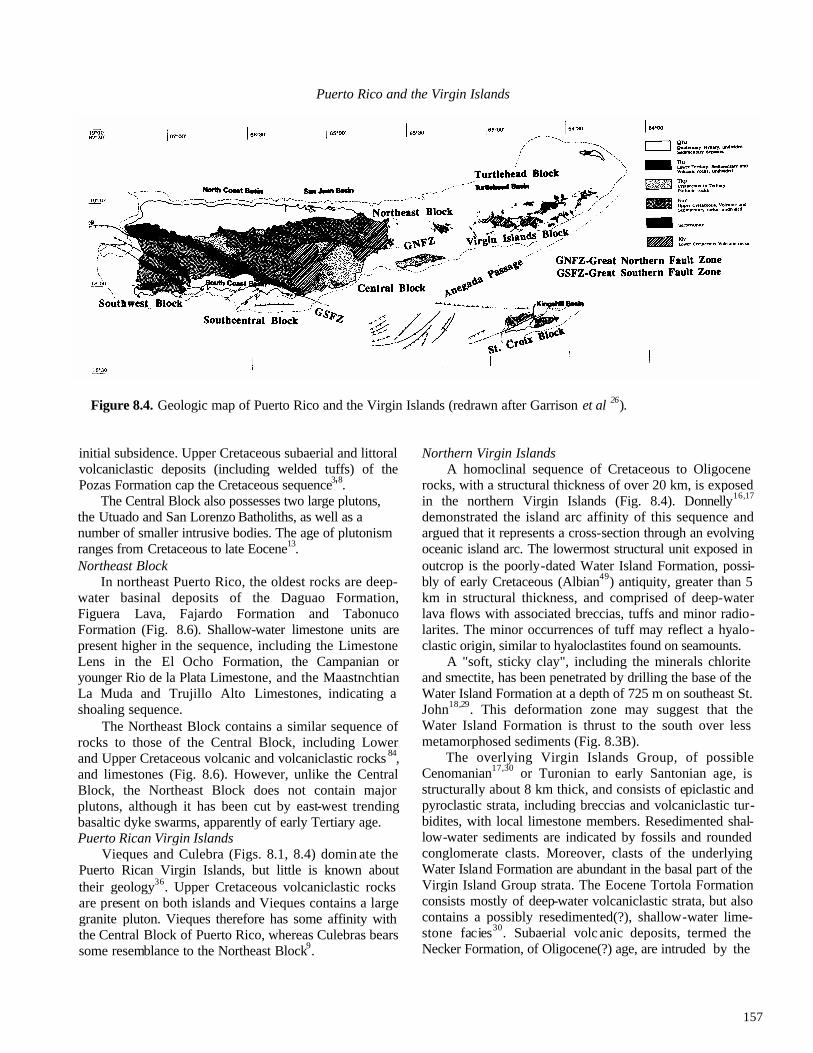
157
Puerto Rico and the Virgin Islands
Figure 8.4. Geologic map of Puerto Rico and the Virgin Islands (redrawn after Garrison et al 26).
initial subsidence. Upper Cretaceous subaerial and littoral volcaniclastic deposits (including welded tuffs) of the Pozas Formation cap the Cretaceous sequence3'8.
The Central Block also possesses two large plutons, the Utuado and San Lorenzo Batholiths, as well as a number of smaller intrusive bodies. The age of plutonism ranges from Cretaceous to late Eocene13. Northeast Block
In northeast Puerto Rico, the oldest rocks are deep-water basinal deposits of the Daguao Formation, Figuera Lava, Fajardo Formation and Tabonuco Formation (Fig. 8.6). Shallow-water limestone units are present higher in the sequence, including the Limestone Lens in the El Ocho Formation, the Campanian or younger Rio de la Plata Limestone, and the Maastnchtian La Muda and Trujillo Alto Limestones, indicating a shoaling sequence.
The Northeast Block contains a similar sequence of rocks to those of the Central Block, including Lower and Upper Cretaceous volcanic and volcaniclastic rocks 84, and limestones (Fig. 8.6). However, unlike the Central Block, the Northeast Block does not contain major plutons, although it has been cut by east-west trending basaltic dyke swarms, apparently of early Tertiary age. Puerto Rican Virgin Islands
Vieques and Culebra (Figs. 8.1, 8.4) domin ate the Puerto Rican Virgin Islands, but little is known about their geology36. Upper Cretaceous volcaniclastic rocks are present on both islands and Vieques contains a large granite pluton. Vieques therefore has some affinity with the Central Block of Puerto Rico, whereas Culebras bears some resemblance to the Northeast Block9.
Northern Virgin Islands A homoclinal sequence of Cretaceous to Oligocene
rocks, with a structural thickness of over 20 km, is exposed in the northern Virgin Islands (Fig. 8.4). Donnelly16,17
demonstrated the island arc affinity of this sequence and argued that it represents a cross-section through an evolving oceanic island arc. The lowermost structural unit exposed in outcrop is the poorly-dated Water Island Formation, possi-bly of early Cretaceous (Albian49) antiquity, greater than 5 km in structural thickness, and comprised of deep-water lava flows with associated breccias, tuffs and minor radio-larites. The minor occurrences of tuff may reflect a hyalo-clastic origin, similar to hyaloclastites found on seamounts.
A "soft, sticky clay", including the minerals chlorite and smectite, has been penetrated by drilling the base of the Water Island Formation at a depth of 725 m on southeast St. John18,29. This deformation zone may suggest that the Water Island Formation is thrust to the south over less metamorphosed sediments (Fig. 8.3B).
The overlying Virgin Islands Group, of possible Cenomanian17,30 or Turonian to early Santonian age, is structurally about 8 km thick, and consists of epiclastic and pyroclastic strata, including breccias and volcaniclastic tur-bidites, with local limestone members. Resedimented shal-low-water sediments are indicated by fossils and rounded conglomerate clasts. Moreover, clasts of the underlying Water Island Formation are abundant in the basal part of the Virgin Island Group strata. The Eocene Tortola Formation consists mostly of deep-water volcaniclastic strata, but also contains a possibly resedimented(?), shallow-water lime-stone facies30. Subaerial volc anic deposits, termed the Necker Formation, of Oligocene(?) age, are intruded by the

158
DAVID K. LARUE
Figure 8.5. Cenozoic stratigraphy of Puerto Rico and the Virgin Islands (based on many sources).
Oligocene Virgin Islands Batholith and overlain by Upper Miocene to Holocene limestones of the Rogues Bay Forma- tion30,51.
The northern Virgin islands therefore represent a rela-tively complete island arc sequence, although the actual oceanic arc basement is not exposed. It should be noted that Rankin66 argued against a simple homoclinal stack and for a more complex megafold based on regional studies of sedimentary facing-directions. Turtlehead
Seismic reflection profiles and correlation with Turtle-head #1, drilled by Mobil in the 1980s (Fig. 8.1), indicates that strata to the north of the northern Virgin Islands have
apparently not undergone the same deformation history, appearing less deformed. The Turtlehead well bottomed in igneous (or volcaniclastic) rocks of uncertain age after pene-trating Tertiary sediments. This may indicate the presence of another tectonic block, termed here the Turtlehead Block. St. Croix
Cretaceous rocks on St. Croix are similar to those observed on Puerto Rico and the Virgin Islands, consisting of Upper Cretaceous (Cenomanian to Maastrichtian), deep-water, volcaniclastic sediments, intruded locally by Upper Cretaceous (Maastrichtian) plutons of mafic to intermediate composition72-74,85. Formations mapped on St. Croix are principally of submarine fan facies, such as massive sand-

159
Puerto Rico and the Virgin Islands
Figure 8.6. Mesozoic stratigraphy of Puerto Rico and the Virgin Islands (based on many sources).
stones and thin-bedded turbidites. An unusual feature of the submarine fan facies rocks is the common occurrence of black cherts, not clearly of pelagic origin. The major oddity of St. Croix relative to the rest of the Virgin Islands and Puerto Rico is the intense deformation of the rocks, including possible thrust faults, and the widespread development of a penetrative slaty cleavage (see below). Whetten85 argued that keratophyric fragments in Cretaceous sandstones on St. Croix may have been derived from the northern Virgin Islands. If so, this provides the only direct geologic link, other than the general composition of the Upper Cretaceous arc complex, with any other island of the eastern Greater Antilles. North Slope complex
As mentioned in the neotectonics section, a metamorphic complex is recognised between the 19° Latitude Fault and the Puerto Rico Trench, based on analysis of dredge hauls, studies from submersibles and regional geologic considerations. Perfit et al 64 concluded that the metamor- phic rocks may be continuous with rocks of the Samana Pen-insula on Hispaniola33,34 and represent moderate P-T condi-
tions. Sedimentary rocks in the north slope complex are from Eocene to Holocene in age. The metamorphic rocks probably came from arc-related protoliths. Early Tertiary stratigraphy of Puerto Rico
The early Tertiary stratigraphy of Puerto Rico is not clearly related to the blocks previously defined or to early Tertiary rocks that occur between the blocks. The Eocene Belt of Puerto Rico separates the Southcentral and Central Blocks, and is structurally associated with the Great Southern Fault Zone. Elsewhere, early Tertiary rocks occur fairly sporadically or else are preserved in grabens (Fig. 8.4). Early Tertiary rocks also have a scattered distribution between the Central and Northeastern Blocks (near the Great Northern Fault Zone), though a belt of rocks per se is not well-defined as the Eocene belt. Early Tertiary rocks include volcanic flows of basic to intermediate composition, volcaniclastic turbidites, shallow- and deep-water limestones, and intrusions. An interesting feature of early Tertiary rocks in north central Puerto Rico is the local occurrence of plutonic rock fragments and detrital quartz grains, indicating that the plutons of the island were being uplifted and eroded. Shal-

160
DAVID K. LARUE
low-water limestone facies are found in northcentral and southcentral Puerto Rico, suggesting that the Central Block may have been a topographic high in the Eocene. Locally, fragments of Cretaceous limestones are present in Eocene strata of south central Puerto Rico. Other early Tertiary facies seem to be of a deep-water origin. Early Tertiary stratigraphy of the northern Virgin Islands
Two Paleogene stratigraphic units are recognised in the northern Virgin islands, the Tortola and Necker Formations (Fig. 8.5). The Eocene Tortola Formation is over 8 km in structural thickness, and is comprised of andesitic and augite-andesitic tuffs, breccias and volcanic sandstones de-posited in a submarine setting. An intercalated shallow-water limestone lens may be resedimented. This unit is overlain by the Oligocene(?) Necker Formation, which is approximately 2 km in structural thickness, and is comprised of tuffs and breccias deposited under subaerial conditions. Longshore51 argued that the Oligocene13 Virgin Islands Batholith predates or is the same age as the Necker Formation. Early Tertiary of St. Croix
No Paleogene rocks are present on St. Croix. Older publications suggested that the Jealousy Formation may be as old as Eocene. However, recent studies indicate that it is Miocene. The oldest pelagic carbonates on St. Croix are known from a mudball (Fig. 8.5) which contains foraminif- ers of early Eocene to early Miocene age50. Plutons
Plutons of varying size and composition occur in Puerto Rico and the Virgin Islands. Plutons in Puerto Rico are largest in the Central Block, are granodioritic, dioritic and quartz dioritic in composition, and are clearly of calc -alka- line affinity62. The Utuado and San Lorenzo Batholiths are late Cretaceous in age (80-60 Ma)13, whereas other plutons on Puerto Rico range from 130-37 Ma. The Virgin Islands Batholith is younger, 36-33 Ma, but locally is as young as 24.3 Ma13,37. Intrusive rocks, including dykes, sills and larger bodies referred to as plutons, are present on St. Croix, ranging in age from 71.8-66.1 Ma74.
Eocene to Oligocene deformational events Puerto Rico
Localized intense deformation occurred between depo-sition of Eocene and Oligocene strata, and is indicated by a profound angular unconformity. Timing of this deformation is based on the youngest age of the deformed sequence (middle to late Eocene) and the oldest age of the overlap sequence (middle to late Oligocene), indicating that defor-mation occurred in the late Eocene to middle Oligocene. Style of deformation is variable, and not simply defined by end-member deformation types such as fold and thrust belt, or zone of strike-slip, tectonism. Two principal fault zones
have been mapped on Puerto Rico, the Great Northern and Southern Fault Zones (Fig. 8.4). Deformation associated with these fault zones seems to be primarily strike-slip. However, evidence of shortening is also widespread, as indicated by folded and thrust-faulted rocks, especially in southcentral Puerto Rico21,22,28 (Fig. 8.4). Uplift, as indicated by metamorphic facies below the unconformity, was of the order of 2 or more kilometres. Together the two effects seem to indicate a dominantly transpressional deformation environment10,22. Also associated with this deformation was anticlockwise block rotation of at least 20°, based on studies of palaeomagnetism in Eocene rocks 79. Northern Virgin Islands
Deformation occurred later in the northern Virgin Islands than in Puerto Rico, where plutons and intrusives as young as Upper Oligocene occur13,37 which are overlain by a poorlv-developed, Miocene to Pliocene overlap sequence30. The northern Virgin Islands consist of a great homoclinal sequence locally cut by faults (see above). Outcrop-scale folds are very rare, although the rocks are locally foliated. It is not clear whether this foliation is related to the regional tectonic event or to the intrusion of the Virgin Islands Batholith. On St. Thomas, the foliation strikes approximately east-west and dips essentially vertically.
Based on seismic reflection data and information from the Turtlehead well (Fig. 8.1), it can be concluded that Eocene rocks north (=offshore) of Tortola in the Turtlehead Basin are not significantly deformed. This suggests that the intensity of the Eocene-Oligocene deformational event decreases toward the north. A similar situation appears to apply north of Puerto Rico45, where undeformed Eocene strata are apparently present to the north of folded and faulted Eocene rocks. This suggests that a deformation front exists within the arc crust, separating less deformed rocks in the north from more deformed rocks in the south.
St.Croix It is not clear whether St. Croix experienced this Eo-
cene-Oligocene deformational event. Speed et al74 pre-viously proposed that deformation occurred in the Cretaceous, based on the observation of non-deformed Cre-taceous intrusions cutting foliated rocks. However, foliated intrusive bodies have now been discovered, indicating at least some of the plutons are pre-deformational19. Moreover, dredge samples from the northern slope of St. Croix reveal volcaniclastic rocks similar to those on St. Croix, but with whole-rock K-Ar ages as young as 33.5-28.3 Ma (Oligocene)6. Bouysse et al.6 interpreted the younger age to be the age of seritization accompanying development of schistosity. Thus, it appears that St. Croix may have been affected by Oligocene tectonism.
Style of deformation on St. Croix is unique compared

161
Puerto Rico and the Virgin Islands
to elsewhere in the eastern Greater Antilles, consisting of tightly-folded sandstones and mudstones, typically exhibit-ing a well-developed axial planar foliation, locally cut by faults. Speed and Joyce75 recently reinterpreted the style of deformation using the fold and thrust belt model, and argued that a number of discrete thrust sheets jean be recognised, a view supported by Draper and Bartel19.
Summary of Cretaceous and early Tertiary deformation events A total of three deformation events are currently recog-
nised in the Cretaceous to early Tertiary of Puerto Rico and the Virgin Islands. These deformation events are not univer -sally correlative between islands. The oldest event, that formed the serpentinite melange of the Bermeja Complex, is recognised in southwest Puerto Rico. This serpentinite melange is comprised of rocks with both arc and oceanic crustal affinities, and is overlain unconformably by the Turonian Paguera Limestone. Deformation may therefore have occurred in the Aptian to Cenomanian. A key point is that blocks in the melange consist of oceanic crustal rocks intruded by arc volcanic rocks, indicating the deformation of an island arc already built atop oceanic crust and is therefore not an arc-oceanic crust accretion event. The age of the melange formation in the Southwest Block apparently corresponds to the age of the unconformity at the top of the Water Island Formation and the pre-Robles Group (Fig. 8.6).
In St. Croix, a late Cretaceous deformation event is recognised as responsible for the intense deformation of Cenomanian to Maastrichtain volcaniclastic strata. Speed and Joyce argued that deformation occurred in an accre-tionary prism setting, with plutonism occurring after trans-port of the accretionary prism over the arc massif. However, an intra-arc basin deformational site seems more likely, especially based on the observation of Draper and Bartel19 of deformed plutons, indicating that sedimentation occurred in an island arc environment, not a forearc. This deformation event or a correlative unconformity has not been recognised on Puerto Rico or the northern Virgin Islands.
The early Tertiary event recognised in Puerto Rico and the northern Virgin Islands is clearly the most widespread of the three deformations recognised. Origin of the defor-mation is uncertain, but most recent studies indicate a tran-spressional setting 21,22,28, possibly associated with subduction of buoyant seafloor46. Deformation apparently decreases toward the north of Puerto Rico and the northern Virgin Islands, supporting the intra-arc transpressional the-ory. The importance of this orogenic event in St. Croix is unclear.
SUMMARY OF NINE PHASES OF
DEVELOPMENT OF PUERTO RICO AND THE VIRGIN ISLANDS
(1) Oceanic crustal development in the late Jurassic, as indicated by amphibolites in the Bermeja Complex69.
(2) Early arc build-up in the early Cretaceous, as indicated by arc volcanics in the Bermeja Complex, cutting the oceanic crustal rocks, and volcanism and associated sedimentation in the Central Block of Puerto Rico (pre- Robles Group) and the northern Virgin Islands (Water Island Formation).
(3) Early arc disruption, as indicated by the Bermeja Com plex serpentinite melange, which contains blocks of both arc and oceanic crustal rocks. This early arc dis ruption phase is manifest elsewhere in Puerto Rico and in the northern Virgin Islands by an unconformity of Albian age.
(4) Renewed arc build-up in the late Cretaceous (late Al- bian(?) to Cenomanian, continuing to the Maas- trichtian), as indicated by a thick volcanic pile in Puerto Rico, the northern Virgin Islands and St. Croix.
(5) A localised end-Cretaceous (mostly Maastrichtian) arc disruption event, recognised only in St. Croix.
(6) Renewed arc build-up in the early Tertiary, associated with arc dissection as indicated by plutonic clasts, de- trital quartz and fragments of Cretaceous limestone in early Tertiary rocks. This is an odd period of arc growth and uplift, probably transitional to the next phase of evolution.
(7) Cessation of volcanism, uplift of several kilometres, deformation and rotation of the arc massif in the late Eocene to middle Oligocene in Puerto Rico, and in the middle to late Oligocene in the northern Virgin Islands. This deformation is possibly associated with subduc tion of buoyant oceanic crust or related to a change in plate motion associated indirectly with the Cuban col- lision to the west.
(8) Carbonate platform development on Puerto Rico (late Oligocene to Miocene) and the northern Virgin Islands (late Miocene?), with sedimentation in abasinal setting in St. Croix (early Miocene).
(9) A deformational event from middle Miocene to the Recent, associated with profound, local, tectonic subsi dence, local extensional and contractional tectonism, and accompanied by anticlockwise block rotation of Puerto Rico and the northern Virgin Islands by 25°.
ACKNOWLEDGMENTS—This chapter represents a summary of work performed at the University of Puerto Rico from 1986-1991. Discussions with colleagues there were always fruitful, especially James Joyce, Hans Schellekens and Alan Smith. Support for these studies came from the Puerto Rico Power Authority and included two grants from the National Science Foundation. Reviews by Gren Draper and an anonymous reviewer

162
DAVID K.LARUE
improved the typescript.
REFERENCES
1 Almy, C. C., Jr. 1965. Parguera Limestone, Upper Creta-ceous Mayaguez Group, southwest Puerto Rico. Un-published Ph.D. thesis, Rice University, Houston, 189pp.
2Alonso, R.M., Krieg, E.A. & Meyeitoff, A. A. 1987. Post-early Pliocene age of the Puerto Rico Trench: in Duque-Caro, H. (ed.), Transactions of the Tenth Caribbean Geological Conference, Cartagena, Columbia, 14th-20th August, 1983, 82-103.
3Berryhill, H.L., Jr. 1965. Geology of the Ciales Quadrangle, Puerto Rico. U.S. Geological Survey Bulletin, 1184, 84pp.
4Biju-Duval, B., Bizon, G., Mascle, A. & Muller, C. 1982. Active margin processes: field observation in southern Hispaniola: in Watkins, J.S. & Drake, C.L. (eds), Studies in Continental Margin Geology. American Association of Petroleum Geologists Memoir, 34, 325-344.
5Birch, F.S. 1986. Isostatic, thermal and flexural models of the subsidence of the north coast of Puerto Rico. Geology, 14, 427-429.
6Bouysse, P., Andreieff, P., Richard, M, Baubron, J., Mascle, A., Maury, R. &. Westercamp, D. 1985. Aves Swell and northern Lesser Antilles Ridge: rock dredging results from Arcante 3 cruise: in Mascle, A. (ed.), Geody-namiquesdes Caribes, Symposium, Paris, 5-8Fevrier. Editions Technip, Paris, 65-75.
7Bowin, C. 1972. Puerto Rico Trench negative gravity anomaly belt. Geological Society of America Memoir, 132, 339-350.
8Briggs, R.P. 1971. Geologic map of the Orocovis Quadrangle, Puerto Rico. U.S. Geological Survey, Miscellaneous Geologic Investigations, Map 1-615.
9Briggs, R.P. & Akers, J.P. 1974. Hydrogeologic map of Puerto Rico and adjacent islands. U.S. Geological Survey Hydrologic Investigations Atlas, HA-197.
10Briggs, R.P. & Pease, M.H. 1961. Compressional graben and horst structures in east-central Puerto Rico. U.S. Geological Survey Short Papers, B365-B366.
11Byme, D.B., Suarez, G. & McCann, W.R. 1985. Muertos Trough subduction-microplate tectonics in the northern Caribbean. Nature, 317, 420-421.
12Case, I.E. 1975. Geophysical studies in the Caribbean Sea: in Nairn, A.E.M. & Stehli, F.G. (eds), The Ocean Basins and Margins. 3. The Gulf of Mexico and the Caribbean. Plenum, New York, 107-180.
13Cox, D.F., Marvin, F.R., M'Gonigle, J.W., Mclntyre, D.H. & Rogers, C. 1977. Potassium-argon geochronol-
ogy of some metamorphic, igneous and hydrothermal events in Puerto Rico and the Virgin Islands. U.S. Geological Survey Journal of Research, 5, 689-703.
14Curet, A.F. 1981. The geology of a Cretaceous-Tertiary volcano-sedimentary sequence in the''Mayaguez and Rosario Quadrangles in west-central Puerto Rico. Un-published Ph.D. thesis, University of California at Santa Barbara
15Curet, A.F. 1986. Geologic map of the Mayaguez amd Rosario Quadrangles, Puerto Rico. U.S. Geological Survey, Miscellaneous Geologic Investigations, Map 1-1657.
16Donnelly, T.W. 1964. Evolution of eastern Greater Antilles island arc. American Association of Petroleum Geologists Bulletin, 48, 680-696.
17Donnelly, T.W. 1966. Geology of St. Thomas and St. John, U.S. Virgin Islands: in Hess, H.H. (ed.), Caribbean Geological Investigations. Geological Society of America Memoir, 98, 85-176.
18Donnelly, T.W. 1968. Field guide to the geology of St. John and St. Thomas. Field Trip Guidebook, Fifth Caribbean Geological Conference, St. Thomas, U.S. Virgin Islands, 1-5 July, 1968,1-26.
19Draper, G. & Bartel, J. M. 1990. Development of cleavage in the Cretaceous rocks of St. Croix, U.S. V.I., and some tectonic implications. Geological Society of America Abstracts with Programs, 22, A337.
20EEZ SCAN 85 Scientific Staff. 1987. Atlas of the U.S. Exclusive Economic Zone, eastern Caribbean. U.S. Geological Survey, Miscellaneous Geologic Investiga-tions, I-1864B, 58 pp.
21Erikson, J.P. 1988. Structural study of the Paleogene deformation in and around the Southern Puerto Rico Fault Zone of south central Puerto Rico. Unpublished Ph.D. thesis, Stanford University, 79 pp.
22Erikson, J.P., Pindell, J.L. & Larue, D.K. 1989. Mid Eocene-early Oligocene sinistral transcurrent faulting in Puerto Rico associated with formation of the northern Caribbean Plate Boundary Zone. Journal of Geology, 98, 365-384.
23Fox, P.J. & Heezen, B.C. 1975. Geology of the Caribbean crust: in Nairn, A.E.M. & Stehle, F.G. (eds), The Ocean Basins and Margins. 3. The Gulf of Mexico and the Caribbean. Plenum, New York, 421-466.
24Frost, S.H., Harbour, J.L., Beach, D.K., Realini, M.J. & Harris, P.M. 1983. Oligocene reef tract development, southwestern Puerto Rico. Sedimentia, 9, 141 pp. Rosenstiel School of Marine and Atmospheric Science, Miami.
25Gardner, W.D., Glover, L.K. & Hollister, C.D. 1980. Canyons off northwest Puerto Rico: studies of their origin and maintenance with the nuclear research sub-

163
Puerto Rico and the Virgin Islands
marine NR-1. Marine Geology, 37, 41-70.
26Ganison, L.E., Martin, R.G., Berryhill, H.L., Buell, M.W., Ensminger, H.R. & Peny, R.K. 1972. Prelimi-nary tectonic map of the eastern Greater Antilles region. U.S. Geological Survey, Miscellaneous Geological In-vestigations, Map 1-732.
27Gill, I.P., Hubbard, D.K., McLaughlin, P. & Moore, C. H. 1989. Sedimentological and tectonic evolution of Ter -tiary St. Croix: in Hubbard, D.K. (ed.), Terrestrial and Marine Geology of St. Croix, U.S. Virgin Islands. West Indies Laboratory, St. Croix, Special Publication, 8, 49-72.
28Glover, L. ffl. 1971. Geology of the Coamo area, Puerto Rico, and its relation to the volcanic arc-trench associa-tion. U.S. Geological Survey, Professional Paper, 636, 102pp.
29Hekinian, R. 1971. Petrological and geochemical study of spilites and associated rocks from St. John, U.S. Virgin Islands. Geological Society of America Bulletin, 82, 659-682.
30Helsey, C.E. 1960. Geology of the British Virgin Islands. Unpublished Ph.D. thesis, Princeton University.
31Houlgatte, E. 1983. Etude d'une partie de la frontiere nord-est de las Plaque Caraibe. Unpublished thesis, Universite de Bretagne Occidental, 3° cycle, 69 pp.
32Jordan, T.H. 1975. The present day motions of the Carib-bean Plate. Journal of Geophysical Research, 80, 4433-4440.
33Joyce, J. 1982. The lithology and structure of the eclogite and glaucophane-bearing rocks on the Samana Penin-sula, Dominican Republic: in Snow, W., Gil, N., Llinas, R., Rodriguez-Torres, R., Seaward, M. & Tavares, I. (eds), Transactions of the Ninth Caribbean Geological Conference, Santo Domingo, Dominican Republic, 16th-20th August, 1980, 417-422.
34Joyce, J. 1985. High pressure-low temperature metamor-phism and the tectonic evolution of the Samana Penin-sula, Dominican Republic, Greater Antilles. Unpublished Ph.D. thesis, Northwestern University, 270pp.
35Kaczor, L. & Rogers, J. 1990. The Cretaceous Aguas Buenas and Rio Maton Limestones of southern Puerto Rico. Journal of South American Earth Sciences, 3, 1-8.
36Kemp, J.F. & Meyerhoff, H.A. 1926. Scientific survey of Porto Rico and the Virgin Islands, volume 4, parts I and II. New York Academy of Sciences, New York, 219 pp. Kesler, S.E. & Sutter, J.F. 1979. Compositional evolution of intrusive rocks in the eastern Greater Antilles island arc. Geology, 1, 197-200.
38Krushensky, R.D. & Curet, A.F. 1984. Geologic map of the Monte Guilarte Quadrangle, Puerto Rico. U.S. Geo-logical Survey, Miscellaneous Geologic Investigations,
Map I-1556. 39Krushensky, R.D. & Monroe, W.H. 1978a. Geologic map of
the Penuelas and PuntaCuchara Quadrangles, Puerto Rico. U.S. Geological Survey, Miscellaneous Geologic Investigations, Map I-1042.
40Krushensky, RD. & Monroe, W.H. 1978b. Geologic map of the Yauco and Punta Verraco Quadrangles, Puerto Rico. U.S. Geological Survey, Miscellaneous Geologic Investigations, Map I-1147.
41Ladd, J.W., Shih, T. & Tsai, C.J. 1981. Cenozoic tectonics of central Hispaniola and adjacent Caribbean Sea. American Association of Petroleum Geologists Bulletin, 65,466-489.
42Ladd, J.W. & Watkins, J.S. 1978. Active margin structures within the north slope of the Muertos Trench. Geologie en Mijnbouw, 57, 255-260.
43Ladd, J.W, Worzel, J.L. & Watkins, J.S. 1977. Multifold seismic reflection records from the northern Venezuela Basin and the north slope of Muertos Trench: in Tal-wani, M. & Pitman, W.C. (eds), Island Arcs, Deep-Sea Trenches and Back-Arc Basins. American Geophysical Union, Washington, D.C, 41-56.
44Larue, D.K. 1990. Toa Baja drilling project, Puerto Rico. EOS, 71, 233-234.
45Larue, D.K. & Berrong, B. 1991. Cross section through the Toa Baja drillsite: evidence for northw ard change in late Eocene deformation intensity. Geophysical Research Letters, 18, 561-564.
46Larue, D. K., Joyce, J. & Ryan, H. F. 1990. Neotectonics of the Puerto Rico Trench: extensional tectonism and forearc subsidence: in Larue, D.K. & Draper, G. (eds), Transactions of the Twelth Caribbean Geological Con-ference, St. Croix, U.S. Virgin Islands, 7th-IIthAugust, 1989,231-247. Miami Geological Society, Florida.
47Larue, D.K., Pierce, P. & Erikson, J. 1991. Cretaceous intra-arc summit basin on Puerto Rico: in Gillezeau, K. A. (ed.), Transactions of the Second Geological Conference of the Geological Society of Trinidad and Tobago, Port-of-Spain, Trinidad, April 3-8, 1990, 184-190.
48Larue, D.K. & Ryan, H.F. 1990. Extensional tectonism in the Mona Passage, Puerto Rico and Hispaniola: a pre-liminary study: in Larue, D.K. & Draper, G. (eds), Transactions of the Twelth Caribbean Geological Con-ference, St. Croix, U.S. Virgin Islands, 7th-11th August, 1989,223-230. Miami Geological Society, Florida.
49Lewis, J.F. & Draper, G. (with Bourdon, C., Bowin, C, Mattson, P., Maurrasse, F., Nagle, F. & Pardo, G.). 1990. Geology and tectonic evolution of the northern Caribbean margin: in Dengo, G. & Case, J.E. (eds), The geology of North America. Volume H. The Caribbean region, 77 - 140. Geological Society of America, Boul-

164
DAVID K. LARUE
der. 50Lidz, B.H. 1984. Oldest (early Tertiary) subsurface car -
bonate rocks of St. Croix, U.S. V.I., revealed in tur-bidite-mudball. Journal of Foraminiferal Research, 14, 213-227.
51Longshore, J.D. 1966. Chemical and mineralogical vari-ations in the Virgin Islands batholith and its associated wall rocks. Unpublished Ph.D. thesis, Rice University, 94pp.
52Mann, P. & Burke, K. 1984. Neotectonics of the Carib-bean. Review of Geophysics and Space Science,22, 309-362.
53Masson, D.G. & Scanlon, K.M. 1991. The neotectonic setting of Puerto Rico. Geological Society of America Bulletin, 103,144-154.
54Mattson, P.H. 1960. Geology of the Mayaguez area, Puerto Rico. Geological Society of America Bulletin, 71, 319-362.
55Mattson, P.H. & Pessagno, E.A., Jr. 1979. Jurassic and early Cretaceous radiolarians in Puerto Rican ophiolite-tectonic implications. Geology, 7,440-444.
56McCann, W.R. & Sykes, L.R. 1984. Subduction of aseis-mic ridges beneath the Caribbean Plate: implications for the tectonics and seismic potential of the north eastern Caribbean. Journal of Geophysical Research, 89, 4493-4519.
57Meyerhoff, A.A., Krieg, E.W., Cloos, J.D. & Taner, I. 1983. Petroleum possibilities of Puerto Rico. Oil and Gas Journal, 81 (no. 51), 113-120.
58Molnar, P. & Sykes, L.R. 1969. Tectonics of the Carib-bean and Middle America regions from focal mecha-nisms and seismicity. Geological Society of America Bulletin, 59, 801-854.
59Monroe, W.H. 1980. Geology of the middle Tertiary formations of Puerto Rico. U.S. Geological Survey Professional Paper, 954, 93 pp.
60Moussa, M.T. 1977. Bioclastic sediment gravity flow and submarine sliding in the Juana Diaz Formation, south-western Puerto Rico. Journal of Sedimentary Petrol-ogy, 47, 593-599.
61Moussa, M.T., Seiglie, G.A., Meyeihoff, A.A. & Taner, I. 1987. The Quebradillas Limestone (Miocene-Plio-cene), northern Puerto Rico, and tectonics of the north-eastern Caribbean margin. Geological Society of America Bulletin, 99 ,427-439.
62Nelson, A.E. 1968. Intrusive rocks of north-central Puerto Rico. U.S. Geological Survey Professional Paper, 600B, B16-B20.
63Officer, C.B., Ewing, J.I., Hennion, D.G., Haikrider, D.G. & Miller, D.E. 1959. Geophysical investigations of the eastern Caribbean: Venezuela Basin, Antilles island arc, and Puerto Rico Trench. Physical and Chemical
Earth, 3, 17-109. 64Perfit, M.R., Heezen, B.C., Rawson, M. & Donnelly, T.W.
1980. Chemistry, origin, and tectonic significance of metamorphic rocks from the Puerto Rico Trench. Ma-rine Geology, 34,125-156.
65Pindell, J.L. & Barrett, S.F. 1990. Geological evolution of the Caribbean region; a plate-tectonic perspective: in Dengo, G. & Case, J.E. (eds), The geology of North America. Volume H. The Caribbean region, 405-432. Geological Society of America, Boulder.
66Rankin, D. 1984. Geology of the U.S. Virgin Islands, a progress report. U.S. Geological Survey Open File Re-port, 84-762, 83-96.
67Reid, J., Plumley, P. & Schellekens, J. 1991. Paleomag-netic evidence for late Miocene counterclockwise rota-tion of north coast carbonate sequence, Puerto Rico. Geophysical Research Letters, 18, 565-568.
68Schell, B.A. & Tarr, A.C. 1978. Plate tectonics of the northeastern Caribbean Sea region. Geologie en Mijnbouw, 51, 319-324.
69Schellekens, J.H., Montgomery, H., Joyce, J. & Smith, A.L. 1990. Late Jurassic to late Cretaceous develop-ment of island arc crust in southwestern Puerto Rico: in Larue, D.K. & Draper, G. (eds), Transactions of the Twelth Caribbean Geological Conference, St. Croix, U.S. Virgin Islands, 7th-llth August, 1989, 268-281. Miami Geological Society, Florida.
70Schneidermann, N., Beckmann, J.C. & Heezen, B.C. 1972. Shallow water carbonates from the Puerto Rico Trench region: in Petzall, C. (ed.), Transactions of the Sixth Caribbean Geological Conference, Margarita Island, Venezuela, 6th-14thJuly, 1971, 423-425.
71Seiglie, G.A. & Moussa, M.T. 1984. Late Oligocene-Plio-cene transgressive-regressive cycles of sedimentation in northwestern Puerto Rico: in Schlee, J. S. (ed.), Inter-regional Unconformities and Hydrocarbon Accumula-tion. American Association of Petroleum Geologists Memoir, 36, 89-96.
72Speed, R.C. 1974. Depositional realm and deformation of Cretaceous rocks, East End, St. Croix; in Multer, H.G. & Gerhard, L.C. (eds), Guidebook to the Geology and Ecology of some Marine and Terrestrial Environments, St. Croix, U.S. Virgin Islands. West Indies Laboratory, St. Croix, Special Publication 5, 189-200.
73Speed, R.C. 1989. Tectonic evolution of St. Croix: impli-cations for tectonics of the northeastern Caribbean: in Hubbard, D.K. (ed.), Terrestrial and Marine Geology of St. Croix, U.S. Virgin Islands. West Indies Laboratory, St. Croix, Special Publication 8, 9-22.
74Speed, R.C., Gerhard, L.C. & McKee, E.H. 1979. Ages of deposition, deformation and intrusion of Cretaceous rocks, eastern St. Croix, Virgin Islands. Geological

165
Puerto Rico and the Virgin Islands
Society of America Bulletin, 90, 629-632.
75Speed, R.C. & Joyce, J. 1989. Depositional and structural evolution of Cretaceous strata, St. Croix: in Hubbard, D.K. (ed.), Terrestrial and Marine Geology of St. Croix, U.S. Virgin Islands. West Indies Laboratory, St. Croix, Special Publication 8, 23-36.
76Speed, R.C. & Larue, D.K. 1991. Extension and transten-sion in the plate boundary zone of the northeastern Caribbean. Geophysical Research Letters, 18,573-576. Talwani, M., Sutton, G.H. & Woreel, J.L. 1959. A crustal section across the Puerto Rico Trench. Journal of Geophysical Research, 64, 1545-1555.
78Todd, R. & Low, D. 1979. Smaller foraminifera from deep wells on Puerto Rico and St. Croix. U.S. Geological Survey, Professional Paper, 863, 32 pp.
79Van Fossen, M.C., Channell, J.E.T. & Schellekens, J.H. 1989. Paleomagnetic evidence for Tertiary antic lock-wise rotation in southwest Puerto Rico. Geophysical Research Letters, 16, 819-822.
80Volckmann, R.P. 1983. Upper Cretaceous stratigraphy of southwest Puerto Rico: a revision. U.S. Geological
Survey Bulletin, 1537-A, A73-A83. 81 Volckmann, R.P. 1984a. Geologic map of the Puerto Real
Quadrangle, southwest Puerto Rico. U.S. Geological Survey, Miscellaneous Geologic Investigations, Map 1-559.
82Volckmann, R.P. 1984b. Geologic map of the San Ger-man Quadrangle, southwest Puerto Rico. U.S. Geologi-cal Survey, Miscellaneous Geologic Investigations, Map 1-558.
83Weaver, J., Smith, A. & Seiglie, G. 1975. Geology and tectonics of the Mona Passage. Transactions of the American Geophysical Union, 56, 451.
84Weiland, T.J. 1988. The petrology of the volcanic rocks in the Lower Cretaceous formations of northeastern Puerto Rico. Unpublished Ph.D. thesis, University of North Carolina, 265 pp.
85Whetten, J.T. 1966. Geology of St. Croix, U.S. Virgin Islands: in Hess, H. H. (ed), Caribbean Geological Investigations. Geological Society of America Memoir, 98, 177-239.

166

167
Ctribbean Geology: An Introduction U.W.I. Publishers' Association, Kingston
© 1994 The Authors
CHAPTER 9
The Lesser Antilles
GEOFFREY WADGE
N.E.R.C. Unit for Thematic Information Systems, Department of Geography, University of Reading, P.O. Box 227, Reading, RG6 2AB, England
INTRODUCTION
THE LESSER Antilles are a chain of islands that extend in an 850 km arc from Sombrero in the north to Grenada in the south (Fig. 9.1). They are separated from the Greater An-tilles by the Anegada Passage whilst the Venezuela conti-nental margin starts just south of Grenada. The Lesser Antilles is a true island arc; islands built largely by volcan-ism above a subduction zone16. This involves the subduc-tion of Atlantic ocean floor westwards beneath the Caribbean Plate at the rate of about 20 mm/year. Compared to island arcs globally the Lesser Antilles arc is relatively short, long-lived (at least since the Eocene), of only moderate vigour and displays a very well-developed accretionary wedge in its southern part.
STRUCTURE AND GEOPHYSICS
There are four important components to the structure of the arc: the Atlantic oceanic crust; the forearc (upon which the accretionary wedge is built); the arc massif itself; and the Grenada Basin behind the arc. There is considerable along-arc variation in this pattern. In particular, a well-defined trench, the Puerto Rico Trench, exists only in the north. This is about 250 km from the volcanic front (position of the active volcanoes), but the distance to the equivalent feature in the south, the deformation front of disturbed accreted sediments, is about 420 km. Further, the back-arc Grenada Basin extends only as far northwards as Guadeloupe.
Gravity Anomalies There is an arcuate pair of gravity anomalies associated
with the Lesser Antilles: positive over the arc massif and negative over the forearc or edge of the Caribbean plate20.
The positive anomalies, which are present after both free-air and Bouguer corrections, are mainly due to the relatively high crustal level of dense igneous rocks. The negative anomalies, in contrast, are due to the relatively great thickness of low density sedimentary rocks in the basins of the forearc and the accretionary wedge.
Seismicity Two types of earthquake are recognised in the arc:
tectonic earthquakes associated with the subduction of the oceanic crust and its effects in the forearc; and volcanic earthquakes associated with the rise of magma into the crust beneath the volcanoes. It is possible to map the crude shape of the subducted slab from the hypocentres of the deeper tectonic earthquakes received by seismometers from the network within the Lesser Antilles19 (Fig. 9.1 c). This shape, or Wadati-Benioff zone, shows three segments:
(A) A vigorous northern segment (from Martinique north wards) dipping about 50-60° to the WSW and reaching depths up to 210 km.
(B) A weakly-seismic southern segment (as far south as the Grenadines) dipping about 45-50° to the WNW and reaching depths of up to 170 km.
(C) An essentially vertical segment south of (B) extending to the Paria Peninsula of Venezuela.
From the energy released by the major historical earth-quakes the equivalent rates of slip and hence convergence of the subduction process can be calculated15. These rates (5 mm/year and 1 mm/year) for the northern and southern segments are significantly less than the 20 mm/year pre-dicted from global plate tectonic models. This implies that much of the slip between the Caribbean and American plates is achieved without friction, that is, aseismically. This is

168
The Lesser Antilles
Figure 9.1. The Lesser Antilles region, (a) Bathymetric map. l=Volcanic Caribbees; 2=Limestone Caribbees; 3=axis of the inner arc; 4=axis of the outer arc; 5=deformation front. Isobaths in m. (b) Schematic crustal structure of the Lesser Antilles arc. l=outer forearc crust; 2=inner forearc crust; 3=arc massif; 4=oceanic basement ridges; 5=late Jurassic -early Cretaceous Atlantic crust. AA', BB', CC’, DD'=lines of sections shown in Figure 9.2. (c) Isobaths (in km) of the Benioff zone beneath the arc (after Wadge and Shepherd19). The diagonal shading shows the vertical part of the southern zone beneath the Venezuelan continental shelf. (After Maury et al.9). particularly so in the south, where some sediment can be seen on seismic reflection profiles to be subducted beneath the accretionary wedge.
The reason for the distinct break in the Wadati-Benioff zone beneath Martinique and St. Lucia is not known. It may represent the boundary between the North American and South American plates, but evidence supporting this is
lacking. One feature that is certain is that to the north of St. Lucia the arc massif bifurcates into two: an Eocene to Miocene eastern arc; and a Pliocene to Recent western arc.
Seismic Refraction and Reflection Data The crustal structure of the arc down to the MOHO
(about 30 km depth below Martinique) has been determined

169
GEOFFREY WADGE by seismic refraction experiments3. Seismic reflection data has allowed the structural and sedimentary history of the sedimentary basins within the arc to be elucidated14. There
are three main crustal layers:
(A) An upper layer of average seismic velocity of 3.3 km/s comprising a mixture of sediments and volcanics.
(B) A middle layer of average seismic velocity of 6.2 km/s indicative of intermediate plutonic rocks.
(C) A lower layer whose average velocity of 6.9 km/s suggests basic rocks, probably oceanic crust or basic plutonic cumulates.
There is considerable lateral variation in the depth of these layers which is probably the result of a long and complex history of subduction zone processes. Cross-sec-tional models of the structure of the arc based on gravity anomalies constrained by seismic refraction and reflection data show distinctive differences between the northern and southern segments (Fig. 9.2). In the south the volcanic front sits on a single arc massif, whereas in the north the present-day volcanoes are on the western flank of the massif and have contributed relatively little to its growth. In the north models suggest a complicated forearc structure, perhaps involving an additional slice of oceanic crust between the Caribbean forearc and the subducting slab. In the southern Grenadines the high velocity layer is very shallow, which has led to speculation that the oceanic crust of the Grenada Basin may extend across to the forearc at this latitude.
STRATIGRAPHY AND VOLCANISM
There is evidence of an island arc in the Lesser Antilles for at least 50 Ma4,9 (Fig. 9.3). However, much of this evidence is fragmentary, sometimes consisting of small regions of outcrop whose significance to the whole arc's history is open to speculation. The value of stratigraphic correlation is weak when most of the rocks are of volcanic origin7 and have been generated from essentially point sources (volca-noes).
Basement Exposures Although there is no evidence for an east-facing island
arc prior to the middle Eocene, it seems clear that the basement on which the Cenozoic arc is built is not simply Caribbean oceanic oust alone. Cretaceous/Paleocene is-land arc rocks may underlie much of the arc from Guade-loupe northwards. The most important of the basement exposures is on La Desirade, east of Guadeloupe1. Beneath a plateau of Lower Pliocene limestones is a Mesozoic igne-ous complex consisting of trondhjemite/rhyolite lava flows,
with an isotopic age of 145-150 Ma, and younger metavol-canic rocks, some of which have interbedded cherts with a biostratigraphic age of about 112-119 Ma. Many of the submarine escarpments of the northeast-facing part of the arc from Guadeloupe to Anguilla have revealed Upper Cretaceous rocks in dredge hauls. Similarly, Upper Cretaceous rocks, some with island arc affinities, are known from dredge hauls along the Aves Swell that runs N-S behind the Lesser Antilles. The Aves Swell is interpreted to be an island arc that was active prior to the Lesser Antilles arc.
Barbados Barbados has a unique character in the arc (see Speed,
this volume). It is the exposed top of the accretionary wedge of sediments that have been scraped off by subduction, the Barbados Ridge. Most of the island is covered by terraces of Pleistocene reef limestones that record rapid, differential uplift along an axis trending NE-SW. However, on the northeast coast two groups of older accretionary rocks are exposed. These are: (i) the Miocene-Middle Eocene Oce-anic Group comprising mainly lightly deformed abyssal rocks; and (ii) the Lower-Middle Eocene Scotland Group comprising deformed terrigenous and hemipelagic rocks (radiolarites). The source of the terrigenous Eocene rocks was debris flows of material containing metamorphic min-erals from South America either in a deep-sea trench or a submarine fan.
The Limestone Caribbees The islands of the northeastern Lesser Antilles from
Anguilla to Marie Galante are characterised by Cenozoic limestones, hence their name of Limestone Caribbees8. The limestones are of different ages; Eocene on St. Barthelemy, Oligocene on Antigua, Miocene on Anguilla and St. Martin, and Pliocene-Quaternary on Barbuda, Grande Terre (Guadeloupe) and Marie Galante. Underlying volcanic rocks representing the older, eastern branch of the arc are well-exposed on St. Martin, St. Barthelemy (Eocene and Oligocene age) and Antigua (Oligocene age). On Anguilla Paleocene/Eocene age sediments overlie volc anic rocks of unknown age. Volcanic rocks are not exposed in Barbuda, Grande Terre (Guadeloupe) or Marie Galante. Barbuda is offset from the axis of the old volcanic front and may not have been a volcanic centre. In general, the age of the oldest exposed rocks in the Limestone Caribbees increases north-wards. The lack of volcanic intercalations in the Upper Oligocene Antigua Formation suggests that volcanism had ceased by this time in the Limestone Caribbees. It resumed millions of years later much further west.
The Volcanic Caribbees The present day volcanic front extends from Grenada

170
The Lesser Antilles
Figure 9.2. Cross sections of the crust of the arc derived from gravity modelling constrained by seismic refrac-tion and reflection data. The lines of section are shown in Figure 9.1b. The position of the active volcanic arc is shown by triangles. In section AA' it lies at the edge of the crustal thickening associated with the main body of the arc. The inactive volcanic arc in section DD' is contiguous with the active arc and joins it south of Grenada. Numbers give the densities (10-3 x kg.m-3) of the layers used in the gravity models: 1.8-2.55, sediment; 2.3-3.05, igneous crustal rocks; 3.3, mantle. Position of MOHO shown by dotted lines in sections AA', BB', from models including gravitational attraction of subducted lithosphere. (After Maury et al.9).
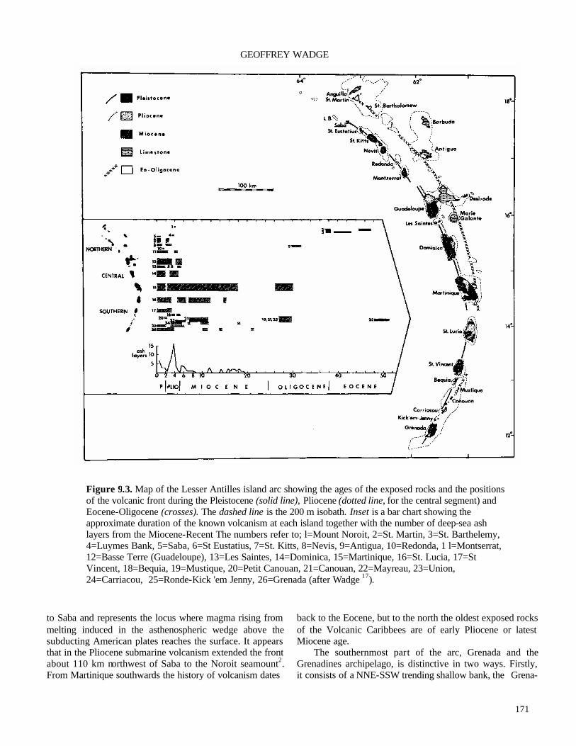
171
GEOFFREY WADGE
to Saba and represents the locus where magma rising from melting induced in the asthenospheric wedge above the subducting American plates reaches the surface. It appears that in the Pliocene submarine volcanism extended the front about 110 km northwest of Saba to the Noroit seamount2. From Martinique southwards the history of volcanism dates
back to the Eocene, but to the north the oldest exposed rocks of the Volcanic Caribbees are of early Pliocene or latest Miocene age.
The southernmost part of the arc, Grenada and the Grenadines archipelago, is distinctive in two ways. Firstly, it consists of a NNE-SSW trending shallow bank, the Grena-
Figure 9.3. Map of the Lesser Antilles island arc showing the ages of the exposed rocks and the positions of the volcanic front during the Pleistocene (solid line), Pliocene (dotted line, for the central segment) and Eocene-Oligocene (crosses). The dashed line is the 200 m isobath. Inset is a bar chart showing the approximate duration of the known volcanism at each island together with the number of deep-sea ash layers from the Miocene-Recent The numbers refer to; l=Mount Noroit, 2=St. Martin, 3=St. Barthelemy, 4=Luymes Bank, 5=Saba, 6=St Eustatius, 7=St. Kitts, 8=Nevis, 9=Antigua, 10=Redonda, 1 l=Montserrat, 12=Basse Terre (Guadeloupe), 13=Les Saintes, 14=Dominica, 15=Martinique, 16=St. Lucia, 17=St Vincent, 18=Bequia, 19=Mustique, 20=Petit Canouan, 21=Canouan, 22=Mayreau, 23=Union, 24=Carriacou, 25=Ronde-Kick 'em Jenny, 26=Grenada (after Wadge 17).

172
The Lesser Antilles
Figure 9.4. Isopach map of the Roseau airfall tephra in cores from the western Atlantic and eastern Caribbean. Solid (?) circles indicate cores which contain Roseau airfall ash. Upper number corresponds to core number, lower value is thickness of airfall tephra layer in on. Open (o) circles indicate cores which do not contain Roseau tephra. Shaded area represents the distribution of the subaqueous pyroclastic debris flow deposit in the Grenada Basin (after Carey and Sigurdsson6). dines Bank, on which rocks representing much of the Ceno-zoic are exposed. Secondly, alkaline Mg-rich basaltic rocks were common in the Pliocene-Quaternary. These form the only historically active volcano, the submarine Kick'em Jenny north of Grenada. The oldest rocks in this part of the arc are Middle Eocene, possibly older, basalts, which may represent Eocene oceanic crust continuous with that in the Grenada Basin. Sedimentary rocks are abundant in this area, ranging from the Middle Eocene to Middle Miocene in Grenada, Carriacou and Canouan. They are charac -teristically turbiditic or pelagic in character and appear to represent gravity flow deposits in small basins that shoaled with time. During the late Oligocene to early Miocene these sedimentary rocks were variably deformed by faulting, fold-ing and uplift in a compressional regime.
From St. Vincent to Basse Terre (Guadeloupe) the arc consists of large islands created by overlapping volcanic massifs. The rocks of St. Vincent and Basse Terre are younger than 5 Ma, though there may be older, buried rocks. The age of the rocks decreases systematically along the axis of these two islands, northwards in St. Vincent and south-wards in Basse Terre, suggesting migration of the local
source of magma with time17. Large, mature volcanoes such as Soufriere (St. Vincent) and Morne Diablotins (Dominica) consist of a central core of domes, lava flows, ash flow and fall deposits, with a surrounding apron of reworked sedi-mentary units mainly derived from a variety of primary deposits. These reworked deposits (the geomorphological term is 'glacis') are often very similar to each other and of small lateral extent. This makes it very difficult to map any meaningful stratigraphy on the lower flanks of such volca-noes.
Much more useful for stratigraphic purposes are the primary pyroclastic deposits. Prior to the start of wide-
spread European colonisation of the Lesser Antilles around 1650 A.D., the islands had been occupied intermittently for about 3000 years by Amerindian peoples. Their shell mid-dens and pottery remains can provide a useful marker for dating the upper age limit of overlying pyroclastic deposits, as in St. Kitts and Martinique. Hot pyroclastic deposits can carbonize wood and radiocarbon dating techniques have been used extensively to decipher pyroclastic volcanic stra-tigraphy back to about 40,000 yr B.P., particularly thai of Mount Pelee on Martinique. Many ash fall deposits and

173
GEOFFREY WADGE
Figure 9.5. Cross-sections along the Lesser Antilles volcanic front The upper section shows the crustal structure from Grenada to Guadeloupe determined from the seismic refraction results of Boynton et al.3. The base of the crust is shown (dash-dot line) beneath Martinique. The large dashed line is the top of the lower crustal layer (average seismic velocity=6.9 km/s). The solid line is the more accurately defined top of the upper crustal layer (average seismic velocity=6.2 km/s). The small dashed line is this same boundary derived from the time-term solutions of separate line segments rather than for the whole survey (solid line). Vertical exaggeration 10:1. The lower section, at true scale, illustrates the segmentations of the volcanic front and the concept of plume traces. The dotted line is the mean position of the Benioff zone from Wadge and Shepherd19, and the two bars of horizontal ruling shows the positions of the inferred breaks in the subducting slab. The bars of stippling represent the plume traces in section and are labelled alphabetically; GhGrenada, J=Ronde/Kick 'em Jenny, C=Carriacou, PC=Petit Canouan, B=Bequia, V=St Vincent, L=St Lucia, M=Martinique, D=Dominica, LS=Les Saintes, Gu=Basse Terre (Guadeloupe), Mo=Montserrat, R=Redonda, NK=Nevis/St. Kitts, E=St. Eustatius, S=Saba, L=Luymes Bank. Volcanoes active during the last 0.1 Ma are shown as black lines and are numbered; 1-Mt St. Catherine, 2=Kick 'em Jenny, 3=Soufriere, St. Vincent, 4=Qualibou, 5=Mount Pelde, 6=Mome Patates, 7= Micotrin/Morne Trois Pitons, 8=Morne Diablotins, 9=Soufriere, Guadeloupe, 10=Soufriere Hills, 1l=Nevis Peak, 12=Mt. Misery, 13=The Quill, 14=The Mountain. The horizontal arrows show the sense of migration of the three proposed examples of lateral motion of plume traces. The two inset histograms are of the frequency of the spacings between the centres of plume traces and of volcanoes (<0.1 Ma). (After Wadge17).

174
The Lesser Antilles
large pyroclastic flows reach the sea, but only the largest reach the deep basins such as the Grenada Basin. By pis-ton-coring the sediments in these basins at numerous sites around the arc these distal deposits can be identified13. Using biostratigraphic dating together with trace element analysis of the ash layers, the age, source, extent and volume of the ash deposits can sometimes be determined. It was in this way that the source of the largest eruption in the arc during the last 100,000 years was determined6. Submarine debris flow deposits to the west in the Grenada Basin and widespread air fall ash to the east were correlated geochemi-cally and temporally. These deposits represent different facies of the same eruptive deposits and can be most closely correlated with ignimbrite deposits on Dominica from the Micotrin volcano that are dated about 30,000 yr B.P. (Fig. 9.4).
Eastern Martinique and St. Lucia contain important exposures of Miocene rocks, which are the most northerly in the Volcanic Caribbees. Upper Miocene (11-5 Ma) rocks of both calc-alkaline and arc-tholeiite character occur along the length of St. Lucia with the oldest (18-15 Ma) examples being found in the north. Oligocene age rocks are known from the St. Anne and Caravelle peninsulas of Martinique, but the bulk of eastern Martinique displays a remarkable record of almost continuous migration of volcanic activity from tholeiitic products in the east at about 16 Ma to calc -alkaline rocks in the west at about 6 Ma. This is the only place in the arc where direct evidence for the transition from the eastern Limestone Caribbees front to the current Volcanic Caribbees front has been observed.
The northern segment of the arc from Montserrat to Saba consists of smaller islands whose volcanoes reach to lower altitudes than the volcanoes of the central part of the arc. Volcanic output is also much less. One effect of the lower altitude of these volcanoes is more intimate interac-tion with the sea. For instance, at St. Eustatius the last volcanic activity has built up a cone, the Quill, off the southern coast of the earlier volcanoes. On the southern side of the cone a steeply-dipping bed of Pleistocene limestone, tuff and gypsum, the White Wall Formation, is exposed. This is thought to be a part of the shallow, submarine shelf bodily forced up from beneath the sea by a rising mass of partly solidified magma, or cryptodome, within the body of the main cone.
PETROCHEMISTRY
The commonest rock type on the islands of the Lesser Antilles is probably a reworked conglomerate of andesitic composition. Basalts are well-represented throughout the arc. Dacites are more localised, but important in major
centres such as the Qualibou volcano in St. Lucia Rhyolites are quite rare and are mainly differentiates of tholeiit ic magmas.
No major plutons are exposed. Small, high-level intru-sions up to 1 km in diameter are known from, for example, St. Barthelemy (Eocene) and Mustique (Oligocene), but the dioritic plutons that are presumed to underlie the main islands are still deeply buried. Plutonic nodules are carried to the surface during eruptions, but to gain an insight into what must lie 5-10 km below volcanoes such as Soufriere, St. Vincent, we must look to older, eroded island arcs such as the mid-Cretaceous diorite-gabbro pluton of Tobago (see Jackson and Donovan, this volume).
The geochemistry of the younger volcanic rocks allows a four-fold subdivision5,9:
(A) Alkalic/subalkalic basalts. Mainly found in Grenada, the Grenadines and southern St. Vincent, these rocks are rich in Mg, Cr and Ni.
(B) K-poor series (0.5% < K2O at SiO2 = 50%). Typically represented by island arc tholeiites in St. Kitts, St. Eustatius and St. Vincent.
(C) Medium-K series (0.5% < K2O < 0.9% at SiO2 = 50%). The most voluminous products of the arc, typically andesite, common in Montserrat, Grande-Terre (Guadeloupe), Dominica and Mount Pelee, Martinique.
(D) High-K series (K2O > 0.9% at SiO2 = 50%). Known only in the central and southern parts of the arc (for example, Pitons du Carbet (Martinique), Grenada).
Overall there is a definite pattern of increasing amounts of incompatible elements and radiogenic strontium in the volcanic rocks from north to south. This has been correlated with an increasing contribution to the asthenospheric melt by subducted sediments from the Orinoco. Superimposed on this is the tendency at any one volcano for products to evolve from K-poor to K-rich with age.
ACTIVE VOLCANOES
There are no hard and fast rules about whether a volcano is active, that is, still capable of erupting, or not. Figure 9.5 shows 14 central volcanoes that have erupted repeatedly in the last 100,000 years in the Lesser Antilles10, though fiiture work may revise this figure. Dominica has at least three active volcanoes and is the most active island in the arc, though the least well-known volcanologically. However, compared to many other island arcs the Lesser Antillean volcanism is not particularly vigorous. There are only four volcanoes that have erupted new magma during the recorded history of the last 300 years: Kick 'em Jenny; Soufriere (St.

175
GEOFFREY WADGE
Figure 9.6. Maps showing the morphological limits of Mount Pelee (Martinique) and Soufriere (St. Vincent), with the distributions of the products of their eruptions during this century. (After Roobol and Smith11).
Vincent); Mount Pelee (Martinique); and Soufriere (Guadeloupe). The near-simultaneous eruptions of Soufri-ere (St. Vincent) and Mount Pelee in 1902 caused a sensa-tion when about 30,000 people were killed by pyroclastic surges, most in the town of St. Pierre on the southwestern flank of Mount Pelee. Subsequent study of the eruptive behaviour and deposits of both volcanoes has made them type examples of basaltic pyroclastic flow and dome/crater lake growth (Soufriere), and andesitic block-and-ash flows (Mount Pelee)11 (Fig. 9.6).
There are two other types of activity that have occurred
at the volcanoes of the arc during the historic period; phrea-tic eruptions and seismic crises. Phreatic eruptions are usually small explosive eruptions involving steam and old rock fragments. The eruption of Soufriere (Guadeloupe) in 1976-1977 which caused the evacuation of the town of Basse Terre for several weeks was of this type, probably caused by rising magma within the volcano heating the groundwater. Seismic crises are even more common and typically involve tens to hundreds of small earthquakes at depths of a few kilometres as rising magma deforms the basement of the volcanoes.
176
The Lesser Antilles
HAZARDS FROM FUTURE ERUPTIONS
The most regular natural hazard faced by the people of the Lesser Antilles are hurricanes. Meteorological tracking and telecommunications nowadays provide considerable lead time for people to take cover and secure property. The situation for the hazards from earthquakes and volcanic eruptions is rather different. Earthquakes rarely provide precursory symptoms and the only practical steps to mitigate their effects is to design buildings to withstand shaking. However, erupting volcanoes usually do provide plenty of precursory symptoms prior to eruption. The difficulty here lies in interpreting them in terms of the probable course of events.
There are three separate, but dependent, tasks facing scientists and government officials who must evaluate haz-ards from future eruptions: (1) monitoring the state of activ-ity; (2) assessing the probability of hazards around the volcano; and (3) devising a plan of action based on that assessment. Individual island governments generally do not have the expertise to carry out the first of these tasks. Regionally-based organisations such as the Seismic Re-search Unit of the University of the West Indies, based in Trinidad, can fill this role, primarily by monitoring the seismicity beneath the volcanic centres. Ideally there should be a baseline set of measurements to establish what is 'normal' for each volcano. Such measurements may in-clude seismicity, geodetic shape of the volcano, and gas temperature and composition. These are best carried out from local observatories, which are unfortunately expensive to maintain. Only two have operated in recent years, on Soufriere (Guadeloupe) and Soufriere (St. Vincent).
When a volcanic crisis begins there is a need to greatly increase the level of observational measurement. This ne-cessitates bringing in equipment and expertise. The inter-national volcanological community has shown itself capable of responding to such needs as in St. Vincent in 1979. After many months of mild precursory activity at Soufiiere (St. Vincent), a rapidly-assembled team of scien-tists from Trinidad, the USA and UK deployed a monitoring network and advised on the safe evacution of 15,000 people prior to the most dangerous explosive phase of the erup-tion12.
The observational data obtained before and during a developing crisis (which may last many weeks) must be interpreted in terms of the location, time and severity of imminent eruptions. The interpretation must also be put into the context of the hazardous consequences of these erup-tions. These hazards are best as sessed before the crisis occurs by study of the deposits of earlier eruptions18. Sci-entific advice on the eruptive status of a volcano, together with maps of zones at risk from potential hazards are the
material needed by government to act in time of crisis. It is a problem common to many volcanoes, but particularly to those of the Lesser Antilles which erupt infrequently, that hazard assessments and disaster preparedness plans can be ignored unless the hazard is perceived to be imminent11. With hindsight, the town of St. Pierre on the flanks of Mount Pelee was (and is) seen to be in a location at great potential hazard from pyroclastic flows. A similar conclusion can be reached for some other major towns in the Lesser Antilles such as Plymouth (Montserrat) and Basse Terre (Guadeloupe).
ACKNOWLEDGEMENTS—I thank the Geological Society of America and R.C. Maury for permission to reproduce Figures 9.1 and 9.2; S.N. Carey and Elsevier for permission to reproduce Figure 9.4; and M.J. Roobol and Springer Verlag for permission to reproduce Figure 9.6.
REFERENCES
1Bouysse, P., Schmidt-Effing, R. & Westercamp, D. 1983. La Desirade islands (Lesser Antilles) revisited: Lower Cretaceous radiolarian cherts and arguments against an ophiolitic origin for the basal complex. Geology, 11, 244-247.
2Bouysse, P. & Westercamp, D. 1990. Subduction of Atlantic aseismic ridges and late Cenozoic evolution of the Lesser Antilles island arc. Tectonophysics, 175, 349-380.
3Boynton, C.H., Westbrook, O.K., Bott, M.H.P. & Long, R.E. 1979. A seismic refraction investigation of the crustal structure beneath the Lesser Antilles island arc. Royal Astronomical Society Geophysical Joumal, 58, 371-393.
4Briden, J.C., Rex, D.C., Faller, A.M. & Tomblin, J.F. 1979. K-Ar geochronology and palaeomagnetism of volcanic rocks in the Lesser Antilles island arc. Philosophical Transactions of the Royal Society of London, A291, 485-528.
5Brown, G.M., Holland, J.G., Sigurdsson, J., Tomblin, J.F. & Arculus, R.J. 1977. Geochemistry of the Lesser Antilles volcanic island arc. Geochimica et Cosmo- chimica Acta, 41,785-801.
6Carey, S.N. & Sigurdsson, H. 1980. The Roseau ash: deep-sea tephra deposits from a major eruption on Dominica, Lesser Antilles arc. JournalofVolcanology and Geothermal Research, 7, 67-86.
7Lewis, J. and Robinson, E. 1976. A revised stratigraphy and geological history of the Lesser Antilles: in Causse, R. (ed.), Transactions of the Seventh Caribbean Geological Conference, Guadeloupe, 30th June-12th July, 1974, 339-344.
8Martin-Kaye, P.H.A. 1969. A summary of the geology of

177
GEOFFREY WADGE
the Lesser Antilles. Overseas Geology and Mineral Resources, 10, 172-206.
9Maury, R.C., Westbrook, O.K., Baker, P.E., Bouysse, P. & Westercamp, D. 1990. Geology of the Lesser Antilles: in Dengo, G. & Case, J.E. (eds), The Geology of North America. Volume H. The Caribbean Region, 141-166. Geological Society of America, Boulder.
10Robson, G.R. & Tomblin, J.F. 1966. Catalogue of the Active Volcanoes of the World: Part 20, West Indies. International Association for Volcanology, 56pp.
11Roobol, M.J. & Smith, A.L. 1989. Volcanic and associ-ated hazards in the Lesser Antilles: in Latter, J.H. (ed.), Volcanic Hazards, 57-85. Springer-Verlag, Berlin.
12Shepherd, J.B., Aspinall, W.P., Rowley, K.C., Pereira, J.A., Sigurdsson, H., Fiske, R.S. & Tomblin, J.F. 1979. The eruption of Soufriere volcano, St. Vincent, April-June 1979. Nature, 282, 24-28.
13Sigurdsson, H., Sparks, R.S.J., Carey, S.N. & Huang, T.C. 1980. Volcanogenic sedimentation in the Lesser An-tilles arc. Journal of Geology, 88, 523-540.
14Speed, R.C. & Westbrook, O.K. 1984. Lesser Antilles arc and adjacent terranes. A tlas 10, Ocean Margin Drlling Program, Regional Atlas Series. Marine Science Inter-
national, Woods Hole. 15Stein, S., Engeln, J.F. & Wiens, D.A. 1982. Subduction
seismicity and tectonics in the Lesser Antilles. Journal of Geophysical Research, 87, 8642-8664.
16Tomblin, J.F. 1975. The Lesser Antilles and Aves Ridge: in Nairn, A.E.M. and Stehli, F.G. (eds), The Ocean Basins and Margins. Volume 3. The Gulf of Mexico and the Caribbean, 467-500. Plenum, New York.
17Wadge, G. 1986. The dykes and structural setting of the volcanic front in the Lesser Antilles island arc. Bulletin Volcanologique, 48, 349-372.
18Wadge, G. & Isaacs, M.C. 1988. Mapping the volcanic hazards from Soufriere Hills volcano, Montserrat, West Indies using an image processor. Journal of the Geological Society, London, 145, 541-551.
19Wadge, G. & Shepherd, J.B. 1984. Segmentation of the Lesser Antilles Subduction zone. Earth and Planetary Science Letters, 71, 297-304.
20Westbrook, O.K. 1975. The structure of the crust and upper mantle in the region of Barbados and the Lesser Antilles. Royal Astronomical Society Geophysical Journal, 43, 201-242.

178
179
Caribbean Geology: An Introduction U.W.I. Publishers* Association, Kingston
© 1994 The Authors
CHAPTER 10
Barbados and the Lesser Antilles Forearc
ROBERT C. SPEED
Department of Geological Science, Northwestern University, Evanston, Illinois 60208, U.SA.
INTRODUCTION
THE ISLAND of Barbados differs geologically from other islands of the eastern Caribbean by virtue of its evolution in an accretionary prism rather than a magmatic arc. The accretionary prism is the extensive Barbados Ridge (Fig. 10.1), which is east of and separate from the ridge of the Lesser Antilles magmatic arc platform. Barbados island is the only exposure above sea level of the Barbados Ridge.
The Barbados Ridge lies above the subduction zone between the descending Atlantic oceanic lithosphere of the American Plate and the overriding Caribbean Plate (Fig. 10.1). The accretionary prism has evolved over 50 Ma by the processes of accretion, deformation and diapirism. Bar-bados island permits the study of the rocks, ages of events and tectonic structures of the inner realm of the prism, and is therefore a major source of information on the geologic evolution of the Barbados Ridge as a whole. Because the Barbados Ridge is technically oceanward or forward of the Lesser Antilles magmatic arc, it is included in the Lesser Antilles forearc, together with the forearc basins, such as the Tobago Trough and the Lesser Antilles Trough (Fig. 10.1). An atlas of geophysical and geological data from the Lesser Antilles magmatic arc and forearc has been published by Speed et al28.
This chapter discusses first the structure of the Lesser Antilles forearc as a whole and then presents the geology of Barbados island as a sample of that of the forearc. It then returns to the tectonic evolution of the forearc in the light of Barbadian geology. Three sequential events in the history of the island of Barbados are given particular emphasis: early accretion in the construction of the Barbados Ridge; late stage deformation that affected the inner region of the forearc; and the tectonic rise of Barbados above sea level in the last million years.
SOUTHERN LESSER ANTILLES FOREARC
The southeastern Caribbean region is comprised of two, possibly three, major plates, the Caribbean, South American and, possibly, North America. The position of the South American-North American plate boundary within the Atlan-tic basin is uncertain. Because the relative motion between the North and South American Plates is small near Bar-bados1, they can be considered a single plate, the American Plate (Fig. 10.2). The Caribbean-American plate boundary is well-defined from St. Lucia north by earthquakes that define a westward-dipping subduction zone. South from St. Lucia, the plate boundary probably continues south below Barbados (Fig. 10.2), according to the locus of minimum Bouger gravity anomalies, but south of there its position is increasingly uncertain.
The Caribbean-American plate boundary of the south-eastern Caribbean is overlain by the Lesser Antilles arc system, which comprises a magmatic arc platform and an extensive forearc (Fig. 10.1). The forearc consists of two principal elements, the Barbados accretionary prism and forearc basins, of which the Tobago Trough is situated at the latitude of Barbados. The accretionary prism lies above incoming Atlantic oceanic lithosphere of the American Plate between an outer deformation front (ODF; Fig. 10.1), the locus of current accretion of sediment, and a transition zone to undeformed forearc basin strata. The transition zone, also the site of active deformation, is called the Inner Forearc Deformation Belt (IFDB; Fig. 10.1). Barbados island is at the structural high, the thickest part of the prism, and prob-ably above the trace of subduction between crystalline American and Caribbean lithospheres.
The profile width and maximum thickness of the prism below Barbados are about 250 km and 20 km, respectively (Fig. 10.1B). The prism tapers eastward from the structural high because of progressively lesser duration for thickening

180
Barbados and the Antillean Forearc
Figure 10.1. Regional tectonic setting of Barbados. (A) Southern Lesser Antilles arc system. Key: T.P =Tobago platform; T=Trinidad; F.T.B.=fold-thrust belt; S.A.=South America. (B) Map showing forearc divisions; Vs are active volcanoes. (C) Cross-section of forearc along trace AA' on (B).
by the combined mechanisms of frontal accretion, under -plating, backrotation, horizontal contraction and sedimenta-tion at the sea bed. The prism taper west of the structural high mainly reflects the tectonic wedging of the prism west into the forearc basin31 (Fig. 10.IB). The profile width and volume of the prism increase from north to south with proximity to South American sources of terrigenous sedi-ment. North of 15°N, the prism is probably mud-rich14,15, whereas it is probably increasingly sand-rich to the south35 . The ODF is the locus of the most seaward emergent thrust in an imbricate stack above the prism's basal detach- ment fault, which is less than halfway down through the section of incoming sediment on the Atlantic litho- sphere14,15,37 (Fig. 10.3). The transect of DSDP leg 78A-ODP leg 110 drillholes (Fig. 10.1) across the ODF at 15.5°N (Fig. 10.IB) indicates that the thrust packets shorten hori-zontally and thicken by internal folding and backrotation westward from the ODF. A few tens of kilometres west-ward, such contractile mechanisms lode and further defor-
mation is taken up by out-of-sequence thrusting on shal-lowly west-dipping faults36 (Fig. 10.1C). The lower section of incoming sediment underrides the ODF and the accretion-ary prism (Figs 10.1C, 10.3). The distance of underriding before attachment to the base of the accretionary prism (underplating; Fig. 10.1C) is the full prism width north of 15.5°N, according to deep seismic sounding36, but is uncer-tain at the latitude of Barbados. The concept that thick underplating has occurred below Barbados (Fig. 10.1 C) has been proposed as one possible explanation for extensive late-stage deformation of Barbados and the IFDB23.
The forearc basin of the Tobago Trough west of Bar-bados (Fig. 10. IB) contains as much as 12 km of unde-formfed sediment above oceanic crust that is probably of middle Eocene age (about 50 Ma) 26,27. The sedimentary succession thickens southeastward as a wedge off the down-tilted eastern flank of the arc platform to maxima along the Inner Deformation Front26 (IDF; Fig. 10. IB). Deformed forearc basin strata can be tracked east of the IDF by seismic

181
ROBERT C. SPEED
Figure 10.2. Map of southeastern Caribbean showing possible geography of Caribbean and American plates. CST is subduction trace between crystalline lithospheres of the two plates below terranes and accreted sediments whose surface extent is delimited by the outer deformation front (ODF) and inner deformation front (IDF); hachures indicate locus of Neogene island arc volcanoes.
reflection sections (Fig. 10.4), but, except for shallow inter-vals, isopachs are lost at the IDF31. Within the Tobago Trough, strata are interpreted to consist of calcareous pe-lagic, and South American hemipelagic and quartzose, tur-biditic sediments in the Paleogene section. The Neogene section is interpreted to contain upwardly increasing amounts of volcanogenic sediment and ashfall from the Lesser Antilles magmatic arc platform, whose emergence and volcanism began at about 20 Ma.
The IFDB is a belt of active deformation about 50 to 70 km wide to the east of the IDF (Fig. 10.1B). The belt extends at least 400 km on strike between about 12°N and an undefined northern limit. The IFDB is a fold and thrust belt developed in thick strata of the Tobago Trough by arcward (westward) wedging of the accretionary prism in approxi-
mately the last 20 Ma. The subprism detachment probably developed above crystalline basement close to and above the subduction trace (Fig. 10.1C). A later section returns to the evolution of the IFDB in the light of the geology of Barbados.
TECTONOSTRAT1GRAPHY OF BARBADOS
Barbados island (Fig. 10.5) provides by outcrop and drilling a study volume of the structural high (about 1000 square km)2,3,7-10,16,17,21-23,25,33,34. These studies indicate that some mappable rock units at the surface and in the subsur- face are in tectonic contact, and probably never evolved as an initial depositional succession. Rather, the rock units

182
Barbados and the Antillean Forearc
Figure 10.3. Detail of structure at modern accretionary front of Barbados accretionary prism at DSDP-ODP sites of Figure 10. IB, from Moore et al (1988); bathymetry in m; seismic section (CRV 128) has vertical exag-geration of 3; trace shown in black line on bathymetric map; interpreted depth section shown at bottom without vertical exaggeration.
have been brought together at various times from relatively distant sites of deposition by faulting. Thus, we must con-sider the succession of rock units of Barbados as a tectonos-tratigraphy, and enquire about the times, conditions and directions of tectonic emplacement, together with the tradi-tional sequence of deposits and unconformities.
Barbados is comprised of four major tectonostrati-graphic units, which are, in order of emplacement (Figs 10.5,10.6):
(1) The basal complex, which consists of deformed sedi ments of Eocene depositional age accreted at an Eocene outer deformation front, probably during the earliest years of prism history. It extends to maximum well depths (4.5 km) and, probably, far below22,23.
(2) The prism cover, which consists of strata including mid-Miocene beds that were deposited on or are parautochthonous to the basal complex2,23.
(3) The Oceanic allochthon, which is thrust above the basal complex and prism cover, and consists of fault slices of the Oceanic beds. These are Eocene to Miocene strata as thick as 1.5 km that were thrust east from the outer (eastern) flank of the Tobago Trough during Neogene deformation of the IFDB25,33.
(4) Diapirs, which consist of organic mud-matrix melange. These have been emplaced through the basal complex, prism cover and mainly along the base of the Oceanic allochthon, but also locally within it.
The four tectonostratigraphic units are overlain by autochthonous reef-related deposits of Pleistocene and Holocene age. The reef deposits record the progressively broadening domal emergence of the island during glacial-eustatic oscillation of sea level6,11,13. The rise of Barbados as an island, beginning before about 650 ka4, is anomalous with respect to regional submergence of the structural high in the late Neogene31 and is thought to be due mainly to local diapirism25 (see below).
Basal complex The basal complex (Figs 10.5, 10.6) is the lowest tec-
tonostratigraphic unit of Barbados. It is very thick and extensive, and probably forms the upper half if not the entire thickness of the accretionary prism at its structural high (Fig. 10.1C). The basal complex is composed of fault-bounded packets of marine sedimentary rocks of known Eocene depositional ages. At least 45 such packets have been iden-tified at the surface9,22 and, almost certainly, many more

183
ROBERT C. SPEED
Figure 10.4. Line drawing of seismic reflection profile T3 across the IFDB; track shown on Figure 10.9 (from Torrini and Speed31).
exist at depth. The packet boundaries are plane or smoothly-curved
faults. Surface dips of such faults are between 0° and 90°. In the main, packets contain remarkably coherent internal structure, consisting of homoaxial, shallowly-plunging folds of a single generation and faults with only minor displacement. Packet thickness normal to the bounding faults is between 20 and 1000 m. Some packet-bounding faults have multiple generations of structures in their walls, indicating reactivation. Well inside the packet boundaries, rocks have mainly continuous folds as early structures. The packets are interpreted to be products of accretion by off-scraping (Fig. 10.3) early in the development of the Bar-bados accretionary prism.
Rocks of the basal complex are composed of two main lithic suites, terrigenous and hemipelagic. The terrigenous suite is at least 90% of the volume; it is approximately half illitic mud, and half quartz sand and sandstone. It was originally called the Scotland Series7 and Scotland Forma-tion20. The suite is a product of sediment-gravity flows of varied mechanisms that brought South American continental sediment to the deep seafloor in the middle and late Eocene10,15. Such sediments occur mainly in three different types of layer assemblies: mudstone-predominant sequences of low porosity, with or without impermeable, fine-grained sandstone, in thicknesses up to 200 m; sequences 10-100 m thick of sandy turbidites that are commonly matrix-rich or throroughly cemented and have a low porosity; and medium- and coarse-grained, sandstone-rich successions as thick as 125 m in which cementation is meagre and porosity high (40-50%). Each type exists in many packets. There is no interpacket stratigraphy and the total thickness of a terrigenous succession that may have existed before accretion is uncertain.
The hemipelagic suite consists of radiolarian mud-stones and radiolarites that are all early or early middle Eocene and are apparently older than the terrigenous beds. This suite occupies discrete, thin (10-30 m) fault packets that are apparently distributed in minor volume throughout the basal complex. Such packets have remarkable continuity on strike, but their continuity with dip is uncertain.
An admissible model of the depositional setting of rocks of the basal complex23 is that the hemipelagic suite and much of the terrigenous suite were in a stratigraphic succession above oceanic lithosphere fronting Eocene northern South America (Fig. 10.7). Channels crossing the abyssal plain delivered terrigenous sediments, perhaps as far as the outer deformation front. It is not clear whether or not trench wedge deposition occurred at the ODF. The detach-ment below the Eocene prism is thought to have propagated through rocks of the hemipelagic suite because no older strata are known in the basal complex. Further, the hemipelagic suite probably contained the detachment be-cause its radiolarian abundance likely caused a high-poros-ity zone in the Eocene section, as found in the modem incoming section in the DSDP leg 78 A-110 transect15.
Prism cover Prism cover comprises those sedimentary rocks that are
interpreted to have been deposited on the basal complex after the complex was accreted. Therefore, the permissible age range of the prism cover is late Eocene to late Neogene; the latter age comes from the age of emplacement of the Oceanic allochthon above the structural high. Prism cover on Barbados includes several geographically discrete units2,23. Among these, the Woodbourne Intermediate Unit, which occupies the Woodbourne Trough of southern Bar-bados (Figs 10.5,10.6), has by far the largest volume. Other

184
Barbados and the Antillean Forearc
Figure 10.5. Geologic map and sections of Barbados island (Oceanic nappes are equivalent to Oceanic allochthons in text). Sites with heavy dots are deep wells.
units to the north in Barbados are in fault packets within or at the top of the basal complex, except for the Kingsley Unit that may be in place23. Much of the prism cover is subsur-face and its base has not been cored or closely studied. It cannot be proved whether such cover is autochthonous or not However, owing to the close sedimentologic and struc-tural links with nearby rocks of the basal complex, all prism cover is regarded as locally deposited (autochthonous or parautochthonous).
As a whole, prism cover is of terrigenous (quartz-clay) composition and commonly mud-rich. It is sporadically marly and locally constituted by coarse-grained, channel-filling sandstone and debris flow. Microfossil ages in core and outcrops of prism cover are Oligocene, Miocene and possibly Pliocene2,23.
The Woodbourne Intermediate Unit appears to have a highly varied thickness, from 0.2 to 1 km, along the axis of
the Woodbourne Trough (Fig. 10.5). Its stratigraphy and facies, moreover, are heterogenous. The variability is thought to be due to deposition during late stage deformation that caused the synclinal subsidence of the trough, together with folding and local thrusting of the trough floor. Only Miocene ages have been obtained from the Woodbourne Intermediate Unit. The unit has a generalized stratigraphy, with lower mudstones and upper sandstones16. Cores show that at least some strata are turbiditic and are composed of particles mainly derived from the basal complex, including Eocene radiolarians and pollen, but also derived from earlier prism cover.
Prism cover probably evolved as a thin, hemipelagic coating of the basal complex in Oligocene and possibly late Eocene time. With the onset of late stage deformation and major folding early in the Miocene (see below), the flanks of a central anticline of Barbados (Fig. 10.8) became the

185
ROBERT C. SPEED
source of sediment gravity flows that accumulated in the synclinal basins. Local surficial eruption of the melange diapir gave rise to at least one unit of prism cover and may have been a copious source of debris taken away by downslope transport. The deposition of prism cover was ended by overthrusting of the Oceanic allochthon.
Oceanic allochthon The Oceanic allochthon probably fully-covered the ba-
sal complex and prism cover of Barbados upon its emplace-ment in the late Miocene or Pliocene. The allochthon has provided an important seal to upward migration of fluids and, apparently, to the upward flow of the diapiric melange. The allochthon is as thick as 1.5 km in the Woodbourne Trough, but rarely more than 0.3 km in thickness elsewhere, due apparently to erosion before emergence and deposition of the Pleistocene reef (Fig. 10.5). The allochthon is a series of thrust nappes in its lower 100-200 m, but is apparently a single, undisrupted sheet above the nappes30,33. The rocks of the allochthon are the Oceanic beds (Oceanic Se-ries7,18,19), which are an initially continuous succession of mainly calcareous pelagic, muddy and ashfall layers of middle Eocene to early Miocene age. These include modest facies changes that reflect local channelization and slope failure in some of the depositional sites of the Oceanic beds, and that occur mainly in Upper Oligocene and Miocene Oceanic beds. The depth of deposition is considered to have been lower bathyal and abyssal from study of benthic foraminifers and ostracodes 19,29. The depositional site was a hemipelagic basin. The source of the Oceanic allochthon is interpreted to have been the outer (eastern) flank of the Tobago Trough forearc basin; the tectonic transport was at least 20 km and probably substantially greater.
The base of the Oceanic allochthon is the sub-Oceanic fault zone (SOFZ; Fig. 10.5), which is a 1 to 50 m thick zone of slices of: claystone representing carbonate-leached Oce-anic beds; slices of footwall rock; nodules of light-carbon limestone32; and concentrated bitumens. In contrast to the abundant evidence for transport of water and hydrocarbons and for shear strain in the SOFZ, the Oceanic beds higher in the allochthon are almost unaffected by either phenomenon, implying that the allochthon was an impermeable cap to its defluidizing substrate. Moreover, the mushrooming of the main diapir of the central anticline at the base, and the related doming (Fig. 10.8), of the Oceanic allochthon, indicate that it behaved largely as a cohesive plastic membrane during postemplacement deformation.
Melange diapirs
Exposures below the Pleistocene reef indicate that Bar-bados contains at least five bodies of diapiric, mud-matrix melange that are discrete at the present surface. The largest
by far is that indicated invading the central anticline on Figures 10.5,10.6 and 10.8 (packet 18 of Larue and Speed9). The active body is continuous on strike (NE-SW) for 20 km across the island and probably to the SW offshore an equal distance31. In its lower reaches, it is interpreted to be a vertical dyke of width at least 3 km. As noted, it is mush-roomed at higher levels below the Oceanic allochthon.
All exposures of the melange diapirs show generally similar rocks; angular blocks of sedimentary rocks up to 10 m long, granules of green mudstone and foliated, organic-rich, sandy mudstone matrix. Pollen ages for the matrix are Paleocene to Middle Eocene. Block types are mainly hard rocks of the basal complex; bitumen-cemented, coarse-grained, quartz sandstones; and light carbon nodular lime-stones. The source region of the melange diapirs is below maximum well depth (4.5 km). However, the thermal im-maturity of kerogens in the matrix indicates a maximum depth of about 10 km, given a present temperature gradient of 10° km-1 for Barbados24. The diapirism may have arisen by fluid overpressure at an especially impermeable thrust slice or stratum within the basal complex, of which the green mudstone granules may be samples. However, the bulk of the diapir bodies is material entrained during passage through the basal complex and, perhaps, prism cover. The instability permitting buoyant rise was caused by late-stage folding of Barbados (Fig. 10.8). Each of the melange diapirs has probably acted as a conduit for hydrocarbon advection, in addition to mass transport of organics together with inorganic particles. This can be inferred from the veins of bitumen in the diapirs and their walls, together with the high proportion of organic carbon in the diapirs relative to that of the basal complex.
TECTONOSTRATIGRAPHIC EVOLUTION OF BARBADOS
The tectonostratigraphic evolution of Barbados occurred in two stages23. The early stage consisted of the offscraping of sediments of the basal complex late in the Eocene. This produced an assembly of fault-bounded packets that have probably been at or within 1 -2 km of the seabed ever since24. The late stage was constituted by the emplacement of the other three tectonostratigraphic units on, and of the refold-ing and reactivated faulting of, the basal complex. On Bar-bados, the earliest dated late stage event is subsidence of the Woodbourne Trough at 16 Ma23. However, if late stage events are correctly correlated with IFDB development and related changes in the Tobago Trough, then they probably began on Barbados as far back as 20 Ma (early Miocene). It is not clear whether or not a period of nondeformation occurred between the two stages of deformation.
On Barbados, late stage deformation included NW-SE

186
Barbados and the Antillean Forearc
Figure 10.6. Tectonostratigraphic stacking diagram for Barbados island. Key: heavy lines indicate tectonic contacts; tight lines indicate depositional contacts; dashes indicate uncertainty; lined pattern indicates prism cover.
Figure 10.7. Map showing conceptual depositional palaeogeography of Eocene sediments now in basal complex of Barbados.
contraction, taken up by open folding and reactivation of faults, commonly with southeast vergence, but locally with northwest backthrusting. A major syncline-anticline-syn-cline set is thought to have developed across Barbados (Fig. 10.8, top) as an early and fundamental structure in such contraction. The southern syncline, the Woodbourne Trough, has probably subsided continuously since the early Miocene, accumulating a thick, troughal unit of prism cover, the Woodbourne Intermediate Unit (Fig. 10.8). The central
anticline has been the locus of concentrated diapirism, which was either invited by or propelled the amplitude growth of this fold. The diapirism continues today. The northern syncline is inferred from relics of prism cover in the subsurface of northern Barbados23. There, south-vergent thrusts cut the syncline and imbricated it complexly (Fig. 10.5). Succeeding events in the late stage deformation (Fig. 10.8) were: progressive thrusting of the basal complex and prism cover; the overthrusting from the west of the Oceanic

187
ROBERT C. SPEED
Figure 10.8. Schematic serial cross-sections through Barbados showing structures produced by progressive late stage deformation; the central anticline undergoes axial diapirism; the southern syncline subsides throughout the time series.
allochthon; and the rise and mushrooming below the Oce-anic allochthon of the central melange diapir. The greatest thickness and youngest ages of the Oceanic allochthon are in the Woodbourne Trough because its relative lowness and continuing subsidence protected the allochthon from ero-sion. The oldest tracts of the autochthonous reef occur above the central anticline and lower, peripheral reef tract are serially younger, indicating the continuing rise of the central anticline/central diapir to the present.
INTERPRETATION OF THE GEOLOGY OF THE IFDB
The geology and structural evolution of the IFDB are now interpreted using seismic data from Torrini and Speed31 and the geology of Barbados. The principal rock units are: Cenozoic forearc basin strata; accretionary prism rocks of which the basal complex of Barbados is assumed to be representative; syndeformational cover, which is probably like Miocene and younger prism cover on Barbados; and diapirs5. The principal structures resolved or interpreted in the IFDB are folds (Fig. 10.9), a long-floor detachment and a roof thrust (Fig. 10.10, bottom), and an extensive out-of-sequence duplex between the floor and roof faults (Fig. 10.10). The IFDB is divided into western and eastern zones (Fig. 10.9) on the bases of the orientation and character of folds at the seabed and by seismic properties. The western zone is thought to be constituted by forearc basin strata in major folds in its western half and, in its eastern half, below
the roof thrust, in a west-verging duplex. The eastern zone contains west-thinning wedges of accretionary prism and, between them, the easternmost slices of duplexed forearc basin strata (Fig. 10.10). Syndeformational cover sediments occupy synclinal troughs below the seabed and probably occur below the eastern half of the roof thrust. As noted above, in Barbados, the forearc basin strata of the roof thrust's hanging wall are interpreted to be the Oceanic allochthon and syntectonic cover below the roof thrust is prism cover (shown as the Woodbourne Intermediate Unit in Fig. 10.10).
The movement history of the IFDB began in the early Miocene with an assumed forearc basin-prism configura-tion31 (Fig. 10.10, top). The Atlantic lithosphere underrides the forearc basement just east (to the right) of the section. The prism detaches from, and is pushed west on, the base-ment, wedging below the forearc basin (Fig. 10.10, middle). The wedging causes shortening in the forearc basin succes-sion that is taken up by a long detachment fault that ends 50 km west in a ramp and a fault-propagation fold, and by a train of detachment folds above the detachment. At this stage, the forearc basin strata also move up the prism ramp on the conjugate back thrust (Fig. 10.10, middle). Further westward motion of the prism is accommodated by ramping within itself on one or more out-of-sequence thrusts. Ahead of it propagates a duplex of forearc basin strata below the roof thrust (Fig. 10.10, bottom).

188
Barbados and the Antillean Forearc Figure 10.9. Geologic map of inner forearc deformation belt (IFDB) showing eastern and western zones, and shallow structures (from Torrini and Speed ). Dotted contours are water depth in metres; T# is cross-section trace from Figure 10.10.
QUATERNARY REEFS AND THE RISE
OF BARBADOS ISLAND
A large fraction of Barbados is covered by a limestone cap (Fig. 10.5) that is comprised of Quaternary deposits related to coral reefs4,6,13. The limestone cap is a relatively thin sheet, varying between about 30 and 120 m thick. The sheet
has the general form of a southwest-plunging arch, similar to that of the topographic surface of the island (Fig. 10.11A), The limestone cap, together with the Oceanic allochthon, almost certainly once extended over what is now the Scot-land district (Fig. 10.5), from which they have been eroded. The coral reefs that compose the limestone cap occupy adjacent strips within the cap (Fig. 10.11B) and are not

189
ROBERT C. SPEED
Figure 10.10. Cross-sections illustrating sequential development of IFDB by thin-skinned thrusting and arcward wedging of accretionary prism (from Torrini and Speed31).
vertically stacked one on the other. Each individual reef of the more than 20 identified has a terrace shape in cross section and three principal architectural elements (Fig. 10.12), namely reef crest, backreef and forereef. The ele-ments are analogous to biofacies of modern Caribbean reefs12 and have the reef crest defined by Acroporapalmata that grew within a few metres of sea level. The forereef was the seaward slope to the reef crest and is composed of debris from the crest together with deeper-water corals. The back-reef was on the landward side of the crest and contains sediment deposited mainly in lagoons.
The distribution of the crests of the major Quaternary reefs of the limestone cap is shown in Figure 10.12B13. Individual crests can be traced by their A. palmata biofacies from the northern to the southern end of the island. Collec-tively, they form a series of parallel curvilinear tracks that define the west-plunging arch; the Mount Hillaby-Clermont nose (Fig. 10.11B) is the hinge of the arch and the locus of highest elevation of each reef crest.
Radiometric dating of corals of individual reef crests indicates that, in general, age increases episodically from the present shoreline toward the Scotland district (Fig. 10.11)
and toward higher elevation4,6,13. For example, the ages of the crests of the lowest three terraces (Fig. 10.11B) are about 80, 105 and 125 ka. The oldest of these, named First High Cliff (Fig. 10.11B), has been dated sufficiently thoroughly to show that the duration of active coral growth on the crest was at least 8 ka. The precision of dating decreases greatly with age, owing to many causes, but principally to the isotopic exchange during carbonate diagenesis. The oldest reef dated, near Golden Ridge (Fig. 10.11B), gives ages of about 640 ka. The oldest preserved reefs are those rimming the Scotland district; they could be as old as 1 Ma or more. It is evident that the succession of Quaternary reef tracts in the limestone cap record approximate sea level at various times in the past and that the pattern of outward migration of sea level relative to the Scotland district records the progressive rise of Barbados island through sea level. The first point on Barbados to reach sea level was either in the Scotland district or, perhaps, offshore to the east of the Scotland district. The distribution of reef crests in position and elevation shows that the uplift has been heterogenous. The rates of uplift have been greatest in the Scotland district and along the Mount Hillaby-Clermont nose (Fig. 10.11B).

190
Barbados and the Antillean Forearc
Figure 10.11. Maps of Barbados island showing features of Pleistocene reef cap (from Mesolella et al.13). (A) Elevation of island at base of reef obtained from well data. (B) Crests of individual reef tracts defined by Acropora palmata biofacies. Lined ornament indicates sub-reef outcrop.
There, a rate of 0.4-0.5 m ka-1 over 125 ka has been calcu-lated4,11. Elsewhere, rates are lower, approaching zero on the south coast.
However, the uplift of the island does not explain the series of discrete reef terraces that make up the limestone cap, rather than a single continuous diachronous reef span-ning the more-or-less million years since Barbados first reached sea level. The discrete reefs can be explained by the superposition of eustatic oscillation of sea level on the presumably steadier tectonic rise of the island. The exposed reef terraces probably developed during peaks or high sea level stands of the oscillations, before they emerged by tectonic uplift. The reefs that grew at other times in an oscillation were probably mainly covered by the next high stand growth. The 125 ka reef crest (First High Cliff; Fig. 10.11B) is correlated with the last interglacial period, when sea level was higher than that of today by about 6 m. The 80 and 105 ka reefs correspond to partial warming periods, called interstadials, in the late Pleistocene glacial epoch.
The tectonic uplift of Barbados island over the last million years is anomalous with respect to the subsidence of much of the Barbados Ridge over the past 8 Ma. The unconformity occurs in the Barbados Ridge north and south of Barbados island31. This unconformity, now averaging 1.5 km below sea level, is interpreted to have been a wavecut
terrace and hence developed close to sea level. The implica-tion is that the rise of Barbados island is due to local tectonics. This rise can be explained as due to the upwelling of the mud-melange diapir of the central anticline (Fig. 10.8). Evidence for this origin is that the largest body of the diapir occurs below the highest elevations of the island as a huge, southwest-trending dyke and because diapirism is still active. However, the emplacement pattern of the diapir is complex. Smaller diapirs, which are probably satellite intrusions, cause local deformation and the crest of the main body is flanged out below the Oceanic allochthon (Fig. 10.8).
REFERENCES
1 Argus, D. & Gordon, R.G. (in press). North America-South America plate boundary. Journal of Geophysical Research.
2Barker, L.H., Gordon, J.M. & Speed, R.C. 1988. A study of the Barbados intermediate unit surface and subsurface: in Barker, L.H. (ed.), Transactions of the Eleventh Caribbean Geological Conference, Dover Beach, Barbados, July 20th-26th, 1986, 36:1-36:24.
3Barker, L.H. & Poole, E. 1982. The Geology and Mineral Resource Assessment of the Island of Barbados. Gov-

191
ROBERT C. SPEED
Figure 10.12. Diagrammatic cross-section through typical Barbadian reef tract showing principal morphologic and biofacial zones (from Mesolella12). ernment of Barbados, St. Michael.
4Bender, M.J., Fairbanks, R.G., Taylor, F.W., Matthews, RJC, Goddard, J.G. & Broecker, W.S/I979. Uranium-series dating of the Pleistocene reef tracts of Barbados. Geological Society of America Bulletin, 90, 577-594.
5Brown,K.M.&Westbrook,G.K. 1989. Mud diapirism and subcretion in the Barbados Ridge accretionary wedge. Tectonics, 7, 613-640.
6Edwards, R.L., Chen, J.H., Ku, T.L. & Wasserburg, G. 1987. Precise timing of the last interglacial period from mass spectrometric determination of thorium 230 in corals. Science, 236, 1547-1553.
7Harrison, J.B. & Jukes-Brown, AJ. 1892. The Geology of Barbados. The Barbados Legislature.
8Larue, D.K. & Speed, R.C. 1983. Quartzose turbidites of the accretionary complex of Barbados, I, Chalky Mount succession. Journal of Sedimentary Petrology, 53, 1337-1352.
9Larue, D.K. & Speed, R.C. 1984. Structure of the accre-tionary complex of Barbados, II, Bissex Hill. Geologi-cal Society of America Bulletin, 95, 1360-1373.
10Lawrence, S.R., Barker, L.H., Soulsby, A. & Payne, P. 1983. A geological and geophysical investigation of Barbados. Abstracts, Tenth Caribbean Geological Conference, Cartagena, Colombia, 14th-20th August.
11Matthews, R.K. 1972. Relative elevation of late Pleisto-cene high sea-level stands, Barbados. Quaternary Re-search, 3,147-153.
12Mesolella, KJ. 1967. Zonation of uplifted Pleistocene coral reefs on Barbados, West Indies. Science, 156, 638-640.
13Mesolella, K.J., Sealy, H.A. & Matthews, R.K. 1970. Facies geometries within Pleistocene reefs of Bar-bados. American Association of Petroleum Geologists
Bulletin, 54,1899-1917.
14Moore, J.C., Biju-Duval, B., Bergen, J.A., Blackington, G., Claypool, G.E., Cowan, D.S., Duennebier, F., Guerra, R.T., Hemleben, C.H. J., Hussong, D., Marlow, M.S., Nafland, J.H., Pudsey, C.J., Renz, G.W., Tardy, M., Willis, M.E., Wilson, D. & Wright, A.A. 1982. Off scraping and underthrusting of sediment at the de-formation front of the Barbados Ridge: Deep Sea Drilling Project Leg 78A. Geological Society of America Bulletin, 93,1065-1077.
15Moore, J.C., Mascle, A., Taylor, E., Andreieff, P., Al-varez, F., Barnes, R., Beck, C., Behrmann, J., Blanc, G., Brown, K., Clark, M., Dolan, J., Fisher, A., Gieskes, J., Hounslow, M., McLellan, P., Moran, K., Ogawa, Y., Sakai, T., Schoonmaker, J., Vrolijk, P., WiUens, R. & Williams, C. 19&8. Tectonics and hydrogeology of the northern Barbados Ridge: results from Ocean Drilling Program Leg 110. Geological Society of America Bul-letin, 100,1578-1593.
16Payne, P., Sargeant, M. & Jones, K. 1988. An approach to the evaluation and exploitation of hydrocarbons from the Barbados accretionary prism: in Barker, L.H. (ed.), Transactions of the Eleventh Caribbean Geological Conference, Dover Beach, Barbados, 20th-26th July, 1986 , 39:1-39:20.
17Poole, E. & Barker, L.H. 1982. Geology of Barbados, scale 1:50,000. Government of Barbados, St. Michael.
18Saunders, J.B. & Cordey, W.G. 1968. The biostratigraphy of the Oceanic Formation in the Bath Cliff section, Barbados: in Saunders, J.B. (ed.), Transactions of the Fourth Caribbean Geological Conference, Port-of-Spain, Trinidad, 28th March-12th April, 1965, 443-449.
19Saunders, J.B., Bernoulli, D., Muller-Merz, E., Oberhan-

192
Barbados and the Antillean Forearc
sli, H., Perch-Nielsen, K., Riedel, W.R., Sanfilippo, A. & Tonini, R., Jr. 1984. Stratigraphy of the late middle Eocene to early Oligocene in the Bath Cliff section, Barbados, West Indies. Micropaleontology, 30, 390-425.
20Senn, A. 1940. Paleogene of Barbados and its bearing in the history and structure of the Antillean-Caribbean region. A merican Association of Petroleum Geologists Bulletin, 24, 1548-1610.
21Speed, R.C. 1981. Geology of Barbados: implications for an accretionary origin. Proceedings of the 26th Inter-national Geological Congress, 259-265.
22Speed, R.C. 1983. Structure of the accretionary complex of Barbados, 1, Chalky Mount. Geological Society of America Bulletin, 94, 3633-3643.
23Speed, R.C. 1988. Geological history of Barbados: a preliminary synthesis: in Barker, L.H. (ed.), Transac-tions of the Eleventh Caribbean Geological Confer-ence, Dover Beach, Barbados, 20th-26th July, 1986, 29:1-29:11.
24Speed, R.C. 1990. Volume loss and defluidization history of Barbados. Journal of Geophysical Research, 95, 8983-8996.
25Speed, R.C. & Larue, D.K. 1982. Architecture and impli-cations for accretion. Journal of Geophysical Research, 87,3633-3643.
26Speed, R.C., Torrini, R., Jr. & Smith, P.L. 1989. Tectonic evolution of the Tobago Trough forearc basin. Journal of Geophysical Research, 94, 2913-2936.
27Speed, R.C. & Walker, J.A. 1991. Oceanic crust of the Grenada Basin in the southern Lesser Antilles Arc Platform. Journal of Geophysical Research, 96, 3835-3851.
28Speed, R.C., Westbrook, O.K., Ladd, J.W., Mauffiet, A., Biju-Duval, B., Mascle, A., Jackson, R., Munschy, M, Stein, S., McCann, W.R., Schoonmaker, J.E., Saunders, J.B., Beck, C. & Wright, A. 1984. Lesser Antilles arc and adjacent terranes, Atlas 10, Ocean Margin Drill-ing Program, Regional Atlas Series. 27 sheets, scale 1:2,000,000. Marine Science International, Woods
Hole, Massachusetts. 29Steineck, P.L, Breen, M, Nevis, N. & O'Hara, P. 1984.
Middle Eocene and Oligocene deep seaOstracoda from the Oceanic Formation, Barbados. Journal of Paleon-tology, 58, 1463-1496.
30Torrini, R, Jr. 1988. Structure and kinematics of the Oceanic nappes, Barbados: in Barker, L.H. (ed.), Transactions of the Eleventh Caribbean Geological Conference, Dover Beach, Barbados, 20th-26th July, 1986, 15:1-15:15.
31Torrini, R, Jr. & Speed, R.C. 1989. Tectonic wedging in the forearc basin-accretionary prism transition, Lesser Antilles forearc. Journal of Geophysical Research, 94, 10549-10584.
32Torrini,R, Jr., Speed, R.C. &Claypool,G.E. 1990. Origin and geologic implications of the diagenetic limestone in fault zones of Barbados: in Larue, D.K. & Draper, G. (eds), Transactions of the Twelth Caribbean Geologi-cal Conference, St. Croix, U.S. Virgin Islands, 7th-llth August, 1989, 366-370.
33Torrini, R., Jr., Speed, R.C. & Mattioli, G.S. 1985. Tec-tonic relations between forearc basin strata and the accretionary complex at Bath, Barbados. Geological Society of America Bulletin, 96, 861-874.
34Westbrook, G.K. 1975. The structure of the crust and upper mantle in the region of Barbados and the Lesser Antilles. GeophysicalJoumal of the Royal Astronomi-cal Society, 43, 201-242.
35Westbrook, G.K. 1982. The Barbados Ridge complex: tectonics of a mature forearc system: in Leggett, J.K. (ed.), Trench and Forearc Geology. Special Publica-tion of the Geological Society, London, 10, 275-291.
36Westbrook, G.K., Ladd, J.W., Buhl, P., Bangs, N. & Tiley, G.J. 1988. Cross section of an accretionary wedge: Barbados Ridge complex. Geology, 16, 631-635.
37Westbrook, G.K., Smith, M.J., Peacock, J.H. & Poulter, M.J. 1982. Extensive underthrusting of undeformed sediment beneath the accretionary complex of the Lesser Antilles subduction zone. Nature, 300, 625-628.

193
Caribbean Geology: An Introduction U.W.I. Publishers' Association, Kingston
© 1994 The Authors
CHAPTER 11
Tobago
TREVOR A. JACKSON and STEPHEN K. DONOVAN
Department of Geology, University of the West Indies, Mona, Kingston 7, Jamaica
INTRODUCTION
THE ISLAND of Tobago is located in the southeastern corner of the Caribbean Plate and has been interpreted as part of an allochthonous terrane that forms the easternmost fragment of the Caribbean Mountain System29. The island can be divided into essentially three provinces; one sedi-mentary, one igneous and one metamorphic 15. Snoke and Rowe divided these provinces into five major units: (1) North Coast Schist Group (NCSG); (2) Tobago Volcanic Group (TVG); (3) ultramafic-felsic plutonic suite; (4) mafic dyke swarm; and (5) Tertiary and Quaternary sedimentary rocks.
The metamorphic province contains the oldest of these units, the North Coast Schist Group, comprising a succes-sion of Lower Cretaceous(?) low-to-medium grade meta-morphic rocks that outcrop in the northern third of the island. The NCSG is juxtaposed to rocks of the igneous province, which consists of a complex pluton of batholithic propor-tions that intruded the Tobago Volcanic Group, a thick sequence of volcaniclastic rocks and related lava flows of mafic to intermediate composition. Mafic dykes intrude the pluton, TVG and NCSG29. The sedimentary province is located in the southwestern end of the island and comprises Neogene and Quaternary terrigenous and carbonate rocks. These rocks lie unconformably on the pre-Cenozoic rocks of the igneous province.
PREVIOUS WORK
The earliest general account of the geology of Tobago was written by Cunningham-Craig5. This report described the occurrence of schists, igneous rocks, Tertiary beds and coral, and included a geological sketch map of the island
showing the distribution of these different rock types. Fol-lowing this initial contribution, Trechmann34 published an account of the Cenozoic sedimentary rocks and palaeontol-ogy of the island.
It was not until John Maxwell of Princeton University visited the island that Tobago was mapped in detail. Max-well's research was for a doctoral degree and the bulk of his thesis was eventually published in the Bulletin of the Geo-logical Society of America20. His map (Fig. 11.1 herein) and stratigraphy (Table 11.1 A) of the island have been generally accepted, with only minor modifications, by subsequent workers. Indeed, in the revised geologic map (Fig. 11.2) of the island by Snoke et al.29, the names of groups and several formations have been retained (Table 11.IB). Maxwell's work has therefore formed the basis on which the past 50 years of research on the island have been developed.
Maxwell20 (Table 11.lA herein) considered the NCSG to represent the oldest rocks exposed on Tobago, compris-ing, in order of descreasing age, the Main Ridge, Parlatuvier and Mount Dillon Formations. The mineralogy of these formations shows them to be low-to-medium grade, region-ally metamorphosed rocks. The Main Ridge Formation comprises phyllitic sericitic schists which grade upwards into the series of metavolcanic rocks known as the Parlatu-vier Formation. Maxwell20 considered that "Mica schist, thin beds of quartzite and chert, and interbedded metavol-canics characterize the Mount Dillon Formation."
To the south and southeast of the NCSG, Maxwell identified younger plutonic and volcanic rocks. He consid-ered the ultramafic plutonic series to be the oldest unit of
Figure 11.1. (next page) Geological map of Tobago (after Maxwell20). Maxwell's stratigraphy is summarised in Table 11.1A.

194

195
T. A. JACKSON and S. K. DONOVAN
tbis sequence, followed by extrusive and intrusive rocks of the Tobago Volcanic Group, and by a complex dioritic intrusion of batholithic proportions.
Maxwell divided the TVG into four formations. The Goldsborough (oldest) and Hawk's Bill (youngest) Forma-tions were both described as dacitic, with the Hawk's Bill consisting mainly of lava flows, and the Goldsborough comprising tuffs, breccias and flows. Both formations were delineated as occupying small coastal areas of outcrop rela-tive to the more extensively exposed Bacolet and Merchis-ton Formations. Maxwell reported that the Bacolet and Merchiston Formations are petrographicaUy identical, and consist of basalt and andesite agglomerates, tuff-breccias and tuffs.
The diorite batholith was interpreted by Maxwell to be younger than the ultramafic rocks. This relationship has been disproven by Snoke et al.29, who have shown that the ultramafic rocks formed from cumulates associated with the crystal differentiation of the 'so-called' diorite batholith. However, the heterogenous nature of the batholith was noted by Maxwell, who identified at least three intrusive phases: melagabbro and meladiorite; mesocratic hornblende diorite; and biotite quartz diorite.
Maxwell reported that the Cretaceous igneous rocks were overlain unconformably by late Tertiary and Quater-nary fossiliferous sedimentary rocks in the south. The Ter-tiary rocks of the Rockly Bay Formation occur as a series of small, scattered exposures and comprise a sequence of well-bedded marls, sands and sandy clays. Maxwell considered this formation to be late Miocene to Pliocene in age. How-ever, Saunders and Muller-Merz26 dated this formation as late early to early middle Pliocene in age on the basis of foraminiferal data.
The Quaternary beds, which are primarily coralline limestone, are far more extensive in areal extent than the Tertiary rocks. According to Maxwell, these rocks outcrop over much of southwest Tobago, at elevations of up to 30m.
Following Maxwell's major contribution, there was very little active research on the geology of Tobago for almost 30 years. The resurgence of interest began with a paper by Rowley and Roobol25, which included geochemi-cal analyses for the TVG and the ultramafic -diorite intru-sion. They showed that chemical similarities exist between the Hawk's Bill and Goldsborough, and Bacolet and Mer-chiston, Formations, thus supporting the petrographic simi-larities previously detected by Maxwell. Donnelly and Rogers7 published further chemical analyses, confirming that the volcanic and plutonic rocks of Tobago were charac-teristic of the primitive island arc series. Thus, for the first time, a volcanic arc setting associated with plate conver-gence was established for the TVG and the consanguineous ultramafic-diorite batholith.
Rowley and Roobol25 also produced several K-Ar ra-diometric dates for both the TVG and the plutonic rocks. Unfortunately, several of the isotopic dates did not agree well with the field evidence and it was concluded that metasomatism might have been responsible for producing the anomalous ages. This phenomenon was confirmed sub-sequently by Jackson and Smith16 as the major cause of rock alteration in the TVG and it was postulated that metasoma-tism most probably occurred during the intrusion of the batholith.
Additional K-Ar dates were supplied by Girard10 who, by combining her results with some of the more 'acceptable4
results from Rowley and Roobol25, narrowed the timing of the igneous activity in Tobago to between 100 and 70 Ma. These ages concurred with the palaeomagnetic data publish-ed by Briden et al4, who reported that the igneous rocks of Tobago all display a normal polarity which is consistent with the long Cretaceous normal polarity interval from circa 110 to 80 Ma. More recently, 40Ar-39Ar dates reported by Sharp and Snoke27 provided a range for the volcanic-plu-tonic-dyke complex of between 108 ± 3 to 91 ± 2 Ma which is in agreement with previous published ages.
Despite the post-magmatic alteration of the volcanic rocks, Girard10 and Leterrier et al18 were able to determine the composition of some of the unaltered pyroxene and amphibole phenocrysts in the TVG using microprobe analy-sis. The authors established that the augite of the Bacolet Formation was characteristic of pyroxenes associated with calc -alkaline rocks, whereas the diopsidic augite identified in the Hawk's Bill Formation commonly occurs in tholeiitic rocks. They also identified magnesio-hastingsite amphi-boles which are associated with arc-related rocks.
Jackson et al.15 also established an arc-related origin for the older metavolcanic rocks of the NCSG. Geochemical analyses of the Parlatuvier Formation showed that prior to undergoing low-grade metamorphism, the rocks were oce-anic island arc basaltic and andesitic lava flows and volcani-clastics, thus belonging to the primitive island arc or island arc tholeiite series. Subsequently, Frost and Snoke9 also determined a volcanogenic source for the Mount Dillon Formation, which they described as silicified tuffs and cherts.
STRATIGRAPHY
Mesozoic The Mesozoic rocks of Tobago are divided into three
major groups: the greenschist facies NCSG; the TVG; and the ultramafic -felsic plutonic suite. A mafic dyke swarm intruded the TVG and the plutonic suite. Scattered dykes have also been identified in the NCSG, but are much rarer.

196
Tobago
Table 11.1A. Stratigraphy of Tobago (after Maxwell20).
SYSTEM SERIES FORMATION
Quaternary Coral -----------------------------------------------------------------------------------------------------------
Tertiary Pliocene and Upper Miocene Rockly Bay Formation ------------------------------------------UNCOMFORMITY------------------------------------------------
Hawk's Bill Formation
-------------------------------------
TOBAGO Intrusion of diorite batholith
VOLCANIC ------------------------------------- GROUP Merchiston-Bacolet Formation
-------------------------------------- Goldsborough Formation
Cretaceous(?) --------------------------UNCOMFORMITY--------------------------------------------- Intrusion of ultramafic rocks NORTH -------------------------------------
COAST Mount Dillon Formation SCHIST --------------------------------------
GROUP Parlatuvier Formation -------------------------------------
Main Ridge Formation
In this section, we have chosen to use, where possible,
the revised stratigraphy and lithological subdivisions of Tobago defined by Frost and Snoke9 and Snoke et al.29
North Coast Schist Group (NCSG) Frost and Snoke 9 and Snoke et al29 divided the NCSG
into two lithostratigraphic units, the Parlatuvier Formation and the structurally higher Mt. Dillon Formation. The main difference between this revised stratigraphy and that of Maxwell is the suppression of the Main Ridge Formation (which is regarded as part of the Parlatuvier) and an associ-ated argillite-volcaniclastic interval within the Parlatuvier (compare Figs 11.1 and 11.2A, and Tables 11.1A and 11.1B).
Parlatuvier Formation The Parlatuvier Formation is more extensive than the
Mount Dillon Formation, which outcrops only along the southwestern edge of the metamorphic belt (Fig. 11.2A, B).
The Parlatuvier Formation weathers to a yellowish-brown or buff colour, similar to fresh and weathered Mount Dillon Formation. However, fresh exposures of the Parlatuvier Formation differ from the Mount Dillon Formation by being pale green in colour because of the abundance of chlorite, epidote and amphibole. The Parlatuvier Formation contains porphyroclasts of plagioclase feldspar, amphibole and cli-nopyroxene enclosed in a fine-grained schistose matrix of mica, chlorite, granular quartz and epidote, and actinolite. Jackson et al.15 and Snoke et al.29 have postulated that prior to pervasive lower greenschist facies metamorphism, the Parlatuvier Formation comprised basalt and andesite lava flows, lapilli tuffs, crystal lithic tuffs and mafic dykes. On the basis of the geochemical evidence (in particular, the immobile and discriminant elements), it was concluded that the metavolcanic rocks of the Parlatuvier Formation were originally extruded in an oceanic island-arc setting. Normal-ized rare earth element (REE) patterns are either flat or show slight LREE enrichment, suggesting that these rocks belong

197
T. A. JACKSON and S. K. DONOVAN
Table 11.1B. Stratigraphy of Tobago (slightly modified after Frost and Snoke9).
SYSTEM SERIES FORMATION
Holocene Superficial deposits
------------------------------------------------------------------------------- Quaternary Coral limestone
Pleistocene --------------------------------------- ----------------------------------------------------------------- Montgomery beds
Tertiary Pliocene ----------------------------------------- Rockly Bay Formation ------------------------------------------UNCOMFORMITY------------------------------------------------
Mafic dyke swarms,
ultramafic-felsic plutonic
intrusions
----INTRUSIVE CONTACT----
TOBAGO Bacolet Formation
‘medial’ VOLCANIC ----------------------------------------- GROUP Epiclastic Unit
Cretaceous ------------------------------------------- Goldsborough Formation
----------------------------------------- Argyle Formation -----------------------UNCOMFORMITY---------------------------------------------
Mount Dillon Formation Lower NCSG ----------------------------------------- Parlatuvier Formation
to the primitive island arc/island arc tholeiite series15.
Mount Dillon Formation The Mount Dillon Formation consists of a greenschist
facies sequence of interbedded mica schists, quartzites and phyllites. together with minor graphitic schists and chert bands1,20. Schists are the dominant lithology within this formation. They are fine-grained and contain relict porphy-roclasts of plagioclase feldspar and quartz in a matrix of chlorite, mica, stilpnomelane, quartz and opaques1,30.
Snoke et al.30 suggested a volcanogenic source for much of the Mount Dillon Formation, with the rocks being predominantly meta-dacite crystal-lapilli tuffs and volcano-
genic argillites. There is evidence from both the chemistry and petrography that suggests many of the metavolcanic layers were affected by siliceous hydrothermal alteration prior to metamorphism9.
Figure 11.2A (next page). Geological map of Tobago (reproduced by permission of the Geological Society from "Tobago, West Indies, a fragment of a Mesozoic island arc: petrochemical evidence” by C.D. Frost and A.W. Snoke, in Journal of the Geological Society, London, volume 146 for 1989). See also Snoke et al.29,30 and Table 11.1B herein.

198

199

200
Tobago
Figure 11.3. Simplified geological map of southwest Tobago (after Donovan8, redrawn after Saunders and Muller-Merz26). The
Montgomery beds and Rockly Bay Formation are not differentiated from each other in this figure. The sections in Figure 11.4 were measured at the southwestern end of the outcrop in Rockly Bay. The inset map shows the position of Tobago (arrowed) in the eastern Caribbean. Key: lrb=Little Rockly Bay.
Amphibolitic rocks Yule et al.36 identified an east-west striking belt of
amphibolitic rock, less than 250 m thick, along the northern margin of the ultramafic-felsic batholith. This amphibolitic rock possesses a weak to moderate foliation that overprints the pre-existing fabric of the NCSG wallrock, and contains mainly hornblende and plagioclase ± epidote. Snoke et al30
interpreted these rocks as a metamorphosed aureole of am-phibolite facies in the NCSG wallrock, produced during the emplacement of the ultramafic-diorite batholith.
Yule et al.36 defined the northern boundary of the amphibolitic rocks on the presence of a high-angle thrust fault, while the southern boundary is marked by a normal fault. Snoke et al.30 proposed that after the initial contact metamorphism of the NCSG wall rock, the plutonic com-plex and its associated aureole rose to cooler levels of the crust. During this process, a distinct brittle reverse fault was created (the 'back aureole' fault of Snoke et al.). Subsequent laboratory analysis of oriented samples has shown that the principal deformation was shear with extension, indicating that the sense of movement was normal and probably cre-ated by downward movement or collapse of the pluton
relative to the NCSG (G. Wadge, written communication). The normal fault that defines the southern boundary of the aureole is younger and may have been produced when strike-slip movement began along the southern margin of the Caribbean Plate during the Neogene.
Tobago Volcanic Group The contact between the TVG and the NCSG is inferred
to be an unconformity, the TVG post-dating the deformation and greenschist metamorphism of the NCSG.
The revised stratigraphy of the TVG by Frost and Snoke9 is incomplete and the authors admit to some uncer -tainty in the stratigraphic order of the proposed formations with the inclusion of 'undifferentiated volcanic and sedi-mentary rocks' (Fig. 11.2). The TVG mainly comprises clinopyroxene-plagioclase phyric basalt and andesite lava flows, volcaniclastic breccias and tuffs20, with minor beds of volcanogemc argillites bearing radiolanans and mouldic ammonites28. The radiolarians indicate an Albian to early Cenomanian age, while the ammonites suggest these beds to be of Albian antiquity9,30. These fossiliferous layers, which occur in association with volcaniclastic breccia, grit

201
T. A. JACKSON and S. K. DONOVAN
and sandstone (Table 11.IB) have been mapped as a sepa-rate 'Epiclastic Unit' by Frost and Snoke9. Frost and Snoke9
also introduced the Argyle Formation, which has an abun-dance of hornblende phenocrysts in the lithic fragments of the breccia and tuff. Hornblende is generally rare or absent in the Bacolet and Goldsborough Formations, where plagio-clase and clinopyroxene are the two dominant phenocrystic minerals. Indeed, the proportions of these two minerals are a major factor in differentiating between the Bacolet and Goldsborough Formations; Goldsborough has plagio-clase>clinopyroxene, whereas the Bacolet has clinopy-roxene>plagioclase (although Wadge and co-workers do not consider that these non-Bacolet Formation plagioclase-rich rocks constitute a true formation; written communica-tion).
Although dominantly a volcaniclastic succession, the TVG also includes minor lava flows and pillowed lava flows. The most impressive pillow lavas outcrop between Mount Irvine and Plymouth (Fig. 11.2), and represent a major portion of what Maxwell described as the Hawk's Bill Formation. The rocks contain amygdaloidal quartz and veins of red jasper, suggesting that siliceous hydrothermal fluids played an active, post-magmatic role in the alteration of these lavas. Because of the high silica content of these rocks, Maxwell20 erroneously described them as dacites. Subsequently, Jackson and Smith16 and Frost and Snoke9 have shown that the rocks range from basalt to andesite in composition.
Metasomatism has been responsible for the extensive alteration of the TVG, based on the mobility of K, Rb and Ba in these rocks16, and the occurrence of pumpellyite, albite, zeolite, sericite, chlorite and serpentine.
The TVG characteristically has a primitive island arc chemistry6,7. The primitive island arc nature of these rocks is particularly well displayed in their relatively flat REE patterns and their high FeO/MgO to silica ratio. Radiogenic Sr and Nd isotopic data9 suggest that the TVG formed in an oceanic island-arc setting that was far removed from conti-nental influences. Ultramafic-felsic plutonic suite
The ultramafic -felsic plutonic complex intrudes both the NCSG and the TVG, and forms a zone of contact metamorphism in those areas that have been unaffected by faulting. Rocks of the TVG are occasionally found incorpo-rated within the pluton as large-scale roof pendants28.
Snoke et al.31 have shown the plutonic suite to be composite, consisting of four distinct and mappable units: deformed and metamorphosed mafic rocks; ultramafic rocks; diorite-gabbro; and biotite tonalite. These divisions are different to those originally identified by Maxwell20 (see above).
The outermost unit is the deformed mafic plutonic -vol-
canic complex, which outcrops along the northern margin of the batholith. These rocks were penetratively deformed under amphibolite to pyroxene hornfels facies during the emplacement of the adjacent ultramafic unit of the pluton31.
The common minerals of the ultramafic rocks are cli-nopyroxene and olivine±hornblende and spinel. This unit outcrops as a linear belt that ranges in composition from wehrlite to olivine clinopyroxenit^ with occasional dunite masses 29. These rocks are regarded as the early cumulate facies of the plutonic suite24.
The main phase of plutonic activity resulted in the intrusion of the heterogenous diorite/gabbro unit. These rocks are mainly medium- to coarse-grained, but are occa-sionally pegmatitic. Hornblende is the most abundant ferro-magnesian mineral and can comprise as much as 75% of the rock volume20. Clinopyroxene and plagioclase are also ma-jor rock-forming minerals in the plutonic rocks, which range in composition from melagabbro/meladionte to quartz dio-rite.
The biotite tonalite (=biotite quartz diorite of Max-well20) forms an east-west dyke-like body (Fig. 11.2) and is presumed to be the youngest part of the plutonic suite31. This unit contains biotite, hornblende, oscillatory zoned plagioclase, quartz and minor opaques, forming the most siliceous unit in the plutonic complex9. Small sections of the tonalite, like the other units of the pluton, have undergone deuteric alteration, with biotite altered to chlorite and leu-coxene, hornblende changed to chlorite and epidote, and plagioclase altered to sericite and clay minerals.
Mafic volcanic dyke complex Maxwell20 identified volcanic dyke rocks in the plu-
tonic suite, the TVG and the NCSG. The dykes are generally fine-grained, containing hornblende ± clinopyroxene and plagioclase as the major constituents. Frost and Snoke9
noted that the dykes that intrude the NCSG are chemically distinct from those that occur in the younger igneous rocks. They consider the dykes that intrude the NCSG to be an-desite, containing low MgO (< 4%) and FeO (5-6%), and possessing a characteristic greenschist facies mineral as-semblage. In contrast, the dykes which occur in the TVG and the plutonic complex range from basalt to andesite, and have higher percentages of FeO (>7%) and MgO (>8%).
Cenozoic The Cenozoic rocks of southwestern Tobago are Neo-
gene in age and late Quaternary in age and, apart from superficial deposits, originated in shallow marine environ-ments. These rocks rest unconformably on the underlying Mesozoic strata. The Cenozoic sequence is flat-lying, struc -turally simple apart from rare faults31 and has been divided

202
Tobago
Figure 11.4. Strip logs (after Donovan8) of two measured sections at the southwestern end of the type section of the Rockly Bay Formation, drawn from data in Trechmann34 and Maxwell20. Note the apparently large variation in thickness of some beds, in two sections measured within 100m of each other.
into four units (Fig. 11.2): the Rockly Bay Formation of Maxwell20; the Montgomery beds of Snoke and co-workers; the Pleistocene raised reef; and superficial deposits (river alluvium and beach sands) of late Quaternary age.
Paleogene Reworked Eocene orbitoid foraminifers at the base of
the Neogene Balanus Clay Bed of the Rockly Bay Forma-tion (Renz in Maxwell20) provide the only evidence for Paleogene deposition in the Tobago area.
Rockly Bay Formation The Rockly Bay Formation3,20 comprises a sequence
of clays and coarser clastic rocks, including pebble beds, derived from weathering of Mesozoic (and Eocene; see above) rocks and incorporates an abundant marine fauna (marl beds with Ostrea sp. and balanids should probably be included within this formation3,34). The type section is exposed along the coast at Rockly Bay, southwest of Scar -borough and towards Red Point (Fig. 11.3). Both Trechmann34 and Maxwell20 published measured sections of the type sequence, which are summarized in Figure 11.4. Borehole evidence35 suggests a maximum thickness of circa 180 m for this formation, beneath a cover of coral limestone, with sands and pebble beds in the lower most third overlain by clay-rich strata.

203
T. A. JACKSON and S. K. DONOVAN
Figure 11.5. Schematic reconstruction of the palaeoenvironment of the mid-Pliocene Balanus Bed of Tobago (after Donovan8). The full vertical development of the bed is not shown. Relationships between localities not to scale. Vertical scale approximates both to water depth and bed thickness.
Trechmann34 considered the Rockly Bay Formation (=Tobago "Crag" of Trechmann) to be Miocene in age on the basis of its mollusc fauna (Table 11.2). Maxwell20
suggested it to be comparable to the lower part of the Talparo Formation of Trinidad (latest Miocene to Pliocene in age), based on a comparative analysis of the foraminifers by H.H. Renz. Saunders and Muller-Merz26 showed the Rockly Bay Formation to be late early or early middle Pliocene in age following identification of a diverse fauna of foraminifers. On the basis of this age, Donovan8 speculated that the deposition of the Rockly Bay Formation may have been related to a mid-Pliocene rise in sea-level of about 100 m11. However, Mr. R.D. Liska (written communication, May 3rd, 1990) has subsequently informed SKD that a restricted and well-defined palynoflora of Pleistocene antiquity has been recovered from this unit. The Miocene age of Trechmann is discounted due to the inherent difficulties of using Neogene molluscs from the western Atlantic for such Lyellian determinations 33. Until the conflicting micropa-laeontological determinations are resolved, it is considered parsimonious to regard the Rockly Bay Formation as being
Plio-Pleistocene in age. Trechmann34 recognised two horizons with distinctive
macrofossil assemblages in the Rockly Bay Formation. The Arca patricia Bed of Little Rockly Bay (Fig. 11.3) overlies the unconformity with the Mesozoic volcanic rocks. The bed includes disarticulated valves of the large ark Anadara (='Arca’) patricia and oysters referred to Ostrea sp. A basal conglomerate is well-developed and occasional pebble beds occur throughout this part of the sequence (see measured sections in Trechmann34 and Maxwell20).
The second distinct fossiliferous horizon is the Balanus Clay Bed (Maxwell20; forming part of the Tobago "Crag" of Trechmann34; Fig. 11.4 herein). The invertebrate macro-fauna is dominated by the large balanid barnacle Megabalamis tintinnabulum (Linne) sensu lato (a faunal list is given in Table 11.2). In the type section of the Rockly Bay Formation, the matrix of the Balanus Clay is muddy, with about 60% or more by weight of the sediment dominated by balanid shells and disarticulated plates. This is an unusual environment for balanids, which prefer a hard substrate, but which occur as fist-size aggregations growing from an origi-

204
Tobago
nally small attachment point. It is also unusual for barnacles to form such a dominant element within a fauna. Laterally, the muds grade into sands which are more proximal to the weathering igneous source. Indeed, close to the lateral un-conformable contact with the Mesozoic volcanic rocks, in situ weathered basalt is superficially identical with sands enclosing barnacles, oysters and scallops8. The Balanus Clay Bed presumably overlies or overlaps 34 the Arca patri-cia Bed, and is in turn overlain by clays and fine sands in which macrofossils are rare26.
Donovan8 (Fig. 11.5 herein) has modelled the pa-laeoenvironment of the Balanus Clay Bed. The apparently wedge-shaped morphology of this unit was probably the result of a rise in sea level with associated transgression. The lateral contact with the basalt is a rare example of an ancient rocky shoreline being preserved in the rock record17 and here, at least, suitable substrates for barnacle attachment were plentiful, so individuals did not aggregate as they did in the clay environment of the type section. Grain size and bed thickness diminish away from this contact.
Montgomery beds Snoke et al.29,31 (Fig. 11.2A herein) have separated a
sequence of "sandstone, conglomerate, and limestone of Montgomery" from the Rockly Bay Formation. These Montgomery beds are awaiting formal description, but are postulated to be of Plio-Pleistocene age and are inferred to be younger than the Rockly Bay Formation.
Coral limestone The youngest lithified deposit in southwest Tobago is
the coral limestone, a Pleistocene raised reef of probable last interglacial age35. Wadge and Hudson35 estimated that this deposit has an average thickness of 12 m over an area of 27 sqr km. Trechmann34 published a brief faunal list for the coral limestone, although it is undoubtedly incomplete; the dominant faunal elements are benthic molluscs and her -matypic corals. Both Trechmann34 and Maxwell20 published measured sections from this sequence. Unfortunately, a detailed palaeoenvironmental analysis of this late Pleisto-cene raised reef, perhaps comparing it with the modem Buccoo Reef12 of southwest Tobago, has yet to be under-taken (but see Snoke et al.30). Wadge and Hudson35 dis-agreed with Trechmann's assertion34 that the coral limestone is terraced, although Maxwell (in Beckmann et al.3) considered that there is a "...series of ill-defined ter-races from the lowest at about six feet [1.85 m] to remnants at about 100 feet [circa 30 m] above sea level."
Superficial deposits Research on the superficial deposits of Tobago
has concentrated on the beach sediments2,13,14,22. Composition
Table 11.2. Macrofauna of the Balanus Clay Bed, Rockly Bay Formation. Molluscan names from Trechmann34 included without revision.
Barnacles (Withers in Trechmann34) Megabalanus tintinnabulum (Linnaeus) sensu lato Balanus amphitrite? Darwin
Bivalves20,34 Glycimeris cf. acuticostatus Carrick Moore Pecten cf. maturensis Maury Spondylus cf. bostrychites Guppy Ostrea sp.
Gastropods20,34 Conus cf.forvoides Gabb Ancilla (Eburnd) sp. Malea cf. elliptica Pilsbry and Johnson Natica cf. catena Da Costa Scalaria sp. Fasciolaria semistriata G.B. Sowerby Fasciolaria sp. Fissurella sp. Vermetus sp.
Echinoids19 Eucidaris tribuloiaes (Lamarck) Arbacia improcera (Conrad)
Bryozoans (Dr. P.D. Taylor, research in progress) circa 10 genera
Crabs decapod fragments indet.
of beach sands in Tobago is strongly influenced by weath-ering and erosional products derived from the Mesozoic igneous and metamorphic sequences of the island. However, where protected from a terrigenous input, carbonate beach sands have developed13.
STRUCTURE
Deformational features of the metamorphic rocks The NCSG is comprised of strongly deformed metavol-
canic and metasedimentary rocks which experienced pene-trative plastic deformation during greenschist facies metamorphism. Ahmad et al.1 recognised two phases of deformation within the NCSG, characterised by synmeta- morphic ductile deformation (D1) and superposed brittle

205
T. A. JACKSON and S. K. DONOVAN
deformation (D2) features. According to Rowe23, both linear (L) and planar (S) fabrics were developed during meta-morphism, producing a series of L- and S-tectonites. Non-penetrative brittle structures (such as upright, kink-style folds and crenulations) and brittle fault zones cross-cut and deform the earlier ductile fabrics.
The first generation D1 structures were formed during the deformation and metamorphism of the NCSG. They are represented by F1 isoclinal folds that developed around a low, plunging NE-S W fold axis and by a pervasive regional foliation, S1, that is subparallel to the axial surfaces of the F1 folds32. Rowe23 stated that "S1 foliation varies in char-acter from weakly developed, closely spaced cleavage in LS tectonites to strongly developed slaty and phyllitic cleavage in SL tectonites."
D2 structures, which represent a second episode of deformation, are characterised by F2 folds and a local spaced to crenulation cleavage S2
1. The F2 folds are tight to open and have developed approximately coaxial to F1 fold axes. The associated planar fabrics are only sparsely developed and are best observed within the incompetent layers of the Mount Dillon Formation1.
Structural elements also occur in the amphibolite facies aureole and include synmetamorphic foliations and mineral lineations, and a post-metamorphic open fold phase32. These structures are best displayed adjacent to the ul-tramafic pluton where strong L-S tectonites are developed, with foliation striking subparallel to and dipping beneath the plutonic complex, and the lineation plunging gently to mod-erately down the dip of the foliation23. The foliations are defined by the alignment of the hornblende and plagioclase crystals, and by the alternating hornblende- and plagioclase-rich gneissic layers. Lineations are defined by the elongate hornblende and plagioclase grains23.
Fault systems There are several major faults that transect the lithic
belts of Tobago. The two prominent trends of these major fault systems are E-W and NNW-SSE. These faults occur mainly in the igneous and metamorphic terranes, with the oldest being the ‘back aureole' fault which defines the northern contact of the amphibolite facies aureole (see above). It is a normal fault whose origin is probably linked to the downward movement or collapse of the pluton relative to the NCSG (G. Wadge, written communication). The 'back aureole' fault is offset by younger normal and oblique-slip faults32. The normal faults strike approximately E-W and are subparallel to the ‘back aureole' fault. Both sets of faults are offset by NNW-SSE striking, high-angle, oblique-slip faults (Fig. 11.2). According to Snoke et al.32, the age of the 'back aureole' fault is Cretaceous, but the normal and oblique-slip faults are Tertiary.
The youngest faults occur in the south of Tobago within the sedimentary province and are associated with the E-W striking Southern Tobago Fault System. Morgan et al.21
reported that this fault system is active and has a right lateral motion based on the earthquake swarm data for 1982. This motion conforms with a broad zone of right-lateral plate boundary motion displayed by other active faults along the southeastern corner of the Caribbean Plate.
GEOLOGICAL HISTORY
The Mesozoic metamorphic and igneous rocks that form the greater part of Tobago represent two stages of oceanic arc growth with an intervening phase of regional metamor-phism. Prior to deformation and metamorphism of the NCSG, basalt, andesite and dacite volcaniclastic rocks and minor lava flows of primitive island arc/island arc tholeiite affinity were extruded on a basement of oceanic crust. This first stage of arc development occurred in either the late Jurassic or early Cretaceous 9.
The second stage of arc growth occurred in the mid Cretaceous, and was preceded by penetrative deformation and lower greenschist facies metamorphism of the protolith. This younger arc was built directly on, or adjacent to, the older arc terrane represented by the NCSG9. The second stage was manifested by subaqueous primitive island arc/is -land arc tholeiite basalt and andesite volcanic breccias, tuffs and lava flows that form the TVG, intruded by an associated suite of ultramafic -tonalite plutons. The emplacement of the plutons led to the alteration of the TVG and the NCSG, producing a strongly foliated and lineated amphibolite fa-cies aureole. The last phase of magmatic activity during the growth of the mid-Cretaceous volcanic-plutonic arc com-plex was the intrusion of a mafic dyke swarm. Rowe23
considered that the preferred orientation of the dykes and the presence of small-scale extensional faulting suggest that the arc may have evolved in an extensional, rather than contractional, setting, thus facilitating the emplacement of the pluton to a higher level within the crust.
Uplift and erosion of the composite arc was accompa-nied by normal and oblique-slip faulting during the late Mesozoic and Paleogene. Possible downfaulting in the south was coupled with a mid-Pliocene(?) rise in sea level which led to the deposition of the Rockly Bay Formation. During the Pleistocene there was normal, followed by re-verse, movement along the Southern Tobago Fault System. This movement accounted for the deposition, and sub-sequent uplift and tilting, of the coral limestone35.
ACKNOWLEDGMENTS—The authors thank the Geological Society, London, and Dr. A.W. Snoke for granting permission to reproduce Figure 11.2A, and the Geological Society of Trinidad and Tobago and Dr. A.W.

206
Tobago
Snoke for granting permission to reproduce Figure 11.2B. Fieldwork by SKD in Tobago was supported by the 1987 Sylvester-Bradley Award of the Palaeontological Association, the Geologists' Association (G.W. Young Fund and G.A. Fund), and the Geological Society of Trinidad and Tobago. TAJ gratefully acknowledges support from the Ministry of Energy and Natural Resources, Government of Trinidad and Tobago, for logistic support during fieldwork in 1982 and 1984.
REFERENCES
1Ahmad, R., Babb, S., DeFour, J. & Shurland, D. 1986. The development of successive structures in the Mount Dillon Formation of Tobago: in Rodrigues, K. (ed.), Transactions of the First Geological Conference of the Geological Society of Trinidad and Tobago, Port-of-Spain,July 10th-12th, 1985, 40-52.
2Bachew, S. & Lewis, N. 1986. The impact of beach sand mining at Goldsborough Bay, Tobago: in Rodrigues, K. (ed.), Transactions of the First Geological Confer-ence of the Geological Society ofTrinidad and Tobago, Port-of-Spain, July 10th-l2th, 1985, 78-84.
3Beckmann, J.P., Butterlin, J., Cederstrom, D.J., Christman, R.A., Chubb, L.J., Hoffstetter, R., Kugler, H.G., Mar-tin-Kaye, P.H.A., Maxwell, J.C., Mitchell, R.C., Ramirez, R, Versey, H.R., Weaver, J.D., Westermann, J.H. & Zans, V.A. 1956. Lexique Stratigraphique International, Volume 5. Amerique Latine, 2b, Antilles. CNRS, Paris, 495 pp.
4Briden, J.C., Rex, D.C., Fuller, A.M. & Tomblin, J.F. 1979. K-Ar geochronology and palaeomagnetism of volcanic rocks in the Lesser Antilles island arc. Philo-sophical Transactions of the Royal Society, London, A291, 485-528.
5Cunningham-Craig, E.H. 1907. Preliminary Report by the Government Geologist on the Island of Tobago. Trinidad Council Paper, no. 9. [Not seen].
6Donnelly, T.W., Beets, D., Carr, M.J., Jackson, T., Klaver, G., Lewis, J., Maury, R., Schellenkens, H., Smith, A.L., Wadge, G. & Westercamp, D. 1990. History and tectonic setting of Caribbean magmatism: in Dengo, G. & Case, J.E. (eds), The Geology of North America, Volume H, The Caribbean Region, 339-374. Geological Society of America, Boulder, Colorado.
7Donnelly, T.W. & Rogers, J.J. 1978. The distribution of igneous rock suites throughout the Caribbean. Geolo-gie en Mijnbouw, 57, 151-162.
8Donovan, S.K. 1989. Palaeoecology and significance of barnacles in the mid-Pliocene Balanus Bed of Tobago, West Indies. Geological Journal, 24, 239-250.
9Frost, C.D. & Snoke, A.W. 1989. Tobago, West Indies, a fragment of a Mesozoic oceanic island arc: petro-chemical evidence. Journal of the Geological Society,
London, 146, 953-964. 10Girard, D. 1981. Petrologie du quelques series spilitiques
Mesozoiques du domaine caraibe et ensembles magma-tiques de Vile de Tobago: implications geody-namiques. Unpublished Ph.D. thesis, Universite de Bretagne Occidentale.
11Haq, B.U., Hardenbol, J. & Vail, P.R. 1987. Chronology of fluctuating sea levels since the Triassic. Science, 235, 1156-1167.
12Hudson, D. & Mountjoy, E.W. 1990. Patch reef ecology, sedimentology and distribution Buccoo Reef complex, Tobago: in Larue, D.K. & Draper, G. (eds), Transac-tions of the 12th Caribbean Geological Conference, St. Croix, U.S.V.I., August 7th-llth, 1989, 376-388.
13Hudson, D.I.G. & Mukherji, K.K. 1985. Preliminary pe-trology of Bon Accord beach sand, southwestern To-bago, West Indies. Transactions of the 4th Latin American Geological Conference, Port-of-Spain, Trinidad, July 7th-15th, 1979, 179-196.
14Hudson, D.I.G., Mukherji, K.K., Sawh, H., Jenkins, J.T. & Shevchenko, G. 1982. Beach sediments of Tobago, West Indies: in Snow, W., Gil, N., Llinas, R., Ro-driguez-Torres, R., Seaward, M. & Tavares, I. (eds), Transactions of the 9th Caribbean Geological Confer-ence, Santo Domingo, Dominican Republic, August 16th-20th, 1980, 1, 139-149.
15Jackson, T.A., Duke, M.J.M., Smith, T.E. & Huang, C.H. 1988. The geochemistry of the metavolcanics in the Parlatuvier Formation, Tobago: evidence of an island arc origin: in Barker, L. (ed.), Transactions of the llth Caribbean Geological Conference, Dover Beach, Bar-bados, July 20th- 26th, 1986,21.1-21.8.
16Jackson, T.A. & Smith, T.E. 1986. Metasomatism in the Tobago Volcanic Group, Tobago, W.I.: in Rodrigues, K. (ed.), Transactions of the First Geological Confer-ence of the Geological Society of Trinidad and Tobago, Port-of-Spain, July 10th-12th, 1985, 34-39.
17Johnson, M.E. 1988. Why are ancient rocky shorelines so uncommon? Journal of Geology, 96, 469-480.
18Leterrier, J., Maury, R.C., Thonon, P., Girard, D. & Mar-chal, M. 1982. Clinopyroxene composition as a method of identification of the magmatic affinities of paleo-volcanic series. Earth and Planetary Science Letters, 59, 139-154.
19Lewis, D.N. & Donovan, S.K. 1991. The Pliocene Echi-noideaof Tobago, West Indies. Tertiary Research, 12, 139-146.
20Maxwell, J.C. 1948. Geology of Tobago, British West Indies. Bulletin of the Geological Society of America, 59, 801-854.
21Morgan, F.D., Wadge, G., Latchman, J., Aspinall, W.P., Hudson, D. & Samstag, F. 1988. The earthquake haz-

207
T. A. JACKSON and S. K. DONOVAN
ard alert of September 1982 in southern Tobago. Bulletin of the Seismological Society of America, 78, 1550-1562.
220'Brien, C.B. & Lawson, D. 1988. Nearshore processes and sedimentation at Queen's & Richmond Bays, To-bago, West Indies: in Barker, L. (ed.), Transactions of the llth Caribbean Geological Conference, Dover Beach, Barbados, July 20th-26th, 1986,14.1-14.25.
23Rowe, D.W. 1987. Structural and petrologic history of northeastern Tobago, West Indies: a partial cross-sec-tion through a composite oceanic arc complex. Unpub-lished M.Sc. thesis, University of Wyoming, Laramie.
24Rowley, K. 1979. Field trips C and F Tobago. Field Guide, 4th Latin American Geological Conference, Port-of-Spain, Trinidad, July 7th-15th, 65-69.
25Rowley, K. & Roobol, MJ. 1978. Geochemistry and age of the Tobago igneous rocks. Geologie en Mijnbouw, 57, 315-318.
26Saunders, J.B. & Muller-Merz, E. 1985. The age of the Rockly Bay Formation, Tobago. Transactions of the 4th Latin American Geological Conference, Port-of-Spain, Trinidad, July 7th-15th, 1979, 1, 339-344.
27Sharp, W.D. & Snoke, A.W. 1988. Tobago, West Indies; geochronological study of a fragment of a composite Mesozoic island arc. Geological Society of America Abstracts with Programs, 20, 60.
28Snoke, A.W. & Rowe, D.W. 1986. Petrotectonic setting of Tobago, West Indies. Geological Society of America Abstracts with Programs, 18, 756.
29Snoke, A.W., Rowe, D.W, Yule, J.D. & Wadge, G. 1990. New geological map of Tobago, West Indies: summary and some important revisions. Abstracts, 2nd Geological Conference of the Geological Society of Trinidad and Tobago, Port-of-Spain, April 2nd-8th, 17.
30Snoke, A.W., Rowe, D.W, Yule, J.D. & Wadge, G. 1991. Tobago, West Indies: a cross-section across a fragment of the accreted, Mesozoic oceanic -arc, of the southern Caribbean: in Gillezeau, K.A. (ed.), Transactions of the Second Geological Conference of the Geological Society of Trinidad and Tobago, Port-of-Spain, Trinidad, April 3-8, 1990, 236- 243.
31Snoke, A.W, Yule, J.D, Rowe, D.W. & Wadge, G. 1990. Geologic history of Tobago, West Indies. Abstracts, 2nd Geological Conference of the Geological Society of Trinidad and Tobago, Port-of-Spain, April 2nd-8th, 19??, 17-19.
32Snoke, A.W, Yule, J.D, Rowe, D.W, Wadge, G. & Sharp, W.D. 1990. Stratigraphic and structural rela tionships on Tobago, West Indies, and some tectonic implications: in Larue, D.K. & Draper, G. (eds), Transactions of the 12th Caribbean Geological Conference, St. Croix, U.S.V.L,August 7th-11th, 1989,389-402.
35Stanley, S.M. & Campbell, L.D. 1981. Neogene mass extinction of western Atlantic molluscs. Nature, 293, 457-459.
34Trechmann, CT. 1934. Tertiary and Quaternary beds of Tobago, West Indies. Geological Magazine, 71, 421-493.
35Wadge, G. & Hudson, D. 1986. Neotectonics of southern Tobago: in Rodrigues, K. (ed.), Transactions of the 1st Geological Conference of the Geological Society of Trinidad and Tobago, Port-of-Spain, July 10th-12th, 1985, 7-20.
36Yule, J.D, Snoke, A.W. & Rowe, D.W. 1988. A dy-namothermal inverted metamorphic aureole on Tobago, West Indies: a product of megathrusting or forceful intrusion? Geological Society of America Abstracts with Programs, 20, 60-61.

208

209
Caribbean Geology: An Introduction U.W.I. Publishers' Association, Kingston
© 1994 The Authors
CHAPTER 12
Trinidad
STEPHEN K. DONOVAN
Department of Geology, University of the West Indies, Mona, Kingston 7, Jamaica
INTRODUCTION
TRINIDAD OCCUPIES a geologically important position at the southeast corner of the Caribbean Plate and north-eastern South America, including a fragment of the Meso-zoic metamorphic belt (Fig. 12.1). The metamorphosed Mesozoic succession of the east-west trending Northern Range of Trinidad forms part of the Araya-Paria-Trinidad Province21, being geologically continuous with related rocks in northern Venezuela (see Donovan, this volume). The Northern Range is divided from the less deformed Cretaceous and Cenozoic successions of the Trinidad Prov-ince21 to the south by the major El Pilar Fault Zone. On-shore, the Trinidad Province is divided into four physiographic regions, each with an approximately east-west trend (Fig. 12.2); the Northern Basin, the Central Range, the Southern Basin and the Southern Range.
Including the Northern Range, these five physiographic regions each show individual rock successions and struc-tural styles. The stratigraphy of each of these regions is considered in turn herein, traversing from north to south, followed by a discussion of the structural geology and a synthesis of the geological history. There are a number of other published reviews of the geology of Trinidad, amongst which are recommended those by Kugler37, Suter74, Barr and Saunders11, and Carr-Brown and Frampton19.
The sedimentary succession of Trinidad contains many monotonous sequences of fine-grained clastic rocks that have not been easily subdivisible on lithologic grounds. Biostratigraphy, particularly that based on foraminifers, is therefore of extreme importance in Trinidadian geology67. However, detailed discussion of foraminiferal biostrati-graphic schemes is outside the remit of the present discus-sion and the interested reader is directed to the many relevant publications detailed in the reference list.
STRATIGRAPHY: NORTHERN RANGE
The Northern Range of Trinidad is a subterrane of the Cordillera de la Costa Province of northeastern South Amer-ica, produced by the emplacement south or southeast of extensive sheets of Mesozoic metavolcanic s (only the Sans Souci Formation in Trinidad) and metasediments into Pa-leogene flysch21. The metamorphic grade is lower green-schist facies2, with a generally east-west trend of foliations. The Northern Range is bordered to the north by the North Coast Fault Zone and to the south by the El Pilar Fault Zone. The Mesozoic rocks of the Northern Range comprise the Caribbean Group and were first described by Wall and Sawkins82.
The stratigraphy of the Caribbean Group is imperfectly understood due to a combination of factors, particularly the poor exposure afforded by the dense forest cover, an incom-plete understanding of the structural geology and a paucity of biostratigraphically useful fossils. Two contrasting li-thostratigraphic schemes exist. The succession illustrated in Figure 12.3A is based on the supposition that the sequence essentially youngs from north to south, with the Maracas Formation being the oldest and younger beds in the north being thrust onto older beds. However, Potter53 demon-strated that a major overturned anticlinal structure in the western Northern Range has led to a repetition of sequences. Thus, the Maracas and Grande Riviere Formations (Fig. 12.3A) have been reinterpreted as the northern and southern limbs, respectively, of the same formation within this anti-cline. Saunders and co-workers are preparing a revised map of the Northern Range, part of which (Fig. 12.3B) is in-cluded herein for comparison. That some confusion exists concerning the succession of strata is demonstrated by Frey et al.24, who included the Rio Seco Formation on a map while excluding it from their stratigraphic chart. The strati-

210
Trinidad
Figure 12.1. Regional geotectonic map of the southern Caribbean region showing the inferred distribution of fragments of the Cretaceous oceanic arc and associated geological terranes (reproduced by permission of the Geological Society from * Tobago, West Indies, a fragment of a Mesozoic oceanic island arc: petrochemical evidence" by Carol D. Frost and Arthur W. Snoke in Journal of the Geological Society, London, volume 146 for 1989).
graphy discussed below corresponds to that in Table 12.1. Further discussion of those formations mentioned in Figure 12.3A, but not discussed herein, can be found in references given in the text.
Maraval Formation The Maraval Formation is the oldest formation within
the western Northern Range. The base is not seen and the minimum thickness of the unit is postulated to be 500 m. Potter53 considered the formation to comprise three hori-zons of massive, recrystallized limestone, including the development of a possible reef knoll, interbedded with calc -schists. Lenses of gypsum37 are also present.
Rio Seco Formation It is uncertain if the Maraval Formation should include
the Rio Seco Formation of the eastern Northern Range, or whether both formations should be considered as separate units. A Tithonian (uppermost Jurassic) age has been deter-mined for the Rio Seco Formation on the basis of the occurrence of the ammonite Perisphinctes transitorius Op-pel70. Potter52 considered the facies of this unit to include massive limestones in the central Northern Range, flanked by calcareous phyllites. The dominant bioclasts are echinoid plates, with algae, rare molluscan fragments and question-
able foraminiferans, which Furrer26 and Saunders64 considered indicative of a shallow water depositional environment.
Maracas Formation The Maracas Formation conformably overlies the Ma-
raval Formation. Potter53 considered that "The originally described outcrop is the overturned northern limb of the Northern Range anticline; the upright southern limb was shown as the Grande Rivifere Formation by Kugler40." The Maracas Formation comprises interbedded quartzites and phyllites with rare massive quartzites and slates, with a few thin limestones near the base and top. Sedimentary struc -tures produced by turbiditic deposition52 indicate a pa-laeocurrent direction from north to south10,53. Volcanic ash bands are present and a metavolcanic horizon of tholeiitic affinity from near the base of the formation is chemically similar to the volcanics of the Sans Souci Formation32.
Chancellor Formation Potter 53 considered the Chancellor Formation to rest
conformably on the Maracas Formation, but to be unconfor-mably overlain by the Morvant Beds. The sedimentary sequence of the Chancellor Formation comprises lower limestones (100 m), lower phyllites (40-180 m), upper lime-stones (170 m) and upper phyllites (20-100 m)53. The re-

211
STEPHEN K. DONOVAN
crystallized limestones are less pure than those of the Mara-cas Formation.
Toco Formation The Toco Formation of the eastern Northern Range
comprises dark calcareous shales with thin limestones and occasional coarse-grained quartzites9. Trechmann76 de-scribed a sponge-bearing reef limestone in Toco Bay which provided the first evidence for a Cretaceous age for the Northern Range9. The Tompire Formation, dated as Barre-mian in age on the basis of apyritized ammonite fauna31 and its included foraminiferans12,64, comprises calcareous, semi-phyllitic shales interbedded with occasional thin lime-stones in the type area at Tompire Bay9. However, the Toco and Tompire Formations can only be differentiated in coastal sections and are generally grouped together as a single unit.
Sans Souci Formation Apart from minor volcanic horizons in some other
formations (see Maracas Formation, above), the Sans Souci Formation represents the only outcrop of igneous rocks in Trinidad. The formation only outcrops between the villages of Sans Souci and Grande Riviere on the eastern north coast. The formation comprises massive basaltic volcaniclastics, basaltic lavas, intrusive gabbros and terrigenous sedimen-tary rocks, including limestones, shales, sandstones and conglomerates 81. The contact with the Toco Formation to the south is faulted. The inferred age of the Sans Souci Formation is ?Aptian-?Santonian81.
Galera Formation The Galera Formation comprises non-calcareous, dark
grey shales interbedded with occasional siltstones and quartzitic sandstones 52. Sandstones predominate in the lower part of the formation, the upper part of the section being shaley. Included foraminiferans are Upper Creta- ceous8,52 .
Morvant Beds The Morvant Beds53 comprise black, pyritic, gypsifer-
ous shales interbedded with coarse-grained calcareous sand-stones with wildflysch blocks and boulders, probably derived from the Chancellor Formation and Morvant Beds. The contact with underlying Chancellor Formation is un-conformable.
STRATIGRAPHY: TRINIDAD PROVINCE
Case et al.21 summarized the geology of the Trinidad Prov- ince as comprising a series of superimposed and deformed
sedimentary basins containing Cretaceous carbonates and elastics, Paleogene flysch and neritic deposits, and Neogene marine and deltaic sediments. This sequence may total 10 km in thickness and is disrupted by mud diapirs.
The Cenozoic stratigraphic succession in the Trinidad Province is summarized in Figure 12.4. The Cretaceous succession of the same area, which only outcrops in the Central Range, is summarized in Table 12.2. Details of type localities are given in Kugler38. Although major strati-graphic units are considered within separate physiographic regions herein, there are at least time stratigraphic equiva-lents in adjacent areas until the Pliocene (Fig. 12.4).
Northern Basin This is a younger Cenozoic synclinal basin which un-
derlies the Caroni Plains, a low-lying area of terraces, allu-vial plains and swamps 11. The contact with the Northern Range is the El Pilar Fault Zone (Fig. 12.3A). Cunapo Formation
The Cunapo Formation is a sequence of conglomerates that range from the Upper Oligocene to the Upper Pliocene, interdigitating with various formations in the Northern Ba-sin19 (Fig. 12.4 herein). The Cunapo Formation is developed adjacent to the Northern Range, which acted as the source area during its uplift. The Cunapo, Brasso and younger formations are Northern Basin units which onlap the Central Range (R.D. Liska, written communication). Brasso Formation
The Brasso Formation (Lower to Middle Miocene) has a maximum thickness of about 1,800 m37 and is sub-divided into three principal members38:
- Navarro River Member (youngest) - Tunnel Hill Member - Esmerelda Member (oldest)
The Esmerelda Member comprises dark bluish-grey to bluish-black silts and includes a rich fauna, including occa-sional layers of well-preserved neritic pteropod molluscs. The Ste. Croix Member is a lateral equivalent of the Es-merelda Member, comprising foraminiferal silts and clays with minor sand beds, and yielding a fauna of corals, pteropods and foraminiferans. The middle and upper parts of the Brasso Formation comprise grey clays and silts which include interbedded sands that may grade into conglomer-ates74. Higgins and Saunders29 noted that the different members of this formation are difficult to distinguish in the field without palaeontological evidence.
The lower boundary of the Brasso Formation is not accurately known in the Northern Basin and may be under- lain by the Lower Cipero Formation19, although Tyson and Ali78 have suggested that it is underlain by a sequence

212
Trinidad
Figure 12.2. Outline map of Trinidad showing the five principal physiographic regions (redrawn after Rodrigues60).
comprising the Lower Cipero, Cunapo and Nariva Forma-tions. In the type section of the Brasso Formation, in the Central Range, the Ste. Croix Member rests on the Nariva Formation39 and different members are known to overstep older formations down to the Paleocene38. Suter74 considered the lower boundary to be unconformable. The Brasso Formation interdigitates with the Cunapo Formation to the north and the Nariva Formation to the south.
The fauna of the Brasso Formation indicates an outer neritic to bathyal environment of deposition19,38. Tamana Formation
The Tamana Formation comprises massive, white to yellow, granular to crystalline limestones with intercalated sands and clays38. Various calcareous units are included within this formation, including the Guaracara (youngest; Middle Miocene), Biche and Brigand Hill (oldest; Lower Miocene) Limestones, the limestones becoming younger from east to west (R.D. Liska, written communication). Total thickness is approximately 100 m37,38. These lime-stones have sharp, discordant contacts with the underlying clays and silts of the Brasso Formation74, or with the Nariva Formation or sediments of Lower Cretaceous to Middle
Eocene age37. The fauna is dominated by the benthic foraminifer Amphistegina and the alga Lithothamnia, with some corals (such as Porites) and molluscs, although macro-fossils are poorly preserved. Lower limestones are rubbly, becoming more massive towards the top74.
The limestones of the Tamana Formation have tradi-tionally been considered to be reefal in origin. Wharton et al.83 have shown the Brigand Hill Limestone of the north-eastern Central Range to be a large algal shoal reef or a reef shoal. Manzanilla Formation
The Manzanilla Formation (Upper Miocene) is sub-di-vided into three members19,29:
- Telemaque Sandstone Member (youngest) - Montserrat Glauconitic ‘Sandstone’ Member - San Jose Calcareous Silt Member (oldest)
The San Jos6 Member comprises dark grey to black, calcareous silts which have been burrowed. A rich fauna of foraminiferans and small molluscs indicates an open mar rine, inner sublittoral environment of deposition63. The

213
STEPHEN K. DONOVAN
Montserrat Member is only locally developed It is not a true sandstone, but a glauconitic pelleted clay mixed with abun-dant shell debris . The sands of the Telemaque Member include arenaceous foraminiferans indicative of brackish conditions of deposition19. Shelly lenses within this mem-ber have produced a diverse mollusc fauna.
The succession within the Manzanilla Formation indi-cates infilling and shallowing of the Northern Basin. The diverse mollusc fauna differs from those of the underlying Brasso and the overlying Springvale Formations 38. The Manzanilla Formation is the main producing horizon of the North Soldado Field in the Gulf of Paria19. This is the only example of significant petroleum production from Northern Basin sediments56. Springvale Formation
The Springvale Formation (Pliocene) has a total thick-ness of about 1,100 m and is divided into three mem-bers19,29.
- Chickland Clay Member (youngest) - Savaneta Glauconitic Sandstone Member - Gransaull Clay Member (oldest)
The Gransaull Member also includes common silts and sands. The Savaneta Member is a thin, shelly sandstone that is a good marker bed in the western part of the island29.
The Springvale Formation is unconformable on the Manzanilla Formation and is unconformably overlapped by the Talparo Formation38. The Springvale Formation se-quence represents a marine incursion after the shallowing indicated by the Manzanilla Formation19, although occa-sional lignite horizons indicate the close proximity of coastal swamps37. The included faunas indicate an inner neritic environment. Mollusc-rich beds are locally devel-oped. Talparo Formation
The Talparo Formation (Pliocene) is a sequence of over 1,000 m of sands, sandy clays and clays with occasional lignites which were deposited under mar ginal marine to brackish and freshwater conditions 37,38. The formation be-comes conglomeratic towards the Northern Range74. The formation is sub-divided into six members. Marine clays predominate in the lower part of the sequence. Spontaneous ignition of lignites in the overlying sands and silts of brack-ish water origin has baked adjacent fine-grained sediments to bright, brick-red 'porcellanites'37. The formation rests unconformably on the Springvale Formation and is overlain by Pleistocene river terraces. Cedros Formation
The Pleistocene Cedros Formation comprises poorly-consolidated, blocky clays and fine- to coarse-grained sands, yellow, red and brown in colour, with lenses of
iron-cemented sands and conglomerates38. Clasts in the conglomerates include chert, quartz and 'porcellanite'. Some clays include plant debris.
Central Range The Central Range is a line of northeast-southwest
trending hills formed by an asymmetrical anticlinal structure with a Cretaceous (Table 12.2) to Paleogene (Fig. 12.4) core11. Cuche Formation
The oldest rocks outcropping in the core of the Central Range form the Cuche Formation, although Tyson and Ali78
have shown it to be underlain by Couva Evaporites17 and basal sands of equivalent age to the Maracas Formation of the Northern Range. The Cuche Formation is divided into two members38:
- Maridale Marl Member (younger) - La Carriere Shale Member (older)
The La Carriere Member comprises dull grey, calcare-ous, silty shales with occasional thin sandstones and nodular ironstone bands, carbonaceous partings and anhydrite38,39. The upper part of the member is an increasingly calcareous mudstone, with intercalated arkosic quartzites. Belemnites, rare fragments of ammonite and a good fauna of foraminif-erans all indicate a Barremian age12,37. Rare, intraforma-tional conglomerates comprise massive limestone blocks occurring as slip masses which were derived from an Urgonian facies1,39, containing corals and caprinid rudists78.
The Maridale Member includes belemnite-bearing, foraminiferal marls and calcareous mudstones37,38 and out-crops in the core of the Central Range. Contacts are always faulted74. The foraminiferans indicate this member to be Upper Aptian to Lower Albian13. The Cuche Formation is overlain unconformably by Upper Cretaceous shales and the Paleocene Chaudiere Formation38. Gautier Formation
Unconformably overlying the Cuche Formation, the Gautier Formation represents an abrupt change of facies to mainly well-bedded, black, bituminous and calcareous shales 39, with sandy conglomerates containing pebbles and bivalves, and laminated sandstones and mudstones78. This represents a deeper water facies and contains an abundant fauna of planktonic foraminiferans of Cenomanian age. The Gautier Formation is separated from the overlying Na-parima Hill Formation by a disconformity38. Naparima Hill Formation
The Upper Cretaceous Naparima Hill Formation is a sequence of well-bedded, sometimes bituminous mudstones and shales, with some marls and bituminous lime-

214
Trinidad
Table 12.1. Mesozoic formations of the Northern Range of Trinidad, based on Frey et al.24, Ahmad3, Wadge and Macdonald81, and Potter53,54. The given thicknesses are probably inaccurate due to structural repetitions2.
Formation Thickness Stratigraphic Position Lithology Morvant Beds >220m ?Upper Cretaceous Galera <200m Campanian-Maastrichtian Sans Souci 1000 m ?Aptian-?Santonian Toco 1200m Barremian-Aptian Chancellor 400-500 m Lower Cretaceous Maracas 1200-1500 m uppermost Jurassic-lowermost Cretaceous Rio Seco >450 m Tithonian Maraval >500 m Upper Jurassic
phyllites, sandstones, conglomerates grits, conglomerates, sandstones±non-calcareous shales basaltic flows and tuffs with a gabbroic sill, terrigenous sediments black shales, sandstones, grits, conglomerates, limestone lenses limestones, phyllites non-calcareous phyllites, quartzites, limestones, calcareous phyllites, altered volcanic ash band limestones, calc -phyllites limestones, calc -phyllites
stones37,38,78.The upper part of this formation is a "...curi-ous silicified siltstone/claystone referred to colloquially as "argiline" or "argillite"..."11. Cherts are abundant in these upper layers74. Biostratigraphic markers include both ben-thomc and planktonic foraminiferans. A deep water, low energy environment of deposition is suggested19. Guayaguayare Formation
The Maastrichtian Guayaguayare Formation is a dark grey, calcareous shale, disconformable on the Naparima Hill Formation and unconformably overlain by the Lizard Springs Formation38,39. Slip masses of Guayaguayare Formation occur in the Paleogene Chaudiere Formation. Chaudiere Formation
The Chaudiere Formation comprises non-calcareous, dark green, olive green or grey, slightly silty shales which alternate with occasional coarse-grained sandstone layers, particularly in the upper part37,38. This unit is a ‘calcare- ous-type' flysch which includes large slip masses37. The formation lacks macrofossils, but is typified by a rich fauna of arenaceous foraminiferans19. The best development of this sequence is near and over the Central Range uplift, where it reaches a maximum thickness of circa 800 m7,39. The Chaudiere Formation was originally mapped in the Central Range and has yet to be proven in drill cores in the Northern Basin (R.D. Liska, written communication).
The lower disconformable boundary of the Chaudiere
Formation oversteps various Cretaceous formations. A ba-sal conglomerate, the St. Joseph Boulder Bed, is developed, which Kugler37 considered as evidence of end Cretaceous orogenic activity. The Chaudiere Formation conformably merges upwards into the Pointe-a-Pierre Formation. Pointe-a-Pierre Formation
The Pointe-a-Pierre Formation comprises a lower shale-rich and an upper, coarse-grained sandy member38. The sandstones show a range of sedimentary structures that indicate a turbiditic origin and individual beds can be up to 15 m thick74. The suggested environment of deposition is deeper water. Macrofossils are lacking, the characteristic fauna comprising arenaceous foraminfers. This formation is conformable on the Chaudiere Formation38. Navet Formation
The deep water, open marine facies of the Lizard Springs Formation (see below) continues into the Navet Formation, which comprises up to about 300 m of light grey to greenish grey, sometimes chalky marls and calcareous clays with an abundant fauna of foraminiferans, particularly planktics. with occasional horizons rich in radiolari-ans19,37,38. The Navet Formation is subdivided into a number of marls which are not given member status 38. Nariva Formation
The lower part of the Nariva Formation is a monoto-nous sequence of red-weathering mudstones and shales with

215
STEPHEN K. DONOVAN Table 12.2. Cretaceous strata of the Trinidad Province, exposed as a series of inliers in the Central Range (Fig. 12.3A). Based on data in Kugler38, Higgins and Saunders29, Carr-Brown and Frampton19, Tyson and Ali78 and R.D. Liska (written communication). ______________________________________________________________________________________________________Formation Thickness Stratigraphic Position Lithology ____________________________________________________________________________________________________
Guayaguayare 120m Maastrichtian calcareous shale
Naparima Hilt up to 600 m Upper Turonian- Campanian bituminous mudstones and shales, marls, silicified siltstones and mudstones, cherts
Gautier up to 600m Upper Albian-Lower Cenomanian bituminous and calcareous shales, sandy conglomerates, mudstones
Cuche 600-1500m Barremian- Albian calcareous shales, marls, sandstones, nodular ironstones, anhydrite, massive limestone slip masses, calcareous mudstones ____________________________________________________________________________________________________
occasional sandstone and mudstone lenses. The upper part of the formation is mainly silts and sands, with thin lig-nites37. However, the upper part of the formation shows an unusual development of 'wildflysch', containing gravity slide masses up to several hundreds of metres in length from all older Central Range formations37,39. Olistostromic blocks from younger formations occur lower in the Nariva Formation than those of older formations, suggesting a progressive erosion39.
The fauna is characterized by benthic, mainly aren-aceous foraminiferans and planktics are rare19. The sands may be proximal turbidites78 and the sequence probably represents a relatively deep water, turbid environment. On the basis of the typical Nariva Formation foraminiferal biofacies, Liska43 considered this unit to be diachronous within the Lower Miocene.
The Nariva Formation interfingers with both the Brasso Formation to the north and the Cipero Formation to the south11. The base of the Nariva Formation is unconformable and conglomeratic, and the formation is in turn unconfor-mably overlapped by the Lengua Formation38. The sands of the Nariva Formation are stratigraphically the oldest major oil reservoirs in Trinidad, and are producing both on land and offshore in the Brighton area in the southwest part of the Central Range19.
Southern Basin and Southern Range The Southern Basin is a synclinal structure with a
fill of upper Cenozoic sediments. The complicated folding and faulting of the rim of this basin has produced many of Trinidad's oil-producing structures 11. The physiographic expression of the Southern Basin is a low-lying, undulating countryside with some swamps and, in the west at Brighton, the La Brea pitch lake.
The Southern Range is a series of low hills at the southern margin of the island, produced by a series of small, discontinuous anticlinal structures which are mainly associ-ated with mud diapirism11.
While the petroleum geology of Trinidad is not specifi-cally discussed herein due to limitations of space, principal fields, trap geometry and producing horizons are summa-rized in Table 12.3. Lizard Springs Formation
The Lizard Springs Formation is a dark green to grey, compact to nodular, poorly stratified marl and calcareous clay, associated with wildflysch conglomerates and large slip masses11,66, with a total thickness of greater than 300 m38. The formation is unconformable on the underlying Cretaceous Guayaguayare and Naparima Hill Formations , but conformably grades into the Navet Formation. The Chaudiere and Lizard Springs Formations interfinger, the latter representing a more deep water environment of depo-sition19. The Lizard Springs Formation is stratigraphically subdivided on the basis of a rich fauna of planktic and benthic foraminiferans. San Fernando Formation
The contact between the San Fernando and Navet For-mations is at the Mount Moriah Member, comprising bed-ded silts and glauconictic sands overlain by a boulder bed29. The overlying beds of the San Fernando Formation include impure sandstones, silts, glauconitic shales and calcareous foraminiferal clays, the last associated with the Vistabella Limestone, a lenticular biohermal unit comprising Li-thothamnia algae and orbitoidal foraminiferans37-39,74. Olistostromic blocks are also present. The formation is at least 90m thick.
The lithological contrast with the underlying Navet Formation is interpreted as being due to renewed tectonism

216

217
STEPHEN K. DONOVAN
Figure 12.3. (A) (opposite): Simplified geologi-cal map of Trinidad (redrawn, with minor modi-fication, after Barr and Saunders11; see also Kugler37,40; Carr-Brown and Frampton19). Ages of various formations discussed in the text and in Figure 12.4. Key: B-B=Los Bajos Fault; E-E=E1 Pilar Fault Zone. (B) (above): Geological map of the Northern Range north of Port-of-Spain, redrawn after Frey et al.24 (see also Pot-ter53). Stratigraphy as in Table 12.1. Inset map shows the part of northern Trinidad in main diagram.
producing rapid uplift in the basin. Thus, the highest marl of the Navet Formation, the Hospital Hill Marl, deposited in an open marine environment, is overlain by neritic near-shore facies of the basal Mount Moriah Member, suggesting that tectonic uplift was a geologically rapid event19,37. Cipero Formation
The Cipero Formation lies unconformably upon the San Fernando Formation. The Cipero Formation comprises deep-water calcareous clays and marls with rich, domi-nantly planktic foraminferal faunas37. Estimates for maxi-mum formation thickness vary up to 2,700 m37. A major included slip mass, the Bamboo Silt, is derived from the San Fernando Formation38. The Cipero Formation represents a return to deeper water, open sea conditions of deposition following a hiatus in sedimentation following deposition of the San Fernando Formation19. The Cipero Foimation is widespread throughout the Southern Basin11. The divisions between the Lower and Middle, and Middle and Upper Cipero Formation are determined biostratigraphically at the Oligocene-Miocene and the Lower-Middle Miocene boundaries, respectively (Fig. 12.4).
The Retrench Sands of the Middle Cipero Formation may have originated as deep water fans and are associated with radiolarian marls19,74. The younger (Upper Cipero) Herrera Sands are more important as an oil producer. The Herrera Sands have a well-documented turbiditic origin, with a source to the north or northwest30,36,51. Lithologi-cally, the Herrera Sands have a 'pepper and salt’ appearance, comprising fragments of chert, black shale, black limestone and coal fragments with clear quartz grains30. The sands occur as narrow, elongate turbidite fans, trending northeast-southwest36; for example, the "intermediate" sand of Hosein30 is 27 km long by 615 m wide. Hosein30 considered that the Herrera Sands occur at three levels ("underthrust", "intermediate", "overthrust") separated by thrust faults. The Herrera Sand facies persists into the lower part of the Karamat Formation, but becomes siltier33.
The Rio Claro Boulder Bed, formerly considered to be the basal unit of the Lengua Formation, has been shown by Liska43 to be tectonic, not sedimentary, in origin and is included on foraminiferal evidence within the Cipero For-mation. Karamat Formation
The Karamat Formation is a non-calcareous, greenish-grey clay38. Silty sand lenses in the lower part of the formation are late Herrera Sand units (see above). Included olistoliths are of Upper Cretaceous to Lower Miocene antiquity19. The distinctive fauna comprises arenaceous foraminiferans19. The formation has a maximum thickness of about 1,200 m. The lack of calcium carbonate is in contrast to the underlying Cipero and overlying Lengua Formations.
218
Trinidad
Lengua/Lower Cruse Formation
The Lengua and Lower Cruse Formations were grouped together as one unit by Liska42 on biostratigraphic and lithologic grounds. The Upper Miocene Lengua Lower Cruse Formation is a sequence of dark greenish-grey, some-times gypsiferous calcareous clays and marls with a rich fauna of calcareous and arenaceous benthic and planktic foraminfers (Lengua Formation38,39) overlain by greasy, non-calcareous clays with claystone nodules and occasional sand layers, and including a fauna of arenaceous foraminif-erans (Lower Cruse Formation). This unit rests conformably on the Karamat Formation. The Lengua Formation may be up to about 600 m thick38, overlain by up to 1,200 m of Lower Lengua Formation clays39. Both marls and clays are incompetent, and are associated with mud tectonism. Len-gua Formation foraminiferans indicate bathyal or deeper environments (R.D. Liska, written communication), while the somewhat different fauna of the Lower Cruse Formation may indicate increased freshwater discharge prior to deltaic deposition14. Roseau Formation
The Roseau Formation is a grey, non-calcareous clay of deeper water origin with a similar lit hology and foraminifer fauna to the Lower Cruse Formation clay, but was formerly considered to be a lateral equivalent to the Cruse and Forest Formations14,19. However, Liska42,44
pointed out that the Lower Cruse Formation is Late Miocene in age, whereas the Cruse and Forest Formations are both Pliocene, and considered the Roseau Formation to be an arenaceous facies of the Lengua/Lower Cruse Formation44. The fauna of the Roseau Formation includes agglutinated foraminiferans, with mangrove pollen as the dominant pa-lynomorph14. Cruse Formation
In contrast to the clay facies of the underlying Len-gua/Lower Cruse Formation, the Cruse, Forest and Morne 1'Enfer Formations have basal clays overlain by sandy se-quences, a succession associated with the progressive shal-lowing of the Southern Basin11. These formations represent three cycles of deltaic infilling of the Southern Basin, younger formations being sandier and originating in more shallow water19.
The Cruse Formation is a sequence comprising about 750 m or more of lenticular often channeled sands, inter-bedded with clays and silts16,37. Sands are fine-grained and quartzitic, often massive and including a range of sedimen-tary structures such as basal mud clasts, small scale current bedding, load casts, abundant submarine slumps and fine parallel laminations11,14. Some channels cut down into the Lower Cruse clays37. Bertrand15 considered the Cruse For-mation to be a paralic deposit with channel, barrier bar and delta fringe sands, separated by transgressive and swampy
clays. The reservoirs of the Cruse Formation are important oil producers. Forest Formation
The Forest Formation comprises the Lower Forest Clay Member overlain by the Forest Sands Member. The Lower Forest Clay Member comprises pure to slightly silty clays with a fauna of arenaceous foraminiferans16. This represents a regionally transgressive mud unit57. The Lower Forest Clay Member is unconformably overlain by the Forest Sands Member, which comprises massive to thinly bedded sands separated by silty clays and with occasional lignite beds16. This unit was deposited in a delta front/barrier bar environment16,57. The fauna includes both calcareous and arenaceous foraminiferans. The upper part of the Forest Sand Member is a major oil producing horizon. The Forest Formation is strongly unconformable with, and overlaps onto, the Cruse Formation74. Morne l'Enfer Formation
The Morne 1'Enfer Formation comprises four mem- bers16:
- Upper Morne l’Enfer Member (youngest) - Lot 7 Silt - Lower Morne 1'Enfer Member - Upper Forest Clay Member (oldest)
The Upper Forest Clay Member has a basal clay se-quence which grades up into a silty clay followed by alter-nating thin sands, silts and silty clays, with a good fauna of arenaceous and calcareous foraminiferans. This is overlain by the Forest Silt at the base of the Lower Morne 1'Enfer Member, comprising silts and silty clays with occasional sands. These grade up into massive sands, well-bedded to cross-bedded, with thinner clay partings and including a poor fauna of brackish water foraminiferans. The overlying Lot 7 Silt is a grey silt to silty clay, often with white laminae of fine-grained sandstone. At the top of the formation the massive sands of the Upper Morne 1'Enfer Member are associated with grey silts and clays, lignitic clays, lignites with interbedded clays (up to 1.5 m thick) and porcellanites, with a poor fauna of brackish water foraminiferans 16. The Morne 1'Enfer Formation rests unconformably on the Forest Formation. The total thickness of the formation may be about 900 m. Bertrand15 considered the Morne 1'Enfer Formation to consist of sheet sands deposited in a continental to inner fringe deltaic environment. A detailed palaeoen-vironmental analysis by Saunders and Kennedy68 of the upper part of this formation recognised a nearshore lagoonal environment that was infilled to tidal flat conditions and succeeded by marsh or swamp.

219
STEPHEN K. DONOVAN
Table 12.3. Oilfields of Trinidad (simplified after Persad47; see also Persad49 and Rohr61). The Moruga Group comprises the Gros Mome and Mayaro Formations (see text). The Catshill Formation is an equivalent of the Cruse and Forest Formations
Oilfield Name Producing Structure (Trap) Producing Formation
ONSHORE
Balata-Bovallius detached overthrust Herrera Sands
Barrackpore-Penal detached overthrust Herrara Sands
Brighton-Point Ligoure detached overthrust/strike slip-en echelon Morne 1'Enfer
anticline
Catshill strike slip-en echelon anticline Catshill
Coora-Quarry-Mome Diablo strike slip-stratigraphic strike Cruse-Forest-Morne 1'Enfer
Fyzabad-Forest Reserve slip-en echelon anticline Cruse-Forest
Guayaguayare Group detached growth fault related Moruga
Moruga East strike slip-anticline Forest equivalent
Oropouche detached overthrust Retrench Sands
Palo Seco-Erin-Grande Ravine strike slip-stratigraphic Cruse-Forest-Morne 1'Enfer
Point Fortin-Parrylands-Guapo strike slip-anticlines Cruse-Forest-Morne 1'Enfer
Rock Dome East (Moruga North- detached overthrust Herrera Sands
Trinity-Inniss)
Rock Dome West (Moruga detached overthrust Herrera Sands
West-Rock Dome)
OFFSHORE: GULF OF PARIA
Soldado Main strike slip-anticline Cruse
Soldado North strike slip-graben Manzanilla
Soldado East strike slip Cruse-Forest-Morne 1'Enfer
OFFSHORE: EAST COAST
Galeota Complex strike slip-anticline/detached overthrust Moruga and equivalent
Poui detached growth fault/strike slip anticline Moruga and equivalent
Samaan detached growth fault/strike slip anticline Moruga and equivalent
Teak detached growth fault/strike slip anticline Moruga and equivalent
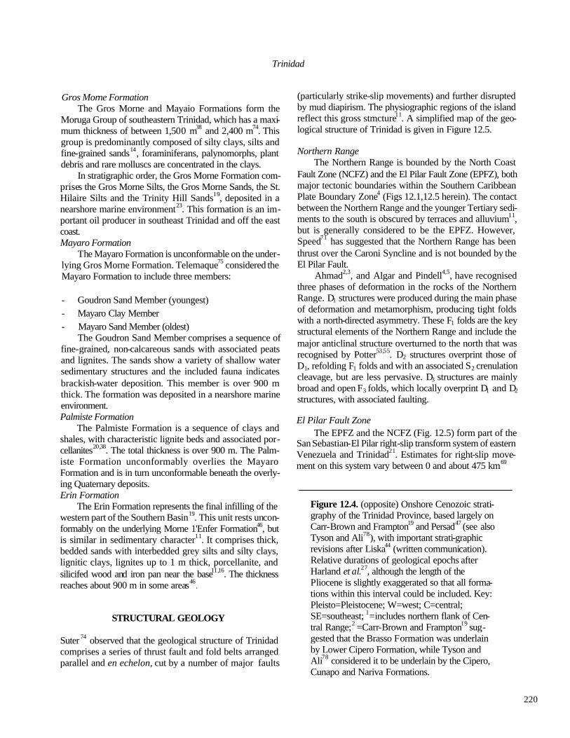
220
Trinidad
Gros Morne Formation The Gros Morne and Mayaio Formations form the
Moruga Group of southeastern Trinidad, which has a maxi-mum thickness of between 1,500 m38 and 2,400 m74. This group is predominantly composed of silty clays, silts and fine-grained sands14, foraminiferans, palynomorphs, plant debris and rare molluscs are concentrated in the clays.
In stratigraphic order, the Gros Morne Formation com-prises the Gros Morne Silts, the Gros Morne Sands, the St. Hilaire Silts and the Trinity Hill Sands19, deposited in a nearshore marine environment23. This formation is an im-portant oil producer in southeast Trinidad and off the east coast. Mayaro Formation
The Mayaro Formation is unconformable on the under-lying Gros Morne Formation. Telemaque75 considered the Mayaro Formation to include three members:
- Goudron Sand Member (youngest) - Mayaro Clay Member - Mayaro Sand Member (oldest)
The Goudron Sand Member comprises a sequence of fine-grained, non-calcareous sands with associated peats and lignites. The sands show a variety of shallow water sedimentary structures and the included fauna indicates brackish-water deposition. This member is over 900 m thick. The formation was deposited in a nearshore marine environment. Palmiste Formation
The Palmiste Formation is a sequence of clays and shales, with characteristic lignite beds and associated por-cellanites20,38. The total thickness is over 900 m. The Palm-iste Formation unconformably overlies the Mayaro Formation and is in turn unconformable beneath the overly-ing Quaternary deposits. Erin Formation
The Erin Formation represents the final infilling of the western part of the Southern Basin19. This unit rests uncon-formably on the underlying Morne 1'Enfer Formation46, but is similar in sedimentary character11. It comprises thick, bedded sands with interbedded grey silts and silty clays, lignitic clays, lignites up to 1 m thick, porcellanite, and silicifed wood and iron pan near the base11,16. The thickness reaches about 900 m in some areas46
.
STRUCTURAL GEOLOGY
Suter 74 observed that the geological structure of Trinidad comprises a series of thrust fault and fold belts arranged parallel and en echelon, cut by a number of major faults
(particularly strike-slip movements) and further disrupted by mud diapirism. The physiographic regions of the island reflect this gross stmcture11. A simplified map of the geo-logical structure of Trinidad is given in Figure 12.5.
Northern Range The Northern Range is bounded by the North Coast
Fault Zone (NCFZ) and the El Pilar Fault Zone (EPFZ), both major tectonic boundaries within the Southern Caribbean Plate Boundary Zone4 (Figs 12.1,12.5 herein). The contact between the Northern Range and the younger Tertiary sedi-ments to the south is obscured by terraces and alluvium11, but is generally considered to be the EPFZ. However, Speed71 has suggested that the Northern Range has been thrust over the Caroni Syncline and is not bounded by the El Pilar Fault.
Ahmad2,3, and Algar and Pindell4,5, have recognised three phases of deformation in the rocks of the Northern Range. D1 structures were produced during the main phase of deformation and metamorphism, producing tight folds with a north-directed asymmetry. These F1 folds are the key structural elements of the Northern Range and include the major anticlinal structure overturned to the north that was recognised by Potter53,55. D2 structures overprint those of D1, refolding F1 folds and with an associated S2 crenulation cleavage, but are less pervasive. D3 structures are mainly broad and open F3 folds, which locally overprint D1 and D2
structures, with associated faulting.
El Pilar Fault Zone The EPFZ and the NCFZ (Fig. 12.5) form part of the
San Sebastian-El Pilar right-slip transform system of eastern Venezuela and Trinidad21. Estimates for right-slip move-ment on this system vary between 0 and about 475 km69
Figure 12.4. (opposite) Onshore Cenozoic strati-graphy of the Trinidad Province, based largely on Carr-Brown and Frampton19 and Persad47 (see also Tyson and Ali78), with important strati-graphic revisions after Liska44 (written communication). Relative durations of geological epochs after Harland et al.27, although the length of the Pliocene is slightly exaggerated so that all forma-tions within this interval could be included. Key: Pleisto=Pleistocene; W=west; C=central; SE=southeast; 1=includes northern flank of Cen-tral Range;2 =Carr-Brown and Frampton19 sug-gested that the Brasso Formation was underlain by Lower Cipero Formation, while Tyson and Ali78 considered it to be underlain by the Cipero, Cunapo and Nariva Formations.

221
STEPHEN K. DONOVAN

222
Trinidad
Figure 12.5. Structural geology of Trinidad (redrawn after Ahmad3). KEY C = upper Cenozoic sediments T = lower to middle Cenozoic sediments K = unmetamorphosed Cretaceous sediments M = metamorphosed Mesozoic sediments CRFZ = Central Range Fault Zone AF = Arima Fault EPFZ = El Pilar Fault Zone CF = Chupara Fault NCFZ = North Coast Fault Zone GRF = Grande Rivtere Fault SCFZ = South Coast Fault Zone
Throughout most of its length in Trinidad and Venezuela, the EPFZ separates contrasting geological terranes80. In Trinidad the EPFZ is considered to occupy a sheared and downfaulted region occupied by synclinal and anticlinal structures south of the ArimaFault3. Robertson et al59. have demonstrated that the EPFZ was an active right-lateral strike-slip system during the Pleistocene. However, geo-physical evidence does not support it being an active seismic zone or strike-slip plate margin in Trinidad at the present day62, despite the evidence for it being an active strike-slip fault zone in Venezuela. Robertson and Burke58,59 have
suggested that the plate boundary zone in the southeast Caribbean may be 250-300 km wide, extending from the Orinoco Delta in the south to Grenada in the north. Relative plate movements may thus be taken up on multiple fault systems and it would thus not be necessary for all faults to be simultaneously active. They have also postulated that strike-slip movements along the NCFZ, the EPFZ, the Central Range Fault Zone and the South Coast Fault Zone have juxtaposed dissimilar stratigraphic sequences in adjacent dep-ositional basins.

223
STEPHEN K. DONOVAN
Trinidad Province
Barr and Saunders11 summarized the geological struc-ture of Trinidad south of the Northern Range as comprising folds with a southwardly-directed asymmetry, that have been overfolded and overthrusted to the south. Middle Mio-cene tectonic movements separated the Northern and South-ern Basins by the barrier of the Central Range79.
Northern Basin The principal structural feature of the Northern Basin
is the Caroni Syncline (Fig. 12.5), which comprises gentle folds apparently not affected by major thrust faults3. Sub-sidiary anticline structures interrupt the southern flank11, with dips reaching up to 45° towards the Central Range.
Central Range The structure of the Central Range was summarised by
Suter 74 as having a simple northern flank, a complexly faulted core and a southern flank which overthrusts to the south37. In the east there is a sharp unconformity between the Cretaceous plus older Tertiary and the younger Tertiary, although the pre-Tertiary core is lacking in the west11. Folding of these sediments may be related to movement on the Central Range Fault Zone (Fig. 12.5), which shows both strike-slip and thrust movements. The core of the Central Range has been thrust southwards74.
Immediately south of the Central Range proper is the Naparima Thrust and Fold Belt, a sequence of stronglv folded and faulted Tertiary sediments about 6-10 km wide11. Folds are clustered, narrow and elongate, often overturned towards the south and with limbs imbricately underthrust74. Structures are discontinuous, except for a series of south-wardly overthrust anticlines.
Southern Basin and Southern Range Structural styles south of the Central Range are defined
by thrust faults (frequently associated with folds), clay diapir anticlines and associated mud volcanism, with an overall southwardly-directed asymmetry3.
The Siparia-Ortoire Syncline is the major structural component of the Southern Basin11, and it is within the folded and faulted sediments of this basin that Trinidad's major oil fields are developed. The Fairylands Fold Zone, to the north of the Los Bajos Fault in the southwest penin-sula, is an oil-producing region of shallow structures, par-ticularly asymmetrical anticlines, developed in Neogene sediments74.
The Los Bajos Fault is a major vertical, right lateral strike-slip fault which runs approximately eastsoutheast-westnorthwest across the southwest peninsula of Trinidad and cuts across the Siparia-Ortoire Syncline3,11,77. Move-ment on this fault occurred between the early Pliocene and
Pleistocene65, producing associated shallow-rooted folds which are major petroleum traps. Displacement on the fault is about 10 km85 . Tyson77 recognised both transtensional and transpressional effects in regions where the fault di-verged from its general trend of 113° from north, producing graben and anticlinal structures, respectively.
To the south, the Southern Range Anticline is com-posed of a discontinuous line of anticlinal folds, thrust faulted and deformed by mud diapirs11,74. These anticlines strike out to sea at Erin Bay on the south coast of the southwest peninsula and sometimes receive surface expres-sion as ephemeral mud islands28. Mud diapir anticlines are elongate and narrow, ruptured at the crest of the uplift by parallel strike faults or diapiric core faults74. The ejecta from mud volcanoes and flows form a variety of geomorphic features. For general discussions of mud volcanism in south-ern Trinidad, see Higgins and Saunders28, Kugler41 and Kerr et al.34, amongst others.
The La Brea pitch lake is situated on the southwest peninsula of Trinidad and represents an unusual type of diapirism. It had an original area, before exploitation, of about 0.5 sq km6. The asphalt of the lake comprises 40% bitumen, 30% mineral matter and 30% free water plus gas, which Kugler39 interpreted as a mixture of Nariva Forma-tion sediments thickened by asphaltic oil. The lake is not bowl-shaped, but irregular22, varying in depth from 20 m in the centre to 1 km in the west. Two intersecting faults act as conduits for the asphalt.
GEOLOGICAL HISTORY
Wielchowsky et al.84 and Persad48 have determined a framework for the geological evolution of Trinidad, based on sedimentary and tectonic evidence, in which four phases of development are recognised.
Middle Jurassic to late Cretaceous: rift/passive margin phase
This phase was related to the formation of the proto-Caribbean oceanic crust, following the Mesozoic separation of the North and South American Plates18,50. Subsequent to this rifting episode, northern South America was a passive margin, with shelf sedimentation of shales and carbonates, a shelf-edge carbonate platform and turbidites in deeper water to the north48. A source to the south or southwest provided sediment for basins in central and southern Trini-dad84. There is stratigraphic and structural continuity be-tween rock sequences of this age in Venezuela and Trinidad. These terrenes south of the EPFZ may be parautochthonous, whereas terranes north of the EPFZ are almost certainly allochthonous, having been transported tectonically. Speed

224
Trinidad
and Poland72 considered that these rocks of the Northern Range are the deeper succession of a complex sedimentary sequence, deposited in deep water marine environments in the Mesozoic and ?Paleogene as turbidites and hemipelagic sediments on oceanic crust.
Latest Cretaceous to mid-early Miocene: episodic transpressional phase
Deformation during this interval in Trinidad followed two structural styles84:
(A) strike-slip and oblique subduction of continental and/or oceanic lithosphere to the north, and probably involving basement; and
(B) 'thin-skinned' thrusting and folding to the south.
Uplift and erosion to the north led to the deposition of clastic sequences in foreland troughs.
Mid-early Miocene to late middle Miocene: extensional phase
Extension was probably related to large-scale transten-sional forces as Trinidad and the Lesser Antilles Arc moved past each other, resulting in the formation of the Northern Basin.
Late middle Miocene to present: transpressional phase Local transtension emplaced and uplifted the regionally
metamorphosed rocks of the Northern Range, inverting the southern edge of the Caroni Syncline, and shortening un-metamorphosed sedimentary sequences of Lower Creta-ceous to Miocene rocks in central and southern Trinidad79,84. The newly-formed Northern and Southern Basins were separated by the Central Range, a region of erosion, with sediment being shed into the Southern Basin, and subsequent biohermal growth. The end Miocene shal-lowing of the Southern Basin was due to infilling by deltaic sediments derived from South America The sedimentary source for the infilling of the Northern and Southern Basins may have been the proto-Orinoco45 or proto-Essequibo73
Rivers.
ACKNOWLEDGEMENTS—I thank the Geological Society, London, and Dr. A.W. Snoke for granting permission to reproduce Figure 12.1. Field-work in Trinidad was supported by grants from the Geologists' Association (G.W. Young Fund and Curry Fund) and the Geological Society of Trinidad and Tobago, which I gratefully acknowledge. I thank Kirton Rodrigues and particularly Bob Li ska for their valuable review comments on this paper.
REFERENCES
1Ager, D.V. 1981. The nature of the stratigraphic record (2nd edition). Macmillan, London, xiv+122 pp.
2 Ahmad, R. 1988. Kinematic history of the Northern Range, Trinidad. Abstracts, Recent Advances in Caribbean Geology, Kingston, Jamaica, 18th-20th November, 1-2.
3 Ahmad, R. 1991. Structural styles in Trinidad: in Gillezeau, K. A. (ed.), Transactions of the Second Geological Con-ference of the Geological Society of Trinidad and To-bago, Port-of- Spain, Trinidad, April 3-8, 1990, 244-265.
4Algar, S.T. & Pindell, J.L. 199la. Structural development of the Northern Range of Trinidad, and implications for the tectonic evolution of the southeastern Caribbean: in Gillezeau, K. A. (ed.), Transactions of the Second Geo-logical Conference of the Geological Society of Trinidad and Tobago, Port-of-Spain, Trinidad, April 3-8, 1990, 6-22.
5Algar, S.T. & Pindell, J.L. 1991b. Stratigraphy and sedi-mentology of the Toco region of the Northern Range, N.E. Trinidad: in Gillezeau, K. A. (ed.), Transactions of the Second Geological Conference of the Geological Society of Trinidad and Tobago, Port-of-Spain, Trinidad, April 3-8, 1990, 56-69.
6Barker, M.H.S. & Roberts, K.H. 1968. Excursion 6A south Trinidad: in Saunders, J.B. (ed.), Transactions of the Fourth Caribbean Geological Conference, Port-of-Spain, Trinidad, 28th March-12th April, 1965, 438-441.
7Barr, K.W. 1952. Limes tone blocks in the Lower Cretaceous Cuche Formation of the Central Range, Trinidad, B.W.I. Geological Magazine, 89, 417-425.
8Barr, K.W. 1966. A cross-section through the Northern Range of Trinidad: in Robinson, E. (ed.), Transactions of the Third Caribbean Geological Conference, Kingston, Jamaica, 2nd-llthApril, 1962, 27-33. Geological Survey Department, Kingston.
9Barr, K.W. 1968. Excursion no. 2 eastern Northern Range and Toco district: in Saunders, J.B. (ed.), Transactions of the Fourth Caribbean Geological Conference, Port-of-Spain, Trinidad, 28th March-12th April,1965, 430-432.
10Barr, K.W. 1985. Graded bedding and associated phe-nomena in the Northern Range of Trinidad: in Trans-actions of the Fourth Latin American Geological Conference, Port-of-Spain, Trinidad, 7th-15th July, 1979,1,117-135.
11Barr, K.W. & Saunders, J.B. 1968. An outline of the geology of Trinidad: in Saunders, J.B. (ed.), Transac-tions of the Fourth Caribbean Geological Conference, Port-of-Spain, Trinidad, 28th March-12th April, 1965,

225
STEPHEN K. DONOVAN
1-10. 12Bartenstein, H., Bettenstaedt, F. & Belli, H.M. 1957. Die
Foraminiferan der Unterkreide von Trinidad, B.W.I. Erster Teil: Cuche- and Toco-Formation. Eclogae Geologicae Helvetiae, 50, 5-67.
13Bartenstein, H., Bettenstaedt, F. & Bolli, H.M. 1966. Die Foraminiferen der Unterkreide von Trinidad, W.I. Zweiter Teil: Maridale-Formation (Typlokalitat). Eclogae Geologicae Helvetiae, 59, 129-178.
14Batjes, D.A.J. 1968. Palaeoecology of foraminiferal as-semblages in the late Miocene Cruse and Forest Forma-tions of Trinidad, Antilles: in Saunders, J.B. (ed.), Transactions of the Fourth Caribbean Geological Con-ference, Port-of-Spain, Trinidad, 28th March-12th April, 1965, 141-156.
15Bertrand, W.G. 1985. Geology of the Point Fortin Field: in Transactions of the Fourth Latin American Geologi-cal Conference, Port-of-Spain, Trinidad, 7th-15th July, 1979,2, 690-699.
16Bower, T.H. & Hunter, V.F. 1968. Geology of Texaco Forest Reserve Field, Trinidad, W.I.: in Saunders, J.B. (ed.), Transactions of the Fourth Caribbean Geologi-cal Conference, Port -of-Spain, Trinidad, 28th March-nth April, 1965,75-86.
17Bray, R. & Eva, A. 1989. Age, depsoitional environment, and tectonic significance of the Couva marine eva-porite, offshore Trinidad: in Duque-Caro, H. (ed.), Transactions of the Tenth Caribbean Geological Con-ference, Cartagena de Indias, Columbia, 14th-22nd August, 1983, p. 372. INGEOMINAS, Bogota.
18Burke, K., Cooper, C., Dewey, J.F., Mann, P. & Pindell, J.L. 1984. Caribbean tectonics and relative plate mo-tions. Geological Society of America Memoir, 162, 31-63.
19Carr-Brown, B. & Frampton, J. 1979. An outline of the stratigraphy of Trinidad. Field Guide, Fourth Latin American Geological Conference, Port-of-Spain, Trinidad, 7th-15th July, 12pp.
20Carr-Brown, B. & Young-On, V. 1990. Age and strati-graphic status of the Palmiste Formation, Trinidad, West Indies: in Larue, D.K. & Draper, G. (eds), Trans-actions of the Twelth Caribbean Geological Confer-ence, St. Croix, U.S. Virgin Islands, 7th-llth August, 1989, p. 534. Miami Geological Society, Florida.
21Case, I.E., Holcombe, T.L. & Martin, R.G. 1984. Map of geologic provinces in the Caribbean region. Geological Society of America Memoir, 162, 1-30.
22Chaitan, W.B. & Graterol, V.R. 1991. A gravity investi-gation of the pitch lake of Trinidad and Tobago: in Gillezeau, K. A. (ed.), Transactions of the Second Geo-logical Conference of the Geological Society of Trini-dad and Tobago, Port-of- Spain, Trinidad, April 3-8,
1990, 49.
23Farfan, P. & Bally, K. 1991. An outline of the geology of the Samaan Field, Trinidad West Indies: in Gillezeau, K.A. (ed.), Transactions of the Second Geological Con-ference of the Geological Society of Trinidad and To-bago, Port-of- Spain, Trinidad, April 3-8, 1990, 139-156.
24Frey, M., Saunders, J. & Schwander, H. 1988. The min-eralogy and metamorphic geology of low-grade me-tasediments, Northern Range, Trinidad. Journal of the Geological Society, London, 145, 563-575.
25Frost, C.D. & Snoke, A.W. 1989. Tobago, West Indies, a fragment of a Mesozoic oceanic island arc: petrochemi-cal evidence. Journal of the Geological Society, Lon-don, 146, 953-964.
26Furrer, M.A. 1968. Paleontology of some limestones and calcphyllites of the Northern Range of Trinidad, West Indies: in Saunders, J.B. (ed.), Transactions of the Fourth Caribbean Geological Conference, Port-of-Spain, Trinidad, 28th March-12th April, 1965,21-24.
27Harland, W.B., Armstrong, R.L., Cox, A.V., Craig, L.E., Smith, A.G. & Smith, D.G. 1990. A geologic time scale 1989. Cambridge University Press, Cambridge, xvi+263 pp.
28Higgins, G.E. & Saunders, J.B. 1967. Report on the 1964 Chatham Mud Island, Erin Bay, Trinidad, West Indies. American Association of Petroleum Geologists Bulle-tin, 51,55-64.
29Higgins, G.E. & Saunders, J.B. 1968. Excursion no. 4 western Central Range: in Saunders, J.B. (ed.), Trans-actions of the Fourth Caribbean Geological Confer-ence, Port-of-Spain, Trinidad, 28th March-12th April, 1965,435-437.
30Hosein, F. 1990. Exploitation of the Middle Miocene oil bearing intermediate Herrera Sandstone reservoirs in Trinidad, West Indies: in Larue, D.K. & Draper, G. (eds), Transactions of the Twelth Caribbean Geologi-cal Conference, St. Croix, U.S. Virgin Islands, 7th-llth August, 1989, 430-443. Miami Geological Society, Florida.
31Imlay, R.W. 1954. Barremian ammonites from Trinidad, British West Indies. Journal of Paleontology, 28,662-667.
32Jackson, T.A., Smith, T.E. & Duke, M.J.M. 1991. The geochemistry of ametavolcanic horizon in the Maracas Formation, Northern Range, Trinidad: evidence of ocean floor basalt activity: in Gillezeau, K.A. (ed.), Transactions of the Second Geological Conference of the Geological Society of Trinidad and Tobago, Port-of-Spain, Trinidad, April 3-8, 1990, 42-41.
33Jones, H.P. 1968. The geology of the Herrera Sands in the Moruga West Oilfield of south Trinidad: in Saunders,

226
Trinidad
J.B. (ed.), Transactions of the Fourth Caribbean Geological Conference, Port-of-Spain, Trinidad, 28th Marcel2th April 1965, 91-100.
34Kerr, P.P., Drew, I.M. & Richardson, D.S. 1970. Mud volcano clay, Trinidad, West Indies. American Asso-ciation of Petroleum Geologists Bulletin, 54, 2101-2110.
35Kirmani, K.U. 1985. Geology of the Inniss, Catshill and BalataEast Oilfields in Trinidad, West Indies: in Trans-actions of the Fourth Latin American Geological Con-ference, Port -of-Spain, Trinidad, 7th-15th July, 1979, 2,700-713.
36Kuarsingh, H.B. 1990. The sedimentology and patrology [sic] of the Herrera Sandstones of Trinidad W.I.: in Lame, D.K. & Draper, G. (eds), Transactions of the Twelth Caribbean Geological Conference, St. Croix, U.S. Virgin Islands, 7th-llth August, 1989, p. 551. Miami Geological Society, Florida.
37Kugler, H.G. 1953. Jurassic to Recent sedimentary envi-ronments of Trinidad. Vereinigung Schweizerische Pe-troleum-Geologie und Ingenier Bulletin, 20 (59), 27-60.
38Kugler, H.G. 1956a. Trinidad—La Trinite with a map: in Beckmann et aL, Lexique Stratigraphique Interna-tional, Amerique Latine, Fascicule 2b, Antilles, 41-116, 1 pl. CNRS, Paris.
39Kugler, H.G. 1956b. Trinidad. Geological Society of America Memoir, 65,351-365,1 pl.
40Kugler, H.G. 1961. Geological map of Trinidad, scale 1:100,000. Petroleum Association of Trinidad.
41Kugler, H.G. 1968. Sedimentary volcanism: in Saunders, J.B. (ed.), Transactions of the Fourth Caribbean Geological Conference, Port-of-Spain, Trinidad, 28th March-12th April, 1965,11-13.
42Liska, R.D. 1987. The Cipero and LenguaFormations and the middle late Miocene boundary: in Duque-Caro, H. (ed.), Transactions of the Tenth/Caribbean Geological Conference, Cartagena de Indias, Columbia, 14th-22ndAugust, 1983, 204-209. INGEOMINAS, Bogota.
43Liska, R.D. 1988. The Rio Claro Boulder Bed of central Trinidad, a sedimentary or tectonic event: in Barker, L. (ed.), Transactions of the Eleventh Caribbean Geologi-cal Conference, Dover Beach, Barbados, 20th-25th July, 1986,12.1-12.7.
44Liska, R.D. 1991. The history, age and significance of the Globorotalia menardii Zone in Trinidad and Tobago, West Indies. Micropaleontology, 37, 173-182.
45Michelson, J.E. 1976. Miocene deltaic oil habitat, Trini-dad. American Association of Petroleum Geologists Bulletin, 60, 1502-1519.
46Nath, M. 1985. Production geology of the Coora/Quany Field: in Transactions of the Fourth Latin American
Geological Conference, Port-of-Spain, Trinidad, 7th-15th July, 1979,2, 726-737.
47Persad, K.M. 1985. Outline of the geology of the Trinidad area: in Transactions of the Fourth Latin American Geological Conference, Port-of-Spain, Trinidad, 7th-15th July, 7979,2,738-758.
48Persad, K.M. 1988. Tectonosedimentary evolution of Trinidad and Tobago. Abstracts, Recent Advances in Caribbean Geology, Kingston, Jamaica, 18th-20th November, 20-21.
49Persad, K.M. 1989. 1990 Trinidad and Tobago petroleum consultants encyclopedia. Petroleum Consultants Trinidad Limited.
50Pindell, J.L. & Barrett, S.F. 1990. Geological evolution of the Caribbean region; a plate-tectonic perspective: in Dengo, G. & Case, J.E. (eds), The geology of North America, Volume H, The Caribbean region, 405-432. Geological Society of America, Boulder.
51Poole, W.G. 1968. Some sedimentary features of the Herrera Sands of the Clarke Road area, Barrackpore Oilfield; Trinidad, West Indies: in Saunders, J.B. (ed.), Transactions of the Fourth Caribbean Geological Con-ference, Port-of- Spain, Trinidad, 28th March-12th April, 1965,101-109.
52Potter, H.C. 1968. A preliminary account of the stratigra-phy and structure of the eastern part of the Northern Range, Trinidad: in Saunders, J.B. (ed.), Transactions of the Fourth Caribbean Geological Conference, Port -of-Spain, Trinidad, 28th March-12th April, 1965, 15-20.
53Potter, H.C. 1973. The overturned anticline of the North-ern Range of Trinidad near Port of Spain. Journal of the Geological Society, London, 129, 133-138.
54Potter, H.C. 1976. Type sections of the Maraval, Maracas and Chancellor Formations in the Caribbean Group of the Northern Range of Trinidad: in Cauusse, R. (ed.), Transactions of the Seventh Caribbean Geological Conference, Guadeloupe, 30th June-12th July, 1974, 505-527. B.R.G.M., Orleans.
55Potter, H.C. 1985. The geology of the central part of the Northern Range, Trinidad: in Transactions of the Fourth Latin American Geological Conference, Port-of-Spain, Trinidad, 7th-15th July, 1979, 1, 102-105.
56Radovsky, B. & Iqbal, J. 1985. Geology of the North Soldado Field: in Transactions of the Fourth Latin American Geological Conference, Port-of-Spain, Trinidad, 7th-15thJuly, 7979,2, 759-769.
57Rambarran, H. 1985. Geology of the Parrylands Field: in Transactions of the Fourth Latin American Geological Conference, Port-of-Spain, Trinidad, 7th-15th July, 1979,2, 770-780.
58Robertson, P. & Burke, K. 1989. Evolution of southern

227
STEPHEN K. DONOVAN Caribbean plate boundary. American Association of Petroleum Geologists Bulletin, 73, 490-509.
59Robertson, P., Burke, K. & Wadge, G. 1986. Structure of the Melajo Clay near Arima, Trinidad and strike-slip motion in the El Pilar Fault Zone: in Rodrigues,K.(ed.), Transactions of the First Geological Conference of the Geological Society of Trinidad and Tobago, Port-of-Spain, Trinidad, 10th-12th July, 1985, 21-33.
60Rodrigues, K. 1988. Petroleum source rock evaluation of the Tertiary of Trinidad: in Barker, L. (ed.), Transac-tions of the Eleventh Caribbean Geological Confer-ence, Dover Beach, Barbados, 20th-26th July, 1986, 38.1-38.16.
61Rohr, G.M. 1991. Exploration potential of Trinidad and Tobago. Journal of Petroleum Geology, 14, 343-354.
62Rowley, K. & Ambeh, W. 1991. The case of the El Pilar Fault system in Trinidad and its implications for seis-mic hazard in the S.E. Caribbean: in Gillezeau, K.A. (ed.), Transactions of the Second Geological Confer-ence of the Geological Society of Trinidad and Tobago, Port-of-Spain, Trinidad, April 3-8, 1990, 106.
63Saunders, J.B. 1968. Excursion no. 1 Manzamlla coast: in Saunders, J.B. (ed.), Transactions of the Fourth Carib-bean Geological Conference, Port-of-Spain, Trinidad, 28th March- 12th April, 1965, 427-429.
64Saunders, J.B. 1972. Recent paleontological results from the Northern Range of Trinidad: in Petzall, C. (ed.), Transactions of the Sixth Caribbean Geological Con-ference, Maragarita, Venezuela, 6th-14th July, 1971, 455-460.
65Saunders, J.B. 1974. Trinidad: in Spencer, A.M. (ed.), Mesozoic-Cerrozoic orogenic belts: data for orogenic studies. Special Publication of the Geological Society, London, 4, 671-682. [Not seen.]
66Saunders, J.B. 1977. Slumping phenomena and olis-tostromes in the Tertiary geologic history of Trinidad. GUA Papers on Geology, series 1, no. 9, p. 171.
67Saunders, J.B. & Bolli, H.M. 1985. Trinidad's contribu-tion to world biostratigraphy: in Transactions of the Fourth Latin American Geological Conference, Port-of-Spain, Trinidad, 7th-15th July,1979, 2, 781-795.
68Saunders, J.B. & Kennedy, J.E. 1968. Sedimentology of a section in the Upper Morne 1'Enfer Formation, Guapo Bay, Trinidad: in Saunders, J.B. (ed.), Transactions of the Fourth Caribbean Geological Conference, Port-of-Spain, Trinidad, 28th March-12th April, 1965, 121-140.
69Schubert,C. 1979. El Pilar Fault Zone, northeastern Vene-zuela: brief review. Tectonophysics, 52, 447-455.
70Spath, L.F. 1939. On some Tithonian ammonites from the Northern Range of Trinidad. Geological Magazine, 76, 187-189.
71Speed, RC. 1987. South American-Antfllean Arc collision
and the El Pilar Fault: in Duque-Caro, H. (ed.), Transactions of the Tenth Caribbean Geological Con-ference, Cartagena de Indias, Columbia, 14th-22nd August, 1983, p. 170. INGEOMINAS, Bogota.
72Speed, R.C. & Poland, K.A. 1990. Miocene metamor-phism and Neogene tectonics of Northern Range rocks. Abstracts, Second Geological Conference of the Geo-logical Society of Trinidad and Tobago, Port of Spain, Trinidad, 2nd-8th April, 19??, 19-20.
73Stainforth, R.M. 1978. Was it the Orinoco? American Association ofPetroleum Geologists Bulletin, 62, 303-306.
74Suter, H.H. 1960. The general and economic geology of Trinidad, B. W.I., 2nd edition, with revisionary appendix by G.E. Higgins. HMSO, London, 145 pp.
75Telemaque, C.P. 1990. An evaluation of the geological history and hydrocarbon potential of the late Miocene-?Plio/Pleistocene sediments of the Goudron Field -Trinidad: in Lame, D.K. & Draper, G. (eds), Transac-tions of the Twelth Caribbean Geological Conference, St. Croix, U.S. Virgin Islands, 7th-llth August, 1989, 415-429. Miami Geological Society, Florida.
76Trechmann, C.T. 1935. Fossils from the Northern Range of Trinidad. Geological Magazine, 72, 166-175.
77Tyson, L. 1990. Structural features associated with the Los Bajos Fault and their interpretation in the light of current theories of strike-slip tectonics: in Larue, D.K. & Draper, G. (eds), Transactions of the Twelth Caribbean Geological Conference, St. Croix, U.S. Virgin Islands, 7th-11th August, 1989,403-414. Miami Geological Society, Florida.
78Tyson, L. & Ali, W. 1991. Cretaceous to Middle Miocene sediments in Trinidad: in Gillezeau, K. A. (ed.), Trans-actions of the Second Geological Conference of the Geological Society of Trinidad and Tobago, Port-of-Spain, Trinidad, April 3-8, 1990, 266-277.
79Tyson, L., Babb, S. & Dyer, B. 1991. Middle Miocene tectonics and its effects on late Miocene sedimentation in the Trinidad: in Gillezeau, K.A. (ed.), Transactions of the Second Geological Conference of the Geological Society of Trinidad and Tobago, Port-of-Spain, Trinidad, April 3-8, 1990, 26-40.
80Vierbuchen, R. 1977. New data relevant to the tectonic history of the El Pilar Fault. GUA Papers on Geology, series 1, no. 9, 213-214.
81Wadge, G. & Macdonald, R 1985. Cretaceous tholeiites of the northern continental margin of South America: the Sans Souci Formation of Trinidad. Journal of the Geological Society, London, 142, 297-308.
82Wall, G.P. & Sawkins, J.G. 1860. Report on the geology of Trinidad. Memoir of the Geological Survey, 211 pp.

228
Trinidad
[Not seen.]
83Wharton, S., Dupigny, A. & Keens-Dumas, J. 1986. A preliminary investigation of the Brigand Hill Lime-stone, Brigand Hill Quarry, Plum Milan Road: in Ro drigues, K. (ed), Transactions of the First Geological Conference of the Geological Society of Trinidad and Tobago, Port-of-Spain, Trinidad, 10th-12th July, 1985, 102-113.
84Wielchowsky, C.C., Rahmanian, V.D. & Hardenbol, J.
1991. A preliminary tectonostratigraphic framework for onshore Trinidad: in Gillezeau, K.A. (ed.), Trans-actions of the Second Geological Conference of the Geological Society of Trinidad and Tobago, Port-of-Spain, Trinidad, April 3-8,1990, 41.
85Wilson, C.C. 1968. The Los Bajos Fault: in Saunders, J.B. (ed.), Transactions of the Fourth Caribbean Geological Conference, Port-of-Spain, Trinidad, 28th March-12th April, 1965, 87-89.

229
Caribbean Geology: An Introduction U.W.I. Publishers' Association, Kingston
© 1994 The Authors
CHAPTER 13
Northern South America
STEPHEN K. DONOVAN
Department of Geology, University of the West Indies, Mona, Kingston 7, Jamaica
INTRODUCTION
THE SOUTHERN Caribbean Plate Boundary Zone (SCPBZ) comprises many independently moving blocks and associated basins, and has a total width of circa 250 km, at least in the southeastern Caribbean70. The SCPBZ in-cludes Trinidad (see Donovan, chapter 12, this volume), northern Venezuela and northern Colombia (Fig. 13.1). The present chapter considers the principal geological and physiographic provinces within continental northern South America that are associated with the SCPBZ. The interpre-tation of this zone used herein is broad and includes discus-sion of the Precambrian of the Guyana Shield, that forms the stable craton upon which many of the basins developed and with which the deformed terranes collided.
This chapter concentrates on the onshore geology of northern South America, with the exception of the South Caribbean Deformed Belt, which occurs both onshore and (mainly) offshore. Discussion of the offshore geology will be found in contributions on the Caribbean sea floor (Don-nelly, Chapter 3, this volume), and the Netherlands and Venezuelan Antilles (Jackson and Robinson, Chapter 14, this volume). Because the present volume is directed at an English-speaking audience, I have referred to published papers in that language. For relevant publications in Span-ish, the reader is directed to the comprehensive bibliog-raphies in Case et al.18,20. Further, many facts and interpretations are quoted from review papers, rather than primary sources, as the former are often of the greatest utility to the general reader.
STRATIGRAPHY AND STRUCTURE: GUYANA SHIELD
The following brief introduction to the Guyana Shield is based mainly on Read and Watson69, and, particularly,
Gibbs and Barron31. The Guyana and Brazilian Shields are major South
American plateaux regions separated by the intracratonic Amazon Basin. In the Guyana Shield older metamorphic complexes of Archean and early Proterozoic age are over-lain by the Roraima Group, comprising relatively unde-formed clastic sedimentary rocks of middle Proterozoic age. Older rocks yield abundant evidence of metamorphism, deformation and granite intrusion associated with a Trans-Amazonian orogeny about 2000 Ma22,31. The Guyana Shield extends through the three Guyanas (British [=Guy-ana], Dutch [=Suriname] and French) into Venezuela, Co-lombia and Brazil (Fig. 13.1). The highest point of the plateau is Mount Roraima (2810 m), famous as "The Lost World” of Sir Arthur Conan Doyle's novel. A detailed geological map of the Guyana Shield appeared in Gibbs and Barron31.
Archean Imataca Complex The Imataca Complex in eastern Venezuela includes
the oldest rocks of the Guyana Shield, yielding radiometric dates of 3400 to 3700 Ma for the protolith60,61 and comprising quartz-feldspar gneisses associated with granulites and with localised migmatisation. The principal metamorphic event that affected this complex was the Trans-Amazonian orogeny. The parent rocks of the Imataca Complex were mainly calc -alkaline rocks of continental origin. Other li-thologies include intermediate granulites, mafic gneisses, metasedimentary gneisses, iron formations38,39, ultramafic gneisses, dolomitic marbles and anorthosites31. Granites are present in areas of lower metamorphic grade, at least some of which were the product of the Trans-Amazonian orogeny. The Guri Fault to the south separates the Imataca Complex from the rest of the Guyana Shield18.

230
STEPHEN K. DONOVAN
Figure 13.1. The main geological elements of northern South America (after Harrington34, fig. 1; Read and Wat-son69, fig. 9.1; Gibbs and Barron31, fig. 2). Key: AMB=Andean Mobile Belt; CMB=Caribbean Mobile Belt; GS=Guyana Shield; LB=Llanos Pericratonic Basins (Phanerozoic foreland deposits of Andes).
Early Proterozoic granite-greenstone-gneiss belts
Greenstone belts dated at about 2250 Ma occur in the north and east of the shield. It is this early Proterozoic protolith that gives radiometric ages dating Trans-Ama-zonian metamorphism. These greenstone belts comprise metamorphosed basalts, andesites, dacites and rhyolites, with metagreywackes, phyllites, metaconglomerates, meta-morphosed manganiferous and ferruginous sedimentary rocks, cherts and carbonates 31. Pillow lavas and turbidites indicate accumulation in a submarine environment. The stratigraphic thickness of the Pastora greens tone belt in Guyana is about 8-10 km, with metamorphosed mafic to felsic volcanics succeeded by metasedimentary rocks. The metamorphic facies varies from sub-greenschist in the centre of the belt to amphibolite, produced by thermal metamorphism, near the contact with the Supamo granite18.
The Ile de Cayenne Series in French Guyana is a Trans-Amazonian metamorphic complex comprised of me-dium to high metamorphic grade supracrustals, including migmatised and granitised metasedimentary rocks of granulite facies invaded by granitic intrusions. The dominant fold trends are northeast-southwest and east-west.
Middle Proterozoic The Middle Proterozoic was a time of continental sedi-
mentation and magmatism. From 1900 to 1500 Ma conti-nental sedimentary and volcanic rocks with associated granites were formed in the central and western part of the shield. These Middle Proterozoic platform cover sequences
do not extend far into the outcrop area of the greenstone belts and rest unconformably on the Trans-Amazonian succession. Calc -alkaline to alkaline felsic igneous rocks were erupted in several episodes in the Middle Proterozoic, with mafic dykes and sills intruded between 1700 and 1500 Ma. Middle Proterozoic platform cover sequences are undeformed or only locally deformed in association with block faulting and intrusion.
The flat-lying Roraima Group covers an area of 1000 km by 600 km, contains at least a million cubic kilometres of sediment29, and forms flat tablelands with precipitous scarps in Venezuela, Guyana and Brazil. The formation includes up to 3700 m of pink and red sandstones, sometimes current bedded, with associated jasperoid tuffs, conglomerates, siltstones and shales18. A basal conglomerate is well-exposed in Brazil. Clastics are arkosic and include detrital diamonds. The environments of deposition were fluvio-deltaic to lacustrine31,40. The lowest horizons overlie rhyolitic volcanics in the Guyanas. Basic sills and dykes have intruded the formation, and sheets of gabbro and orthonorite reach hundreds of metres in thickness. This intrusion produced doming and gentle folding. Jasperoid tuffs have given radiometric dates of 1730 to 1650 Ma. Dolerite intrusions have given radiometric ages of 1600 to 1800 Ma18,68. The source of the sediments appears to have been the Saharan Shield (Fig. 13.2).
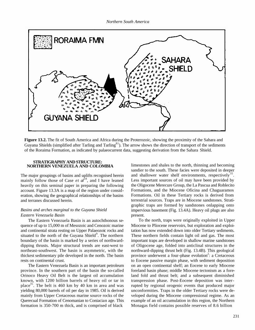
231
Northern South America
Figure 13.2. The fit of South America and Africa during the Proterozoic, showing the proximity of the Sahara and Guyana Shields (simplified after Tarling and Tarling81). The arrow shows the direction of transport of the sediments of the Roraima Formation, as indicated by palaeocurrent data, suggesting derivation from the Sahara Shield.
STRATIGRAPHY AND STRUCTURE:
NORTHERN VENEZUELA AND COLOMBIA
The major groupings of basins and uplifts recognised herein mainly follow those of Case et al18, and I have leaned heavily on this seminal paper in preparing the following account. Figure 13.3A is a map of the region under consid-eration, showing the geographical relationships of the basins and terranes discussed herein.
Basins and arches marginal to the Guyana Shield Eastern Venezuela Basin
The Eastern Venezuela Basin is an autochthonous se-quence of up to 15,000 m of Mesozoic and Cenozoic marine and continental strata resting on Upper Palaeozoic rocks and situated to the north of the Guyana Shield9. The northern boundary of the basin is marked by a series of northward-dipping thrusts. Major structural trends are east-west to northeast-southwest. The basin is asymmetric, with the thickest sedimentary pile developed in the north. The basin rests on continental crust.
The Eastern Venezuela Basin is an important petroleum province. In the southern part of the basin the so-called Orinoco Heavy Oil Belt is the largest oil accumulation known, with 1200 billion barrels of heavy oil or tar in place35. The belt is 460 km by 40 km in area and was yielding 80,000 barrels of oil per day in 1985. Oil is derived mainly from Upper Cretaceous marine source rocks of the Querecual Formation of Cenomanian to Coniacian age. This formation is 350-700 m thick, and is comprised of black
limestones and shales to the north, thinning and becoming sandier to the south. These facies were deposited in deeper and shallower water shelf environments, respectively35. Less important sources of oil may have been provided by the Oligocene Merecure Group, the La Pascua and Roblecito Formations, and the Miocene Oficina and Chaguaramos Formations. Oil in these Tertiary rocks is derived from terrestrial sources. Traps are in Miocene sandstones. Strati-graphic traps are formed by sandstones onlapping onto impervious basement (Fig. 13.4A). Heavy oil plugs are also present.
To the north, traps were originally exploited in Upper Miocene to Pliocene reservoirs, but exploration and exploi-tation has now extended down into older Tertiary sediments. These northern fields contain light oil and gas. The most important traps are developed in shallow marine sandstones of Oligocene age, folded into anticlinal structures in the northward-dipping thrust belt (Fig. 13.4B). This geological province underwent a four-phase evolution2: a Cretaceous to Eocene passive margin phase, with sediment deposition on an open continental shelf; an Eocene to early Miocene foreland basin phase; middle Miocene tectonism as a fore-land fold and thrust belt; and a subsequent diminished transpression phase. Post-Eocene deposition was inter-rupted by regional orogenic events that produced major unconformities. Traps in the older Tertiary rocks were de-veloped during the Miocene compressional regime. As an example of an oil accumulation in this region, the Northern Monagas field contains possible reserves of 8.6 billion

232
STEPHEN K. DONOVAN

233
Northern South America
barrels trapped in Eocene and Oligocene reservoir sand-stones2. El Baul Swell
The El Baul Swell (or Arch or High) is a northwest-southeast trending uplift which separates the Eastern Vene-zuelan and Barinas-Apure Basins. The El Baul Swell has a core of deformed, slightly metamorphosed Cambro-Ordo-vician shales50 unconformably overlain by faulted Permian or Triassic felsic volcanic rocks. Alkaline plutons of possi-bly Palaeozoic antiquity are overlain by Cretaceous and Tertiary strata. This horst forms part of the stable South American craton. Barinas-Apure Basin
The Barinas-Apure Basin in southwest Venezuela is a sub-Andean basin, southeast of and parallel to the Cordillera de Merida, or Venezuelan Andes. The Guyana Shield forms the basement. Locally, Palaeozoic sequences are developed, overlain by up to 4.5 km of mainly marine clastic sedimen-tary rocks of Cretaceous age and up to 5 km of Cenozoic sedimentary rocks. Sedimentary sequences are over 9 km thick adjacent to the Andes and thin towards the Guyana Shield21. Older Cenozoic marine clastic and carbonate rocks underlie younger continental deposits. Sedimentary se-quences take the form of five to six coarsening-upward megacycles21, with coarser-grained deposits sometimes act-ing as reservoirs. Source rocks are Lower Cretaceous shales of marine origin. There is moderate folding and extensive faulting at depth, with hydrocarbon reserves contained in a variety of structural and stratigraphic traps. The Andes have been thrust south and east over this basin. The Arauca Arch, which trends northeast-southwest, separates the Barinas-Apure Basin from the Llanos Basin (Fig. 13.3A) to the southwest21.
For a recent discussion of the basement underlying the basins discussed above, see Feo-Codecido et al.28.
Southern Caribbean Plate Boundary Zone Falcon Basin
The Falcon Basin is a graben structure of the Venezue-lan borderland whose formation was related to wrench fault-ing. Deformed Paleocene to Eocene flysch, associated with the Siquisiqui terrane, was thrust south during the later Paleogene. Depos ition of the flysch and of allochthonous blocks (see below) had ceased by the late Eocene, with uplift and erosion occurring in the Oligocene to Miocene64. Sub-sidence related to the wrench fault systems led to the depo-sition of up to 6000 m of Neogene clastic sediments and reef limestones. Facies relationships of Oligocene and Miocene rocks are complex89. Lower Oligocene deltaic sediments are gradationally overlain by Middle Oligocene to Lower Mio-cene marine shales of deeper water origin (1000 m depth), with thin developments of bioclastic and reefal limestones derived as fore-reef debris. These deeper water sediments are in turn overlain by calcareous turbidites, shallow-water elastics and reef-related deposits. Locally, basic igneous sills and dykes of Miocene age intrude Oligocene and Mio-cene sediments in the central part of the basin63,65. Basin formation occurred under an extensional tectonic regime in the Oligocene and Miocene64, accompanied by crustal thin-ning and basaltic magmatism. Total sedimentary thickness exceeds 9000 m. Compressive deformation occurred during the Miocene and later. The main structural trends are east-west to northeast-southwest, defined by transcurrent and normal faults, with associated folds and reverse faults. The underlying crust is transitional or oceanic. This is the only northern Venezuelan basin (including offshore sequences)
Figure 13.3A. (Opposite, top) Map of northern South America, showing the relative positions of uplifts and basins discussed herein (simplified after part of Case et al.18, sheet 1; James 35, fig. 1). Key: A=Aruba; B= Bonaire; C=Curacao; G=Grenada; P=Panama; SV=St. Vincent; T=Trinidad: BAB=Barinas-Apure Basin; BGB= Baja Guajira Basin; CB=Cesar Basin; CC=Cordillera Central; CDM=Cordillera de Merida (Venezuelan Andes); CM=Caribbean Mountains; COc=Cordillera Occidental; COr=Cordillera Oriental; CT=Choc6 Terrane; EBS=El Baul Swell; EVB=Eastern Venezuela Basin; FB=Falcon Basin; G=Guajira Peninsula; GS=Guyana Shield; LB=Llanos Basin (not discussed in text); M=Middle Magdalena Basin; MB=Maracaibo Basin; P=Paraguana Peninsula; SCDB=South Caribbean Deformed Belt; SJ=San Jacinto terrane; SJM=San Jorge-Magdalena Prov-ince; SM=Sierra Nevada de Santa Marta; SP=Sierra de Perija: dotted lines=political boundaries; dashed lines= geological boundaries (stratigraphic, unconformable or thrusted); solid lines=faults; coastlines stippled..
Figure 13.3B. (Opposite, bottom) Major faults of northwestern South America (slightly modified after Mann et al.53, fig. 2). Key to fault zones: A=Bocono; B=Santa Marta-Bucaramanga; C=Oca-Chirinos; D=Urdaneta; E=Valera; F=Cuiza; G=Romeral; H=Tigre; I=Cerrejon; J=Avispa; K=Humocaro; L=Otu; M=Cimitarra; N=Palestina; O=North Panama; P=South Caribbean; Q=Moron-El Pilar.

234
STEPHEN K. DONOVAN
Figure 13.4. (A) schematic cross-section across the Eastern Venezuela Basin (simplified after James35, fig. 4). (B) schematic cross-section across the northeast Eastern Venezuela Basin, showing the development of anticlines between imbricate thrusts (simplified after Aymard et al.2, fig. 2). (C) schematic cross-section across the Maracaibo Basin (simplified after James35, fig. 3). Key: K=Cretaceous; E=Eocene; pE=post-Eocene; O=Oligocene; M=Mio-cene; P=Pliocene; u=upper; IR=Interior Range of Caribbean Mountains; HOB=Heavy Oil Belt; SP= Sierra de Perija. Vertical and horizontal scales in km.

235
Northern South America
Figure 13.5. Simplified geological map of the Caribbean Mountains of northern Venezuela (redrawn after Bellizzia and Dengo7, fig. 1). Key: MN=Margarita coastal ophiolite nappes; CCN=Cordillera de la Costa nappe; CTN=Caucagua-El Tinaco nappe (not shown are rocks of pre-Mesozoic age in this belt which may be either autochthonous basement or allochthonous in the nappe); LHN=Loma de Hierro nappe; VCN=Villa de Cura nappe; PN=Piemontina nappe; 'FV' -“Faja Volcada”: EP=E1 Pilar Fault; S=Sebastian Fault: EVB=Eastem Venezuela Basin; FB=Falcon Basin; GP=Gulf of Paria; M=Margarita Island; T=Trinidad.
to have so far produced liquid hydrocarbons 35, although large discoveries of gas have been made off the Paria Pen-insula (V. Hunter, written communication).
The Siquisiqui and Aroa-Misi6n terranes occur in the south-central and southeast of the Falcon Basin, respec -tively, as elongate, east-west orientated, allochthonous me-langes. The Siquisiqui terrane is comprised of gabbros, pillow basalts, peridotites, cherts, limestones, shales and phyllites64 of Jurassic and Cretaceous age, emplaced in Paleogene flysch, and unconformably overlain by Oligo-cene to Miocene strata. The Aroa-Mision terrane includes blocks of metasedimentary and metavolcanic rocks of pre-sumed Mesozoic antiquity, with ultramafic rocks and gneissic bodies that may be Precambrian in age, overthrust by Paleogene strata. Palaeomagnetic evidence shows that these terranes were rotated prior to emplacement78. Caribbean Mountains
The Caribbean Mountains consist of deformed, mainly allochthonous 6 terranes (Fig. 13.5) that are related geologi-cally to the Mesozoic rocks of Tobago and the Northern Range of Trinidad (see Donovan herein, Fig. 12.1). Six nappes, which have been emplaced south or southeast into Paleogene flysch and which are separated by faulted con-tacts, are recognised. All nappes have approximately east-west trends subparallel to the coastline of northern Venezuela (Fig. 13.5), of which only the Piemontina nappe is parautochthonous. The offshore islands of the southern Caribbean Sea form part of the same complex7. The Carib-bean Mountains have been complexly metamorphosed5 and are separated from the Venezuelan Andes to the west by the
Barquisimeto Trough. Metamorphic grade is greenschist to amphibolite or higher, including eclogites, with east-west trending foliations. It is uncertain whether there has been one or more metamorphic events). Palaeomagnetic evi-dence indicates a 90° clockwise rotation of some nappes since the late Cretaceous8,78. The underlying crust is conti-nental in the south and oceanic in the north.
The Margarita coastal ophiolite nappe, named after Margarita Island (Fig. 13.5), outcrops as a narrow, discon-tinuous coastal belt of metasedimentary and mainly meta-volcanic rocks 7.
The Cordillera de la Costa nappe is geologically con-tinuous with the Northern Range of Trinidad (Fig. 13.5). The pre-Mesozoic basement of the Sebastopol complex is composed mainly of metagranites7. It is overlain unconfor-mably by the Caracas Group, a thick sequence of metasedi-mentary rocks with some large granitic intrusions and metamorphosed mafic igneous rocks7. Although formerly considered to be Mesozoic-Cenozoic, many of the rock units within the nappes have now been shown to be Palaeozoic. For example, the Caracas Group, previously considered to be Jurassic to Lower Cretaceous, is intruded by Ordovician granites (R. Shagam, written communication). Metamor-phic grade is greenschist to amphibolite facies or higher18. Ave Lallemant1,33 has identified three episodes of deforma-tion of these rocks, in the late Cretaceous, Oligocene to Miocene and the Miocene to Recent.
The Caucagua-El Tinaco nappe is bounded by the La Victoria Fault to the north and the Santa Rosa Fault in the south. It is constituted of 7:

236
STEPHEN K. DONOVAN
- Discordant volcanic-sedimentary sequence, including the Siquisique ophiolite
- Albian to Cenomanian sedimentary forma tions
- Tinaquillo peridotites, a mafic-ultramafic complex
- El Tinaco complex, the Palaeozoic or older basement
The Loma de Hierro nappe is a narrow zone limited by the Santa Rosa and Agua Fria Faults, with Maastrichtian to Paleocene metasedimentary rocks resting on the Loma de Hierro ophiolite complex7.
The Villa de Cura nappe is a sequence of over 5000 m of mainly metavolcanic rocks of blueschist facies18 which represent an ophiolitic assemblage of probable island arc origin7,8. Palaeomagnetic evidence8 indicates 90° clockwise rotation since the Cretaceous. Tectonic emplacement occurred during the late Cretaceous and Paleocene. This nappe rests on continental crust18.
The Piemontina nappe or non-metamorphic belt4 on the southern flank of the Caribbean Moun-tains (Fig. 13.5) is an unrotated nappe8 which may be parautochothonous on the South American era-ton. The nappe is bound by the Cantagallo and other faults to the north, and by closely-spaced, north-ward-dipping thrusts to the south, where the nappe is thrust over the "Faja Volcada" or overturned belt, _________________________________________
Figure 13.6. Simplified geological map of the Cordillera de Merida (redrawn after Case et al20, fig. 3). Key: PC/PZ= Precambrian and Palaeozoic metasedi-mentary and metaigneous rocks; PZ= Palaeozoic sedimentary and metasedi-mentary rocks (mainly marine); PP= Palaeozoic granitoid plutons; M=Meso-zoic sedimentary and igneous rocks; J=Triassic -Jurassic sedimentary and vol-canic rocks (mainly continental); KM=Cretaceous metamorphic rocks; K=Cretaceous sedimentary rocks (mainly marine); T=Tertiary sedimentary rocks (marine and continental): GC=geological contact; F=fault (sense of displacement unknown); TF=thrust fault; SF=strike-slip fault: C=Colombia; V=Venezuela; MB=Maracaibo Basin; SAB=sub-Andean basins.
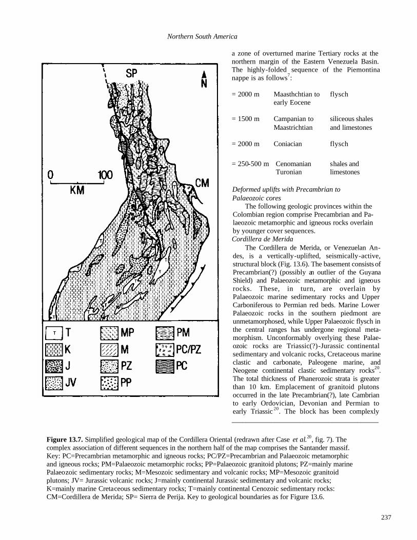
237
Northern South America a zone of overturned marine Tertiary rocks at the northern margin of the Eastern Venezuela Basin. The highly-folded sequence of the Piemontina nappe is as follows7: = 2000 m Maasthchtian to flysch early Eocene = 1500 m Campanian to siliceous shales Maastrichtian and limestones = 2000 m Coniacian flysch
= 250-500 m Cenomanian shales and Turonian limestones
Deformed uplifts with Precambrian to Palaeozoic cores
The following geologic provinces within the Colombian region comprise Precambrian and Pa-laeozoic metamorphic and igneous rocks overlain by younger cover sequences. Cordillera de Merida
The Cordillera de Merida, or Venezuelan An-des, is a vertically-uplifted, seismically-active, structural block (Fig. 13.6). The basement consists of Precambrian(?) (possibly an outlier of the Guyana Shield) and Palaeozoic metamorphic and igneous rocks. These, in turn, are overlain by Palaeozoic marine sedimentary rocks and Upper Carboniferous to Permian red beds. Marine Lower Palaeozoic rocks in the southern piedmont are unmetamorphosed, while Upper Palaeozoic flysch in the central ranges has undergone regional meta-morphism. Unconformably overlying these Palae-ozoic rocks are Triassic(?)-Jurassic continental sedimentary and volcanic rocks, Cretaceous marine clastic and carbonate, Paleogene marine, and Neogene continental clastic sedimentary rocks20. The total thickness of Phanerozoic strata is greater than 10 km. Emplacement of granitoid plutons occurred in the late Precambrian(?), late Cambrian to early Ordovician, Devonian and Permian to early Triassic 20. The block has been complexly _________________________________________
Figure 13.7. Simplified geological map of the Cordillera Oriental (redrawn after Case et al.20, fig. 7). The complex association of different sequences in the northern half of the map comprises the Santander massif. Key: PC=Precambrian metamorphic and igneous rocks; PC/PZ=Precambrian and Palaeozoic metamorphic and igneous rocks; PM=Palaeozoic metamorphic rocks; PP=Palaeozoic granitoid plutons; PZ=mainly marine Palaeozoic sedimentary rocks; M=Mesozoic sedimentary and volcanic rocks; MP=Mesozoic granitoid plutons; JV= Jurassic volcanic rocks; J=mainly continental Jurassic sedimentary and volcanic rocks; K=mainly marine Cretaceous sedimentary rocks; T=mainly continental Cenozoic sedimentary rocks: CM=Cordillera de Merida; SP= Sierra de Perija. Key to geological boundaries as for Figure 13.6.

238
STEPHEN K. DONOVAN
Figure 13.8. Simplified geological map of the Cordillera Central (CC), the Cordillera Occidental (CO) and the Romeral Fault Zone (RFZ), redrawn after Case et al.20. Key: PC=Precambrian igneous and metamorphic rocks; PM=Palaeozoic metamorphic rocks; PP=Palaeozoic grantoid plutons; MP=Mesozoic and Palaeozoic granitoid plutons; J=Mesozoic (mostly Jurassic) volcanic and continental sedimentary rocks; KV=Cretaceous mafic and intermediate subaqueous volcanic rocks; U=mainly intrusive mafic and ultramafic rocks (mostly Cretaceous); KM=Cretaceous metamorphic rocks; K=Cretaceous sedimentary rocks; TP=Tertiary granitoid plutons; TV= Neogene and Quaternary volcanic rocks; T=Paleogene (mainly marine) and younger (mainly continental) sedi-mentary rocks; AB=Antioquian Batholith. Key to geological boundaries as in Figure 13.6.

239
Northern South America deformed by numerous Phanerozoic events, the four princi-pal orogenic episodes occurring in the late Precambrian(?), Devonian to early Carboniferous, late Permian (associated with high grade regional metamorphism) and end Eo-cene73 ,74. Late Cenozoic uplift was complex and polyphase43. Younger rocks have a generally northeast-southwest structural trend20, including the active, axial Bo-cono Fault Zone (Fig. 13.3B). Movement on this fault is predominantly dip-slip with lesser strike-slip71,72 (R. Sha-gam, written communication) and it is interpreted by some as part of the SCPBZ, although all of the movement between the two plates cannot be taken up on this structure alone32. The faults flanking the Cordillera de Merida are thrusts and reverse faults that dip towards the core of the uplift20. The Cordillera de Merida is separated from the Cordillera Ori-ental by the Tachira depression, which represents a zone of thrusting towards the southwest52. Cordillera Oriental
The core of the Cordillera Oriental (Fig. 13.7) exposes Precambrian to Palaeozoic metamorphic and minor igneous rocks. Precambrian gneisses in the southern part of the province give radiometric ages of 1600 Ma20. These are overlain by Palaeozoic sedimentary rocks, Mesozoic conti-nental deposits, volcanics, evaporites and marine elastics, with thick, mostly continental Cenozoic successions devel-oped locally14,37. There are more than 10,000 m of post-Pa-laeozoic strata74. In the southern part of the range, Cretaceous(?) evaporites have produced salt anticlines 20,37. Principal deformation episodes occurred during the Precam-brian, Palaeozoic and late Cretaceous to Paleogene, with uplift following in the post-Miocene. The main structural trend is north-south. Flanking thrust faults dip beneath the range, although most faults are high-angle structures. The principal fault, the Santa Marta-Bucaramanga Fault20 (Fig. 13.3B), is seismically active. It is believed by many to be a left-lateral strike-slip fault and by others to be an oblique slip high-angle thrust. Folds are broad and open in the north, but complex in the south where they are related to salt tectonics. This range was intruded by granitoid plutons in the Palaeozoic and Mesozoic, mainly in the area of the Santander Massif in the northern part of the province, and has been autochthonous on South America since the Juras-sic 49,50,75. Regional metamorphic events occurred in the late Precambrian, late Ordovician to late Silurian, and pos -sibly early Carboniferous and Permian74. The underlying crust is continental.
The Santander Massif (Fig. 13.7) in the north of the Cordillera Oriental is one of three major uplifts within the range37. In the massif the following sequence of rocks have been mapped20,74:
Jurassic -Cretaceous siliciclastics and local carbonates Devonian-Permian or 2000-2500 m of clastics Triassic and carbonates, with red
beds towards the top of the sequence
--------------------unconformity-------------------------------
Cambrian-Ordovician Silgar and Quetame Series—metamorphic rocks of greenschist to lower amphibolite facies
----------------------unconformity---------------------------------- Precambrian Bucaramanga Gneiss— metamorphic rocks of high amphibolite facies
However, this stratigraphic scheme is probably over-simplified. For example, some formation boundaries corre-spond to metamorphic isograds and the Silgar Series metawackes have been traced laterally into Bucaramanga Gneiss (R. Shagam, written communication). Conceivably some of the crystalline rocks have no stratigraphic signifi-cance, but are merely different metamorphic facies of the same rock unit.Granite plutonism occurred in the late Pre-cambrian and late Ordovician, with the main phase of batho-lith emplacement between the late Triassic and late Jurassic20. Sierra de Perija
The Sierra de Perija uplift is similar in both stratigraphy and structure to the Cordillera Oriental and the Venezuelan Andes. The underlying crust is continental. Precambrian(?) and Palaeozoic crystalline rocks are sparsely exposed on the eastern flanks20. Palaeozoic marine and continental?) strata occur as isolated outcrops, with Palaeozoic and Mesozoic volcanic, plutonic and continental sedimentary rocks con-centrated in the core of the uplift. Mesozoic red beds, associated with hypabyssal intrusions and interbedded with volcanic rocks, are best developed in northnortheast-south-southwest trending extensional grabens55,79. Jurassic and Cretaceous marine strata are exposed at high elevations. At least eight major deformation episodes have affected the Sierra de Perija during the Phanerozoic, with four in the Cenozoic, in the early Eocene, middle Eocene, late Oligo-cene and Pliocene42. Major structural trends are northeast-southwest. This range was uplifted in the post-Miocene20,41,42 and is still seismically active. Available palaeomagnetic data from Jurassic rocks suggests that the Sierra de Perija and the Cordillera de Merida had diff- erent patterns of tectonic movement during the Mesozoic20,56.

240
STEPHEN K. DONOVAN
Figure 13.9. The geological evolution of northern South America during the Cenozoic (after Dewey and Pindell24, fig. 2; Pindell and Barrett66, fig. 10). A, Paleocene. B, Eocene. C, Oligocene. D, early Miocene. E, late Miocene. F, Holocene. For explanation see text. Key: heavy stipple=continental crust overthrust by oceanic terra-nes; light stipple=flysch of the Scotland Formation, Barbados; VVV=island arc volcanism; heavy arrows= relative motion of South American and Caribbean Plates; anticlinal symbols=forehand flexural bulge of advancing thrust load of oceanic terranes.
Cordillera Central The core of the Cordillera Central (Fig. 13.8) uplift is
comprised of Precambrian to (mainly?) Palaeozoic igneous and metamorphic rocks, with gneisses of granulite facies unconformably overlain by fossiliferous Ordovician me-tasedimentary rocks of low greenschist facies20. The oldest radiometric dates obtained are in excess of 1300 Ma82. The Palaeozoic island arc-related sequence was metamorphosed in the late Devonian to early Carboniferous58,59. This core is overlain in the east by Triassic limestones and Jurassic continental deposits and calc-alkaline volcanic rocks, suc-ceeded by Cretaceous marine clastic and carbonate sedi-mentary rocks20. In the west obducted20 oceanic and mantle rocks occur in a thrust zone. Up to 4000 m of Mesozoic
flanking sedimentary rocks are developed, which have been moderately folded and strongly faulted. The rock associa-tion of the Cordillera Central constitutes a polydeformed metamorphic complex of Precambrian to Cretaceous rocks 82. Large Tertiary and (mainly) Mesozoic plutons have intruded this province. The great Antioquian Batholith (Fig. 13.8) of the centre of the Cordillera was mainly intruded during the Cretaceous into high-grade metamorphic rocks of uncertain (Palaeozoic?) age, which had previously been intruded by Palaeozoic granitoid plutons that were them-selves subsequently metamorphosed20. Ultramafic and mafic bodies, possible fragments of upper mantle or lower crust, outcrop in the north and west. The main structural trends are north-south to northeast-southwest, most large

241
Northern South America
faults having a major strike-slip component, such as the right-lateral PalestinaFault 27 (Fig. 13.3B). The eastern mar-gin of the cordillera is bounded by a narrow, east-verging fold and thrust belt12,20. The underlying crust is continental and, in obducted slices, oceanic20.
The northern limit of active Colombian volcanism oc -curs in the southern part of the Cordillera Central, related to plate convergence at the Colombia Trench, and thick Neo gene volcanic terraces are developed. Cenozoic volcanism in this region commenced in the late Oligocene to early Miocene84 or late Miocene54, with the formation of calc-al-kaline stratovolcanoes erupting mainly andesitic lavas. Re-cent eruptions include that of Nevado del Ruiz on 13th November, 1985, which generated lahars that flowed down flanking river valleys and killed between 22,000 and 25,000 people57, the fourth highest recorded death toll from a volcanic event. Sierra Nevada de Santa Marta
The Sierra Nevada de Santa Marta massif is a pyrami-dal, poly component uplift with a northeast-southwest struc-tural trend that defines three parallel metamorphic terranes 83. It is the highest mountain range in Colombia, reaching a maximum elevation of about 5800 m42. It is bordered to the north by the Oca Fault (right slip) and to the west by the Santa Marta Fault (left slip), both with large vertical components (Fig. 13.3B). Precambrian gneisses in the core of the uplift have given radiometric Rb-Sr dates of circa 1300 Ma20,48. The core is overlain by some Palaeozoic sedimentary rocks, and Mesozoic volcanics and volcani-clastic rocks, and was intruded by Phanerozoic plutons. The Santa Marta schists form a Mesozoic subterrane to the northwest47, related to similar sequences in the Guajira Peninsula (the Ruma metamorphic belt), in Aruba, the Para-guan Peninsula and the Cordillera de la Costa of the Carib-bean Mountains 20. The crust is continental, but geophysical evidence shows that it is not in isostatic equilibrium10,19. The Santa Marta Massif was uplifted and transported north-westwards over adjacent basins on a low angle thrust fault, and between the Oca and Santa Marta Faults, during the Pliocene42. Palaeomagnetic analysis of Jurassic strata indi-cates no large tectonic rotations have occurred since the mid-Mesozoic, in contrast to those recognised for rocks of the Guajira Peninsula to the north51. Guajira Peninsula
Precambrian and Palaeozoic metamorphic rocks out-crop in the core of the Guajira Peninsula This core is overlain by a thick sequence of Mesozoic clastic and car-bonate sedimentary rocks, with local volcanic rocks, all of which are highly deformed. The Ruma metamorphic belt (related to the Santa Marta schists; see above) in the north is composed of Mesozoic metamorphic and ultramafic rocks related to end Cretaceous to Paleocene subduction20. A
major fault separates the north and south sections of the province. Tertiary basins rest unconformably on these older strata and contain a total thickness of at least 4000 m of marine clastic and carbonate rocks, with some continental strata20. The terrane has been intruded by felsic plutons19,20. The crust is oceanic, transitional or continental, and is not in isostatic equilibrium (cf. Sierra Nevada de Santa Marta). Palaeomagnetic evidence indicates rotation of Cretaceous rocks in the southern part of the province20,49 .
Mesozoic-Cenozoic deformed belts Cordillera Occidental
The Cordillera Occidental (Fig. 13.8) rests on oceanic crust17. It is a complex, polycomponent terrane20 comprised of a great thickness of Mesozoic eugeosynclinal rocks17
including Cretaceous tholeiitic basalts and basaltic an-desites, with sedimentary rocks of pelagic and turbiditic origin, and local developments of ultramafic rocks 30, all of which were intruded by Tertiary granitoid plutons. The principal structural trend is north-south. Beds are often steep, vertical or overturned17. Major fault systems border the Cordillera Occidental in the east and west20. The major deformation episode of this province occurred before the mid-Miocene20, but great vertical uplift has continued into the Recent.
The Romeral Fault Zone (Figs 13.3B, 13.8), of late Cretaceous to Paleogene antiquity, forms a suture zone between the Cordillera Occidental, on oceanic crust, and the Cordillera Central, on continental crust17. Principal struc -tural trends are north-south to northeast-southwest, but whether the terrane is dipping towards the east or west is uncertain20. The sequence comprises a 'megamelange' of ultramafic rocks, ophiolite fragments, scattered blueschists, fragments of continental crust, and Mesozoic flysch and pelagic sedimentary rocks18. A superimposed Tertiary ba-sin, infilling a graben-like structure17, includes circa 3000 m of mainly continental sedimentary and volcanic rocks which are locally tightly folded20. Tertiary igneous rocks have been rotated anticlockwise46. Choco Terrane
The Choco Terrane (Fig. 13.3A) is comprised of up-lifted oceanic crust and magmatic arc rocks of late Creta-ceous to Paleogene age, which adjoin deep forearc basins containing up to 10,000 m of pelagic, turbiditic andmarginal marine sedimentary strata of Cretaceous and Cenozoic age. To the west, the Choco Terrane is bordered by a partly-in-filled trench and is overriding the Nazca Plate26. The main structural trends are north-south, northeast-southwest and northwest-southeast. The Choco Terrane is overridden to the east by the Cordillera Occidental and the South Carib-bean Deformed Belt along the Atrato Fault, an eastward-dip-ping reverse fault18,26. The Choco Terrane continues

242
STEPHEN K. DONOVAN
northwards into eastern Panama15,26. San Jacinto Terrane
The San Jacinto Terrane extends to the north of the Cordillera Occidental and is probably underlain by oceanic crust. It is constituted of late Cretaceous to Neogene marine pelagic, turbiditic, clastic and carbonate sedimentary rocks, with associated fluvial and lacustrine deposits, to a total thickness of up to 10,000 m. Cretaceous strata have been intruded by tonalite plutons. The principal structural trend is northnortheast-southsouthwest, with Cenozoic deforma-tional events and Paleogene diapirism having produced strong deformation18,20, with broad, gentle synclines separated by narrow, elongate anticlines25. South Caribbean Deformed Belt
The South Caribbean Deformed Belt (SCDB; Fig. 13.3A), with its eastern extension as the Curacao Ridge16,77, is situated offshore Colombia and Venezuela and rests on oceanic crust. It consists of up to 10,000 m of poorly consolidated and highly deformed Cretaceous and Cenozoic sedimentary rocks and sediments45 of pelagic and turbiditic origin, derived from South America and deposited on the Caribbean Plate during its eastward drift23. Northeast-southwest and east-west structural trends (folds and thrust faults) are related to the oblique southeastward convergence of the Caribbean Plate with northern South America36,44 at an estimated rate of 20 mm per year. This convergence has produced the deformation of the SCDB and induced uplift of the Venezuelan Andes, Sierra de Perija, Guajira Penin sula, Netherlands Antilles, northwest Caribbean Mountains and the Sierra Nevada de Santa Marta. Mud diapirism is widespread in the west of this terrane25,87. Active deformation is probably concentrated along the northern margin of the SCDB, with the effects of deformation becoming progressively older towards the south45, with slices of oceanic crust possibly incorporated into the belt. In western Colombia, the SCDB is concealed by the northward-prograding, undeformed sediment apron of the Magdalena Fan11,76. The SCDB comes ashore as the Sinu Terrane in northwest Colombia25. Paraguana Peninsula
The Paraguan Terrane is an uplifted block in northwestern Venezuela with the following rock sequence18:
Tertiary = 3000 m of gently deformed strata
Mesozoic metavolcanic and metasedimentary rocks, including an anorthositic gabbro and an ultramafic complex
Palaeozoic metaigneous rocks
Palaeomagnetic evidence indicates that this terrane has been rotated during regional deformation78. The underlying
crust is oceanic or undefined.
Andean basins on continental crust Maracaibo Basin
The Maracaibo Basin is an Andean basin, sandwiched between the Venezuelan Andes and the Sierra de Per ija. This basin has a total thickness of about 11,000 m and has been the most important of the three major petroleum provinces in Venezuela35. It includes continental deposits of Jurassic age, at least 1000 m of Cretaceous marine carbonates and clastic sedimentary rocks, and 5000-7000 m of Tertiary deltaic, fluvial, lacustrine and marine deposits (Fig. 13.4C). Hydrocarbons are comprised of heavy oils in shallow reser-voirs, with lighter oil and gas at depth. Production is from stratigraphic traps in shallow Tertiary sandstones (north-east88), or structural traps in Tertiary sandstones and Creta-ceous limestones (central and western lake), or Tertiary sandstones, Cretaceous limestones and (locally) base-ment35. The principal source rock is the Cenomanian-San-tonian La Luna Formation, an organic -rich, dark grey to black limestone to calcareous shale with cherts and of ma-rine origin. It is uncertain whether the La Luna Formation is deep- or (more probably) shallow-water in origin, but it overlies the (mainly) shallow-water marine limestones of the Cogollo Group3. Production is mainly from the north, but in the south the North Andean Foredeep also contains important reserves35. Thick sedimentary sequences in the southern part of the basin (the late Cenozoic Guayabo delta) include near-shore to non-marine sequences produced by erosion from the Cordillera Oriental and, subsequently, the Cordillera de Merida85.
The basement is metamorphosed continental crust. Faulting is complex and increases with depth, with moderate folding adjacent to faults. The Oca Fault (Fig. 13.3B) is a major east-west, dextral strike-slip or oblique slip structure that bounds the north of the basin86. The main structural trends are north-south and northeast-southwest. Middle Magdalena Basin
The Middle Magdalena Basin is an intermontane basin situated between the Cordillera Oriental and the Cordillera Central. This basin contains at least 6000 m of Mesozoic marine14 and continental sedimentary (and volcanic?) rocks, and Cenozoic marine and, mainly, continental depos-its18,20. Marine deposition largely ceased after the Creta-ceous following the uplift of the Cordillera Central20. Neogene volcaniclastics in the west were derived from stratovolcanoes in the Cordillera Central84. The Cenozoic sedimentary sequence thickens eastwards14. Structural trends are north-south to northeast-southwest. Deformation (dominantly faults and associated minor folds, with associ-ated local unconformities) increases eastwards14, and south-wards into the Upper Magdalena Basin20, and folds increase

243
Northern South America in abundance northwards13. The Cordillera Oriental is thrust over the Middle Magdalena Basin. This basin is an impor-tant petroleum province. The underlying crust is continental. San Jorge-Magdalena Basin
The San Jorge-Magdalena province is between the Cor-dillera Central and the Sierra Nevada de Santa Marta. The crystalline basement is comprised of Precambrian and Pa-laeozoic rocks similar to those of the Cordillera Central. 3000 to 8000 m of overlying (mainly) Tertiary continental and marine strata are moderately deformed, with a north-east-southwest structural trend. The basin is an important hydrocarbon province18,20. Cesar Basin
The Cesar Basin is located between the Sierra Nevada de Santa Marta and the Sierra de Perija in northeastern Colombia. The asymmetrical basin fill thickens southeast13, and is comprised of up to 1000 m of Mesozoic strata overlain by a similar thickness of marine and (mainly) continental sediments of Cenozoic age, with major lignite and coal deposits in the northeast18,20. The principal structural components are broad folds and high-angle faults trending northeast-southwest. The Sierra de Perija may be thrust over this basin20,42. The underlying crust is continental18,20.
The stratigraphy and structure of the Cesar and Middle MagdalenaBasins are similar, and Campbell has proposed that the two were continuous with each other before offset-ting by the northnorthwest-southsoutheast trending Santa Marta Fault (for an alternative view, see Poison and Henao67; Fig. 13.3B). Campbell's suggestion has been sup-ported by more recent data and analyses42. Baja Guajira Basin
The Baja Guajira Basin is situated between the Oca Fault to the south and the Guajira Province to the north (Fig. 13.3A). A northwest-southeast trending concealed fault may border the northern margin of the basin19. The basin fill consists of up to 4000 m of Eocene(?) to Pliocene clastic sedimentary rocks of both terrestrial and marine origin18. Deformation is moderate, and is probably related to pull-apart movements on the east-west trending Cuiza (to the north) and OcaFaults19,20. The underlying crust is continental, at least towards the south.
CENOZOIC GEOLOGICAL EVOLUTION
The model for the evolution of the South Caribbean Plate Boundary Zone followed herein (Fig. 13.9) is that proposed by Dewey and Pindell23,24,66. Although other models for the evolution of the Caribbean Plate exist (see, for example, Morris et al.62), the Dewey and Pindell model is considered the most feasible paradigm available. The following account is based mainly on that of Pindell and Barrett66.
Cretaceous to Paleocene
The northern Venezuelan nappes were emplaced onto the margin of the South American Plate diachronously, younging from west to east, between the Cretaceous and Pliocene. This pattern of emplacement-was closely related to the eastward progression of the Caribbean Plate during the Cenozoic. Nappe emplacement and the development of an associated foredeep occurred in the Maracaibo Basin during the Paleocene to early Eocene (Fig. 13.9A), with the accumulation of turbidites within the basin and the offshore trench; in the Caribbean Mountains in the Oligocene to Miocene (Fig. 13.9B-D); and in the Eastern Venezuela Basin in the late Miocene to Pliocene (Fig. 13.9E, F). The Grenada Basin also opened in the Paleocene due to intra-arc spreading66. Eocene and Oligocene
The presumed offset of the Caribbean and South American Plates in the late Eocene was 1400 km80. East-ward-dipping subduction of the Caribbean Plate at the Sinu Trench commenced in the Eocene25. The eastward advance of the Caribbean Plate produced diachronous accretion of turbidites. Nappes and the turbiditic accretionary complex were emplaced onto the northern South American margin, with associated dextral shear66 and the clockwise rotation of rock assemblages within nappes8,78. The Oligocene sub-sidence of the Falcon Basin originated by continental stretching and pull-apart basin development due to dextral strike-slip motions. Early to late Miocene
The commencement of the Andean orogeny during the Miocene led to the northeastward migration of Andean terranes, such as the movement of the Maracaibo Block53
along the Bocono and Santa Marta-Bucaramanga Fault Zones (Fig. 13.9D-F). Thus, basins and terranes within the South Caribbean Plate Boundary Zone have migrated north-east and east with respect to the South American craton23. This resulted in the Caribbean/South American transform fault becoming convergent, with the Venezuelan borderland overriding the Caribbean Plate. Present
The Panama arc of Central America collided with the Western Cordillera along the Atrato Suture during the Plio-cene and Pleistocene23. The topography of the Andes has been produced by continued convergence of these terranes. The Netherlands and Venezuelan Antilles were obducted onto the Caribbean Plate during the Neogene or earlier, associated with the development of the South Caribbean Deformed Belt.
ACKNOWLEDGMENTS—I thank the American Geophysical Union, Jim Pindell and John Dewey for granting permission to reproduce Figure 13.9. This paper was greatly improved in the light of incisive review comments by William B. MacDonald, Vernon Hunter and, particularly, Reginald

244
STEPHEN K. DONOVAN
Shagam.
REFERENCES
1Ave Lallemant, H.G. 1990. The Caribbean-South Ameri-can plate boundary, Araya Peninsula, eastern Vene-zuela: in Larue, D.K. & Draper, G. (eds), Transactions of the Twelfth Caribbean Geological Conference, St. Croix, U.S. Virgin Islands, 7th-llth August, 1989,461-471. Miami Geological Society, Miami.
2Aymard, R., Pimentel, L., Eitz, P., Lopez, P., Chaouch, A., Navarro, J., Mijares, J. & Pereira, J.G. 1990. Geological integration and evaluation of Northern Monagas, East-ern Venezuela Basin: in Brooks, J. (ed.), Classic Petro-leum Provinces. Geological Society Special Publication, 50, 37-53.
3Bartok, P., Reijers, T.J.A. & Juhasz, 1.1981. Lower Creta-ceous Cogollo Group, Maracaibo Basin, Venezuela: sedimentology, diagenesis, and petrophysics. Ameri-can Association of Petroleum Geologists Bulletin, 65, 1110-1134.
4Beck, C.M. 1978. Polyphasic Tertiary tectonics of the interior range in the central part of the western Carib-bean chain, Guarico state, northern Venezuela Geolo-gieenMijnbouw, 57, 99-104.
5Beets, D.J., Maresch, W.V., Klaver, G.T., Mottana, A., Bocchio, R., Beunk, F.F. & Monen, H.P. 1984. Mag-matic rock series and high-pressure metamorphism as constraints on the tectonic history of the southern Car -ibbean. Geological Society of America Memoir, 162, 95-130.
6Bellizzia, A. 1972. Is the entire Caribbean Mountain belt of northern Venezuela allochthonous? Geological So-ciety of America Memoir, 132, 363-368.
7Bellizzia, A. & Dengo, G. 1990. The Caribbean Mountain system, northern South America; a summary: in Dengo, G. & Case, J.E. (eds), The Geology of North America. Volume H. The Caribbean Region, 167-175. Geologi-cal Society of America, Boulder.
8Blin, B., Sichler, B. & Stephan, J.F. 1990. Contribution of paleomagnetism in the relations between the Piemontin and internal nappes of the Venezuelan Caribbean chain: synthesis and new data: in Larue, D.K. & Draper, G. (eds), Transactions of the Twelfth Caribbean Geologi-cal Conference, St. Croix, U.S. Virgin Islands, 7th-llth August, 1989,453-460. Miami Geological Society, Mi-ami.
9Bonini, W.E. 1978. Anomalous crust in the Eastern Vene-zuela Basin and the Bouguer gravity anomaly field of northern Venezuela and the Caribbean borderland. Geologie en Mijnbouw, 57, 117-122.
10Bonini, W.E, Garing, J.D. & Kellogg, J.N. 1982. Late
Cenozoic uplifts on the Maracaibo-Santa Marta block, slow subduction of the Caribbean Plate, and results from a gravity study: in Snow, W, Gil, N, Llinas, R, Rodriguez-Torres, R.; Seaward, M. & Tavares, I. (eds), Transactions of the Ninth Caribbean Geological Con-ference, Santo Domingo, Dominican Republic, 16th-20th August, 1980,1, 99-105.
11Breen, N.A. 1989. Structural effect of Magdalena Fan deposition on the northern Colombia convergent mar-gin. Geology, 17, 34-37.
12Butier, K. & Schamel, S. 1988. Structure along the eastern margin of the Central Cordillera, Upper Magdalena Valley, Colombia Journal of South American Earth Sciences, 1,109-120.
13Campbell, C.J. 1968. The Santa Marta wrench fault of Colombia and its regional setting: in Saunders, J.B. (ed.), Transactions of the Fourth Caribbean Geological Conference, Port-of- Spain, Trinidad, 28th March-nth April, 1965, 241-261.
14Campbell, C.J. & Burgl, H. 1965. Section through the Eastern Cordillera of Colombia, South America. Geo-logical Society of America Bulletin, 76, 567-590.
15Case, J.E. 1974. Oceanic crust forms basement of eastern Panama. Geological Society of America Bulletin, 85, 645-652.
16Case, J.E. 1974. Major basins along the continental mar-gin of northern South America: in Burk, C.A. & Drake, C.L. (eds), The Geology of Continental Margins, 733-741. Springer-Verlag, New York.
17Case, J.E., Duran S., L.G., Lopez R., A. & Moore, W.R. 1971. Tectonic investigations in western Colombia and eastern Panama. Geological Society of America Bulle-tin, 82, 2685-2712.
18Case, J.E., Holcombe, T.L. & Martin, R.G. 1984. Map of the geologic provinces in the Caribbean region. Geo-logical Society of America Memoir, 162,1-30.
19Case, J.E. & MacDonald, W.D. 1973. Regional gravity anomalies and crustal structure in northern Colombia. Geological Society of America Bulletin, 84, 2905-2916.
20Case, J.E., Shagam, R. & Giegengack, R.F. 1990. Geology of the northern Andes; an overview: in Dengo, G. & Case, J.E. (eds), The Geology of North America. Vol-ume H. The Caribbean Region, 177-200. Geological Society of America, Boulder.
21Chigne, N. & Hernandez, L. 1990. Main aspects of petro-leum exploration in the Apure area of southwestern Venezuela, 1985-1987: in Brooks, J. (ed.), Classic Pe-troleum Provinces. Geological Society Special Publi-cation, 50, 55-75.
22Cordani,U.G., Melcher, G.C. & de Almeida, F.F.M. 1968. Outline of Precambrian geochronology of South Amer-

245
Northern South America
ica Canadian Journal of Earth Sciences, 5, 629-632.
23Dewey, J.F. & Pindell, J.L. 1985. Neogene block tectonics of eastern Turkey and northern South America: conti-nental applications of the finite difference method. Tec-tonics, 4, 71-83.
24Dewey, J.F. & Pindell, J.L. 1986. Neogene block tectonics of eastern Turkey and northern South America: conti-nental applications of the finite difference method: reply. Tectonics, 5, 703-705.
25Duque-Caro, H. 1984. Structural style, diapirism, and accretionary episodes of the Sinu-San Jacinto terrane, southwestern Colombia borderland. Geological Soci-ety of America Memoir, 162, 303-316.
26Escalante, G. 1990. The geology of southern Central America and western Colombia: in Dengo, H. & Case, I.E. (eds), The Geology of North America. Volume H. The Caribbean Region, 201-230. Geological Society of America, Boulder.
27Feininger, T. 1970. The Palestina Fault, Colombia Geo-logical Society of America Bulletin, 81,1201-1216.
28Feo-Codecido, G., Smith, F.D., Jr., Aboud, N. & Gia-como, E. de D. 1984. Basement and Paleozoic rocks of the Venezuelan Llanos basins. Geological Society of America Memoir, 162, 175-187.
29Gansser, A. 1954. The Guiana Shield (S. America): geo-logical observations. Eclogae Geologicae Helvetiae, 47, 77-112.
30Gansser, A. 1973. Facts and theories on the Andes. Jour-nal of the Geological Society, London, 129, 93-131.
31Gibbs, A.K. & Barron, C.N. 1983. The Guiana Shield reviewed. Episodes, 6 (2), 7-14.
32Giegengack, R. 1984. Late Cenozoic tectonic environ-ments of the central Venezuelan Andes. Geological Society of America Memoir, 162, 343-364.
33Guth, L.R. & Ave Lallemant, H.G. 1990. A kinematic history for eastern Margarita Island, Venezuela: in Lame, D.K. & Draper, G. (eds), Transactions of the Twelfth Caribbean Geological Conference, St. Croix, U.S. Virgin Islands, 7th-11th August,1989, 472-480. Miami Geological Society, Miami.
34Harrington, H.J. 1962. Paleogeographic development of South America. American Association of Petroleum Geologists Bulletin, 46, 1773-1814.
35James, K.H. 1990. The Venezuelan hydrocart>on habitat: in Brooks, J. (ed.), Classic Petroleum Provinces. Geo-logical Society Special Publication, 50, 9-35.
36Jordan, T.H. 1975. The present-day motion of the Carib-bean Plate. Journal of Geophysical Research, 80, 4433-4439.
37Julivert, M. 1970. Cover and basement tectonics in the Cordillera Oriental of Colombia, South America, and a comparison with some other folded chains. Geological
Society of America Bulletin, 81, 3623-3646. 38Kalliokoski, J. 1965. The metamorphosed iron ore of El
Pao, Venezuela. Economic Geology, 60, 100-116. 39Kalliokoski, J. 1965. Geology of north-central Guayana
Shield, Venezuela Geological Society of America Bulletin, 76, 1027-1050.
40Keats, W. 1976. The Roraima Formation in Guyana: a revised stratigraphy and a proposed environment of deposition: in Boletin de Geologia Publicacion Espe-cial, 1. Memoria, Segundo Congreso Latinoamericano de Geologia, Caracas, Venezuela, 11 al 16 de Noviembre de 1973,2,901-940.
41Kellogg, J.N. 1982. Cenozoic basement tectonics of the Sierra de Perija, Venezuela and Colombia: in Snow, W., Gil, N., Llinas, R., Rodriguez-Torres, R, Seaward, M. & Tavares, I. (eds), Transactions of the Ninth Carib-bean Geological Conference, Santo Domingo, Domini-can Republic, 16th-20th August, 1980,1 107-117.
42Kellogg, J.N. 1984. Cenozoic tectonic history of the Sierra de Perija, Venezuela-Colombia, and adjacent basins. Geological Society of America Memoir, 162,239-261.
43Kohn, B.P., Shagam, R, Banks, P.O. & Burkley, L.A. 1984. Mesozoic -Pleistocene fission-track ages on rocks of the Venezuelan Andes and their tectonic implica-tions. Geological Society of America Memoir, 162, 365-384.
44Ladd, J.W., Holcombe, T.L., Westbrook, O.K. & Edgar, N.T. 1990. Caribbean marine geology; active margins of the plate boundary: in Dengo, G. & Case, J.E. (eds), The Geology of North America. Volume H. The Carib-bean Region, 261-290. Geological Society of America, Boulder.
45Ladd, J.W., Truchan, M., Talwani, M., Stoffa, P.L., Buhl, P., Houtz, R, Mauffret, A. & Westbrook, G. 1984. Seismic reflection profiles across the southern margin of the Caribbean. Geological Society of America Mem-oir, 162, 153-159.
46MacDonald, W.D. 1980. Anomalous paleomagnetic di-rections in late Tertiary andesitic intrusions of the Cauca depression, Colombian Andes. Tectonophysics, 68, 339-348.
47MacDonald, W.D., Doolan, B.L. & Cordani, U.G. 1971. Cretaceous-early Tertiary metamorphic K-Ar age val-ues from the south Caribbean. Geological Society of America Bulletin, 82, 1381-1388.
48MacDonald, W.D. & Hurley, P.M. 1969. Precambrian gneisses from northern Colombia, South America. Geological Society of America Bulletin, 80, 1867-1872.
49MacDonald, W.D. & Opdyke, N.D. 1972. Tectonic rota-tions suggested by paleomagnetic results from northern Colombia, South America Journal of Geophysical Re-search, 11,5720-5730.

246
STEPHEN K. DONOVAN
50MacDonald, W.D. & Opdyke, N.D. 1974. Triassic paleo-
magnetism of northern South America. American As-sociation of Petroleum Geologists Bulletin, 58, 208-215.
51MacDonald, W.D. & Opdyke, N.D. 1984. Preliminary paleomagnetic results from Jurassic rocks of the Santa Marta massif, Colombia. Geological Society of Amer-ica Memoir, 162, 295-298.
52Macellari, C. 1984. Late Tertiary tectonic history of the Tachira Depression, southwestern Venezuelan Andes. Geological Society of America Memoir, 162, 333-341.
53Mann, P., Schubert, C. & Burke, K. 1990. Review of Caribbean neotectonics: in Dengo, G. & Case, I.E. (eds), The Geology of North America. Volume H. The Caribbean Region, 307-338. Geological Society of America, Boulder.
54Marriner, G.F. & Millward, D. 1984. The petrology and geochemistry of Cretaceous to Recent volcanism in Colombia: the magmatic history of an accretionary plate margin. Journal of the Geological Society, Lon-don, 141, 473-486.
55Maze, W.B. 1984. Jurassic La Quinta Formation in the Siena de Perija, northwestern Venezuela: geology and tectonic environment of red beds and volcanic rocks. Geological Society of America Memoir, 162, 263-282.
56Maze, W.B. & Margraves, R.B. 1984. Paleomagnetic re-sults from the Jurassic La Quinta Formation in the Perijarange, Venezuela, and their tectonic significance. Geological Society of America Memoir, 162, 287-293.
57McClelland, L., Simkin, T., Summers, M., Nielsen, E. & Stein, T.C. (eds). 1989. Global Volcanism 1975-1985. The First Decade of Reports from the Smithsonian Institution's Scientific Event Alert Network (SEAN). Prentice Hall and American Geophysical Union, Engle-wood Cliffs, New Jersey and Washington, D.C., vi+655 pp.
58McCourt, W.J. & Aspden, J.A. 1987. A plate tectonic model for the Phanerozoic evolution of central and southern Colombia: in Duque-Caro, H. (ed.), Transac-tions of the Tenth Caribbean Geological Conference, Cartagena de Indias, Colombia, 14th-20th August, 1983, 38-47. INGEOMINAS, Bogota
59McCourt, W.J., Aspden, J.A. & Brook, M. 1984. New geological and geochronological data from the Colom-bian Andes: continental growth by multiple accretion. Journal of the Geological Society, London, 141, 831-845.
60Montgomery, C.W. 1979. Uranium-lead geochronology of the Archean Imataca Series, Venezuelan Guayana Shield. Contributions to Mineralogy and Petrology, 69, 167-176.
61Montgomery, C.W. & Hurley, P.M. 1978. Total-rock
U-Pb and Rb-Sr systematics in the Imataca Series, Guayana Shield, Venezuela. Earth and Planetary Sci-ence Letters, 39, 281-290.
62Morris, A.E.L., Taner, I., Meyerhoff, H.A. & Meyerhoff, A. A. 1990. Tectonic evolution of the Caribbean region; alternative hypothesis: in Dengo, G. & Case, I.E. (eds), The Geology of North America. Volume H. The Carib-bean Region, 433-457. Geological Society of America, Boulder.
63Muessig, K.W. 1978. The central Falcon igneous suite, Venezuela: alkaline basaltic intrusions of Oligocene-Miocene age. Geologie en Mijnbouw, 57, 261-266.
64Muessig, K.W. 1984. Structure and Cenozoic tectonics of the Falcon Basin, Venezuela, and adjacent areas. Geo-logical Society of America Memoir, 162, 217-230.
65Muessig, K.W. 1984. Paleomagnetic data on the basic igneous intrusions of the central Falcon Basin, Vene-zuela. Geological Society of America Memoir, 162, 231-237.
66Pindell, J.L. & Barrett, S.F. 1990. Geological evolution of the Caribbean region; a plate-tectonic perspective: in Dengo, G. & Case, I.E. (eds), The Geology of North America. Volume H. The Caribbean Region, 405-432. Geological Society of America, Boulder.
67Poison, I.J. & Henao, D. 1968. The Santa Marta wrench fault: a rebuttal: in Saunders, J.B. (ed.), Transactions of the Fourth Caribbean Geological Conference, Port-of-Spain, Trinidad, 28th March-12th April 1965, 263-266.
68Priem, H.N.A., Boelrijk, N. A.I.M., Hebeda, E.H., Verdur-men, E.A.Th. & Verschure, R.H. 1973. Age of the Precambrian Roraima Formation in northeastern South America: evidence from isotopic dating of Roraima pyroclastic volcanic rocks in Suriname. Geological Society of America Bulletin, 84, 1677-1684.
69Read, H.H. & Watson, J. 1975. Introduction to geology. Volume 2. Earth history. Part J: Early stages of Earth history. MacMillan, London, xii+221 pp.
70Robertson, P. & Burke, K. 1989. Evolution of southern Caribbean Plate Boundary, vicinity of Trinidad and Tobago. American Association of Petroleum Geologists Bulletin, 73,490-509.
71Rod, E. 1956. Strike-slip faults of northern Venezuela. American Association of Petroleum Geologists Bulletin, 49, 451-416.
72Schubert, C. 1982. Neotectonics of Bocono Fault, western Venezuela. Tectonophysics, 85, 205-220.
73Shagam, R. 1972. Andean research project, Venezuela: principal data and tectonic implications. Geological Society of America Memoir, 132, 449-463.
74Shagam, R. 1975. The northern termination of the Andes: in Nairn, A.E.M. & Stehli, F.G. (eds), The Ocean

247
Northern South America
Basins and Margins. Volume 3. The Gulf of Mexico and the Caribbean, 325-420. Plenum, New York.
75Shagam, R., Kohn, B.P., Banks, P.O., Dasch, L.E., Var-gas, R., Rodriguez, G.I. & Pimentel, N. 1984. Tectonic implications of Cretaceous-Pliocene fission-track ages from rocks of the circum-Maracaibo Basin region of western Venezuela and eastern Colombia Geological Society of America Memoir, 162,385-412.
76Shepard, P.P. 1973. Sea floor off Magdalena Delta and Santa Marta area, Colombia. Geological Society of America Bulletin,84, 1955-1972.
77Silver, E.A., Case, I.E. & MacGillavry, H.J. 1975. Geo-physical study of the Venezuelan Borderland. Geologi-cal Society of America Bulletin, 86, 213-226.
78Skerlec, G.M. & Margraves, R.B. 1980. Tectonic signifi-cance of paleomagnetic data from northern Venezuela. Journal of Geophysical Research, 85, 5303-5315.
79Steinitz, G. & Maze, W.B. 1984. K-Ar ages on horn-blende-andesite from the Sierra de Perija, western Venezuela. Geological Society of America Memoir, 162, 283-285.
80Sykes, L.R., McCann, W.R. & Kafka, A.L. 1982. Motion of Caribbean Plate during last 7 million years and implications for earlier Cenozoic movements. Journal of'Geophysical Research, 87, 10656-10676.
81Tarling, D.H. & Tarling, M.P. 1972. Continental drift: a study of the Earth's moving surface. Pelican, Middle-sex, 142 pp.
82Toussaint, J.F. & Restrepo, J.J. 1982. Magmatic evolution of the northwestern Andes of Colombia. Earth-Science Reviews, 18, 205-213.
83Tschanz, C.M., Marvin, R.F., Cruz B., J., Mehnert, H.H.
& Cebula, G.T. 1974. Geologic evolution of the Sierra Nevada de Santa Marta, northeastern Colombia. Geo-logical Society of America Bulletin, 85, 273-284.
84Van Houten, F.B. 1976. Late Cenozoic volcaniclastic deposits, Andean foredeep, Colombia. Geological So-ciety of America Bulletin, 87,481-495. Van Houten, F.B. & James, H.E. 1984. Late Cenozoic Guayabo delta complex in southwestern Maracaibo Basin, northeastern Colombia. Geological Society of America Memoir, 162, 325-332.
86Vasquez, E.E. & Dickey, P.A. 1972. Major faulting in north-western Venezuela and its relation to global tec-tonics: in Petzall, C. (ed.), Transactions of the Sixth Caribbean Geological Conference, Margarita, Vene-zuela, 6th-14thJuly, 1971, 191-202.
87Vernette, G. & Klingebiel, A. 1988. Geometry and sedi-mentary facies of interdiapiric basins along the Carib-bean Colombian margin: in Barker, L. (ed.), Transactions of the Eleventh Caribbean Geological Conference, Dover Beach, Barbados, 20th-26th July, 1986,6:1-6:9. Energy and Natural Resources Division, Barbados.
88Viapiana, R.P. 1990. Eocene stratigraphical studies, Ma-racaibo Basin, northwestern Venezuela: in Larue, D.K. & Draper, G. (eds), Transactions of the Twelfth Carib-bean Geological Conference, St. Croix, U.S. Virgin Islands, 7th-llth August, 1989, 485-494. Miami Geological Society, Miami.
89Wheeler, C.B. 1963. Oligocene and Lower Miocene stra-tigraphy of western and northeastern Falcon Basin, Venezuela. American Association of Petroleum Geolo-gists Bulletin, 47, 35-68.

248

249
Caribbean Geology: An Introduction U.W.I. Publishers' Association, Kingston
© 1994 The Authors
CHAPTER 14
The Netherlands and Venezuelan Antilles
TREVOR A. JACKSON and EDWARD ROBINSON
Department of Geology, University of the West Indies, Mona, Kingston 7, Jamaica
INTRODUCTION
THE SOUTHERN Caribbean, or Aruba-Blanquilla, chain includes the islands of the Netherlands and Venezuelan Antilles (Fig. 14.1). These islands are genetically related and lie across several wide platforms that have a northwest-southeast structural trend6. They are composed of Lower Cretaceous to Paleogene volcanic and sedimentary rocks that were intruded by granitic plutons, and silicic and mafic dykes and sills. These rocks are overlain unconformably by Tertiary to Holocene sedimentary rocks.
A major gravity high parallels the island chain. This regional high has been interpreted as a manifestation of dense rock (that is, oceanic crust(?)), perhaps as much as 30 km thick9,10,32,48,52. Individual highs characterise almost every island and are found in association with lows, which more or less coincide with the deep water passages between the islands. These features suggest that the islands are fault-bounded, positive blocks, separated by sediment-filled pas-sages and basins.
The islands of the Netherlands Antilles, which com-prise Aruba, Curacao and Bonaire, form part of the Leeward Antilles (ABC) terrane11. Those of the Venezuelan Antilles, further east, include the islands of Las Aves, Los Roques, La Orchila, La Blanquilla and Los Hermanos. Some of these islands form part of the ABC terrane (Las Aves, Los Roques and La Orchila), whereas those to the east (La Blanquilla and Los Hermanos) belong to the Blanquilla province12. The islands of Margarita and Los Testigos, which belong to the Margarita subterrane, are not discussed in this chapter (see Donovan, Chapter 13, this volume). The ABC and Blanquilla terranes are separated by the La Orchila Basin, which is a graben-like structure trending northwest-south-east. The entire chain of islands is separated from mainland Venezuela by the Bonaire Basin and from the South Carib-
bean Deformed Belt (SCDB) by the Los Roques Basin4,11.
THE NETHERLANDS ANTILLES/ABC ISLANDS
Aruba Aruba Lava Formation
The Cretaceous of Aruba consists of two major units. The older is the Aruba Lava Formation, formerly called the Diabase-Schist-Tuff Foimation5, which is intruded by a composite tonalitic pluton (Fig. 14.2a). The age of the Aruba Lava Formation is based on Turonian(?) ammonites that were identified in sedimentary intercalations24. Rb-Sr iso-topic data for the tonalite body reveal an age that ranges between 85.1 ± 0.5 Ma and 70.4 ±2.0 Ma40. However, the younger date is probably a reset age caused by a low-grade thermal event at about 72 Ma5,39. Additional isotopic data for the pluton suggest that intrusion took place at 88±0.8 Ma39.
The Aruba Lava Formation is over 3 km thick and consists of basalt, dolerite, volcaniclastic conglomerate, sandstone, tuff, pelagic chert and cherty limestone. Basalt flows and dolerite sills form most of the formation. The basalts occur as pillowed lavas and sheet-flows, interdigi-tating with pyroclastic and volcaniclastic sediments5. The dolerite sills occur at various levels in the sequence and do not attain a thickness greater than 300 m.
The basalt flows alternate with accretionary lapilli tuffs of basaltic composition and clasts of basalt and dolerite. A pebbly mudstone intercalated with fine-grained turbidites contains ammonites of Turonian(?) age, together with a shallow-water, benthic marine fauna
The basalts have been affected by contact metamor-phism associated with the intrusion of the pluton, as there are low to medium-grade metamorphic minerals such as

250
The Netherlands and Venezuelan Antilles
Figure 14.1. Generalized map of the southern Caribbean region. Key: A=Aruba; Bl=La Blanquilla; Bo=Bon-aire; C=Curacao; LA=Las Aves; LF=Los Frailes; LH=Los Hermanos; LM=Los Monjes; LO=La Orchila; LT=Los Testigos; M=Margarita; T=Tortuga; To=Tobago; Tr=Trinidad.
albite, epidote, hornblende and uralite present in the rocks. However, despite the alteration of the basalt and dolerite, the original minerals in the mafics (clinopyroxene and pla-gioclase) are preserved. These minerals occur throughout the sequence, but in different proportions.
The major and trace element chemistry of the basalts are similar in composition to the basalts in neighbouring Curacao. These mafic rocks, which show MORB affinities, contain flat chrondrite-normalised REE patterns and differ from their Curacao counterparts only by displaying a posi-tive Eu anomaly5. Tonalite Pluton
The greater part of the island of Aruba is occupied by a pluton of batholithic proportions, composed primarily of a hornblende tonalite, with lesser amounts of trondhjemite, granitic pegmatite, norite and gabbro. The norite and gabbro occur as roof pendants in the tonalite body and represent an earlier intrusive phase24. Their mineralogy grades from equal amounts of hypersthene and augite in the norite to abundant hornblende, relict augite and quartz in the gabbro. Plagioclase, which is prominent in both rock types, is com-positionally zoned from An64 to An52, with cores sometimes being as calcic as An75.
The tonalite is composed mainly of plagioclase crystals showing oscillatory zoning in the range An58-An37. Inter-stitial quartz and potassium feldspar are the other felsic minerals. The dark minerals are hornblende, biotite, cli-
nopyroxene and magnetite. Trondhjemite occurs locally as schlieren in the tonalite24. The schlieren range in length from 20 cm to more than 50 m and are commonly found in close association with small pegmatite veins. Dykes of similar composition to the gabbros and trondhjemite intrude the Aruba Lava Formation and the composite pluton.
The mineralogy of the trondhjemite comprises mainly plagioclase (An42-An22), together with quartz, and minor potassium feldspar, biotite and hornblende. The pegmatite contains micrographic intergrowths of quartz, plagioclase feldspar, perthite and minor amounts of biotite.
From their geochemistry, the rocks that compose the pluton show a calc-alkaline trend5. In addition to the behav-iour of MgO and FeO with respect to SiO2, the REE patterns are LREE-enriched with respect to the HREE. A mantle source for the pluton was postulated by Priem et al.40
because of the low initial 87Sr/86Sr ratios. Both the Aruba Lava Formation and tonalite pluton
have been affected by late hydrothermal alteration. The Aruba Lava Formation has also been metamorphosed by the intrusion of the tonalite pluton and contains a zone of alteration that ranges from hornblende-hornfels facies at the contact to prehnite-quartz facies some 4 km away5. Limestones at Butucu and Seroe Colorado
A series of Tertiary limestones, with very restricted outcrop on Butucu Ranch, east-central Aruba, is distinct in lacking quartz and containing a middle Tertiary faunal as-

251
T.A. JACKSON and E. ROBINSON
semblage50. The total exposed thickness is about 8.5 m and consists of pale brown to orange coralline algal-foraminif-eral packstone with minor coral fragments. The foraminifera include several species of Lepidocyclina, Heterostegina and Pararotalia, collectively indicative of the Upper Eocene to possibly lowermost Oligocene (Fig.14.2b). Another iso-lated exposure of what may be the same unit has been reported from Seroe Colorado, at the southeastern tip of the island, containing the coral Antiguastrea cellulosa (Upper Eocene to Lower Miocene). Seroe Domi Formation
Named for exposures on Curacao, the Seroe Domi Formation in Aruba is developed mainly along the south-western side of the island13 as a series of largely detrital limestones and conglomerates, to which can be added, as a member, the sands and clays of the Oranjestad borehole. Conventionally, the Seroe Domi Formation is divided into three informal units, the older, middle and younger parts, but the full development of the formation is not seen on Aruba. Here the older unit has been recorded only from Seroe Canashito, where it consists of massive, extensively dolomitized, coral-algal limestone, lacking stratigraphically diagnostic fossils13.
At Spaans Lagoen the Seroe Domi Formation is divided into two parts13. An older part, of coral-poor, dolomitized limestones, is massive at the base, but becomes thin-bedded in the overlying strata. It contains little terrigenous detritus, but has angular non-carbonate fragments in the basal layers. The younger part is comprised of well-bedded limestones, rich in terrigenous detritus, especially well-rounded peb-bles, and with many macrofossils, particularly molluscs. Oranjestad Sands and Clays
The water borehole at Oranjestad was drilled to a depth of 302 m in 1942, on the advice of two French friars, after tests with a divining rod. Only hypersaline artesian water was encountered, at 268 m. Microfossils from the borehole were analysed by Drooger17, who concluded that the sands and clays were of Lower or Middle Miocene. However, a review of Drooger's species list leads us to suggest that the upper part of the borehole section is Pliocene age (based on the presence of Pulleniatina obliquiloculata and Globoro-talia miocenica) and that the lower part of the section (to 268 m) is no lower than Upper Miocene (indicated by Sphaeroidinella rutschi and Globogerinoides conglobatus). The sequence in the borehole probably represents a basal unit of the Seroe Domi Formation.
Curacao Curacao Lava Formation
The Cretaceous stratigraphy of Curacao is represented by two major units. The Curacao Lava Formation is uncon-formably overlain by the Knip Group, which in turn is
overlain conformably by the Cenozoic Midden-Curacao Formation (Figs. 14.3b). The Curacao Lava Formation con-tains a pelagic intercalation that yields six genera of ammon-ites of late middle Albian age51. K-Ar whole-rock dates for the basalts in this formation seem anomalous, in that the ages5 are either older or younger than Albian.
The Curacao Lava Formation includes over 5 km of pillow basalts, reworked hyaloclastites, dolerite sills, and a thin succession of siliceous shales and limestones. The formation is divided into lower, middle and upper sec- tions30, based mainly upon the petrographic and textural variations in the basalts. The lower part has a thickness of at least 1000 m in which picrite basalts alternate with tholei- itic basalts that display mostly variolitic texture. The middle 2000 m consists of tholeiitic pillow basalts which show predominantly non-variolitic texture, associated pillow breccias and local dolerite sills. The upper part is compos ed almost entirely of non-variolitic pillow basalts, abundant hyaloclastites, dolerite sills and thin bands of sedimentary rock. The picrites are composed principally of olivine and clinopyroxene30. Spinifex texture, commonly found in komatiites, has been identified in some of the picrites. Olivine and pyroxene, together with plagioclase and spinel, are the main minerals found in the variolitic and non-vari-olitic basalts.
The basalts of the Curacao Lava Formation are compo-sitionally similar to the Aruba Lava Formation and are part of a Mid Ocean Ridge Basalt (MORB) sequence formed by shallow melting of mantle5. Based on the absence of ves-icles in the pillow lavas, the Curacao Lava Formation was extruded in a water depth of about 5 km30. The formation is believed to be the ophiolitic analogue of layer 2, except that its thickness is much greater than that of normal oceanic crust, aid is instead comparable with oceanic plateaus15. Knip Group
There is a marked angular unconformity that separates the sedimentary rocks of the Knip Group from the underly-ing Curacao Lava Formation. The Knip Group consists almost entirely of pelagic, silica-rich and clastic sedimen-tary rocks that contain a fauna of late Senonian age. Rocks of the Knip Group are well-dated biostratigraphically by rudists, larger and planktic foraminiferans, and ammonites. Ages range from Santonian or early Campanian for the basal limestone lenses, through early to middle Campanian for the olistostrome units, to late Campanian and Maastrichtian for the highest part of the sequence. Beets3 described two fossiliferous limestone lenses, the Zevenbergen and Cas-abao limestones, from the base of the Knip Group. The Zevenbergen limestone contains fragments of algae, corals, gastropods, crinoids and rudists. The Casabao limestone is composed of larger foraminifers, algae, bryozoans, crinoids and oysters. The presence of the rudist Torreites tschoppi in

252
The Netherlands and Venezuelan Antilles
Figure 14.2. (a) (top) Simplified geologic map of Aruba (modified from Helmers and Beets24), (b) (bottom) Stratigraphic column for Aruba.

253
T.A. JACKSON and E. ROBINSON
the Zevenbergen limestone suggests a late Santonian-Cam-panian age range for the limestone.
The Knip Group ranges in thickness from just over 2000 m in the northwest to less than 100 m in the southeast of the island (Fig.14.3a). It is divided into nine formations, all of which are Upper Cretaceous3. In the northwest the Sint Christoffel Formation is a 1000 m thick succession of boul-der beds, slump breccias, pebbly mudstones, turbidites and silica-rich pelagic sediments, associated with limestone lenses. This formation grades upwards into Seroe Gratia Formation, which is comprised of 300 m of cherry lime-stones, bedded cherts and radiolites, with minor amounts of volcaniclastic sandstone. The Seroe Gratia Formation is conformably overlain by the Lagoen Formation, which rep-resents a 750 m turbidite succession of sandstones, silt-stones, mudstones and marls with intercalations of tuffs. Upwards and laterally these rocks grade into the Seroe Kortape and Zorgvlied Formations, which are both pelagic silica-rich sequences. Towards the centre and southeast, formations similar in lithology to those in the northwest, but containing more clastic material, were described by Beets3. These units are the Mameter Formation, with a maximum thickness of 250 m in the centre, and the Stenen Koraal and Ronde Klip Formations in the southeast, which have a maximum total thickness of 200 m. Midden Curacao Formation
Molengraaff 36 gave this name to a Cenozoic sequence over 1000 m in thickness, comprised of conglomerates, sandstones and shales, which outcrops in central and eastern Curacao. Beets2,3 described these beds as turbidites, with minor pelagic components, overlying the Knip Group con-formably. The vertical and lateral distribution of units within the formation have been interpreted2,3 as indicating the existence of two interfingering submarine fans. A larger fan bordering the northern flank of a basin (synclinorium of Beets) contains unmetamorphosed and metamorphic (greenschist facies) basal andesite, together with rare, shal-low-water limestone components, derived from a northerly source. The smaller fan, on the southern flank of the basin, contains the quartz-muscovite-plagioclase association seen in the underlying Knip Group, and was evidently derived from a southerly source area. The early Paleocene (Danian) age of the Midden Curacao Formation is based on poorly preserved planktic foraminifers (Globogerina? pseudobul-loides, G.? triloculinoides, Globorotalia? compressa). Seroe di Cueba and Mainsjie Formations
The rocks considered here to be Eocene age consist of sequences, exposed at two localities, which have been given formational status, together with a number of other scattered exposures of various kinds. They have a common strati-graphic position, lying unconformably on older, usually Cretaceous rocks, and are overlain unconformably by ter-
race deposits of Quaternary age. Schaub43 named the Seroe di Cueba Formation for the
well-known exposures forming the hill known as Cer'i Cueba (Fig.14.3a), previously called the -Seroe di Cueba Series by Molengraaff36. Although not actually exposed, it is clear from the physiography that the limestones making up the sequence form an outlier, unconformably overlying the rocks of the surrounding countryside, which belong to the Knip Group.
Although the earliest palaeontological studies reported ages ranging from Eocene to Oligocene, the Oligocene date for the upper part of the formation31 has never been con-firmed. Many workers have attributed a late Eocene age to the sequence, but this has also been questioned. For exam-ple, Molengraaff’s36 late Eocene date was based, at least partly, on the presence of the echinoid Eupatagus grandi-florus (a junior synonym of E. clevei) in the lower limestone, recorded previously from the limestones of St. Bartholomew in the northeastern Caribbean. Thought at that time to be Upper Eocene, the St. Bartholomew limestones are now known to be Middle Eocene. The extensive larger foraminiferal fauna from Cer'i Cueba closely resembles that of the Santa Rita Formation of western Venezuela, which also was once thought to be late Eocene, but is now known to be late middle Eocene in age28,38.
The Mainsjie Formation is now poorly exposed, but consists of a series of calcareous sandy and conglomeratic beds, at least 10 m thick, forming a hill in eastern Curacao. The middle Eocene age of these beds was determined by Hermes25 based on planktic foraminifera (Orbulinoides beckmanni and/or Truncorotaloides rohri Biozones).
Other exposures of Eocene rocks occur at Seroe Blanco, the mouth of a cave at Cueba Bosa, conglomeratic algal limestone at Plantation Patrick, and pebbly sandstones and siltstones at Certu Kloof (Fig. 14.3a). All these are isolated from one another, but the available fossil evidence indicates that they can all be regarded as belonging to a single forma-tion of probable late middle Eocene age, the same as for the Seroe di Cueba and Mainsjie Formations. The sedimentary rocks and fossils all indicate deposition under shallow ma-rine conditions, ranging from locally brackish water and carbonate shoals to open shelf palaeoenvironments. Seroe Domi Formation
The Seroe Domi Formation represents an accumulation of reef and pebble debris as submarine talus fans. Molen-graaff36 first named this unit for outcrops of hard to soft, often coral-rich limestones, typically exposed at Seroe Domi, northwest of Willemstad. It is found in all three islands of the Netherlands Antilles, mainly on the leeward (southwestern) sides, where it typically forms prominent cuestas, gently tilted towards the present coastline, and with the landward cuesta margin often terminating in nearly

254
The Netherlands and Venezuelan Antilles
Figure 143. (a) (top) Simplified geologic map of Curacao (modified from Helmers and Beets24), (b) (bottom) Stratigraphic column for Curacao.

255
T.A. JACKSON and E. ROBINSON
vertical cliffs. De Buisonje13 restricted the term Seroe Domi Forma-
tion to exclude limestones and other rocks forming late Quaternary constructional raised marine terraces. Because the angle of dip of the strata forming the Seroe Domi Formation is normally greater than the angle of inclination of the cuesta tops, and where visible, the angle of inclination of the formation base, the Seroe Domi Formation stratifica-tion can be regarded as large scale foreset bedding. De Buisonje's evaluation of various sedimentary criteria, mainly burrow infill data, also led him to conclude that there has been little or no tilting of the strata since deposition. The foreset stratification shows original depositional dip. For this reason de Buisonje used the informal terms older, middle and younger, to describe the various parts of the formation, as the terms upper, middle and lower are difficult to apply. In general, in all three islands, he recognised the older part, of strongly dolomitized algal limestones, poor in macrofossils; a middle part, rich in hermatypic corals and algae, together with rounded, non-carbonate pebbles; and a younger part, characterized by an abrupt increase in non-car-bonate pebbles.
In Curacao the older Seroe Domi Formation is reported only from the southeastern end of the island, at Tafelberg, Santa Barbara, Seroe Magasina, and Duivelsklip, where the basal layers locally contain larger foraminiferans, such as Miogypsina globulina (Drooger in de Buisonje13). At Tafel-berg (Fig. 14.3a) the section has undergone locally extensive phosphatization23.
The middle and younger parts of the formation are best considered collectively as they occur together at several localities west of Tafelberg in the absence of the older part of the formation. Coral-algal bioclastic limestones, includ-ing corals such as Montastrea, pass up into layers with benthic molluscs, such as Ostrea and Spondylus. The high-est parts of the middle sequence contain Acropora, some-times in abundance. The younger part of the Seroe Domi Formation consists of thick conglomerates with well-rounded pebbles.
On the basis of the Miogypsina found at Tafelberg a late-early Miocene to early-middle Miocene age can be suggested for the oldest part of the Seroe Domi Formation. However, mixed basal faunas have been collected at other localities, so it is possible that the larger foraminiferans are all reworked from older formations. The age of the middle Seroe Domi Formation is limited from late Miocene (or later) to late Pliocene, on the evidence of the coral faunas (Agaricia, Stylophora, Mussa angulosa, possibly Mean-drina meandrites18); the presence ofAcropora cervicornis in the younger Seroe Domi Formation strongly suggests an early Pleistocene age.
Intrusive Rocks There are two types of intrusions exposed on Curacao,
both of which are calc-alkaline in composition3. The oldest is a late Cretaceous diorite (K-Ar whole-rock age = 72 ± 7 Ma) which intrudes the Curacao Lava Formation. Younger intrusive rocks include a series of intermediate sills and dykes that intrude the Knip Group and Midden Curacao Formation6.
These intrusives, together with their wallrocks, are metamorphosed to zeolite facies. Laumontite, prehnite, chlorite, pumpellyite, albite and calcite occur as replace-ment and vein minerals in these rocks.
Bonaire Washikemba Formation
The Cretaceous units of Bonaire comprise the Washikemba and Rincon Formations (Fig. 14.4b). The for-mer is over 5 km in thickness, consisting of pillow lavas, lava flows, shallow intrusions, and subaqueous pyroclastic flows that alternate with pelagic and volc aniclastic sedi-ments5. Imprints of ammonites identified by Cobban (in Beets and MacGillavry4) from cherty shales suggest a mid-dle late Albian age for this formation. The overlying Rincon Formation is late Senonian and comprises a 30 m succession of fossiliferous limestones and marls.
The sedimentary rocks that make up the Washikemba Formation appear to have accumulated in a deep water environment5. Pelagic sediments in the lower half are cherts, radiolarites and cherty shales, whereas cherty limestones and marls are common in the upper half. Subaqueous pyro-clastic flows, consisting largely of angular pumice frag-ments, commonly occur in the upper part of the formation.
Although there is a broad range in the composition of the volcanic rocks from basalt to rhyolite, their overall volume is bimodal, with basaltic andesite and rhyolite being the dominant types. In addition to the pyroclastic rocks, the volcanic rocks occur as pillow lava flows, sheet-flows, laccoliths and sills. The chemistry of these rocks indicate an island-arc derivation for the sequence. Donnelly and Ro-gers16 and Donnelly et al.15 described the volcanic rocks as being part of their Primitive Island Arc (PIA) series. These rocks are therefore different in their tectonomagmatic set-ting to the volcanic rocks of the Curacao Lava and Aruba Lava Formations.
The rocks of the Washikemba Formation have been affected by low-grade metamorphism. Primary minerals in the volcanic rocks, such as pyroxene, hornblende and pla-gioclase, have been altered to low-grade mineral assem-bleges of the prehnite-pumpellyite and zeolite facies4. Rincon Formation
The Rincon Formation occurs as isolated outcrops in the central part of the island, and is comprised of limestone,

256
The Netherlands and Venezuelan Antilles
Figure 14.4. (a) (top) Simplified geologic map of Bonaire (modified from Helmers and Beets24), (b) (bottom) Stratigraphic column for Bonaire.

257
T.A. JACKSON and E. ROBINSON
marl and calcareous sandstone. Its stratigraphic relationship with the underlying Washikemba Formation is not clear due to the faulted nature of the contacts. However, Beets and MacGillavry4 inferred that the Rincon Formation lies un-conformably on the Washikemba Formation, because of their different ages, as determined from their fossil assem-blages. The shallow-water fauna, which includes rudists and other bivalves, algae, gastropods and larger foraminiferans, indicate a middle to late Maastrichtian age. Soebi Blanco Formation and Pos Dominica conglomerates
The Soebi Blanco Formation consists of 400 m of conglomerates, sandstones and mudstones at Seroe Largo in central Bonaire (Fig.14.4a). Fragments include quartzites, gneisses and schists, material which is exotic to Bonaire, but resembles some of the components found in the Midden Curacao Formation. U-Pb analysis on zircon fractions from a granulite pebble contained in the formation revealed a date of approximately 1150 Ma41, which would suggest that the source rock originated on mainland South America. Creta-ceous limestone fragments also occur. This sequence has generally been regarded as fluviatile in origin. Red con-glomerates with granodiorite pebbles at Pos Dominica are also of fluvial origin and may be related. However, these rocks lack the metamorphic fragments of the Soebi Blanco Formation, and pass upwards into mollusc-bearing, calcare-ous sandstones.
The unfossiliferous Soebi Blanco Formation is usually regarded as being of Paleocene age (Fig. 14.4b) on the basis of its stratigraphic position and because it contains similar lithic components to the Paleocene Midden Curacao Forma-tion. However, the depositional environment is apparently quite different and a direct palaeogeographic connection appears unlikely because a southern origin is indicated for the Midden Curacao Formation. The Pos Dominica red beds are probably of Eocene age, based on the molluscan fauna of the overlying beds29. Montagne Formation
These rocks are a series of impure, yellow-weathering limestones that outcrop southwest of Montagne. Similar exposures have been reported from east of the Rincon de-pression, from a borehole at Porta Spanjo and from overly-ing the Soebi Blanco beds at Seroe Largo33. At Montagne (Fig. 14.4a) the formation consists of a lower, mollusc-bear-ing unit, overlain by an upper unit characterized by echi-noids and larger foraminifers. The assemblages are indicative of a late to middle Eocene age, and an inner to middle sublittoral palaeoenvironment. In contrast, a small exposure nearby (seen by ER) includes planktic foraminif-eral, sponge spiculites of a decidedly bathyal character and of late Eocene age. Structural complications prevent a clear interpretation of the stratigraphic relationships. The planktic
foraminiferal assemblages from the Porta Spanjo borehole suggest an outer sublittoral to bathyal palaeoenvironment25. Seroe Domi Formation
The Seroe Domi Formation is divided into three parts as on Curacao and Aruba13. Original dips of more than 30° have been recorded. The older part is not as dolomitic as on the other islands and in places contains a basal, angular, volcanic breccia, including blocks with mid Tertiary larger foraminifers. As in the other islands the fossil evidence indicates a late Miocene to early Pleistocene age for the unit. The early Miocene fossils sometimes encountered in the base of the unit are either derived from an early Miocene unit, no longer exposed on the islands, or may be compo-nents of a local early Miocene unit, unconformable below the Seroe Domi Formation. As in Curacao, the Seroe Domi of Bonaire is indicative of deposition as talus in a deep forereef palaeoenvironment. Quaternary of the Netherlands Antilles
A sequence of denudational terraces, or benches, is widely recognised throughout the islands of Aruba, Curacao and Bonaire13,26. Many of these are associated with con-structional terrace limestones. These evidently formed by in situ deposition of coral reef complexes fringing a slowly uplifting landscape, while experiencing a series of late Pleis-tocene eustatic sea-level fluctuations.
De Buisonje13 recognised five terrace levels, named, from highest to lowest; Highest Terrace, Higher Terrace, Middle Terrace II, Middle Terrace I, and Lower Terrace. Herweijer and Focke26 distinguished more than ten benches/terraces associated with these terrace limestones. They showed that both the Lower Terrace and Middle Terrace I are composite terrace systems, made up of several distinct limestone units separated by unconformities (five in the Lower Terrace and at least four in Middle Terrace I).
In the Lower Terrace limestones the best preserved deposits are divided into two zones by Herweijer and Focke26. A barrier-reef zone, made up of almost exclusively of a framework dominated by the coral Acropora palmata and the alga Porolithon pachydermum, is distinguished from a back-reef zone, dominated byMontastrea annularis and other corals, such as Siderastrea, Diploria and Acropora cervicornis, often forming an interlocking framework, associated with fragmental, coral-algal sediments. Thick coralline algal crusts and massive rhodolites indicate open marine, relatively high energy regimes.
The elevation of the five limestone units of the Lower Terrace range from +10 m to -9 m a.s.1. (above sea level), while those of the Middle Terrace range up to 27 m a.s.1.. The higher terraces are more fragmentary and less well-pre-served.
Uranium series dates on the Lower Terrace group range from 90,000 to 13 0,000 years bp, indicating correlation with

258
The Netherlands and Venezuelan Antilles
similar aged deposits on La Orchila and La Blanquilla of the Venezuelan Antilles, and with the globally recognised 125,000 years bp sea-level high, generally correlated with the Sangamon Interglacial Stage. Uranium and thorium series ages determined for the Middle Terrace I group (up to 27 m above sealevel) are less conclusive, but suggest an age of about 500,000 years bp.
More recent events include the formation of Caracas-baai in southeastern Curac ao, apparently the scar left by a large coastal landslip, involving about 0.25 km of the Seroe Domi deposits, which slid into the adjacent ocean to depths of up to 800 m. The age of this event has been placed at 5,000 to 10,000 years bp14.
THE VENEZUELAN ANTILLES
Many of the islands that constitute the Venezuelan Antilles are atolls with little exposed area above sea level, such as Las Aves. Only on the islands of Gran Roque, La Orchila, La Blanquilla, Los Hermanos and Los Testigos are there exposures of Cretaceous and younger rock (Fig. 14.5). On all of these islands Cretaceous igneous and metamorphic rocks are unconformably overlain by Quaternary sediments (Fig. 14.5). Tertiaiy rocks have not been found. Cretaceous
According to Schubert and Moticska45, the oldest rocks in the Venezuelan Antilles outcrop on La Orchila in the form of chlorite schists and phyllites, quartz-epidote-garnet or-thoamphibolite, hornblende gneiss, and micaceous epidote gneiss and schist. These rocks are intruded by a composite pluton, ranging from granite to dolerite, which has produced a low-grade contact metamorphic aureole in the surrounding wallrocks. Ultramafic rocks such as peridotite and ser-pentinite are exposed in the centre of the island, but their relationship with the other rocks is unclear.
West of La Orchila, on the island of Gran Roque, mafic igneous rocks have been intruded by quartz-diorite dykes. These silicic rocks, which give K-Ar dates of between 66 and 77 ± 6 Ma6, are intruded by pegmatite and aplite dykes. Hargraves and Skerlac 22 identified hornblende, biotite, minor clinopyroxene, slightly altered feldspar, and quartz as the major rock-forming minerals in the quartz-diorite.
Schubert and Moticska45 reported that the rocks on La Blanquilla are composed predominantly of a trondhjemite-tonalite pluton called the Garanton batholith. Bellizzia and Dengo6 cited K-Ar dates of between 81 and 64 Ma for these rocks, which were in turn intruded by pegmatite dykes and veins. Schubert and Moticska45 described the occurrence of amphibolite xenoliths within the tonalitic part of the pluton.
Outcrops of amphibolite, together with hornblende gneiss and biotite-epidote schist, occur 15 km southeast of
La Blanquilla on the Los Hermanos islands. These rocks, which are believed to be the wallrock for the Garanton batholith of La Blanquilla, reveal anomalous K-Ar dates of between 67 and 71 Ma42. Pegmatite dykes that cross-cut the metamorphic rocks may be responsible for the low ages obtained in the metamorphic rocks. Quaternary
On Gran Roque there are conglomerate terraces of 3 and 5 m elevation, consisting of fragments from the underlying basement rocks, cemented by carbonate45. On La Orchila erosional features, indicating three old sea-level elevations, were identified by Schubert and Valastro47 at 9, 11.5 and 33 m above present sea level. Some of these are associated with marine or coastal deposits. The most extensive level is associated with various deposits including storm debris near the coast. Corals and the gastropod Strombus are prominent fossil components. Two230Th/238U dates on the corals from this terrace yielded ages of about 131,000 years bp.
By far the most extensive series of marine terraces is exposed on the island of La Blanquilla. They are at three levels, 7-10, 11-15 and 25 m above sea level. The mainly carbonate deposits, known collectively as the La Blanquilla Formation, rest unconformably on the Garanton trondhjemite20,44. The highest terrace surface has developed doline topography on the extensively recrystallised lime-stones of which it is formed. A basal conglomerate includes blocks of amphibolite, not found elsewhere on the island, but exposed as basement in the Los Hermanos archipelago, 15 km to the southeast. The middle terrace covers about a third of the island and exhibits two facies; a coral-rich facies considered a reef, and a sandy facies interpreted as lagoonal and beach deposits behind the reef. Schubert and Szabo46
obtaineda 234U/238Uage of 325,000 ±70,000 years bp from a Diploria coral.
The youngest (lowest) terrace, also known as the El Falucho Member of the La Blanquilla Formation34, out-crops around most of the island. The deposits consist almost entirely of coral fragments, the rocks showing much less diagenesis than those of the other terraces. Schubert and Szabo46 obtained a 230Th age of 133,000 ± 7,000 years bp from a Montastrea coral, indicating correlation of this set of terrace deposits with those of the lowest terrace on La Orchila
GEOLOGICAL EVOLUTION OF THE SOUTH CARIBBEAN ISLAND CHAIN
The paucity of good geochronometric control, especially for some of the rock types of the Venezuelan Antilles, places constraints on reconstructing the evolution of the South Caribbean island chain during the Mesozoic era. If the chlorite schists, hornblende gneisses, and amphibolites of

259
T.A. JACKSON and E. ROBINSON
Figure 14.5. Geologic maps of Gran Roque, La Blanquilla, La Orchila and Los Hermanos (after Santamaria and Schubert42).

260
The Netherlands and Venezuelan Antilles

261
T.A. JACKSON and E. ROBINSON
La Orchila and Los Hermanos are correlated with the North Coast Schist Group of Tobago, further east (see Jackson and Donovan, Chapter 11, this volume), then these rocks repre-sent the oldest exposed rocks along the island chain. This interpretation is based on similarities in lithology and meta-morphic grade, but ignores the K-Ar radiometric ages for the hornblende gneiss of Los Hermanos, which has been dated at between 67 and 71 Ma42. We suspect that these are reset dates caused by the intrusion of the trondhjemite-tonalite pluton in the late Cretaceous. These rocks therefore represent part of the first phase of arc magmatism that occurred in the late Jurassic(?)-early Cretaceous49. They were subsequently deformed and metamorphosed prior to a second phase of magmatism in the mid-Cretaceous.
The mafic rocks of Araba, Curacao and Gran Roque, which are described as ocean floor tholeiites/MORB, repre-sent a mid-Cretaceous magmatic phase. According to San-tamaria and Schubert42 their presence indicates that there was an underthrusting of the Caribbean plate beneath South America at this time. However, more recent work5,49 sug-gests that these rocks originated as a result of back-arc/in-tra-arc spreading, whic h Donnelly et al.15 regard as a manifestation of oceanic plateau magmatism. Accompany-ing ocean floor volcanism was the eruption of PIA volcanic rocks as indicated by the Washikemba Formation of Bon-aire. These volcanic rocks are bimodal in composition and are comprised of basaltic andesite, rhyolite lava flows and submarine pyroclastic deposits, thereby indicating a domi-nance of subaqueous arc activity at this time. Together with the MORB of Curacao, Aruba, and Gran Roque, these rocks form the remnant of a mid-Cretaceous arc terrane.
The youngest phase of magmatism in the Mesozoic is well represented throughout the Southern Caribbean island chain in the form of late Cretaceous -early Tertiary granitoid batholiths of calc -alkaline composition5,42,49. The plutons display no major geochemical variations along the island chain; however, when compared with the Mesozoic plutons of the Caribbean Mountains of Venezuela there is a marked potassium polarity between the two regions42 This geo-chemical polarity prompted Santamaria and Schubert to conclude that during the late Cretaceous the South Carib-bean islands continued to be the site of island-arc magma-tism, whereas the high-potassium plutons of the Caribbean Mountains were associated with continental arc magma-tism.
By the Paleocene igneous activity was on the wane, and the region of Curacao and Bonaire was receiving sediments from a continental source. In Curacao these sedimentary rocks, represented by the Midden Curacao Formation, were being deposited from a southern source into the southern part of a basin, while simultaneously being fed with island-arc debris from a northern source. In Bonaire the source
direction for the fluviatile Soebi Blanco Formation has not been established. U-Pb ages of 1150 Ma obtained by Priem et al.41 for fragments in the Soebi Blanco Formation have been used by those authors to suggest a possible source in the present Guajira Peninsula, where rocks of this age and character are exposed today. According to Maresch and Santamaria and Schubert42, during the Danian to middle Eocene, rocks in this region of the chain were subjected to folding, low-grade regional metamorphism, and intrusion by minor dykes and sills.
The early and middle Eocene was a time of high relative eustatic sea-level21, and deposits of this age are common throughout northern South America. In the offshore region of the Netherlands Antilles, scattered records of middle Eocene shelf carbonate and non-carbonate deposition show these islands to have been positive features compared with the deeper water palaeoenvironments displayed by most similar-aged units in northern Venezuela (Pauji/Mene Grande, Guacharaca beds19,27), and the inshore island of Margarita (Punta Mosquito Formation7,28). In the Venezuelan offshore islands this depositional phase is not represented. Records for the middle Tertiary are also mostly lacking, as they are over large parts of northern South America, except in the centres of the newly forming pull-apart basins of Falcon and in the offshore areas1,8,37.
Records for the late Tertiary to early Quaternary, typi-fied by the Seroe Domi Formation of the ABC islands, suggest continuing positive areas with fringing reefs devel-oping from late Miocene times onwards and bordering the Neogene pull-apart basins.
Compared with data reported from Barbados, the aver-age rate of uplift of the three Netherlands Antilles islands over the last half million years has been very low, about 0.05 m/1000 yr, compared with about 0.43 m/1000 yr for Barbados26.
ACKNOWLEDGEMENTS—The authors thank Carlos Schubert for allowing us to reproduce Fig. 14.5. We are also indebted to Steve Donovan and two anonymous referees for their critical comments of the manuscript.
REFERENCES
1Amstein, R. 1987. Transgresion Miocena en la region norcentral de Falcon. Memoria de VII Congreso Geologico Venezolano, 2, 641-661.
2Beets, D.J. 1972. Lithology and stratigraphy of the Creta-ceous and Danian succession of Curacao. Uitgaven Natuurwetenschappelijke Studierkring voor Suriname enNederlandseAntillen, Utrecht, 70,153 pp.
3Beets, D.J. 1977. Cretaceous and early Tertiary of Curacao: in Eighth Caribbean Geological Conference Guide to the Field Excursions on Curacao, Bonaire and Aruba.

262
The Netherlands and Venezuelan Antilles
GUA Papers of Geology, 10, 7-17.
4Beets, D J. & MacGillavry, HJ. 1977. Outline of the Cre-taceous and early Tertiary history of Curacao, Bonaire and Aruba: in Eighth Caribbean Geological Confer-ence Guide to the Field Excursions on Curacao, Bon-aire and Aruba. GUA Papers of Geology, 10,1-6.
5Beets, D.J., Maresch, W.V., Klaver, G.T., Mottana, A., Bocchio, R., Beunk, F.F. & Monen, H.P. 1984. Mag-netic rock series and high pressure metamorphism as constraints on the tectonic history of the southern Car -ibbean. Geological Society of America Memoir, 162, 95-130.
6Bellizzia, A. & Dengo, G. 1990. The Caribbean mountain system, northern South America; a summary: in Dengo, G. & Case, J.E. (eds), The Geology of North America. Volume H. The Caribbean Region, 167-176. Geological Society of America, Boulder.
7Bermudez, P.J. & Gamez, H.A. 1966. Estudio paleon-tologico de una section del Eoceno. Memoria de la Sociedad de Ciencias Naturales La Salle, 26 (75), 205-259.
8Boesi, T. & Goddard, D. 1990. A new geologic model related to the distribution of hydrocarbon source rocks in the Falcon Basin, northwestern Venezuela: in Biddle, K.T. (ed.), Active Margin Basins. American Associa-tion of Petroleum Geologists, Memoir, 52, 303-319.
9Bonini, W.E., Pimstein de Gaeta, C. & Graterol, V. 1977. Mapa de anomalias gravimetricas de Bouguer de la parte norte de Venezuela y areas vacinas, Escala 1:100,000. Ministerio de Energia y Minas, Caracas.
10Case, J.E. 1975. Geophysical studies in the Caribbean Sea: in Nairn, A.E.M. & Stehli, F.G. (eds), The Ocean Basins and Margins. 3. The Gulf of Mexico and the Caribbean. Plenum, New York, 107-181.
HCase, J.E., Holcombe, T.L. & Martin, R.G. 1984. Map of geologic provinces in the Caribbean region. Geological Society of America Memoir, 162, 1-30.
12Case, J.E., MacDonald, W.D. & Fox, P.J. 1990. Caribbean crustal provinces; seismic and gravity evidence: in Dengo, G. & Case, J.E. (eds), The Geology of North America. Volume H. The Caribbean Region, 15-36. Geological Society of America, Boulder.
13de Buisonje, P.H. 1974. Neogene and Quaternary geology of Aruba, Curacao and Bonaire (Netherlands Antilles). Uitgaven Natuurwetenschappelijke Studiekring voor Suriname en de Nederlandse Antillen, 78, 291 pp.
14de Buisonje, P.H. & Zonneveld, J.I.S. 1976. Caracasbaai: a submarine slide of a high coastal fragment in Curacao. Nieuwe West-Indischegids, 5, 55-88.
15Donnelly, T.W., Beets, D., Carr, M.J., Jackson, T., Klaver, G., Lewis, J., Mauiy, R., Schellenkens, H., Smith, A.L., Wadge, G, & Westercamp, D. 1990. History and
tectonic setting of Caribbean magmatism: in Dengo, G. & Case, J.E. (eds), The Geology of North America. Volume H. The Caribbean Region, 339-374. Geologi-cal Society of America, Boulder.
16Donnelly, T.W. & Rogers, J.J.W. 1978. The distribution of igneous rock suites throughout the Caribbean. Geologie en Mijnbouw, 57, 151-162.
17Drooger, C.W. 1953. Miocene and Pleistocene foraminif-era from Oranjestad, Aruba (Netherlands Antilles). Contributions to the Cushman Foundation for Foraminiferal Research, 4 (4), 116-147.
18Frost, S.H. 1972. Evolution of Cenozoic Caribbean coral faunas: in Petzall, C. (ed), Transactions of the Sixth Caribbean Geological Conference, Margarita, Vene-zuela, 6th-14thJuly, 1971, 461-464.
19Furrer, M. 1968. The depositional environment of the Mene Grande Formation. Asociacion Venezolano de Geologia, Mineriay Petroleo, Boletinlnformativo, 10, 192-195.
20Gonzalez de Juana, C., Iturralde de Arozena, J.M., & Picard Cadilat, X. 1980. Geologia de Venezuela yde sus Cuencas Petroliferos (2 volumes). Ediclones Fon-inves, Caracas.
21Haq, B.U., Hardenbol, J. & Vail, P.R. 1987. Chronology of fluctuating sea levels since the Triassic. Science, 235, 1156-1167.
22Hargraves, R.B. & Skerlec, G.M. 1982. Paleomagnetism of some Cretaceous -Tertiary igneous rocks on Vene-zuelan offshore islands, Netherlands Antilles, Trinidad and Tobago: in Snow, W., Gil, N., Llinas, R., Ro-driguez-Torres, R., Seaward, M. & Tavares, I. (eds), Transactions of the Ninth Caribbean Geological Con-ference, Santo Domingo, Dominican Republic, 16th-20th August, 1980 ,2, 509-518.
23Have, T. ten, Heijnen, W. & Nickel, E. 1982. Alterations in guano phosphates and Mio-Pliocene carbonates of Table Mountain Santa Barbara, Curacao. Sedimentary Geology, 31, 141-165.
24Helmers, H. & Beets, D.J. 1977. Cretaceous of Aruba: in Eighth Caribbean Geological Conference Guide to the Field Excursions on Curacao, Bonaire and Aruba. GUA Papers of Geology, 10, 29-35.
25Hermes, J.J. 1968. Planktonic foraminifera from the Seroe Mainsji Formation of Curacao. Geologie en Mijnbouw, 47,280-290.
26Herweijer, J.P. & Focke, J.W. 1978. Late Pleistocene depositional and denudation history of Aruba, Bonaire and Curacao. Geologie en Mijnbouw, 57, 177-187.
27Hunter, V.F. 1972. A middle Eocene flysh from east Falcon, Venezuela; in Petzall, C. (ed.), Transactions of the Sixth Caribbean Geological Conference, Margarita, Venezuela, 6th-14thJuly, 1971, 126-130.
263
T.A. JACKSON and E. ROBINSON
28Hunter, V.F. 1978. Foraminiferal correlation of Tertiary
mollusc horizons of the southern Caribbean area. Geologie en Mijnbouw, 57,193-203.
29Jung, P. 1974. Eocene mollusks from Curacao, West Indies. Verhandlungen der Naturforschenden Gesell-schqftin Basel, 84, 483-500.
30Klaver, G.T. 1987. The Curacao Lava Formation: an ophiolitic analogue of the anomalous thick layer 2B of the mid-Cretaceous oceanic plateaus in the western Pacific and central Caribbean. GUA Papers of Geology, 27,168pp.
31Koch, R. 1929. Berichtigung und Erganzung zu der Notiz "Tertiarer Foraminiferankalk von der Insel Curacao". Eclogae Geologicae Helvetiae, 22, 159-161.
32Lagaay, R.A. 1969. Geophysical investigations of the Netherlands Leeward Antilles. Verhandelingen der Koninklijke Nederlandse Akademie van Wetenschap-pen, Afd. Natuurkunde, 25 (2), 86 pp.
33MacGillavry, HJ. 1977. Tertiary Formations: in Eighth Caribbean Geological Conference Guide to the Field Excursions on Curacao, Bonaire and Aruba. GUA Papers of Geology, 10, 36-38.
34Maloney, N.J. 1971. Geologia de la isla de la Blanquilla y notes sobre el archipelago de Los Hermanos, Venezuela oriental. Ada Cientiflca Venezolana, 22, 6-10.
35Maresch, W.V. 1974. Plate tectonics origin of the Carib-bean mountain system of northern South America: dis -cussion and proposal. Geological Society of America Bulletin, 85, 669-682.
36Molengraaf,G.J.H. 1929. Geologie en geohydrologie van het eiland Curacao. Waltman, Delft, 126 pp.
37Muessig, K.W. 1984. Structure and Cenozoic tectonics of the Falc6n Basin, Venezuela, and adjacent areas. Geo-logical Society of America Memoir, 162, 217-230.
38Pittelli Viapiana, R. 1990. Eocene stratigraphical studies, Maracaibo Basin, Northwestern Venezuela: in Larue, D.K. & Draper, G. (eds), Transactions of the Twelfth Caribbean Geological Conference, StCroix, U.S. Virgin Islands, 7th-llth August, 1989, 485-494. Miami Geological Society, Florida.
39Priem, H.N.A., Beets, D J., Boelrijk, N.A.I.M. & Hebeda, E.H. 1986. On the age of the late Cretaceous tonali-tic/gabbroic batholith on Aruba, Netherlands Antilles (southern Caribbean borderland). Geologie en Mynbouw, 65,247-256.
40Priem, H.N.A., Beets, D.J., Boelrijk, N.A.I.M., Hebeda, E.H., Verfuimen, E.A.T. & Veischure, R.H. 1978. Rb-Sr evidence for episodic intrusion of the late Creta-ceous tonalitic batholith of Aruba, Netherlands An-
tilles. Geologie en Mijnbouw, 57,293-296. 41Priem, H.N.A, Beets, D.J. & Verdurmen, E.A.T. 1986.
Precambrian rocks in an early Tertiary conglomerate on Bonaire, Netherlands Antilles (southern Caribbean bor-derland): evidence for a 300 km eastward displacement relative to the South American mainland? Geologie en Mijnbouw, 65,35-40.
42Santamaria, F. & Schubert, C. 1974. Geochemistry and geochronology of the southern Caribbean-northern Venezuala plate boundary. Geological Society of Amer-ica Bulletin, 85, 1085-1098.
43Schaub, H.P. 1948. Geological observations on Curac ao, N.W.I. American Association ofPetroleum Geologists, 32, 1275-1291.
44Schubert, C. 1976. Formacion Blanquilla, isla La Blan-quilla (Dependencias federates). Informe preliminar sobre terrazas cuaternarias. Acta Cientifica Venezo-lana, 27, 251-257.
45Schubert, C. & Moticska, P. 1972. Geological recon-naisance of the Venezuelan islands the Caribbean Sea between Los Roques and Los Testigos: in Petzall, C (ed.), Transactions of the Sixth Caribbean Geological Conference, Margarita, Venezuela, 6th-14th July, 1971, 81-82.
46Schubert, C. & Szabo, BJ. 1978. Uranium-series ages of Pleistocene marine deposits on the islands of Curacao and La Blanquilla, Caribbean Sea. Geologie en Mijnbouw, 57, 325-332.
47Schubert, C. & Valastro, S. 1976. Quaternary geology of La Orchila island, central Venezuelan offshore, Carib-bean Sea. Geological Society of America Bulletin, 87, 1131-1142.
48Silver, E.A., Case, I.E. & MacGillavry, HJ. 1975. Geo-physical study of the Venezuelan borderland. Geologi-cal Society of America Bulletin, 86, 213-226.
49Snoke, A.W. 1991. An evaluation of the petrogenesis of the accreted Mesozoic island arc of the southern Carib-bean: in Gellizeau, K.A. (ed.), Transactions of the Second Geological Conference of the Geological Soci-ety of Trinidad and Tobago, Port-of-Spain, 3rd-8th April 1990, 222-232.
50Westermann, J.H. 1932. The geology of Aruba. Unpub-lished Ph.D. thesis, Utrecht University, 129 pp.
51Wiedmann, J. 1978. Ammonites from the Curacao Lava Formation, Curacao, Caribbean. Geologie en Mijnbouw, 57,361-364.
52Worzel, J.L. 1965. Pendulum gravity measurements at sea, 1936-1959. John Wiley & Sons, New York, 422pp.

264

265
Caribbean Geology: Introduction U.W.I. Publishers' Association, Kingston
©1994 The Authors
CHAPTER 15
Northern Central America
BURKE BURKART
Department of Geology, University of Texas at Arlington, Arlington, Texas 76019, U.SA.
INTRODUCTION
A GOAL of this chapter is to present a current picture of the geology of northern Central America, a region which en-compasses a large part of the western margin of the Carib-bean and shares its complex geological history. Another purpose is to discuss constraints Central American geology may place on plate tectonic models, many of which are discussed in other chapters.
Northern Central America is defined for this chapter as the region from the Isthmus of Tehuantepec to Nicaragua, including the Yucatan Peninsula of Mexico, all of Guate-mala, Belize, and Honduras (Fig. 15.1). The Peten region of Guatemala is the northernmost part or 'panhandle' of that country, located just to the west of Belize. In common usage the term northern Guatemala refers to the region adjoining the Peten to the south.
Few geological studies preceded the monumental works of Karl Sapper, which span the interval from 1890 to 1937, and provided the foundation for the geology of Cen-tral America, Belize and southern Mexico84. Sapper's 1937 publication85 included the first published geologic map of Central America. Roberts and Irving provided an excel-lent summary of the geology of Central America in their treatise on the mineral deposits of the region. There are two excellent, comprehensive works on the geology of Central America, by Weyl95 and by Donnelly et al.34 .
PLATE TECTONIC SETTING
Northern Central America is generally accepted to be the place of intersection of the Cocos, North American, and Caribbean plates44. The intersection is a complex arrange-ment of faults distributed widely over parts of western Guatemala, southwestern Mexico and the Gulf of Tehuan-tepec. Molnar and Sykes66 studied earthquake focal mecha-
nisms, presenting the first model of interactions between these plates, and their model is still useful in describing plate interactions involving Central America. Recent studies have adopted the designation proposed by Dengo27,28 that di-vides Central America into the Maya block (or Yucatan block) north of the major transform faults, and the Chortis block to the south (Fig. 15.2).
Hess and Maxwell47 proposed a left-lateral displace-ment of northern Central America of about 600 km across faults extending westward from the Cayman Trough. Since that time, data from the Caribbean generally have supported models of eastward displacement of the Caribbean Plate past northernmost Central America, while geological mapping in Guatemala and Chiapas, Mexico has verified a set of left-lateral strike-slip faults that appear to be prolongations of boundary faults of the Cayman Trough. Yet, if the ulti-mate test of a model of displaced terranes is the strong matching of lithology, stratigraphy, or structure across a plate boundary zone, then the model of Hess and Maxwell47, and other more recent models with even greater magnitudes of offset, remain unproven.
The Maya block is tacitly regarded as an independent subdivision of the North American Plate, separated on the northwest by the poorly-defined, north-trending, left-lateral Salina Cruz fault89, by normal faults separating it from the Yucatan Basin, and a generally unspecified set of structures from the Gulf of Mexico Basin82. In more recent studies, Burkart and Scotese12 have mapped a complex zone of right-lateral en echelon faults they call the Orizaba fault zone. These faults run northwest along the western margin of the Isthmus of Tehuantepec, forming the probable north-western boundary of the Maya block (Fig. 15.3). The north-ern margin along coastal and offshore Gulf of Mexico is thought to be extensional, and the Yucatan Basin a complex zone of strike-slip faults. The active plate boundary zone across Guatemala is dominated by the Polochic and Mo-

266
BURKE BURKART
Figure 15.1. Index map of Central America and southern Mexico showing political boundaries of Mexico, Belize, Guatemala, El Salvador (E.S.), Honduras and Nicaragua, the states of southern Mexico and El Peten of Guatemala. tagua faults, which are both earthquake faults with sinistral displacement The tectonic significance of the Jocotan-Chamelecon fault, an apparently older fault in this system, is controversial. In Guatemala it is the northern boundary of extensional terrane represented by grabens whose orienta-tions are approximately normal to the fault.
The Middle America trench runs parallel to the south-ern coast of Mexico and the entire coast of Central America, marking the zone of northeast-subduction of the Cocos Plate beneath the North American and Caribbean plates (Fig. 15.2). Shallow and intermediate earthquakes define the Be-nioff zone, revealing that Cocos Plate subduction is at a shallower angle (15°) beneath the southern coast of Mexico than beneath northern Central America (21°)24. This transi-tion occurs near the central Gulf of Tehuantepec where a northeast-trending, transverse break in the descending plate is believed to be located.
STRATIGRAPHlC SEQUENCE
Stratigraphy of the Maya and Chortis blocks is quite differ -ent for rocks older than Miocene. Each block will therefore be discussed separately. Stratigraphic sequences of the Mo-
tagua River Valley of Guatemala as well as the ophiolite sequences of that region will also be discussed separately. Rocks of the Motagua suture zone are discussed in some detail by Donnelly et al.34
The composite Mesozoic and Cenozoic sedimentary section on the northern margin of the Maya block is over 18,000 m thick. Although this aggregate thickness will probably not exist at any one place, it contrasts sharply with similar sections on the adjacent Chortis and Guerrero blocks. The thickest Mesozoic -Cenozoic section on the Guerrero block west of the Orizaba fault zone (Fig. 15.2) is about 4,000 m, whereas the aggregate thickness of the Mesozoic-Cenozoic section is about 8,000 m on the Chortis block in Honduras34,41,57. Aii additional contrast is a section of more than 3,000 m of Carboniferous -Permian sedimentary strata on the Maya block and the apparent absence of unmetamorphosed Palaeozoic strata on the Chortis block. A probable Palaeozoic age for a thick section of pre-Creta-ceous phyllites, minor marbles and quartzites, exposed on the Chortis block is, as yet, unproven. Palaeozoic sedimen-tary rocks on the Guerrero block are limited to a few small graben basins where thin sequences of Cambrian, Ordovi-cian, and Carboniferous strata occur, and to larger basins where the maximum thickness of Carboniferous -Permian

267
Northern Central America
Figure 15.2. Major plate tectonic elements of Central America. The Chortis block is the western margin of the Caribbean Plate. Cocos Plate subduction along the Middle America Trench occurs along an east-dipping megathrust The Chortis, Maya (Yucatan) and Guerrero blocks are separated by generalized strike-slip faults indicated by heavy lines. The Maya block has independent motion and is not part of the North American plate as often assumed. Filled circles represent Quaternary volcanoes (not all are represented along Mexican Volcanic belt and Central American Volcanic front).
clastics reaches 600 m57. On the basis of its great thickness of sedimentary section the northern margin of the Maya block is exceptional.
MAYA BLOCK Basement Rocks
Uplifted basement rocks of the Chiapas massif and nuclear Central America form an arcuate southern border to the Maya block, extending from the western Gulf of Tehuan-tepec across northern Guatemala to the Caribbean Sea The oldest known rocks of the Maya block are Precambrian schists and gneisses along the northwestern margin of the Chiapas massif near the town of Arriaga (Fig. 15.4; at 16.5° N, 94° W) in the state of Chiapas, Mexico. The Arriaga sequence, which is intruded by granites with ages of 702 Ma and 780 Ma, was regarded by de Cserna21 as an extension of the Precambrian terrane composed of graphitic schists and gneisses with minor marbles found in the state of Oaxaca, Mexico. The Oaxaca metamorphics, with Pb-alpha,
K-Ar, and Rb-Sr ages ranging from 850 to 1,110 Ma, have been considered time-equivalent to Grenville-age metamor-phic rocks of the Appalachians and Canada39,40. There are no verified Precambrian rocks in the basement complex of Guatemala
Pb-U ages of 1,075 Ma and 345 Ma (Proterozoic and Lower Carboniferous) for the Rabinal granite in northern Guatemala (15°N 90°30'W) were obtained from intersec -tions of isotopic ratios and the concordia line. The younger age appears to be that of pluton emplacement, whereas the older may be the age of inherited zircons from the older metamorphic sequence34,42,60. The Rabinal granite may correlate with the 'old granite' 59 in the northwest Cuchu-matanes Mountains and with the Mountain Pine Ridge pluton of Belize, with an age of 336 Ma3.
Damon et al.23 analyzed 10 biotite granite samples with an apparent Rb-Sr age of 256 ± 10 Ma (Upper Permian), representing five localities along the northwest part of the Chiapas massif. They believe this to be a single batholith and cite evidence that it extends to the western side of the Gulf of Tehuantepec in the State of Oaxaca. Four Triassic

268
BURKE BURKART
Figure 15.3. (opposite, top) Major structures of northern Central America (from Case and Holcombe16, Burkart and Self13, Peterson 70, Donnelly et al.34 and Home et al.49; unpublished field data for the Orizaba fault zone by B. Burkart and G. Moreno). Filled circles are Quaternary volcanoes. F.Z. = fault zone. Dot pattern outlines margins of deep Tertiary basins of Veracruz, Tabasco, Chiapas and Campeche believed to represent a diffuse exten-sional boundary at the trailing edge of the Maya block 12. The Orizaba fault zone delineates the west margin of the Maya block; it merges with left-lateral strike-slip faults crossing Guatemala and possibly with mapped right-lat-eral faults sub-parallel to the Pacific coast of Guatemala13. Motagua and Polochic faults tie into the Swan fracture zone in Gulf of Honduras. Extensional tectonics related to strike-slip faulting is prevalent south and east of Mo-tagua and Jocotan fault zones. Right-lateral offset in the Neogene across the Guayape F.Z. of Honduras; earlier dis-placement believed to be left-lateral38,43.
Figure 15.4. (opposite, bottom) Geologic map of northern Central America from the Isthmus of Tehuantepec to northwestern Nicaragua. Heavy lines indicate mapped faults, with reverse faults indicated by barbs and normal faults by lines pointing to downthrown block. Strike-slip fault offset direction indicated by single arrow. Cabanas fault is just to the south of the Motagua fault in the Motagua River Valley. Light lineations are from Landsat im-agery or aerial photographs. Palaeozoic rocks are exposed in the core of the Comalapa anticlinorium (see text), which crosses the frontier between Guatemala and Mexico just south of Angostura Reservoir. Filled circles are Quaternary volcanoes. Map symbols for lithologies are as follows:
Igneous rocks
Ti Tertiary intrusions. U Upper Cretaceous (Campanian) ultramafic rocks, primarily serpentinites.
UKg Upper Cretaceous granitoids of the Soconuzco and Santa Maria Intrusions of west Guatemala and south Chiapas.
Ki Cretaceous intrusions.
Pzi Palaeozoic intrusive rocks. I Intrusive rocks, age unspecified.
Metamorphic Rocks
Pzm Palaeozoic metamorphic rocks. Includes Chuacus Group metamorphics in Guatemala and Chiapas, San Diego Phyllite in east Guatemala and west Honduras, and Peten Formation in Honduras. Map pattern indicates general direction of metamorphic foliation.
Pern Precambrian metamorphic rocks. Grenvillian gneisses and schists.
Sedimentary Rocks
TK Cretaceous and Tertiary clastics. In Guatemala and adjacent Chiapas, the Ocozocuautla and Sepur Formations. In Honduras, the Cenomanian to Oligocene Valle de Angeles Group.
K Cretaceous marine sedimentary rocks. In northwest Guatemala, the Ixcoy Formation; in central and east Guatemala the Coban-Campur Formation; in Chiapas, the Sierra Madre Limestone and various Upper Cretaceous limestone and clastic units. In east Guatemala and Honduras, the Atima Limestone of the Yojoa Group.
JK Jurassic to Lower Cretaceous Todos Santos terrigenous clastics of Guatemala and southern Mexico.
J El Plan Formation and possibly the Honduras Group of Honduras and east Guatemala.
Mz Undifferentiated Mesozoic marine and continental sedimentary rocks.
Pz Palaeozoic rocks of the Santa Rosa Group of the Maya block.

269
Northern Central America

270
BURKE BURKART ages between 226 Ma and 237 Ma were calculated for the Hummingbird and Sapote granites of Belize by Donnelly et al.34, using original data of Bateson and Hall3 and recent decay constants. Donnelly et al.34 reported a Rb-Sr age of 227 Ma and younger ages of 212 Ma and 213 Ma by Ar39/40 for the Matanzas granite of central Guatemala (15° 7'N, 90° 12'W). These correlate well with a 238 Ma thermal event determined by Ar39/40 analysis of amphibolite from the Chuacus Group34.
Marcus59 considered the synorogenic Tenam-Poxlac granites of the northwest Cuchumatanes Mountains to be post-Palaeozoic and pre- Jurassic in age. A K-Ar age of 196 Ma (Lower Jurassic) was reported55 for this granite. Identi-cal K-Ar ages of 191 ± 4 Ma were reported23 for two intrusions from the state of Oaxaca on the Guerrero block: a biotite-quartz-monzanite porphyry (17° 15.8'N, 95° 15.4’W) and a biotote diorite (17° 13'N, 95° 14.8'W).
Damon et al.23 reported K-Ar ages from three granite and granodiorite samples from near the village of Albino Com) (15° 45'N, 92° 43'W) to be in the range of 170-174 ± 3-4 Ma (middle Jurassic). These rocks are cut by andesitic dykes with ages of 141 ± 3 Ma (Neocomian or early Creta-ceous).
Palaeozoic metamorphic rocks of the Chuacus Group are exposed in the Sierra de Chuacus between the Polochic and Motagua fault zones of central and eastern Guatemala, and along the margins of the Chiapas massif (Fig. 15.4). Protoliths of this sequence were mainly sedimentary rocks whose metamorphism, according to McBirney60 and McBirney and Bass61, was in the late Devonian. Most of the rocks of the Chuacus Group are of greenschist facies, con-taining white mica, garnet, epidote, chloritized biotite, al-bite, sphene and oxides. However, McBirney60 mapped almandine amphibolite, and a retrograde metamorphic fa-cies near zones of shearing that lacked garnet and frequently biotite. Kesler et al.52 and Kesler51 employed the term ‘western Chuacus Group’ for a metasedimentary sequence of muscovite schists, banded gneisses, and minor marbles and amphibolites south of the Polochic fault in western Guatemala It is divided into a muscovite-rich unit, a banded gneiss and an undivided unit (partly of volcanic protolith), each of which represents an original sedimentary lithology from a granitic source. This sequence forms a southeast-plunging anticlinorium cored with metaigneous rocks, gra-nodiorite and monzonite. The westernmost exposures of the Chuacus Group south of the Polochic fault in Chiapas, Mexico are quartzo-feldspathic chlorite augengneiss, metaquartzite, black phyllite, mica schist and metaigneous rocks11. Quartz-feldspar-biotite gneisses and augengneisses with igneous protoliths in the composition range of grano-diorite to diorite are found north of the Polochic fault along the Pacific margin of the Chiapas massif51. Also north of
the Polochic fault, in the core of the Cuchumatanes dome, semi-pelitic and quartzo-feldspathic gneisses, schists, and minor amphibolites have been correlated with the Chuacus Group59. Palinspastic reconstruction (Fig. 15.5) which re-verses 130 km of left-lateral slip across the Polochic fault aligns Palaeozoic metamorphic rocks of the Chiapas massif with the western Chuacus Group south of the fault to pro-duce a continuous N 60° W orientation of foliation direc - tions8,9. Metamorphic basement rocks of the Maya Mountains of Belize, known as the Maya Series31, correlate in age and lithology with the Chuacus Group, de Cserna21
noted that in Oaxaca, Mexico, Grenvillian (Precambrian) basement rocks are overlain by greenschist and lower am-phibolite facies rocks whose protoliths were igneous and sedimentary rocks of probable Ordovician origin. He attrib-uted metamorphism of the younger sequence to post-Silu-rian orogeny, citing evidence for westward thrusting of an allochthon of these younger schists over the Precambrian basement sequence. Even though the term Chuacus Group has not been employed outside of Guatemala for the younger of the two metamorphic sequences of the Maya block, correlative metamorphic rocks are found in Chiapas, and perhaps on the Guerrero block in Oaxaca.
Metamorphic rocks form at least part of the subsurface basement of the Yucatan Peninsula, as schists and gneisses have been penetrated in petroleum exploration wells in Yucatan and Belize. No correlations have been established with known sequences 34.
Soconuzco-Santa Maria Intrusive Rocks The Soconuzco Intrusions consist of six or more calc-
alkaline granite, granodiorite, monzonite and tonalite plu-tons that are northwest-trending in the Sierra de Soconuzco of the Chiapas massif (Figs 15.4, 15.5). Some of these plutons have intruded the Todos Santos Formation and are unconformably overlain by Miocene ignimbrites, making them post-earliest Cretaceous and pre-Miocene. Burkart et al.11 reported a K-Ar age of 68.4 Ma (Maastrichtian) for the southernmost of these plutons in Chiapas, the Motozintla Granite. Across the Polochic fault, 130 km to the east in northwestern Guatemala, calc-alkaline granodiorites and granites of the Santa Maria intrusive complex intruded Upper Palaeozoic sedimentary rocks. The Metal Mining Agency of Japan63 reported K-Ar ages for six granitoid rocks in the Santa Maria complex. Two quartz monzonites provide an Aptian and Neocomian, or early Cretaceous, age (135 Ma, 117 Ma), while three granodiorites indicate an Upper Cretaceous age interval from Santonian to Maas-trichtian (85, 83, 74 Ma). K-Ar ages of Paleocene-Eocene (62 and 58 Ma) are reported for two rhyolite sill and dyke samples.
On the 130 km sinistral palinspastic reconstruction

271
Northern Central America
Figure 15.5. Palinspastic reconstruction reversing 130 km of left-lateral slip across the Polochic fault Mid-Miocene restoration showing the proto-Polochic fault. Motagua and Jocotan faults traces are as they exist today. The Tonala fault83 is a part of the Orizaba fault zone. The Arista fault83 is an extension of the Polochic fault zone in the Gulf of Tehuantepec. All fault traces are dashed. Reconstruction juxtaposes Chiapas massif to crystalline rocks of western Guatemala (Nuclear Central America). PC = Precambrian metamorphic rocks; Pzi = Palaeozoic intrusive rocks; Pzm = Palaeozoic metamorphic rocks (wavy pattern); dot pattern = late Palaeozoic Santa Rosa Group; UKg = Upper Cretaceous granitoid rocks of Soconuzco intrusions and Santa Maria intrusions (plus pattern); question mark suggests the possibility that Jocotan-Chamelecon or Motagua fault zones may have connected with the Orizaba fault zone at this time.
across the Polochic fault the Soconuzco intrusions form a continuous northwest-trending belt with the Santa Maria Granites (Fig. 15.5). There are other Upper Cretaceous -Ter-tiary intrusions of similar composition range along the plate boundary zone in northern Central America (see below).
Sedimentary Rocks Lower Carboniferous rocks, the oldest known sedimen-
tary rocks of the Maya block, are reported from two regions. The first is the northern Cuchumatanes Mountains, where the Cantel Sequence (Fig. 15.6), is believed to be upper Lower Carboniferous to lower Upper Carboniferous 55. The Cantel Sequence, which unconformably overlies Chuacus Group schists, is separated by unconformity from the over-lying Santa Rosa Group. It consists of micaceous sandstones and black shales interbedded with volcaniclastic layers with volcanic glass shards and radiolarian cherts intruded by dolerite sills55. The second reported occurrence of Lower Carboniferous sedimentary rocks, referred to as the Lower Santa Rosa Formation, is found in Chiapas, Mexico on the
southern limb and nose of the Comalapa anticlinorium (Fig. 15.4), where 6,300 m of section (some very likely repeated) is increasingly metamorphosed to garnet schist towards the base. The Lower Santa Rosa Formation consists of phyllitic shales and anhydrite whose identifiable fauna has a Lower Carboniferous to Upper Permian range. This sequence is discordantly overlain by the unmetamorphosed Santa Rosa Formation, composed of Desmoinsian-Upper Virgilian (Upper Carboniferous) sandstones and shales, interbedded with fossiliferous limestones 46,57.
The Santa Rosa Group of northwestern Guatemala overlies the Lower Carboniferous Cantel strata in the Cuchumatanes Mountains and has been divided into four units: the Sacapulas, Tactic, and Esperanza Formations, and Chochal Limestone (Fig. 15.6). The Sacapulas and Tactic Formations may be in part Upper Carboniferous, but the Esperanza Formation, which consists of interbedded lime-stone and shales, and the Chochal Limestone, are Wolfcam-pian and Leonardian, respectively (Lower and Middle Permian). Along the southern front of the Cuchumatanes

272
BURKE BURKART
Figure 15.6. Correlation chart for late Palaeozoic stratigraphic units: (1) southern Chiapas, including southern part of Chiapas fold belt 46,57,88; (2) southern Cuchumatanes Mountains of northwest Guatemala18; (3) Northern Cuchumatanes Mountains of northwest Guatemala55; and (4) Maya Mountains of Belize45. The Lower Santa Rosa Formation, Cantel Sequence and Maya Mountains sequence containing the Bladen Volcanic Member may be stratigraphically equivalent. If so, the Bladen Volcanic Member is probably not a part of the Santa Rosa Group.
Mountains in northwestern Guatemala the Sacapulas For-mation is overlain by shales of the Tactic Formation, above which interbedded limestone and shale of the Esperanza Formation is capped by a massive dolomitic limestone with shale, the Chochal Limestone. Northward across the Cuchu-matanes Mountains in northwestern Guatemala, interbed-ded carbonates of the Esperanza Formation are replaced by shales, and the distinction between Tactic and Esperanza Formations cannot be made. This, along with the existence of an oolitic facies in the Chochal Limestone in the northern Cuchumatanes55, is suggestive of a northward shoaling, and is consistent with the argument of Hall and Bateson that the Permian shoreline was not far north of Maya Mountains exposures in Belize. Dengo27 reported Upper Carbonifer-ous-Permian age strata in wells in southern Yucatan, yet
found them to be absent in northern Yucatan. The entire Palaeozoic section is missing in some exploration wells in the central part of the Yucatan Peninsula.
In the Maya Mountains of Belize, Dixon31 defined two Upper Palaeozoic units, the Maya Formation and the discor-dant, overlying Macal Sandstone. Upper Carboniferous to Permian fossils have been identified in the Macal Sand-stone, which was later correlated with and placed in the Santa Rosa Group by Bateson2. Hall and Bateson45 defined the Bladen Volcanic Member within the clastic sequence. Anderson et al.1 correlated the Chicol and Sacapulas For-mations of northern Guatemala with the Bladen Volcanic Member. Carbonates of the Maya Mountains are thinner than the Chochal Formation of Guatemala, but are of equiva-lent Permian age.

273
Northern Central America
Figure 15.7. Correlation chart for Mesozoic and Cenozoic stratigraphic units of the Maya block and the Motagua Valley (after Donnelly et al.34). Additional information includes radiometric ages of Santa Maria and Soconuzco granodiorites in west Guatemala and Chiapas, respectively (filled circles). Time correlation of Ocozocuautla and Sepur Formation clastics containing probable volcanic equivalents of granodiorites is noted, as is time of ophiolite emplacement in eastern Guatemala. In southern Chiapas the name Upper Santa Rosa For-
mation is equivalent to Sacapulas and Tactic Formations of adjacent Guatemala. The Upper Santa Rosa Formation was found by Malpica-Cruz58 to be Upper Carboniferous on the basis of algae of the genus Komia. Upper Permian sedimen-tary rocks are not known on the Maya block, evidently because late Palaeozoic orogenesis (see below) had begun by that time.
Jurassic-Cretaceous Red Bed Basins and Evaporites Mesozoic salt deposits are distributed north of a region
bounded by the western margin of the Isthmus of Tehuan-tepec and Chiapas-Guatemala massif as far west as central Guatemala, but are absent in eastern Guatemala, the Peten, Belize, and approximately the eastern third of the Yucatan Peninsula4,70,89. These evaporites have given rise to salt domes and salt massifs in the Isthmian Basin of Veracruz and offshore Gulf of Mexico. Whereas earliest salt was of Jurassic (pre-Oxfordian) age, Bishop4 suggested salt was deposited throughout the late Jurassic and most of the Cre-taceous somewhere within the region described above.
Jurassic evaporites in Chiapas, Mexico and northern Guatemala were followed by the Todos Santos and San Ricardo Formations, which comprise an Upper Jurassic -lowermost Cretaceous siliciclastic -carbonate sequence de-posited during rift basin development5,6. The Todos Santos Formation consists mainly of fluvial deposits in northwest-trending graben basins (Fig. 15.7). In the Cuchumatanes Mountains of northwestern Guatemala the sequence reaches
1,200 m in thickness, thinning to a few 10s of m across the basement horst of the Tenam-Poxlac uplift.
Shales and carbonates of the San Ricardo Formation of Chiapas, Mexico were deposited during marine transgres-sion across active extensional basins that may have been related to a continuation of the opening of the Gulf of Mexico initiated in the late Jurassic5,6.
The Great Cretaceous Carbonate Event Steele87 and Waite92 measured a 5,000 m sequence of
platform limestones and dolomites deposited from Middle Aptian to Middle Santonian in Chiapas, Mexico. This se-quence is referred to as the Sierra Madre Limestone in Chiapas, Mexico, the Orizaba Limestone in Pueblaand Vera Cruz states of Mexico, the Ixcoy Limestone in northwestern Guatemala, and the Coban and Campur Limestones in cen-tral and eastern Guatemala and the subsurface of the Peten. Although some have been explained as solution breccias, other notably thick, massive informational breccias and conglomerates in the Ixcoy and Coban Limestones of Gua-temala are of possible tectonic origin1,7. In Chiapas this great carbonate section overlies the San Ricardo Formation or is unconformable on basement rock of the Chiapas mas-sif. It extends across Guatemala into the Caribbean and into the subsurface of Tabasco and Chiapas states of Mexico where it is a major petroleum reservoir rock. In the Reforma and offshore Campeche districts the Sierra Madre Lime-stone is productive from carbonate reef, reef talus, karstic limestone, and dolomitic limestone, with enhanced reser-

274
BURKE BURKART
voir porosity from fracturing 70. Arc-related flysch of the Ocozocuautla-Sepur Formations The Cretaceous carbonate sequence was succeeded by
deposition of siliciclastics of the Ocozocuautla Formation in Chiapas17, and the Sepur Group and Toledo Formation in Guatemala and Belize, respectively30,34,80,90. The Cam-panian-Maastrichtian Sepur Formation of southeastern Guatemala was interpreted by Rosenfeld80 as a submarine fan deposit containing ophiolitic debris with up to 1 km or larger serpentinite olistoliths, and bearing a significant com-ponent of plutonic and volcanic detritus with calc -alkaline affinities. Rosenfeld80 commented as follows on the prove-nance of these clasts: "The igneous suite in the conglomer-ate therefore consists of subaerially erupted lavas and pyroclastics, and hypabyssal acid plutonic rocks typically associated with a partially denuded volcanic arc." Wilson98 and Rosenfeld80 concurred that the sediment source for the Sepur flysch deposits was from the south, but Rosenfeld80
could find no suitable source for the igneous components. The Oxec ophiolite, exposed just north of Lago de Izabal in the Sierra de Santa Cruz (Fig. 15.4), is an Upper Campanian slide-mass that separates upper from lower Sepur Group clastics34,80. In southern Belize flysch deposits of the equivalent Toledo Formation contain fossils as young as early Eocene. The correlative Ocozocuautla Formation in Chiapas is a sequence of shallow shelf deposits of conglom-erate, sandstone, shales, and limestone, with abundant inter-bedded volcanic ash derived from a late Cretaceous magmatic arc to the south.
Tertiary sedimentary units Tertiary sedimentary rocks reach an estimated thick-
ness of between 8,000 and 10,000 m along coastal regions of Veracruz and Tabasco, and offshore in the Gulf of Mex-ico70. These mostly fine-grained clastic marine sequences are essentially absent west of the Isthmus of Tehuantepec, and in the Chiapas fold and fault belt are preserved only where downfolded or faulted against Sierra Madre Lime-stone. Three major Tertiary block-faulted basins are found in the Gulf of Mexico coastal region, the Veracruz, Comal-calco, and Macuspana basins, the latter two separated by a horst upon which a major petroleum region, the Reforma trend, is situated (Fig. 15.3). Over 4,000 m of Paleogene marine clastics are associated with turbidites in the centres of these coastal basins. Original thicknesses of up to 5,000 m of continental and marine sediments were deposited in the Paleogene in a narrow (circa 70 km wide), elongate basin along the Chiapas fold belt and across northern Guatemala to the Caribbean70. Over much of the Chiapas-Guatemala fold belt the Tertiary sedimentary section is absent because of early to middle Cenozoic uplift and erosion. Tertiary
sedimentary basins are complex, having formed in associa-tion with strike-slip and local reverse faulting68. Miocene sedimentary rocks are mainly marine clastics in the basins of Veracruz, Tabasco and northern Chiapas, but grow more calcareous eastward onto the Yucatan Peninsula. Tertiary carbonates extend across the entire Yucatan platform70.
Several Miocene conglomerates of local extent occur in the Peten and along the Caribbean coast. The Rio Dulce Formation, a Lower to Middle Miocene fossiliferous lime-stone of up to 1,000 m thickness, is found along the coast and near Lago de Izabal34. The Pliocene Herreria Formation is composed of claystones, marls and limestones with occa-sional lignites, cropping out around the eastern part of Lago de Izabal and along the coast of Guatemala and southern Belize.
Little has been published on Tertiary continental and marine basins along the Caribbean margin of eastern Gua-temala and Belize, but oil company exploration reports suggest many extensional basins are developed adjacent to a widespread set of northnortheast-trending left-lateral strike-slip faults, some with significant normal separation. Bishop4 described block-faulted topography along the east-ern coast of the Yucatan Peninsula extending from Quintana Roo into Belize. Downfaulting to the east along northnorth-east-trending normal faults is believed to have begun in the early Tertiary and to be still active. Sediment thicknesses of at least 5,000 m are present in the Lake Izabal half graben, formed by left-lateral offset across the Polochic fault. The Armas Formation, consisting of about 1,400 m of conglom-erates, sands, red beds and deltaic sedimentary rocks, is located within a fault-bounded depression in the Motagua River Valley near the Caribbean coast.
MOTAGUA FAULT ZONE
The El Tambor Group, an ophiolite assemblage in the Mo-tagua River Valley and adjacent ranges of central and east-ern Guatemala, is compelling evidence for late Cretaceous collision between the Maya and Chortis blocks. Donnelly et al.34 summarized the information on ophiolites of the Mo-tagua suture zone, which consist of serpentinite, pillow basalts, interbedded cherts and basalts, wackes, phyllites and schists, with local exposures of gabbros, plagiogranites, slightly serpentinized peridotites and pelagic limestones. Structural evidence supporting collision includes north-ver-gent thrust sheets to the north of the Motagua Valley and south-vergent thrusts to the south. Abundant amphibolites and rare eclogites are metamorphic equivalents that occur in regions adjacent to the suture zone. An early Cretaceous to Cenomanian age has been assigned to basalts of the El Tambor Group, while a late Campanian age has been given

275
Northern Central America
to the time of collision along the Motagua suture zone.
In northeastern Guatemala an allochthonous volcani-clastic wacke sequence of Aptian-Albian age, called the Tzumuy Formation, is found north of Lake Izabal80. This sequence is comprised of coarse-grained beds containing andesite detritus interbedded with fine-grained sedimentary rocks deposited on the upper pillow basalts of the Sierra de Santa Cruz ophiolite, and is believed to represent the initial age of obducted ocean crust. Rosenfeld80 suggested possible correlation with the Devil's Racecourse Formation (pre-late Albian) of Jamaica, and with similar units of Hispaniola and Puerto Rico.
Continental red beds of the Eocene Subinal Formation occur in two elongate structural basins in the Motagua River Valley. There the Subinal Formation has been divided into two units, a lower quartz pebble conglomerate and an upper conglomeratic red sandstone displaying typical fluvial structures 34. Rare occurrences of the brackish-water gastro-pod Lagunitis, of Eocene age, have been found in both upper and lower units. The Subinal Formation has been extended in name to Eocene red beds in southeastern Guatemala, where up to 3000 m of andesitic conglomerates, fluvial sandstones and siltstones, and minor andesite flows overlain by volcanic arenites fill a northeast-trending graben10,33,44. A K-Ar age of 42 Ma (late Eocene) has been determined for andesite clasts in the lower conglomeratic sequence.
Two significant points relate to the structural occur-rences of the Eocene red beds of Guatemala: they are not present on the Maya block; they are found in parallel block-faulted basins bounded by segments of the Motagua and Cabanas faults (Fig. 15.4), and near Quezaltepeque in south-eastern Guatemala, by an unnamed fault parallel to the Motagua fault trend. The depositional axis of this southern basin is also parallel to the Motagua trend. Clearly these were intermontane basins bounded by active faults with considerable dip-slip components33. It remains to be proven that there was a significant strike-slip component to the faulting that formed these basins. On the basis of ages, geometries and positions in the plate boundary zone, it is this author's opinion that they are strike-slip basins and that the Maya-Chortis transform boundary was active in the Eocene.
CHORTIS BLOCK
Basement Rocks The oldest known rock of the Chortis block is in a
basement ridge complex cropping out along the northern margin. A metaigneous sequence of granodiorite, gneiss and tonalite hornfels in the Sierra de Omoa of western Honduras is pre-Upper Carboniferous and possibly as old as upper
Precambrian or Cambrian48-50. The correlative Las Ovejas Complex, located along the southern border of the Motagua Valley of Guatemala, is composed of quartzofeldspathic gneisses, two-mica schists, amphibolites and marbles. Silli-manite is common, while andalusite and staurolite are found locally.
A younger metamorphic sequence of phyllites, gra-phitic schists, and minor marbles and quartzites is called the San Diego Phyllite in eastern Guatemala, and the Peten and Cacaguapa Formations in central Honduras. The sequence is unconformable with the overlying Mesozoic sedimentary rocks of southeastern Guatemala and central Honduras, and in the Sierra de Omoa it is unconformable above the older metamorphic sequence10,14,36,48,50. These rocks are bracketed within a range from 140 to 305 Ma.
A series of granitoid plutons occurs in the northern marginal complex intruding the Las Ovejas Complex and San Diego Phyllite. Home et al.48 described Laramide plu-tons of tonalite and granodiorite in the Sierra de Omoa of northwestern Honduras, Clemons and Long19 described the Chiquimula Pluton of late Cretaceous age (84, 95 Ma), composed of granite, granodiorite, diorite and gabbro, found just south of the Motagua fault zone in eastern Guatemala. Donnelly et al.34 believed that this is possibly a composite pluton of later Cretaceous-early Tertiary age. Ritchie and McDowell77 described a granitoid pluton north of Guate-mala City of late Cretaceous age.
Very few field studies have been conducted in the remote eastern area of Honduras and northern Nicaragua called Terra Incognita by Home et al.49, where widespread exposures of metamorphic rocks of two sequences have been reported. Zoppis Bracci99 defined the Palacaguina Formation, a greenschist facies association of phyllites, schists, and minor quartzite and marble beds, apparently correlative with the San Diego Phyllites and Cacaguapa Formation. Engels35 described a greenschist facies assem-blage of metamorphosed pillow basalt, volcanic ash and dolerite exposed in northern Nicaragua, which he consid-ered to be younger than the Palacaguina Formation. Mills and Hugh64 regarded the volcanic sequence to be Creta-ceous and lower Tertiary.
A Rb-Sr age of l40±15 Ma(early Cretaceous) has been reported49 for the Dipilto batholith, a calc-alkaline adamel-lite to tonalite intrusion into the Palacaguina Formation. This is one of many similar plutons distributed in an east-northeast trend in northwestern Nicaragua.
Sedimentary Rocks Palaeozoic sedimentary rocks have not been reported
south of the Motagua fault zone, and Mesozoic sedimentary sections are quite different north and south of the fault. The El Plan Formation of central Honduras, which is probably

276
BURKE BURKART
Figure 15.8. Late Cretaceous island arc terrane in Chiapas, Mexico. Section A-A' begins in Gulf of Tehuantepec Palaeozoic metamorphics (wavy pattern) overlain by Carboniferous though Upper Cretaceous sedimentary rocks (dot pattern-, well data reported by Sanchez-Barreda83). Upper Cretaceous (UK) volcanics are hypothetical as volcanic equivalents of UK granodiorites are known only in UK sedimentary rocks (Gulf of Tehuantepec forearc basin; fine- to coarse-gained clastic sequences with volcanic ash and conglomerates of tonalite, dacite and porphyritic basalt pebbles *)• UK continental back arc basin; Ocozocuautia Fonnation shallow-water clastics with serpentinite grains, containing ash beds and limestone. Collision of Chortis and Maya blocks32 required subduction and, probably, arc magmatism as suggested here. Concordia fault zone with high angle reverse faults67 is margin of uplifted massif A similar cross section (south to north) for eastern Guatemala would terminate on the north in the deeper Sepur clastic basin. There the arc intrusions are missing today, possibly by displacement across postulated transform faults.
the oldest sedimentary unit on the Chortis block, consists of sandstone, siltstone and shale ranging from a few to several hundred metres in thickness. Home et al.49 considered that the El Plan Formation may have been deposited during the Jurassic in a terrigenous and shallow shelf environment Part of the El Plan Formation may correlate with the Honduras Group, a Jurassic to possibly lowest Cretaceous sequence of siliciclastics found in southeastern Guatemala and Hondu-ras49,76. The Honduras Group is unconformable on base-ment rocks and conformable with overlying limestones of the Atima Formation.
Limestones of the Aptian-Albian (Lower Cretaceous) Atima Formation are found from southeastern Guatemala to central Honduras. Recent revision of stratigraphic nomen-clature49 redefined the Atima Formation as the only unit of the Yojoa Group65. The Atima Formation is dominated by massive-bedded, dark gray biomicrite, of a shallow car-bonate shelf environment broken by small, rudist-domi-
nated horizons and skeletal sand shoals. Deep-water facies are reported from southeastern Guatemala10 and central Honduras 98.
Tertiary block faulting has, no doubt, complicated the study of Mesozoic stratigraphy of the Chortis block, but the stratigraphy itself is inherently complex, with large thick-ness and facies changes occurring in relatively short dis-tances. Depositional basins appear to have been technically active during the time of deposition of the Atima Formation which has thicknesses ranging from 1,700 m to as thin as 100 m in areas adjacent to old basement highs10,49. In southeastern Guatemala just north of the Jocotan fault, only 300 m of Atima Limestone is found unconformably overly-ing basement rock of the northern marginal complex. Adja-cent and to the south of the Jocotan fault the section increases to 1,290 m of thin-bedded Albian limestone sepa-rated by 200 m of fanglomerate from 430 m of massive-bed-ded limestone. Donnelly et al.33 suggested significant

277
Northern Central America dip-slip movement up-to-the-north across the Jocotan fault in the Albian. This relationship has been noted by Home et al.50 across the Chamelecon fault, a continuation of the Jocotan fault in Honduras. Just 30 km south, near the Gua-temala-El Salvador border, the combined Atima Limestone section thins to 950 m, with 400 m of thin-bedded limestone overlain by 550 m of massive-bedded limestone.
Conformably overlying the Atima Limestone is the Valle de Angeles Group, which consists of two unnamed, red siliciclastic formations and an intervening marine lime-stone, the Jaitiqui Limestone of western Honduras or Es-quias Formation of central Honduras36,37,50,65,97. The lower conglomeratic sandstone ranges from about 1,000 m to 2,000 m in thickness and appears to have been deposited in an intermontane graben basin. The clastics grade into and are conformable with the Cenomanian Jaitiqui/Esquias limestones, whose thicknesses range from 200 to 400 m. The thickness of upper red bed sequence of fine-grained clastic rocks ranges from 0 to 1,000 m. Volcanic detritus is found throughout the unit with nodular gypsum present in the lower part. A transitional to near-shore environment has been interpreted for this unit, including deltaic, sabhka, floodplain and shallow marine facies. The Jaitiqui Lime-stone lies within the Cenomanian-Oligocene time inter-val34.
Although the Valle de Angeles Formation of El Salva-dor94, and the Totogalpa Formation of northern Nicara-gua62,100, have been correlated with the Eocene Subinal Formation of Guatemala, the age of these units is unknown and the correlation is uncertain 4. The formations are domi-nated by continental volcaniclastic conglomerates, sand-stones, shales and water -deposited silicic ash interbedded with andesite flows.
LATE TERTIARY VOLCANIC ROCKS
Ignimbrites, flows, and volcaniclastic sedimentary rocks Miocene and younger ignimbrites, lava flows, and vol-
caniclastic sediments occur on both the Maya and Chortis blocks, spanning a region from the State of Oaxaca, Mexico to Costa Rica. These volcanic deposits attain thicknesses of up to 2,000 m and form the base of the volcanic province of the western Isthmus of Central America. In eastern Guate-mala and most of Honduras rhyolitic tuffs, volcaniclastic sedimentary sequences and capping basalts are known as the Padre Miguel Group10. Ignimbrites of Miocene age of similar character are found on the Maya block in western Gua-temala, along the Sierra de Soconuzco drainage divide and as scattered deposits in the State of Oaxaca. Miocene to Holocene pyroclastic flows and terrigenous volcaniclastic sedimentary rocks partially fill the north-trending grabens
adjacent and to the south of the Jocotan fault, and pull-apart basins along the Motagua fault zone. Silicic volcanism accompanied extension, with ignimbrites and volcaniclastic infilling of the resulting basins13,49,96. Gordon43 reported a number of extensional basins located in central and eastern Honduras, mostly associated with right-lateral faults. Burkart and Self13 relate these basins to extension south of the Jocotan fault.
Central American volcanic arc The Quaternary volcanic arc of Central America ex-
tends 1,100 km northwestward along the Pacific coast from Panama to the Mexico-Guatemala border. Volcanic geology of Central America has been summarized by Weyl95 and Carr and Stoiber15, who reported more than 580 mainly andesitic volcanoes along this essentially continuous belt, about 40 of which are significant, independent edifices. Central American volcanoes 15 have produced 16 cubic km of volcanic products since the year 1680, in contrast to the Lesser Antilles arc, which has produced 1 cubic km along its 750 km length. Lavas are primarily basalts and andesites, but silicic ash-flow tuffs are particularly abundant in the volcanic highlands of Guatemala. The Central American volcanic arc terminates with Volcan Tacana at the Guate-mala-Mexico border, where the Polochic and Motagua fault zones merge. Quaternary volcanic centres north of these faults are not only farther inland than the Central American arc, but are small and widely scattered22. Displacement inland of Maya block volcanism from the Central American arc may be the result of the shallow subduction angle that begins in this region, with the occurrence of volcanism in places of crustal extension.
PRE-MESOZOIC HISTORY OF NORTHERN CENTRAL AMERICA
Grenvillian gneisses and overlying Chuacus Group schists, the two basement rock units of the Chiapas massif, are probably correlative with two sequences of uplifted meta-morphic basement in Oaxaca, where Cserna20 reported a major late Ordovician orogenic event including overthrust-ing. There have been few studies of basement rocks of Chiapas and this event has not been confirmed there. North-west-trending directions of metamorphic foliation are com-mon to both the Chuacus Group schists of the massif and the younger sequence of metamorphic rocks of Oaxaca.
A major unconformity exists on the Maya block be-tween Chuacus Group metamorphics and platform clastics and carbonates of the Lower Carboniferous to Lower Per-mian Santa Rosa Group. In Guatemala Upper Carboniferous siliciclastics with radiolarian cherts and volcaniclastic de-posits constitute the oldest sedimentary sequence above this

278
BURKE BURKART
unconformity. The Cantel Sequence of northern Guatemala is Lower Carboniferous, deposited during the postulated late Palaeozoic convergence of North and South America when the Maya block may have been situated in the northern Gulf of Mexico81. It is possible that this sequence represents the accretionary prism of an island arc system.
There has been debate over the existence of a major deforniational event in the post-Leonard (Permian) to pre-late Jurassic time span in northern Central America1. In the breached Comalapa anticlinorium in Mexico about 100 km northwest of the frontier, Lopez Ramos56 reported a major angular unconformity between Permian limestones and the overlying Todos Santos Formation. Webber and Ojeda93
reported northeast-trending folds and northwest-trending faults in Permian beds of southeastern Oaxaca that did not involve the overlying Mesozoic strata. In eastern Guatemala there is a major angular unconformity between the Lower Permian Chochal Formation and an underlying sandstone (Las Escobas beds) that is clear evidence for an early Per -mian deformational event34. Granitoid plutons of Permian-Triassic age are found in the Chiapas massif and core of the Cuchumatanes anticlinorium59, yet no angular unconfor-mity has been detected between late Palaeozoic sedimentary rocks and overlying Mesozoic sedimentary sequences in the Comalapa anticlinorium in the Cuchumatanes Mountains of northwestern Guatemala1,10,11. McBirney60 found no con-vincing evidence of a mountain-building episode in the post-Permian to pre-Jurassic (Todos Santos Formation) time interval in the central Guatemalan Cordillera. The con-cordance between Palaeozoic and Mesozoic strata has been documented only in two regions that are exactly juxtaposed on the 130 km palinspastic reconstruction9, suggesting that the observation is valid, but for a relatively small area. The late Palaeozoic was certainly a time of major orogeny on the Maya block, because the unconformity is profound, repre-senting a time span from middle Permian to late Jurassic during which uplift, igneous intrusion and folding has been documented.
MESOZOIC TECTONIC HISTORY OF NORTHERN CENTRAL AMERICA
Opening of the Gulf of Mexico is thought to have begun in the Oxfordian (late Jurassic) as the Maya block moved southeastwardly with respect to the North American plate across a transform boundary in much the same position as the Orizaba fault zone. Transtension across this fault zone may have caused late Jurassic and early Cretaceous rifling of the Maya block resulting in the salt basins of the south-ernmost Gulf of Mexico and terrigenous clastic basins of the Todos Santos Formation. The Todos Santos Formation was succeeded from the Neocomian through Santonian (early to
mid-late Cretaceous) by the great shelf carbonate sequence in Mexico from Chiapas northward to offshore Gulf of Mexico, and in northern Guatemala and Belize. In this time interval thick evaporites extended into the platform interior across northern Chiapas and the Peten of Guatemala. Car-bonate buildup on the Yucatan platform continued until the Holocene70.
Structure of the Maya Mountains of Belize, which were initiated in the Cretaceous, is dominantly that of a horst block bounded by northeast-trending faults. Dengo and Bohnenberger30 considered that the mountains were topog-raphically high in the Cretaceous. Cretaceous carbonates thin toward the Maya Mountains, but Bishop4, in an inter-pretation of exploration seismic and well data, determined that the uplifted region was submerged in the early to middle Cretaceous. Palaeozoic granites, Maya Series metamor-phics (Chuacus Group equivalents) and Santa Rosa Group sedimentary rocks are exposed on this structure over a wide area of east-central Belize (Figs. 15.3, 15.4). This large block tilts westward and is known as La Libertad arch in the subsurface of the central Peten.
Northeast subduction in the late Cretaceous beneath the Chiapas massif and western Guatemala produced the vol-canic arc represented by granodiorite plutons that penetrate the basement terranes of the Chiapas-Guatemala massif. Intrusions of that age are not present in eastern Guatemala north of the Motagua fault zone, but the existence of rocks of similar ages and compositions on Jamaica and the Cay-man Ridge raises the possibility (as of now unproven) that these intrusions are displaced terranes from northern Central America.
The great carbonate event ended in southern Chiapas and northern Guatemala with outpourings of volcaniclastic debris into continental back arc basins during the develop-ment of the Soconuzco volcanic arc in late Cretaceous-Pa-leocene (Fig. 15.8). Volcanic debris is found in the Campanian-Eocene Ocozocuatla and Sepur Formations from central Chiapas to eastern Guatemala.
The Chiapas -Guatemala fold belt was initiated in the late Cretaceous in response to northeast convergence. Don-nelly32,34 noted that convergence culminated with obduc-tion of ophiolites and uplift of basement rock on thrust faults along the Motagua suture zone, interpreting ophiolite em-placement as the result of collision of the Chortis and Maya blocks in the Campanian. An alternate hypothesis has been advanced71,72,74,81 , wherein suturing of a proto-Greater An-tilles volcanic arc to the Maya block resulted from north-eastern movement of the western part of a proto-Caribbean plate. Later suturing of the eastern part of that arc to the Bahama platform would have taken place with continued plate movement.
The metamorphic fabric of the Chuacus Group on the

279
Northern Central America
Maya block is parallel to late Cretaceous compressional structures, forming an arcuate bend from the Chiapas massif southward across northern Guatemala to the Caribbean51. Near the Motagua suture zone the original structure of the Chuacus Group metamorphic rocks has been obscured by deformation that began in late Cretaceous on a north-trending congressional axis34. Overprinting has not occurred in the Chiapas massif or in the core of the Cuchumatanes anticlinorium. There the Chuacus Group metamorphic rocks are penetrated by undeformed plutonic rocks with radiomet-ric ages ranging from late Permian through late Juras-sic 23,57,59. The coincidence of northwest-trending structural fabrics in Chuacus Group metamorphic rocks and Mesozoic rocks of those regions must represent two separate times of compression along the same direction. Late Cretaceous-early Tertiary (Laramide) compressional orientation was probably normal to the northwest-trending continental mar-gin in Chiapas, the Chiapas massif.
ORIGIN OF THE CHORTIS BLOCK
The origin of the Chortis block has been the subject of much speculation. Donnelly et al.34 listed the following in their review of published hypotheses of suspected early Meso-zoic positions: in the central Gulf of Mexico; against the eastern Maya block in the Gulf of Honduras; adjacent to the Guerrero block (the south coast of Mexico); off the north-west coast of South America; in the Pacific Ocean; and in its present position. The position adjacent to the Guerrero block appears to be the most favoured at this time. Dengo29
and Donnelly et al.34 noted that Mesozoic sedimentary rocks are similar on the Chortis block and in the Morelos-Guerrero basin along the south coast of Mexico. The two successions also have comparable thicknesses (see above) and unconformable relationships to basement metamorphic sequences.
Authors who support a Guerrero block origin for Chortis are in general agreement that it has reached its present position by eastward transform fault displacement, but there is less agreement on the time of initiation of strike-slip motion, and whether a Chortis-Maya block collision took place. Donnelly32 considered this movement was initiated before 119 Ma (Aptian), with most of it over after Chortis-Maya block collision at 65 Ma (end Maastrichtian).
A drawback to a pre-Aptian emplacement of Chortis is the difficulty in explaining the late Cretaceous volcanic arc of Chiapas and western Guatemala, because Chortis would be in the way of northeast subduction if it were attached to the Maya block at that time. Ross and Scotese81 described development of the "E-W trending Polochic -Motagua-Jo-cotan faults with the southern strike-slip margin of the
Cayman Ridge", an event they believed to be middle to late Eocene in age, that "transferred the Chortis Block and associated terranes from the North American plate and added them to the Caribbean plate". Pindell and Dewey74
postulated that this motion began at 36 Ma (earliest Oligo-cene). As surmised above, the late Cretaceous volcanic arc of Chiapas and western Guatemala would be shut off from subduction as Chortis moved adjacent and, indeed, that arc seems to have become inactive in the Paleocene.
OFFSETS ACROSS THE MAJOR STRIKE-SLIP FAULTS
Estimates of total slip across the Polochic, Motagua, Jocotan or other faults in Guatemala, Honduras, and Chiapas Mexico have been the subject of much controversy. As stated above, Hess and Maxwell47 implied about 600 km of left-lateral offset across postulated Cayman Trough strike-slip faults which they suggested might extend across the Central American isthmus. About 1,100 km of left-lateral slip has been determined by Pindell and Dewey74 from the length of the Cavman Trough. Wadge and Burke91 and Rosencrantz et al.79 agreed with an offset of this magnitude. The three major fault zones crossing Guatemala are discussed below from the perspective that one or more may be candidates for this major offset.
The Polochic fault trends westward across northern Guatemala, cutting obliquely across northwest-trending outcrop belts and structures, and separating terranes of great contrast. It is the only one of the three major faults in Guatemala that does not run parallel to regional contacts and structure, the major factor in facilitating a match of geologi-cal features across the fault which leads to a measurement of 130 km left-lateral displacement9. The fault, which is essentially west-trending across the isthmus, bends to the westnorthwest and appears to merge with the Arista fault83 in the Gulf of Tehuantepec. Thus, contrary to previous speculation9, it does not cross the Gulf of Tehuantepec to the Middle America trench (Fig. 15.3). Along the Polochic fault zone there are at least three major fault wedges, bounded by the active fault and by abandoned segments of the fault11,26. In eastern Guatemala the Polochic fault splays into three segments (Fig. 15.4). Schwartz et al.86 mapped topographic offsets on the northern splay that runs north of Lake Izabal (North Izabal fault9). The central splay, which passes beneath sediments of Lake Izabal just southeast of the northwestern shore, is visible on multichannel seismic profiles across the lake (data from petroleum exploration programs). This splay constitutes the major fault boundary to the Lake Izabal half graben, which has major vertical separation down to the northwest. Transtension clearly ac-companied left-lateral slip across this segment of the fault,

280
BURKE BURKART
which is probably the splay with the greatest amount of strike-slip offset
The following geological features have been correlated across the Polochic fault to establish its 130 km offset (Fig. 15.5): basement terrane of the Chiapas massif and that of northern Guatemala (nuclear Central America); faults, folds and outcrop patterns exposed north of the fault in the north-west-trending Chiapas-Guatemala fold belt, and matching features south of the fault; the Upper Cretaceous Soconuzco intrusions north of the fault and Santa Maria intrusions to the south; Upper Cretaceous serpentinite allochthons north and south of the fault; middle-Miocene conglomerates north of the fault with source rocks to the south; lead-zinc deposits north and south of the fault9,11,25,53. In addition, major rivers and drainage divides have 130 km of left offset9. Displacement across the faults is believed to have begun about 10 Ma (middle Miocene).
In central and eastern Guatemala the Motagua fault zone consists of a wide zone of shears with two distinct, sub-parallel faults within a deep river valley. Left-lateral displacement of between 0.7 to 3.4 m across the northern of the two splays, the Cabanas fault, accompanied the 1976 Guatemala earthquake that had an epicentre in the Motagua Valley of eastern Guatemala75. The fault zone has very poor topographic expression in western Guatemala across the volcanic plateau, appearing on Landsat imagery as a diffuse zone of disconnected lineations. The fault traces may have been obscured by young volcanic ash, but absence of after-shocks following the 1976 event across that region suggests that Holocene displacement has been less than on the well-mapped faults to the east. Just west of the Mexico-Guate-mala frontier, where the fault zone emerges from the volcanic rocks, a continuous, left-lateral strike-slip fault has been mapped on trend with the Landsat lineations. This apparent westward extension has very little geomorphic expression, but has displaced Miocene intrusions by at least a few 10s of km. It is this author's view that the Motagua fault zone in westernmost Guatemala and Chiapas is an unlikely candidate for Neogene displacements of magnitude greater than 100km.
The map trace of the Jocotan-Chamelecon fault is that of a discontinuous arc comprised of 20 to 30 km segments offset by generally north-trending normal faults that bound grabens, such as the Guatemala City graben (Fig. 15.3). The fault zone is the boundary between uplifted basement ter -rane to the north and thick Neogene volcanic and volcani-clastic sedimentary rocks to the south. It is the southern boundary of the ophiolite terrane of Central America and the northern boundary fault to a major Eocene Subinal Forma-tion basin (above)33. Donnelly et al.33, who first described the Jocotan fault, found that significant vertical separation had occurred during the deposition of Aptian-Albian lime-
stones. Muehlberger and Ritchie69 believed the Jocotan-Chamelecon fault to be an inactive segment of the plate boundary zone across Guatemala, with the Motagua and Polochic fault zones being more recently active. Burkart and Self13 stressed the importance of the extended terrane south of the Jocotan-Chamelecon fault zone and the scarcity of such terrane to the north. They provided a model whereby graben basins grow due to rotation and extension of crustal blocks around the fault, with left-lateral slip accumulating to the east Donnelly et al.34 did not include the Jocotan-Chamelecon fault in their discussions of major strike-slip faults of Guatemala. A major difficulty confronting those who propose 100s of km of offset on this fault is the observation that mapped traces of the fault in northwest Honduras do not clearly connect with or project into the Swan Fracture Zone, a requirement of a major transform fault in this plate boundary zone. However, it can be argued that Neogene deformations in eastern Guatemala and north-west Honduras that postdate its period of major strike-slip activity could have obscured a previous connection. Some strike-slip displacement is proven by the juxtaposition across the Jocotan-Chamelecon fault zone of extended ter-rane against non-extended terrane (Figs 15.3, 15.4). How-ever, major strike-slip displacement remains unproven but not out of the question.
SUMMARY AND PROSPECTUS
A bipartite metamorphic basement with Proterozoic and mid-Palaeozoic ages of metamorphism has been reported for the Guerrero block and northern part of the Maya block. The Chortis block also has two distinct metamorphic se-quences, but ages of these rocks are still uncertain. Contin-ued work on ages of Chortis and Guerrero block metamorphic rocks will be quite important in verifying the proposed match of the two.
Carboniferous sedimentary sections of Chiapas, north-west Guatemala, and Belize could elucidate palaeo-geographic settings and basin evolution during this period of proposed convergence betw een the Maya block and North American plate. Especially important in this context are the volcanic flows and volcaniclastic sedimentary se-quences with radiolarian cherts within these sequences.
The Orizaba fault zone was the probable transform fault at the western margin of the Gulf of Mexico during its opening in the late Jurassic. Throughout the remaining Mesozoic the Orizaba fault zone was the western margin of a progressively deepening sedimentary basin across the Isthmus of Tehuantepec and other parts of southern Mexico and northern Guatemala. The Todos Santos-San Ricardo siliciclastic-carbonate basins may have formed by transten-

281
Northern Central America
sion across individual faults within the system. Hints of contemporaneous tectonism can be found in stratigraphic literature on the great carbonate sequence, the Orizaba, Sierra Madre, Ixcoy, and Coban-Campur Limestones, mostly reports of tectonic breccias in northern Guatemala7. It is the author's opinion that transtensional strike-slip faulting may prove to be the dominant tectonic process in the evolution of Mesozoic and Cenozoic sedimentary basins across the Maya block.
Whether the Motagua Valley ophiolite terrane repre-sents collision between the Maya and Chortis blocks, or between the Maya block and an oceanic island arc, is a problem that is still outstanding.
Further documentation of late Cretaceous arc magma-tism in the Chiapas Massif and western Guatemala is re-quired. The cross-section of tectonic elements from Gulf of Tehuantepec across the Chiapas Massif (Fig. 15.8) is not duplicated in eastern Guatemala. If the Soconuzco and Santa Maria granodiorites are offset 130 km across the Polochic fault, what has happened to the possible southeastward continuation of that arc across the other plate boundary faults? Intervening plutons in central and eastern Guatemala and in the Sierra Omoa of Honduras of similar age and composition, lie along the northern marginal complex (see above) within the plate boundary zone. These may be dis -placed segments of the same volcanic arc, lying now across inactive splays of the complex Maya-Chortis block trans -form-fault boundary. The Soconuzco-Santa Maria plutons and those of similar composition in Jamaica and the Cayman Ridge are properly situated to conform to displaced terraces as suggested by the current models71,73,81. Future studies of displacements across the Chortis-Maya block plate boundary zone should investigate not only the intru-sions, but also other tectonic elements associated with the arc.
There is the lingering problem that proven sinistral displacement across faults of northern Central America is an order of magnitude less than the 1,100 km or more of Cayman trough offset accepted by many woikers in the Caribbean. It appears difficult to reconcile 1,100-km of displacement across northern Central America in the Neo-gene. However, there are fewer constraints on major offset in the Paleogene across the Jocotan-Chamelecon or Motagua faults.
REFERENCES
1 Anderson, T.H., Burkart, B., demons, R.E., Bohnenber-ger, O.K. & Blount, D.H. 1973. Geology of the western Altos Cuchumatanes, northwestern Guatemala. Geological Society of America Bulletin, 84, 805-826.
2Bateson, J. H. 1972. New interpretation of geology of Maya Mountains, British Honduras. American Association of Petroleum Geologists Bulletin, 56, 956-963.
3Bateson, J.H. & Hall, I.H.S. 1977. The geology of the Maya Mountains, Belize. Institute of Geological Sciences Overseas Memoir, 3, 43 pp.
4Bishop, W.F. 1980. Petroleum geology of northern Central America. Journal of Petroleum Geology, 3,3-59.
5Blair, T.C. 1987a Tectonic and hydrologic control on cyclic alluvial fan, fluvial, and lacustrine rift-basin sedimentation, Jurassic -lowermost Cretaceous Todos Santos Formation, Chiapas, Mexico. Journal of Sedi-mentary Petrology, 57, 845-862.
6Blair, T.C. 1987b. Mixed siliciclastic -caibonate marine and continental syn-rift sedimentation, Upper Jurassic -lowermost Cretaceous Todos Santos and San Ricardo Formations, western Chiapas, Mexico. Journal of Sedi-mentary Petrology, 58, 623-636.
7Blount, D.N. & Moore, C.H. 1969. Depositional and non-depositional carbonate breccias, Chiantla quadrangle, Guatemala. Geological Society of America Bulletin, 80, 429-442.
8Burkart, B. 1978. Offset across the Polochic Fault of Guatamalaand Chiapas, Mexico. Geology, 6, 328-332.
9Burkart, B. 1983. Neogene North American-Caribbean plate boundary across northern Central America: offset along the Polochic fault. Tectonophysics, 99, 251-270.
10Burkart, B., demons, R.E. & Crane, D.C. 1973. Mesozoic and Cenozoic stratigraphy of southeastern Guatemala American Association of Petroleum Geologists Bulletin, 57, 63-73.
11Burkart, B., Deaton, B.C., Dengo, C. & Moreno, G. 1987. Tectonic wedges and offset Laramide structures along the Polochic fault of Guatemala and Chiapas, Mexico: reaffirmation of large Neogene displacement. Tecton-ics, 6, 411-422.
12Burkart, B. & Scotese, C. 1990. The Orizaba fault zone: link between the Mexican volcanic belt and strike-slip faults of northern Central America EOS, 71,1559.,
13Burkart, B. & Self, S. 1985. Extension and rotation of crustal blocks in northern Central America and effect on the volcanic arc. Geology, 13, 22-26.
14Carpenter, R.H. 1954. Geology and ore deposits of the Rosario mining district and San Juanciot Mountains, Honduras. Geological Society of America Bulletin, 65, 23-38.
15Carr, M.J. & Stoiber, R.E. 1990. Volcanism: in Dengo, G. & Case, J.E. (eds), The Geology of Nroth America. Volume H. The Caribbean Region, 375-391. Geologi-cal Society of America, Boulder.
16Case, J.E. & Holcombe, T.L. 1980. Geologic -tectonic map of the Caribbean region, scale 1:2,500,000. U.S.

282
BURKE BURKART
Geological Survey Miscellaneous Investigations Map 1-1100
17Chubb, L.J. 1959. Upper Cretaceous of central Chiapas, Mexico. American Association of Petroleum Geolo-gists Bulletin, 43, 725-756.
18Clemons, R.E., Anderson, T.H., Bohnenberger, O.H. & Buikart, B. 1974. Stratigraphic nomenclature of recog-nized Paleozoic and Mesozoic rocks of western Guatemala. American Association of Petroleum Geologists Bulletin, 58, 313-320.
19Clemons, R.E. & Long, L.E. 1971. Petrologic and Rb-Sr isotopic study of the Chiquimula pluton, southeastern Guatemala. Geological Society of America Bulletin, 82, 2729-2740.
20Cserna, Z. de. 197 la. Taconian (early Caledonian) defor-mation in the Huasteca structural belt of eastern Mexico. American Journal of Science, 271,544-550.
21Cserna, Z. de. 19715. Precambrian sedimentation, tectonics and magmatism in Mexico. Geologischen Rund-schau, 60, 1488-1513.
22Damon, P.E. & Montesinos, E. 1978. Late Cenozoic vol-canism and metallogenesis over an active Benioff zone in Chiapas, Mexico. Arizona Geological Society Digest, 11,155-168.
23Damon, P.E, Shafiqullah, M. & Claik, K.F. 1981. Age trends of igneous activity in relation to metallogenesis in the southern Cordillera: in Dickinson, W.R. & Payne, W.D. (eds), Relations of Tectonics to ore deposits in the southern Cordillera. Arizona Geological Society Digest, 16,137-154.
24Dean, B.W. & Drake, C.L. 1978. Focal mechanism solu-tions and tectonics of the Middle America Arc. Journal of Geology, 86,111-128.
25Deaton, B.C. & Buikart, B. 1984. Time of sinistral slip of the Polochic fault of Guatemala. Tectonophysics, 102, 297-313.
26Dengo, C.A. 1982. Structural analysis of the Polochic fault zone in western Guatemala, Central America. Unpublished Ph.D. thesis, College Station, Texas A & M University, 295 p.
27Dengo, G. 1969. Problems of tectonic relations between Central America and the Caribbean. Gulf Coast Association of Geological Societies Transactions, 19, 311-320.
28Dengo, G. 1972. Review of Caribbean serpentinites and their tectonic implications. Geological Society of Amer-ica Memoir, 132, 303-312.
29Dengo, G. 1985. Mid America; tectonic setting for the Pacific margin from southern Mexico to northwestern Columbia: in Nairn, A.E.M. & Stehli, F.G. (eds), The Ocean Basins and Margins. Volume 7, 123-180. Plenum, New York.
30Dengo, G. & Bohnenberger, O.K. 1967. Structural devel-opment of northern Central America. American Asso-ciation of Petroleum Geologists Memoir, 11,203-220.
31Dixon, C.G. 1956. Geology of southern British Honduras, with notes on adjacent areas. Government Printing Office, Belize, 85 pp.
32Donnelly, T.W. 1989. Geologic history of the Caribbean and Central America: in Bally, A.W. & Palmer, A.R. (eds), The Geology of North America. Volume A. An Overview. Geological Society of America, Boulder.
33DonneUy, T.W., Crane, D. & Burkart, B. 1968. Geologic history of the landward extension of the Bartlett Trough-preliminary notes: in Saunders, J.B. (ed.), Transactions of the Fourth Caribbean Geological Con-ference, Port-of-Spain, Trinidad, 28th March-12th April, 1965, 225-228.
34Donnelly, T.W., Home, G.S., Finch, R.C. & Lopez Ra-mos, E. 1990. Northern Central America; the Maya and Chortis blocks: in Dengo, G. & Case, J.E. (eds), The Geology of North America. Volume H. The Caribbean Region, 37-76. Geological Society of America, Boul-der.
35Engels, B. 1964. Geologische problematic und struk-turanalyse Nikaraguas. Geologischen Rundschau, 54, 758-795.
36Fakundiny, R.H. & Everett, J.R. 1976. Re-examination of the stratigraphy of the El Rosario and Comayagua quadrangles, Honduras. Publicaciones Geologicas del ICAITI, 5,31-42.
37Finch, R.C. 1981. Mesozoic stratigraphy of central Hon-duras. American Association of Petroleum Geologists Bulletin, 65, 1320-1333.
38Finch, R.C. & Ritchie, A.W. 1991. The Guayape fault system, Honduras, Central America Journal of South American Earth Sciences, 4, 43-60.
39Fries, C. & Rincon-Qrta, C. 1965. Contribuciones del laboratorio de geocronometria, parte 2, Nuevas apor-taciones geocronologicas y tecnicas empleadas en el laboratorio de geocronometria. UniversidadAutonoma de Mexico, Instituto de Geologia, Bulletin, 73, 57-133.
40Fries, C., Jr., Schmitter-Villeda, E., Damon, P.E. & Liv-ingston, D.E. 1962. Rocas precambricas de edad gren-viliana de la parte central de Oaxaca, en el sur de Mexico. Universidad Nacional Autonoma de Mexico, Instituto de Geologia, Bulletin, 64, 45-63.
41Frost, S.H & Langenheim, R.L. 1974, Cenozoic reef bio-facies. Tertiary larger Foraminifera and scleractinian corals from Chiapas, Mexico. Northern Illinois University Press, Dekalb, 388 p.
42Gomberg, D.M., Banks, P.O. & McBirney, A.R 1968, Guatemala: Preliminary zircon ages from Central Cor-dillera. Science, 162, 121-122.

283
Northern Central America
43Gordon, M. B. 1990. Mesozoic igneous rocks on the
Chortis block: implications for Caribbean reconstruc -tions. EOS, 70,1342.
44Guzman-Speziale, M., Pennington, W.D. & Matumoto, T. 1981. The triple junction of the North America, Cocos, and Caribbean plates: seismicity and tectonics. Tectonics, 8, 981-997.
45Hall, I.H.S & Bateson, J.H. 1972. Late Paleozoic lavas in Maya Mountains, British Honduras, and their possible regional significance. American Association of Petro-leum Geologists Bulletin, 56, 950-956.
46Fernandez, G.R. 1973. Paleogeografia del Paleozoico de Chiapas. Boletin de la Asodacion Mexicana de Geologos Petroleros, 25, nos. 1-3, 77-134.
47Hess, H.H. & Maxwell, J.C. 1953. Caribbean research project. Geological Society of America Bulletin, 64, 1-6.
48Horne, G.S., Clark, G.S. & Pushkar, P. 1976. Pre-Creta-ceous rocks of northwestern Honduras: basement ter-rane in Sierra de Omoa. American Association of Petroleum Geologists Bulletin, 60, 566-583.
49Horne, G.S., Finch, R.C. & Donnelly, T.W. 1990. The Chortis Block: in Donnelly, T.W., Home, G.S., Finch, R.C. & Lopez Ramos, E., Northern Central America; the Maya and Chortis blocks: in Dengo, G. & Case, J.E. (eds), The Geology of North America. Volume H. The Caribbean Region, 55-72. Geological Society of America, Boulder.
50Horne, G.S., Pushkar, P. & Shafiqullah, M. 1976. Preliminary K-Ar dates from the Laramide series of Central Honduras. Publicaciones Geologicas del ICAITI, 5, 91-98.
51Kesler, S.E. 1971. Nature of ancestral erogenic zone in nuclear Central America. American Association of Pe-troleum Geologists Bulletin, 55, 2116-2129.
52Kesler, S.E., Josey, W.L. & Collins, E.M. 1970. Basement rocks of wes tern nuclear Central America: the Western Chuacus Group, Guatemala Geological Society of America Bulletin, 81,3307-3322.
53Kesler, S.E., Levy, E. & Martin F., C. 1990. Metallogenic evolution of the Caribbean region: in Dengo, G. & Case, J.E. (eds), The Geology of North America. Volume H. The Caribbean Region, 459-482. Geological Society of America, Boulder.
54Lewis, J.F. & Draper, G. 1990. Geology and tectonic evolution of the northern Caribbean Margin: in Dengo, G. & Case, J.E. (eds), The Geology of North America. Volume H. The Caribbean Region, 77-140. Geological Society of America, Boulder.
55Litke, G.R. 1975. The stratigraphy and sedimentation of the Barillas quadrangle, Department of Huehuetenango, Guatemala, CA. Unpublished M.S. the-
sis, The University of Texas at Arlington, 196 pp. 56 Lopez Ramos, E. 1969. Marine Paleozoic rocks of
Mexico. American Association of Petroleum Geologists Bulletin, 52,2399-2417.
57Lopez Ramos, E. 1981. Geologia de Mexico, Volume III (2nd edition). D.F., Mexico, 446 pp.
58Malpica-Cruz. 1974. Estudio paleontologico y de micro-facies del Paleozoico de la cuenca de Chicomuselo, Chiapas. Unpublished report, Institute Mexicano del Petroleo.
9Marcus, D.L. 1974. Igneous and metamorphic petrology of Barillas quadrangle, northwestern Guatemala. Un-published M.S. thesis, The University of Texas at Ar-lington, 117 pp.
60McBimey, A.R. 1963. Geology of a part of the central Guatemalan Cordillera. University of California Publi-cations in Geological Sciences, 38,177-242.
61McBirney, A.R. & Bass, M. 1969. Structural relations of pre-Mesozoic rocks of northern Central America. American Association of Petroleum Geologists Mem-oir, 11,269-280.
62McBirney, A.R. & Williams, H. 1965. Volcanic geology of Nicaragua. University of California Publications in Geological Sciences, 55, 65 pp.
63Metal Mining Agency of Japan. 1978. Republic oj'Guatemala report on geological survey of Cuchumatanes area, western Guatemala, phase II. Unpublished report, Japan International Cooperation Agency, Government of Japan, 43 pp.
64Mills, R.A. & Hugh, K.E. 1974. Reconnaissance geologic map of Mosquitia region, Honduras and Nicaragua Caribbean coasts. American Association of Petroleum Geologists Bulletin, 58, 189-207.
65Mills, R. A, Hugh, K.E, Feray, D.E. & Swolfs, H.C. 1967. Mesozoic stratigraphy of Honduras. American Association of Petroleum Geologists Bulletin, 51, 1711-1780.
66Molnar, P. & Sykes, L.R. 1969. Tectonics of the Carib bean and Middle America regions from focal mechanisms and seismicity. Geological Society of America Bulletin, 80, 1639-1684.
67Morovec, D. 1983. Study of the Concordia fault system near Jerico, Chiapas, Mexico. Unpublished M.S. thesis, The University of Texas at Arlington, 155 pp.
68Mossman, W. & Viniegra-O., F. 1976. Complex fault structures in Veracruz province of Mexico. American Association ofPetroleum Geologists Bulletin, 60,379-388.
69Muehlberger, W.R. & Ritchie, A.W. 1975. Caribbean-American plate boundary in Guatemala and southern Mexico as seen on Skylab IV orbital photography. Geology, 3,232-235.
70Peterson, J.A. 1983. Petroleum geology and resources of

284
BURKE BURKART
southeastern Mexico, northern Guatemala, and Belize. United States Geological Survey, Circular, 760, 44 pp.
71Pindell, J.L. 1985. Alleghenian reconstruction and sub-sequent evolution of the Gulf of Mexico, Bahamas and proto-Caribbean sea. Tectonics, 4, 1-39.
73Pindell, J.L. & Barrett, S.F. 1990. Geological evolution of the Caribbean region; a plate-tectonic perspective: in Dengo, G. & Case, J.E. (eds), The Geology of North America. Volume H. The Caribbean Region, 405-432. Geological Society of America, Boulder.
74Pindell, J. & Dewey, J.P. 1982. Permo-Triassic recon-struction of western Pangaea and the evolution of the Gulf of Mexico/Caribbean region. Tectonics, 1, 179-211.
75Plafker, G. 1976. Tectonic aspects of the Guatemalan earthquake of 4 February 1976. Science, 193, 1201-1208.
76Ritchie, A.W. & Finch, R.C. 1985. Widespread Jurassic strata on the Choitis Block of the Caribbean Plate. Geological Society of America Abstracts with Pro-grams, 17, 700-701.
77Ritchie, A.W. & McDowell, F.W. 1979. K-Ar ages of plutonic and volcanic rocks from the volcanic high-lands of Guatemala northwest of Guatemala City. Ischron/West, 25, 3-4.
78Roberts, RJ. & Irving, E.M. 1957. Mineral deposits of Central America. U. S. Geological Survey Bulletin, 1034,205pp.
79Rosencrantz, E. & Sclater. J.G. 1986. Depth and age in the Cayman Trough. Earth and Planetary Science Letters, 79, 133-144.
80Rosenfeld, J.H. 1981. Geology of the western Sierra de Santa Cruz, Guatemala, Central America: an ophiolite sequence. Unpublished Ph.D thesis, State University of New York at Binghamton, 313 pp.
81Ross, M.I. & Scotese, C.R. 1988. A hierarchical tectonic model of the Gulf of Mexico and Caribbean region. Tectonophysics, 155,139-168.
82Salvador, A. 1987. Late Triassic -Jurassic paleogeography and origin of the Gulf of Mexico. American Association of Petroleum Geologists Bulletin, 71, 419-451.
83Sanchez-Barreda, L.A. 1981. Geologic evolution of the continental margin of the GulfofTehuantepec in south-eastern Mexico. Unpublished Ph.D. thesis, The University of Texas at Austin, 191 p.
84Sapper, K. 1899. Ueber Gebirgsbau und Boden des nordlischen Mittelamerika Petermanns Mitteilung, 27, no. 127,119pp.
85Sapper, K. 1937. Mittelamerika; Handbuch der Region-alen Geologie. Steinmann & Wikkens, Heidelberg, 160 pp.
86Schwartz, D.P., Cluff, L.S. & Donnelly, T.W. 1979. Qua-
ternary faulting along the Caribbean-North American plate boundary in Central America. Tectonophysics, 52, 431-445.
87Steele, D.R. 1985. Physical stratigraphy and petrology of the Cretaceous Sierra Madre Limestone, west-central Chiapas: in Contributions to the Stratigraphy of the Sierra Madre Limestone (Cretaceous) of Chiapas, Part 1. Universidad Nacional Autonoma de Mexico, Insti tute de Geologia, Bulletin, 102, 1-101.
88Thompson, M..L. & Miller, A.K. 1944. The Permian of southernmost Mexico and its fusulinid fauna. Journal of Paleontology, 18, 481-504.
89Viniegra, O., F. 1971. Age and evolution of salt basins of southeastern Mexico. American Association of Petro-leum Geologists Bulletin, 55, 478-494.
90Vinson, G.L. 1962. Upper Cretaceous and Tertiary strati-graphy of Guatemala. American Association of Petro-leum Geologists Bulletin, 17, 101-163.
91Wadge, G. & Burke, K. 1983. Neogene Caribbean Plate rotation and associated Central American tectonic evo-lution. Tectonics, 2 ,633-643.
92Waite, E. 1985. Biostratigraphy and paleoenvironmental analysis of the Sierra Madre Limestone (Cretaceous), Chiapas: in Contributions to the Stratigraphy of the Sierra Madre Limestone (Cretaceous) of Chiapas, Part 2. Universidad Nacional Autonoma de Mexico, Insti tute de Geologia, Bulletin, 102,103-245.
93Webber, B.N. & Ojeda, J. 1957. Investigacion sobre laleri-tas fosiles en las regiones sureste de Oaxaca y sur de Chiapas. Institute Nacional de Recursos Naturales, Mexico City, Boletin, 37,1-67.
94Weber, H.S. 1979. On the lithology and stratigraphy of the "Estratos de Metapn" in the Republic of El Salva-dor, Central America. Geologischen Jahrbuch, 37,31-54.
95Weyl, R. 1980. Geology of Central America. Gebriider Borntraeger, Berlin, 371 pp.
96Williams, H. 1960. Volcanic history of the Guatemala Highlands. University of California Publications in Geological Sciences, 38, 1-86.
97Williams, H. & McBirney, A.R 1969. Volcanic history of Honduras. University of California Publications in Geological Sciences, 85,1-101.
98Wilson, H.H. 1974. Crteaceous sedimentation and oro-geny in nuclear Central America. American Associa-tion of Petroleum Geologists Bulletin, 58,1348-1396.
99Zoppis Bracci, L. 1957. Estudio geoldgico de la region de Palacagiiina y su deposito de antimonio. Boletin del Service Geoldgico Nacional de Nicaragua, 1,29-34.
100Zoppis Bracci, L. & del Guidice, D. 1960. Reconoci-miento geo!6gico del Valle de Punta Gorda. Boletin del Servico Geologico Nacional de Nicaragua, 4, 61-83.

285
Index
Africa 16-17,20-21,24,26,28,231 African Plate see Africa A horizon 60 A'horizon 60 A" horizon 4,48-49,53-54, 56,58-61 Albian 17, 19-20, 24, 26-28, 57, 61, 71, 74, 80, 84, 112,
115,132,137,139,141,157,161,200,215,236,251, 255,275-277,280
Alps 3 Altamiraterrane 132,144 amber 132 ammonites 57,76,133,200,210-211,213,249,251 Andean basins 242-243 Andes 5-6,9-10,13,21-22,26,29,31,33-34,230,233,243 Anegada 152 Anegada Passage 5,8,151-152,154,167 Anguilla 151,153,169 Antigua 151,153,169,171 Appalachians 3,80,267 Aptian 13, 16-19, 24, 26-28, 61, 72, 74, 84, 112, 115,
132-133, 141, 145, 161, 211, 214, 270,273,275-276, 279-280
Archaen 57,229 Aruba 9,57,233,241,249-252,257,261 Atlantic 4,7,13,15-18,22,24,26,28,46,53,58,60-61,
132,151-153,167-168,172,179,187,203 Aves Island 9,41 Aves Ridge (Swell) 3, 5-6, 8-9, 17-19, 26, 30-31,41-42,
50-51,58,169 Bahamas, Bahamas Platform see Florida-Bahamas Platform Baja Guajira basin 15,233,243 Bajocian 69,84 Barbados 8,31,46,169,179-192,240,261 Barbados Ridge 5,8-9,15,169,179,190 Barbuda 151,153,169 Barinas-Apure basin 233 Barremian 26-27,84,114-115,211,213-215 Basse Terre (Guadeloupe) 171-173,175-176 Bathonian 22,84 BeataRidge 3-5,41,43,48-49,55,57-59,133,143 Belize 15,45,121, 265-267,270,272-274,278,280 Bequia 171,173 Bermeja complex 19,32,156,161 Berriasian 16,26,84 B horizon 53 B'horizon 53 B" horizon 4,29,43,48-49,53-59,139,142 Blake Plateau 21
Blanquilla province 249 Blue Mountains Block 111,113-114,117,121 Bonaire 9,233,249-250,255-257,261 Bonaire Basin 9,15,249 Brazil 230 Brazilian Shield 229
calcareous nannofossils 115-116 Callovian 22,24,57,84 Camaguey Block 67,73 Cambrian 233,237,239,266,275 Campanian 7, 17-20, 28-30, 49, 53, 57, 74, 76-81, 84,
112-114, 116-117, 134, 137-139, 142, 144-145, 157, 214-215,237,251,253,268,274,278
Canada 267 Canouan 171-172 Carboniferous 6, 237, 239-240, 266-267, 271-273, 275-
278,280 Caribbean Mountains 9,193,209,233-237,241-243,261 Caribbean sea floor 41-64,139,144,229 Carriacou 171-173 Cayman Brae 87,89-90,93,98,100,103-104 Cayman Islands 87-109 Cayman Ridge 3,7-8,30,45,87,278-279,281 Cayman Trough (Trench) 3-5, 7-8,13,15,17-19, 31-32,
41,43,45,48,51,82,111,122,143,145,265,279,281 Cenomanian 17,81,84,132,134,157-158,161,200-204,
213,215,231,236-237,242,268,274,277 Cenozoic 6-10,13,17,30-34,43,45,54,59-60,67,77,115,
122, 140-141,144, 158,169,187,193,201-204,209, 211,215,220,222,231,233,235,237,239-243,251, 253,266,273-274,281
Central America 3-4,6-7,19,42,51,60-61,87,111,121, 144-145,243,265-284
Central Cordillera see Cordillera Central Central Cuba Block 67,70-76 Central Range (Trinidad) 209,211,213-215,223-224 Cesar basin 15,233,243 Chiapas 19,21,265,267-268,270-274,276-281 Chiapas foldbelt see Sepur basin Chicxulub Crater 6 Choco Block 5-6,33,233,241-242 Chorotega Block 5-6 Chortis Block 5-6, 18-19, 21, 24, 26, 28-31, 43, 53, 57,
265-267,274-281 Clarendon Block 111,114-117 Cocos Plate 6,33,265-267 Colombia 6,15,19,21,24,26-27,29,31,33-34,57,229,
231-243

286
Colombian Basin 3-5, 7, 19, 41, 43, 45, 48-51, 53, 55, 57-58,60,64,111,139
Colombia Trench 241 Coniacian 4,27,72,77,84,116-117,133,137,139,142,
231,237 Cordillera Central (Hispaniola) 129,133-134,140-142 Cordillera Central (SAm) 9-10,21,29,32,233,238,240-
243 Cordillera de la Costa see Caribbean Mountains Cordillera de Merida (Venezuelan Andes) 9-10,233,235-
237,239,242 Cordillera Occidental 6,9,29,33,233,238,241-243 Cordillera Oriental (Hispaniola) 133 Cordillera Oriental(SAm) 9-10,33,233,237,239,242-243 Cordillera Septentrional 133,141 Costa Rica 6,15,19,28-29,43,57-58,61,277 Cretaceous 4, 6-9, 13, 17, 19-20, 22, 24, 26-31, 41-43,
50-51,53-59, 61,65, 67-71,73-75,77-78, 80-81, 84, 111-119, 121, 129-130, 132, 134-135, 137, 139-141, 143-145, 151, 154, 156-161, 168-169, 174, 193, 195-197,205, 209-215,217,222-224, 231, 233-243, 249, 253,255,257,261,266,268,270-271,273-276,278-281
Cretaceous/Tertiary boundary 6,139 Cuba 4-5,7-8,15,18,20,26,28-31,33,43,45,57,65-87,
142,145,151 Culebra 152,156-157 Curacao 9,57,61,233,249-251,253-255,257,261 Curacao Ridge 9,242
Daman 137,253,261 Deep Sea Drilling Project see DSDP Demarara Rise 58 Desmoinsian 271 Devonian 237,239-240,270 Dominica 171-174 Dominican Republic 5,15,26-27,34,129,134,137,139 DSDP 4, 24,41-43, 49, 51, 53-55, 57-59, 61, 139, 180,
182-183 Duarte terrene 134,137,141-142,144
Eastern Cordillera see Cordillera Oriental Eastern Venezuela/Trinidad basin 5,18,20,32,231,233-
235,237,243 Ecuador 26,28-29 El Haul Swell 233 El Salvador 43,266,277 Enriquillo basin 15,33 Eocene 4, 8,16-20,22,27,31-33,49,51, 58,60, 65,67, 72-
73, 77, 80-82, 84-85, 87, 113, 115-119, 121-122, 129,132-135,137,139-145, 151,154,156-157,159-161, 167-169,171-172, 174, 182-186, 202,212, 231,
233-234,237,239-240,243,251, 253,257,261,270, 274-275,277-278,280
Falcon Basin 15,32,233,235,243,261 Farallon Plate 17,26,28-29 Florida see Florida-Bahamas Platform Florida-Bahamas Platform 3, 5, 7, 17,19, 21-22, 24, 26,
29-31,65,140-142,145,151,154,278 foraminiferans 57, 89, 91, 113-114, 120, 139, 160, 185,
202-203,209-215,218,220,251,253,255,257 French Guyana 229-230
Galapagos 33 Gondwana 16,21-22,26 Grand Cayman 87,89-91,93,98-101,103-104 Grande Terre (Guadeloupe) 169,174 Gran Roque 258-259,261 Greater Antilles 5,7,18-19,26,28,30-31,50,65,111,129,
142,145,151,154,156-161,167,278 Grenada 8,167,169-174,222,233 Grenada Basin 3-5, 8-9, 13, 15, 30-32,41, 50, 167, 169,
172,174,243 Grenadines 8,167,169,171-172,174 Grenville Orogeny 7,80,267-268,270,277 Guadeloupe 8,167,169,171,173-176 GuajiraPeninsula 20,24,233,241-243,261 Guatemala 3,15,20,32,43,51,57,265-268,270-281 Guerrero block 266-267,279-280 Guinea Plateau 21 Gulf of Honduras 8,268,279 Gulf of Mexico 3, 5-7, 13-39, 4647, 80, 265, 273-274,
278-280 Gulf of Tehuantepec 265-267,271,276,279 Gulf Stream 61 Guyana 26,229-230 Guyana Shield 34,229-231,233,237
Hait i 5,7,51,53,58,121,129,134,137,139 Hanover Block 111,116-117 Hauterivian 84 Hess Escarpment 4,7,43 Himalayas 3 Hispaniola 3-5, 7, 13, 17-19, 29, 32-34, 57, 61, 80-82,
129-150,152-154,159,275 Holocene 6-8, 17, 19-20, 28, 32-33, 45, 51, 80-82, 84,
98-99,104,121-122,130,140,143-145,151,154-155, 157, 159, 161, 168, 171, 182, 197, 235, 240, 249, 277-278,280
Honduras 7,43,57,265-266,268,275-277,279-281 Hotte-Selle-Bahorucoterrane 139,143-145 hydrocarbons 19,115, 117, 154, 185,213,215,219-220,
223,231,233,235,273

287
inoceramids 113,116 Made la Juventud (Isla de Pinos) Block 65,67,69,71,81 Isthmus of Tehuantepec 265,268,273-274,280 Jamaica 1,4-5,7,31,43,57,87,111-127,275,278,281 John Crow Mountains Belt 111,113,117,121 Jurassic 6-8,10,13,16-17,19,21-24,26-27,30-31,55-56,
61,65,67-74,76-78, 80, 84,137,144,156,161,168, 205,210,214,223,235-241,261,268,270,273,276, 278-280
Kick 'em Jenny see Ronde-Kick 'em Jenny Kimmeridgian 84,156
La Blanquilla 9,249-250,258-259 La Desirade 13,19,26,169 La Orchila 9,249-250,258-261 La Orchila Basin 9,249 Laramide Orogeny 279 LasAves 9,249-250,258 last interglacial see Sangamonian Leeward Antilles (ABC terrane) 249-258 Leonardian 271,278 Les Saintes 171,173 Lesser Antilles 3-5,8-9,17-18,31-32,41,46,50-51,151-
153,167-192,224 Limestone Caribees 8,168-169,174 Little Cayman 87,89-90,93,103-104 Llanos Basins 230,233 Loma Caribe/Tavera terrane 134,142 Los Frailes 9,250 Los Hermanos 9,249-250,258-261 Los Monjes 9,250 Los Roques 9,249 Los Roques Basin 249 Los Testigos 9,249-250,258 Lower Magdelana Basin 15 Luymes Bank 171,173
Maastrichtian 20,28-29,31,68,72-73,79-81,84,112-114, 116,118,132, 137, 139, 144-145, 157-158,161,214-215,236-237,251,257,274,279
Magdelana Fan 4,242 Maracaibo Basin 15-16, 18, 20, 22, 32, 233-234, 236,
242-243 Maracaibo Block 33 Margarita 9,235,249-250,261 Marie Galante 169 Martinique 8,167-168,171-175 Maya Block see Yucatan/Maya Block Mayreau 171 Median Belt (Hispaniola) 134,137-138
Mesozoic 6,9,13,16,19,67,71,74,78,80-81,156-159, 169, 195-205, 209-210, 214, 222-224, 231, 235-243, 258,261,266,268,270,273,275-281
Mexico 7,18-19,21-22,24,26,28,45,265-268,270,273, 276-280
Mid-Atlantic Ridge 21,55 Middle America Trench 6,266-267,279 Middle Magdelana Basin 233,242-243 Miocene 6,8,18,20,31-36,51,58,60,79,82,84,87,89,
91,93,100-101,113-114,117,120-122,129-130,132, 134-135, 137, 139-145, 151, 153-155, 157, 160-161, 168-169, 171-172, 174, 182, 184-187, 195-196, 203, 211-212, 215, 217-218, 223-224, 231, 233-235, 239-241,243,251,255,257,261,266,270-271,274,277, 280
MOHO 46,49-51,56,168,170 Mona Canyon 151-153 Mona Passage 151,153-155 Montpelier-Newmarket Belt 111,121 Montserrat 171,173-174,176 Mount Noroit 171 MuertosTrough 4,41,133,135,139,151,153-154 Mustique 171,174
Nazca Plate 5,33,241 Neocomian 16,26,270,278 Neogene 9,18-19,22,33,41,51,81-82,84,115,121,130,
134-135, 145, 181-183, 193, 200-203, 211, 223, 233, 237-238,241-243,261,268,280-281
Netherlands Antilles 9,229,242-243,249-263 Nevis 153,171,173 Nicaragua 7,43,265-266,268,275 Nicaraguan Rise 3-5,7-8,15,30-31,41,43,48,55,57-58,
60,111-113,121 North America 4,6-8,13,15-22,24,26,29-31,33,61,65,
76, 80-81, 84, 87, 129-130, 144-145, 151, 154, 167-168,179,181,223,265-267,278-280
North American Plate see North America Northern Basin (Trinidad) 209,211-213,223-224 Northern Caribbean Plate Boundary Zone (NCPBZ) 4,
31-33,81 Northern Range (Trinidad) 209-211, 214, 220, 223-224,
235 North Panama Deformed Belt 4-5 North Puerto Rican Basin 15,154-155
Oceanic allochthon (Barbados) 182-188,190 ODP 80,182 Offshore Drilling Project see ODP Old Bahama Trench 133 Oligocene 7, 15, 19, 31-34, 67, 78, 82, 84, 87, 89, 100,
134-135, 137, 139, 143-144, 151, 153-155, 157-158,

288
160-161,169, 171-172, 174, 184, 211, 217,231, 233-235,239-241,243,251,253,268,277,279
Ontong-Java Plateau 58,61 Ordovician 233,235,237,239-240,266,270,277 Oriente Block 67,74-76,81-82 Oro terrane 133,141-142 ostracodes 117,185 Oxfordian 24-25,69,76,84,273,278
Pacific 6,13,17-19,21, 24, 26-27,29,33, 53,58-61, 81, 268,270,277,279
Palaeozoic 6-7, 9-10, 43, 231, 233, 235-243, 266, 268, 270-273,275-276,278,280
Paleocene 7, 9, 30, 32, 58-59, 67-68, 70, 77, 80-81, 84, 113-119, 121-122, 132, 134-135, 137, 139, 144-145, 151,169,185,212,233,236,240-241,243, 253, 257,261,270,278
Paleogene 6-9,18-20,24,26,29-31,33,41-42,55,57,67, 72-74, 78, 80-82, 84, 160, 181, 202, 205, 209, 211, 213-214, 224, 233, 235, 237-239, 241-242, 249, 274,281
Pan-African Orogeny 80 Panama 3,6,15,28-29,33,43,57,233,242-243 Panama-Costa Rica Fans 4 Pangea 13,16,21-22 Paraguana Peninsula 233,241-242 Pedro Bank 7 Permian 6,16,233,237,239,266-267,271-273,277-279 Peru 26,28 Petit Canouan 171,173 petroleum see hydrocarbons Phanerozoic 57,60-61,230,237,239,241 Pinar del Rio Block 65,67-70 Pleistocene 8,82,84,91-93,101,103,122,129,135,137,
143-144, 169, 171, 174, 182, 185, 190, 197, 202-205,213,220,223,243,255,257
Pliocene 6,32,60,71,79,82,84,101,122,129,132,135, 139-140, 144, 154, 160, 168-169, 171-172, 184-185,195-197, 203-205, 211, 213, 220, 223, 231, 234,239,241,243,251,255,274
pollen (palynomorphs) 185,203,220 Precambrian 7,9-10,19,32,43,65,74,229,235-241,243,
267-268,270-271,275 Presqu'ile de Nord-Ouest Neiba terrane137,139,141,144 Prism cover (Barbados) 182-185 Proterozoic 229-231,267,280 pteropods 211 Puerto Rico 3, 5, 7, 13, 17-19, 26, 32, 57, 60-61,
145,151-165,275 Puerto Rico-northem Virgin Islands (PRNVT) Block
151-154 Puerto Rico Trench 3,34,45,151,153-154,159,167
Quaternary 8, 18, 71, 84, 111, 120-122, 135, 169, 172, 188-190, 193, 195-197, 201-202, 220, 238,253, 255, 257-258,261,267-268,277 radiolarians 19,49,57-58,60,73,76,132-
134,137,139,169,183,200,214,217,271,277,280 Recent see Holocene Redonda 171,173 Reykjanes Ridge 48 Rio San Juan/Puerto Plata/Pedro Garcia terrane132,144 Ronde-Kick 'em Jenny 8,171-174 rudists 113,116-117,156,213,251,276 Saba 153,171,173-174 Saba Bank 9,15,151,153 Saharan Shield 230-231 Samana terrane 130,132,142,144 Sangamonian 104,190,204,258 San Jacinto terrane 233,242 San Jorge-Magdelana basin 233,243 San Juan Basin 15,17-18,32-33 Santander Massif 239 Santonian 7,28-29,58-59,72, 84,115-117,133-
135,137,144-145,211,214,242,251,253,270,273,27 seamounts 53,137,141,171 Seibo terrane 132-134,141-142,144 Senonian 251,255 Sepur basin 15,18,20,276 Sierra de Perija 9-10,233-234,237,239,242-243 Sierra Madre Occidental 19 Sierra Madre Oriental 22,26 Sierra Nevada de Santa Marta 9-10,19,233,241-243 Silurian 239 Sinu terrane 242 Sombrero 167 South America 3-4, 6,9-10, 13,15-22,24, 26,29-33,48,
50,59,61,76,80-81,84,167-169,179-181,183,209,223-224,229-247,261,278-279
South American Plate see South America South Caribbean Deformed Belt 4-5,9,33,229,233,241-
243,249 South Coast Basin (Puerto Rico) 154-155 Southern Basin (Trinidad) 209,215-220,223-224
Southern Caribbean Plate Boundary Zone (SCPBZ)
32,220,229,233-237,239,243 Southern Range (Trinidad) 209,215-220,223 St.Barthelemy 153,169,171, 174,253 St.Croix 151-155,158-161 St.Eustatius 171,173-174 St. John 152,157 St.Kitts 8,171-174 St.Lucia 8,168,171,173-174,179

289
St. Martin 153,169,171 St. Thomas 152,160 St. Vincent 8,171-176,233 sub-Andean basins 233,236 Surname 229 Swan Island 87
Tertiary 6-9,19-20,29,32,51,67,70-71,77,87,111-113, 115, 117-122, 129, 137, 139-140, 151, 154-161, 193, 195-196, 205, 220, 223,231, 233,236,238, 240-243,249-250,257-258,261, 268,271,274- 277,279 Tethys 19 Tiero terrene 137,141-142,144-145 Tithonian 69,73,84,210,214 Tobago 9,27,174,180,193-207,210,235,250,261 Tobago Trough 8,15,179-182,185 Tortola 152 Tortue-Amina-Maimon terrane 134,141-142,144 Tortue Island 134 Tortuga 250 Trans-Amazonian Orogeny 229-230 Triassic 6-7,13,15-16,19-24,233,236-237,239-240,267, 278 Trinidad 1,16,20,24,57,176,180,209-229,233,235,250 Trinidad Province 209,211-220,223 Trois Riveres-Peralta terrane 137,141-142,144 Turks and Caicos Islands 7 Turonian 4,29,49, 53, 58, 61,76,80, 84, 115, 117, 132,
137,139,157,161,215,237,249
Union 171 USA 16,21-22,176 Valanginian 24-25,84 Venezuela 9,15,17,24,27,31-33,57,167-168,209,220,222-
223,229-243,249,253,261 Venezuelan Andes see Cordillera de Merida Venezuelan Antilles 9,229,243,249-263 Venezuelan Basin 3-6,9,19,41-43,45,48-51,53,55-
60,139,151-153 Venezuelan borderland 5,9,233,243 Vieques 152,157 Virgilian 271 Virgin Gorda 152 Virgin Islands 7,145,151-165 Virgin Islands Basin 151-152,154 Volcanic Caribees 8,168-169,171-172,174 Wagwater Belt 111,117-118,121 Western Cordillera see Cordillera Occidental Windward Passage 8 Wolfcampian 271 YucatanBasin 3,5,8,13,15,30-31,41,45,47-
51,55,60,81,265 Yucatan/Maya block/platform 3,5-6, 8,16-17,19,21-
22,24,26,28-31,92,121,265-281