california marine life protection act initiative · · 2013-06-11california marine life...
TRANSCRIPT

California Marine Life Protection Act Initiative Key to Color Coding in the August 2007 Version of the California MLPA Draft Master Plan for Marine Protected Areas with Additional Proposed
Changes from the MLPA Blue Ribbon Task Force made at the September 12, 2007 MLPA BRTF meeting
September 17, 2007
Blue strikethrough and underline
April 2007 edits proposed by the California Department of Fish and Game
Blue strikethrough and underline, in italics
August 2007 edits proposed by the California Department of Fish and Game
Blue strikethrough and underline with yellow highlights
September 12, 2007 comments and additional proposed changes suggested by the MLPA Blue Ribbon Task Force
Additional comments and proposed changes from the MLPA Blue Ribbon Task Force can be found on pages 1, 11-12, 14-17, 21-22, 30-34, 40, 67, 84, 90 of the enclosed draft master plan, and pages ii and O-1 of the enclosed draft master plan appendices.

CALIFORNIA MARINE LIFE PROTECTION ACT
MASTER PLANfor
Marine Protected Areas
California Department of Fish & Game
Revised Draft July 21, 2006August 2007 with additional comments and
proposed changes from the MLPA Blue Ribbon Task Force

California Department of Fish and Game Master Plan for Marine Protected Areas July 21, 2006
CONTENTS
Executive Summary...................................................................................................................................................i Section 1. Introduction.............................................................................................................................................1
Early Years...........................................................................................................................................................2 Post World War II .................................................................................................................................................3 California’s Marine Heritage.................................................................................................................................4 Marine Life of California .......................................................................................................................................6 Factors Affecting Marine Wildlife Populations......................................................................................................7 The Marine Life Management Act........................................................................................................................8 Recent Developments..........................................................................................................................................9 Marine Protected Areas Generally.................................................................................................................1110MLPA Initiative Process .....................................................................................................................................12 Roles in the Marine Life Protection Act Initiative................................................................................................13
Organizational Partners, Committees, and Teams.........................................................................................13 Master Plan Framework ......................................................................................................... 15 and Master Plan 16
Section 2. Process for Designing Alternative Marine Protected Area Network Proposals ............................18 The Blue Ribbon Task Force MPA Design Process ..........................................................................................19 Task 1: Regional MPA Planning ....................................................................................................................2624
Activity 1.1: Convene regional process...........................................................................................................26 Activity 1.2: Develop additional advice .......................................................................................................2627Activity 1.3: Prepare regional profile ...............................................................................................................27 Activity 1.4: Develop regional ecological and socioeconomic goals, objectives and design considerations.................................................................................................................................................27Activity 1.5: Determine key locations for MPAs to meet the MLPA goals within the region .......................2728
Task 2: Assemble Draft Regional Alternative MPA PackagesProposals ..........................................................28 Activity 2.1: Recommend potential changes to existing MPAs.......................................................................28 Activity 2.2: Assemble alternative MPA packages for the region. ..............................................................2829
Task 3: Evaluate Alternative MPA Package Proposals .................................................................................2829Activity 3.1: Evaluate alternative MPA proposals .......................................................................................2829Activity 3.2: Identify monitoring and evaluation indicators. .............................................................................29 Activity 3.3: Forward alternative package proposals to the Department ........................................................29Activity 3.4: Submit proposals to Commission................................................................................................29 30
Task 4: Commission Consideration and Action .................................................................................................30 Activity 4.1: Commission review of proposals. ...............................................................................................30 Activity 4.2: Formal regulatory process...........................................................................................................30 Activity 4.3: Public testimony. .........................................................................................................................30 Activity 4.4: Commission acts on alternative regional MPA proposals...........................................................30
Section 3. Considerations in the Design of MPAs ..............................................................................................31 Goals of the Marine Life Protection Program.....................................................................................................31 MPA Networks ...................................................................................................................................................33 Science Advisory Team Guidance on MPA Network Design ............................................................................34 Consideration of Habitats in the Design of MPAs..............................................................................................40 Species Likely to Benefit from MPAs .................................................................................................................45 Biogeographical Regions ...................................................................................................................................46 Types of MPAs...................................................................................................................................................48 State Marine Reserve ........................................................................................................................................49 State Marine Park ..............................................................................................................................................50 State Marine Conservation Area........................................................................................................................50 State Marine Recreational Management Area...................................................................................................51 Combined use of marine reserves, marine parks and marine conservation areas ...........................................51 Levels of protection for MPA classification ........................................................................................................51 Setting Goals and Objectives for MPAs.............................................................................................................56 Enforcement and Public Awareness Considerations in Setting Boundaries .....................................................59 Information Supporting the Design of MPAs......................................................................................................60 Other Programs and Activities Other Than Fishing ...........................................................................................61
California Department of Fish and Game Master Plan for Marine Protected Areas July 21, 2006
Section 4. Management..........................................................................................................................................64 Structure of regional MPA management plans ..................................................................................................65 Description of major elements............................................................................................................................66
Section 5. Enforcement..........................................................................................................................................70 Existing Enforcement Assets .............................................................................................................................70 MPA Enforcement Considerations.....................................................................................................................72 Enforcement Plan Objectives.............................................................................................................................73
Section 6. Monitoring and Adaptive Management of MPAs...............................................................................75 Developing a Monitoring and Evaluation Program for MPAs and Network Components..................................76
Section 7. Funding..............................................................................................................................................8382MLPA funding history .....................................................................................................................................8382Blue Ribbon Task Force input on funding..........................................................................................................83Appropriate Sources of Funds ...........................................................................................................................84Expected activities required to implement the MLPA ....................................................................................8584Possible partners in funding or performing activities required to implement the MLPA ....................................86 Expected duration and levels of expenditures ...............................................................................................8786Structures for receipt and allocation of funds.................................................................................................8887
Section 8. Regional MPA Management Plans......................................................................................................898.1: North Coast Region (California/Oregon border - NOTE: This section has been moved to Point Arena)89
Appendix O without ChangePlanned Completion 2011
8.2: North-Central Coast Region (Point Arena to Pigeon Point)........................................................................89Planned Completion 2009
8.3: San Francisco Bay Region (Waters within San Francisco Bay).................................................................89Planned Completion 2010
8.4: Central Coast Region (Pigeon Point to Point Conception) .........................................................................898.4.1 Introduction ............................................................................................................................................89
Description of region ...................................................................................................................................89Regional design and implementation considerations ..................................................................................91Regional goals, and objectives ...................................................................................................................93Description of individual MPA boundaries (including maps), regulations, and objectives ..........................94
8.4.2. General Activities and Locations ........................................................................................................134Scientific Monitoring and Research plan ...................................................................................................134Outreach, Interpretation and Education plan.............................................................................................161Enforcement plan.......................................................................................................................................161Contingencies and Emergency Planning ..................................................................................................163
8.4.3. Operations ..........................................................................................................................................163Equipment and Facilities ...........................................................................................................................163Staffing.......................................................................................................................................................163Collaborations and Potential Partnerships ................................................................................................163
8.4.4. Costs and Funding..............................................................................................................................163Estimated costs .........................................................................................................................................163Potential funding sources ..........................................................................................................................163
8.4.5. Timelines and Milestones ...................................................................................................................164Timeline and Criteria for Implementation .................................................................................................164Timeline for Evaluation and Review of Effectiveness................................................................................164
8.5: South Coast Region (Point Conception to U.S./Mexico Border) ..............................................................164Planned Completion 2008
Literature Cited .................................................................................................................................................16590
List of Figures
Figure 1. Players in the Marine Life Protection Act Initiative ....................................................................................13 Figure 2. Process for MPA planning in study regions ..........................................................................................2021Figure 3. Flowchart of the review process to determine if individual, regional, and MLPA goals
are being met by the various types of MPAs and other management measures ..............................................32 Figure 4. An example of sea surface temperature in the California coastal waters, May 30, 2000.........................43
California Department of Fish and Game Master Plan for Marine Protected Areas July 21, 2006
Figure 5. Flowchart of process to establish and conduct a monitoring program......................................................78 Figure 6. Año Nuevo State Marine Reserve and Greyhound Rock State Marine Conservation Area.....................97Figure 7. Elkhorn Slough State Marine Reserve, Elkhorn Slough State Marine Park, and Morro Cojo
Lagoon State Marine Reserve .........................................................................................................................100Figure 8. Soquel Canyon State Marine Conservation Area and Portuguese Ledge State Marine
Conservation Area ...........................................................................................................................................103Figure 9. Ed Ricketts State Marine Conservation Area, Hopkins State Marine Reserve, and Pacific
Grove State Marine Conservation Area ...........................................................................................................106Figure 10. Carmel Pinnacles State Marine Conservation Area, Carmel Bay State Marine Conservation
Area, Point Lobos State Marine Reserve, and Point Lobos State Marine Conservation Area........................110Figure 11. Pt. Sur State Marine Reserve and Pt. Sur State Marine Conservation Area........................................116Figure 12. Big Creek State Marine Reserve and Big Creek State Marine Conservation Area ..............................119Figure 13. Piedras Blancas State Marine Reserve and Piedras Blancas State Marine Conservation Area..........123Figure 14. Cambria State Marine Reserve.............................................................................................................126Figure 15. Morro Bay East State Marine Reserve and Morro Bay State Marine Recreational
Management Area with no-take portion of the SMRMA indicated...................................................................128Figure 16. Pt. Buchon State Marine Reserve and Pt. Buchon State Marine Conservation Area including
the Diablo Canyon Nuclear Power Plant Safety Zone .....................................................................................131Figure 17. Vandenberg State Marine Reserve.......................................................................................................134Figure 18. Description of Structural Tiers ...............................................................................................................135
List of Tables
Table 1: Process for MPA planning in study regions............................................................................................2122Table 2: Comparison of potential marine protected area goals ...............................................................................59 Table 3. Central coast enforcement personnel with marine emphasis (2005).........................................................71 Table 4. Natural Resource Enforcement Assets in California ..................................................................................72 Table 5. Central coast MPA objectives that will be met by adoption and implementation of the MPA ..................148Table 6. Central coast MPA monitoring activities based upon MLPA Goals and individual MPA objectives ........150Table 7. MPAs with deep water (> 30 m) hard bottom habitat (area in mi2) ..........................................................159Table 8. Focal fish and invertebrate species for deep water (> 30m) hard bottom habitats .................................159Table 9. MPAs with shallow water (< 30m) hard bottom habitat (area in mi2) .......................................................161Table 10. Focal fish and invertebrate species for shallow water (< 30m) hard bottom habitats ............................162Table 11. MPAs with mid and deep water (>30 m) soft bottom habitat (area in mi2).............................................163Table 12. Focal fish and invertebrate species for mid and deep water (> 30 m) soft bottom habitats...................164Table 13. MPAs with rocky intertidal habitat (area in mi2)......................................................................................165Table 14. Focal fish and invertebrate species for intertidal hard bottom habitats.................................................165Table 15. Focal marine birds and mammals ..........................................................................................................166Table 16. MPAs with coastal marsh and estuary habitat (area in mi2)...................................................................168Table 17. Focal species for estuaries.....................................................................................................................168Table 18. Enforcement considerations for central coast region MPAs ..................................................................173Table 19 Central coast enforcement personnel with marine emphasis (August 2006)..........................................175Table 20. Existing data collection efforts which may provide information or potential collaboration in the Central Coast study region ...............................................................................................................................178
Appendices (a separate document) A. The Marine Life Protection Act B. The Marine Managed Areas Improvement Act C. Implementation of the Marine Life Protection Act: 1999-2004 D. Strategy for Stakeholder and Interested Public Participation E. Social Science Tools and Methods F. Outline of Information Required for Proposals for Alternative Networks of Marine Protected Areas G. Master List of Species Likely to Benefit from Marine Protected Areas H. Summary of Recent and Ongoing Processes Related to the Marine Life Protection Act Initiative I. List of Existing State Marine Protected Areas prior to MLPA Implementation (January 2005) J. Glossary and Defined Terms
California Department of Fish and Game Master Plan for Marine Protected Areas July 21, 2006
K. Marine Life Protection Act Initiative Lessons Learned Report from the Central Coast Regional Process L. Marine Life Protection Act Initiative Estimated Long-Term Costs to Implement the California Marine Life
Protection Act M. Marine Life Protection Act Initiative Consultant’s Adaptive Management and Monitoring and Evaluation
Framework N. Marine Life Protection Act Initiative Task Force Memo and Consultants’ Report on Options for Funding
the Marine Life Protection Act
O. Regional Marine Protected Area Management Plans

California Department of Fish and Game Master Plan for Marine Protected Areas July 21, 2006Page August 2007 Page i
Executive Summary
Section 1. Introduction
In 1999, the legislature approved and the governor signed the Marine Life Protection Act (MLPA; Stats.1999, Chapter 1015). The MLPA requires that the Department of Fish and Game (Department) prepare and present to the Fish and Game Commission (Commission) a master plan that will guide the adoption and implementation of a Marine Life Protection Program, which includes a statewide network of marine protected areas (MPAs). Other recent related legislation includes the Marine Life Management Act of 1998 (MLMA; Stats. 1998, Chapter 1052), Marine Managed Areas Improvement Act of 2000 (MMAIA; Stats. 2000, Chapter 385), and California Ocean Protection Act of 2004 (COPA; Stats. 2004, Chapter 719).
This legislation continues a long tradition of legislation addressing the conservation of California’s diverse coastal and marine wildlife and habitats. Since World War II especially, pressures on these resources have grown as fishing effort and ability have increased and as coastal development has transformed coastal habitats and generated pollutants. In the last 35 years, both federal and state government programs have made an effort to address, if not solve, all of these problems. Marine and coastal wildlife populations also are affected by environmental factors, such as short and long-term shifts in oceanographic conditions, the total effect of which are not clearly understood.
Since passage of the MLMA in 1998, restrictions on commercial and recreational fishing have grown as fishery managers have sought to maintain sustainable fisheries in the face of uncertainty and of declining fish populations. The MLMA reflects shifts in the goals of fishery management away from a single-species focus on maximum yields toward sustainable yields and an ecosystem perspective.
The MLPA reflects prevailing scientific views regarding the role of MPAs in conserving biological diversity, protecting habitats, aiding in the recovery of depleted fisheries, and promoting recreation, study, and education. There remains disagreement whether MPAs, particularly no-take marine reserves, provide direct benefits to fisheries. These scientific viewpoints are discussed in more detail in this document.
In August 2004, the California Resources Agency, California Department of Fish and Game, and Resources Legacy Fund Foundation launched an effort to implement the MLPA, after two unsuccessful earlier attempts. This MLPA Initiative established an MLPA Blue Ribbon Task Force, together with a Master Plan Science Advisory Team (science team) and stakeholder advisory groups, to oversee the completion of several objectives. The first of these objectives was a master plan framework, which included guidance, based on the MLPA, for the development of alternative proposals of MPAs statewide, beginning in an initial central coast study region. The framework is the backbone of this document, the master plan, which also includes specific recommendations for MPAs in each region. The master plan is expected to be an evolving document, which will be modified based on lessons learned in various regional processes and through monitoring and evaluation of MPAs throughout the State. Initial modifications have been incorporated subsequent to the completion of the first regional design process in the central coast.
California Department of Fish and Game Master Plan for Marine Protected Areas July 21, 2006Page August 2007 Page ii
Section 2. Process for Designing Alternative Marine Protected Area Network Proposals
Rather than attempting to design a single network for the entire state at one time, the MLPA Initiative envisions the assembly of a statewide network by 2011 from a series of regional processes, beginning with an area along the central coast. The master plan framework was the primary guide for that process. The master plan (developed from the framework) describes a series of activities, most of which to be undertaken by regional stakeholder groups and sub-teams of the statewide science team.
The overall aim of this four-step process is developing alternative MPA proposals for consideration by the Department, selection of a preferred alternative by the Department, and adoption of a proposal by the Commission. These steps are:
1. Regional planning, starting with the identification of study regions, moving through the preparation of regional profiles and additional advice, designing regional goals and objectives, analyzing existing MPAs and other management, and ending with the identification of alternative approaches to networks and potential MPA sites;
2. MPA planning, in which proposals for packages of MPAs are developed, after evaluation of existing and new MPAs and other management activities;
3. Evaluating the proposals, in which either the MLPA Blue Ribbon Task Force evaluates the proposals and forwards a package to the Department or the Commission reviews the proposals and provides direction to the Department, which conducts a feasibility analysis, prepares a preferred alternative, develops initial regulatory documents, and forwards this information to the Commission;
4. Commission action on MPA proposals, which includes preparing regulatory analyses (including California Environmental Quality Act review), public testimony, and action by the Commission.
It is expected that the Master Plan and the process described above will be reviewed upon completion and that changes will be made based on lessons learned. This adaptive use of the master plan will help facilitate future regional processes and statewide implementation.
Section 3. Considerations in the Design of MPAs
Achieving the MLPA’s goals and objectives to improve a statewide network of MPAs will require consideration of a number of issues, each of which is discussed in this section.
Goals of the Marine Life Protection Program
The MLPA identifies a set of goals for the Marine Life Protection Program including: conservation of biological diversity and the health of marine ecosystems; recovery of wildlife populations; improving recreational and educational opportunities consistent with biodiversity conservation; protection of representative and unique habitats for their intrinsic value; ensuring that MPAs have defined objectives, effective management and enforcement, and are designed on sound science; and ensuring MPAs are managed, to the extent possible as a network.

California Department of Fish and Game Master Plan for Marine Protected Areas July 21, 2006Page August 2007 Page iii
The MLPA notes that a variety of levels of protection may be included in MPAs and that the above program shall include several elements. These are: an “improved marine life reserve component”; specified objectives and management and enforcement measures; provisions for monitoring and adaptive management; provisions for educating the public and encouraging public participation; a process for the establishment, modification, or abolishment of existing or future new MPAs.
Each regional preferred alternative submitted by the Department to the Commission must include recommended no-take areas that encompass a representative variety of marine habitat types and communities across a range of depths and conditions and avoid activities that upset the natural functions within reserves. Collectively the regional alternatives must include replicates of similar types of habitats in each biogeographical region to the extent possible.
MPA Networks
The MLPA calls for improving and managing the state’s MPAs as a network, to the extent possible. The MLPA itself does not define a network. However, there are two common approaches to MPA networks: MPAs linked biologically and/or oceanographically, and MPAs linked through administrative function. Biological and oceanographic linkages are described in more detail in this section. At a minimum, the statewide network should function at an administrative level which reflects a consistent approach to design, funding and management.
Science Advisory Team Guidance on MPA Network Design
Explained in more detail below, the science team for the MLPA Initiative developed guidance regarding the design of MPA networks. This guidance, which is expressed in ranges for some aspects such as size and spacing of MPAs, should be the starting point for regional discussions of alternative MPAs. Although this guidance is not prescriptive, any significant deviation from it should be consistent with both regional goals and objectives and the requirements of the MLPA. The following guidelines are linked to specific objectives and not all guidelines will necessarily be achieved by each MPA:
The diversity of species and habitats to be protected, and the diversity of human uses of marine environments, prevents a single optimum network design in all environments.
To protect the diversity of species that live in different habitats and those that move among different habitats over their lifetime, every ‘key’ marine habitat should be represented in the MPA network.
To protect the diversity of species that live at different depths and to accommodate the movement of individuals to and from shallow nursery or spawning grounds to adult habitats offshore, MPAs should extend from the intertidal zone to deep waters offshore.
To best protect adult populations, based on adult neighborhood sizes and movement patterns, MPAs should have an alongshore extent of at least 5-10 km (3-6 m or 2.5-5.4 nm) of coastline, and preferably 10-20 km (6-12.5 m or 5.4-11 nm). Larger MPAs would be required to fully protect marine birds, mammals, and migratory fish.
To facilitate dispersal among MPAs for important bottom-dwelling fish and invertebrate groups, based on currently known scales of larval dispersal, MPAs should be placed within 50-100 km (31-62 m or 27-54 nm) of each other.
California Department of Fish and Game Master Plan for Marine Protected Areas July 21, 2006Page August 2007 Page iv
To provide analytical power for management comparisons and to buffer against catastrophic loss of an MPA, at least 3-5 replicate MPAs should be designed for each habitat type within each biogeographical region.
To lessen negative impact while maintaining value, placement of MPAs should take into account local resource use and stakeholder activities.
Placement of MPAs should take into account the adjacent terrestrial environment and associated human activities.
To facilitate adaptive management of the MPA network into the future, and the use of MPAs as natural scientific laboratories, the network design should account for the need to evaluate and monitor biological changes within MPAs.
Consideration of Habitats in the Design of MPAs
The MLPA calls for protecting representative types of habitat in different depth zones and environmental conditions. The science team generally confirmed that all but one of the habitats identified in the MLPA occur within state waters: rocky reefs, intertidal zones, sandy or soft ocean bottoms, underwater pinnacles, kelp forests, submarine canyons, and seagrass beds. They noted that seamounts do not occur within state waters. The science team also noted that rocky reefs, intertidal zones, and kelp forests are actually broad categories that include several types of habitat.
The science team identified five depth zones which reflect changes in species composition: intertidal, intertidal to 30 meters, 30 meters to 100 meters, 100 meters to 200 meters, and deeper than 200 meters. The science team also called for special delineation of estuaries as a critical California coastal habitat. Finally, the science team recommended expanding the habitat definitions to include ocean circulation features, principally upwelling centers, freshwater plumes from rivers, and larval retention areas.
Species Likely to Benefit from MPAs
The MLPA requires the identification of species likely to benefit from MPAs. Identifying these species may also assist in identifying habitat areas that can contribute to achieving the goals of the MLPA. The Department prepared a list of such species, which appears in Appendix G. The Department will work with the science team in refining this list for each region. This will include identifying species on the list that are in direct need of consideration when designing MPAs, as opposed to those that may benefit but are not in immediate need of additional protection.
Geographical Regions
The MLPA requires that representative habitats be included, to the extent possible, in more than one marine reserve in each biogeographical region. The MLPA identifies the following three biogeographical regions:
The area extending south from Point Conception, The area between Point Conception and Point Arena, and The area extending north from Point Arena.

California Department of Fish and Game Master Plan for Marine Protected Areas July 21, 2006Page August 2007 Page v
The MLPA also authorizes a master plan science team to modify these regions. A variety of options for the possible definition of biogeographical regions were presented to the Blue Ribbon Task Force:
1) The three biogeographical regions defined in the MLPA; 2) The two biogeographic provinces recognized by many scientists with a boundary at
Point Conception; 3) The four marine regions identified by the Master Plan Team convened by the
Department in 2000, with boundaries at Pt. Conception, Pt. Año Nuevo, and Pt. Arena; and
4) The biogeographical regions recognized by scientists who have identified borders based on species distributional patterns or on abundance and diversity data with boundaries at Pt. Conception, Monterey Bay and/or San Francisco Bay, and Cape Mendocino.
Accepting the strong scientific consensus of a major biogeographical break at Pt. Conception, the Blue Ribbon Task Force confirmed that two biogeographical regions exist along the California coast for purposes of implementing the Marine Life Protection Act. The more refined information on other breaks will be useful in designating study regions and in designing a statewide network of MPAs.
Types of MPAs and MMAs
The MLPA recognizes the role of different types of MPAs in achieving the objectives of the Marine Life Protection Program. Three types of MPAs are defined by the Marine Managed Areas Improvement Act: state marine reserve, state marine park, and state marine conservation area. Each designation provides authority for different levels of restriction on human uses and includes various objectives. The MLPA sets other requirements for the use of state marine reserves. These differences are briefly described below and their potential use in zoning of areas is discussed. In addition, one type of marine managed area (MMA) is recommended for use in locations where waterfowl hunting may occur (primarily estuarine areas). This MMA is a state marine recreational management area and may specifically allow hunting while protecting subtidal marine resources.
Setting Goals, Objectives, and Design Considerations for MPAs
The MLPA requires that all MPAs have clearly identified goals and objectives and suggests several possible objectives. The MPA design process will begin with setting regional goals and objectives that are consistent with the MLPA, then identifying goals and objectives for individual MPAs. It is recommended that these regional goals be substantially similar, if not the same, to the goals of the MLPA. Once set, goals and objectives will influence crucial decisions regarding size, location and boundaries, as well as management measures and the focus of monitoring and evaluation programs. The goals and objectives of other complementary programs will be consulted, such as the Nearshore Fishery Management Plan adopted under the Marine Life Management Act and the Abalone Recovery and Management Plan. In addition, considerations for the design of MPA networks may differ within each region. Design considerations will be developed which complement the goals and objectives and specify items to be taken into account while preparing alternatives.

California Department of Fish and Game Master Plan for Marine Protected Areas July 21, 2006Page August 2007 Page vi
Enforcement and Public Awareness Considerations in Setting Boundaries
Public acceptance and understanding of and compliance with MPA regulations can be increased if certain criteria are considered in the design of MPAs. First, boundaries should be clear, well-marked where possible, recognizable, measurable and enforceable. Ease of access to MPAs may influence the level of enforcement activity required to ensure compliance and protection. Siting MPAs where there are other special management programs such as national marine sanctuaries may enhance enforceability. In its feasibility analysis, the Department will place an emphasis on boundaries and regulations that are easily understood and enforced.
Information Supporting the Design of MPAs
The MLPA calls for the use of the “best readily available science” in designing and managing MPAs. Baseline data needs will be identified in regional profiles and MPA management plans, and the master plan offers several examples of these types of information. The MLPA also calls for soliciting information from local communities and interested parties regarding the marine environment, the history of fishing, water pollution, and the socioeconomic and environmental impacts of MPA alternatives. Considerations in evaluating the economic value of marine ecosystems and the economic effects of specific MPAs are described.
Other Programs and Activities Other than Fishing
Current and anticipated human activities that may affect representative habitats and focal species in each region and at each MPA site should be described. Where non-fishing activities may have a significant impact, a proposal for an MPA may include recommendations to appropriate agencies for reducing the impacts of those activities. Such recommendations generally should be referred also to the California Ocean Protection Council established under the California Ocean Protection Act of 2004.
Section 4. Management
The MLPA requires that California’s MPAs have effective management measures. The initial focus for meeting this requirement is the preparation of a regional management plan, a suggested outline of which is found in this section. Besides generally guiding day-to-day management of MPAs, a management plan also distills the reason for key elements of MPAs that should be monitored, evaluated, and revised in response to new information and experience. A management plan should describe the allocation of responsibility to various government agencies, non-governmental organizations and industry groups. Where possible, management of MPAs should rely on collaboration among groups, including volunteer efforts. Finally, advisory committees formed for the purpose of designing MPAs in a region may serve important purposes in the implementation of MPAs. Likewise, a statewide MPA advisory committee that can assist with implementation should be considered. Much of the material required for a management plan will be developed during the regional design of MPAs.

California Department of Fish and Game Master Plan for Marine Protected Areas July 21, 2006Page August 2007 Page vii
Section 5. Enforcement
The MLPA identifies enforcement as one of the chief deficiencies in California’s existing MPAs. Therefore, the MLPA requires that the Marine Life Protection Program provides for adequate enforcement and includes enforcement measures for all MPAs, and that the master plan include recommendations for improving enforcement.
A general discussion of the capacities of the Department’s enforcement program as well as the programs of other state and federal agencies, with which the Department may collaborate is included. A set of enforcement program objectives, including cooperative efforts, community involvement, education and operations is identified.
Section 6. Monitoring and Adaptive Management of MPAs
Like the Marine Life Management Act, the MLPA calls for adaptive management. The MLPA requires that the master plan include recommendations for monitoring and evaluation in selected areas for adaptive management. The MLPA also requires that all MPAs have measurable goals and objectives.
A process for developing monitoring and evaluation programs in different regions is described. A communications plan that will help ensure that results of monitoring are provided to decision makers and the public in terms that they can understand and act upon should be developed. A comprehensive review of monitoring results and performance should be conducted every threeto five years. If monitoring results are not consistent with the goals and objectives of an individual MPA, the region, and overall network, recommendations should be developed for altering the MPAs and their management. In addition to these planned comprehensive reviews, preliminary monitoring results and updates on monitoring progress will be provided to the Commission annually. At least every three years, the Commission is required to receive and act upon proposals to add, delete, or modify MPAs. A long-term schedule incorporating these annual updates and triennial reviews will be established.
General considerations in identifying indicators as part of a monitoring and evaluation program, and specific examples of indicators for biophysical, socioeconomic and governance objectives are discussed. Collaborative monitoring efforts with fishermen and other groups are encouraged.
Section 7. Funding
The MLPA requires that the master plan include recommendations for funding MPA management activities and for implementing the Marine Life Protection Program. The inclusion of financing considerations in management plans for regional MPAs is discussed and examples of various sources of funding are provided. Contractors to the MLPA Initiative also produced a report on long-term costs and funding options for implementing the MLPA (Appendix L and N).
California Department of Fish and Game Master Plan for Marine Protected Areas July 21, 2006Page August 2007 Page viii
Section 8. Regional MPA Management Plans For each of four coastal regions and the San Francisco Bay region detailed plans for the management of MPAs are provided. Where a region has not yet been considered within the scope of the MLPA, a proposed completion date and simple timeline are provided. For each completed region, details on specific MPA locations, boundaries, and regulations are provided. Information on the overall monitoring, enforcement, outreach and management plans are included. These plans also include cost estimates and potential funding sources and, if appropriate, timelines for implementation of new or modified MPAs in each region.
Appendices
A separate volume includes appendices with more extensive information on a number of issues raised.

California Department of Fish and Game Master Plan for Marine Protected Areas July 21, 2006Page August 2007 Page 1
Suggestion: This version of the master plan could benefit from a professions science writer/editor to delete unnecessary repetition, add clarity, and increase consistency.
Section 1. Introduction
California’s rich natural heritage has supported commercial and recreational fisheries, which provide consumers with a healthy source of high-quality protein, recreational anglers with enjoyable experiences, and many coastal communities with sources of employment and revenues. The nearshore waters off California’s coast are among the top destinations for recreational scuba divers from around the world. Whether watching the flight of birds or the graceful forms of dolphins and whales, people also have increasingly sought enjoyment from observing marine wildlife. The dramatic growth of marine aquaria along the coast also serves as evidence of growing public interest in ocean wildlife, while California’s century-long renown as a leader in marine science has only grown. California enjoys beautiful and productive marine resources.
In 1999, the State of California adopted the Marine Life Protection Act (MLPA; Stats.1999, Chapter 1015), one in a long history of statutes and regulations designed to protect California’s ocean and estuarine waters and the species and habitats found within them. The Department of Fish and Game (Department) is required to prepare and present to the Fish and Game Commission (Commission) a master plan that will guide the adoption and implementation of the Marine Life Protection Program [Fish and Game Code (FGC) Section 2855].
Another relevant law, the Marine Managed Areas Improvement Act (Stats. 2000, Chapter 385), was adopted in 2000. This law sought to clarify and simplify the variety of existing designations for marine managed areas (MMAs) which include marine protected areas (MPAs). The two measures, taken together, represent a declaration that California intends to protect its oceans and the marine species that live there and provide direction on how to proceed.
In 2004 the legislature approved and the Governor signed the California Ocean Protection Act (Stats. 2004, Chapter 719). One purpose of this law is to coordinate activities of state agencies that are charged with the protection and conservation of coastal waters and ocean ecosystems, in order to improve the effectiveness of state efforts to protect ocean resources within existing fiscal limitations. The legislation identifies the following objectives:
(a) Provide a set of guiding principles for all state agencies to follow, consistent with existing law, in protecting the state’s coastal and ocean resources. (b) Encourage cooperative management with federal agencies, to protect and conserve representative coastal and ocean habitats and the ecological processes that support those habitats. (c) Improve coordination and management of state efforts to protect and conserve the ocean by establishing a cabinet level oversight body responsible for identifying more efficient methods of protecting the ocean at less cost to taxpayers. (d) Use California’s private and charitable resources more effectively in developing ocean protection and conservation strategies.

California Department of Fish and Game Master Plan for Marine Protected Areas July 21, 2006Page August 2007 Page 2
(e) Provide for public access to the ocean and ocean resources, including to marine protected areas, for recreational use, and aesthetic, educational, and scientific purposes, consistent with the sustainable long-term conservation of those resources.
Related to this legislation, on October 18, 2004, Governor Arnold Schwarzenegger released an ocean action plan, Protecting Our Ocean: California's Action Strategy, with four primary goals:
Increase the abundance and diversity of species in California's oceans, bays, estuaries and coastal wetlands.Make water in these bodies cleaner.Provide a marine and estuarine environment that Californians can productively and safely enjoy.Support ocean dependent economic activities.
Part of this ocean action plan is full implementation of the MLPA. Among other policies, the ocean action plan also addresses the relationship between California’s management activities and the Department of Defense as follows:
Coordinate California ocean and coastal management activities that impact military facilities/operations with the Department of Defense, as well as requesting the Department of Defense to coordinate their activities and operational needs with the State of California to the extent possible without compromising national security objectives.
Early Years
From its very first days as a state in 1850, California has adopted statutes and regulationsdealing with the ocean, fisheries, and protection of resources, commerce and industry. In an historic sense, California's history of involvement (as with most other states) has been through early steps to regulate fishing and define health and safety requirements for those who earn a living on the waters, and to protect outstanding areas and features along the California coast and in state waters.
In the early decades of statehood, California’s policy toward natural resources reflected the desire of government at all levels to promote economic expansion by bringing natural resources into production (McEvoy 1986). Even so, lawmakers in California, as elsewhere, became concerned that the expansion of fishing might well threaten the long-term economic health of the fishing industry. In 1852, the California State Legislature passed its first fishing statute to regulate the Sacramento River salmon fishery, and continued to pass more regulations over the next several decades. In 1870, the legislature responded to the concerns of sport fishermen by establishing a State Board of Fish Commissioners, which later became the Commission. In this and other ways, California led the nation. By the end of the 19th
century, the California State Legislature had adopted a body of fisheries management law that was a model for its time.
At the same time, the courts repeatedly upheld the importance of the state’s role in protecting its resources. In 1894, for instance, the California State Supreme Court found that “The wild game within a state belongs to the people in their collective, sovereign capacity; it is not the

California Department of Fish and Game Master Plan for Marine Protected Areas July 21, 2006Page August 2007 Page 3
subject of private ownership, except in so far as the people may elect to make it so; and they may, if they see fit, absolutely prohibit the taking of it, or any traffic or commerce in it, if deemed necessary for its protection or preservation, or the public good.”
Californians often feel strongly about both available fisheries and regulations on access. Some assert that article 1, section 25, of the California Constitution gives the public a “right to fish.” It states “The people shall have the right to fish upon and from the public lands of the State and in the waters thereof…provided, that the legislature may by statute, provide for the season when and the conditions under which the different species of fish may be taken.”
However, this “right to fish” is not absolute. In 1918, the California Supreme Court considered whether a law providing for the licensing of fishermen was unconstitutional because it violated article 1, section 25. The court rejected the argument, finding that the provision authorizing the legislature to fix the seasons and conditions under which fish are taken was intended to leave the matter under the legislature’s discretion [Paladini v. Superior Court (1918) 178 Cal. 369]. As recently as 1995, a court reaffirmed the qualified, not fundamental, right to fish and that the language of the State Constitution was not intended to curtail the ability of the legislature (or the Commission through legislated authority) to regulate fishing [California Gillnetters Association v. Department of Fish and Game (1995) 39 Cal.App.4th 1145].
Also, section 25 must be read in connection with article 4, section 20 (formerly section 25½), which states that the California State Legislature may enact appropriate laws for protection of fish and game, and may delegate to the Commission such powers relating to protection and propagation of fish and game [Ex parte Parra (1914) 24 Cal.App. 339, 340]. In that respect, the California Supreme Court found it “most apparent” that the purpose of (now) article 4, section 20 “was to clothe the Legislature with ample power to adequately protect the fish and game of the state.” Further, the California Supreme Court has long declared that the power to regulate fishing has always existed as an aspect of the inherent power of the legislature to regulate the terms under which a public resource may be taken by private citizens [In re Phoedovius (1918) 177 Cal. 238, 245-246; People v. Monterey Fish Products Company (1925) 195 Cal. 548, 563]. This regulatory power clearly includes the regulation of fishing within MPAs [Section 2860, FGC].
Like other economic activities, from agriculture to manufacturing, fishing began expanding rapidly in the first few decades of the 1900s. In 1912, the legislature responded by authorizing staff for the Commission, which found itself with greater and greater responsibilities for managing industrial fisheries, in particular. In 1927, the legislature created a Department of Natural Resources, within which it housed a Division of Fish and Game.
Post World War II
After World War II, the marine policies of California and other state and federal governments were based largely on several assumptions that reflected the progressive thinking of the time. First, the abundance of marine wildlife was thought to be nearly without practical limits. Second, scientists and fishery managers believed that we possessed enough knowledge to exploit marine populations at very high levels over long periods of time without jeopardizing them. Third, the value of marine wildlife was principally as a commodity to be processed and
California Department of Fish and Game Master Plan for Marine Protected Areas July 21, 2006Page August 2007 Page 4
traded. Finally, the chief challenge in commercial fisheries management was to expand domestic fishing fleets in order to exploit the assumed riches of the sea.
In 1945, the legislature granted the Commission discretionary authority over recreational fisheries. In 1947, the legislature instituted a tax on sardine landings that was used to fund research into causes for the decline in sardine abundance. These activities led to the inauguration of one of the world’s longest series of fisheries research cruises, the California Cooperative Oceanic Fisheries Investigations, CalCOFI, a cooperative venture of the California Department of Fish and Game, Scripps Institution of Oceanography and the National Marine Fisheries Service.
Several factors combined to challenge these assumptions. Changing fishing technologies and expanding fleets increased harvests. Poor forestry practices resulted in sediment loading to coastal watersheds that impeded spawning. Development decreased wetlands, reducing their important capacities in marine life cycles and in filtering run off.
In the face of disturbing declines in a number of fisheries, state and federal fisheries agencies around the country began an intensive review of prevailing policies in the mid-1960s. In 1967, the California State Legislature passed the California Marine Resources Conservation and Development Act to develop a long-range plan for conservation and development of marine and coastal resources (1967 California Statutes Ch. 1,642). In the same year, Governor Ronald Reagan imposed an emergency two-year moratorium on commercial sardine fishing (1967 California Statues Ch. 278).
During the 1960s, recreational fishermen convinced the legislature to remove certain species of fish from commercial exploitation, such as calico bass and striped marlin. Beginning in the 1970s, traditional views of marine fish populations as commodities began shifting more rapidly. Marine wildlife and ecosystems were increasingly valued for themselves and for uses such as tourism, education, and scientific research. Recognition of the need to balance the capacity of fishing fleets with the often limited and uncertain productive capacity of marine species grew. Rather than seeking to extract the maximum yield from marine species, fisheries managers began seeking levels that would be sustainable into the distant future.
Changes also occurred in marine recreational activities. Catch and release programs became important in some fisheries. The value of the experience of fishing was recognized as being greater than just the monetary value of fishing to local businesses. Non-consumptive recreation, including surfing, diving, sightseeing, and other activities, increased dramatically. Additionally, the public became more interested in the value of healthy marine environments for both recreational use and the intrinsic value of the ocean itself.
California’s Marine Heritage
For 1,100 miles, the spectacular mass of California’s lands meets the Pacific Ocean. In many areas, mountains plunge into the oceans. Elsewhere, ancient shorelines stand as terraces above the surf. Streams and rivers break through the coastal mountains and lowlands and, in some places, flow into bays and lagoons rimmed with wetlands. Offshore, islands and rocks break the surface.

California Department of Fish and Game Master Plan for Marine Protected Areas July 21, 2006Page August 2007 Page 5
This is what we can easily see. But beneath the surface of the water offshore, California’s dramatic geological formations continue. Unlike the Atlantic or Gulf coasts, California’s shallow continental shelf is quite narrow, generally no wider than 5 miles. At its broadest point off San Francisco, the shelf extends 30 miles offshore before plunging from 600 feet to the abyssal region at 6,000 feet. Beyond state waters, peaks called seamounts rise from the depths and are generally recognized as areas where prey species aggregate, attracting a variety of marine life.
Whether near or far from shore, the ocean bottom may be rocky, sandy, or silty. It may be flat or formed of rocky reefs. In areas along the coast, great canyons cut into the continental shelf quite close to shore. For example, the Monterey submarine canyon, which is larger than the Grand Canyon of the Colorado, begins within miles of the shoreline. There, as in other submarine canyons, marine life normally found far offshore occurs close to land in the deep waters. Off southern California, the ocean bottom appears like a piece of crumpled paper, with basins, troughs, canyons, peaks, and cliffs alternating in a checkerboard pattern.
Ocean currents introduce other dimensions to California’s coastal waters. For much of the year, the California Current brings colder northern waters southward along the shore as far as southern California. There, where the coastline juts eastward, the California Current moves offshore. In the gap between the California Current and the mainland, the Southern California Countercurrent flows into the Santa Barbara Channel. Around Point Conception, these two currents meet, creating a rich transition zone. Closer to shore and deeper, the California Undercurrent also carries warmer water northward.
Seasonal changes in wind direction commonly create seasonal patterns for these currents. Beginning in March, for instance, northwesterly winds combine with the rotation of the Earth to drive surface waters offshore, triggering the upwelling of cold, nutrient-rich water from the depths. Fueled by sunlight and these nutrients, single-celled algae bloom and create a rich soup that fuels a blossoming of marine life, attracting larger animals from seabirds and swordfish to humpback and blue whales.
By September, as the northwesterly winds die down, the cold water sinks again and warmer waters return to the coast. This oceanic period lasts into October, when the predominant winds move to the southwesterly direction. These winds drive a surface current, called the Davidson Current, which flows north of Point Conception and inside the California Current, generally lasting through February.
Laid over this general pattern are both short-term and long-term changes. Local winds, topography, tidal motions, and discharge from rivers create their own currents in nearshore waters. Less frequently, a massive change in atmospheric pressure off Australia floods the eastern Pacific with warm water, which suppresses the normal pattern of upwelling. These short-term climatic changes, called El Niño, reduce the productivity of coastal waters, causing some fisheries and seabird and marine mammal populations to decline and others to increase. For instance, warm waters that flow north in an El Niño carry the larva of California sheephead and lobster from the heart of their geographical range in Mexico into the waters off California.
Other oceanographic changes last for a decade or more and these natural fluctuations can have significant impacts on the health and composition of marine life. In these regime shifts,

California Department of Fish and Game Master Plan for Marine Protected Areas July 21, 2006Page August 2007 Page 6
water temperatures rise or fall significantly, causing dramatic changes in the distribution and abundance of marine life. The collapse of the California sardine fishery occurred when heavy commercial fishing continued on sardine populations that were greatly reduced by a cooling of offshore waters in the late 1940s and early 1950s. In response to the decline in sardines, California law severely curtailed the catch. In 1977, waters off California began warming and remained relatively warm. The warmer water temperatures were favorable for sardines, whose abundance greatly increased. But the warmer waters also reduced the productivity of other fish, including many rockfishes, lingcod, sablefish, and those flatfishes that favor cold water for successful reproduction.
Currents and other bodies of water may differ dramatically in temperature and chemistry, as well as speed and direction. These factors all influence the kinds of marine life found in different bodies of water. In general terms, geography, oceanography, and biology combine to divide California marine fisheries and other marine life into two major regions north and south of Point Conception. Within each region, other differences emerge. Conservation and use of California’s marine life depends partly upon recognizing these differences.
Marine Life of California
The waters off California are host to hundreds of species of fish and marine plants and algae. Thousands of species of marine invertebrates inhabit the sea floor from tidepools along the shoreline to muddy plains thousands of feet deep. Dozens of species of coastal and offshore birds spend some part of the year in California’s waters, as do 35 species of marine mammals.
This great variety of marine life reflects the different responses of groups of animals and plants to changing environmental conditions over long periods of time. In successfully meeting their needs for growth, survival, and reproduction, individual species have developed a set of characteristics that biologists call life history traits. These traits include age at maturity, maximum age, maximum size, growth rate, natural mortality rate, and feeding and reproductive strategies.
Differences among species can be dramatic. For instance, California market squid mature within 12 months and die soon after spawning, whereas widow rockfish do not mature until age five at the earliest and may live as long as 59 years. This has profound consequences for managing fisheries so that they are sustainable.
Reproductive strategies also vary. Queenfish, for instance, may spawn 24 times in a season, ultimately releasing their body weight in eggs into the open water, where most will be eaten whether or not they are fertilized. In contrast, species such as olive rockfish spawn just once a year, releasing up to 500,000 larvae, which have been fertilized and developed internally. Other species, including sharks and surfperches, bear a small number of fully functional and live young each year.
Amid the variety, the life histories of fish tend to fall into several larger categories. For instance, fish species that have low rates of mortality as adults, such as many species of sharks, bluefin tuna, and billfish, also mature late and reproduce in smaller numbers. Organisms that have high rates of mortality as adults, such as anchovies and squid, mature early, and reproduce in large numbers. Some species spend the first several months of their lives floating as
California Department of Fish and Game Master Plan for Marine Protected Areas July 21, 2006Page August 2007 Page 7
planktonic larvae in ocean currents. Climate and oceanographic changes influence the abundance of these species more than does the number of spawning adults. Many mollusks and some sharks produce eggs which are physically attached to the substrate until hatching. For these species, local conditions and predation play a major role in abundance.
Species differ also in their movements. For instance, during winter Dover sole move into deeper water where they reproduce, then move back into shallower water in the summer to feed. Pacific whiting migrate from their summer feeding grounds off Oregon and Washington to their winter spawning grounds off southern California and Baja California. By contrast, gopher rockfish, which can live to 30 years, venture less than a mile from their home range.
Individual plants and animals are part of larger communities that are linked in many ways. One of the clearest of relationships concerns what eats what, also known as the food web. Generally, this begins with herbivores, which consume plants that have manufactured food through photosynthesis. These herbivores may be as small as the larva of an anchovy or as large as a basking shark. The smaller herbivores pass along much of the food value of the plants when they are eaten by primary carnivores, which in turn may be consumed by higher level carnivores. Humans enter the food web at a variety of levels, removing not only higher level carnivores, but herbivores, and even the lowest level algae.
These relationships among wildlife populations differ considerably among different habitats and communities. A decrease in the abundance of some species, habitat alteration, or climate changes, for instance, can affect species that feed upon them. Conversely, an increase in predator species may reduce the abundance or prey species. Healthy habitat can also play an important role in the abundance of marine wildlife. A large percentage of the state’s coastal wetlands have been destroyed or degraded, causing incalculable losses in coastal wildlife. Pollution of coastal waters can expose marine animals to toxic chemicals and can foster changes in plant communities that wildlife depends upon. A decrease in the abundance of some species, due to habitat alteration, pollution, fishing, or climate changes, can produce a ripple effect throughout the marine environment. Considering these interrelationships when managing fisheries requires an ecosystem perspective. In addition, it is important to consider existing risk-averse fishery management regulations that have, for example, restored species such as sardine to “fully recovered” status, and integrate these considerations into the ecosystem management context.
Factors Affecting Marine Wildlife Populations
The abundance and diversity of populations of marine wildlife are influenced by a wide range of natural and human-caused factors, including short-term and long-term shifts in oceanographic conditions and numerous human activities, which may have direct or indirect effects (Parrish and Tegner 2001; Sheehan and Tasto 2001; NRC 1995). The impact of each factor varies with distance from shore and with individual species.
Some types of natural phenomena, such as El Niño and La Niña fluctuations, in which especially warm or especially cool waters respectively dominate, may have transitory impacts on marine wildlife and their habitats, while other natural phenomena, such as longer-term shifts in oceanographic conditions, may affect the abundance of some types of marine wildlife over

California Department of Fish and Game Master Plan for Marine Protected Areas July 21, 2006Page August 2007 Page 8
much longer periods (Parrish and Tegner 2001). Increasingly, fisheries managers are attempting to adjust to these natural phenomena.
As in other coastal states, the development and growth of California’s population and economy, especially since World War II, introduced additional stresses to coastal ecosystems. Coastal development transformed coastal watersheds, wetlands, and estuaries, and placed greater demands on coastal ecosystems. These stresses include chemical pollution and eutrophication (input of excessive nutrients into the environment), alteration of physical habitat, and the invasion of exotic species (NRC 1995). Intake structures for “once-through” cooling systems at electrical power plants kill marine life, and the thermal discharges from these facilities contribute the largest volume of effluent into California’s coastal ocean. Chemical pollution and eutrophication can alter the abundance and biodiversity of wildlife in coastal environments, especially bays and estuaries (NRC 1995). Pollution ranges from toxic chemicals to partially treated sewage, and the sources of potential pollution range from point sources, such as sewage treatment plants, to non-point sources, such as runoff from agricultural and urban lands (Sheehan and Tasto 2001). Similarly, estuarine and shoreline habitats have been especially affected by residential, commercial and industrial development (Sheehan and Tasto 2001).
The degree of impact from these stresses on water quality and habitats varies markedly along the state’s coastline. Storm-water runoff is a particular problem in major urban areas, while some waters of the central coast are most affected by agricultural runoff (Sheehan and Tasto 2001). San Francisco Bay’s waters are affected both by industrial discharges and by dairy farm runoff. In some areas, particularly bays and estuaries, waters are so impaired that certain uses are prohibited or restricted. Many north coastal streams are impaired due to sedimentation, habitat modification, altered temperature and eutrophication. Timber harvest activities in north coast watersheds are a particular concern.
In the last 35 years, both federal and state governments have carried out regulatory and other programs to reduce these threats to coastal ecosystems. At the federal level, the Clean Water Act launched an enormous effort to reduce the flow of sewage and industrial pollutants into coastal waters (Sheehan and Tasto 2001). Since 1990, the federal government, in cooperation with state governments, has encouraged efforts to reduce the flow of non-point source pollution. In July 2000, California was the first state in the nation to receive full federal approval of its Coastal Non-point Source Pollution Control Program by the U.S. Environmental Protection Agency and the National Oceanic and Atmospheric Administration (the lead federal agencies that administer the Clean Water Act and Coastal Zone Management Act, respectively). Storm water runoff from large and medium sized urban areas is now regulated as a point source under the National Pollutant Discharge Elimination System Program. The Governor’s ocean action plan outlines many other such programs.
Passage and implementation of the state coastal legislation in the 1970s slowed the rate of loss of sensitive coastal habitats, and in some areas, efforts are underway to restore converted wetlands. In the last several years, the state has devoted more resources to addressing coastal water quality and habitat, including major state bonds. Nonetheless, future population and economic growth will continue to stress on coastal ecosystems.

California Department of Fish and Game Master Plan for Marine Protected Areas July 21, 2006Page August 2007 Page 9
The Marine Life Management Act
Like these other factors, fishing can have impacts on marine fish populations and other wildlife and has likely been having these effects since humans began to harvest marine species (NRC 1995, Jackson, et al. 2001). California has long sought to manage fisheries in its waters for long-term sustainability. In 1998 the California State Legislature responded to the shifts in understanding and public values as well as declines in some fisheries and nearshore ecosystems by adopting the Marine Life Management Act (MLMA; Stats. 1998, Chapter 1052).
Before the MLMA, the responsibility for managing most of California's marine resources harvested by commercial fisheries within state waters lay with the State Legislature, while the Department and the Commission managed the recreational fisheries and those commercial fisheries with catch quotas that changed periodically. Management of commercial fisheries under this division of responsibility was complicated, piecemeal, and often untimely, with necessary regulatory changes only occurring after much political deliberation and approval by both the California State Assembly and California State Senate.
The MLMA transferred permanent management authority to the Commission for the nearshore finfish fishery, the white seabass fishery, emerging fisheries, and other fisheries for which the Commission had some management authority prior to January 1, 1999. As importantly, the MLMA broadened the focus of fisheries management to include consideration of the ecosystem - the entire community of organisms (both fished and unfished) and the environment and habitats that those species depend on.
Recent Developments
The Marine Life Protection Act was enacted in 1999. (See Appendix A for text of the MLPA, as amended.) In doing so, the California State Legislature recognized the benefits of setting aside some areas under special protection and of ensuring that these marine protected areas (MPAs) were developed in a systematic manner, with clear goals and objectives, and management plans and programs for monitoring and evaluating their effectiveness. Rather than focusing on one use or value for marine protected areas, the MLPA recognized a wide range of values, including the conservation of biological diversity1.
Between the MLPA’s passage in 1999 and the creation of the MLPA Initiative in 2004, there were two efforts at implementation. Both attempts suffered from a lack of adequate resources. The first attempt did not ensure a robust multi-stakeholder involvement. Both attempts failed to provide sufficient information needed by stakeholders, particularly regarding the potential socioeconomic impacts of potential MPAs (See Appendix C for a more detailed description of MLPA implementation).
The first attempt became problematic when the Department and the MLPA Master Plan Team developed a set of initial proposals for a statewide network of MPAs without significant stakeholder input, even though the intent was to revise these initial proposals based on public
1 Biological diversity or “biodiversity” is defined by Public Resources Code Section 12220(b) as: a component and measure of ecosystem health and function. It is the number and genetic richness of different individuals found within the population of a species, of populations found within a species range, of different species found within a natural community or ecosystem, and of different communities and ecosystems found within a region.

California Department of Fish and Game Master Plan for Marine Protected Areas July 21, 2006Page August 2007 Page 10
comment as required by the MLPA. The second attempt was more inclusive of stakeholders, but suffered from a lack of staff and funding. After these unsuccessful attempts, state legislators and the Department realized that this complex and controversial process required significant resources and time to implement and evaluate successfully.
Since passage of the MLPA in 1999, the Pacific Fishery Management Council established several major recreational and commercial fishery closures to protect lingcod and certain populations of rockfish that were declared overfished2 by the National Marine Fisheries Service (lingcod has subsequently been declared recovered, though the southern part of the stock is still estimated to be at low levels). The closures, which remain in effect today, are generally based on depth and affect certain types of bottom-fishing gear. The closures have changed in both their total area and season several times.
The primary closures are the Cowcod Conservation Areas in southern California, which are almost entirely in federal waters, and the Rockfish Conservation Area, which is statewide and encompasses portions of state and federal waters. The total area included in State waters within the Cowcod Conservation Area is approximately 135 square nautical miles or 3.5% of all State waters. Within this area certain types of trapping and surface fishing are allowed, as well as some trawling.
While portions of the Rockfish Conservation Area are open seasonally to bottom fishing gears which impact groundfish, and the whole area is open to surface fishing, certain depth zones in certain parts of the state are closed to groundfish take year-round. The area within State waters which is closed to groundfish take year-round is about 190 square nautical miles or 4% of all State waters. These figures are based on the 2005 fishing regulations, which may change.
Such fishery conservation measures are similar to certain types of limited-take MPAs and can function as de facto MPAs. One important distinction between these closures and MPAs is that the former, while potentially of long-term duration, change based on assessments of specific stocks. Once the goal of rebuilding overfished populations is achieved, such closures may be abolished or greatly reduced. In contrast, MPAs are likely to be abolished if they fail to achieve such objectives as biodiversity conservation and habitat protection.
A significant increase in the total amount of state waters included in MPAs occurred in 2003 when the Commission established a system of 12 new MPAs (10 state marine reserves and 2 state marine conservation areas) around the Santa Barbara Channel Islands. The establishment of the 10 Channel Islands state marine reserves increased the area of state waters in marine reserves from 0.2% to 2.5%. This occurred after an initial year of discussion in the Commission, an approximately two and a half year stakeholder-based process, and another 1.5 years of public regulatory process. Monitoring of the new MPAs, and of the effect they are having on local fishing patterns, is now occurring. The details of the Channel Islands monitoring program are available at www.dfg.ca.gov/mrd/channel_islands.
2 The Federal definition of “overfished” generally describes any stock or stock complex determined to be below its overfish/rebuilding threshold (the default proxy of which is 25% of its estimated unfished biomass). Note that stocks may become overfished for a variety of reasons, including non-fishing impacts.

California Department of Fish and Game Master Plan for Marine Protected Areas July 21, 2006Page August 2007 Page 11
Marine Protected Areas Generally
Comment on proposed changes to this section: Text summarizing the National Research Council (NRC) report Marine Protected Areas: Tools for Sustaining Ocean Ecosystems has been revised (in the April 13, 2007 version) to, in some cases, generalize scientific conclusions regarding no-take marine reserves to apply to marine protected areas. These changes should be re-evaluated to ensure that the literature cited that relates to marine reserves isaccompanied by narratives that relate to marine reserves, not MPAs generally, and that the NRC report is accurately characterized. The master plan should not infer (as it currently does) that scientific literature demonstrates that non-reserve MPAs produce the same results as marine reserves.
California is able to take advantage of several decades of experience and study regarding MPAs elsewhere in the United States and abroad, as well as within its own waters. While most of this experience is with no-take reserves, it can be applied generally to other MPAs. In 2001, for instance, a committee of the National Academy of Sciences released its report Marine Protected Areas: Tools for Sustaining Ocean Ecosystems. Like other reports of the National Academy of Sciences, this report can be considered an authoritative general review of the science of marine protected areas (OMB 2004). Many of their conclusions, while directedIt is important to note that this group defined “marine reserves, may” more broadly than the State of California definition, using a definition more closely aligned with California’s definition of “marine protected areas”. References from the report below have applicabilitybeen changed to other MPAsreflect the broad definition. Among other things, this expert panel concluded:
A growing body of literature documents the effectiveness of marine reserves MPAs for conserving habitats, fostering the recovery of overexploited species, and maintaining marine communities.
Networks of marine reserves MPAs, where the goal is to protect all components of the ecosystem through spatially defined closures, should be included as an essential element of ecosystem-based management.
Choosing a location for a marine reserve or protected an MPA area requires an understanding of probable socioeconomic impacts as well as the environmental criteria for siting.
It is essential to involve all potential stakeholders at the outset to develop plans for MPAs that enlist the support of the community and serve local conservation needs.
Marine reserves and protected areas MPAs must be monitored and evaluated to determine if goals are being met and to provide information for refining the design of current and future MPAs and reserves..
Sufficient scientific information exists on the habitat requirements and life-history traits of many species to support implementation of marine reserves and protected areas of MPAs to improve management.

California Department of Fish and Game Master Plan for Marine Protected Areas July 21, 2006Page August 2007 Page 12
The recommendations from this study echo the goals of the MLPA, particularly with regard to location, size and zoning. Those were as follows:
MPA DesignEffective implementation of marine reserves and protected areas depends on participation by the community of stakeholders in developing the management plan. Federal and state agencies will need to provide resources, expertise, and coordination to integrate individual MPAs into the frameworks for coastal and marine resource management in order to meet goals established at the state, regional, national, or international level. The lead agency will need to first identify all stakeholders, both on- and off-site, and then utilize methods of communication appropriate for various user groups.
Identifying LocationsChoice of sites for MPAs should be integrated into an overall plan for marine area management that optimizes the level of protection afforded to the marine ecosystem as a whole because the success of MPAs depends on the quality of management in the surrounding waters.
Determining SizeThe optimal size of marine reserves and protected areas should be determined for each location by evaluating the conservation needs and goals, quality and amount of critical habitat, levels of resource use, efficacy of other management tools, and characteristics of the species or biological communities requiring protection.
Designating Zones and Designing NetworksZoning should be used as a mechanism for designating sites within an MPA to provide the level of protection appropriate for each management goal. 3
The National Academy of Sciences study also concluded on how MPAs of various designations might work together to achieve various goals expected of MPAs:
In many instances, multiple management goals will be included in an MPA plan and zoning can be used to accomplish some of these goals. These zones may include “ecological reserves” to protect biodiversity and provide undisturbed areas for research, “fishery reserves” to restore and protect fish stocks, and “habitat restoration areas” to facilitate recovery of damaged seabeds. 4
Since the National Academy of Sciences report, a vigorous discussion among scientists and decision makers has explored the benefits and costs of MPAs, particularly marine reserves(Nowlis and Friedlander 2004; Hilborn et al. 2004; SSC 2004; NFCC 2004; FAO 2004). Many of these discussions have focused upon the use of marine reserves MPAs as a fisheries management tool and on the effect of marine reserve MPA designation on fishing operations, fisheries management, and fish populations outside reserves. There has been virtually no discussion of the value and design of other types of MPAs, such as marine parks and marineconservation areas. There has been little direct comparison of the relative benefits no-take
3 Ibid, p. 4-7 4 Ibid, p. 7

California Department of Fish and Game Master Plan for Marine Protected Areas July 21, 2006Page August 2007 Page 13
reserves compared to marine parks and marine conservation areas. Much of the existing research has focused on either no-take reserves alone or broader classes of MPAs and fisheries management measures but has not directly compared the two.
Recent literature supports the potential value of marine reserves MPAs for protecting habitat and biodiversity within reserve boundaries (Nowlis and Friedlander 2004; Hilborn et al. 2004; FAO 2004). This same literature cites several potential benefits of marine reserves MPAs to fisheries management, including buffering against uncertainty, reducing collateral ecological impacts (e.g., bycatch and habitat damage), managing multi-species fisheries, and improving knowledge. Empirical evidence for increased fish catches outside marine reserves MPAs is sparse, although there are strong reasons to believe that if designed properly, marine reservesMPAs can contribute to fisheries management in some circumstances (Nowlis and Friedlander 2004; Hilborn et al. 2004). Without experience gained from the establishment of additionalmarine reserves MPAs, assessing the appropriateness of marine reserves MPAs for fisheries enhancement purposes will remain difficult.
At the same time, potential problems with marine reserves MPAs have been cited, including possible shifts in fishing effort, disruption of stock assessment research, and socioeconomic impacts (Hilborn et al.2004; FAO 2004; SSC 2004). Empirical evidence for these potential impacts is sparse, as well. These authors urge care in the design of marine reservesMPAs so as to minimize losses to fisheries and to increase the opportunity to obtain empirical information on marine reserves by careful experimental design (Hilborn et al. 2004; SSC 2004). These studies also note that for certain species, especially species with highly mobile adults, marine reservesMPAs are unlikely to benefit fisheries (Nowlis and Friedlander 2004; Hilborn et al.; SSC 2004; NFCC 2004). When designing marine reserves or other MPAs with a goal of enhancing fisheries, the target species and potential impacts must be considered.
It is important to remember that a primary purpose of the MLPA is to develop a plan and implement a program that will protect and restore marine biodiversity and ecosystems. The MLPA recognizes that MPAs may be a tool to accomplish those purposes, but they are not the only tool. Implementation of the MLPA must consider and respect other efforts, including traditional fishery management, water quality controls and coastal development management, in order to avoid duplication and conflicts in the state’s efforts to protect California’s ocean environment.
MLPA Initiative Process
In August 2004, a new effort was launched to implement the MLPA. Combining public and private sources of support, the MLPA Initiative had four key objectives to achieve by December 2006:
the development of a draft master plan framework; the development of alternative proposals for an MPA network component in a central
coast study region; recommendations on funding sources for MPA implementation and management; and recommendations to increase the coordination between state and federal agencies with
authority to manage ocean resources.

California Department of Fish and Game Master Plan for Marine Protected Areas July 21, 2006Page August 2007 Page 14
The first two of these products were provided to the Department for its consideration and submission to the Commission, which will take action through its normal process. These products are intended to provide a strong foundation for completing the statewide network of MPAs by 2011.
The MLPA Initiative process included the following groups and organizations:
MLPA Blue Ribbon Task Force (an oversight body) MLPA Initiative staffScience Advisory Team (an expansion of the former Master Plan Team with additional expertise)Science Advisory Sub-Team for the central coast region MLPA Statewide Interests Group for providing advice on the initiative processRegional stakeholder group for the central coast region Peer review of SAT guidelines for developing networks of MPAs and of the application of those guidelines in evaluating proposed packages Department staff Commission
Figure 1 portrays the links among the various players in the initiative process including changes made to this process subsequent to the central coast study region (2004-2006). See Appendix D for a description of stakeholder participation strategies.
Figure 1. Players in the Marine Life Protection Act Initiative North Central Coast Study Region. [Edit notation: The firstversion of Figure 1 is recommended to replace the second version that follows]
[Suggested edits to Figure 1:
Label version below “Central Coast Study Region” and move to new Appendix O which covers information about the first phase of the MLPA Initiative (Central Coast Study Region)
Add two-way arrow between MLPA Blue Ribbon Task Force and the Fish and Game Commission
Add two-way arrow between MLPA Master Plan Advisory Team and the Fish and Game Commission
Add an explanation of what one-way and two-way arrows mean

California Department of Fish and Game Master Plan for Marine Protected Areas July 21, 2006Page August 2007 Page 15
If these or other changes cannot be made in such a way that the figure adds value for the reader, the figure should be removed to reduce the potential for mixed messages and confusion.]
Figure 1. Players in the Marine Life Protection Act Initiative. [Edit notation: The line through the figure below is intended to indicate deleted text]
Note: input is solicited from the interested public and stakeholders at each step, until adoption of regulations by the Commission.
Roles in the Marine Life Protection Act Initiative
Organizational Partners, Committees, and Teams
The Commission is the ultimate decision-making authority for implementation of the MLPA. Specifically, the Commission makes all final decisions on the master plan, the proposed regional marine protected area proposals, and supporting CEQA documentation, all after completing its own process of public reviews. The principal mission of the other partners is to support the Commission in making sound policy decisions required by the MLPA. Although the Commission was not involved in the day-to-day work of the MLPA Initiative, the initiative provided regular opportunities for informational meetings and strategic consultation with the Commission. Commission staff also became active participants in the steering committee planning process subsequent to the first regional process (see below).
The California Resources Agency provides general oversight and public leadership for the initiative and implementation of the MLPA. Besides providing policy direction for coordinating funding and staffing, the agency made critical decisions in shaping the initiative. The secretary of the California Resources Agency selected the chair and other members of the MLPA Blue Ribbon Task Force. The secretary convened and charged the members of the task force with meeting the objectives identified in the task force description below. The California Resources Agency is also seeking adequate current and future funding for agency and Department personnel committed to the initiative and for completing future phases of the MLPA. Agencystaff also became active participants in the steering committee planning process subsequent to the first regional process (see below).
The Department serves as the lead agency for the design and implementation of the MLPA master plan and a statewide network of marine protected areas. The Department continues its traditional support of the Resources Agency and the Commission. In consultation with the
California Department of Fish and Game Master Plan for Marine Protected Areas July 21, 2006Page August 2007 Page 16
Agency secretary, the Commission president, and the task force chair, the Director of the Department selected the members of the science team. Through the initiative's Steering Committee (described below), the Department assisted the development of the draft master plan framework and proposals for marine protected areas along the central coast, and isultimately responsible for presenting the final draft master plan and comments on the Blue Ribbon Task Force’s alternatives for marine protected areas in each region, including preferred alternatives for each region, to the Commission. The Department also provides biological, enforcement and other relevant information, participates in meetings as appropriate, reviews working documents, and acts as lead agency under the California Environmental Quality Act, among other activities.
The MLPA Blue Ribbon Task Force is composed of distinguished, knowledgeable and highly credible public leaders selected by the secretary of the California Resources Agency. The charge to the task force in the first study region (the central California coast between Pigeon Point and Point Conception) was to oversee the preparation of the draft master plan framework and the development of alternative proposals for marine protected areas in an area along the central coast for the Department to present to the Commission; to prepare a comprehensive strategy for long-term funding of planning, management and enforcement of marine protected areas; and to develop recommendations for improved coordination of managing marine protected areas with federal agencies involved in ocean management. The task force also worked to resolve policy disputes and provide direction in the face of uncertainty, while meeting the objectives of the MLPA. The chair of the task force selected the executive Director of the MLPA Initiative, who in turn selected the senior MLPA project manager, operations & communications manager, and central coast MLPA project manager; worked with the Director of the Department to convene and direct the science team; and served as the principal link between the task force and initiative staff. Several task force members served as liaisons to the central coast project. In subsequent study regions task force members will provide ongoing policy guidance and advice as well as oversee the preparation of MPA alternatives and selecting a preferred alternative in each study region.
The Resources Legacy Fund Foundation useduses its best efforts to obtain, coordinate and administer philanthropic investments to supplement public funding for the MLPA Initiative, provides strategic advice to the California Resources Agency on public-private funding, and supported the initiative staff in managing private contracts for the initiative.
Other state and federal agencies played a variety of roles in the initiative. For instance, federal agencies, such as NOAA Fisheries, the National Ocean Service, and the National Marine Sanctuary Program, are valuable sources of information and may have programs that should be taken into account in designing regional MPAs. State agencies may play a similar role.
Note on suggested edits below: Make this language consistent with the charters for each group.]
The directorDirector of the Department, in consultation with the chair of the task force, the secretary of the agency, and the president of the Commission, convened the convenes aMaster Pan Science Advisory Team (science team)) for each study region process. The science team wasis composed of the members required by the MLPA, including staff from the Department, the Department of Parks and Recreation, the State Water Resources Control
California Department of Fish and Game Master Plan for Marine Protected Areas July 21, 2006Page August 2007 Page 17
Board, one member appointed from a list provided by Sea Grant, and an expanded group of scientists knowledgeable in marine ecology, fisheries science, marine protected areas, economics and the social sciences. The role of the science team wasis to assist the task force in developing the draft master plan framework by reviewing supporting and draft documents, addressing scientific issues, and framing and referring policy challenges to the task force. The science team reported to the task forcereports to the Department Director and provides input to the directortask force.
The charge to the SAT is to provide the scientific knowledge and judgment necessary to assist the Department with: (1) meeting the objectives of the MLPA Initiative, (2) providing input to the BRTF, and (3) completing the north central coast portion of the California Master Plan for MPAs. Principally, the SAT is charged with reviewing and commenting on scientific papers relevant to the implementation of the MLPA, reviewing alternative MPA proposals, reviewing draft master plan documents, addressing scientific issues presented by those documents, and addressing scientific questions raised by the BRTF or stakeholders. In the course of assisting the Department, members shall refrain from making policy judgments; rather, where available science presents options or uncertainty, the SAT shall frame and refer those policy questions to the Department or, if appropriate, the BRTF.
A sub-team of the science team serves the central coast project each study region project. The Science Advisory Sub-Team for the central coast region was composed of members of the science team, and worked with the central coast project manager and central coast stakeholder group to develop alterative marine protected area proposals by reviewing supporting and draft documents, addressing scientific issues and information provided by the central coast stakeholder group, and framing and referring policy challenges to the task force. At least one member of the science sub-team attended each central coast stakeholder group meeting. This group continues to assist the Department in reviewing and analyzing MPA packages for the central coast. This group continued to assist the Department in reviewing and analyzing MPA packages for the central coast throughout the alternative development process.In subsequent study regions, the science team similarly designates a sub-team to work directly with the stakeholders and Department to help develop scientifically sound alternatives.
The MLPA Regional Stakeholder Group includesd key, affected members of the central coast study region current study region who were are able and willing to provide information that assisted in the development of proposed alternative network components of marine protected areas. The Director of the Department and the central coast liaison of the task force solicitednominations, and selected from the nominees a representative group that met regularly over the course of the regional process to provide input to the regional project manager, provide information and other input for framing key scientific questions to be addressed by the science advisory sub-team, and worked as a group to develop alternative proposals for MPAs. The Department providesd enforcement, biological, and policy staff support to the group for information and input on enforcement key issues.
The MLPA Statewide Interests Group was is composed of members from key interest groups to advise the task force and staff on the overall MLPA Initiative process. The group did doesnot vote or otherwise take formal positions on any procedural or substantive issues, but

California Department of Fish and Game Master Plan for Marine Protected Areas July 21, 2006Page August 2007 Page 18
instead alertsed the task force and staff to issues and opportunities that could improve public involvement in the initiative process.
The MLPA Steering Committee was is chaired by the MLPA Initiative’s executive director, andin the first regional process included the Department’s MLPA policy advisor, statewide technical advisor, MPA mandate coordinator, and central coast regional coordinator, and the intiative’s senior project manager, operations & communications manager, and central coast project manager. The committee was responsible for coordinating all work necessary to achieve each of the objectives of the initiative.
In subsequent study regions, the steering committee was expanded based on the experience in the central coast process. Members now include the initiative’s executive director, senior project manager, and operations and communications manager; the Department’s MPA policy advisor and MPA project supervisor; and representatives from the Resources Agency and Fish and Game Commission. This more comprehensive steering committee is designed to ensure that all policy issues in the regional process are quickly and adequately portrayed to the primary oversight and decision makers in the process.
Other Staff
Both the MLPA Initiative and Department hired and contracted a variety of other staff to help support the initiative process. Examples of these staff included biological technicians, scientific advisors, research writers, and administrative support staff. In other regions, similar levels of staffing, preferably within theThe Department, will be necessary to properly support the planning after the first study region process was complete, received significant increases in staff through the state budget process to support the implementation of the MLPA. These positions were filled in late 2006 to create a new organizational component within the Department’s Marine Region. This group of new staff will support planning and implementation in all study regions.
Master Plan Framework and Master Plan
The MLPA calls for the development of a master plan by the Department, and its adoption by the Commission5. The MLPA Initiative divided the master plan into two principal parts: a section providing guidance in the application of the MLPA to the development of a statewide MPA network (the master plan framework), and a section describing the preferred alternatives for MPA proposals. The MLPA Initiative envisioned a focus on portions of the state in a series of regional processes, beginning with the central coast. The requirement for a full master plan and implementing regulations will be met when the Commission adopts the final portion of the plan and all regions of the coast have been completed. The present master plan includes descriptions of MPAs only for those regions which have been completed.
It is important to emphasize that the physical, biological, social and economic conditions in each region of the state will affect the specific application of the MLPA and the processes recommended in this document. For example, California coastal waters, especially those in southern California, are critical for our nation's military both for training and testing as well as
5 The Fish and Game Code requires the Department to provide a draft master plan to the Commission by January 2005 and the Commission to adopt a final master plan with regulations by December 2005 [Section 2859, FGC].

California Department of Fish and Game Master Plan for Marine Protected Areas July 21, 2006Page August 2007 Page 19
operations. The United States Department of Defense controls two of the Channel Islands and has installations along significant portions of the mainland coastline. Many of the operational ocean areas are significantly restricted to public access. Based on inputs from the Department of Defense, the designation of MPAs in specified operational areas of the military may not be consistent with military readiness. Therefore, in assessing the overall MLPA network, the beneficial effects of military operational areas (as well as other de facto MPAs such as long-term closures implemented through fishing regulations), with respect to habitat conservation goals will be considered in the needs assessment.
The central coast effort provided concrete experience in applying the master plan framework and this more specific guidance to a specific area. This experience was used to recommend changes incorporated in the present master plan document. In this way, the master plan framework served as the foundation for an evolution of practice that will continue to be adapted to new information as well as serving as a blueprint for developing a statewide MPA network.
The following points summarize changes made to the master plan framework in order to respond to the lessons learned in the central coast and to convert what was a framework document into a more complete master plan for the central coast:
Section 1. Introduction: references to the MLPA Initiative have been adjusted to indicate the Initiative’s role in the central coast process versus the ongoing role of the Department in other regions. Section 2. Process for Designing Alternative Marine Protected Area Network Proposals: The specific proposed regional boundaries and timeline for completion was added to provide guidance for the entire state process.
The process steps for developing alternative MPA proposals within a region have been simplified and restructured. These changes reflect the actual process used in the central coast as compared to the suggested process in the framework. Section 3. Considerations in the Design of MPAs: The scientific guidance on MPA design was modified in response to peer review comments from the Oregon Seagrant review panel. These changes were primarily in the form of minor text edits for clarity.
The scientific guidance was also modified to describe how the SAT considered the varying levels of protection in different types of MPAS. Section 4. Management: This section was completely revised based on information provided during the central coast process on the development of regional management plans. The outline provided in this section was then used in developing the central coast management plan (Section 8). Section 5. Enforcement: No changes were made to this section. Details on enforcement plans for each region are found in Section 8. Section 6. Monitoring and Adaptive Management of MPAs: No changes were made to this section. Details on monitoring and adaptive management plans for each region are found in Section 8. Section 7. Funding: This section was completely revised based on information and recommendations provided by the Blue Ribbon Task Force during the central coast process. In addition, details on costs and potential funding sources for each region are found in Section 8.

California Department of Fish and Game Master Plan for Marine Protected Areas July 21, 2006Page August 2007 Page 20
Section 8. Regional MPA Management Plans: This new section fulfills the MLPA requirement that the master plan include: recommended networks of MPAs; a preferred alternative; and recommendations for monitoring, enforcement, and funding. Appendices: Informational documents developed during the central coast process have been added to the list of appendices.

California Department of Fish and Game Master Plan for Marine Protected Areas July 21, 2006Page August 2007 Page 21
Section 2. Process for Designing Alternative Marine Protected Area Network Proposals
[Suggestion: This and other sections of the master plan could benefit from a professions science writer/editor to delete unnecessary repetition, add clarity, and increase consistency.]
For practical reasons, the MLPA mandated required review and improvement of the existing array of MPAs and ensuring that California’s MPAs function as a network cannot be established in a single step. The resources and effort required to design and evaluate MPAs along the state’s entire 1,100-mile coast at the same time are beyond the capacity of both governmental and non-governmental resources. In addition, ecological, social and economic conditions differ widely among many regions.
A sound master plan based on the requirements of the MLPA should enable application of the MLPA to differing conditions while maintaining a statewide perspective. For these and other reasons, this master plan envisions that the statewide network will be assembled by establishing MPAs in each of several study regions along the coast by 2011. Once established, the management, research, education, and monitoring in each region can be coordinated statewide.
The master plan framework was first applied to developing alternative proposals in the central coast study region. Critical to understanding this process were several concepts and definitions. The “central coast study region” was the first general area under consideration for the design of MPAs. By no means was the entire region expected to be designated an MPA. Rather, after review of the circumstances within the region, including existing MPAs and the setting of regional design considerations, goals and objectives, alternatives for the region were developed.
Equally important, this study region was smaller than the “biogeographical regions” defined in the MLPA. It is the biogeographical regions that are the basis for determining the number of marine reserves as required by the MLPA for replicates of similar habitats within marine reserves.
Within the first study region, existing regulations (including existing MPAs), the status of the resources and habitats, and the requirements of the MLPA were considered. Regional goals, objectives and design considerations were then developed, followed by potential goals and objectives for individual MPAs. Possible boundaries and regulations were then identified for individual MPAs in the region, including alternative designs and potential changes to or removal of existing MPAs.
This variety of approaches to configuring MPAs within the central coast region was assembled into alternative proposals. These alternatives were considered by the task force, and a subset was recommended to the Department. The Department ensured these alternatives were feasible, selected a preferred alternative, and formally presented the alternatives to the Commission.
California Department of Fish and Game Master Plan for Marine Protected Areas July 21, 2006Page August 2007 Page 22
In subsequent study regions, the task force will select a preferred alternative and, rather than creating or selecting a separate preferred alternative, the Department will provide specific comments on the task force preferred. This will ensure the recommendations developed in the detailed stakeholder involvement process will be fully considered at every stage. The Department’s comments on the preferred, coupled with a more central role in the alternative development process, will ensure that all alternatives forwarded to the Commission are feasible.
The Blue Ribbon Task Force MPA Design Process
[Suggestion: Revise the text below and Table 1 to make clear that the SAT will evaluate any and all alternative MPA proposals considered by the task force and California Fish and Game Commission, and any proposed changes thereto up until final adoption of a proposal by the commission. Any option under consideration by the commission should be subject to the same review of habitat, size and spacing analysis and socio-economic analysis by the Science Sub-Team.]
The MPA design process is composed of four general activities:
1. Regional MPA planning, which starts with the identification of a study region along the coast that constitutes a logical locale based on a variety of scientific and socioeconomic criteria for studying where MPAs might appropriately be placed. Much of this background information is assembled into a regional profile. A regional stakeholder group is then established for the selected region. This step ends with the identification of regional goals and objectives, an evaluation of existing MPAs and other management measures, initial discussion of areas of ecological importance and human use interest, and refinement of the regional profile.
2. Assembling alternative MPA proposals, which involves developing and refining packages of MPAs alternative MPA proposals for the study region. This stage also includes an initial evaluation of the proposals, including socioeconomic effects, and afeasibility study to determine whether proposals can be implemented.
2. Evaluating alternative MPA proposals, which begins with initial evaluation by the task force or Development of alternative MPA proposals is informed by: a) information provided in the regional profile; b) guidance on developing MPAs which satisfy the MLPA provided by the Science Advisory Team and adopted by the Commission. The task force then forwards the package of alternative proposals to; c) the Department, or the Commission provides direction to the Department, which reviews the proposals, selects a preferred alternative ’s written guidance on feasibility criteria; d) contributions of members of the regional stakeholder group; and e) contributions provided from other sources, including interested parties, potentially affected stakeholders and prepares a general management planpublic comments. This stage also includes an initial evaluation of the proposals, including socioeconomic effects, and a feasibility study to determine whether proposals can be implemented.
During this stage regional goals and objectives developed in earlier study regions are assessed and revised as needed for subsequent study regions. As proposed MPA

California Department of Fish and Game Master Plan for Marine Protected Areas July 21, 2006Page August 2007 Page 23
alternatives are finalized, information on how each MPA contributes to the goals and objectives will be developed and incorporated into the proposals for MPAs in the region... The Department actively supports this development and refinement of MPA proposals, bringing its information and perspectives into the process both verbally and in written comments.
3. Evaluating alternative MPA proposals, which begins with initial evaluation by the task force based on the information described in step 2 above. The task force then forwards the package of alternative proposals and its recommendation of a preferred alternative to the Commission. As the recommendations regarding proposed MPAs and a recommended preferred alternative are provided to the Commission, the Department provides information, analyses and comments to the Commission on feasibility of aspects of the MPA proposals and on the prospects of the MPA proposals to achieve the goals of the MLPA.
4. Fish and Game Commission consideration and action on MPA proposals, which includes public hearings, consideration of testimony and action on the proposals.
Figure 2 illustrates these activities and the major elements of each. Table 1 provides a summary of the activities and elements of the activities, together with a list of the lead actors and the groups to be consulted. A more detailed description of each activity follows in the text.
The ultimate goal of these activities is compliance with the MLPA, and specific elements listed here provide general guidance only. In each regional process, the specific elements undertaken must be selected and adjusted based both on the specifics of that region and adaptations suggested from prior experiences implementing the MLPA.
The process used in the central coast study region and the master plan framework guiding that process were used as the basis for this statewide master plan. Changes were made to the framework and process based on lessons learned in the central coast process.
[Suggestion: Additional efforts are necessary to ensure consistency between text descriptions of the MPA design process and Figure 2 and Table 1. For example, text says regional profile will be developed prior to RSG being formed, but Figure 2 and Table 1 reverse this order.Another area where a professional science writer/editor could be helpful.]

Cal
iforn
ia D
epar
tmen
t of F
ish
and
Gam
e M
aste
r P
lan
for
Mar
ine
Pro
tect
ed A
reas
J
uly
21, 2
006A
ugus
t 200
7P
age
24
Fig
ure
2. P
roce
ss fo
r M
PA
pla
nnin
g in
stu
dy r
egio
ns.
Not
e th
at d
urin
g st
eps
2 an
d 3,
the
Dep
artm
ent,
BR
TF
, Sci
ence
Tea
m, C
omm
issi
on a
nd o
ther
gro
ups
will
par
ticip
ate
in r
evie
w a
nd e
valu
atio
n of
pot
entia
l al
tern
ativ
es.
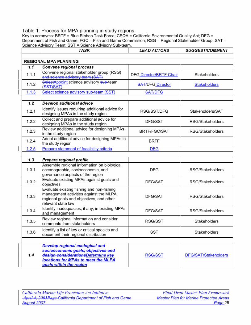
California Marine Life Protection Act Initiative Final Draft Master Plan Framework April 4, 2005Page California Department of Fish and Game Master Plan for Marine Protected AreasAugust 2007 Page 25
Table 1: Process for MPA planning in study regions. Key to acronyms: BRTF = Blue Ribbon Task Force; CEQA = California Environmental Quality Act; DFG = Department of Fish and Game; FGC = Fish and Game Commission; RSG = Regional Stakeholder Group; SAT = Science Advisory Team; SST = Science Advisory Sub-team.
TASK LEAD ACTORS SUGGEST/COMMENT
REGIONAL MPA PLANNING1.1 Convene regional process
1.1.1 Convene regional stakeholder group (RSG)and science advisory team (SAT) DFG Director/BRTF Chair Stakeholders
1.1.2 SelectAppoint science advisory sub-team(SST)SAT) SAT/DFG Director Stakeholders
1.1.3 Select science advisory sub-team (SST) SAT/DFG
1.2 Develop additional advice
1.2.1 Identify issues requiring additional advice for designing MPAs in the study region RSG/SST/DFG Stakeholders/SAT
1.2.2 Collect and prepare additional advice for designing MPAs in the study region DFG/SST RSG/Stakeholders
1.2.3 Review additional advice for designing MPAs in the study region BRTF/FGC/SAT RSG/Stakeholders
1.2.4 Adopt additional advice for designing MPAs in the study region BRTF
1.2.5 Prepare statement of feasibility criteria DFG
1.3 Prepare regional profile
1.3.1Assemble regional information on biological, oceanographic, socioeconomic, and governance aspects of the region
DFG RSG/Stakeholders
1.3.2 Evaluate existing MPAs against goals and objectives DFG/SAT RSG/Stakeholders
1.3.3
Evaluate existing fishing and non-fishing management activities against the MLPA, regional goals and objectives, and other relevant state law
DFG/SAT RSG/Stakeholders
1.3.4 Identify inadequacies, if any, in existing MPAs and management DFG/SAT RSG/Stakeholders
1.3.5 Review regional information and consider comments from stakeholders RSG/SST Stakeholders
1.3.6 Identify a list of key or critical species and document their regional distribution SST Stakeholders
1.4
Develop regional ecological and socioeconomic goals, objectives and design considerationsDetermine key locations for MPAs to meet the MLPA goals within the region
RSG/SST DFG/SAT/Stakeholders

California Department of Fish and Game Master Plan for Marine Protected Areas July 21, 2006Page August 2007 Page 26
TASK LEAD ACTORS SUGGEST/COMMENT
1.4.1
Design regional goals, objectives and design considerations consistent with the MLPA and other relevant state lawEvaluate distribution of representative and unique habitats
RSG/SST Stakeholders
1.4.2Review regional goals, objectives and design considerations Evaluate wildlife populations, habitats, and uses of concern
BRTF/FGC/SATRSG/SST Stakeholders
1.4.3
Approve regional goals, objectives and design considerations Evaluate activities affecting populations and habitats within the region
BRTFRSG/SST Stakeholders
1.4.4 Identify species likely to benefit that are of particular concern to the region RSG/SST Stakeholders
1.4.5
DetermineIdentify key locations forin the region where MPAs to meetmay help achievethe MLPA goals within the region andcontribute to an overall network
RSG/SST DFG/SAT/Stakeholders
1.5.1 Evaluate distribution of representative and unique habitats RSG/SST Stakeholders
1.5.2 Evaluate wildlife populations, habitats, and uses of concern RSG/SST Stakeholders
1.5.3 Evaluate activities affecting populations and habitats within the region RSG/SST Stakeholders
1.5.4 Identify species likely to benefit that are of particular concern to the region RSG/SST Stakeholders
1.5.5Identify key locations in the region where MPAsmay help achieve the MLPA goals and contribute to an overall network
RSG/SST Stakeholders
ASSEMBLE DRAFT REGIONAL ALTERNATIVE MPA PACKAGESPROPOSALS
2.1 Consider potential changes to existing MPAs RSG/SST DFG/SAT/Stakeholders
2.1.1
Consider potential modifications to existing MPAs and potential new and alternative MPAs for meeting goals and objectives of the region, the MLPA, and of other relevant state law
RSG/SST Stakeholders
2.2 Assemble draft alternative MPA packagesproposals for the region RSG/SST Stakeholders
2.2.1
Identify objectives for each existing and potential new MPAPrepare a range of alternative proposals including a variety of MPAs within the region in order to achieve the goals and objectives based on the design considerations for the region.
RSG/SST SST/SAT/Stakeholders
2.2.2
Prepare a range of alternative proposals including a variety of MPAs within the region in order to achieve the goals and objectives based on the design considerations for the region.Identify objectives for each existing and potential new MPA
RSG/SST SST/SAT/Stakeholders

California Department of Fish and Game Master Plan for Marine Protected Areas July 21, 2006Page August 2007 Page 27
TASK LEAD ACTORS SUGGEST/COMMENT
2.2.3Present this range of alternatives along with justification for each to the BRTF orCommission and SAT for review
RSG
EVALUATE ALTERNATIVE MPA PROPOSALS
3.1Evaluate alternative MPA proposals against the MLPA and other relevant state law
BRTF/FGC Stakeholders
3.1.1 Prepare preliminary habitat, size, and spacing analysis of each alternative proposal SAT/SST Stakeholders
3.1.2Prepare preliminary socio-economic analysis of potential impacts of each alternative proposal
SAT/SST/DFG Stakeholders
3.1.3Review SST analyses and revise proposals as needed to more fully meet the goals, objectives and design considerations
RSG
3.2 Identify monitoring and evaluation indicators SST/SAT DFG
3.3
Forward recommended alternative proposals and recommended preferred alternative to the DepartmentCommissionfor consideration and submission to FGCaction
BRTF
3.3.1 Conduct feasibility analysis to ensure proposals may be implemented DFG RSG/BRTF
3.3.2
Design general management plan for MPAs in the region, including monitoring, enforcement, and financing, with a periodic review of effectivenessProvide comments on BRTF recommendations to Commission
DFG/SAT RSG/BRTF/Stakeholders
3.3.3
Prepare preferred alternative based upon information submitted by BRTF, RSG, and other stakeholdersDesign general management plan for MPAs in the region, including monitoring, enforcement, outreach and financing, with a periodic review of effectiveness
DFG/SAT RSG/SAT/Stakeholders
3.4Department submission of alternative proposals, preferred alternative and other documents to FGC
DFG
COMMISSION CONSIDERATION AND ACTION
4.1 FGC review of alternative proposals and public testimony FGC Stakeholders/DFG/BRTF
4.2If FGC requests, the Department prepares regulatory documents, and a CEQA analysis is performed
DFG

California Department of Fish and Game Master Plan for Marine Protected Areas July 21, 2006Page August 2007 Page 28
TASK LEAD ACTORS SUGGEST/COMMENT
4.3FGC accepts public testimony on alternative MPA proposals and supporting documents
FGC Stakeholders
4.4 FGC acts on MPA proposals FGC
The text below describes in greater detail the process for MPA planning in a study region. It is important to note that some of the sub-activities described below may occur simultaneously or may be repeated, such as the design of individual MPAs within a region. Other important activities, such as applying socioeconomic analyses or taking monitoring into account in the design of MPAs, are elements of broader activities throughout the process.
Task 1: Regional MPA Planning
The objective of this task is to develop background information, goals and objectives, and determine key locations in the region where MPAs may be useful to achieve the MLPA goals and contribute to the overall network. This profile serves as a foundation for setting goals and objectives, developing alternative proposals, and identifying needs for additional information.
During the MLPA Initiative process, designing MPAs began with identification of an initial study region. The study region focused initial efforts to implement the MLPA in a discrete area. For the MLPA Initiative process, the MLPA Blue Ribbon Task Force (BRTF) oversaw all aspects of regional planning in the initial study region. In evaluating possible initial study region alternatives along the central coast from Point Conception to Point Arena, the MLPA Initiative used the following criteria, which may be useful in future evaluations:
Biophysical boundaries. Species of plants and animals are not distributed continuously along the California coast. Many species form natural communities with borders that may assist in determining the central coast study region. Although the borders themselves may be fuzzy, the central coast clearly has two major zones, divided by the outflow from San Francisco Bay. A weaker, but important break occurs at Point Sur, where current gyres cause abrupt changes in the composition of the community of species. Is the area large enough for replicates? Options were reviewed to determine if they were large enough to replicate various habitat types in more than one MPA within the entire region.Relative amount of habitat mapped. High-resolution mapping allows determination of bottom type on a finer scale than hard versus soft, and can distinguish relief, complexity, and rugosity, for example, of hard bottom structures. This criterion, rated as either high, moderately-high, moderate, or low, was based on the amount of available, high-resolution, fine-scale, habitat mapping data relative to the potential study region.Human activity boundaries. The diversity and intensity of human activities in coastal waters are discontinuous as well. As an example, recreational fishing is more prevalent south of Point Conception than north. The waters around Monterey are among the most popular sites for scuba diving in the United States. Government jurisdictions add another layer of complexity that should also be considered. Several sub-categories were considered within this criterion:
o Recreational fishing

California Department of Fish and Game Master Plan for Marine Protected Areas July 21, 2006Page August 2007 Page 29
o Commercial fishing o Scuba diving o County jurisdictions o Military/security uses o State/federal jurisdiction
Progress of past MLPA and other public discussion groups. Input from outside groups’ prior or ongoing discussions was considered. These groups may provide important information that will assist the regional process. Potential state, federal and private partners with financial or in-kind services. Potential partners were considered. The assistance provided by these partners can enhance and facilitate regional processes. Scientific knowledge of, and research being conducted in, the region. Public and private entities, such as universities, state and federal agencies, public waste dischargers (e.g.,Southern California Coastal Water Research Project), and power generating companies (e.g., Pacific Gas and Electric’s Diablo Canyon Power Plant) have conducted or are conducting research and monitoring studies in a variety of areas along the coast. Availability of region-specific information, including information on the distribution of habitats identified in the MLPA, should help determine the final study region. Availability of first-hand knowledge of the area. Numerous scientists, fishermen, and other informed individuals collectively provide a wealth of knowledge within specific areas. The level and availability of this type of information should be considered. Number of existing MPAs. Availability of scientific data about existing MPAs and how they meet or do not meet both resource protection needs and the requirements of the MLPA are important in determining a study region.Existing fishery regulations in the region and how they meet or do not meet both resource protection needs and the requirements of the MLPA. Existing regulations create differences in the need for additional protection in certain areas. Number of complete Department fishing districts and management areas (related to existing fishery regulations). The selected study region should reflect a consideration of these areas. Range or area over which a resource user may be expected to have a working knowledge of the resources. Similar to the range over which resources are utilized by user groups, the geographic range of a user’s working knowledge will vary with the resource or resources in question. This also applies to researchers, fishery managers, and other scientists within the region. The selected study region should not be so large as to preclude the ability of individual representatives to provide input on its entire geographic extent. Distance members of a regional stakeholder group would need to travel in order to participate in group meetings. Choosing too large a study region could impose logistical problems for those required to, or interested in, participating in the process. This criterion was rated from high to low based on the length of coastline (nautical miles) within the potential study region as follows:
o High = greater than 200 miles o Moderate to high = 151-200 miles o Moderate = 100-150 miles o Low = less than 100 miles
Availability of Department personnel. The same considerations relative to travel that apply to the regional stakeholder group would also apply to Department staff.

California Department of Fish and Game Master Plan for Marine Protected Areas July 21, 2006Page August 2007 Page 30
A list of potential initial study regions was prepared and input was taken from the public both at BRTF meetings and at three public workshops in 2005. Specific areas of agreement among the majority of comments were noted. In addition, specific areas of concern became apparent. From this, a set of three potential initial study regions was developed. The positive and negative aspects of each potential region were presented to the BRTF, which then selected the final initial study region of Pigeon Point to Point Conception based on the information provided.
The same criteria used to determine the initial study region have been applied to the rest of the California coast. Using these criteria and the lessons learned from the initial central coast region provides a good format for completing implementation throughout the California coast. Accordingly, the following timeline is recommended for statewide planning:
Region 1: Central Coast Region (Pigeon Point to Point Conception) - Planning within this initial region was completed in 2006 Region 2: South Coast Region (Point Conception to U.S./Mexico border) - Planned completionin 2008Region 3: North-Central Coast Region (Point Arena to Pigeon Point) - Planned completion in 2009Other Regions: South Coast Region 4:(Point Conception to U.S./Mexico border), SanFrancisco Bay Region (Waters within the San Francisco Bay District as defined in CCR, Title 14, Section 27.00) - Planned completion in 2010Region 5:), North Coast Region (California/Oregon border to Point Arena) - Planned completion in 2011
The above provides a planning timeline, which may differ from the timeline of actual implementation. Implementation dates for MPAs within each region will be dependent upon acquiring appropriate levels of staff and funding to adequately manage, monitor, and enforce each area. Within each region, detailed management plans (described below) will provide specific plans and budgets for these critical activities.
Activity 1.1: Convene regional planning process
Activity 1.1.1: The directorDirector of the Department and chair of the BRTF convenes a regional stakeholder group and science advisory team to participate in the evaluation of the region and existing management, regional goals and objectives and potential changes to existing MPAs and the design of any additional MPAs.
Activity 1.1.2: The Director of the Department convenes a science advisory team withdesired membership of not more than 15 members. The science team will participate in evaluation of draft MPA proposals and provide scientific input and guidance to the Department for use in the BRTF regional planning process.
[Note: Since other groups’ membership size is not specified, why include for SAT?Current SAT has 16 members.]

California Department of Fish and Game Master Plan for Marine Protected Areas July 21, 2006Page August 2007 Page 31
Activity 1.1.2: The science team and Department identify members who will serve on a science sub-team, which will work closely with the regional stakeholder group, and will serve as a link to the science team.
Activity 1.2: Develop additional advice
Activity 1.2.1: The regional stakeholder group, the science advisory sub-team, and staff identify issues requiring additional advice for designing MPAs in the study region.
Activity 1.2.2: In consultation with the science advisory sub-team, staff prepares draft advice on these issues.
Activity 1.2.3: theThe task force, Commission and science team review additional advice for designing MPAs in the study region.
Activity 1.2.4: the The task force or Commission acts on the additional advice. and incorporates it into planning and guidance documents.
Activity 1.2.5: The Department prepares a statement of feasibility criteria and provides it to the BRTF, RSG, and science team. This statement will provide overarching guidance on critical features of MPA proposals that make with the intent of making them realistically able to be implemented if adopted.
[Note: The DFG feasibility criteria should not override the goals of the MLPA and other elements of the MLPA or process.]
Activity 1.3: Prepare regional profile
Activity 1.3.1: Staff assemble regional information on biological, oceanographic,socioeconomic and governance aspects and draw upon suggestions and information provided by local communities and other stakeholders. The profile will include governance aspects related to tribal uses in the region if applicable. See Appendix E for a description of social science tools and methods. The types of the information that might be included in a regional profile may be found in Appendix F.
Activity 1.3.2: Within the profile, staff evaluate existing MPAs in the study region. This preliminary analysis will include a review of existing studies within each MPA and a determination of whether the areas are meeting their original goals as well as whether they may achieve regional goals and MLPA requirements.
Activity 1.3.3: Within the profile, staff evaluate existing management of fishing and non-fishing activities (e.g., Rockfish Conservation Areas or trawl fishery closures, etc.). Wherethis other management meets the goals and objectives of the MLPA in all or part of the region, it should be incorporated into the final design. This evaluation should include an assessment of whether this other management could be leveraged to help meet the goals and objectives of the MLPA in all or in part of the region during MPA design.

California Department of Fish and Game Master Plan for Marine Protected Areas July 21, 2006Page August 2007 Page 32
Activity 1.3.4: Within the profile, staff identify inadequacies in existing MPAs and management activities in meeting the goals and objectives of the MLPA. (See Appendix H for a description of planning processes related to the MLPA.)
Activity 1.3.5: The regional stakeholder group and the science sub-team review regional information and consider comments from stakeholders.
Activity 1.3.6: Drawing upon the list of species likely to benefit from protection within MPAs described in Appendix G, the science advisory sub-team develops a list of key or critical species and document their regional distribution.
Activity 1.4: Develop regional ecological and socioeconomic goals, objectives and design considerations
Activity 1.4.1: Drawing upon the regional profile and the goals and objectives of the MLPA, the regional stakeholder group and the science advisory sub-team design recommended regional goals, objectives and design considerations, consistent with the MLPA and other relevant state law. (See discussion of setting goals and objectives below.)
Activity 1.4.2: The regional goals, objectives, and design considerations developed in the regional effort are reviewed by the science team, whose comments are forwarded to the task force. The task force reviews the proposed regional goals, objectives, and alternativenetwork concepts and provides comments and suggestions to the regional stakeholdergroup for consideration in revision. The task force subsequently forwards its comments and suggestions, together with the proposed regional goals, objectives, and network concepts, to the Department
Activity 1.4.3: The task force approves the regional goals, objectives, and designconsiderations, when satisfied that they meet the standards of the MLPA.
Activity 1.5: Determine key locations for MPAs to meet the MLPA goals within the region.
Activity 1.54.1: The regional stakeholder group and the science advisory sub-team evaluate the distribution of representative and unique habitats in the region, based on the information assembled in Activity 1.3, and information provided by stakeholders, including local communities and fishermenresource users.
Activity 1.54.2: The regional stakeholder group and the science advisory sub-team identify and evaluate wildlife populations, habitats, and various human uses that may negatively impact the populations and habitats in the region.
Activity 1.54.3: The regional stakeholder group and the science advisory sub-team identify and evaluate activities that may affect populations and habitats.
Activity 1.54.4: The regional stakeholder group and the science advisory sub-team determine which key or critical species from step 1.3.6 are likely to benefit from MPAs in the region. Species Regulations allowing take for species not likely to benefit should also
California Department of Fish and Game Master Plan for Marine Protected Areas July 21, 2006Page August 2007 Page 33
be considered as prohibition of their take maycould lead to unnecessary socioeconomicimpact. All species, however, should be considered for their ecological roles and interactions, whether the individual species benefit or not. The regional stakeholder group should consider what regulations are appropriate for each proposed MPA to meet the regional goals and objective.
Activity 1.54.5: The regional stakeholder group and the science advisory sub-team identify key locations in the region where MPAs may help achieve the MLPA goals and contribute to an overall network. The groups will consider both ecologically important areas and areas of key human interest in their discussions.
Task 2: Assemble Draft Regional Alternative MPA PackagesProposals
The objective of this task is to make specific recommendations on changes to existing MPAs along with suggestions for alternative new MPAs and other potential management measures. The intent is for the sum of individual MPAs to meet the regional goals and objectives and the sum of the regions to meet the MLPA goals and objectives and network requirements, while noting that any individual MPA may not meet all of the goals of the region or network.
Activity 2.1: Recommend potential changes to existing MPAs.
Activity 2.1.1: The regional stakeholder group and the science sub-team review all the above information and make initial recommendations for the modification, reduction in size, expansion, or removal of existing MPAs in order to meet regional goals and objectives consistent with the goals of the MLPA and of other relevant State law.
Activity 2.2: Assemble draft alternative MPA packagesproposals for the region

California Department of Fish and Game Master Plan for Marine Protected Areas July 21, 2006Page August 2007 Page 34
Activity 2.2.1: The regional stakeholder group reviews each revised or potential new MPA and identifies initial objectives for each MPA to help meet the goals and objectives of the MLPA.Activity 2.2.1: The regional stakeholder group and the science advisory sub-team prepare a range of alternative proposals including a variety of MPAs within the region. Each proposal is intended to achieve the goals and objectives of the MLPA and is based on the design considerations developed for the region
Activity 2.2.2: The regional stakeholder group reviews each revised or potential new MPA and the science advisory sub-team prepare a range of alternative proposals including a variety of MPAs within the region. Each proposal is intendedidentifies initial objectives for each MPA to achievehelp meet the goals and objectives of the MLPA and is based on the design considerations developed for the region.
Activity 2.2.3: The alternative proposals are presented to the task force or Commissionand SAT for review and evaluation.
Task 3: Evaluate Alternative MPA proposals
The objectives of this task are to conduct initial reviews of the alternative MPA proposals, to conduct environmental and socioeconomic analyses as required by law, and to identify potential monitoring and evaluation indicators for long-term management.
Activity 3.1: Evaluate alternative MPA proposals.
The science advisory sub-team and science team conduct a variety of analyses in order to provide relative comparisons of each package to each other in respect to the MLPA goals and objectives and other relevant State law. Where feasible, Tthis review is provided to the BRTF and Commission for discussion all proposals and may lead to revisions to the proposals and a repetition of portions of Task 3.
Activity 3.1.1: The science advisory sub-team and science team prepare preliminary analyses of the habitats within MPAs, MPA sizes, and MPA spacing for each alternative proposal. These analyses provide a relative comparison of how well each proposal meets specific goals of the MLPA.
Activity 3.1.2: The science advisory sub-team and science team, in conjunction with the Department and potential contracted support, prepare a preliminary analysis of the maximum potential impact of each proposal to existing fishing in terms of area set aside versus frequency of use.
Activity 3.1.3: The regional stakeholder group reviews the science team analyses and revises proposals, as necessary, to more fully meet the goals, objectives and design considerations.
Activity 3.2: Identify monitoring and evaluation indicators.
California Department of Fish and Game Master Plan for Marine Protected Areas July 21, 2006Page August 2007 Page 35
The regional stakeholder group and the science advisory sub-team identify potential monitoring and evaluation indicators used to evaluate progress toward achieving goals and objectives.
Activity 3.3: Forward proposals to Commission.
The task force forwards alternative proposals for MPAs, initial evaluations, and the general management plan, together with its own evaluation and a preferred alternative, to the Commission for its consideration and actions.
Activity 3.3: Forward proposals to .1: The Department.The task force forwards alternative proposals for MPAs, initial evaluations, and conducts a feasibility analysis of the general management plan, together with its own evaluation, to the Department for its consideration and submission to the Commission.proposals. This includes analysis of Department ability to enforce, monitor, manage and fund the full implementation of the proposed MPAs. The analysis will not be contingent upon existing funds, but proposals must be reasonably expected to be implemented within the MLPA implementation timeframe. Proposals that are found infeasible will be noted with specific comments for the Commission.
Activity 3.3.12: The Department conducts a provides its comments based upon the feasibility analysis ofto the Commission including any recommendations on how to make proposals. This analysis includes analysis of the Department’s feasible while maintaining their scientific integrity and ability to enforce, monitor, manage and fundfulfillthe full implementationgoals and objectives of the proposed MPAs. The analysis will not be contingent upon existing funds, but proposals must be reasonably expected to be implemented within the MLPA implementation timeframe. Proposals that are found infeasible may be altered by the Department in preparation of its preferred alternative, returned to the regional stakeholder group for further discussion and revision, or noted with specific comments for the Commission. .
Activity 3.3.23: The Department with assistance from the science team designs a general management plan for MPAs in the region, including specific plans for monitoring, enforcement, costs and financing, and periodic review of effectiveness. This plan may be forwarded to the Commission along with the specific area proposals or separately during the decision making process (Task 5).
Activity 3.3.3: The Department prepares a preferred alternative based upon the information submitted by the task force, regional stakeholder group, and other stakeholders or interested parties.
Activity 3.4: Submit proposals to Commission.The Department submits those alternative proposals that are consistent with the MLPA, a preferred alternative, and other pertinent information from the regional groups and the taskforce, to the Commission.
Task 4: Commission consideration and action

California Department of Fish and Game Master Plan for Marine Protected Areas July 21, 2006Page August 2007 Page 36
The objectives of this task are to consider public testimony and other information regarding the MPA proposals submitted by the Department and to take action on these proposals.
Activity 4.1: Commission review of proposals. The Commission reviews the alternative regional MPA proposals, takes public testimony, and determines whether to request that the Department begin the formal regulatory process.
Activity 4.2: Formal regulatory process. If the Commission does make such a request, the Department prepares regulatory language and other documents and analyses required by the California Environmental Quality Act (CEQA) and other relevant law.
Activity 4.3: Public testimony. The Commission then accepts public testimony on the alternative regional MPA proposals and on the analyses conducted under CEQA and other law.
Activity 4.4: The Commission acts on alternative regional MPA proposals.
California Department of Fish and Game Master Plan for Marine Protected Areas July 21, 2006Page August 2007 Page 37
Section 3. Considerations in the Design of MPAs
Accomplishing MLPA goals and objectives to improve a statewide network of MPAs requires considering a number of issues, some of which are addressed in the MLPA itself. These are as follows:
Goals of the Marine Life Protection Program MPA networks Types of MPAs Settling goals and objectives for MPAs Geographical regions Representative and unique habitats Species likely to benefit from MPAs Enforcement considerations in setting boundaries Information used in the design of MPAs Monitoring and evaluation strategies and resources Other activities affecting resources of concern
Each of these issues is discussed below.
Goals of the Marine Life Protection Program
The foundation for achieving the goals and objectives of the MLPA is a Marine Life Protection Program (Program), which must be adopted by the Commission. The MLPA sets the following goals for the Program [FGC subsection 2853(b)]:
(1) To protect the natural diversity and abundance of marine life, and the structure, function, and integrity of marine ecosystems.
(2) To help sustain, conserve, and protect marine life populations, including those of economic value, and rebuild those that are depleted.
(3) To improve recreational, educational, and study opportunities provided by marine ecosystems that are subject to minimal human disturbance, and to manage these uses in a manner consistent with protecting biodiversity.
(4) To protect marine natural heritage, including protection of representative and unique marine life habitats in California waters for their intrinsic value.
(5) To ensure that California's MPAs have clearly defined objectives, effective management measures, and adequate enforcement, and are based on sound scientific guidelines.
(6) To ensure that the state's MPAs are designed and managed, to the extent possible, as a network.
The goals, objectives, management, monitoring, and evaluation of an MPA network must be consistent with the MLPA goals and objectives.
The goals of the MLPA go beyond the scope of traditional management of activities affecting living marine resources, which has focused upon maximizing yield from individual species or groups of species. For example, the first goal emphasizes biological diversity and the health of

California Department of Fish and Game Master Plan for Marine Protected Areas July 21, 2006Page August 2007 Page 38
marine ecosystems, rather than the abundance of individual species. The second goal recognizes a role of an MPA system as a tool in fisheries management. The third recognizes the importance of recreation and education in MPAs, and balances these with the protection of biodiversity. The fourth recognizes the value of protecting representative and unique marine habitats for their own value. The fifth and sixth goals address the deficiencies in California’s existing MPAs that the MLPA identifies elsewhere in the law. (See the glossary in Appendix J for definitions of some key terms in this goal statement.)
The MLPA also states that the preferred siting alternative for MPA networks, which the Department must present to the Commission, must include an “improved marine life reserve6
component” and must be designed according to all of the following guidelines:
(1) Each MPA shall have identified goals and objectives. Individual MPAs may serve varied primary purposes while collectively achieving the overall goals and guidelines of this chapter.
(2) Marine Life Reserves in each bioregion shall encompass a representative variety of marine habitat types and communities, across a range of depths and environmental conditions.
(3) Similar types of marine habitats shall be replicated, to the extent possible, in more than one marine life reserve in each biogeographical region.
(4) Marine life reserves shall be designed, to the extent practicable, to ensure that activities that upset the natural functions of the area are avoided.
(5) The MPA network and individual MPAs shall be of adequate size, number, type of protection, and location to ensure that each MPA meets its objectives and that the network as a whole meets the goals and guidelines of the MLPA.
Overall, proposed MPAs in each region must meet their individual goals and objectives, and the collection of MPAs and other management measures in each region and throughout the State must meet the goals and objectives of the MLPA. A simple decision tree for examining this is shown in Figure 3. This diagram indicates how the various types of MPAs along with other management measures work together to meet individual goals, regional goals, and the goals of the MLPA.
Figure 3. Flowchart of the review process to determine if individual, regional, and MLPA goals are being met by the various types of MPAs and other management measures.
6 As noted previously, marine life reserve in the context of the MLPA is synonymous with a state marine reserve.

California Department of Fish and Game Master Plan for Marine Protected Areas July 21, 2006Page August 2007 Page 39
MPA Networks
One of the goals of the Marine Life Protection Program calls for improving and managing the state’s MPAs as a network, to the extent possible. Although neither statute nor legislative history defines "network," the ordinary dictionary usage contemplates interconnectedness as a characteristic of the term. The first finding of the MLPA highlights the fact that California’s MPAs “were established on a piecemeal basis rather than according to a coherent plan” [Fish and Game Code Section 2851(a)]. The term “reserve network” has been defined as a group of reserves which is designed to meet objectives that single reserves cannot achieve on their own (Roberts and Hawkins, 2000). In general this definition may infer some direct or indirect connection of MPAs through the dispersal of adult, juvenile, and/or larval organisms or other biological interactions. In most cases, larval and juvenile dispersal rates are not known and oceanography or ocean current patterns may be combined with larval biology to help determine connectivity.
Portions of the overall network will likely differ in each region of the state. The MLPA also requires that the network as a whole meet the various goals and guidelines set forth by the law and contemplates the adaptive management of that network [Fish and Game Code Section 2857(c)(5)]. In order to meet those goals a strict interpretation of an ecological network across the entire state, based on biological connectivity, may not be possible.
As stated above, the MLPA also requires that MPAs be managed as a network, to the extent possible. This implies a coordinated system of MPAs. MPAs might be linked through biological function as in the case of adult and juvenile movement or larval transport. MPAs managed as a network might also be linked by administrative function. The important aspects of this interpretation are that MPAs are linked by common goals and a comprehensive management and monitoring plan, and that they protect areas with a wide variety of representative habitat as required by the MLPA. MPAs should be based on the same guiding principles, design criteria, and processes for implementation. In this case, a statewide network could be one that has connections through design, funding, process, and management. At a minimum, the master plan should insure that the statewide network of MPAs reflects a consistent approach to design, funding and management. The desired outcome would include components of both biological connectivity and administrative function to the extent each are practicable and supported by available science.
Because of the long-term approach of the MLPA Initiative, the statewide network of MPAs called for by the MLPA will be developed in phases, region by region. Within each region, components of the statewide network will be designed consistent with the MLPA and with regional goals and objectives. Each component ultimately will be presented as a series of options, developed in a regional process involving a regional stakeholder group and a sub-group of the science team. Each will include a preferred alternative identified by the Department and delivered to the Commission. Another application of phasing may be an incremental implementation of a portion of the statewide MPA network within a single region. This type of phasing could allow for the completion of baseline surveys or the time necessary to secure additional funding for enforcement and management. Final proposals should include an explanation of the timing of implementation.

California Department of Fish and Game Master Plan for Marine Protected Areas July 21, 2006Page August 2007 Page 40
Science Advisory Team Guidance on MPA Network Design
[Note: Recommend adding the SAT methodology reports from the central coast process as an appendix to the master plan and then reference in this section and others, as needed.]
The MLPA calls for the use of the best readily available science, and establishes a science team as one vehicle for fostering consistency with this standard. The MLPA also requires that the MPA network and individual MPAs be of adequate size, number, type of protection, and location as to ensure that each MPA and the network as a whole meet the objectives of the MLPA. In addition, the MLPA requires that representative habitats in each bioregion be replicated to the extent possible in more than one marine reserve.
The availability of scientific information is expected to change and increase over time. As with the rest of this framework, the following guidelines should be modified if new science becomes available that indicates changes are warranted. Additionally, changes should be made based on adaptive management and lessons learned as MPAs are monitored throughout various regions of the state.
The science team provided the following guidance in meeting the MLPA standards. This guidance, which is expressed in ranges for some aspects such as size and spacing of MPAs, should be the starting point for regional discussions of alternative MPAs. Although this guidance is not prescriptive, any significant deviation from it should be consistent with both regional goals and objectives and the requirements of the MLPA. The guidelines are linked to specific objectives and not all guidelines will necessarily be achieved by each MPA. For each recommendation below, detailed references are provided in the bibliography with notation linking them to the appropriate section.
Overall MPA and network guidelines:
The diversity of species and habitats to be protected, and the diversity of human uses of marine environments, prevents a single optimum network design in all environments.
For an objective of protecting the diversity of species that live in different habitats and those that move among different habitats over their lifetime, every ‘key’ marine habitat should be represented in the MPA network.
For an objective of protecting the diversity of species that live at different depths and to accommodate the ontogenetic movement of individuals to and from nursery or spawning grounds to adult habitats, MPAs should extend from the intertidal zone to deep waters offshore.
For an objective of protecting adult populations, based on adult neighborhood sizes and movement patterns, MPAs should have an alongshore span of 5-10 km (3-6 m or 2.5-5.4 nm) of coastline, and preferably 10-20 km (6-12.5 m or 5.4-11 nm). Larger MPAs would be required to fully protect marine birds, mammals, and migratory fish.
For an objective of facilitating dispersal and connectedness of important bottom-dwelling fish and invertebrate groups among MPAs, based on currently known scales of larval dispersal, MPAs should be placed within 50-100 km (31-62 m or 27-54 nm) of each other.
"Key" marine habitats (defined below) should be replicated in multiple MPAs across large environmental and geographic gradients to protect the greater diversity of species

California Department of Fish and Game Master Plan for Marine Protected Areas July 21, 2006Page August 2007 Page 41
and communities that occur across such gradients, and to protect species from local year-to-year fluctuations in larval production and recruitment.
For an objective of providing analytical power for management comparisons and to buffer against catastrophic loss of an MPA, at least three to five replicate MPAs should be designed for each habitat type (see pages 43-45) within a biogeographical region.
For an objective of lessening negative impact while maintaining value, placement of MPAs should take into account local resource use and stakeholder activities.
Placement of MPAs should take into account the adjacent terrestrial environment and associated human activities.
For an objective of facilitating adaptive management of the MPA network into the future, and the use of MPAs as natural scientific laboratories, the network design should account for the need to evaluate and monitor biological changes within MPAs.
1. Different marine habitats support particular species and biological communities, which in themselves vary across large-scale environmental gradients. (See references noted “A” in literature cited)
MPA networks should include "key" marine habitats (defined below), and each of these habitats should be represented in multiple MPAs across biogeographical regions, upwelling cells, and environmental and geographical gradients.
The strong association of most demersal marine species with particular habitat types (e.g., sea grass beds, submarine canyons, shallow and deep rock reefs), and variation in species composition across latitudinal, depth clines and biogeographical regions, implies that habitat types must be represented across each of these larger environmental gradients to capture the breadth of biodiversity in California’s waters.
Different species use marine habitats in different ways. As a result, protection of all the key habitats along the California coast is a critical component of network design. “Key” habitat types provide particular benefits by harboring a different set of species or life stages, having special physical characteristics, or being used in ways that differ from the use of other habitats. For the purpose of evaluation, key habitat types were considered to be; sand beach, rocky intertidal, estuary, shallow sand, deep sand, shallow rock, deep rock, kelp, shallow canyon, and deep canyon. In addition, many species require different habitats at different stages of their life cycle - for example, nearshore species may occur in offshore open ocean habitats during their larval phase. Thus, protection of these habitats, as well as designs that ensure connections between habitats, is critical to MPA success. Individual MPAs that encompass a diversity of habitats will both ensure the protection of species that move among habitats and protect adjoining habitats that benefit one another (e.g., exchange nutrients, productivity). Habitats with unique features (educationally, ecologically, archeologically, anthropologically, culturally, spiritually), or those that are rare should be targeted for inclusion. Habitats that are uniquely productive (e.g. upwelling centers or kelp forests) or aggregative (e.g., fronts) or those that sustain distinct use patterns (e.g. dive training centers, fishing or whale watching hot spots) should also get special consideration in design planning.
2. Target species are ecologically diverse (See references noted “B” in literature cited)

California Department of Fish and Game Master Plan for Marine Protected Areas July 21, 2006Page August 2007 Page 42
MPAs potentially protect a large number of species within their borders, and these species can have dramatically different requirements. As a result, MPA networks cannot be designed for the specific needs of each individual species. Rather, design criteria need to focus on maximizing collective benefits across species by minimizing compromises where possible. Commonly, it is more practical to consider protecting groups of species based on shared functional characteristics that influence MPA function and design (e.g., patterns of adult movement; patterns of larval dispersal; dependence on critical locations such as spawning grounds, mammal haul out areas, bird rookeries). It is also reasonable to emphasize protection of individual species and groups of species that have special significance because of their dominant role in ecosystems or their economic importance. Ecologically dominant species play the largest roles in the function of coastal ecosystems, and economically important species often experience the greatest impacts from human activities. In addition, knowledge of the distribution of rare, endemic, and endangered species should supplement the use of species groups. Generally, MPAs should not be used solely to enhance single-species management goals.
3. Uses of marine and adjacent terrestrial environments are diverse (See references noted “C” in literature cited)
The way people use coastal marine environments is highly diversified in method, goals, timing, economic objectives, and spatial patterns. The wide spectrum of environmental uses should be a part of decisions comparing alternative networks of MPAs. The heterogeneity of uses, both between and within consumptive and non-consumptive categories make it unlikely that any one design will satisfy all user groups. The design will need to make some explicit provisions for trading off among the various negative and positive impacts on user groups. Placement of MPAs should also take into account the adjacent terrestrial environment and associated human activities. Freshwater runoff can be an important source of nutrients but also a potential source of contaminants to the adjacent marine environment. Terrestrial protected areas (e.g., preserves, parks) can regulate human access, restrict discharge of contaminants and provide enforcement support to adjoining MPAs.
4. MPA permanence is especially critical for long lived animals
Two clear objectives for establishing self-sustaining MPAs are to protect areas that are important sources of reproduction (nurseries, spawning areas, egg sources) and to protect areas that will receive recruits and thus be future sources of spawning potential. To meet the first objective of protecting areas that serve as sources of young, protection should occur both for areas that historically contained high abundances and for areas that currently contain high abundances. Historically productive fishing areas, which are now depleted, are likely to show a larger, ultimate response to protective measures if critical habitat has not been damaged. Protecting areas where targeted populations were historically abundant alone is insufficient, however, because the pace of recovery may be slow, especially for species with relatively long life spans and sporadic recruitment (for example, top marine predators). Including areas with currently high abundances in an MPA network helps buffer the network from the inevitable time lag for realizing the responses of some species. The biological characteristics of longevity and sporadic recruitment also suggest that the concept of a rotation of open and closed areas will probably not work well for the diversity of coastal species in California.

California Department of Fish and Game Master Plan for Marine Protected Areas July 21, 2006Page August 2007 Page 43
5. Size and shape guidelines (See references noted “D” in literature cited)
To provide any significant protection to a target species, the size of an individual MPA must be large enough to encompass the typical movements of many individuals. Movement patterns vary greatly among species. Some are completely immobile or move only a few meters. Others forage widely. The more mobile the individuals, the larger the individual MPA must be to afford protection. Therefore, minimum MPA size constraints are set by the more mobile target species. Because some of California’s coastal species are known to move hundreds of miles, MPAs of any modest size are unlikely to provide a high degree of protection for these species. Fortunately, tagging studies indicate that net movements of many of California’s nearshore bottom-dwelling fish species, particularly reef-associated species, are on the order of 5-20 km (3-12.5 m or 2.5-11 nm) or less over the course of a year (Lea et al. 1999). Knowledge of these individual adult neighborhood or home range sizes must be combined with knowledge of how individuals are distributed relative to one another (e.g., in exclusive versus overlapping neighborhoods) to determine how many individuals a specific MPA design will protect. Current data suggest that MPAs spanning less than about 5-10 km (3-6 m or 2.5-5.4 nm) in extent along coastlines may leave many individuals of important species poorly protected. Larger MPAs, spanning 10-20 km (6-12.5 m or 5.4-11 nm) of coastline, are probably a better choice given current data on adult fish movement patterns.
In an MPA network it is relatively easy to protect non-mobile species, and relatively difficult to protect species whose ranges generally extend beyond MPA boundaries. This is due to the fact that highly mobile species will spend the majority of their lives outside the protected area and thus receive little added protection by its establishment. Non-mobile species, conversely, may spend their entire life within the protected area and be completely protected from human take. In light of this, special consideration in MPA network design is paid to species with intermediate mobility, which will not only receive significant protection but also be available for take when outside MPA boundaries. With MPAs spanning 10-20 km of coastline, pelagic species with very large neighborhood sizes will likely receive little protection unless the MPA network as a whole affords significant reductions in mortality during the cumulative periods that individuals spend in different MPAs, or unless other ecological benefits are conferred (e.g., protection of feeding grounds, reduction in bycatch). Protection for highly mobile species will come from other means, such as state and federal fisheries management programs, but MPAs may play a role.
Less is known about the net movements of most of the deeper water sedentary and pelagic fishes, especially those associated with soft-bottom habitat, but it is reasonable to suspect that the range of movements will be similar or greater than those of nearshore species. One cause of migration in demersal fishes is the changing resource/habitat requirements of individuals as they grow. Thus, individual ranges can reflect the gradual movement of an individual among habitats, and MPAs that encompass more diverse habitat types will more likely encompass the movement of an individual over its lifetime. Although fisheries may not target younger fish, offshore MPAs that include inshore nursery habitats increase the likelihood of replenishment of adult populations offshore. Such MPAs would also protect younger fish from incidental take (i.e. bycatch). Fish with moderate movements, especially those in deeper water, will require larger MPA sizes. Because several species also move between shallow and deeper habitat, MPAs that extend offshore (from the coastline to the three-mile offshore boundary of State waters) will accommodate such movement and protect individuals over their lifetime.

California Department of Fish and Game Master Plan for Marine Protected Areas July 21, 2006Page August 2007 Page 44
Typically, the relative amount of higher relief rocky reef habitat decreases with distance from shore. In such situations, a MPA shape that covers an increasing area with distance offshore (i.e., a wedge shape) may be an effective design. This shape also better accommodates the greater movement ranges of deeper water and soft-bottom associated fishes and the larval/juvenile stages of nearshore species which may occur offshore during their planktonic phase of life. However, this may conflict with the optimum design for enforcement purposes of using lines of latitude and longitude for boundaries.
Coupling of pelagic and benthic habitats is an important consideration in both offshore and nearshore MPA design. The size of a protected area should also be large enough to facilitate enforcement and to limit deleterious edge effects caused by fishing adjacent to the MPA. MPA shape should ultimately be determined on a case-by-case basis using a combination of information about bathymetry, habitat complexity, species distribution, and relative abundance.
6. Spacing between MPAs (See references noted “E” in literature cited)
The exchange of larvae among MPAs is the fundamental biological rationale for MPA “networks”. Larval exchange has at least three primary objectives: to assure that populations within MPAs are not jeopardized by their reliance on replenishment from less protected populations outside MPAs; to ensure exchange and persistence of genetic traits of protected populations (e.g., fast growth, longevity); and to enhance the independence of populations and communities within MPAs from those outside MPAs for the use of MPAs as reference sites. One role of MPAs is to act as reference sites for comparison with less protected populations or communities. For this to occur, MPAs must act independently from areas with less protected populations. Independence is enhanced for MPAs whose replenishment is contributed to by other MPAs.
Movement out of, into and between MPAs by juveniles, larvae, eggs, or spores of marine species depends on their dispersal distance. Important determinants of dispersal distance are the length of the planktonic period, oceanography and current regimes, larval behavior, and environmental conditions (e.g., temperature and sources of entrainment). As with adult movement patterns, the dispersal of juveniles, larvae and eggs varies enormously among species. Some barely move from their natal site. Others disperse vast distances. MPAs will only be connected through the dispersal of young if they are close enough together to allow movement from one MPA to another. Any given spacing of MPAs will undoubtedly provide connectivity for some species and not for others. The challenge is minimizing the number of key or threatened species that are left isolated by widely spaced MPAs.
Based on emerging genetic data from species around the world, larval movement of 50-100 km appears common in marine invertebrates (Kinlan et al. 2005; Kinlan and Gaines 2003; Shanks et al. 2003; Siegel et al. 2003). For fishes, larval neighborhoods based on genetic data appear generally larger, ranging up to 100-200 km. For marine birds and mammals, dispersal of juveniles of hundreds of km is not unusual, but for some of these species, return of juveniles to natal areas can maintain fine-scale population structure. For MPAs to be within dispersal range for most commercial or recreational groundfish or invertebrate species, they will need to be on the order of 50-100 km apart. Otherwise, a large fraction of coastal species will gain no benefits from connections between MPAs.

California Department of Fish and Game Master Plan for Marine Protected Areas July 21, 2006Page August 2007 Page 45
Current patterns, retention features such as fronts, eddies, bays, and the lees of headlands may create “recruitment sinks and sources”. Such spatial variation in recruitment habitat may be predictable - dispersal distances will be shorter where retention is substantial (e.g., lees of headlands). As a result, MPAs may need to be more closely spaced in these settings. Although dispersal data appear to be valid for a wide range of species, there are few coastal marine species in California that allow these estimates of larval neighborhoods to be made with confidence. Nonetheless, the specific pattern of larval dispersal in any particular species is not as important for network design as the sum of all the patterns of larval dispersal for all the species of concern.
7. Minimal replication of MPAs
MPAs in a particular habitat type need to be replicated along the coast. Four major reasons for this are: to provide stepping-stones for dispersal of marine species; to insure against local environmental disaster (e.g. oil spills or other catastrophes) that can significantly impact an individual, small MPA; to provide independent experimental replicates for scientific study of MPA effects; and for the use of MPAs as reference sites to evaluate the effects of human influences on populations and communities outside MPAs. Ideally at least five replicates (but a minimum of three) containing sufficient representation or each habitat type, should be placed in the MPA network within each biogeographical region and for each habitat to serve these goals. For large biogeographical regions, fulfilling the critical stepping stone role may require even more MPA replicates. The spacing criteria discussed above will drive the number of replicates in this situation. To ensure that the effects of MPAs can be quantified, the network should be designed in a way that facilitates comparison of protected and unprotected habitats, and between different degrees of consumptive and non-consumptive uses.
8. Human activities ranges and MPA placement
The geographic extent of human activities is suggestive of size and placement of MPAs. Fishing fleets and other user groups typically have a finite home range from ports and access points along the coast. Many activities, especially in central California, are day-based and conducted from motor-, sail- or hand-powered crafts with ranges between 1 and 29 miles (1 and 25 nautical miles). Historical patterns of fishing activity may have been concentrated much closer to ports than is true today because of declines in target species abundance from activities in the past. If MPAs are designed to limit consumptive uses, MPAs located farthest away from access points will tend to be associated with lower negative impacts. However, MPAs often become magnets for fishing along their edges. These situations create positive impacts for consumptive users by locating MPAs close to ports and coastal access points. Similarly, MPAs designed to facilitate certain non-consumptive types of activities such as diving may be more effective closer to ports and coastal access points. As a general rule, locating MPAs at the outer reaches of the maximum range of any given user group will tend to minimize the impacts on that group, both negative (loss of opportunity) and positive (creation of opportunity). The balance between these influences must be evaluated for specific locations. In addition, if MPAs restrict transit they will carry higher social, economic and, potentially, safety costs for users seeking access to sites beyond the MPA. For these reasons, it is recommended that, in general, MPAs do not restrict transit.

California Department of Fish and Game Master Plan for Marine Protected Areas July 21, 2006Page August 2007 Page 46
9. Human activity patterns
Human activities have distinct hotspots where effort is concentrated. In certain cases there may be an ecological benefit from eliminating certain activities while their may be socioeconomic benefit from allowing others. Areas of intense use will not only be those most impacted by human perturbation of the ecosystem but also those where eliminating certain consumptive uses may cause high levels of short-term economic impact. It is recommended that proposals consider, in their design, areas of intensive human use and the cost and benefit of establishing MPAs in these areas.
Consideration of Habitats in the Design of MPAs (See additional references noted “F” in literature cited)
The first step in assembling alternative proposals for MPAs in a region and in the context of a statewide MPA network is to use existing information to the extent possible to identify and to map the habitats that should be represented. The MLPA also calls for recommendations regarding the extent and types of habitats that should be represented.
The MLPA identifies the following habitat types: rocky reefs, intertidal zones, sandy or soft ocean bottoms, underwater pinnacles, seamounts, kelp forests, submarine canyons, and seagrass beds. The Master Plan Team convened in 2000 reduced this basic list by eliminating seamounts, since there are no seamounts in state waters. The team also identified four depth zones as follows: intertidal, intertidal to 30 meters, 30 meters to 200 meters, and beyond 200 meters. Several of the seven habitat types occur in only one zone, while others may occur in three or four zones. While pelagic habitats are also important from an ecosystem perspective, they are more difficult to include in a network of MPAs due to the transitory nature of the water and its inhabitants, both of which are not constrained by lines on a map.
The science team recommends expanding these habitat definitions in several ways:
1. Based on information about fish depth distributions provided in a new book on the ecology of California marine fishes (Allen et al. in press), the science team recommends dividing the 30-200 m depth zone into a 30-100 m and a 100-200 m zone. This establishes five depth zones for consideration:
IntertidalIntertidal to 30 m (0 to 16 fm) 30 to 100 m (16 to 55 fm) 100 to 200 m (55 to 109 fm) 200 m and deeper
2. The habitats defined in the MLPA implicitly focus on open coast ecosystems and ignore the critical influence of estuaries. California's estuaries contain most of the State's remaining soft bottom and herbaceous wetlands such as salt marshes, sand and mud flats, and eelgrass beds. Ecological communities in estuaries experience unique physical gradients that differ greatly from those in more exposed coastal habitats. They harbor unique suites of species, are highly productive, provide sheltered areas for bird and fish feeding, and are nursery grounds for the young of a wide range of coastal species. Emergent plants filter sediments and nutrients from the watershed, stabilize

California Department of Fish and Game Master Plan for Marine Protected Areas July 21, 2006Page August 2007 Page 47
shorelines, and serve as buffers for flood waters and ocean waves. Given these critical ecological roles and ecosystem functions, estuaries warrant special delineation as a critical California coastal habitat.
3. Three of the habitats defined in the MLPA – rocky reefs, intertidal zones, and kelp forests – are generic habitat descriptions that include distinct habitats that warrant specific consideration and protection. In the case of rocky reefs and intertidal zones, the type of rock that forms the reef greatly influences the species using the habitat. For example, granitic versus sedimentary rock reefs harbor substantially different ecological assemblages and should not be treated as a single habitat. Similarly, the term kelp forest is a generic term that subsumes two distinct ecological assemblages dominated by different species of kelp. Kelp forests in the southern half of the state are dominated by the giant kelp, Macrocystis pyrifera. By contrast, kelp forests in the northern half of the state are dominated by the bull kelp, Nereocystis luetkeana. In central California, both types of kelp forests occur. These two types of kelp forests harbor distinct assemblages and should be treated as separate habitats.
4. Habitat definitions in the MLPA should be expanded to include ocean circulation features, because habitat is not simply defined by the substrate. Seawater characteristics are analogous to the climate of habitats on land, and play a critical role in determining the types of species that can thrive in any given setting. Just as features of both the soil and atmosphere characterize habitats on land, features of both the substrate (e.g., rock, sand, mud) and the water that bathes it (e.g., temperature, salinity, nutrients, current speed and direction) characterize habitats in the sea. No one would argue that a sand dune at the beach and a sand dune in the desert are the same habitat. Similarly, rocky reefs in distinct oceanographic settings are different habitats that can differ fundamentally in the species that use the reefs.
5. There are often multiple habitat types within a relatively small area, and these are often incorporated into proposed MPAs. The science team distinguished these habitat types using the highest resolution bathymetry data available, when calculating percent of each habitat within proposed MPAs. For the purposes of linking habitats within a network or network component, each MPA was characterized by the habitats that it includes in an ecologically meaningful amount. For the purpose of evaluating whether habitats are adequately represented within individual MPAs, the following factors must be considered: the relative amount of that habitat in the entire region, the overall size of the MPA, and the home range of species likely to benefit from protection in an MPA that rely upon that habitat.
6. In the central coast region, high-resolution bathymetric imagery data are not available for most of the southern half of the region. Coarse-scale bathymetry data indicated that a large portion of the region was soft bottom, yet commercial and recreational fishing effort data for rockfishes associated with hard bottom, as well as anecdotal information from fishermen and other constituents, indicated that considerable hard bottom exists within state waters. Maps derived from recreational CPFV fishing data for rockfish trips and maximum extent of kelp should be used to develop proxies for the location of hard-bottom habitat for any region in which high resolution maps do not exist; these in turn should be used for habitat calculations for proposed MPAs.
The oceanography of the California coastline is dominated by the influence of the California Current System. On the continental shelf and slope this system consists of two primary currents - the California Current, which flows toward the equator, and the California

California Department of Fish and Game Master Plan for Marine Protected Areas July 21, 2006Page August 2007 Page 48
Undercurrent, which flows toward the North Pole (Hickey, 1979; 1998). When present, the undercurrent occurs beneath the southward flowing California Current. North of Pt. Conception, the undercurrent may reach the surface as a nearshore, poleward flowing current that is best developed in fall and winter (Collins et al., 2000; Pierce et al., 2000). These currents vary in intensity and location, both seasonally and from year to year.
Organisms will also be affected by the circulation induced by tidal currents. For those living in shallow water habitats very close to shore, inshore of the surf zone, the dominant influence on transport of planktonic eggs and larvae will be the circulation generated by breaking waves.
As can be seen in a satellite image of ocean temperature along the California coastline (Figure 4), the circulation and physical characteristics of the California Current System are exceedingly complex and variable. This is not the image one would expect if ocean currents were analogous to northward or southward flowing rivers in the sea. Rather, ocean flows are greatly modified by variation in the strength and direction of winds, ocean temperatures and salinity, tides, the topography of the coastline, and the shape of the ocean bottom, among several other factors. The end result is a constantly changing sea of conditions.
The patterns are not completely random, however. Many aspects of ocean climates vary somewhat predictably in space, especially ones that are tied to key features of the coastline – points and headlands, river mouths, etc. Locations that share similar ocean climates are typically more similar in the types of species they harbor. Therefore, defining habitats for the MLPA and MPA networks must include habitats defined by coastal oceanography as well as the composition of the seafloor.

California Department of Fish and Game Master Plan for Marine Protected Areas July 21, 2006Page August 2007 Page 49
Figure 4. An example of sea surface temperature in the California coastal waters, May 30, 2000.
Although a wide range of oceanographic habitats could be defined for the California coastline, the science team suggests that three prominent habitats stand out because of their demonstrated importance to different suites of coastal species:
Upwelling centers Freshwater plumes Retention areas
It is not recommended that such features (some of which are of very large scale) be isolated as habitats to be designated as MPAs or specifically encompassed within MPAs. However, MPAs could be designated that included or benefited from the presence or proximity of such features and processes.

California Department of Fish and Game Master Plan for Marine Protected Areas July 21, 2006Page August 2007 Page 50
Upwelling Centers
Upwelling is one of the most biologically important circulation features in the ocean. Upwelling occurs when deep water is brought to the surface. On average deep water is colder and more nutrient rich than surface waters. When upwelling delivers nutrients to the sunlit waters near the surface, it provides the fuel for rapid growth of marine plants, both plankton and seaweeds. Ultimately the added nutrients can energize the productivity of entire marine food webs. Upwelling regions are the most productive ocean ecosystems. The west coast of North America is one of the few major coastal upwelling regions on the entire planet (Chavez and Collins, 2000; Hickey, 1998). The major driver of upwelling along the California coastline is wind. Winds that blow from the north and northwest parallel to California’s generally north-south coastline drive currents at the surface. Because of the complicated effects of friction and the rotation of the earth, surface water is pushed to the right of the direction of the wind (the Coriolis Effect). With winds blowing from the north and northwest, this effect pushes surface waters away from shore. As water is pushed offshore, it is replaced by water that is upwelled from below.
The rate of upwelling depends on many features that vary spatially along the coastline – the strength and direction of the wind, the topography of the shoreline, and the shape of the continental shelf are three of the most important. Capes and headlands play a key feature in all of these drivers of upwelling. They accelerate alongshore winds, and they channel coastal currents in such a way that upwelling intensity can increase dramatically in their vicinity. As a result, major headlands and capes from Pt. Conception north are commonly centers of upwelling associated with strong rates of offshore transport of surface waters, greatly elevated nutrient concentrations, and enhanced productivity offshore (Pickett and Paduan, 2003). Since major capes and headlands tend to be fairly regularly spaced along the California coastline, with an average spacing between 150 and 200 km (93 and 124 m or 81 and 108 nm), these upwelling centers drive cells of ocean circulation with relatively predictable patterns of flow. Enhanced offshore flow and upwelling emanates from headlands, versus eddies and locations of more frequent alongshore flow in the regions between headlands. These filaments of upwelled water are readily identified emanating from key headlands in most satellite images of ocean temperature or biomass of phytoplankton. Because the upwelling centers are locations of more frequent and intense offshore flow near the surface, which moves larvae and other plankton away from shore, and elevated nutrients, which fuels much more rapid algal productivity, these locations represent a distinct oceanographically driven coastal habitat with substantially different species composition and dynamics compared to other coastal locations.
Freshwater Plumes
A second coastal habitat driven by features of the water column is generated by the influence of rivers. Freshwater emerging from watersheds alters the physical characteristics of coastal seawater (especially salinity), changes the pattern of circulation (by altering seawater density), and delivers a variety of particles and dissolved elements, such as sediments, nutrients, and microbes. These effects all arise from the land and can have a profound influence on the success of different marine species. The mouths of watersheds set the locations of low salinity plumes, and the size and shape of the plume vary over time as functions of the volume of flow from the watershed, the concentration of particles, and the nature of coastal circulation into which the water is released. The location of California’s freshwater plume habitats can be

California Department of Fish and Game Master Plan for Marine Protected Areas July 21, 2006Page August 2007 Page 51
defined by both satellite and ocean-based measurements. In other parts of the country (e.g. Mississippi River delta) and the state (e.g. San Francisco Bay estuarine complex) the influence of this habitat type is much greater than it is in regions such as the central California coast south of San Francisco.
Larval Retention Areas
Since connectivity and movement of larvae, plankton, and nutrients play such an important role in the impact of MPAs on different species, changes in the speed and direction of coastal currents can create very different ecological settings. A number of circulation features can greatly limit the coastal particles. In particular, features characterized by rotational flows, such as eddies, can greatly enhance the length of time that a particle or larval fish stays in a general region of the coastline. Such retentive features have been shown to significantly affect the species composition of coastal ecosystems (Largier, 2004). Since many retention areas are tied to fixed features of coastal topography (e.g., eddies in the lee of coastal headlands or driven by bottom topography), they define unique regions of coastal habitat that can be predictably defined.
Experience in California and elsewhere demonstrates that individual MPAs generally include several types of habitat in different depth zones, so that the overall number of MPAs required to cover the various habitat types can be smaller than the number of total habitats. The Master Plan Team convened in 2000 also called for considering adjacent lands and habitat types, including seabird and pinniped rookeries. Since marine birds and mammals are protected by federal regulations, they are not a primary focus of the MLPA. Nonetheless, these species can play important ecological roles and their success may be impacted by changes in other components of California’s coastal ecosystems that are a primary focus of MLPA. Therefore, MPA planning needs to coordinate with other efforts focused on marine birds and mammals.
As noted regarding the design of MPAs, this guidance should be the starting point for regional discussions regarding representative habitats in a region. Although this guidance is not prescriptive, any significant deviation from it should be explained.
Species Likely to Benefit from MPAs
Recommending the extent of habitat that should be included in an MPA network will require careful analysis and consideration of alternatives. These recommendations may vary with habitat and region, but should be based on the best readily available science. One aspect of determining appropriate levels of habitat coverage is the habitat requirements of species likely to benefit from MPAs in a region. California Fish and Game Code subsection 2856(a)(2)(B) requires that the master plan identify “select species or groups of species likely to benefit from MPAs, and the extent of their marine habitat, with special attention to marine breeding and spawning grounds, and available information on oceanographic features, such as current patterns, upwelling zones, and other factors that significantly affect the distribution of those fish or shellfish and their larvae.”
The Department prepared a master list of such species, which appears in Appendix G. This list may serve as a useful starting point for identifying such species in each region during the development of alternative MPA proposals. With the assistance of the science team, the

California Department of Fish and Game Master Plan for Marine Protected Areas July 21, 2006Page August 2007 Page 52
Department should develop a list of species specific to each study region of the state, as they are determined, for use by the appropriate regional stakeholder group. The list will indicate which species are of critical concern and why. This regional list then can assist in evaluating desirable levels of habitat coverage in alternative MPA proposals. Although the statewide list will be all inclusive, it is not likely that all species on the list will benefit from the establishment of new, or the expansion of existing, MPAs. For example, a species may be in naturally low abundance within this portion of its geographical range.
The Department, with the assistance of the science team, will develop scientifically based expectations of increases in abundance of focal species for each MPA. These expectations, while not hard targets or performance goals, will help managers determine the efficacy of MPAs. If expected increases are not realized, the process of adaptive management will allow for changes in the MPA design.
Biogeographical Regions
In calling for a statewide network of MPAs, to the extent possible, the MLPA recognizes that the state spans several biogeographical regions, and identified these, initially, as follows [FGC subsection 2852(b)]:
The area extending south from Point Conception, The area between Point Conception and Point Arena, and The area extending north from Point Arena.
In the same provision, the MLPA provides authority for the master plan team required by FGC subsection 2855(b)(1) to establish an alternate set of boundaries. The Master Plan Team convened by the Department in 2000 determined that the three regions identified in the MLPA were not zoogeographic regions; scientists recognize only two zoogeographic regions between Baja California and British Columbia with a boundary at Pt. Conception. Instead of the term “biogeographical region,” the team adopted the term “marine region” and identified four marineregions:
North marine region: California-Oregon border to Point Arena (about 210 linear miles or 183 linear nautical miles of coastline);
North-central marine region: Point Arena to Point Año Nuevo (about 180 linear miles or 156 linear nautical miles of coastline);
South-central marine region: Point Año Nuevo to Point Conception (about 233 linear miles or 203 linear nautical miles of coastline); and
South marine region: Point Conception to the U.S./Mexico border, including the islands of the southern California Bight (about 280 linear miles or 243 linear nautical miles of coastline).
Three of the above four regions (those north of Point Conception) fall within the larger zoogeographic region accepted by scientists. These sub-regions were used more or less as subdivisions of the greater zoogeographic region by the former Master Plan Team. Technically, the requirement of replicate state marine reserves encompassing a representative variety of habitat types and depths would only apply to the two recognized zoogeographic regions within the state. However, based on the concept of a network of MPAs, in whatever

California Department of Fish and Game Master Plan for Marine Protected Areas July 21, 2006Page August 2007 Page 53
way it is defined, and the fact that it would likely require unusually and unacceptably large state marine reserves to incorporate a wide variety of habitat types if only two (the minimum definition of “replicate”) state marine reserves were established in each zoogeographic region, it is likely that a statewide network will contain more than two state marine reserves in each biogeographical region.
MPAs in different biogeographical regions will affect different suites of species. Thus replication and network design may be considered separately for relatively distinct stretches of coastline. Biogeographical regions can be distinguished based upon data of two types: 1) the location of species’ borders along the coastline; and 2) surveys of species’ distribution and abundance. Historically, the locations of species’ borders, i.e., places where multiple species terminate their ranges, have been used to define biogeographical regions or provinces. However, regional boundaries typically are set by only small subset of the species distributed up and down coast from these “breakpoints”.
The abundances and diversity of species at locations along the coast are much more reflective of differences in biological communities and provide the best evidence of biologically distinct regions from both structural and functional standpoints. Historically, such data on abundance and biological diversity have not been available at enough locations along most coastlines for broad scale, geographic analyses. As a result, definitions of biogeographical regions have been forced to rely on a less meaningful measure of biological differences – the location of species’ borders.
Biogeographers have divided all major oceans into large biogeographic provinces. California’s coastline spans two of these large-scale provinces – the Oregonian and the Californian Provinces – with a boundary in the vicinity of Point Conception. This prominent biogeographical boundary has been recognized for more than half a century. More detailed analyses of species’ borders also have led to the identification of regional scale boundaries between biogeographical sub-provinces.
Biogeographers commonly have used distributional data for subgroups of taxonomically related species (e.g., snails, seaweeds, or fish) to set biogeographical boundaries; interestingly, the boundaries for sub-provinces often differ among taxonomic groups because different types of species respond to different physical and biological characteristics in different ways (Airamé et al. 2003). Two locations, however, emerge as prominent boundaries for key coastal species. Seaweeds, intertidal invertebrates, and nearshore fishes have comparable numbers of species’ borders in the vicinity of Monterey Bay as they do at Point Conception. In addition, coastal fishes have an important sub-province boundary at Cape Mendocino.
Scientific data do not support a significant biological break between biogeographical regions at Point Arena, as identified in earlier MLPA documents. Therefore, on the basis of the distribution of species’ borders for key coastal species groups, there are three biogeographical regional boundaries and four regions along the California coast:
1. The U.S./Mexico border to Point Conception, 2. Point Conception to Monterey Bay, 3. Monterey Bay to Cape Mendocino, and 4. Cape Mendocino to the California/Oregon border.

California Department of Fish and Game Master Plan for Marine Protected Areas July 21, 2006Page August 2007 Page 54
In the past decade, detailed data have become available on species abundances and diversity from a large number of locations along California’s coast. This wealth of information on actual species assemblages now provides the opportunity to define biogeographical regions on the basis of actual ecosystem compositions, rather than the presumed composition of ecosystems inferred from species’ borders. These ecosystem-based data are a better scientific fit with the goals of the MLPA. Summaries of species abundance and diversity data, especially for shallow water species (<30 m depth), suggest that there are four points of transition along the California coastline that demarcate distinct marine assemblages: Point Conception, Monterey Bay, San Francisco Bay, and Cape Mendocino.
Three of these locations are identical to those defined above solely on the basis of species’ borders for prominent groups. The new boundary that emerges from abundance and biodiversity data is San Francisco Bay. The region between Monterey Bay and Cape Mendocino has two distinct biological assemblages on coastal reefs even though this is not a region characterized by large numbers of species’ borders. The difference in assemblages on either side of San Francisco Bay appears to be caused by changes in the types of rock that form nearshore reefs. Since the type of rock is used to defined bottom habitats for MPA designation, this transition in species composition could be addressed in MPA designs using habitat considerations or, alternatively by designating the Monterey Bay to San Francisco Bay segment as a distinct biogeographical region.
Based on this review, there are four possible definitions of the biogeographical regions that will serve as the basic structure of the statewide network of MPAs. These options are as follows:
1. The three biogeographical regions defined in the MLPA; 2. The two biogeographic provinces recognized by many scientists with a boundary at
Point Conception; 3. The four marine regions identified by the former Master Plan Team, with boundaries
at Point Conception, Point Año Nuevo, and Point Arena; and 4. The biogeographical regions recognized by scientists who have identified borders
based on species distributional patterns or on abundance and diversity data with boundaries at Point Conception, Monterey Bay and/or San Francisco Bay, and Cape Mendocino.
Accepting the strong scientific consensus of a major biogeographical break at Point Conception, the MLPA Blue Ribbon Task Force recommended that the Commission adopt the two biogeographic provinces as the biogeographical regions for purposes of implementing the Marine Life Protection Act. The task force recommended that the more refined information on other breaks be used in designating study regions and in designing networks of MPAs. These recommendations were adopted by the Commission in August 2005 within the Master Plan Framework and are not changed in this Master Plan.
Types of MPAs
The MLPA recognizes the role of different types of MPAs in achieving the objectives of the Marine Life Protection Program [FGC subsection 2853(c)]. While the MLPA does not define the different types, the Marine Managed Areas Improvement Act (MMAIA) defines all types of

California Department of Fish and Game Master Plan for Marine Protected Areas July 21, 2006Page August 2007 Page 55
MMAs including the three MPAs (state marine reserve, state marine park, and state marine conservation area) and one MMA (state marine recreational management area) used in the Master Plan for MLPA implementation (See Appendix B for the text of the MMAIA as amended).
Besides somewhat different purposes, which are described below, each type of MPA represents a different level of restriction on activities within MPA boundaries. These restrictions and purposes suggest how each designation can be used effectively in a network of MPAs.
State Marine Reserve
As defined in the MMAIA, a state marine reserve prohibits injuring, damaging, taking or possessing any living, geological, or cultural resources and must maintain the area “to the extent practicable in an undisturbed and unpolluted state” while allowing “managed enjoyment and study” by the public [PRC subsection 36710(a)]. The responsible agency may permit research, restoration, or monitoring. Such activities as boating, diving, research, and education may be allowed, to the extent feasible, so long as the area is maintained “to the extent practicable in an undisturbed and unpolluted state.” Such activities may be restricted to protect marine resources. It specifically allows the agency to permit scientific activities. The definition of “marine life reserve” in the MLPA is consistent with this definition.
The MLPA and MMAIA thus require striking a balance between protection and access in marine reserves. The form that this balance takes in an individual marine reserve will depend upon the goals and objectives of that reserve. While the MLPA specifically precludes commercial and recreational fishing from marine reserves, it also authorizes restrictions on other activities, including non-extractive activities (e.g., diving, kayaking, snorkeling, etc.). Any such restrictions, however, must be based on specific objectives for an individual site and the best readily available science. It is important to note that this statement does not imply that navigation will necessarily be restricted though MPAs or that other non-extractive activities will be regulated, although in some instances the latter may be necessary. For example, it may be necessary to protect populations of sensitive marine birds or mammals in their nesting or breeding areas by prohibiting access to some areas.
The MLPA sets other requirements for the use of marine reserves. At FGC subsection 2857(c)(3), the MLPA requires “[s]imilar types of marine habitats and communities shall be replicated, to the extent possible, in more than one marine life reserve in each biogeographical region.” Consistent with this approach, this Master Plan Framework foresees that in each biogeographical region described above, representative habitat across a range of depths should be represented in at least two marine reserves in order to assure the replication of habitats required by the MLPA. It should be noted that several of habitat types occur in only one depth zone, while others may occur in three or four depth zones. Experience demonstrates that individual MPAs generally include several types of habitat in different depth zones, so the overall number of marine reserves required to replicate the various habitat types may be less than the total combination of depth zones and habitats replicated across each region.

California Department of Fish and Game Master Plan for Marine Protected Areas July 21, 2006Page August 2007 Page 56
State Marine Park
As defined in the MMAIA, a state marine park prohibits injuring, damaging, taking or possessing for commercial use any living or nonliving marine resources. Other uses that would compromise the protection of living resources, habitat, geological, cultural, or recreational features may be restricted. All other uses are allowed, consistent with protecting resources.
State marine parks, hereafter called “marine parks”, differ from marine reserves to different degrees in their purposes as well as the type of restrictions. Unlike marine reserves, marine parks allow some or all types of recreational fishing. The types of restrictions on fishing may vary with the focal species, habitats, and goals and objectives of an individual marine park within a region. Where the primary goal is biodiversity conservation, restrictions on fishing may be different from those in a marine park where the primary goal is enhancing recreational opportunities.
State Marine Conservation Area
In a state marine conservation area, activities that would compromise the protection of species of interest, the natural community7, habitat, or geological features may be restricted. Research, education, and recreational activities, as well as commercial and recreational fishing may be permitted.
State marine conservation areas, hereafter called “marine conservation areas”, also differ from marine reserves in their purpose as well as the type of restrictions. This type of MPA allows some level of recreational and/or commercial fishing. The restrictions on fishing may vary with the focal species, habitats, and goals and objectives of an individual MPA within a region, and may, for instance, be in the form of restrictions on the catch of particular species or on the use of certain types of fishing gear. Marine conservation areas may be useful in protecting more sedentary, benthic species, while allowing the harvest of pelagic finfish8 species. Another use of a marine conservation area would be to allow the continued use of traps (which typically have relatively low bycatch rates and are more efficient for harvesting invertebrates) while prohibiting the harvest of finfish species of concern by hook-and-line or by trawls (which typically have relatively high bycatch rates). At present the large fishery closures known as the Cowcod Conservation Areas and the Rockfish Conservation Area may function as de factomarine conservation areas in that bottom fishing for finfishes is prohibited but other types of fishing are allowed, though the specific regulations in these areas are subject to change dependent on stock assessments.
5 Natural community is defined in Fish and Game Code section 2702(d) as a distinct, identifiable, and recurring association of plants and animals that are ecologically interrelated. 8 Pelagic Finfish are defined in California regulation as: northern anchovy (Engraulis mordax), barracudas (Sphyraena spp.), billfishes* (family Istiophoridae), dolphinfish (Coryphaena hippurus), Pacific herring (Clupea pallasi), jack mackerel (Trachurus symmetricus), Pacific mackerel (Scomber japonicus), salmon (Oncorhynchus spp.), Pacific sardine (Sardinops sagax), blue shark (Prionace glauca), salmon shark (Lamna ditropis), shortfin mako shark (Isurus oxyrinchus), thresher sharks (Alopias spp.), swordfish (Xiphias gladius), tunas (family Scombridae), and yellowtail (Seriola lalandi).

California Department of Fish and Game Master Plan for Marine Protected Areas July 21, 2006Page August 2007 Page 57
State Marine Recreational Management Area
In a state marine recreational management area, activities which would compromise the recreational value of the area are restricted. Recreational opportunities may be protected, enhanced, or restricted, while preserving basic resource values of the area. While not specifically a marine protected area, these marine managed areas are useful for consideration in areas where certain recreational use is allowed while extraction of subtidal living marine resources is prohibited. Specifically, these areas can be used where allowing waterfowl hunting is consistent with the desired level of subtidal resource protection. The use of this designation can specifically allow hunting, while preserving the subtidal resources in a manner similar to a state marine reserve.
Combined use of marine reserves, marine parks and marine conservation areas
The combination of the use of marine reserves, marine parks and marine conservation areas has an especially valuable role to play in designing a network that accommodates a spectrum of uses (NRC 2001; Salm et al. 2000). In the design of MPAs, plans that use all three types of MPAs may allow separation of incompatible uses (NRC 2001). For instance, a marine reserve could be buffered with a marine park in which some types of recreational fishing are regulated but allowed or with a marine conservation area where limited recreation and commercial fishing are allowed. The buffer zone may allow the full benefit of spillover to be realized in the limited-take area.
This approach may, however, prove to be problematic relative to the enforcement and public understanding of different regulations within contiguous areas. Confusing differences in regulations in a small spatial area can lead to unintentional infractions and a degradation of the function of the MPA. Care must be taken to ensure that regulations are understandable and observed by the public and enforced as necessary.
Levels of Protection for MPA Classifications
[Suggestion: Retain the general elements of this section that highlight the SAT’s categorization of MPAs by relative level of protection (such as first three paragraphs), but move to Appendix O that portion of the narrative specific to the categorization completed for the central coast study region. Add to the appendices all the SAT methodology reports from the MLPA central coast process, including the rationale for developing levels of protection, and reference in the main body of the master plan. This is a good example of where a science writer/editor would be helpful]
The MLPA Master Plan Science Advisory Team recognized that there is great variation in the type and magnitude of activities that may be permitted within the three types of MPAs, in particular SMPs and SMCAs. This variety intentionally provides designers of MPA network components with flexibility in proposing MPAs that either individually or collectively fulfill the various goals and objectives specified in the MLPA. However, this flexibility can result in complex and possibly confusing levels of protection afforded by any individual MPA or collection of MPAs. In particular, SMCAs allow for many possible combinations of recreational and commercial extractive activities. Therefore, MPA network component proposals with similar numbers and sizes of SMCAs may in fact differ markedly in the type, degree, and

California Department of Fish and Game Master Plan for Marine Protected Areas July 21, 2006Page August 2007 Page 58
distribution of protection throughout the study region. Thus, the purpose of categorizing MPAs by their relative level of protection is to simplify comparisons of the overall conservation value of MPAs within and among proposed network components.
Rationale for categories of protection
MPA proposals should be evaluated particularly with respect to five of the six MLPA goals: 1, 2, 3, 4, and 6. Goal 1 addresses protection of the natural diversity and abundance of marine life, and the structure, function, and integrity of marine ecosystems. Goal 2 aims to help sustain, conserve, and protect marine life populations, including those of economic value, and rebuild those that are depleted. One aspect of Goal 3 that should be evaluated is theopportunity to study marine ecosystems that are subject to minimal human disturbances. As related to this goal, proposals should be evaluated with respect to the replication of appropriate MPA designations, habitats, and control areas. Goal 4 pertains to the protection of marine natural heritage, including protection of representative and unique marine life habitats in central California waters. Goal 6 aims to ensure that MPAs are designed and managed, to the extent possible, as a network. Goal 5 seeks to ensure that MPAs have clearly defined objectives, effective management, adequate enforcement, and are based on sound scientific guidelines. The first three parts of goal 5 are not evaluated scientifically and the last is why the master plan includes significant discussion of scientific guidelines.
The likelihood that any particular MPA or collection of MPAs will meet any of these five goals is based in large part on the type and magnitude of removal or mortality (collectively referred to as “take”) of living marine resources that occur within the MPAs. Three forms of take include (1) direct removal of a species from an MPA, (2) unintended incidental removal of a species in the process of targeting another species (referred to as “bycatch”), and (3) perturbation of the ecosystem in such a way that it leads to increased mortality of a species (e.g., alteration of habitat that leads to reduced refuge from predators). Take is not limited to fishing activities. For example, coastal power generating stations impinge fishes and invertebrates and entrain their larvae in the process of drawing ocean water for cooling systems. Likewise, many minor seawater intakes and sewage outfalls occur along the coast. The impacts of seawater intakes and sewage outfalls can be diffuse in nature, and can affect ecosystems both locally and regionally.
For the analysis of proposed MPA packages within the central coast region, pollutant sources and entrainment/impingement from coastal power plants, both of which may influence proposed MPAs, were not considered. This was largely a result of limited time and resources rather than a known lack of potential impact. It is recommended that the potential impact of water quality on MPAs is an important element which deserves further consideration. It is recommended that the science team work with the scientific staff of the State Water Resources Control Board and the Central Coast Regional Water Quality Control Board to more fully evaluate potential water quality impacts if requested to do so by the Blue Ribbon Task Force.
Additionally, commercial kelp harvest can reduce habitat availability and may directly and indirectly increase mortality of juvenile fishes. Thus, the level of protection and conservation value afforded by any particular MPA depends very much on the type and magnitude of fishing and other human activities that will be allowed within the marine protected areas.

California Department of Fish and Game Master Plan for Marine Protected Areas July 21, 2006Page August 2007 Page 59
State marine reserves (SMRs) provide the greatest level of protection to species and to ecosystems by allowing no take of any kind (with the exception of scientific take for research, restoration, or monitoring). The high level of protection created by an SMR is based on the assumption that no other appreciable level of take or alteration of the ecosystem is allowed (e.g., sewage discharge, seawater pumping, kelp harvest). In particular, SMRs provide the greatest likelihood of achieving MLPA goals 1, 2, and 4.
All other MPA designations (SMCA and SMP) allow some level of extraction of one or more species. The indirect effects of this extraction are poorly understood, both with regard to how other species in the ecosystem are affected (e.g., predators, prey, competitors), as well as incidental take of other species (i.e., bycatch). Because of this uncertainty, SMRs can provide managers with a greater certainty in meeting the objectives of ecosystem-wide protection (Goal 1) and provide them with comparisons to other types of MPAs to better understand the consequences of the direct and indirect effects of extraction allowed in those MPAs.
State marine parks (SMPs) are designed to provide recreational opportunities and therefore can allow some or all types of recreational take of a wide variety of fish and invertebrate species by various means (e.g., hook and line, spear fishing). Because of the variety of species that potentially can be taken and the potential magnitude of recreational fishing pressure, SMPs that allow recreational fishing provide low protection and conservation value relative to other, more restrictive MPAs (e.g., SMRs and some SMCAs). Although SMPs have lower value for achieving MLPA goals 1 and 2, they may assist in achieving other MLPA goals.
State marine conservation areas (SMCAs) potentially have the most variable levels of protection and conservation of the three MPA designations because they allow any combination of commercial and recreational fishing, as well as other extractive activities (e.g., kelp harvest). Coastal MPAs (i.e. MPAs within state waters) are most effective at protecting species with limited range of movement and close associations to seafloor habitats. Less protection is afforded to more wide-ranging, transient species like salmon and other pelagic finfish. This may lead to proposals of SMCAs that prohibit take of bottom-dwelling species, while allowing the take of pelagic finfish. However, fishing for some pelagic finfish, like salmon near the bottom or in relatively shallow water, increases the likelihood of taking bottom species that are targeted for protection (e.g., California halibut, lingcod, and rockfishes). Rates of bycatch are particularly high in shallow water where bottom fish may move close to the surface and become susceptible to the fishing gear. In addition, for recreational salmon fishing, the practice of “mooching” has a potentially higher bycatch rate than that of trolling.
Participants at a recent national conference9 on benthic-pelagic coupling considered the nature and magnitude of interactions among benthic (bottom-dwelling) and pelagic finfish, and the implications of these interactions for the design of marine protected areas. At this meeting, scientists and recreational fishing representatives agreed that bycatch is higher in water depths <50m (164 ft) and lower in deeper water. This information, along with incidental catch statistics provided by CDFG, formed the basis of categorization of SMCAs into three relative levels of protection of bottom-dwelling species and their habitats.
9 Benthic-pelagic linkages in MPA design: a workshop to explore the application of science to vertical zoning approaches. November 2005. Sponsored by NOAA National Marine Protected Area Center, Science Institute, Monterey, CA.
California Department of Fish and Game Master Plan for Marine Protected Areas July 21, 2006Page August 2007 Page 60
SMCA High Protection – These SMCAs protect benthic communities, both directly and indirectly, and allow only the take of pelagic finfish. Proposed SMCAs that prohibit take of all species except salmon and other pelagic finfish in water depth greater than 50m (164 ft) were placed in this category. SMCAs with high protection are equivalent to SMRs for protecting many, but not all, species and habitats. However, our understanding of the interactions among pelagic finfish and the benthic community is incomplete. Moreover, salmon fishing in deep water (>50m) can be conducted near the bottom, resulting in bycatch of benthic species. Therefore these SMCAs do not have as high protection and conservation value as no-take SMRs, and are less likely to achieve MLPA goals 1,2, and 4. Moreover, SMRs are needed to evaluate the effects of SMCAs that allow the take of pelagic finfish.
SMCA Moderate Protection – These SMCAs protect the majority of benthic species and their habitats while allowing for the take of pelagic finfish, selected benthic fishes and invertebrates, and giant kelp (hand harvested only; see kelp harvesting section below). It is recommended that proposed SMCAs in central California that prohibit take of all species except pelagic finfish, squid, jacksmelt, butterfish, crab, spot prawn, and giant kelp should be placed in this category (a modified list of species may be appropriate in other parts of the state). These MPAs are considered to provide relatively lower protection than SMRs and SMCAs (high) primarily because they allow the take of species (crab, spot prawn and, to a lesser extent, squid) that have direct interaction, as predator, prey or habitat of those species targeted for protection. Thus, removal of these species can potentially affect the overall ecosystem (Goal 1) as well as particular species targeted for protection that feed on or otherwise interact with these species (Goal 2). In addition, take of crabs and spot prawns that live on the seafloor increases the likelihood of bycatch of those bottom-dwelling species that may be targeted for protection (i.e. rockfishes).
Although bycatch of bottom-dwelling species in market squid landings is considered minimal, the presence of bycatch has been documented through the Department’s port sampling program. The port sampling program records bycatch (i.e., presence or absence evaluations), but actual amounts of bycatch have not been quantified to date. During 2004, bycatch was present in about forty-nine percent of the observed squid landings in central California, but species that constituted bycatch were primarily pelagic finfish. Benthic species targeted for protection by MPAs comprised a very small component of the squid fishery (CDFG10).Spawning squid occur near the bottom when attaching their egg masses directly onto sand sediment. Occurrence of squid as bycatch in bottom trawls also indicates their presence on or near the bottom and their co-occurrence with benthic species. Landing receipts from the commercial butterfish and jacksmelt fisheries in central California indicate some bycatch of benthic soft-bottom species such as white croaker.
The magnitude of bycatch in the commercial spot prawn trap fishery11 was quantified from a CDFG observer program in 2000-2001. In central California (Point Conception to Monterey Bay), an average of about 150 pounds of bottom-dwelling fish was taken with every 1000 pounds of spot prawns. Thirty species of finfish were observed as bycatch in the spot prawn trap fishery. The top five species, in decreasing frequency of occurrence, were sablefish,
10 California Dept. Fish and Game, P. Reilly, personal communication) 11 Reilly, P.N. and J. Geibel. 2002. Results of California Department of Fish and Game Spot Prawn Trawl and Trap Fisheries Bycatch Observer Program 2000-2001. Report prepared for the California Fish and Game Commission (July 2002).

California Department of Fish and Game Master Plan for Marine Protected Areas July 21, 2006Page August 2007 Page 61
rosethorn rockfish, greenblotched rockfish group (includes greenblotched, greenspotted, and pink rockfish), spotted cusk eel, and filetail catshark, comprising 78% of all fishes in the catch (by weight). Observed bycatch included seventeen species of rockfishes. Sea stars constituted the vast majority of invertebrates taken as bycatch. Other invertebrates included red rock crab, a large sea slug, galatheid crab, urchin, octopus, box crab, hermit crab, decorator crab, brittle star, feather star, and sea cucumber. Most invertebrates and many fish species, other than rockfishes, could be returned to the water alive.
Bycatch associated with the Dungeness crab trap fishery has not been documented. Although some fishes associated with sand sediments are likely caught in this fishery, other crabs (mostly rock crab) are the only species reported in Dungeness crab landings12.
SMCA Low Protection – These SMCAs protect some benthic species and their habitats. These proposed SMCAs allow various forms of commercial and recreational fishing and kelp harvesting. Both the directed take and potential bycatch from those fisheries will greatly limit the conservation value of these MPAs relative to SMRs and SMCAs of high and moderate protection. Also, mechanical harvest of giant kelp and the harvest of bull kelp by any method result in both direct and indirect take of many invertebrate and fish species (see kelp harvesting section below). As such, these SMCAs are least likely to assist in achieving MLPA goals 1, 2, and 4.
Kelp harvesting – Potential impacts of kelp harvesting depend on the species of kelp, the method of harvest (mechanical or hand collection), and the volume of plant material removed. For both methods, take is constrained by regulations to the upper 1.2 m (4 feet) of the forest canopy formed at the surface of the ocean. Harvest of kelp forests is targeted primarily at the giant kelp, Macrocystis pyrifera, and secondarily the bull kelp, Nereocystis luetkeana.Importantly, giant kelp is a perennial (individual plants can live multiple years), and reproduction and new growth occur at the bottom of the plant. In contrast, bull kelp is an annual (individuals live only one year), and reproduction and new growth occur at the top of the plant. In addition the gas-filled bladder responsible for keeping the bull kelp erect is located at the surface. Therefore, kelp harvesting, regardless of method, has a greater negative impact on bull kelp than on giant kelp.
Assessments of the impact of harvest (both mechanical and hand) on giant kelp suggest minimal impact to the kelp plants themselves because the plants are not removed entirely and can re-grow rapidly to replace the removed canopy. Moreover, the reproductive portion of the plant is left intact at the bottom of the plant. However, harvest near the end of the summer may result in loss of the canopy for the remainder of the growing season. Whereas the amount of harvested bull kelp is much less than that of giant kelp, no impact assessment of harvesting has been conducted for bull kelp in California. However, negative impact to individuals and populations of bull kelp is likely to be much greater than giant kelp because the reproductive and growth capacity of the plants is terminated with harvest.
Of additional, and perhaps greater, concern with the harvesting of kelp is the (1) loss of habitat provided by the forest canopy for other species, (2) loss of production of plant material that is fed on by numerous grazers and detritivores in kelp forests and other habitats where drift kelp
12 California Dept. Fish and Game, P. Reilly, personal communication).
California Department of Fish and Game Master Plan for Marine Protected Areas July 21, 2006Page August 2007 Page 62
contributes to local productivity (e.g., heads of submarine canyons and sandy beaches), and (3) take (i.e. bycatch) of other species closely associated with the canopy habitat. The two harvesting methods differ markedly with respect to these three impacts. Mechanical kelp harvest is conducted by large, specially designed vessels that remove large volumes of the forest canopy and kill many associated species of fishes and invertebrates (including many species of juvenile rockfishes). Loss of habitat and food provided by kelp canopies translates to changes in growth, survival, and reproduction of those species associated with the canopy. The coastwide impact of this mortality on juvenile rockfishes has not been assessed. However, the impact to an individual kelp forest within a proposed MPA is likely to be substantial, with the loss of large numbers (1,000’s) of juveniles. Because of the impacts of mechanical kelp harvest on the well-understood role of kelp to the structure, function, and services provided by kelps to shallow reef ecosystems (Goal 1), and on many species targeted for protection (Goal 2), SMCAs that allow mechanical harvest of kelp, even if no other extractive activities are permitted, should be considered as having low protection and conservation value.
Impacts of hand harvest of kelp in support of the abalone mariculture industry have received less attention, in large part because of the presumed lesser impact of this method compared to mechanical harvest. The reduced impact is based in part on the lower volume of plant material removed and the likelihood that juvenile fishes are less likely to be removed with the canopy. However, experiments by CDFG in 1977 indicated that kelp canopy removal might increase the likelihood that young-of-the-year rockfishes are consumed by opportunistic, predatory fishes such as juvenile bocaccio13. Repeated collection of the kelp canopy from the same area likely increases local-scale impacts on habitat and food production. Because the impacts of hand harvest on the well-understood role of kelp to the structure, function and services provided by kelps to shallow reef ecosystems (Goal 1), and on many species targeted for protection by MPAs (Goal 2) are less than the impacts from mechanical harvest, SMCAs that allow hand harvest of kelp should be considered as having moderate protection and conservation value.
Setting Goals and Objectives for MPAs
Whether MPAs within a region are reserves, parks, or conservation areas, or some combination of the above, the MLPA specifies that all MPAs have certain features. First, the MLPA requires that the Program and each MPA in the preferred alternative have specific identified objectives [FGC subsections 2853(c)(2) and 2857(c)(1)]. FGC subsection 2857(c)(1) states: “[I]ndividual MPAs may serve varied primary purposes while collectively achieving the overall goals and guidelines of this chapter.” The MLPA provides some options for what these objectives are. At FGC subsection 2857(b), the MLPA states that the preferred alternative may include MPAs that will achieve either or both of the following objectives:
(1) Protection of habitat by prohibiting potentially damaging fishing practices or other activities that upset the natural ecological functions of the area.
(2) Enhancement of a particular species or group of species, by prohibiting or restricting fishing for that species or group within the MPA boundary.
13 Houk, J.L. and K. McCleneghan. 1993. Effects of kelp canopy removal on young-of-the-year rockfish abundance, using two census methods. California Dept. Fish and Game, Administrative Report No. 93-5. 29 p
California Department of Fish and Game Master Plan for Marine Protected Areas July 21, 2006Page August 2007 Page 63
It is important to note that it is potentially damaging fishing practices, not fishing per se, that is addressed in the first objective, and that both the first and second objectives may be achieved outside of the MPLA itself, as a result of other regulatory processes. The California Ocean Protection Act provides a framework for identifying opportunities to meet the objectives of the MLPA through the actions of other state agencies.
Setting goals and objectives for a region and for individual MPAs within a region will be a critical step in developing meaningful alternatives for a statewide MPA network and assembling a recommended network of MPAs, and in the design of monitoring and evaluation. Assembling and evaluating available information on the biological, oceanographic, socioeconomic and governance features of a region, including existing MPAs, and other closures implemented through fishery management regulations, and also including non-fishing impacts, should precede setting regional goals and objectives. Similarly, setting regional goals and objectives should precede setting goals and objectives for individual MPAs as well as designing boundaries and management measures for individual MPAs. Importantly, the process of establishing regional goals and objectives must include stakeholder involvement in the analysis and decision-making process.
Once set, goals and objectives will influence crucial design decisions regarding size, location, and boundaries. For instance, a marine reserve whose primary goal is protection of biological diversity may well have a different configuration than a marine reserve whose goal is enhancement of depleted fisheries (Nowlis and Friedlander 2004).
There are a variety of techniques for setting goals and objectives. No one technique is likely to suit the diverse situations in all regions. Deciding upon a process for setting goals and objectives should be an early focus for regional discussions. In fashioning goals, the following characteristics should be kept in mind (Pomeroy et al. 2004).
A goal is a broad statement of intent that is:
Brief and clearly defines the desired long-term vision and/or condition that will result from effective management of the MPA;
Typically phrased as a broad mission statement; and Simple to understand and communicate.
An objective is a more specific measurable statement of what must be accomplished to attain a goal. Usually, attaining a goal requires accomplishing two or more objectives. Useful objectives have the following features:
Specific and easily understood; Written in terms of what will be accomplished, not how to go about it; Realistically achievable; Defined within a limited time period; and Can be measured and validated.
California Department of Fish and Game Master Plan for Marine Protected Areas July 21, 2006Page August 2007 Page 64
In developing regional goals and objectives, attention should be paid to other complementary programs. For instance, like the MLPA, the Marine Life Management Act (MLMA) takes an ecosystem-based approach to management. The Nearshore Fishery Management Plan (NFMP) required by the MLMA identified MPAs as an important tool in achieving its goals and objectives. Similarly, the Abalone Recovery and Management Plan (ARMP) recommends the use of MPAs as additional protection to assist with the recovery of abalone populations and help support populations in fished areas. While the NFMP and ARMP defer to the MLPA process in designing and establishing networks of MPAs, the plans also identify key features of MPA networks that would contribute to the goals and objectives of the NFMP, MLMA, and ARMP. Other fishery management plans should be reviewed for similar linkages. The features that MPAs should include in order to fulfill the goals of the NFMP are (from NFMP, Section 1, and Chapter 3):
Restrict take in any MPA [intended to meet the NFMP goals] so that the directed fishing or significant bycatch of the 19 NFMP species is prohibited
Include some areas that have been productive fishing grounds for the 19 NFMP species in the past but are no longer heavily used by the fishery
Include some areas known to enhance distribution or retain larvae of NFMP species Consist of an area large enough to address biological characteristics such as movement
patterns and home range. There is an expectation that some portion of NFMP stocks will spend the majority of their life cycle within the boundaries of the MPA
Consist of areas that replicate various habitat types within each region including areas that exhibit representative productivity
The features that MPAs should include in order to fulfill the goals of the ARMP include the following (from ARMP, Section 7.1.1.3). The ARMP recommends that at least four of the following criteria should be met:
Suitable rocky habitat containing abundant kelp and/or foliose algae Presence of sufficient populations to facilitate reproduction. The reproductive biology of
abalone suggests that fertilization success is reliant on close proximity, thus high densities of breeding animals could promote reproduction.
Suitable nursery areas. Nursery grounds have been identified for juvenile abalone: crustose coralline rock habitats in shallow waters which include microhabitats of moveable rock, rock crevices, urchin spine canopy, and kelp holdfasts. Protection of areas with this cryptic habitat may promote juvenile growth and survival until emergence at 50-100 mm in shell diameter. Areas where invasive surveys find high densities of small abalone (less than 50 mm) can be classified as potential nursery areas.
Oceanographic regimes. The protected lee of major headlands may act as collection points for water and larvae. These areas (for example, the northwest portion of Drakes Bay) may promote the settlement of planktonic larvae, and act as natural nurseries (Ebert et. al. 1988).
Size. Existing MPAs do not provide enough area for large numbers of abalone, nor are they ideal for research regarding population dynamics. Accessibility. MPAs need to be accessible to researchers, enforcement personnel, and others with a legitimate interest in resource protection.

California Department of Fish and Game Master Plan for Marine Protected Areas July 21, 2006Page August 2007 Page 65
Once developed, regional goals and objectives can be matched with the goals of the different types of MPAs, as defined by the Marine Managed Areas Improvement Act (MMAIA) at PRC Section 36700 and in the MLPA. The MMAIA defines the goals for the three types of MPAs as shown in Table 2.

California Department of Fish and Game Master Plan for Marine Protected Areas July 21, 2006Page August 2007 Page 66
Table 2: Comparison of potential marine protected area goals.
Purpose
StateMarine
Reserve
StateMarine Park
State Marine Conservation
AreaProtect or restore rare, threatened, or endangered native plants, animals, or habitats in marine areas. X X
Protect or restore outstanding, representative, or imperiled marine species, communities, habitats, and ecosystems. X X X
Protect or restore diverse marine gene pools. X X Contribute to the understanding and management of marine resources and ecosystems by providing the opportunity for scientific research in outstanding, representative, or imperiled marine habitats or ecosystems.
X X X
Provide opportunities for spiritual, scientific, educational, and recreational opportunities X
Preserve cultural objects of historical, archaeological, and scientific interest in marine areas. X
Preserve outstanding or unique geological features. X X Provide for sustainable living marine resource harvest. X
Although the MLPA does not identify specific goals and objectives for marine parks and marine conservation areas, it does identify possible functions, which may be considered as goals, for marine reserves. At FGC subsection 2851(f), the MLPA says that marine reserves:
protect habitat and ecosystems, conserve biological diversity, provide a sanctuary for fish and other sea life, enhance recreational and educational opportunities, provide a reference point against which scientists can measure changes elsewhere in
the marine environment, and may help rebuild depleted fisheries.
Some or all of these functions may apply to any particular marine park or marine conservation area. For example, a conservation area which allows fishing for salmon and pelagic species could address bullets 1-3 and 5-6 by protecting all benthic species. A marine park could address bullet 4 as well as bullet 5.
As mentioned above, the MLPA recognizes that individual MPAs may have several goals and objectives, such as protection of biological diversity and enhancement of recreational opportunities. In these instances, special care should be taken in designing management measures, such as restrictions as well as data collection and monitoring, which will maximize the different objectives and quantify whether different objectives are being met.
Enforcement and Public Awareness Considerations in Setting Boundaries
Regardless of the amount of enforcement funding, personnel, or equipment available, the enforceability and public acceptance and understanding of marine protected areas will be enhanced if a number of criteria are considered during design and siting. While the complexities of the California coastline and locations and distributions of protected habitats

California Department of Fish and Game Master Plan for Marine Protected Areas July 21, 2006Page August 2007 Page 67
and resources make using the same criteria at each location difficult, an effort should be made to include as many of these considerations as possible.
Marine protected area boundaries should be well-marked where possible, recognizable, measurable, and enforceable. Selecting known, easily recognizable landmarks or shoreline features, where possible, as starting points for marine protected area boundaries will provide a common, easily referenced understanding of those boundaries. In general, marine protected area boundaries should be straight lines that follow whole number north-south longitude and east-west latitude coordinates wherever possible. Likewise, any offshore corners or boundary lines should be located at easily determined coordinates. This is especially true if installation and maintenance of boundary marker buoys is not cost effective or feasible. Using depth contours or distances from shore as boundary designations should be avoided, if possible, due to ambiguities in determining exact depths and distances. However, in some cases, depth boundaries may be not only unavoidable but desirable. Many of California’s existing MPAs in ocean waters use depth as the offshore boundary. This is a practical concession based on the use by divers who possess depth gauges but no other navigational aids. In the case of a proposed intertidal MPA, for example, depth would be the only practical alternative for an offshore boundary.
There are benefits and disadvantages to siting marine protected areas in locations that are accessible and/or observable, either from the shore or the water. On one hand they can increase the likelihood that potential illegal activities will be observed and reported, thereby discouraging such activities because they might be observed and increase public awareness of the MPA.
Conversely, MPAs sited in areas that are very easily accessed will naturally have higher potential for illegal activities to occur. Additionally, these areas will have the highest level of conflict with existing uses. Siting MPAs in areas close to harbors may raise issues of safety and convenience by requiring extractive users to travel farther to areas open to fishing could be problematic. Siting must be balanced between the ease of enforcement and monitoring and the potential for infractions to occur. If enforceable alternative areas are available farther from easy access points, they should be considered.
Siting marine protected areas within, or near, locations under special management (national marine sanctuaries and parks, state and local parks and beaches, research facilities, museums and aquaria, etc) may provide an added layer of enforcement, observation and public awareness. This is especially true if there are shore-side facilities and personnel based at the site.
Information Supporting the Design of MPAs
Throughout the development of alternative proposals for MPAs, an emphasis must be placed upon using the best readily available science, as required at FGC subsection 2855(a). The MLPA does not require complete or comprehensive science, but rather the level of science that is practicable.
Baseline data needs for MPAs should be drafted for inclusion in the regional profile and MPA management plan described elsewhere in this document. Examples of such needs are:

California Department of Fish and Game Master Plan for Marine Protected Areas July 21, 2006Page August 2007 Page 68
Status of recreational, commercial, and other marine resources in the region; Status of species in need of restoration; Analysis of consumptive and non-consumptive activities affecting living marine
resources in the region, including commercial and recreational fishing, diving, point and non-point discharges, among others;
Analysis of existing management and regulations; Geographical patterns of extractive and non-extractive uses; Economic contribution of ocean-dependent activities to local and regional economies.
This process should also draw upon the knowledge, values, and expertise of local communities and other interested parties. At FGC subsection 2855(c)(1)-(2), the MLPA specifically requires that local communities and interested parties be consulted regarding:
(1) Practical information on the marine environment and the relevant history of fishing and other resources use, areas where fishing is currently prohibited, and water pollution in the state's coastal waters.
(2) Socioeconomic and environmental impacts of various alternatives.
Understanding the distribution, magnitude, and spatial extent of economic activities and values is important in the design of marine protected areas. Marine protection can both positively and negatively impact the level and sustainability of economic values, taxes and employment. Within each region a varying level of data exist for determining these values. Additionally, stakeholder groups in each region will help provide informal data on the value of resources in their area. More information on social science tools and methods can be found in Appendix E. The regional MPA process should make every effort to assemble socioeconomic information early and to apply it in the design and evaluation of MPAs.
Other Programs and Activities Other Than Fishing
Regional profiles and profiles of potential MPAs should describe current and anticipated human activities that may affect representative habitats and focal species. Water quality and marine habitats, especially in estuarine areas, may be degraded by any of a wide range of activities (Sheehan and Tasto 2001). For instance, water quality may be undermined by point source discharges from pulp mills, sewage treatment plants, manufacturing facilities, as well as by nonpoint source discharges from agriculture, urban areas, forestry, marinas and boating, mine drainage, on-site sewage systems, and by modification of river flows. Water quality and habitats may be directly affected by dredging and the disposal of dredge spoil, and by catastrophic spills of oil or other substances.
A profile should discuss whether any such non-fishing activities are significantly affecting wildlife or habitats of concern in a potential MPA site. Where the effects of any such activities present a clear threat to resources of concern, a profile should identify current efforts to mitigate those threats. Federal, state, county, and local government agencies carry out a diverse array of programs to manage such activities (Sheehan and Tasto 2001). The Governor’s ocean action plan includes a useful survey of such programs (CRA and CEPA 2004). If warranted, a proposal for an MPA may include recommendations to appropriate agencies for reducing impacts of activities that are likely to prevent an MPA from achieving its
California Department of Fish and Game Master Plan for Marine Protected Areas July 21, 2006Page August 2007 Page 69
goals and objectives. Generally, such recommendations should also be referred to California Ocean Protection Council since the California Ocean Protection Act of 2004 created that body to promote coordination of ocean protection efforts across agencies. The council is ideally positioned to insure that MPAs established under the MLPA benefit from the programs and capabilities of agencies with responsibilities beyond those of the Department.
One significant aspect of the MLPA is its intent to comprehensively identify:
areas in the ocean uniquely worthy of being reserved for their specific or intrinsic value, areas that need the additional protections and attention that may come with being designated as an MPA, habitats and species that should be protected within MPAs in each region of the state, andareas of the ocean that should be reserved for specific uses.
The MLPA depicts the legislature’s intent to make California’s existing array of MPAs function as a network. It focuses on sustaining healthy marine ecosystems for their long-term values.
One purpose of the council established by the California Ocean Protection Act of 2004 (COPA) is to coordinate the activities of state agencies related to the protection and conservation of the coastal waters and ocean ecosystems to improve effectiveness of all these efforts within limited resources. COPA and the Council may serve as the vehicle for addressing non-fishing impacts that are not under the regulatory authority of the Commission.
Efforts are being undertaken by many state and federal agencies that contribute to and support the overall goals of the MLPA. These efforts include the following:
the Department’s work to implement the Marine Life Management Act with its broader ecosystem considerations in fishery management;
the State Water Resources Control Board recent updates to its California Ocean Plan to ensure that it establishes appropriate water quality standards and lays out a workable implementation plan;
the work of the California Coastal Commission in monitoring local coastal programs, establishing a Critical Coastal Areas Program, permitting coastal development, and ensuring coastal zone access;
the Resource Agency and California Environmental Protection Agency in their agreement to strengthen an MOU regarding watershed planning to give renewed support to collaborative efforts to ensure land-based activities avoid harming the marine environment in general, and bays and estuaries in particular;
the National Marine Sanctuary Program’s sponsorship of research and community discussions regarding special marine protected areas in the Monterey Bay National Marine Sanctuary.
Likewise, there are numerous similar efforts being undertaken by federal agencies including the Water Quality Protection Program of the Monterey Bay National Marine Sanctuary; the Army Corps of Engineers’ Coastal Sediment Management Master Plan; and the continuing efforts of NOAA Fisheries to confront ocean impacts derived from upstream pollution, sand and gravel mining, over-drafting water rights, and invasive species.

California Department of Fish and Game Master Plan for Marine Protected Areas July 21, 2006Page August 2007 Page 70
While not all of these programs will have a significant effect on regional implementation of the MLPA and the designation of MPAs, coordination of the regional planning efforts will help identify ways that various efforts can be integrated and made supplementary to each other to avoid overlap and conflict. Identifying goals for individual MPAs and a network of MPAs in the context of the goals and objectives of these other agencies and programs will help ensure consistency. Management, research, and monitoring plans for MPAs should also be coordinated with these other agencies and programs to increase the likelihood that MPAs will successfully meet the MLPA goals with the least cost and disruption to the public benefits derived from the ocean.

California Department of Fish and Game Master Plan for Marine Protected Areas July 21, 2006Page August 2007 Page 71
Section 4. Management
Without effective management, MPAs and MPA networks become “paper parks,” and their goals, objectives, and benefits are not achieved (Kelleher et al. 1995). In passing the MLPA, the California State Legislature cited a lack of clearly defined purposes and effective management for MPAs previously established in state waters. As a result, the Legislature found, “…the array of MPAs creates the illusion of protection while falling far short of its potential to protect and conserve living marine life and habitat” [FGC sub-section 2851(a)]. To remedy this, the Legislature called for an overall program that will “ensure that California’s MPAs have clearly defined objectives, effective management measures, and adequate enforcement, and are based upon sound scientific guidelines…” and that MPAs have “specific identified objectives, and management and enforcement measures” [FGC sub-sections 2853(b)(5) and 2853(c)(2)].
The initial focus for meeting the management requirements of the MLPA should be the preparation of regional management plans. Besides generally guiding day-to-day management, research, education, enforcement, monitoring, and budgeting, a management plan also distills the reasoning for key elements of the network that should be monitored, evaluated, and revised in response to new information and experience. Much of the material required to complete a management plan will be developed in the course of designing, evaluating, and establishing a regional proposal.
Regional management plans will not contain specific details for methodology, protocol or activities, but will provide a foundation for developing more specific action plans, as necessary, and for adapting management measures to new information. Management plans will include a schedule for review and possible revision at least every five years, and a mechanism for revisions in the interim in response to significant events, such as unexpected monitoring results, budget shifts, or changes in the status of the populations of focal species, habitats, or the character or effectiveness of management outside individual MPAs.
While the Department, and in some circumstances the California Department of Parks and Recreation, exercise primary authority for the management of California’s MPAs, these agencies can draw upon the capacity of other agencies and organizations in carrying out critical management activities. MPAs located adjacent to facilities such as onshore protected areas, marine labs, or similar such institutions may be effectively co-managed by the local management entities. A management plan should describe the potential management partners including various government agencies and non-government organizations and industry groups. Collaboration with non-governmental organizations, including among others non-profit conservation and education organizations, yacht clubs, and fishermen’s or recreational divers’ groups, can enhance implementation of important management activities, such as education, research, and monitoring.
Stakeholder advisory committees should continue to play a role in the management of MPAs in a region after completion of the design process, although other methods for engaging the public may be used. Some form of state-wide MPA advisory committee may also serve a valuable function to help ensure a continuing linkage between public and governmental participants as the MLPA is implemented throughout the state.

California Department of Fish and Game Master Plan for Marine Protected Areas July 21, 2006Page August 2007 Page 72
Primary review of MPA regulations and effectiveness towards achieving stated goals will occur within the Fish and Game Commission’s established regulatory process. The MLPA requires that the Commission “…at least every three years, receive, consider, and promptly act upon petitions from any interested party to add, delete, or modify MPAs, favoring those petitions that are compatible with the goals and guidelines of (the MLPA)” [FGC subsection2861(a)]. As such, at a minimum a triennial review of MPAs adopted by the Commission must occur. It is, however, likely that biological changes in response to the establishment of MPAs will take longer than three years to initially occur and to subsequently change (see discussion in Section 6 below). Additionally, it is important to consider monitoring on an ongoing basis, to ensure Commission concerns, scientific needs, and stakeholder input are being incorporated into ongoing planning. Thus, the following schedule of review and decision-making in regards to monitoring and adaptive management are recommended:
Annual Monitoring Reports and Updates - Provided to the Commission at its December meetingTriennial MPA Proposal Hearings - Scheduled by the Commission not later than three years subsequent to the completion of the statewide MLPA implementation process and every third year thereafter.Comprehensive Reviews of Monitoring Results - Provided to the Commission five years after first implementation of MPAs within each study region. Upon completion of statewide implementation, a schedule will be developed to provide a comprehensive review of monitoring results for each study region on a rotating basis. This may be scheduled at the same hearing as the annual reports, with an emphasis on results from the study region reaching its five-year timeframe.
Structure of the Regional MPA Management Plans
Management plans typically have multiple objectives. Management plans: 1. summarize programs and regulations; 2. guide preparation of annual operating plans; 3. articulate visions, goals, objectives and priorities; 4. guide management decision-making; 5. guide future project planning (including funding needs); 6. ensure public involvement in management processes; and 7. contribute to the attainment of system goals and objectives ( adapted from NOAA,
2002, p. 5).
Regional MPA management plans are envisioned to be working documents; plans should be readily accessible for reference and alteration. Retaining the plans’ usefulness requires regular updates to incorporate new information from actual implementation, consistent with goals of adaptive management. To accomplish this, processes for review and revision when necessary are included.
California Department of Fish and Game Master Plan for Marine Protected Areas July 21, 2006Page August 2007 Page 73
In developing a regional MPA management plan, many basic questions arise. Why develop a plan? Who is it for? What does it hope to accomplish, and how does it propose to do so? Relevant issues may be grouped under the follow general headings:
1. Introduction (“Why?” and “Where?”)a. Description of region b. Regional design and implementation considerations c. Regional goals, and objectives d. Description of individual MPA boundaries (including maps), regulations, and
objectives2. General Activities and Locations (“What?” and “Where?”)
a. Scientific Monitoring and Research plan b. Outreach, Interpretation and Education plan c. Enforcement plan d. Contingencies and Emergency Planning
3. Operations (“How?”)a. Equipment and Facilities b. Staffing c. Collaborations and Potential Partnerships
4. Costs and Funding (“How Much?”)a. Estimated costs b. Potential funding sources
5. Timelines and Milestones (“When?”)a. Timeline and Criteria for Implementationb. Timeline for Evaluation and Review of Effectiveness

California Department of Fish and Game Master Plan for Marine Protected Areas July 21, 2006Page August 2007 Page 74
Description of Major Elements
1. Introduction: A regional MPA management plan begins with a clear definition of the region and specific considerations for design and implementation within the region. The description includes the regional goals and objectives adopted by that regions’ stakeholder group. Boundaries of each individual MPA within the region are described along with the individual MPA objectives, and accompanying regulations. A concise list at the beginning of the plan of all characteristics relevant to the regional MPA network component and the individual MPAs will help managers determine what characteristic issues apply to the development and application of the regional MPA management plan. The MLPA Central Coast Regional Profile, completed in September 2005, provides much of this information for the central coast study region. It will be incorporated by reference within the regional MPA management plan. Future regional profiles should provide similar reference for the rest of the State.
2. General Activities and Locations: Management plans will describe general activities including; plans for scientific monitoring and research; outreach, interpretation and education activities; MPA specific enforcement plans; and contingency plans for management if current environmental or financial status changes dramatically. It is important to note that the assessment of activities specifies what is to be done in general, not who is to do it or specific protocols or methods.
a. Monitoring and Research: specifics on developing adaptive management and monitoring plans are found in Section 6.
b. Interpretation and Education: Strategies for outreach, interpretation, and education, although related, should be considered separately. Interpretation is an informal educational and communication process designed to help people enrich their understanding and appreciation of MPAs and their involvement with them. In contrast, education is broader and more holistic, imparting the knowledge and science of ocean and coastal resources and the role of marine protected areas in general to targeted audiences. Outreach includes both of the above along with materials designed to provide basic information on a broad scale to the general public.
Examples of interpretive activities include signs, dioramas, and docents for individual MPAs located either at shore stations adjacent to the MPA or at nearby embarkation points such as harbors or marinas. Educational activities might include organized field trips by K-12 classes or presentations to organizations, and are not as site-specific. General public outreach may include brochures, regulatory pamphlets and web-based information.
c. Enforcement: Enforcement activities will vary depending on the final design, location, and regulations of individual MPAs. General enforcement concerns are discussed in Section 5. Regional management plans will contain specifics on necessary enforcement activities, equipment and staff for full implementation.

California Department of Fish and Game Master Plan for Marine Protected Areas July 21, 2006Page August 2007 Page 75
d. Contingency Planning: The regional MPA management plan should identify risks specific to individual MPAs, measures that can minimize such risks, and plans for responding to them. Risks may include catastrophic pollution events, vessel groundings, or severe weather. Depending on the nature of the MPA, some of these risks will be more likely than others, and should be anticipated appropriately. Many such risks already may be the subject of contingency plans drawn up by other organizations; these plans should be referenced so they are easily referred to in the event of a catastrophe. Contingency plans will also address how implementation may change, or the specific processes to discuss change, in the event of significant ecological or financial changes.
3. Operations: A fundamental task of management plans is to explain how the managing entity proposes to implement its strategies to achieve its goals. This section of the plan should include realistic projections of the equipment and facilities needed for regional MPA management, and the number of staff and their respective qualifications.
It is not necessary that the Department provide all of the resources identified, as other sources may be found. However, the needs should be explicitly identified in order to guide the allocation of resources appropriately. Naturally, MPAs with different objectives will have different operations, and will have different stakeholder groups interested in the activities of an MPA. These groups can provide additional support.
a. Equipment and Facilities: The management plan will identify the physical resources needed to accomplish its activities. This section of a plan should include specific details that will enable the quantification of needs. Many facilities and equipment needs may be addressed by existing resources and fulfill multiple goals.
b. Staffing: Estimating how many people are expected to be involved in the implementation (short term) and management (long term) of the regional MPA network component is essential to projecting how much equipment to procure and how large facilities need to be. It also informs other considerations, such as how much training to anticipate.
Some tasks are non-delegable, and should only be undertaken by the Department. Other tasks can be filled by anyone capable of and interested in doing the job. For instance, scientific research may be most appropriately conducted by researchers from other institutions. For clarity’s sake, the regional MPA management plan should specify which personnel needs are deemed Department staff only, and which can appropriately be conducted by others agencies, groups, or organizations.
c. Collaborations and Potential Partnerships: The Department should maintain oversight of these activities to assure they are carried out appropriately by the entity to which the task is delegated. The regional MPA management plan should specify the potential reporting arrangements for collaborative efforts.
The plan should also identify which operational steps are deemed appropriate for collaborative partnerships. As constituents become more involved with MPA management activities, they may be interested in opportunities to assist in achieving

California Department of Fish and Game Master Plan for Marine Protected Areas July 21, 2006Page August 2007 Page 76
the strategies. By identifying in the management plan what tasks are appropriate for future collaborations, the plan helps focus collaborators attention to those needs.
4. Costs and Funding: This section converts the enumerated tactics into a quantified estimate of implementation costs.
a. Cost estimates: Management plans will identify local sources of funding for co-management arrangements, if any, and identify the costs not borne by outside collaborators that remain the Department’s responsibility. This task may benefit from estimated implementation costs prepared by the MLPA Initiative staff and released in draft form to the public on April 20, 2006 (Appendix L).
b. Potential Funding Sources: Though full implementation will be contingent upon acquiring adequate funding, management plans will describe both identified funding and potential new sources of funding. The description of existing financial resources will allow the Department to recommend the implementation strategy and timeline. A report on options for funding the Marine Life Protection Act was provided by consultants to the MLPA Initiative (Appendix N). This report provides an overview of potential major funding sources. Additional funding may come from local sources, outside partners and federal and private grants. Information on funding is also provided in Section 7.
5. Timelines and Milestones: A regional MPA management plan is valuable as a roadmap to guide the steps to be taken in MPA implementation. As such, laying out the expected course of implementation at the outset frames the expectations to follow. Initially this will provide the detailed expectations and requirements needed prior to implementation. Once implementation has begun, milestones and a timeline also provide a framework for evaluating and reviewing the effectiveness of MPA management.
Deadlines estimated for achieving milestones should be general and not specific to calendar dates. This recognizes that the purpose of a timeline is not to set “drop-dead” target deadlines, but rather to document which actions necessarily come before other actions, and to realistically assess how long the actions will take to complete.
For the purposes of a regional MPA management plan, only major events in the implementation of the MPA’s activities and when they are to occur should be detailed. More detailed schedules would be desirable for actual scheduling purposes, but are not appropriate in a management plan.
a. Timeline and Criteria for Implementation: Based on the information above, the Department will provide a comprehensive analysis of the needs and timeline for implementation. Certain MPAs are necessarily more difficult to implement, either due to their remoteness from facilities and staff or from the complexity of their design and regulations. Additionally, certain MPAs will benefit from existing partnerships and facilities, while others may require completely new infrastructure and programs. The Department will recommend an implementation timeline for each MPA in a region. In most cases this timeline will not include specific implementation dates.

California Department of Fish and Game Master Plan for Marine Protected Areas July 21, 2006Page August 2007 Page 77
Implementation will be based on specific criteria in the form of funding, staff, and other resources.
b. Timeline for Evaluation and Review of Effectiveness: Milestones are useless without a mechanism to revisit projections in light of actual experience. Regional MPA management plans will include annual review and long-term review. The annual review will allow fine-tuning expectations and addressing changed circumstances. Recognizing how actual conditions differ from expected conditions gives an opportunity to update the timeline so that partners can adjust their contributions. Also, assessing a plan’s strengths and weakness in anticipating results of operations provides vital information about the planning process itself.
Prior to conducting a more comprehensive, long-term review, sufficient time must be provided for biological and other changes to occur and for the monitoring program to collect enough data to detect changes with statistical significance. Though some changes may be very rapid, most will take many years to accrue, especially given the biology of fish and invertebrate species. In order to allow the process of adaptive management to continue, however, review cannot be put off indefinitely. Thus, it is recommended that a major review of the program’s results occur approximately 5 years after implementation.

California Department of Fish and Game Master Plan for Marine Protected Areas July 21, 2006Page August 2007 Page 78
Section 5. Enforcement
Existing Enforcement Assets
As indicated in the MLPA [FGC Section 2851(a)], a lack of enforcement resources is one of the reasons California’s existing MPAs create the illusion of protection while falling short of their potential to protect resources. This lack of resources is not unique to MPA enforcement and is true across all fisheries enforcement in California. To remedy this, the MLPA requires that the Marine Life Protection Program provide for adequate enforcement [FGC Section 2853(b)(5)] and include appropriate enforcement measures for all MPAs in the system [FGC Section 2853(c)(2)]. The MLPA includes in this the use, to the extent practicable, of advanced technology and surveillance systems. Because of the added emphasis on MPAs established by the MLPA and the clear need for increased enforcement resources, additional assets will be required.
The Department of Fish and Game’s enforcement staff is charged with enforcing marine resource management laws and regulations over an area encompassing approximately 1,100 miles of coastline and out to sea. Department staff also provide enforcement of federal laws and regulations within State waters and in federal waters. Enforcement duties include all commercial and sport fishing statutes and regulations, all Fish and Game Code and Title 14, California Code of Regulations restrictions, marine water pollution incidents, homeland security, and general public safety. General fishing regulations and other restrictions apply within MPAs as well as specific MPA restrictions.
The Department shares jurisdiction for federal regulations including the Magnuson Stevens Fishery Conservation and Management Act, the Endangered Species Act, and the Lacey Act. Department enforcement patrols regularly extend into federal waters between three and 12 nautical miles from shore as well as intoor the Exclusive Economic Zone beyond12(EEZ), generally defined as 3 to 200 nautical miles. from shore. A significant portion of both commercial and recreational fishing effort, and subsequently enforcement effort, occurs in federal waters and the EEZ. The existing patrol effort beyond state waters and outside MPAs must also be considered in the plan. How effectively state and federal regulations are enforced within and around the MPAs will affect the success of MPAs in conserving and protecting marine resources.
The Department of Fish and Game maintains a fleet of seven large patrol boats in the 54- to 65-foot class stationed at major ports throughout the state. These patrol boats are staffed by a cadre of 22 officers, and five support personnel. The Department also has eight patrol boats in the 24- to 30-foot range, and another 15 patrol skiffs stationed at ports and harbors throughout the state. Overall the Department has approximately 230 wardens in the field, responsible for a combination of both inland and marine patrol. A portion of these wardens have a “marine emphasis” focusing primarily on ocean enforcement but also enforcing inland regulations. The Department has a fleet of single- and twin-engine fixed wing aircraft that work in conjunction with both marine and land based wardens to help identify and investigate violations. Though seemingly impressive, when compared to the more than 5,000 square miles of California State waters and the federal waters beyond, as well as California’s vast inland area, these numbers are quite small.

California Department of Fish and Game Master Plan for Marine Protected Areas July 21, 2006Page August 2007 Page 79
In the central California coast, for example, there are presently 30 to 40 wardens in the field. Of these, only about 15 have a marine emphasis and are responsible for enforcing regulations over more than 1,100 square miles of state waters within the study region (See table 3).
Table 3. Central coast enforcement personnel with marine emphasis (2005). Pigeon Point to Big Sur Big Sur to Point Conception
Land Based Patrol Boat Land Based Patrol Boat Total
1 Lt. / 2 Wardens
(1 vacant position)
1 Lt. / 2 Wardens
1 patrol boat
3 Wardens 2 Lt. / 4 Wardens
2 patrol boats
4 Lt. / 11 Wardens
The Department of Fish and Game‘s Special Operations Unit (SOU) consists of ten enforcement officers who are tasked with conducting statewide covert investigations primarily dealing with the commercialization of fish and /or wildlife. SOU investigations allow a team of well trained Department wardens to take the time and effort, usually not available to field wardens, to thoroughly investigate these large poaching operations that are severely impacting California’s fish and wildlife resources. The SOU reports directly to the Marine Assistant Chief out of Sacramento Headquarters. The unit has no uniform patrol responsibility anywhere in the state. The unit is directed to specific investigations using information gathered from a variety of sources throughout the state.
The investigations conducted by SOU are varied, and include commercialization of recreationally caught or illegally taken bear, deer, turkey, abalone, lobster, sturgeon, salmon and steelhead, and a variety of other marine and inland fish as well as many other wildlife species. Covert investigations are very time consuming and expensive to conduct. The investigations can last anywhere from a few days to several years to complete. The SOU supervisor works closely with a local District Attorney during all investigations, which helps facilitate aggressive prosecution of most SOU cases. SOU may be used to assist with major MPA violations.
The Department’s enforcement program also works closely with the enforcement programs of a number of other agencies including the California Department of Parks and Recreation, NOAA Fisheries, National Marine Sanctuary Program, National Park Service, and United States Coast Guard on matters of mutual enforcement interest (See Table 4). Though these programs often provide financial or logistical support, they do not provide significant staff resources statewide, especially for offshore patrols or patrols of areas not adjacent to their own facilities. As part of seeking new cooperative agreements, the Department will make efforts to acquire more direct assistance from appropriate agencies.

California Department of Fish and Game Master Plan for Marine Protected Areas July 21, 2006Page August 2007 Page 80
Table 4. Natural Resource Enforcement Assets in California Agency Assets and Activities
U.S. Coast Guard
The U.S. Coast Guard has a primary role in protecting natural resources under the Oil Pollution Act of 1990, the Rivers and Harbors Act of 1899, and the Marine Plastic Pollution and Control Act. The U.S. Coast Guard works directly with the Department’s Office of Spill Prevention and Response (OSPR) on oil pollution incidents. They also provide limited support for State and Federal fisheries regulation enforcement.
U.S. Fish and Wildlife Service U.S. Fish and Wildlife Service agents and officers have the statutory authority to enforce the Marine Mammal Protection Act, Endangered Species Act and Lacey Act.
NOAA Fisheries
The Department has a Joint Enforcement Agreement with NOAA Fisheries. NOAA Fisheries provides funding to the state to enforce federal regulations in state waters, federal offshore waters and in bays, estuaries, rivers and streams.
National Marine Sanctuaries
Currently, there are several sanctuary officers within the central coast area, patrolling the Monterey Bay National Marine Sanctuary. Boats and aircraft available for law enforcement patrols in all California Sanctuaries. Law enforcement agreements coordinate enforcement efforts, share physical resources, cross deputize state officers and provide federal funds for state operations.
National Park Service The National Park Service has enforcement personnel stationed at various federal parks along the California coast and at some of the off-shore islands.
California Department of Fish and Game
Seven large patrol boats and over twenty smaller craft are dedicated to marine patrol efforts. One large patrol boat is primarily responsible for the Channel Islands marine protected areas law enforcement patrols. Two large patrol boats are within the central coast area.
California Department of Parks and Recreation
The Department of Parks and Recreation manages approximately one third of the California coastline and has law enforcement personnel stationed in park units throughout California, many with on water patrol capability. These officers have the authority to enforce Fish and Game statutes.
Harbor Police, City Police, and Sheriffs
Local harbor districts, sheriff and police Departments often employ peace officers to conduct on-water patrols within their jurisdictions.
The MLPA places an increased importance and focus on MPAs as a tool to enhance marine resources and requires that the existing array of MPAs be improved and managed to the extent possible as a network. In order to adequately enforce MPA regulations, the Department will prioritize areas of particular concern or at particular risk and emphasize patrol of these areas. Given the Department’s other broad mandates to enforce both state and federal marine resource regulations current assets are not adequate to redirect to MPA specific patrols. The increased focus on MPAs suggested by the MLPA and the comprehensive network the act mandates will require not only a detailed enforcement plan, but additional enforcement assets.
MPA Enforcement Considerations
The level and type of enforcement activity in an individual MPA depends upon several factors. In particular, the goals and objectives of the individual MPA and its accompanying regulations dictate the enforcement needs. Specific MPA regulations and the need for or desired level of enforcement within an MPA also impact enforcement needs. In some cases, MPAs may be enforced without direct contact of individual vessels, such as in a no-take MPA where a vessel is obviously not engaged in fishing. In limited-take areas, the specific regulations may require

California Department of Fish and Game Master Plan for Marine Protected Areas July 21, 2006Page August 2007 Page 81
close examination of individual vessels to determine whether fishing activities comply with the regulations. However, while enforcement in no-take areas may consist of visual observation from a distance if the desired level of enforcement is high, they may also require careful examination of individual vessels.
Beyond the MPA classification, other elements of MPA design have implications for an effective enforcement plan. The following factors facilitate enforcement of MPAs:
Straight line offshore boundaries which follow lines of latitude and longitude - more easily recognized by users and enforcement is simplifiedLarger shoreline lengths - provide a buffer against unintentional boundary infractions
Proximity to cities - enhances the ability to enforce as more assets are readily available and deployment of staff and equipment is easier, however may pose problems for level of use (see below) Distant from heavily used areas - areas near urban development are often more heavily visited and require more enforcement effort to ensure compliance Fewer points of public access - Increased numbers of access points to an MPA (e.g., multiple shoreside access points versus only offshore access) require increased monitoring efforts and increased staffing Adjacent to the shoreline - enforceable using smaller vessels and shoreside patrol when compared to offshore MPAs with no shoreline connection Adjacent to onshore facilities - existing staff (e.g., state park rangers) can assist in enforcement and monitoring
The number of and distance between MPAs impacts the ability to enforce the MPA regulations. If MPAs are too far from one another, individual patrols are not able to enforce multiple areas. If MPAs are too numerous, individual patrols are not able to reach all areas. Each case would require additional enforcement personnel to cover the entire network of MPAs.
Finally, the enforcement plan must consider natural barriers to enforcement. MPAs established in areas with normally rough conditions may be difficult to patrol or access. As noted above, offshore MPAs require larger vessels and dedicated at-sea patrol. MPAs located farther offshore or more distant from ports have higher patrol costs in both time and expenses. MPAs adjacent to shore, however, may also have natural barriers to their enforceability. This would include distance from patrol bases as noted above, along with physical inaccessibility. Though MPAs in very remote and difficult-to-access areas will naturally have fewer visitors and a decreased chance of unintentional infractions, they are also uniquely suited for unobserved intentional infractions.
Enforcement Plan Objectives
The primary objective of an MPA enforcement plan is to ensure compliance with regulations designed to achieve the individual MPAs objectives. Compliance is enhanced through visible and consistent patrol and through adequate outreach to ensure public knowledge of regulations and areas. As noted above, additional enforcement personnel and assets will be required to achieve this primary objective. Increased use of cooperative agreements with other agencies may be a partial solution, but additional funding for enforcement is required for any of the solutions.

California Department of Fish and Game Master Plan for Marine Protected Areas July 21, 2006Page August 2007 Page 82
The objectives of the enforcement plan can be split into four primary categories:
1. Provide an effective and comprehensive operational ability 2. Maintain and enhance cooperative efforts with other agencies 3. Ensure public awareness of regulations and rationale 4. Provide outreach and education
The activities and funding required to implement these objectives are detailed in appendix L. In summary, the activities include:
Effective and comprehensive operational ability Identify areas of high priority, biological sensitivity, or enforcement need Determine MPA Network enforcement needs Hire additional enforcement officers Explore and acquire remote observation technology and techniques
Priorities are developed based on the potential for resource impact, level of use, and potential for infractions. High priority areas include habitats that are particularly vulnerable to damage, areas with high aggregations of critical species or species at low abundance, and areas where infractions are likely to occur or have occurred at high rates in the past.
Seek additional cooperative agreements Develop standard operating procedures Develop a standardized training program Seek and support ongoing and enhanced memoranda of understanding
Ensure public awareness of regulations and rationale and provide enhanced outreach and education
Establish a Department MPA outreach program Develop outreach materials for enforcement staff to distribute Establish an education advisory board Hold public forums to educate specific groups Develop standardized signage protocols
The Department already conducts significant outreach and educational activities. In order to ensure public awareness of MPA regulations and rationale, the Department would create specific curricula and materials dedicated to MPAs. The Department would create standards for statewide signage and information to make outreach materials consistent. Additional funding would be required for any outreach and educational activities.

California Department of Fish and Game Master Plan for Marine Protected Areas July 21, 2006Page August 2007 Page 83
Section 6: Monitoring and Adaptive Management of MPAs
In the last several decades, monitoring and evaluation have become important features of management approaches to living marine resources and the environment (NRC 1990, NRC 2001). More recently, they have become central elements in management programs intended to adapt as understanding of the managed ecosystems – both the biophysical and social systems – improves and circumstances change. In California, the legislature incorporated this adaptive approach into the Marine Life Management Act (MLMA) in 1998. Besides defining adaptive management, the MLMA requires the development of research and monitoring activities within fishery management plans [FGC Sections 90.1, 7073(b)(3), and 7081].
A year later, the legislature incorporated the principle of adaptive management as well as monitoring and evaluation of MPAs and a statewide MPA network into the MLPA in several passages. At FGC Section 2856(a)2(H), for instance, the MLPA requires that the master planinclude “[R]ecommendations for monitoring, research, and evaluation in selected areas of the preferred alternative, including existing and long-established MPAs, to assist in adaptive management of the MPA network, taking into account existing and planned research and evaluation efforts.”
In these and other ways, the MLPA emphasizes the role of monitoring and evaluation in adapting individual MPAs and the MPA network in response to new knowledge and circumstances. The adaptive management approach of the MLPA provides for future proposals to add, modify, or eliminate MPAs based on information gained from monitoring and evaluation activities, the development of new scientific information, and input from interested parties.The MLPA requires adaptive management to ensure that a system of MPAs meets its stated goals [Section 2853 (c) (3)]. The MLPA defines adaptive management as “a management policy that seeks to improve management of biological resources, particularly in areas of scientific uncertainty, by viewing program actions as tools for learning. Actions shall be designed so that, even if they fail, they will provide useful information for future actions, and monitoring and evaluation shall be emphasized so that the interaction of different elements within marine systems may be better understood” (Section 2852 (a)). Adaptive management requires learning from current experience to improve the process of achieving the goals of the MLPA over time. The law embeds ecosystem-based adaptive management, monitoring, and evaluation into the state policies related to the management of MPAs.
This approach will require the State to develop and implement a monitoring, evaluation, and adaptive management program. The State must also develop the institutions and processes for adaptive management which do not yet exist. Two such examples are the institutions and processes by which monitoring data are collected, maintained and made useful to policy makers over long periods of time and those required to assess this information, including involvement of scientists and stakeholders and formulate recommendations to policy makers. Adaptive management, monitoring, and evaluation will be implemented at multiple spatial scales, including individual MPA, MPA networks in a region, and statewide when appropriate.
It is worth noting that the MLPA calls for monitoring and evaluation of selected areas within the preferred alternative to assist with adaptive management of the MPA network. This does not
California Department of Fish and Game Master Plan for Marine Protected Areas July 21, 2006Page August 2007 Page 84
mean that other MPAs should not also be monitored and evaluated in accordance with their own objectives and regional goals, but that the performance of selected MPAs might be used to guide future decisions over a wider area.
Monitoring and evaluation should not be done for their own sake, but to gauge the performance of an MPA in relation to its objectives. A cost effective approach in many areas may be to link these activities to other ongoing monitoring activities. Similarly there may be many opportunities to involve affected stakeholders and members of the general public in monitoring and evaluation activities as well, thus leveraging further the resources available.
Since MPAs will be implemented in a phased approach in individual regions through 2011 rather than adopted all at once statewide, the initial focus must be on developing effective monitoring programs in individual regions, including monitoring in areas both inside and outside MPAs. The final phase in developing monitoring and evaluation programs will be toevaluate and adjust these programs in individual regions to reflect a coherent program statewide.
[Suggestion: Re-word the next two paragraphs of new narrative as they are confusing. Again, an area where a science writer/editor would be helpful.]
An important part of marine ecosystem management is the establishment of programs to monitor, evaluate performance, and adaptively manage the biological, social, and economic status and trends of areas within and nearby the MPAs. [What does this mean? How does one adaptively manage trends?] This chapter develops a general approach to these issues and Chapter 8 includes specifics for individual MPA network components. Long-term monitoring data are critical for understanding the status and trends of resources and identifying emerging threats to MPAs. The data will help managers, policymakers, scientists, and stakeholders determine the impacts and effectiveness of the MPA array. Data will be used to evaluate the progress towards achieving the statewide goals, regional goals and objectives, and objectives for individual MPAs established by the MLPA and by the regional stakeholder groups. They will aid in understanding the structure and function of ecosystems within the MPA system, and thereby provide an improved scientific basis for future decision-making. These data will be used for adaptive management of the MPAs.
Since MPAs will be implemented in a phased approach in individual regions through 2011, rather than adopted all at once statewide, the monitoring programs will be developed sequentially as planning is completed for each region. Nevertheless, integrating these regional monitoring programs into a coherent statewide program will be essential to ensure the resulting data can be analyzed, reported, and used to inform statewide policies. Significant economies of scale also will result if standardized methods are applied across multiple locations and regions. Early consideration should be given to how the regional monitoring programs will be integrated into the statewide system, because such integration is likely to require development of general practices – such as protocols, data standards, and information management systems – that can be applied across multiple MPAs and regions.
Clear and measurable objectives should, in turn, form the basis for the design of systems to monitor and evaluate the impacts of management actions. Monitoring and evaluation systems should explicitly address five principles (Pomeroy et al. 2004). Such programs should be:
California Department of Fish and Game Master Plan for Marine Protected Areas July 21, 2006Page August 2007 Page 85
Useful to managers and stakeholders for improving MPA management; Practical in use and cost; Balanced to seek and include scientific input and public participation; Flexible for use at different sites and in varying conditions; and Holistic through a focus on both natural and human perspectives.
Developing a Monitoring and Evaluation Program for MPAs and Network Components
To promote consistency among monitoring and evaluation programs in different regions, a consistent process should be followed. Many of the recommendations below comeare modifiedfrom a 2004 guidebook to natural and social indicators for evaluating MPA management effectiveness (Pomeroy et al. 2004). This discussion relies heavily on the guidebook because it is comprehensive, reflects the experience from MPAs around the world, has been field tested, and relies principally upon techniques that are simple rather than complex, and therefore more likely to be implemented and sustained over the long-term. The overall intent is to ensure that progress is made to achieve the overall Goals of the MLPA. Individual MPA objectives are important in this, but should be linked to the program goals for use in evaluation.
The process below presents only the more general features of the approach presented by Pomeroy et al.; much more detail is available in the guidebook itself. In addition, monitoring and evaluation programs should reflect local conditions, constraints and opportunities. The basic steps for establishing a monitoring program are listed below and displayed in a flowchart in Figure 5.
Identify regional goals and objectives and individual MPA objectives o Identify any overlapping goals and objectives
Select indicators to evaluate biophysical, and socioeconomic and governance patternsand processes
o Review and prioritize indicators, o Develop quantifiable benchmarks of progress on indicators that will measure
progress toward regional goals and objectives and individual MPA objectives, and
o Identify how selected indicators and benchmarks relate to one another Plan the evaluation
o Assess existing data; o Assess resource needs for measuring selected indicators; o Determine the audiences to receive the evaluation results; o Review relevant monitoring and evaluation programs at existing MPAs, such as
at the Channel Islands; o Identify participants in the evaluation; and o Develop a timeline and work plan for the evaluation.
Review and revise planned monitoring and evaluation program o Conduct structured peer and public review processes, and o Make modifications in response to review
Implement the evaluation work plan o Select methods and approach and collect data;
California Department of Fish and Game Master Plan for Marine Protected Areas July 21, 2006Page August 2007 Page 86
o Manage collected data (including identifying the data manager, providing for the long-term archiving and access to the data, and making the data available for analysis and sharing);
o Analyze collected data; and o Conduct peer review and independent evaluation to ensure robustness and
credibility of results Communicate results and adapt management
o Share results with target audiences, and o Use results to adapt management strategies
Indicators of success include those pertaining to biophysical goals and objectives,socioeconomic goals and objectives, and governance (management) goals and objectives..Examples include, among many others, focal species abundance to determine whether resources are being sustained, household income to determine whether livelihoods affected by MPAs are being enhanced or maintained, and level of enforcement coverage and human use levels to determine if effective management strategies are in place.desired enhancement of recreational, research, and other non-consumptive opportunities is occurring. Pomeroy et al. list a total of 42 indicators (10 biophysical, 16 socioeconomic, and 16 governance) that cover combinations of 21 commonly used MPA goals and 68 commonly used objectives. The guidebook essentially provides a “toolbox” of indicators and a starting point for developing a plan. It also provides some detail on survey methods used to measure the indicators, though is not a comprehensive listing of all survey methodologies. Once regional goals and objectives are selected and individual MPA objectives determined, the guidebook and following flowchart (Figure 5) will help provide a method to establish monitoring programs.

Cal
iforn
ia D
epar
tmen
t of F
ish
and
Gam
e M
aste
r P
lan
for
Mar
ine
Pro
tect
ed A
reas
Ju
ly 2
1, 2
006P
age
Aug
ust 2
007
Pag
e87
Fig
ure
5. F
low
char
t of p
roce
ss to
est
ablis
h an
d co
nduc
t a m
onito
ring
prog
ram
14.
Sta
rt P
roce
ss
C
ycle
Com
plet
e
14F
rom
Ada
pted
from
Pom
eroy
, et a
l., 2
004.
Step
1-1
: Ide
ntif
y M
PAO
vera
ll G
oals
an
d ob
ject
ives
Step
1-2
: Mat
ch
rele
vant
indi
cato
rs
toyo
ur M
PA g
oals
an
d ob
ject
ives
Step
1-3
: Rev
iew
&
prio
ritiz
e th
e in
dica
tors
iden
tifie
d
Feas
ible
to
unde
rtak
e?
Prio
ritiz
e a
sub-
set o
f in
dica
tors
Step
1-4
: Ide
ntif
y ho
w th
e se
lect
ed
indi
cato
rs r
elat
e to
on
e an
othe
r
Step
2-1
: Ass
ess
reso
urce
nee
ds f
or
mea
suri
ng y
our
indi
cato
rs
Suff
icie
nt
reso
urce
s?
Plan
to
Secu
re?
Dev
elop
a
plan
to
secu
re
reso
urce
s
Step
2-2
: Det
erm
ine
the
audi
ence
(s)
to
rece
ive
resu
lts
Impl
emen
t the
pl
an a
nd s
ecur
e th
e re
sour
ces
need
ed
Step
2-3
: Ide
ntif
y w
ho p
artic
ipat
es in
ev
alua
tion
Step
2-4
: Dev
elop
a
timel
ine
and
wor
kpla
n fo
r th
e ev
alua
tion
Step
3-1
: Im
plem
ent
eval
uatio
n w
orkp
lan
Step
3-2
: C
olle
ct D
ata
Step
3-3
: M
anag
e D
ata
Step
3-4
: A
naly
ze C
olle
cted
D
ata
Are
dat
a re
liabl
e?
Det
erm
ine
sour
ce
of e
rror
(e.
g.,
hum
an o
r sa
mpl
e)
and
adju
st p
lan
Step
3-5
: Pe
er r
evie
w a
nd
inde
pend
ent
valid
atio
n of
res
ults
Step
4-1
: Sha
re
resu
lts w
ith ta
rget
au
dien
ces
Step
4-2
: Use
re
sults
to a
dapt
m
anag
emen
t st
rate
gies
Goa
ls &
ob
ject
ives
ac
hiev
ed?
Rev
iew
and
ad
just
MPA
m
anag
emen
t pr
actic
es
Mai
ntai
n M
PAm
anag
emen
t pe
rfor
man
ce
Iter
ate
Proc
ess
California Department of Fish and Game Master Plan for Marine Protected Areas August 2007 Page 88
To achieve the purpose of informing adaptive management, the results of monitoring and evaluation must be communicated to decision makers and the public in terms that they can understand and act upon (NRC 1990). Moreover, in addition to aiding in MPA management, measuring, analyzing and communicating indicators can promote learning, sharing of knowledge and better understanding of MPA natural and social systems among scientists, resource managers, stakeholders, members of the public, and other interested parties (Pomeroy et al. 2004). To these ends, monitoring and evaluation programs for MPAs should include a communications plan that identifies the target audiences and specifies the timing, methods, and resources to regularly synthesize and present monitoring and evaluation results.
Though the results from ongoing monitoring and evaluation should be reviewed periodically, a comprehensive analysis of monitoring results should be conducted approximately every threeto five years. The longer time-frame for review takes into account the fact that biological changes are slow to occur and. Some trends are more likely to become apparent on this time scale., although others may take longer to emerge. These reviews should be transparent, include peer review, and make results available to the public. Besides evaluating monitoring methods and results, the review should evaluate whether or not the monitoring results are consistent with the objectives of the individual MPA, the goals and objectives of the region, and those of the MLPA. If the results are not consistent, the review should develop recommendations for adjustments in the management of the MPA network.
Within the above set of required components, specific monitoring methods are not prescribed.,although, as mentioned previously, some alignment of regional and statewide approaches will be desired. For example, monitoring and evaluation programs may be effective within a range of levels in intensity and sampling frequencies. They also may rely on different indicators, depending on the individual and regional MPA goals and objectives.
General Considerations in Identifying Indicators
An indicator measures the success of a management action, such as the specific design of an MPA. It is a unit of information measured over time that will make it possible to document changes in specific attributes of the MPA (Pomeroy et al. 2004). General considerations in selecting or designing an indicator include:
Measurable - able to be recorded and analyzed in quantitative or qualitative terms. Precise - clear meaning, with any differences in meaning well understood OR measured
the same way by different people. Consistent - not changing over time, but always measuring the same thing. Sensitive - changing proportionately in response to actual changes in the variables
measured. Simple - rather than complex. Independence defined - correlation with other indicators examined.
In selecting indicators, a monitoring and evaluation plan for an MPA or portion of the MPA network should (Pomeroy et al. 2004):
Define and provide a brief description of the indicator;

California Department of Fish and Game Master Plan for Marine Protected Areas August 2007 Page 89
Explain the purpose and rationale for measuring the indicator; Consider difficulty and utility—that is, how difficult it is to measure and the relative
usefulness of information provided by the indicator; Evaluate the required resources including people, equipment, and funding; Specify the method and approach to collecting, analyzing, and presenting information
onhow the indicator, including sample size, andsampling design addresses issues ofspatial and temporal variation;
Identify reference points or benchmarks against which results will be measured and timelines within which changes are expected;
Explain how results from measuring the indicator can be used to better understand and adaptively manage the MPAprogram;
Provide references on methods and previous uses of the indicator.
Prior knowledge of the variability in the indicators selected should be incorporated into the monitoring and evaluation design where possible. If no prior knowledge exists variation in indicators must be identified within the monitoring and evaluation program. Multiple independent indicators are required for complex systems such as in the marine environment. Consideration also should be given to the timescale within which changes in an indicator might reasonably be expected. For instance, recovery of populations of long-lived species, such as some rockfishes, may require many years; performance measures or other types of benchmarks for such indicators should reflect this longer timescale.
MPA monitoringMonitoring and evaluation programs should measure at a minimum biophysical, and socioeconomic, and governance indicators, since these dimensions of marine ecosystems are inextricably linked (Pomeroy et al. 2004). Possible indicators are described below.
Biophysical. One common focus of MPAsMPA programs is the conservation of living marine resources and habitats of California’s coastal waters. Likely biophysical goals of individual MPAs and MPA networks established under the MLPA include sustaining the abundance and diversity of marine wildlife, protecting vulnerable species and habitats, and restoring depleted populations and degraded habitats. Thus, potential biophysical indicators might include (Pomeroy et al. 2004):
Abundance and population structure of species of high ecological or human use value; Composition and structure of a community of organisms; Survival of young; Measures of ecosystem condition; Type and level of return on fishing effort; Water quality; and Areas whose habitat or wildlife populations are showing signs of recovery.
Socioeconomic. Socioeconomic indicators make it possible to understand and incorporate the concerns and interests of stakeholders, to determine the impacts of management measures on stakeholders, and to document the valueuses and values of an MPA tothe program for the public and to decision makers (Pomeroy et al. 2004).

California Department of Fish and Game Master Plan for Marine Protected Areas August 2007 Page 90
PossibleExamples of possible socioeconomic indicators consistent with MLPA goals include(Pomeroy et al. 2004):
Use data (and values of those uses) for consumptive and non-consumptive purposes, including:
o Numbers of participants o Economic effects on local communitiesMeasures of economic and to supporting
industryo Measures of perceived value and level of satisfaction derived from allowed
consumptive and non-consumptive activities o Changes in geographic and other patterns of use in and around MPAs within the
region;LevelEffects of understanding ofallowed human impactsuses on MPA resources;Perceptions of non-market and non-use value;Community infrastructure and business;Number and nature of markets; andVolunteer and community engagement in MPA-related monitoring and education;ShareholderStakeholder knowledge of natural history and current use patterns and intensity.
All of these indicators would be tailored and specifically defined to reflect the conditions, resources present, use patterns and goals and objectives of each MPA or region.
Governance. By definition, MPAs are a governance tool since they limit, forbid, or otherwise control human use of marine areas and wildlife through rights and rules (Pomeroy and others 2004). Governance may include enforcement, use rights, and regulations. Goals for governance of MPAs include the following (Pomeroy et al. 2004):
Legal certainty as indicated by legal challenges or reported failure to act because of legal uncertainty;Effective management structures and strategies maintained;Effective legal structures and strategies for management maintained;Effective public participation and representation ensured;Management plan compliance by resource users enhanced; andResource use conflicts managed and reduced.
Possible governance indicators include the following:
Local understanding of MPA regulations;Availability of MPA administrative resources;Existence and activity level of community organizations; Level of public involvement; andClearly defined enforcement procedures.
In addition, it is important to recognize the role that volunteer monitoring activities can play in evaluation. As mentioned earlier, there may be many opportunities to leverage with existing monitoring activities in the region and to make very productive use of stakeholder, other

California Department of Fish and Game Master Plan for Marine Protected Areas August 2007 Page 91
members of the public and educational and research entities to form partnerships in conducting monitoring and management programs. For example, the Citizen Watershed Monitoring Network in the Monterey Bay National Marine Sanctuary has used a monitoring protocol developed by the U.S. Environmental Protection Agency in collecting information on water quality in the sanctuary. Information from this program has helped in determining where education and outreach efforts should be targeted, in determining how successful specific pollution reduction activities have been, and in identifying problem areas for further investigation.
Finally, monitoring and evaluation programs can benefit from engaging commercial and recreational fishermen. At the Channel Islands, in Morro Bay, Fort Bragg, and elsewhere along the California coast, fishermen, research scientists, and federal and state biologists are carrying out field projects of mutual interest, including tag-and-recapture studies that provide critical information on the movement of fish and their growth rates. Similarly, recreational fishermen have recently participated in collecting information on their catches as part of the Coastside Fishing Club’s Recreational Catch Estimation Project. The Channel Islands National Marine Sanctuary Foundation supports a Cooperative Marine Research Program which helps coordinate and fund fisheries/science cooperative monitoring projects. These initiatives are in the early stages of development, and offer important opportunities for collaboration.

California Department of Fish and Game Master Plan for Marine Protected Areas August 2007 Page 92
Section 7. Funding
Adequate funding for implementing the Marine Life Protection Act (MLPA) should be a high priority. The MLPA states that “...the commission Commission shall...implement the program [of marine protected areas] to the extent funds are available” Section 2859 (b). Consistent with this legislative intent, many participants in the MLPA Initiative advocated sufficient funding for effective management, education, enforcement, monitoring and evaluation as critical to successful implementation. Members of the California Fish and Game Commission also voiced this position, as did the leadership of the Department.
MLPA Funding History
Assembly Bill 993 (1999) enacted the MLPA to mandate the adoption by the Fish and Game Commission of a Master Plan guiding implementation of the Marine Life Protection Program.15
The MLPA specifies the Master Plan components, including recommendations for funding sources to ensure all MPA management activities are carried out and the Marine Life Protection Program is implemented.16
In signing AB 993, Governor Davis stated he was encouraging the proponents and the Department “to seek assistance from private resources to help implement the provisions of the bill.” The following year, AB 2800 (Stats.2000, Chapter 385) enacted the Marine Managed Areas Improvement Act (MMAIA), to require a standardized classification system for marine managed areas, which includes MPAs. The MMAIA expressly recognizes the need to coordinate efforts to identify opportunities for public/private partnerships,17 and is intended to work in coordination with the MLPA.18 The MLPA, in turn, requires that the Master Plan be prepared with the advice, assistance, and involvement of [fisheries] participants, marine conservationists, marine scientists, and other interested persons, and allows the Department to engage other experts to contribute to the Master Plan.19
The funding history of the current MLPA effort began with a 2004 public/private partnership between the Resources Agency, the Department, and the Resources Legacy Fund Foundation. The anticipated use of private matching funds for MLPA implementation was acknowledged in the agendas of both the Assembly Budget Subcommittee No. 3 (April 21, 2004) and the Senate Budget and Fiscal Review Subcommittee No. 2 (May 19, 2004). In appropriating $500,000 (Item 3600-001-0647), the Budget Bill (SB 1113; Stats.2004, Chapter 208) provided that the funds shall be available to match private funds for expenditure for MLPA-related activities. The Budget Bill was signed by the Governor on July 31, 2004. On August 27, 2004, the three entities executed a Memorandum of Understanding that laid the groundwork for the MLPA Initiative.
15Fish and Game Code §§ 2853(b) 2855(a). 16Fish and Game Code § 2856(a)(2)(K). 17Public Resources Code § 36601(a). 18 Fish and Game Code §§1591, 2854; Public Resources Code §§ 36750(a), 36900(b), 36900(e); See also Assembly Committee on Water, Parks, and Wildlife, Analysis of AB 2800 (1999-2000 Regular Session) April. 25, 2000; Senate Rules Committee, 3d reading analysis of AB 2800. 19Fish and Game Code § 2855(b)(4), (b)(5).

California Department of Fish and Game Master Plan for Marine Protected Areas August 2007 Page 93
In 2005, the Governor’s budget proposed $500,000 from the Environmental License Plate Fund to continue MLPA implementation. The agendas for both the Assembly Budget Subcommittee No. 3 (April 13, 2005) and the Senate Budget and Fiscal Review Subcommittee No. 2 (May 18, 2005) note the funding “is leveraging over $2 million in private foundation expenditures.” In February, the Legislative Analyst’s Office recommended that the Legislature hold the issue open pending receipt and review of the draft Master Plan Framework from the Blue Ribbon Task Force.20 After the draft Framework was transmitted to the Fish and Game Commission on May 13, 2005, the Senate Subcommittee staff recommended approving the proposal as budgeted. Consistent with the subcommittee actions, the Budget Bill (SB 77, Stats.2005, Chapter 38) appropriated $15,802,000 (Item 3600-001-0005), of which $500,000 was allocated through a Budget Change Proposal to the Marine Region for MLPA Design Management (PCA A1020) totaling $416,667.
The Governor’s January 10, 2006 budget again proposed $500,000 from the Environmental License Plate Fund to continue MLPA implementation.21 A March 30, 2006 Finance Letter included an additional $380,000 from the General Fund to fund existing Department positions that were supported by a reimbursement contract with the Resources Legacy Fund Foundation, which expires December 31, 2006.22 On April 24, 2006, Senate Subcommittee No. 2 staff recommended that it hold the issue open and request the Department to provide additional information. The Governor’s May 2006 Revision proposed $2.6 million from the General Fund to the Ocean Protection Council for MLPA implementation, together with an equivalent amount of reimbursement authority to the Department. On May 17, 2006, staff for the Senate Budget and Fiscal Review Subcommittee No. 2 recommended that it approve all MLPA proposals as budgeted. Consistent with the subcommittee actions, the Budget Bill (AB 1801, Stats.2006, Chapter 47) appropriated “at least” $ 3.47 million for MLPA implementation (Item 3600-001-0001, paragraph 8). The final approved budget for the 2006/2007 fiscal year included 11 new fulltime permanent positions for the Department to assist with planning and implementation of the MLPA along with additional one-time funds provided to both the Department and Ocean Protection Council to assist with MLPA planning and implementation. These positions and additional funding allowed the Department to establish a new organizational unit dealing specifically with MPA processes.
Blue Ribbon Task Force Input on Future Funding
Decisions about funding the MLPA involve considerations of: 1. Appropriate sources of funds; 2. Expected activities required to implement the MLPA; 3. Possible partners in funding or performing activities required to implement the MLPA; 4. Expected duration and levels of expenditures; and 5. Structures for receipt and allocation of funds.
Each of these decisions was considered by the MLPA Blue Ribbon Task Force (BRTF) and recommendations made for each.
20Analysis of the 2005-06 Budget Bill (LAO: February 2005), pp. B-63 to B-65. 21 “Environmental License Plate Fund (ELPF),” Presentation to Assembly Budget Subcommittee No. 3 (LAO: May 23, 2006), p. 2. 22Senate Budget and Fiscal Review Subcommittee No. 2 Agenda (April 24, 2006), p. 15.

California Department of Fish and Game Master Plan for Marine Protected Areas August 2007 Page 94
Appropriate Sources of Funds
Implementing the MLPA will help protect marine life and habitat and benefit Californians. Therefore, the use of general purpose, taxpayer supported resources (the General Fund for operating expenses and general obligation bonds for capital expenditures) is clearly warranted. Some particular benefits of enhanced marine life will accrue to specific users, such as recreational divers whose experiences are improved. However, these benefits may not develop for some time, or be of small magnitude to any individual, and may be administratively difficult to collect in a cost-efficient manner. At a broader geographical scale, there are likely to be economic benefits of enhanced marine life to coastal tourist businesses and to coastal property owners. Additionally, industries with operations in marine environments should reasonably expect MPAs not only to protect but also to enhance marine life over time.
Task force recommendations related to appropriate sources of funds: 1. The primary public source of funding for implementing the MLPA should be general-
purpose taxpayer funds. Efforts should be made to seek General Fund operating and general obligation bond support for the MLPA.
2. A state statute should be pursued establishing an occupancy tax on lodging in coastal areas, which is a reasonable way to capture benefits from enhanced marine life to fund implementation of the MLPA.
3. A state statute should be pursued directing fines and/or legal settlements for harmful acts in marine environments to the “Marine Life Protection Fund” (described below).
4. A state statute should be pursued establishing a presumption that costs to enhance marine life should be part of any new or renewed license or other regulatory permission for industrial activities in marine environments, to be funded by payments directed to the Marine Life Protection Fund.
5. A state statute should be pursued to allocate a share of any operating permit, or similar state, federal or local regulation, which deals with facilities, individuals or businesses that impact the ocean through discharges to the Marine Life Protection Fund.
6. A small group of interested parties should be convened to negotiate a “rigs-to-marine life” agreement to place agreed upon funds for decommissioning oil rigs into the Marine Life Protection Fund.
7. In conjunction with the above, the state should seek federal and private sector support on a matching basis.
Expected Activities Required to Implement the MLPA
California has managed individual MPAs for some time, and has recent experience with managing a network of MPAs created around the Channel Islands. This experience provides some useful information about management activities required under the MLPA. However, existing MPAs, excepting those at Channel Islands, were created before the MLPA was enacted and all were created prior to full implementation of the MLPA. The MLPA established new goals for ecosystem protection and management of both individual MPAs and networks. The management requirements and associated costs of the MLPA, therefore, go beyond the activities currently undertaken by most existing MPAs.

California Department of Fish and Game Master Plan for Marine Protected Areas August 2007 Page 95
Without specifying them in detail, it is useful to identify the different activities required for successful implementation of the MLPA, which include at least the following:
1. design, such as the process undertaken for the MLPA Central Coast Project 2. designation, including the regulatory and environmental review processes necessary to
create MPAs 3. start up, including public education regarding designation, signage, capital equipment,
and recruitment of personnel 4. baseline science, both biological and socioeconomic regarding human uses and
impacts5. operations, including management, education, personnel and enforcement 6. monitoring, including data collection, maintenance and analysis, both within and outside
individual MPAs to: 1) inform management about individual MPAs and 2) provide a basis for adaptive management
7. adaptive management processes, being the collection of information and judgments regarding the performance of individual MPAs and of networks at an ecosystem level, to change the configuration and regulations of the MPA to reflect new information and experience
8. refreshing equipment, materials and personnel as required
The first four of these activities are “one time” but will occur over several years, almost certainly past the 2011 completion date for designating marine protected areas as anticipated in the Master Plan. The remaining activities will continue as long as established MPAs remain in force.
For each activity, choices may be made about how to complete the activity (that is, steps followed to complete the activity and level of effort expended). For example, monitoring is an activity which can be undertaken in a variety of ways, with four major sets of choices needed regarding (a) what to monitor, (b) how to collect data, (c) where to collect those data, and (d) with what frequency. Choices about how to undertake activities should be made in terms of sufficiency to support management and policy decisions regarding the workings of the network of marine protected areas. There will also be choices about who “does” the needed activities. For some activities, it is possible for non-agency actors to play very large roles, with baseline science, monitoring and education being good examples. The design, adaptive management and enforcement activities will remain largely the responsibility of governments.
With respect to long-term funding, some of these activities will be fundable from bonds. Capital expenses clearly fall into this category and planning for such expenditures has been funded from bond proceeds.
Task force recommendations related to expected activities required to implement the MLPA:1. Plans to fund implementation of the MLPA should address all of the activities required
for its successful implementation, recognizing that the sources of the funds may vary and who undertakes activities may also vary over time.
2. Allocation of funds for the MLPA should be pursued in resource-focused bond proposals now pending or those developed in the future.

California Department of Fish and Game Master Plan for Marine Protected Areas August 2007 Page 96
Possible Partners in Funding or Performing Activities Required to Implement the MLPA
While the MLPA is a state statute, successful implementation can rely on partnerships. Identifying possible partners, creating the devices for joint action, and managing partnerships over time requires resources, but offers considerable promise. The list of possible partners includes other state agencies, local governments, fishermen and other users of marine resources, non-profit organizations, philanthropic organizations and volunteer groups. Partnerships can also provide access to streams of funding that are not directly available for implementing the MLPA, with examples including sharing of facilities or monitoring activities in ways that achieve the goal of MLPA implementation at lower cost. In other cases, a partner may have competencies that need not be directly provided by the state.
In developing and managing partnerships, the goal of effectively implementing the MLPA should be the criterion for entering into a partnership and the test of its success. Most partners will have goals only partially congruent with those of the MLPA and their activities will only partly match those needed by the MLPA, factors which require attention to managing the relationships. Explicit attention to partnerships contributed to the success of the Great Barrier Reef National Marine Park Authority, which has 40 individual managing partnerships.
Task force recommendations related to potential partners in funding or performing activities required to implement the MLPA:
1. Explicitly provide for the development and management of partnerships in state funding and personnel authorizations of the Department of Fish and Game.
2. Create funding mechanisms that support partnerships, which could include a joint pool of funds for marine related research to which state agencies, local governments, and philanthropic organizations could contribute, which would then fund and manage research pursuant to an agreed upon plan. Ensure legally that funds placed in joint pool or similar arrangement must be spent on MPA activities, and may not be diverted for other purposes.
Expected Duration and Levels of Expenditures
The MLPA anticipates protection of marine resources over a long period of time. The goals of protecting ecosystem integrity and habitats will continue indefinitely even as adaptive management may result in changes to specific MPAs.
Given that the statewide network of MPAs has not yet been designated, the choices about how activities are performed have not been made, and the desirability of partnerships in specific areas are not known, efforts to predict exact levels of needed funding will inevitably be inaccurate. Analyses of costs of similar or analogous programs, however, can be used to develop a reasonable range of expected expenditures. For example, an examination of the monitoring and evaluation activities associated with the Channel Islands marine protected areas and Monterey Bay National Marine Sanctuary can provide two examples of costs incurred in the activities of those two efforts to protect marine areas.

California Department of Fish and Game Master Plan for Marine Protected Areas August 2007 Page 97
As plans for implementing the MLPA are developed, closer examination of those similar or analogous programs can inform decisions regarding funding. Closer examination may lead to the conclusion that some activities can be dropped while others need to be added.
A staff analysis of the costs of similar and analogous programs suggests a range of $20-60 million annually to implement the MLPA in all California state waters. Design expenditures will be high in early years, operation and monitoring expense will build up as MPAs are designated, and adaptive management and refreshing costs will be included regularly in later years. These cost estimates will be refined as more is learned about the programs for which cost data are available but they are unlikely to change dramatically. While not large in the context of the total California State budget, expenditures in this range would be large for the Department of Fish and Game, for which the Governor’s 2006-07 budget projects $310 million in expenditures, of which only $53.6 million is from the General Fund.
Task force recommendations related to expected duration and levels of expenditures:1. Reliable long-term funding sources are needed for implementation of the MLPA and
such sources should be a significant part of a long-term funding plan. 2. Sufficient funds should be anticipated from all sources, state and other, to adequately
fund implementation of the MLPA. The best available estimates suggest total costs of several tens of millions of dollars annually. Those cost estimates should be refined, but realistic estimates of both costs and available funds should be the basis of judgments that adequate funds are available.
3. While MLPA implementation expenditures should be funded from both state and non-state sources, the state should play the lead role in ensuring adequate funding for this state program.
Structures for Receipt and Allocation of Funds
State funds for MLPA implementation will come through the established state funding mechanisms of annual budget of operating funds and bond accounts. Implementation of the MLPA would be facilitated by creating two additional structures for receipt and disbursement of funds. The first would be the “Marine Life Protection Fund” established to receive funds other than state appropriations devoted to the protection of marine life in California. The legal structure and governance of the organization should be designed to minimize risk of diversion of funds received to purposes other than marine life protection. The Marine Life Protection Fund should be structured to receive and allocate both endowment funds and capital or operating funds to be disbursed for general or specified purposes. Some sources of funds for this organization were identified above and its existence could attract other funds. The Marine Life Protection Fund would be a ready device to which organizations or individuals could direct funds to support marine life protection.
A second new structure to collect and allocate funds should focus on monitoring and evaluation activities in California ocean and estuarine waters. California has several state programs and local governments have created entities to implement monitoring and evaluation activities (e.g., Southern California Coastal Water Research Project). A similar structure could provide a device to effectuate partnerships in designing and implementing monitoring programs and in managing and analyzing data for needed policy making. This structure could

California Department of Fish and Game Master Plan for Marine Protected Areas August 2007 Page 98
be called the “California Marine Monitoring and Evaluation Institute.” A similar approach was successful in the Great Barrier Reef National Marine Park.
Task force recommendations related to structures for receipt and allocation of funds:1. A design for the “Marine Life Protection Fund” as described above be developed and
support pursued for this concept. 2. A design for the “California Marine Monitoring and Evaluation Institute” as described
above should be developed and support pursued for this concept.

California Department of Fish and Game Master Plan for Marine Protected Areas July 21, 2006Page August 2007 Page 90
Section 8. Regional MPA Management Plans NOTE: This section has been removed from the body of the draft Master Plan and inserted as a new Appendix O without change.
California Department of Fish and Game Master Plan for Marine Protected Areas July 21, 2006Page August 2007 Page 91
Literature Cited
Agardy, M.T. 1995. The science of conservation in the coastal zone: new insights on how to design, implement and monitor marine protected areas. IUCN Marine Conservation and Development Report, Gland, Switzerland.
Airamé, S., S. Gaines, and C. Caldow. 2003. Ecological Linkages: Marine and Estuarine Ecosystems of Central and Northern California. NOAA, National Ocean Service. Silver Spring, MD. 164 pp.
AAllen, L.G., D.J. Pondella II, and M.H. Horn (eds.) In press (2006). The Ecology of California Marine Fishes. University of California Press, Berkeley, CA.
FArmstrong, E.M. 2000. Satellite Derived Sea Surface Temperature Variability Off California During the Upwelling Season. Remote Sensing of Environment 73: 1-17.
EBailey, K.M., R.C. Rancis, and P.R. Stevens. 1982. The life history and fishery of Pacific whiting, Merluccius productus. California Cooperative Oceanic and Fishery Investigations, Report 23:81–98.
EBarnes, J.T. and D.H. Hanan. 1995. Status of the Pacific mackerel resource and fishery, 1994 and 1995. California Department of Fish & Game, Marine Resources Division, Admin. Report 95-4. 20 pp.
EBarnes, J.T., A.D. MacCall, L.D. Jacobson, and P. Wolf. 1992. Recent population trends and estimates for the Pacific sardine (Sardinops sagax). California Cooperative Oceanic Fisheries Investigations, Report 33:60-75.
CBatisse, M. 1990. Development and implementation of the Biosphere Reserve concept and its applicability to coastal regions. Environmental Conservation 17(2): 111-116.
EBaumgartner, T.R., A. Soutar, and V. Ferreira-Bartrina. 1992. Reconstruction of the history of Pacific sardine and northern anchovy populations over the past two millennia from sediments of the Santa Barbara Basin, California. California Cooperative Oceanic and Fisheries Investigations, Report 33:24–40.
Botsford, L.W., F. Micheli, and A. Hastings. 2003. Principles for the design of marine reserves. Ecological Applications 13:S25-S31.
FBreaker, L.C., and R.P. Gilliland. 1981. A satellite sequence of upwelling along the California coast. In Richards, F.A. [Ed.]. Coastal Upwelling. American Geophysical Union. Washington, D. C. Pp. 97-94.
Bureau of Land Management, Department of the Interior (2005). California Coastal National Monument Resource Management Plan, Washington, D.C.

California Department of Fish and Game Master Plan for Marine Protected Areas July 21, 2006Page August 2007 Page 92
EBurton, E. J., J. M. Cope, L. A. Kerr, and G. M. Cailliet. 2000. Biological characteristics of nearshore fishes of California: A review of existing knowledge and proposed additional studies for the Pacific Ocean interjurisdictional fisheries management plan coordination and development. Report submitted to the Pacific State Marine Fisheries Commission. http://www.dfg.ca.gov/mrd/lifehistories/report_final.html
ECailliet, G.M. and D.W. Bedford. 1983. The biology of three pelagic sharks from California waters, and their emerging fisheries: A review. California Cooperative Oceanic and Fisheries Investigations, Report 24:57-69.
ECailliet, G.M., E.K. Osada, and M. Moser. 1988. Ecological studies of sablefish in Monterey Bay. California Department of Fish & Game 74(3):132–153.
California Marine Life Protection Act Initiative. 2005. Central Coast Regional Profile, Sacramento, CA.
California Marine Life Protection Act Initiative. 2006. Draft Adaptive Management and Monitoring, Evaluation Framework, recommendation to the Blue Ribbon Task Force, February 16, 2006.
California Resources Agency and California Environmental Protection Agency (CRA and CEPA). 2004. Protecting Our Ocean" California's Action Strategy. Prepared for Governor Arnold Schwarzenegger, September 2004.
ECarlson, H. R. and R. E. Haight. 1972. Evidence for a home site and homing of adult yellowtail rockfish, Sebastes flavidus. J. Fish. Res. Bd. Canada 29:1011-1014.
FCarr, M.H. 2000. Marine protected areas: challenges and opportunities for understanding and conserving coastal marine ecosystems. Environmental Conservation. 27:106-109.
BCarr, M.H. and D.C. Reed. 1993. Conceptual issues relevant to marine harvest refuges:examples from temperate reef fishes. Canadian Journal of Aquatic Sciences and Fisheries 50:2019-2028.
ACarr, M.H. and C. Syms. In press (2006). Chapter 15: Recruitment. In: Allen, L.G., D.J. Pondella II, and M.H. Horn (eds.) The Ecology of California Marine Fishes. University of California Press, Berkeley, CA.
ECass, A.J., G.A. McFarlane, M.S. Smith, I. Barber, and K. Rutherford. 1986. Lingcod tagging in the Strait of Georgia, 1983-84. Can. MS Rep. Fish. Aquat. Sci. 1875. 49 pp.
Chavez, F.P., and C.A. Collins, 2000: Editorial: Studies of the California Current System: present past and future. Deep-Sea Res. II, Vol 47, 761-763.
Collins, C.A., N. Garfield, T.A. Rago, F.W. Rischmiller, and E. Carter, 2000: Mean structure of the inshore countercurrent and California undercurrent off Point Sur, California. Deep-Sea Res. II, Vol. 47, 765-782.

California Department of Fish and Game Master Plan for Marine Protected Areas July 21, 2006Page August 2007 Page 93
ECoombs, C. I. 1979. Reef fishes near Depoe Bay, Oregon: movement and the recreational fishery. MS thesis, Oregon State University, Corvallis.
ECulver, B. N. 1987. Results from tagging black rockfish (Sebastes melanops) off the Washington and northern Oregon coast. Pages 231-240 in Proceedings of the international rockfish symposium. University of Alaska Sea Grant Report 87-2, Fairbanks.
EDark, T.A. (ed.). 1985. Pacific whiting: the resource, industry, and management history. Marine Fisheries Review 47(2):1-98.
BEckert, G. L., Effects of the planktonic period on marine population fluctuations. Ecology: Vol. 84, 2:372–383.
Gell, F.R., and C.M. Roberts. 2003. Benefits beyond boundaries: the fishery effects of marine reserves. Trends in Ecology & Evolution 18:448-455.
FGraham, W.M., and J.L. Largier. 1997. Upwelling shadows as nearshore retention sites: the example of northern Monterey Bay. Continental Shelf Research 17(5): 509-532.
EGrantham, B.A., G.L. Eckert and A.L. Shanks. 2003. Dispersal potential of marine invertebrates in diverse habitats. Ecological Applications 13:S108-S116.
Green, R.H. 1979. Sampling Design and Statistical Methods for Environmental Biologists. John Wiley and Sons, New York. 257 pp.
EHallacher, L. E. 1984. Relocation of original territories by displaced black-and-yellow rockfish, Sebastes chrysomelas, from Carmel Bay, California. Calif. Fish and Game Bull. 70(3):158-162.
DHalpern, B. 2003. The impact of marine reserves: Do reserves work and does reserve size matter? Ecological Applications 13(1) Supplement: S117-137.
Halpern, B.S. and R.R. Warner. 2003 Matching marine reserve design to reserve objectives. Proceedings of the Royal Society of London - Series B; Biological Sciences. 270(1527). 22 September 2003. 1871-1878.
EHartman, A. R. 1987. Movement of scorpionfishes (Scorpaenidae: Sebastes and Scorpaena)in the southern California Bight. Calif. Fish and Game Bull. 73(2):68-79.
EHaugen, C.W. (ed.). 1990. The California halibut, Paralichthys californicus, resource and fisheries. California Department of Fish & Game Fish Bulletin 174.
EHeilprin, D. J. 1992. The role of olfaction in the homing ability of the blue rockfish, Sebastesmystinus, in Carmel Bay, California. MS Thesis, Moss Landing Marine Laboratories, San Jose State University. 63 pp.
Hickey, B.M., 1979: The California Current System-Hypotheses and facts. Progress in Oceanography, Vol. 8, 191-279.

California Department of Fish and Game Master Plan for Marine Protected Areas July 21, 2006Page August 2007 Page 94
Hickey, B.M., 1998: Western North America, Tip of Baja California to Vancouver Island. In: Robinson, Allan R. and Brink, Kenneth H., The Sea, Wiley, New York, pp. 345-393.
Hilborn, R., K. Stokes, J.J. Maguire, T. Smith, L.W. Botsford, J. Mangel, J. Orensanz, A. Parma, J. Rice, J. Bell, K.L. Cochrane, S. Garcia, S.J. Hall, G.P. Kirkwood, K. Sainsbury, G. Stefansson, and C. Walters. 2004. When can marine reserves improve fisheries management? Ocean & Coastal Management 47:197-205.
Hixon, M.A. and B.N. Tissot. 2007. Comparison of trawled vs untrawled mud seafloorassemblages of fish and macroinvertebrates at Coquille Bank, Oregon. J. of Exp. Mar. Biol. Ecol. In Press.
EHorton, H.F. 1989. Species profiles: Life histories and environmental requirements of coastal fishes and invertebrates (Pacific Northwest) - Dover and rock sole. Biological Report, U.S. Fish and Wildlife Service. 17 pp.
A Hyrenbach, D.K., K.A. Forney, P.K. Dayton. Marine protected areas and ocean basin management. Aquatic Conservation: Marine and Freshwater Ecosystems 10(6): 437-458.
EIanelli, J.N., R. Lauth, and L.D. Jacobson. 1994. Status of the thornyhead (Sebastolobus sp.) resource in 1994. National Marine Fisheries Service, Alaska Fisheries Science Center. 58 pp.
Jackson, J.B.C., M.X. Kirby, W.H. Berger, K.A. Bjorndal, L.W. Botsford, B.J. Bourque, R.H. Bradbury, R. Cooke, J. Erlandson, J.A. Estes, T.P. Hughes, S. Kidwell, C.B. Lange, and R.R. Warner. 2001. Historical Overfishing and the Recent Collapse of Coastal Ecosystems. Science. 293:629-637.
EJagielo, T.H. 1990. Movement of tagged lingcod Ophiodon elongatus at Neah Bay, Washington. Fish. Bull. 88(4):815-820.
Jones, P.J.S. 1994. A review and analysis of the objectives of marine nature reserves. Ocean and Coastal Management 22(3): 149-178.
AJones, P. J. S. 2002. Marine protected area strategies: issues, divergences and the search for middle ground. Reviews in Fish Biology and Fisheries. 11: 197-216.
EKarpov, K. A., D. P. Albin, and W. H. VanBuskirk. 1995. The marine recreational finfishery in northern and central California: Historical comparison (1958-1986), status of stocks (1980-1986), and effects of changes in the California Current.Bulletin Number 176 of the California Department of Fish and Game.
Kelleher, G., C. Bleakey, and S. Wells. 1995. A Global Representative System of Marine Protected Areas. Washington, D.C.: World Bank.
Kelleher, G, editor. 1999. Guidelines for Marine Protected Areas. Wales, UK: IUCN.http://www.iucn.org/themes/wcpa/pubs/pdfs/mpa_guidelines.pdf.

California Department of Fish and Game Master Plan for Marine Protected Areas July 21, 2006Page August 2007 Page 95
Kelleher G. and R. Kenchington. 1992. Guidelines for Establishing Marine Protected Areas. A Marine Conservation and Development Report. IUCN, Gland, Switzerland. vii+ 79 pp.
CKildow, J. and C. S. Colgan. 2005. California’s Ocean Economy. Report to the Resources Agency, State of California. The National Ocean Economics Program. July 2005. 156 pages. http://resources.ca.gov/press_documents/CA_Ocean_Econ_Report.pdf
EKinlan, B.P. & Gaines, S.D. 2003. Propagule dispersal in marine and terrestrial environments: A community perspective. Ecology, 84, 2007-2020.
FKlinger, T. and C. Ebbesmeyer. 2001. Using Oceanographic Linkages to Guide Marine Protected Area Network Design. Puget Sound Research. http://www.psat.wa.gov/Publications/01_proceedings/sessions/oral/4a_kling.pdf
EKramer, S.H. 1990. Habitat specificity and ontogenetic movements of juvenile California halibut, Paralichthys californicus, and other flatfishes in shallow waters of southern California. Ph.D. thesis, University of California San Diego. 266 pp.
EKrygier, E.E. and W.G. Pearcy. 1986. The role of estuarine and offshore nursery areas for young English sole, Parophrys vetulus Girard, off Oregon. U.S. Fisheries Bulletin 84:119–132.
Largier, J., 2004: The importance of retention zones in the dispersal of larvae. American Fisheries Society Symposium, 42, 105-122.
ELaurs, R.M. and R.J. Lynn. 1977. Seasonal migration of North Pacific albacore, Thunnusalalunga, into North American coastal waters: Distribution, relative abundance, and association with transition zone waters. U.S. Fishery Bulletin 75(4):795–822.
ELea, R. N., R. D. McAllister, and D. A. VenTresca. 1999. Biological aspects of nearshore rockfishes of the genus Sebastes from Central California, with notes on ecologically related sport fishes. Calif. Fish and Game Fish Bull No. 177. 109 pp.
ELeet, W.S., C.M. Dewees, and C. W. Haugen. 1992. California's living marine resources. University of California Sea Grant, Davis. 257 pp.
ELeet. W.S., C.M. Dewees, R. Klingbeil, and E. Larson. 2001. California's Living Marine Resources: A Status Report. California Department of Fish and Game. 593 pp.
ELenarz, W.H., D.A. VenTresca, W.M. Graham, F. B. Schwing, and F. Chavez. 1995. Explorations of El Nino events and associated biological population dynamics off central California. California Cooperative Oceanic Fisheries Investigations Reports. 36:106-119.
ALove, M.S., M.H. Carr and L.J. Haldorson. 1991. The ecology of substrate-associated juveniles of the genus Sebastes. Environmental Biology of Fishes 30:225-243.

California Department of Fish and Game Master Plan for Marine Protected Areas July 21, 2006Page August 2007 Page 96
ELove, M. 1996. Probably more than you want to know about the fishes of the Pacific Coast. Really Big Press, Santa Barbara, CA. 381 pp.
ELove, M.S., M. Yoklavich, and L. Thorsteinson. 2002. The rockfishes of the Northeast Pacific. University of California Press, Berkeley and Los Angeles, California. 404 pp.
EMacCall, A. D., S. Ralston, D. Pearson, and E. Williams. 1999. Status of bocaccio off California in 1999 and outlook for the next millenium. In Appendix: Status of the Pacific coast groundfish fishery through 1999 and recommended acceptable biological catches for 2000: Stock assessment and fishery evaluation. Pacific Fishery Management Council, 2130 SW Fifth Avenue, Suite 224, Portland, Oregon.
CMascia, M. 2004. Social dimensions of marine reserves. pages 164-186 In: Sobel, J and C. Dahlgren (eds) Marine Reserves: A Guide to Science, Design, and Use. Island Press, Washington DC, USA. 381 pages.
EMatthews, K. R. 1990. An experimental study of the habitat preferences and movement patterns of copper, quillback, and brown rockfishes (Sebastes spp.). Environ. Biol. Fish. 29:161-178.
EMatthews, K.R. 1992. A telemetric study of the home ranges and homing routes of lingcod Ophiodon elongatus on shallow rocky reefs off Vancouver Island, British Columbia. Fish. Bull. 90:784-790.
EMathews, S.B. and M. LaRiviere. 1987. Movement of tagged lingcod, Ophiodonelongatus, in the Pacific Northwest. Fish. Bull. 85(1):153-159.
EMathews, S. B., and M. W. Barker. 1983. Movements of rockfish (Sebastes) tagged in northern Puget Sound, Washington. Fishery Bulletin 82:916-922.
McEvoy, A.F. 1986. The Fisherman's Problem: Ecology and Law in the California Fisheries, 1850-1980. New York, Cambridge University Press. 368 pp.
EMiller, D.J. and J. Geibel. 1973. Summary of blue rockfish and lingcod life histories: A reef ecology study; and giant kelp, Macrocystis pyrifera, experiments in Monterey Bay, California. California Department of Fish & Game Fish Bulletin No. 158. 137 pp.
AMoser, H. G. and G. W. Boehlert. 1991. Ecology of pelagic larvae and juveniles of the genus Sebastes. Environmental Biology of Fishes 30: 203-224.
National Fisheries Conservation Center (NFCC). 2004. Consensus Statement: Integrating Marine Reserves and Fisheries Management. http://www.nfcc-fisheries.org/consensus.
National Marine Sanctuary Program (NMSP). 2004. Sanctuary Advisory Councils National Report. National Ocean Service. 36 pp. http://www.sanctuaries.nos.noaa.gov/special/SAC_workshop_reportfinal.pdf

California Department of Fish and Game Master Plan for Marine Protected Areas July 21, 2006Page August 2007 Page 97
National Fisheries Conservation Center (NFCC). 2004. Integrating Marine Reserve Science and Fishery Management. in NFCC Consensus Conference. http://nfcc-fisheries.org/consensus/.
National Oceanic and Atmospheric Administration (NOAA), National Marine Sanctuary Program. 2002. National Marine Sanctuary Management Plan Handbook, 3rd Edition, Silver Springs, Maryland.
National Research Council (NRC). 1990. Managing Troubled Waters: The Role of Marine Environmental Monitoring. Washington, DC: National Academy Press. 125 pp.
National Research Council (NRC). 1995. Understanding Marine Biodiversity: A Research Agenda for the Nation. National Academy Press, Washington, D.C.
A,CNational Research Council (NRC). 2001. Marine protected areas: Tools for sustaining ocean ecosystems. National Academy Press, Washington, D.C.
ANational Research Council (NRC). 2005. Understanding Marine Biodiversity. National Academy of Sciences. Washington, D.C.
Nasby-Lucas, N.M., B.W. Embly. M.A. Hixon, S.G. Merle, B.n. Tissot, and D.J. Wright. 2002. Integration of submersible transect data and high-resolution multibeam sonar imagery for a habitat-based groundfish assessment of Hecata Bank, Oregon. Fish. Bull. 100:739-751.
Nowlis, J.S. and A. Friedlander. 2004. Design and Designation of Marine Reserves, in Marine Reserves: A Guide to Science, Design, and Use, Sobel S and Dahlgren C, Eds. Island Press, Washington, DC.
Office of Management and Budget (OMB). 2004. Final Information Quality Bulletin for Peer Review. December 4, 2004. (Accessed 24 March 2004)http://www.thecre.com/pdf/peer_bulletin.pdf.
EPalumbi, S. R. 2003. Population genetics, demographic connectivity and the design of marine reserves. Ecological Applications. 13:S146-S158.
Parrish, R.R. and M.J. Tegner. 2001. California’s Variable Ocean Environment, in California’s Living Marine Resources: A Status Report, Leet, W.S., Dewees, C.M., Klingbeil, R., and Larson, E.J., Eds. California Department of Fish and Game. Pages 21-28.
EPearcy, W.G. 1992. Movements of acoustically-tagged yellowtail rockfish Sebastes flaviduson Heceta Bank, Oregon. Fish. Bull. 90:726-735.
EPereyra, W.T., W.G. Pearcy, and F.E. Carvey, Jr. 1969. Sebastes flavidus, a shelf rockfish feeding on mesopelagic fauna, with consideration of the ecological implications. J. Fish. Res. Bd. Can. 26:2211-2215.

California Department of Fish and Game Master Plan for Marine Protected Areas July 21, 2006Page August 2007 Page 98
Pickett, M., and J.D. Paduan, 2003: Wind stress curl and related upwelling in the California Current System from high resolution COAMPS reanalysis fields. J. Geophys Res., 108, 25-1 to 25-10.
Pierce, S.D., R.L. Smith, P.M. Kosro, J.A. Barth, and C.D. Wilson, 2000: Continuity of the poleward undercurrent along the eastern boundary of the mid-latitude north Pacific. Deep-Sea Res. II, Vol. 47, 811-829.
Pomeroy R.S., J.E. Parks, and L.M. Watson. 2004. How is your MPA doing? A Guidebook of Natural and Social Indicators for Evaluating Marine Protected Area Management Effectiveness. IUCN, Gland, Switzerland and Cambridge, UK. xvi + 216 p. (Accessed 17 January 2004). http://effectivempa.noaa.gov/guidebook/guidebook.html.
Pomeroy, R.S. and T. Goetze. 2003. Belize case study: Marine protected areas co-managed by Friends of Nature. Caribbean Coastal Co-management Guidelines Project. Barbados: Caribbean Conservation Association (CCA). 69 pp. http://www.ccanet.net/Downloads/BelizeMPAs.pdf.
A,DRoberts, C.M., S. Andelman, G. Branch, R.H. Bustamante, J.C. Castilla, J. Dugan, B.S. Halpern, K.D. Lafferty, H. Leslie, J. Lubchenco, D. McArdle, H.P. Possingham, M. Ruckelshaus, and R.R. Warner. 2003. Ecological criteria for evaluating candidate sites for marine reserves. Ecological Applications Supplement 13(1): 199-214.
DRoberts, C.M., S. Andelman, G. Branch, R.H. Bustamante, J.C. Castilla, J. Dugan, B.S. Halpern, K.D. Lafferty, H. Leslie, J. Lubchenco, D. McArdle, H.P. Possingham, M. Ruckelshaus, and R.R. Warner. 2003. Application of ecological criteria in selecting marine reserves and developing reserve networks. Ecological Applications 13(1) Supplement 13(1): 215-228.
DRoberts, C.M., B. Halpern, S.R. Palumbi, and R. Warner. 2001. Designing Reserve Networks: Why Small, Isolated Protected Areas Are Not Enough. Conservation Biology 2: 10-17.
Roberts, C.M. and J.P Hawkins. 2000. Fully-protected marine reserves: a guide. WWF Endangered Seas Campaign. Washington, DC and Environment Department, University of York, York YO10 5DD, UK.
Salm R.V., J. Clark, and E. Siirila. 2000. Marine and Coastal Protected Areas: A guide for planners and managers. Washington, DC: IUCN. xxi + 371 pp.
ASalomon, A.K., N.P. Waller, C. McIlhagga, R.L. Yung, C. Walters 2002. Modeling the trophic effects of marine protected area zoning policies: A case study, Aquatic Ecology, Volume 36, Issue 1, Jan 2002, Pages 85 – 95.
Scientific and Statistical Committee, Pacific Fishery Management Council (SSC). 2004. Marine reserves: objectives, rationales, fishery management implications and regulatory requirements. Pacific Fishery Management Council, Portland, Oregon.

California Department of Fish and Game Master Plan for Marine Protected Areas July 21, 2006Page August 2007 Page 99
EShanks, A.L., B. Grantham, and M.H. Carr. 2003. Propagule dispersal distance and the size and spacing of marine reserves. Ecological Applications 13:S159-169.
FService, S.K., J.A. Rice, and F. P. Chavez. 1998. Relationship between physical and biological variables during the upwelling period in Monterey Bay, California. Deep-Sea Research Part II 45: 1669-1685.
Sheehan, L. and R. Tasto. 2001. The Status of Habitats and Water Quality in California’s Coastal and Marine Environment, in California’s Living Marine Resources: A Status Report, Leet, W.S., Dewees, C.M., Klingbeil, R., and Larson, E.J., Eds. California Department of Fish and Game. Pages 29-45.
ESmith, S.E. and N. Abramson. 1990. Leopard shark Triakis semifasciata distribution, mortality rate, yield, and stock replenishment estimates based on a tagging study in San Francisco Bay. U.S. Fishery Bulletin 88(2):371–381.
EStanley, R. D., B. M. Leaman, L. Haldorson, and V. M. O'Connell. 1994. Movements of tagged adult yellowtail rockfish, Sebastes flavidus, off the west coast of North America. Fish. Bull. 92:655-663.
DStarr, R.M., V. O'Connell, and S. Ralston. 2004. Movements of lingcod (Ophiodon elongatus)in southeast Alaska: potential for increased conservation and yield from marine reserves. Canadian Journal of Fisheries and Aquatic Sciences. 61:1083-1094.
EStarr, R.M., J.N. Heine, J.M. Felton, and G.M. Cailliet. 2002. Movements of bocaccio (Sebastes paucispinis) and greenspotted (Sebastes chlorostictus) rockfishes in a Monterey submarine canyon: Implications for the design of marine reserves. Fishery Bulletin Vol. 100, No. 2. pp. 324-337.
EStarr, R.M., J.N. Heine, and K.A. Johnson. 2000. In situ techniques for tagging and tracking rockfishes. North American Journal of Fisheries Management, Vol. 20:597-609.
EStarr, R.M. and R.E. Thorne. 1998. Acoustic assessment of squid stocks. pp. 181-198 in: P.G. Rodhouse, E.G. Dawe, and R.K. O'Dor (eds.): Squid recruitment dynamics: the genus Illex as a model, the commercial Illex species and influences on variability. FAO Fish. Tech. Pap. No. 376. Rome, Italy.
AStevens, T. 2002. Rigor and representativeness in marine protected area design. Coastal Management. 30:237-248.
Stewart-Oaten, A. 1986. Problems in the analysis of environmental monitoring data. Pp. 109-132 In Schmitt, R.J., C.W. Osenberg (eds) Detection of ecological impacts: conceptual issues and application in coastal marine habitats. Academic Press, San Diego, CA.
CStoms, D.M., F.W. Davis, S.J. Andelman, M.H Carr, S.D. Gaines, B.S. Halpern, R. Hoenicke, S.G. Leibowitz, A. Leydecker, E.M.P. Madin, H. Tallis, and R.R. Warner. in press. Integrated coastal reserve planning: making the land-sea connection. Frontiers in Ecology.

California Department of Fish and Game Master Plan for Marine Protected Areas July 21, 2006Page August 2007 Page 100
FStrub, P.T., P.M. Kosro, and A. Huyer. 1991. The nature of cold filaments in the California Current system. Journal of Geophysical Research 96:14743-14768.
Tenera Environmental, Inc. 1998. Diablo Canyon Power Plant Thermal Effects Monitoring Program analysis report. Chapter 1 Changes in the marine environment resulting from the Diablo Canyon Power Plant discharge. Pacific Gas and Electric Company, San Francisco, CA.
United Nations Food and Agriculture Organization, Committee on Fisheries (FAO). 2004. Marine protected areas (MPAs) and fisheries. COFI/2005/8.
EWilkins, M.E. 1996. Long term trends in abundance: Results of triennial bottom trawl surveys of west coast groundfish resources between 1977 and 1995. Alaska Fisheries Science Center, NMFS/NOAA, 7600 Sand Point Way NE, Seattle, Washington 98115.
EYamanaka, K.L. and L.J. Richards. 1993. Movements of transplanted lingcod, Ophiodon elongatus, determined by ultrasonic telemetry. Fish. Bull. 91:582-587.
Yoklavich, M., G. Cailliet, R.N. Lea, H.G. Greene, R. Starr, J. De Marignac, and J. Field. 2002. Deepwater habitat and fish resources associated with the Big Creek Marine Ecological Reserve. CalCOFI Rep. 43:120-140.
Yoklavich, M., H.G. Greene, G.M. Cailliet, D.E. Sullivan, R.N. Lea, and M.S. Love. 2000. Habitat associations of deep-water rockfishes in a submarine canyon: an example of a natural refuge. Fish. Bull. 98:625-641.