buyers guide - hydro-international.com · to the acquisition, processing, ... 4 | 2015 edition ......
TRANSCRIPT
THE GLOBAL MAGAZINE FOR HYDROGRAPHYWWW.HYDRO-INTERNATIONAL.COM
BuyersGuide2015
NOVEMBER/DECEMBER 2014 | VOLUME 18 NUMBER 9
SOURCE FOR PRODUCTS AND SERVICE COMPANY PROFILES
HYDBG2015_Cover 1 24-11-2014 15:35:29

We see more than just a contractor. We see talents and ambitions of true specialists whose
expertise drives the industry forward.
We go beyond recruitment. Every day, our clients entrust us with complex recruitment
tasks that cross oceans and borders. With over 30 years of experience, we meet
demands by offering a full suite of taxation, administration, logistics, and legal services
– including up-to-date compliance advice. We are here for the survey industry that
always looks towards the next frontier, and for the professional with the talent and
determination to get there. www.atlasprofessionals.com At the frontier of Energy & Marine
Maritime LabourConvention 2006
No.
357
9
HYDBG2015_Cover 2 24-11-2014 15:35:30
EDITORIAL
PHO
TOG
RAPH
Y: A
RIE
BRU
INSM
A (W
WW
.ARI
EBRU
INSM
A.N
L)
Hydro INTERNATIONAL BUYERS GUIDE | 2015 EDITION | 3
Hydro International is an independent international magazine published 8 times a year by Geomares Publishing. The magazine and related e-newsletter inform worldwide professional, industrial and governmental readers of the latest news and developments in the hydrographic, surveying, marine cartographic and geomatics world. Hydro international encompasses all aspects, activities and equipment related to the acquisition, processing, presentation, control and management of hydrographic and surveying-related activities.
Publishing Company: Geomares PublishingP.O. Box 112, 8530 AC Lemmer, The NetherlandsPhone: +31 (0) 514 56 18 54, Fax: +31 (0) 514 56 38 [email protected] www.geomares.nl
No material may be reproduced in whole or in part without written permission from Geomares PublishingCopyright © 2014, Geomares Publishing, The NetherlandsAll rights reserved. ISSN 1385-4569
Publishing Director: Durk Haarsma
Financial Director: Meine van der Bijl
Contributing Editors: RADM Giuseppe Angrisano (retd) of the Italian Navy,
Dr. ir. Leendert Dorst, Andrew Gerrard, MSc, Dr Ronald Koomans, Mark Pronk, BSc,
Marck Smit, Capt. Albert ‘Skip’ Theberge, NOAA Corps (retd.)
Editorial Board: Cor Beemster, Ir. Sicco Kamminga, Ir. Rob van Ree
Regional Correspondents: Andrew Armstrong (USA), Gary Chisholm
(New Zealand), Safaruddin Kamaruddin (Malaysia), Cdr Ayodeji Olugbode (Nigeria),
Andrew Leyzack (Canada)
Editorial Manager: Drs. Joost Boers
Copy Editor: Kirsten van Hasselt
Account Manager: Herma Lenten
Marketing Assistant: Trea Fledderus
Circulation Manager: Adrian Holland
Design: Verheul Media Supporters BV, Alphen aan den Rijn, www.vrhl.nl
AdvertisementsInformation about advertising is available in the media planner on our website or by contacting our account manager ([email protected]).
Buyers GuideHydrography is booming – survey companies, data specialists, hydrographers, cartographers, oceanographers… they are all working hard to get the job done. And they need to invest for an improved handling of their clients requests. Time is scarce… that’s why Hydro international is preparing a Buyer’s Guide to facilitate communication between you and your clients. The Buyer’s Guide features Company Profiles, Contact Details and an online directory with a categorised overview of suppliers. The Buyer’s Guide is distributed among subscribers of Hydro International, visitors to international trade shows throughout the year and is available from www.hydro-international.com/buyersguide – thus it is a valuable information source to consult regularly throughout the year. For further information, please contact [email protected]
Paid SubscriptionHydro International is available bi-monthly on a subscription basis. The annual subscription rate for Hydro international is €100 within the European Union, and €145 for non-European countries. Subscription can commence at any time, by arrangement via our website or by contacting Abonnementenland, a Dutch subscription administration company. Subscriptions are automatically renewed upon expiry, unless Abonnementenland receives written notification of cancellation at least 60 days before expiry date. Prices and conditions may be subject to change. For multi-year subscription rates or information on current paid subscriptions, contact Abonnementenland, Postbus 20, 1910 AA Uitgeest, Netherlands, +31 (0)251-257926, (09.00-17.00 hrs, UTC +1) [email protected]
Editorial ContributionsAll material submitted to the publisher (Geomares Publishing) and relating to Hydro International will be treated as unconditionally assigned for publication under copyright subject to the Editor’s unrestricted right to edit and offer editorial comment. Geomares Publishing assumes no responsibility for unsolicited material or for the accuracy of information thus received. Geomares Publishing assumes, in addition, no obligation for return postage of material if not explicitly requested. Contributions must be sent to the editorial manager [email protected].
ReprintsPrinted copies of all articles (including those published in earlier issues) can be ordered. For more information, please contact [email protected]
Chances and Combinations Data, data and even more data. It’s like there’s no other subject in hydrography these
days. One of the most important things these days is to create order in the chaos so as to
be able to make bathymetric data underpin policy, to enable informed decision-making.
Therefore, it is necessary to make sense of all these data. Many manufacturers and
academic institutions are beginning to develop solutions to make just this happen. This is
exactly what we want to achieve with this Buyers Guide. I know we don’t have millions of
manufacturers, service providers and dealers in our business, but it can still sometimes
be diffi cult to see through the maze. What I also know is that we will see an increasing
number of small and larger bidders from outside hydrography looking to place projects with
surveying companies and manufacturers in our fi eld. There will be an increasing demand
for hydrographic techniques, products, data and even hydrographic professionals in the
years to come. Hydrography will mature over the coming years and during the process we
will need to look beyond borders. This yearly Hydro International Buyers Guide will guide
you through the maze of contractors, service providers and manufacturers alike. Wherever
you are on the globe, you will fi nd a company that suits your needs. This Guide – both its
printed version and the online directory at www.hydro-international.com – is the only source
in hydrography where you will fi nd companies, manufacturers and service providers from
every corner of the globe. Close to 40,000 professionals all over the world will get to see this
edition of the Buyers Guide. I sincerely hope this Buyers Guide will be of help to all of you,
growing your business by fi nding that one long lost or new company or making it possible
to fi nally approach that company you have been hearing about time after time. I hope
this Buyers Guide will help in creating and achieving millions of chances and unexpected
combinations.
Durk Haarsma [email protected]
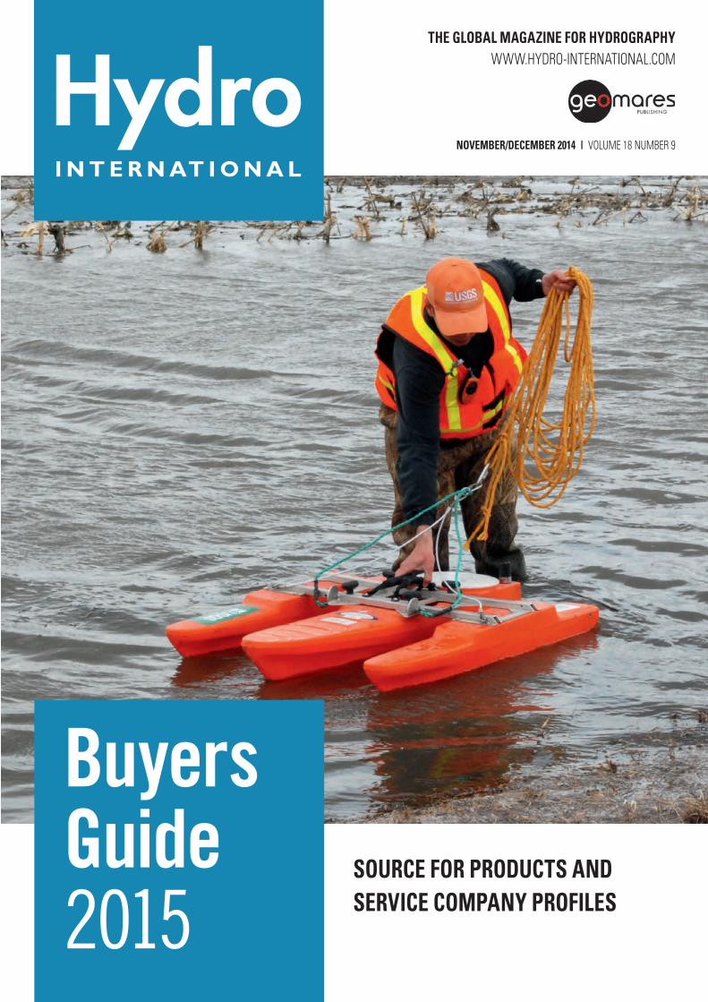
Photography cover: An ADCP being used to measure current and streamfl ow near Mapleton, MD,
USA. Image courtesy: Marisa Lubeck, USGS, USA.
HYDBG2015_Editorial 3HYDBG2015_Editorial 3 24-11-2014 14:58:2924-11-2014 14:58:29
| 2015 EDITION | Hydro INTERNATIONAL BUYERS GUIDE4
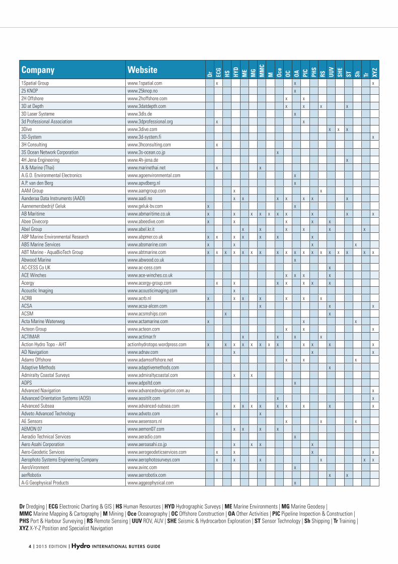
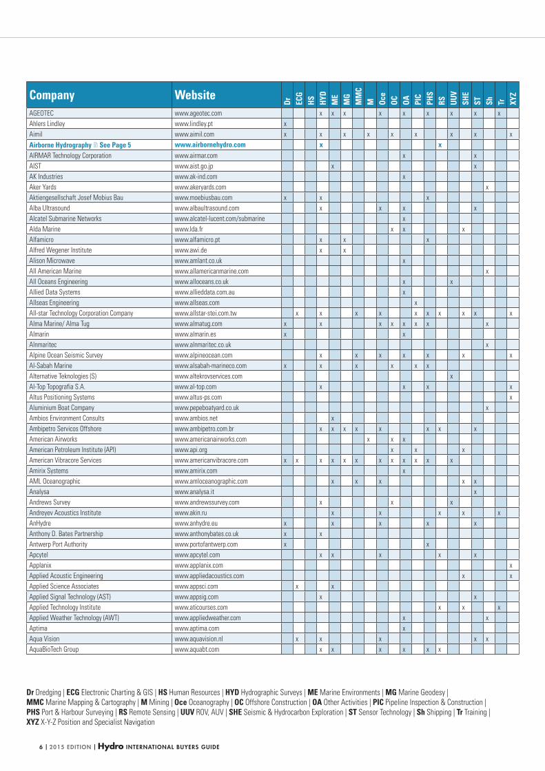
Dr Dredging | ECG Electronic Charting & GIS | HS Human Resources | HYD Hydrographic Surveys | ME Marine Environments | MG Marine Geodesy |
MMC Marine Mapping & Cartography | M Mining | Oce Oceanography | OC Offshore Construction | OA Other Activities | PIC Pipeline Inspection & Construction |
PHS Port & Harbour Surveying | RS Remote Sensing | UUV ROV, AUV | SHE Seismic & Hydrocarbon Exploration | ST Sensor Technology | Sh Shipping | Tr Training |
XYZ X-Y-Z Position and Specialist Navigation
Company Website
Dr ECG
HS HYD
ME
MG
MM
CM Oc
eOC OA PI
CPH
SRS UU
VSH
EST Sh Tr XY
Z
1Spatial Group www.1spatial.com x x x
25 KNOP www.25knop.no x
2H Offshore www.2hoffshore.com x x
3D at Depth www.3datdepth.com x x x x
3D Laser Systeme www.3dls.de x
3d Professional Association www.3dprofessional.org x x
3Dive www.3dive.com x x x
3D-System www.3d-system.fi x
3H Consulting www.3hconsulting.com x
3S Ocean Network Corporation www.3s-ocean.co.jp x
4H Jena Engineering www.4h-jena.de x
A & Marine (Thai) www.marinethai.net x x
A.G.O. Environmental Electronics www.agoenvironmental.com x
A.P. van den Berg www.apvdberg.nl x
AAM Group www.aamgroup.com x x
Aanderaa Data Instruments (AADI) www.aadi.no x x x x x x x
Aannemersbedrijf Geluk www.geluk-bv.com x x
AB Maritime www.abmaritime.co.uk x x x x x x x x x x
Abee Divecorp www.abeedive.com x x x x x
Abel Group www.abel.kr.it x x x x x x
ABP Marine Environmental Research www.abpmer.co.uk x x x x x x x
ABS Marine Services www.absmarine.com x x x x
ABT Marine - AquaBioTech Group www.abtmarine.com x x x x x x x x x x x x x x x x x x
Abwood Marine www.abwood.co.uk x
AC-CESS Co UK www.ac-cess.com x
ACE Winches www.ace-winches.co.uk x x x x
Acergy www.acergy-group.com x x x x x x x
Acoustic Imaging www.acousticimaging.com x
ACRB www.acrb.nl x x x x x x x
ACSA www.acsa-alcen.com x x x
ACSM www.acsmships.com x x
Acta Marine Waterweg www.actamarine.com x x x
Acteon Group www.acteon.com x x x
ACTIMAR www.actimar.fr x x x x
Action Hydro Topo - AHT actionhydrotopo.wordpress.com x x x x x x x x x x x x
AD Navigation www.adnav.com x x x
Adams Offshore www.adamsoffshore.net x x x
Adaptive Methods www.adaptivemethods.com x
Admiralty Coastal Surveys www.admiraltycoastal.com x x
ADPS www.adpsltd.com x
Advanced Navigation www.advancednavigation.com.au x
Advanced Orientation Systems (AOSI) www.aositilt.com x x
Advanced Subsea www.advanced-subsea.com x x x x x x x x x
Adveto Advanced Technology www.adveto.com x x
AE Sensors www.aesensors.nl x x x
AEMON 07 www.aemon07.com x x x x
Aeradio Technical Services www.aeradio.com x
Aero Asahi Corporation www.aeroasahi.co.jp x x x x
Aero-Geodetic Services www.aerogeodeticservices.com x x x x
Aerophoto Systems Engineering Company www.aerophotosurveys.com x x x x x x
AeroVironment www.avinc.com x
aerRobotix www.aerrobotix.com x x
A-G Geophysical Products www.aggeophysical.com x
HYDBG2015_Tabel 4HYDBG2015_Tabel 4 24-11-2014 15:46:2624-11-2014 15:46:26
Hydro INTERNATIONAL BUYERS GUIDE | 2015 EDITION | 5
BUYERS GUIDEBUYERS GUIDE
No 3572
More information
Klubbhusgatan 15,
553 03 Jönköping,
Sweden
Phone: +46 361967680
Email: [email protected]
www.airbornehydro.com
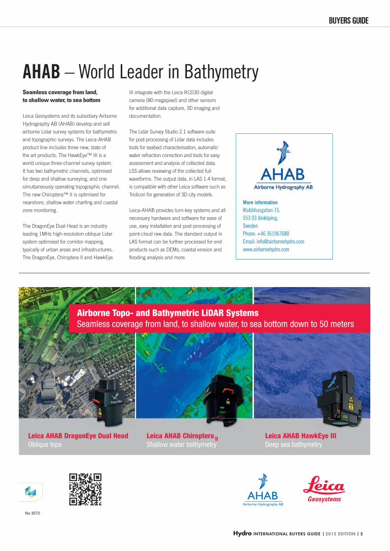
Seamless coverage from land, to shallow water, to sea bottom
Leica Geosystems and its subsidiary Airborne
Hydrography AB (AHAB) develop and sell
airborne Lidar survey systems for bathymetric
and topographic surveys. The Leica-AHAB
product line includes three new, state of
the art products. The HawkEye™ III is a
world unique three-channel survey system.
It has two bathymetric channels, optimised
for deep and shallow surveying, and one
simultaneously operating topographic channel.
The new Chiroptera™ II is optimised for
nearshore, shallow water charting and coastal
zone monitoring.
The DragonEye Dual Head is an industry
leading 1MHz high-resolution oblique Lidar
system optimised for corridor mapping,
typically of urban areas and infrastructures.
The DragonEye, Chiroptera II and HawkEye
III integrate with the Leica RCD30 digital
camera (80 megapixel) and other sensors
for additional data capture, 3D imaging and
documentation.
The Lidar Survey Studio 2.1 software suite
for post-processing of Lidar data includes
tools for seabed characterisation, automatic
water refraction correction and tools for easy
assessment and analysis of collected data.
LSS allows reviewing of the collected full
waveforms. The output data, in LAS 1.4 format,
is compatible with other Leica software such as
Tridicon for generation of 3D city models.
Leica-AHAB provides turn-key systems and all
necessary hardware and software for ease of
use, easy installation and post-processing of
point-cloud raw data. The standard output in
LAS format can be further processed for end
products such as DEMs, coastal erosion and
fl ooding analysis and more.
AHAB – World Leader in Bathymetry
HYDBG2015_AHAB P5 5HYDBG2015_AHAB P5 5 24-11-2014 11:47:1624-11-2014 11:47:16
| 2015 EDITION | Hydro INTERNATIONAL BUYERS GUIDE6
Dr Dredging | ECG Electronic Charting & GIS | HS Human Resources | HYD Hydrographic Surveys | ME Marine Environments | MG Marine Geodesy |
MMC Marine Mapping & Cartography | M Mining | Oce Oceanography | OC Offshore Construction | OA Other Activities | PIC Pipeline Inspection & Construction |
PHS Port & Harbour Surveying | RS Remote Sensing | UUV ROV, AUV | SHE Seismic & Hydrocarbon Exploration | ST Sensor Technology | Sh Shipping | Tr Training |
XYZ X-Y-Z Position and Specialist Navigation
Company Website
Dr ECG
HS HYD
ME
MG
MM
CM Oc
eOC OA PI
CPH
SRS UU
VSH
EST Sh Tr XY
Z
AGEOTEC www.ageotec.com x x x x x x x x x
Ahlers Lindley www.lindley.pt x
Aimil www.aimil.com x x x x x x x x x
Airborne Hydrography See Page 5 www.airbornehydro.com x xAIRMAR Technology Corporation www.airmar.com x x
AIST www.aist.go.jp x x
AK Industries www.ak-ind.com x
Aker Yards www.akeryards.com x
Aktiengesellschaft Josef Mobius Bau www.moebiusbau.com x x x
Alba Ultrasound www.albaultrasound.com x x x x
Alcatel Submarine Networks www.alcatel-lucent.com/submarine x
Alda Marine www.lda.fr x x x
Alfamicro www.alfamicro.pt x x x
Alfred Wegener Institute www.awi.de x x
Alison Microwave www.amlant.co.uk x
All American Marine www.allamericanmarine.com x
All Oceans Engineering www.alloceans.co.uk x x
Allied Data Systems www.allieddata.com.au x
Allseas Engineering www.allseas.com x
All-star Technology Corporation Company www.allstar-stei.com.tw x x x x x x x x x x
Alma Marine/ Alma Tug www.almatug.com x x x x x x x x
Almarin www.almarin.es x x
Alnmaritec www.alnmaritec.co.uk x
Alpine Ocean Seismic Survey www.alpineocean.com x x x x x x x
Al-Sabah Marine www.alsabah-marineco.com x x x x x x
Alternative Teknologies (S) www.altekrovservices.com x
Al-Top Topografia S.A. www.al-top.com x x x x
Altus Positioning Systems www.altus-ps.com x
Aluminium Boat Company www.pepeboatyard.co.uk x
Ambios Environment Consults www.ambios.net x
Ambipetro Servicos Offshore www.ambipetro.com.br x x x x x x x x
American Airworks www.americanairworks.com x x x
American Petroleum Institute (API) www.api.org x x x
American Vibracore Services www.americanvibracore.com x x x x x x x x x x x x
Amirix Systems www.amirix.com x
AML Oceanographic www.amloceanographic.com x x x x x
Analysa www.analysa.it x
Andrews Survey www.andrewssurvey.com x x x
Andreyev Acoustics Institute www.akin.ru x x x x x
AnHydre www.anhydre.eu x x x x x
Anthony D. Bates Partnership www.anthonybates.co.uk x x
Antwerp Port Authority www.portofantwerp.com x x
Apcytel www.apcytel.com x x x x x
Applanix www.applanix.com x
Applied Acoustic Engineering www.appliedacoustics.com x x
Applied Science Associates www.appsci.com x x
Applied Signal Technology (AST) www.appsig.com x x
Applied Technology Institute www.aticourses.com x x x
Applied Weather Technology (AWT) www.appliedweather.com x x
Aptima www.aptima.com x
Aqua Vision www.aquavision.nl x x x x x
AquaBioTech Group www.aquabt.com x x x x x x
HYDBG2015_Tabel 6HYDBG2015_Tabel 6 24-11-2014 15:46:3224-11-2014 15:46:32
Hydro INTERNATIONAL BUYERS GUIDE | 2015 EDITION | 7
BUYERS GUIDEBUYERS GUIDE
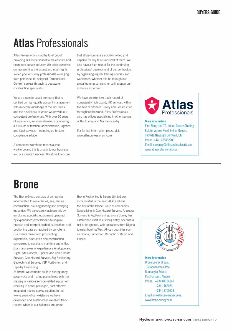
Atlas Professionals is at the forefront of
providing skilled personnel to the offshore and
nearshore survey industry. We pride ourselves
on representing the largest and most highly
skilled pool of survey professionals – ranging
from personnel for shipyard (Dimensional
Control) surveys through to deepwater
construction specialists.
We are a people-based company that is
centred on high-quality account management
with in-depth knowledge of the industries
and the disciplines to which we provide our
competent professionals. With over 30 years
of experience, we meet demands by offering
a full suite of taxation, administration, logistics
and legal services – including up-to-date
compliance advice.
A competent workforce means a safe
workforce and this is crucial to our business
and our clients’ business. We strive to ensure
Atlas Professionals that all personnel are suitably skilled and
capable for any tasks required of them. We
also have a high regard for the continuing
professional development of our contractors
by organising regular training courses and
workshops, whether this be through our
global training partners, or calling upon our
in-house expertise.
We have an extensive track record of
consistently high-quality HR services within
the fi eld of offshore Survey and Construction
throughout the world. Atlas Professionals
also has offi ces specialising in other sectors
of the Energy and Marine industry.
For further information please visit
www.atlasprofessionals.com
More information
First Floor, Unit 7C, Indian Queens Trading
Estate, Warren Road, Indian Queens,
TR9 6TL Newquay, Cornwall, UK
Phone: +44 1726862200
Email: [email protected]
www.atlasprofessionals.com
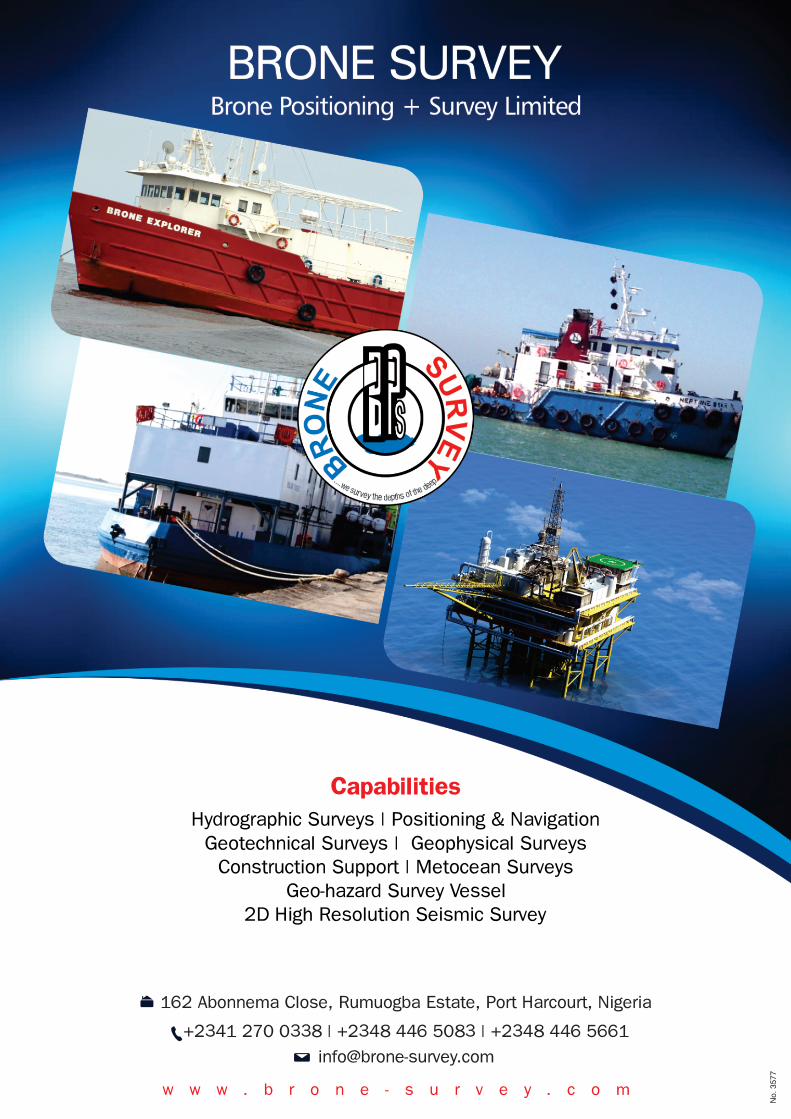
The Brone Group consists of companies
incorporated to serve the oil, gas, marine
construction, civil engineering and dredging
industries. We consistently achieve this by
employing specialist equipment operated
by experienced professionals to acquire,
process and interpret seabed, subsurface and
positioning data as required by our clients.
Our clients range from prospecting,
exploration, production and construction
companies to naval and maritime authorities.
Our major areas of expertise are Analogue and
Digital Site Surveys, Pipeline and Cable Route
Surveys, Geo-Hazard Surveys, Rig Positioning,
Geotechnical Surveys, VSP Positioning and
Pipe-lay Positioning.
At Brone, we combine skills in hydrography,
geophysics and marine geotechnics with the
mastery of various service-related equipment
resulting in a well-packaged, cost-effective
integrated marine survey solution. In the
twelve years of our existence we have
developed and sustained an excellent track
record, which is our hallmark and pride.
BroneBrone Positioning & Survey Limited was
incorporated in the year 2000 and was
the fi rst of the Brone Group of companies.
Specialising in Geo-Hazard Surveys, Analogue
Surveys & Rig Positioning, Brone Survey has
established itself as a strong entity, one that is
not to be ignored, with operations from Nigeria
to neighbouring West African countries such
as Ghana, Cameroon, Republic of Benin and
Liberia.
More information
Brone Energy Group,
162 Abonnema Close,
Rumuogba Estate,
Port Harcourt, Nigeria
Phone: +234 84754343
+234 1465083
+234 12700338
Email: [email protected],
www.brone-survey.com
HYDBG2015_Atlas-Brone_P7 7HYDBG2015_Atlas-Brone_P7 7 24-11-2014 15:01:3724-11-2014 15:01:37
| 2015 EDITION | Hydro INTERNATIONAL BUYERS GUIDE8
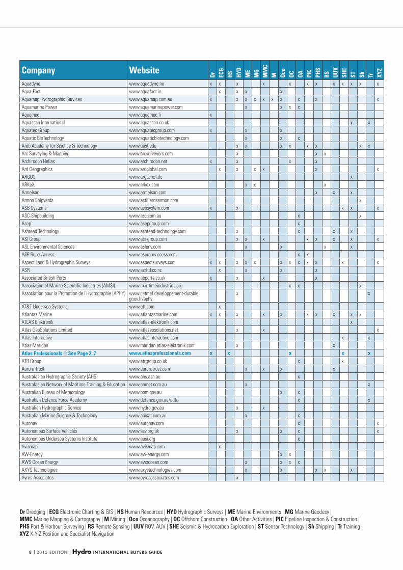
Dr Dredging | ECG Electronic Charting & GIS | HS Human Resources | HYD Hydrographic Surveys | ME Marine Environments | MG Marine Geodesy |
MMC Marine Mapping & Cartography | M Mining | Oce Oceanography | OC Offshore Construction | OA Other Activities | PIC Pipeline Inspection & Construction |
PHS Port & Harbour Surveying | RS Remote Sensing | UUV ROV, AUV | SHE Seismic & Hydrocarbon Exploration | ST Sensor Technology | Sh Shipping | Tr Training |
XYZ X-Y-Z Position and Specialist Navigation
Company Website
Dr ECG
HS HYD
ME
MG
MM
CM Oc
eOC OA PI
CPH
SRS UU
VSH
EST Sh Tr XY
Z
Aquadyne www.aquadyne.no x x x x x x x x x x x x
Aqua-Fact www.aquafact.ie x x x x
Aquamap Hydrographic Services www.aquamap.com.au x x x x x x x x x x
Aquamarine Power www.aquamarinepower.com x x x x
Aquamec www.aquamec.fi x
Aquascan International www.aquascan.co.uk x x
Aquatec Group www.aquatecgroup.com x x x
Aquatic BioTechnology www.aquaticbiotechnology.com x x x
Arab Academy for Science & Technology www.aast.edu x x x x x x x x
Arc Surveying & Mapping www.arcsurveyors.com x x x
Archirodon Hellas www.archirodon.net x x x x
Ard Geographics www.ardglobal.com x x x x x x
ARGUS www.argusnet.de x
ARKeX www.arkex.com x x x
Armelsan www.armelsan.com x x x
Armon Shipyards www.astillerosarmon.com x
ASB Systems www.asbsystem.com x x x x x
ASC-Shipbuilding www.asc.com.au x x
Asep www.asepgroup.com x
Ashtead Technology www.ashtead-technology.com x x x x
ASI Group www.asi-group.com x x x x x x x x
ASL Environmental Sciences www.aslenv.com x x x x
ASP Rope Access www.aspropeaccess.com x x
Aspect Land & Hydrographic Surveys www.aspectsurveys.com x x x x x x x x x x x x
ASR www.asrltd.co.nz x x x x
Associated British Ports www.abports.co.uk x x x x
Association of Marine Scientific Industries (AMSI) www.maritimeindustries.org x x x
Association pour la Promotion de l'Hydrographie (APHY) www.cetmef.developpement-durable.gouv.fr/aphy
x x
AT&T Undersea Systems www.att.com x
Atlantas Marine www.atlantasmarine.com x x x x x x x x x x
ATLAS Elektronik www.atlas-elektronik.com x
Atlas GeoSolutions Limited www.atlaseosolutions.net x x x
Atlas Interactive www.atlasinteractive.com x x
Atlas Maridan www.maridan.atlas-elektronik.com x x
Atlas Professionals See Page 2, 7 www.atlasprofessionals.com x x x x xATR Group www.atrgroup.co.uk x x
Aurora Trust www.auroratrust.com x x x x
Australasian Hydrographic Society (AHS) www.ahs.asn.au x
Australasian Network of Maritime Training & Education www.anmet.com.au x x
Australian Bureau of Meteorology www.bom.gov.au x x
Australian Defence Force Academy www.defence.gov.au/adfa x x
Australian Hydrographic Service www.hydro.gov.au x x
Australian Marine Science & Technology www.amsat.com.au x x
Autonav www.autonav.com x x
Autonomous Surface Vehicles www.asv.org.uk x x x x
Autonomous Undersea Systems Institute www.ausi.org x
Avismap www.avismap.com x
AW-Energy www.aw-energy.com x x
AWS Ocean Energy www.awsocean.com x x x x
AXYS Technologies www.axystechnologies.com x x x x x
Ayres Associates www.ayresassociates.com x
HYDBG2015_Tabel 8HYDBG2015_Tabel 8 24-11-2014 15:46:3824-11-2014 15:46:38
Hydro INTERNATIONAL BUYERS GUIDE | 2015 EDITION | 9
BUYERS GUIDE
Dr Dredging | ECG Electronic Charting & GIS | HS Human Resources | HYD Hydrographic Surveys | ME Marine Environments | MG Marine Geodesy |
MMC Marine Mapping & Cartography | M Mining | Oce Oceanography | OC Offshore Construction | OA Other Activities | PIC Pipeline Inspection & Construction |
PHS Port & Harbour Surveying | RS Remote Sensing | UUV ROV, AUV | SHE Seismic & Hydrocarbon Exploration | ST Sensor Technology | Sh Shipping | Tr Training |
XYZ X-Y-Z Position and Specialist Navigation
More information
115 Waggoners Lane,
Fredericton, New Brunswick,
Canada, E3B 2L4,
Phone: +1 506 458 8533,
Email: [email protected],
www.caris.com
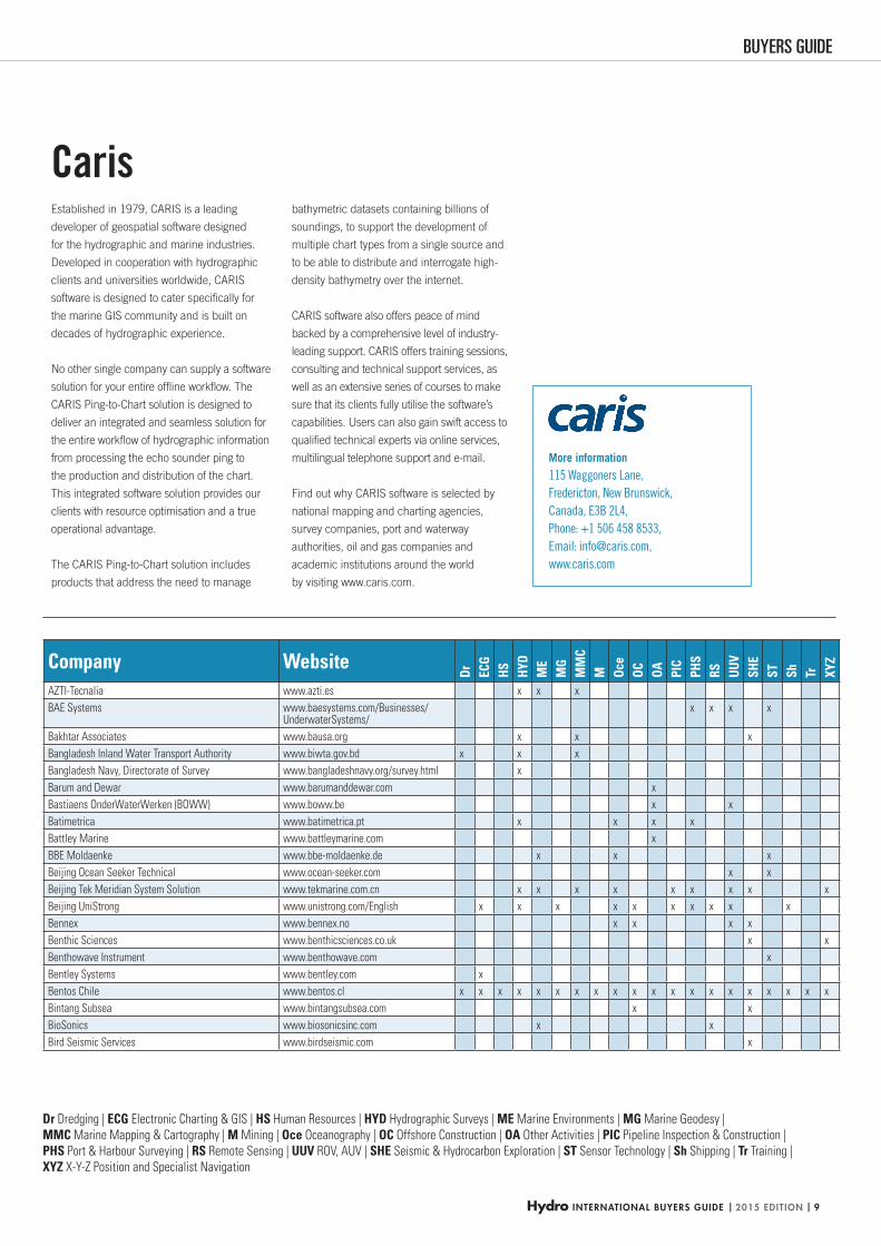
Established in 1979, CARIS is a leading
developer of geospatial software designed
for the hydrographic and marine industries.
Developed in cooperation with hydrographic
clients and universities worldwide, CARIS
software is designed to cater specifi cally for
the marine GIS community and is built on
decades of hydrographic experience.
No other single company can supply a software
solution for your entire offl ine workfl ow. The
CARIS Ping-to-Chart solution is designed to
deliver an integrated and seamless solution for
the entire workfl ow of hydrographic information
from processing the echo sounder ping to
the production and distribution of the chart.
This integrated software solution provides our
clients with resource optimisation and a true
operational advantage.
The CARIS Ping-to-Chart solution includes
products that address the need to manage
bathymetric datasets containing billions of
soundings, to support the development of
multiple chart types from a single source and
to be able to distribute and interrogate high-
density bathymetry over the internet.
CARIS software also offers peace of mind
backed by a comprehensive level of industry-
leading support. CARIS offers training sessions,
consulting and technical support services, as
well as an extensive series of courses to make
sure that its clients fully utilise the software’s
capabilities. Users can also gain swift access to
qualifi ed technical experts via online services,
multilingual telephone support and e-mail.
Find out why CARIS software is selected by
national mapping and charting agencies,
survey companies, port and waterway
authorities, oil and gas companies and
academic institutions around the world
by visiting www.caris.com.
Caris
Company Website
Dr ECG
HS HYD
ME
MG
MM
CM Oc
eOC OA PI
CPH
SRS UU
VSH
EST Sh Tr XY
Z
AZTI-Tecnalia www.azti.es x x x
BAE Systems www.baesystems.com/Businesses/UnderwaterSystems/
x x x x
Bakhtar Associates www.bausa.org x x x
Bangladesh Inland Water Transport Authority www.biwta.gov.bd x x x
Bangladesh Navy, Directorate of Survey www.bangladeshnavy.org/survey.html x
Barum and Dewar www.barumanddewar.com x
Bastiaens OnderWaterWerken (BOWW) www.boww.be x x
Batimetrica www.batimetrica.pt x x x x
Battley Marine www.battleymarine.com x
BBE Moldaenke www.bbe-moldaenke.de x x x
Beijing Ocean Seeker Technical www.ocean-seeker.com x x
Beijing Tek Meridian System Solution www.tekmarine.com.cn x x x x x x x x x
Beijing UniStrong www.unistrong.com/English x x x x x x x x x x
Bennex www.bennex.no x x x x
Benthic Sciences www.benthicsciences.co.uk x x
Benthowave Instrument www.benthowave.com x
Bentley Systems www.bentley.com x
Bentos Chile www.bentos.cl x x x x x x x x x x x x x x x x x x x x
Bintang Subsea www.bintangsubsea.com x x
BioSonics www.biosonicsinc.com x x
Bird Seismic Services www.birdseismic.com x
HYDBG2015_Tabel 9HYDBG2015_Tabel 9 24-11-2014 15:46:3824-11-2014 15:46:38
No.
357
7
3577.indd 1 21-11-14 13:56HYDBG2015_Advertenties 10HYDBG2015_Advertenties 10 24-11-2014 16:11:5124-11-2014 16:11:51
Hydro INTERNATIONAL BUYERS GUIDE | 2015 EDITION | 11
BUYERS GUIDE
Dr Dredging | ECG Electronic Charting & GIS | HS Human Resources | HYD Hydrographic Surveys | ME Marine Environments | MG Marine Geodesy |
MMC Marine Mapping & Cartography | M Mining | Oce Oceanography | OC Offshore Construction | OA Other Activities | PIC Pipeline Inspection & Construction |
PHS Port & Harbour Surveying | RS Remote Sensing | UUV ROV, AUV | SHE Seismic & Hydrocarbon Exploration | ST Sensor Technology | Sh Shipping | Tr Training |
XYZ X-Y-Z Position and Specialist Navigation
Company Website
Dr ECG
HS HYD
ME
MG
MM
CM Oc
eOC OA PI
CPH
SRS UU
VSH
EST Sh Tr XY
Z
BIRNS www.birns.com x x x x x
Bjorgun www.bjorgun.is x
Black Laser Learning www.blacklaserlearning.com x x
Blom Aerofilms www.blomaerofilms.com x x x x
Blom www.blomasa.com x x
Blue Blue Electronics www.blueblue-electronics.com x x x x x x x x
Blue Marble Geographics www.bluemarblegeo.com x
Blue Water Recoveries www.bluewater.uk.com x x x
Bluefin Robotics www.bluefinrobotics.com x x x x x x x
Bluesky International www.bluesky-world.com x x
Bluestone Offshore www.bluestoneoffshore.com x x x x x
Bluestream Offshore www.bluestreamoffshore.com x x x
BMT Group www.bmt.org x x x x x
BHC Nav www.bhcnav.com x
Bowtech Products www.bowtech.co.uk x x x
Braveheart Shipping www.braveheartshipping.com x x x x
Bridge Marine Science Group (BMSG) www.bridgemarinescience.com x x x x
British Antarctic Survey www.antarctica.ac.uk x x x x
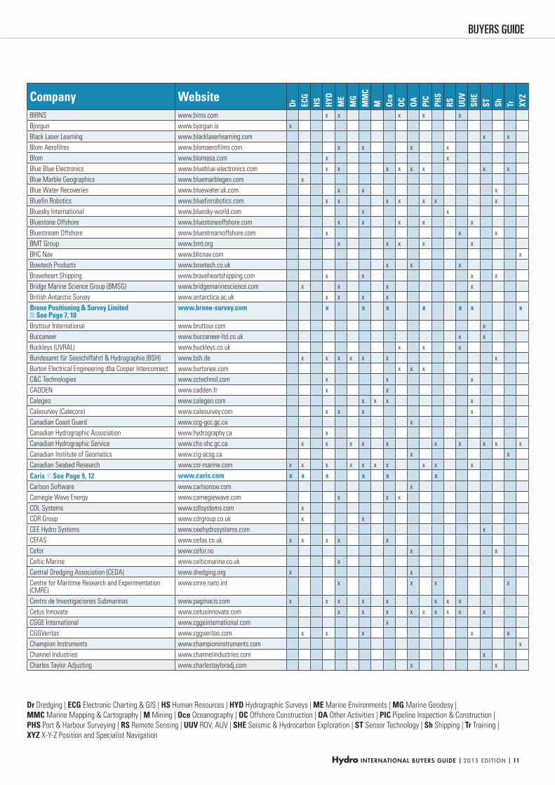
Brone Positioning & Survey Limited See Page 7, 10
www.brone-survey.com x x x x x x x
Bruttour International www.bruttour.com x
Buccaneer www.buccaneer-ltd.co.uk x x
Buckleys (UVRAL) www.buckleys.co.uk x x x
Bundesamt für Seeschiffahrt & Hydrographie (BSH) www.bsh.de x x x x x x x
Burton Electrical Engineering dba Cooper Interconnect www.burtonee.com x x x
C&C Technologies www.cctechnol.com x x x
CADDEN www.cadden.fr x x
Calegeo www.calegeo.com x x x x
Calesurvey (Calecore) www.calesurvey.com x x x x
Canadian Coast Guard www.ccg-gcc.gc.ca x
Canadian Hydrographic Association www.hydrography.ca x
Canadian Hydrographic Service www.chs-shc.gc.ca x x x x x x x x x x
Canadian Institute of Geomatics www.cig-acsg.ca x x
Canadian Seabed Research www.csr-marine.com x x x x x x x x x x
Caris See Page 9, 12 www.caris.com x x x x x xCarlson Software www.carlsonsw.com x
Carnegie Wave Energy www.carnegiewave.com x x x
CDL Systems www.cdlsystems.com x
CDR Group www.cdrgroup.co.uk x x
CEE Hydro Systems www.ceehydrosystems.com x
CEFAS www.cefas.co.uk x x x x x
Cefor www.cefor.no x x
Celtic Marine www.celticmarine.co.uk x
Central Dredging Association (CEDA) www.dredging.org x x
Centre for Maritime Research and Experimentation (CMRE)
www.cmre.nato.int x x x x
Centro de Investigaciones Submarinas www.paginacis.com x x x x x x x x
Cetus Innovate www.cetusinnovate.com x x x x x x x x x
CGGE International www.cggeinternational.com x
CGGVeritas www.cggveritas.com x x x x x
Champion Instruments www.championinstruments.com x
Channel Industries www.channelindustries.com x
Charles Taylor Adjusting www.charlestayloradj.com x x
HYDBG2015_Tabel 11HYDBG2015_Tabel 11 24-11-2014 15:46:4524-11-2014 15:46:45
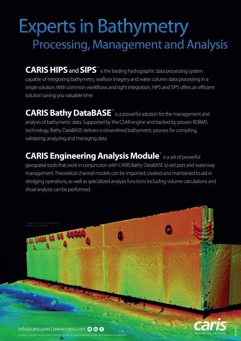
CARIS HIPS and SIPSTM
is the leading hydrographic data processing system
capable of integrating bathymetry, seafloor imagery and water column data processing in a
single solution. With common workflows and tight integration, HIPS and SIPS offers an efficient
solution saving you valuable time.
CARIS Bathy DataBASETM
is a powerful solution for the management and
analysis of bathymetric data. Supported by the CSAR engine and backed by proven RDBMS
technology, Bathy DataBASE delivers a streamlined bathymetric process for compiling,
validating, analyzing and managing data.
CARIS Engineering Analysis ModuleTM
is a set of powerful
geospatial tools that work in conjunction with CARIS Bathy DataBASE to aid port and waterway
management. Theoretical channel models can be imported, created and maintained to aid in
dredging operations, as well as specialized analysis functions including volume calculations and
shoal analysis can be performed.
[email protected] | www.caris.comM A R I N E G I S E X P E R T S
Copyright © 2014 CARIS. All rights reserved. CARIS, HIPS and SIPS are registered trademarks of CARIS (Universal Systems Ltd.), Reg. USPTO.
Image courtesy of Luc Dumontier,
Montreal Port Authority
No.
356
1
3561.indd 1 24-10-14 09:48HYDBG2015_Advertenties 12HYDBG2015_Advertenties 12 24-11-2014 15:45:1124-11-2014 15:45:11
Hydro INTERNATIONAL BUYERS GUIDE | 2015 EDITION | 13
BUYERS GUIDEBUYERS GUIDE
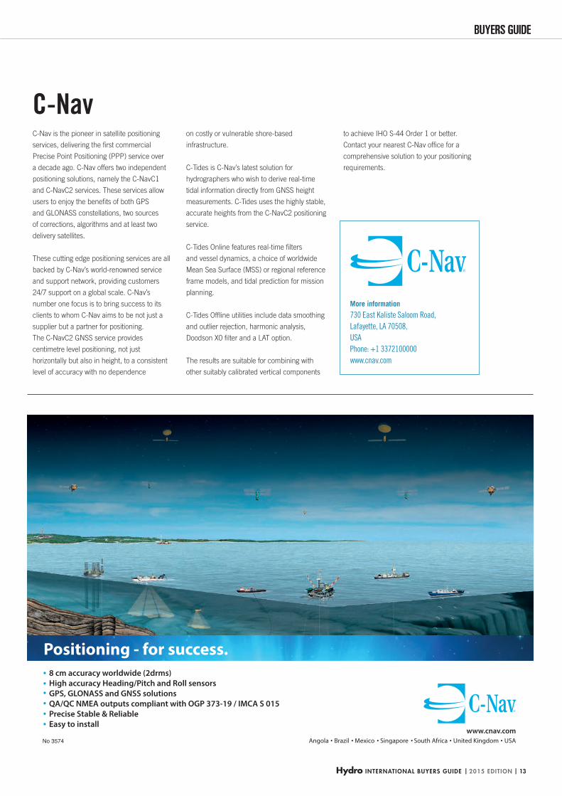
8 cm accuracy worldwide (2drms) High accuracy Heading/Pitch and Roll sensors GPS, GLONASS and GNSS solutions QA/QC NMEA outputs compliant with OGP 373-19 / IMCA S 015 Precise Stable & Reliable Easy to install
www.cnav.comAngola Brazil Mexico Singapore South Africa United Kingdom USA
Positioning - for success.
No 3574
More information
730 East Kaliste Saloom Road,
Lafayette, LA 70508,
USA
Phone: +1 3372100000
www.cnav.com
C-Nav is the pioneer in satellite positioning
services, delivering the fi rst commercial
Precise Point Positioning (PPP) service over
a decade ago. C-Nav offers two independent
positioning solutions, namely the C-NavC1
and C-NavC2 services. These services allow
users to enjoy the benefi ts of both GPS
and GLONASS constellations, two sources
of corrections, algorithms and at least two
delivery satellites.
These cutting edge positioning services are all
backed by C-Nav’s world-renowned service
and support network, providing customers
24/7 support on a global scale. C-Nav’s
number one focus is to bring success to its
clients to whom C-Nav aims to be not just a
supplier but a partner for positioning.
The C-NavC2 GNSS service provides
centimetre level positioning, not just
horizontally but also in height, to a consistent
level of accuracy with no dependence
on costly or vulnerable shore-based
infrastructure.
C-Tides is C-Nav’s latest solution for
hydrographers who wish to derive real-time
tidal information directly from GNSS height
measurements. C-Tides uses the highly stable,
accurate heights from the C-NavC2 positioning
service.
C-Tides Online features real-time fi lters
and vessel dynamics, a choice of worldwide
Mean Sea Surface (MSS) or regional reference
frame models, and tidal prediction for mission
planning.
C-Tides Offl ine utilities include data smoothing
and outlier rejection, harmonic analysis,
Doodson X0 fi lter and a LAT option.
The results are suitable for combining with
other suitably calibrated vertical components
to achieve IHO S-44 Order 1 or better.
Contact your nearest C-Nav offi ce for a
comprehensive solution to your positioning
requirements.
C-Nav
HYDBG2015_C-Nav_P13 13HYDBG2015_C-Nav_P13 13 24-11-2014 14:54:5924-11-2014 14:54:59
| 2015 EDITION | Hydro INTERNATIONAL BUYERS GUIDE14
Dr Dredging | ECG Electronic Charting & GIS | HS Human Resources | HYD Hydrographic Surveys | ME Marine Environments | MG Marine Geodesy |
MMC Marine Mapping & Cartography | M Mining | Oce Oceanography | OC Offshore Construction | OA Other Activities | PIC Pipeline Inspection & Construction |
PHS Port & Harbour Surveying | RS Remote Sensing | UUV ROV, AUV | SHE Seismic & Hydrocarbon Exploration | ST Sensor Technology | Sh Shipping | Tr Training |
XYZ X-Y-Z Position and Specialist Navigation
Company Website
Dr ECG
HS HYD
ME
MG
MM
CM Oc
eOC OA PI
CPH
SRS UU
VSH
EST Sh Tr XY
Z
Chart Pilot www.chartpilot.ru x x x
ChartCo www.chartco.com x
ChartWorld International www.chartworld.com x x
Chartworx www.chartworx.com x x
Cheetah Marine www.cheetahmarine.co.uk x x
Chelsea Technologies Group www.chelsea.co.uk x x x x x
Chesapeake Technology www.chesapeaketech.com x x x x x
China Maritime Safety Authority www.ngd.goc.cn x x x x
China Offshore Thales GeoSolutions www.cosl-fugro.com x x x x x
Chinese Academy of Science, Institute of Oceanology www.qdio.ac.cn x x
CHL Netherlands www.chl.nl x
Choubey Consultants www.choubeyconsultants.com x
Chris Ransome & Associates www.crahouston.com x x x x
Christian Pröber Unterwassertechnik www.cpu-bremen.de x
CIRIA www.ciria.org x
Clark Labs www.clarklabs.org x
Class Instrumentation www.classltd.com x x x x
Clearpath Robotics www.clearpathrobotics.com x x
Cledirsa www.cledirsa.com x x x x x x
ClipCard www.clipcard.com x x
CLS www.cls.fr x
Clydeside Surveys www.clydeside-surveys.ltd.uk x x x x
C-MAP USA www.jeppesen.com x x
C-MAX www.cmaxsonar.com x
CMS Geotech www.cms-geotech.co.uk x x x x x x x
C-Nav See Page 13 www.cnavgnss.com x xCoastal Science www.coastalscience.co.uk x x x
Coda Octopus Martech www.martechsystems.co.uk x
CodaOctopus Products www.codaoctopus.com x x x x x x x x x x
CODAR Ocean Sensors www.codar.com x x x x x
Codevintec Italiana www.codevintec.it x x x x x x x x x x
Colex International www.colexint.com x x
Comark Corporation www.comarkcorp.com x x
Commonwealth Scientific and Industrial Research Organisation (CSIRO)
www.csiro.au x x x x x
ComNav Marine www.comnavmarine.com x
Concept Systems www.csl.co.uk x x
Control Signal www.control-signal.com.tw x
Contros Systems & Solutions www.contros.eu x x x x x x x
Cortland Fibron BX Limited www.thecortlandcompanies.com x x x x x x x x x
Council for Geoscience, Marine Geosciences Unit www.geoscience.org.za x x x x x x
CP Cases www.cpcases.com x
C-Products Europe www.c-products.co.uk x
CREOCEAN www.creocean.fr x x x x x x
CSIP www.csip.co.uk x
CSIR www.csir.co.za x x
CSnet International www.csnetintl.com x
CT Systems www.ctsystems.eu x x x x x x x x
C-Tecnics www.c-tecnics.com x x x x
Cwamas Citra Prakarsa www.cwamas.com x x x x x x x x x x
Cybernetix www.cybernetix.fr x x
Cygnus Instruments www.cygnus-instruments.com x
HYDBG2015_Tabel 14HYDBG2015_Tabel 14 24-11-2014 15:46:4924-11-2014 15:46:49
Hydro INTERNATIONAL BUYERS GUIDE | 2015 EDITION | 15
BUYERS GUIDEBUYERS GUIDE
INTEGRATED ROV / USV SOLUTIONSINTEGRATED ROV / USV SOLUTIONS
Deep Ocean Engineering, Inc. 2528 Qume Dr. Ste 11 San Jose, CA 95131 USA Tel: 408-436-1102 www.deepocean.com [email protected]
I-1650I-1650
TriggerfishTriggerfishT4NT4N
No 3569
More information
2528 Qune Dr Ste 11,
San Jose,
CA 95131,
USA
Phone: +1 4084361102
www.deepocean.com
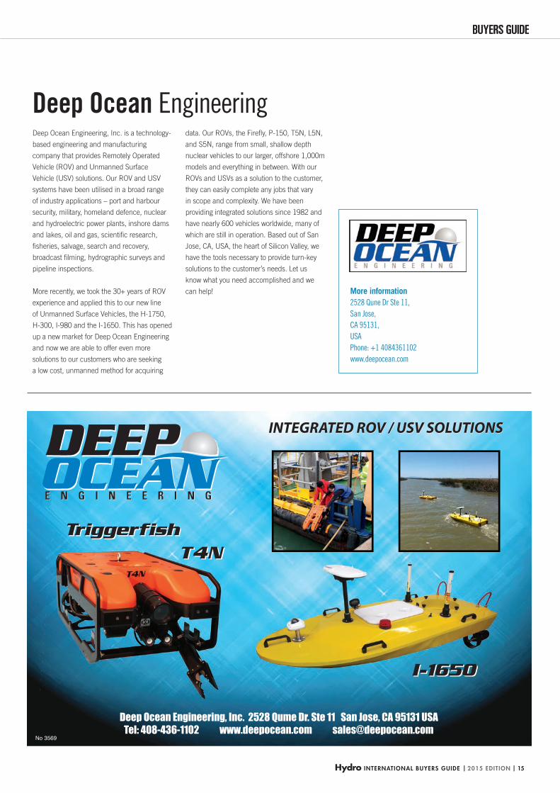
Deep Ocean Engineering, Inc. is a technology-
based engineering and manufacturing
company that provides Remotely Operated
Vehicle (ROV) and Unmanned Surface
Vehicle (USV) solutions. Our ROV and USV
systems have been utilised in a broad range
of industry applications – port and harbour
security, military, homeland defence, nuclear
and hydroelectric power plants, inshore dams
and lakes, oil and gas, scientifi c research,
fi sheries, salvage, search and recovery,
broadcast fi lming, hydrographic surveys and
pipeline inspections.
More recently, we took the 30+ years of ROV
experience and applied this to our new line
of Unmanned Surface Vehicles, the H-1750,
H-300, I-980 and the I-1650. This has opened
up a new market for Deep Ocean Engineering
and now we are able to offer even more
solutions to our customers who are seeking
a low cost, unmanned method for acquiring
data. Our ROVs, the Firefl y, P-150, T5N, L5N,
and S5N, range from small, shallow depth
nuclear vehicles to our larger, offshore 1,000m
models and everything in between. With our
ROVs and USVs as a solution to the customer,
they can easily complete any jobs that vary
in scope and complexity. We have been
providing integrated solutions since 1982 and
have nearly 600 vehicles worldwide, many of
which are still in operation. Based out of San
Jose, CA, USA, the heart of Silicon Valley, we
have the tools necessary to provide turn-key
solutions to the customer’s needs. Let us
know what you need accomplished and we
can help!
Deep Ocean Engineering
HYDBG2015_DeepOcean_P15 15HYDBG2015_DeepOcean_P15 15 24-11-2014 14:54:0924-11-2014 14:54:09
| 2015 EDITION | Hydro INTERNATIONAL BUYERS GUIDE16
Dr Dredging | ECG Electronic Charting & GIS | HS Human Resources | HYD Hydrographic Surveys | ME Marine Environments | MG Marine Geodesy |
MMC Marine Mapping & Cartography | M Mining | Oce Oceanography | OC Offshore Construction | OA Other Activities | PIC Pipeline Inspection & Construction |
PHS Port & Harbour Surveying | RS Remote Sensing | UUV ROV, AUV | SHE Seismic & Hydrocarbon Exploration | ST Sensor Technology | Sh Shipping | Tr Training |
XYZ X-Y-Z Position and Specialist Navigation
Company Website
Dr ECG
HS HYD
ME
MG
MM
CM Oc
eOC OA PI
CPH
SRS UU
VSH
EST Sh Tr XY
Z
Dacon www.dacon.com x x
Damen Dredging Equipment www.damendredging.com x x
Danish Coastal Authority www.kyst.dk x x x
Danish Geospatial Agency www.gst.dk x x x
Danish National Space Center www.spacecenter.dk x x x
Dansurvey www.dansurvey.com x x x x
Datema www.datema.nl x x
Dawson & Associates dawsonassociates.com x
DC Servicios Ambientales www.dcserviciosambientales.es x x
De Beers Marine www.debeersgroup.com x x x x x x
De Regt Marine Cables deregtcables.com x x x x x x x x x x
Debex - Engenharia e Sistemas www.debex.pt x
Deep www.deepbv.nl x x x x x x x x
Deep Ocean Engineering See Page 15 www.deepocean.com xDeep Sea Diving www.deepseadive.com x x x
Deep Trekker www.deeptrekker.com x
DeepOcean Subsea Services www.deepocean.no x x x x
DeepSea Power & Light www.deepsea.com x x
Defence Forces Technical Research Centre www.mil.fi/laitokset/pvtt/esittely_en.dsp
x x
DegUsan www.degusan.com x x x x x x x x x x
DELTA OHM www.deltaohm.com x x x x x x
Deltares www.deltares.nl x x x x x x x x x x x x
Denialink www.denialink.com x x x
Desert Star www.desertstar.com x
Design Projects www.design-projects.com x x x x
Desmar www.desmar.cl x x x x x x x x x
DETEK Marine Offshore Technology www.detek-tr.com x x x
Deutsche Hydrographische Gesellschaft (DHyG) www.dhyg.de x x
Develogic See Page 17 www.develogic.de x x x x x x x xDGPS Argentina www.dgpsargentina.com.ar x x x x x x x
DHI - Water & Environment www.dhi.dk x x x x x
Diginext www.diginext.fr x
DigitalGlobe www.digitalglobe.com x x
Direccion de Hidrografia y Navegacion Peru www.dhn.mil.pe x x x x x x x
Direccion de Hidrografia y Navegacion Venezuela www.dhn.mil.ve x
Directorate for Inland Waterways Serbia www.plovput.rs x x x x
Directorate of Hydrography and Navigation, Brazil www.dhn.mar.mil.br x x
Discovery Marine www.dmlsurveys.co.nz x x x x x
Dive Works www.diveworks.com.au x x
DMGT www.dmgt.co.uk x x
DNV GL Group www.dnv.com x x
DOER Marine www.doermarine.com x x x x x
DOF Subsea www.dofsubsea.com x x x x x
Dolphin Geo www.dolpingeo.com x
Dolphin Interconnect Solutions www.dolphinics.com x x
dotOcean www.dotocean.eu x x
Douglas Westwood www.douglas-westwood.com x x x
DPS Offshore www.dps-offshore.com x x x
Draaicentrum - DC Engineering www.dc-engineering.nl x x
Dragon & Elephant Enterprises www.de-hydro.com.tw x x x x x x
Drapor www.drapor.com x x x x x x x x x
HYDBG2015_Tabel 16HYDBG2015_Tabel 16 24-11-2014 15:46:5324-11-2014 15:46:53
Hydro INTERNATIONAL BUYERS GUIDE | 2015 EDITION | 17
BUYERS GUIDEBUYERS GUIDE
[email protected]+49 (0)40 982625-13develogic.de
Fully network capable modular system Proven in numerous industrial and research projects worldwide In-house design and extensive manufacturing capabilities enable highly integrated customized turnkey solutions
Acoustic telemetry with proven range up to 30,000 m Spar type data acquisition and telemetry buoys for harshest conditions Seafloor landers with custom instrumentation for deployments down to full ocean depth
From seafloor to desktop.Turnkey systems for subsea data acquisition and telemetry.
No
3567
More information
Eiffestraße 598,
20537 Hamburg,
Germany
Phone: +49 (0)4098262513
Email: [email protected]
www.develogic.de
develogic subsea systems is a German-based
company with a focus on developing and
manufacturing turn-key customised data-
acquisition and telemetry solutions for marine
monitoring applications.
To be able to deliver cost-effective systems
with short turnaround times the company has
developed a building block system containing
all necessary elements for collecting data
anywhere in the ocean and transporting it to the
customers offi ce. Available technology ranges
from modular pressure housings, data loggers
and acoustic telemetry solutions to seafl oor
landers, large sensor- and telemetry buoys.
The end-to-end design and manufacturing
process integrates electronic and 3D
mechanical design, multi-physics and
structural simulation, 3D CAM and computer-
aided inspection in order to provide consistent
high quality to our customers.
In addition, extensive in-house manufacturing
capabilities for both mechanical and electronic
systems support the creation of highly
integrated, unique solutions.
In 2013, develogic invested close to EUR1M
in state of the art CNC machinery as part of
the extension of its mechanical workshop.
Pick-and-place machines, a vapour phase
soldering oven and related inspection, test and
measurement equipment allow prototyping
of highly integrated customised PCBs with
shortest turnaround times.
In addition to the custom solutions business,
develogic also specialises in marine acoustic
solutions: acoustic telemetry systems with
proven ranges up to 30,000m, passive
acoustic recording systems with continuous
recording capabilities up to 3 years and
RAFOS sound sources for underwater
navigation are part of the standard product
portfolio.
Customers are well-known international
research institutes, navies and companies in
the sectors renewable energy, construction
and offshore oil and gas.
develogic subsea systems
HYDBG2015_Develogic_P17 17HYDBG2015_Develogic_P17 17 24-11-2014 16:33:3824-11-2014 16:33:38
| 2015 EDITION | Hydro INTERNATIONAL BUYERS GUIDE18
Dr Dredging | ECG Electronic Charting & GIS | HS Human Resources | HYD Hydrographic Surveys | ME Marine Environments | MG Marine Geodesy |
MMC Marine Mapping & Cartography | M Mining | Oce Oceanography | OC Offshore Construction | OA Other Activities | PIC Pipeline Inspection & Construction |
PHS Port & Harbour Surveying | RS Remote Sensing | UUV ROV, AUV | SHE Seismic & Hydrocarbon Exploration | ST Sensor Technology | Sh Shipping | Tr Training |
XYZ X-Y-Z Position and Specialist Navigation
Company Website
Dr ECG
HS HYD
ME
MG
MM
CM Oc
eOC OA PI
CPH
SRS UU
VSH
EST Sh Tr XY
Z
Drumgrange www.drumgrange.co.uk x x x
DSIT Solutions www.dsit.co.il x x
DSME E&R www.sonarbeam.com x x
DTI Telecom www.dti.qc.ca x x
Dutch Dredging www.dutchdredging.nl x
Dyk & Bygg www.dykobygg.se/ x x x x x x x x x x
Dynacon www.dynacon.com x
Eagle North America www.eaglena.com x
EarthNC www.earthnc.com x x x x
East Marine www.eastmarine.com.sg x
East View Geospatial (EVG) www.eastview.com x x
ECA Robotics www.eca-robotics.com x x x x x x x
ECDIS www.ecdis.org.uk x x
Ecosub www.ecosub.org x x
ED Service Center www.edsc.dk x
Eddelbüttel + Schneider www.e-s.de x x
EdgeTech www.edgetech.com x x x x x x x x x x x x
Edison Chouest Offshore www.chouest.com x x x x x
EGS www.egssurvey.com x x x
EIT Group www.eitgroup.com x x x
EIVA See Page 19 www.eiva.dk xEK Marine www.ekmarine.ie x
EKO - GIS Services www.eko-gis.pl x x x
Elcome Marine Services www.elcomeindia.com x x
ElecTech Solutions www.electechsolutions.co.uk x x x x x x x
Electro-Flow Controls www.electroflowcontrols.com x x x
Electronic Devices www.dsts.com x
Electronic Navigation (ENL) www.enl.co.nz x x
EMEC www.emec.org.uk x
EMGS AS www.emgs.com x x
e-MLX Co www.emlx.co.kr x
EMS Environmental Monitoring Systems www.ems-sistemas.com x x
ENAPRO - Ente Administrator del Puerto de Rosario www.enapro.gov.ar x
Energinet.dk www.energinet.dk x x x
Energy North www.energynorth.co.uk x x x x
Engineering Bureau Dr. Manzenrieder + Partner www.imp-ol.de x x
Enitech www.enitech.de x
Enterpa Engenharia www.enterpa.com.br x x x x x
EofE Ultrasonics www.echologger.com x x
EOMAP www.eomap.com x x x x
Erdas www.erdas.com x
Eriksson Dykeri www.erikssondiving.com x x x
Ernst + Enbring www.eue-kabel.de x
ESCORT www.escort.com.pl x x x x x x x x x
Escuela T.S. Ingenieros Navales www.upm.es x x
ESGEMAR www.esgemar.com x x x x x
Esri www.esri.com/nautical x x x x
ETH Zürich www.ethz.ch x x
Euro/CFD www.eurocfd.com x x
Euroceanique www.macartney.com x x x x x x x x x x
Euronav www.euronav.co.uk x x
European Space Agency (ESA) www.esa.int x x x x
HYDBG2015_Tabel 18HYDBG2015_Tabel 18 24-11-2014 15:46:5624-11-2014 15:46:56
Hydro INTERNATIONAL BUYERS GUIDE | 2015 EDITION | 19
BUYERS GUIDEBUYERS GUIDE
Making data headwayNaviSuite - A complete software toolbox for subsea survey and engineeringwww.eiva.com/navisuite
Courtesy of Statoil and DOF Subsea
Courtesy of Fugro Chance Inc.
Courtesy of Tilone Subsea Limited
No 3573
More information
Niels Bohrs Vej 17,
8660 Skanderborg,
Denmark
Phone: +45 86282011
Email: [email protected]
www.eiva.com
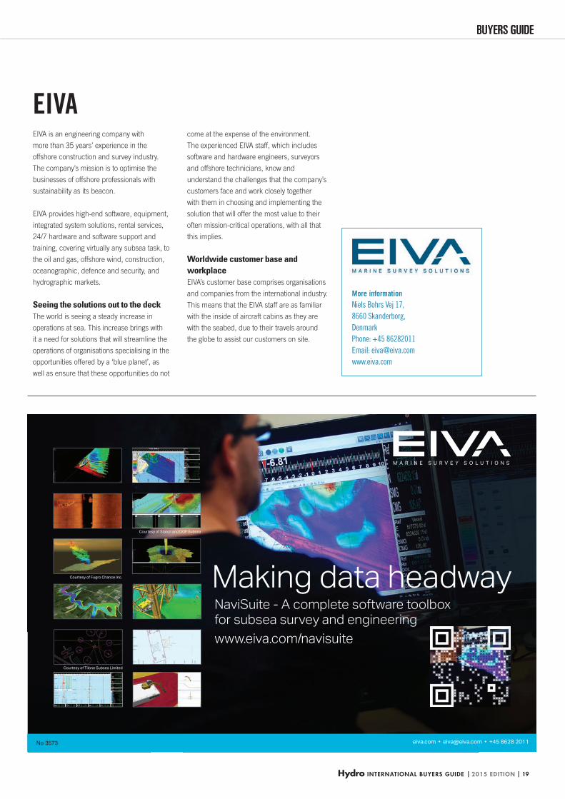
EIVA is an engineering company with
more than 35 years’ experience in the
offshore construction and survey industry.
The company’s mission is to optimise the
businesses of offshore professionals with
sustainability as its beacon.
EIVA provides high-end software, equipment,
integrated system solutions, rental services,
24/7 hardware and software support and
training, covering virtually any subsea task, to
the oil and gas, offshore wind, construction,
oceanographic, defence and security, and
hydrographic markets.
Seeing the solutions out to the deckThe world is seeing a steady increase in
operations at sea. This increase brings with
it a need for solutions that will streamline the
operations of organisations specialising in the
opportunities offered by a ‘blue planet’, as
well as ensure that these opportunities do not
come at the expense of the environment.
The experienced EIVA staff, which includes
software and hardware engineers, surveyors
and offshore technicians, know and
understand the challenges that the company’s
customers face and work closely together
with them in choosing and implementing the
solution that will offer the most value to their
often mission-critical operations, with all that
this implies.
Worldwide customer base and workplaceEIVA’s customer base comprises organisations
and companies from the international industry.
This means that the EIVA staff are as familiar
with the inside of aircraft cabins as they are
with the seabed, due to their travels around
the globe to assist our customers on site.
EIVA
HYDBG2015_Eiva_P19 19HYDBG2015_Eiva_P19 19 24-11-2014 15:09:5724-11-2014 15:09:57
| 2015 EDITION | Hydro INTERNATIONAL BUYERS GUIDE20
Dr Dredging | ECG Electronic Charting & GIS | HS Human Resources | HYD Hydrographic Surveys | ME Marine Environments | MG Marine Geodesy |
MMC Marine Mapping & Cartography | M Mining | Oce Oceanography | OC Offshore Construction | OA Other Activities | PIC Pipeline Inspection & Construction |
PHS Port & Harbour Surveying | RS Remote Sensing | UUV ROV, AUV | SHE Seismic & Hydrocarbon Exploration | ST Sensor Technology | Sh Shipping | Tr Training |
XYZ X-Y-Z Position and Specialist Navigation
Company Website
Dr ECG
HS HYD
ME
MG
MM
CM Oc
eOC OA PI
CPH
SRS UU
VSH
EST Sh Tr XY
Z
European Wind Energy Association (EWEA) www.ewea.org x x
EvoLogics See Page 21, 68 www.evologics.de x x x x x xExocetus Technologies www.exocetus.com x
Exploratech Service www.xploratech.com x
Exploration Consultants Australia www.rpsgroup.com/energy x x x
Explorer Marine SBoSS www.explorermarinesboss.com x x x x x x x x x x x
Exprodat Consulting www.exprodat.com x x x x
Eye4Software www.eye4software.com x x x x
F. W. Breithaupt & Sohn www.breithaupt.de x x
F.A.R.O. www.faromarine.com x x x x x
Fagerman Technologies www.lidarusa.com x x
Falmouth Scientific (FSI) www.falmouth.com x x x x x x
Far Eastern Federal University www.dvfu.ru x x x x x x x x x
Fastwave Communications www.fastwave.com.au x x
Fathoms www.fathoms.co.uk x x x x
Fédération Internationale des Géomètres (FIG) www.fig.net x x
Field Surveyors www.fieldsurveyors.co.uk x x
Fintry Marine www.fintry-marine.com x
Fiomarine www.fiomarine.com x
First Institute of Oceanography www.fio.org.cn x x x x
Flotation Technologies www.flotec.com x x x x
Floyd & Associates www.floyd-assoc.co.uk x x x x x x
Fluid Imaging Technologies www.fluidimaging.com x x x
FMC Technologies www.fmctechnologies.com x x
Force3 Offshore www.f3offshore.com x x x x x x x x x x x x x x x
Forsberg Services www.forsbergservices.co.uk x x
Fugro www.fugro.com x x x x x x x x x x
Fugro (Aberdeen) www.fugrosurvey.co.uk x x x x x x x x x x
Fugro Aerial Mapping www.fugro.com x
Fugro Chance www.fugrochance.com x
Fugro EMU www.fugroemu.com x x x x x x x x x x x x
Fugro Engineers www.fugro.com x
Fugro France SA www.fugro.fr x x
Fugro General Robotics www.fugrogrl.com x x x
Fugro Geoconsulting www.fugro.co.uk x x x x
Fugro Geodetic www.fugro.com.pk x x
Fugro GEOS www.geos.com x x x x x
Fugro GeoServices (Alaska Division) www.fugrogeoservices.com x x x x x x x x
Fugro Japan www.fugro.co.jp x x
Fugro LADS Corporation www.fugrolads.com x x x x x x
Fugro Oceanor www.oceanor.com x x x
Fugro OSAE www.fosae.de x x x x
Fugro Pelagos www.fugro-pelagos.com x x x x
Fugro Satellite Positioning See Page 39 www.fugro.com/fsp xFugro Seacore www.seacore.com x x x
Fugro Seastar www.fugroseastar.no x x
Fugro Survey www.fugro.com x x x x x x
Fugro Survey Africa www.fugro-africa.com x x
Fugro-Inpark www.fugro-nederland.nl x x
Fugro-Rovtech www.rovtech.co.uk x x x
Fugro-Topnav www.fugro-africa.com x x
Fugro-TSM www.tsmarine.net x x
HYDBG2015_Tabel 20HYDBG2015_Tabel 20 24-11-2014 15:47:0124-11-2014 15:47:01
Hydro INTERNATIONAL BUYERS GUIDE | 2015 EDITION | 21
BUYERS GUIDE
More information
Ackerstrasse 76,
13355 Berlin, Germany
Phone: +49 30 4679862-0
fax +49 30 4679862-01;
Email: [email protected],
www.evologics.de
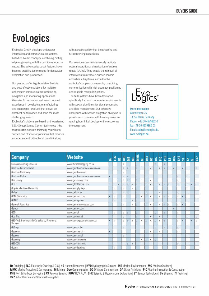
EvoLogics GmbH develops underwater
information and communication systems
based on bionic concepts, combining cutting
edge engineering with the best ideas found in
nature. The advanced product features have
become enabling technologies for deepwater
exploration and production.
Our products offer highly reliable, fl exible
and cost-effective solutions for multiple
underwater communication, positioning,
navigation and monitoring applications.
We strive for innovation and invest our vast
experience in developing, manufacturing
and supporting products that deliver an
excellent performance and solve the most
challenging tasks.
EvoLogics’ solutions are based on the patented
S2C (Sweep Spread Carrier) technology - the
most reliable acoustic telemetry available for
subsea and offshore applications that provides
an independent bidirectional data link along
with acoustic positioning, broadcasting and
full networking capabilities.
Our solutions can simultaneously facilitate
optimal operation and navigation of subsea
robots (UUVs). They enable the retrieval of
information from various subsea sensors
and other subsystems, and allow the
control of complex processes by combining
communication with high-accuracy positioning
and multiple monitoring options.
The S2C systems have been developed
specifi cally for harsh underwater environments
with special algorithms for signal processing
and data management. Our extensive
experience with sensor integration allows us to
provide our customers with turn-key solutions
ranging from initial deployment to recovering
the equipment.
EvoLogics
Dr Dredging | ECG Electronic Charting & GIS | HS Human Resources | HYD Hydrographic Surveys | ME Marine Environments | MG Marine Geodesy |
MMC Marine Mapping & Cartography | M Mining | Oce Oceanography | OC Offshore Construction | OA Other Activities | PIC Pipeline Inspection & Construction |
PHS Port & Harbour Surveying | RS Remote Sensing | UUV ROV, AUV | SHE Seismic & Hydrocarbon Exploration | ST Sensor Technology | Sh Shipping | Tr Training |
XYZ X-Y-Z Position and Specialist Navigation
Company Website
Dr ECG
HS HYD
ME
MG
MM
CM Oc
eOC OA PI
CPH
SRS UU
VSH
EST Sh Tr XY
Z
Furness Mapping Services www.furnessmapping.co.uk x x x
Gardline Environmental www.gardlinemarinesciences.com x x x x x x x x x x
Gardline Geosurvey www.gardline.co.uk x
Gardline Hydro www.gardlinemarinesciences.com x x x x x x x
Gas Survey www.gas-survey.com x x x x x x
GBT www.gbtoffshore.com x x x x x x x x x x x x x x
Gdynia Maritime University www.am.gdynia.pl x x x x x
Gehym www.gehym.es x x x x x x x
GEM Elettronica www.gemrad.com x x x x x x x x x x x x x x
GENEQ www.geneq.com x x x
General Acoustics www.generalacoustics.com x x x x x x x x x x
Genrov www.genrov.com x
GEO www.geo.dk x x x x x x x
Geo Plus www.geoplus.nl x x x x x x
GEO TAG Engenharia & Consultoria, Projetos e Serviços.
www.geotagbatimetria.com.br x x x x x x x x x x x x x x x x
GEO.xyz www.geoxyz.be x x x x
Geocean www.geocean.fr x x x x x
Geocom www.geocom.cl x
Geocomp www.geocomp.com x x x x
GEOCON www.geocon.co.uk x x x
Geodat www.geodat.nb.ca x
HYDBG2015_Tabel 21HYDBG2015_Tabel 21 24-11-2014 15:47:0124-11-2014 15:47:01
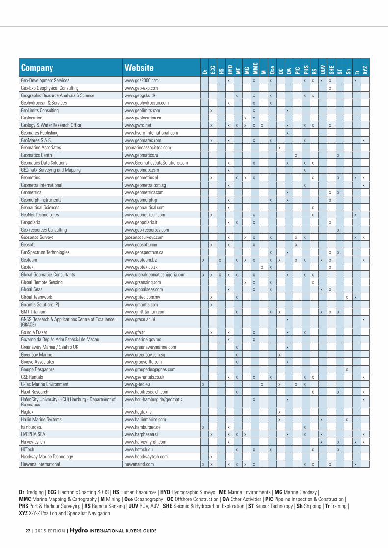
| 2015 EDITION | Hydro INTERNATIONAL BUYERS GUIDE22
Dr Dredging | ECG Electronic Charting & GIS | HS Human Resources | HYD Hydrographic Surveys | ME Marine Environments | MG Marine Geodesy |
MMC Marine Mapping & Cartography | M Mining | Oce Oceanography | OC Offshore Construction | OA Other Activities | PIC Pipeline Inspection & Construction |
PHS Port & Harbour Surveying | RS Remote Sensing | UUV ROV, AUV | SHE Seismic & Hydrocarbon Exploration | ST Sensor Technology | Sh Shipping | Tr Training |
XYZ X-Y-Z Position and Specialist Navigation
Company Website
Dr ECG
HS HYD
ME
MG
MM
CM Oc
eOC OA PI
CPH
SRS UU
VSH
EST Sh Tr XY
Z
Geo-Development Services www.gds2000.com x x x x x x x x
Geo-Exp Geophysical Consulting www.geo-exp.com x
Geographic Resource Analysis & Science www.geogr.ku.dk x x x x x
Geohydrocean & Services www.geohydrocean.com x x x
GeoLimits Consulting www.geolimits.com x x x
Geolocation www.geolocation.ca x x
Geology & Water Research Office www.gwro.net x x x x x x x x x x
Geomares Publishing www.hydro-international.com x
GeoMares S.A.S. www.geomares.com x x x x x x
Geomarine Associates geomarineassociates.com x
Geomatics Centre www.geomatics.ru x x
Geomatics Data Solutions www.GeomaticsDataSolutions.com x x x x x
GEOmatx Surveying and Mapping www.geomatx.com x x
Geometius www.geometius.nl x x x x x x x x
Geometra International www.geometra.com.sg x x x
Geometrics www.geometrics.com x x x
Geomorph Instruments www.geomorph.gr x x x x
Geonautical Sciences www.geonautical.com x x
GeoNet Technologies www.geonet-tech.com x x x x
Geopolaris www.geopolaris.it x x x x
Geo-resources Consulting www.geo-resources.com x
Geosense Surveys geosensesurveys.com x x x x x x x x
Geosoft www.geosoft.com x x x x
GeoSpectrum Technologies www.geospectrum.ca x x x x
Geoteam www.geoteam.biz x x x x x x x x x x x x
Geotek www.geotek.co.uk x x x
Global Geomatics Consultants www.globalgeomaticsnigeria.com x x x x x x x x x
Global Remote Sensing www.grsensing.com x x x x
Global Seas www.globalseas.com x x x x x
Global Teamwork www.gtitec.com.my x x x x
Gmantis Solutions (P) www.gmantis.com x
GMT Titanium www.gmttitanium.com x x x x x x
GNSS Research & Applications Centre of Excellence (GRACE)
www.grace.ac.uk x x
Gourdie Fraser www.gfa.tc x x x x x
Governo da Região Adm Especial de Macau www.marine.gov.mo x x
Greenaway Marine / SeaPro UK www.greenawaymarine.com x x
Greenbay Marine www.greenbay.com.sg x x
Groove Associates www.groove-ltd.com x x
Groupe Desgagnes www.groupedesgagnes.com x
GSE Rentals www.gserentals.co.uk x x x x x x x
G-Tec Marine Environment www.g-tec.eu x x x x x
Habit Research www.habitresearch.com x x x x
HafenCity University (HCU) Hamburg - Department of Geomatics
www.hcu-hamburg.de/geomatik x x x
Hagtak www.hagtak.is x
Hallin Marine Systems www.hallinmarine.com x x x
hamburgeo. www.hamburgeo.de x x x
HARPHA SEA www.harphasea.si x x x x x x x x
Harvey-Lynch www.harvey-lynch.com x x x x x
HCTech www.hctech.eu x x x x x
Headway Marine Technology www.headwaytech.com x
Heavens International heavensintl.com x x x x x x x x x x
HYDBG2015_Tabel 22HYDBG2015_Tabel 22 24-11-2014 15:47:0324-11-2014 15:47:03
Hydro INTERNATIONAL BUYERS GUIDE | 2015 EDITION | 23
BUYERS GUIDEBUYERS GUIDE
Intelligent Marine Robots
You Can Rely On
For more information about our REMUS AUVs, please contact
us at +1 508-563-6565 or [email protected] HYDROID.com
No
3564
More information
6 Benjamin Nye Circle,
Pocasset,
MA 02559-4900,
USA
Phone: +1 5085636565,
Fax: +1 5085633445,
Email: [email protected]
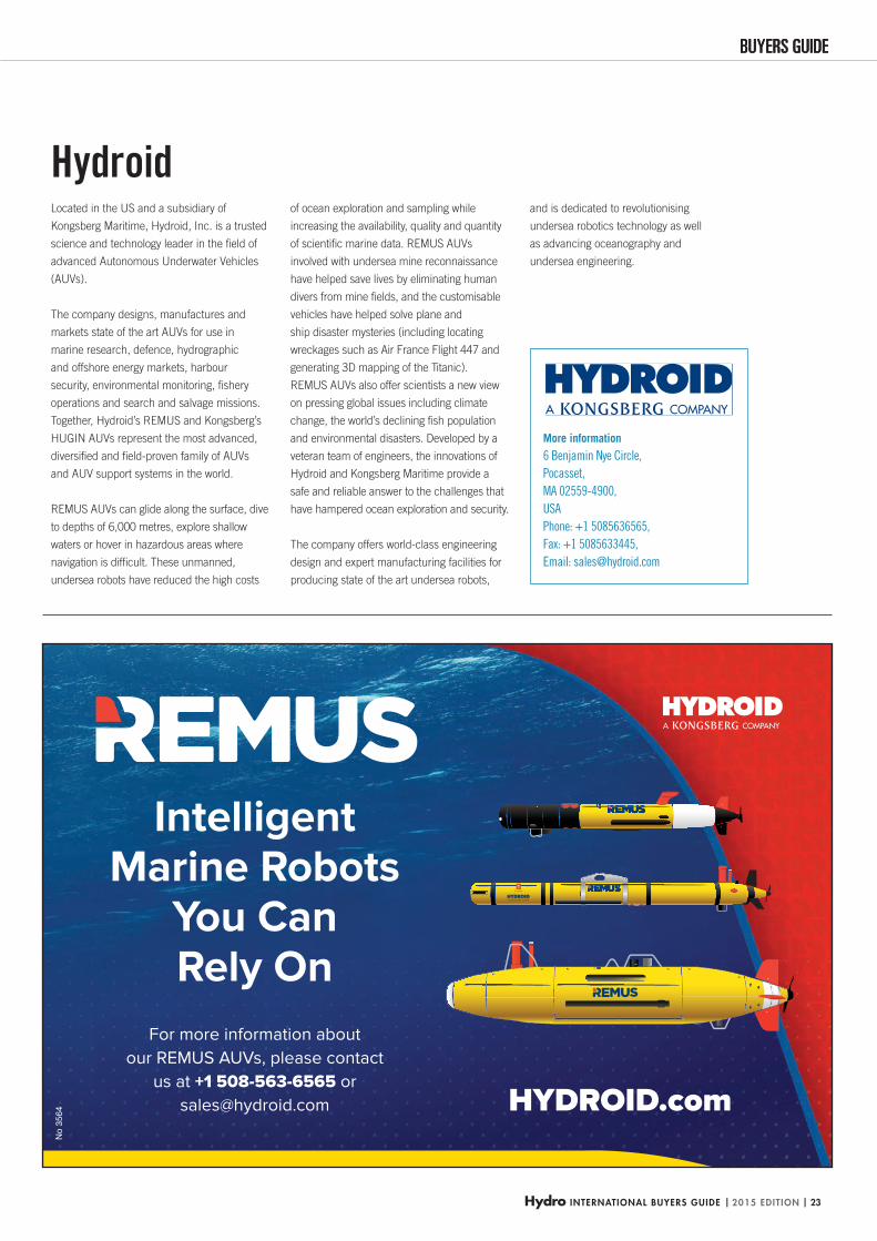
Located in the US and a subsidiary of
Kongsberg Maritime, Hydroid, Inc. is a trusted
science and technology leader in the fi eld of
advanced Autonomous Underwater Vehicles
(AUVs).
The company designs, manufactures and
markets state of the art AUVs for use in
marine research, defence, hydrographic
and offshore energy markets, harbour
security, environmental monitoring, fi shery
operations and search and salvage missions.
Together, Hydroid’s REMUS and Kongsberg’s
HUGIN AUVs represent the most advanced,
diversifi ed and fi eld-proven family of AUVs
and AUV support systems in the world.
REMUS AUVs can glide along the surface, dive
to depths of 6,000 metres, explore shallow
waters or hover in hazardous areas where
navigation is diffi cult. These unmanned,
undersea robots have reduced the high costs
of ocean exploration and sampling while
increasing the availability, quality and quantity
of scientifi c marine data. REMUS AUVs
involved with undersea mine reconnaissance
have helped save lives by eliminating human
divers from mine fi elds, and the customisable
vehicles have helped solve plane and
ship disaster mysteries (including locating
wreckages such as Air France Flight 447 and
generating 3D mapping of the Titanic).
REMUS AUVs also offer scientists a new view
on pressing global issues including climate
change, the world’s declining fi sh population
and environmental disasters. Developed by a
veteran team of engineers, the innovations of
Hydroid and Kongsberg Maritime provide a
safe and reliable answer to the challenges that
have hampered ocean exploration and security.
The company offers world-class engineering
design and expert manufacturing facilities for
producing state of the art undersea robots,
and is dedicated to revolutionising
undersea robotics technology as well
as advancing oceanography and
undersea engineering.
Hydroid
HYDBG2015_Hydroid_P23 23HYDBG2015_Hydroid_P23 23 24-11-2014 14:46:0624-11-2014 14:46:06
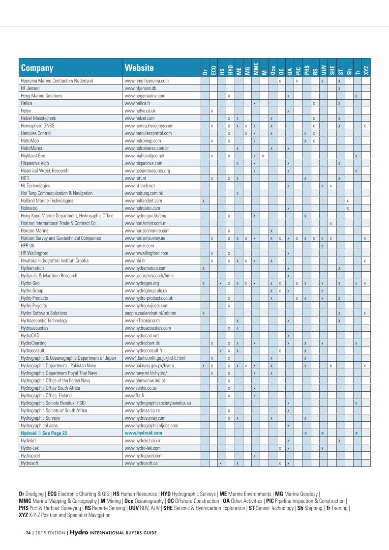
| 2015 EDITION | Hydro INTERNATIONAL BUYERS GUIDE24
Dr Dredging | ECG Electronic Charting & GIS | HS Human Resources | HYD Hydrographic Surveys | ME Marine Environments | MG Marine Geodesy |
MMC Marine Mapping & Cartography | M Mining | Oce Oceanography | OC Offshore Construction | OA Other Activities | PIC Pipeline Inspection & Construction |
PHS Port & Harbour Surveying | RS Remote Sensing | UUV ROV, AUV | SHE Seismic & Hydrocarbon Exploration | ST Sensor Technology | Sh Shipping | Tr Training |
XYZ X-Y-Z Position and Specialist Navigation
Company Website
Dr ECG
HS HYD
ME
MG
MM
CM Oc
eOC OA PI
CPH
SRS UU
VSH
EST Sh Tr XY
Z
Heerema Marine Contractors Nederland www.hmc-heerema.com x x x x
HF Jensen www.hfjensen.dk x
Hegg Marine Solutions www.heggmarine.com x x x
Helica www.helica.it x x x
Helyx www.helyx.co.uk x x
Helzel Messtechnik www.helzel.com x x x x x
Hemisphere GNSS www.hemispheregnss.com x x x x x x x x x
Hercules Control www.herculescontrol.com x x x x x x
HidroMap www.hidromap.com x x x x x
HidroMares www.hidromares.com.br x x x
Highland Geo www.highlandgeo.net x x x x x
Hispanova Vigo www.hispanova.com x x x x
Historical Wreck Research www.oceantreasures.org x x x
HITT www.hitt.nl x x x x x
HL Technologies www.hl-tech.net x x x
Hoi Tung Communuication & Navigation www.hoitung.com.hk x
Holland Marine Technologies www.hollandmt.com x x
Holmatro www.holmatro.com x x
Hong Kong Marine Department, Hydrogaphic Office www.hydro.gov.hk/eng x x x
Horizon International Trade & Contract Co. www.horizonint.com.tr x
Horizon Marine www.horizonmarine.com x x
Horizon Survey and Geotechnical Companies www.horizonsurvey.ae x x x x x x x x x x x x x x
HPR UK www.hpruk.com x
HR Wallingford www.hrwallingford.com x x x
Hrvatska Hidrografski Institut, Croatia www.hhi.hr x x x x x x x
Hydramotion www.hydramotion.com x x x
Hydraulic & Maritime Research www.ucc.ie/research/hmrc x
Hydro Geo www.hydrogeo.org x x x x x x x x x x x x x x
Hydro Group www.hydrogroup.plc.uk x x x x
Hydro Products www.hydro-products.co.uk x x x x x x
Hydro Projects www.hydroprojects.com x
Hydro Software Solutions people.zeelandnet.nl/prblom x x x
Hydroacoustic Technology www.HTIsonar.com x x x
Hydroacoustics www.hydroacoustics.com x x
HydroCAD www.hydrocad.net x
HydroCharting www.hydrochart.dk x x x x x x x x
Hydroconsult www.hydroconsult.fr x x x x x
Hydrographic & Oceanographic Department of Japan www1.kaiho.mlit.go.jp/jhd-E.html x x x x
Hydrographic Department - Pakistan Navy www.paknavy.gov.pk/hydro x x x x x x x x x x
Hydrographic Department Royal Thai Navy www.navy.mi.th/hydro/ x x x x
Hydrographic Office of the Polish Navy www.bhmw.mw.mil.pl x
Hydrographic Office South Africa www.sanho.co.za x x
Hydrographic Office, Finland www.fta.fi x x
Hydrographic Society Benelux (HSB) www.hydrographicsocietybenelux.eu x x
Hydrographic Society of South Africa www.hydrosa.co.za x x
Hydrographic Surveys www.hydrosurvey.com x x x x
Hydrographical Jobs www.hydrographicaljobs.com x
Hydroid See Page 23 www.hydroid.com x x xHydrokit www.hydrokit.co.uk x x
Hydro-Lek www.hydro-lek.com x x x
Hydropixel www.hydropixel.com x
Hydrosoft www.hydrosoft.ca x x x x
HYDBG2015_Tabel 24HYDBG2015_Tabel 24 24-11-2014 15:47:0724-11-2014 15:47:07
Hydro INTERNATIONAL BUYERS GUIDE | 2015 EDITION | 25
BUYERS GUIDEBUYERS GUIDE
HYPACK, Inc. SOUNDING BETTER!
HYPACK® Hydrographic Survey So ware Single beam, Side Scan, ADCP
DREDGEPACK®
Dredge Posi oning So ware Cu er Suc ons, Excavator, Hopper, and Crane support
HYSWEEP®
Mul beam, Backsca er, and Topographic Laser So ware
For more informa on visit us at www.hypack.com - [email protected] - +1-860-635-1500
Over 25 years providing hydrographic surveying and dredging so ware solu ons! N
o 35
80
More information
56 Bradley Street,
Middletown, CT 06457,
USA
Phone +1 8606351500
Email: [email protected]
www.hypack.com
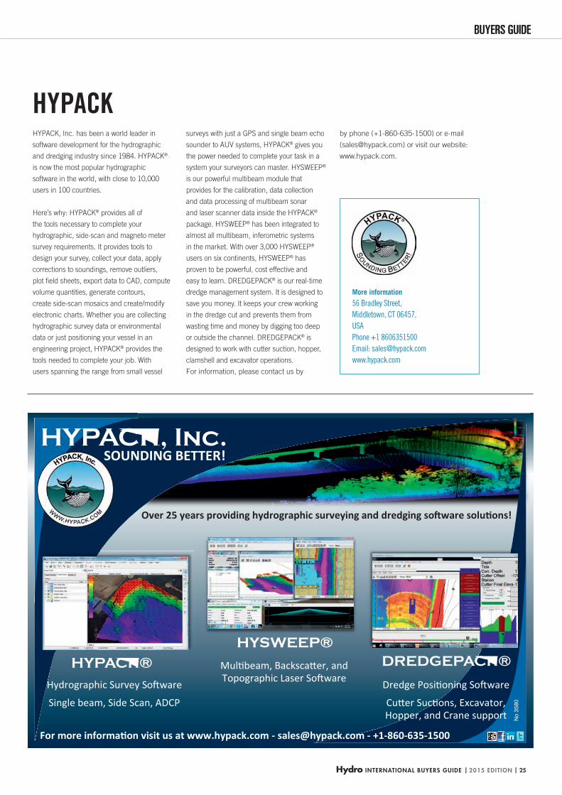
HYPACK, Inc. has been a world leader in
software development for the hydrographic
and dredging industry since 1984. HYPACK®
is now the most popular hydrographic
software in the world, with close to 10,000
users in 100 countries.
Here’s why: HYPACK® provides all of
the tools necessary to complete your
hydrographic, side-scan and magneto meter
survey requirements. It provides tools to
design your survey, collect your data, apply
corrections to soundings, remove outliers,
plot fi eld sheets, export data to CAD, compute
volume quantities, generate contours,
create side-scan mosaics and create/modify
electronic charts. Whether you are collecting
hydrographic survey data or environmental
data or just positioning your vessel in an
engineering project, HYPACK® provides the
tools needed to complete your job. With
users spanning the range from small vessel
surveys with just a GPS and single beam echo
sounder to AUV systems, HYPACK® gives you
the power needed to complete your task in a
system your surveyors can master. HYSWEEP®
is our powerful multibeam module that
provides for the calibration, data collection
and data processing of multibeam sonar
and laser scanner data inside the HYPACK®
package. HYSWEEP® has been integrated to
almost all multibeam, inferometric systems
in the market. With over 3,000 HYSWEEP®
users on six continents, HYSWEEP® has
proven to be powerful, cost effective and
easy to learn. DREDGEPACK® is our real-time
dredge management system. It is designed to
save you money. It keeps your crew working
in the dredge cut and prevents them from
wasting time and money by digging too deep
or outside the channel. DREDGEPACK® is
designed to work with cutter suction, hopper,
clamshell and excavator operations.
For information, please contact us by
by phone (+1-860-635-1500) or e-mail
([email protected]) or visit our website:
www.hypack.com.
HYPACK
HYDBG2015_Hypack_P25 25HYDBG2015_Hypack_P25 25 24-11-2014 15:17:4224-11-2014 15:17:42
| 2015 EDITION | Hydro INTERNATIONAL BUYERS GUIDE26
Dr Dredging | ECG Electronic Charting & GIS | HS Human Resources | HYD Hydrographic Surveys | ME Marine Environments | MG Marine Geodesy |
MMC Marine Mapping & Cartography | M Mining | Oce Oceanography | OC Offshore Construction | OA Other Activities | PIC Pipeline Inspection & Construction |
PHS Port & Harbour Surveying | RS Remote Sensing | UUV ROV, AUV | SHE Seismic & Hydrocarbon Exploration | ST Sensor Technology | Sh Shipping | Tr Training |
XYZ X-Y-Z Position and Specialist Navigation
Company Website
Dr ECG
HS HYD
ME
MG
MM
CM Oc
eOC OA PI
CPH
SRS UU
VSH
EST Sh Tr XY
Z
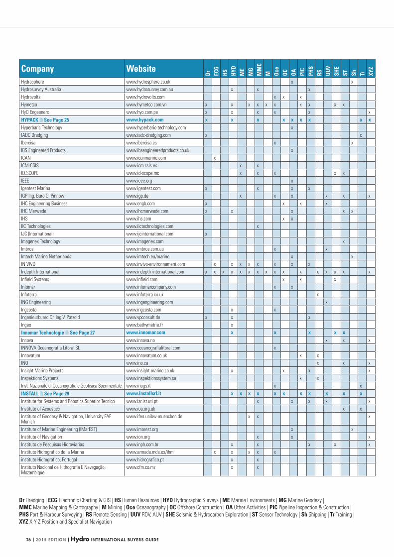
Hydrosphere www.hydrosphere.co.uk x x
Hydrosurvey Australia www.hydrosurvey.com.au x x x
Hydrovolts www.hydrovolts.com x x x
Hymetco www.hymetco.com.vn x x x x x x x x x x
HyO Engeeners www.hyo.com.pe x x x x x x
HYPACK See Page 25 www.hypack.com x x x x x x x x xHyperbaric Technology www.hyperbaric-technology.com x
IADC Dredging www.iadc-dredging.com x x
Ibercisa www.ibercisa.es x x
IBS Engineered Products www.ibsengineeredproducts.co.uk x
ICAN www.icanmarine.com x
ICM-CSIS www.icm.csis.es x x
ID.SCOPE www.id-scope.mc x x x x x
IEEE www.ieee.org x
Igeotest Marina www.igeotest.com x x x x
IGP Ing. Buro G. Pinnow www.igp.de x x x x x x
IHC Engineering Business www.engb.com x x x x
IHC Merwede www.ihcmerwede.com x x x x x
IHS www.ihs.com x x
IIC Technologies www.iictechnologies.com x
IJC (International) www.ijcinternational.com x
Imagenex Technology www.imagenex.com x
Imbros www.imbros.com.au x x
Imtech Marine Netherlands www.imtech.eu/marine x x
IN VIVO www.invivo-environnement.com x x x x x x x x
Indepth-International www.indepth-international.com x x x x x x x x x x x x x x x x
Infield Systems www.infield.com x x x
Infomar www.infomarcompany.com x x
Infoterra www.infoterra.co.uk x
ING Engineering www.ingengineering.com x
Ingcosta www.ingcosta.com x x
Ingenieurbuero Dr. Ing V. Patzold www.vpconsult.de x x x
Ingeo www.bathymetrie.fr x
Innomar Technologie See Page 27 www.innomar.com x x x x xInnova www.innova.no x x x
INNOVA Oceanografia Litoral SL www.oceanografialitoral.com x
Innovatum www.innovatum.co.uk x x
INO www.ino.ca x x x
Insight Marine Projects www.insight-marine.co.uk x x x x
Inspektions Systems www.inspektionssystem.se x x
Inst. Nazionale di Oceanografia e Geofisica Sperimentale www.inogs.it x x
INSTALL See Page 29 www.installsrl.it x x x x x x x x x x xInstitute for Systems and Robotics Superior Tecnico www.isr.ist.utl.pt x x x x x
Institute of Acoustics www.ioa.org.uk x x
Institute of Geodesy & Navigation, University FAF Munich
www.ifen.unibw-muenchen.de x x x
Institute of Marine Engineering (IMarEST) www.imarest.org x x
Institute of Navigation www.ion.org x x x
Instituto de Pesquisas Hidroviarias www.inph.com.br x x x x x
Instituto Hidrográfico de la Marina www.armada.mde.es/ihm x x x x x
instituto Hidrográfico, Portugal www.hidrografico.pt x x
Instituto Nacional de Hidrografia E Navegação, Mozambique
www.cfm.co.mz x x
HYDBG2015_Tabel 26HYDBG2015_Tabel 26 24-11-2014 15:47:1024-11-2014 15:47:10
Hydro INTERNATIONAL BUYERS GUIDE | 2015 EDITION | 27
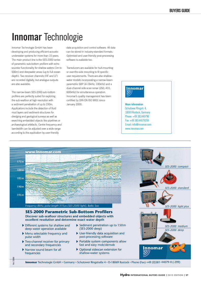
BUYERS GUIDEBUYERS GUIDEN
o 33
88
More information
Schutower Ringstr. 4,
18069 Rostock, Germany
Phone: +49 381440790
Fax: +49 38144079299
Email: [email protected]
www.innomar.com
Innomar Technologie GmbH has been
developing and producing effi cient acoustic
underwater systems for more than 15 years.
The main product line is the SES-2000 series
of parametric sub-bottom profi lers with echo
sounder functionality for shallow waters (1m to
500m) and deepwater areas (up to full ocean
depth). Two receiver channels (HF and LF)
are recorded digitally, but analogue outputs
are also available.
The narrow-beam SES-2000 sub-bottom
profi lers are perfectly suited for exploring
the sub-seafl oor at high resolution with
a sediment penetration of up to 150m.
Applications include the detection of fl uid
mud layers and sediment structures for
dredging and geological surveys as well as
searching embedded objects like pipelines or
archaeological artefacts. Centre frequency and
bandwidth can be adjusted over a wide range
according to the application by user-friendly
data acquisition and control software. All data
can be stored in industry-standard formats.
Optimised and user-friendly post-processing
software is available too.
Transducers are available for hull-mounting
or over-the-side mounting to fi t specifi c
user requirements. There are also shallow-
water models incorporating a narrow-beam
parametric SBP (4-15kHz; 100kHz) and a
dual-channel side-scan sonar (250, 410,
600kHz) for simultaneous operation.
Innomar’s quality management has been
certifi ed by DIN EN ISO 9001 since
January 2000.
Innomar Technologie
HYDBG2015_Innomar_P27 27HYDBG2015_Innomar_P27 27 24-11-2014 14:52:4924-11-2014 14:52:49
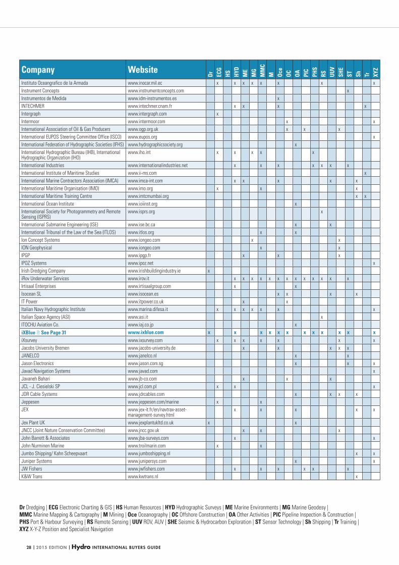
| 2015 EDITION | Hydro INTERNATIONAL BUYERS GUIDE28
Dr Dredging | ECG Electronic Charting & GIS | HS Human Resources | HYD Hydrographic Surveys | ME Marine Environments | MG Marine Geodesy |
MMC Marine Mapping & Cartography | M Mining | Oce Oceanography | OC Offshore Construction | OA Other Activities | PIC Pipeline Inspection & Construction |
PHS Port & Harbour Surveying | RS Remote Sensing | UUV ROV, AUV | SHE Seismic & Hydrocarbon Exploration | ST Sensor Technology | Sh Shipping | Tr Training |
XYZ X-Y-Z Position and Specialist Navigation
Company Website
Dr ECG
HS HYD
ME
MG
MM
CM Oc
eOC OA PI
CPH
SRS UU
VSH
EST Sh Tr XY
Z
Instituto Oceangrafico de la Armada www.inocar.mil.ec x x x x x x x x
Instrument Concepts www.instrumentconcepts.com x
Instrumentos de Medida www.idm-instrumentos.es x
INTECHMER www.intechmer.cnam.fr x x x x
Intergraph www.intergraph.com x
Intermoor www.intermoor.com x x
International Association of Oil & Gas Producers www.ogp.org.uk x x x
International EUPOS Steering Committee Office (ISCO) www.eupos.org x
International Federation of Hydrographic Societies (IFHS) www.hydrographicsociety.org x
International Hydrographic Bureau (IHB), International Hydrographic Organization (IHO)
www.iho.int x x x x x
International Industries www.internationalindustries.net x x x x x x x
International Institute of Maritime Studies www.ii-ms.com x
International Marine Contractors Association (IMCA) www.imca-int.com x x x x x
International Maritime Organisation (IMO) www.imo.org x x x
International Maritime Training Centre www.imtcmumbai.org x x
International Ocean Institute www.ioiinst.org x
International Society for Photogrammetry and Remote Sensing (ISPRS)
www.isprs.org x
International Submarine Engineering (ISE) www.ise.bc.ca x x
International Tribunal of the Law of the Sea (ITLOS) www.itlos.org x x
Ion Concept Systems www.iongeo.com x x
ION Geophysical www.iongeo.com x x
IPGP www.ipgp.fr x x x
IPOZ Systems www.ipoz.net x
Irish Dredging Company www.irishbuildingindustry.ie x
iRov Underwater Services www.irov.it x x x x x x x x x x x x x
Irtisaal Enterprises www.irtisaalgroup.com x x
Isocean SL www.isocean.es x x x x
IT Power www.itpower.co.uk x x
Italian Navy Hydrographic Institute www.marina.difesa.it x x x x x x x
Italian Space Agency (ASI) www.asi.it x
ITOCHU Aviation Co. www.iaj.co.jp x
iXBlue See Page 31 www.ixblue.com x x x x x x x x x x x xiXsurvey www.ixsurvey.com x x x x x x x
Jacobs University Bremen www.jacobs-university.de x x x x x
JANELCO www.janelco.nl x x
Jason Electronics www.jason.com.sg x x x
Javad Navigation Systems www.javad.com x
Javaneh Bahari www.jb-co.com x x x
JCL - J. Ciesielski SP www.jcl.com.pl x x x
JDR Cable Systems www.jdrcables.com x x x x
Jeppesen www.jeppesen.com/marine x x
JEX www.jex-it.fr/en/navtrax-asset-management-survey.html
x x x x x
Jex Plant UK www.jexplantukltd.co.uk x x
JNCC (Joint Nature Conservation Committee) www.jncc.gov.uk x x x
John Barrett & Associates www.jba-surveys.com x x
John Nurminen Marine www.troilmarin.com x x
Jumbo Shipping/ Kahn Scheepvaart www.jumboshipping.nl x x
Juniper Systems www.junipersys.com x x
JW Fishers www.jwfishers.com x x x x x x
K&W Trans www.kwtrans.nl x
HYDBG2015_Tabel 28HYDBG2015_Tabel 28 24-11-2014 15:47:1524-11-2014 15:47:15
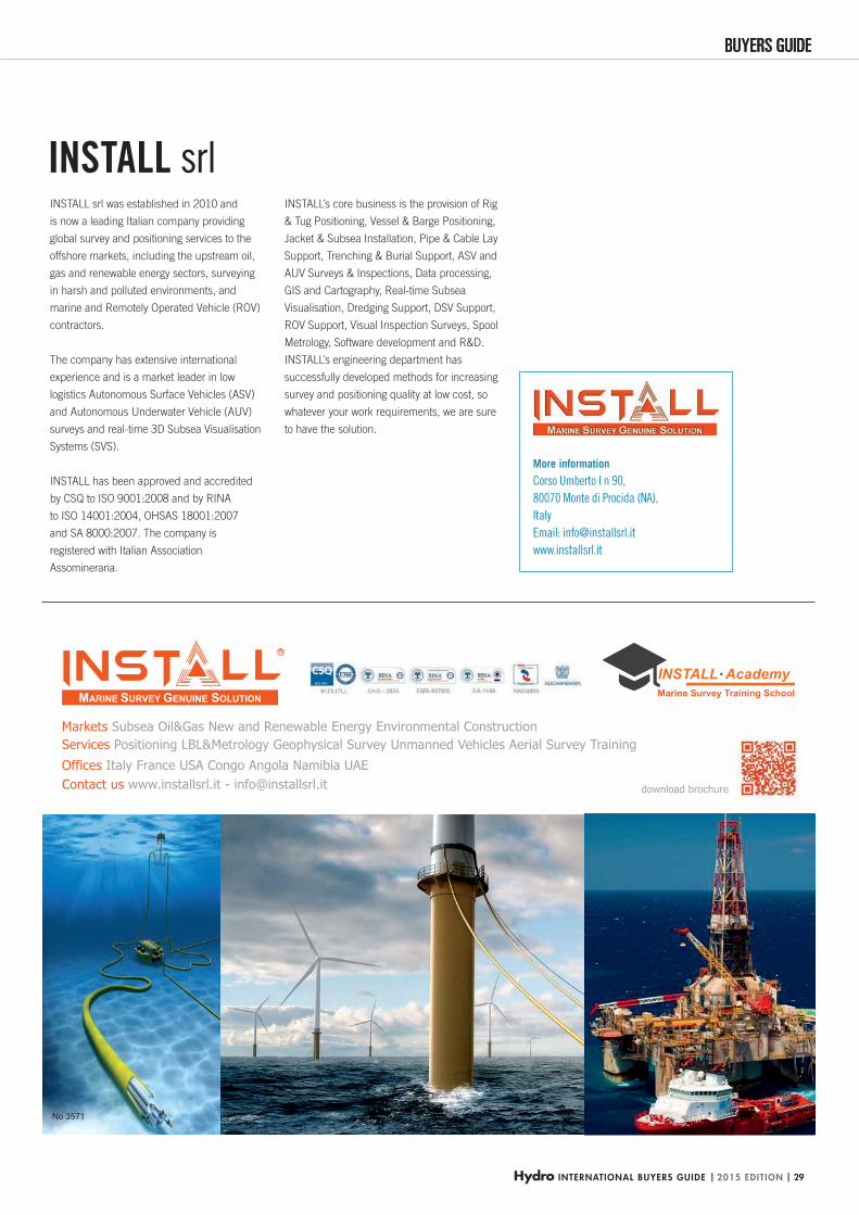
Hydro INTERNATIONAL BUYERS GUIDE | 2015 EDITION | 29
BUYERS GUIDEBUYERS GUIDE
No 3571
More information
Corso Umberto I n 90,
80070 Monte di Procida (NA),
Italy
Email: [email protected]
www.installsrl.it
INSTALL srl was established in 2010 and
is now a leading Italian company providing
global survey and positioning services to the
offshore markets, including the upstream oil,
gas and renewable energy sectors, surveying
in harsh and polluted environments, and
marine and Remotely Operated Vehicle (ROV)
contractors.
The company has extensive international
experience and is a market leader in low
logistics Autonomous Surface Vehicles (ASV)
and Autonomous Underwater Vehicle (AUV)
surveys and real-time 3D Subsea Visualisation
Systems (SVS).
INSTALL has been approved and accredited
by CSQ to ISO 9001:2008 and by RINA
to ISO 14001:2004, OHSAS 18001:2007
and SA 8000:2007. The company is
registered with Italian Association
Assomineraria.
INSTALL’s core business is the provision of Rig
& Tug Positioning, Vessel & Barge Positioning,
Jacket & Subsea Installation, Pipe & Cable Lay
Support, Trenching & Burial Support, ASV and
AUV Surveys & Inspections, Data processing,
GIS and Cartography, Real-time Subsea
Visualisation, Dredging Support, DSV Support,
ROV Support, Visual Inspection Surveys, Spool
Metrology, Software development and R&D.
INSTALL’s engineering department has
successfully developed methods for increasing
survey and positioning quality at low cost, so
whatever your work requirements, we are sure
to have the solution.
INSTALL srl
HYDBG2015_INSTALL_P29 29HYDBG2015_INSTALL_P29 29 24-11-2014 11:53:3024-11-2014 11:53:30
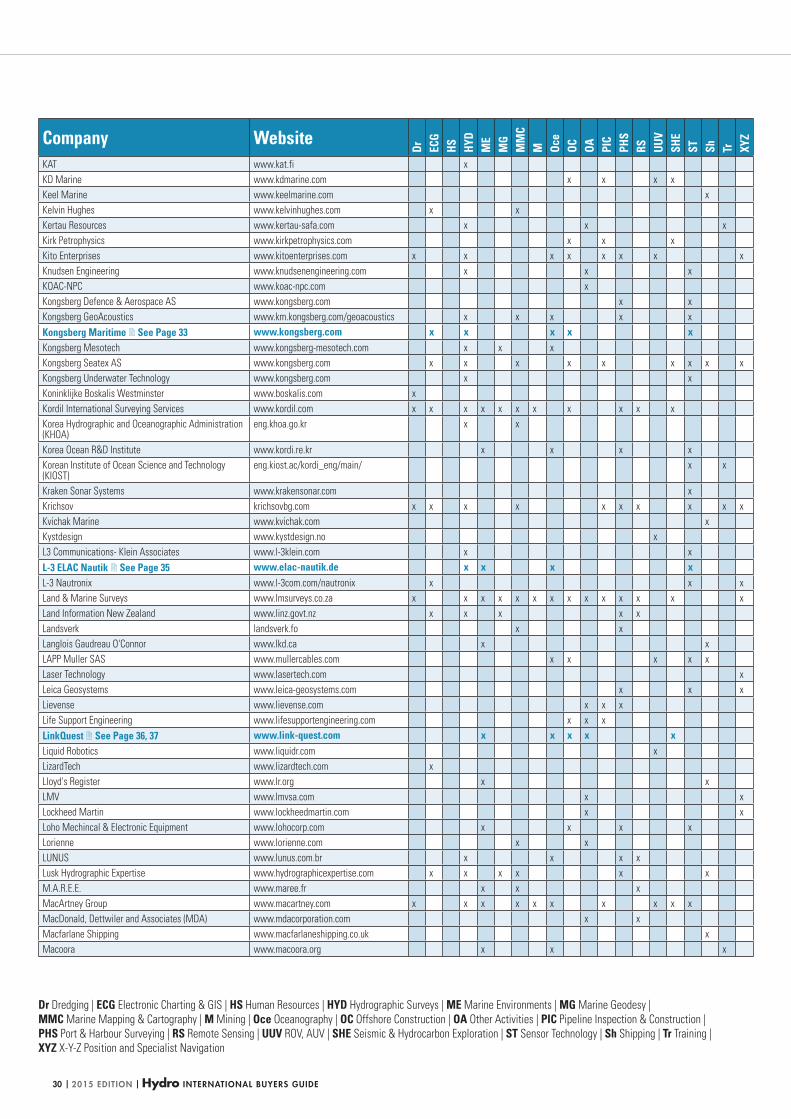
| 2015 EDITION | Hydro INTERNATIONAL BUYERS GUIDE30
Dr Dredging | ECG Electronic Charting & GIS | HS Human Resources | HYD Hydrographic Surveys | ME Marine Environments | MG Marine Geodesy |
MMC Marine Mapping & Cartography | M Mining | Oce Oceanography | OC Offshore Construction | OA Other Activities | PIC Pipeline Inspection & Construction |
PHS Port & Harbour Surveying | RS Remote Sensing | UUV ROV, AUV | SHE Seismic & Hydrocarbon Exploration | ST Sensor Technology | Sh Shipping | Tr Training |
XYZ X-Y-Z Position and Specialist Navigation
Company Website
Dr ECG
HS HYD
ME
MG
MM
CM Oc
eOC OA PI
CPH
SRS UU
VSH
EST Sh Tr XY
Z
KAT www.kat.fi x
KD Marine www.kdmarine.com x x x x
Keel Marine www.keelmarine.com x
Kelvin Hughes www.kelvinhughes.com x x
Kertau Resources www.kertau-safa.com x x x
Kirk Petrophysics www.kirkpetrophysics.com x x x
Kito Enterprises www.kitoenterprises.com x x x x x x x x
Knudsen Engineering www.knudsenengineering.com x x x
KOAC-NPC www.koac-npc.com x
Kongsberg Defence & Aerospace AS www.kongsberg.com x x
Kongsberg GeoAcoustics www.km.kongsberg.com/geoacoustics x x x x x
Kongsberg Maritime See Page 33 www.kongsberg.com x x x x xKongsberg Mesotech www.kongsberg-mesotech.com x x x
Kongsberg Seatex AS www.kongsberg.com x x x x x x x x x
Kongsberg Underwater Technology www.kongsberg.com x x
Koninklijke Boskalis Westminster www.boskalis.com x
Kordil International Surveying Services www.kordil.com x x x x x x x x x x x
Korea Hydrographic and Oceanographic Administration (KHOA)
eng.khoa.go.kr x x
Korea Ocean R&D Institute www.kordi.re.kr x x x x
Korean Institute of Ocean Science and Technology (KIOST)
eng.kiost.ac/kordi_eng/main/ x x
Kraken Sonar Systems www.krakensonar.com x
Krichsov krichsovbg.com x x x x x x x x x x
Kvichak Marine www.kvichak.com x
Kystdesign www.kystdesign.no x
L3 Communications- Klein Associates www.l-3klein.com x x
L-3 ELAC Nautik See Page 35 www.elac-nautik.de x x x xL-3 Nautronix www.l-3com.com/nautronix x x x
Land & Marine Surveys www.lmsurveys.co.za x x x x x x x x x x x x x x
Land Information New Zealand www.linz.govt.nz x x x x x
Landsverk landsverk.fo x x
Langlois Gaudreau O'Connor www.lkd.ca x x
LAPP Muller SAS www.mullercables.com x x x x x
Laser Technology www.lasertech.com x
Leica Geosystems www.leica-geosystems.com x x x
Lievense www.lievense.com x x x
Life Support Engineering www.lifesupportengineering.com x x x
LinkQuest See Page 36, 37 www.link-quest.com x x x x xLiquid Robotics www.liquidr.com x
LizardTech www.lizardtech.com x
Lloyd's Register www.lr.org x x
LMV www.lmvsa.com x x
Lockheed Martin www.lockheedmartin.com x x
Loho Mechincal & Electronic Equipment www.lohocorp.com x x x x
Lorienne www.lorienne.com x x
LUNUS www.lunus.com.br x x x x
Lusk Hydrographic Expertise www.hydrographicexpertise.com x x x x x x
M.A.R.E.E. www.maree.fr x x x
MacArtney Group www.macartney.com x x x x x x x x x x
MacDonald, Dettwiler and Associates (MDA) www.mdacorporation.com x x
Macfarlane Shipping www.macfarlaneshipping.co.uk x
Macoora www.macoora.org x x x
HYDBG2015_Tabel 30HYDBG2015_Tabel 30 24-11-2014 15:47:2224-11-2014 15:47:22
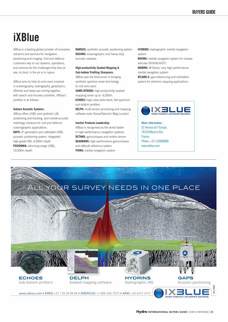
Hydro INTERNATIONAL BUYERS GUIDE | 2015 EDITION | 31
BUYERS GUIDEBUYERS GUIDE
ECHOESC O S DELPHDELPH HYDRINSHYDRINS GAPSGAPS
+33 1 30 08 88 88 +1 888-600-7573 +65 6747 4912
All your survey needs in one place
No
3584
More information
52 Avenue de l’Europe,
78160 Marly le Roi,
France
Phone: +33 130088888
www.ixblue.com
iXBlue is a leading global provider of innovative
solutions and services for navigation,
positioning and imaging. Civil and defence
customers rely on our systems, operations,
and services for the challenges they face at
sea, on land, in the air or in space.
iXBlue aims to help its end-users involved
in oceanography, hydrography, geophysics,
offshore and deep-sea mining together
with search and recovery activities. iXBlue’s
portfolio is as follows:
Subsea Acoustic Systems:
iXBlue offers USBL and synthetic LBL
positioning and tracking, and inertial-acoustic
metrology solutions for civil and defence
oceanographic applications.
GAPS: 4th generation pre-calibrated USBL
acoustic positioning system, integrated
high-grade INS, 4,000m depth
POSIDONIA: ultra-long range USBL,
10,000m depth
RAMSES: synthetic acoustic positioning system
OCEANO: oceanographic and heavy duty
acoustic releases
High-productivity Seabed Mapping &
Sub-bottom Profi ling Sharpness:
iXBlue was the forerunner in bringing
synthetic aperture sonar technology
to civil end-users.
SAMS-DT6000: high-productivity seabed
mapping sonar up to -6,000m.
ECHOES: high-class wide band, fl at spectrum
sub-bottom profi lers
DELPH: multi-sensor processing and mapping
software suite (Sonar/Seismic/ Mag Locator)
Inertial Products Leadership:
iXBlue is recognised as the world leader
in high-performance navigation systems.
OCTANS: gyrocompass and motion sensor
QUADRANS: high-performance gyrocompass
and attitude reference system
PHINS: inertial navigation system
HYDRINS: hydrographic inertial navigation
system
ROVINS: inertial navigation system for subsea
vehicles (ROV/AUV/DT)
MARINS: M Series, very high-performance
inertial navigation system
ATLANS-C: geo-referencing and orientation
system for airborne mapping applications.
iXBlue
HYDBG2015_IXBlue_P31 31HYDBG2015_IXBlue_P31 31 24-11-2014 11:51:4724-11-2014 11:51:47
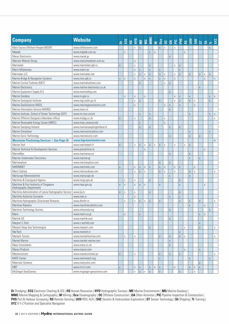
| 2015 EDITION | Hydro INTERNATIONAL BUYERS GUIDE32
Dr Dredging | ECG Electronic Charting & GIS | HS Human Resources | HYD Hydrographic Surveys | ME Marine Environments | MG Marine Geodesy |
MMC Marine Mapping & Cartography | M Mining | Oce Oceanography | OC Offshore Construction | OA Other Activities | PIC Pipeline Inspection & Construction |
PHS Port & Harbour Surveying | RS Remote Sensing | UUV ROV, AUV | SHE Seismic & Hydrocarbon Exploration | ST Sensor Technology | Sh Shipping | Tr Training |
XYZ X-Y-Z Position and Specialist Navigation
Company Website
Dr ECG
HS HYD
ME
MG
MM
CM Oc
eOC OA PI
CPH
SRS UU
VSH
EST Sh Tr XY
Z
Main Source Offshore People (MSOP) www.offshoremm.com x x x x x x
Maptek www.maptek.com.au x x x x
Marac Electronics www.marak.gr x
Marcom-Watson Group www.marcomwatson.com.au x
Marimeter www.marimeter.spb.ru x x x x x
Marin Miljöanalys www.marin.se x x x x x
Marinatec LLC www.marinatec.net x x x x x x x x x x x x
Marine Bridge & Navigation Systems www.mns.spb.ru x x x x x x x x x x
Marine Current Turbines (MCT) www.marineturbines.com x x x
Marine Electronics www.marine-electronics.co.uk x
Marine Equipment Supply B.V. www.mestrading.com x
Marine Geodesy www.m-geo.ru x x x x x x x x
Marine Geological Institute www.mgi.esdm.go.id x x x x x x x x
Marine GeoSolutions (MGS) www.marinegeosolutions.com x x x x x
Marine Information Service (MARIS) www.maris.nl x
Marine Institute, School of Ocean Technology (SOT) www.mi.mun.ca/sot x x x x x
Marine Offshore Designers (Aberdeen office) www.modgy.co.uk x x x x x
Marine Renewable Energy Center (MREC) www.mrec.umassd.edu x x
Marine Sampling Holland www.marinesamplingholland.nl x x x x
Marine Simulation www.marinesimulation.com x x
Marine Sonic Technology www.marinesonic.com x x x
Marinestar Positioning Services See Page 39 www.fugromarinestar.com xMarine Tech www.marinetech.fr x x x x x x x x x x x
Marine Technical & Development Services www.pomaritime.ie x x
MarineNav www.marinenav.ca x x
Mariner Underwater Electronics www.mariner.gr x x
Marinexplore www.marinexplore.com x x
MARiNMET www.marinmet.com x x x x x x x x x x
Maris Subsea www.marissubsea.com x x x x x x x x x
Mariscope Meerestechnik www.mariscope.de x x
Maritime & Coastguard Agency www.mcga.gov.uk x x x x
Maritime & Port Authority of Singapore (Hydrographic Department)
www.mpa.gov.sg x x x x x x x x
Maritime Administration of Latvia Hydrographic Service www.lja.lv x x x x x
Maritime Authority Suriname www.mas.sr x x x
Maritime Hydrographic Directorate Romania www.dhmfn.ro x x x x x x x x x x
Maritime Robotics www.maritimerobotics.com x x
Maritime Technology Society www.mtsociety.org x x
Marix www.marix.co.jp x x x x
Marlink AS www.marlink.com x
Marport C-Tech www.c-techltd.com x
Marport Deep Sea Technologies www.marport.com x x x x
MarTech www.martech.it x
Martech Tunisia www.martechtunisia.com x x x x x x x
Martek Marine www.martek-marine.com x
Mass Consultants www.mass.co.uk x
Massa Products www.massa.com x x
Masterconnect www.masterconnect.pt x x x x x x
MATE Center www.marinetech.org x x x
Materials Systems www.matsysinc.com x
MBT www.m-b-t.com x x x x x x x x x x
McGregor GeoScience www.mcgregor-geoscience.com x x x x x x x
HYDBG2015_Tabel 32HYDBG2015_Tabel 32 24-11-2014 15:47:2424-11-2014 15:47:24
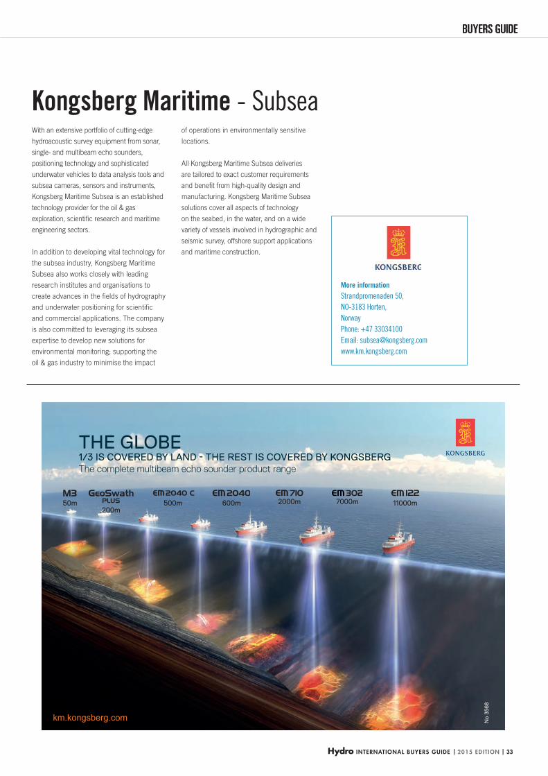
Hydro INTERNATIONAL BUYERS GUIDE | 2015 EDITION | 33
BUYERS GUIDEBUYERS GUIDE
200m500m 600m 11000m2000m 7000m
THE GLOBE 1/3 IS COVERED BY LAND - THE REST IS COVERED BY KONGSBERGThe complete multibeam echo sounder product range
km.kongsberg.com
50m
No
3568
More information
Strandpromenaden 50,
NO-3183 Horten,
Norway
Phone: +47 33034100
Email: [email protected]
www.km.kongsberg.com
With an extensive portfolio of cutting-edge
hydroacoustic survey equipment from sonar,
single- and multibeam echo sounders,
positioning technology and sophisticated
underwater vehicles to data analysis tools and
subsea cameras, sensors and instruments,
Kongsberg Maritime Subsea is an established
technology provider for the oil & gas
exploration, scientifi c research and maritime
engineering sectors.
In addition to developing vital technology for
the subsea industry, Kongsberg Maritime
Subsea also works closely with leading
research institutes and organisations to
create advances in the fi elds of hydrography
and underwater positioning for scientifi c
and commercial applications. The company
is also committed to leveraging its subsea
expertise to develop new solutions for
environmental monitoring; supporting the
oil & gas industry to minimise the impact
of operations in environmentally sensitive
locations.
All Kongsberg Maritime Subsea deliveries
are tailored to exact customer requirements
and benefi t from high-quality design and
manufacturing. Kongsberg Maritime Subsea
solutions cover all aspects of technology
on the seabed, in the water, and on a wide
variety of vessels involved in hydrographic and
seismic survey, offshore support applications
and maritime construction.
Kongsberg Maritime - Subsea
HYDBG2015_Kongsberg_P33 33HYDBG2015_Kongsberg_P33 33 24-11-2014 15:06:5424-11-2014 15:06:54
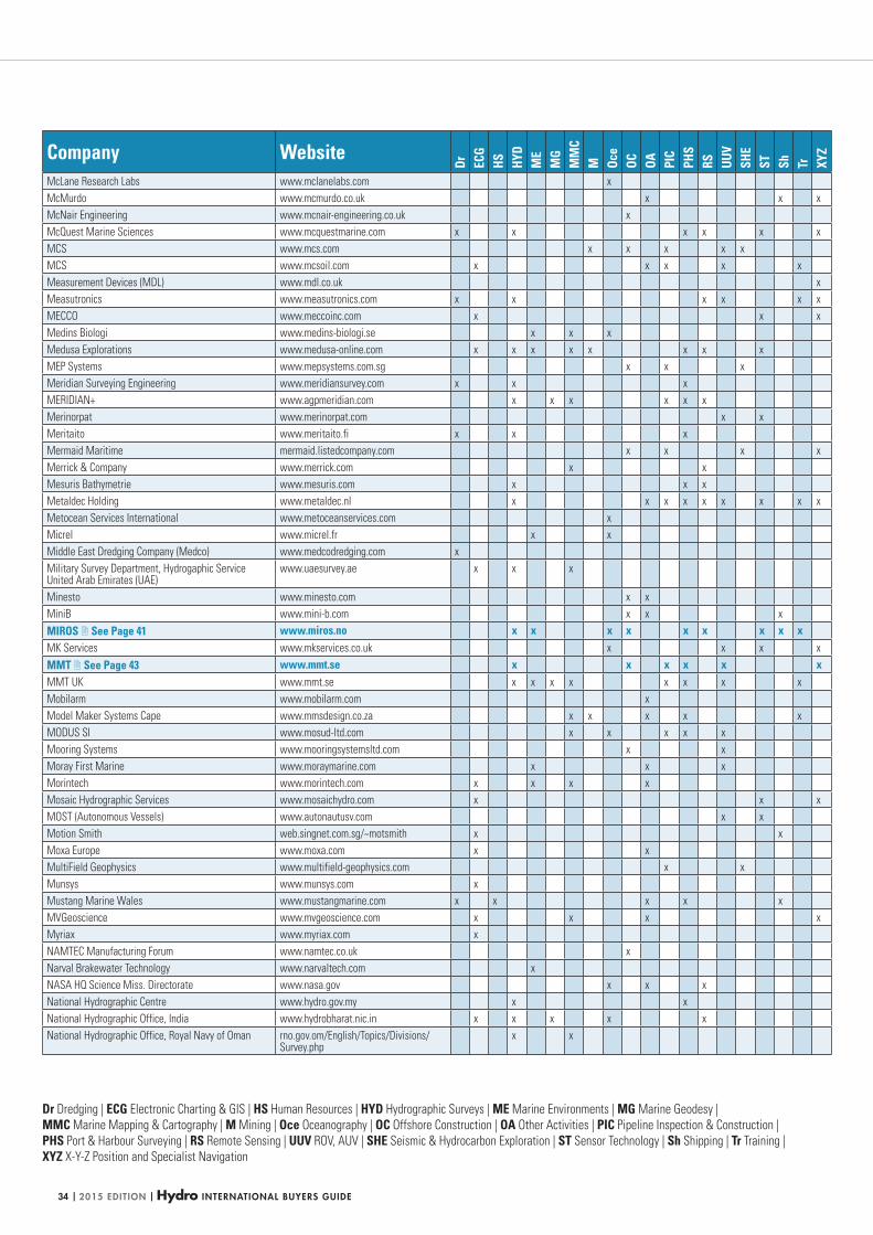
| 2015 EDITION | Hydro INTERNATIONAL BUYERS GUIDE34
Dr Dredging | ECG Electronic Charting & GIS | HS Human Resources | HYD Hydrographic Surveys | ME Marine Environments | MG Marine Geodesy |
MMC Marine Mapping & Cartography | M Mining | Oce Oceanography | OC Offshore Construction | OA Other Activities | PIC Pipeline Inspection & Construction |
PHS Port & Harbour Surveying | RS Remote Sensing | UUV ROV, AUV | SHE Seismic & Hydrocarbon Exploration | ST Sensor Technology | Sh Shipping | Tr Training |
XYZ X-Y-Z Position and Specialist Navigation
Company Website
Dr ECG
HS HYD
ME
MG
MM
CM Oc
eOC OA PI
CPH
SRS UU
VSH
EST Sh Tr XY
Z
McLane Research Labs www.mclanelabs.com x
McMurdo www.mcmurdo.co.uk x x x
McNair Engineering www.mcnair-engineering.co.uk x
McQuest Marine Sciences www.mcquestmarine.com x x x x x x
MCS www.mcs.com x x x x x
MCS www.mcsoil.com x x x x x
Measurement Devices (MDL) www.mdl.co.uk x
Measutronics www.measutronics.com x x x x x x
MECCO www.meccoinc.com x x x
Medins Biologi www.medins-biologi.se x x x
Medusa Explorations www.medusa-online.com x x x x x x x x
MEP Systems www.mepsystems.com.sg x x x
Meridian Surveying Engineering www.meridiansurvey.com x x x
MERIDIAN+ www.agpmeridian.com x x x x x x
Merinorpat www.merinorpat.com x x
Meritaito www.meritaito.fi x x x
Mermaid Maritime mermaid.listedcompany.com x x x x
Merrick & Company www.merrick.com x x
Mesuris Bathymetrie www.mesuris.com x x x
Metaldec Holding www.metaldec.nl x x x x x x x x x
Metocean Services International www.metoceanservices.com x
Micrel www.micrel.fr x x
Middle East Dredging Company (Medco) www.medcodredging.com x
Military Survey Department, Hydrogaphic Service United Arab Emirates (UAE)
www.uaesurvey.ae x x x
Minesto www.minesto.com x x
MiniB www.mini-b.com x x x
MIROS See Page 41 www.miros.no x x x x x x x x xMK Services www.mkservices.co.uk x x x x
MMT See Page 43 www.mmt.se x x x x x xMMT UK www.mmt.se x x x x x x x x
Mobilarm www.mobilarm.com x
Model Maker Systems Cape www.mmsdesign.co.za x x x x x
MODUS SI www.mosud-ltd.com x x x x x
Mooring Systems www.mooringsystemsltd.com x x
Moray First Marine www.moraymarine.com x x x
Morintech www.morintech.com x x x x
Mosaic Hydrographic Services www.mosaichydro.com x x x
MOST (Autonomous Vessels) www.autonautusv.com x x
Motion Smith web.singnet.com.sg/~motsmith x x
Moxa Europe www.moxa.com x x
MultiField Geophysics www.multifield-geophysics.com x x
Munsys www.munsys.com x
Mustang Marine Wales www.mustangmarine.com x x x x x
MVGeoscience www.mvgeoscience.com x x x x
Myriax www.myriax.com x
NAMTEC Manufacturing Forum www.namtec.co.uk x
Narval Brakewater Technology www.narvaltech.com x
NASA HQ Science Miss. Directorate www.nasa.gov x x x
National Hydrographic Centre www.hydro.gov.my x x
National Hydrographic Office, India www.hydrobharat.nic.in x x x x x
National Hydrographic Office, Royal Navy of Oman rno.gov.om/English/Topics/Divisions/Survey.php
x x
HYDBG2015_Tabel 34HYDBG2015_Tabel 34 24-11-2014 15:47:2924-11-2014 15:47:29
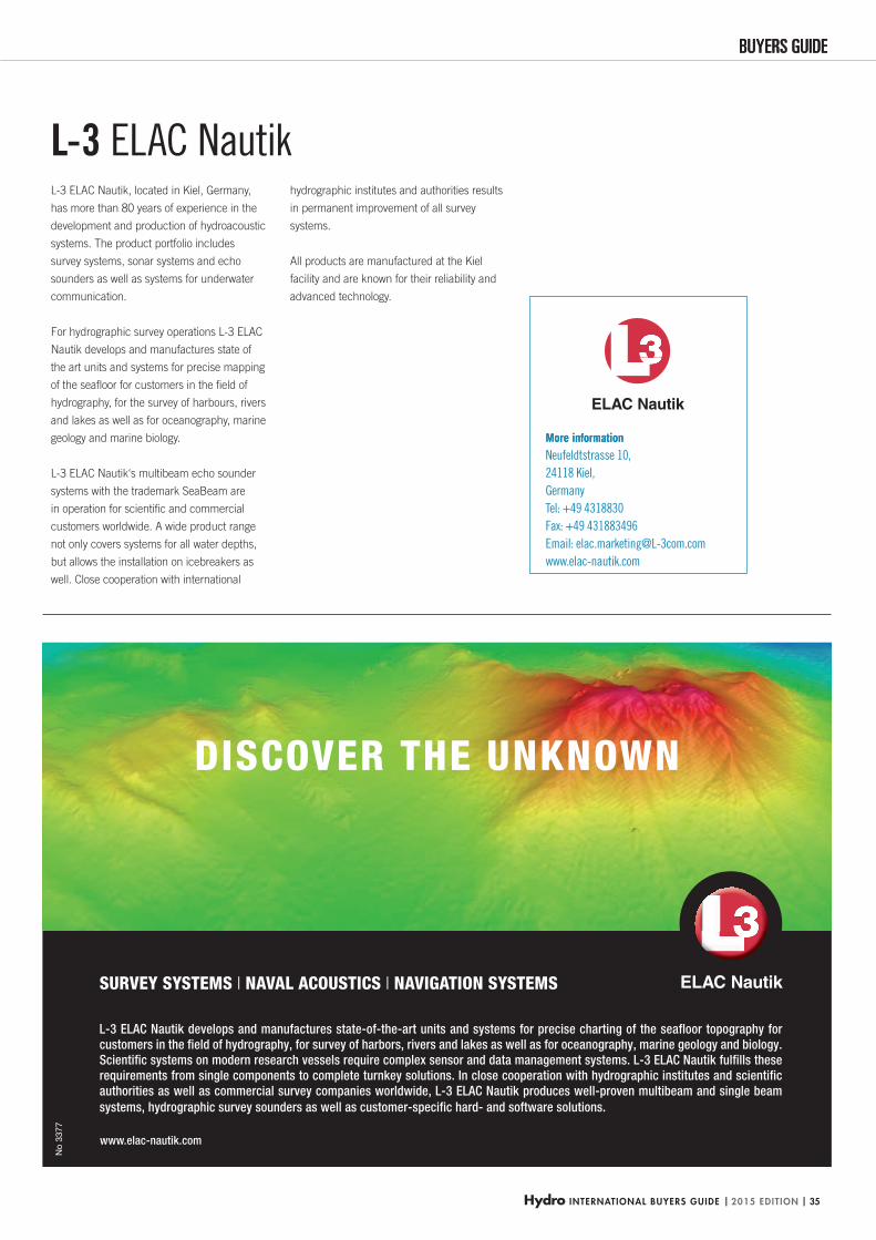
Hydro INTERNATIONAL BUYERS GUIDE | 2015 EDITION | 35
BUYERS GUIDEBUYERS GUIDE
www.elac-nautik.com
DISCOVER THE UNKNOWN
SURVEY SYSTEMS l NAVAL ACOUSTICS l NAVIGATION SYSTEMS
L-3 ELAC Nautik develops and manufactures state-of-the-art units and systems for precise charting of the seafloor topography for customers in the field of hydrography, for survey of harbors, rivers and lakes as well as for oceanography, marine geology and biology.Scientific systems on modern research vessels require complex sensor and data management systems. L-3 ELAC Nautik fulfills these requirements from single components to complete turnkey solutions. In close cooperation with hydrographic institutes and scientific authorities as well as commercial survey companies worldwide, L-3 ELAC Nautik produces well-proven multibeam and single beam systems, hydrographic survey sounders as well as customer-specific hard- and software solutions.
No
3377
More information More information
Neufeldtstrasse 10,
24118 Kiel,
Germany
Tel: +49 4318830
Fax: +49 431883496
Email: [email protected]
www.elac-nautik.com
L-3 ELAC Nautik, located in Kiel, Germany,
has more than 80 years of experience in the
development and production of hydroacoustic
systems. The product portfolio includes
survey systems, sonar systems and echo
sounders as well as systems for underwater
communication.
For hydrographic survey operations L-3 ELAC
Nautik develops and manufactures state of
the art units and systems for precise mapping
of the seafl oor for customers in the fi eld of
hydrography, for the survey of harbours, rivers
and lakes as well as for oceanography, marine
geology and marine biology.
L-3 ELAC Nautik‘s multibeam echo sounder
systems with the trademark SeaBeam are
in oper ation for scientifi c and commercial
customers worldwide. A wide product range
not only covers systems for all water depths,
but allows the installation on icebreakers as
well. Close cooperation with international
hydrographic institutes and authorities results
in permanent improvement of all survey
systems.
All products are manufactured at the Kiel
facility and are known for their reliability and
advanced technology.
L-3 ELAC Nautik
HYDBG2015_L3 35HYDBG2015_L3 35 24-11-2014 16:23:0724-11-2014 16:23:07
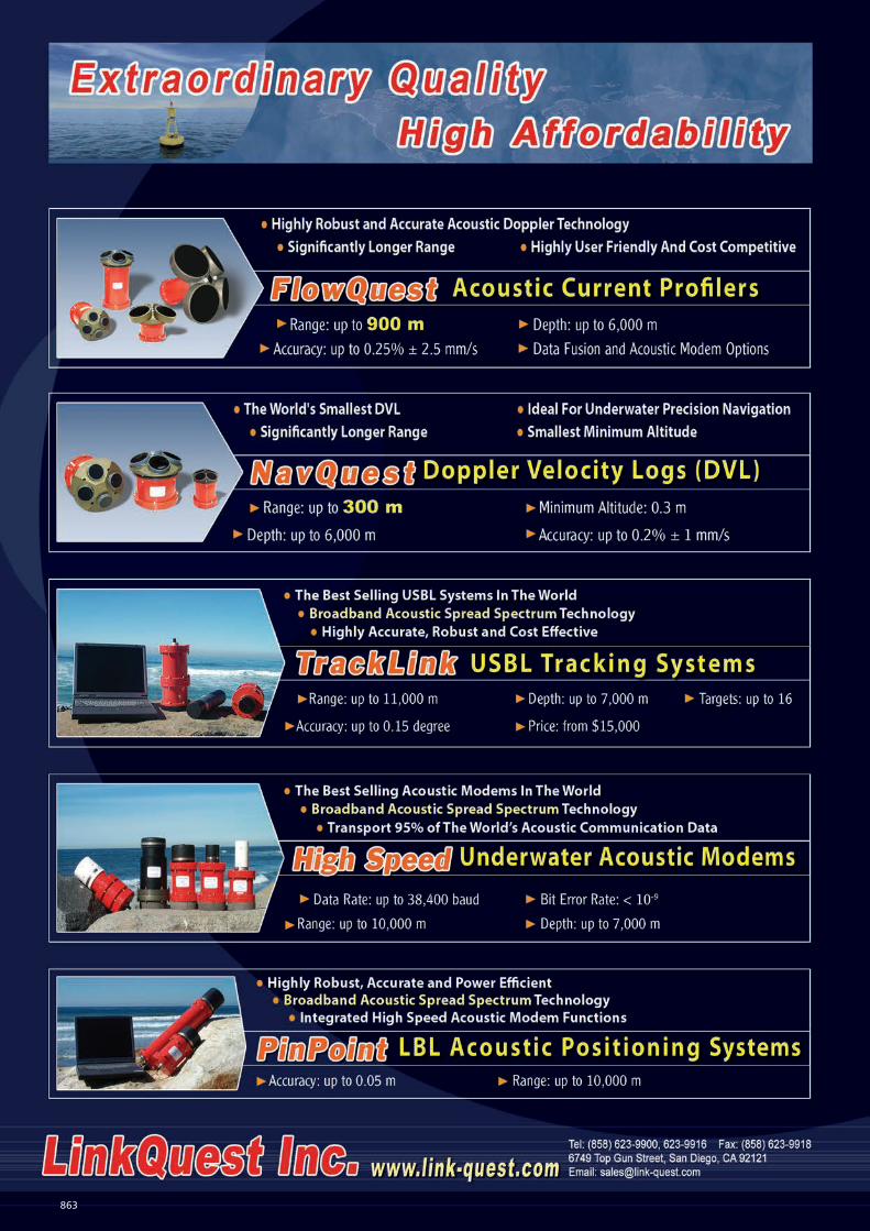
863
Adv. Hydro 1-1 pag. 210x297.indd 1 21-10-2009 10:32:48HYDBG2015_Advertenties 36HYDBG2015_Advertenties 36 24-11-2014 15:45:1524-11-2014 15:45:15
Hydro INTERNATIONAL BUYERS GUIDE | 2015 EDITION | 37
BUYERS GUIDEBUYERS GUIDE
More information
6749 Top Gun Street,
San Diego,
CA 92121,
USA
Phone: +1 8586239900
Email: [email protected]
www.link-quest.com
LinkQuest Inc. is a leading manufacturer of
precision acoustic instruments for offshore
oil explor ation, construction, drilling, survey,
environmental study and other ocean-
ographic applications. Our innovative
Broadband Acoustic Spread Spectrum (BASS)
technology sets new standards for acoustic
communication and positioning.
LinkQuest is the dominant supplier of
Underwater Acoustic Modems in the world.
Its high-speed acoustic modems transport
more than 95% of the world’s acoustic
communication data. LinkQuest’s line of
TrackLink Acoustic Tracking Systems provide
the world’s most robust, accurate and
cost-effective Ultra Short Baseline (USBL)
solutions. The TrackLink systems are the
world’s best selling USBL tracking systems.
LinkQuest manufactures highly accurate,
robust and cost effective FlowQuest Acoustic
Current Profi lers for measuring currents and
fl ows in oceans, harbours, lakes, rivers and
open channels and NavQuest Doppler Velocity
Logs for precision navigation and positioning
of underwater vehicles.
LinkQuest also manufactures Pin-Point LBL
acoustic positioning systems and Precision
Marine Geodetic Systems used for tsunami
and earthquake monitoring and prediction.
LinkQuest
QPSQPS BV (Quality Positioning Services) makes
industry leading software for collection,
post-processing and visualisation of
maritime geomatic data. Our products QPS
QINSy, QPS Qimera and QPS Fledermaus
seamlessly partner ArcGIS for Maritime,
to solve problems and gain effi ciencies for
maritime-related businesses. QPS QINSy
is a software suite used for many types of
maritime geomatic surveys, ranging from
simple single beam surveys to very complex
offshore construction works. QPS Qimera is
an evolution in hydrographic data processing
and it combines the core technologies of
QINSy and Fledermaus. QPS Fledermaus is a
powerful tool used by commercial, academic
and government clients worldwide to interact
in 4D with geographical datasets.
Our QPS Qastor is Electronic Chart Software
(ECS) that enables navigation, piloting and
precise docking, as well as several other
applications, such as Oil & Gas FPSO/
SPM mooring, patrol vessel and tugboat
operations. Using wired or wireless methods,
Qastor interfaces to most devices outputting
NMEA data strings, to AIS units, and to the
QPS Qastor Connect Server which supplies
meteorological data, VTS targets and ENC
updates to Qastor users.
QPS is an independent software company that
has been headquartered in the Netherlands
since 1986, and now has subsidiary offi ces in
the USA, Canada and the UK. In 2012, QPS
became a member of the SAAB (Sweden)
group of companies (Defence and Security
Solutions).
More information
Huis ter Heideweg 16,
3705 LZ Zeist,
The Netherlands
Phone: +31 306941200
Fax: +31 306923663
Email: [email protected]
www.qps.nl
USA Phone: +1 6034311773
Fax: +1 6037660485
Email: [email protected]
www.qps.nl
HYDBG2015_LinkQuest-QPS_P37 37HYDBG2015_LinkQuest-QPS_P37 37 24-11-2014 15:14:1824-11-2014 15:14:18
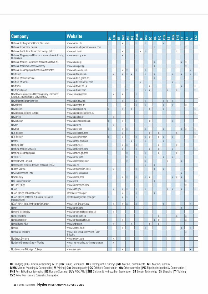
| 2015 EDITION | Hydro INTERNATIONAL BUYERS GUIDE38
Dr Dredging | ECG Electronic Charting & GIS | HS Human Resources | HYD Hydrographic Surveys | ME Marine Environments | MG Marine Geodesy |
MMC Marine Mapping & Cartography | M Mining | Oce Oceanography | OC Offshore Construction | OA Other Activities | PIC Pipeline Inspection & Construction |
PHS Port & Harbour Surveying | RS Remote Sensing | UUV ROV, AUV | SHE Seismic & Hydrocarbon Exploration | ST Sensor Technology | Sh Shipping | Tr Training |
XYZ X-Y-Z Position and Specialist Navigation
Company Website
Dr ECG
HS HYD
ME
MG
MM
CM Oc
eOC OA PI
CPH
SRS UU
VSH
EST Sh Tr XY
Z
National Hydrographic Office, Sri Lanka www.nara.ac.lk x x x x
National Hyperbaric Centre www.nationalhyperbariccentre.com x x
National Institute of Ocean Technology (NIOT) www.niot.res.in x x x x
National Mapping and Resource Information Authority, Philippines
www.namria.gov.ph x x
National Marine Electronics Association (NMEA) www.nmea.org x x x
National Maritime Safety Authority www.nmsa.gov.pg x x
National Oceanography Centre Southampton www.noc.soton.ac.uk x x x x x
Nautikaris www.nautikaris.com x x x x x x x x x x
Nautilus Marine Service www.nautilus-gmbh.de x
Nautilus Minerals www.nautilusminerals.com x x
Nautronix www.nautronix.co.uk x x x
Nautronix Group www.nautronix.com x x x x x x
Naval Meteorology and Oceanography Command (CNMOC), Hydrographic Service USA
www.cnmoc.navy.mil x x x
Naval Oceanographic Office www.navo.navy.mil x x x x x x
Navcontrol www.navcontrol.fr x x x x x
Navgeocom www.navgeocom.ru x x x x x x
Navigation Solutions Europe www.navigationsolutions.eu x
Navionics www.navionics.it x
Navis Group www.navisincontrol.com x x x x
Navtor www.navtor.no x
Navtron www.navtron.ro x x x x x x x x
NCS Subsea www.ncs-subsea.com x x x x x
NCS Survey www.ncs-survey.com x x x x x x x x x
Neotek www.neotek-web.com x x x
Neptune EHF www.neptune.is x x x x x
Neptune Marine Services www.neptunems.com x x x x x x
Neptune Oceanographics www.neptune.gb.com x x x x
NEREIDES www.nereides.fr x x x x x
NesscoInvsat Limited www.nesscogroup.com x x x x
Netherlands Institute for Sea Research (NIOZ) www.nioz.nl x x
NETmc Marine www.netmcmarine.co.uk x x x x
Newton Research Labs www.newtonlabs.com x
Nexans Italy www.nexans.com x x x x x x x x
NKE Instrumentation www.nke.fr x x
No Limit Ships www.nolimitships.com x
NOAA www.noaa.gov x x x x x x x x x
NOAA (Office of Coast Survey) chartmaker.noaa.gov x x x
NOAA (Office of Ocean & Coastal Resource Management)
coastalmanagement.noaa.gov x x x x
NOAA (UNH Joint Hydrographic Center) www.ccom-jhc.unh.edu x x x x x x
Norbit www.norbit.com x
Norcom Technology www.norcom-technology.co.uk x
Nordic Martime www.nordic.com.sg x x x
Nordseetaucher www.nordseetaucher.de x x x x
Norsk Hydro ASA www.hydro.com x x x x
Nortek www.Nortek-BV.nl x x x x
North Star Shipping www.craig-group.com/North_Star_Shipping
x
Northport Systems www.fugawi.com x
Northrop Grumman Sperry Marine www.sperrymarine.northropgrumman.com
x
Northwestern Michigan College www.nmc.edu x x
HYDBG2015_Tabel 38HYDBG2015_Tabel 38 24-11-2014 15:47:3524-11-2014 15:47:35
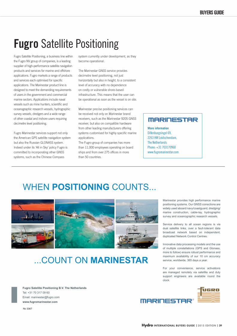
Hydro INTERNATIONAL BUYERS GUIDE | 2015 EDITION | 39
BUYERS GUIDEBUYERS GUIDE
WHEN POSITIONING COUNTS...
...COUNT ON MARINESTAR
Fugro Satellite Positioning B.V. The NetherlandsTel: +31 70 317 09 60Email: [email protected] www.fugromarinestar.com
Marinestar provides high performance marine positioning systems. Our GNSS corrections are widely used aboard navy/coastguard, dredging/marine construction, cable-lay, hydrographic survey and oceanographic research vessels.
Service delivery to all ocean regions is via dual satellite links, over a fault-tolerant data broadcast network based on independent, duplicated Network Control Centres.
Innovative data processing models and the use of multiple constellations (GPS and Glonass, more to follow) ensure robust performance and maximum availability of our 10 cm accuracy service, worldwide, 365 days a year.
For your convenience, service activations are managed remotely via satellite and duty support engineers are available round the clock.
No 3367
More information
Dillenburgsingel 69,
2263 HW Leidschendam,
The Netherlands
Phone: +31 703170960
www.fugromarinestar.com
Fugro Satellite Positioning, a business line within
the Fugro NV group of companies, is a leading
supplier of high-performance satellite navigation
products and services for marine and offshore
applications. Fugro markets a range of products
and services each optimised for specifi c
applications. The Marinestar product line is
designed to meet the demanding requirements
of users in the government and commercial
marine sectors. Applications include naval
vessels such as mine hunters, scientifi c and
oceanographic research vessels, hydrographic
survey vessels, dredgers and a wide range
of other coastal and inshore users requiring
decimetre level positioning.
Fugro Marinestar services support not only
the American GPS satellite navigation system
but also the Russian GLONASS system.
Indeed under its ‘All in Sky’ policy Fugro is
committed to incorporating other GNSS
systems, such as the Chinese Compass
system currently under development, as they
become operational.
The Marinestar GNSS service provides
decimetre level positioning, not just
horizontally but also in height, to a consistent
level of accuracy with no dependence
on costly or vulnerable shore-based
infrastructure. This means that the user can
be operational as soon as the vessel is on site.
Marinestar precise positioning services can
be received not only on Marinestar brand
receivers, such as the Marinestar 9205 GNSS
receiver, but also on compatible hardware
from other leading manufacturers offering
systems customised for highly specifi c marine
applications.
The Fugro group of companies has more
than 11,000 employees operating on board
ships and from over 275 offi ces in more
than 50 countries.
Fugro Satellite Positioning
HYDBG2015_Marinestar_P39 39HYDBG2015_Marinestar_P39 39 24-11-2014 11:59:2924-11-2014 11:59:29
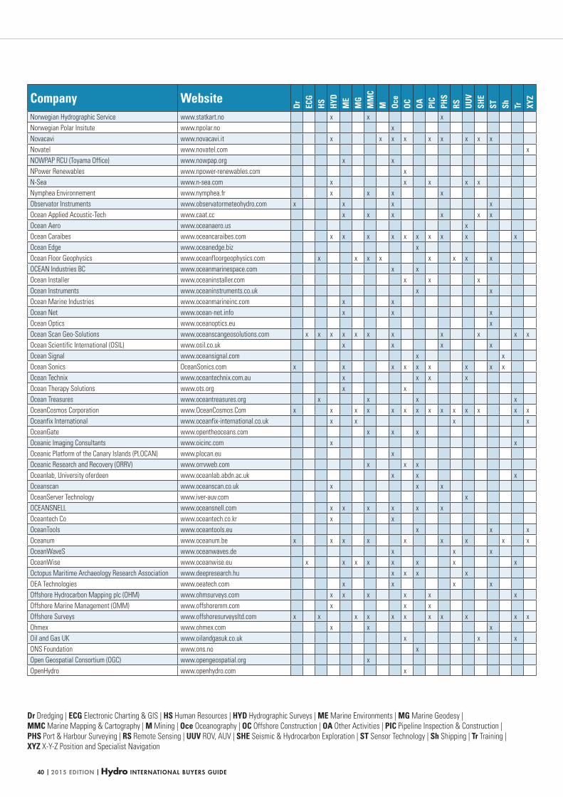
| 2015 EDITION | Hydro INTERNATIONAL BUYERS GUIDE40
Dr Dredging | ECG Electronic Charting & GIS | HS Human Resources | HYD Hydrographic Surveys | ME Marine Environments | MG Marine Geodesy |
MMC Marine Mapping & Cartography | M Mining | Oce Oceanography | OC Offshore Construction | OA Other Activities | PIC Pipeline Inspection & Construction |
PHS Port & Harbour Surveying | RS Remote Sensing | UUV ROV, AUV | SHE Seismic & Hydrocarbon Exploration | ST Sensor Technology | Sh Shipping | Tr Training |
XYZ X-Y-Z Position and Specialist Navigation
Company Website
Dr ECG
HS HYD
ME
MG
MM
CM Oc
eOC OA PI
CPH
SRS UU
VSH
EST Sh Tr XY
Z
Norwegian Hydrographic Service www.statkart.no x x x
Norwegian Polar Insitute www.npolar.no x
Novacavi www.novacavi.it x x x x x x x x x
Novatel www.novatel.com x
NOWPAP RCU (Toyama Office) www.nowpap.org x x
NPower Renewables www.npower-renewables.com x
N-Sea www.n-sea.com x x x x x
Nymphea Environnement www.nymphea.fr x x x x
Observator Instruments www.observatormeteohydro.com x x x x
Ocean Applied Acoustic-Tech www.caat.cc x x x x x x
Ocean Aero www.oceanaero.us x
Ocean Caraibes www.oceancaraibes.com x x x x x x x x x x
Ocean Edge www.oceanedge.biz x
Ocean Floor Geophysics www.oceanfloorgeophysics.com x x x x x x x x
OCEAN Industries BC www.oceanmarinespace.com x x
Ocean Installer www.oceaninstaller.com x x x
Ocean Instruments www.oceaninstruments.co.uk x x
Ocean Marine Industries www.oceanmarineinc.com x x
Ocean Net www.ocean-net.info x x x
Ocean Optics www.oceanoptics.eu x
Ocean Scan Geo-Solutions www.oceanscangeosolutions.com x x x x x x x x x x x
Ocean Scientific International (OSIL) www.osil.co.uk x x x x
Ocean Signal www.oceansignal.com x x
Ocean Sonics OceanSonics.com x x x x x x x x x
Ocean Technix www.oceantechnix.com.au x x x x
Ocean Therapy Solutions www.ots.org x x
Ocean Treasures www.oceantreasures.org x x x x
OceanCosmos Corporation www.OceanCosmos.Com x x x x x x x x x x x x x x
Oceanfix International www.oceanfix-international.co.uk x x x x
OceanGate www.opentheoceans.com x x x
Oceanic Imaging Consultants www.oicinc.com x x
Oceanic Platform of the Canary Islands (PLOCAN) www.plocan.eu x
Oceanic Research and Recovery (ORRV) www.orrvweb.com x x x
Oceanlab, University oferdeen www.oceanlab.abdn.ac.uk x x x
Oceanscan www.oceanscan.co.uk x x x
OceanServer Technology www.iver-auv.com x
OCEANSNELL www.oceansnell.com x x x x x x
Oceantech Co www.oceantech.co.kr x x
OceanTools www.oceantools.eu x x x
Oceanum www.oceanum.be x x x x x x x x x
OceanWaveS www.oceanwaves.de x x x
OceanWise www.oceanwise.eu x x x x x x x x
Octopus Maritime Archaeology Research Association www.deepresearch.hu x x x x
OEA Technologies www.oeatech.com x x x x
Offshore Hydrocarbon Mapping plc (OHM) www.ohmsurveys.com x x x x x x
Offshore Marine Management (OMM) www.offshoremm.com x x x
Offshore Surveys www.offshoresurveysltd.com x x x x x x x x x x x
Ohmex www.ohmex.com x x x
Oil and Gas UK www.oilandgasuk.co.uk x x x
ONS Foundation www.ons.no x
Open Geospatial Consortium (OGC) www.opengeospatial.org x
OpenHydro www.openhydro.com x
HYDBG2015_Tabel 40HYDBG2015_Tabel 40 24-11-2014 15:47:4024-11-2014 15:47:40
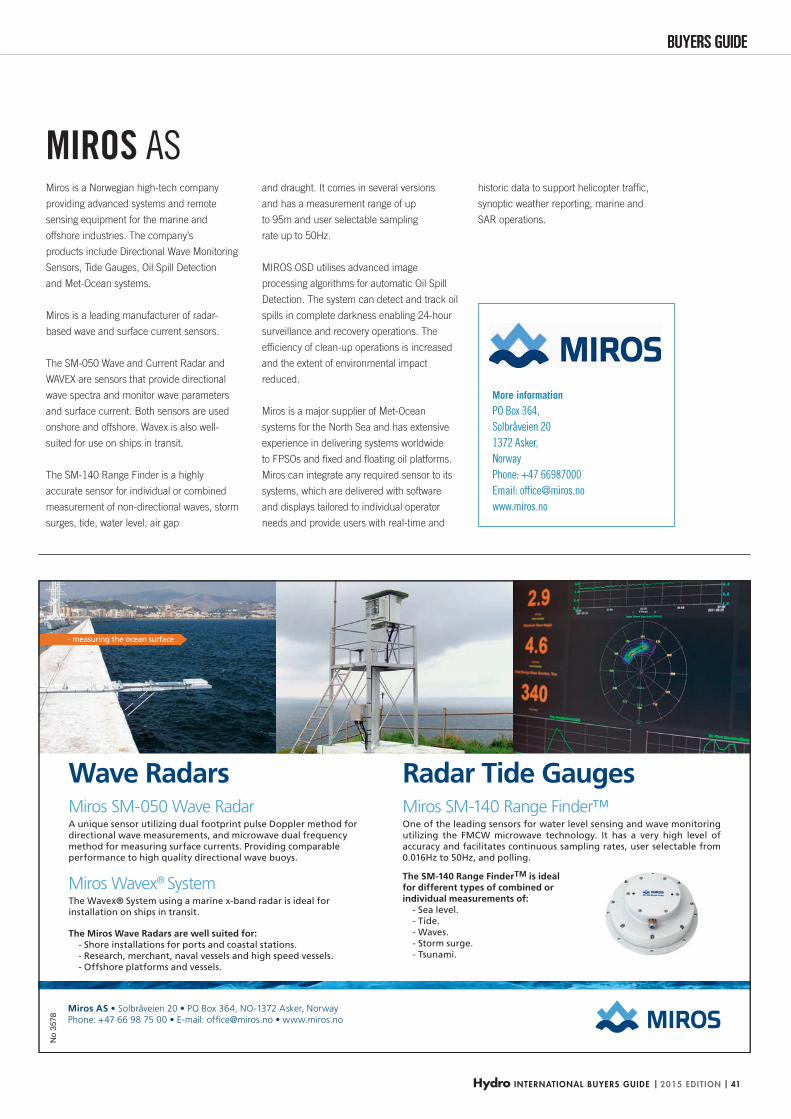
Hydro INTERNATIONAL BUYERS GUIDE | 2015 EDITION | 41
BUYERS GUIDEBUYERS GUIDEN
o 35
78
More information
PO Box 364,
Solbråveien 20
1372 Asker,
Norway
Phone: +47 66987000
Email: offi [email protected]
www.miros.no
Miros is a Norwegian high-tech company
providing advanced systems and remote
sensing equipment for the marine and
offshore industries. The company’s
products include Directional Wave Monitoring
Sensors, Tide Gauges, Oil Spill Detection
and Met-Ocean systems.
Miros is a leading manufacturer of radar-
based wave and surface current sensors.
The SM-050 Wave and Current Radar and
WAVEX are sensors that provide directional
wave spectra and monitor wave parameters
and surface current. Both sensors are used
onshore and offshore. Wavex is also well-
suited for use on ships in transit.
The SM-140 Range Finder is a highly
accurate sensor for individual or combined
measurement of non-directional waves, storm
surges, tide, water level, air gap
and draught. It comes in several versions
and has a measurement range of up
to 95m and user selectable sampling
rate up to 50Hz.
MIROS OSD utilises advanced image
processing algorithms for automatic Oil Spill
Detection. The system can detect and track oil
spills in complete darkness enabling 24-hour
surveillance and recovery operations. The
effi ciency of clean-up operations is increased
and the extent of environmental impact
reduced.
Miros is a major supplier of Met-Ocean
systems for the North Sea and has extensive
experience in delivering systems worldwide
to FPSOs and fi xed and fl oating oil platforms.
Miros can integrate any required sensor to its
systems, which are delivered with software
and displays tailored to individual operator
needs and provide users with real-time and
historic data to support helicopter traffi c,
synoptic weather reporting, marine and
SAR operations.
MIROS AS
HYDBG2015_Miros_P41 41HYDBG2015_Miros_P41 41 24-11-2014 11:49:2624-11-2014 11:49:26
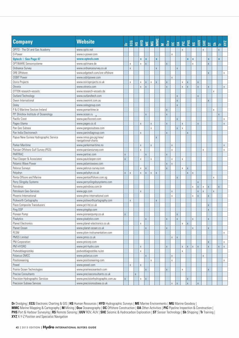
| 2015 EDITION | Hydro INTERNATIONAL BUYERS GUIDE42
Dr Dredging | ECG Electronic Charting & GIS | HS Human Resources | HYD Hydrographic Surveys | ME Marine Environments | MG Marine Geodesy |
MMC Marine Mapping & Cartography | M Mining | Oce Oceanography | OC Offshore Construction | OA Other Activities | PIC Pipeline Inspection & Construction |
PHS Port & Harbour Surveying | RS Remote Sensing | UUV ROV, AUV | SHE Seismic & Hydrocarbon Exploration | ST Sensor Technology | Sh Shipping | Tr Training |
XYZ X-Y-Z Position and Specialist Navigation
Company Website
Dr ECG
HS HYD
ME
MG
MM
CM Oc
eOC OA PI
CPH
SRS UU
VSH
EST Sh Tr XY
Z
OPITO - The Oil and Gas Academy www.opito.net x x x
O-Power www.o-power.com x
Optech See Page 47 www.optech.com x x x x x x xOPTIMARE Sensorsysteme www.optimare.de x x x x x x
Ordnance Survey www.ordnancesurvey.co.uk x x x
ORE Offshore www.edgetech.com/ore-offshore x x
OSBIT Power www.osbitpower.com x
Osiris Projects www.osirisprojects.co.uk x x x x x x x x x
Otronix www.otronix.com x x x x x x x x
OTTEN research-vessels www.research-vessels.de x
Outland Technology www.outlandtech.com x x
Owen International www.owenint.com.au x x
Oxley www.oxleygroup.com x
P & O Maritme Sevices Ireland www.pomaritime.ie x x
P.P. Shirshov Institute of Oceanology www.ocean.ru x x x
Pacific Crest www.pacificcrest.com x x
Pageo Utama www.pageo.co.id x x x x x x
Pan Geo Subsea www.pangeosubsea.com x x x
Pan India Electromech www.panindiagroup.com x x x
Papua New Guinea Hydrographic Service www.nmsa.gov.pg/new/navigational-charts
x
Parker Maritime www.parkermaritime.no x x x x
Parsian Offshore Gulf Survey (PGS) www.parsiansurvey.com x x x x
PARTRAC www.partrac.com x x x
Paul Clasper & Associates www.paulclasper.com x x x x x
Pelamis Wave Power www.pelamiswave.com x x
Pelorus Surveys www.pelorus-survey.com x x x x x
Pelydryn www.pelydryn.co.uk x x x x x x x x
Penta Offsore and Marine www.pentaoffshore.com.sg x x
Perry Slingsby Systems www.perryslingsbysystems.com x
Petrobras www.petrobras.com.br x x x x x
Petroleum Geo-Services www.pgs.com x x x x x
Phoenix International www.phnx-international.com x x x x
Pickworth Cartography www.pickworthcartography.com x x
Piezo Composite Transducers www.pct-ltd.co.uk x
Ping DSP www.pingdsp.com x
Pioneer Pump www.pioneerpump.co.uk x x
Pixalytics www.pixalytics.com x x x x x
Planet Electronics www.planet-electronics.co.uk x x x
Planet Ocean www.planet-ocean.co.uk x x x x
PLSM www.plsm-instrumentation.com x
PMSS Limited www.pmss.co.uk x x
PNI Corporation www.pnicorp.com x x
PNT-HYDRO www.pnt-hydro.com x x x x x x x x x
Podvoddiagnostika podvoddiagnostika.ru/en x x
Polarcus DMCC www.polarcus.com x x x
Positioneering www.positioneering.com x x x
Powel www.powel.com x x
Prairie Ocean Technologies www.prairieoceantech.com x x x x
Precise Consultants www.preciseconsultants.co.uk x
Precision Hydrographic Services www.precisionhydrographic.com.au x x x x
Precision Subsea Servces www.precisionsubsea.co.uk x x x x
x
HYDBG2015_Tabel 42HYDBG2015_Tabel 42 24-11-2014 15:47:4324-11-2014 15:47:43

Hydro INTERNATIONAL BUYERS GUIDE | 2015 EDITION | 43
BUYERS GUIDEBUYERS GUIDE
We are the professional and expert solution to your marine surveying needs, specialising in the oil & gas, renewable & marine cable and hydrography sectors.
We have teams of qualified and experienced specialists, who are leaders in their fields, offering you the very best service, without exception. Pioneering and developing new techniques and using the latest equipment, in order to meet the market’s high demands.
We work closely with you, with expert dedication, every step of the way.
Read more at www.mmt.se No
3555
More information
MMT Head Offi ce: MMT Sweden AB,
Sven Källfelts Gata 11,
SE 426 71 Västra Frölunda, Sweden
Phone +46 317620300
UK Offi ce: MMT (UK) Ltd
2a Banbury Offi ce Village, Noral Way,
Banbury, Oxon, OX16 2SB, UK
Phone: +44 1295817740
Company email: [email protected]
www.mmt.se
Specialising in high-resolution seabed
mapping, MMT is the solution to your marine
surveying needs. We collect, process and
visualise the conditions of the seabed and
the assets on it. Dedication and accuracy
pervade our marine surveys and provide the
offshore industry with the highest quality ROV,
ROTV and AUV services with hydrographic,
geophysical and geotechnical data and
reports.
Our services are for our clients in the oil &
gas, hydrography and renewable energy &
marine cable sectors. Typical tasks include
hydrographic charting projects, route surveys
for cables and pipelines, and site surveys for
platforms and wind farms.
We have a fully equipped fl eet of survey and
ROV vessels. Our combined vessel sizes and
range make it possible to offer a complete
solution for all water depths. Geophysical site
surveys are performed for various offshore
infrastructures and munitions searches. Our
Geotechnical department operates a range of
coring equipment. IRM services are performed
in cooperation with trusted partners and MMT
possess the only ROV capable of collecting
high-quality data at up to 5 knots. We also
conduct environmental mapping.
All our services are handled by our best
resource — our dedicated personnel. Our
qualifi ed and experienced specialists pioneer
and develop new techniques using the latest
equipment, in order to meet the market’s high
demands.
We always have your needs in mind and pride
ourselves on our reputation. We work closely
with you, with expert dedication, every step of
the way.
MMT
HYDBG2015_MMT_P43 43HYDBG2015_MMT_P43 43 24-11-2014 14:48:4024-11-2014 14:48:40

• Find detailed spec-based comparisons for more than 700 products
• Read other industry professionals’ comments and opinions
• Access data quickly, easily and free of charge
Bringing together the highly valued GIM International
and HYDRO International product surveys all in one place.
Make Geo-matching.com your fi rst stopThe independent product comparison website for geomatics devices.
COMPARE TOOLSBEFORE YOU BUY!
BROWSE& COMPAREover 700PRODUCTS!
HYDBG2015_Tabel 44HYDBG2015_Tabel 44 24-11-2014 15:47:5024-11-2014 15:47:50
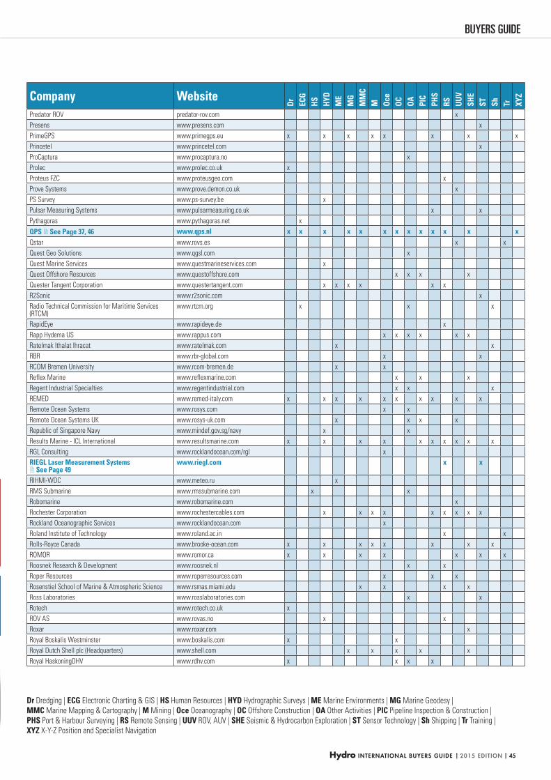
Hydro INTERNATIONAL BUYERS GUIDE | 2015 EDITION | 45
BUYERS GUIDE
Dr Dredging | ECG Electronic Charting & GIS | HS Human Resources | HYD Hydrographic Surveys | ME Marine Environments | MG Marine Geodesy |
MMC Marine Mapping & Cartography | M Mining | Oce Oceanography | OC Offshore Construction | OA Other Activities | PIC Pipeline Inspection & Construction |
PHS Port & Harbour Surveying | RS Remote Sensing | UUV ROV, AUV | SHE Seismic & Hydrocarbon Exploration | ST Sensor Technology | Sh Shipping | Tr Training |
XYZ X-Y-Z Position and Specialist Navigation
Company Website
Dr ECG
HS HYD
ME
MG
MM
CM Oc
eOC OA PI
CPH
SRS UU
VSH
EST Sh Tr XY
Z
Predator ROV predator-rov.com x
Presens www.presens.com x
PrimeGPS www.primegps.eu x x x x x x x x
Princetel www.princetel.com x
ProCaptura www.procaptura.no x
Prolec www.prolec.co.uk x
Proteus FZC www.proteusgeo.com x
Prove Systems www.prove.demon.co.uk x
PS Survey www.ps-survey.be x
Pulsar Measuring Systems www.pulsarmeasuring.co.uk x x
Pythagoras www.pythagoras.net x
QPS See Page 37, 46 www.qps.nl x x x x x x x x x x x x xQstar www.rovs.es x x
Quest Geo Solutions www.qgsl.com x
Quest Marine Services www.questmarineservices.com x
Quest Offshore Resources www.questoffshore.com x x x x
Quester Tangent Corporation www.questertangent.com x x x x x x
R2Sonic www.r2sonic.com x
Radio Technical Commission for Maritime Services (RTCM)
www.rtcm.org x x x
RapidEye www.rapideye.de x
Rapp Hydema US www.rappus.com x x x x x x
Ratelmak Ithalat Ihracat www.ratelmak.com x x
RBR www.rbr-global.com x x
RCOM Bremen University www.rcom-bremen.de x x
Reflex Marine www.reflexmarine.com x x x
Regent Industrial Specialties www.regentindustrial.com x x x
REMED www.remed-italy.com x x x x x x x x x x
Remote Ocean Systems www.rosys.com x x
Remote Ocean Systems UK www.rosys-uk.com x x x x
Republic of Singapore Navy www.mindef.gov.sg/navy x x
Results Marine - ICL International www.resultsmarine.com x x x x x x x x x x
RGL Consulting www.rocklandocean.com/rgl x
RIEGL Laser Measurement Systems See Page 49
www.riegl.com x x
RIHMI-WDC www.meteo.ru x
RMS Submarine www.rmssubmarine.com x x
Robomarine www.robomarine.com x
Rochester Corporation www.rochestercables.com x x x x x x x x x
Rockland Oceanographic Services www.rocklandocean.com x
Roland Institute of Technology www.roland.ac.in x x
Rolls-Royce Canada www.brooke-ocean.com x x x x x x x x
ROMOR www.romor.ca x x x x x x x
Roosnek Research & Development www.roosnek.nl x x
Roper Resources www.roperresources.com x x x
Rosenstiel School of Marine & Atmospheric Science www.rsmas.miami.edu x x x x
Ross Laboratories www.rosslaboratories.com x x
Rotech www.rotech.co.uk x
ROV AS www.rovas.no x x
Roxar www.roxar.com x
Royal Boskalis Westminster www.boskalis.com x x
Royal Dutch Shell plc (Headquarters) www.shell.com x x x x x
Royal HaskoningDHV www.rdhv.com x x x x
HYDBG2015_Tabel 45HYDBG2015_Tabel 45 24-11-2014 15:47:5124-11-2014 15:47:51
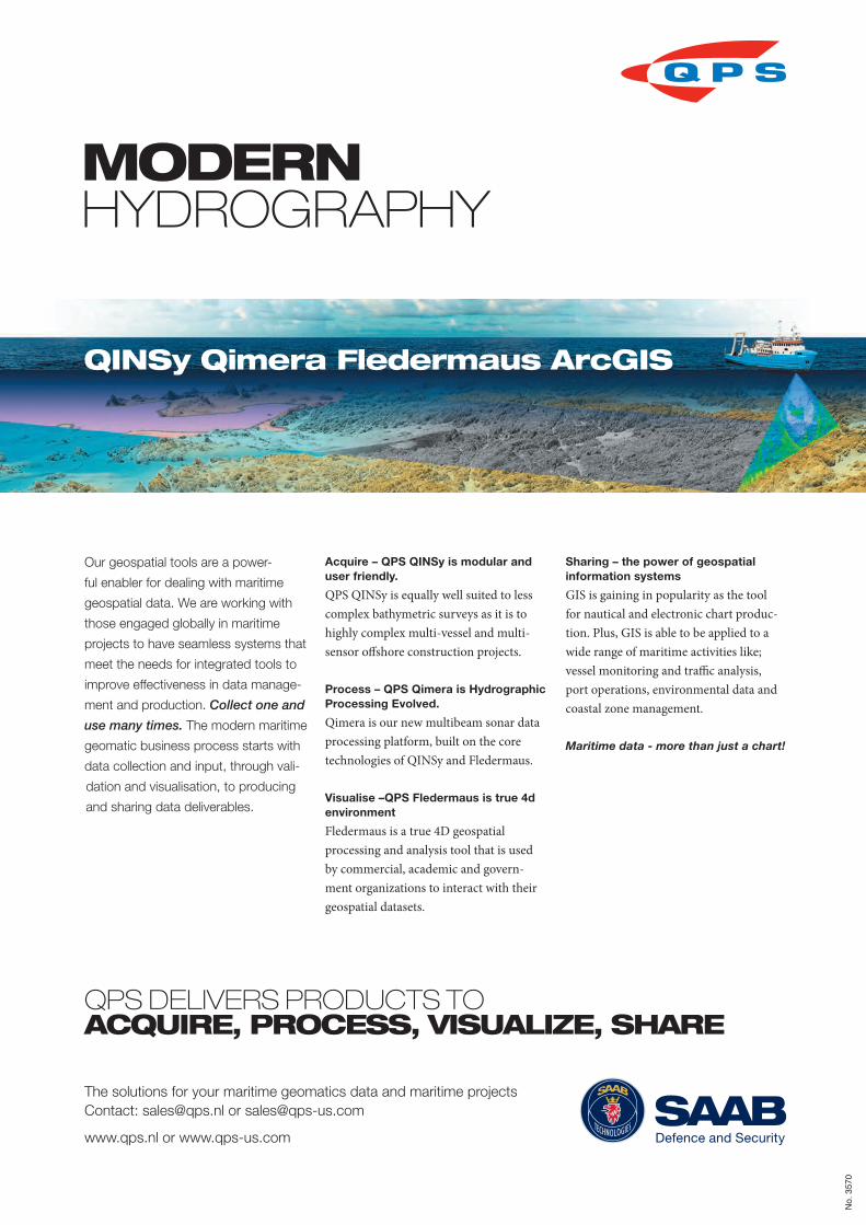
MODERN HYDROGRAPHY
Our geospatial tools are a power-
ful enabler for dealing with maritime
geospatial data. We are working with
those engaged globally in maritime
projects to have seamless systems that
meet the needs for integrated tools to
improve effectiveness in data manage-
ment and production. Collect one and
use many times. The modern maritime
geomatic business process starts with
data collection and input, through vali-
dation and visualisation, to producing
and sharing data deliverables.
Acquire – QPS QINSy is modular and user friendly.
QPS QINSy is equally well suited to less complex bathymetric surveys as it is to highly complex multi-vessel and multi-sensor offshore construction projects.
Process – QPS Qimera is Hydrographic Processing Evolved.
Qimera is our new multibeam sonar data processing platform, built on the core technologies of QINSy and Fledermaus.
Visualise –QPS Fledermaus is true 4d environment
Fledermaus is a true 4D geospatial processing and analysis tool that is used by commercial, academic and govern-ment organizations to interact with their geospatial datasets.
Sharing – the power of geospatial information systems
GIS is gaining in popularity as the tool for nautical and electronic chart produc-tion. Plus, GIS is able to be applied to a wide range of maritime activities like; vessel monitoring and traffic analysis, port operations, environmental data and coastal zone management.
Maritime data - more than just a chart!
QPS DELIVERS PRODUCTS TO ACQUIRE, PROCESS, VISUALIZE, SHARE
The solutions for your maritime geomatics data and maritime projects
Contact: [email protected] or [email protected]
www.qps.nl or www.qps-us.com Defence and Security
QINSy Qimera Fledermaus ArcGIS
No.
357
0
3570.indd 1 05-11-14 08:36HYDBG2015_Advertenties 46HYDBG2015_Advertenties 46 24-11-2014 15:45:1824-11-2014 15:45:18
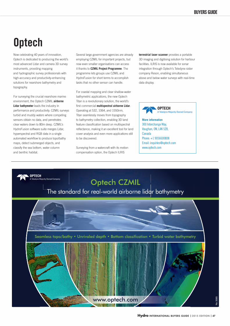
Hydro INTERNATIONAL BUYERS GUIDE | 2015 EDITION | 47
BUYERS GUIDEBUYERS GUIDE
Seamless topo/bathy Unrivaled depth Bottom classification Turbid water bathymetry
The standard for real-world airborne lidar bathymetryor reaalll-wwoorrlllddd aiirbbboorne llidaOptech CZMIL
www.optech.com
No
3585
Optech
More information
300 Interchange Way,
Vaughan, ON, L4K 5Z8,
Canada
Phone: +1 9056600808
Email: [email protected]
www.optech.com
Now celebrating 40 years of innovation,
Optech is dedicated to producing the world’s
most advanced Lidar and camera 3D survey
instruments, providing mapping
and hydrographic survey professionals with
high-accuracy and productivity-enhancing
solutions for nearshore bathymetry and
topography.
For surveying the crucial nearshore marine
environment, the Optech CZMIL airborne
Lidar bathymeter leads the industry in
performance and productivity. CZMIL surveys
turbid and muddy waters where competing
sensors obtain no data, and penetrates
clear waters down to 80m deep. CZMIL’s
HydroFusion software suite merges Lidar,
hyperspectral and RGB data in a single
automated workfl ow to produce topo/bathy
maps, detect submerged objects, and
classify the sea bottom, water column
and benthic habitat.
Several large government agencies are already
employing CZMIL for important projects, but
now even smaller organisations can access
it thanks to CZMIL Project Programme. The
programme lets groups use CZMIL and
HydroFusion for short terms to accomplish
tasks that no other sensor can handle.
For coastal mapping and clear shallow-water
bathymetric applications, the new Optech
Titan is a revolutionary solution, the world’s
fi rst commercial multispectral airborne Lidar.
Operating at 532, 1064, and 1550nm,
Titan seamlessly moves from topography
to bathymetry collection, enabling 3D land
feature classifi cation based on multispectral
refl ectance, making it an excellent tool for land
cover analysis and even more applications still
to be discovered.
Surveying from a watercraft with its motion
compensation option, the Optech ILRIS
terrestrial laser scanner provides a portable
3D imaging and digitising solution for harbour
facilities. ILRIS is now available for sonar
integration through Optech’s Teledyne sister
company Reson, enabling simultaneous
above and below water surveys with real-time
data display.
HYDBG2015_OPTECH_P47 47HYDBG2015_OPTECH_P47 47 24-11-2014 15:12:1024-11-2014 15:12:10
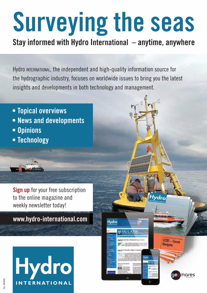
Hydro INTERNATIONAL, the independent and high-quality information source forthe hydrographic industry, focuses on worldwide issues to bring you the latestinsights and developments in both technology and management.
for your free subscriptionto the online magazine and weekly newsletter today!
No.
MH
002
Naamloos-11 1 06-03-2014 10:59:07HYDBG2015_Advertenties 48HYDBG2015_Advertenties 48 24-11-2014 15:45:2124-11-2014 15:45:21
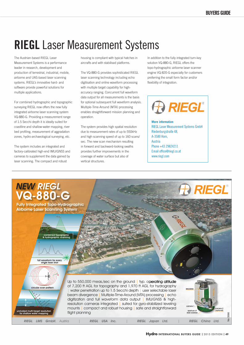
Hydro INTERNATIONAL BUYERS GUIDE | 2015 EDITION | 49
BUYERS GUIDEBUYERS GUIDE
full waveform for every single laser shot
circular scan pattern
Fully Integrated Topo-Hydrographic Airborne Laser Scanning System
NEW RIEGL VQ-880-G
25 cm
unrivaled multi-target resolutionfor shallow water mapping
combined topographic& hydrographic scanning
Up to 550,000 meas./sec on the ground | typ. operating altitude of 7,200 ft AGL for topography and 1,970 ft AGL for hydrography | water penetration up to 1.5 Secchi depth | user selectable laser beam divergence | Multiple-Time-Around (MTA) processing | echo digitization and full waveform data output | IMU/GNSS & high-resolution cameras integrated | suited for gyro-stabilized leveling mounts | compact and robust housing | safe and straightforward flight planning
IMU/GNSS
camera 2(optional)aperture of
laser scanner
camera 1
RIEGL LMS GmbH, Austria | RIEGL USA Inc. | RIEGL Japan Ltd. | RIEGL China Ltd. No
3566
More information
RIEGL Laser Measurement Systems GmbH
Riedenburgstraße 48,
A-3580 Horn,
Austria
Phone +43 29824211
Email offi [email protected]
www.riegl.com
The Austrian-based RIEGL Laser
Measurement Systems is a performance
leader in research, development and
production of terrestrial, industrial, mobile,
airborne and UAS-based laser scanning
systems. RIEGL’s innovative hard- and
software provide powerful solutions for
multiple applications.
For combined hydrographic and topographic
surveying RIEGL now offers the new fully
integrated airborne laser scanning system
VQ-880-G. Providing a measurement range
of 1.5 Secchi depth it is ideally suited for
coastline and shallow-water mapping, river
bed profi ling, measurement of aggradation
zones, hydro-archaeological surveying, etc.
The system includes an integrated and
factory-calibrated high-end IMU/GNSS and
cameras to supplement the data gained by
laser scanning. The compact and robust
housing is compliant with typical hatches in
aircrafts and with stabilised platforms.
The VQ-880-G provides sophisticated RIEGL
laser scanning technology including echo
digitisation and online waveform processing
with multiple target capability for high-
accuracy ranging. Concurrent full waveform
data output for all measurements is the basis
for optional subsequent full waveform analysis.
Multiple-Time-Around (MTA) processing
enables straightforward mission planning and
operation.
The system provides high spatial resolution
due to measurement rates of up to 550kHz
and high scanning speed of up to 160 scans/
sec. The new scan mechanism resulting
in forward and backward-looking swaths
provides further improvements in the
coverage of water surface but also of
vertical structures.
In addition to the fully integrated turn-key
solution VQ-880-G, RIEGL offers the
topo-hydrographic airborne laser scanner
engine VQ-820-G especially for customers
preferring the small form factor and/or
fl exibility of integration.
RIEGL Laser Measurement Systems
HYDBG2015_Riegl_P49 49HYDBG2015_Riegl_P49 49 24-11-2014 14:51:0224-11-2014 14:51:02
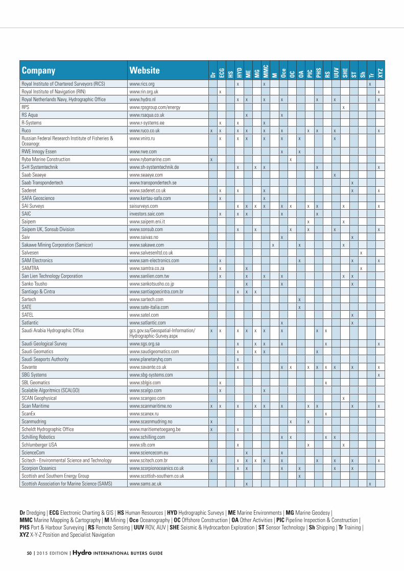
| 2015 EDITION | Hydro INTERNATIONAL BUYERS GUIDE50
Dr Dredging | ECG Electronic Charting & GIS | HS Human Resources | HYD Hydrographic Surveys | ME Marine Environments | MG Marine Geodesy |
MMC Marine Mapping & Cartography | M Mining | Oce Oceanography | OC Offshore Construction | OA Other Activities | PIC Pipeline Inspection & Construction |
PHS Port & Harbour Surveying | RS Remote Sensing | UUV ROV, AUV | SHE Seismic & Hydrocarbon Exploration | ST Sensor Technology | Sh Shipping | Tr Training |
XYZ X-Y-Z Position and Specialist Navigation
Company Website
Dr ECG
HS HYD
ME
MG
MM
CM Oc
eOC OA PI
CPH
SRS UU
VSH
EST Sh Tr XY
Z
Royal Institute of Chartered Surveyors (RICS) www.rics.org x x x
Royal Institute of Navigation (RIN) www.rin.org.uk x x
Royal Netherlands Navy, Hydrographic Office www.hydro.nl x x x x x x x
RPS www.rpsgroup.com/energy x
RS Aqua www.rsaqua.co.uk x x
R-Systems www.r-systems.ee x x x
Ruco www.ruco.co.uk x x x x x x x x x x
Russian Federal Research Institute of Fisheries & Oceanogr.
www.vniro.ru x x x x x x x
RWE Innogy Essen www.rwe.com x x
Ryba Marine Construction www.rybamarine.com x x
S+H Systemtechnik www.sh-systemtechnik.de x x x x x
Saab Seaeye www.seaeye.com x
Saab Transpondertech www.transpondertech.se x
Saderet www.saderet.co.uk x x x x x
SAFA Geoscience www.kertau-safa.com x x
SAI Surveys saisurveys.com x x x x x x x x x x
SAIC investors.saic.com x x x x x
Saipem www.saipem.eni.it x x
Saipem UK, Sonsub Division www.sonsub.com x x x x x x
Saiv www.saivas.no x x
Sakawe Mining Corporation (Samicor) www.sakawe.com x x x
Salvesen www.salvesenltd.co.uk x
SAM Electronics www.sam-electronics.com x x x x
SAMTRA www.samtra.co.za x x x
San Lien Technology Corporation www.sanlien.com.tw x x x x x x
Sanko Tsusho www.sankotsusho.co.jp x x x
Santiago & Cintra www.santiagoecintra.com.br x x x
Sartech www.sartech.com x
SATE www.sate-italia.com x
SATEL www.satel.com x
Satlantic www.satlantic.com x x
Saudi Arabia Hydrographic Office gcs.gov.sa/Geospatial-Information/Hydrographic-Survey.aspx
x x x x x x x x x
Saudi Geological Survey www.sgs.org.sa x x x x x x
Saudi Geomatics www.saudigeomatics.com x x x x
Saudi Seaports Authority www.planetaryhq.com x
Savante www.savante.co.uk x x x x x x x x x
SBG Systems www.sbg-systems.com x
SBL Geomatics www.sblgis.com x x
Scalable Algoritmics (SCALGO) www.scalgo.com x x
SCAN Geophysical www.scangeo.com x
Scan Maritime www.scanmaritime.no x x x x x x x x x x
ScanEx www.scanex.ru x
Scanmudring www.scasnmudring.no x x x
Scheldt Hydrographic Office www.maritiemetoegang.be x x
Schilling Robotics www.schilling.com x x x x
Schlumberger USA www.slb.com x x x
ScienceCom www.sciencecom.eu x x
Scitech - Environmental Science and Technology www.scitech.com.br x x x x x x x x x x
Scorpion Oceanics www.scorpionoceanics.co.uk x x x x x x
Scottish and Southern Energy Group www.scottish-southern.co.uk x
Scottish Association for Marine Science (SAMS) www.sams.ac.uk x x
HYDBG2015_Tabel 50HYDBG2015_Tabel 50 24-11-2014 15:47:5424-11-2014 15:47:54
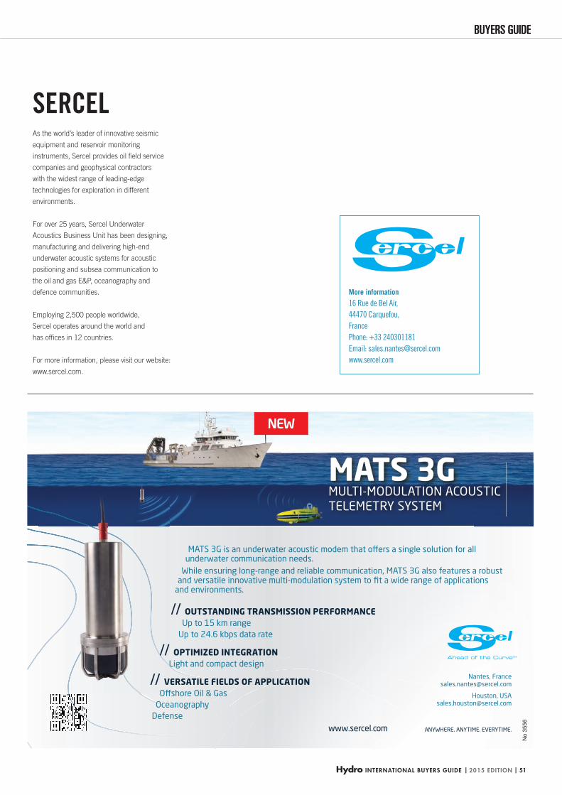
Hydro INTERNATIONAL BUYERS GUIDE | 2015 EDITION | 51
BUYERS GUIDEBUYERS GUIDE
NEW
MATS 3GMULTI-MODULATION ACOUSTICTELEMETRY SYSTEM
// OUTSTANDING TRANSMISSION PERFORMANCEUp to 15 km range
Up to 24.6 kbps data rate
// OPTIMIZED INTEGRATION Light and compact design
// VERSATILE FIELDS OF APPLICATION Offshore Oil & Gas
Oceanography Defense
www.sercel.com ANYWHERE. ANYTIME. EVERYTIME.
Nantes, France [email protected]
Houston, USA [email protected]
MATS 3G is an underwater acoustic modem that offers a single solution for all underwater communication needs.
While ensuring long-range and reliable communication, MATS 3G also features a robust and versatile innovative multi-modulation system to fit a wide range of applications
and environments.
No
3556
More information
16 Rue de Bel Air,
44470 Carquefou,
France
Phone: +33 240301181
Email: [email protected]
www.sercel.com
As the world’s leader of innovative seismic
equipment and reservoir monitoring
instruments, Sercel provides oil fi eld service
companies and geophysical contractors
with the widest range of leading-edge
technologies for exploration in different
environments.
For over 25 years, Sercel Underwater
Acoustics Business Unit has been designing,
manufacturing and delivering high-end
underwater acoustic systems for acoustic
positioning and subsea communication to
the oil and gas E&P, oceanography and
defence communities.
Employing 2,500 people worldwide,
Sercel operates around the world and
has offi ces in 12 countries.
For more information, please visit our website:
www.sercel.com.
SERCEL
HYDBG2015_Sercel_P51 51HYDBG2015_Sercel_P51 51 24-11-2014 14:57:0324-11-2014 14:57:03
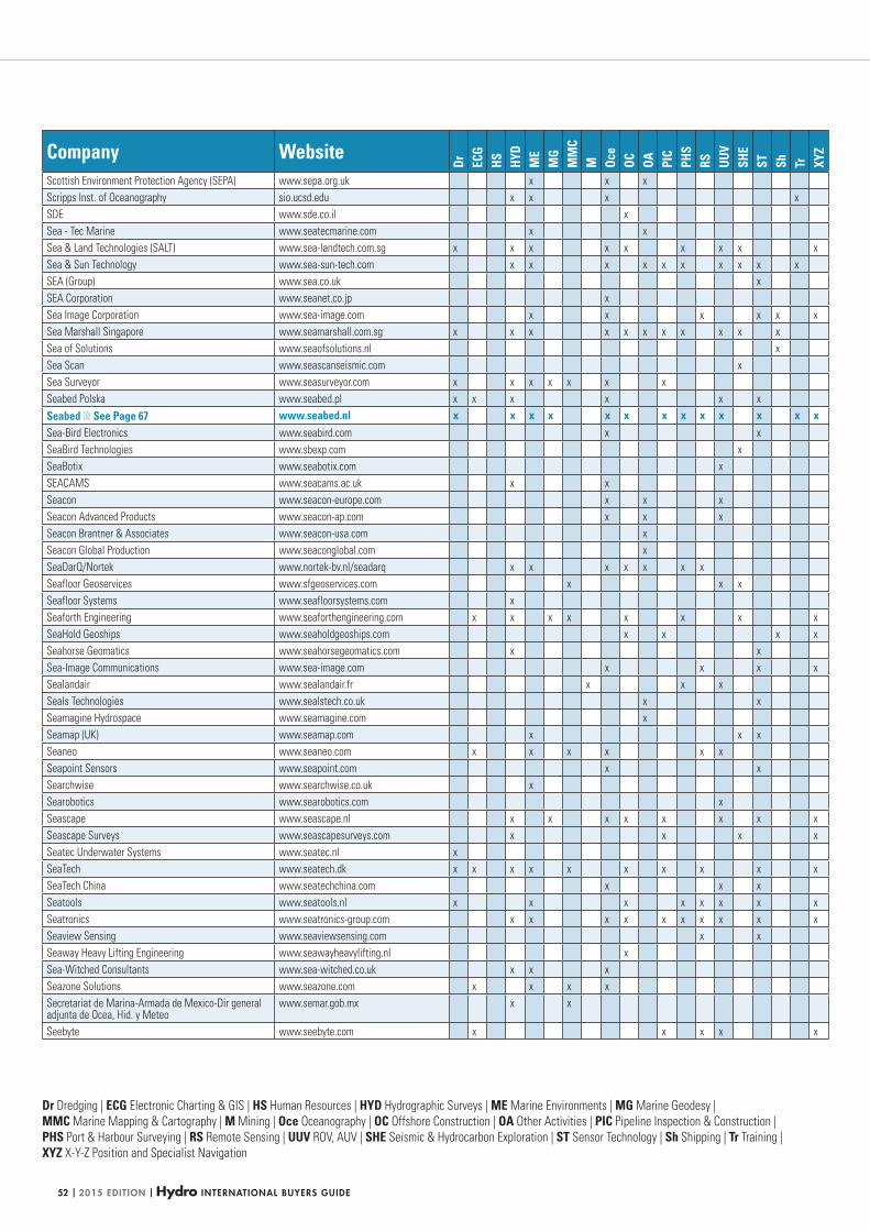
| 2015 EDITION | Hydro INTERNATIONAL BUYERS GUIDE52
Dr Dredging | ECG Electronic Charting & GIS | HS Human Resources | HYD Hydrographic Surveys | ME Marine Environments | MG Marine Geodesy |
MMC Marine Mapping & Cartography | M Mining | Oce Oceanography | OC Offshore Construction | OA Other Activities | PIC Pipeline Inspection & Construction |
PHS Port & Harbour Surveying | RS Remote Sensing | UUV ROV, AUV | SHE Seismic & Hydrocarbon Exploration | ST Sensor Technology | Sh Shipping | Tr Training |
XYZ X-Y-Z Position and Specialist Navigation
Company Website
Dr ECG
HS HYD
ME
MG
MM
CM Oc
eOC OA PI
CPH
SRS UU
VSH
EST Sh Tr XY
Z
Scottish Environment Protection Agency (SEPA) www.sepa.org.uk x x x
Scripps Inst. of Oceanography sio.ucsd.edu x x x x
SDE www.sde.co.il x
Sea - Tec Marine www.seatecmarine.com x x
Sea & Land Technologies (SALT) www.sea-landtech.com.sg x x x x x x x x x
Sea & Sun Technology www.sea-sun-tech.com x x x x x x x x x x
SEA (Group) www.sea.co.uk x
SEA Corporation www.seanet.co.jp x
Sea Image Corporation www.sea-image.com x x x x x x
Sea Marshall Singapore www.seamarshall.com.sg x x x x x x x x x x x
Sea of Solutions www.seaofsolutions.nl x
Sea Scan www.seascanseismic.com x
Sea Surveyor www.seasurveyor.com x x x x x x x
Seabed Polska www.seabed.pl x x x x x x
Seabed See Page 67 www.seabed.nl x x x x x x x x x x x x xSea-Bird Electronics www.seabird.com x x
SeaBird Technologies www.sbexp.com x
SeaBotix www.seabotix.com x
SEACAMS www.seacams.ac.uk x x
Seacon www.seacon-europe.com x x x
Seacon Advanced Products www.seacon-ap.com x x x
Seacon Brantner & Associates www.seacon-usa.com x
Seacon Global Production www.seaconglobal.com x
SeaDarQ/Nortek www.nortek-bv.nl/seadarq x x x x x x x
Seafloor Geoservices www.sfgeoservices.com x x x
Seafloor Systems www.seafloorsystems.com x
Seaforth Engineering www.seaforthengineering.com x x x x x x x x
SeaHold Geoships www.seaholdgeoships.com x x x x
Seahorse Geomatics www.seahorsegeomatics.com x x
Sea-Image Communications www.sea-image.com x x x x
Sealandair www.sealandair.fr x x x
Seals Technologies www.sealstech.co.uk x x
Seamagine Hydrospace www.seamagine.com x
Seamap (UK) www.seamap.com x x x
Seaneo www.seaneo.com x x x x x x
Seapoint Sensors www.seapoint.com x x
Searchwise www.searchwise.co.uk x
Searobotics www.searobotics.com x
Seascape www.seascape.nl x x x x x x x x
Seascape Surveys www.seascapesurveys.com x x x x
Seatec Underwater Systems www.seatec.nl x
SeaTech www.seatech.dk x x x x x x x x x x
SeaTech China www.seatechchina.com x x x
Seatools www.seatools.nl x x x x x x x x
Seatronics www.seatronics-group.com x x x x x x x x x x
Seaview Sensing www.seaviewsensing.com x x
Seaway Heavy Lifting Engineering www.seawayheavylifting.nl x
Sea-Witched Consultants www.sea-witched.co.uk x x x
Seazone Solutions www.seazone.com x x x x
Secretariat de Marina-Armada de Mexico-Dir general adjunta de Ocea, Hid. y Meteo
www.semar.gob.mx x x
Seebyte www.seebyte.com x x x x x
HYDBG2015_Tabel 52HYDBG2015_Tabel 52 24-11-2014 15:47:5824-11-2014 15:47:58
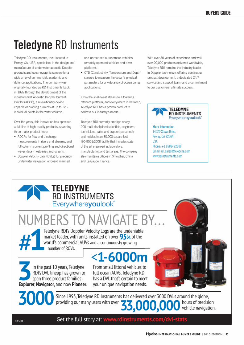
Hydro INTERNATIONAL BUYERS GUIDE | 2015 EDITION | 53
BUYERS GUIDEBUYERS GUIDE
#13
NUMBERS TO NAVIGATE BY. . .Teledyne RDI’s Doppler Velocity Logs are the undeniable market leader, with units installed on over 95% of the world’s commercial AUVs and a continuously growing
number of ROVs.
In the past 10 years, Teledyne RDI’s DVL lineup has grown to span three product families:
Explorer, Navigator, and now Pioneer.
Since 1993, Teledyne RD Instruments has delivered over 3000 DVLs around the globe, providing our many users with over3000
<1-6000mFrom small littoral vehicles to full ocean AUVs, Teledyne RDI has a DVL that’s certain to meet your unique navigation needs.
hours of precision vehicle navigation.33,000,000
Get the full story at: www.rdinstruments.com/dvl-stats
d over 3000 DVLs around the globe,
o I et s.
hours of precision
No 3581
More information
14020 Stowe Drive,
Poway, CA 92064,
USA
Phone: +1 8588422600
Email: [email protected]
www.rdinstruments.com
Teledyne RD Instruments, Inc., located in
Poway, CA, USA, specialises in the design and
manufacture of underwater acoustic Doppler
products and oceanographic sensors for a
wide array of commercial, academic and
defence applications. The company was
originally founded as RD Instruments back
in 1982 through the development of the
industry’s fi rst Acoustic Doppler Current
Profi ler (ADCP), a revolutionary device
capable of profi ling currents at up to 128
individual points in the water column.
Over the years, this innovation has spawned
a full line of high-quality products, spanning
three major product lines:
ADCPs for fl ow and discharge •
measurements in rivers and streams, and
full column current profi ling and directional
waves data in estuaries and oceans.
Doppler Velocity Logs (DVLs) for precision •
underwater navigation onboard manned
and unmanned autonomous vehicles,
remotely operated vehicles and diver
platforms.
CTD (Conductivity, Temperature and Depth) •
sensors to measure the ocean’s physical
parameters for a wide array of ocean going
applications.
From the shallowest stream to a towering
offshore platform, and everywhere in between,
Teledyne RDI has a proven product to
address our industry’s needs.
Teledyne RDI currently employs nearly
200 multi-disciplined scientists, engineers,
technicians, sales and support personnel;
and resides in an 80,000 square foot
ISO-9001:2008 facility that includes state
of the art engineering, laboratory,
manufacturing and test areas. The company
also maintains offi ces in Shanghai, China
and La Gaude, France.
With over 30 years of experience and well
over 20,000 products delivered worldwide,
Teledyne RDI remains the industry leader
in Doppler technology, offering continuous
product development, a dedicated 24/7
service and support team, and a commitment
to our customers’ ultimate success.
Teledyne RD Instruments
HYDBG2015_Teledyne_P53 53HYDBG2015_Teledyne_P53 53 24-11-2014 14:13:5024-11-2014 14:13:50
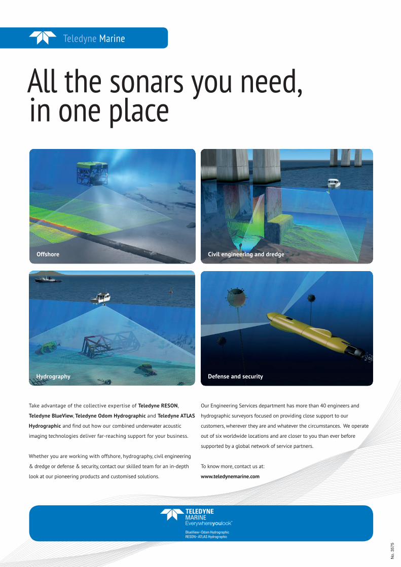
Teledyne Marine
All the sonars you need,in one place
Take advantage of the collective expertise of Teledyne RESON,
Teledyne BlueView, Teledyne Odom Hydrographic and Teledyne ATLAS
Hydrographic and find out how our combined underwater acoustic
imaging technologies deliver far-reaching support for your business.
Whether you are working with offshore, hydrography, civil engineering
& dredge or defense & security, contact our skilled team for an in-depth
look at our pioneering products and customised solutions.
Our Engineering Services department has more than 40 engineers and
hydrographic surveyors focused on providing close support to our
customers, wherever they are and whatever the circumstances. We operate
out of six worldwide locations and are closer to you than ever before
supported by a global network of service partners.
To know more, contact us at:
www.teledynemarine.com
Offshore
Defense and security
Civil engineering and dredge
Hydrography
No.
357
5
3575.indd 1 05-11-14 08:34HYDBG2015_Advertenties 54HYDBG2015_Advertenties 54 24-11-2014 15:45:2624-11-2014 15:45:26
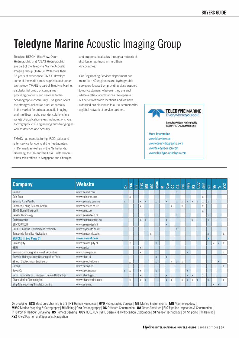
Hydro INTERNATIONAL BUYERS GUIDE | 2015 EDITION | 55
BUYERS GUIDE
Dr Dredging | ECG Electronic Charting & GIS | HS Human Resources | HYD Hydrographic Surveys | ME Marine Environments | MG Marine Geodesy |
MMC Marine Mapping & Cartography | M Mining | Oce Oceanography | OC Offshore Construction | OA Other Activities | PIC Pipeline Inspection & Construction |
PHS Port & Harbour Surveying | RS Remote Sensing | UUV ROV, AUV | SHE Seismic & Hydrocarbon Exploration | ST Sensor Technology | Sh Shipping | Tr Training |
XYZ X-Y-Z Position and Specialist Navigation
Company Website
Dr ECG
HS HYD
ME
MG
MM
CM Oc
eOC OA PI
CPH
SRS UU
VSH
EST Sh Tr XY
Z
Seiche www.seiche.com x
Seis Pros www.seispros.com x x
Seismic Asia Pacific www.seismic.com.au x x x x x x x x x x x x
Seistech, Ealing Science Centre www.seistech.co.uk x x x x
SEND Signal-Elektronik www.send.de x
Sensor Technology www.sensortech.ca x x
Sensorconsult www.sensorconsult.no x x x x x
SENSORTECH www.sensor-tech.it x
SEOES - Marine University of Plymouth www.plymouth.ac.uk x
Septentrio Satellite Navigation www.septentrio.com x x x
SERCEL See Page 51 www.sercel.com xSerendipity www.serendipity.nl x x x x x
SERI www.seri.ir x
Servicio de Hidrografia Naval, Argentina www.hidro.gov.ar x x x x
Servicio Hidrografico y Oceanografico Chile www.shoa.cl x x
SEtech Geotechnical Engineers www.setech-uk.com x x x x x x
Settop www.settop.es x
SevenCs www.sevencs.com x x x x x
Seyir Hidrografi ve Osinografi Dairesi Baskanligi www.shodb.gov.tr x x x x x x x
Shark Marine Technologies www.sharkmarine.com x x x x x x x x x x x
Ship Manoeuvring Simulator Centre www.smso.no x x
Teledyne RESON, BlueView, Odom
Hydrographic and ATLAS Hydrographic
are part of the Teledyne Marine Acoustic
Imaging Group (TMAIG). With more than
35 years of experience, TMAIG develops
some of the world’s most sophisticated sonar
technology. TMAIG is part of Teledyne Marine,
a substantial group of companies
providing products and services to the
oceanographic community. The group offers
the strongest collective product portfolio
in the market for subsea acoustic imaging
and multibeam echo sounder solutions in a
variety of application areas including offshore,
hydrography, civil engineering and dredging as
well as defence and security.
TMAIG has manufacturing, R&D, sales and
after service functions at the headquarters
in Denmark as well as in the Netherlands,
Germany, the UK and the USA. Furthermore,
it has sales offi ces in Singapore and Shanghai
Teledyne Marine Acoustic Imaging Groupand supports local sales through a network of
distribution partners in more than
47 countries.
Our Engineering Services department has
more than 40 engineers and hydrographic
surveyors focused on providing close support
to our customers, wherever they are and
whatever the circumstances. We operate
out of six worldwide locations and we have
extended our closeness to our customers with
a global network of service partners.
More information
www.blueview.com
www.odomhydrographic.com
www.teledyne-reson.com
wwww.teledyne-atlashydro.com
HYDBG2015_Tabel 55HYDBG2015_Tabel 55 24-11-2014 15:48:0024-11-2014 15:48:00
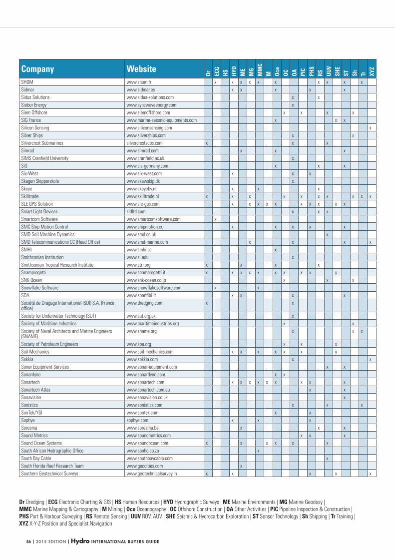
| 2015 EDITION | Hydro INTERNATIONAL BUYERS GUIDE56
Dr Dredging | ECG Electronic Charting & GIS | HS Human Resources | HYD Hydrographic Surveys | ME Marine Environments | MG Marine Geodesy |
MMC Marine Mapping & Cartography | M Mining | Oce Oceanography | OC Offshore Construction | OA Other Activities | PIC Pipeline Inspection & Construction |
PHS Port & Harbour Surveying | RS Remote Sensing | UUV ROV, AUV | SHE Seismic & Hydrocarbon Exploration | ST Sensor Technology | Sh Shipping | Tr Training |
XYZ X-Y-Z Position and Specialist Navigation
Company Website
Dr ECG
HS HYD
ME
MG
MM
CM Oc
eOC OA PI
CPH
SRS UU
VSH
EST Sh Tr XY
Z
SHOM www.shom.fr x x x x x x x x x x
Sidmar www.sidmar.es x x x x x
Sidus Solutions www.sidus-solutions.com x x
Sieber Energy www.syncwaveenergy.com x
Siem Offshore www.siemoffshore.com x x x x
SIG France www.marine-seismic-equipments.com x x x
Silicon Sensing www.siliconsensing.com x
Silver Ships www.silverships.com x x
Silvercrest Submarines silvercrestsubs.com x x x
Simrad www.simrad.com x x x
SIMS Cranfield University www.cranfield.ac.uk x
SiS www.sis-germany.com x x x
Six-West www.six-west.com x x x
Skagen Skipperskole www.skawskip.dk x
Skeye www.skeyebv.nl x x x
Skilltrade www.skilltrade.nl x x x x x x x x x x
SLE GPS Solution www.sle-gps.com x x x x x x x x x x
Smart Light Devices sldltd.com x x x
Smartcom Software www.smartcomsoftware.com x
SMC Ship Motion Control www.shipmotion.eu x x x x x
SMD Soil Machine Dynamics www.smd.co.uk x
SMD Telecommunications CC (Head Office) www.smd-marine.com x x x x
SMHI www.smhi.se x
Smithsonian Institution www.si.edu x
Smithsonian Tropical Research Institute www.stri.org x x x x
Snamprogetti www.snamprogetti.it x x x x x x x x x x
SNK Ocean www.snk-ocean.co.jp x x x
Snowflake Software www.snowflakesoftware.com x x
SOA www.soanfibi.it x x x x
Société de Dragage International (SDI) S.A. (France office)
www.dredging.com x x
Society for Underwater Technology (SUT) www.sut.org.uk x
Society of Maritime Industries www.maritimeindustries.org x x
Society of Naval Architects and Marine Engineers (SNAME)
www.sname.org x x x
Society of Petroleum Engineers www.spe.org x x x
Soil Mechanics www.soil-mechanics.com x x x x x x x
Sokkia www.sokkia.com x x
Sonar Equipment Services www.sonar-equipment.com x x
Sonardyne www.sonardyne.com x x
Sonartech www.sonartech.com x x x x x x x x x
Sonartech Atlas www.sonartech.com.au x x
Sonavision www.sonavision.co.uk x
Sonistics www.sonistics.com x x x
SonTek/YSI www.sontek.com x x
Sophye sophye.com x x x
Soresma www.soresma.be x x x
Sound Metrics www.soundmetrics.com x x x
Sound Ocean Systems www.soundocean.com x x x x x x
South African Hydrographic Office www.sanho.co.za x
South Bay Cable www.southbaycable.com x
South Florida Reef Research Team www.geocities.com x
Southern Geotechnical Surveys www.geotechnicalsurvey.in x x x x x
HYDBG2015_Tabel 56HYDBG2015_Tabel 56 24-11-2014 15:48:0724-11-2014 15:48:07
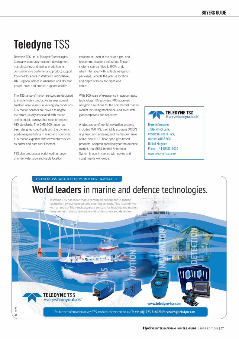
Hydro INTERNATIONAL BUYERS GUIDE | 2015 EDITION | 57
BUYERS GUIDEBUYERS GUIDEN
o 33
79
More information
1 Blackmoor Lane,
Croxley Business Park,
Watford WD18 8GA,
United Kingdom
Phone: +44 1923216020
www.teledyne-tss.co.uk
Teledyne TSS Ltd, a Teledyne Technologies
Company, conducts research, development,
manufacturing and testing in addition to
comprehensive customer and product support
from headquarters in Watford, Hertfordshire,
UK. Regional offi ces in Aberdeen and Houston
provide sales and product support facilities.
The TSS range of motion sensors are designed
to enable highly productive surveys aboard
small or large vessels in varying sea conditions.
TSS motion sensors are proven to negate
the errors usually associated with motion
and to enable surveys that meet or exceed
IHO standards. The DMS-500 range has
been designed specifi cally with the dynamic
positioning marketing in mind and combines
TSS motion expertise with new features such
as power and data over Ethernet.
TSS also produces a world-leading range
of underwater pipe and cable location
equipment, used in the oil and gas, and
telecommunications industries. These
systems can be fi tted to ROVs and,
when interfaced with suitable navigation
packages, provide the precise location
and depth of burial for pipes and
cables.
With 100 years of experience in gyrocompass
technology, TSS provides IMO-approved
navigation solutions for the commercial marine
market including mechanical and solid state
gyrocompasses and repeaters.
A latest range of inertial navigation systems
includes MAHRS, the highly accurate ORION
ring laser gyro systems; and the Saturn range
of INS and AHRS fi bre optic gyro-based
products. Adapted specifi cally for the defence
market, the MK31 Inertial Reference
System is now in service with navies and
coast guards worldwide.
Teledyne TSS
HYDBG2015_TeledyneTSS_P57 57HYDBG2015_TeledyneTSS_P57 57 24-11-2014 17:30:1424-11-2014 17:30:14
No.
324
2
3242_Valeport.indd 1 25-10-12 12:22:56HYDBG2015_Advertenties 58HYDBG2015_Advertenties 58 24-11-2014 15:45:2924-11-2014 15:45:29
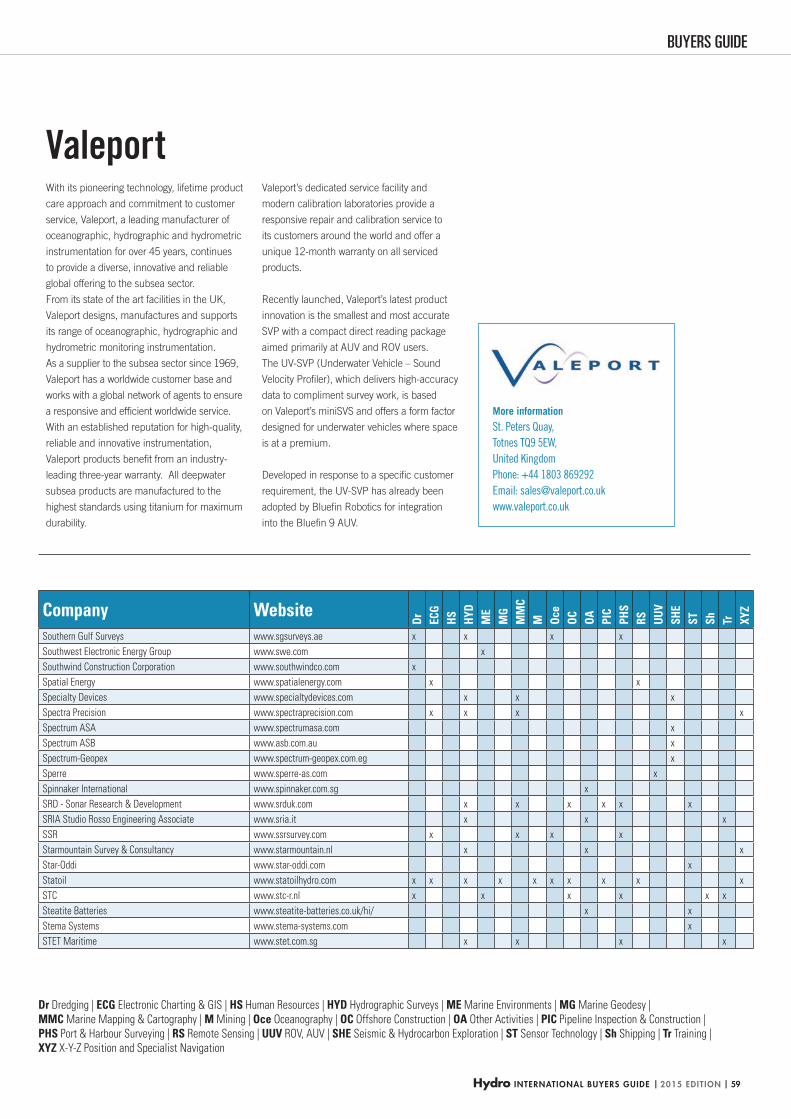
Hydro INTERNATIONAL BUYERS GUIDE | 2015 EDITION | 59
BUYERS GUIDE
Dr Dredging | ECG Electronic Charting & GIS | HS Human Resources | HYD Hydrographic Surveys | ME Marine Environments | MG Marine Geodesy |
MMC Marine Mapping & Cartography | M Mining | Oce Oceanography | OC Offshore Construction | OA Other Activities | PIC Pipeline Inspection & Construction |
PHS Port & Harbour Surveying | RS Remote Sensing | UUV ROV, AUV | SHE Seismic & Hydrocarbon Exploration | ST Sensor Technology | Sh Shipping | Tr Training |
XYZ X-Y-Z Position and Specialist Navigation
With its pioneering technology, lifetime product
care approach and commitment to customer
service, Valeport, a leading manufacturer of
oceanographic, hydrographic and hydrometric
instrumentation for over 45 years, continues
to provide a diverse, innovative and reliable
global offering to the subsea sector.
From its state of the art facilities in the UK,
Valeport designs, manufactures and supports
its range of oceanographic, hydrographic and
hydrometric monitoring instrumentation.
As a supplier to the subsea sector since 1969,
Valeport has a worldwide customer base and
works with a global network of agents to ensure
a responsive and effi cient worldwide service.
With an established reputation for high-quality,
reliable and innovative instrumentation,
Valeport products benefi t from an industry-
leading three-year warranty. All deepwater
subsea products are manufactured to the
highest standards using titanium for maximum
durability.
Valeport Valeport’s dedicated service facility and
modern calibration laboratories provide a
responsive repair and calibration service to
its customers around the world and offer a
unique 12-month warranty on all serviced
products.
Recently launched, Valeport’s latest product
innovation is the smallest and most accurate
SVP with a compact direct reading package
aimed primarily at AUV and ROV users.
The UV-SVP (Underwater Vehicle – Sound
Velocity Profi ler), which delivers high-accuracy
data to compliment survey work, is based
on Valeport’s miniSVS and offers a form factor
designed for underwater vehicles where space
is at a premium.
Developed in response to a specifi c customer
requirement, the UV-SVP has already been
adopted by Bluefi n Robotics for integration
into the Bluefi n 9 AUV.
Company Website
Dr ECG
HS HYD
ME
MG
MM
CM Oc
eOC OA PI
CPH
SRS UU
VSH
EST Sh Tr XY
Z
Southern Gulf Surveys www.sgsurveys.ae x x x x
Southwest Electronic Energy Group www.swe.com x
Southwind Construction Corporation www.southwindco.com x
Spatial Energy www.spatialenergy.com x x
Specialty Devices www.specialtydevices.com x x x
Spectra Precision www.spectraprecision.com x x x x
Spectrum ASA www.spectrumasa.com x
Spectrum ASB www.asb.com.au x
Spectrum-Geopex www.spectrum-geopex.com.eg x
Sperre www.sperre-as.com x
Spinnaker International www.spinnaker.com.sg x
SRD - Sonar Research & Development www.srduk.com x x x x x x
SRIA Studio Rosso Engineering Associate www.sria.it x x x
SSR www.ssrsurvey.com x x x x
Starmountain Survey & Consultancy www.starmountain.nl x x x
Star-Oddi www.star-oddi.com x
Statoil www.statoilhydro.com x x x x x x x x x x
STC www.stc-r.nl x x x x x x
Steatite Batteries www.steatite-batteries.co.uk/hi/ x x
Stema Systems www.stema-systems.com x
STET Maritime www.stet.com.sg x x x x
More information St. Peters Quay,
Totnes TQ9 5EW,
United Kingdom
Phone: +44 1803 869292
Email: [email protected]
www.valeport.co.uk
HYDBG2015_Tabel 59HYDBG2015_Tabel 59 24-11-2014 15:48:1124-11-2014 15:48:11
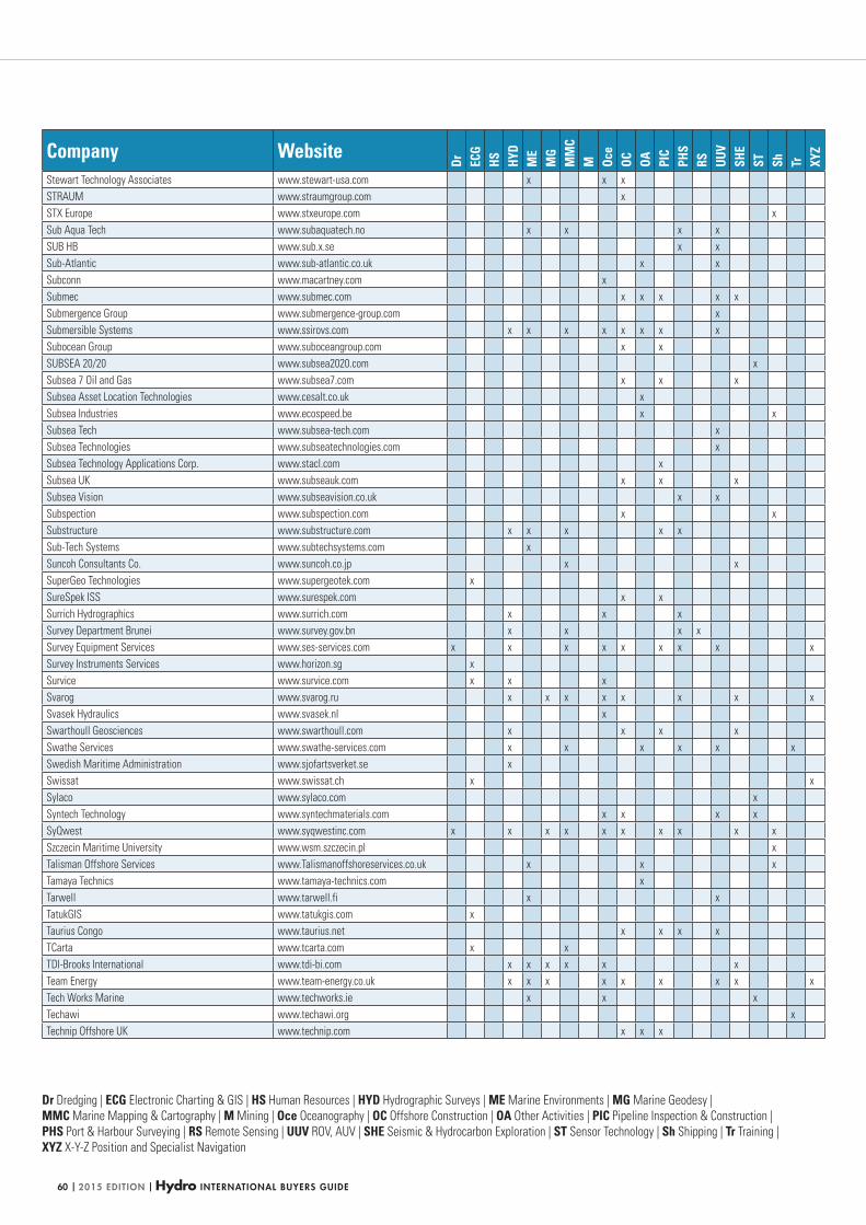
| 2015 EDITION | Hydro INTERNATIONAL BUYERS GUIDE60
Dr Dredging | ECG Electronic Charting & GIS | HS Human Resources | HYD Hydrographic Surveys | ME Marine Environments | MG Marine Geodesy |
MMC Marine Mapping & Cartography | M Mining | Oce Oceanography | OC Offshore Construction | OA Other Activities | PIC Pipeline Inspection & Construction |
PHS Port & Harbour Surveying | RS Remote Sensing | UUV ROV, AUV | SHE Seismic & Hydrocarbon Exploration | ST Sensor Technology | Sh Shipping | Tr Training |
XYZ X-Y-Z Position and Specialist Navigation
Company Website
Dr ECG
HS HYD
ME
MG
MM
CM Oc
eOC OA PI
CPH
SRS UU
VSH
EST Sh Tr XY
Z
Stewart Technology Associates www.stewart-usa.com x x x
STRAUM www.straumgroup.com x
STX Europe www.stxeurope.com x
Sub Aqua Tech www.subaquatech.no x x x x
SUB HB www.sub.x.se x x
Sub-Atlantic www.sub-atlantic.co.uk x x
Subconn www.macartney.com x
Submec www.submec.com x x x x x
Submergence Group www.submergence-group.com x
Submersible Systems www.ssirovs.com x x x x x x x x
Subocean Group www.suboceangroup.com x x
SUBSEA 20/20 www.subsea2020.com x
Subsea 7 Oil and Gas www.subsea7.com x x x
Subsea Asset Location Technologies www.cesalt.co.uk x
Subsea Industries www.ecospeed.be x x
Subsea Tech www.subsea-tech.com x
Subsea Technologies www.subseatechnologies.com x
Subsea Technology Applications Corp. www.stacl.com x
Subsea UK www.subseauk.com x x x
Subsea Vision www.subseavision.co.uk x x
Subspection www.subspection.com x x
Substructure www.substructure.com x x x x x
Sub-Tech Systems www.subtechsystems.com x
Suncoh Consultants Co. www.suncoh.co.jp x x
SuperGeo Technologies www.supergeotek.com x
SureSpek ISS www.surespek.com x x
Surrich Hydrographics www.surrich.com x x x
Survey Department Brunei www.survey.gov.bn x x x x
Survey Equipment Services www.ses-services.com x x x x x x x x x
Survey Instruments Services www.horizon.sg x
Survice www.survice.com x x x
Svarog www.svarog.ru x x x x x x x x
Svasek Hydraulics www.svasek.nl x
Swarthoull Geosciences www.swarthoull.com x x x x
Swathe Services www.swathe-services.com x x x x x x
Swedish Maritime Administration www.sjofartsverket.se x
Swissat www.swissat.ch x x
Sylaco www.sylaco.com x
Syntech Technology www.syntechmaterials.com x x x x
SyQwest www.syqwestinc.com x x x x x x x x x x
Szczecin Maritime University www.wsm.szczecin.pl x
Talisman Offshore Services www.Talismanoffshoreservices.co.uk x x x
Tamaya Technics www.tamaya-technics.com x
Tarwell www.tarwell.fi x x
TatukGIS www.tatukgis.com x
Taurius Congo www.taurius.net x x x x
TCarta www.tcarta.com x x
TDI-Brooks International www.tdi-bi.com x x x x x x
Team Energy www.team-energy.co.uk x x x x x x x x x
Tech Works Marine www.techworks.ie x x x
Techawi www.techawi.org x
Technip Offshore UK www.technip.com x x x
HYDBG2015_Tabel 60HYDBG2015_Tabel 60 24-11-2014 15:48:1524-11-2014 15:48:15
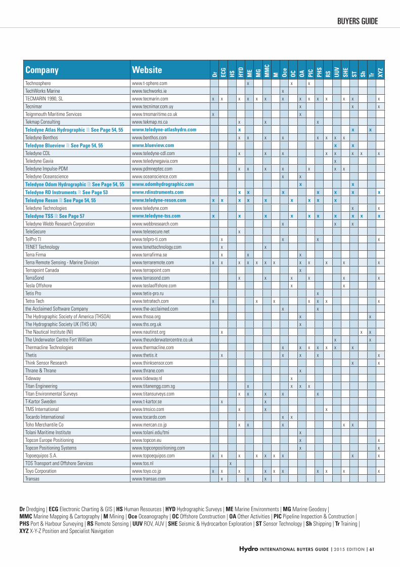
Hydro INTERNATIONAL BUYERS GUIDE | 2015 EDITION | 61
BUYERS GUIDE
Dr Dredging | ECG Electronic Charting & GIS | HS Human Resources | HYD Hydrographic Surveys | ME Marine Environments | MG Marine Geodesy |
MMC Marine Mapping & Cartography | M Mining | Oce Oceanography | OC Offshore Construction | OA Other Activities | PIC Pipeline Inspection & Construction |
PHS Port & Harbour Surveying | RS Remote Sensing | UUV ROV, AUV | SHE Seismic & Hydrocarbon Exploration | ST Sensor Technology | Sh Shipping | Tr Training |
XYZ X-Y-Z Position and Specialist Navigation
Company Website
Dr ECG
HS HYD
ME
MG
MM
CM Oc
eOC OA PI
CPH
SRS UU
VSH
EST Sh Tr XY
Z
Technosphere www.t-sphere.com x x x
TechWorks Marine www.techworks.ie x
TECMARIN 1990, SL www.tecmarin.com x x x x x x x x x x x x x x
Tecnimar www.tecnimar.com.uy x x x
Teignmouth Maritime Services www.tmsmaritime.co.uk x x
Tekmap Consulting www.tekmap.ns.ca x x x
Teledyne Atlas Hydrographic See Page 54, 55 www.teledyne-atlashydro.com x x xTeledyne Benthos www.benthos.com x x x x x x x x
Teledyne Blueview See Page 54, 55 www.blueview.com x xTeledyne CDL www.teledyne-cdl.com x x x x x x x x
Teledyne Gavia www.teledynegavia.com x
Teledyne Impulse-PDM www.pdmneptec.com x x x x x x x
Teledyne Oceanscience www.oceanscience.com x x
Teledyne Odom Hydrographic See Page 54, 55 www.odomhydrographic.com x x
Teledyne RD Instruments See Page 53 www.rdinstruments.com x x x x x x x
Teledyne Reson See Page 54, 55 www.teledyne-reson.com x x x x x x x x xTeledyne Technologies www.teledyne.com x x
Teledyne TSS See Page 57 www.teledyne-tss.com x x x x x x x x x xTeledyne Webb Research Corporation www.webbresearch.com x x x
TeleSecure www.telesecure.net x
TelPro TI www.telpro-ti.com x x x x
TENET Technology www.tenettechnology.com x x
Terra Firma www.terrafirma.se x x x
Terra Remote Sensing - Marine Division www.terraremote.com x x x x x x x x x x x x
Terrapoint Canada www.terrapoint.com x
TerraSond www.terrasond.com x x x x x x
Tesla Offshore www.teslaoffshore.com x x
Tetis Pro www.tetis-pro.ru x
Tetra Tech www.tetratech.com x x x x x x x
the Acclaimed Software Company www.the-acclaimed.com x x
The Hydrographic Society of America (THSOA) www.thsoa.org x x
The Hydrographic Society UK (THS UK) www.ths.org.uk x
The Nautical Institute (NI) www.nautinst.org x x x
The Underwater Centre Fort William www.theunderwatercentre.co.uk x x
Thermacline Technologies www.thermacline.com x x x x x x x
Thetis www.thetis.it x x x x x
Think Sensor Research www.thinksensor.com x x
Thrane & Thrane www.thrane.com x
Tideway www.tideway.nl x
Titan Engineering www.titanengg.com.sg x x x x
Titan Environmental Surveys www.titansurveys.com x x x x x
T-Kartor Sweden www.t-kartor.se x x
TMS International www.tmsico.com x x x
Tocardo International www.tocardo.com x x
Toho Merchantile Co www.mercan.co.jp x x x x x
Tolani Maritime Institute www.tolani.edu/tmi x
Topcon Europe Positioning www.topcon.eu x x
Topcon Positioning Systems www.topconpositioning.com x x
Topoequipos S.A. www.topoequipos.com x x x x x x x x x
TOS Transport and Offshore Services www.tos.nl x
Toyo Corporation www.toyo.co.jp x x x x x x x x x x
Transas www.transas.com x x x
HYDBG2015_Tabel 61HYDBG2015_Tabel 61 24-11-2014 15:53:3224-11-2014 15:53:32
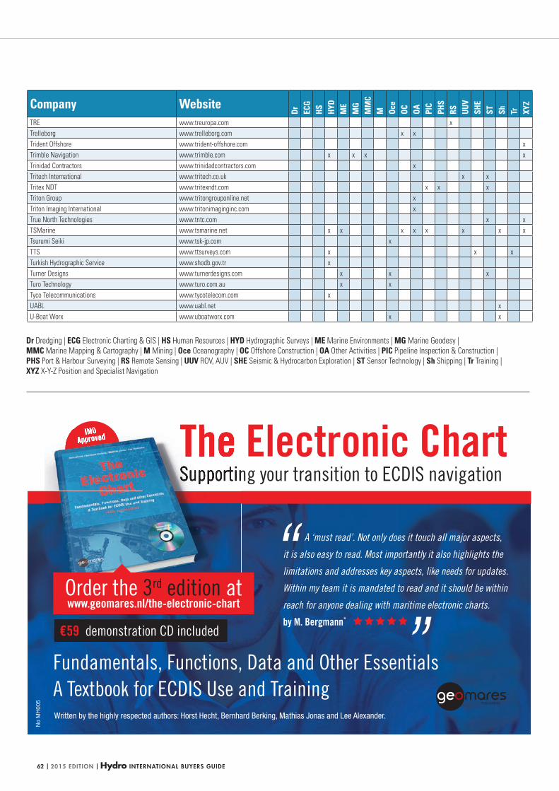
| 2015 EDITION | Hydro INTERNATIONAL BUYERS GUIDE62
Dr Dredging | ECG Electronic Charting & GIS | HS Human Resources | HYD Hydrographic Surveys | ME Marine Environments | MG Marine Geodesy |
MMC Marine Mapping & Cartography | M Mining | Oce Oceanography | OC Offshore Construction | OA Other Activities | PIC Pipeline Inspection & Construction |
PHS Port & Harbour Surveying | RS Remote Sensing | UUV ROV, AUV | SHE Seismic & Hydrocarbon Exploration | ST Sensor Technology | Sh Shipping | Tr Training |
XYZ X-Y-Z Position and Specialist Navigation
The Electronic ChartSupporting your transition to ECDIS navigation
Fundamentals, Functions, Data and Other EssentialsA Textbook for ECDIS Use and Training
IMOApproved
Order the 3rd edition atwww.geomares.nl/the-electronic-chart
€59 demonstration CD included
A ‘must read’. Not only does it touch all major aspects,
it is also easy to read. Most importantly it also highlights the
limitations and addresses key aspects, like needs for updates.
Within my team it is mandated to read and it should be within
reach for anyone dealing with maritime electronic charts.
by M. Bergmann*
Written by the highly respected authors: Horst Hecht, Bernhard Berking, Mathias Jonas and Lee Alexander.
No
MH
005
Company Website
Dr ECG
HS HYD
ME
MG
MM
CM Oc
eOC OA PI
CPH
SRS UU
VSH
EST Sh Tr XY
Z
TRE www.treuropa.com x
Trelleborg www.trelleborg.com x x
Trident Offshore www.trident-offshore.com x
Trimble Navigation www.trimble.com x x x x
Trinidad Contractors www.trinidadcontractors.com x
Tritech International www.tritech.co.uk x x
Tritex NDT www.tritexndt.com x x x
Triton Group www.tritongrouponline.net x
Triton Imaging International www.tritonimaginginc.com x
True North Technologies www.tntc.com x x
TSMarine www.tsmarine.net x x x x x x x x
Tsurumi Seiki www.tsk-jp.com x
TTS www.ttsurveys.com x x x
Turkish Hydrographic Service www.shodb.gov.tr x
Turner Designs www.turnerdesigns.com x x x
Turo Technology www.turo.com.au x x
Tyco Telecommunications www.tycotelecom.com x
UABL www.uabl.net x
U-Boat Worx www.uboatworx.com x x
HYDBG2015_Tabel 62HYDBG2015_Tabel 62 24-11-2014 15:48:2524-11-2014 15:48:25
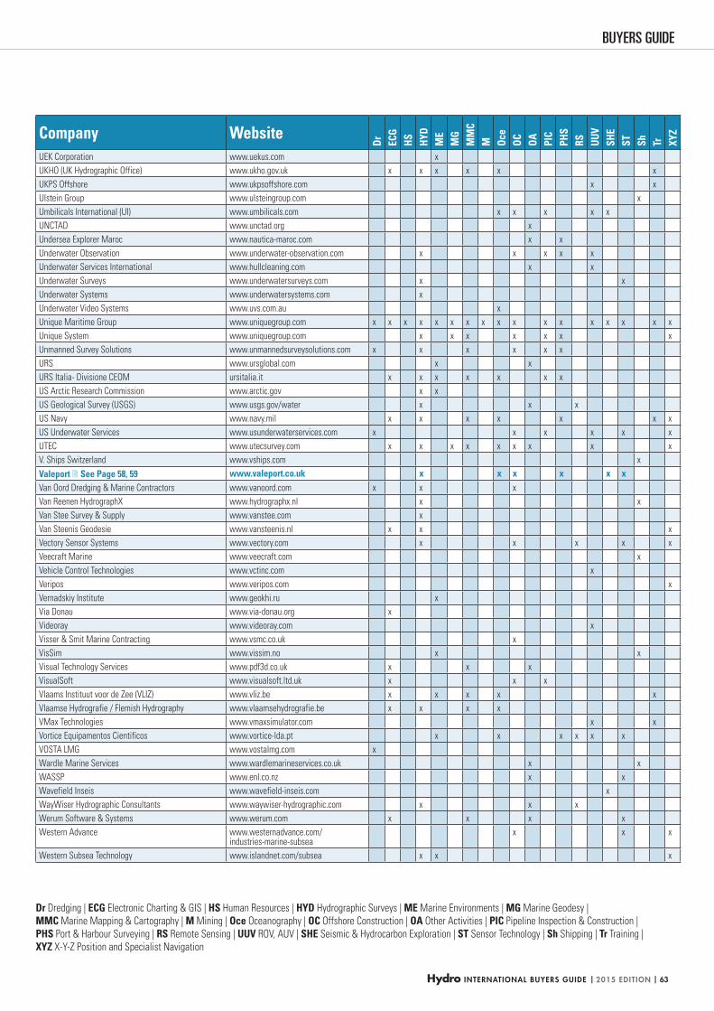
Hydro INTERNATIONAL BUYERS GUIDE | 2015 EDITION | 63
BUYERS GUIDE
Dr Dredging | ECG Electronic Charting & GIS | HS Human Resources | HYD Hydrographic Surveys | ME Marine Environments | MG Marine Geodesy |
MMC Marine Mapping & Cartography | M Mining | Oce Oceanography | OC Offshore Construction | OA Other Activities | PIC Pipeline Inspection & Construction |
PHS Port & Harbour Surveying | RS Remote Sensing | UUV ROV, AUV | SHE Seismic & Hydrocarbon Exploration | ST Sensor Technology | Sh Shipping | Tr Training |
XYZ X-Y-Z Position and Specialist Navigation
Company Website
Dr ECG
HS HYD
ME
MG
MM
CM Oc
eOC OA PI
CPH
SRS UU
VSH
EST Sh Tr XY
Z
UEK Corporation www.uekus.com x
UKHO (UK Hydrographic Office) www.ukho.gov.uk x x x x x x
UKPS Offshore www.ukpsoffshore.com x x
Ulstein Group www.ulsteingroup.com x
Umbilicals International (UI) www.umbilicals.com x x x x x
UNCTAD www.unctad.org x
Undersea Explorer Maroc www.nautica-maroc.com x x
Underwater Observation www.underwater-observation.com x x x x x
Underwater Services International www.hullcleaning.com x x
Underwater Surveys www.underwatersurveys.com x x
Underwater Systems www.underwatersystems.com x
Underwater Video Systems www.uvs.com.au x
Unique Maritime Group www.uniquegroup.com x x x x x x x x x x x x x x x x x
Unique System www.uniquegroup.com x x x x x x x
Unmanned Survey Solutions www.unmannedsurveysolutions.com x x x x x x
URS www.ursglobal.com x x
URS Italia- Divisione CEOM ursitalia.it x x x x x x x
US Arctic Research Commission www.arctic.gov x x
US Geological Survey (USGS) www.usgs.gov/water x x x
US Navy www.navy.mil x x x x x x x
US Underwater Services www.usunderwaterservices.com x x x x x x
UTEC www.utecsurvey.com x x x x x x x x x
V. Ships Switzerland www.vships.com x
Valeport See Page 58, 59 www.valeport.co.uk x x x x x xVan Oord Dredging & Marine Contractors www.vanoord.com x x x
Van Reenen HydrographX www.hydrographx.nl x x
Van Stee Survey & Supply www.vanstee.com x
Van Steenis Geodesie www.vansteenis.nl x x x
Vectory Sensor Systems www.vectory.com x x x x x
Veecraft Marine www.veecraft.com x
Vehicle Control Technologies www.vctinc.com x
Veripos www.veripos.com x
Vernadskiy Institute www.geokhi.ru x
Via Donau www.via-donau.org x
Videoray www.videoray.com x
Visser & Smit Marine Contracting www.vsmc.co.uk x
VisSim www.vissim.no x x
Visual Technology Services www.pdf3d.co.uk x x x
VisualSoft www.visualsoft.ltd.uk x x x
Vlaams Instituut voor de Zee (VLIZ) www.vliz.be x x x x x
Vlaamse Hydrografie / Flemish Hydrography www.vlaamsehydrografie.be x x x x
VMax Technologies www.vmaxsimulator.com x x
Vortice Equipamentos Cientificos www.vortice-lda.pt x x x x x x
VOSTA LMG www.vostalmg.com x
Wardle Marine Services www.wardlemarineservices.co.uk x x
WASSP www.enl.co.nz x x
Wavefield Inseis www.wavefield-inseis.com x
WayWiser Hydrographic Consultants www.waywiser-hydrographic.com x x x
Werum Software & Systems www.werum.com x x x x
Western Advance www.westernadvance.com/industries-marine-subsea
x x x
Western Subsea Technology www.islandnet.com/subsea x x x
HYDBG2015_Tabel 63HYDBG2015_Tabel 63 24-11-2014 15:48:2624-11-2014 15:48:26
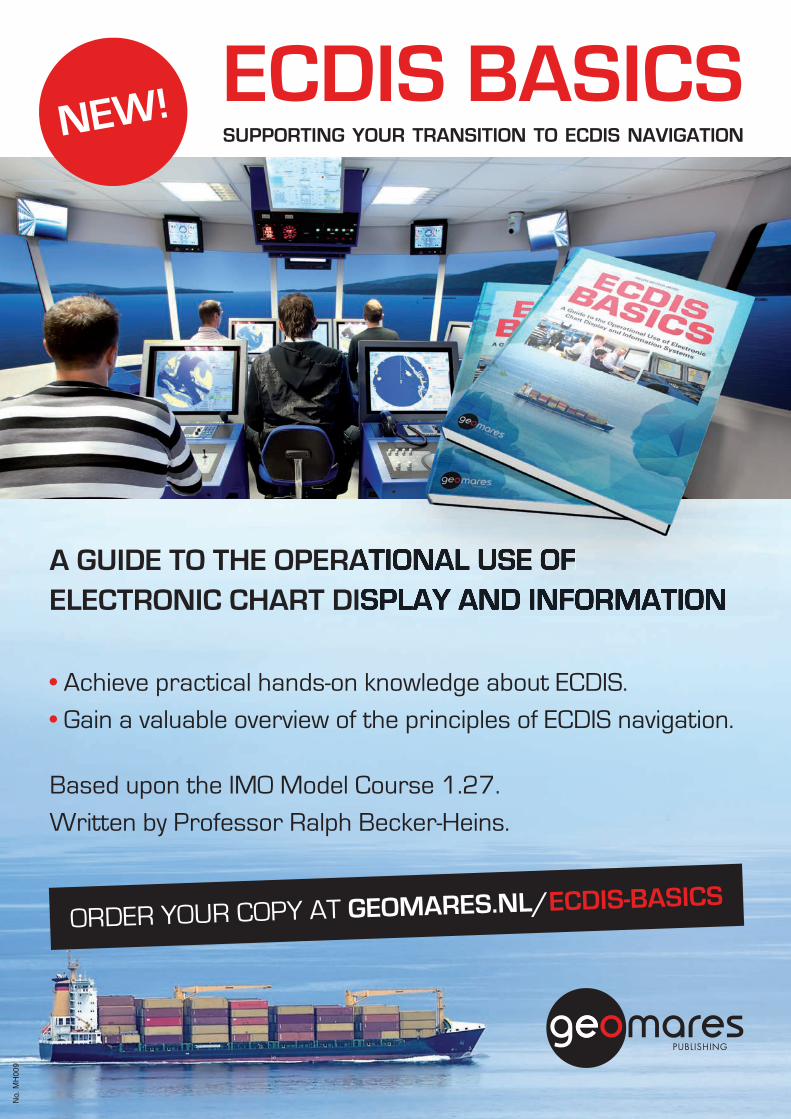
ECDIS BASICSSUPPORTING YOUR TRANSITION TO ECDIS NAVIGATION NEW!
A GUIDE TO THE OPERATIONAL USE OF ELECTRONIC CHART DISPLAY AND INFORMATION
• Achieve practical hands-on knowledge about ECDIS.
• Gain a valuable overview of the principles of ECDIS navigation.
Based upon the IMO Model Course 1.27.
Written by Professor Ralph Becker-Heins.
ORDER YOUR COPY AT GEOMARES.NL/ECDIS-BASICS
No.
MH
009
MH009.indd 1 17-06-2014 15:49:43HYDBG2015_Tabel 64HYDBG2015_Tabel 64 24-11-2014 15:48:3024-11-2014 15:48:30
Hydro INTERNATIONAL BUYERS GUIDE | 2015 EDITION | 65
BUYERS GUIDE
Dr Dredging | ECG Electronic Charting & GIS | HS Human Resources | HYD Hydrographic Surveys | ME Marine Environments | MG Marine Geodesy |
MMC Marine Mapping & Cartography | M Mining | Oce Oceanography | OC Offshore Construction | OA Other Activities | PIC Pipeline Inspection & Construction |
PHS Port & Harbour Surveying | RS Remote Sensing | UUV ROV, AUV | SHE Seismic & Hydrocarbon Exploration | ST Sensor Technology | Sh Shipping | Tr Training |
XYZ X-Y-Z Position and Specialist Navigation
Company Website
Dr ECG
HS HYD
ME
MG
MM
CM Oc
eOC OA PI
CPH
SRS UU
VSH
EST Sh Tr XY
Z
WesternGeco do Brasil www.westerngeco.com x x
Westminster Dredging www.boskalis.co.uk x
WFS Technologies www.wfs-tech.com x x
Wheeler Associates www.weswheeler.com x x
Wiertsema & Partners www.wiertsema.nl x x x
Williamson & Associates www.wassoc.com x x x x x x x x
Wish Software www.wishsoftware.com x
Witteveen + Bos www.witteveenbos.nl x x x
WNL Marine Electronics www.wnl.nl x x x
Woods Hole Group www.whgrp.com x x x x
Woods Hole Oceanographic Institution (WHOI) www.whoi.edu x x x x x
Workskiff www.workskiff.com x
World Maritime University www.wmu.se x x x x x
Wuxi Haiying-Cal Tec Marine Technology Co. www.haiying.com.cn x x x
Xeos Technologies www.xeostech.com x x x x x
Xodus Group www.xodusgroup.com x x
Xsens Technologies www.xsens.com x
Xylem Analytics UK www.xylemanalytics.co.uk x x x x
YSI www.ysi.com x
Zebra-Tech www.zebra-tech.co.nz x
Zeework Marine ww.zeework.co.uk x x x x x
Zeni Lite Buoy www.zenilite.co.jp x
Zetechtics www.zetechtics.com x
Zhejiang Machinery & Equipment I/E Corp. www.zmec.com x
Zupt www.zupt.com x x
17-06-2014 15:49:43 HYDBG2015_Tabel 65HYDBG2015_Tabel 65 24-11-2014 15:48:3124-11-2014 15:48:31

Note to media buyers: Hydro International takes pride in having a BPA audited circulation.
Check www.buysafemedia.com to read why it’s a smart decision to expose your products to a
qualified and quantified market of hydrographic professionals.
Yes, I want to secure my participation in this year’s Buyers Guide by taking out the regular package for only €1,790,- Half-page full colour ad in print version
Half-page Company Profile
Company Profile in Product or Service Category on the website
2x Banner ad in E-newsletter Hydro International
And yes, I want to upgrade my package in this year’s Buyers Guide
Full page colour ad for an extra €490,-
Full page premium position for an extra €1,000,-
(inside front cover, inside back cover, back cover – comes on a first come,
first serve basis)
Prices are exclusive VAT (when applicable)
Company
Name
Tel:
Fax:
Email:
Signature:
Don’t miss out on the Buyers Guide 2016
Sign up now!Sign up now!
YeGuHa
Ha
Co
2x
AnBu
Fu
Fu
(in
fir
Pr
Compan
Name
Tel:
Fax:
Email:
Signatu
THE GLOBAL MAGAZINE FOR HYDROGRAPHYWWW.HYDRO-INTERNATIONAL.COM
BuyersGuide2016
NOVEMBER/DECEMBER 2015 | VOLUME 19 NUMBER 9
SOURCE FOR PRODUCTS AND SERVICE COMPANY PROFILES
HYDBG2016_Cover 1HYDBG2016_Cover 1
24-11-2014 11:00:37
Most extensive source, available in print and online, for hydrographic professionals
On desks and in inboxes of more than 20,000 members of the Hydro International community
The most extensive source for professionals
working in hydrography and adjacent fields is
prepared once again. Readers will find this
year’s Buyers Guide on their desks together
with the next issue of Hydro International.
The Buyers Guide is also distributed on
tradeshows all over the world.
Get maximum exposure for your company.
Make sure you are visible. It has never been easier.
Just check the boxes below and fax the form
to +31 514 56 38 98 or scan the form and send
it via email to [email protected] Our sales
team will contact you on deadlines, technical
specifications and requirements for material.
33864_adv_HYDBG_2016.indd 1 24-11-14 13:54HYDBG2015_Tabel 66HYDBG2015_Tabel 66 24-11-2014 16:04:1324-11-2014 16:04:13
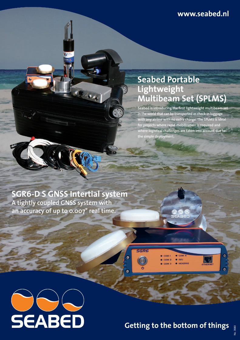
No.
358
3
HYDBG2015_Cover 67 24-11-2014 15:35:31
S2C TECHNOLOGY: COMMUNICATION AND TRACKING COMBINED
- time, space and cost - saving solutions - low power consumption for autonomous operations - advanced data delivery algorithms, addressing and networking, remotely confi gurable settings - extendable platform with multiple confi guration options: power-saving Wake Up module, acoustic releaser,
additional sensors, custom solutions, OEM versions available
USBL POSITIONING SYSTEMS
simultaneous positioning and communication - no need to switch between positioning mode and modem mode
- fl exible SiNAPS positioning software - reliable data transmissions - range: up to 8000 m - accuracy: up to 0.04 degrees
UNDERWATER ACOUSTIC MODEMS
reliable data transmissions even in adverse conditions, customizable standard modems or new M-series “mini” modems in a light and compact design, special editions for developers, S2C communication and positioning emu-lator for free with every purchase
- range: up to 8000 m - depth: up to 6000 m - data rate: up to 31.2 kbps
LBL POSITIONING SYSTEMS
highly accurate, precise and stable performance, simultaneous positioning and data transmissions
- fl exible SiNAPS positioning software - reliable data transmissions - range: up to 8000 m - accuracy: better than 0.01 m
UNDERWATERCOMMUNICATIONAND POSITIONING
SOLUTIONS
Ackerstrasse 76,13355 Berlin, Germany
tel.: +49 30 4679 862 - 0fax: +49 30 4679 862 - 01
EvoLogics GmbH
M-SERIES ‘MINI‘ MODEMS
a great solution for AUVs:available now!
No.
355
9
HYDBG2015_Cover 68 24-11-2014 15:35:31