bushwalks of mountain lagoon - blue mountains · pdf filemountain lagoon fourteen kilometres...
TRANSCRIPT

BUSHWALKS OF MOUNTAIN LAGOON

BUSHWALKS OF
MOUNTAIN LAGOON Earth has not anything to show more fair: Dull would he be of soul who could pass by A sight so touching in its majesty:
William Wordsworth
This booklet has been prepared by Mill Paddock Cottage B&B
www.millpaddock.com.au
A Cautionary word …
The booklet is intended for your general information only and is NOT a
definitive walking guide. While some of the walks listed here are readily
accessible to casual rambling, others are only suitable for experienced
bushwalkers and require appropriate, adequate preparation. The Wollemi
National Park is a vast, uninhabited wilderness area of dense bushland, rugged
terrain and deep canyons with difficult access. It is not a place to be spending a
night unprepared, regardless of the season. For all the walks, sensible footwear
and clothing are recommended, as well as hats, sunscreen, insect repellent and
a water bottle. A few moments’ preparation before setting out for the day will
help to ensure that you have a safe and enjoyable walk.
Copyright Mill Paddock Cottage
Mountain Lagoon 2012
Design & Layout – J Murray Water Colour Drawing – Paul Bramble

Mountain Lagoon
Fourteen kilometres off The Bells Line of Road from Bilpin, the village of
Mountain Lagoon is scarcely large enough to make a dot on the map; some
twenty properties scattered along the ridge beside Mountain Lagoon Road and
another twenty or so around the lagoon itself comprise the entire settlement.
There are no public buildings other than the NSW Rural Fire Brigade Shed, no
shops, no post office, no petrol station – but what the village lacks in services, it
more than makes up for in the beauty of its surroundings.
Mountain Lagoon
The lagoon, some 12 acres in area, is situated along the Kurrajong Fault Line,
which runs through Mountain Lagoon. Drilling by Geoscience Australia in 2008
confirmed that the fault line crosses the south-eastern corner of Mountain
Lagoon, closely following the road line of the lower end of Sams Way. It also
identified evidence of a bedrock uplift of some 20 metres, similar to that found in
the Wheeney Creek area, in land to the east of the road. Water levels in the
lagoon rise and fall in conjunction with the level of the water table and at the
time of publication, after several excessively wet years, the lagoon is full to over-
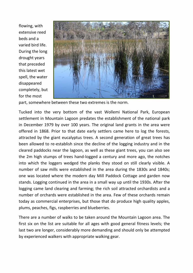
flowing, with
extensive reed
beds and a
varied bird life.
During the long
drought years
that preceded
this latest wet
spell, the water
disappeared
completely, but
for the most
part, somewhere between these two extremes is the norm.
Tucked into the very bottom of the vast Wollemi National Park, European
settlement in Mountain Lagoon predates the establishment of the national park
in December 1979 by over 100 years. The original land grants in the area were
offered in 1868. Prior to that date early settlers came here to log the forests,
attracted by the giant eucalyptus trees. A second generation of great trees has
been allowed to re-establish since the decline of the logging industry and in the
cleared paddocks near the lagoon, as well as these giant trees, you can also see
the 2m high stumps of trees hand-logged a century and more ago, the notches
into which the loggers wedged the planks they stood on still clearly visible. A
number of saw mills were established in the area during the 1830s and 1840s;
one was located where the modern day Mill Paddock Cottage and garden now
stands. Logging continued in the area in a small way up until the 1930s. After the
logging came land clearing and farming; the rich soil attracted orchardists and a
number of orchards were established in the area. Few of these orchards remain
today as commercial enterprises, but those that do produce high quality apples,
plums, peaches, figs, raspberries and blueberries.
There are a number of walks to be taken around the Mountain Lagoon area. The
first six on the list are suitable for all ages with good general fitness levels; the
last two are longer, considerably more demanding and should only be attempted
by experienced walkers with appropriate walking gear.

Mountain Lagoon’s “magnificent trees”

The Walks
Sams Way (The Lagoon Loop)
More in the nature of a gentle country ramble than a serious bushwalk, a stroll around the Sams Way Loop is a lovely one in any season. Named after Sam Boughton, one of the area’s original residents, Sams Way branches off Mountain Lagoon Road just beyond Dutch’s Nursery, skirting the lagoon on its eastern side and re-joining the main road just before it becomes a fire trail. The lagoon loop is approximately 3.2km.
You can walk the loop in either direction; a left turn into Sams Way just beyond
the nursery provides a gentle downhill walk to where the lagoon meets the
road and a sharp climb back up the hill on the other side.
Those of a less energetic inclination should continue along Mountain Lagoon
Road, down the steep hill to the second entrance to Sams Way and follow this
road back up to the junction near the nursery.
The spectacular 3km long avenue of trees on Sams Way was planted some
sixty years ago by Sam Boughton and his son Buck, using a variety of
alternating deciduous trees and conifers to line each side of the road. Sam died
in 1961 and never saw the trees reach their magnificent maturity, but he and
his son were truly men of vision and their legacy remains today for all to enjoy,
as the seasons change throughout the year. There is brilliant new lime green
foliage in spring, dense, cool shade where the trees form a complete canopy
over Sams Way in summer and a magnificent display of red and gold and
purple in autumn. Even the stark, bare branches etched against a pale blue
winter sky have a special beauty.

On your walk around the lagoon, look out for –
Sam’s monument, approximately 100m down from the first entrance to
Sams Way on the left.
If you are walking in spring, the beautiful azalea hedge, planted at the
same time as the trees, along the old farmhouse boundary.
Some huge eucalyptus deanii beside the road as you go down (or up) the
steep hill.
Little Lagoon, where the lagoon comes close to the road, and beyond
the paddocks between Little Lagoon and the original Boughton
farmhouse, Cooramill, extensive views across the water.
The stump of a hand-logged tree in the big paddock beside the lagoon.
Wood ducks and swamphens on the lagoon, and occasionally a grey
heron.
Eastern and crimson rosellas all through the year, white tailed black
cockatoos in summer and gang-gang cockatoos from late summer
through till winter, as they feed on the seeds of the Liquid Amber trees.
Female satin bower birds (and if you are especially lucky, a male one,
too), lots of little birds in the shrubbery along the roadside - fairy wrens,
yellow breasted robins, red backed finches, silver eyes, grey and
occasionally rufous fantails, as well as all the usual suspects such as
kookaburras, plovers, noisy minors and bell minors, a wide variety of
honey eaters, magpies, butcher birds and currawongs.
Early morning and late afternoon walkers might be lucky enough to spot
the occasional wallaby down for a drink and there could even be a prize
for the person who actually manages to photograph the resident
wombat who lives across from Little Lagoon! Look very closely and you
might spot a koala or two in one of the smooth-barked eucalypts
growing in the lagoon paddock.
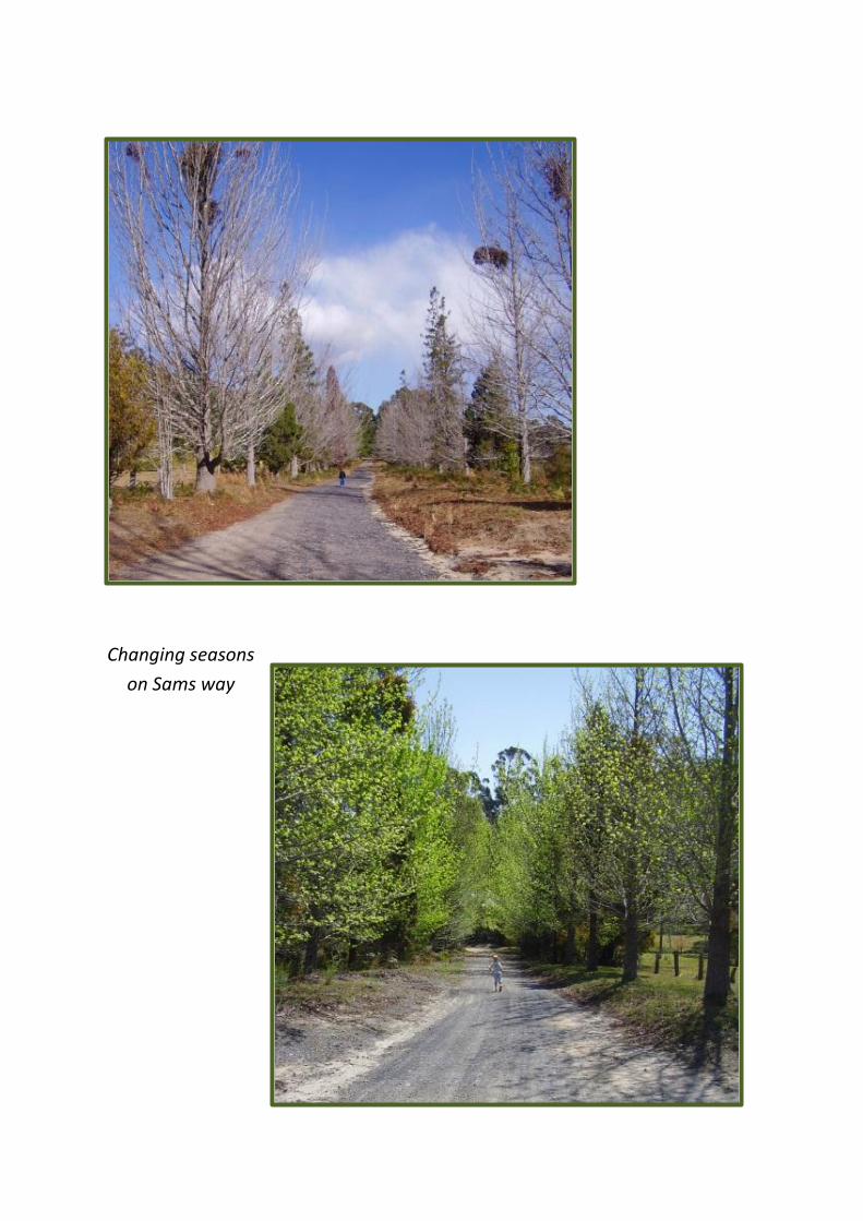
Changing seasons
on Sams way

Tootie Creek Track
By the channels of coolness the echoes are calling, And down the dim gorges I hear the creek falling;
It lives in the mountain where moss and the sedges Touch with their beauty the banks and the ledges. Through breaks of the cedar and sycamore bowers
Struggles the light that is love to the flowers; And softer than slumber, and sweeter than singing, The notes of the bell-birds are running and ringing
Henry Kendall
The Tootie Creek track begins just 50m beyond the end of the bitumen road,
along the western boundary of the first property on the left. The track follows
the fence line around behind this property, before heading off into the bush in
a northerly direction. It then leaves the ridge and descends along the side of a
fairly steep gully where there are some splendid, large grey gums growing.
Watch out for koalas here; in this area the grey gum is the koala’s preferred
food.
Beyond the gully the track passes through a cutting of rare pink shale and
shortly afterwards, is crossed by a wet creek (2.1km from Mountain Lagoon
Road) lined by many tall, straight blue gum and grey myrtle trees. It then
enters a small rainforest where sassafras, coachwood, tree ferns and soft
bracken abound, before reaching a beautiful open section of Tootie Creek
(3.6km from Mountain Lagoon Road).
Tootie Creek

The summer walker will be tempted to strip down and plunge into this pristine
water hole, just as the timber getters did in days of yore. Platypuses have been
seen in this part of the creek, but this shy creature is not easy to find, so there
are no guarantees that you will be lucky enough to catch sight of one!
Of course, what goes up must come down again and he who walks down this
hill must walk back up it. The ascent of some 300m can be a bit of a slog, but
the return walk is made easier by the good condition of the track.
The round trip is a walk of just over 7km and it is recommended that at least 4
hours be allowed for the walk – and some R&R while out at the creek.
The beautiful Telopea speciosissima – Waratah – is endemic to the Mountain Lagoon area

Cabbage Tree Creek Track
Cabbage Tree Creek, T3 and Colo Meroo walking tracks all have a common
start, about 1.2km down Sams Way from the first entrance to the loop road
close to Dutch’s Nursery. Some 800m out the track from Sams Way, this
signposted walk veers to the left off the main track, where walkers can go
around a locked gate designed to prevent vehicle but not pedestrian access.
The track continues to descend for about 1km to a cleared area. Be warned, in
wet conditions (and not so wet ones) this area is infamous for its leeches – stay
on the move!
From the clearing a short rough walking track continues in a south-westerly
direction along a tributary running down into Cabbage tree creek. Halfway
down this track if you drop over the side into the tributary you will find a
beautiful waterfall, and
adventurous hikers might
like to go up the tributary
above the waterfall in
search of what is reputed to
be Mountain Lagoon’s
biggest tree – a gigantic
turpentine.
As with the Tootie Creek
Track, the only way out is to
retrace one’s steps up the
same track. On the way
back, look out for a grove of
casuarina trees whose fruit
is the favourite food of the
rare glossy black cockatoo.
Umbrella fern
Thick socks and sturdy boots provide some protection from leeches; a can of
Bushman Heavy Duty Personal Insect Repellent (for sand flies, mosquitoes,
tick, leeches and march flies) might also be a useful thing to carry with you!
Allow 3 hours to walk this track.

Cabbage Tree Creek Waterfall

Long Ridge Track
The entrance to the Long Ridge Track is on the left along Mountain Lagoon
Road, 1.5km after the bitumen ends as you come from Bilpin. This track skirts
the western edge of the property Mill Paddock, and then meanders for 6km
through the wet and dry sclerophyll forests typical of the area, featuring a
good variety of local tree species such as grey gum (Eucalyptus punctata),
stringybark (Eucalyptus globoidea), bloodwood (Eucalyptus eximia) and
turpentine (Syncarpia glomulifera).
Like the majority of tracks in the Mountain Lagoon area that are now used by
bushwalkers, Long Ridge was originally put in by loggers to gain access to the
forest and haul out the timber. With the commercial timber industry long
gone, the track today is maintained as a fire trail. While there is no spectacular
view at the end of the walk, Long Ridge offers a pleasant, relatively easy 5.5km
hike through some typical east coast Australian bushland and, as is the case
with several other tracks in the area, you stand a good chance of having it all to
yourself! 2km along the trail, a short side track leads to an abandoned shale
quarry.
Sclerophyl forest typical of the Mountain Lagoon area
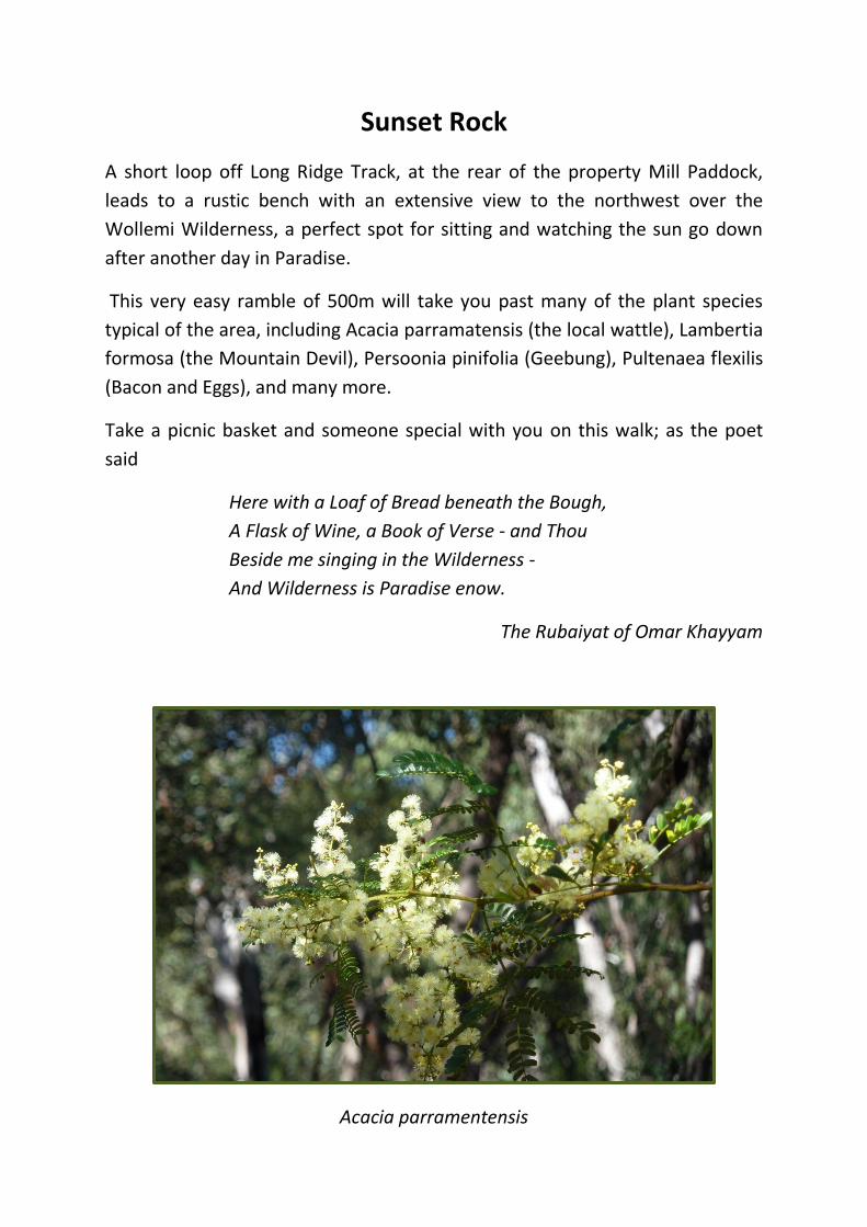
Sunset Rock
A short loop off Long Ridge Track, at the rear of the property Mill Paddock,
leads to a rustic bench with an extensive view to the northwest over the
Wollemi Wilderness, a perfect spot for sitting and watching the sun go down
after another day in Paradise.
This very easy ramble of 500m will take you past many of the plant species
typical of the area, including Acacia parramatensis (the local wattle), Lambertia
formosa (the Mountain Devil), Persoonia pinifolia (Geebung), Pultenaea flexilis
(Bacon and Eggs), and many more.
Take a picnic basket and someone special with you on this walk; as the poet
said
Here with a Loaf of Bread beneath the Bough,
A Flask of Wine, a Book of Verse - and Thou
Beside me singing in the Wilderness -
And Wilderness is Paradise enow.
The Rubaiyat of Omar Khayyam
Acacia parramentensis

T3 Track to “The End of the Earth”
The T3 Track (as do Colo Meroo and Cabbage Tree Creek Tracks) starts on Sams
Way 1.2km from the western entrance to this loop road. A National Parks and
Wildlife sign saying “Walking Tracks, Tootie Creek - Colo Meroo” clearly marks
the beginning of the track, which is in fact a graded fire trail. The walk to the
end of the track, avoiding the two side trails with locked gates, is 5.5km and
after some initial “ups and downs” is a relatively flat walk through beautiful
wet scerophyll eucalyptus woodland, finishing on a rise with spectacular views
over the Wollemi Wilderness.
From the circular clearing at the end of the track, walk across the rocky
outcrop to the edge of the escarpment and be amazed at the vast expanse of
the Wollemi Wilderness, viewed from a special spot that the locals call
“The End of the Earth”.
Although there are no facilities here, this is a lovely place to have a picnic while
enjoying the scenery. As you walk, keep an eye open for wallabies, goannas
and other lizards, lyrebirds and a host of other smaller birds, and wildflowers in
season.

The return walk of 11km is a comfortable day’s outing, allowing time to picnic
and enjoy the panoramic view. Take water with you (there are no accessible
creeks along this track) and keep to the track – and remember; the hilliest part
of the walk is the last kilometre on the way home, so allow plenty of time to
complete the return journey in daylight.
The beautiful Angophora costata with its new, tanny-pink bark

Colo Meroo - Gosper’s Ridge Track
Colo Meroo begins at the NPW signpost on Sams Way, branching off to the
right at a locked gate 400m along the main track. The track climbs a steep but
short hill then continues into a lovely damp glade (renowned for its funnel web
spiders – don’t worry, you won’t see them on the track!). From the gate to the
end of the wide track is 4.4km of easy, very pleasant walking. Beyond this
point, however, the track narrows, continuing for a further 3km until it reaches
the cliffs, with stunning views over the Colo River. Walkers should allow at
least 6 hours for a return journey to this point.
From this viewing point the walk continues as more of a rough scramble along
Maille’s Ridge for a further 2km to the Meroo Trig Station, before descending
to the Colo River.
While this last section is roughly signposted, it is for serious, experienced
walkers only and usually includes camping overnight at the river before
walking out the following day. Those intending to go right through to the river
should be well prepared with the appropriate equipment.
Colo River from Maille’s Ridge
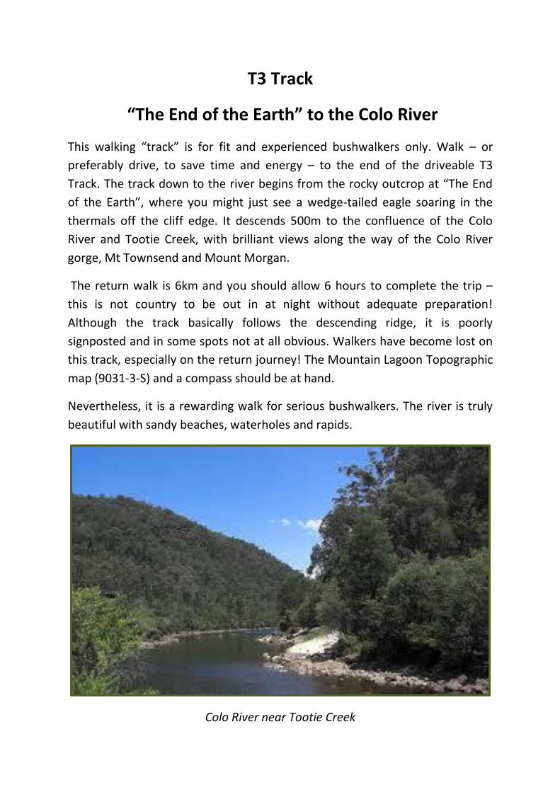
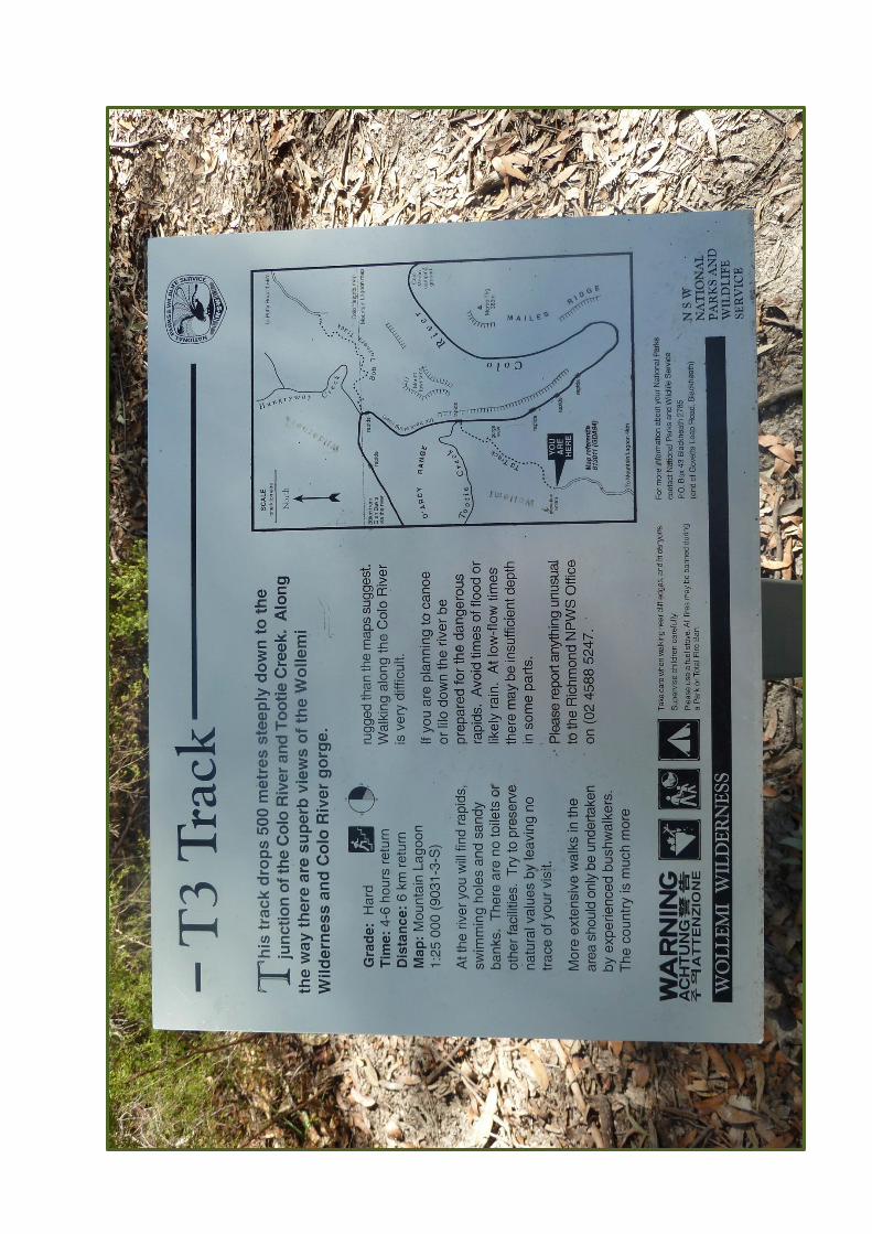
T3 Track
“The End of the Earth” to the Colo River
This walking “track” is for fit and experienced bushwalkers only. Walk – or
preferably drive, to save time and energy – to the end of the driveable T3
Track. The track down to the river begins from the rocky outcrop at “The End
of the Earth”, where you might just see a wedge-tailed eagle soaring in the
thermals off the cliff edge. It descends 500m to the confluence of the Colo
River and Tootie Creek, with brilliant views along the way of the Colo River
gorge, Mt Townsend and Mount Morgan.
The return walk is 6km and you should allow 6 hours to complete the trip –
this is not country to be out in at night without adequate preparation!
Although the track basically follows the descending ridge, it is poorly
signposted and in some spots not at all obvious. Walkers have become lost on
this track, especially on the return journey! The Mountain Lagoon Topographic
map (9031-3-S) and a compass should be at hand.
Nevertheless, it is a rewarding walk for serious bushwalkers. The river is truly
beautiful with sandy beaches, waterholes and rapids.
Colo River near Tootie Creek