bulow creek paddling guide - florida dep · historic state park gamble rogers memorial state ......
TRANSCRIPT
§̈¦95
MOODY BLVD
OLD DIXIE HWY
JOHN ANDERSON HWY.
OLD KINGS HIGHWAY
OCEAN SHORE BLVD
OLD DIXIE HWY
Bulow Creek State Park
Bulow Plantation RuinsHistoric State Park
WALTER BOARDMAN
HIGH BRIDGE RD
Favoretta
Bulow Creek State Park
Betty Steflik Memorial Preserve
North Peninsula State Park
North Peninsula State Park
Gamble Rogers Memorial State Recreation Area at Flagler Beach
¬«201
¬«2001
¬«4011
¬«A1A
Flagler Beach
FLAGLER
VOLUSIA
£¤1
¯
Access Point 3: Smith Creek LandingN: 29.4096 W: -81.1009
Access Point 1: Bulow Plantation Ruins Historic State Park
N: 29.4344 W: -81.1370
0 1 20.5 Miles
B u l o w C r e e k P a d d l i n g T r a i lB u l o w C r e e k P a d d l i n g T r a i l
Atlantic Ocean
Smith Creek
TomokaBasin
Access Point 2: Walter Boardman Lane BridgeN: 29.4073 W: -81.1218
!|!|
I*Þ!9!|
I*Þ
Florida Conservation LandsWetlands
RestroomsI*Camping!9Potable WaterÞ
Canoe/Kayak Launch!|
Bulow Creek Designated Paddling Trail
Florida State Parks
%
%
%
%
%
%
FLAGLER
Beverly Beach
£¤1
§̈¦95
Relay Tract Conservation
Easements
Bulow Creek State Park
Graham Swamp Conservation Area
Tomoka State Park
Betty Steflik Memorial Preserve
Lehigh Greenway
North Peninsula State Park
Bulow Plantation Ruins Historic State Park
Gamble Rogers Memorial StateRecreation Area at Flagler Beach
Addison Blockhouse Historic State Park
Korona
Dupont
Favoretta
Beverly Beach
Flagler Beach
Ormond-by-the-Sea
¯
0 2.5 51.25 Miles
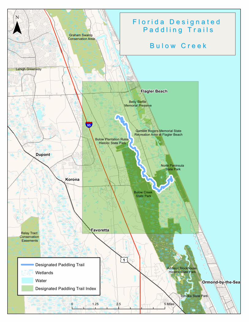
F l o r i d a D e s i g n a t e d F l o r i d a D e s i g n a t e d P a d d l i n g T r a i l sP a d d l i n g T r a i l s
B u l o w C r e e kB u l o w C r e e k
WetlandsWaterDesignated Paddling Trail Index
Designated Paddling Trail
Paddling Trail Guide
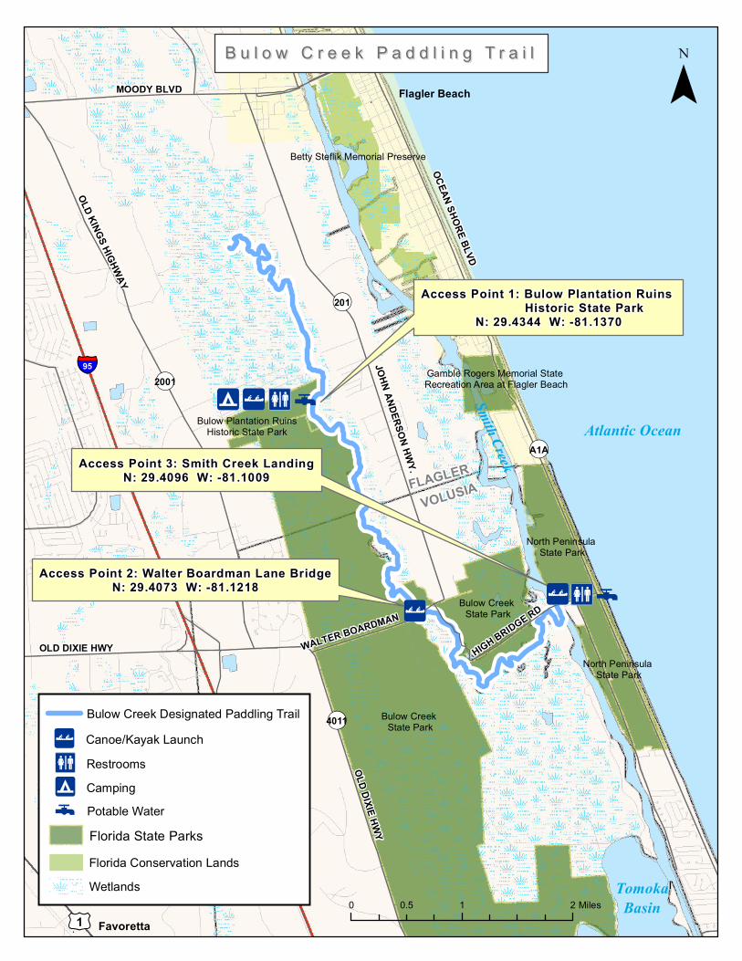
The Waterway Native Americans inhabited the area along Bulow Creek for many years prior to European settlement, and middens are exposed in the middle section of the paddling trail, near the Boardman Bridge. The Bulow Creek Paddling Trail passes by an old Florida community called Mound Grove, and a number of old homes are easily visible from the water. While the marsh in the northern section is entirely intact, the marsh below the Boardman Bridge is traversed by a number of man-made canals and what appears to be an old railroad grade or tram road. The Paddling Experience Bulow Creek begins at the historic Bulow Plantation Ruins Historic State Park and leads upstream and back and then downstream to the entrance of the Intracoastal Waterway. You can paddle about 3 miles upstream from the park until the creek becomes too narrow. Most of this area is wild and scenic. Going downstream, the water begins to turn brackish as you approach the Intracoastal Waterway. Much of the trail flows through grassy coastal marsh typical of the Atlantic Coast. If you leave a vehicle at Bulow Plantation Ruins Historic State Park, be sure to return to your car before the gates are locked at 5 p.m. It can be difficult navigating the channels in the salt marsh between the Walter Boardman Bridge and the takeout at High Bridge Road. Be sure to take a GPS, map and compass. Access Points
#1 Start of the trail, Bulow Plantation Ruins Historic State Park. Take the short 10-minute nature trail to the interesting sugar mill ruins and interpretive display. There is a boat ramp to launch small powerboats and paddlecraft. From I-95, exit at Old Dixie Highway and head east. Turn north (left) onto Old Kings Rd. Bulow Ruins State park is about 2.5 miles, on the right. #2, Mile 3, Walter Boardman Bridge, From I-95, exit at Old Dixie Highway and head east. Turn left onto Walter Boardman Lane. Look for a small bridge over Bulow Creek. #3, Mile 6.5, End of the trail, Smith Creek Landing at North Peninsula State Park.
More than two miles of beautiful, unspoiled Atlantic beaches beckon visitors to this stunning state park. This Florida haven shelters rare creatures such as Florida scrub-jays, indigo snakes, and gopher tortoises. Visitors can spend the afternoon swimming, sunning at the

Paddling Trail Guide
beach, or surf fishing. Bird-watchers will enjoy spotting the native and migratory species. From I-95, Exit at Old Dixie Highway and head east. Turn left onto Walter Boardman Lane. Continue for about 2 miles and turn right onto High Bridge Road. Cross over Halifax River, and park is on the left. Outfitters and Shuttle Service Tropical Kayaks at Palm Coast Marina, (386) 445-0506 Canoes may be rented from the Bulow Creek Ruins Historical State Park, (386) 517-2084 Base Camp Bulow Plantation Ruins Historic State Park is one of four contiguous parks in the area. After visiting the plantation ruins stop by Bulow Creek State park and visit the Fairchild Oak, then continue south on Old Dixie Highway to Tomoka State Park. This park is a great base camp for exploring this fascinating area. Tomoka is a bird-watcher's paradise, and a site on the Great Florida Birding Trail. It is especially rewarding during the spring and fall migrations. A boat ramp gives boaters and canoeists access to the Tomoka River, a designated paddling trail. Mix up your adventure and visit The Bulow Woods Trail, a 6.8 mile hiking and biking trail that runs from the Fairchild Oak in Bulow Creek State Park to Bulow Plantation Ruins State Historic Site. The trail is 6.8 miles one-way, totaling over 13 miles to return to Bulow Creek. History In 1836, the Second Seminole War swept away the prosperous Bulow Plantation where the Bulow family grew sugar cane, cotton, rice, and indigo. Ruins of the former plantation—a sugar mill, a unique spring house, several wells, and the crumbling foundations of the plantation house and slave cabins—show how volatile the Florida frontier was in the early 19th century. Today, a scenic walking trail leads visitors to the sugar mill ruins, listed on the National Register of Historic Sites Click here for more on the history of the Bulow Plantation. Besides Bulow Plantation Ruins Historic State Park, Bulow Creek State Park protects nearly 5,600 acres of the Bulow Creek basin. The park boasts one of the largest remaining stands of southern live oak forest along the East Coast, including the 400-year-old Fairchild Oak.