bs 5837: 2012 tree survey report and arboricultural … · cog moors wwtw – proposed advanced...
TRANSCRIPT
COG MOORS WWTW – PROPOSED ADVANCED ANAEROBIC DIGESTION (AAD) PLANT BS 5837: 2012 Tree Survey Report and Arboricultural Impact Assessment AUGUST 2017

Arcadis (UK) Limited is a private limited company registered in England registration number: 1093549. Registered office, Arcadis House, 34 York Way, London, N1 9AB. Part of the Arcadis Group of Companies along with other entities in the UK. Regulated by RICS. Copyright © 2015 Arcadis. All rights reserved. arcadis.com
CONTACT
Martin Dilworth Senior Arboriculturist
dd +44 (0)1925 843485.
m +44(0)7540 143539. e [email protected]
Arcadis. Arcadis House 34 York Way London N1 9AB United Kingdom

Version control Version Date Author Checker Approver Changes
1 23/08/17 M Dilworth M Girvan & B Murray
M Girvan & B Murray
This report has been prepared for Dŵr Cymru Welsh Water (DCWW) (the “Client”) in accordance with the terms and conditions of appointment dated 1st July 2014 (the “Appointment”) between the Client and Arcadis (UK) Limited (“Arcadis”) for the purposes specified in the Appointment. For avoidance of doubt, no other person(s) may use or rely upon this report or its contents, and Arcadis accepts no responsibility for any such use or reliance thereon by any other third party.
CONTENTS
EXECUTIVE SUMMARY ..................................................................................................... 1
1 INTRODUCTION ....................................................................................................... 3
1.1 Overview ................................................................................................................................................ 3
1.2 Site Location and Setting..................................................................................................................... 3
1.3 Proposed Scheme ................................................................................................................................ 4
2 METHODOLOGY ...................................................................................................... 5
2.1 Tree Survey Methodology .................................................................................................................... 5
Individual trees and general data capture...................................................................................................... 5
Groups of trees ................................................................................................................................................. 5
Woodlands ........................................................................................................................................................ 5
Hedgerows ........................................................................................................................................................ 5
Categorisation ................................................................................................................................................... 5
2.2 Arboricultural Impact Assessment Methodology ............................................................................. 5
2.3 Root Protection Area ............................................................................................................................ 6
2.4 Survey Limitations ................................................................................................................................ 6
2.5 Statutory Tree Protection ..................................................................................................................... 7
3 TREE SURVEY RESULTS ........................................................................................ 8
3.1 Tree Assessment and Categorisation ................................................................................................ 8
3.2 Tree Species Diversity ......................................................................................................................... 8
3.3 Age Diversity ......................................................................................................................................... 9
4 ARBORICULTURAL IMPACT ASSESSMENT (AIA) ............................................. 10
4.1 Potential Arboricultural Impacts ....................................................................................................... 10
4.2 Tree Removal ...................................................................................................................................... 10
4.3 Incursions within Root Protection Areas ......................................................................................... 11
4.4 Facilitation Pruning ............................................................................................................................ 11
4.5 Mitigation ............................................................................................................................................. 11
5 ARBORICULTURAL CLERK OF WORKS (ACOW) ROLES AND
RESPONSIBILITIES ......................................................................................................... 12
6 DISCUSSION AND CONCLUSIONS ...................................................................... 14
7 REFERENCES ........................................................................................................ 15
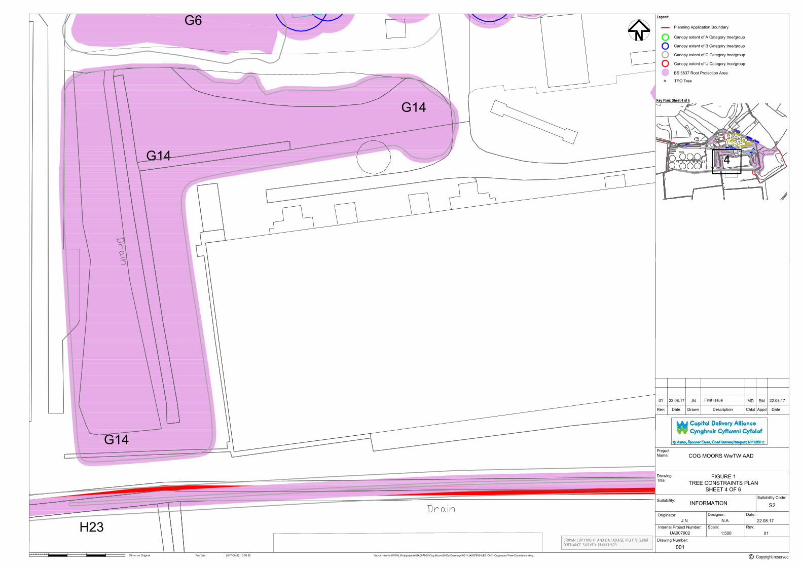
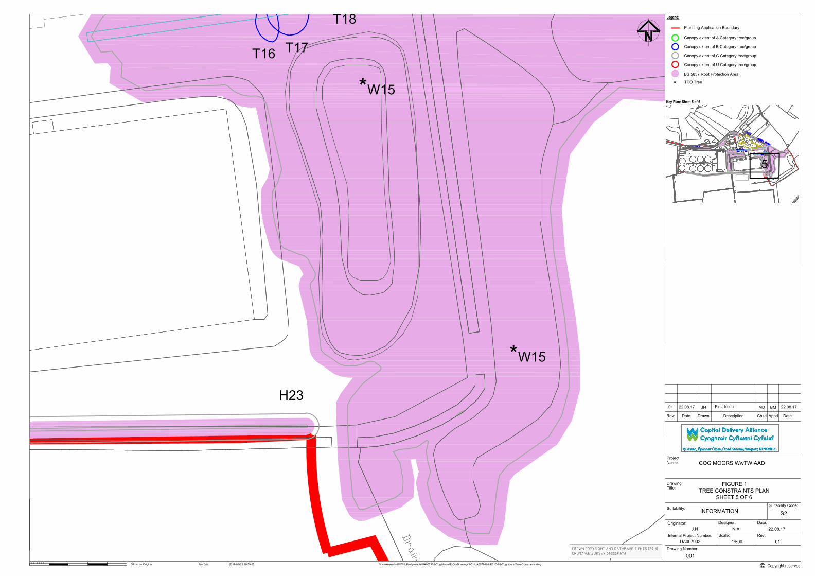
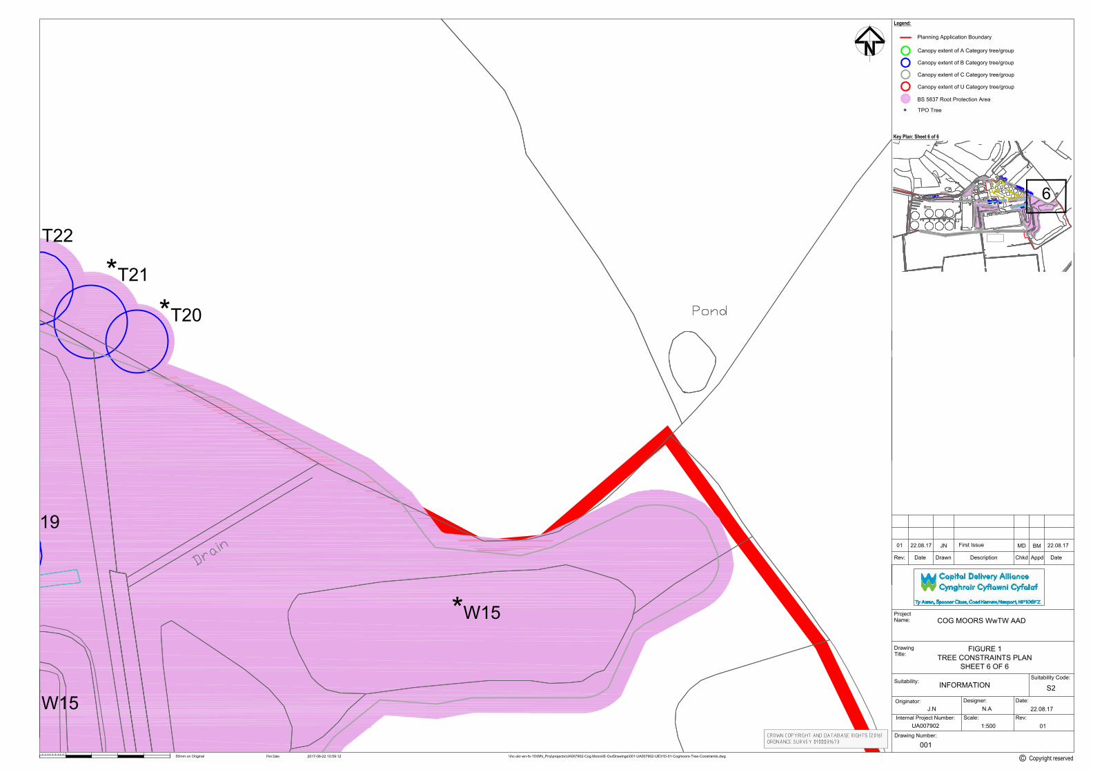
FIGURE 1. TREE CONSTRAINTS PLAN ......................................................................... 16
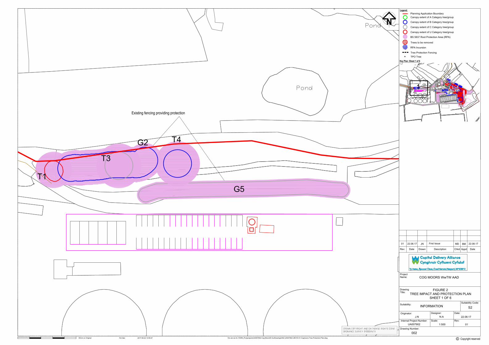
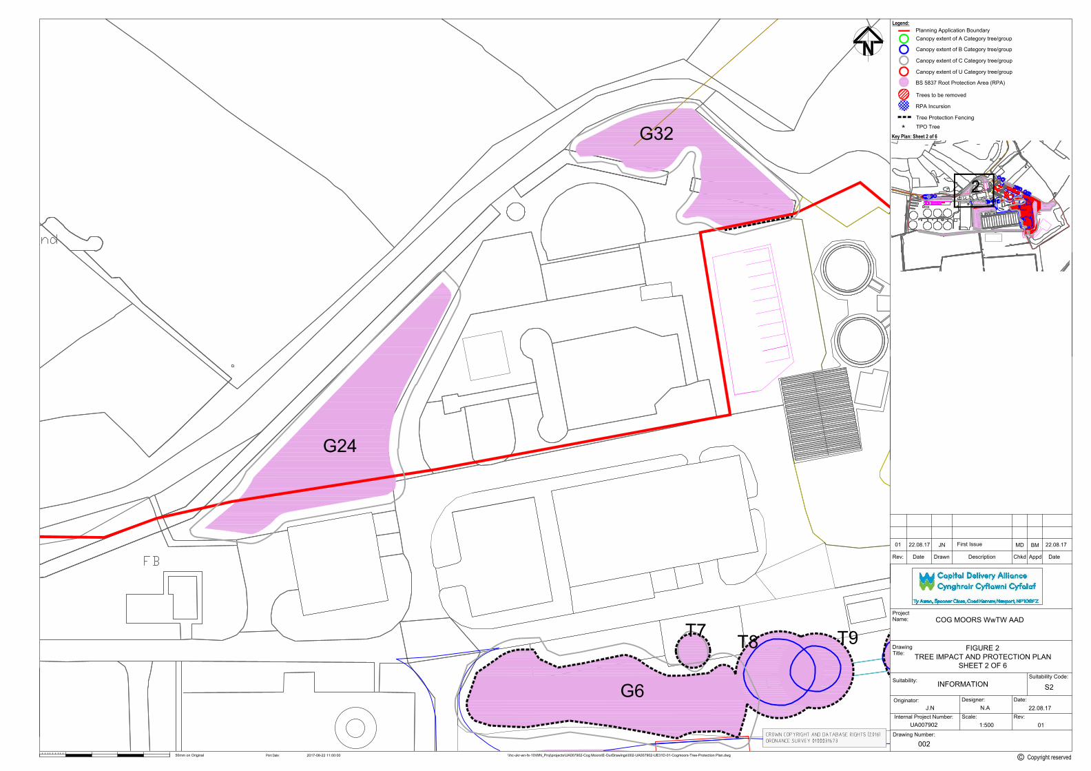
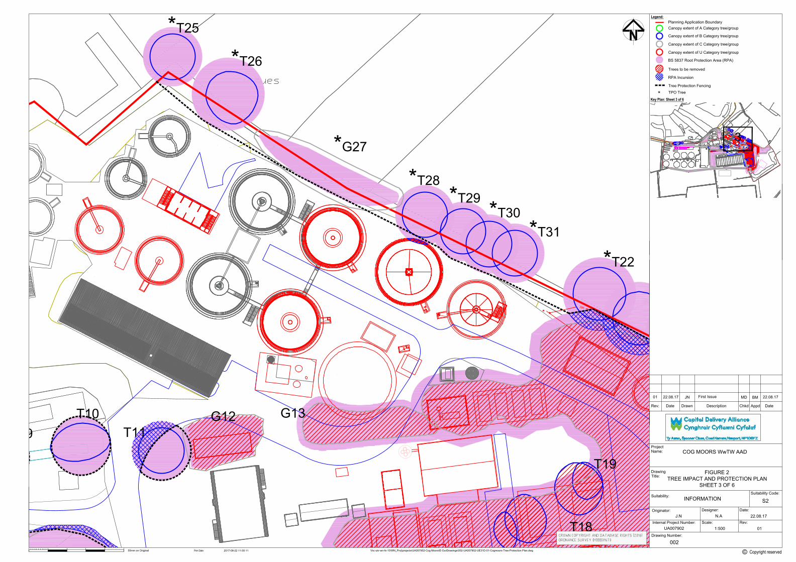
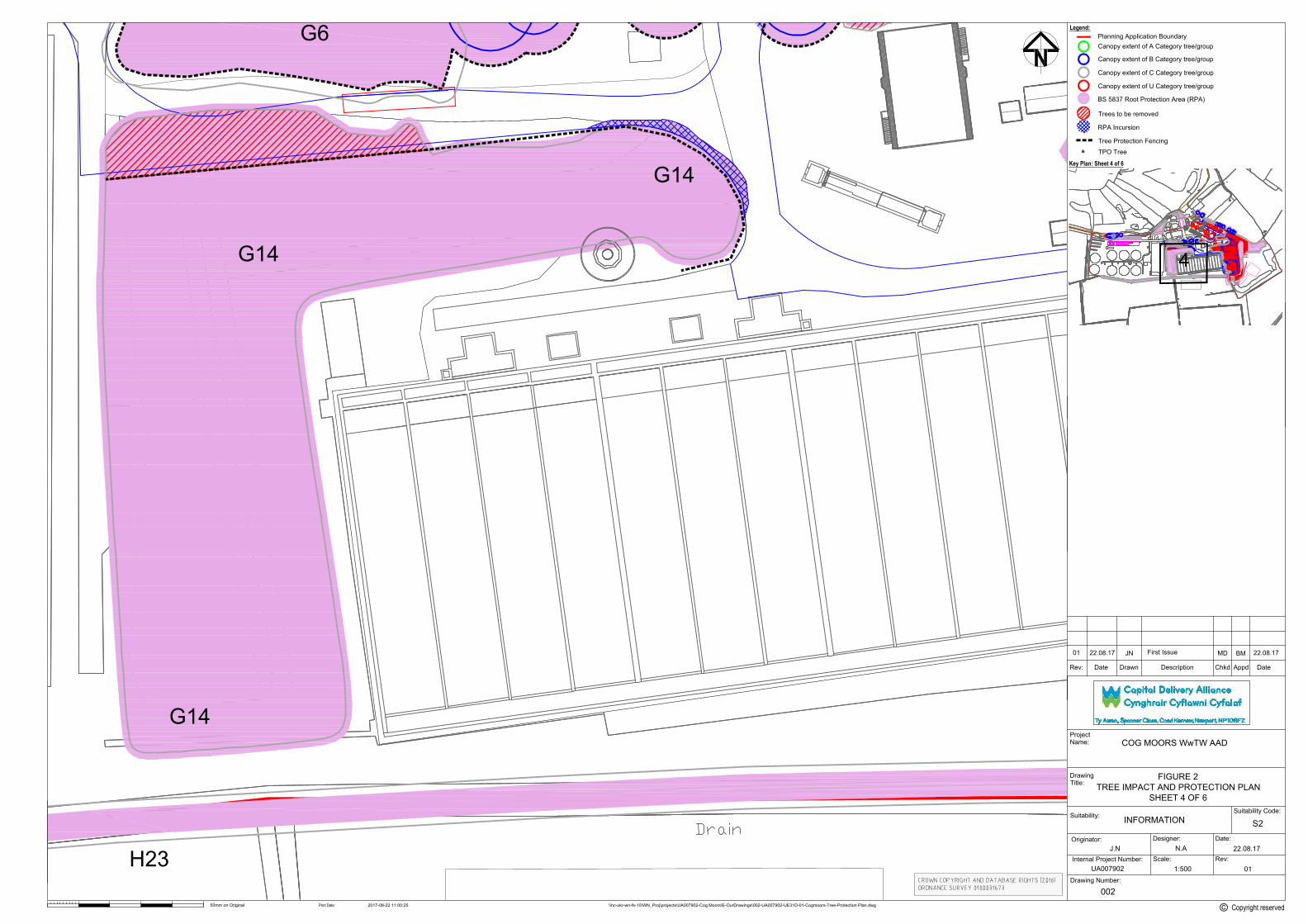
FIGURE 2. TREE IMPACT AND PROTECTION PLAN .................................................... 18
APPENDIX A. EXPLANATION OF TERMS ...................................................................... 20
APPENDIX B. TREE SCHEDULES .................................................................................. 22
APPENDIX C. PRELIMINARY METHOD STATEMENT ................................................... 31
APPENDIX D. PHOTOGRAPHS ....................................................................................... 36
COG MOORS WWTW – PROPOSED ADVANCED ANAEROBIC DIGESTION (AAD) PLANT BS 5837: 2012 Tree Survey Report and Arboricultural Impact Assessment
1
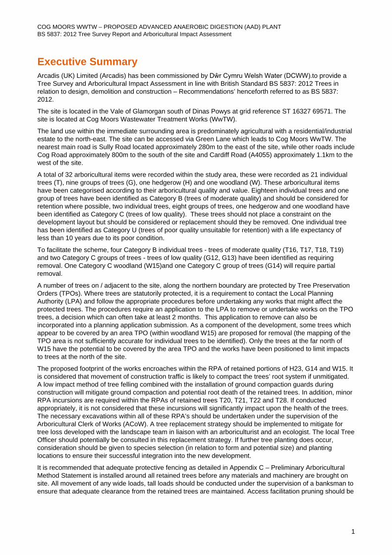
Executive Summary Arcadis (UK) Limited (Arcadis) has been commissioned by Dŵr Cymru Welsh Water (DCWW).to provide a Tree Survey and Arboricultural Impact Assessment in line with British Standard BS 5837: 2012 Trees in relation to design, demolition and construction – Recommendations’ henceforth referred to as BS 5837: 2012.
The site is located in the Vale of Glamorgan south of Dinas Powys at grid reference ST 16327 69571. The site is located at Cog Moors Wastewater Treatment Works (WwTW).
The land use within the immediate surrounding area is predominately agricultural with a residential/industrial estate to the north-east. The site can be accessed via Green Lane which leads to Cog Moors WwTW. The nearest main road is Sully Road located approximately 280m to the east of the site, while other roads include Cog Road approximately 800m to the south of the site and Cardiff Road (A4055) approximately 1.1km to the west of the site.
A total of 32 arboricultural items were recorded within the study area, these were recorded as 21 individual trees (T), nine groups of trees (G), one hedgerow (H) and one woodland (W). These arboricultural items have been categorised according to their arboricultural quality and value. Eighteen individual trees and one group of trees have been identified as Category B (trees of moderate quality) and should be considered for retention where possible, two individual trees, eight groups of trees, one hedgerow and one woodland have been identified as Category C (trees of low quality). These trees should not place a constraint on the development layout but should be considered or replacement should they be removed. One individual tree has been identified as Category U (trees of poor quality unsuitable for retention) with a life expectancy of less than 10 years due to its poor condition.
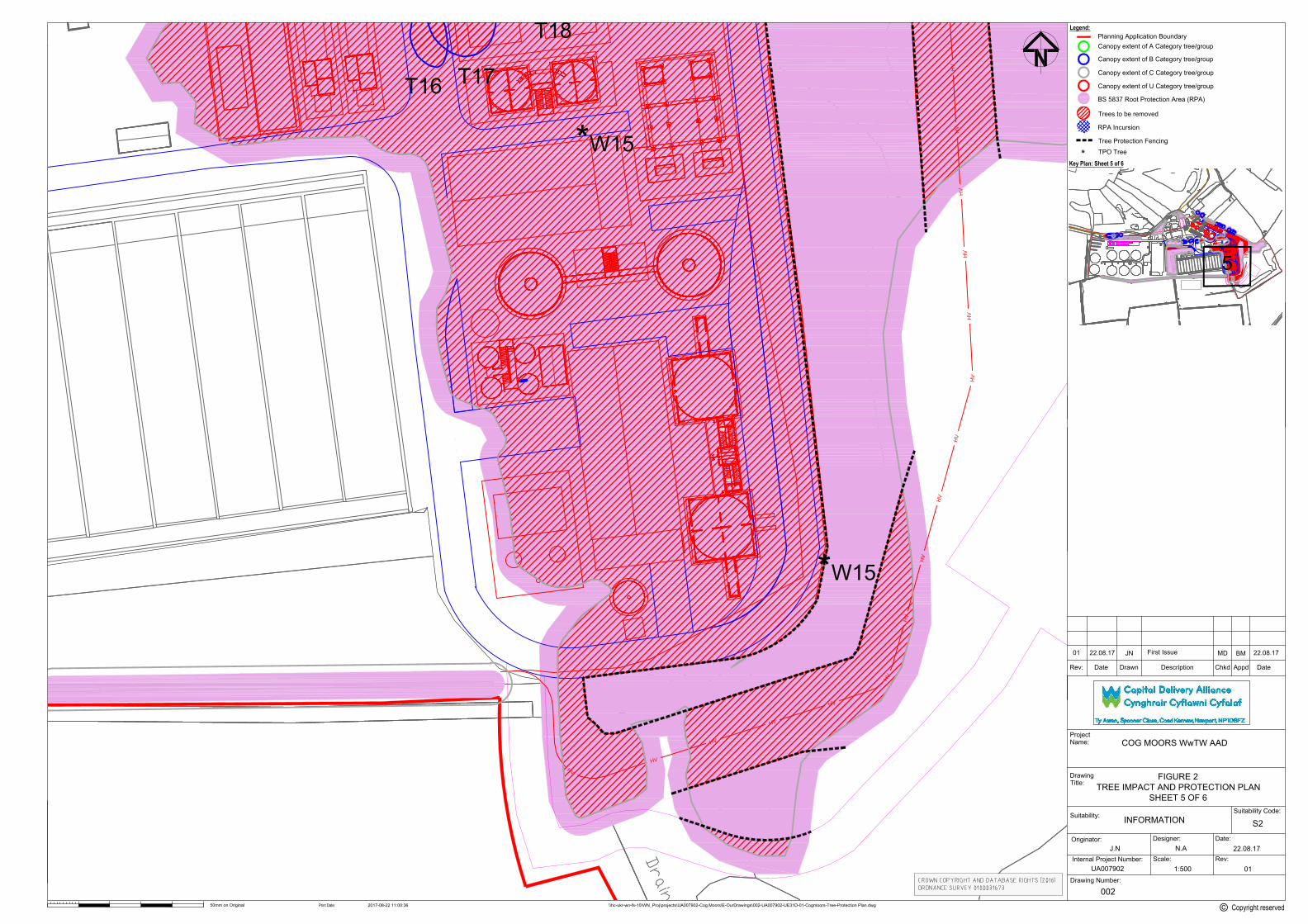
To facilitate the scheme, four Category B individual trees - trees of moderate quality (T16, T17, T18, T19) and two Category C groups of trees - trees of low quality (G12, G13) have been identified as requiring removal. One Category C woodland (W15)and one Category C group of trees (G14) will require partial removal.
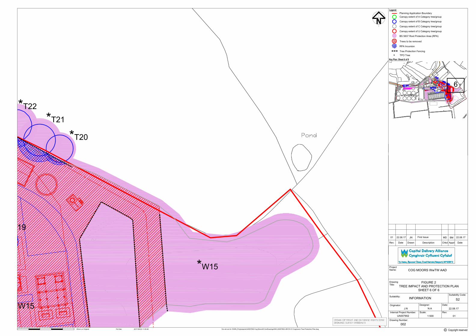
A number of trees on / adjacent to the site, along the northern boundary are protected by Tree Preservation Orders (TPOs). Where trees are statutorily protected, it is a requirement to contact the Local Planning Authority (LPA) and follow the appropriate procedures before undertaking any works that might affect the protected trees. The procedures require an application to the LPA to remove or undertake works on the TPO trees, a decision which can often take at least 2 months. This application to remove can also be incorporated into a planning application submission. As a component of the development, some trees which appear to be covered by an area TPO (within woodland W15) are proposed for removal (the mapping of the TPO area is not sufficiently accurate for individual trees to be identified). Only the trees at the far north of W15 have the potential to be covered by the area TPO and the works have been positioned to limit impacts to trees at the north of the site.
The proposed footprint of the works encroaches within the RPA of retained portions of H23, G14 and W15. It is considered that movement of construction traffic is likely to compact the trees’ root system if unmitigated. A low impact method of tree felling combined with the installation of ground compaction guards during construction will mitigate ground compaction and potential root death of the retained trees. In addition, minor RPA incursions are required within the RPAs of retained trees T20, T21, T22 and T28. If conducted appropriately, it is not considered that these incursions will significantly impact upon the health of the trees. The necessary excavations within all of these RPA’s should be undertaken under the supervision of the Arboricultural Clerk of Works (ACoW). A tree replacement strategy should be implemented to mitigate for tree loss developed with the landscape team in liaison with an arboriculturist and an ecologist. The local Tree Officer should potentially be consulted in this replacement strategy. If further tree planting does occur, consideration should be given to species selection (in relation to form and potential size) and planting locations to ensure their successful integration into the new development.
It is recommended that adequate protective fencing as detailed in Appendix C – Preliminary Arboricultural Method Statement is installed around all retained trees before any materials and machinery are brought on site. All movement of any wide loads, tall loads should be conducted under the supervision of a banksman to ensure that adequate clearance from the retained trees are maintained. Access facilitation pruning should be
COG MOORS WWTW – PROPOSED ADVANCED ANAEROBIC DIGESTION (AAD) PLANT BS 5837: 2012 Tree Survey Report and Arboricultural Impact Assessment
2
carried out where necessary to maintain this clearance. A bespoke AMS is likely to be required for any works which have the potential to impact retained trees.
It should also be noted that a number of trees within the site (including individuals, groups and trees within woodlands) were recorded as having potential to support roosting bats (in separate, associated ecology surveys). The majority of these trees are to be retained within the development. Some of the trees within W15 (which is to be partially removed) were identified as having have bat roosting potential. All necessary recommendations regarding bats are detailed in the Ecology Report (Arcadis July 2017).
All tree works must be carried out by a qualified contractor in accordance with BS3998: 2010: Tree Work – Recommendations.
COG MOORS WWTW – PROPOSED ADVANCED ANAEROBIC DIGESTION (AAD) PLANT BS 5837: 2012 Tree Survey Report and Arboricultural Impact Assessment
3
1 Introduction 1.1 Overview Arcadis Consulting (UK) Limited (Arcadis) has been commissioned by Dŵr Cymru Welsh Water (DCWW) to provide arboricultural services to support a planning application for a proposed scheme at a Site referred to as: Cog Moors Wastewater Treatment Works (WwTW).
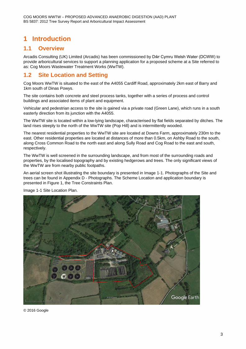
1.2 Site Location and Setting Cog Moors WwTW is situated to the east of the A4055 Cardiff Road, approximately 2km east of Barry and 1km south of Dinas Powys.
The site contains both concrete and steel process tanks, together with a series of process and control buildings and associated items of plant and equipment.
Vehicular and pedestrian access to the site is gained via a private road (Green Lane), which runs in a south easterly direction from its junction with the A4055.
The WwTW site is located within a low-lying landscape, characterised by flat fields separated by ditches. The land rises steeply to the north of the WwTW site (Pop Hill) and is intermittently wooded.
The nearest residential properties to the WwTW site are located at Downs Farm, approximately 230m to the east. Other residential properties are located at distances of more than 0.5km, on Ashby Road to the south, along Cross Common Road to the north east and along Sully Road and Cog Road to the east and south, respectively.
The WwTW is well screened in the surrounding landscape, and from most of the surrounding roads and properties, by the localised topography and by existing hedgerows and trees. The only significant views of the WwTW are from nearby public footpaths.
An aerial screen shot illustrating the site boundary is presented in Image 1-1. Photographs of the Site and trees can be found in Appendix D - Photographs. The Scheme Location and application boundary is presented in Figure 1, the Tree Constraints Plan.
Image 1-1 Site Location Plan.
© 2016 Google
COG MOORS WWTW – PROPOSED ADVANCED ANAEROBIC DIGESTION (AAD) PLANT BS 5837: 2012 Tree Survey Report and Arboricultural Impact Assessment
4
1.3 Proposed Scheme The proposed Advanced Anaerobic Digestion (AAD) plant comprises a number of new process and storage tanks and buildings, together with the demolition of and modifications to some existing items of plant and equipment.
The proposed development would provide for:
• Additional digestion capacity; • Conditioning of the sludge generated on the site, (dewatering and removal of contaminating rags and
plastic); • Reception facilities for sludge imported to the site from satellite WwTWs; • Blending of the indigenous sludge and imported sludge; • A thermal hydrolysis plant (THP), which uses steam to increase the temperature and pressure in a
reaction vessel to pre-treat the sludge; • Boilers to generate the steam for thermal hydrolysis; • A siloxane plant to remove contaminants from the biogas generated; • A combined heat and power (CHP) plant to generate useable heat and electricity, which can be used on
site, exported to the grid, or both. • A UV plant to treat some of the final effluent water from the WwTW, to provide better quality process
water, for the THP sludge preparation downstream of thermal hydrolysis; • Tanks to hold sludge and liquor, resulting from the thickening and dewatering processes; • A cake storage silo; • Odour control equipment; • New internal site access roads and drainage; • Site clearance and earthworks and new fencing; • New motor control centre (MCC) equipment and control kiosks; and • Appropriate mitigation planting and ecological mitigation measures; The proposed development will not involve the use of any hazardous substances in notifiable quantities.
Temporary construction compounds will be sited on an area of mown grassland, immediately adjacent to the existing final settlement tanks, and on an area of grassland to the east of the proposed AAD plant.
Vehicular access to the proposed development will continue to be gained from the A4055 via Green Lane.
In addition, an upgrade to the electricity connection will be required.
COG MOORS WWTW – PROPOSED ADVANCED ANAEROBIC DIGESTION (AAD) PLANT BS 5837: 2012 Tree Survey Report and Arboricultural Impact Assessment
5
2 Methodology 2.1 Tree Survey Methodology An Arboricultural Survey was undertaken by Martin Dilworth FdSc MArborA (Senior Arboriculturist) on 9th February 2017 in accordance with BS 5837:2012 Trees in Relation to Design, Demolition and Construction – Recommendations (British Standards Institution, 2012).
Observations were conducted from ground level, utilising the “Visual Tree Assessment” (VTA) system as outlined in The Body Language of Trees, A Handbook for Failure Analysis Research for Amenity Trees No.4 (Department of the Environment, 1994) with the aid of binoculars.
Individual trees and general data capture For reference, individual trees are identified with the letter T and associated number on the schedules and plan. The stem diameter of the trees on site was recorded using a rounded down diameter tape at 1.5m above ground level. Measurements were taken in millimetres. The height of the subject trees was estimated to the nearest metre using a digital clinometer.
Maximum crown spread of the subject tree was measured from the centre of the trunk to the tips of the live lateral branches taken at four compass points (N-E-S-W) using a ground tape. Crown spread measurements were taken in metres.
Tree age was estimated from visual indicators (such as tree size and appearance of bark) which was taken as a provisional guide. Age estimates often need to be modified based on further information such as historical records and local knowledge.
If direct access to the tree was not possible estimations from appropriate vantage points were taken, any limitations or estimations are presented within the survey limitations section and noted in the associated schedules.
Groups of trees Groups of trees are identified with the letter G and number on the associated schedules and plans. Stem diameter of groups of trees was set as an average stem diameter of the trees within these individual groups and a maximum height of the tallest tree within the group.
Woodlands Woodlands are identified with the letter W and number on the associated schedules and plans. A sample method for surveying woodlands has been used taking average measurements of stem diameter, crown spreads and heights from a selected sample area of woodland. The size and shape of the sample area varies depending on site access and topography.
Hedgerows Hedgerows are identified with the letter H and number on the associated schedules and plans. A 30m section of hedgerow has been surveyed for each hedgerow, recording the number of species, average stem diameter, and the maximum height. Any individual trees present within the hedgerow are recorded as individual trees.
Categorisation In compliance with Table 1 of BS 5837: 2012 the trees surveyed in this report have been categorised according to their arboricultural quality and value. A glossary of survey terms can be found in Appendix A - Explanation of Terms.
2.2 Arboricultural Impact Assessment Methodology The Arboricultural Impact Assessment (AIA) was undertaken by Martin Dilworth FdSc MArborA (Senior Arboriculturist) in July 2017 as a desk based study based on the collected field data and design details provided on behalf of the Client. Table 1 Data Sources, provides the data sources used.
COG MOORS WWTW – PROPOSED ADVANCED ANAEROBIC DIGESTION (AAD) PLANT BS 5837: 2012 Tree Survey Report and Arboricultural Impact Assessment
6
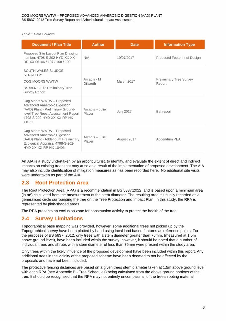
Table 1 Data Sources
Document / Plan Title Author Date Information Type
Proposed Site Layout Plan Drawing number: 4798-S-202-HYD-XX-XX-DR-XX-06106 / 107 / 108 / 109
N/A 19/07/2017 Proposed Footprint of Design
SOUTH WALES SLUDGE STRATEGY
COG MOORS WWTW
BS 5837: 2012 Preliminary Tree Survey Report
Arcadis - M Dilworth March 2017 Preliminary Tree Survey
Report
Cog Moors WwTW – Proposed Advanced Anaerobic Digestion (AAD) Plant - Preliminary Ground-level Tree Roost Assessment Report 4798-S-202-HYD-XX-XX-RP-NX-11021
Arcadis – Julie Player July 2017 Bat report
Cog Moors WwTW – Proposed Advanced Anaerobic Digestion (AAD) Plant - Addendum Preliminary Ecological Appraisal 4798-S-202-HYD-XX-XX-RP-NX-10406
Arcadis – Julie Player August 2017 Addendum PEA
An AIA is a study undertaken by an arboriculturist, to identify, and evaluate the extent of direct and indirect impacts on existing trees that may arise as a result of the implementation of proposed development. The AIA may also include identification of mitigation measures as has been recorded here. No additional site visits were undertaken as part of the AIA.
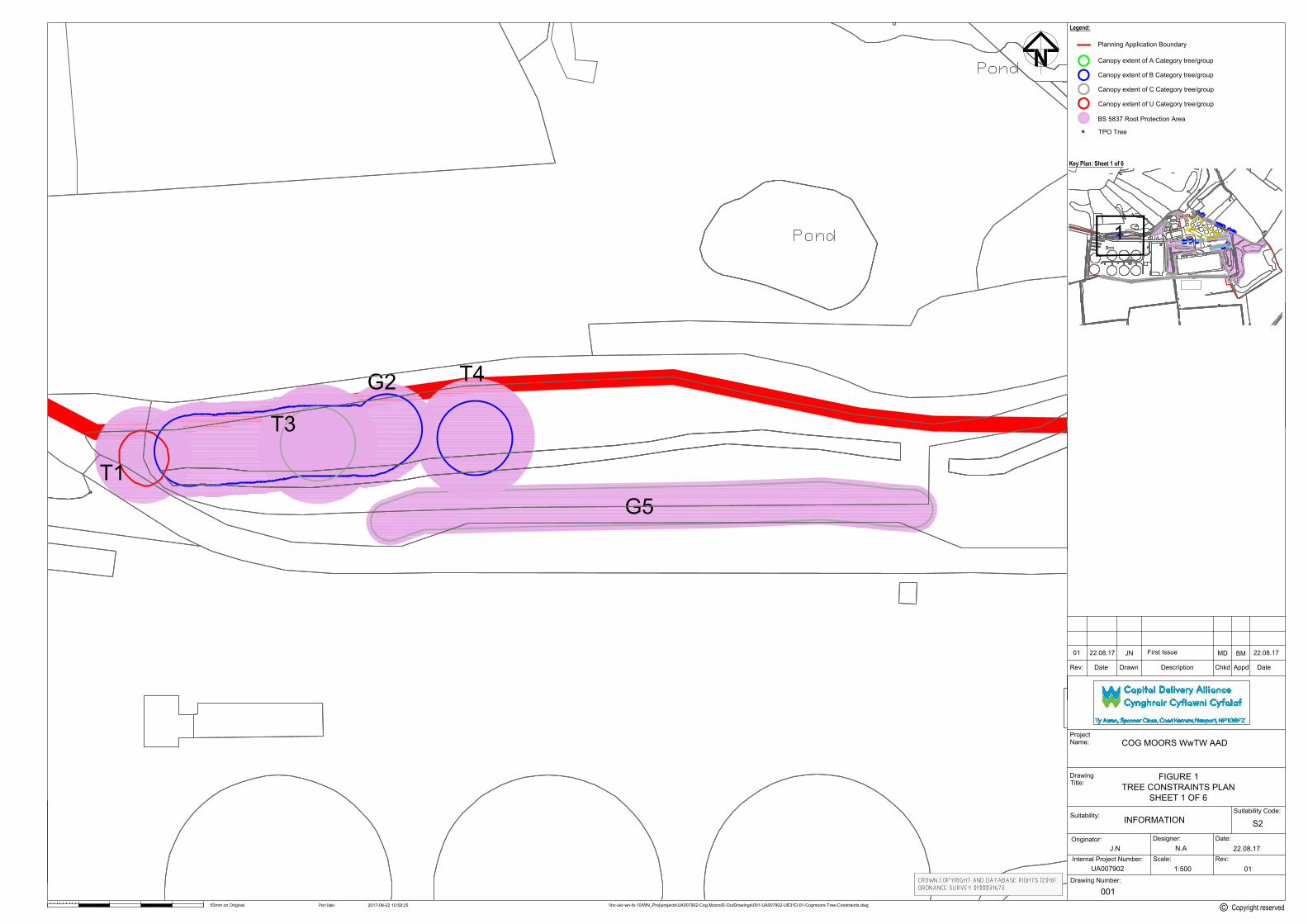
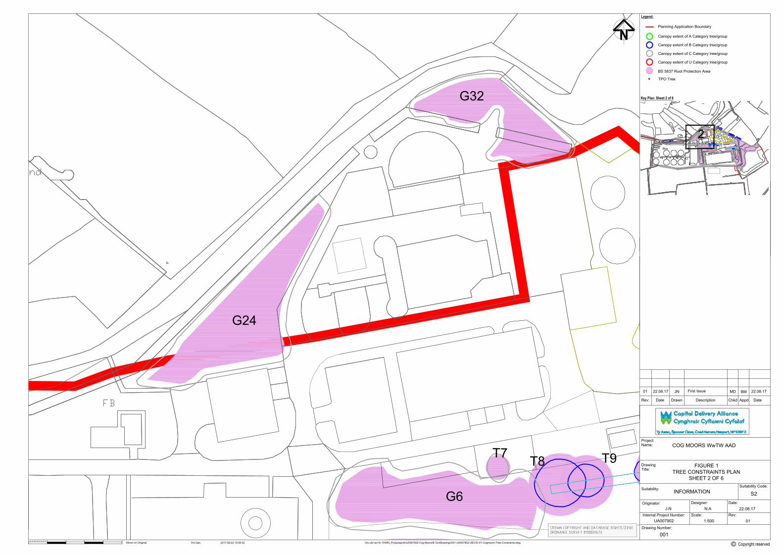
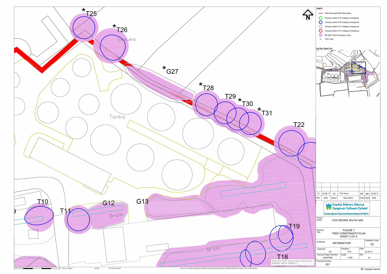
2.3 Root Protection Area The Root Protection Area (RPA) is a recommendation in BS 5837:2012, and is based upon a minimum area (in m2) calculated from the measurement of the stem diameter. The resulting area is usually recorded as a generalised circle surrounding the tree on the Tree Protection and Impact Plan. In this study, the RPA is represented by pink-shaded areas.
The RPA presents an exclusion zone for construction activity to protect the health of the tree.
2.4 Survey Limitations Topographical base mapping was provided, however, some additional trees not picked up by the Topographical survey have been plotted by hand using local land based features as reference points. For the purposes of BS 5837: 2012, only trees with a stem diameter greater than 75mm, (measured at 1.5m above ground level), have been included within the survey; however, it should be noted that a number of individual trees and shrubs with a stem diameter of less than 75mm were present within the study area.
Only trees within the likely influence of the proposed development have been included within this report. Any additional trees in the vicinity of the proposed scheme have been deemed to not be affected by the proposals and have not been included.
The protective fencing distances are based on a given trees stem diameter taken at 1.5m above ground level with each RPA (see Appendix B - Tree Schedules) being calculated from the above ground portions of the tree. It should be recognised that the RPA may not entirely encompass all of the tree’s rooting material.
COG MOORS WWTW – PROPOSED ADVANCED ANAEROBIC DIGESTION (AAD) PLANT BS 5837: 2012 Tree Survey Report and Arboricultural Impact Assessment
7
Some areas of the site were inaccessible due to dense undergrowth preventing a full assessment and an accurate measurement of some trees. Where tree survey data has been estimated (based on assessments from the nearest safe vantage points), these trees are denoted by a # in the associated Schedules.
Trees are living organisms and as such their health and condition are naturally subject to change over time. Unforeseen future circumstances such as neglect, wilful damage or severe/extreme weather conditions may affect the future health and condition of the trees included in this report.
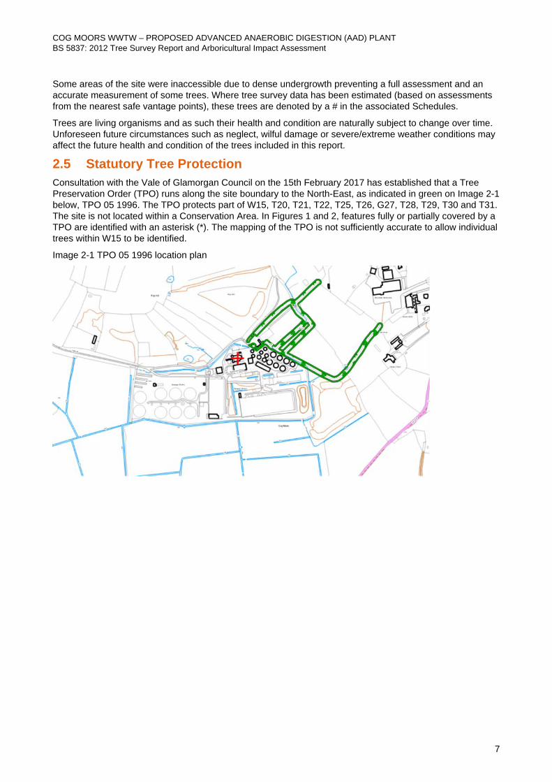
2.5 Statutory Tree Protection Consultation with the Vale of Glamorgan Council on the 15th February 2017 has established that a Tree Preservation Order (TPO) runs along the site boundary to the North-East, as indicated in green on Image 2-1 below, TPO 05 1996. The TPO protects part of W15, T20, T21, T22, T25, T26, G27, T28, T29, T30 and T31. The site is not located within a Conservation Area. In Figures 1 and 2, features fully or partially covered by a TPO are identified with an asterisk (*). The mapping of the TPO is not sufficiently accurate to allow individual trees within W15 to be identified.
Image 2-1 TPO 05 1996 location plan
COG MOORS WWTW – PROPOSED ADVANCED ANAEROBIC DIGESTION (AAD) PLANT BS 5837: 2012 Tree Survey Report and Arboricultural Impact Assessment
8
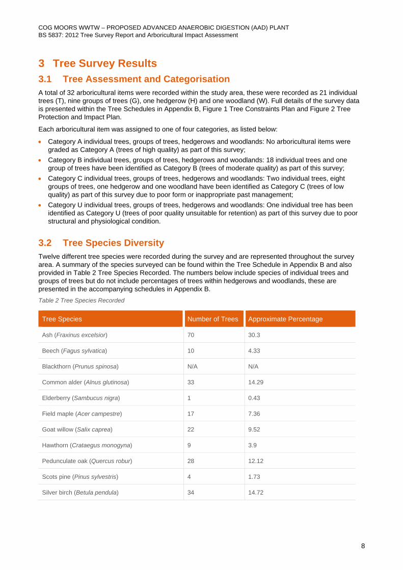
3 Tree Survey Results 3.1 Tree Assessment and Categorisation A total of 32 arboricultural items were recorded within the study area, these were recorded as 21 individual trees (T), nine groups of trees (G), one hedgerow (H) and one woodland (W). Full details of the survey data is presented within the Tree Schedules in Appendix B, Figure 1 Tree Constraints Plan and Figure 2 Tree Protection and Impact Plan.
Each arboricultural item was assigned to one of four categories, as listed below:
• Category A individual trees, groups of trees, hedgerows and woodlands: No arboricultural items were graded as Category A (trees of high quality) as part of this survey;
• Category B individual trees, groups of trees, hedgerows and woodlands: 18 individual trees and one group of trees have been identified as Category B (trees of moderate quality) as part of this survey;
• Category C individual trees, groups of trees, hedgerows and woodlands: Two individual trees, eight groups of trees, one hedgerow and one woodland have been identified as Category C (trees of low quality) as part of this survey due to poor form or inappropriate past management;
• Category U individual trees, groups of trees, hedgerows and woodlands: One individual tree has been identified as Category U (trees of poor quality unsuitable for retention) as part of this survey due to poor structural and physiological condition.
3.2 Tree Species Diversity Twelve different tree species were recorded during the survey and are represented throughout the survey area. A summary of the species surveyed can be found within the Tree Schedule in Appendix B and also provided in Table 2 Tree Species Recorded. The numbers below include species of individual trees and groups of trees but do not include percentages of trees within hedgerows and woodlands, these are presented in the accompanying schedules in Appendix B. Table 2 Tree Species Recorded
Tree Species Number of Trees Approximate Percentage
Ash (Fraxinus excelsior) 70 30.3
Beech (Fagus sylvatica) 10 4.33
Blackthorn (Prunus spinosa) N/A N/A
Common alder (Alnus glutinosa) 33 14.29
Elderberry (Sambucus nigra) 1 0.43
Field maple (Acer campestre) 17 7.36
Goat willow (Salix caprea) 22 9.52
Hawthorn (Crataegus monogyna) 9 3.9
Pedunculate oak (Quercus robur) 28 12.12
Scots pine (Pinus sylvestris) 4 1.73
Silver birch (Betula pendula) 34 14.72
COG MOORS WWTW – PROPOSED ADVANCED ANAEROBIC DIGESTION (AAD) PLANT BS 5837: 2012 Tree Survey Report and Arboricultural Impact Assessment
9
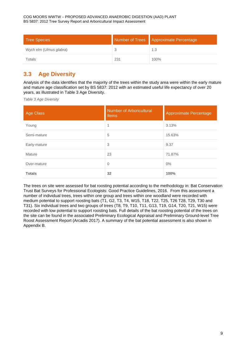
Tree Species Number of Trees Approximate Percentage
Wych elm (Ulmus glabra) 3 1.3
Totals 231 100%
3.3 Age Diversity Analysis of the data identifies that the majority of the trees within the study area were within the early mature and mature age classification set by BS 5837: 2012 with an estimated useful life expectancy of over 20 years, as illustrated in Table 3 Age Diversity. Table 3 Age Diversity
Age Class Number of Arboricultural Items Approximate Percentage
Young 1 3.13%
Semi-mature 5 15.63%
Early-mature 3 9.37
Mature 23 71.87%
Over-mature 0 0%
Totals 32 100%
The trees on site were assessed for bat roosting potential according to the methodology in: Bat Conservation Trust Bat Surveys for Professional Ecologists: Good Practice Guidelines, 2016. From this assessment a number of individual trees, trees within one group and trees within one woodland were recorded with medium potential to support roosting bats (T1, G2, T3, T4, W15, T18, T22, T25, T26 T28, T29, T30 and T31). Six individual trees and two groups of trees (T8, T9, T10, T11, G13, T19, G14, T20, T21, W15) were recorded with low potential to support roosting bats. Full details of the bat roosting potential of the trees on the site can be found in the associated Preliminary Ecological Appraisal and Preliminary Ground-level Tree Roost Assessment Report (Arcadis 2017). A summary of the bat potential assessment is also shown in Appendix B.
COG MOORS WWTW – PROPOSED ADVANCED ANAEROBIC DIGESTION (AAD) PLANT BS 5837: 2012 Tree Survey Report and Arboricultural Impact Assessment
10
4 Arboricultural Impact Assessment (AIA) 4.1 Potential Arboricultural Impacts Development can have an adverse impact on trees and other woody vegetation within a site. This can result in: (1) immediate vegetation removal to facilitate the footprint of a new development; (2) potential future tree loss through the early decline of trees due to soil compaction; and (3) root disturbance and damage within a tree’s rooting area.
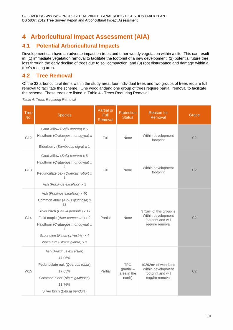
4.2 Tree Removal Of the 32 arboricultural items within the study area, four individual trees and two groups of trees require full removal to facilitate the scheme. One woodlandand one group of trees require partial removal to facilitate the scheme. These trees are listed in Table 4 - Trees Requiring Removal. Table 4: Trees Requiring Removal
Tree No. Species
Partial or Full
Removal
Protection Status
Reason for Removal Grade
G12
Goat willow (Salix caprea) x 5
Hawthorn (Crataegus monogyna) x 1
Elderberry (Sambucus nigra) x 1
Full None Within development footprint C2
G13
Goat willow (Salix caprea) x 5
Hawthorn (Crataegus monogyna) x 4
Pedunculate oak (Quercus robur) x 1
Ash (Fraxinus excelsior) x 1
Full None Within development footprint C2
G14
Ash (Fraxinus excelsior) x 40
Common alder (Alnus glutinosa) x 22
Silver birch (Betula pendula) x 17
Field maple (Acer campestre) x 9
Hawthorn (Crataegus monogyna) x 4
Scots pine (Pinus sylvestris) x 4
Wych elm (Ulmus glabra) x 3
Partial None
371m2 of this group is Within development
footprint and will require removal
C2
W15
Ash (Fraxinus excelsior)
47.06%
Pedunculate oak (Quercus robur)
17.65%
Common alder (Alnus glutinosa)
11.76%
Silver birch (Betula pendula)
Partial
TPO (partial –
area in the north)
10292m2 of woodland Within development
footprint and will require removal
C2
COG MOORS WWTW – PROPOSED ADVANCED ANAEROBIC DIGESTION (AAD) PLANT BS 5837: 2012 Tree Survey Report and Arboricultural Impact Assessment
11
Tree No. Species
Partial or Full
Removal
Protection Status
Reason for Removal Grade
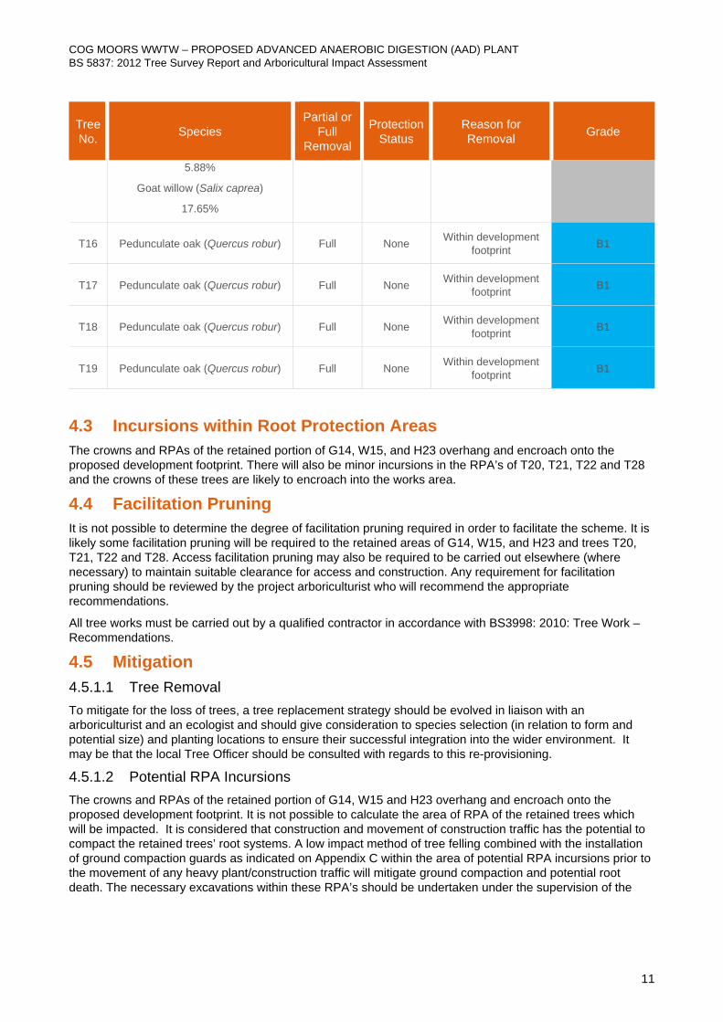
5.88%
Goat willow (Salix caprea)
17.65%
T16 Pedunculate oak (Quercus robur) Full None Within development footprint B1
T17 Pedunculate oak (Quercus robur) Full None Within development footprint B1
T18 Pedunculate oak (Quercus robur) Full None Within development footprint B1
T19 Pedunculate oak (Quercus robur) Full None Within development footprint B1
4.3 Incursions within Root Protection Areas The crowns and RPAs of the retained portion of G14, W15, and H23 overhang and encroach onto the proposed development footprint. There will also be minor incursions in the RPA’s of T20, T21, T22 and T28 and the crowns of these trees are likely to encroach into the works area.
4.4 Facilitation Pruning It is not possible to determine the degree of facilitation pruning required in order to facilitate the scheme. It is likely some facilitation pruning will be required to the retained areas of G14, W15, and H23 and trees T20, T21, T22 and T28. Access facilitation pruning may also be required to be carried out elsewhere (where necessary) to maintain suitable clearance for access and construction. Any requirement for facilitation pruning should be reviewed by the project arboriculturist who will recommend the appropriate recommendations.
All tree works must be carried out by a qualified contractor in accordance with BS3998: 2010: Tree Work – Recommendations.
4.5 Mitigation 4.5.1.1 Tree Removal To mitigate for the loss of trees, a tree replacement strategy should be evolved in liaison with an arboriculturist and an ecologist and should give consideration to species selection (in relation to form and potential size) and planting locations to ensure their successful integration into the wider environment. It may be that the local Tree Officer should be consulted with regards to this re-provisioning.
4.5.1.2 Potential RPA Incursions The crowns and RPAs of the retained portion of G14, W15 and H23 overhang and encroach onto the proposed development footprint. It is not possible to calculate the area of RPA of the retained trees which will be impacted. It is considered that construction and movement of construction traffic has the potential to compact the retained trees’ root systems. A low impact method of tree felling combined with the installation of ground compaction guards as indicated on Appendix C within the area of potential RPA incursions prior to the movement of any heavy plant/construction traffic will mitigate ground compaction and potential root death. The necessary excavations within these RPA’s should be undertaken under the supervision of the

COG MOORS WWTW – PROPOSED ADVANCED ANAEROBIC DIGESTION (AAD) PLANT BS 5837: 2012 Tree Survey Report and Arboricultural Impact Assessment
12
Arboricultural Clerk of Works (ACoW). A bespoke AMS is likely to be required for the proposed works which have potential to impact these arboricultural features.
Trees T11, T20, T21, T22 and T28 will have minor RPA incursions as a result of the works. These incursions are small in area and it is assessed that if conducted appropriately (see mitigation below) these incursions should not significantly impact upon the health of the tree. A bespoke AMS is likely to be required for the proposed works which have potential to impact these arboricultural features.
The RPA’s for the other retained trees should be regarded as an absolute restricted zone and fencing to protect these areas should be installed prior to construction works commencing and plant and machinery arriving on site. The fencing should remain intact throughout the duration of the scheme and only be removed upon completion.
4.5.1.3 General Mitigation It is recommended that adequate protective fencing as detailed in Appendix C - Preliminary Arboricultural Method Statement is installed around all retained trees before any materials and machinery are brought on site.
Adequate protective fencing as detailed in Appendix C - Preliminary Method Statement should be installed around all retained trees, where practical, before any materials and machinery are brought on site.
Site operations involving plant with booms, jibs and counterweights should be planned in advance to prevent contact with retained trees. All operations involving such plant in close proximity to trees should be conducted under the supervision of a banksman to ensure that adequate clearance from the retained trees is maintained.
It is recommended that some of the construction works are carried out under a watching brief, (i.e. supervision and monitoring of the construction) by an Arboricultural Clerk of Works (ACoW) at intervals agreed at a pre-commencement site meeting. The interval should be sufficiently flexible to allow the supervision of key works as they occur.
5 Arboricultural Clerk of Works (ACoW) Roles and Responsibilities The role of site supervision should be carried out be an appropriately qualified arboriculturist with a minimum qualification recognised by the Arboricultural Association at level 3.
The Arboricultural Clerk of Works (ACoW) will assess the proposed fencing distances during the pre-commencement meeting (as informed by the initial AIA) and modify the position of fencing to accommodate any variations in RPA sizes and ensure tree protection barriers are appropriately located.
When the tree protection barriers have to be moved to allow for works within the RPA’s of retained trees the ACoW will monitor these movements and the RPA incursion works will be supervised by the ACoW. These works will likely need to be conducted according to the prescriptions of a bespoke AMS.
The AMS will cover all works inside the RPA of retained trees, including: removal of the current kerbing and excavation works within the current areas of hard and soft landscape within the site. The ACoW will ensure that the roots of the trees within the RPA’s are protected in accordance with Section 7.2 BS5638:2012. These protection measures will be recorded in an AMS and may include the following:
– Exposed roots will be protected from desiccation and significant changes in temperature as directed by the ACoW;
– Removal of roots occurring in clumps of greater than 25 mm diameter will be undertaken with consultation of the ACoW;
– All roots will be removed by clean secateurs or a handsaw in accordance with the Forestry Commission biosecurity measures will be supervised by the ACoW;
– The backfilling of retained roots will be undertaken directly and supervised by the ACoW; – Monitoring of compliance will be undertaken at intervals advised by the ACoW. – Hand digging may be recommended by the ACoW

COG MOORS WWTW – PROPOSED ADVANCED ANAEROBIC DIGESTION (AAD) PLANT BS 5837: 2012 Tree Survey Report and Arboricultural Impact Assessment
13
Supervision will be required for relocation of the tree protection barriers and works within the RPA’s. In addition, once all the construction works have been completed a re-inspection of the retained trees should occur to ensure that the mitigation measures were successful. This should occur one to three months after all active associated with the construction of the approved development has ceased within the site.
Should any other tree-related problems arise on site, the site manager will immediately inform the appointed ACoW who will assess the situation and make recommendations accordingly.
All tree works must be carried out by a qualified contractor in accordance with BS3998:2010: Tree Work – Recommendations.
COG MOORS WWTW – PROPOSED ADVANCED ANAEROBIC DIGESTION (AAD) PLANT BS 5837: 2012 Tree Survey Report and Arboricultural Impact Assessment
14
6 DISCUSSION AND CONCLUSIONS A total of 32 arboricultural items were recorded within the study area, these were recorded as 21 individual trees (T), nine groups of trees (G), one hedgerow (H) and one woodland (W). Eighteen individual trees and one group of trees were identified as Category B (trees of moderate quality) and should be considered for retention where possible, two individual trees, eight groups of trees, one hedgerow and one woodland were identified as Category C (trees of low quality). These trees should not place a constraint on the development layout but should be considered or replacement should they be removed. One individual tree was identified as Category U (trees of poor quality unsuitable for retention) with a life expectancy of less than 10 years and is unsuitable for retention.
To facilitate the design proposal, a total of four Category B individual trees and two Category C groups of trees will require full removal. One woodland and one tree group (all Category C) will require partial removal to facilitate the scheme footprint.
A number of trees on / adjacent to the site, along the northern boundary are protected by Tree Preservation Orders (TPOs). Where trees are statutorily protected, it is a requirement to contact the Local Planning Authority (LPA) and follow the appropriate procedures before undertaking any works that might affect the protected trees. The procedures require an application to the LPA to remove or undertake works on the TPO trees, a decision which can often take at least 2 months. This application to remove can also be incorporated into a planning application submission. As a component of the development, some trees which appear to be covered by an area TPO (within woodland W15) are proposed for removal (the mapping of the TPO area is not sufficiently accurate for individual trees to be identified). Only the trees at the far north of W15 have the potential to be covered by the area TPO and the works have been positioned to limit impacts to trees along the northern boundary of the site.
It should also be noted that trees, groups of trees and a woodland were recorded with potential to support roosting bats. Should any of these trees require removal further assessment with regards to roosting bats is likely to be required prior to felling.
Some retained trees will have their RPAs impacted. Construction activities in these areas must be conducted in a manner to ensure that the health of the trees is not impacted.
Replacement tree planting mitigation should be developed which may require consultation with the local Tree Officer.
The Preliminary Arboricultural Method Statement (AMS) provided in Appendix C, gives general guidance on tree protection measures and mitigation. Site supervision by an Arboricultural Clerk of Works (ACoW) is also recommended. A bespoke AMS is likely to be required for the proposed works impacting retained trees when further construction details are determined.
All tree works must be carried out by a qualified contractor in accordance with BS3998: 2010: Tree Work – Recommendations.
COG MOORS WWTW – PROPOSED ADVANCED ANAEROBIC DIGESTION (AAD) PLANT BS 5837: 2012 Tree Survey Report and Arboricultural Impact Assessment
15
7 REFERENCES Arcadis (July 2017) - Cog Moors WwTW – Proposed Advanced Anaerobic Digestion (AAD) Plant - Preliminary Ground-level Tree Roost Assessment Report 4798-S-202-HYD-XX-XX-RP-XX-11021
Arcadis (August 2017) - Cog Moors WwTW – Proposed Advanced Anaerobic Digestion (AAD) Plant - Addendum Preliminary Ecological Appraisal 4798-S-202-HYD-XX-XX-RP-NX-10406
British Standards Institution (2012) BS 5837: 2012 Trees in relation to design, demolition and construction – Recommendations.
Collins, (ed) (2016) Bat Conservation Trust Bat Surveys for Professional Ecologists: Good Practice Guidelines, 2016
Mattheck, C. and Broeler, H. DETR (1994) The Body Language of Trees: A Handbook for Failure Analysis Research for Amenity Trees No.4.
British Standards Institution (2010) BS 3998:2010, Tree Work Recommendations.
16
FIGURE 1. Tree Constraints Plan
*W15
T16
T17
T18
T19
T1
G2
T4
G5
T3
H23
G14
G6
T7
T8
T9
T10
G32
G24
*T25
*T26
*G27
*T28
T29
*T30
*T31
T11
G12
G13
T22
H23
G14
*T21
G14
*T20
*W15
*W15
T1
G2
T4
G5
T3
Print Date: 2017-08-22 10:58:25 \\hc-ukr-wn-fs-10\WN_Proj\projects\UA007902-Cog Moors\E-OurDrawings\001-UA007902-UE31D-01-Cogmoors-Tree-Constraints.dwg50mm on Original
Legend:
©
Copyright reserved
Canopy extent of A Category tree/group
Canopy extent of B Category tree/group
Canopy extent of C Category tree/group
Canopy extent of U Category tree/group
BS 5837 Root Protection Area
Planning Application Boundary
1
Key Plan: Sheet 1 of 6
TPO Tree
*
Drawing Number:
Internal Project Number:
Suitability:
Originator:
Designer:
Drawing
Title:
Project
Name:
Scale:
Date:
Rev:
Rev: Date Drawn Description Chkd Appd Date
Suitability Code:
01 22.08.17JN
First Issue
MDBM
22.08.17
COG MOORS WwTW AAD
FIGURE 1
TREE CONSTRAINTS PLAN
SHEET 1 OF 6
INFORMATION
J.N
UA007902
001
N.A22.08.17
1:500 01
S2
G6
T7
T8
T9
G32
G24
*W15
T16
T17
T18
T19
T1
G2
T4
G5
T3
H23
G14
G6
T7
T8
T9
T10
G32
G24
*T25
*T26
*G27
*T28
T29
*T30
*T31
T11
G12
G13
T22
H23
G14
*T21
G14
*T20
*W15
*W15
Print Date: 2017-08-22 10:58:32 \\hc-ukr-wn-fs-10\WN_Proj\projects\UA007902-Cog Moors\E-OurDrawings\001-UA007902-UE31D-01-Cogmoors-Tree-Constraints.dwg50mm on Original
Legend:
©
Copyright reserved
Canopy extent of A Category tree/group
Canopy extent of B Category tree/group
Canopy extent of C Category tree/group
Canopy extent of U Category tree/group
BS 5837 Root Protection Area
Planning Application Boundary
2
Key Plan: Sheet 2 of 6
TPO Tree
*
Drawing Number:
Internal Project Number:
Suitability:
Originator:
Designer:
Drawing
Title:
Project
Name:
Scale:
Date:
Rev:
Rev: Date Drawn Description Chkd Appd Date
Suitability Code:
01 22.08.17JN
First Issue
MDBM
22.08.17
COG MOORS WwTW AAD
FIGURE 1
TREE CONSTRAINTS PLAN
SHEET 2 OF 6
INFORMATION
J.N
UA007902
001
N.A22.08.17
1:500 01
S2
T17
T18
T19
T9
T10
*T25
*T26
*G27
*T28
T29
*T30
*T31
T11
G12
G13
T22
*W15
T16
T17
T18
T19
T1
G2
T4
G5
T3
H23
G14
G6
T7
T8
T9
T10
G32
G24
*T25
*T26
*G27
*T28
T29
*T30
*T31
T11
G12
G13
T22
H23
G14
*T21
G14
*T20
*W15
*W15
Print Date: 2017-08-22 10:58:42 \\hc-ukr-wn-fs-10\WN_Proj\projects\UA007902-Cog Moors\E-OurDrawings\001-UA007902-UE31D-01-Cogmoors-Tree-Constraints.dwg50mm on Original
Legend:
©
Copyright reserved
Canopy extent of A Category tree/group
Canopy extent of B Category tree/group
Canopy extent of C Category tree/group
Canopy extent of U Category tree/group
BS 5837 Root Protection Area
Planning Application Boundary
3
Key Plan: Sheet 3 of 6
TPO Tree
*
Drawing Number:
Internal Project Number:
Suitability:
Originator:
Designer:
Drawing
Title:
Project
Name:
Scale:
Date:
Rev:
Rev: Date Drawn Description Chkd Appd Date
Suitability Code:
01 22.08.17JN
First Issue
MDBM
22.08.17
COG MOORS WwTW AAD
FIGURE 1
TREE CONSTRAINTS PLAN
SHEET 3 OF 6
INFORMATION
J.N
UA007902
001
N.A22.08.17
1:500 01
S2
H23
G14
G6
G14
G14
*W15
T16
T17
T18
T19
T1
G2
T4
G5
T3
H23
G14
G6
T7
T8
T9
T10
G32
G24
*T25
*T26
*G27
*T28
T29
*T30
*T31
T11
G12
G13
T22
H23
G14
*T21
G14
*T20
*W15
*W15
Print Date: 2017-08-22 10:58:52 \\hc-ukr-wn-fs-10\WN_Proj\projects\UA007902-Cog Moors\E-OurDrawings\001-UA007902-UE31D-01-Cogmoors-Tree-Constraints.dwg50mm on Original
Legend:
©
Copyright reserved
Canopy extent of A Category tree/group
Canopy extent of B Category tree/group
Canopy extent of C Category tree/group
Canopy extent of U Category tree/group
BS 5837 Root Protection Area
Planning Application Boundary
4
Key Plan: Sheet 4 of 6
TPO Tree
*
Drawing Number:
Internal Project Number:
Suitability:
Originator:
Designer:
Drawing
Title:
Project
Name:
Scale:
Date:
Rev:
Rev: Date Drawn Description Chkd Appd Date
Suitability Code:
01 22.08.17JN
First Issue
MDBM
22.08.17
COG MOORS WwTW AAD
FIGURE 1
TREE CONSTRAINTS PLAN
SHEET 4 OF 6
INFORMATION
J.N
UA007902
001
N.A22.08.17
1:500 01
S2
*W15
T16
T17
T18
H23
*W15
*W15
T16
T17
T18
T19
T1
G2
T4
G5
T3
H23
G14
G6
T7
T8
T9
T10
G32
G24
*T25
*T26
*G27
*T28
T29
*T30
*T31
T11
G12
G13
T22
H23
G14
*T21
G14
*T20
*W15
*W15
Print Date: 2017-08-22 10:59:02 \\hc-ukr-wn-fs-10\WN_Proj\projects\UA007902-Cog Moors\E-OurDrawings\001-UA007902-UE31D-01-Cogmoors-Tree-Constraints.dwg50mm on Original
Legend:
©
Copyright reserved
Canopy extent of A Category tree/group
Canopy extent of B Category tree/group
Canopy extent of C Category tree/group
Canopy extent of U Category tree/group
BS 5837 Root Protection Area
Planning Application Boundary
5
Key Plan: Sheet 5 of 6
TPO Tree
*
Drawing Number:
Internal Project Number:
Suitability:
Originator:
Designer:
Drawing
Title:
Project
Name:
Scale:
Date:
Rev:
Rev: Date Drawn Description Chkd Appd Date
Suitability Code:
01 22.08.17JN
First Issue
MDBM
22.08.17
COG MOORS WwTW AAD
FIGURE 1
TREE CONSTRAINTS PLAN
SHEET 5 OF 6
INFORMATION
J.N
UA007902
001
N.A22.08.17
1:500 01
S2
*W15
T19
T22
*T21
*T20
*W15
*W15
T16
T17
T18
T19
T1
G2
T4
G5
T3
H23
G14
G6
T7
T8
T9
T10
G32
G24
*T25
*T26
*G27
*T28
T29
*T30
*T31
T11
G12
G13
T22
H23
G14
*T21
G14
*T20
*W15
*W15
Print Date: 2017-08-22 10:59:12 \\hc-ukr-wn-fs-10\WN_Proj\projects\UA007902-Cog Moors\E-OurDrawings\001-UA007902-UE31D-01-Cogmoors-Tree-Constraints.dwg50mm on Original
Legend:
©
Copyright reserved
Canopy extent of A Category tree/group
Canopy extent of B Category tree/group
Canopy extent of C Category tree/group
Canopy extent of U Category tree/group
BS 5837 Root Protection Area
Planning Application Boundary
6
Key Plan: Sheet 6 of 6
TPO Tree
*
Drawing Number:
Internal Project Number:
Suitability:
Originator:
Designer:
Drawing
Title:
Project
Name:
Scale:
Date:
Rev:
Rev: Date Drawn Description Chkd Appd Date
Suitability Code:
01 22.08.17JN
First Issue
MDBM
22.08.17
COG MOORS WwTW AAD
FIGURE 1
TREE CONSTRAINTS PLAN
SHEET 6 OF 6
INFORMATION
J.N
UA007902
001
N.A22.08.17
1:500 01
S2
18
FIGURE 2. Tree Impact and Protection Plan
DN
DN
HV
*W15
T16
T17
T18
T19
T1
G2
T4
G5
T3
H23
G14
G6
T7
T8
T9
G32
G24
*T25
*T26
*G27
*T28
*T29
*T30
*T31
G12
G13
*T22
G14
*T21
G14
*T20
*W15
*W15
T10
T11
T1
G2
T4
G5
T3
50mm on Original
Legend:
Canopy extent of A Category tree/group
Canopy extent of B Category tree/group
Canopy extent of C Category tree/group
Canopy extent of U Category tree/group
BS 5837 Root Protection Area (RPA)
Planning Application Boundary
1
Key Plan: Sheet 1 of 6
TPO Tree
*
Trees to be removed
RPA Incursion
Tree Protection Fencing
Existing fencing providing protection
Drawing Number:
Internal Project Number:
Suitability:
Originator:
Designer:
Drawing
Title:
Project
Name:
Scale:
Date:
Rev:
Rev: Date Drawn Description Chkd Appd Date
Suitability Code:
01 22.08.17JN
First Issue
MDBM
22.08.17
COG MOORS WwTW AAD
FIGURE 2
TREE IMPACT AND PROTECTION PLAN
SHEET 1 OF 6
INFORMATION
J.N
UA007902
002
N.A22.08.17
1:500 01
S2
Print Date: 2017-08-22 10:59:47 \\hc-ukr-wn-fs-10\WN_Proj\projects\UA007902-Cog Moors\E-OurDrawings\002-UA007902-UE31D-01-Cogmoors-Tree-Protection Plan.dwg
©
Copyright reserved
G6
T7
T8
T9
G32
G24
DN
DN
HV
*W15
T16
T17
T18
T19
T1
G2
T4
G5
T3
H23
G14
G6
T7
T8
T9
G32
G24
*T25
*T26
*G27
*T28
*T29
*T30
*T31
G12
G13
*T22
G14
*T21
G14
*T20
*W15
*W15
T10
T11
Print Date: 2017-08-22 11:00:00 \\hc-ukr-wn-fs-10\WN_Proj\projects\UA007902-Cog Moors\E-OurDrawings\002-UA007902-UE31D-01-Cogmoors-Tree-Protection Plan.dwg50mm on Original
Legend:
©
Copyright reserved
2
Key Plan: Sheet 2 of 6
Canopy extent of A Category tree/group
Canopy extent of B Category tree/group
Canopy extent of C Category tree/group
Canopy extent of U Category tree/group
BS 5837 Root Protection Area (RPA)
Planning Application Boundary
TPO Tree
*
Trees to be removed
RPA Incursion
Tree Protection Fencing
Drawing Number:
Internal Project Number:
Suitability:
Originator:
Designer:
Drawing
Title:
Project
Name:
Scale:
Date:
Rev:
Rev: Date Drawn Description Chkd Appd Date
Suitability Code:
01 22.08.17JN
First Issue
MDBM
22.08.17
COG MOORS WwTW AAD
FIGURE 2
TREE IMPACT AND PROTECTION PLAN
SHEET 2 OF 6
INFORMATION
J.N
UA007902
002
N.A22.08.17
1:500 01
S2
H
V
H
V
H
V
T17
T18
T19
T9
*T25
*T26
*G27
*T28
*T29
*T30
*T31
G12
G13
*T22
T10
T11
DN
DN
HV
*W15
T16
T17
T18
T19
T1
G2
T4
G5
T3
H23
G14
G6
T7
T8
T9
G32
G24
*T25
*T26
*G27
*T28
*T29
*T30
*T31
G12
G13
*T22
G14
*T21
G14
*T20
*W15
*W15
T10
T11
Print Date: 2017-08-22 11:00:11 \\hc-ukr-wn-fs-10\WN_Proj\projects\UA007902-Cog Moors\E-OurDrawings\002-UA007902-UE31D-01-Cogmoors-Tree-Protection Plan.dwg50mm on Original
Legend:
©
Copyright reserved
3
Key Plan: Sheet 3 of 6
Canopy extent of A Category tree/group
Canopy extent of B Category tree/group
Canopy extent of C Category tree/group
Canopy extent of U Category tree/group
BS 5837 Root Protection Area (RPA)
Planning Application Boundary
TPO Tree
*
Trees to be removed
RPA Incursion
Tree Protection Fencing
Drawing Number:
Internal Project Number:
Suitability:
Originator:
Designer:
Drawing
Title:
Project
Name:
Scale:
Date:
Rev:
Rev: Date Drawn Description Chkd Appd Date
Suitability Code:
01 22.08.17JN
First Issue
MDBM
22.08.17
COG MOORS WwTW AAD
FIGURE 2
TREE IMPACT AND PROTECTION PLAN
SHEET 3 OF 6
INFORMATION
J.N
UA007902
002
N.A22.08.17
1:500 01
S2
H23
G14
G6
G14
G14
DN
DN
HV
*W15
T16
T17
T18
T19
T1
G2
T4
G5
T3
H23
G14
G6
T7
T8
T9
G32
G24
*T25
*T26
*G27
*T28
*T29
*T30
*T31
G12
G13
*T22
G14
*T21
G14
*T20
*W15
*W15
T10
T11
Print Date: 2017-08-22 11:00:25 \\hc-ukr-wn-fs-10\WN_Proj\projects\UA007902-Cog Moors\E-OurDrawings\002-UA007902-UE31D-01-Cogmoors-Tree-Protection Plan.dwg50mm on Original
Legend:
©
Copyright reserved
4
Key Plan: Sheet 4 of 6
Canopy extent of A Category tree/group
Canopy extent of B Category tree/group
Canopy extent of C Category tree/group
Canopy extent of U Category tree/group
BS 5837 Root Protection Area (RPA)
Planning Application Boundary
TPO Tree
*
Trees to be removed
RPA Incursion
Tree Protection Fencing
Drawing Number:
Internal Project Number:
Suitability:
Originator:
Designer:
Drawing
Title:
Project
Name:
Scale:
Date:
Rev:
Rev: Date Drawn Description Chkd Appd Date
Suitability Code:
01 22.08.17JN
First Issue
MDBM
22.08.17
COG MOORS WwTW AAD
FIGURE 2
TREE IMPACT AND PROTECTION PLAN
SHEET 4 OF 6
INFORMATION
J.N
UA007902
002
N.A22.08.17
1:500 01
S2
DN
DN
H
V
H
V
H
V
H
V
H
V
H
V
H
V
H
V
H
V
HV
HV
HV
HV
HV
HV
H
V
*W15
T16
T17
T18
*W15
DN
DN
HV
*W15
T16
T17
T18
T19
T1
G2
T4
G5
T3
H23
G14
G6
T7
T8
T9
G32
G24
*T25
*T26
*G27
*T28
*T29
*T30
*T31
G12
G13
*T22
G14
*T21
G14
*T20
*W15
*W15
T10
T11
Print Date: 2017-08-22 11:00:36 \\hc-ukr-wn-fs-10\WN_Proj\projects\UA007902-Cog Moors\E-OurDrawings\002-UA007902-UE31D-01-Cogmoors-Tree-Protection Plan.dwg50mm on Original
Legend:
©
Copyright reserved
5
Key Plan: Sheet 5 of 6
Canopy extent of A Category tree/group
Canopy extent of B Category tree/group
Canopy extent of C Category tree/group
Canopy extent of U Category tree/group
BS 5837 Root Protection Area (RPA)
Planning Application Boundary
TPO Tree
*
Trees to be removed
RPA Incursion
Tree Protection Fencing
Drawing Number:
Internal Project Number:
Suitability:
Originator:
Designer:
Drawing
Title:
Project
Name:
Scale:
Date:
Rev:
Rev: Date Drawn Description Chkd Appd Date
Suitability Code:
01 22.08.17JN
First Issue
MDBM
22.08.17
COG MOORS WwTW AAD
FIGURE 2
TREE IMPACT AND PROTECTION PLAN
SHEET 5 OF 6
INFORMATION
J.N
UA007902
002
N.A22.08.17
1:500 01
S2
HV
HV
HV
HV
HV
H
V
H
V
H
V
H
V
H
V
H
V
H
V
*W15
T19
*T22
*T21
*T20
*W15
DN
DN
HV
*W15
T16
T17
T18
T19
T1
G2
T4
G5
T3
H23
G14
G6
T7
T8
T9
G32
G24
*T25
*T26
*G27
*T28
*T29
*T30
*T31
G12
G13
*T22
G14
*T21
G14
*T20
*W15
*W15
T10
T11
Print Date: 2017-08-22 11:00:46 \\hc-ukr-wn-fs-10\WN_Proj\projects\UA007902-Cog Moors\E-OurDrawings\002-UA007902-UE31D-01-Cogmoors-Tree-Protection Plan.dwg50mm on Original
Legend:
©
Copyright reserved
6
Key Plan: Sheet 6 of 6
Canopy extent of A Category tree/group
Canopy extent of B Category tree/group
Canopy extent of C Category tree/group
Canopy extent of U Category tree/group
BS 5837 Root Protection Area (RPA)
Planning Application Boundary
TPO Tree
*
Trees to be removed
RPA Incursion
Tree Protection Fencing
Drawing Number:
Internal Project Number:
Suitability:
Originator:
Designer:
Drawing
Title:
Project
Name:
Scale:
Date:
Rev:
Rev: Date Drawn Description Chkd Appd Date
Suitability Code:
01 22.08.17JN
First Issue
MDBM
22.08.17
COG MOORS WwTW AAD
FIGURE 2
TREE IMPACT AND PROTECTION PLAN
SHEET 6 OF 6
INFORMATION
J.N
UA007902
002
N.A22.08.17
1:500 01
S2
COG MOORS WWTW – PROPOSED ADVANCED ANAEROBIC DIGESTION (AAD) PLANT BS 5837: 2012 Tree Survey Report and Arboricultural Impact Assessment
20
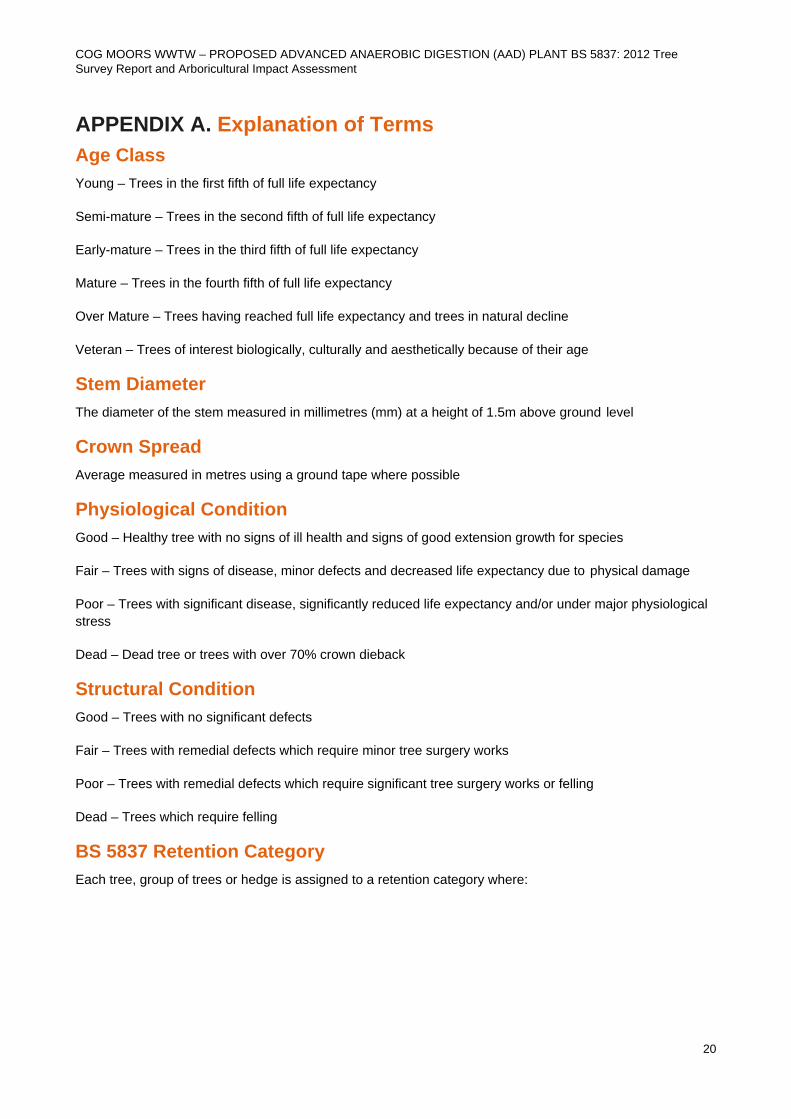
APPENDIX A. Explanation of Terms Age Class Young – Trees in the first fifth of full life expectancy
Semi-mature – Trees in the second fifth of full life expectancy
Early-mature – Trees in the third fifth of full life expectancy
Mature – Trees in the fourth fifth of full life expectancy
Over Mature – Trees having reached full life expectancy and trees in natural decline
Veteran – Trees of interest biologically, culturally and aesthetically because of their age
Stem Diameter The diameter of the stem measured in millimetres (mm) at a height of 1.5m above ground level
Crown Spread Average measured in metres using a ground tape where possible
Physiological Condition Good – Healthy tree with no signs of ill health and signs of good extension growth for species
Fair – Trees with signs of disease, minor defects and decreased life expectancy due to physical damage
Poor – Trees with significant disease, significantly reduced life expectancy and/or under major physiological stress
Dead – Dead tree or trees with over 70% crown dieback
Structural Condition Good – Trees with no significant defects
Fair – Trees with remedial defects which require minor tree surgery works
Poor – Trees with remedial defects which require significant tree surgery works or felling
Dead – Trees which require felling
BS 5837 Retention Category Each tree, group of trees or hedge is assigned to a retention category where:
COG MOORS WWTW – PROPOSED ADVANCED ANAEROBIC DIGESTION (AAD) PLANT BS 5837: 2012 Tree Survey Report and Arboricultural Impact Assessment
21
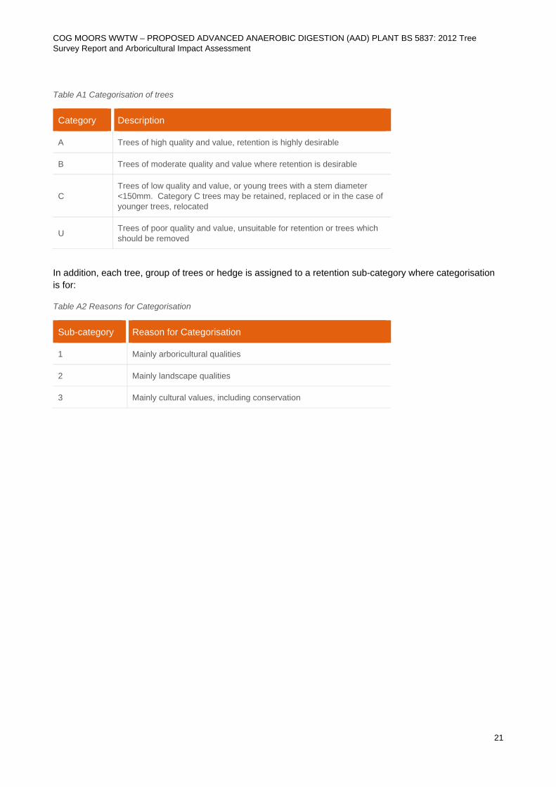
Table A1 Categorisation of trees
Category Description
A Trees of high quality and value, retention is highly desirable
B Trees of moderate quality and value where retention is desirable
C Trees of low quality and value, or young trees with a stem diameter <150mm. Category C trees may be retained, replaced or in the case of younger trees, relocated
U Trees of poor quality and value, unsuitable for retention or trees which should be removed
In addition, each tree, group of trees or hedge is assigned to a retention sub-category where categorisation is for:
Table A2 Reasons for Categorisation
Sub-category Reason for Categorisation
1 Mainly arboricultural qualities
2 Mainly landscape qualities
3 Mainly cultural values, including conservation
SOUTH WALES SLUDGE STRATEGY COG MOORS WWTW
BS 5837: 2012 Tree Survey Report and Arboricultural Impact Assessment
22 *
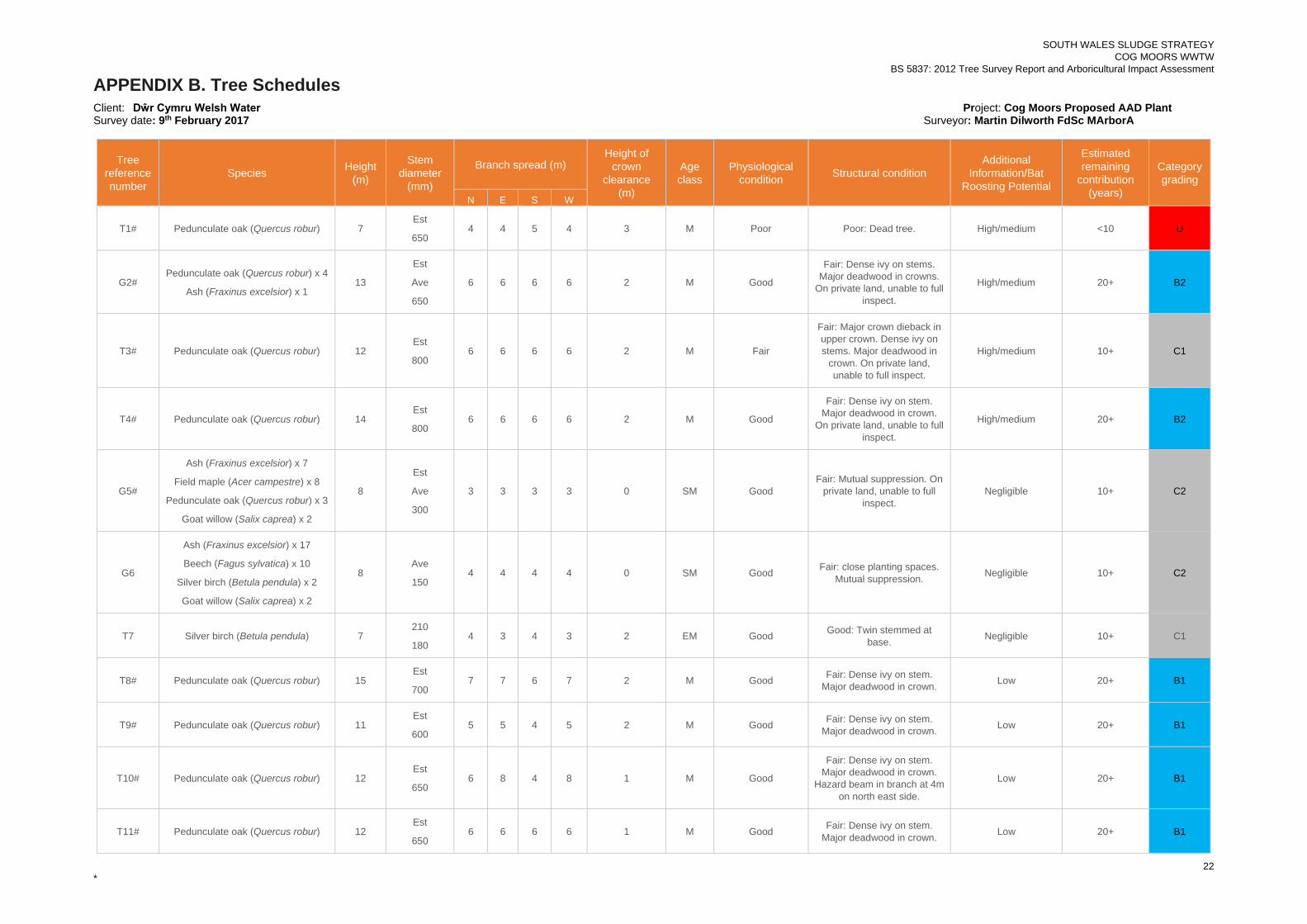
APPENDIX B. Tree Schedules Client: Dŵr Cymru Welsh Water Project: Cog Moors Proposed AAD Plant Survey date: 9th February 2017 Surveyor: Martin Dilworth FdSc MArborA
Tree reference number
Species Height (m)
Stem diameter
(mm)
Branch spread (m) Height of
crown clearance
(m)
Age class
Physiological condition Structural condition
Additional Information/Bat
Roosting Potential
Estimated remaining
contribution (years)
Category grading
N E S W
T1# Pedunculate oak (Quercus robur) 7 Est
650 4 4 5 4 3 M Poor Poor: Dead tree. High/medium <10 U
G2# Pedunculate oak (Quercus robur) x 4
Ash (Fraxinus excelsior) x 1 13
Est
Ave
650
6 6 6 6 2 M Good
Fair: Dense ivy on stems. Major deadwood in crowns.
On private land, unable to full inspect.
High/medium 20+ B2
T3# Pedunculate oak (Quercus robur) 12 Est
800 6 6 6 6 2 M Fair
Fair: Major crown dieback in upper crown. Dense ivy on stems. Major deadwood in
crown. On private land, unable to full inspect.
High/medium 10+ C1
T4# Pedunculate oak (Quercus robur) 14 Est
800 6 6 6 6 2 M Good
Fair: Dense ivy on stem. Major deadwood in crown.
On private land, unable to full inspect.
High/medium 20+ B2
G5#
Ash (Fraxinus excelsior) x 7
Field maple (Acer campestre) x 8
Pedunculate oak (Quercus robur) x 3
Goat willow (Salix caprea) x 2
8
Est
Ave
300
3 3 3 3 0 SM Good Fair: Mutual suppression. On
private land, unable to full inspect.
Negligible 10+ C2
G6
Ash (Fraxinus excelsior) x 17
Beech (Fagus sylvatica) x 10
Silver birch (Betula pendula) x 2
Goat willow (Salix caprea) x 2
8 Ave
150 4 4 4 4 0 SM Good Fair: close planting spaces.
Mutual suppression. Negligible 10+ C2
T7 Silver birch (Betula pendula) 7 210
180 4 3 4 3 2 EM Good Good: Twin stemmed at
base. Negligible 10+ C1
T8# Pedunculate oak (Quercus robur) 15 Est
700 7 7 6 7 2 M Good Fair: Dense ivy on stem.
Major deadwood in crown. Low 20+ B1
T9# Pedunculate oak (Quercus robur) 11 Est
600 5 5 4 5 2 M Good Fair: Dense ivy on stem.
Major deadwood in crown. Low 20+ B1
T10# Pedunculate oak (Quercus robur) 12 Est
650 6 8 4 8 1 M Good
Fair: Dense ivy on stem. Major deadwood in crown.
Hazard beam in branch at 4m on north east side.
Low 20+ B1
T11# Pedunculate oak (Quercus robur) 12 Est
650 6 6 6 6 1 M Good Fair: Dense ivy on stem.
Major deadwood in crown. Low 20+ B1
SOUTH WALES SLUDGE STRATEGY COG MOORS WWTW
BS 5837: 2012 Tree Survey Report and Arboricultural Impact Assessment
23 *
Tree reference number
Species Height (m)
Stem diameter
(mm)
Branch spread (m) Height of
crown clearance
(m)
Age class
Physiological condition Structural condition
Additional Information/Bat
Roosting Potential
Estimated remaining
contribution (years)
Category grading
N E S W
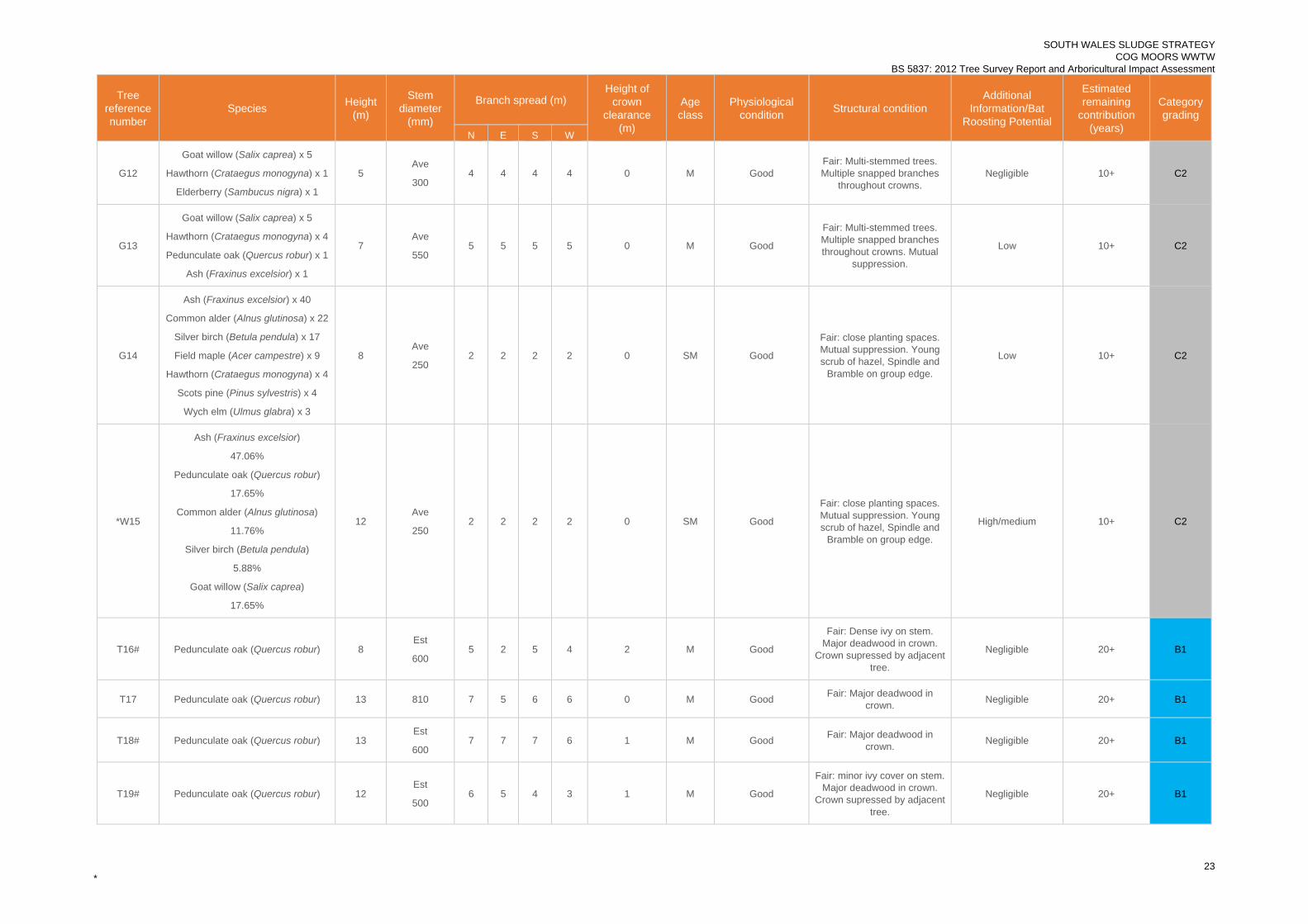
G12
Goat willow (Salix caprea) x 5
Hawthorn (Crataegus monogyna) x 1
Elderberry (Sambucus nigra) x 1
5 Ave
300 4 4 4 4 0 M Good
Fair: Multi-stemmed trees. Multiple snapped branches
throughout crowns. Negligible 10+ C2
G13
Goat willow (Salix caprea) x 5
Hawthorn (Crataegus monogyna) x 4
Pedunculate oak (Quercus robur) x 1
Ash (Fraxinus excelsior) x 1
7 Ave
550 5 5 5 5 0 M Good
Fair: Multi-stemmed trees. Multiple snapped branches throughout crowns. Mutual
suppression.
Low 10+ C2
G14
Ash (Fraxinus excelsior) x 40
Common alder (Alnus glutinosa) x 22
Silver birch (Betula pendula) x 17
Field maple (Acer campestre) x 9
Hawthorn (Crataegus monogyna) x 4
Scots pine (Pinus sylvestris) x 4
Wych elm (Ulmus glabra) x 3
8 Ave
250 2 2 2 2 0 SM Good
Fair: close planting spaces. Mutual suppression. Young scrub of hazel, Spindle and
Bramble on group edge.
Low 10+ C2
*W15
Ash (Fraxinus excelsior)
47.06%
Pedunculate oak (Quercus robur)
17.65%
Common alder (Alnus glutinosa)
11.76%
Silver birch (Betula pendula)
5.88%
Goat willow (Salix caprea)
17.65%
12 Ave
250 2 2 2 2 0 SM Good
Fair: close planting spaces. Mutual suppression. Young scrub of hazel, Spindle and
Bramble on group edge.
High/medium 10+ C2
T16# Pedunculate oak (Quercus robur) 8 Est
600 5 2 5 4 2 M Good
Fair: Dense ivy on stem. Major deadwood in crown.
Crown supressed by adjacent tree.
Negligible 20+ B1
T17 Pedunculate oak (Quercus robur) 13 810 7 5 6 6 0 M Good Fair: Major deadwood in crown. Negligible 20+ B1
T18# Pedunculate oak (Quercus robur) 13 Est
600 7 7 7 6 1 M Good Fair: Major deadwood in
crown. Negligible 20+ B1
T19# Pedunculate oak (Quercus robur) 12 Est
500 6 5 4 3 1 M Good
Fair: minor ivy cover on stem. Major deadwood in crown.
Crown supressed by adjacent tree.
Negligible 20+ B1
SOUTH WALES SLUDGE STRATEGY COG MOORS WWTW
BS 5837: 2012 Tree Survey Report and Arboricultural Impact Assessment
24 *
Tree reference number
Species Height (m)
Stem diameter
(mm)
Branch spread (m) Height of
crown clearance
(m)
Age class
Physiological condition Structural condition
Additional Information/Bat
Roosting Potential
Estimated remaining
contribution (years)
Category grading
N E S W
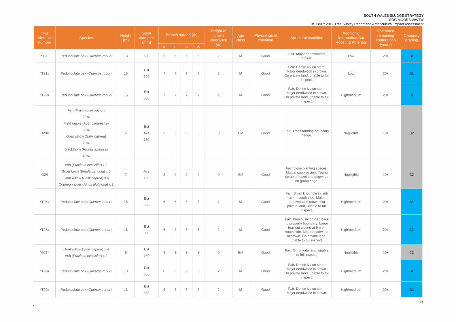
*T20 Pedunculate oak (Quercus robur) 13 600 6 6 6 6 2 M Good Fair: Major deadwood in crown. Low 20+ B1
*T21# Pedunculate oak (Quercus robur) 15 Est
800 7 7 7 7 2 M Good
Fair: Dense ivy on stem. Major deadwood in crown.
On private land, unable to full inspect.
Low 20+ B1
*T22# Pedunculate oak (Quercus robur) 15 Est
800 7 7 7 7 2 M Good
Fair: Dense ivy on stem. Major deadwood in crown.
On private land, unable to full inspect.
High/medium 20+ B1
H23#
Ash (Fraxinus excelsior)
20%
Field maple (Acer campestre)
20%
Goat willow (Salix caprea)
20%
Blackthorn (Prunus spinosa)
40%
6
Est
Ave
150
3 3 3 3 0 EM Good Fair: Trees forming boundary hedge. Negligible 10+ C2
G24
Ash (Fraxinus excelsior) x 2
Silver birch (Betula pendula) x 6
Goat willow (Salix caprea) x 4
Common alder (Alnus glutinosa) x 2
7 Ave
150 2 2 2 2 0 SM Good
Fair: close planting spaces. Mutual suppression. Young scrub of hazel and dogwood
on group edge.
Negligible 10+ C2
*T25# Pedunculate oak (Quercus robur) 15 Est
650 6 6 6 6 1 M Good
Fair: Small knot hole in limb at 4m south side. Major deadwood in crown. On
private land, unable to full inspect.
High/medium 20+ B1
*T26# Pedunculate oak (Quercus robur) 16 Est
800 6 8 8 6 2 M Good
Fair: Previously pruned back to property boundary. Large
tear-out wound at 5m on south side. Major deadwood
in crown. On private land, unable to full inspect.
High/medium 20+ B1
*G27# Goat willow (Salix caprea) x 4
Ash (Fraxinus excelsior) x 2 6
Est
150 3 3 3 3 0 EM Good Fair: On private land, unable
to full inspect. Negligible 10+ C2
*T28# Pedunculate oak (Quercus robur) 13 Est
650 6 6 6 6 2 M Good
Fair: Dense ivy on stem. Major deadwood in crown.
On private land, unable to full inspect.
High/medium 20+ B1
*T29# Pedunculate oak (Quercus robur) 13 Est
650 6 6 6 6 2 M Good Fair: Dense ivy on stem.
Major deadwood in crown. High/medium 20+ B1
SOUTH WALES SLUDGE STRATEGY COG MOORS WWTW
BS 5837: 2012 Tree Survey Report and Arboricultural Impact Assessment
25 *
Tree reference number
Species Height (m)
Stem diameter
(mm)
Branch spread (m) Height of
crown clearance
(m)
Age class
Physiological condition Structural condition
Additional Information/Bat
Roosting Potential
Estimated remaining
contribution (years)
Category grading
N E S W On private land, unable to full
inspect.
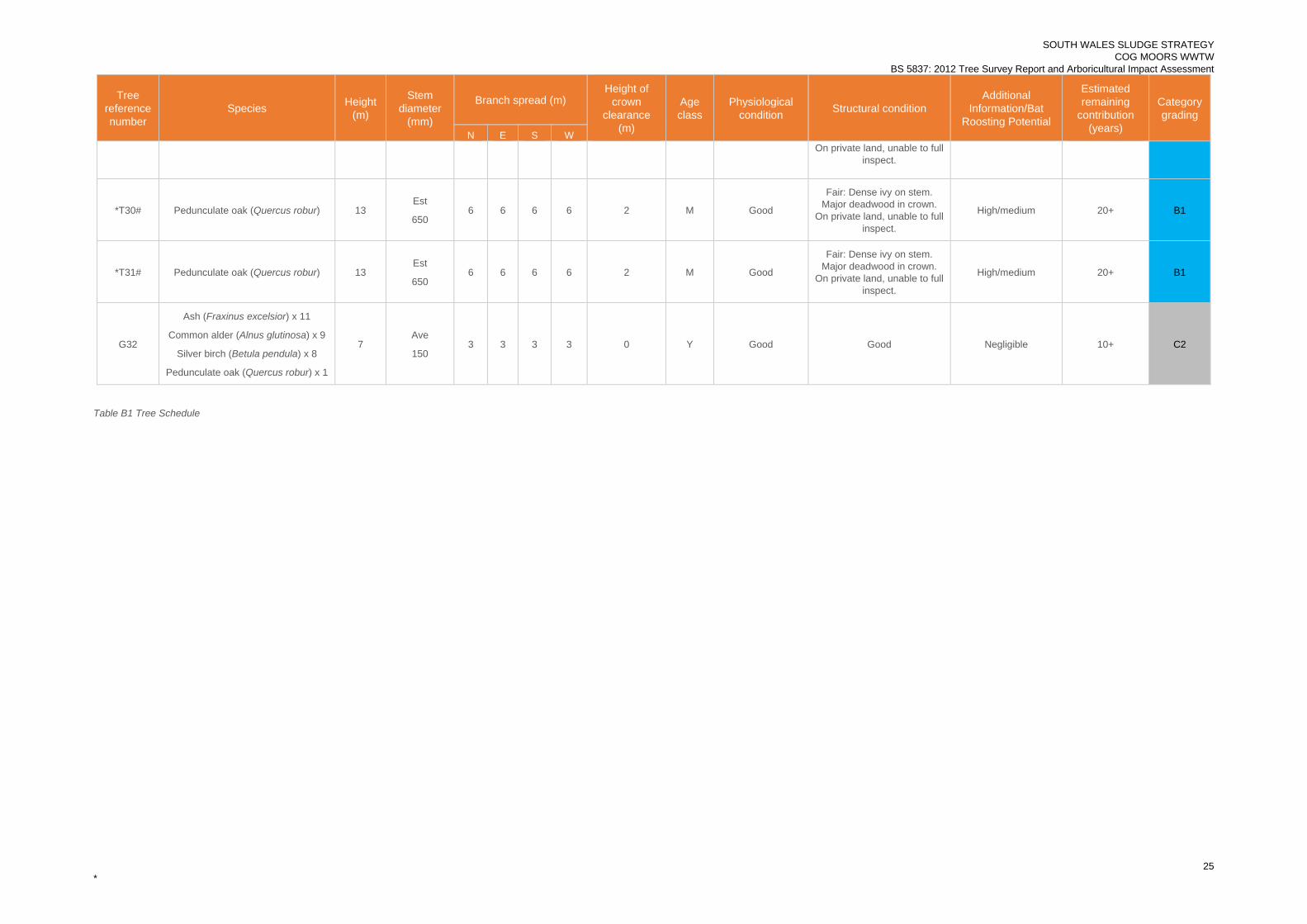
*T30# Pedunculate oak (Quercus robur) 13 Est
650 6 6 6 6 2 M Good
Fair: Dense ivy on stem. Major deadwood in crown.
On private land, unable to full inspect.
High/medium 20+ B1
*T31# Pedunculate oak (Quercus robur) 13 Est
650 6 6 6 6 2 M Good
Fair: Dense ivy on stem. Major deadwood in crown.
On private land, unable to full inspect.
High/medium 20+ B1
G32
Ash (Fraxinus excelsior) x 11
Common alder (Alnus glutinosa) x 9
Silver birch (Betula pendula) x 8
Pedunculate oak (Quercus robur) x 1
7 Ave
150 3 3 3 3 0 Y Good Good Negligible 10+ C2
Table B1 Tree Schedule
COG MOORS WWTW – PROPOSED ADVANCED ANAEROBIC DIGESTION (AAD) PLANT BS 5837: 2012 Tree Survey Report and Arboricultural Impact Assessment
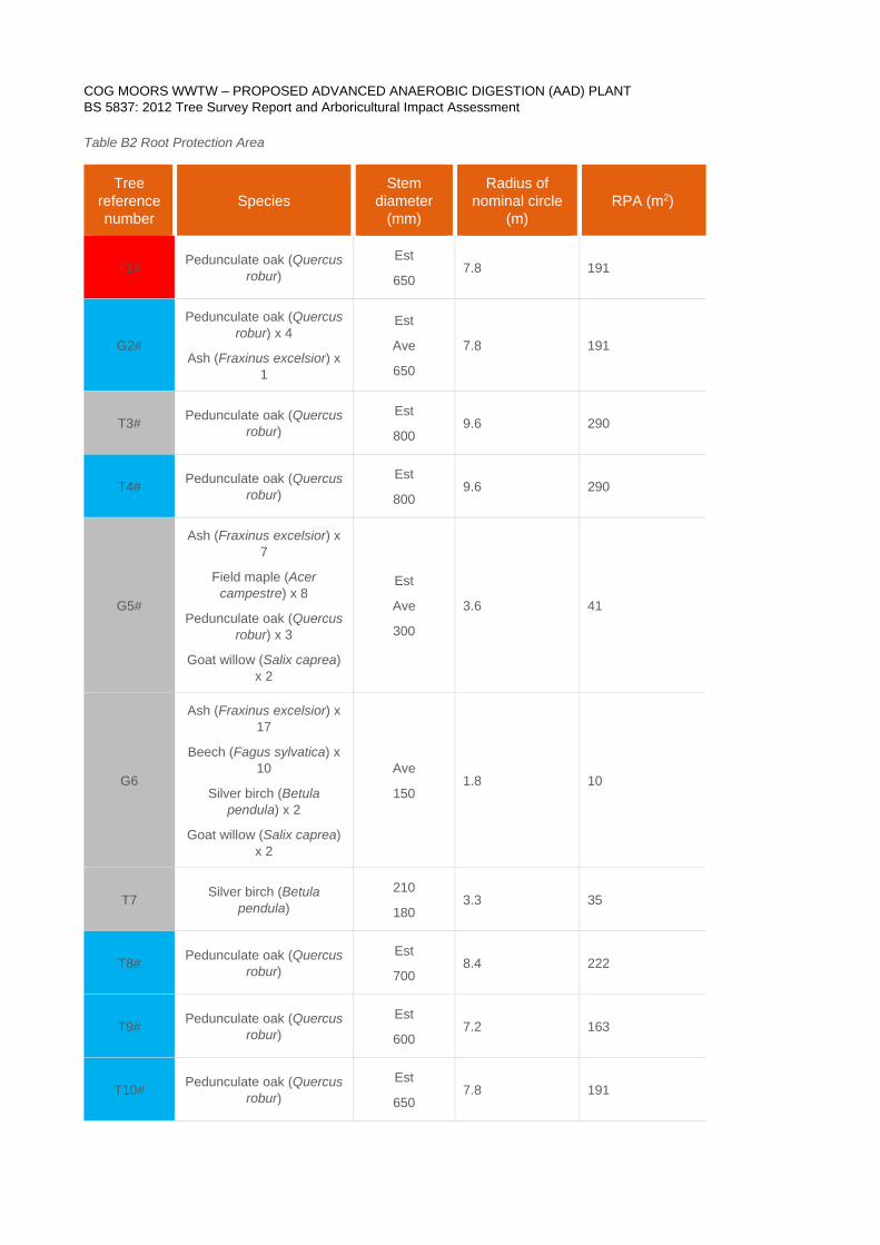
Table B2 Root Protection Area
Tree reference number
Species Stem
diameter (mm)
Radius of nominal circle
(m) RPA (m2)
T1# Pedunculate oak (Quercus robur)
Est
650 7.8 191
G2#
Pedunculate oak (Quercus robur) x 4
Ash (Fraxinus excelsior) x 1
Est
Ave
650
7.8 191
T3# Pedunculate oak (Quercus robur)
Est
800 9.6 290
T4# Pedunculate oak (Quercus robur)
Est
800 9.6 290
G5#
Ash (Fraxinus excelsior) x 7
Field maple (Acer campestre) x 8
Pedunculate oak (Quercus robur) x 3
Goat willow (Salix caprea) x 2
Est
Ave
300
3.6 41
G6
Ash (Fraxinus excelsior) x 17
Beech (Fagus sylvatica) x 10
Silver birch (Betula pendula) x 2
Goat willow (Salix caprea) x 2
Ave
150 1.8 10
T7 Silver birch (Betula pendula)
210
180 3.3 35
T8# Pedunculate oak (Quercus robur)
Est
700 8.4 222
T9# Pedunculate oak (Quercus robur)
Est
600 7.2 163
T10# Pedunculate oak (Quercus robur)
Est
650 7.8 191
COG MOORS WWTW – PROPOSED ADVANCED ANAEROBIC DIGESTION (AAD) PLANT BS 5837: 2012 Tree Survey Report and Arboricultural Impact Assessment
27 *
Tree reference number
Species Stem
diameter (mm)
Radius of nominal circle
(m) RPA (m2)
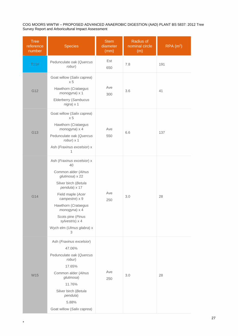
T11# Pedunculate oak (Quercus robur)
Est
650 7.8 191
G12
Goat willow (Salix caprea) x 5
Hawthorn (Crataegus monogyna) x 1
Elderberry (Sambucus nigra) x 1
Ave
300 3.6 41
G13
Goat willow (Salix caprea) x 5
Hawthorn (Crataegus monogyna) x 4
Pedunculate oak (Quercus robur) x 1
Ash (Fraxinus excelsior) x 1
Ave
550 6.6 137
G14
Ash (Fraxinus excelsior) x 40
Common alder (Alnus glutinosa) x 22
Silver birch (Betula pendula) x 17
Field maple (Acer campestre) x 9
Hawthorn (Crataegus monogyna) x 4
Scots pine (Pinus sylvestris) x 4
Wych elm (Ulmus glabra) x 3
Ave
250 3.0 28
W15
Ash (Fraxinus excelsior)
47.06%
Pedunculate oak (Quercus robur)
17.65%
Common alder (Alnus glutinosa)
11.76%
Silver birch (Betula pendula)
5.88%
Goat willow (Salix caprea)
Ave
250 3.0 28
COG MOORS WWTW – PROPOSED ADVANCED ANAEROBIC DIGESTION (AAD) PLANT BS 5837: 2012 Tree Survey Report and Arboricultural Impact Assessment
28 *
Tree reference number
Species Stem
diameter (mm)
Radius of nominal circle
(m) RPA (m2)
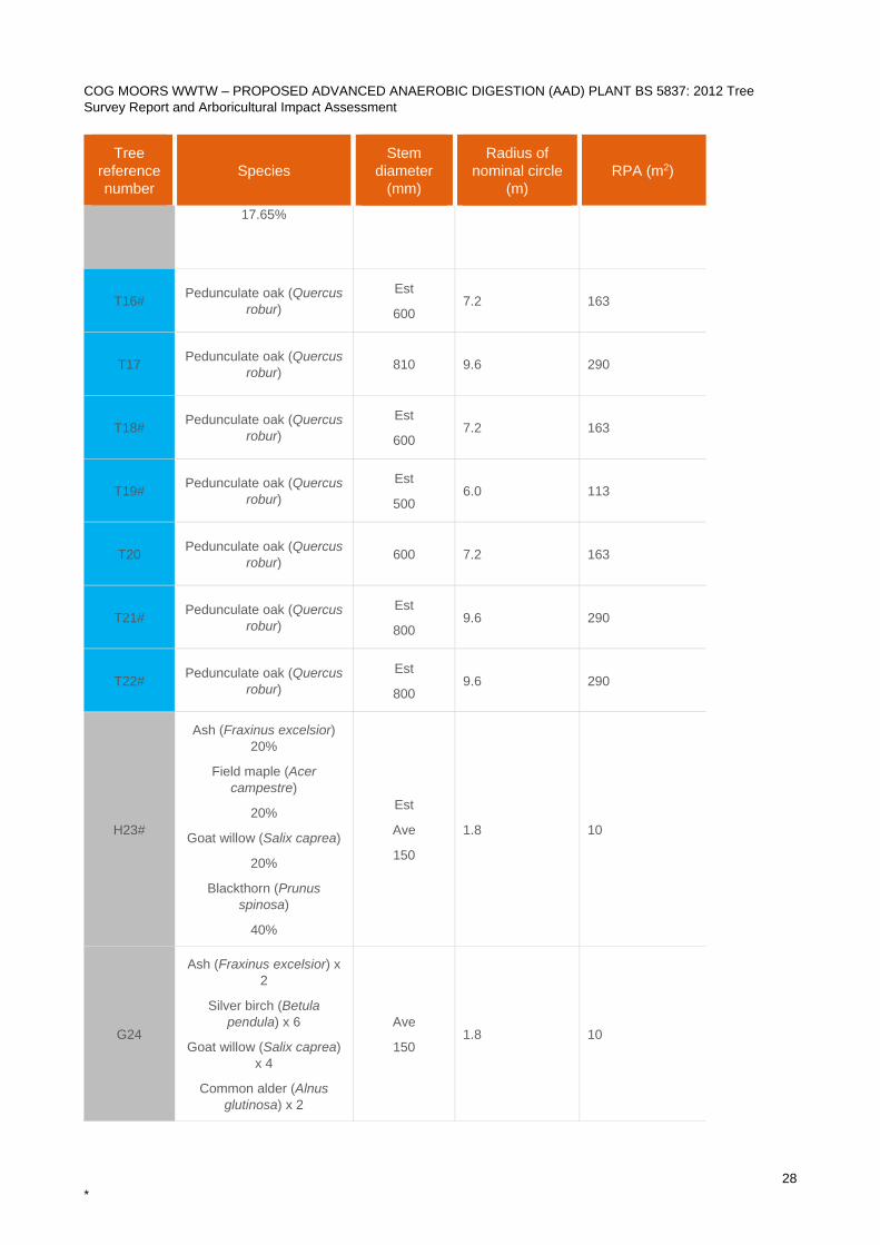
17.65%
T16# Pedunculate oak (Quercus robur)
Est
600 7.2 163
T17 Pedunculate oak (Quercus robur) 810 9.6 290
T18# Pedunculate oak (Quercus robur)
Est
600 7.2 163
T19# Pedunculate oak (Quercus robur)
Est
500 6.0 113
T20 Pedunculate oak (Quercus robur) 600 7.2 163
T21# Pedunculate oak (Quercus robur)
Est
800 9.6 290
T22# Pedunculate oak (Quercus robur)
Est
800 9.6 290
H23#
Ash (Fraxinus excelsior) 20%
Field maple (Acer campestre)
20%
Goat willow (Salix caprea)
20%
Blackthorn (Prunus spinosa)
40%
Est
Ave
150
1.8 10
G24
Ash (Fraxinus excelsior) x 2
Silver birch (Betula pendula) x 6
Goat willow (Salix caprea) x 4
Common alder (Alnus glutinosa) x 2
Ave
150 1.8 10
COG MOORS WWTW – PROPOSED ADVANCED ANAEROBIC DIGESTION (AAD) PLANT BS 5837: 2012 Tree Survey Report and Arboricultural Impact Assessment
29 *
Tree reference number
Species Stem
diameter (mm)
Radius of nominal circle
(m) RPA (m2)
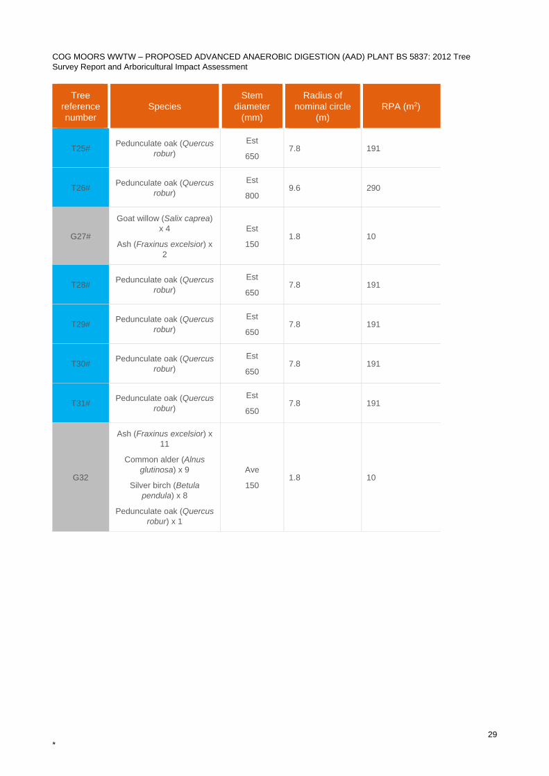
T25# Pedunculate oak (Quercus robur)
Est
650 7.8 191
T26# Pedunculate oak (Quercus robur)
Est
800 9.6 290
G27#
Goat willow (Salix caprea) x 4
Ash (Fraxinus excelsior) x 2
Est
150 1.8 10
T28# Pedunculate oak (Quercus robur)
Est
650 7.8 191
T29# Pedunculate oak (Quercus robur)
Est
650 7.8 191
T30# Pedunculate oak (Quercus robur)
Est
650 7.8 191
T31# Pedunculate oak (Quercus robur)
Est
650 7.8 191
G32
Ash (Fraxinus excelsior) x 11
Common alder (Alnus glutinosa) x 9
Silver birch (Betula pendula) x 8
Pedunculate oak (Quercus robur) x 1
Ave
150 1.8 10
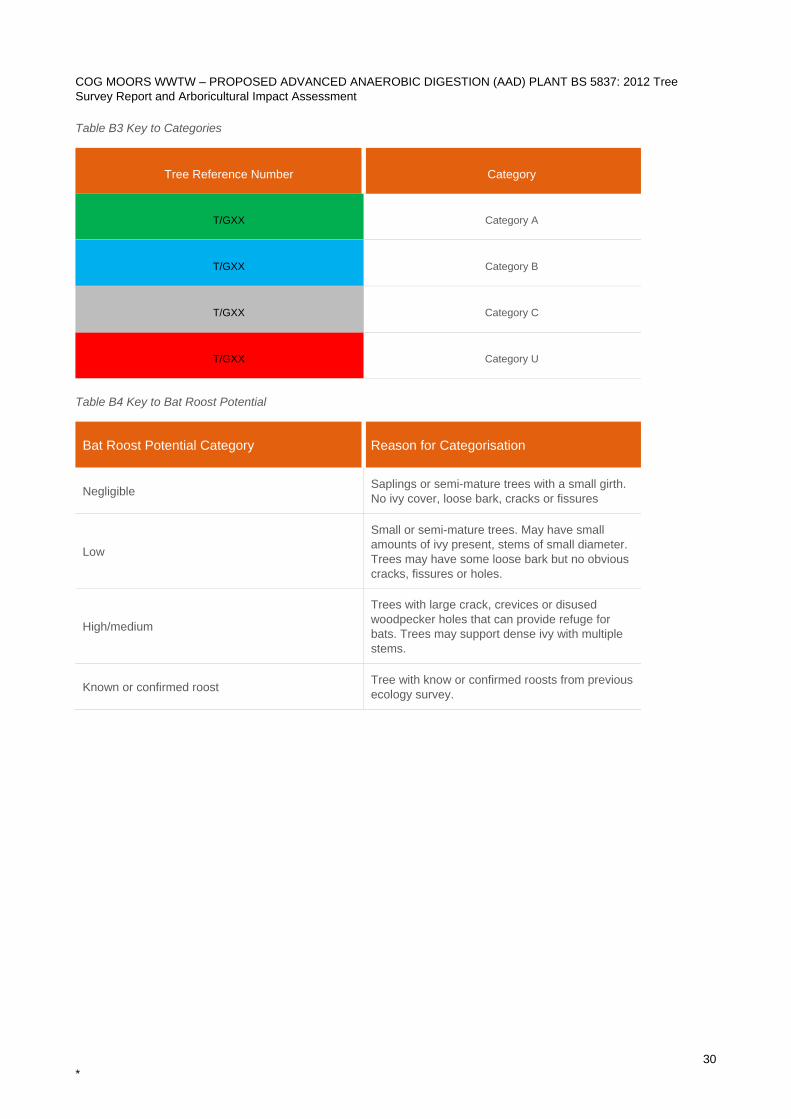
COG MOORS WWTW – PROPOSED ADVANCED ANAEROBIC DIGESTION (AAD) PLANT BS 5837: 2012 Tree Survey Report and Arboricultural Impact Assessment
30 *
Table B3 Key to Categories
Tree Reference Number Category
T/GXX Category A
T/GXX Category B
T/GXX Category C
T/GXX Category U
Table B4 Key to Bat Roost Potential
Bat Roost Potential Category Reason for Categorisation
Negligible Saplings or semi-mature trees with a small girth. No ivy cover, loose bark, cracks or fissures
Low
Small or semi-mature trees. May have small amounts of ivy present, stems of small diameter. Trees may have some loose bark but no obvious cracks, fissures or holes.
High/medium
Trees with large crack, crevices or disused woodpecker holes that can provide refuge for bats. Trees may support dense ivy with multiple stems.
Known or confirmed roost Tree with know or confirmed roosts from previous ecology survey.
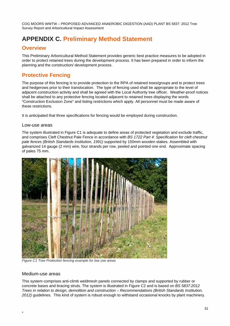
COG MOORS WWTW – PROPOSED ADVANCED ANAEROBIC DIGESTION (AAD) PLANT BS 5837: 2012 Tree Survey Report and Arboricultural Impact Assessment
31 *
APPENDIX C. Preliminary Method Statement Overview This Preliminary Arboricultural Method Statement provides generic best practice measures to be adopted in order to protect retained trees during the development process. It has been prepared in order to inform the planning and the construction/ development process. Protective Fencing The purpose of this fencing is to provide protection to the RPA of retained trees/groups and to protect trees and hedgerows prior to their translocation. The type of fencing used shall be appropriate to the level of adjacent construction activity and shall be agreed with the Local Authority tree officer. Weather-proof notices shall be attached to any protective fencing located adjacent to retained trees displaying the words “Construction Exclusion Zone” and listing restrictions which apply. All personnel must be made aware of these restrictions. It is anticipated that three specifications for fencing would be employed during construction. Low-use areas The system illustrated in Figure C1 is adequate to define areas of protected vegetation and exclude traffic, and comprises Cleft Chestnut Pale Fence in accordance with BS 1722 Part 4: Specification for cleft chestnut pale fences (British Standards Institution, 1991) supported by 150mm wooden stakes. Assembled with galvanized 14 gauge (2 mm) wire, four strands per row, peeled and pointed one end. Approximate spacing of pales 75 mm.
Figure C1 Tree Protection fencing example for low use areas
Medium-use areas This system comprises anti-climb weldmesh panels connected by clamps and supported by rubber or concrete bases and bracing struts. The system is illustrated in Figure C2 and is based on BS 5837:2012 Trees in relation to design, demolition and construction – Recommendations (British Standards Institution, 2012) guidelines. This kind of system is robust enough to withstand occasional knocks by plant machinery.
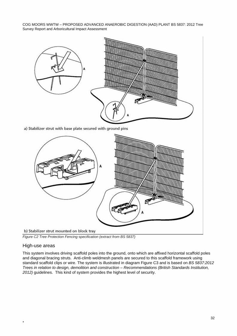
COG MOORS WWTW – PROPOSED ADVANCED ANAEROBIC DIGESTION (AAD) PLANT BS 5837: 2012 Tree Survey Report and Arboricultural Impact Assessment
32 *
Figure C2 Tree Protection Fencing specification (extract from BS 5837)
High-use areas This system involves driving scaffold poles into the ground, onto which are affixed horizontal scaffold poles and diagonal bracing struts. Anti-climb weldmesh panels are secured to this scaffold framework using standard scaffold clips or wire. The system is illustrated in diagram Figure C3 and is based on BS 5837:2012 Trees in relation to design, demolition and construction – Recommendations (British Standards Institution, 2012) guidelines. This kind of system provides the highest level of security.
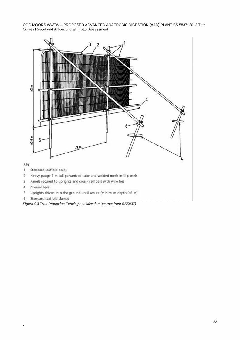
COG MOORS WWTW – PROPOSED ADVANCED ANAEROBIC DIGESTION (AAD) PLANT BS 5837: 2012 Tree Survey Report and Arboricultural Impact Assessment
33 *
Figure C3 Tree Protection Fencing specification (extract from BS5837)
COG MOORS WWTW – PROPOSED ADVANCED ANAEROBIC DIGESTION (AAD) PLANT BS 5837: 2012 Tree Survey Report and Arboricultural Impact Assessment
34 *
Construction Exclusion Zone (CEZ) The Construction Exclusion Zone (CEZ) is the area identified by an arboriculturist to be protected during development, including site clearance and construction work, through the use of barriers and/or ground protection fit-for-purpose to ensure the successful long-term retention of a tree. The area within the construction exclusion zone is to be regarded as sacrosanct and the fencing shall not be taken down or relocated at any time. All areas excluded by protective tree fencing shall be treated as CEZs, and the following restrictions shall apply:
• No construction activity whatsoever must occur within these areas. • No tree works, without the written consent from the Local Authority. • No alterations of ground levels or conditions. • No chemicals or cement washings. • No excavation. • No temporary structures.* • No storage of soil, rubble or other materials. • No vehicles or machinery to be used or parked without appropriate ground protection measures as
per BS5837 recommendations. This will require the use of a proprietary system of reinforced concrete slabs/steel road plates on a compressible layer, or side butting scaffold boards/ 18mm plywood sheets on a compressible layer. The type of ground protection used shall be appropriate for the likely loading applied.
• No fixtures (lighting, signs etc.) to be attached to trees. • No fires within 10 metres of the canopies of any tree or hedgerows.
*Sales Cabins or site huts, provided they are of the Jack Leg type, can be sited to act as ground protection for the duration of the construction.
General construction activity Since the canopies of retained trees may be in close proximity to areas of crane operation, the following restrictions will apply:
• All cranes will be sited outside the defined RPAs of retained trees / groups, and the appointed contractor will ensure all relevant personnel shall be made aware of the location of branches and the need to avoid causing damage to them.
• Prior to the implementation of lifting operations, a representative from the equipment supply company shall visit the site and ensure all operations can be completed without causing damage to retained trees. A lifting plan will be prepared and submitted for approval prior to all lifting operations. The lifting plan will make provision for the potential for damage of retained trees.
• All lifting operations will be completed under the close direction of a qualified banksman, who will be briefed by the appointed contractor as to the need to avoid damage the stems and branches of retained trees.
• Should additional tree removal or pruning be required the Local Authority Tree Officer shall be contacted and the scope of works agreed in writing.
• All materials will be stored within designated areas and no materials shall be stored within any RPA.
Hazardous materials Any mixing of cement-based materials is to take place outside the RPAs of all trees. Provision shall be made to ensure that the mixing area is contained so that no water runoff enters the RPAs of any trees. All mixers and barrows shall be cleaned within this dedicated mixing area. All other chemicals hazardous to tree health, including petrol and diesel, are to be stored in suitable containers as specified by the Control of Substances Hazardous to Health (COSHH) Regulations (2002).
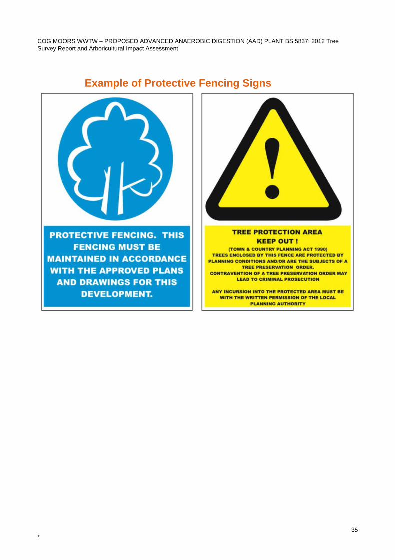
COG MOORS WWTW – PROPOSED ADVANCED ANAEROBIC DIGESTION (AAD) PLANT BS 5837: 2012 Tree Survey Report and Arboricultural Impact Assessment
35 *
Example of Protective Fencing Signs
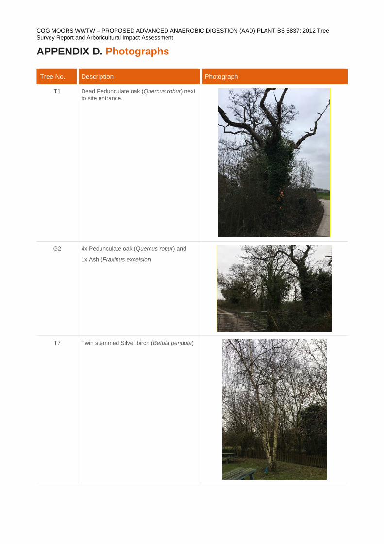
COG MOORS WWTW – PROPOSED ADVANCED ANAEROBIC DIGESTION (AAD) PLANT BS 5837: 2012 Tree Survey Report and Arboricultural Impact Assessment
APPENDIX D. Photographs
Tree No. Description Photograph
T1 Dead Pedunculate oak (Quercus robur) next to site entrance.
G2 4x Pedunculate oak (Quercus robur) and
1x Ash (Fraxinus excelsior)
T7 Twin stemmed Silver birch (Betula pendula)
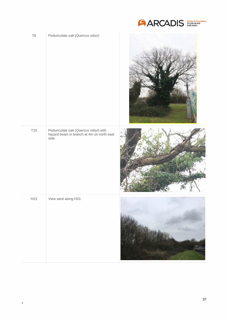
37 *
T8 Pedunculate oak (Quercus robur)
T10 Pedunculate oak (Quercus robur) with hazard beam in branch at 4m on north east side.
H23 View west along H23.
Arcadis (UK) Limited
Arcadis House 34 York Way London N1 9AB United Kingdom
T: +44 (0)20 7812 2000
arcadis.com