biodata - ernetpeople.iitr.ernet.in/facultyresume/biodata-aksaraf_l4... · web viewdistinguish...
TRANSCRIPT
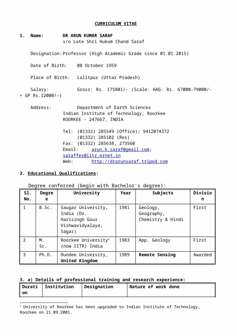
CURRICULUM VITAE
1. Name: DR ARUN KUMAR SARAFs/o Late Shri Hukum Chand Saraf
Designation: Professor (High Academic Grade since 01.01.2015)
Date of Birth: 08 October 1959
Place of Birth: Lalitpur (Uttar Pradesh)
Salary: Gross: Rs. 175801/- (Scale: HAG: Rs. 67000-79000/- + GP Rs.12000/-)
Address: Department of Earth SciencesIndian Institute of Technology, RoorkeeROORKEE – 247667, INDIA
Tel: (01332) 285549 (Office); 9412074372(01332) 285102 (Res)
Fax: (01332) 285638, 273560Email: [email protected]; [email protected]: http://drarunsaraf.tripod.com
2. Educational Qualifications:
Degree conferred (begin with Bachelor's degree):Sl.
No.Degree University Year Subjects Division
1 B.Sc. Saugar University, India (Dr. Harisingh Gour Vishwavidyalaya, Sagar)
1981 Geology, Geography, Chemistry & Hindi
First
2 M. Sc. Roorkee University (now IITR) India
1983 App. Geology First
3 Ph.D. Dundee University,United Kingdom
1989 Remote Sensing Awarded
3. a) Details of professional training and research experience:Duration Institution Designation Nature of work done1983-86 University of
Roorkee (now IITR)J.R.F. and S.R.F Fellowship
Sedimentology and Geomorphology on CSIR direct of Kosi River Alluvial Fan
1986-89 DundeeUniversity, United Kingdom
Research Fellow on "National Scholarship for Study Abroad"
Remote Sensing Applications in Geobotanical Exploration
Feb. 19-23,1990
CSRE, IIT,Bombay
Trainee Geographic Information Systems for Resources Data Handling, Analysisand Management
Feb.25-4thMarch, 1991
CED, Universityof Roorkee (now IITR)
Trainee Artificial Intelligence
University of Roorkee has been upgraded to Indian Institute of Technology, Roorkee on 21.09.2001.
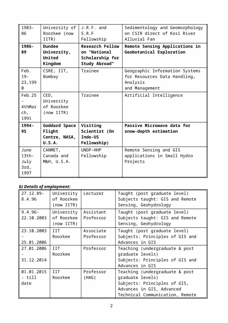
1994-95 Goddard Space Flight Centre, NASA, U.S.A.
Visiting Scientist (On Indo-US Fellowship)
Passive Microwave data for snow-depth estimation
June 13th-July 3rd, 1997
CANMET, Canada and M&H, U.S.A.
UNDP-HHP Fellowship Remote Sensing and GIS applications in Small Hydro Projects
b) Details of employment:27.12.89-8.4.96
Universityof Roorkee (now IITR)
Lecturer Taught (post graduate level)Subjects taught: GIS and Remote Sensing, Geohydrology
9.4.96-22.10.2003
Universityof Roorkee (now IITR)
Assistant Professor
Taught (post graduate level)Subjects taught: GIS and Remote Sensing, Geohydrology
23.10.2003- 25.01.2006
IIT Roorkee Associate Professor
Taught (post graduate level)Subjects: Principles of GIS and Advances in GIS
27.01.2006-31.12.2014
IIT Roorkee Professor Teaching (undergraduate & post graduate levels)Subjects: Principles of GIS and Advances in GIS
01.01.2015- till date
IIT Roorkee Professor (HAG) Teaching (undergraduate & post graduate levels)Subjects: Principles of GIS, Advances in GIS, Advanced Technical Communication, Remote Sensing, Digital Image Processing
4. Research specialization: Geographic Information System (GIS), Remote Sensing,Digital Image Processing and Groundwater Hydrology
5. Honours and Awards:a. INSA – Royal Society, U.K. Fellowship – 2002b. INSA – Chinese Academy of Sciences Bilateral Fellowship - 2011c. National Remote Sensing Award-2001d. GIS Professional of the Year-2001e. National Scholarship for Study Abroad 1986, Govt. of Indiaf. Indo-US S&T Fellowship, 1994-95g. Khosla Research Award '96h. Khosla Research Prize'96i. Khosla Research Prize'97j. Excellent Performance Recognition by IITR for the years 2001-02k. Excellent Performance Recognition by IITR for the years 2002-03l. Excellent Performance Recognition by IITR for the years 2003-04m. Excellent Performance Recognition by IITR for the years 2004-05n. Best Paper Award in Map Asia 2004 (Beijing, China)o. Nominated as Scientific Board Member of the International Geoscience Programme (IGCP)
Scientific Board of UNESCO and IUGSp. INSA – Academy of Sciences, Iran Bilateral Fellowship - 2016
6. Development of Labs/facilities:
(a) Geographic Information Systems Lab(b) Digital Image Processing Lab(c) NOAA-HRPT-FY-CHRPT-MVISR Satellite Earth Station(d) Terra/Aqua-MODIS Satellite Earth Station (project has been cleared by the PAMC, DST/MoES)
2

7. Extensive experience with DIP & GIS software:a. Arc GIS 10b. Arc/View 3.2, Spatial Analyst 2.0, Image Analyst 1.0,
Network Analyst 1.0 & 3D Analyst 1.0c. ERDAS 10
8. Development of courses:
(a) Geographic Information Systems (GIS)(b) Digital Image Processing(c) Groundwater Hydrology(d) Advance Remote Sensing(e) Advance GIS
9. Membership in scientific and professional societies:
(a) Indian Society of Remote Sensing (ISRS)(b) Indian Society of Geomatics (ISG)(c) International Association of Hydrological Sciences (IAHS)(d) Indian Society of Earthquake Engineering (ISET) (e) Indian Association of Soil and Water Conservationists (IASWC)(f) Indian Society for Rock Mechanics & Tunnelling Technology (ISRMTT)
10. Administrative Experience:
Member in National and IITR Committees:
1. Member, PAC-Seismicity, MoES New Delhi (since 2007)2. Member, PAC-International Programme on Environment, Earth and Atmospheric
Sciences, DST, New Delhi (since 2010)3. Member, Expert Panel of Indian National Committee on Ground Water (INCGW) (since
2009)4. Member, PAMC - Seismicity Programme, DST, New Delhi (2002-2007)5. Member, PDA, CAIR (DRDO), Bangalore6. Member, Board of Courses and Studies, ISMU, Dhanbad (2005-2007)7. Member, Executive Council of IGS (2008-2011)8. Member, IITR-Office Automation Committee (since 2004)9. Coordinator , IITR Hospital Computerization Committee (since 2006)10. Convener, Institute Lecture Series (since 2006)11. Member, IITR ISC Advisory Committee (since 2008)12. Member, IITR Information Superhighway Centre Purchase Committee (since 2007)13. Member, IITR Software Purchase Committee (since 2002)14. Member, Board for Sponsored Research & Industrial Consultancy, IITR (2001-03, 2009-
onward for two years)15. Chairman, Department’s Finance and Purchase Committee (2007-2009)16. Chairman, Department Research Committee (2010-2012)17. Member, Executive Council of Indian Society of Geomatics (2008-2011)18. Member, Expert Panel of Indian National Committee on Ground Water (INCGW) (2009-till
date)19. Geoscience Advisory Council (GAC) of Ministry of Mines (GoI) (2011-2015)20. Expert of Governing Body of Jharkhand Space Applications Center (2013-2016)21. Expert Member of UGC Review Committee of Geology Department, Patna University (2011-
14)22. Expert Member of UGC Review Committee of Geology Department, Lucknow University
(2014-18)3
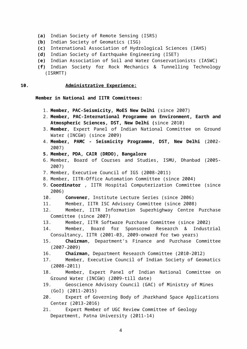
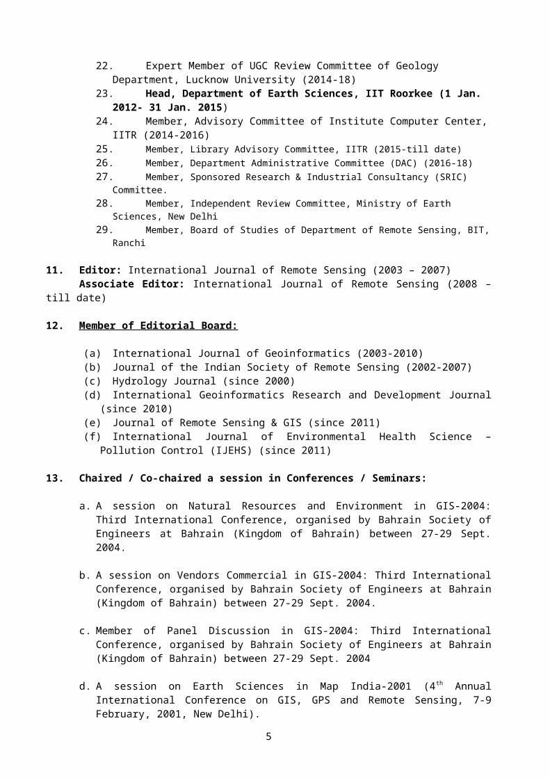
23. Head, Department of Earth Sciences, IIT Roorkee (1 Jan. 2012- 31 Jan. 2015)24. Member, Advisory Committee of Institute Computer Center, IITR (2014-2016)25. Member, Library Advisory Committee, IITR (2015-till date)26. Member, Department Administrative Committee (DAC) (2016-18)27. Member, Sponsored Research & Industrial Consultancy (SRIC) Committee.28. Member, Independent Review Committee, Ministry of Earth Sciences, New Delhi29. Member, Board of Studies of Department of Remote Sensing, BIT, Ranchi
11. Editor: International Journal of Remote Sensing (2003 – 2007)Associate Editor: International Journal of Remote Sensing (2008 – till date)
12. Member of Editorial Board:
(a) International Journal of Geoinformatics (2003-2010)(b) Journal of the Indian Society of Remote Sensing (2002-2007)(c) Hydrology Journal (since 2000)(d) International Geoinformatics Research and Development Journal (since 2010)(e) Journal of Remote Sensing & GIS (since 2011)(f) International Journal of Environmental Health Science – Pollution Control (IJEHS) (since
2011)
13. Chaired / Co-chaired a session in Conferences / Seminars:
a. A session on Natural Resources and Environment in GIS-2004: Third International Conference, organised by Bahrain Society of Engineers at Bahrain (Kingdom of Bahrain) between 27-29 Sept. 2004.
b. A session on Vendors Commercial in GIS-2004: Third International Conference, organised by Bahrain Society of Engineers at Bahrain (Kingdom of Bahrain) between 27-29 Sept. 2004.
c. Member of Panel Discussion in GIS-2004: Third International Conference, organised by Bahrain Society of Engineers at Bahrain (Kingdom of Bahrain) between 27-29 Sept. 2004
d. A session on Earth Sciences in Map India-2001 (4th Annual International Conference on GIS, GPS and Remote Sensing, 7-9 February, 2001, New Delhi).
e. A session on Environmental Planning in Map India-2002 (5 th Annual International Conference on GIS, GPS and Remote Sensing, 6-8 February, 2002, New Delhi).
f. A session on GIS-Remote Sensing based Seismic Hazard Studies (Symposium on Seismic Hazard Analysis and Microzonation, to be held between September 23-24, 2005 at Department of Earthquake Engineering, Indian Institute of Technology Roorkee, Roorkee).
g. A session on Watershed Management & Irrigation Water Management (International Symposium on Recent Advances in Water Resources Development and Management (RAWRDM-2005), November 23-25, 2005 held at WRDM, IIT Roorkee).
h. A session on Earthquake and Precursory studies (Workshop on "Himalayan Earthquakes: a Fresh Appraisal (HIMEQ-2006) held between 7-8 Oct. 2006 at Wadia Institute of Himalayan Geology).
i. A session on Brain Storm Track – Panel Discussions (International Workshop & Conference on “Geoinformation Technology for NDM & Rehabilitation” held between 8-9 May 2006 at Esfahan, Iran.
4
j. A session on Earthquake Prediction (5th International Conference on Seismology and Earthquake Engineering (SEE5)) held between 13-16 May 2007 at Tehran, Iran.
k. A session on Earthquakes and Landslides (2nd International Conference on Geoinformation Technology for Natural Disaster Management and Rehabilitation (GiT4NDM&R) held in Bangkok during 30-31 January 2009 at Asian Institute of Technology, Bangkok, Thailand.
l. Winter fog over the Indo-Gangetic Plains: Mapping and Modelling using Remote Sensing and GIS" in the ICOACCE-10 on 12th February 2010 (jointly organized by the Techbuddy Consulting & GITS, Udaipur.
m. Remote Sensing Observations of Earthquake Thermal Precursors” in the National Seminar on Geoscience for Society and Environment on 20th February 2010 organized by the Department of Geology, Utkal University, Bhubaneswar.
n. Distinguish Guest in the National Seminar on "Management of groundwater resources in India with special reference to Bihar" and deliver an invited talk entitled "Remote Sensing and GIS Technologies in Groundwater Recharge Studies" between 18-19th March 2013.
o. National Conference on ‘Revisiting Development Paradigms for Uttarakhand’, organised by Department of HSS, IIT Roorkee between 15-16th Feb. 2014.
p. International Symposium on Geoinformatics (IGS-2014) (chaired session on "Geoinformatics in Environment"), organized by University Putra Malaysia, Kuala Lumpur, Malaysia between 14-15th Oct. 2014.
q. National Seminar on Geo-Environmental Hazards and Neo-Tectonic Activities in Himalaya organized by Department of Geology, HNB Garhwal University Campus, Badshahi Thaul, Tehri Garhwal between 28-30th Oct. 2014.
r. Integrated Water Resource Management session chaired in the International Conference on Water, Environment, Energy and Society (ICWEES – 2016), held between March 15 – 18, 2016 at AISECT University, Bhopal.
14. Coordinated Training / Workshop / Seminars
a. Low Flow Estimation Training cum Workshop between 9-13 October 2001 at AHEC with CEH, U.K. (sponsored by DFID, U.K.)
b. National Conference on “Earth Sciences in India: Challenges and Emerging Trends” Convener, between 7-9 Nov. 2013 at Department of Earth Sciences, IIT Roorkee.
c. Q.I.P. Sponsored One Day Workshop entitled “Geoinformatics in Earthquake Studies” QIP Centre, IIT Roorkee 19-20th February 2016.
d. Short-Term Training Course on GIS Concept and Applications, CED, IIT Roorkee 22-26th June, 2015.
e. Short-term training course on Geoinformatics in Earthquake Studies (sponsored by Ministry of Earth Sciences, New Delhi), CED, IIT Roorkee, 01-05th Nov. 2016.
15. Visits abroad:a. United Kingdom, 1986-1989, 1993, 2002
5
b. France, 1988c. GSFC-NASA, United States, 1994, 1997d. Nepal, 1995, 1999e. Canada, 1997f. China, 2004, 2011, 2016g. Bahrain, 2004h. UAE, 2004, Dec. 2015i. Iran, 2007, 2011, 2016j. Thailand, 2009k. Japan, 2009l. Russia, 2010m. Bhutan, 2011n. Malaysia, March 2012, Sept. 2012, Oct. 2014
List of publications in National and International Journals
1. Saraf, A. K., A. P. Cracknell and J. McManus, (1989), Geobotanical applications of Airborne Thematic Mapper data in Sutherland, N-W Scotland, International Journal of Remote Sensing, Vol. 10, No. 3, 1989, pp. 545-555.
2. Saraf, A. K. and A. P. Cracknell, (1989), Linear discriminant and profile analysis: An aid in remote sensing for geobotanical investigation, International Journal of Remote Sensing, Vol. 10, No. 11, pp. 1735-1748.
3. Saraf, A. K. and S. K. Jain, (1993), Characteristics and fundamental properties of geographic data, GIS Today, July 1993, pp. 23-25.
4. Jain, S. K. and A. K. Saraf (1995), Storage and retrieval of spatial data in GIS, GIS Today, Vol.4, 1995, pp. 3-6.
5. R. P. Gupta, A. K. Saraf, P. Saxena and R. Chander (1994), IRS Detection of surface effects of the Uttarkashi earthquake of 20 October 1991, Himalaya, International Journal of Remote Sensing, Vol. 15, No.11, pp. 2153-2156.
6. Prakash, A., A. K. Saraf, R. P. Gupta, D. Dutta and R. M. Sundaram, (1994), Surface thermal anomalies associated with underground fires in Jharia coal mines, India, International Journal of Remote Sensing, Vol. 16, No. 12, pp. 2105-2109.
7. Saraf, A. K., R. P. Gupta, S. K. Sengupta and A. Prakash, (1995), Landsat TM data for estimating ground temperature and depth of subsurface coal-fire in Jharia Coalfield, India, International Journal of Remote Sensing, Vol. 16, No.12, pp. 2111-2124.
8. Gupta, R. P., R. Chander, A. K. Tewari and A. K. Saraf, (1995), Remote sensing delineation of zones susceptible to seismically induced liquefaction in the Ganga plains, Journal of Geological Society of India, Vol. 46, July 1995, pp. 75-82.
9. Das, J. D., A. K. Saraf and A. K. Jain, (1995), Fault Tectonics of Shillong Plateau and adjoining regions, Northeast India using remote sensing data, International Journal of Remote Sensing, Vol. 16, No. 9, pp. 1633-1646.
10. Prakash, A., R. G. S. Sastry, R. P. Gupta and A. K. Saraf, (1995), Estimating the depth of buried hot features from thermal IR remote sensing data : a conceptual approach, International Journal of Remote Sensing, Vol.16, No.13, pp. 2503-2510.
6

11. Prakash, A., A. K. Saraf, R. P. Gupta, M. Dutta and R. M. Sundaram, (1995), Surface thermal anomalies associated with underground fires in Jharia coal mines, India, International Journal of Remote Sensing, 1995, Vol. 16, No. 12, pp.2105-2109.
12. Das, J. D., A. K. Saraf and A. K. Jain, (1996), A Satellite picture reveals seismically potential tectonic structures in North-east India, International Journal of Remote Sensing, Vol.17, No.8, pp.1433-1437.
13. Saraf, A. K., J. Das, B. Agarwal and R. M. Sundaram, (1996), False topography perception phenomena and its correction, International Journal of Remote Sensing, Vol.17, No.18, pp.3725-3733.
14. Saraf, A. K., B. Agarwal, V. N. Singh, R. M. Sundaram and R. P. Gupta, (1996), GIS predicted isoseismal map of Garhwal Himalayas, India, ITC Journal, 96-3/4, pp.272-277.
15. Saraf, A. K. and Arun Kumar (1997), GIS in small hydro planning and resource management, GIS@Development, Sept.-Oct., 1997, pp.30-37.
16. Saraf, A. K. and J. D. Das, (1997), Neogene deformation of Siwaliks affected by the Delhi-Hardwar ridge as seen in satellite data, India, Current Science, Vol.73, No.10, 25 November 1997, pp.877-880.
17. Saraf, A. K., (1997), Near real time earthquake information on Internet and applications of Geographic Information System, Newsletter of the Indian Society of Geomatics, Vol.3, No.2, pp.13-14.
18. Prakash, A., R. P. Gupta, A. K. Saraf, (1997), A Landsat TM based comparative study of surface and subsurface fires in the Jharia coalfield, India, International Journal of Remote Sensing, 1997, Vol. 18, No.11, pp.2463-2469.
19. Saraf, A. K., (1998), Jabalpur earthquake of 22nd May, 1997: Assessing the causes and damages using remote sensing and GIS techniques, (1998), GIS @ Development, January - February, 1998, pp.24-28.
20. R. P. Gupta, A. K. Saraf and R. Chander, (1998), Discrimination of areas susceptible to earthquake-induced liquefaction from Landsat data, International Journal of Remote Sensing, 1998, Vol.19, No.4, pp.569-572.
21. Saraf, A. K. and P. R. Choudhury, (1998), Integrated Remote Sensing and GIS for Groundwater Exploration and Identification of Artificial Recharge Sites, International Journal of Remote Sensing, Vol. 19, No. 10, pp.1825-1841.
22. Saraf, A. K., (1998), IRS-LISS-II improves geological mapping in the Himalayas, International Journal of Remote Sensing, Vol. 19, No.12, pp. 2239-2243.
23. Saraf, A. K., J. L. Foster and P. Singh and Soukhin Tarafdar, (1999), Passive microwave data for snow-depth and snow-extent estimations in the Himalayan Mountains, International Journal of Remote Sensing, Vol. 20, No.1, pp.83-95.
24. Saraf, A. K., (1999), IRS-1C-LISS-III and PAN data fusion: An approach to improve remote sensing based mapping techniques, International Journal of Remote Sensing, Vol.20, No.10, pp.1929-1934.
25. Sarkar, I. and A. K. Saraf, (1999), A study of the Chamoli earthquake-induced damage using ground and satellite data, Current Science, 78, pp.91-97.
7
26. Saraf, A. K., (2000), IRS-1C-PAN Depicts Chamoli earthquake induced landslides in Garhwal Himalayas, India, International Journal of Remote Sensing, Vol.21, No.12, pp. 2345-2352.
27. Saraf, A. K., V. C. Goyal, A. S. Negi, B. Roy and P. R. Choudhary, (2000), Remote sensing and GIS techniques for study of springs in a watershed in Garhwal Himalayas (India), International Journal of Remote Sensing, Vol.21, No.12, pp.2353-2361.
28. Saraf, A. K., P. Kumar and R. Kumar, (2000), RGB-CMYK-HLS pseudo colour transformation technique for enhancement of geological structures, International Journal of Remote Sensing, Vol.21, No. 15, pp.2769-2776.
29. Saraf, A. K., P. R. Choudhury, B. Sarma and P. Ghosh, (2001), Impacts of reservoirs on groundwater and vegetation: A study based on remote sensing and GIS techniques, International Journal of Remote Sensing, Vol.22, No. 13, pp.2439-2448.
30. Saraf, A. K., P. Mishra, S. Mitra, B. Sarma and D. K. Mukhopadhyay, (2002), Remote sensing and GIS technologies for improvements in geological structures interpretation and mapping, International Journal of Remote Sensing, Vol. 23, No.13, pp.2527-2536.
31. Saraf, A. K. and I. Sarkar (2002). Seismotectonic and Environmental Aspects of the Chamoli Earthquake using Ground and Satellite data, Himalayan Geology, Vol. 23 (1&2), 2002, pp.77-86.
32. Saraf, A. K., A. Sinvhal, H. Sinvhal, P. Ghosh and B. Sarma, (2002), Satellite data reveals 26th January 2001 Kutch earthquake induced ground changes and appearance of water bodies, International Journal of Remote Sensing, Vol. 23, No. 9, 2002, pp. 1749-1756.
33. Rees, H.G., A.M. Croker, M. K. Singhal, A. K. Saraf, A. Kumar, M.D. Zaidman and A. Gustard, (2002), Flow regime estimation for small-scale hydropower development in Himachal Pradesh, Journal of Applied Hydrology, Vol.XV, No. 2&3, pp.77-90.
34. Saraf, A. K., A. S. Roy, B. Sarma, P. Ghosh, (2002), Development of An Integrated Remote Sensing and GIS Technique to Assess the Impact of Reservoirs on Groundwater in Hard Rock Terrain, Asian Journal of Geoinformatics, Vol. 3, No. 2, pp.25-33.
35. Choudhary, P. R. and A. K. Saraf, (2002), Artificial recharge site selection using GIS and remote sensing, Geo Spatial Today, Oct. 2002, pp. 71-80.
36. Saraf, A. K., (2003), Development of a pseudo colour transformation technique using satellite image and survey map for change detection, International Journal of Remote Sensing, Vol. 24, No. 6, pp.1183-1187.
37. Jain, S. K., P. Singh, A. K. Saraf and S. M. Seth, (2003), Estimation of sediment yield for a rain, snow and glacier fed river in the western Himalayan region, Water Resources Management, Vol. 17, No. 5, pp. 377-393.
38. Saraf. A. K., B. Sarma and Chandramani, (2003), Spatial Statistical Technique in relating earthquake epicentres with structural features, GIS @ Development, June 2002, pp. 23-27.
39. Saraf, A. K. and S. Choudhury, (2003), Earthquakes and thermal anomalies, Geospatial Today, Vol. 2, No. 2, pp. 18-20.
40. Sinvhal, A., P. R. Bose, V. Prakash, A. Bose, A. K. Saraf and H. Sinvhal, (2003), Isoseismals for the Kutch earthquake of 26th January 2001, Journal of Earth System Science, 112, No. 3, pp. 375-383.
8
41. Saraf, A. K., P. R. Choudhury, B. Roy, B. Sarma, Vijay S. and S. Choudhury (2004), GIS based surface hydrologic modelling in identification of groundwater recharge zones, International Journal of Remote Sensing, Vol. 25, No. 24, pp. 5759-5770.
42. Saraf, A. K. (2005), GIS Education in India: Important issues and Challenges, GIS Development, Vol. 9, No. 1, pp. 30-31.
43. Saraf, A. K. and S. Choudhury, (2005), NOAA-AVHRR detects thermal anomaly associated with 26 January, 2001 Bhuj Earthquake, Gujarat, India, International Journal of Remote Sensing, Vol. 26, No. 6, pp. 1065–1073.
44. Saraf, A. K., P. Ghosh, B. Sarma and S. Choudhury, (2005), Development of a new image correction technique to remove false topographic perception phenomena, International Journal of Remote Sensing, Vol. 26, No. 8, 20 April 2005, 1523–1529.
45. Saraf, A. K. and Swapnamita Choudhury (2005), Thermal Remote Sensing Technique in the study of Pre-Earthquake Thermal Anomalies, The Journal of Indian Geophysical Union, Vol. 9, No. 3, pp. 197-207.
46. Saraf, A. K. and S. Choudhury, (2005), Satellite detects surface thermal anomalies associated with the Algerian earthquakes of May 2003, International Journal of Remote Sensing, Vol. 26, No. 13, 10 July 2005, pp. 2705-2713.
47. Saraf, A. K. and S. Choudhury, (2006), NOAA-HRPT and FY-CHRPT Satellite Earth Station at IITR, GIS Development, Vol. 9, No. 12, pp. 44-46.
48. Saraf, A. K., B. P. Mishra, S. Choudhury and P. Ghosh, (2005), DEM generation from NOAA-AVHRR nighttime data and its comparison with USGS-DEM, International Journal of Remote Sensing, Vol.26, No. 18, pp. 3879-3887.
49. Saraf, A. K., S. Choudhury and S. Dasgupta, (2006), Satellite observations of the great mega thrust Sumatra earthquake activities, International Journal of Geoinformatics, Vol. 1, No. 4, pp. 67-74.
50. Saraf, A. K. and S. Choudhury (2006), Himalayas - the Abode of Snow: As Seen from Satellites, International Journal of Remote Sensing, Vol. 27, No. 9, pp. 1739–1740.
51. Choudhury, S., S. Dasgupta, A. K. Saraf and S. Panda (2006), Remote Sensing Observations of Pre-Earthquake Thermal Anomalies in Iran, International Journal of Remote Sensing, Vol. 27, No. 18-20, pp. 4381-4396.
52. S. Choudhury, A. K. Saraf and S. K. Panda (2006), SSM/I Applications in Studies of Thermal Anomalies associated with Earthquakes, International Journal of Geoinformatics, Vol. 2, No.3, pp. 9-16.
53. Jain, S. K., A. Goswami and A. K. Saraf (2006), Flood inundation mapping using NOAA AVHRR data, Water Resources Management, Vol. 20, Number 6 / December, 2006, pp. 949-959, DOI 10.1007/s11269-006-9016-4.
54. Saraf, A. K., S. T. Sinha, P. Ghosh and S. Choudhury, (2007), A new technique to remove false topographic perception phenomenon and its impacts in image interpretation, International Journal of Remote Sensing, Vol. 28, No. 5, pp. 811 - 821.
55. Das, J. D., A. K. Saraf and S. Panda, (2007), Satellite data in rapid analysis of Kashmir earthquake (October 2005) triggered landslide pattern and river water turbidity in and around epicentral region , International Journal of Remote Sensing, Vol. 28, No. 8, pp. 1835-1842.
9
56. Choudhury, S. H. Rajpal and A. K. Saraf (2007), Mapping and forecasting of North Indian winter fog: an application of spatial technologies, International Journal of Remote Sensing, Vol. 28, No. 16, pp. 3649-3663.
57. Panda, S. K., S. Choudhury, A. K. Saraf and J. D. Das, (2007), MODIS land surface temperature data detects thermal anomaly preceding 08 October 2005 Kashmir earthquake, International Journal of Remote Sensing, Vol. 28, No. 20, pp. 4587-4596.
58. Das, J. D., T. Dutta and A. K. Saraf, (2007), Remote sensing and GIS application in change detection of the Barak river channel, N.E. India. Journal Indian Society of Remote Sensing, Vol. 35, No. 4, pp. 309-320.
59. Saraf, A. K., S. Choudhury, S, K. Panda, S. Dasgupta and V. Rawat, (2007), Does a major earthquake precede a thermal anomaly? International Journal of Geoinformatics, Vol. 3, No.3, pp. 1-8.
60. Das, J. and A. K. Saraf (2007), Remote Sensing in mapping of Brahmaputra/Jamuna River channel pattern and its relation to various landforms and tectonic environment, International Journal of Remote Sensing, Volume 28, No.16, pp. 3619 - 3631.
61. Jasrotia, A. S., R. Kumar; A. K. Saraf, (2007), Delineation of groundwater recharge sites using integrated remote sensing and GIS in Jammu district, India, International Journal of Remote Sensing, Vol. 28, No. 22, pp. 5019 – 5036.
62. Jain, S. K., A. Goswami and A. K. Saraf (2008), Determination of Land Surface Temperature and its Lapse Rate in Satluj Basin using NOAA Data, International Journal of Remote Sensing, Vol. 29, No.11-12, pp. 3091-3103.
63. Saraf, A. K., V. Rawat, P. Banerjee, S. Choudhury, S. K. Panda, S. Dasgupta and J.D. Das (2008), Satellite detection of earthquake thermal precursors in Iran, Natural Hazards, Vol. 47, No. 119-135 (Also available online at http://www.springerlink.com/content/683702x74kq785m8/fulltext.pdf, DOI: 10.1007/s11069-007-9201-7.
64. Jain, S. K., A. Goswami, A. K. Saraf, (2008), Accuracy Assessment of MODIS, NOAA and IRS Data in Snow Cover Mapping under Himalayan Condition, International Journal of Remote Sensing, Vol. 29, Nos. 19-20, pp. 5863-5878.
65. Jain, S., A. Goswami and A. K. Saraf (2009), Role of elevation and aspect in snow distribution in Western Himalayas, Water Resources and Management, Vol. 23, pp. 71–83: DOI 10.1007/s11269-008-9265-5.
66. Jain, S., A. Goswami and A. K. Saraf (2009), Assessment of Snowmelt Runoff Using Remote Sensing and Effect of Climate Change on Runoff, Water Resources and Management, DOI 10.1007/s11269-009-9523-1.
67. Saraf, A. K., Vineeta Rawat, Swapnamita Choudhury, Sudipta Dasgupta and Josodhir Das, (2009), Advances in understanding of the mechanism for generation of earthquake thermal precursors detected by satellites, International Journal of Applied Earth Observation and Geoinformation, Vol. 11, pp. 373-379.
68. Saraf, A. K., J. D. Das and Vineeta Rawat, (2009), Satellite Based Detection of Early Occurring and Co-Seismic landslides, Journal of South Asia Disaster Studies, Vol. 2, No. 1, pp.47-55.
69. Das, J. D., A. K. Saraf, Yazdana Shujat, (2010), Remote sensing technique in identifying geometry and geomorphic features of Indo-Burman frontal fold belt, International Journal of Remote Sensing, Vol. 31, No. 16, pp. 4481- 4503.
10
70. Kanika Sharma, A. K. Saraf, J. D. Das*, Vineeta Rawat and Yazdana Shujat (2010), SRTM and ASTER DEM characteristics of two areas from Himalayan region, International Geoinformatics Research and Development Journal Vol. 1, No. 3, pp. 25-31.
71. Saraf, A. K., J. D. Das and Vineeta Rawat, (2010), Satellite Based Detection of Early Occurring and Co-Seismic landslides, International Geoinformatics Research and Development Journal, Vol. 1, No. 1, pp.1-12.
72. Saraf, A. K., A. K. Bora and J. D. Das, Vineeta Rawat, Kanika Sharma and Sanjay K. Jain (2010), Winter fog over the Indo-Gangetic Plains: Mapping and Modelling using Remote Sensing and GIS, Natural Hazards, Vol. 58, No. 1, pp. 199–220, DOI 10.1007/s11069-010-9660-0.
73. Vineeta Rawat, Saraf A. K., J. D. Das, Kanika Sharma & Yazdana Suzat (2010), Anomalous land surface temperature and outgoing long wave radiation observations prior to earthquakes in India and Romania, Natural Hazards, Vol. 59, pp. 33–46 (DOI 10.1007/s11069-011-9736-5).
74. Das, J. D., Yazdana Shujat and Saraf, A.K. (2010) Spatial technologies in deriving the morphotectonic characteristics of tectonically active western Tripura region, Northeast India. Journal of Indian Society of Remote Sensing, Vol. 39, No. 2, pp.249-258 (DOI 10.1007/s12524-011-0090-6.)
75. Das, J. D., Yazdana Shujat, Saraf, A.K., Rawat, V., Sharma, K. (2010) Morphotectonic features and fault propagation folding of Bhuban Hills, NE India using Satellite image and DEM. Journal of Indian Society of Remote Sensing Vol. 39, No. 1, pp.73-81 (DOI: 10.1007/s12524-011-0066-6).
76. Jain, S.K., Goswami, A., Saraf, A.K., (2010), Snowmelt runoff modelling in a Himalayan basin with the aid of satellite data, International Journal of Remote Sensing, Vol. 31, No. 24, pp. 6603 – 6618.
77. A. K. Saraf, Rawat, V., Das, J., Zia, M. and Sharma, K., (2011), Satellite detection of thermal precursors of Yamnotri, Ravar and Dalbandin earthquakes, Natural Hazards, Vol. 61, No. 2 (2012), pp. 861-872 (DOI 10.1007/s11069-011-9922-5).
78. Saraf, A. K., Vineeta Rawat, J. D. Das, Andrew Tronin, Swapnamita Choudhury and Kanika Sharma (2011), NOAA-AVHRR data displaying Thermal Line in the Himalayan foothills and its association with Frontal Thrust and Chamoli earthquake, Memoir of the Geological Society of India, No. 77, 2011, ISBN: 978-81-907636-2-2, pp. 195-204.
79. Saraf A. K., Mohammed Zia, J. D. Das, Kanika Sharma and Vineeta Rawat (2011), False Topographic Perception Phenomena observed with the satellite images of Moon’s surface, International Journal of Remote Sensing, Volume 32, Issue 24, 2011, pp. 9869-9877 (DOI:10.1080/01431161.2010.550950).
80. Chong Xu, Xiwei Xu, Fuchu Dai, A. K. Saraf, (2012), Comparison of different models for susceptibility mapping of earthquake triggered landslides related with the 2008 Wenchuan earthquake in China, Computers & Geosciences, (doi:10.1016/j.cageo.2012.01.002).
81. Saraf, A. K., J. D. Das, Ankita Biswas, Vineeta Rawat, Kanika Sharma & Yazdana Suzat (2012), SAR Interferometry in post-seismic ground deformations detection related with 2001 Bhuj Earthquake, India, International Journal of Remote Sensing, Vol. 33, No. 4 (2012), pp. 1296–1308 (DOI:10.1080/01431161.2010.549855).
82. Mir, R., S. Jain, A. K. Saraf and A. Goswami, (2013), Glacier Volume Changes and Their Climatic Causes in Tirungkhad Basin Located in Western Himalaya, Journal of Remote Sensing & GIS Volume 4, Issue 2, ISSN: 2230 -7990, pp.35-46.
11
83. Mir, R., S. Jain, A. K. Saraf and A. Goswami, (2013), Detection of changes in glacier mass balance using satellite and meteorological data in Tirungkhad basin located in Western Himalaya, Journal of the Indian Society of Remote Sensing, DOI 10.1007/s12524-013-0303-2.
84. Chakarvorty, C. J. K. Pati, S. K. Patil, Swati Shukla, Ambalika Niyogi and A. K. Saraf, (2014), Physical characterization, magnetic measurements, REE geochemistry and biomonitoring of dust load accumulated during a protracted winter fog period and their implications, Environmental Monitoring and Assessment, Vol. 186, pp. 2965–2978 (DOI 10.1007/s10661-013-3594-4).
85. Zia, Mohammed, Kanika Sharma, A. K. Saraf, Josodhir Das, Suman Baral and Mrinmoy Das, (2014), Ground deformational studies using ALOS-PALSAR data between 2007 and 2010 of the central Kutch area, Gujarat, India, Nat Hazards (2014) 71:1379–1388, DOI 10.1007/s11069-013-0947-9.
86. Siyahghalatia, S., A. K. Saraf, B. Pradhana, M. N. Jebura and M. S. Tehranya, (2014), Rule-based semi-automated approach for the detection of landslides induced by 18 September 2011 Sikkim, Himalaya, earthquake using IRS LISS3 satellite images, Geomatics, Natural Hazards and Risk, DOI:10.1080/19475705.2014.898702 (Published online: 04 Apr 2014).
87. Mir, R., S. K. Jain, A. K. Saraf and S. A. Goswami, (2015), Declines in SWE (snowfall) in response to temperature in Satluj basin, Journal of Earth System Sciences, Vol. 124, No. 2, March 2015, pp. 365–382.
88. Mir, R., S. Jain, A. Goswami, A. K. Saraf, (2015), Glacier changes using satellite data and effect of climate in Tirungkhad basin located in Western Himalaya, Geocarto International, Vol. 29, No. 3, 2015, pp. 293–313.
89. Mir, R., S. Jain, A. K. Saraf, (2015), Analysis of current trends in climatic parameters and its effect on discharge of Satluj River basin, Western Himalaya, Natural Hazards, DOI 10.1007/s11069-015-1864-x.
90. Mir, R., S. K. Jain, A. K. Saraf and S. A. Goswami, (2015), Accuracy assessment and trend analysis of MODIS derived Snow Cover Area in Satluj basin, western Himalaya, International Journal of Remote Sensing, Vol. 36, No. 15, 3837–3858, http://dx.doi.org/10.1080/01431161.2015.1070320.
91. Kar, E., A. K. Saraf, J. Das and S. Baral, (2015), Geospatial analysis of geomorphic evidences of active faults in Kachchh, Gujarat, Bhoom-Kampan, Vol. 4, No. 2, pp.3-4.
92. Baral, S. S., Sharma, K., Saraf, A. K., Das, J., Singh, G., Borgohain, S. and Kar, E., (2016), Thermal anomaly from NOAA data: Nepal Earthquake, Current Science, Vol. 110, No. 110, pp. 150-153.
93. Baral, S. S., Josodhir Das, A. K. Saraf, Susanta Borgohain and Gaurav Singh, (2016), Comparison of Cartosat and ASTER DEM in different terrain of India, Asian Journal of Geoinformatics, Vol. 16, No. 1 (http://www.geoinfo.ait.ac.th/ajg/index.php/journal/article/view/253).
94. Kanika Sharma, Arun K. Saraf, Josodhir Das*, Suman S. Baral, Susanta Borgohain and Gaurav Singh (2016), Mapping and Change Detection Study of Nepal-2015 Earthquake Induced Landslides, Bhoo Kampan, Vol. 5, No. 1-2, pp. 2-4.
95. Kar, E., Baral, S. S. Saraf, A. K., Das, J., Singh, G. and Borgohain, S., (2016), Remote Sensing and GIS based analysis of Geomorphic Evidences and Morphometry of active faults in Kachchh area, Journal of the Indian Society of Remote Sensing, 45(1):79–88, DOI 10.1007/s12524-016-0588-z.
12

96. Shujat, Yazdana J. D. Das, A. K. Saraf and Kanika Sharma (2015), Digital Elevation Model generation, comparison and accuracy assessment, Journal of Applied Geomatics (submitted).
97. Jain, S. R. Mir, A. Goswami, A. K. Saraf, (2015), Snow water equivalent trends in Satluj River basin, located in western Himalaya, Hydrological Sciences Journal (manuscript ID: HSJ-2012-0440) (submitted).
98. Jain, S. R. Mir, A. Goswami, A. K. Saraf, (2015), Snowfall trends in Satluj River basin, located in western Himalaya, Natural Hazards (submitted).
99. Jain, S. R. Mir, A. K. Saraf, A. Goswami, (2015), Trend analysis of snowfall and its effect on the flow of Satluj River basin, located in western Himalaya, Hydrological Processes (submitted).
100. Sharma, K. A. K. Saraf, Josodhir Das and Suman S. Baral, (2015), False topographic perception phenomena: observed in satellite images of Mars, Current Science (submitted).
101. Srishti Dixit, Susanta Borgohain, Suman Sourav Baral, A. K. Saraf, Josodhir Das, Gaurav Singh, (2015), Geo-Informatics in identification of groundwater recharge structures in Bundelkhand Region, Journal of the Geological Society of India, (manuscript ID: JGSI-S-15-00158) (submitted).
102. Jasrotia, A.S., Rajesh Kumar, Ajay Kumar and A. K. Saraf, (2015), Artificial recharge to groundwater using geospatial and groundwater modeling techniques in North Western Himalaya, India, International Journal of Water Resources Development (submitted).
103. Choudhury, Palash, A. K. Saraf, Josodhir Das, Gaurav Singh, Susanta Borgohain and Suman Saurav Baral, Mapping of fog-affected areas over Northern India using remote sensing and GIS, Journal of the Indian Society of Remote Sensing (submitted).
104. Saraf, A. K., Palash Choudhury, Josodhir Das, Gaurav Singh, Susanta Borgohain and Suman Saurav Baral, Negative Ion based Radiation Fog Dispersion Technique – An Experiment, Current Science (submitted).
CHAPTER IN BOOKS
1. Saraf, A. K. and S. K. Jain (1996), Integrated use of remote sensing and GIS methods for ground water exploration in parts of Lalitpur District, U. P., In: Subsurface-water Hydrology, edited. by V. P. Singh and B. Kumar, Kluwer Academic Publishers, pp.251-259.
2. Saraf, A. K., (1998), Data integration in Geographic Information System and its efficacy, in book entitled "Remote Sensing Applications in Geosciences", edited by N. K. Tripathi and V. N. Bajpai, 1998, Anmol Publications Pvt. Ltd., New Delhi.
3. Jain, S. K., M.K. Shulka and Saraf, A. K., (1999), Urban hydrology: research and Modelling including use of remote sensing, pp. 232-256, in book “Remote Sensing of Urban Environment” edited by B. S. Sokhi and S. M. Rashid, Manak Publications Pvt. Ltd., New Delhi.
4. Saraf, A. K., Swapnamita Choudhury and Sudipta Dasgupta, (2006), “Satellite detection of pre-earthquake thermal anomaly and sea water turbidity associated with the Great Sumatra Earthquake” in book the “The Indian Ocean Tsunami” edited by Ted S. Murthy, U. Aswathanarayana & N. Nirupama, Taylor & Francis Group, London, pp. 215-234.
5. Saraf, A. K., Palash Choudhury, Josodhir Das, Gaurav Singh, Susanta Borgohain, Suman Saurav Baral and Kanika Sharma, (2017), “Geoinformatics in Mapping of Fog-Affected Areas over Northern India and Development of Ion Based Fog Dispersion Technique”, in book the “Geo-Spatial Knowledge and
13
Intelligence Hanning Yuan, Jing Geng and Fuling Bian (Eds.), Springer Nature Singapore Pte Ltd. 2017, pp. 527-534.
6. Das, J. D., A.K. Saraf and V. Srivastava, (2017), “GIS in Seismic Hazard Assessment of Shillong Region, India”, in book the “Geo-Spatial Knowledge and Intelligence Hanning Yuan, Jing Geng and Fuling Bian (Eds.), Springer Nature Singapore Pte Ltd. 2017, pp. 546-552.
LIST OF VIDEO COURSES DELIVERED
1. Introduction to Geographic Information Systems, NPTEL (National Programme on Technology Enhanced Learning) Video Course (a project funded by MHRD) available at http://nptel.ac.in/courses/105107155/.
2. Introduction to Remote Sensing, NPTEL (National Programme on Technology Enhanced Learning) Video Course (a project funded by MHRD) available at http://nptel.ac.in/courses/121107009/#.
3. Digital Image Processing of Remote Sensing Data (National Programme on Technology Enhanced Learning) Video Course (a project funded by MHRD) available at http://nptel.ac.in/courses/105107160/.
4. Digital Elevation Models and Applications (National Programme on Technology Enhanced Learning) Video Course (a project funded by MHRD) (recording has been completed. Will be available soon).
List of publications in National and International Seminar / Symposiums / Workshops
1. Saraf, A. K. and A. P. Cracknell, (1987), Remote Sensing for geobotanical studies in the Central Grampian Highlands of Scotland, Proceedings of the 13th Annual Conference of Remote Sensing Society, University of Nottingham, September 7-11, 1987, pp. 225-232.
2. Saraf, A. K., A. P. Cracknell and M. Ibrahim, (1988), MOMS-01 data for bathymetric and geological studies, Proceedings of the 4th International Colloquium on Spectral Signatures of Objects in Remote Sensing held at Aussois, France, 18-22 January, 1988, (ESA SP-287 April 1988), pp. 435-438.
3. Cracknell, A. P. and A. K. Saraf, (1988), Improvement of geological mapping in N-W Scotland, 16th International Congress of Photogrammetry and Remote Sensing, International Society of Photogrammetry and Remote Sensing, July 1-10, 1988, Kyoto, Japan, Vol.27, pp. 132-141.
4. Saraf, A. K. and A. P. Cracknell, (1988), Geological applications of Thermal Infrared characteristics of vegetation, Proceedings of IGARSS '89 Symposium, Edinburgh, Scotland, 13-16 Sept. 1988, Ref. ESA SP-284 (IEEE 88CH2497-6), pp. 1059-1060.
5. Cracknell, A. P. and A. K. Saraf, (1989), Contribution of 0.57 μm/0.88 μm ratio technique in geobotanical studies, IGARSS '89, 12th Canadian Symposium on Remote Sensing Vancouver, Canada, July 10-14, 1989, pp. 2507-2510.
6. Saraf, A. K. and A. P. Cracknell, (1989), The potential utility of thermal infrared satellite data in geological mapping in Scandinavia, 7th Thematic Conference, Remote Sensing for Exploration Geology, Methods, Integration, Solution, 2-6 October, 1989, Calgary, Alberta, Canada.
7. Saraf, A. K., R. P. Gupta and Anish Kumar, (1992), Remote sensing technique in underground fire detection in coal mines of Jharia, Proc. Remote Sensing Applications and Geographic Information Systems-Recent Trends, ICORG-92, Hyderabad, Tata McGraw-Hill Publ., pp.50-54.
14
8. Saraf, A. K., R. M. Sundaram and R. P. Gupta, (1992), Flexible Interactive Remote Sensing Data Information and Management System, Proceedings of 18th Annual Conference of the Remote Sensing Society, Sept. 15-17, 1992, University of Dundee, U.K., pp. 581-589.
9. R. P. Gupta, R. Chander, A. K. Tewari and A. K. Saraf, (1992), Remote sensing applied to hazard zoning of earthquake-induced liquefaction, 6th Australian Remote Sensing Conference, Nov. 1992, Wellington, New Zealand.
10. Saraf, A. K., (1993), Remote Sensing Applications in Geology, Course Lecture Notes, Centre for Remote Sensing, UOR, Roorkee, 1993.
11. Saraf, A. K., (1993), Introduction to GIS, Course Lecture Notes, Centre for Remote Sensing, UOR, Roorkee, 1993.
12. Saraf, A. K., R. P. Gupta and B. Sharma, (1993), Remote sensing studies in geoenvironmental degradation caused by brick kiln industry, in the area around Roorkee, India, Proceedings of National Seminar on Hydrological Hazards-Prevention & Mitigation, March 17-18, 1993, University of Roorkee, pp. 9.9-9.17.
13. Saraf, A. K., R. P. Gupta, P. Saxena and R. Chander (1993), Effects of Uttarkashi earthquake as seen on satellite data, Proceedings of Seminar on Himalayan Geology & Geophysics, March 22-25, 1993, Wadia Institute of Himalayan Geology, Dehra Dun, pp.97.
14. Saraf, A. K., R. P. Gupta, R. M. Sundaram and B. Agarwal, (1994), Geographic Information System predicted earthquake intensity maps for parts of Garhwal Himalayas, Proceedings of 9th Himalaya-Karakorum-Tibet Workshop, 1-4 April, 1994 Kathmandu, pp.117.
15. Saraf, A. K., R. P. Gupta, R. M. Sundaram and B. Agarwal, (1994), Geographic Information System predicted earthquake intensity maps for parts of Garhwal Himalayas, Proceedings of 9th Himalaya-Karakorum-Tibet Workshop, 1-4 April, 1994 Kathmandu, pp.117.
16. Sundaram, R. M., A. K. Saraf and R. P. Gupta, (1994), GIS and Remote Sensing techniques for seismic hazard zonations in parts of Garhwal Himalayas, Proceedings of 9th Himalaya-Karakorum-Tibet Workshop, 1-4 April, 1994 Kathmandu, pp.139.
17. Das, J., A. K. Saraf and A. K. Jain, (1994), Satellite images reveal some tectonically important structural features from Northeast India, Proceedings of 9th Himalaya-Karakorum-Tibet Workshop, 1-4 April, 1994 Kathmandu, pp.31.
18. Saraf, A. K. and S. K. Jain (1994), Integrated use of remote sensing and GIS methods for ground water exploration in parts of Lalitpur District, U. P., International Conference on Hydrology and Water Resources, New Delhi, Dec. 20-22, 1993, 251-259.
19. Saraf, A. K. and S. K. Jain (1994), Geographic Information Systems for mass balance studies of a Himalayan glacier and part of Antarctic Shelf Ice, International Symposium on 'Snow and its Manifestation' Sept. 26-28, 1994.
20. Saraf, A. K., R. P. Gupta, S. K. Jain and N. K. Srivastava (1994), GIS based processing and interpretation of groundwater quality data, Proceedings of the Regional Workshop on Environmental Aspects of Groundwater Development, Oct. 17-19, 1994, Kurukshetra, India, pp. II-9 - II-4.
21. Saraf, A. K., (1994), Remote Sensing and GIS applications in ground water exploration, Course Lecture Notes, Punjab Remote Sensing Centre, PAU, Ludhiana, 1994.
15
22. Jain, S. K., A. K. Saraf, U. C. Choubey and M. T. Geleta, (1994), Estimation of potential run-off from a water shed using GIS techniques, Proceedings of the ISRS Silver Jubilee Year Symposium on "Remote Sensing for Environmental Monitoring and Management with Special Emphasis on Hill Regions", to be held in Oct. 19-21, 1994, IIRS, Dehradun.
23. Saraf, A. K., (1995), Digital Image Processing and enhancement, involving scope and examples from mineral resources, Course Lecture Notes, Indian Geological Congress, UOR, Roorkee, 1995.
24. Saraf, A. K., (1995), GIS - Scope and Methodology, Course Lecture Notes, Indian Geological Congress, UOR, Roorkee, 1995.
25. Saraf, A. K., (1996), Remote Sensing and GIS applications in small hydro projects investigations, Course Lecture Notes, U.P. Administration Academy, Nainital and Alternate Hydro Energy Centre, University of Roorkee, 1996.
26. Saraf, A. K., (1997), Integrated remote sensing and GIS technologies for environmental impact assessment of mining project, Proceedings of the Annual Miners Environment and Mineral Conservation Week 1996-97, pp. 135-142.
27. Saraf, A. K. and Arun Kumar (1997), Remote Sensing and GIS applications in small hydro projects planning and development, Proceedings of International Conference on Small Hydro Power Systems, 13-14 March, 1997, British Council Division, New Delhi.
28. Saraf, A. K., (1996), Data Integration in a GIS platform and its Efficacy, Course Lecture Notes, University of Pune, Pune, 1996.
29. Saraf, A. K. and P. R. Choudhury, (1997), Integrated application of remote sensing and GIS for groundwater exploration in hard rock terrain, Proceedings of International Symposium on Emerging Trends in Hydrology, Sept. 25-27, 1997, Department of Hydrology, University of Roorkee, pp.435-442.
30. Saraf, A. K., (1997), Geographic Information System and Internet in Earthquake Information Management & Dissemination, Proceedings of Geomatics-97, Sept. 18-20, 1997, Indian Institute of Remote Sensing, Dehradun, pp.57-60.
31. Saraf, A. K., (1998), Remote Sensing and GIS techniques for environmental impact assessment, Lecture Notes of Training Course on Environmental Impact Assessment, Centre of Continuing Education, University of Roorkee, Roorkee, Feb. 16-21, 1998.
32. Saraf, A. K., (1998), Remote Sensing application in groundwater studies, Lecture Notes of Training Course on Application of Remote Sensing and GIS techniques in Hydrology, 2-7 March, 1998, National Institute of Hydrology, Roorkee, pp.XIV-1 - XIV-14.
33. Saraf, A. K., (1998), Jabalpur Earthquake of 22nd May, 1997: Assessing the damage using Remote Sensing and GIS Techniques, Proceedings of the 11th Symposium on Earthquake Engineering, Department of Earthquake Engineering, Vol.I, pp.103-116, University of Roorkee, Roorkee, 17-19 December, 1998.
34. Saraf, A. K., (1998), Remote Sensing and GIS Applications in Groundwater Exploration, Lecture Notes of Post Graduate Diploma Course in Geosciences, Indian Institute of Remote Sensing, Dehra Dun, 1998.
35. Saraf, A. K., V. C. Goyal and A. S. Negi (1999), Springs delineation in a mountainous watershed using Remote Sensing and GIS Techniques, Proceedings of the National Symposium on Remote Sensing
16
Applications for Natural Resources: Retrospective and Perspective, Indian Space Research Organisation, Bangalore, 19-21 January, 1999, pp. 112-113.
36. Saraf, A. K., A. Srivastava, B. Roy, B. S. Pradhan and P. R. Choudhary (1999), Landuse Modelling in Geographic Information System for Dwarkeshwar Watershed, Bankura District, Proceedings of the National Symposium on Remote Sensing Applications for Natural Resources: Retrospective and Perspective, Indian Space Research Organisation, Bangalore, 19-21 January, 1999, pp. 99-100.
37. Saraf, A. K. and I. Sarkar, (1999), Seismotectonic and environmental aspects of the Chamoli earthquake using ground and satellite data, Proceedings of Workshop on March 29, 1999 Chamoli Earthquake and its impact, Wadia Institute of Himalayan Geology, Dehradun, Oct.22-23, 1999, pp.50.
38. Sarkar, I. and A. K. Saraf, (2000), An integrated survey of the Chamoli earthquake-induced damage using ground and satellite data, Proceedings of Seminar on “Lessons for Architects & Engineers from Recent Indian Earthquakes, Institution of Engineers (India), Roorkee, January 6-7, 2000, pp. 111-127.
39. Saraf, A. K., (2001), Applications and limitations of Remote Sensing and GIS technologies, in proceedings of National Seminar on Application of New Techniques in Modern Geography, organised by the Department of Geography, University of Pune, Pune, 26-27 February 2001, pp.7-8.
40. Sinvhal, A. P. R. Bose, V. Prakash, A. Bose, A. K. Saraf and H.Sinvhal, (2001) Damage, Seismotectonics and Isoseismals for the Kutch Earthquake Of 26th January, 2001, Proceedings of Workshop on Recent Earthquakes of Chamoli and Bhuj, held between 24-26 May, 2001, Department of Earthquake Engineering, University of Roorkee, pp.61-70.
41. Saraf, A. K., A. Sinhval and H. Sinhval (2001), The Kutch Earthquake of January 26 th 2001: Satellite Data Reveals Earthquake Induced Ground Changes and Appearance of Water Bodies, Proceedings of Workshop on Recent Earthquakes of Chamoli and Bhuj, held between 24-26 May, 2001, Department of Earthquake Engineering, University of Roorkee, pp.207-215.
42. Saraf, A. K., A. Sinvhal, H. Sinvhal, P. Ghosh and B. Sarma, (2001), Satellite data reveals 26th January 2001 Kutch earthquake induced ground changes and appearance of water bodies, A report on Bhuj Earthquake of 26th January 2001, Department of Earthquake Engineering, University of Roorkee, Roorkee.
43. Saraf, A. K., (2001), Watershed characteristics, Proceedings of Low Flow Estimation Training cum Workshop, Hindu Kush – Himalayan FRIEND, 9th-13th October 2001, Indian Institute of Technology, Roorkee, pp. 70-77.
44. Saraf, A. K., (2001), GIS based determination of catchment characteristics using spatial data , Proceedings of Low Flow Estimation Training cum Workshop, Hindu Kush – Himalayan FRIEND, 9 th-13th October 2001, Indian Institute of Technology, Roorkee, pp. 78-93.
45. Saraf, A. K., (2001), Remote Sensing and GIS Applications in Earthquake Studies, Proceedings of Seminar on Dehradun (Uttaranchal) The National Remote Sensing Hub, held on 1 st December, 2001 at DEAL, Dehra Dun, organized by The Institute of Electronics & Telecommunication Engineers, Local Center, Dehradun, pp.8-9.
46. Saraf, A. K., (2002), Overview of GIS, Proceedings of Refresher Course on Remote Sensing and GIS applications in Earth Sciences, held between 17th December 2001 to 12th January 2002 at Department of Geography, University of Pune.
17
47. Saraf, A. K., (2002), Non-spatial information and various types of DBMS, Proceedings of Refresher Course on Remote Sensing and GIS applications in Earth Sciences, held between 17 th December 2001 to 12th January 2002 at Department of Geography, University of Pune.
48. Saraf, A. K., (2002), Hardware and software requirements of GIS, Proceedings of Refresher Course on Remote Sensing and GIS applications in Earth Sciences, held between 17th December 2001 to 12th January 2002 at Department of Geography, University of Pune.
49. Saraf, A. K., (2002), GIS based planning of small hydro projects, Proceedings of International Course on Cost Effective Planning and Design of Small Hydro Projects, held between 5-15th February 2002 at Alternate Hydro Energy Centre, Indian Institute of Technology, Roorkee.
50. Sarma, B., and A. K. Saraf (2002), Study of Landuse-Groundwater relationship using an integrated remote sensing and GIS approach, Proceedings of Map Asia 2002, Asian Conference on GIS, GPS, Aerial Photography and Remote Sensing, organised by Asian Institute of Technology, Bangkok and CSDMS, New Delhi, held in Bangkok between 7-9 August, 2002.
51. Saraf, A. K. and Swapnamita Choudhury (2004), Satellite detects pre-earthquake thermal anomalies associated with past major earthquakes, Proceedings of Map Asia 2004 held at Beijing between 26-29 August 2004, organised by Chinese Academy of Surveying and Mapping, Bejing, China, pp. 40 (full paper at www.gisdevelopment.net).
52. Saraf, A. K., (2004), Thermal remote sensing in earthquake studies, Proceedings of Third International Conference: GIS-2004 held at Bahrain between 27-29 September 2004, organised by the Bahrain Society of Engineers, Bahrain, pp.19-33.
53. Jain, S. K., A. K. Saraf and Tanvear Ahmad, (2004), Estimation of snow covered area in drainage basins of Himalayan region from NOAA data, Proceedings of International Conference on Hydrology of Mountain Environments, Berchtesgaden, Germany, held between 27 September – 1 October, 2004, pp. 147-152.
54. Saraf, A. K. and Swapnamita Choudhury (2004), Thermal Remote Sensing Technique in the Study of Pre-earthquake Thermal Anomalies, Proceedings of IGU Conference held at NGRI, Hyderabad, India held between 29-31 December 2004, pp. 5 (abstract only, full paper will come in IGU Journal).
55. Saraf, A. K., Sudipta Dasgupta and Swapnamita Choudhury, (2005), Satellite Detects Pre-Earthquake Thermal Anomalies in Iran, Proceedings of Symposium on Seismic Hazard Analysis and Microzonation, held between September 23-24, 2005 at Department of Earthquake Engineering, Indian Institute of Technology Roorkee, Roorkee, pp.331-340.
56. Panda, S. K. and A. K. Saraf, (2005), Application of Remote Sensing and GIS in Post-Tsunami Damage Assessment, Proceedings of Symposium on Seismic Hazard Analysis and Microzonation, held between September 23-24, 2005 at Department of Earthquake Engineering, Indian Institute of Technology Roorkee, Roorkee, pp.435-442.
57. Saraf, A. K., Swapnamita Choudhury and Santosh Panda, (2006), Satellite remote sensing detects pre-earthquake thermal anomalies, Proceedings of Workshop on Himalayan Earthquakes: A Fresh Appraisal, held between 7-8 October 2006 at Wadia Institute of Himalayan Geology, Dehra Dun, pp. 31-32.
58. Saraf, A. K. and Arun Kumar, (2006), Spatial Technologies in Himalayan Small Hydropower Development, Proceeding of summit on Himalayan Small Hydropower Summit (HSHS) held between 12-13 October 2006 in Dehra Dun, organised by Alternate Hydro Energy Centre, IIT Roorkee, pp. 85-89.
18
59. Choudhury, S. and A. K. Saraf, (2006), Remote sensing based precursory studies for earthquakes, (2006), Proceedings of First India Disaster Management Congress organised by the National Institute of Disaster Management, New Delhi, held between 29-30 Nov. 2006 at New Delhi, pp. 71-72.
60. Saraf, A. K. Swapnamita Choudhury, Santosh Panda and Sudipta Dasgupta, (2006), Satellites Detect Pre-Earthquake Transient Thermal Anomalies, Proceedings of 13 th Symposium on Earthquake Engineering (13 SEE-06), held between 19-21 December 2006 at Department of Earthquake Engineering, Indian Institute of Technology Roorkee, Roorkee, Vol. I, pp. 65-74.
61. Das, J.D., A. K. Saraf and S. Panda, Kashmir Earthquake of 2005 generated Landslides and Water Turbidity as detected by Satellite Data and the Tectonic setup, Proceedings of 13 th Symposium on Earthquake Engineering (13 SEE-06), held between 19-21 December 2006 at Department of Earthquake Engineering, Indian Institute of Technology Roorkee, Roorkee, Vol.I, pp. 335-341.
62. Das, J.D., S. Choudhury, A. K. Saraf and S. Panda, Earthquake Hazard Perception in Seismically Active Northeastern Part of India being Affected by the Analogous Sumatran Tectonic Setting, Proceedings of 13th Symposium on Earthquake Engineering (13 SEE-06), held between 19-21 December 2006 at Department of Earthquake Engineering, Indian Institute of Technology Roorkee, Roorkee, Vol. I, pp. 98-106.
63. Saraf, A. K. Swapnamita Choudhury, Santosh Panda and Sudipta Dasgupta, (2007), Remote Sensing Observations of Pre-earthquake Thermal Anomalies in Iran, Proceedings of 5 th Conference on Seismology and Earthquake Engineering (SEE 5) held between 14-16 May 2007 at International Institute of Earthquake Engineering and Seismology, Tehran, Iran, full paper in CD.
64. Saraf, A. K. Swapnamita Choudhury, Santosh Panda and Sudipta Dasgupta, (2007), Does a major earthquake precede a thermal anomaly? Proceedings 1st International Workshop & Conference of Geoinformation Technology for Natural Disaster Management and Rehabilitation, held between 8-9 May 2007 at Esfahan, Iran, organized by Asian Institute of Technology, Bangkok & Association of Geoinformation Technology, Bangkok, pp. 9.
65. Saraf, A. K. (2007), Detection of earthquake thermal precursor by remote sensing technique, National Workshop on Earthquake Precursors, held between 28-29 th June 2007 at Ministry of Earth Sciences, organised by Ministry of Earth Sciences, New Delhi.
66. Saraf, A. K., S. Choudhury, V. Rawat, P. Banerjee, S. Dasgupta and J.D. Das, (2008), Detecting Earthquake Precursor: A Thermal Remote Sensing Approach, Map India-2008, held between 6-8 Feb. 2008, organised by GIS Development, NOIDA, India.
67. Saraf, A. K., J. Das and V. Rawat, (2009), Can satellite detect early signatures of earthquake-induced landslides of Himalayas?, Proceedings of 2nd International Conference on Geoinformation Technology for Natural Disaster Management and Rehabilitation, held between 30-31 January 2009 at, AIT, Bangkok, Thailand, p. 256.
68. Saraf, A. K.,V. Rawat, S. Choudhury and J. Das, (2009), Earthquake thermal precursors: Their detection and analysis, Proceedings of 2nd International Conference on Geoinformation Technology for Natural Disaster Management and Rehabilitation, held between 30-31 January 2009 at, AIT, Bangkok, Thailand, p. 256.
69. Saraf, A. K., V. Rawat, S. Choudhury, P. Banerjee, S. Dasgupta, and J.D. Das (2009), Remote Sensing Observations of Earthquake Thermal Precursors of India and Iran, Proceedings of 1st International
19
Workshop on Validation of Earthquake precursors by Satellite and Terrestrial Observations (VESTO), Chiba University, Chiba, Japan, March 26-28, 2009, p.17.
70. Saraf, A. K., Vineeta Rawat and J.D. Das and Kanika Sharma (2010), Remote Sensing Observations of Earthquake Thermal Precursors Proceedings of National Seminar on Geoscience for Society and Environment, Department of Geology, Utkal University, Bhubaneshwar, 22nd February 2010, p. 5.
71. Saraf, A. K., J. D. Das, Ankita Biswas, Vineeta Rawat, Kanika Sharma & Yazdana Suzat (2011), SAR Interferometry detects post-seismic ground deformations related with 2001 Bhuj Earthquake, Proceedings of 1st International Symposium on the 2001 Bhuj Earthquake and Advances in Earthquake Science – 2011, organized by Institute of Seismological Research, Gandhinagar, January 22-24, 2011, pp91-92.
72. Saraf, A. K., Advances in Remote Sensing and GIS Technologies in Earthquake Studies. Proceeding of 5th SASTech-2011, organized by Khavaran Higher Education Institute, Mashhad, Iran, May 12-17, 2011 (in CD).
73. Saraf, A. K., J.D. Das, Vineeta Rawat and Kanika Sharma (2011), Satellite Remote Sensing in Earthquake Thermal Precursors studies, Proceedings of EDPD 2011 Conference, Kanyakumari, India, Sept. 21-25, 2011 (in CD).
74. Saraf, A. K., Bhavya Maheshwari, Josodhir Das, K. K. Saifuddin, Variation in Rainfall Precipitation over India: GIS Aided Spatial and Temporal Analysis, Proceeding of 6th SASTech-2011, organized by Khavaran Higher Education Institute, Kuala Lumpur, Malaysia, March 25-26, 2012 (in CD).
75. Saraf, A. K., (2012), Does a major earthquake precede a thermal anomaly? Proceedings of 11th
International Symposium on Geoinformation (ISG-2012) held in Kuala Lumpur, Malaysia during 25-26th Sept. 2012, pp. 24.
76. Saraf, A. K. (2014), Winter Fog in North India: Menace or Natural Disaster? Proceedings of 13th
International Symposium on Geoinformation (ISG-2014) held in Kuala Lumpur, Malaysia during -14-15th Oct. 2014, (in CD).
77. Saraf, A. K. and Josodhir Das, (2014), Satellite based detection of early occuring and co-sesmic landslides, Proceedings of National Seminar on Geo-Environmental Hazards and Neo-Tectonic Activities in Himalaya held in Department of Geology, HNB Garhwal University Campus, Badshahi Thaul, Tehri Garhwal between 28-30th Oct. 2014.
78. Saraf, A. K., Suman Baral, Josodhir Das, Eirin Kar, Gaurav Singh and Susanta Borgohain, (2015), Nepal Earthquake of 25th April 2015: Remote Sensing in detection of pre-earthquake anomalous thermal line and co-seismic ground deformations, Proceedings of the 5th International Conference on Earth Observation for Global Changes and the 7th Geo-information Technologies for Natural Disaster Management held in Al Ain, UAE during 08-10th Dec. 2015 (in CD).
79. Saraf, A. K., Srishti Dixit, Susanta Borgohain, Suman Sourav Baral, Josodhir Das and Gaurav Singh, (2016), Geo-Informatics in identification of potential groundwater recharge sites in Bundelkhand Craton, International Conference on Water, Environment, Energy and Society (ICWEES – 2016), held between March 15 – 18, 2016 at AISECT University, Bhopal.
80. Borgohain, S., Das, J., Saraf, A. K., Singh, G., Baral, S. S. and Sharma, K., (2016), Flood Hazard Assessment of the Jiadhal Fan, Assam, India, Proceedings of International Conference on Climate Change Mitigation and Technologies for Adaptation (IC3MTA-2016), held between 20-21 st June, 2016, at Synod College, Shillong, Meghalaya, pp.23-26.
20
81. Gaurav Singh,Ajanta Goswami, Josodhir Das, A. K. Saraf, Susanta Borgohain, (2016), Understanding the impact of regional climate condition and local features on Glacial behavior around Satopanth and Bhagirath Glacier in Alaknanda valley, Uttarakhand, India, Proceedings of International Conference on Climate Change Mitigation and Technologies for Adaptation (IC3MTA-2016), held between 20-21st June, 2016, at Synod College, Shillong, Meghalaya, pp.53-58.
PUBLICATIONS ON INTERNET
1. Saraf, A. K., (1999), Vector Conversions Extension for Arc View 3.x, http://gis.esri.com/arcscripts/scripts.cfm?CFGRIDKEY=-439343986.
2. Saraf, A. K., and Vijay S., (1999), Graphics Conversions Extension for Arc View 3.x, http://gis.esri.com/arcscripts/scripts.cfm?CFGRIDKEY=-1894324292.
3. Saraf, A. K., (1999), Link to Word Perfect for Windows Script in Avenue for Arc View 3.x, http://gis.esri.com/arcscripts/scripts.cfm?CFGRIDKEY=609465638
4. Saraf, A. K., (1999), Link to Internet Explorer Extension in Avenue for Arc View 3.1, http://gis.esri.com/arcscripts/scripts.cfm?CFGRIDKEY=941684366
5. Saraf, A. K., (1999), Link to Netscape Communicator in Avenue for Arc View 3.1, http://gis.esri.com/arcscripts/scripts.cfm?CFGRIDKEY=775501676
6. Saraf, A. K., (1999), Themes Intersections to Points (TIPs) in Avenue for Arc View 3.1, http://gis.esri.com/arcscripts/scripts.cfm?CFGRIDKEY=-245539193
7. Saraf, A. K., (1999), Grid Analyst Extension in Avenue for Arc View 3.1, http://gis.esri.com/arcscripts/scripts.cfm?CFGRIDKEY=944902604
8. Saraf, A. K., (2000), Nearest Neighbour Analyst Extension in Avenue for Arc View 3.1, http://gis.esri.com/arcscripts/scripts.cfm?CFGRIDKEY=949482021
9. Saraf, A. K., (2000), Rename Table Field in Avenue for Arc View 3.1, http://gis.esri.com/arcscripts/scripts.cfm?CFGRIDKEY=950759006
10. Saraf, A. K., (2000), Theme Tools Extension in Avenue for Arc View 3.1, http://gis.esri.com/arcscripts/scripts.cfm?CFGRIDKEY=952917437
11. Saraf, A. K., (2000), Change Polygon Outline Pattern Extension in Avenue for Arc View 3.1, http://gis.esri.com/arcscripts/scripts.cfm?CFGRIDKEY=0A485DB6-2CF-11D4-942E005
12. Saraf, A. K., P. Kundu, B. Sarma, (2001), Integrated remote sensing and GIS in groundwater recharge investigation and selection of artificial recharge sites in a hard rock terrain, http://www01.giscafe.com/technical_papers/Papers/paper031/Sarafpaper.pdf
13. Saraf, A. K., (2001), Lineament / Drainage / Roads Density Analyst Extension in Avenue for Arc View 3.1, http://gis.esri.com/arcscripts/details.cfm?CFGRIDKEY=EFBFDDFC-2196-11D5-
14. Saraf, A. K., (2001), Coordinates Tool Box Extension in Avenue for Arc View 3.1, http://gis.esri.com/arcscripts/details.cfm?CFGRIDKEY=D65BA982-2F9D-
21

15. Saraf, A. K., (2001), Automatic Affine Transformation Extension in Avenue for Arc View 3.1, http://gis.esri.com/arcscripts/details.cfm?CFGRIDKEY=4284C0B0-4577-11D5-
16. Saraf, A. K., (2001), Indian Institute of Technology, Roorkee Campus Map at http://www.iitr.ernet.in/about/map/index.htm
17. Saraf A. K., B Sarma and Chandramani (2002), Spatial Statistical Technique in relating earthquake epicentres with structural features, http://www.gisdevelopment.net/application/natural_hazards/earthquakes/nheq0010.htm
18. Choudhary, P. R. and A. K. Saraf, (2002), Artifical recharge site selection using GIS and remote sensing, http://www.geospatialtoday.com/articles/article_80.asp
Participated in the educational / documentary films:
Sl. No. Title of the film Year Coordinator1. Optical properties of minerals in reflected light
Part I (in Hindi)1996 Dr. M. S. Pandian (now at Uni. of
Podicherry)2. Optical properties of minerals in reflected light
Part II (in Hindi)1996 Dr. M. S. Pandian (now at Uni. of
Podicherry)3. Power to the people 2001 MNES-UNDP-GEF, New Delhi3. Watershed and hydrology (in Hindi) 2003 Dr. V. C. Goyal (NIH Roorkee)4. Doyen of Technical Education – IIT Roorkee 2003 Prof. Vinod Kumar, IITR5. IITR 2003 Prof. I. M. Mishra6. IITR 2009 Prof. H. Sinvhal
22
LIST OF Ph.D. THESIS (SUPERVISED) COMPLETED / IN PROGRESS
Sr. No.
Name of the candidate
Title Supervisor(s) Status Year
1. J. Das Fault Tectonics of Shillong Plateau and adjoining region based on remote sensing and field data
Dr. A. K. SarafProf. A. K. JainProf. A. R. Chandrasekaran
Awarded 1995
2. A. Prakash Geoenvironmental studies in Jharia Coal Field
Dr. A. K. SarafProf. R. S. MittalProf. R. P. Gupta
Awarded 1995
3. R.M. Sundaram
Integrated GIS studies for delineation of earthquake-induced hazard zones in parts of Garhwal Himalayas
Dr. A. K. SarafProf. R. P. Gupta
Awarded 1998
4. P. Roychoudary
Integrated Remote Sensing and GIS techniques for groundwater studies in part of Betwa Basin
Dr. A. K. Saraf Awarded 1999
5. S. K. Jain Snowmelt runoff modelling for a Himalayan basin using remote sensing and GIS techniques
Dr. A. K. SarafDr. S. M. SethDr. P. Choudhury
Awarded 2001
6. B. Sarma Landuse Modelling in GIS for Bankura District
Dr. A. K. Saraf Awarded 2003
7. S. Choudhury
Development of Remote Sensing based Geothermic Techniques in Earthquake studies
Dr. A. K. Saraf Awarded 2005
8. Ajanta Goswami
Spatial techniques in snowcover and snowmelt runoff studies in western Himalaya
Dr. A. K. SarafDr. S. K. Jain, NIH
Awarded 2008
9. Vineeta Rawat
Application of thermal remote sensing in earthquake precursor studies
Dr. A. K. SarafDr. J. D. Das, DEQ
Awarded 2011
10. Yazdana Suzat
Geoinformatics in evaluating morphotectonics of Indo-Burman Frontal Fold Belt
Dr. A. K. SarafDr. J. D. Das, DEQ
Awarded 2011
11. Riyaz Mir Geoinformatics for cryosphere studies under changing climate in Western Himalaya
Dr. A. K. SarafDr. S. K. Jain, NIH
Awarded 2016
12. Kanika Sharma
Remote Sensing studies of earthquake induced ground deformations and landslides
Dr. A. K. SarafDr. J. D. Das, DEQ
Awarded 2017
13. Suman K. Baral
Geoinformatics for Terrain Change Studies in Tectonically Active Kutch region, India
Dr. A. K. SarafDr. J. D. Das, DEQ
Started in Sept. 2011
Submitted
14. Susanta Boregohain
Bhramputra river morphology and seismotectonic relation
Dr. A. K. SarafDr. J. D. Das, DEQ
Started in January 2013
Submitted
15. Gaurav Singh Spatial technology for geomorphotectonics in part of Uttarakhand
Dr. A. K. SarafDr. J. D. Das, DEQ
Started in January 2013
In progress
16. Debasmita Maharana
SAR Interferometry and Thermal Remote Sensing Techniques to detect earthquake induced surface changes
Dr. A. K. SarafDr. J. D. Das, DEQ
Started in July 2016
In progress
23
LIST OF RESEARCH PROJECTS
1. Remote sensing investigations for hydrological exploration in parts of Garhwal Himalayan glaciers, Sponsored by D.S.T., New Delhi, 1993-1995, (as co-PI) (completed).
2. Land hazard evaluation and zonation mapping in Kumaon Himalaya for environmental regeneration and land-use planning, Sponsored by D.S.T., New Delhi, (as co-PI) (completed).
3. Integrated Remote Sensing and Geographic Information Systems (GIS) Technologies for the determination of snow-depth and snow-extent in the Himalayas, AICTE, New Delhi, (as PI) (completed).
4. Landuse Modelling in GIS for Bankura District, DST-NRDMS (UNDP), (as PI) (completed).
5. Development of satellite geothermic technique for earthquake related studies, AICTE, New Delhi, (as PI) (completed).
6. Assessment of impact of hydropower dams on vegetation using remote sensing and GIS, MoEF, (as co-PI) (completed).
7. Development of remote sensing based geothermic technique in earthquake studies, DST, New Delhi, (as PI) (completed).
8. Earthquake Hazard Assessment of Indo-Burman Tectonic Belt based on Spatial Technologies (RS & GIS), DST, (as Co-PI) (completed).
9. Development of North Indian Winter Fog GIS forecasting model, MHRD-IITR, (as PI) (completed).
10. Earthquake precursor research using satellite thermal infrared data, Indo-Russian (ILTP) – DST, New Delhi, (as PI) (completed).
11. Earthquake hazard assessment of Indo-Burman Tectonic Belt based on Spatial Technology. DST-MoES, New Delhi (as Co-PI) (completed).
12. SAR Interferometry in Surface Deformation Studies in Tectonically Active Parts of India, CSIR, New Delhi (as PI) (completed).
13. Development of ion based winter fog dispersion technique, CSIR, New Delhi (as PI) (in progress).
LIST OF CONSULTANCY PROJECTS
1. Interpretation of satellite images for land use mapping of the area north of Mangalore, Karnataka, Sponsored by Envirotech Consultants Pvt. Ltd., New Delhi, 1992 (completed) (worked as PI).
2. Petrographic investigations of sediments from Deb, Goi and Nahali rivers of Khargone District (M.P.), Sponsored by Narmada Valley Development Authority, (PWDNVDASSP), DN. NO. I, Barwani (M.P.), 1994 (completed) (worked as PI).
3. Geohydrological investigations of ash pond areas of Rihand, Singrauli and Vindhyachal projects of NTPC, Sponsored by N.T.P.C., New Delhi (completed) (worked as CO-PI).
24
4. Landuse mapping using IRS-1B LISS-I and LISS-II data of Hirakund area, Water and Power Consultancy Services (India) Ltd. WAPCOS), New Delhi (completed) (worked as CO-PI).
5. Interpretation of satellite images for Bijwasan-Meerut, Panipat -Saharanpur and Methura -Tundla Pipeline projects, Sponsored by Envirotech Consultants Pvt. Ltd., New Delhi, 1999 (completed) (worked as PI).
6. Interpretation of satellite data for landuse mapping of parts of Cuddalore, Mehsana and Tripura, Sponsored by Envirotech Consultants Pvt. Ltd., New Delhi, 2004 (completed) (worked as PI).
7. Interpretation of satellite data for landuse mapping of part of Visakhapatnam, Sponsored by Envirotech Consultants Pvt. Ltd., New Delhi, 2004 (completed) (worked as PI).
8. Environmental assessment of mining activities in parts of Uttarakhand, Govt. of Uttarakhand, Dehradun, (completed) (worked as Co-PI).
9. Evaluation of performance of GBPIHED, Almora, Min. of Environment and Forest, Govt. of India, (in progress) (worked as Co-PI).
10. Regional Geological & Remote Sensing Studies of HRT/Feeder Tunnel with ground check for Chamkharchu St-I and Kuri Gongri, NHPC, New Delhi, (worked as Co-PI).
11. Review of G B. Pant Institute of Himalayan Environment and Development, Almora (worked as Co-PI).
12. Aeromagnetic Survey based structural and geological interpretation, Sesa Goa, Goa, (worked as Co-PI).
13. Geological mapping and cross section generation of HRT/Feeder Tunnel for Phunatsangchu-III, THDC, Rishikesh (worked as PI).
14. Feasibility study for the Road Tunnel across Sela Pass, Arunachal Pradesh, RITES Ltd., Gurgaon, (worked as PI).
15. Review of G B. Pant Institute of Himalayan Environment and Development, Almora (worked as Co-PI).
16. Hydrological survey of site for ground water depth estimation for installation of deep tubewell, Uttarakhan Pey Jal Nigam, Almora, Uttarakhand (worked as Co-PI).
17. Vetting of Disaster Risk Assessment of Uttarakhand, Govt. of Uttrakhand, 100 Lakh, 1 year (working as Co-PI).
Worked for consultancy projects of Alternate Hydro Energy Centre,Indian Institute of Technology Roorkee
1. UNDP-GEF India Hilly Hydro Zonal Plan Project, Ministry of Non-conventional Energy Sources, Govt. of
India, New Delhi (completed).
2. Master plan preparation for power and irrigation in Darjeeling area, Darjeeling Plantation Association, Darjeeling (completed).
3. Preparation of drainage layout for Tronica City sponsored by U.P.S.I.C., Kanpur (completed).25
4. Refresha Project: Development of a GIS based hydrological model for small hydro potential assessment, with Institute of Hydrology, U.K. sponsored by DFID, (completed).
5. Development of HP-SHP-GIS Database, Sponsored by HIMURJA, Shimla (completed).
6. Development of Nepal-SHP-GIS Database, Sponsored by Water Energy Commission Secretariat, Kathmandu, Nepal (completed).
7. Preparation of Detailed Project Report for Conservation and Management Plan of Dal & Nagin Lakes, Sponsored by Ministry of Environment and Forest, New Delhi (completed).
8. Development of Chattisgarh Small Hydro GIS database (completed).
9. Development of MIS and Computerization of UPID (in association with TCS, Lucknow) (completed).
10. Preparation of DPR for integrated sewage and waste management for abatement of pollution in rivers Kaukhai & Daya at Bhubaneshwar (completed).
11. Development of master plan for SHP Development in Narmada Basin of Madhya Pradesh (completed).
12. Kshipra River Conservation Project of Madhya Pradesh Govt. (Completed).
List of M.Tech/M. Sc./M.E. Dissertation (Master thesis) supervised
S.No. Name of the student
Topic Year
1. Anish Kumar Subsurface Coal-fire detection using Thermal Infrared data 19912. R.M. Sundram Flexible Interactive Remote Sensing Data Information System 19913. Sandeep Ray Application of Radiometric Data for Mineralogical
Investigation1991
4. Anupam Sharia Integrated interpretation of structures observed on remote sensing products and M.E.Q. data in Kumaon - Garhwal, Himalayas
1991
5. Anmol Sharma Landsat TM data application for delineating areas prone to earthquake induced liquefaction in north Bihar
1992
6. S. Sengupta Landsat TM data application for geological studies and estimation of ground temperature due to subsurface fires in parts of Jharia coalfield
1992
7. S. K. Pandey Analysis of step-drawdown pumping test data of hard rock aquifers from parts of Calicut and Malapuram Districts of Kerala
1992
8. Pratul Saxena Mutual relationship between MEQ data and structural features deciphered from IRS CCT's in parts of Garhwal Himalaya
1992
9. Biswajit Sarma Remote Sensing techniques for the geoenvironmental impact assessment caused by the brick-kiln industries around Roorkee
1993
10. M. K. Dutta Development of some advanced image processing techniques 199326
for remote sensing digital data11. N. K. Srivastava Technique of processing and interpreting groundwater data
using GIS1993
12. Mullu Getta Application of Geographic Information Systems in watershed management
1993
13. M. Roy Remote Sensing and GIS applications in GarhwalHimalayan Glaciers Studies
1994
14. Kalpana Mishra Integrated techniques of Remote Sensing and GIS in groundwater studies
1994
15. B. Agarwal Integrated GIS in earthquake studies 199416. Indrani Phukan Remote Sensing Applications in groundwater investigation of
Singrauli and surrounding areas1995
17. Zothansanga Application of GIS in irrigation water management 199518. Sagar Mohanty Development of a GIS-assisted FEM model of 2-dimensional
ground water flow1995
19. Soukhin Tarafdar Application of passive microwave data for snow-depth and snow-extent estimation in part of Himalayas
1997
20. Pankaj Kumar Evaluation of RGB-CMYK-HSB-HLS colour transformation techniques for satellite data enhancement
1998
21. Rajeev Kumar Structural & geomorphological interpretations of Siwaliks east of Hardwar using IRS-1C-LISS-III & PAN data
1998
22. Amlan Mohanty Fast flourier transform in image processing 199823. Bhabani Shankar
MisraQuantitative aspects of false topography perception phenomena
1998
24. Sudipta Sarkar Application of passive microwave data for snow depth estimation in parts of Himalayas
1998
25. Anurag Srivastava
Landuse modelling in GIS for Dwakeshar watershed, Bankura District, West Bengal
1998
26. Anurag Singh Negi
Delineation of springs in a mountainous watershed using integrated remote sensing and GIS techniques
1998
27. Vijay S. Remote sensing and GIS in the study of landuse-hydrological relationship in Dwarkeshwar watershed, West Bengal
1999
28. Pritish Bishoi Remote sensing and GIS application in hydrological study of springs in a mountainous watershed
1999
29. Parthapratim Ghosh
Reservoir impact assessment on vegetation and groundwater using remote sensing and GIS
2000
30. Parijat Kundu Integrated remote sensing and GIS based hydrologic modelling for groundwater recharge investigation
2000
31. Sonali Mitra Satellite data interpretation of geological structures for improvements of existing
2000
32. Bishnu Kumar Development of an integrated remote sensing and GIS technique for hydropower dams impact assessment on groundwater and vegetation
2001
33. Ananda Shankar Roy
Remote sensing and GIS technique in the study of reservoir induced groundwater recharge in a hard rock terrain
2001
34. Tanima Sarkar Improvement of IIT-Roorkee GIS 200235. Chandramani Reservoir impact assessment on vegetation changes and 2002
27
catchment submergence using remote sensing and GIS techniques
36. Bhavani Prasad Mishra
Analysis of NOAA-AVHRR data in identification of temperature – elevation relationship and FTPP in hilly terrain
2003
37. Sudipta Tapan Sinha
Development of FTPP correction techniques and their efficacies in satellite image interpretation
2003
38. Suipta Dasgupta Satellite Geothermic Techniques in earthquake studies 200539. Hemlata Mapping and analysis of fog in Northern India using NOAA-
AVHRR satellite images2005
40. Tanmoy Dutta Geo-morphotectonic and river pattern evaluation of Barak-Surma basin, NE-India using remote sensing and GIS Techniques
2006
41 Priyanka Banerjee
Analysis of thermal remote sensing data in earthquake studies
2007
42 Ajoy K. Bora Remote Sensing and GIS for fog mapping and forecasting in Northern India
2008
43 K. K. Saifuddin Analysis of rainfall data using GIS 200844 Ankita Biswas SAR Interferometry technique in post-seismic deformation
study2009
45 Sandeep Chandra
Modelling of ground displacement through SAR Interferometry
2010
46 Roshan Bilung Estimation of ground displacement due to an earthquake using SAR Interferometry
2011
47 Bhavya Maheshwari
Spatial and Temporal Analysis of Precipitation Over India 2012
48 Anil Bhise Groundwater Prospect Evaluation Using Integrated Remote Sensing and GIS Technique in Hard Rock Terrain
2012
49 Mohammed Zia SAR Interferometry for earthquake induced ground deformational studies
2013
50 Avinash Nirankari
GIS for the development of Geological Cross Sections 2013
51 Anamika Bharadwaj
GIS based temporal and spatial variability analysis of groundwater level in and around granite mine, Lalitpur district, Uttar Pradesh
2013
52 Vikas Kumar Srivastava
Seismic hazard assessment in Shillong region based on geospatial approach
2014
53 Ekesh Chandra GIS approach in ground motion hazard estimation in Kangra region
2014
54 Pattapu Chaitanya
Identification of morphotectonic features of Dehradun region based on remote sensing and GIS
2015
55 Hitendra Singh Parikhar
Study of Kangra re-entrant and associated morphotectonic features based on remote sensing and GIS
2015
56 Srishti Dixit Geo-Informatics in identification of groundwater recharge structures in Bundelkhand Region
2015
57 Eirin Kar Study of geomorphic evidences of active faults in Kachchh area, Gujarat
2015
58 Archit Kumar False topographic perception phenomena seen on the 2015
28
Sahoo satellite images of Mars59 Harsh Anurag Identification of Geomorphology on Mars 201660 Palash
ChoudhuryGeoinformatics applications in fog studies and exploring possibilities of fog dispersion using air ionizing techniques
2016
61 Avichal Agarwal Mapping and GIS based modelling of Tehri Reservoir induced landslides
2017
62 Clint James Surface water bodies of the Tibetan Plateau and their tectonic relations
2017
63 Anamika Choudhury
Satellite based pre-earthquake thermal anomaly detection 2017
29
List of Departmental Seminars guided
S.No. Name of the student
Title of the Seminar Year
1 R.M. Sundaram Fundamentals of Geographic Information Systems 19902 Anish Kumar Application of thermal remote sensing in natural hazard
investigations1991
3 S.K. Sengupta Global Positioning Systems 19914 Utpal Borpujari Use of the Global Positioning System in the studies of crustal
deformation and earthquake prediction1991
5 Mrinal Dutta ERS-1 (European Remote Sensing Satellite-1) 19916 Neeraj
SrivastavaRaster data compression techniques 1992
7 Mrinal Dutta Expert Systems in Spatial Data Analysis 19928 Mrityunjay Roy Remote Sensing as used in the exploration of ground water in
hard rock terrains of India1992
9 Mrityunjay Roy Interpolation technique in Geographic Information System 199310 Chetan
ChaturvediSatellite debris pollution in space 1993
11 Binayak Agarwal
Satellite monitoring of active volcanoes 1993
12 Binayak Agarwal
Triangulated irregular networks a terrain modelling technique 1993
13 Kalpana Mishra Vector data structures in Geographic Information Systems 199314 Jai Kumar Misra Effects of future climate change on water resources 199315 Jai Kumar Misra Geology of the planet Mars 199416 Indrani Phukan Remote Sensing applications in the study of earthquakes and
volcanoes1994
17 Sudhir K. Gupta Radar Interferometry and its application in geology 199418 Sudhir K. Gupta Passive microwave remote sensing in snow studies 199419 Anurag
SrivastavaGIS Modelling 1997
20 Pradyut Nanda Application of GIS in sediment yield modelling & watershed prioritisation
1997
21 Anurag Singh Negi
Remote Sensing of ice & snow 1997
22 Rajeev Kumar Map Projections 199823 Jose Varghese Snow Hydrology : Techniques used in the study of snow and
prediction of snow melt1998
24 Bhabani Shankar Misra
False Topography Perception Phenomena and its correction 1998
25 Amlan Mohanty Fourier Transformation in Image Processing 199826 Pankaj Kumar Radiometric correction of remote sensing data 199827 Sanjeev Kumar Watershed consideration for engineering applications 199828 Vijay S. Tools for watershed analysis 1998
30
29 Pritish Bisoyi Hydrological methods for watershed analysis 199830 Vijay S. Colour Space 199831 Pritish Bisoyi Remote Sensing and GIS in groundwater echarge studies 199832 Parthapratim
GhoshData Fustion Technique for Remote Sensing Data Analysis 1999
33 Parijat Kundu Remote Sensing Based Change Detection Techniques 199934 Ananda Shankar
RoyData integration in GIS through overlay analysis 1999
35 Parthapratim Ghosh
Different impacts of reservoirs 2000
36 Parijat Kundu Digital elevation models and their applications 200037 Bishnu Kumar Crustal deformation studies using G.P.S. 200038 Ananda Shankar
RoyImpacts of reservoirs on groundwater and vegetation in hard rock terrain
2000
39 Chandramani Depth perception with remote sensing data 200040 Sudipta Tapan
SinhaOrthophotographs and its applications 2001
41 Tanima Sarkar Different interpolation techniques in GIS 200142 Bhavani Prasad
MishraGeoreferencing 2001
43 Sudipta Tapan Sinha
Nuclear waste disposal site selection using GIS 2002
44 Bhavani Prasad Mishra
Remote sensing analysis on Bhuj earthquake 2002
45 Sudipta Dasgupta
Nighttime remote sensing and applications 2004
46 Hemlata Resolutions in remote sensing and GIS 200447 Tanmoy Dutta Satellite Observations of Pre-earthquake thermal anomalies 200548 Priyanka
BanerjeeRemote Sensing applications in lighting 2005
49 Ajay Krishna Bora
Applications of thermal remote sensing in earth sciences 2006
50 Shadab Raza India Specific: Impact of Climate Change 200751 Ankita Biswas SAR Interferometry technique in earthquake deformation
studies2008
LIST OF CONFERENCES, SHORT-TERM COURSES ETC. PARTICIPATED
1. 18th Annual Conference of the Remote Sensing Society, Sept. 15-17, 1992, University of Dundee, U.K.
2. National Seminar on Hydrological Hazards-Prevention & Mitigation, March 17-18, 1993, University of Roorkee,
3. National Seminar on Hydrological Hazards-Prevention & Mitigation, March 17-18, 1993, University of Roorkee
31
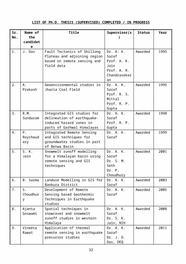
4. Seminar on Himalayan Geology & Geophysics, March 22-25, 1993, Wadia Institute of Himalayan Geology, Dehra Dun
5. 9th Himalaya-Karakorum-Tibet Workshop, 1-4 April, 1994 Kathmandu, Nepal
6. American Geophysical Union Winter Meeting, Dec. 1994, San Fransico, U.S.A.
7. First International Conference on Renewable Energy - Small Hydro, Hydro Centenary - 1997, Hyderabad, 1997.
8. International Conference on Small Hydro Power Systems, British Council Division, New Delhi, 1997.
9. Conference on Geomatics in Disaster Management, Indian Society of Geomatics, Indian Institute of Remote Sensing, Dehradun, 1997.
10. National Symposium on GIS for Business and Environmental Planning, University of Delhi (South Campus), New Delhi, 1997.
11. International Symposium on Emerging Trends in Hydrology, Department of Hydrology, University of Roorkee, Roorkee, 1997.
12. 11th Symposium on Earthquake Engineering, Department of Earthquake Engineering, University of Roorkee, Roorkee, December 17-19, 1998.
13. Indian Remote Sensing Society Conference, 1999, organized by Indian Space Research Organisataion, Bangalore, January,19-21, 1999.
14. Seminar on “The March 29, 1999 Chamoli Earthquake and its Impact (WOCEI-99)”, Wadia Institute of Himalayan Geology, Dehradun, October 22-23, 1999.
15. Seminar on “Lessons for Architects & Engineers from Recent Indian Earthquakes, Institution of Engineers (India), Roorkee, January 6-7, 2000.
16. Map India – 2001, New Delhi, February 7-9, 2001.
17. Seminar on Dehradun (Uttaranchal) The National Remote Sensing Hub, held on 1 st December, 2001 at DEAL, Dehra Dun, The Institute of Electronics & Telecommunication Engineers, Local Center, Dehradun.
18. Refresher Course on Remote Sensing and GIS applications in Earth Sciences, 17 th December 2001 to 12th January 2002 at Department of Geography, University of Pune.
19. Map India – 2002, New Delhi, February 6-8, 2002.
20. ESRI India – 2002, New Delhi, January 22-23, 2002.
21. SEE5, Tehran, Iran (May 12-17, 2007)
22. NDM, Esfhan, Iran (May 7-10, 2007)
23. Map India 2008, NOIDA (Feb. 6-8, 2008)
24. VESTO 2009, Chiba, Japan (March 26-28, 2009)
25. National Seminar on Geoscience for Society and Environment on 20th February 2010 organized by the Department of Geology, Utkal University, Bhubaneswar.
32
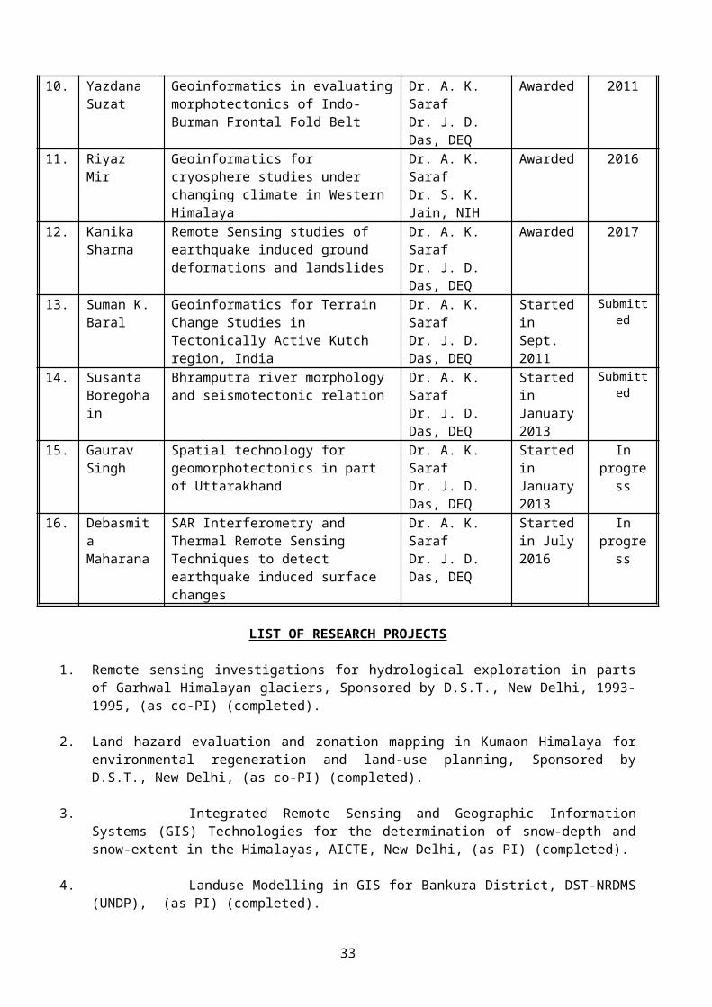
List of Special Lectures delivered in various workshops, courses and in public gatherings
1. Remote Sensing Applications in Geology, at Centre for Remote Sensing, UOR, Roorkee, 1993.
2. Introduction to GIS, at Centre for Remote Sensing, UOR, Roorkee, 1993.
3. Remote Sensing and GIS applications in ground water exploration, at Punjab Remote Sensing Centre, PAU, Ludhiana, 1994.
4. Digital Image Processing and enhancement, involving scope and examples from mineral resources, Indian Geological Congress, UOR, Roorkee, 1995.
5. GIS - Scope and Methodology, Indian Geological Congress, UOR, Roorkee, 1995.
6. Data Integration in a GIS platform and its Efficacy, University of Pune, Pune, 1996.
7. Use of modern techniques for planning of small hydro projects, U.P. Administration Academy, Nainital, July, 1996.
8. Delineation of catchments, Introduction of GIS and data input on GIS, Workshop on GIS based identification of small hydro sites, Alternate Hydro Energy Centre, University of Roorkee, January 30-31, 1998.
9. Introduction to Remote Sensing, Workshop on GIS based identification of small hydro sites, Alternate Hydro Energy Centre, University of Roorkee, January 30-31, 1998.
10. Remote sensing and GIS applications in EIA, Course on Environmental Impact Assessment, Centre of Continuing Education, University of Roorkee, February 16-21, 1998.
11. Delineation of catchments, Introduction of GIS and data input on GIS, Workshop on GIS based identification of small hydro sites, Assam State Remote Sensing Application Centre, February 20-21, 1998.
12. Introduction to Remote Sensing, Workshop on GIS based identification of small hydro sites, Alternate Hydro Energy Centre, Assam State Remote Sensing Application Centre, February 20-21, 1998.
13. Application of remote sensing and GIS techniques in Hydrology, Training Course on Application of Remote Sensing and GIS techniques in Hydrology, National Institute of Hydrology, 2-7 March, 1998.
14. Integrated Remote Sensing and GIS technique for groundwater exploration, Workshop on Remote Sensing and GIS for Resource Management and Development, Geoinformatics Division, Department of Civil Engineering, Indian Institute of Technology, Kanpur, 7th November 1998.
15. Application of Remote Sensing and GIS in earthquake studies, Workshop on Remote Sensing and GIS for Resource Management and Development, Geoinformatics Division, Department of Civil Engineering, Indian Institute of Technology, Kanpur, 7th November, 1998.
16. Remote Sensing and GIS Applications in Groundwater Exploration, Post Graduate Diploma Course in Geosciences, Indian Institute of Remote Sensing, Dehra Dun, 17th December, 1998.
17. Advance digital image processing techniques, M.Sc. Students of Department of Geology, University of Delhi, 8th February 1999.
33
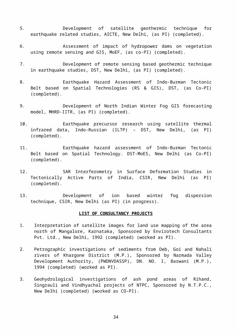
18. Introduction to Geographic Information System (GIS), M.Sc. Students of Department of Geology, University of Delhi, 8th February 1999.
19. Application of Remote Sensing and GIS in groundwater studies, M.Sc. Students of Department of Geology, University of Delhi, 9th February 1999.
20. Remote Sensing and GIS applications in: a. Springs delineation b. Earthquake studies, M.Sc. Students of Department of Geology, University of Delhi, 9th February, 1999.
21. Introduction to GIS-I, Training Programme on Digital Mapping Technology organised by Department of Civil Engineering, University of Roorkee, 15-20 March, 1999.
22. Introduction to GIS-II, Training Programme on Digital Mapping Technology organised by Department of Civil Engineering, University of Roorkee, 15-20 March 1999.
23. Introduction to GIS-III, Training Programme on Digital Mapping Technology organised by Department of Civil Engineering, University of Roorkee, 15-20 March 1999.
24. Introduction to GIS-IV, Training Programme on Digital Mapping Technology organised by Department of Civil Engineering, University of Roorkee, 15-20 March 1999.
25. GIS based planning of Small Hydro Projects, International Course on Planning, Design & Implementation of Small Hydro Power Projects, organised by Alternate Hydro Energy Centre, University of Roorkee, Roorkee, 15-25 March 1999.
26. Training Course on Remote Sensing and GIS applications in Water Resources, National Institute of Hydrology, Roorkee, December 13-24, 1999.
27. Remote Sensing and GIS applications in irrigation and water management, Training Course for Irrigation Trainees, Irrigation Research Institute, Roorkee, June, 2000.
28. Remote Sensing Techniques in Groundwater Development, Short Term Course on Groundwater Recharge, Assessment & Quality, Department of Hydrology, University of Roorkee, July 10 to July 29, 2000.
29. GIS and Remote Sensing based planning of Small Hydro Projects, International Course on Planning, Technology Selection and Implementation of Small Hydro Power Projects, organised by Alternate Hydro Energy Centre, University of Roorkee, Roorkee, 13-23 February 2001.
30. Applications and limitations of Remote Sensing and GIS technologies, National Seminar on Application of New Techniques in Modern Geography, organised by the Department of Geography, University of Pune, Pune, 26-27 February 2001.
31. Remote sensing and GIS applications in geology, Training Programme for Trainee Officers (Engineering Geology), National Hydroelectric Power Corporation, Faridabad, 27.08.2001 – 21.09.2001.
32. Remote Sensing and GIS Applications in Earthquake Studies, Key Note Lecture delivered in Seminar on Dehradun (Uttaranchal) The National Remote Sensing Hub, held on 1st December, 2001 at DEAL, Dehra Dun, organized by The Institute of Electronics & Telecommunication Engineers, Local Center, Dehradun.
33. Overview of GIS, Refresher Course on Remote Sensing and GIS applications in Earth Sciences, held between 17th December 2001 to 12th January 2002 at Department of Geography, University of Pune.
34
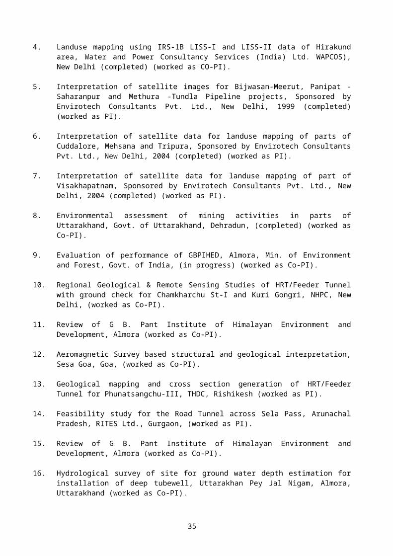
34. Non-spatial information and various types of DBMS, Refresher Course on Remote Sensing and GIS applications in Earth Sciences, held between 17th December 2001 to 12th January 2002 at Department of Geography, University of Pune.
35. Hardware and software requirements of GIS, Refresher Course on Remote Sensing and GIS applications in Earth Sciences, held between 17th December 2001 to 12th January 2002 at Department of Geography, University of Pune.
36. GIS based planning of small hydro projects, International Couse on Cost Effective Planning and Design of Small Hydro Projects, held between 5-15th February 2002 at Alternate Hydro Energy Centre, Indian Institute of Technology, Roorkee.
37. False Topographic Perception Phenomena and its correction, 8th October 2002 at Centre for Environmental Studies, University of Dundee, U.K.
38. Basics of Geographic Information System, Invited Lecture delivered at Department of Geology, University of Delhi, Delhi on 20th Feb. 2003.
39. Colour space and its implications in satellite data fusion and transformations, Invited Lecture delivered at Department of Geology, University of Delhi, Delhi on 20th Feb. 2003.
40. False Topographic Perception Phenomena, its correction methods and new developments, Invited Lecture delivered at Department of Geology, University of Delhi, Delhi on 20th Feb. 2003.
41. GIS, Remote Sensing and GPS applications in small hydropower planning, Invited Lecture delivered at International Course on Technology Selection for Small Hydro Development, Feb. 18-28, 2003 organised by AHEC, IIT Roorkee.
42. Remote Sensing and GIS in earthquake studies, Invited Lecture delivered in Seismic Microzonation of Hilly Areas, An Integrated, Comphrehensive Traning Programme organised at CBRI, Roorkee, Feb. 11-15, 2003.
43. Remote Sensing and GIS applications in earthquake studies, Invited Lecture delivered at GIS Institute, NOIDA on 5th April 2003.
44. Establishment of NOAA-HRPT Satellite Earth Station at IITR and NOAA-AVHRR data application in earthquake studies, Invited Lecture delivered at Forest Survey of India, Dehra Dun on 2nd May 2003.
45. GIS applications in Small Hydropower Development, Invited Lecture delivered at National Workshop on Small Hydropower Development: Opportunities and Challenges" during 5-7 June 2003 at Manali organized by AHEC, IIT Roorkee.
46. Use of modern tools: GIS, GPS and altimeters for planning and investigation of SHP, Invited Lecture delivered at International Training Course on Small Hydropower Development, during 10-22 Februry 2004, AHEC, IIT Roorkee.
47. Fundamental of Digital Image Processing, Invited Lecture delivered at Department of Geology, University of Delhi, Delhi on 19th Feb. 2004.
48. Colour concept in DIP and its applications, Invited Lecture delivered at Department of Geology, University of Delhi, Delhi on 19th Feb. 2004.
49. False Topographic Perception phenomena and its correction techniques, Invited Lecture delivered at Department of Geology, University of Delhi, Delhi on 19th Feb. 2004.
35
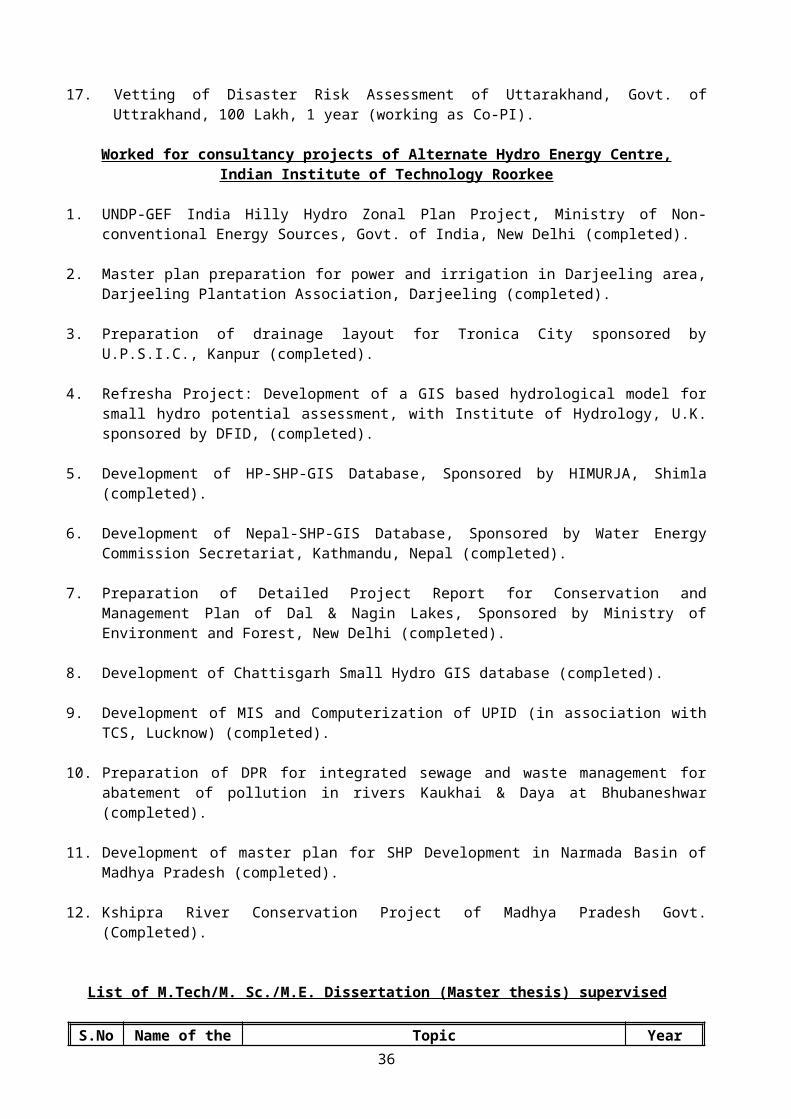
50. Remote Sensing, GIS and GPS applications in groundwater recharge studies, invited Lecture delivered in “Interactive Workshop on Water Conservation” organised by National Institute of Hydrology, Roorkee between 13-14 April, 2004.
51. Remote Sensing and GIS applications in groundwater recharge studies, invited Lecture delivered at National Institute of Hydrology in a special course on “Remote Sensing and GIS applications in Hydrology”, NIH, held between 14-19 June 2004.
52. Remote Sensing and GIS techniques in groundwater recharge studies, invited lecture delivered in a short term course on “Engineering Geological Consideration for Artificial Recharge” organised by Department of Hydrology, IIT Roorkee between 12-23 July, 2004.
53. Remote Sensing and GIS techniques in groundwater recharge studies, invited lecture delivered in a short term course on “Engineering Geological Consideration for Artificial Recharge” organised by Department of Hydrology, IIT Roorkee, 23 Sept., 2004
54. Thermal remote sensing in earthquake studies, Proceedings of Third International Conference: GIS-2004 held at Bahrain between 27-29 September 2004, organised by the Bahrain Society of Engineers, Bahrain, pp.19-33.
55. Use of Modern Tools: GIS, GPS and altimeters for planning and investigation of SHP, lecture delivered in a short term International Course on Grid Based Small Hydropower Development, organised by AHEC, IITR during 27 Jan. – 09 Feb. 2005.
56. Thermal Remote Sensing Applications in Earthquake Studies, Special Lecture delivered in a short term course on Earthquake Engineering and Building Structures, organized by DEQ, IITR during 29 August – 03 September 2005.
57. Basics of GPS and GIS, Special Lecture delivered in the workshop on Himalayan School Earthquake Laboratory Programme (HIM-SELP) to train school teachers of Uttaranchal and Himachal Region held at Wadia Institute of Himalayan Geology, Dehra Dun, delivered on 30 September 2005.
58. Introduction to GPS and its applications in Earth Sciences, Special Lecture delivered on 16 th March 2006 in UGC sponsored Refresher Course for Earth Sciences Faculty held at Department of Geography, University of Pune.
59. DEM and its derivatives and their application in Quantitative Geomorphology, Special Lecture delivered on 16th March 2006 in UGC sponsored Refresher Course for Earth Sciences Faculty held at Department of Geography, University of Pune.
60. RS and GIS applications in groundwater studies, Special Lecture delivered on 17 th March 2006 in UGC sponsored Refresher Course for Earth Sciences Faculty held at Department of Geography, University of Pune.
61. RS and GIS applications in earthquake studies, Special Lecture delivered on 17 th March 2006 in UGC sponsored Refresher Course for Earth Sciences Faculty held at Department of Geography, University of Pune.
62. False Topographic Perception Phenomena and its correction techniques, Special Lecture delivered on 18th March 2006 in UGC sponsored Refresher Course for Earth Sciences Faculty held at Department of Geography, University of Pune.
36
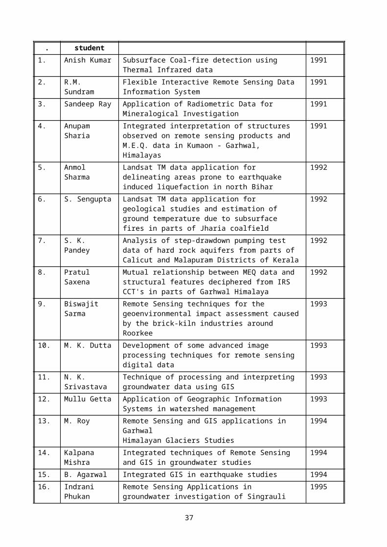
63. Introduction to GPS-I, Special Lecture delivered on 26th April 2006 in a UREDA sponsored Training Course for the Project Officers held at AHEC, IIT Roorkee between 26-29 April 2006.
64. Introduction to GPS-II, Special Lecture delivered on 26th April 2006 in a UREDA sponsored Training Course for the Project Officers held at AHEC, IIT Roorkee between 26-29 April 2006.
65. Introduction to GIS: What is GIS? Who can use GIS? Special Lecture delivered on 26th April 2006 in a UREDA sponsored Training Course for the Project Officers held at AHEC, IIT Roorkee between 26-29 April 2006.
66. Components of GIS, Hardware and Software requirements, Special Lecture delivered on 26th April 2006 in a UREDA sponsored Training Course for the Project Officers held at AHEC, IIT Roorkee between 26-29 April 2006.
67. GIS Applications in SHP Development, Special Lecture delivered on 26th April 2006 in a UREDA sponsored Training Course for the Project Officers held at AHEC, IIT Roorkee between 26-29 April 2006.
68. GIS Applications in general, Special Lecture delivered on 26th April 2006 in a UREDA sponsored Training Course for the Project Officers held at AHEC, IIT Roorkee between 26-29 April 2006.
69. Introduction to GIS, Special Lecture delivered on 24th May 2006 in a USAID-India sponsored Training Course entitled “GIS Based Distribution System Planning Analysis and Asset Management held at CED, IIT Roorkee between May 24-28, 2006.
70. Different components of GIS and data organization, Special Lecture delivered on 24th May 2006 in a USAID-India sponsored Training Course entitled “GIS Based Distribution System Planning Analysis and Asset Management held at CED, IIT Roorkee between May 24-28, 2006.
71. Different components of GIS and data organization, Special Lecture delivered on 24th May 2006 in a USAID-India sponsored Training Course entitled “GIS Based Distribution System Planning Analysis and Asset Management held at CED, IIT Roorkee between May 24-28, 2006.
72. Different components of GIS and data organization, Special Lecture delivered on 24th May 2006 in a USAID-India sponsored Training Course entitled “GIS Based Distribution System Planning Analysis and Asset Management held at CED, IIT Roorkee between May 24-28, 2006.
73. Introduction to GPS, Special Lecture delivered on 24th May 2006 in a USAID-India sponsored Training Course entitled “GIS Based Distribution System Planning Analysis and Asset Management held at CED, IIT Roorkee between May 24-28, 2006.
74. GPS: Errors, corrections and DGPS, Special Lecture delivered on 24th May 2006 in a USAID-India sponsored Training Course entitled “GIS Based Distribution System Planning Analysis and Asset Management held at CED, IIT Roorkee between May 24-28, 2006.
75. Remote Sensing and GIS applications in Earthquake Studies, Special Lecture delivered on 12 th July 2006 in a course on “Earthquake Risk Management” sponsored by Ministry of Home Affairs for PWD Officers, organised by DEQ, IIT Roorkee.
76. Spatial technologies in forest fire studies, Special Lecture delivered on 23 rd August 2006 in a course on “Forest Fire Management”, organised by DMMC-NIDM-FRI Dehradun between 23-25 August 2006 at FRI Dehradun.
37
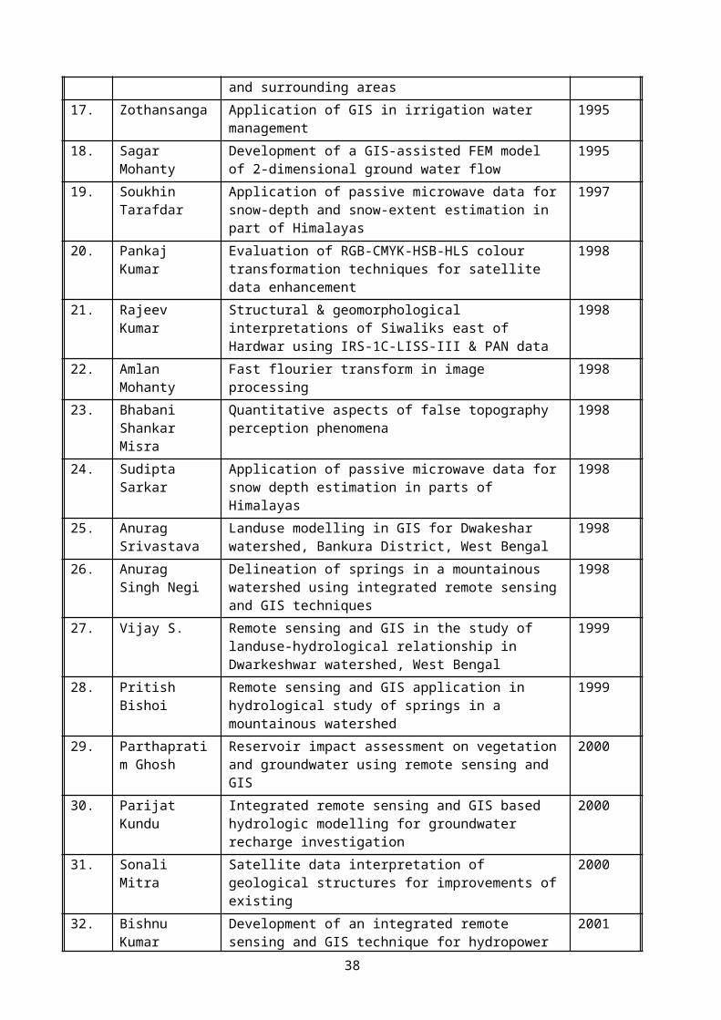
77. GIS & Remote Sensing in SHP Development, Special Lecture delivered on 31 st January 2007 in a international course on “Small Hydropower: Assessment and Development”, organised by AHEC, IIT Roorkee between 30 January – 10 February 2007 at AHEC, IIT Roorkee.
78. GPS & Altimeter in SHP Development, Special Lecture delivered on 1 st February 2007 in a international course on “Small Hydropower: Assessment and Development”, organised by AHEC, IIT Roorkee between 30 January – 10 February 2007 at AHEC, IIT Roorkee.
79. Remote Sensing and GIS applications in earthquake studies, Special Lecture delivered on 24 th July 2007 in Department of Geology and Geophysics, Indian Institute of Technology Kharagpur.
80. Introduction to GIS, Special Lecture delivered on 13th August 2007 in a USAID-India sponsored Training Course entitled “GIS Based Distribution System Planning Analysis and Asset Management held at CED, IIT Roorkee between August 13-17, 2007.
81. Different components of GIS and data organization, Special Lecture delivered on 13th August 2007 in a USAID-India sponsored Training Course entitled “GIS Based Distribution System Planning Analysis and Asset Management held at CED, IIT Roorkee between August 13-17, 2007.
82. Introduction to GPS, Special Lecture delivered on 14th August 2007 in a USAID-India sponsored Training Course entitled “GIS Based Distribution System Planning Analysis and Asset Management held at CED, IIT Roorkee between August 13-17, 2007.
83. GPS: Errors, corrections and DGPS, Special Lecture delivered on 14th August 2007 in a USAID-India sponsored Training Course entitled “GIS Based Distribution System Planning Analysis and Asset Management held at CED, IIT Roorkee between August 13-17, 2007.
84. Remote Sensing and GIS applications in Natural Disaster Investigations, Special Lecture delivered on 7th April 2008 in a DST sponsored Training Course organized by Lal Bahadur Shastri National Academy of Administration, Mussoorie.
85. Introduction to GPS-I, Special Lecture delivered 18th August 2008 in Teachers Training Course organized by Department of Earth Sciences, Manipur University, Imphal.
86. Introduction to GPS-II, Special Lecture delivered 18 th August 2008 in Teachers Training Course organized by Department of Earth Sciences, Manipur University, Imphal.
87. Different types of Digital Elevation Models and their derivatives, Special Lecture delivered 19th
August 2008 in Teachers Training Course organized by Department of Earth Sciences, Manipur University, Imphal.
88. False Topographic Perception Phenomena in Remote Sensing data and its correction techniques, Special Lecture delivered 18th August 2008 in Teachers Training Course organized by Department of Earth Sciences, Manipur University, Imphal.
89. Remote Sensing and GIS applications in earthquake studies, Special Lecture delivered 18th August 2008 in Teachers Training Course organized by Department of Earth Sciences, Manipur University, Imphal.
90. Introduction to Arc View GIS and its applications in water resources, Special Lecture delivered on 21st October 2008 in a Training Course on “Applications of Remote Sensing and GIS in Water Resources Management” organized by National Institute of Hydrology, Roorkee.
38

91. Thermal Remote Sensing in Earthquake Studies, Special Lecture delivered on 27 th March 2009 in Center for Environmental Remote Sensing, Chiba University, Japan.
92. Remote Sensing and GIS applications in Earthquake Studies, Special Lecture delivered on 01st April 2009 in a short term course on “Earthquake Disaster Mitigation” organized by SAARC Disaster Management Centre and Centre of Excellence in Disaster Mitigation & Management, IIT Roorkee.
93. Thermal Remote Sensing in Earthquake Studies, delivered Chief Guest presentation on 22 th April 2009 in Central Building Research Institute Roorkee on ‘World Earth Day’.
94. Earthquake precursor and thermal remote sensing, delivered Special Lecture on 18th December 2009 at Indian Institute of Remote Sensing, Dehradun.
95. Case studies on thermal data applications for earthquake studies, delivered Special Lecture on 18th December 2009 at Indian Institute of Remote Sensing, Dehradun.
96. Remote Sensing and GIS Applications in Earthquake Studies, delivered Special Lecture on 22nd December 2009, in the Lal Bahadur Shastri National Academy of Administration (LBSNAA), Mussoorie.
97. Winter fog over the Indo-Gangetic Plains: Mapping and Modelling using Remote Sensing and GIS" in the ICOACCE-10 on 12th February 2010 (jointly organized by the Techbuddy Consulting & GITS, Udaipur.
98. Remote Sensing Observations of Earthquake Thermal Precursors” in the National Seminar on Geoscience for Society and Environment on 20th February 2010 organized by the Department of Geology, Utkal University, Bhubaneswar.
99. Introduction to Arc View / Arc GIS in training course on Applications of Remote Sensing and GIS in Water Resources Management held during 08-12th March 2010 at NIH, Roorkee.
100. Winter fog over the Indo-Gangetic Plains: Mapping and Modelling using Remote Sensing and GIS in Institution of Engineers of India, Roorkee Local Chapter, Roorkee which celebrated Earth Day on 22 nd
April 2010.
101. Remote Sensing and GIS: Study and Management of Natural Disasters, delivered Special Lecture on 03nd June 2010, in the Lal Bahadur Shastri National Academy of Administration (LBSNAA), Mussoorie.
102. Thermal Remote Sensing in Earthquake Studies, delivered Special Lecture on 29 th August 2010 in University of Petroleum and Energy Studies, Dehradun.
103. False Topographic Perception Phenomena in Remote Sensing data and its correction techniques, delivered Special Lecture on 29th August 2010 in University of Petroleum and Energy Studies, Dehradun.
104. Remote Sensing and GIS Technologies in Earthquake Studies, Short Term Course on Earthquake Risk Mitigation, organized by SAARC Disaster Management Centre and Centre of Excellence in Disaster Mitigation & Management, IIT Roorkee, Sept. 15-21, 2010 at IIT Roorkee.
105. Remote Sensing and GIS in Lake Studies, Short Term Course on Hydrological Investigations for conservation and management of lakes, organized by NIH, Roorkee, 1-3 March 2011.
106. Advances in Remote Sensing and GIS Technologies in Earthquake Studies, Keynote Speech in the 5th SASTech symposium held in Mashad, Iran during 12-14 May 2010.
39
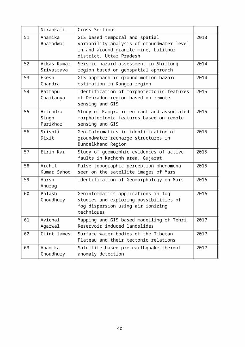
107. GIS Database Management System, Special Lecture in a training course “Applications of Remote Sensing and GIS in Water Resources Management” organized by NIH, Roorkee, 30 May – 10 June 2011.
108. Map Projections in GIS, Special Lecture in a training course “Applications of Remote Sensing and GIS in Water Resources Management” organized by NIH, Roorkee, 30 May – 10 June 2011.
109. Remote Sensing and GIS techniques in Earthquake Studies, Special Lecture delivered at Institute of Geology & Geophysics, Chinese Academy of Sciences, Beijing, China, 24th June 2011.
110. Advances in Remote Sensing and GIS Technologies in Earthquake Studies, Special Lecture delivered at Centre for Earth Observation and Digital Earth, Chinese Academy of Sciences, Beijing, China, 08 th
July 2011.
111. False Topographic Perception Phenomena in Remote Sensing data and its correction techniques Special Lecture delivered at Institute of Spatial Information Sci. & Tech., Beijing Normal University, Beijing, China, 10th July 2011.
112. Remote Sensing and Earthquake Thermal Precursors, Special Lecture delivered at Institute of Earthquake Science, China Earthquake Administration, Beijing, China, 14 th July 2011.
113. Remote Sensing and GIS Technologies in Groundwater Recharge Studies, delivered Special Lecture on 01st Nov. 2011, in the Lal Bahadur Shastri National Academy of Administration (LBSNAA), Mussoorie.
114. Remote Sensing and GIS Technologies in Groundwater Recharge Studies, delivered Distinguish Guest Lecture in the Department of Geology, University of Patna in the National Seminar on "Management of groundwater resources in India with special reference to Bihar" between 18-19th March 2013.
115. The organising committee of INSPIRE INTERNSHIP SCIENCE CAMP (sponsored by the Department of Science & Technology, Government of India) invited to deliver a Special Lecture “False Topographic Phenomena and its Correction Techniques” at Raj Kumar Goel Engineering College, Pilkhuwa, Ghaziabad on 14th May 2013.
116. The organising committee of 1st International Conference "Disasters, Natural Resource Management and Socio-economic Development" of APG organised by Department of Geography, Kurukshetra University, Kurukshetra to deliver a Keynote address entitled "Is winter fog is menace or natural disaster?" on 4th Oct 2013.
117. The organising committee of INSPIRE INTERNSHIP SCIENCE CAMP (sponsored by the Department of Science & Technology, Government of India) invited to deliver a Special Lecture “Geology: Fundaments & Importance” at Bharat Institute of Technology, Meerut on 29th Nov. 2013.
118. Remote Sensing and GIS Technologies in Groundwater Recharge Studies, delivered Special Lecture on 24st Dec. 2013 at Regional Remote Sensing Service Centre, Jodhpur.
119. False Topographic Phenomena and its Correction Techniques, delivered Special Lecture on 24st Dec. 2013 at Regional Remote Sensing Service Centre, Jodhpur.
120. Geo-informatics in Fog Monitoring and Modelling in Indo-Gangetic Plain for Economic Benefits on different sectors in the plains of Uttarakhand, delivered Keynote Address on 15 th Feb. 2014 in
40

National Conference on ‘Revisiting Development Paradigms for Uttarakhand’, organised by Department of HSS, IIT Roorkee.
121. False topographic perception phenomena in remote sensing and its correction, delivered Special Lecture on 12th March 2014 at Department of Geology, University of Lucknow.
122. Geospatial technology in earthquake studies, delivered 'Prof. R. S. Chaturvedi Memorial Lectures' on 13th March 2014 at Remote Sensing Applications Centre, Uttar Pradesh.
123. Winter fog over the Indo-Gangetic Plains: Mapping and Modelling, delivered 'Prof. R. S. Chaturvedi Memorial Lectures' on 13th March 2014 at Remote Sensing Applications Centre, Uttar Pradesh.
124. Remote Sensing and GIS Technologies in Earthquake Studies, delivered in the International Course on ‘Techniques for Earthquake Resistant Design & Retrofitting in South Asia, organized by SAARC Disaster Management Centre, Centre of Excellence in Disaster Mitigation & Management and Department of Earthquake Engineering, IIT Roorkee, between 19-30 th March, 2014 (lecture delivered on 21st March 2014).
125. Winter Fog in North India, has delivered a keynote paper in the International Symposium on Geoinformatics (IGS-2014) held in Kuala Lumpur, Malaysia between 14-15th Oct. 2014.
126. Geoinformatics in Earthquake Studies, delivered a Special Lecture in by the Department of Civil Engineering, University of Malaya, Kuala Lumpur, Malaysia on 16th Oct. 2014.
127. Role of Remote Sensing and GIS in Hilly areas Special Lecture delivered in Geospatial Education and Training Workshop on Management of Water Resources, Glaciers and Climate Change with Special Reference to Uttarakhand held in National Institute of Hydrology, Roorkee between 01-03rd Nov. 2014.
128. Fog Hazard of Indo-Gangetic Plain: Mapping, Modelling and Dispersion Techniques delivered in the Seminar on Geospatial Technology in Natural Resource Management jointly organized by Indian Society of Remote Sensing and Punjab Remote Sensing Centre, Ludhiana between 17-18th March 2015.
129. False Topographic Perception Phenomena and its correction delivered Popular Talk in the Seminar on Geospatial Technology in Natural Resource Management jointly organized by Indian Society of Remote Sensing and Punjab Remote Sensing Centre, Ludhiana between 17-18th March 2015.
130. Geoinformatics in Earthquake Studies delivered Popular Talk in the Seminar on Geospatial Technology in Natural Resource Management jointly organized by Indian Society of Remote Sensing and Punjab Remote Sensing Centre, Ludhiana between 17-18th March 2015.
131. Role of Remote Sensing and GIS in Hilly areas Special Lecture delivered in Geospatial Education and Training Workshop on Management of Water Resources, Glaciers and Climate Change with Special Reference to Uttarakhand held in National Institute of Hydrology, Roorkee between 24-26 May 2015.
132. Remote Sensing for Geologists, Special Lecture delivered in Department of Geology, HNB Garhwal University Campus, Badshahi Thaul, Tehri Garhwal between 29-30th Sept. 2015.
133. Geographic Information Systems, Special Lecture delivered in Department of Geology, HNB Garhwal University Campus, Badshahi Thaul, Tehri Garhwal between 29-30th Sept. 2015.
134. Geoinformatics in Earthquake Studies, Special Lecture delivered in Department of Geology, HNB Garhwal University Campus, Badshahi Thaul, Tehri Garhwal between 29-30th Sept. 2015.
41
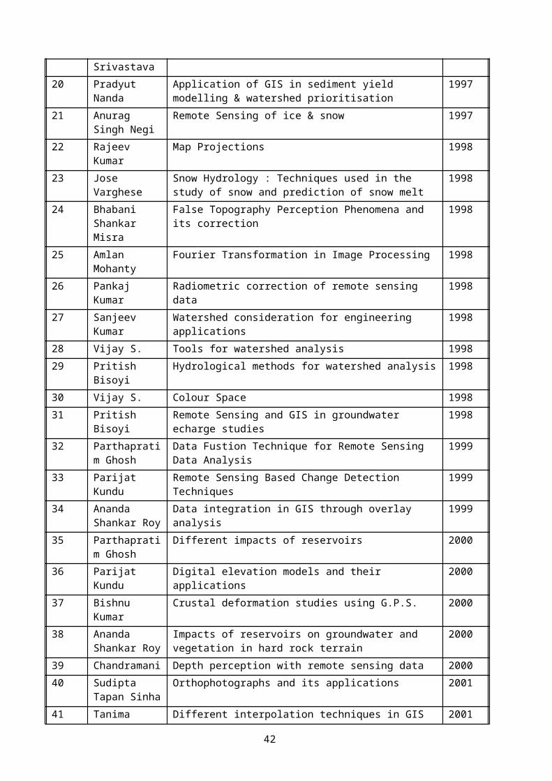
135. False Topographic Perception Phenomena and its correction, Special Lecture delivered in Department of Geology, HNB Garhwal University Campus, Badshahi Thaul, Tehri Garhwal between 29-30th Sept. 2015.
136. Fog Hazard of Indo-Gangetic Plain: Mapping, Modelling and Dispersion Techniques, Special Lecture delivered in Department of Geology, HNB Garhwal University Campus, Badshahi Thaul, Tehri Garhwal between 29-30th Sept. 2015.
137. Remote Sensing and GIS Technologies in Groundwater Recharge Studies, Special Lecture delivered in Department of Geology, HNB Garhwal University Campus, Badshahi Thaul, Tehri Garhwal between 29-30th Sept. 2015.
138. Geoinformatics in Earthquake Studies, Special Lecture delivered in Department of Remote SensingBIT Mesra, Ranchi, Jharkhand on 11th Oct. 2015.
139. Hydrogeomorphological Map Making with use of Remote Sensing & GIS techniques, Special Lecture delivered in Two Days Training Workshop entitled “Application and Uses of Hydro-geomorphological Maps for Groundwater Perceptions” held between 19-20th February 2016 in MeBaDA, Shillong.
140. Use & Application of Hydro-geomorphological Map in Ground Water perception an aid for Borehole Site selection, Special Lecture delivered in Two Days Training Workshop entitled “Application and Uses of Hydro-geomorphological Maps for Groundwater Perceptions” held between 19-20th February 2016 in MeBaDA Shillong.
141. Use and applications of HGMs in selecting artificial recharging sites (Check Dams) etc., Special Lecture delivered in Two Days Training Workshop entitled “Application and Uses of Hydro-geomorphological Maps for Groundwater Perceptions” held between 19-20th February 2016 in MeBaDA Shillong.
142. Case study of RS-GIS based Ground Water prospects Maps, Special Lecture delivered in Two Days Training Workshop entitled “Application and Uses of Hydro-geomorphological Maps for Groundwater Perceptions” held between 19-20th February 2016 in MeBaDA Shillong.
143. Hydrogeomorphological Map Making with use of Remote Sensing & GIS techniques, Special Lecture delivered in Two Days Training Workshop entitled “Application and Uses of Hydro-geomorphological Maps for Groundwater Perceptions” held between 22-23th February 2016 in Guwahati.
144. Use & Application of Hydro-geomorphological Map in Ground Water perception an aid for Borehole Site selection, Special Lecture delivered in Two Days Training Workshop entitled “Application and Uses of Hydro-geomorphological Maps for Groundwater Perceptions” held between 22-23th February 2016 in Guwahati.
145. Use and applications of HGMs in selecting artificial recharging sites (Check Dams) etc., Special Lecture delivered in Two Days Training Workshop entitled “Application and Uses of Hydro-geomorphological Maps for Groundwater Perceptions” held between 22-23th February 2016 in Guwahati.
146. Case study of RS-GIS based Ground Water prospects Maps, Special Lecture delivered in Two Days Training Workshop entitled “Application and Uses of Hydro-geomorphological Maps for Groundwater Perceptions” held between 22-23th February 2016 in Guwahati.
147. Geoinformatics in Earthquake Studies, Invited Lecture delivered at Department of Geography, University of Pune, Pune, 05th March 2016.
42
148. False Topographic Perception Phenomena in Remote Sensing data and its correction techniques, Invited Lecture delivered at Department of Geography, University of Pune, Pune, 05 th March 2016.
149. Geo-Informatics in identification of potential groundwater recharge sites in Bundelkhand Craton, Madhya Pradesh Council of Science and Technology, Bhopal, 17th March 2016.
150. False Topographic Perception Phenomena in Remote Sensing data and its correction techniques, Madhya Pradesh Council of Science and Technology, Bhopal, 17th March 2016.
151. Potential water harvesting sites along quartz reefs, invited presentation in Min. of Water Resources (RD & GR) Project Meeting held in National Institute of Hydrology, Roorkee between 25-26 th April 2016.
152. Geoinformatics in earthquake studies, Invited Lecture delivered at Kharazmi University (Tarbiat Moallem University), Tehran, 17th May 2016.
153. False Topographic Perception Phenomena in Remote Sensing Data and its correction techniques, Invited Lecture delivered at Tarbiat Modares University, Tehran, 17th May 2016.
154. Satellite based detection of pre-earthquake thermal anomalies, Invited Lecture delivered at Institute of Geophysics, University of Tehran, Tehran, 18th May 2016.
155. Applications of Remote Sensing and GIS Techniques in Earthquake Studies, Invited Lecture delivered at Geological Survey of Iran, Tehran, 21st May 2016.
156. Geoinformatics for Groundwater Recharge studies, Invited Lecture delivered at Kharazmi University (Tarbiat Moallem University), Karaz, Iran, 23rd May 2016.
157. Satellite based detection of pre-earthquake thermal anomalies and future perception, Invited Lecture delivered at Chamran University, Ahvaz, Iran, 25th May 2016.
158. Geoinformatics in Earthquake Studies, Invited Lecture delivered at Department of Remote Sensing and GIS, University of Tehran, Tehran, Iran, 28th May 2016.
159. North Indian Fog: Mapping, Modelling and Dispersion Techniques, Invited Lecture delivered at National Center of Experimental Mineralogy and Petrology, University of Allahabad, 20 th September 2016.
---
43