big data in automotive applications - fisher college of ... · big data in automotive applications:...
TRANSCRIPT

Big Data in Automotive Applications: Cloud Computing Based
Velocity Profile Generation for Minimum Fuel Consumption
Giorgio Rizzoni, Ümit Özgüner, Simona Onori, Jim Wollaeger, Adarsh Kumar, Pardis Khayyer, Engin Ozatay
The Ohio State University Center for Automotive Research
Department of Electrical and Computer Engineering Department of Mechanical and Aerospace Engineering

• Introduction
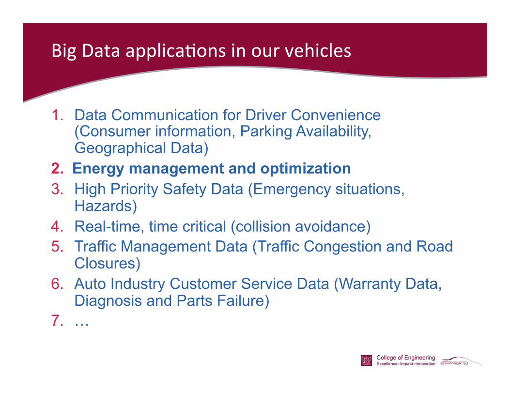
Big Data applica+ons in our vehicles
1. Data Communication for Driver Convenience (Consumer information, Parking Availability, Geographical Data)
2. Energy management and optimization 3. High Priority Safety Data (Emergency situations,
Hazards) 4. Real-time, time critical (collision avoidance) 5. Traffic Management Data (Traffic Congestion and Road
Closures) 6. Auto Industry Customer Service Data (Warranty Data,
Diagnosis and Parts Failure) 7. …

1. Data Communica+on for Driver Convenience
• Consumer information Data • Parking Availability Data • Geographical Data
h9p://ebiquity.umbc.edu/blogger/2010/07/09/google-‐open-‐spot-‐android-‐app-‐finds-‐parking/

2. Fuel consumption optimization

3. Data Communication for Safety and Collaborative Driving
A collabora+ve driving exercise in Holland. Driving 3 autonomous trucks in Japan.
Tes+ng autonomous and semi-‐autonomous cars sharing informa+on in Columbus.

4. Time critical data – collision avoidance
Py

Our vision of the “connected vehicle traffic” of the future where many layers of informa+on is transmi9ed on demand and extensive measured data about the environment is shared.

Hierarchy of data transmission and sharing

Cloud Computing Based Velocity Profile Generation
for Minimum Fuel Consumption
Giorgio Rizzoni, Ümit Özgüner, Simona Onori, Jim Wollaeger, Adarsh Kumar, Pardis Khayyer, Engin Ozatay
The Ohio State University Center for Automotive Research
Department of Electrical and Computer Engineering Department of Mechanical and Aerospace Engineering
Dimitar Filev, John Michelini Ford Motor Company
Research and Advanced Engineering

• Fuel consumption optimization – background and methodology
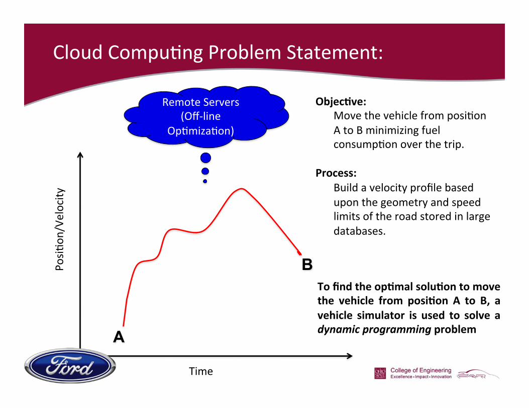
Cloud Compu+ng Problem Statement:
A
B
Objec)ve: Move the vehicle from posi+on A to B minimizing fuel consump+on over the trip.
Process:
Build a velocity profile based upon the geometry and speed limits of the road stored in large databases.
Time
Posi+
on/Velocity
Remote Servers (Off-‐line
Op+miza+on)
To find the op)mal solu)on to move the vehicle from posi)on A to B, a vehicle simulator is used to solve a dynamic programming problem

Dynamic Programming Optimization
!
Minimize energy consumption over a known route, by prescribing the instantaneous velocity of the vehicle.

Siulated Driving Scenario A
Highway-Urban Driving profile composed of 2 h ighway segments followed by urban and highway segments (6km, 1.25km, 4km and 7.35km, respectively) with non-zero road grade.
14
Road Elevation data used to simulate non-zero grade for Scenario 2
Case Study
Addi+onal Fuel Consumed (rela+ve to op+mal)
Slow Poke + 17.5 % Average Profile + 23.2 %
Lead Foot + 27.1 %

Simulated Driving Scenario B
!
!
Case Study Addi+onal Fuel Consumed
Trip Dura+on (seconds)
Op+mal Profile -‐ 1578 Slow Poke + 8.2 % 2026
Average Profile + 10.2 % 1428 Lead Foot + 29.2 % 1132
Actual Driving + 23.9 % 1462
Actual driving profile with rea l g rade da ta . I t i s composed of an 18.8km highway segment followed by 8.6km urban segment with multiple stops events and road elevation.

• Vehicle Implementation

Wireless Internet Provider
Remote Servers (Off-‐line Op+miza+on)
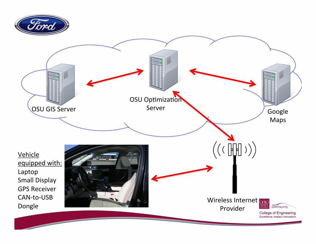
OSU GIS Server OSU Op+miza+on
Server Google Maps
Wireless Internet Provider
Vehicle equipped with: Laptop Small Display GPS Receiver CAN-‐to-‐USB Dongle

OSU ArcGIS Server
• GIS: Geographic Informa+on Systems • ArcGIS sohware is licensed and set up on a server @ CAR • Geographic informa+on from:
• USGS (United States Geological Survey)-‐Provided DEM data of the en+re US
• 3 meter resolu+on of Ohio • 10 meter resolu+on of Con+nental US
• Total database size of eleva+on data: 700 GB

ArcGIS Eleva+on Database
Sample Elevation Data loaded and published on OSU Servers

Driver Interface
Colors Change Based on Driver behavior: RED: Going too fast-‐SLOW down WHITE: Within Target Range GREEN: Going too slow-‐SPEED up

Trial Calibra+on Loop around CAR
1. System was given the waypoints A, B, and C
2. Google Rou+ng algorithm decides upon a route and transmits coordinates to OSU servers over the internet.
3. Communicate with OSU GIS server and get eleva+ons.
4. Run Op+miza+on
Total Trip Distance ≈ 2.2 Miles This route will be used for

Op+mal Profile
Profile was op+mized using new Vehicle Model with a velocity Resolu+on = 2 MPH Predicted MPG: 24.5

Conclusion
• Velocity planning: Through the solution of an optimization problem, we have generated an optimal velocity profile to minimize vehicle fuel consumption through cloud-based optimization.
• Future work includes implementing real-time road traffic information with the cloud-based optimization to recalculate the optimal velocity profile in real-time in response to external traffic disturbances.
• One of the key questions that will be addressed in future research is the scalability of this concept to large numbers of vehicles, and the implications with regard to wireless communications, computing and real-time requirements.

Thank you for your kind attention!
Questions?
http://car.osu.edu