belair2015 campaign questionnaire
TRANSCRIPT

23/03/2015
Analysis of Key User Response to BELAIR2015 Campaign Questionnaire BELAIR2015 Kick-Off Meeting, BELSPO, 20 March 2015

© 2014, VITO NV
BELAIR2015 CAMPAIGN QUESTIONNAIRE
» Questionnaire sent to BELAIR Key-Users on 12 March 2015
» Stephanie Delalieux (VITO) for HESBANIA-Horticulture
» Bas van Wesemael (UCL) for HESBANIA-Soil
» Viviane Planchon (CRA-W) for HESBANIA-Agriculture
» Els Knaeps (replacing Dries Raymaekers) (VITO) for LITORA-Zeebrugge
» Jaak Monbaliu (KUL) for LITORA-Yzermonding
» Jeroen Vandenborre (INBO) for LITORA-Het Zwin and LITORA-Laege Moere
» Boud Verbeiren (VUB) for SONIA-Brussels and SONIA-Forest
» Part of STEREO II’s component scientific support
» BELAIR2013 project aimed to converge the Belgian Scientific Community by identifying a Belgian “multisite” servicing remote sensing (calibration & validation as well as innovative) research activities
© 2014, VITO NV
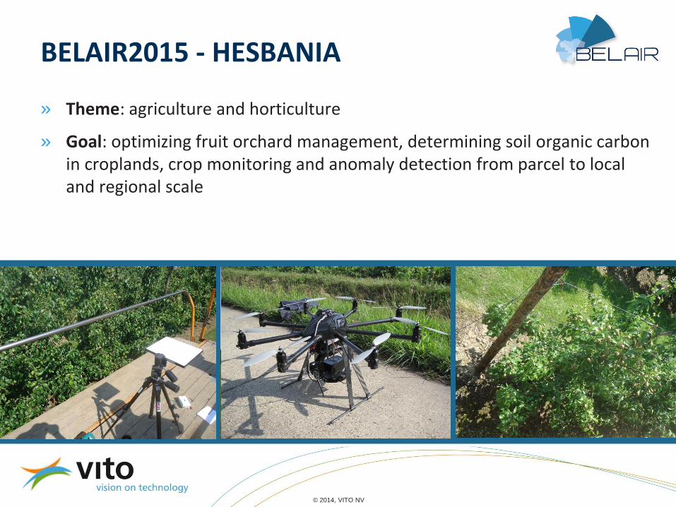
BELAIR2015 - HESBANIA
» Theme: agriculture and horticulture
» Goal: optimizing fruit orchard management, determining soil organic carbon in croplands, crop monitoring and anomaly detection from parcel to local and regional scale

© 2014, VITO NV
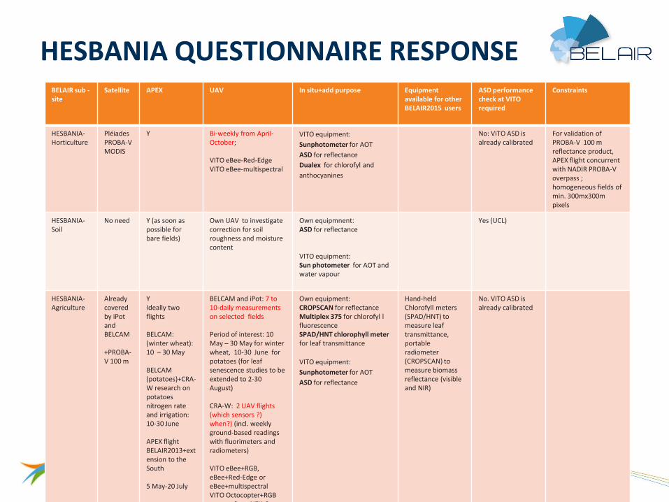
HESBANIA QUESTIONNAIRE RESPONSE
BELAIR sub -site
Thematic topic PI Team Validation
HESBANIA-Horticulture
Fruit orchard management optimization
VITO: Stephanie Delalieux
KUL: Laurent Tits Uhasselt: Roland Valcke Ugent: Kathy Steppe VITO: Sindy Sterckx and Else Swinnen
Validation of PROBA-V 100 m reflectance product
HESBANIA-Soil
Determining soil organic carbon in croplands from APEX imagery
UCL: Bas van Wesemael
UCL: Antoine Stevens, Kristof Van Oost
Preparing for EnMAP
HESBANIA-Agriculture
Crop monitoring CRA-W: Viviane Planchon (
CRA-W: Yannick Curnel Jean-Pierre Goffart Fériel Ben Abdallah VITO: Isabelle Piccard UCL: Pierre Defourny Aurélie Bellavia ULg : Bernard Tychon
Validated products (iPot ): Information on crop growth and development:
Maps with the current development stage of the potato crop Crop emergence maps illustrating the time (date) and degree of crop emergence and crop closure (in terms of % cover). Crop senescence maps reflecting the % cover of non-photosynthetic active vegetation
Validated products (BELCAM) : Crop type sequence (including winter coverage and intermediate crop) Chlorophyll indicators (derived from Landsat, DMC) Leaf chlorophyll content (with red-edge from S-2) LAI, fAPAR (from S2, LDCM and PROBA-V)
Validated products: PROBA-V 100m reflectances
© 2014, VITO NV
HESBANIA QUESTIONNAIRE RESPONSE
BELAIR sub -site
Satellite APEX UAV In situ+add purpose
Equipment available for other BELAIR2015 users
ASD performance check at VITO required
Constraints
HESBANIA-Horticulture
Pléiades PROBA-V MODIS
Y Bi-weekly from April-October; VITO eBee-Red-Edge VITO eBee-multispectral
VITO equipment:
Sunphotometer for AOT
ASD for reflectance
Dualex for chlorofyl and
anthocyanines
No: VITO ASD is already calibrated
For validation of PROBA-V 100 m reflectance product, APEX flight concurrent with NADIR PROBA-V overpass ; homogeneous fields of min. 300mx300m pixels
HESBANIA-Soil
No need Y (as soon as possible for bare fields)
Own UAV to investigate correction for soil roughness and moisture content
Own equipmnent: ASD for reflectance VITO equipment: Sun photometer for AOT and water vapour
Yes (UCL)
HESBANIA-Agriculture
Already covered by iPot and BELCAM +PROBA-V 100 m
Y Ideally two flights BELCAM: (winter wheat): 10 – 30 May BELCAM (potatoes)+CRA-W research on potatoes nitrogen rate and irrigation: 10-30 June APEX flight BELAIR2013+extension to the South 5 May-20 July
BELCAM and iPot: 7 to 10-daily measurements on selected fields Period of interest: 10 May – 30 May for winter wheat, 10-30 June for potatoes (for leaf senescence studies to be extended to 2-30 August) CRA-W: 2 UAV flights (which sensors ?) when?) (incl. weekly ground-based readings with fluorimeters and radiometers) VITO eBee+RGB, eBee+Red-Edge or eBee+multispectral VITO Octocopter+RGB camera Sony NEX-6
Own equipment: CROPSCAN for reflectance Multiplex 375 for chlorofyl l fluorescence SPAD/HNT chlorophyll meter for leaf transmittance
VITO equipment:
Sunphotometer for AOT
ASD for reflectance
Hand-held Chlorofyll meters (SPAD/HNT) to measure leaf transmittance, portable radiometer (CROPSCAN) to measure biomass reflectance (visible and NIR)
No. VITO ASD is already calibrated

© 2014, VITO NV
BELAIR2015 - LITORA
» Theme: coastal & environmental
» Goal: water quality at Port of Zeebrugge, sediment deposition at Yzer estuary and biodiversity at natural parks of Zwin and Laege Moere

© 2014, VITO NV
LITORA QUESTIONNAIRE RESPONSE
» Summary of BELAIR2015 questionnaire response
BELAIR sub -site Thematic topic PI Team Validation
LITORA-Yzermonding Coasts and estuaries: tidal flat biofilm dynamics and heterogeneity
KUL: Jaak Monbaliu TBD
LITORA-Zeebrugge Water quality: sediment concentration VITO: Els Knaeps VITO: Els Knaeps Liesbeth De Keukelaere Sindy Sterckx Jan Vanhout Luc Bertels
Focus lies on the acquisition of UAV imagery and relation to sediment concentration in the water. Both satellite and airborne data are considered as nice-to-have for validation/cross-checking of these products, but the high variation in water quality over time/location + difficult planning related to airborne/high resolution satellite imagery makes it operational hard to acquire the right dataset.
LITORA-Zwin Vegetation & biodiversity INBO: Jeroen Vanden Borre KUL: Ben Somers
Upscale the developed image analysis algorithms to satellite level
LITORA-Laege Moere Vegetation & biodiversity
INBO: Jeroen Vanden Borre KUL: Ben Somers
Upscale the developed image analysis algorithms to satellite level

© 2014, VITO NV
LITORA QUESTIONNAIRE RESPONSE
» Summary of BELAIR2015 questionnaire response
BELAIR sub -site Satellite APEX UAV In situ + add purpose ASD performance check at VITO required
Constraints
LITORA-Yzermonding
Landsat-8 Sentinel 1 Other (TBD)
Yes Dates with low water between 10 am-2pm (flight needs to be made +/- 1 hr before or after low tide): JUNE: 19 (10:14), 22 (12:13), 23 (12:57), 24 (13:47) JULY: 6 (11:26), 7 (12:14), 8 (14:00). Weekends: JUNE 20 (10:54) and 21 (11:33) and JULY 5 (10:40) are also suitable.
Yes VITO eBee+multispectral (if possible hyperspectral) Ideally available all day for within tide time series Dates with suitable low tide (between 10 am – 2 pm): June 19, 22, 23, 24, July 6, 7, 8, 9
VITO equipment: ASD (depending on availability) Sun photometer GPS Other BELAIR user: ASD (KUL-Pol Coppin)
No Low tide
LITORA-Zeebrugge
PLEIADES Landsat-8 DMC
No If possible , micro-hyperspec data from lightweight aircraft. Reasons: More flexible, flying below the clouds and over complete tidal cycle. VNIR is sufficient. Preferably in September due to availability of personnel for campaign planning and execution
VITO Octocopter+NIR camera Own equipment (IMDC): Turbidity logger for turbidity VITO equipment: Filtering of samples for TSM ASD for reflectance
No. VITO ASD is already calibrated
Field data acquisition must be within 1min to overpass of UAV, airborne, satellite sensor
LITORA-Zwin Multitemporal, high spatial and spectral resolution satellite imagery (e.g. Worldview2) If possible Hyperspectral Satellite Imagery (EnMAP, etc.)
Yes Own UAV (INBO): Gatewing X100 with RGB camera VITO: eBee+Red-Edge, eBee+MS
? ? Preferably low tide. Vegetation climax: June-July
LITORA-Laege Moere
Multitemporal, high spatial and spectral resolution satellite imagery (e.g. Worldview2) If possible Hyperspectral Satellite Imagery (EnMAP, etc.)
Yes Own UAV (INBO): Gatewing X100 with RGB camera VITO: eBee+Red-Edge, eBee+MS
? ? Vegetation climax: May – first half of June

© 2014, VITO NV
BELAIR2015- SONIA
» Theme: urban & forestry
» Goal: spatiotemporal estimation and monitoring of water and energy fluxes in urban areas and forest ecosystems

© 2014, VITO NV
SONIA QUESTIONNAIRE RESPONSE
BELAIR sub -site Thematic topic PI Team Validation
SONIA-Brussels Urban water & heat, urban green, urban materials, interception & evapotranspiration Spatiotemporal estimation and monitoring of water and energy fluxes in urban areas
VUB: Boud Verbeiren VUB: Frank Canters KUL: Ben Somers Ugent: Frieke Van Coillie
Landsat 8 and/or ASTER derivatives (e.g. LAI) Simulated EnMap Based on VHR orthophotos validation blocks (usually the size of building blocks or major streets) are constructed wherein relative occurrences of different LC classes are known. Compared to per-pixel or small polygon (hard validation) approaches this method is less susceptible to errors due to geometric shifts between images from different sensors.
SONIA-Forest

© 2014, VITO NV
SONIA QUESTIONNAIRE RESPONSE
BELAIR sub -site Satellite APEX UAV In situ+add purpose ASD performance check at VITO required
Constraints
SONIA-Brussels Landsat 8 (ASTER if available and no near Landsat-8 acquisition time)) Sentinel-1
Yes, 15 June-15 July fine but see constraints (preference as close as possible to 15 June and solar noon) + Lidar > Structural characteristics of urban green
No Own equipment: ASD Fieldspec3 for reflectance SS1 SunScan for LAI SapFlow instrument for SapFlow/Transpiration Theta probe 3 for soil moisture Hobo logger for meteorological parameters (T, RH) Clinometer Measurement tape for Tree and shrub dimensions (height, diameter,…) Precision balance for grass biomass, GAI Spectrophotometry for Chlorophyl content vegetation Precision balance for water content vegetation + Vegetation type and species VITO equipment microtops II sun photometer: visibility and water vapor
Yes (VUB) To capture peak of growing season and spectral difference between oak and beech, as close as possible to 15 June. To reduce shadow, (very relevant in urban areas) as close as possible to solar noon.
SONIA-Forest

© 2014, VITO NV
QUESTIONNAIRE – CONCLUSIONS AND POINTS FOR DISCUSSION » Preferred time APEX flight:
» HESBANIA-Horticulture: PROBA-V nadir overflight (dates to be provided by Sindy Sterckx)
» HESBANIA-Soil: asap
» HESBANIA-Agriculture: ideally 2 flights: winter wheat 10-30 May, potatoes 10 June-30 June, concurrent with PROBA-V nadir overflight (dates to be provided by Sindy Sterckx)
» LITORA-Yzermonding: Dates with low water between 10am-2pm (flight needs to be made +/- 1 hr before or after low tide): JUNE: 19 (10:14), 22 (12:13), 23 (12:57), 24 (13:47) JULY: 6 (11:26), 7 (12:14), 8 (14:00). Weekends: JUNE 20 (10:54) and 21 (11:33) and JULY 5 (10:40) are also suitable.
» LITORA-Zeebrugge: -
» LITORA-Zwin: June-July
» LITORA-Laege Moere: May-1st half of June
» SONIA-Brussels: as close a possible to 15 June and solar noon
» SONIA-Forest: ?

© 2014, VITO NV
QUESTIONNAIRE – CONCLUSIONS AND POINTS FOR DISCUSSION
» VITO UAV
» HESBANIA-Horticulture: justification (scientific and user base) required for bi-weekly April-October, eBee RGB, eBee RE, eBee MS
» HESBANIA-Soil: -
» HESBANIA-Agriculture: justification (scientific and user base) 7-10 daily 10 May-30 May (winter wheat) and 10-30 June (potatoes) (senescence 2-30 August), eBee RGB, eBee RE, eBee MS, octocopter RGB +2 UAV flights (which sensors?, when?, user base?)
» LITORA-Yzermonding: eBee MS (no hyperspectral camera available) (ideally all day)
» LITORA-Zeebrugge: September, Octocopter + NIR (with Dronesed funding)
» LITORA-Zwin: eBee RE, eBee MS
» LITORA-Laege Moere: eBee RE, eBee MS (concurrent with APEX or May-1st half of June?)
» SONIA-Brussels:-
» SONIA-Forest: ?

© 2014, VITO NV
QUESTIONNAIRE – CONCLUSIONS AND POINTS FOR DISCUSSION
» VITO equipment
» HESBANIA-Horticulture: ASD, sun photometer
» HESBANIA-Soil: sun photometer (asap)
» HESBANIA-Agriculture: ASD, sun photometer
» LITORA-Yzermonding: ASD, sun photometer, GPS
» LITORA-Zeebrugge: ASD (September)
» LITORA-Zwin: ?
» LITORA-Laege Moere: ?
» SONIA-Brussels: sun photometer
» SONIA-Forest: ?

© 2014, VITO NV
BELAIR2015 – ASD SPECTRAL AND RADIOMETRIC PERFORMANCE VERIFICATION
» Uniform measurement protocol and verification of spectral and radiometric performance of ASD spectroradiometers of UCL, VUB, KUL (?): spectral (Erbium, Mylar), radiometric (synthetic panels, stability)

© 2014, VITO NV
BELAIR2015 CAMPAIGN – CONTACTS DURING PREPARATION
» BELAIR: [email protected]
» Flight planning: [email protected]
» Data processing: [email protected]
» ASD performance verification: [email protected]
» HESBANIA: [email protected]
» HESBANIA-Horticulture: [email protected]
» HESBANIA-Soil: [email protected]
» HESBANIA-Agriculture: [email protected]
» LITORA: [email protected]
» LITORA-Zeebrugge: [email protected]
» LITORA-Yzermonding: [email protected]
» LITORA-Zwin and Laege Moere: [email protected]
» SONIA Brussels and Forest: [email protected]

© 2014, VITO NV
BELAIR2015 CAMPAIGN – CONTACTS DURING CAMPAIGN » Flight campaign manager (APEX,VITO UAV, ASD, sun photometer):
[email protected]; 014/33 68 63; 0493/09 85 32
» APEX: [email protected]; 014/33 68 22
» VITO UAV: [email protected]; 014/33 67 12
» VITO ASD, sun photometer: [email protected]; 014/33 68 59

© 2013, VITO NV
LITERATURE ON SAMPLING DESIGN AND VALIDATION SITES
» For sampling design and validation approach, see presentation of BELAIR Validation Activities by Walter Debruyn and Keynote presentation by Frédéric Baret presented at the BELAIR Workshop, 13 June 2014, Grand-Leez (http://belair.vgt.vito.be/content/downloads).
» SEN2FLEX: Sobrino et al., “Thermal remote sensing in the framework of the SEN2FLEX project: field measurements, airborne data and applications”, International Journal of Remote Sensing, Vol. 29, Nos. 17–18, 4961-4991 (2008)
» SAT validation: Fensholt et al., “Evaluating MODIS, MERIS, and VEGETATION Vegetation Indices Using In Situ Measurements in a Semi-arid Environment”, IEEE Transactions on Geoscience and Remote Sensing, Vol. 44, No. 7, 1774-1786 (2006)
» Data fusion: Qu et al., “A dynamic Bayesian network data fusion algorithm for estimating leaf area index using time-series data from in situ measurement to remote sensing observations”, International Journal of Remote Sensing, Vol. 33, No. 4, 1106-1125 (2012)
» Site extent and sampling schemes: Morisette et al., “Validation of Global Moderate-Resolution LAI Products: A Framework Proposed Within the CEOS Land Product Validation Subgroup”, IEEE Transactions on Geoscience and Remote Sensing, Vol. 44, No. 7, 1804-1817 (2006)
» Barrax: Su et al., “Quantification of land–atmosphere exchanges of water, energy and carbon dioxide in space and time over the heterogeneous Barrax site”, International Journal of Remote Sensing, Vol. 29, Nos. 17–18, 5215–5235 (2008)