barton road specific plan update community visioning ... · pdf filebarton road specific plan...
TRANSCRIPT

BARTON ROAD SPECIFIC PLAN UPDATE Community Visioning & Recommendations
Summary ReportGrand Terrace, CA

TCTable of Contents
Community Visioning & RecommendationsSummary Report
June 2010
A. ExEcutivE SummAry 3B. implEmEntAtion mEASurES & ovErAll rEcommEndAtionS 4Overall Objectives and Direction for the Specific Plan: 5Short Term (1 to 2 years) 6Mid-Long Term (3 to 7 years) 8
c. introduction 12d. ScAG compASS BluEprint proGrAm 13E. thE procESS 14F. community viSioninG 15Stakeholder Interviews 15Community Survey 17Community Workshop #1 19Community Workshop #2 24
G. Economic dEvElopmEnt SummAry 30h. trAnSportAtion rEcommEndAtionS SummAry 33
tABlE oF contEntS

B
3
Community Visioning & RecommendationsSummary Report
June 2010
A
3
Executive Summary
A. ExEcutivE SummAry
The Community Visioning for the Barton Road Specific Plan Update included a survey, interviews with community stakeholders, and two community workshops to gather input regarding strategies for revitalizing and enhancing the Barton Road area. The community was polled to identify the desired theme, preferred land uses, streetscape improvements, architectural styles, and amenities for Barton Road.
The vision for the Barton Road Specific Plan centers around providing jobs and services, including retail and dining opportunities for local residents and visitors. The community specifically identified a desire for a community gathering place. Other community priorities for the area included establishing a consistent Village theme throughout the corridor and enhancing the appeal of the street with pedestrian amenities such as shaded seating areas, landscaped walkways, and decorative lighting.
This project to update the Barton Road Specific Plan was propelled by the Southern California Association of Governments’ (SCAG) Compass Blueprint Program. The SCAG region is comprised of six counties, including 189 cities. In an effort to improve the quality of life throughout the region, SCAG developed the Compass Blueprint Program founded upon the following principles: Improving Mobility; Promoting Sustainability; Fostering Livability; and Enabling Prosperity.
Implementation strategies and measures to energize and enhance the Barton Road Specific Plan area were developed using the input gathered through the community visioning process, careful analysis relating to economic development and circulation, and the Compass Blueprint Principles. This summary report describes the extensive public outreach and engagement efforts that define the Community Visioning phase of the project and outlines the recommended implementation strategies and measures.
See pages B9, B10, B11
B
4
Implementation Measures & Overall Recommendations
Community Visioning & RecommendationsSummary Report
June 2010
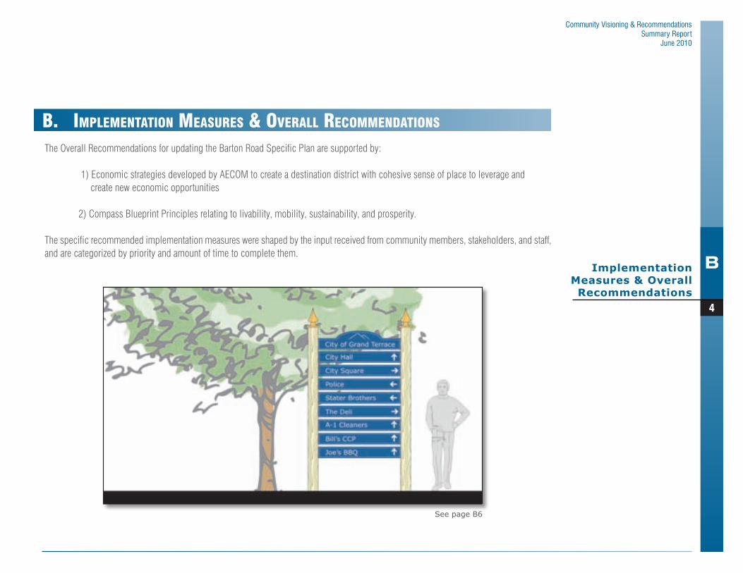
The Overall Recommendations for updating the Barton Road Specific Plan are supported by:
1) Economic strategies developed by AECOM to create a destination district with cohesive sense of place to leverage and create new economic opportunities
2) Compass Blueprint Principles relating to livability, mobility, sustainability, and prosperity.
The specific recommended implementation measures were shaped by the input received from community members, stakeholders, and staff, and are categorized by priority and amount of time to complete them.
B. implEmEntAtion mEASurES & ovErAll rEcommEndAtionS
See page B6

B
5
Implementation Measures & Overall Recommendations
Community Visioning & RecommendationsSummary Report
June 2010
1. Expand the boundaries of the Specific Plan AreaTo optimize the potential for new development within the corridor and implement strategies of the Specific Plan
2. Expand the Village Commercial Planning Area of the Specific Plan.
Enhance and promote pedestrian scale developments consistent with the Village theme desired by the community throughout the corridor. The existing conditions of properties along the north side of Barton Road, between Canal Street and I-215, are more conducive to pedestrian scale developments characteristic of the Village theme.
3. Expand allowable uses within the Planning Areas of the Specific Plan
To attract specialty shops and create a niche, encourage more office and institutional uses to increase daytime population, and encourage a larger mix of synergistic uses (per economic recommendations).
4. Establish a Community Gathering Placea. Close to shopping and dining b. Accessible by car, bicycle, and walkingc. Located along a major corridor, RTA bus route, and
in proximity to I-215
5. Streetscape Theme and Enhancements To present a cohesive and united district, encourage pedestrian mobility, and attract people and businesses to the area.
F Gateway/Entryway Monuments F Hardscape Islands F Thematic Trellises F Enhanced Bike Lanes F Pedestrian Amenity Zones F Business/Civic Directory Signs
Building Enhancements and Design Guidelines (coordinate building design with the Village streetscape theme)
Overall Objectives and Direction for the Specific Plan:
215
Free
way
Barton RoadPalm Avenue
Mo
unt
Ver
non
Pre
sto
n S
tree
t
Mic
hig
an S
tree
t
Canal S
treet
Potential Expansion
Area
Potential Expansion of
(VC) Village Commercial
Planning Area 1(GC) General Commercial
Planning Area 2(VC) Village Commercial
Planning Area 3
(AP) Administrative Professional
Land Use Plan

B
6
Implementation Measures & Overall Recommendations
Community Visioning & RecommendationsSummary Report
June 2010
Below are specific Implementation Measures to carry out the Overall Recommendations for revising the Barton Road Specific Plan. These are intended to energize the corridor, facilitating creation of a destination district and attraction of additional business.
Short Term (1 to 2 years)
1. Adopt revised Specific Plan to include specific recommendations for revitalizing the corridor.
2. Implement a Business/Civic Directory Sign Program
3. Create an Industry Recruitment Group to include merchants, restaurateurs, property owners/developers, lenders, commercial brokers, and Redevelopment Agency staff (further defined in the Economic Development Strategies by AECOM)
a. Further define priority industriesb. Participate in marketing initiatives
4. Identify and consider marketing initiatives to niche businesses and non-retail entities that leverage the City’s assets
a. Senior Service/Health Industryb. Specialty Shopsc. Professional & Management Servicesd. Family activities
5. Seek out an institutional anchor
a. Educational: Technical/Vocational Schoolb. Medical: Nursing School, Assisted Living Facilityc. Government: County offices, Inland Empire Regional
Authorities6. Install thematic district banners along Barton Road (affixed to
the street lights)
7. Implement a Façade Improvement Program
Base Materials
White Trim
Wood SidingCornicesStucco
Trellis Extension

B
7
Implementation Measures & Overall Recommendations
Community Visioning & RecommendationsSummary Report
June 2010
8. Encourage approved developments/projects not yet constructed to incorporate design measures recommended in the Specific Plan
a. Pedestrian-friendly walkways throughout the site and connecting to the street to promote connectivity between the public right-of-way and the commercial uses on the site
b. Pedestrian amenity zone for people to linger, rest, and interact
9. Enhance the bike lanes for safety and visibility
Amenity Zone(in private setback)

B
8
Implementation Measures & Overall Recommendations
Community Visioning & RecommendationsSummary Report
June 2010
Mid-Long Term (3 to 7 years)
1. Construct Gateway/Entryway Monuments per the Specific Plan
Thematic Trellis

B
9
Implementation Measures & Overall Recommendations
Community Visioning & RecommendationsSummary Report
June 2010
To create a draw – attracting people and businesses to the area, promote civic engagement and pride, and further promote and enhance the Barton Road Corridor to provide a cohesive and inviting environment.
2. Develop a Community Gathering Place (see pages 10-11)3. Install thematic trellis shade structures along Barton Road4. Install hardscape islands at regular intervals along Barton
Road5. Provide pedestrian amenity zones within the public ROW
• Adjacent to commercial developments • At regular intervals along Barton Road
6. Install consistent landscaping and sidewalks along Barton Road
Native Plant Material
Stacked Stone Veneer
Vinyl Trellis
Thematic Trellis
Amenity Zone(in public ROW)
Hardscape Island

B
10
Community Visioning & RecommendationsSummary Report
June 2010
Conceptual Public Gathering Space
B
11
Community Visioning & RecommendationsSummary Report
June 2010
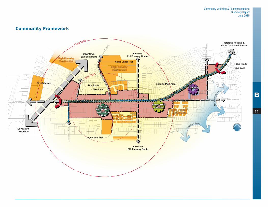
Community Framework
1/4 Mile Radius
1/2 Mile Radius
Mou
ntain Views
Mou
ntai
n Vi
ew
s
215
Freew
ay
Barton RoadPalm Avenue
Azure HillsChurch
PotentialCommunityGathering
Space
City Hall
Bike Lane
Mou
nt V
erno
n
Pre
ston
Stre
et
Mic
higa
n S
treet
Can
al St
reet
High Density Residential
High Density Residential
High Density Residential
High Density Residential
Specific Plan Area
Downtown San Bernardino
Downtown Riverside
Veterans Hospital & Other Commercial Areas
Alternate215 Freeway Route
Alternate215 Freeway Route
City Gateway
Bus Route
Bike Lane
Gage Canal Trail
Gage Canal Trail
Bus Route

B
12
Community Visioning & RecommendationsSummary Report
June 2010
C
12Introduction
c. introduction
The Barton Road Specific Plan encompasses an approximately 1.3-mile corridor along Barton Road, extending from the I-215 Freeway on the west to the intersection of Barton Road and Victoria Street on the east. The specific plan was first approved in 1988 and most recently updated in 2003. The current businesses located within the corridor do not provide a full range of services for residents and those using Barton Road as an alternative to busy freeways. In response to the current state of the corridor, the City has sought community input to identify alternatives and strategies to update the specific plan to revitalize and enhance the corridor to be environmentally sensitive, economically viable, include open space, and reinforce a sense of community.
The Community Visioning phase of this update project is a public outreach and engagement program developed to gain a good understanding of the community’s desires, ideas, and hopes for the area. Community feedback, in conjunction with site analysis for economic development and circulation impacts, have helped to identify a vision for Barton Road and develop clear direction for refinement of the current specific plan (also referred to as the Implementation Plan).
This Summary Report of the Community Visioning phase includes graphics and visualizations summarizing the process, issues identified, and community preferences that support the recommended implementation strategies and revisions of the Implementation Plan. The Community Visioning Summary Report and Implementation Plan are intended to provide City staff with supporting documentation and clear direction and recommendations for completing the Barton Road Specific Plan Update and adoption.

B
13
Community Visioning & RecommendationsSummary Report
June 2010
D
13
SCAG Compass Blueprint Program
d. ScAG compASS BluEprint proGrAm
SCAG Compass Blueprint Program
Program Vision Principles
• Improve mobility for all residents• Foster livability in all communities• Enable prosperity for all people• Promote sustainability for future generations
SCAG Planning Region
• Southern California Association of Governments (SCAG)• 6 Counties• 14 Sub regions• 189 Cities• 19 million residents

B
14
Community Visioning & RecommendationsSummary Report
June 2010
E
14The Process
The Community Visioning phase of this project included extensive public outreach and engagement with four components: Public Surveys, Stakeholder Interviews, and three Community Workshops. During the Community Visioning phase of the project an Economic Development Analysis and Strategies Report was also prepared to evaluate the demand for commercial uses in the corridor, focusing on business that can be supported by residents of the City as well as other commuters traveling along Barton Road. A Transportation Strategies Report was also prepared providing recommendations for revising the current specific plan and include strategies to enhance the pedestrian environment, encourage transit usage and facilitate bike riding while maintaining efficient traffic flows.
The final product of this project is an Implementation Plan with recommendations and strategies developed from the results of the Community Visioning phase, the Economic Development Analysis and Strategies Report and the Transportation Strategies Report.
The final Implementation Plan will be provided to the City after this Summary Report is reviewed by the Planning Commission and City Council during the third workshop. Any input collected during the workshop will help finalize the implementation measures for the plan.
Implementation Plan
Planning Commission & City Council Workshop
Community VisioningSummary Report
&Recommendations
Economic Development
Analysis
CommunityVisioning
TransportationPlanning
E. thE procESS

B
15
Community Visioning & RecommendationsSummary Report
June 2010
F
15
Community Visioning
This Chapter describes the extensive public outreach and engagement efforts that define the Community Visioning phase of the project. The community visioning included stakeholder interviews, a community survey, and two (2) community workshops. Following is a summary of the themes, and issues identified during the stakeholder interviews.
Stakeholder Interviews
During the course of two (2) days the project team interviewed 20 community stakeholders to identify the needs and desires of the community. Stakeholder’s consisted of Elected Officials, City Staff, and members of the business and development community. Below is a summary of the overall themes identified during the interviews.
Small Town, Friendly, Family Community
Stakeholders perceive Grand Terrace to be a small-town, bedroom community that has a family flavor. Friendly and neighborly were two attributes mentioned. It was also indicated that often several generations of families live in Grand Terrace. There is a strong desire to maintain the small-town, safe, family-oriented atmosphere, in which quality of life is important. People like the quiet feel of the community. It was also emphasized that many young people live in Grand Terrace, not just seniors.
Village Design Theme
A village flavor or concept is desired, with a unique and special character for the Barton Road corridor. A consistent or uniform theme is desired, or at least complementary styles, with landscaping and a consistent color for the buildings. However, allowance for a fair degree of creativity was also expressed. Some stakeholders indicated preference for the Cape Cod or New England architectural theme as in the original Specific Plan, while others mentioned Craftsman, or something more contemporary that would blend or provide architectural designs that are similar along the corridor.
Barton Road is the main corridor for business in the City, primarily between Mt. Vernon and Freeway. However, concerns were expressed that traffic is too fast (speeding through), and that traffic should be slowed down. It was expressed that would like to see people stop and frequent businesses, rather than driving through. Connecting parking lots or merging of parcels was also suggested to improve access.
Walkable
Developments and designs that were walkable, with buildings closer to the street were mentioned by stakeholders. There is a desire for seating areas and a gathering or meeting place that attracted pedestrians. Examples cited included Riverside Plaza and Canyon Crest Center in Riverside, and Claremont Village. Numerous examples were provided that residents walk for exercise and could even walk to work. The Gage Canal was mentioned as
F. community viSioninG

16
Community Visioning & RecommendationsSummary Report
June 2010
FCommunity
Visioning
a great opportunity for pedestrian and bicycling. The bicycle rest areas provided by the City were also mentioned as desirable.
Gathering Place
It was expressed that there is a need a community gathering place or central meeting place, which would draw pedestrians and provide seating areas. A need for venue or place for events and entertainment was mentioned, where the Farmer’s Market might be re-located. It was also suggested to have a community center with live theater and places for organizations to meet. There is also a desire for restaurants, coffee shops, ice cream or yogurt shops with outdoor areas or gathering places.
Desirable Uses
Desirable uses identified include sit-down restaurants with outside dining areas, like Starbucks; Trader Joe’s or similar with deli; specialty retail and hardware stores. It was suggested to focus on smaller or specialty stores and services, rather than trying to land big box. It was suggested to find a niche, with services and specialty retail and an assortment of uses that would provide weekend attractions. Stakeholders indicated that people are not aware of businesses in Grand Terrace, or don’t know about Grand Terrace. There is a feeling that there is nothing to attract people to the City, that it is not a destination.

17
Community Visioning & RecommendationsSummary Report
June 2010
FCommunity
Visioning
As part of the Barton Road Specific Plan Outreach Program the “What’s your vision for Barton Road?” survey was published in the February issue of the Blue Mountain Outlook, distributed by the Grand Terrace Chamber of Commerce. The survey results helped the project team gain a better understanding of the community’s desires, ideas, and motivations for Barton Road. The input also helped identify strategies to encourage additional business and development, accommodate increased traffic in a safe manner, and enhance the look and feel of the area in order to create a successful and lively business corridor. Twenty-nine (29) total surveys were received, including 27 from residents of Grand Terrace, and two from other interested persons.
A summary of the feedback received in the surveys is provided below. Through community feedback, and analysis of economic and circulation conditions and trends, the Specific Plan can be modified/updated to create a more vibrant and stable corridor for Grand Terrace.
Community Survey

18
Community Visioning & RecommendationsSummary Report
June 2010
FCommunity
Visioning
Desire for Retail, Restaurants & Community Gathering Place
Grand Terrace survey participants expressed a strong desire to develop Barton Road with more retail, restaurants, and community gathering places (Figure 1). In general residents would like to see more chain stores for hardware, clothing, and groceries developed in the area; examples given include: Lowes, Trader Joes, Barnes and Noble, Kohl’s, and TJ Max (stores that draw a large customer base). Most participants expressed that they did not want fast-food restaurants. There seems to be a general desire to keep the town small and quaint. When asked whether they would support 3-story buildings or taller, 72% of the participants were not supportive (Figure 2).
Participants indicated that community gathering places would help upgrade Barton Road, including outside eating areas with fountains, an ice cream parlor, coffee shops, and other social gathering places.
Landscaping/Greenery/Decorative Lighting/Pedestrian Walkways, Bike Paths/Street Benches & Shade Structures
Most Participants felt that greenery along Barton Road would greatly increase the appeal of the street. Participants also expressed a desire for decorative lighting, street benches, shade structures, and walking paths. When asked whether they would like to see street furniture and amenities that encourage and support pedestrian activities and bicyclists, 62% expressed support (Figure 3).
Overall Themes\Results Question: What would you like to see on Barton Road?
Question: Would you support 3-story buildings or taller on Barton Road?
Question: Would you favor improvements to Barton Road that encourages
pedestrian and bicyclists?
0%
10%
20%
30%
40%
50%
60%
70%
80%
0%
10%
20%
30%
40%
50%
60%
0%
10%
20%
30%
40%
50%
60%
70%
80%
0%
10%
20%
30%
40%
50%
60%
0%
10%
20%
30%
40%
50%
60%
70%
80%
0%
10%
20%
30%
40%
50%
60%
0%
10%
20%
30%
40%
50%
60%
70%
80%
0%
10%
20%
30%
40%
50%
60%
Yes
Yes NoNo
No A
nswe
r
No A
nswe
r
No P
refe
renc
e
Figure 3Figure 2
0%
10%
20%
30%
40%
50%
60%
70%
80%
0%
10%
20%
30%
40%
50%
60%
0%
10%
20%
30%
40%
50%
60%
70%
80%
0%
10%
20%
30%
40%
50%
60%
Most Desirable
Figure 1
Least Desirable No OpinionSomewhat Desirable
Community Gathering PlacesRecreationEntertainmentProfessional Services/OfficesRestaurantsRetail ShopsOther

19
Community Visioning & RecommendationsSummary Report
June 2010
FCommunity
Visioning
Community Workshop #1
On Tuesday, March 30, 2010, a community meeting was conducted to gather input on issues and alternatives for the Barton Road Specific Plan area. The event was held in the Community Room at City Hall located at 22795 Barton Road and took place between 6:00 p.m. and 7:00 p.m. The consultant team conducted the event assisted by City staff.
Flyers advertising the event were posted at City Hall, the Library, the four bike stations located throughout the City, and at the standard public notice posting locations for projects. The flyer was also advertised on the City’s website, and emailed to Chamber of Commerce contacts and interested residents who have requested to be notified of City events.
At the event, community members reviewed the various alternatives for the Barton Road Specific Plan area and provided input regarding their preferences. The input provided at the community meeting will guide the preparation of strategies and an implementation plan for updating the Barton Road Specific Plan to help enhance the area.
The meeting was structured around themed stations, each of which included presentation boards depicting various design concepts and alternatives, and a comment/score card to gauge preferences and obtain ideas and opinions. The format for the event was an open house with several stations covering a variety of topics pertinent to the update and revitalization of the Barton Road Specific Plan. The meeting began with a brief presentation on the purpose of the meeting and stations, introduction of SCAG and the consultant team, and the scope of the project.
3
City of Grand Terrace
City HallCommunity Room22795 Barton RoadGrand Terrace, CA 92313
Barton Road Specific Plan
Tuesday, March 30, 20106:00 pm
Community Meeting
Come share your ideas on how to create a more vibrant and successful Barton Road area for our businesses and residents.

20
Community Visioning & RecommendationsSummary Report
June 2010
FCommunity
Visioning
Community Workshop #1 Station Descriptions & Results
Station 1: Streetscape
Participants were asked to vote on three streetscape theme options – Traditional, Village, and Contemporary. The majority of participants preferred the village streetscape theme (63 percent). Only 25 percent voted for the traditional theme, and 12 percent voted for the contemporary theme.
Participants were also asked to identify their three preferred improvements/enhancements (benches, shade structures, banners, etc.) of the public right-of-way by “scheduling” them according to the participant’s order of priority using stickers representing the year of possible construction. The goal of this exercise was to help the community understand that these elements would be installed over a period of time and not all at once.
In order to quantify the results, year 2011 was tallied with three points, year 2013 was tallied with two points, and year 2015 was tallied with one point. The results show that landscape islands,
parkway improvements, and enhanced paving were the three most preferred streetscape amenities.
Station 2: Signs & Public Art
During stakeholder interviews and in a previously circulated public survey, business and community members indicated that residents were not very familiar with existing businesses and services in the Barton Road area. This station was intended to identify whether there is support for enhanced business signs and programs. Various forms

21
Community Visioning & RecommendationsSummary Report
June 2010
FCommunity
Visioning
of business signs (vehicular and pedestrian wayfinding signs, and themed commercial signs) were displayed as examples for the participants to evaluate. Responses were recorded on the comments cards. 75 percent of participants indicated that they were in support of enhanced business sign programs (25 percent indicated that they were not in support of such programs).
During the stakeholder interviews and the public survey, public art was also discussed as a potential element for theming the public right-of-way along Barton Road. In order to confirm community support and interest in a public art program, various forms of public art were showcased on a board for public comment. There was general support for public art by most participants at the community meeting (63 percent). 25 percent of participants did not vote, and 12 percent indicated that they would not be supportive of such a program.
Station 3: Gathering Place
The desire for a community gathering place was also expressed during stakeholder interviews and in the public survey. At this station participants were asked to identify their preferred location for a gathering place between two potential sites. They were also given an opportunity to choose their preferred design styles and function for a gathering place, such as hardscape or softscape, and they were asked to choose their preferred design components (i.e. water features, staging/amphitheater, etc.).
First, participants were asked to vote on two locations where they would prefer to have a public gathering space. One location is near City Hall. The other location is closer to the Freeway and is just west of Canal Street. Most participants (63 percent) preferred the location close to the Freeway, while 38 percent preferred the location near City Hall.
Participants were then asked to identify whether they would prefer hardscape - option A, combination of hardscape and softscape – option B, or softscape - option C as the design style for a community

22
Community Visioning & RecommendationsSummary Report
June 2010
FCommunity
Visioning
gathering place. The majority of the participants (75 percent) voted for a combination of hardscape and softscape, option B.
Participants were also polled on whether they would prefer an amphitheater, gazebo structure, water feature, or iconic tower as the focal point of a gathering space. Half of the participants voted for a water feature, 38 percent voted for an amphitheater, and 12 percent voted for a gazebo structure.
Station 4: Marketplace of Ideas
This station provided participants a venue for sharing any other ideas that they felt were important or significant for the area. The following comments and suggestions were received:
1. Develop city owned area that is closest to the freeway2. No Islands or Medians that would block access to businesses3. Expand the limits of the Barton Road Specific Plan to include
the area south from Barton Road to High School (along Michigan)
4. Needs more signs and needs to be more visual5. Create a sense of place “Welcome” feel
6. Want a warm and touchy feely sense7. Land Use – Sit-down restaurants8. Does the City have money to do these things?9. Need to have things that can’t be destroyed10. Need to have security to prevent vandalism11. Big graffiti problem12. Keep things simple, easy to maintain13. Streetscape – Water14. Streetscape – Main Costs15. Signage similar to Downtown Redlands16. El Paseo – The Gardens Palm Desert (Landscaping)
Preferred Option

23
Community Visioning & RecommendationsSummary Report
June 2010
FCommunity
Visioning
Comment Card Comments
Comment cards were collected at the end of the meeting to record prevailing preferences regarding the preferred design (street, buildings, etc.), desired amenities, and needs of the community/alternative land uses. Eight comment cards were received.
The first question on the Comment Card asked participants to identify the most desirable and least desirable land uses for the Barton Road area. Restaurants and retail shops were voted as most desirable, with recreation being somewhat desirable. The following graph depicts the received responses (Figure 4).
Participants were also given an opportunity to provide additional comments on the comment cards. Below are response provided by participants on the cards:
1. Develop city owned area that is closest to the freeway2. No Islands or Medians3. Expand the limits of the Barton Road Specific Plan to include
the area south from Barton Road to High School (along Michigan)
4. Needs more signs and needs to be more visual
0
1
2
3
4
5
6
Most Desirable Least Desirable No OpinionSomewhat Desirable
Community Gathering PlacesRecreationEntertainmentProfessional Services/OfficesRestaurantsRetail ShopsOther
Question: What would you like to see on Barton Road?Figure 4

24
Community Visioning & RecommendationsSummary Report
June 2010
FCommunity
Visioning
Community Workshop #2
On Tuesday, May 4, 2010, a second community meeting was conducted to present overall concepts and recommendations for enhancing the Barton Road area. The event was held in the Community Room at City Hall located at 22795 Barton Road and took place between 6:00 p.m. and 7:00 p.m. The consultant team conducted the event assisted by City staff.
Flyers advertising the event were posted at City Hall, the Library, the four bike stations located throughout the City, and at the standard public notice posting locations for projects. The flyer was also advertised on the City’s website, and emailed to Chamber of Commerce contacts and interested residents who have requested to be notified of City events. In addition, the event was advertised in the City’s newsletter and on the community reader board located at Barton Road and Palm Avenue.
At the event, community members reviewed the strategies for modifying the Barton Road Specific Plan and provided input regarding their preferences for thematic elements. The input provided at this second community meeting helped the project team refine the implementation plan strategies for updating the Barton Road Specific Plan.
Similar to the first Community Meeting, the format for this second meeting included a variety of stations with visualization boards reflecting the proposed recommendations and components of the implementation plan for updating the Barton Road Specific Plan.

25
Community Visioning & RecommendationsSummary Report
June 2010
FCommunity
Visioning
Community Workshop #2 Station Descriptions & Results
Similar to the first Community Meeting, the format for this second meeting included a variety of stations with visualization boards reflecting the proposed recommendations and components of the implementation plan for updating the Barton Road Specific Plan. The station themes included:
• SCAG Compass Blueprint Overview • Land Use Plan and Aerial• Streetscape Theme and Enhancements
F Gateway/Entryway Monuments F Thematic Trellis F Hardscape Islands F Streetscape Theme F Building Enhancements
• Community Gathering Place• Marketplace of Ideas
The meeting began with a presentation on the scope of the project within the SCAG Compass Blueprint Program, results of the public input to date, overview of the proposed recommendations, and a brief description of the stations (approximately 20 minutes).
Attendees were asked to record their preferences relating to thematic and decorative elements on comment cards and provide input relating to recommendations.
The following pages present the meeting results, including descriptions of each station and activities, and summaries of participants’ written comments.
Station 1: SCAG Compass Blueprint Overview
Visualization materials were provided at the entrance of the event room and during the introductory presentation describing the role
of the Southern California Association of Governments (SCAG) and the Compass Blueprint Program. Visualization materials depicted how the project to update the City of Grand Terrace Barton Road Specific Plan would promote the Vision Principles of the Compass Blueprint Program.
Station 2: Land Use Map & Aerial
An aerial snapshot of the Barton Road Specific Plan area was presented, indicating recommended expansion of the Specific Plan boundary to include vacant properties adjacent to the Specific Plan area. The boundary expansion included the vacant lots at Mt. Vernon/Barton Road. Incorporating these key vacant lots adjacent to the project area could optimize the potential for new development within the Specific Plan.
A Land Use Map was also presented reflecting the recommended expansion of the Village Commercial District. Expansion of the Village Commercial Planning Area would help establish a

26
Community Visioning & RecommendationsSummary Report
June 2010
FCommunity
Visioning
downtown “Village” character with a greater mix of land uses across a wider area of Barton Road. Expansion of the Village Commercial Planning Area is consistent with economic development strategies and recommendations proposed for revitalizing the area.
Station 3: Streetscape Theme & Enhancements
The Village design theme was identified as the preferred style by the majority of community members during first community meeting. In addition, community members expressed support for enhancement of the street (right-of-way) as a way to unify the area and make it more inviting for pedestrians and vehicle traffic.
• Gateway/Entryway MonumentsIn order to express community identity, a trellis gateway feature consistent with the Village design theme was developed for the west end of the Specific Plan area close to the 215 off ramp.
• Thematic TrellisExpanding on the trellis feature for the City gateway/entryway monuments, stand alone trellises located along Barton Road would promote the theme of the Specific Plan. In order to refine the trellis concept as part of the Village theme for the Specific Plan area, community members were asked to vote on their preferred

27
Community Visioning & RecommendationsSummary Report
June 2010
FCommunity
Visioning
materials (stacked stone or river rock for the bases with white “wood” beams).Half of the participating community members indicated their preference for stacked stone on the bases of thematic trellises for the area.
• Hardscape IslandsDuring the first community meeting, landscape islands were identified as the first street improvement community members
would like to see along Barton Road. Landscape islands not only enhance the visual presentation of the street, but also serve as a traffic calming mechanism, improving the safety of pedestrians, bicyclists, and motor vehicles on the road.
To further promote the sustainability aspect of the project by reducing water use and maintenance, staff suggested that these traffic calming islands have a hardscape design with non-vegetative materials such as boulders, stamped concrete or stones as groundcover, with thematic trellises and a decorative element.
Community members were asked to vote for either boulders, bee hives, or blue mountain silhouettes as their preferred decorative element for the hardscape islands in addition to the trellis elements. Half of the participants preferred decorative boulders within the hardscape medians.
50%Decorative Boulders
25%Bee Hives
25%Mountain Silhouette
50%Stacked Stone
25%River Rock
25%No Preference

28
Community Visioning & RecommendationsSummary Report
June 2010
FCommunity
Visioning
• Streetscape ThemeA variety of streetscape components were also presented reflecting the Village theme, including pedestrian lighting, banners, and street furniture to encourage pedestrian mobility throughout the corridor. A key streetscape component included a pedestrian amenity zone to provide an inviting seating environment, buffered from vehicular traffic without impeding pedestrian walkways. Another important element included business/civic directory signs as a strategy for supporting local businesses while providing direction to shops and civic places.
• Building EnhancementsIn order to provide a consistent look throughout the corridor, elements of the streetscape theme can be applied to existing buildings as they are compatible with the existing architectural guidelines and interim architectural policies of the Specific Plan. At this station we provided examples of architectural accents and elements that can be used to enhance existing and new buildings in order to further promote cohesiveness along Barton Road. Simple architectural enhancements include the addition of white trellis extensions on wall facades, painting building trims and existing
trellises white (if complimentary to the existing wall color palette), installation of simulated wood siding accents, adding stone or river rock veneers at building bases, installation of roof finials, and installation of cornices around roof edges without eaves.
Station 4: Community Gathering Place
The need for a community gathering place was identified through input collected from stakeholders and community members during interviews and the public survey, and supported by participants during the first community meeting. Relying on the design and location preferences indicated by community members during the first meeting, a conceptual site plan for a gathering place within the Barton Road Specific Plan area was presented at the second community meeting.

29
Community Visioning & RecommendationsSummary Report
June 2010
FCommunity
Visioning
The establishment of a gathering place in the Specific Plan area will foster the livability of the area and facilitate regional and local mobility by providing a variety of uses in proximity to the freeway, alternate transportation routes, and commercial developments.
Station 5: Marketplace of Ideas
This station provided participants a venue for sharing any other ideas that they felt were important or significant for the area. The following comments and suggestions were received:
1. Public art in medians/paint bee hives2. Color theme: blue, white, slate/flagstone, river rock in grays/
blues
Comment Card Comments
Comment cards were collected at the end of the meeting to record preferences regarding the preferred materials for thematic trellises and decorative elements for the hardscape islands at the Streetscape Theme and Enhancements Station. The comment cards also recorded additional comments and general input from the participants. Eight comment cards were received.
Participants were also given an opportunity to provide additional input on the comment cards. Below are response provided by participants on the cards:
1. I would appreciate employment opportunities. Also, a community spot for Christians to congregate like a flag pole – to pray for our government and our schools.
2. Public gathering area – construct to curtail skate boarding. Need visibility for law enforcement.
3. Hardscape islands – like concept, but drivers tend to be attracted the them – drunk drivers.
4. Trellis concept – again, like concept but up keep might be costly?
5. Business directory signs need to be affordable for small businesses.
6. I like the idea of a community gathering place.7. We need to figure out a way to get more input from existing
businesses.8. “Kudos” to you all. It’s a good looking plan.9. Love to see this materialize.10. The retrofit example would be more interesting if it had more
of a face lift or change in roof line instead of paint and siding. Maybe a false short second story, decorative windows, etc.
11. Wegmans! (grocery store)12. Expansion of amphitheater instead of third labyrinth.13. Are the trellis’ designed to include irrigation to provide a
place where vines could grow? Having vines would enhance the village theme.
14. Bee hives on top of way finding signs would be interesting.15. Would prefer not to have center islands.16. I like the idea of a walking trail and bike path
on the Gage Canal right-of-way connecting Grant Terrace with the Highgrove. In the past the Gage Canal Company has been against using their property for public purposes. The property owners along the right-of-way have also been against a trail. They said thieves would come down the trail, climb their fence and rob their house. To counter this, the trail could only open from sun up to sun down with gates locked at night.

B
30
Community Visioning & RecommendationsSummary Report
June 2010
G
30
Economic Development
Summary
Background: Building a Successful Destination District
There are several structural approaches that can be used for creating a cohesive sense of place that can be used and leveraged to create new economic opportunities.
Generally, successful districts tend to offer a combination of products and services for immediate or later use by consumers.
• Commercial entertainment or cultural activities that are brief yet pleasurable.
• Consumption of food and beverage that is designed to be eaten within the district at the time of purchase.
• Purchase of products to be taken home for later enjoyment.
Destination Districts and Barton Road
General context for creating a destination district includes the use of some of the principles outlined above, such as establishing an institutional anchor as the foundation of the district, to attract additional businesses. For the Barton Road Specific Plan, the focus is on creating a strong commercial district with a variety of uses beyond retail.
Strengths, Weaknesses, Opportunities, and Threats (SWOT) Analysis
Strengths
• Grand Terrace provides a pleasant environment for businesses and shopping, but this is not sufficient for a company to make a location decision.
• Higher income residents than adjacent cities• Grand Terrace’s existing retail is clustered primarily along
Barton Road. The clustering of retail is very helpful to the vitality of a retail area as shoppers often seek areas in which they can have a variety of shopping options.
• Convenient location/access to Loma Linda University and Hospital, City of Riverside, and City of San Bernardino.
• Clean, low-crime• Promotes success of the family
Weaknesses
• Limited population and low traffic counts do not provide a sufficient market for many national retailers to locate in the area.
• Grand Terrace is not an established business market and office users typically locate to established business areas. The City can work to build a stronger business recognition for the area.
Opportunities
G. Economic dEvElopmEnt SummAry

31
Community Visioning & RecommendationsSummary Report
June 2010
GEconomic Development
Summary
• Several new developments along Barton Road will breathe new life into the retail environment and some will provide opportunities to capture residents from beyond Grand Terrace. However, if the market of patrons is not enlarged, they can damage existing centers.
• Existing Senior Services and Infrastructure in the City of Grand Terrace has a lot to offer the aging baby boomer market segment and may want to consider leveraging these assets:
F Existing assisted living infrastructure F Pleasant community F Convenience to the Loma Linda Hospital
• Grand Terrace has a diversifying market and may want to consider business and retail options for the growing family from varied backgrounds.
Threats
• Current state of the economy will take a number of years for overbuilt retail and office industries in the region to accommodate household growth that never developed. Due to the recession, there will be inexpensive office and retail space available in these more established business areas for several years, which may discourage development in Grand Terrace in the short term.
• Proposed developments compete with existing retail in the Barton Road Specific Plan Area. Although new development can breathe new life into the retail landscape of Grand Terrace, it may be at the expense of existing centers because there may not be sufficient market support for the new center. If the Barton Road Specific Plan area is viewed as an active and attractive retail and commercial district, the development of new centers is less likely to harm existing businesses and would actually become a boon.
Recommendations
The following recommendations describe the strategies that can be enlisted to attract stable businesses to Barton Road and develop an active, successful business corridor:

32
Community Visioning & RecommendationsSummary Report
June 2010
GEconomic Development
Summary
1. EncouragephysicalstreetscapeandconnectionimprovementsShoppers are interested in locations that bring together a variety of shopping/restaurant/and other commercial options for them. By physically and aesthetically connecting the shopping centers along Barton Road, the small centers can offer shoppers more options and create better a shopping district.
F Create attractive pedestrian walkways with places to sit and relax that meander through centers within close proximity.
F Creating consistent landscape and streetscape to provide a unified and distinct aesthetic identity for the corridor.
F Rehabilitate and renovate aging spaces and centers – façade improvement programs.
2. ClusterRetailandServiceTypesinSpecificDistrictsClustering retail helps to create synergy between various centers.
3. RepositionSelectExistingRetailSpaceswithOtherUsesRather than have retail that is under performing in older shopping centers (which often leads to unattractive centers and a slow deterioration of the retail environment), the City may want to encourage older retail to be repositioned into different commercial or institutional uses. These different uses can help to bring additional foot traffic to the corridor.
4. SeekOutaNon-CommercialorInstitutionalAnchorPotential institutional anchors for Barton Road may include:
F Educational: extension of Riverside Community College, Technical /Vocational School
F Medical: Medical Facility, Nursing School Extension Program, Assisted Living Facility
F Governmental: County offices, Inland Empire Regional Authorities, Post Office, State Offices
5. BuildNicheIndustriesRather than compete with areas that are better positioned for general retail and office developments, the City of Grand Terrace should work on building certain niche industries that leverage the City’s assets.
F Senior Service/Health Industry F Specialty Shops Catering to a Higher Income Clientele F Professional and Management Business Services F Commercial Family Activities

B
33
Community Visioning & RecommendationsSummary Report
June 2010
H
33
Transportation Recommendations
Summary
Background
• Barton Road is used as a regional bypass when congestion on the I-215 freeway.
• Barton Road is estimated to carry 20,000 vehicles per day.• Barton Road is classified as a Major Highway (four lanes,
divided) in the Grand Terrace General Plan.
Land uses along both sides of Barton Road consist primarily of commercial development or vacant commercial lots, as well as a small amount of residential, office, and institutional uses. In some places, separate small businesses have been developed on individual parcels, with separate parking and access from Barton Road provided for each parcel. A couple of larger integrated shopping centers have consolidated parcels, and reduced the number of curb cuts on Barton Road to two or three. Some vacant parcels with their own curb cuts are interspersed between developed parcels. Left-turn access to and from the multiple curb cuts along Barton Road is facilitated by the continuous center two-way-left-turn lane throughout the corridor.
Transportation Recommendations
The following suggested improvements provide a menu of strategies that can be employed to accomplish the objectives of creating a safe, small town atmosphere with a comfortable walking /biking environment:
1. TrafficCalmingonBartonRoadStreetscape improvements would be the most effective measure to slow traffic on Barton Road down without lowering the speed limit or creating congestion or un-due delay (traffic calming).
• Raised / Landscaped MedianA raised median with landscaping and/or art elements would narrow the perceived feel of the roadway, and would encourage drivers to drive more cautiously. A broken median (or island) can reduce left-turn-out movements while not restricting all access to businesses, as more solid medians would.
2. ConsolidateandShareAccessandParkingConsolidating access points and creating cross parking and access easements across properties and commercial centers would reduce multiple turning and vehicle conflict points along Barton Road, and would encourage walking access between businesses.
3. EncourageBicycleTravel• Bicycle Lanes
It is recommended that the Class II bike lane be continued along the north side of Barton Road from west of Mount Vernon Avenue to the west Specific Plan boundary.
h. trAnSportAtion rEcommEndAtionS SummAry

34
Community Visioning & RecommendationsSummary Report
June 2010
HTransportation Recommendations
Summary
• Bicycle ConnectionsBicycle connections between adjacent business properties, and between business and residential areas should be established to provide convenient access to commercial and office properties.
• Bicycle FacilitiesBicycle racks are recommended at all commercial facilities at a rate of one rack per each 35 parking spaces in the center. Signs could be used to direct bicyclists to bicycle parking facilities. Employers should also be encouraged to provide indoor bicycle storage areas and lockers for employees who ride to work.
4. EncourageTransitRidershipThe connection between the bus stop and nearby destinations should be clear, well-maintained, and free of obstructions, to provide a convenient and comfortable walking experience that encourages transit use.
Additional amenities that can make transit use more appealing is providing a shelter with benches, posting up-to-date route maps and schedules, providing dynamic bus status information (i.e., next bus arrives in xx minutes).
Community Visioning & RecommendationsSummary Report
June 2010
Disclaimer
This is a project of the City of Grand Terrace with funding provided by the Southern California Association of Governments’ (SCAG) Compass Blueprint Demonstration Project Program. Compass Blueprint assists Southern California cities and other organizations in evaluating planning options and stimulating development consistent with the region’s goals.
The preparation of this report was funded in part through grants from the United States Department of Transportation (USDOT)—Federal Highway Administration and Federal Transit Administration, in accordance with the Metropolitan Planning Program, Section 104(f) of Title 23 of the U.S. Code.
The contents of this report reflect the views of the author who is responsible for the facts and accuracy of the data presented herein. The contents do not necessarily reflect the official views or policies of SCAG, USDOT or the State of California. This report does not constitute a standard, specification or regulation. SCAG shall not be responsible for the City’s future use or adaptation of the report.
