bariloche, argentina 29-31 may - tt · bariloche, argentina 29-31 may . 2 ... carrying payload...
TRANSCRIPT

1INVAP Next Generation Earth Observation LEO Satellites
ITU International Satellite Symposium 2017
Bariloche, Argentina 29-31 May

2
Earth Observation Satellites: SAC ProgramCooperation agreement between CONAE and NASA since 1991.4 LEO satellites (SAC-A, SAC-B, SAC-C, SAC-D), carrying Payload Instruments for Scientific and Earth Observation Applications.
INVAP participation in the Program:• Mission design• Project Management• Systems Engineering• Platform Design & Manufacturing• Payload Design & Manufacturing• Satellite Integration & Test• Launch Base Operations• Launch & Early Orbits Operations• Platform & Payload Commissioning
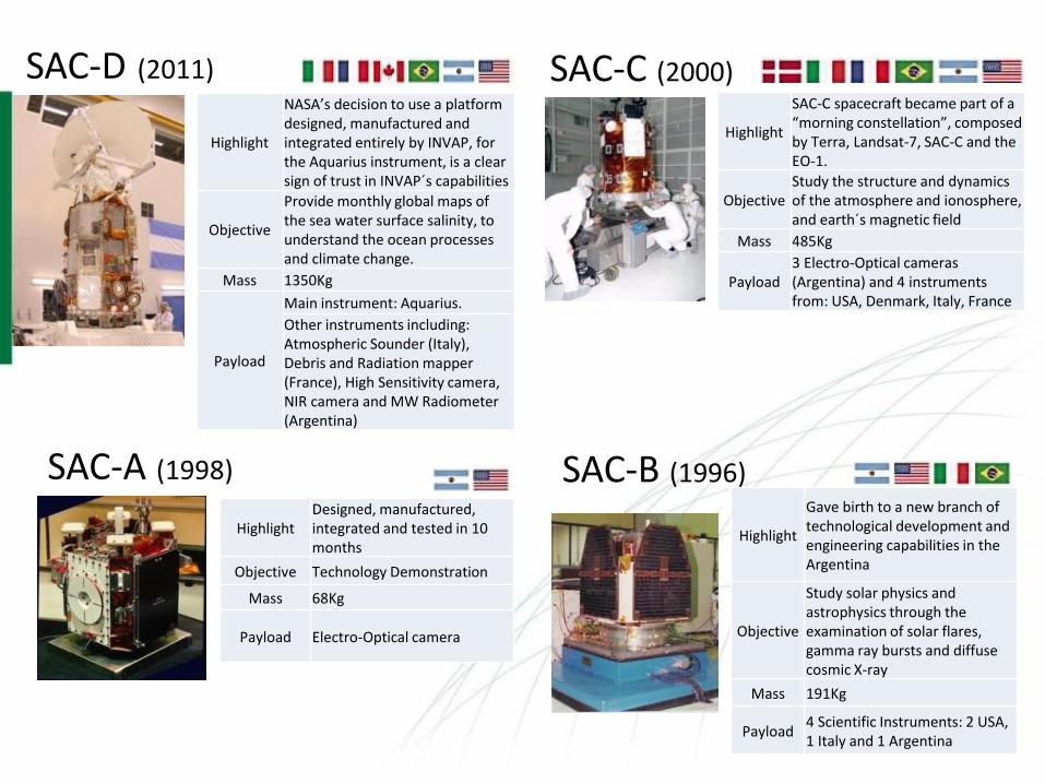
HighlightDesigned, manufactured, integrated and tested in 10 months
Objective Technology Demonstration
Mass 68Kg
Payload Electro-Optical camera
Highlight
Gave birth to a new branch of technological development and engineering capabilities in the Argentina
Objective
Study solar physics and astrophysics through the examination of solar flares, gamma ray bursts and diffuse cosmic X-ray
Mass 191Kg
Payload4 Scientific Instruments: 2 USA, 1 Italy and 1 Argentina
Highlight
NASA’s decision to use a platform designed, manufactured and integrated entirely by INVAP, for the Aquarius instrument, is a clear sign of trust in INVAP´s capabilities
Objective
Provide monthly global maps of the sea water surface salinity, to understand the ocean processes and climate change.
Mass 1350Kg
Payload
Main instrument: Aquarius.
Other instruments including: Atmospheric Sounder (Italy), Debris and Radiation mapper (France), High Sensitivity camera, NIR camera and MW Radiometer (Argentina)
Highlight
SAC-C spacecraft became part of a “morning constellation”, composed by Terra, Landsat-7, SAC-C and the EO-1.
ObjectiveStudy the structure and dynamics of the atmosphere and ionosphere, and earth´s magnetic field
Mass 485Kg
Payload3 Electro-Optical cameras (Argentina) and 4 instruments from: USA, Denmark, Italy, France
SAC-A (1998)
SAC-C (2000)
SAC-B (1996)
SAC-D (2011)

4
• The SAOCOM mission developed for CONAE includes 2 satellites weighting 3 tons each, both carried out simultaneously, to be launched 1 year apart
• Mission Objective: Natural Disasters & Emergency Management, Soil Moisture Measurement by means of the Polarimetric L-Band Synthetic Aperture Radar (SAR)
• The two SAOCOM satellites will form part of the joint Italian-Argentine SIASGE constellation together with 4 Italian satellites carrying X-band SARs
SAOCOM 1 A/B POLARIMETRIC L-BAND SAR(CURRENTLY STATUS: SYSTEM AIT)
SAR general characteristics:• L-Band (1,275 GHz)• Sun-Synchronous Orbit• 620 km altitude• 10 to 100 m resolution• 30 to 350 km swath

5
OCEAN COLOR SATELLITES: SABIA-MAR(CURRENT STATUS: CDR BY THE END OF 2017)
The SABIA-MAR satellites consist of 2 Brazilian (AEB) - Argentine (CONAE) LEO satellites flying in constellation. INVAP is CONAE Prime Contractor for the satellites development including platform, electro-optical payload and system level AIT.SABIA-MAR will be launched in 2021.
Objectives:• Monitor the ocean surface, coastal regions and
internal waters: in low, medium and high resolutions
• Collect data and provide information related to water and food production, through high spectrum, geometric and temporal resolution images

6
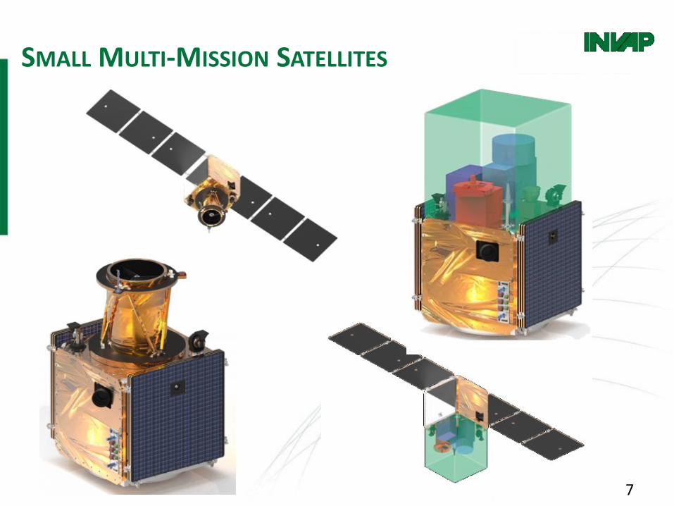
• The Multi-Mission Platform is based on a Modular and Scalable Architecture able to accommodate different LEO missions and applications:
– Electro-Optical Sensors: High-Resolution PAN+MS, Hyper-spectral, High-Sensitivity and Infrared
– Microwave Active Sensors: X-Band Synthetic Aperture Radar (SAR)
PARAMETERS RANGE
Satellite Launch Mass 200 kg to 700 kg
Payload Mass Up to 400 kg
Payload Power(modular solar panels)
Up to 500 W
Payload Volume Size 1m x 1m x 1m
Redundancy Single String to Fully Redundant
Pointing Accuracy < 200m @ 700km
Data Downlink 500 Mbps up to 2 Gbps
Stabilization 3-axis
Nominal Life > 7 years
Launch Vehicle Compatibility Falcon 9 / Vega / PSLV
SMALL MULTI-MISSION SATELLITES
7
SMALL MULTI-MISSION SATELLITES

X-BAND SYNTHETIC APERTURE RADAR
PRODUCTS & USES
INVAP CONFIDENTIAL AND PROPRIETARY
• High Resolution weather independent operation• Vessel Detection and Classification• Border surveillance• Precision agriculture• Subsidence mapping (Interferometry)• Digital Elevation Model (DEM) generation
2.5m x 0.7m antenna performance:
ModeSwath (km)
Across TrackResolution (m)
@ 20°
Stripmap 30 5
Spotlight 13 3.6
Scansar 300 20
Scansar 180 10

T/R MODULE TILE
INVAP CONFIDENTIAL AND PROPRIETARY
● Antenna building block● Azimuth/Elevation pointing● Built-in element level test● Distributed design:
● Robust to multiple element failure
● Modular Multi-mission architecture meets varying mission requirements● Multimode SAR instrument (Stripmap / Spotlight / ScanSAR)● High geometric and radiometric resolution● Single/dual polarization● Repeat pass interferometry● Along track interferometry
X-BAND SYNTHETIC APERTURE RADAR
CAPABILITIES
10
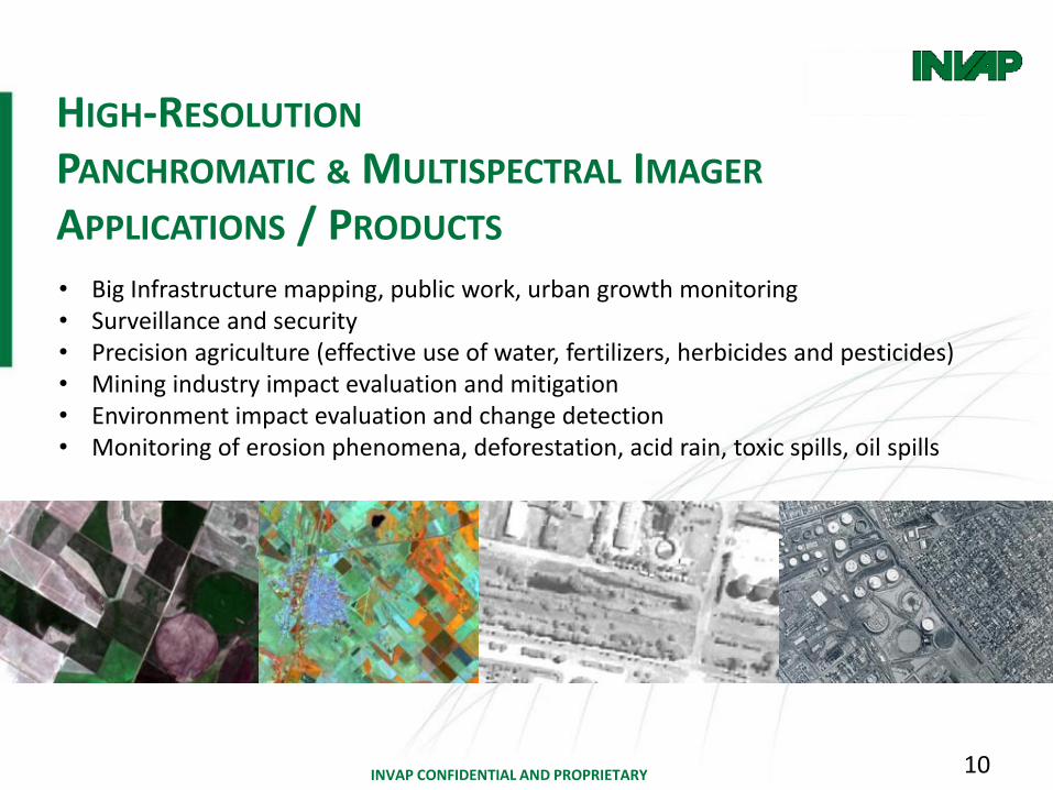
• Big Infrastructure mapping, public work, urban growth monitoring• Surveillance and security• Precision agriculture (effective use of water, fertilizers, herbicides and pesticides)• Mining industry impact evaluation and mitigation• Environment impact evaluation and change detection• Monitoring of erosion phenomena, deforestation, acid rain, toxic spills, oil spills
INVAP CONFIDENTIAL AND PROPRIETARY
HIGH-RESOLUTION
PANCHROMATIC & MULTISPECTRAL IMAGER
APPLICATIONS / PRODUCTS
11
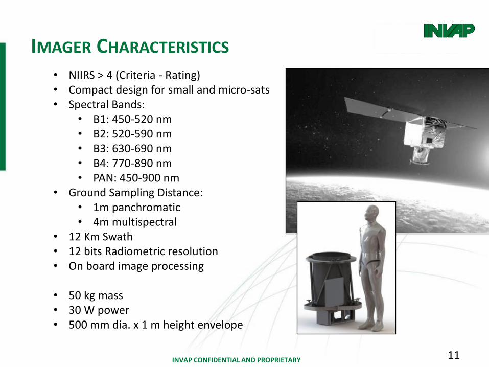
• NIIRS > 4 (Criteria - Rating)• Compact design for small and micro-sats• Spectral Bands:
• B1: 450-520 nm• B2: 520-590 nm• B3: 630-690 nm• B4: 770-890 nm• PAN: 450-900 nm
• Ground Sampling Distance:• 1m panchromatic• 4m multispectral
• 12 Km Swath• 12 bits Radiometric resolution• On board image processing
• 50 kg mass• 30 W power• 500 mm dia. x 1 m height envelope
INVAP CONFIDENTIAL AND PROPRIETARY
IMAGER CHARACTERISTICS

12
HYPER-SPECTRAL SENSOR
APPLICATIONS AND PRODUCTSHYPERSPECTRAL IMAGING (Data Cube)
• High resolution spectral signatures• A family of instruments for broad-band applications• Selected applications in one instrument
MOTIVATIONS• Get a higher level of spectral details to “see the
unseen”• Make agriculture, forestry and fisheries more
productive and sustainable (FAO)
APPLICATIONS AREAS• Agriculture• Forestry• Water• Oil & Gas• Mineralogy & mining
INVAP CONFIDENTIAL AND PROPRIETARY
13
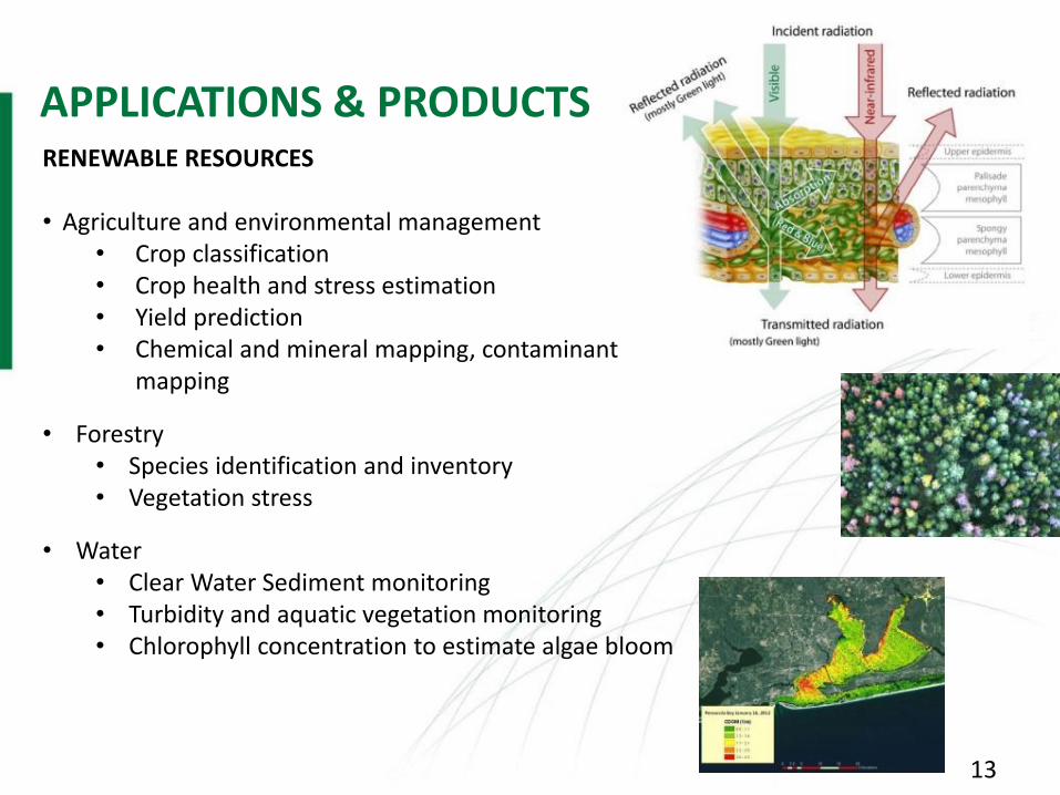
APPLICATIONS & PRODUCTS
INVAP CONFIDENTIAL AND PROPRIETARY
RENEWABLE RESOURCES
• Agriculture and environmental management• Crop classification• Crop health and stress estimation• Yield prediction• Chemical and mineral mapping, contaminant
mapping
• Forestry• Species identification and inventory• Vegetation stress
• Water• Clear Water Sediment monitoring• Turbidity and aquatic vegetation monitoring• Chlorophyll concentration to estimate algae bloom

14
SPECTRAL BANDS• Between 200 and 3000 bands over the entire spectral region VNIR-TIR• Agriculture, water ecosystems, land use and vegetation content with 200-300 bands• Geological, atmospheric and specific vegetation applications will need more than 300• Atmospheric application requirements depend on the observation target and purpose
SPECTRAL RESOLUTION• VNIR 0.05-30nm• SWIR 0.2-40nm• MIR-TIR 4-400nmHigh spectral resolution in geology applications is significantly different to the other applications, especially in the MIR/TIR waveband.
SPATIAL RESOLUTIONBetween 4m and 30m
SIGNAL TO NOISE RATIOWide range: between 400 and 1500 depending on the application
INVAP CONFIDENTIAL AND PROPRIETARY
USER NEEDS DISCUSSION - MARKET OPPORTUNITIES

15
RENEWABLE RESOURCES APPLICATIONS
• 20 m Ground sampling distance• 40 km Swath, 300 km Accessible area
• 470-900nm (VNIR) Spectral Range• 150 Spectral Bands• 2,8nm Spectral Resolution• Better than 10nm FWHM Bandwidth per band• 10 bits Radiometric Resolution• 60 dB Dynamic Range• Area detector• 1Gbps Raw Data Rate• Refractive F#2 Optical Architecture
• 1 kg mass• 2 W power • 100 mm dia. x 100 mm height (Optical Head) envelope
INVAP CONFIDENTIAL AND PROPRIETARY
INSTRUMENT CHARACTERISTICS

16
END-USER SERVICES AND APPLICATIONS
USING SPACE BASED INFORMATIONFRONTEC is a company fully owned by INVAP created in 2016 to supply services to the end-user based on satellite images processing and applications.A technology platform which combines new developments in the aerospace industry, information technologies and agronomy sciences offers innovative and sustainable solutions for the food production industries. This service allows the producer to increase efficiency and reduce costs per ton produced.
Services:• Precision agriculture: including prescription of nutrients by crop and field• Economic analysis of the investments• Online monitoring which will generate alerts for crop stresses• Satellite image processing service

Thank you for your attentionAny questions?
Back-up Slides

19
AGRICULTURAL CRITERIA• Detect mechanized grain harvesting operations• Detect active plowing of fields• Identify small water sources in range land areas
URBAN AND TRANSPORTATION CRITERIA• Distinguish between individual railcars in a train• Detect an automobile• Detect towers associated with power lines
MINING AND OTHER CRITERIA• Distinguish between operational and abandoned quarries• Identify cable logging operations• Detect jeep trails in scrub brush
INVAP CONFIDENTIAL AND PROPRIETARY
NIIRS > 4 CLASSIFICATION CRITERIA
DETECTION AND IDENTIFICATION CAPABILITY