avila point deir
TRANSCRIPT

AVILA POINT REMEDIATION AND DEVELOPMENT
PROJECT DRAFT ENVIRONMENTAL IMPACT REPORT
E C O C O N S U L T I N G I N C .
Barton • Degregori • Jordan • Marshall • Yocom

Eco Consulting Inc.
· 1 Grand Avenue, San Luis Obispo, CA 93401 ·
March 11, 2016 TO: Responsible Agencies and Interested Parties
FROM: Kyle Jordan, Project Lead, Eco Consulting Incorporated
SUBJECT: Avila Point Project Draft Environmental Impact Report (DEIR)
The Draft EIR for the Avila Point Project has been completed and is now available for review. Pursuant to Section 15088 of the State Guidelines for implementation of California Environmental Quality Act (CEQA) the lead agency will be required to provide responses to agency comments. Responses to comments will be prepared by the consultant and reviewed by county staff. A public hearing will be held on the adequacy and accuracy of this document. If you have any questions, please contact: Kyle Jordan, Project Lead [email protected] (805) 756-1111

Table of Contents 1.1 Executive Summary .................................................................................................................... 1 1.1.1 Introduction ......................................................................................................................................... 1 1.1.2 Summary of Proposed Action .............................................................................................................. 1 1.1.3 Alternatives Comparison ...................................................................................................................... 2 1.1.4 Areas of Controversy............................................................................................................................ 2 1.1.5 Major Conclusions and Issues to be Resolved ..................................................................................... 2 1.1.6 Impact/Mitigation Summary Tables .................................................................................................... 3
2.1 Project Description ................................................................................................................... 10 2.1.1 Statement of Objectives .................................................................................................................... 10 2.1.2 Overview of Project ........................................................................................................................... 10
2.1.2.1 Remediation Phase ..................................................................................................................... 10 2.1.2.2 Construction Phase ..................................................................................................................... 11
3.1 Environmental Setting .............................................................................................................. 14 3.1.1 Historical Context and Characteristics ............................................................................................... 14 3.1.2. Present Conditions and Proposed Uses ............................................................................................ 14
4.1 Aesthetics and Visual Resources Impact Analysis ..................................................................... 15 4.1.1 Existing Conditions ............................................................................................................................. 15 4.1.2 Regulatory Setting .............................................................................................................................. 19
4.1.2.1 Bureau of Land Management Methodology .............................................................................. 19 4.1.2.2 San Luis Obispo County ............................................................................................................... 19
4.1.3 Significance Criteria ........................................................................................................................... 21 4.1.3.1 California Environmental Quality Act Guidelines........................................................................ 21
4.1.4 Impact Assessment Methodology ..................................................................................................... 22 4.1.5 Project Impacts and Mitigation Measures ......................................................................................... 22
4.1.5.1 Viewshed Impacts and Mitigation .............................................................................................. 22 4.1.5.2 Light and Glare Impacts and Mitigation ..................................................................................... 26 4.1.5.3 Geological Resources Impacts and Mitigation ........................................................................... 26
4.2 Hazards and Hazardous Materials Impact Analysis ................................................................... 28 4.2.1 Existing Conditions ............................................................................................................................. 28 4.2.2 Regulatory Setting .............................................................................................................................. 30
4.2.2.1 Federal Agencies ......................................................................................................................... 30 4.2.2.2 California Agencies ..................................................................................................................... 30 4.2.2.3 Local Agencies............................................................................................................................. 30 4.2.2.4 Avila Beach Specific Plan ............................................................................................................ 31
4.2.3 Significance Criteria ........................................................................................................................... 31 4.2.3.1 California Environmental Quality Act Guidelines........................................................................ 31 4.2.3.2 Local Disposal Criteria ................................................................................................................ 32
4.2.4 Impact Assessment Methodology ..................................................................................................... 33 4.2.5 Project Impacts and Mitigation Measures ......................................................................................... 33
4.2.5.1 Public Exposure to Hazardous Materials Impacts and Mitigation ............................................. 33 4.2.5.2 Fire Hazard Impacts and Mitigation ........................................................................................... 34 4.2.5.3 Runoff Impacts and Mitigation ................................................................................................... 35 4.2.5.4 Valley Fever Impacts and Mitigation .......................................................................................... 35

4.2.5.5 Emergency Response Impacts and Mitigation ........................................................................... 36
4.3 Hydrology and Water Quality Impact Analysis .......................................................................... 37 4.3.1 Existing Conditions ............................................................................................................................. 37 4.3.2 Regulatory Setting .............................................................................................................................. 39
4.3.2.1 Federal Agencies ......................................................................................................................... 39 4.3.2.2 State Agencies ............................................................................................................................ 39 4.3.2.3 Local Agencies............................................................................................................................. 40
4.3.3 Significance Criteria ........................................................................................................................... 41 4.3.3.1 California Environmental Quality Act Guidelines........................................................................ 41
4.3.4 Impact Assessment Methodology ..................................................................................................... 41 4.3.5 Project Impacts and Mitigation Measures ......................................................................................... 41
4.3.5.1 Surface Water Impacts and Mitigation ...................................................................................... 41 4.3.5.2 Ground Water Impacts and Mitigation ...................................................................................... 42
4.4 Biological Resource Impact Analysis ......................................................................................... 46 4.4.1 Existing Conditions ............................................................................................................................. 46 4.4.2 Regulatory Setting .............................................................................................................................. 51 4.4.3 Significance Criteria ........................................................................................................................... 52
4.4.3.1 California Environmental Quality Act Guidelines........................................................................ 52 4.4.4 Impact Assessment Methodology ..................................................................................................... 53 4.4.5 Project Impacts and Mitigation Measures ......................................................................................... 54
4.4.5.1 Special-Status Plant and Wildlife Species Impacts and Mitigation ............................................ 54 4.4.5.2 Biological Functions of Habitats Impacts and Mitigation ........................................................... 55 4.4.5.3 Wetland Impacts and Mitigation ................................................................................................ 61 4.4.5.4 Wildlife Migration Impacts and Mitigation ................................................................................ 61 4.4.5.5 Biological Size and Diversity Impacts and Mitigation ................................................................. 62
5.1 Alternatives Overview .............................................................................................................. 64 5.2 Alternatives Selection ........................................................................................................................... 64
5.2.1 Screening and Selection Criteria .................................................................................................... 64 5.2.2 Project Objectives .......................................................................................................................... 65 5.2.3 Alternatives Rejected ..................................................................................................................... 65 5.2.4 Alternatives Considered for Further Review .................................................................................. 66
5.3 Alternatives Analysis ............................................................................................................................. 67 5.3.1 Alternative 1: No Project Alternative ............................................................................................. 67 5.3.2 Alternative 2: Reduced Development ............................................................................................ 68 5.3.3 Alternative 3: Reduced Footprint Lodging Alternative .................................................................. 69
5.4 Environmentally Superior Alternative .................................................................................................. 70
6.1 List of Project Preparers ........................................................................................................... 71
7.1 References ............................................................................................................................... 73

1
1.1 Executive Summary
1.1.1 Introduction The following section discusses a brief overview of the project, the anticipated environmental effects, and the potential mitigation measures that could reduce those impacts. This Draft Environmental Impact Report (DEIR) was prepared in accordance with the County of San Luis Obispo and the California Environmental Quality Act (CEQA). With these guidelines, an Initial Study and Notice of Preparation were distributed to collect public comments and aid the direction of scoping and analysis for the DEIR. This DEIR consists of an executive summary, project description, environmental setting, environmental impact analysis and mitigation, and an alternatives analysis. This DEIR is released on March 11, 2016 for a 45-day public comment period. During this public comment period, the public has the opportunity to ask questions and make comments in regards to the content of the DEIR. The Final Environmental Impact Report (FEIR) will contain all public comments as well as responses to each public comment. Revisions will be marked on the FEIR to show any changes made from the DEIR after the public comment period.
1.1.2 Summary of Proposed Action The applicant, Chevron Corporation, is proposing a remediation and construction project at the site previously used as Avila Point Tank Farm and is seeking approval from the County of San Luis Obispo. The project objectives include the remediation of Avila Point Tank Farm, the rezoning of the area from industrial to recreation, and finally the development of a recreational resort and other facilities. The proposed project consists of two phases:
Remediation Phase: Excavation of soil and the remediation of groundwater sources on the project site to reduce oil contaminants existing in those natural resources. This process will consist of the transportation of contaminated soils to an off-site landfill.
Construction/Implementation Phase: The proposed project plan requires the change of land use zoning from industrial to recreational in order to construct and implement a resort with open space recreational activities. This will include the grading of lands, input of private roads, infrastructure improvements, and resort construction. The proposed project will consist of resort lodging totaling in 134,000 square feet including a spa, dining, meeting facilities, fitness facilities, and pool buildings. On site roads and parking lots will also be built to accommodate the increase in traffic and visitors to and from the project site.

2
1.1.3 Alternatives Comparison Eco Consulting Incorporated has designed and analyzed five different project alternatives. These alternatives were analyzed in reference to the project objectives established by Chevron stated in the above section. The No Project Alternative prevents all impacts of the project due to construction and development of the resort (remediation will still be required), but do not meet the project objectives. The Reduced Development/Project Size Alternative proposes a reduction of the project size by 25%. The alternative meets all project objectives and significantly reduces the environmental impacts present in the original proposed project. The Reduced Footprint Lodging Alternative proposes a tree house lodge instead of resort. This meets all the project objectives while providing the same amount of units as the original proposed project and reducing the environmental impacts that are present in the original project plan. The next alternative proposes the resort to be located partially underground. Although this proposal meets the project objectives, it was rejected due to the infeasibility of the deep remediation that would be needed and the difficulty of resort construction. Lastly, an Alternative Project Location was proposed. This alternative would take a significant amount of time and money to acquire a new site. In addition, this alternative would not meet the project objectives established by Chevron and therefore was rejected.
1.1.4 Areas of Controversy One of the areas of controversy caused by the project proposal involves the level of contaminant cleanup required at the project site. Some stakeholders have expressed concern with the limited remediation being done on the project site by Chevron. Those concerned are requesting a longer and more detailed remediation process by Chevron to ensure that the contaminants are removed from the existing soil and water to the greatest extent possible. The proposed remediation plan was designed using human health and ecological risk based approach, creating a remediation approach with reduced levels of ecological risk. Further into the DEIR document, an alternative proposing minimal excavation is discussed, but rejected. Another area of controversy pertains to the increased traffic to the area. Because there is only one road leading to the site, Avila Beach Dr., the increased traffic to the area may cause issues. Not only will the roads and areas become busier, but this may severely affect the ability for emergency vehicles to reach the area. Although this is a legitimate concern, it is somewhat address in the mitigation measures described in the hazards and hazardous materials section of the DEIR.
1.1.5 Major Conclusions and Issues to be Resolved The proposed remediation and construction of the project will have associated significant environmental impacts. While most of these impacts shall be deemed less than significant with

3
mitigation, there are some issues that need to be resolved. The first issue involves the short and long term impacts on viewshed. Because of the location of the facility, construction equipment and permanent infrastructures will impact the viewshed. The mitigation measures in reference to this impact are discussed later in this DEIR. Another issue is the inability for emergency response vehicles to have access to the site and surrounding areas. The increased traffic and population of the area make emergency response delayed. The mitigation measures regarding this impact are also discussed later in this DEIR.
1.1.6 Impact/Mitigation Summary Tables Table 1.6-1. Impacts and Mitigation Tables
Impacts Mitigation
Aesthetic and Visual Resource AV - Impact 1: (Class I) o The project will create an
aesthetically incompatible site open to public view, will introduce a use within a scenic area open to public view, and will be visible from a variety of public viewpoints.
AV - Mitigation 1: o In order to mitigate the short-term
impacts caused by site remediation and construction, the applicant shall ensure that fencing contributes to the aesthetic character of the site and its surroundings.
o In order to mitigate the long-term impacts of the project on the viewshed, the applicant shall incorporate the landscape into the project's design. The final landscaping plans shall consider all the viewpoints that the project is visible from and shall use vegetation to minimize the project's impact on the viewsheds from those points.
AV - Impact 2: (Class II) o There will be a light impact during
the remediation and construction phases of this project. The major light and glare impacts will occur during the operation of the facilities on site once remediation and construction is complete.
AV - Mitigation 2: o For the light impacts that will exist
during remediation and construction, the applicant will submit a lighting plan and lighting operation schedule for review and approval before the process can begin. This will address the direct light and glare sources and how local residents will be shielded from the impacts.
AV – Impact 3: (Class II) o Coastal bluffs located on the project
site may be considered geologically
AV - Mitigation 3: o Prior to the issuance of grading
permits, the applicant will design a

4
unique or important to the community due to their unique exposure and availability to the public for education and observation.
drainage system to direct runoff into infiltration basins. Site drainage plans will be constructed to process runoff on a slope towards the facility and away from the bluffs.
Hazards and Hazardous Materials
HM - Impact 1: (Class II) o The project site is defined by the
California Health and Safety Code as an impacted hazardous waste site and is listed on the Cortese list, due to impacted soils. Four to five feet of chemically impacted soils must be removed and any remaining contaminated soils graded and capped with fill material. There is also potential for workers to be exposed to contaminated soils during removal.
HM - Mitigation 1: o Prior to issuance of grading permits,
the San Luis Obispo County Planning and Building Department will verify that a grading contractor has been certified as a California Title 22 CH. 12 Hazardous Waste Generator to ensure compliance with RCRA Title 40 Part 262. This mitigation measure is designed to limit the improper exposure of workers to hazardous wastes.
o The applicant will develop and submit to the Planning Commission a Designated Route Plan (DRP). The DRP will require loading and unloading of hazardous materials to occur at Cave Landing road and will direct transport drivers to utilize San Luis Bay Drive route to limit exposure to the most sensitive receptors
HM - Impact 2: (Class II) o There is the potential for human
health impacts due to soil contamination as well as contaminated groundwater that is not removed in the remediation phase. Vapor intrusion may pose threats to safety due to fire or explosion, as well as possible adverse health effects from inhalation of chemicals.
HM- Mitigation 2: o Prior to the approval of building
permits, the applicant will submit to the San Luis Obispo County Planning and Building Department an Operation and Maintenance Plan to use and install vapor barriers plastic beneath the resort facilities to prevent vapor entry, as well as adequate pumps to prevent water from entering the facility.
HM - Impact 3: (Class II) o During the remediation and
construction phases, there is a possibility of contaminated water runoff into nearby water bodies
HM - Mitigation 3: o The project shall prepare a
construction SWPPP of the RWQCB regarding water runoff. The project

5
which include the Pacific Ocean and San Luis Obispo Creek.
shall implement BMPs in regards to retaining and/or treating water runoff.
HM - Impact 4: (Class II) o During the remediation and
construction phases of the project there is potential for disturbed soils to expose workers and Avila Beach community members to Valley Fever.
HM - Mitigation 4: o Prior to approval of grading permits,
the applicant will develop and submit a Soil Mitigation Strategy (SMS) to the San Luis Obispo County Planning Commission.
HM - Impact 5: (Class I) o This project will bring additional
visitors and vehicle traffic to the end of Avila Beach Drive, potentially impacting the ability for emergency response vehicles to access parts of the city.
HM - Mitigation 5: o The applicant will need to have a
consultation with PG&E, CalFire, Port San Luis Harbor District, Office of Emergency Services and County Public Works regarding emergency access planning as a result of the proposed project. To reduce the emergency response impact, an emergency response plan has developed alternate routes that will become available to emergency response vehicles when needed.
Hydrology and Water Quality SW - Impact 1: (Class II)
o The Avila Point Project’s construction and remediation stages will alter current drainage patterns that will result in increased quantities of surface runoff. These impacts will be a result of increases in the impermeable surfaces created by the project and the potential for removal of drainage basins that currently catch runoff and allow for infiltration. This could then change the drainage patterns where substantial on- or off-site sedimentation, erosion, or flooding may occur.
SW - Mitigation 1: o Prior to approval of grading permits,
the applicant will prepare a Stormwater Pollution Prevention Plan (SWPPP) and an Erosion Control Plan, to be approved by RWQCB. These plans must include methods to stabilize graded areas, construct slope breaks to limit sheet and rill erosion, create sediment barriers around construction areas to retain soil particles on-site and limit runoff, build temporary and permanent drainages, and build water bars to disperse runoffs.
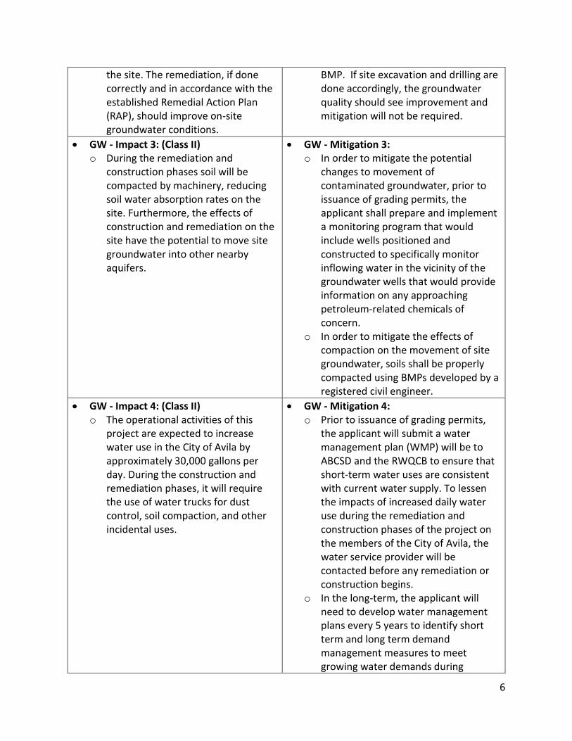
GW - Impact 2: (Class IV) o Depending on the success of the
remediation phase of this project, it may positively or negatively impact the existing groundwater quality on
GW - Mitigation 2: o The change in groundwater quality will
not require mitigation as long as the construction and remediation processes follow the RAP and other
6
the site. The remediation, if done correctly and in accordance with the established Remedial Action Plan (RAP), should improve on-site groundwater conditions.
BMP. If site excavation and drilling are done accordingly, the groundwater quality should see improvement and mitigation will not be required.
GW - Impact 3: (Class II) o During the remediation and
construction phases soil will be compacted by machinery, reducing soil water absorption rates on the site. Furthermore, the effects of construction and remediation on the site have the potential to move site groundwater into other nearby aquifers.
GW - Mitigation 3: o In order to mitigate the potential
changes to movement of contaminated groundwater, prior to issuance of grading permits, the applicant shall prepare and implement a monitoring program that would include wells positioned and constructed to specifically monitor inflowing water in the vicinity of the groundwater wells that would provide information on any approaching petroleum-related chemicals of concern.
o In order to mitigate the effects of compaction on the movement of site groundwater, soils shall be properly compacted using BMPs developed by a registered civil engineer.
GW - Impact 4: (Class II) o The operational activities of this
project are expected to increase water use in the City of Avila by approximately 30,000 gallons per day. During the construction and remediation phases, it will require the use of water trucks for dust control, soil compaction, and other incidental uses.
GW - Mitigation 4: o Prior to issuance of grading permits,
the applicant will submit a water management plan (WMP) will be to ABCSD and the RWQCB to ensure that short-term water uses are consistent with current water supply. To lessen the impacts of increased daily water use during the remediation and construction phases of the project on the members of the City of Avila, the water service provider will be contacted before any remediation or construction begins.
o In the long-term, the applicant will need to develop water management plans every 5 years to identify short term and long term demand management measures to meet growing water demands during

7
normal, dry, and multiple-dry years under the California Urban Water Management Planning Act.
Biological Resources BIO - Impact 1: (Class II)
o Site remediation has the potential to result in short- and long-term impacts to special-status plant and wildlife species. The short-term impacts concern the inability of species to live on the site during remediation and construction of the site.
o The long-term impacts concern the success of the species to utilize the area on or surrounding the site after the development of the project. It has the potential to impact their ability to find resources, shelter, and to reproduce.
BIO - Mitigation 1: o In order to mitigate the short- and
long-term impacts on special listed plant and animal species the applicant shall hire a County-approved biologist to conduct pre-construction surveys to locate the various species during the appropriate seasons. This information shall then be utilized to avoid, relocate, and monitor these species throughout the remediation and construction on the site.
BIO - Impact 2: (Class II) o Site remediation and restoration
could result in short-term and permanent loss of biological functions of wetlands, native grasslands, and other habitats for rare plants and animals, and other biotic communities considered sensitive by federal, state, or local policies, statutes, and regulations.
BIO - Mitigation 2: o A consultation of the project site and
the surrounding area before remediation will need to be done with the California Department of Fish and Wildlife, the US Fish and Wildlife Service, the California Native Plant Society, and the Audubon Society. Through these consultations and surveys, the team will be able to identify any sensitive, endemic, rare, threatened, endangered plant and animal species.
o In addition, these surveys will also provide pertinent information about location, habitat sizes and abundance, and wetland existence and condition. These surveys will be seasonally specific according to the species being evaluated. This will establish a baseline condition for all species in question, allowing for a short-term and long-term monitoring plan once

8
remediation, construction, and implementation occurs.
BIO - Impact 3: (Class I) o The wetlands on the project site are
protected by the California Coastal Commission for the potential of inhabiting endangered plants and fairy shrimp. These wetlands would be destroyed under the current project plans. During remediation these wetland areas will be excavated, impacting the endangered species that live in them.
o The project has proposed to build a parking lot along Cave Landing Rd where a very large wetland is present. Building the parking lot in that location will have significant impacts on the endangered species that utilize that wetland.
BIO - Mitigation 3: o In order to mitigate the impacts to
wetlands multiple actions need to take place. Prior to issuance of grading permits, a Stormwater Pollution Prevention Plan (SWPPP) must be approved by the County and implemented to ensure that storm-water does not flow into sensitive wetland habitat.\
o Prior to issuance of applicable grading permits, the applicant will consult with the California Coastal Commission to establish proper wetland mitigation design.
BIO - Impact 4: (Class II) o Activities during site remediation
and restoration may interfere with wildlife movements which may diminish their chances of survival. This includes any upland or aquatic species that uses the project site for food, shelter, or reproduction. Construction would also inhibit migratory species from using the land they are used to inhabiting each year, impacting their species health.
BIO - Mitigation 4: o Prior to of issuance of applicable
grading permits, the applicant will prepare and submit to the San Luis Obispo County Department of Planning and Building a restoration plan that specifically addresses the effects remediation and construction will have on the terrestrial ecosystem of the project site.
BIO - Impact 5: (Class II) o The surrounding oak woodlands and
bluffs provide habitat for listed and special status species that may be impacted by the use of heavy equipment during remediation and construction.
o Exposure to contaminated soils unearthed during the remediation phase of the project may have
BIO - Mitigation 5: o Prior to the issuance of a grading
permits, the applicant will submit a plan to fund and provide site access to a county approved biological monitor to review and monitor the project remediation and construction.
o Active remediation and construction sites will be fenced off, while the rest of the site will remain unfenced to

9
adverse impacts on the health of listed species, both due to direct contact with the soils and fugitive dust.
allow for proper migration and movement of listed species

10
2.1 Project Description
2.1.1 Statement of Objectives The applicant in this project is the Chevron Corporation. The main objectives of this proposed project are to remediate the area previously known as the Avila Tank Farm and to build a resort and other facilities on the site that will allow it to be utilized for recreation. The project has three specific main components: to obtain a Coastal Development Permit to clean up the soil and groundwater contamination left behind by decades of oil transportation and storage, an amendment to the Local Coastal Plan to change the land-use designation from industrial to recreation to allow for the planned development, and finally a 9-lot subdivision of the site to allow the various roads and infrastructure improvements for the planned resort. The project proposal provides steps towards the remediation of the contaminated project site. The other part of this project proposal consists of the building of roads and infrastructure affiliated with a proposed resort. The resort will be free of automobiles due to the limited access provided by the entry road, therefore, a shuttle system is considered to provide transportation to those utilizing the facilities. In addition, the plans to build a resort would involve the reduction of graded area from 56% to 40%, leaving 60% available for open space. The overall objectives of creating these facilities include creating new jobs, boosting the city’s economy, protecting historical and cultural significance on the site, creating aesthetically pleasing open space, restoring ecological functions, and making area available for recreational use.
2.1.2 Overview of Project
Chevron Corporation is proposing a remediation and development project on the 95 acre former Avila Tank Farm property. The location of the project is shown in Figure 2.2.2-1. The remainder of this section provides a detailed description the remediation and construction phases. The duration of the remediation phase is expected to last approximately one year, with two years allotted for construction once remediation is completed.
2.1.2.1 Remediation Phase The first phase of this construction is the remediation of the site to repair pollution created when the site was known as the Avila Tank Farm. These plans include soil excavation and backfilling, dewatering of excavations, hauling of impacted soils off-site to appropriate facilities, capping impacted soils with clean fill and active hydrocarbon recovery equipment installation and operation. These efforts are proposed to repair most of the damaged that was caused by the oil transportation and storage. The remediation will position the site for the next phase, a comprehensive development program. The remediation element of the project is focused on supporting the proposed development program. In this regard, the entitlements for the
11
proposed development program as well as the agency approved Remediation Action Plan (RAP) will be processed as a single project. The potential remedial actions and preliminary development work requiring evaluation in the EIR may include, but is not limited to: soil excavation and backfilling, dewatering of excavations, hauling of impacted soils off-site to appropriate facilities, capping impacted soils with clean fill, active hydrocarbon recovery equipment installation and operation, future building design requirements such as vapor barriers and raised foundations, grading and road/utility installation to accommodate future development concurrent with remediation activities.
2.1.2.2 Construction Phase The developed site will consist of a two-story, into a 232-unit resort with around 40% of the site developed with 17% consisting of buildings and roads, while 23% is designated for resort landscaping. This leaves the site with 60% available for open space and natural habitat. The amenities and features included in this project are:
California Coastal Trail extension connection from downtown Avila to Cave Landing Road
Strong pedestrian connection to downtown Avila
Scenic overlooks and interpretive signage program
Habitat restoration
Open space preservation including extensive oak woodlands and coastal chaparral
Wellness center and day spa
Public restaurant
Sustainable design features
Meeting facilities
Amphitheater/gathering area This project will provide the public with additional recreational use by and reopening the area once it has been remediated and developed. See Figures 2.1.2-1 through 4 for the regional area, remediation activity area, redevelopment site plan, and community access and amenities.

12
Figure 2.1.2-1. Regional Map
Figure 2.1.2-2. Remediation Activity Locations

13
Figure 2.1.2-3. Redevelopment Site Plan
Figure 2.1.2-4. Community Amenities

14
3.1 Environmental Setting
3.1.1 Historical Context and Characteristics Knowing the historic uses of this site is pertinent to understand the precautions needed to be taken to during the remediation and implementation of the project. For a major part of its history, Avila Beach was an oil shipping port. In the 1920’s and 30’s the Avila Beach boasted the number one oil shipping port in the world. Avila Beach Port was key for U.S. fuel supply during WWII, at which point it was owned by Union Oil. It wasn’t until 1998 that the oil use ended and the tanks were dismantled. Chevron purchased the land in 2005 with plans for redevelopment.
3.1.2. Present Conditions and Proposed Uses In 2005, the Avila Tank Farm Collaborative Assessment Team (ATCAT) began taking groundwater, surface water, soil gas, and soil conditions samples from the project site through the placement of monitoring wells and collection of data from soil borings. Groundwater monitoring is being performed quarterly or semi-annually and then the information is summarized and provided to the Central Coast Regional Water Quality Control Board. ATCAT’s and the Regional Board’s goal is to determine ecological and human health risks due to the past industrial uses of the site and to identify appropriate remediation actions, taking into account proposed land use and regulatory requirements. The Avila Beach Specific Plan requires the Avila Tank Farm (Avila Point) property to be rezoned from Industrial to Recreation (REC). The entitlement applications will be processed primarily through the County of San Luis Obispo and the California Coastal Commission. The Avila Beach Specific Plan also will need to be amended as a part of the General Plan/Local Coastal Program (LCP) amendment to rezone the property. The Avila Beach Specific Plan is a document describing the preservation, restoration and development goals for the City of Avila Beach and is required by California State law to be consistent with the County General Plan and the LCP. The County General Plan and LCP set specific standards for redevelopment and rezoning of a site from industrial to recreational uses that would have to be adhered to in any amendments made in the Avila Specific Plan. Since the project site has a historic use of industrial contaminants that are still present, a Development Plan Permit is necessary for the cleanup of the property before they could begin construction on the project. A Development Plan Permit allows the applicant to pursue site remediation and is approved/denied by the County of San Luis Obispo. A Remedial Action Plan (RAP) has not been submitted by the applicant at this time, but is anticipated in the future and will describe the means by which project remediation will take place. The RAP would be subject to approval after the EIR is completed and the environmental impacts of remediation are evaluated.

15
4.1 Aesthetics and Visual Resources Impact Analysis This section addresses issues involving aesthetics and visual resources resulting from the proposed Avila Point Project. This section of the document analyzes the visual environment and the changes that would occur if the proposed project were to be approved. This section includes photos and visuals of the existing site and the distinguishing characteristics of the project site and its surroundings. In addition, this section contains photo simulations that explore the visual character of the project site and aid in the impact analysis. These simulations are created using the information in the project proposal to best predict the impact the project will have on the aesthetics and visual resources of the site and surrounding areas. The information for this section was drawn from:
Chevron Tank Farm Remediation and Development Project Final Environmental Impact Report
Phillips 66 Company Rail Spur Extension and Crude Unloading Project Final Environmental Impact Report and Vertical Coastal Access Project Assessment
Avila Beach Community Plan
Avila Point/Avila Tank Farm General Plan/Specific Plan Amendment Initial Study Summary
Draft Environmental Impact Report Hollywood Community Plan Area
4.1.1 Existing Conditions The project site is a 95-acre ridgeline parcel on Avila Point, with some areas designated for industrial use and the remaining land designated as undeveloped land. This site is approximately 200 feet above sea-level, directly east of Avila Beach, bordered to the north by Avila Beach Drive and the east by Cave Landing Road. Avila Beach is north of Pismo Beach and south of Morro Bay with the actual project site just northwest of the Avila Sea Caves that overlook Pirate's Cove. U.S. Highway 101 also runs parallel to the coast just east of the project site. Figure 4.1-1 shows the physical location of the project site and proximity to visual resources.

16
Figure 4.1-1. Map of Central Coast Beaches. The red point represents the location of the project site. Due to its location on top of sea bluffs, the project site is visible from multiple vantage points along the coast. The project site overlooks Avila Beach, therefore visitors on Avila Beach or near Avila Beach's coastline would have visibility of the project site. There is also potential visibility from neighboring beach visitors as well including those visiting Shell Beach and Pismo Beach just south of the project site. In addition, the project site also has potential to be visible from drivers on U.S. Highway 101 passing through the area. Views to the west of the project site include the shoreline of the Pacific Ocean, while views to the east include the Avila Beach Golf Resort surrounded by screens of oak trees. The project site was formerly used as a Tank Farm by Unocal, which was eventually bought out by Chevron. Due to the sites previous use of an oil storage and transportation facility, five storage tanks along with additional infrastructure remain visible on the north end of the site. In addition to the infrastructure, graded parcels of land also exist throughout the site even though some have almost been restored to a natural appearance after the removal of the tanks.

17
Figures in 4.1-2 shows where vantage points of the project site were analyzed from key viewing areas:
4.1-2-1 From the shoreline of Avila Beach looking south (No.1) 4.1-2-2 From US 101 highway looking west, near Cave Landing Rd. (No. 2) 4.1-2-3 From the shoreline of Shell Beach looking north (No.3) 4.1-2-4 From the City of Avila Beach, San Rafael St., looking southwest (No.4) 4.1-2-5 From the City of Avila Beach, Avila Beach Dr., looking southwest (No.5)
Figure 4.1.2-1. Key viewing location No. 1 from Port San Luis Dock.
Figure 4.1-2-2. Key viewing location No. 2 from Avila Beach Pier

18
Figure 4.1-2-3. Key viewing location No. 3 from Avila Beach Dr.
Figure 4.1-2-4. Key viewing location No. 4 from Cave Landing Rd.
Figure 4.1-2-5. Key viewing location No. 5 from Ontario Ridge Trail

19
4.1.2 Regulatory Setting Visual impacts resulting from the Avila Point Project are within the jurisdiction of the County of San Luis Obispo and the California Coastal Commission. The regulatory setting pertaining to aesthetics includes the County’s review of the proposed development’s consistency with various elements of the County of San Luis Obispo General Plan and the San Luis Obispo County Coastal Zone Land Use Ordinance, in addition to the provisions in the California Environmental Quality Act (CEQA) Guidelines relating to aesthetics. The methodologies for aesthetic impact analysis were based on the procedures used by the Bureau of Land Management to best quantify the impacts to visual resources the project will have on the area.
4.1.2.1 Bureau of Land Management Methodology The Bureau of Land Management has developed a system called Visual Resource Management that used two stages, Inventory and Analysis, to classify impacts on aesthetics and visual resources. This process involves the rating of visual appeal, the rating of public concern for scenic quality, and the identification of vantage points. The inventory stage involves scenic quality evaluation, sensitivity level analysis and delineation of distance zones. Based on the inventory stage, the project is placed in one of four categories. Class I being the most valued, Class II consisting of allowing low levels of change, Class III involves allowing moderate levels of change, and Class IV allowing major changes to the environment.
Figure 4.1.2-1. The Bureau of Land Management evaluation table of visual sensitivity levels.
4.1.2.2 San Luis Obispo County The project site is within the jurisdiction of the County of San Luis Obispo. The main document pertaining to this projects visual impacts is the County of San Luis Obispo General Plan in addition to the CEQA guidelines. The main elements used to analyze the impacts of aesthetics and visual resources are based on the County Conservation and Open Space Element (COSE) and the San Luis Obispo County Local Coastal Plan.

20
County of San Luis Obispo General Plan The San Luis Obispo Area Plan includes this vision statement: This plan's vision for the future includes continued opportunities for economic vitality and growth, along with the opportunity to maintain the environmental attributes that have themselves contributed to the area's historically healthy economy. The community's excellent living environment and educational opportunities can act to attract or retain businesses providing high quality job opportunities for local residents, enabling them to afford housing within the area, while also enhancing local tax revenues needed for public services. The planning area should maintain a rural character in harmony with agriculture, business, recreational, environmental and residential opportunities. With a focus on the sections stating, "The planning area should maintain a rural character in harmony with agriculture, business, recreational, environmental and residential opportunities", the plan's vision relates the aesthetics and visual resources of the county in regards to:
Protect and, where it has been degraded, enhance wildlife habitat areas;
Protect the scenic values of natural landforms;
Protect important historic or archaeological resources;
Focus urban development within established urban and village areas;
Devote the remainder of the planning area to a "greenbelt" consisting of production agriculture and low-density development (also see Framework for Planning); and
Encourage economic development balanced with the natural resources that enhance the natural beauty and character, and supports the social and environmental health of the planning area.
This is based on analysis provided in the Chevron San Luis Obispo Tank Farm Environmental Impact Analysis document. County Conservation and Open Space Element (COSE) The purpose of this section of the general plan is to identify areas of open space worthy of protection due to their intrinsic value and establish goals accordingly. Through the use of policies and mitigation measures, the integrity of the scenic views to be protected. San Luis Obispo Local Coastal Plan The County of San Luis Obispo planning documents do not contain specific criteria for determining thresholds of significance regarding aesthetic resources. Consideration of the following criteria will be given to ensure project consistency with public plans, policies and goals.

21
Coastal Zone Framework for Planning (Coastal Zone Land Use Element)
Strategic Growth Goal 1: Preserve open space, scenic natural beauty and sensitive environmental areas. Conserve energy resources. Conserve agricultural resources and protect agricultural land
Strategic Growth Goal 2: Strengthen and direct development towards existing and strategically planned communities.
Strategic Growth Goal 7: Encourage mixed land uses Chapter 3: Recreation & Visitor Serving Facilities 30213. Lower cost visitor and
recreational facilities ... shall be protected, encouraged, and, where feasible, provided. Developments providing public recreational opportunities are preferred.
Avila Beach Specific Plan In the Avila Specific Plan, one of the stated goals for Avila Beach’s development is “to maintain and preserve unobstructed public views of the ocean.” Any coastline development in the area is limited to a building height of 25 feet. Due to this building ordinance, in order for the Avila Point project to move forward with development, a special building permit will need to be obtained by the applicant. If this permit is not obtained, then the project developers will need to significantly alter the design of the planned permanent infrastructures to meet the building requirements established in the Avila Beach Specific Plan.
4.1.3 Significance Criteria Impact analysis is in compliance with and primarily applied using Appendix G of the CEQA guidelines.
4.1.3.1 California Environmental Quality Act Guidelines The significance of potential aesthetic impacts are based on thresholds identified within Appendix G of the CEQA Guidelines and the County’s Initial Study Checklist, which provide the following thresholds for determining impact significance with respect to aesthetics resources. Aesthetic impacts would be considered significant if the proposed project would:
Have a substantial adverse effect on a scenic vista Substantially damage scenic resources, including, but not limited to, trees, rock
outcroppings, and historic buildings within a state scenic highway Substantially degrade the existing visual character or quality of the site and its
surroundings Create a new source of substantial light or glare which would adversely affect day or
nighttime views in the area
No specific criteria exists in the County and City planning documents in regards to determining thresholds. With the use of the Bureau of Land Management method, the project's consistency with public policies and regulations concern scenic vistas and roadways, visual character, glare

22
sources, and night lighting are analyzed and classified. In addition, the indication of aesthetic character and visual change sensitivity were used in analysis as well.
4.1.4 Impact Assessment Methodology The aesthetics section will evaluate the existing on-site conditions, and the renderings of the project’s potential impacts. The analysis will address the potential for visual and lighting impacts, including direct visibility, reflective lighting and glare, and reflective materials. The site aesthetics resources will be evaluated to ensure compliance with the Coastal Act, CEQA Guidelines, San Luis Obispo County Initial Study checklist criteria, County Coastal Policies, and other relevant planning documents.
4.1.5 Project Impacts and Mitigation Measures
4.1.5.1 Viewshed Impacts and Mitigation AV - Impact 1: Short-Term and Long-Term Impacts on Avila Point Viewshed Using CEQA guidelines, will the project:
Create an aesthetically incompatible site open to public view?
Introduce a use within a scenic view open to public view?
Change the visual character of an area?
The Avila Point Project will create an aesthetically incompatible site open to public view, will introduce a use within a scenic area open to public view, and will be visible from a variety of public viewpoints. Some of these viewpoints in the Avila Beach area include Port San Luis, Avila Beach, Avila Beach Drive, Cave Landing Road, and the Ontario Ridge Trail as shown in Figure 4.1-4. In the short-term, site remediation impacts on aesthetics will be less than significant with mitigation because site fencing can be designed to better complement the natural surroundings. In the long-term, the project will be visible from a variety of viewpoints and will significantly change the physical character of the coastline at Avila Point. The aesthetically incompatible traits of the project at its completion can be mitigated, however due to the project’s sheer size and coastal location there will not be able to be mitigated for due to the unavoidable residual impacts on the viewshed. AV - Mitigation 1A: Short-Term Impacts In order to mitigate the short-term impacts caused by site remediation and construction, the applicant shall ensure that fencing contributes to the aesthetic character of the site and its surroundings. Prior to issuance of grading permits for areas where fencing is required, the applicant shall submit site fencing plans to the County Department of Planning and Building for review and approval, in compliance with the County of San Luis Obispo's guidelines. These plans shall include fencing types that meet the functional requirements of the remediation process, fencing locations, materials and color palettes consistent with the San Luis Bay Coastal Area

23
Plan and the Avila Beach Specific Plan's design guidelines along with the necessary landscape to break up the public view of the fencing. The fences will be approved by the San Luis Obispo County Planning and Building Department at the time of the issuance of construction permits. AV - Mitigation 1B: Long-Term Impacts In order to mitigate the long-term impacts of the project on the viewshed, the applicant shall incorporate the landscape into the project's design. The final landscaping plans shall consider all the viewpoints that the project is visible from and shall use vegetation to minimize the project's impact on the viewsheds from those points. The project's buildings shall be setback from the cliffs to reduce the impact of visibility from distant viewpoints, especially from Avila Beach, Pismo Beach, and Port San Luis. The project will maintain building heights under 25 feet to comply with Avila Beach Specific Plan and also to reduce project visibility from all viewpoints. Prior to the issuance of certificate of occupancy for the project, the County Department of Planning and Building will approve the mitigation measures applied to visual impacts of the project. (No monitoring necessary after approval) AV - Residual Impact 1: Viewshed The proposed mitigation will reduce the impacts to the existing aesthetics of the project site by using landscaping techniques, additional tree foliage and project design. Although this may make the future resort more aesthetically appealing, the long-term impacts to the viewshed will still be significant with mitigation (Class I).

24
Figures in 4.1-4 shows simulation of where vantage points of the project site were analyzed from key viewing areas:
4.1-4-1 From Port San Luis Dock (No.1) 4.1-4-2 From the Avila Beach Pier (No.2) 4.1-4-3 From Avila Beach Dr. (No.3) 4.1-4-4 From Cave Landing Rd (No.4) 4.1-4-5 From Ontario Ridge Trail (No.5)
Figure 4.1-4-1. Key viewing location No. 1 from Port San Luis Dock.
Figure 4.1-4-2. Key viewing location No. 2 from Avila Beach Pier

25
Figure 4.1-4-3. Key viewing location No. 3 from Avila Beach Dr.
Figure 4.1-4-4. Key viewing location No. 4 from Cave Landing Rd.
Figure 4.1-4-5. Key viewing location No. 5 from Ontario Ridge Trail

26
4.1.5.2 Light and Glare Impacts and Mitigation AV - Impact 2: Glare and Night Lighting Using CEQA guidelines, will the project:
Create glare or night lighting, which may affect surrounding areas? There will be a light impact during the remediation and construction phases of this project. Although construction hours will be limited, light will have potential impacts on nearby residents and drivers with respect to security and safety purposes. The major light and glare impacts will occur during the operation of the facilities on site once remediation and construction is complete. Once the facility is operating, the windows and building materials used will have potential to produce glare from the sun and surrounding artificial lighting. The main areas that will be affected surround and are located adjacent to the project site. AV - Mitigation 2: Glare and Night Lighting For the light impacts that will exist during remediation and construction, the applicant will submit a lighting plan and lighting operation schedule for review and approval before the process can begin. This will address the direct light and glare sources and how local residents will be shielded from the impacts. This plan will include the number, location, and amounts of lights that will be present during each phase of the project. County ordinances will produce the framework for this plan and schedule. The building materials and facility positioning will be adjusted to reduce glare from the sun and glare generated from building materials, reducing the impact to surrounding and adjacent residential areas. AV – Residual Impact 2: Glare and Night Lighting Implementation of the above-listed mitigation measures, including containment of all interior and exterior lighting at night, will reduce the impacts of artificial lighting. In addition, using exterior building materials which eliminate or minimize highly reflective materials will lessen the impacts of glare. These reduced levels of artificial lighting and glare will make them considered less than significant (Class II).
4.1.5.3 Geological Resources Impacts and Mitigation AV - Impact 3: This project will impact the unique geological and physical features of the project site. Using CEQA guidelines, will this project:
Impact unique geological or physical features? Coastal bluffs located on the project site may be considered geologically unique or important to the community due to their unique exposure and availability to the public for education and observation. These bluffs could be affected by altered drainage patterns and subsequent erosion during the remediation and construction or after project implementation resulting in an

27
impact on the aesthetics and visual character of the bluffs. These bluffs, like the rest of the project site, are visible from many vantage points and add to the scenic vista, the degradation of these bluffs can directly impact the aesthetic potential of the site. AV - Mitigation 3: Prior to the issuance of grading permits, the applicant will design a drainage system to direct runoff into infiltration basins. Site drainage plans will be constructed to process runoff on a slope towards the facility and away from the bluffs. The County of San Luis Obispo will monitor the mitigation measures applied by the applicant. AV - Residual Impact 3: Implementation of the mitigation listed above, will create future site drainage plans that prevent significant erosion, and preserve geologic resources, which will reduce impact levels to less than significant with mitigation (Class II).
28
4.2 Hazards and Hazardous Materials Impact Analysis This section addresses the impacts surrounding hazards and hazardous materials. The information for this section was drawn from:
Chevron Tank Farm Remediation and Development Project Final Environmental Impact Report
Phillips 66 Company Rail Spur Extension and Crude Unloading Project Final Environmental Impact Report and Vertical Coastal Access Project Assessment
An Ordinance Amending Title 22 of the San Luis Obispo County Code, The Land Use Ordinance, Chapter 22.14 And Article 8 Relating to Flood Hazard Combining Designation Areas
Avila Point/Avila Tank Farm, General Plan/Specific Plan Amendment Initial Study Summary
Tsunami Emergency Response Plan
4.2.1 Existing Conditions
The current project site was utilized for oil storage and transportation for over 90 years. During that time, tanks of gasoline, crude oil, and other petroleum products have been stored, transported, and eventually removed completely from the site. However, as a result of these former operations, many hazardous materials still exist on site. According to the Avila Tank Farm Collaborative Assessment Team, (ATCAT), representatives from regulatory agencies, Chevron, and various consultants surveyed the site in its current condition. Project site surveys revealed that the primary hazardous materials of concern consist of total petroleum hydrocarbons (TPH), volatile organic compounds (VOC), polynuclear aromatic hydrocarbons, heavy metals, and methane as shown in Figure 4.2-1. These materials could potentially be exposed to people working on the project site or residing near the project site, as well as wildlife on or near the site. In addition to the presence of these materials on Avila Point, the site has also been listed as a Hazardous Waste and Substance Site by the Department of Toxic Substance Control. Additionally, hazardous materials transportation during construction could harm those living and working along transportation route. An accident during hazardous material transportation could expose humans and wildlife to potentially harmful substances.

29
Figure 4.2-1. On-site Remediation Activities
Although this project site is defined as ‘state responsibility’ according to CalFire, it is located in a “High” Fire Hazard Severity Zone and just East of a “Very High” Fire Hazard Severity Zone as seen in Figure 4.2-2. This poses a significant risk for wildfire during remediation, construction, and operation that should be considered before the project begins.
Figure 4.2-2. Fire Hazard Severity Zone
Lastly, there is a potential hazardous fungus that may be present on site that could result in the diagnoses or spread of Valley Fever. Valley Fever is caused by the inhalation of this fungus, that
Avila Point

30
can be found in soil and transmitted through air during excavation. The increased exposure of this fungus is a potential hazard to humans working on the project site, residing near the project site, and those visiting the City of Avila. Although most people’s immune systems are able to fight this disease, mitigating the spread of fungal contamination should be considered before construction begins.
4.2.2 Regulatory Setting
4.2.2.1 Federal Agencies
A number of federal agencies are involved with the regulation of the transportation of and exposure to hazards and hazardous materials. The Environmental Protection Agency (EPA) enforces the regulations established in the National Environmental Policy Act (NEPA) in regards to hazards and hazardous materials. Several laws, the Resource Conservation Recovery Act (RCRA), Toxic Substances Control Act (TSCA), and the Oil Pollution Act (OPA) have been implemented to ensure safety during the excavation of hazardous materials. The RCRA requires the safe handling, treatment, storage, and disposal of hazardous materials monitored by the EPA. The TSCA regulates the introduction of new and already existing hazardous material and works under EPA and to monitor to ensure compliance with EPA’s standards. The OPA requires an accident response program in the case of an oil spill. If the responsible party is unable to clean the oil spill, then a trust fund supported by an oil tax will cover the spill cleanup under the Oil Pollution Act. This could potentially apply to the project applicant.
4.2.2.2 California Agencies
The State of California also has organizations responsible for regulating activity involving hazards and hazardous materials. CalFire is responsible for designating the fire risks for areas in California based on vegetation, topography, weather, crown fire potential, ember production and movement, and likelihood. Because the project site is under the responsibility of the state, a building permit will need to be obtained before construction starts. The permit can only be obtained if the project adheres to the Wildland and Building Codes established by CalFire. The Department of Toxic Substances (DTSC) is part of the California Environmental Protection Agency and regulates the public safety and protection from toxic substances. This entity specifically regulates the handling, transportation, storage, and disposal of toxic substances.
4.2.2.3 Local Agencies
The Central Coast Regional Water Quality Control Board is a county agency that monitors groundwater and wastewater quality. Before applying for the Stormwater General Permit, the applicants will need to obtain a Water Quality Certification from the Regional Water Quality Control Board by complying with the requirements established by the Clean Water Act. This act states that point source pollution and runoff pollution into the waters of the United States, the Pacific Ocean in this case, should be reduced and mitigated for. The runoff and wastewater

31
containing hazardous materials from the soils will have to be minimized, especially if water is being discharged into the nearby ocean. The applicant will also need to work with the California Accidental Release Prevention (Cal-ARP) Program under the County of Environmental Health Division. This division requires the applicant to prepare a program that will reduce public risks of being exposed to hazardous materials. Not only does this program require a plan to reduce exposure, but also an emergency plan design in case an accident occurs on or near the project site and people are exposed to hazardous materials. Additionally, the Secretary of the Department of Transportation regulates the Hazardous Materials Transportation Act (HMTA) to reduce the number of accidents regarding the transportation of hazardous materials and its effects to the surrounding environment. The San Luis Bay Local Coastal Plan falls under the same jurisdiction as the Avila Beach Specific Plan (Board of Supervisors, Planning Commission and Department of Planning and Building). The plan is in accordance specifically with the California Coastal Act of 1976, which mandates that local governments create and implement land use plans that fulfill the requirements of the California Coastal Act.
4.2.2.4 Avila Beach Specific Plan
The project itself would be held to standards outlined in the Avila Beach Specific Plan, but issues regarding hazards and hazardous materials would fall under a different jurisdiction.
4.2.3 Significance Criteria Impact analysis is in compliance with and primarily applied using Appendix G of the CEQA guidelines.
4.2.3.1 California Environmental Quality Act Guidelines County of San Luis Obispo Initial Study Checklist Will the project:
Create a significant hazard to the public or the environment through the routine transport, use, or disposal of hazardous materials
Create a significant hazard to the public or the environment through reasonably foreseeable upset and accident conditions involving the release of hazardous materials into the environment
Emit hazardous emissions or handle hazardous or acutely hazardous materials, substances, or waste within one-quarter mile of an existing or proposed school

32
Be located on a site which is included on a list of hazardous materials sites compiled pursuant to Government Code Section 65962.5 and, as a result, would it create a significant hazard to the public or the environment
For a project located within an airport land use plan or, where such a plan has not been adopted, within two miles of a public airport or public use airport, would the project result in a safety hazard Potentially Significant Impact Less Than Significant with Mitigation Incorporated Less Than Significant Impact No Impact for people residing or working in the project area
For a project within the vicinity of a private airstrip, would the project result in a safety hazard for people residing or working in the project area
Impair implementation of or physically interfere with an adopted emergency response plan or emergency evacuation plan
Expose people or structures to a significant risk of loss, injury or death involving wildland fires, including where wildlands are adjacent to urbanized areas or where residences are intermixed with wildlands
4.2.3.2 Local Disposal Criteria
The thresholds for the excavation and disposal of contaminated soils on the Avila Point project site depend on the concentration of total petroleum hydrocarbon in specific areas of the site. A significant quantity of excavated soil may be subject to special treatment and or transportation to specific waste treatment facilities, however other areas may not require the same treatment or care. The criteria for the disposal of contaminated soils, based on thresholds set by the Los Angeles Regional Water Quality Control Board are grouped into three areas, listed below:
C.1 Unrestricted Onsite Use of Contaminated Soils: “For petroleum hydrocarbon contaminated soils, the threshold concentration is a total petroleum hydrocarbon (TPH) concentration of 10 mg/kg in the gasoline (C4-C12) or diesel (C13-C22) carbon-chain range, or 500 mg/kg in the C23 or greater carbon-chain range.”
C.2 Criteria for Disposal of Contaminated Soils to Unlined Landfills: “Soils contaminated with an average concentration higher than 500 mg/kg in the C4-C12 carbon-chain range, or 1,000 mg/kg in the C13-C22 carbon-chain range, or an average TPH concentration higher than 50,000 mg/kg, shall not be disposed of at unlined, or unlined portions of, Municipal Solid Waste (MSW) landfills.”
C.3 Criteria for Disposal of Contaminated Soils to Lined Landfills: “Soils contaminated with TPH, VOCs, SVOCs, organochlorine pesticides, PCBs, or CAM metals at concentrations greater than concentrations established for unlined landfills in provision C.2, above, but lower than the concentration listed in C.4 below, may be disposed of at a lined, or lined portion, of a Class III landfill in this Region if the corresponding discharger determines, pursuant to approval by the Executive Officer, that the contaminated soils are not classified as designated waste.”

33
C.4 Soils not for Disposal in any Landfill: “Soils contaminated with an average concentration higher than 1,000 mg/kg in the C4-C12 carbon-chain range, or 10,000 mg/kg in the C13-C22 carbon-chain range, or an average TPH concentration higher than 50,000 mg/kg, shall not be discharged at any Class III landfill in this Region.”
4.2.4 Impact Assessment Methodology The hazards and hazardous materials section will evaluate the safety and feasibility of a resort on the project site, considering its current and future conditions. This section will also address the hazardous materials present on the site and whether or not construction will lead to unsafe exposure of said hazardous materials, and whether or not future public users will be subject to health threats due to present contamination. The significance of the threat of the project site’s hazards and hazardous materials will be evaluated using the SLO Tank Farm Project Mitigation Monitoring Plan, which has similar conditions regarding hazards and hazardous materials.
4.2.5 Project Impacts and Mitigation Measures
4.2.5.1 Public Exposure to Hazardous Materials Impacts and Mitigation HM - Impact 1: Human exposure of hazardous materials during transportation and disposal The project site is defined by the California Health and Safety Code as an impacted hazardous waste site and is listed on the Cortese list, due to impacted soils. Four to five feet of chemically impacted soils must be removed and any remaining contaminated soils graded and capped with fill material. There is also potential for workers to be exposed to contaminated soils during removal. Transport of the hazardous soils will potentially expose the public to these materials during a vehicular accident. These soils will be removed from the site and will be disposed of at the Santa Maria Landfill. This site will accept these soils and has adequate controls for the disposal of these soils. There are two potential access routes for the site. Avila Beach drive to Highway 101 is the primary route to the Project Site. This route is heavily impacted with traffic during rush hours and weekends. Truck transit will further impact the traffic patterns. The secondary route would be San Luis Bay Drive to Highway 101. However, Bellevue-Santa Fe Charter School is located within ¼ mile of the road on this route, and there is potential for exposure to sensitive receptors along each of these routes. HM - Mitigation 1: Prior to issuance of grading permits, the San Luis Obispo County Planning and Building Department will verify that a grading contractor has been certified as a California Title 22 CH.

34
12 Hazardous Waste Generator to ensure compliance with RCRA Title 40 Part 262. This mitigation measure is designed to limit the improper exposure of workers to hazardous wastes. The applicant will develop and submit to the Planning Commission a Designated Route Plan (DRP). The DRP will require loading and unloading of hazardous materials to occur at Cave Landing road and will direct transport drivers to utilize San Luis Bay Drive route to limit exposure to the most sensitive receptors at the Bellevue-Santa Fe Charter School and Avila Beach community members. This DRP will also include the credentials of the certified California Title 22 CH.12 Hazardous Waste Transporters to ensure compliance with the RCRA. HM - Residual Impact 1: These impacts will be reduced to Class II with mitigation. HM - Impact 2: Construction and Remediation Impacts There is the potential for human health impacts due to soil contamination as well as contaminated groundwater that is not removed in the remediation phase. Vapor intrusion may pose threats to safety due to fire or explosion, as well as possible adverse health effects from inhalation of chemicals. Human occupancy and use of the site require mitigation prior to certification of occupancy. HM- Mitigation 2: Prior to the approval of building permits, the applicant will submit to the San Luis Obispo County Planning and Building Department an Operation and Maintenance Plan to use and install vapor barriers plastic beneath the resort facilities to prevent vapor entry, as well as adequate pumps to prevent water from entering the facility. These barriers will ensure that vapor concentrations are more than 10% of the lower explosive limit. This mitigation will be reviewed and approved by the RWQCB and County Environmental Health Department. HM - Residual Impact 2: These impacts will be reduced to Class II with mitigation.
4.2.5.2 Fire Hazard Impacts and Mitigation HM - Impact 2: The project site is located within a “High” Fire Hazard Severity Zone, which does not trigger CEQA thresholds. However, there is a “Very High” Fire Hazard Severity Zone (VHFH) located south of the site. Due to this VHFH, the fire hazards on-site must be managed to ensure that there are no fires caused by activities on-site. HM - Mitigation 2: Prior to approval of applicable grading permits, the applicant will develop a plan to mitigate fire hazards in the project site. The applicant will submit a Site Fire Mitigation Strategy (SFMS) to be approved by Cal Fire. This strategy will include the use of BMPs in regards to the accumulation

35
of biomass during remediation activities. This strategy will also include detailed BMPs to reduce the risk of fugitive sparks during welding activities. HM - Residual Impact 2: The impact will be reduced to Class II with mitigation.
4.2.5.3 Runoff Impacts and Mitigation HM - Impact 3: Runoff into nearby water bodies During the remediation and construction phases, there is a possibility of contaminated water runoff into nearby water bodies which include the Pacific Ocean and San Luis Obispo Creek. HM - Mitigation 3: The project shall prepare a construction SWPPP of the RWQCB regarding water runoff. The project shall implement BMPs in regards to retaining and/or treating water runoff. All storm drains and catch basins within the project area shall be marked with signs that say “No Dumping, Drains to Ocean”. Furthermore, materials with the potential to contaminate runoff must be placed in a secured enclosure and then protected by secondary containment structures such as a berm or curb. HM - Residual Impact 3: The impact will be reduced to Class II with mitigation.
4.2.5.4 Valley Fever Impacts and Mitigation HM - Impact 4: Valley Fever During the remediation and construction phases of the project there is potential for disturbed soils to expose workers and Avila Beach community members to Valley Fever. Valley Fever is an infection caused by the fungus Coccidioides immitis that lives in soil, and by breathing the spores, it may result in an infection. Grading has been identified as the most significant potential source of this contaminant by creating dust, resulting in spores becoming airborne. Mitigation must be followed to protect contractors and sensitive receptors in the Avila Beach community. HM - Mitigation 4: Valley Fever Prior to approval of grading permits, the applicant will develop and submit a Soil Mitigation Strategy (SMS) to the San Luis Obispo County Planning Commission. The SMS will detail the number of water trucks that will be used in sufficient quantities to prevent airborne dust from leaving the site. Watering should occur twice daily during remediation work with increased watering frequency whenever wind speeds exceed 15 mph. The SMS will include provisions for soil erosion controls at all appropriate drainage sites to ensure runoff is controlled and soil does not impact surrounding roads and expose Avila Beach residents or users of local open space.

36
The SMS will be reviewed to ensure the plan is consistent with the recommendations of the California Department of Public Health. HM - Residual Impact 4: This impact will be reduced to Class II with mitigation.
4.2.5.5 Emergency Response Impacts and Mitigation The project may impair implementation and may physically interfere with an adopted emergency response or evacuation plan. HM - Impact 5: Emergency Response This project will bring additional visitors and vehicle traffic to the end of Avila Beach Drive, potentially impacting the ability for emergency response vehicles to access parts of the city. In addition to the general limited access, the increase in special events supported by the new venue on site may increase tourism and traffic. It may also limit access to and from the site and nearby venues. In this case, emergency response will be delayed, possibly delaying needed medical attention on or near the project site. Moreover, the Diablo Canyon nuclear power plant emergency response plan would also be impacted. The ability for residents and visitors to evacuate in case of a radiological leak would be delayed due to the increase in tourists and traffic. HM - Mitigation 5: The applicant will need to have a consultation with PG&E, CalFire, Port San Luis Harbor District, Office of Emergency Services and County Public Works regarding emergency access planning as a result of the proposed project. To reduce the emergency response impact, an emergency response plan has developed alternate routes that will become available to emergency response vehicles when needed. These routes include the use of Diablo Canyon Road under the provision of PG&E and San Luis Obispo County in addition to the use of Avila Beach Drive. By increasing the access to and from the project site, the possibility of traffic and increased tourism interfering with emergency vehicle routes will be significantly reduced. HM - Residual Impact 5 Although there will be an increase in exit routes for emergency vehicles, there will still be an increase in traffic associated with tourism, an unavoidable impact. Also, if the use of Diablo Canyon evacuation route increases, then that traffic will have an impact on the use of emergency vehicles for PG&E. This will be a Class I impact.

37
4.3 Hydrology and Water Quality Impact Analysis This section identifies the impacts surrounding hydrology and water quality. This information was primarily drawn from:
Chevron Tank Farm Remediation and Development Project Final Environmental Impact Report
Phillips 66 Company Rail Spur Extension and Crude Unloading Project Final Environmental Impact Report and Vertical Coastal Access Project Assessment
Avila Point/Avila Tank Farm, General Plan/Specific Plan Amendment Initial Study Summary
Golden Shore Master Plan Draft Environmental Impact Report
Avila Beach Community Plan
4.3.1 Existing Conditions
The Existing Conditions section for Hydrology and Water Quality discusses site drainage patterns, local and regional groundwater quality, existing groundwater basins, soil erosion, site flood potential, and present and future water usage. The project site has an abnormal drainage pattern resulting from its previous use as a tank farm. Based on the altered drainage patterns, which can be seen in Figure 4.3-1, water accumulates and pools in two major collection basins in the western and center portions of the project site. Most of the surface water on-site drains toward the ocean and toward the Avila Beach storm drainage system along Avila Beach Drive. The groundwater quality is non-potable and considered contaminated due to the previous industrial use as a tank farm. Levels of iron, manganese, chloride, sulfate, and total dissolved solids, exceed the levels of the drinking water standards. According to the initial study, the geological formations beneath the project site (Pismo and Obispo Formations) are low yielding and do not contain a high quantity or quality of groundwater. Most of this groundwater is contained in “discontinuous fractures of bedrock.” The site groundwater is known to be contaminated at depths from “40 feet to over 100 feet in the Pismo Formation and at depths over 100 feet in the Obispo Formation.” Regionally, water quality in San Luis Obispo County is under review by the U.S. EPA. In 2010, over 700 bodies of water in the Central Coast Region of the Regional Water Quality Control Board were listed as impaired under Section 303(d) of the Clean Water Act. Over eighty percent of people living in the Central Coast rely on groundwater for their drinking water and other uses according to the Central Coast RWQCB. Regional water quality is currently under review and in the process of improvement with monitoring from the U.S. EPA. According to the County prepared Initial Study, site plans provided by the applicant indicate that site topography will be mostly maintained after development of the site. The site has steep

38
north facing slopes with coastal bluffs to the south. The center of the site mainly contains level vegetated coastal terraces. The current soils on the site include: Lopez very shaly clay loam, Diablo and Cibo clays, Cropley clay, Gazos-Lodo clay loams, and Santa Lucia channery clay loam. These soils range from well drained to poorly drained, with low to high runoff potential. These site conditions and soil types have the potential to impact site water quality by contributing to erosion on site. The County of San Luis Obispo has defined the project site as a combining designation flood hazard. According to County Ordinance No. 3289 the Flood Hazard (FH) combining designation is applied to areas where terrain characteristics would present new developments and their users with potential hazards to life and property from potential inundation by a 100-year frequency flood or within coastal high hazard areas. The Avila Beach Community Services District will provide water to the site. The project is estimated to require 30,000 gallons of water a day for daily operations at the completion of the project and will require water during the remediation process. Because the project’s water use triggers CEQA, a Water Supply Assessment must be completed in order to evaluate the potential for one of the water supplier's ability to fulfill the project's demand for water.
Figure 4.3.1-1. Project site drainage patterns at Avila Point, Avila Beach, CA

39
Figure 4.3.1-2. Regional map of San Luis Obispo Creek Watershed, San Luis Obispo County, CA.
4.3.2 Regulatory Setting
The introduction of the project site may result in a possible flood hazards. The Development Plan drainage system must be looked at in terms of changes in water velocity, water quality, and water flow after the addition of the project site.
4.3.2.1 Federal Agencies
Storm runoff on the project site discharges into the ocean, a Clean Water Act Section 401 permit may be required. Under Section 401, “any applicant for a Federal license or permit to conduct any activity including, but not limited to, the construction or operation of facilities, which may result in any discharge into the navigable waters, shall provide the licensing or permitting agency a certification from the State in which the discharge originates or will originate, or, if appropriate, from the interstate water pollution control agency having jurisdiction over the navigable waters at the point where the discharge originates or will originate, that any such discharge will comply with the applicable provisions of sections 301, 302, 303, 306, and 307 of this title.” Plans to control potentially contaminated stormwater runoff during the remediation phase will be subject to approval of a Section 401 Permit from the RWQCB.
4.3.2.2 State Agencies
The Safe Drinking Water Act (SDWA) authorizes the US EPA to set national health-based standards for drinking water to protect against both naturally occurring and man-made contaminants that may be found in drinking water. Because groundwater and soils on the

40
project site is significantly contaminated, controlling its entry into adjacent water bodies is important to meet the standards set by SDWA. As the drainage patterns of th+is site route to the Pacific Ocean, it will be necessary to obtain an applicable National Pollutant Discharge Elimination System (NPDES) permit from the Central Coast Regional Water Quality Board (CCRWQCB) as well as maintaining compliance with the permit conditions.
4.3.2.3 Local Agencies The Porter-Cologne Water Quality Control Act established the California State Water Resources Control Board (SWRCB) and nine Regional Water Quality Control Boards (RWQCB). This act created a water quality policy, enforced standards for water quality, and regulated the discharge of pollutants into water bodies. Under the Porter-Cologne Act, the State Control Board is authorized to establish water quality guidelines for long-range resource planning concerning ground and surface water management and the use of recycled water. In the context of this project, the project applicant will have to monitor site stormwater discharge in accordance with the Central Coast RWQCB, particularly considering its location in the coastal zone and proximity to the Avila Beach estuary.
The Sustainable Groundwater Management Act (SGMA) allows local agencies to customize groundwater sustainability plans to their regional economic and environmental needs. In the County of San Luis Obispo, the local agency in charge of groundwater management is the Public Works Department. The Public Works Department will consider the following groundwater management goals of the SGMA so that it:
Provides for sustainable management of groundwater basins Enhances local management of groundwater consistent with rights to use or store
groundwater Establishes minimum standards for effective, continuous management of groundwater Provides local groundwater agencies with the authority, technical, and financial
assistance needed to maintain groundwater supplies Avoids or minimizes impacts for land subsidence Improves data collection and understanding of groundwater resources and
management Increases groundwater storage and removes impediments to recharge Empowers local agencies to manage groundwater basins, while minimizing state
intervention The project applicant will have to coordinate with the San Luis Obispo Planning and Building Works department to ensure that project construction and remediation respect the integrity of the underlying aquifers and monitor the future use and movement of the groundwater on the project site.

41
4.3.3 Significance Criteria
Impact analysis is in compliance with and primarily applied using Appendix G of the CEQA Guidelines.
4.3.3.1 California Environmental Quality Act Guidelines
The significance of potential impacts to hydrology and water quality are based on the thresholds identified within Appendix G of the CEQA Guidelines and the County’s Initial Study Checklist, which provides the following thresholds for determining impact significance with respect to hydrology and water quality. Impacts to hydrology and water quality that would be considered significant if the project would:
Substantially change the drainage pattern or create a substantial increased amount or rate of surface water runoff that would exceed the capacity of existing or planned drainage and stormwater systems
Substantially change in the quantity, quality, direction or rate of flow of groundwater
Adversely affect the community water service provider
Violate any water quality standards or waste discharge requirements
Expose any other properties to a 100-year flood hazard
Substantially affect the quality of surface water by reducing dissolved oxygen, increasing nitrogen and sediments, etc.
Impacts are expected to occur in a number of areas. Site hydrology is expected to be significantly altered during the construction and remediation phases, which brings potentially significant impacts to sedimentation of nearby water bodies as well as
4.3.4 Impact Assessment Methodology
The hydrology and water quality section will evaluate the existing on-site conditions via site surveys and the review of planning documents. The analysis will be divided into surface water impacts and groundwater impacts. These impacts include water quality, water quantity, runoff patterns and impacts to the local water district for supply. The impacts of the construction and remediation will be evaluated cumulatively. The hydrological resources will be evaluated to ensure compliance with the Clean Water Act, California Coastal Act, CEQA Guidelines, San Luis Obispo County Initial Study checklist criteria, county coastal policies and the Avila Beach Community Services District Guidelines.
4.3.5 Project Impacts and Mitigation Measures
4.3.5.1 Surface Water Impacts and Mitigation County of SLO Initial Study Checklist:

42
Create or contribute runoff water which would exceed the capacity of existing or planned stormwater drainage systems or planned stormwater systems or provide additional source of polluted runoff
Change rates of soil absorption, or amount or direction of surface runoff Change the drainage patterns where substantial on- or off-site sedimentation/ erosion
or flooding may occur SW - Impact 1: The project has the potential to create erosion and significantly impact current drainage patterns. The Avila Point Project’s construction and remediation stages will alter current drainage patterns that will result in increased quantities of surface runoff. These impacts will be a result of increases in the impermeable surfaces created by the project and the potential for removal of drainage basins that currently catch runoff and allow for infiltration. This could then change the drainage patterns where substantial on- or off-site sedimentation, erosion, or flooding may occur. Remediation and construction also has the potential to result in an increase in the amount of stormwater runoff on the site. The current construction plans include drainage features that direct runoff to depressed, wetland-like areas that will allow water to infiltrate the soil. However, future runoff may have the potential to exceed the capacity of existing stormwater systems. SW - Mitigation 1: Prior to approval of grading permits, the applicant will prepare a Stormwater Pollution Prevention Plan (SWPPP) and an Erosion Control Plan, to be approved by RWQCB. These plans must include methods to stabilize graded areas, construct slope breaks to limit sheet and rill erosion, create sediment barriers around construction areas to retain soil particles on-site and limit runoff, build temporary and permanent drainages, and build water bars to disperse runoffs. To mitigate for stormwater runoff and soil absorption impacts during construction, contaminants will be contained and removed according to measures outlined in the California Stormwater Quality Association Best Management Practice Handbook. The applicant must also construct a stormwater detention/percolation basin to prevent off-site runoff from increased surface flows. SW - Residual Impact: Implementing the proposed mitigation will lessen the impacts to drainage patterns on the project site by implementing the three plans and getting them approved by the County. This combined with the containment of oil spills and the construction of stormwater basins will lessen the impacts, making them less than significant (Class II).
4.3.5.2 Ground Water Impacts and Mitigation County of SLO Initial Study Checklist:
Change the quality of groundwater Change the quantity or movement of available surface or groundwater Change rates of soil absorption, or amount or direction of surface runoff

43
Adversely affect community water service provider GW - Impact 2: The project has the potential to change the quality of the groundwater on the site Depending on the success of the remediation phase of this project, it may positively or negatively impact the existing groundwater quality on the site. The remediation, if done correctly and in accordance with the established Remedial Action Plan (RAP), should improve on-site groundwater conditions. The conversion of the site from industrial use to resort and recreational land uses is expected to improve groundwater quality in the long run. However, the risk of improper drilling and excavation techniques have the potential to further impact the already contaminated groundwater. The groundwater quality has the potential to be impacted by the release and exposure of soil contaminants, remnants of the site’s past industrial use. Stormwater could cause the movement and potential infiltration of these contaminants further into the local aquifer. GW - Mitigation 2: The change in groundwater quality will not require mitigation as long as the construction and remediation processes follow the RAP and other BMP. If site excavation and drilling are done accordingly, the groundwater quality should see improvement and mitigation will not be required. In the event that groundwater quality is worsened by the remediation or construction, then mitigation will be required. Potential impacts arising from the exposure of contaminated groundwater into local waterways or entrance into adjacent aquifers will be mitigated. Mitigation would include the implementation of the following: First, the applicant is required to conduct pre-construction environmental assessments in order to draft a specific treatment plan to prevent surface or groundwater pollution. Any contaminated water sources that need to be removed or treated on-site shall be handled in accordance with the methods outlined in the California Stormwater BMP Handbook. Next, contaminated soil shall be handled in a manner that will prevent it from mixing with any flowing water in the project site’s vicinity. However, if any water does become contaminated, the water will be placed into water holding tanks in accordance to the RWQCB policies. A stockpiling plan will be developed to prevent water runoff from the contaminated soils on the project site. This plan will include the covering and berming of the contaminated soils into storage containers to be transported off-site to the Santa Maria Landfill for disposal. These stockpiles will not be located near any on-site storm drains or watercourses. The applicant shall also implement training programs on soil identification and disposal for all employees before remediation or construction begins. During remediation and construction activities meetings will be held frequently to discuss and strengthen possible disposal techniques.

44
GW - Residual Impact 2: The impacts of this project, if adverse, are insignificant with mitigation (Class II). If the groundwater quality is improved, post-project mitigation and monitoring will not be required (Class IV). GW - Impact 3: The project has the potential to significantly change the quantity or movement of site groundwater. The remediation phase of this project includes extensive grading of the project site, which will significantly affect the quantity and movement of site groundwater. The impacts of grading may include loss of groundwater from the local aquifer due to lower infiltration rates. During the remediation and construction phases soil will be compacted by machinery, reducing soil water absorption rates on the site. Furthermore, the effects of construction and remediation on the site have the potential to move site groundwater into other nearby aquifers. Considering that site groundwater is significantly contaminated, it would be considered a significant adverse impact if that groundwater found its way into other aquifers with drinking water uses. GW - Mitigation 3: In order to mitigate the potential changes to movement of contaminated groundwater, prior to issuance of grading permits, the applicant shall prepare and implement a monitoring program that would include wells positioned and constructed to specifically monitor inflowing water in the vicinity of the groundwater wells that would provide information on any approaching petroleum-related chemicals of concern. If petroleum constituents are detected, then an adsorptive carbon canister system or other method approved by the RWQCB and the County shall be installed to assure that the water from the well meets drinking water standards. In order to mitigate the effects of compaction on the movement of site groundwater, soils shall be properly compacted using BMPs developed by a registered civil engineer. The compaction levels and soil-water content shall be approved by the San Luis Obispo County Planning Commission prior to issuance of the applicable grading permit. GW - Residual Impact 3: The proposed mitigation will reduce the impacts on groundwater contamination to less than significant (Class II). However, after construction and excavation there will be a decrease in the quantity of groundwater and unavoidable changes to surface water runoff on the site (Class I). GW - Impact 4: The project has the potential to impact the amount of water used in the Avila Beach Community Services District. The operational activities of this project are expected to increase water use in the City of Avila by approximately 30,000 gallons per day. During the construction and remediation phases, it will require the use of water trucks for dust control, soil compaction, and other incidental uses. Long term impacts of water usage by the resort will be significant if not mitigated for.

45
GW - Mitigation 4: Prior to issuance of grading permits, the applicant will submit a water management plan (WMP) will be to ABCSD and the RWQCB to ensure that short-term water uses are consistent with current water supply. To lessen the impacts of increased daily water use during the remediation and construction phases of the project on the members of the City of Avila, the water service provider will be contacted before any remediation or construction begins. Currently, the Avila Beach Community Services District (ABCSD) receives yearly allocations from Lopez Reservoir that are greater than what is used by the City of Avila. SB 221 requires that written verification from the water service provider be submitted indicating that sufficient water supply is available to serve the future resort’s needs. Thusly, the applicant must contact the ABCSD to provide the project with enough water for construction. During the construction and remediation phases, recycled water will be used for dust control and other purposes. This will help ease the pressure on water supplies in the region, particularly if drought-like conditions persist. In the long-term, the applicant will need to develop water management plans every 5 years to identify short term and long term demand management measures to meet growing water demands during normal, dry, and multiple-dry years under the California Urban Water Management Planning Act. The project is subject to CEQA requiring submittal of a Water Supply Assessment in accordance with SB 610 and Section 10912 of the Clean Water Code. This must then be approved by the public water system and then incorporated into the CEQA document. Furthermore, to avoid long-term water use impacts, the project applicant will establish efficiency standards for all new federally-regulated plumbing fittings and fixtures, including showerheads and lavatory faucets under Title 20, Section 1605.1 (h) and 1605.1 (i) of the California Code of Regulations (CCR). GW - Residual Impact 4: If the above mitigations are implemented, the project will have less than significant impacts on the amount of water used (Class II). As long as reclaimed water is used during construction and the resort implements efficiency standards, there will be no significant impact on water use in the Avila Beach Community Services District.

46
4.4 Biological Resource Impact Analysis This section identifies the botanical and wildlife species, natural communities and habitats, and environmental issues that will occur on the Avila Point Project Site and the immediate area surrounding it. The information for this section was drawn from:
Unocal Former Avila Terminal Ecological Evaluation
Chevron Tank Farm Remediation and Development Project Final Environmental Impact Report
Phillips 66 Company Rail Spur Extension and Crude Unloading Project Final Environmental Impact Report and Vertical Coastal Access Project Assessment
Roadside Revegetation Portal—An Integrated Approach to Establishing Native Plants
Avila Point/Avila Tank Farm, General Plan/Specific Plan Amendment Initial Study Summary
4.4.1 Existing Conditions The proposed project site is a mix of disturbed and natural lands. The biological resources found on or within a mile of the project site may be impacted by the remediation, and development of the project site. While there are no streams that cross through the project site, San Luis Obispo Creek is located less than a mile away to the west and must be considered in impact analysis. Habitats The land is composed of both native and non-native ecological communities including wetlands, coastal scrubs, grasslands, and oak woodlands. These habitats provide important functions and values to the species that live in and around the project site. Specifically, the oak woodlands provide to the site functioning as a seasonal resource mast crop and year round shelter to a large variety of small animals and birds. Man-made seasonal wetlands form on the project site in areas that formerly served as tank bottoms and also in a large meadow area along Avila Beach Drive. They have the potential to support a variety of listed and non-listed aquatic species. The grasslands and coastal scrubs along the cliffs are depended on by many migratory species and protect the land from invasive species. Plant and Animal Species The project site land area supports over 150 plant and wildlife species that are listed on it as seen in Table 4.4.1-1. This list includes species of amphibians (3), reptiles (5), birds (52), mammals (16), and plants (88). Sixteen of those species are listed on the federal or state level. Since the site has not been subject any to disturbances for many years, native vegetation has continued to recover and thrive on the site. Bats have been found in the project area and depend on the large oak trees and remaining infrastructures for shelter and roosting. Special-status birds and common species protected by the Migratory Bird Treaty Act (MBTA) and the California Department of Fish and Wildlife (CDFW) codes are potentially nesting within the project footprint. Peregrine falcons are known to nest on the coastal bluffs along the southern

47
edge of the project. Brown pelicans and double-crested cormorants are commonly seen on the edges of the bluffs. Several special-status reptiles are known to occur in the area including the silvery legless lizard listed under the California Species of Special Concern. Also, the California red-legged frog, a federally threatened species, is documented in the southeast portion of the project site. Multiple species require both the upland and riparian areas to thrive. Table 4.4.1-1. Species documented on the project site during ecological surveys. Bird scientific names omitted because the common names are universally accepted.
Taxa Common Name Scientific Name Listing
Amphibian California red-legged frog Rana draytonii Federally threatened, CA species of concern
California toad Anaxyrus boreas halophilus
Pacific treefrog Pseudacris regilla
Reptile Monterey ring-necked snake
Diadophis punctatus vandenburghi
Northern pacific rattlesnake
Crotalus oreganus oreganus
Northwestern fence lizard Sceloporus occidentalis occidentalis
Silvery legless lizard Anniella pulchra pulchra CA species of concern
Two-stripped garter snake Thamnophis hammondii Federally threatened
Bird American crow*
American robin*
Anna’s hummingbird*
Barn Swallow*
Bell’s sage sparrow CA species of concern
Bewick’s wren*
Black oystercatcher*
Black phoebe*
Blue gray gnatcatcher
Brant’s cormorant*
Bushtit*
California brown pelican* Delisted
California quail
California thrasher*
California towhee*
Caspian tern*
Chestnut-backed chickadee*

48
Cliff swallow*
Common yellowthroat*
Cooper’s hawk* State watch list
Costa’s hummingbird*
Dark-eyed junco*
Double-crested cormorant*
State watch list
European starling
Great blue heron*
Great horned owl*
Heermann’s gull*
House finch*
Hutton’s vireo*
Lawrence’s goldfinch*
Lewis’ woodpecker*
Mallard*
Mourning dove*
Northern Mockingbird*
Nuttall’s woodpecker*
Olive-sided flycatcher* NABCI Watch List
Pacific slope flycatcher
Pelagic cormorant*
Peregrine falcon* Delisted
Pigeon guillemot*
Red-shouldered hawk*
Red-tailed hawk*
Red-winged blackbird*
Western scrub jay*
Song sparrow*
Spotted towhee*
Townsend’s warbler*
Turkey vulture*
Western gull*
White-breasted nuthatch*
White-crowned sparrow*
Wrentit*
Mammal Black-tailed deer Odocoileus hemionus columbianus
Bobcat Lynx rufus
Brush rabbit Sylvilagus bachmani
California ground squirrel Spermophilus beecheyi
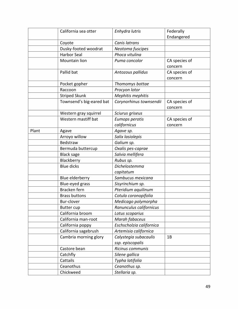
49
California sea otter Enhydra lutris Federally Endangered
Coyote Canis latrans
Dusky-footed woodrat Neotoma fuscipes
Harbor Seal Phoca vitulina
Mountain lion Puma concolor CA species of concern
Pallid bat Antozous pallidus CA species of concern
Pocket gopher Thomomys bottae
Raccoon Procyon lotor
Striped Skunk Mephitis mephitis
Townsend’s big-eared bat Corynorhinus townsendii CA species of concern
Western gray squirrel Sciurus griseus
Western mastiff bat Eumops perotis californicus
CA species of concern
Plant Agave Agave sp.
Arroyo willow Salix lasiolepis
Bedstraw Galium sp.
Bermuda buttercup Oxalis pes-caprae
Black sage Salvia mellifera
Blackberry Rubus sp.
Blue dicks Dichelostemma capitatum
Blue elderberry Sambucus mexicana
Blue-eyed grass Sisyrinchium sp.
Bracken fern Pteridium aquilinum
Brass buttons Cotula coronopifolia
Bur-clover Medicago polymorpha
Butter cup Ranunculus californicus
California broom Lotus scoparius
California man-root Marah fabaceus
California poppy Eschscholzia californica
California sagebrush Artemisia californica
Cambria morning glory Calystegia subacaulis ssp. episcopalis
1B
Castore bean Ricinus communis
Catchfly Silene gallica
Cattails Typha latifolia
Ceanothus Ceanothus sp.
Chickweed Stellaria sp.

50
Clover Trifolium oliganthum
Coast live oak Quercus agrifolia
Congdon’s tarplant Centromadia parryi spp. congdonii
1B
Corn spurry Spergula arvensis
Coyote brush Baccharis pilularis
Creeping spikerush Eleocharis macrostachya
Cudweed Gnaphalium luteo-album
Curly dock Rumex crispus
Fennel Foeniculum vulgare
Fescue Vulpia microstachys
Foxtail barley Hordeum murinum ssp. leporinum
Geranium Geranium sp.
Giant rye grass Leymus condensatus
Goldenbush Isocoma sp.
Goldentop grass Lamarckia aurea
Hedge nettle Stachys bullata
Hoover’s button-celery Eryngium aristulatum var. hooveri
1B
Hyssop loosestrife Lythrum hyssopifolia
Ice plant Conicosia pugioniformis
Iris Iris dougalsiana
Italian thistle Carduus pycnocepalus
Lupine Lupinus nanus
Milk thistle Silybum marianum
Miner’s lettuce Claytonia perfoliata
Miniature lupine Lupinus bicolor
Monterey pine Pinus radiata 1B
Morning-glory Calystegia macrostegia ssp. cyclostegia
Mugwort Artemisia douglasiana
Myoporum Myoporum laetum
Narrow leaved cattail Typha angustifolia
Nasturtium Tropaeolum majus
Nut sedge Cyperus esculentus
Oats Avena sp.
Obispo Indian paintbrush Castilleja densiflora spp. obispoensis
1B
Pepper Schinus molle
Periwinkle Vince major
Plume acacia Albizia lophantha
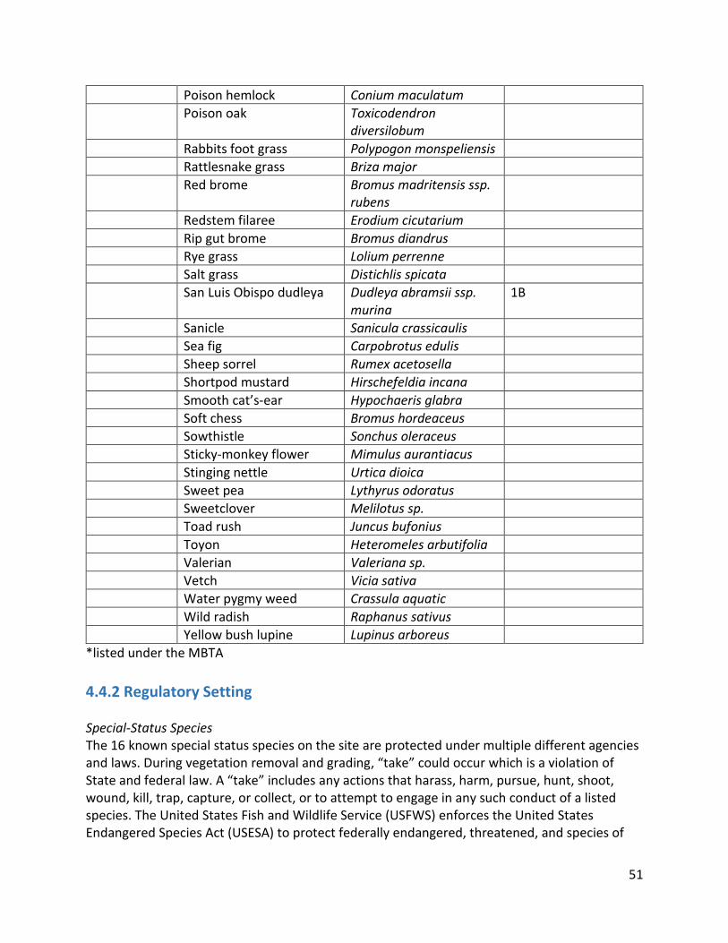
51
Poison hemlock Conium maculatum
Poison oak Toxicodendron diversilobum
Rabbits foot grass Polypogon monspeliensis
Rattlesnake grass Briza major
Red brome Bromus madritensis ssp. rubens
Redstem filaree Erodium cicutarium
Rip gut brome Bromus diandrus
Rye grass Lolium perrenne
Salt grass Distichlis spicata
San Luis Obispo dudleya Dudleya abramsii ssp. murina
1B
Sanicle Sanicula crassicaulis
Sea fig Carpobrotus edulis
Sheep sorrel Rumex acetosella
Shortpod mustard Hirschefeldia incana
Smooth cat’s-ear Hypochaeris glabra
Soft chess Bromus hordeaceus
Sowthistle Sonchus oleraceus
Sticky-monkey flower Mimulus aurantiacus
Stinging nettle Urtica dioica
Sweet pea Lythyrus odoratus
Sweetclover Melilotus sp.
Toad rush Juncus bufonius
Toyon Heteromeles arbutifolia
Valerian Valeriana sp.
Vetch Vicia sativa
Water pygmy weed Crassula aquatic
Wild radish Raphanus sativus
Yellow bush lupine Lupinus arboreus
*listed under the MBTA
4.4.2 Regulatory Setting Special-Status Species The 16 known special status species on the site are protected under multiple different agencies and laws. During vegetation removal and grading, “take” could occur which is a violation of State and federal law. A “take” includes any actions that harass, harm, pursue, hunt, shoot, wound, kill, trap, capture, or collect, or to attempt to engage in any such conduct of a listed species. The United States Fish and Wildlife Service (USFWS) enforces the United States Endangered Species Act (USESA) to protect federally endangered, threatened, and species of

52
special concern. The California Department of Fish and Wildlife (CDFW) enforces the California Endangered Species Act (CESA). This protects all California Fully Protected Species (CFP), California Species of Special Concern (CSC), and the California Rare Plant Rank (1B). The CESA also protects species that have recently been delisted and are now designated as State Watch List Species (WL). The Fish and Wildlife Conservation Act (FWCA) mandates migratory nongame bird species to be protected by the CESA as a USFWS Bird of Conservation Concern (BCC). The MBTA and the CDFW have codes protecting special-status birds and common species nesting within the project footprint. In reference to birds, “takings” include the above-listed actions against individuals as well as their nests, eggs, and disturbances that substantially interfere with breeding activities. In 2014 the North American Bird Conservation Initiative (NABCI) identified bird species that are in need of conservation action. These Watch List species are now protected by the MBTA and are continually being listed under the ESA. Habitats After a site visit, the United States Army Corps of Engineers (USACE) determined the wetlands found on the site do not meet the requirements set in Section 404 of the Clean Water Act. The wetlands fall under the jurisdiction of the California Coastal Commission (CCC) as they have the potential to support a variety of aquatic species including fairy shrimp. The CDFW consider oak woodlands rare and worthy of consideration when they could potentially be harmed by proposed projects. The County of San Luis Obispo also considers oak woodlands to be a sensitive resource. The zoning of the project further protects these species and their natural habitats. The Coastal Zone Framework for Planning (Coastal Zone Land Use Element) has two policies in particular that pertain to this project. Policy 30: Protection of Native Vegetation ensures the protection of native trees and plant cover wherever possible. Thus native plants shall be used to revegetate lands where vegetation is removed. Policy 31: Design of Trails in and Adjoining Sensitive Habitats requires the County of San Luis Obispo to ensure that the design of trails in and adjoining sensitive habitat areas shall minimize adverse impact on these areas.
4.4.3 Significance Criteria Impact analysis is in compliance with and primarily applied using Appendix G of the CEQA guidelines.
4.4.3.1 California Environmental Quality Act Guidelines The significance of potential biological impacts are based on thresholds identified within Appendix G of the CEQA Guidelines and the County’s Initial Study Checklist, which provide the following thresholds for determining impact significance with respect to biological resources. Biological impacts would be considered significant if the proposed project would:

53
Substantially affect a rare or endangered species
Have a substantial adverse effect on any riparian habitat or other sensitive natural community
Have a substantial adverse effect on federally protected wetlands as defined by Section 404 of the Clean Water Act (CWA) and/or the Coastal Act
Interfere substantially with the movement of any resident or migratory species of wildlife or with established native resident or migratory wildlife corridors
Conflict with any local policies or ordinances protecting biological resources
Conflict with the provisions of an adopted Federal Habitat Conservation Plan, Natural Community Conservation Plan or other approved local, regional, or state Habitat Conservation Plan
Reduce the long term viability of native plant, fish, or wildlife populations
Reduce species diversity or numbers of species; or introduce invasive plant or animal species
Potential impacts are expected to occur wherever the proposed construction, development activities, or on-going operational activities would result in temporary or permanent modification of sensitive communities or where habitats occupied or potentially occupied by special-status species. Where potential project-related impacts to sensitive resources were identified, measures for avoiding or minimizing adverse effects to these resources are recommended. Since the proposed project site includes demolition of existing buildings and industrial facilities as well as remediation of previous contamination from the industrial use of the property, direct impacts to biological resources will be a result of remediation activities including vegetation removal and disturbance to wildlife from structure demolition activities. Indirect impacts will include the spread of invasive plant species and changes to soil or hydrology that adversely affects native species overtime. It also may include increased traffic and human disturbance.
4.4.4 Impact Assessment Methodology The biological section will evaluate the various habitats on the project site and their importance to the sensitive species and how they will be impacted by the construction and future uses of the site. This will focus on the potential impacts to plants having their essential nutrients in the soil, proper amounts of water and sunlight, and protection from coastal breezes as well as animal species’ ability to access food, water, shelter, and ability to breed. The biological resources will be evaluated to ensure compliance with the Coastal Act, CEQA Guidelines, San Luis Obispo County Initial Study checklist criteria, County Coastal Policies, and other relevant planning documents.

54
4.4.5 Project Impacts and Mitigation Measures
4.4.5.1 Special-Status Plant and Wildlife Species Impacts and Mitigation BIO - Impact 1: Impacts on Special-Status Plant and Wildlife Species Site remediation has the potential to result in short- and long-term impacts to special-status plant and wildlife species. The short-term impacts concern the inability of species to live on the site during remediation and construction of the site. During the site remediation phase of the project, the project will alter the landscape of Avila Point resulting in many ground disturbances that will potentially harm protected plant and wildlife species. The impacts associated with ground disturbances include vegetation removal, noise and light produced from machinery, and an increased presence of humans. Some species may also be harmed during this process. The long-term impacts concern the success of the species to utilize the area on or surrounding the site after the development of the project. It has the potential to impact their ability to find resources, shelter, and to reproduce. The special-status species that have been identified or have signs of presence on the project-site that are susceptible to these impacts are listed in Table 4.4.1-1. BIO - Mitigation 1: Pre-Construction In order to mitigate the short- and long-term impacts on special listed plant and animal species the applicant shall hire a County-approved biologist to conduct pre-construction surveys to locate the various species during the appropriate seasons. This information shall then be utilized to avoid, relocate, and monitor these species throughout the remediation and construction on the site. Prior to the issuance of construction permits all crew members shall go through environmental training to ensure the project will have minimal impact on the special-status species in the project site. The applicant shall also enter into an agreement with the County to fund and provide access for the County-approved biologist to review and monitor remediation and restoration efforts weekly to ensure that conditions of approval are being enforced and those success criteria are being met. Any sensitive species observed before or during construction shall be relocated by the qualified biologist to its nearest suitable habitat. To mitigate the impacts on any bird species, construction cannot begin during the bird breeding seasons. Construction During construction, sensitive habitat areas will be surrounded by fences with labels specifying the type of habitat. The County-approved biologist will have to approve any removal of vegetation. He or she will have the authority to temporarily halt activities if permit requirements and conditions are not being met. He or she will also be responsible for inspecting the work area each day to ensure that excavation areas, restored areas, and open water habitat do not contain any hazardous chemicals that may pose a risk to wildlife.

55
Post Project Development After the project is built, mitigation measures will be needed to prevent the sudden additional presence of humans from affecting the special-status species. The applicant will have to fence off areas that have recently been revegetated. Once the plants in those areas have become established the certified biologist can approve the fences being removed. Trails will need to be built to go through the various habitats with signs along them instructing visitors to stay on them. BIO - Residual Impact 1 The proposed mitigation will reduce the impacts to existing special status animal species on the project site by having a County-approved biologist conduct pre-construction surveys and monitor activities through the process of remediation and construction. These measures will reduce impact levels to less than significant with mitigation (Class II).
4.4.5.2 Biological Functions of Habitats Impacts and Mitigation BIO - Impact 2: Site remediation and restoration could result in short-term and permanent loss of biological functions of wetlands, native grasslands, and other habitats for rare plants and animals, and other biotic communities considered sensitive by federal, state, or local policies, statutes, and regulations. Impacts on Oak Woodlands This project has the potential to permanently impact Oak Woodland communities on site. According to the County of San Luis Obispo, Oak Woodlands are considered a sensitive resource. Not only are these trees at risk of permanent removal, but this vegetative community serves as habitat for many terrestrial vertebrate species too. Mature individuals are depended upon for year-round shelter by birds and other wildlife. Although the impact on Oak Woodland habitat is mitigable, it will require special care to prevent significant impacts to the functions this habitat provides. See Figure 4.4.5.2-1 for the distribution of oaks on the project site and other trees as well.

56
Figure 4.4.5.2-1. Oak trees proposed for removal from the project site.
Impacts on Rare Vegetation Part of the remediation plan includes the extensive excavation of soil which will lead to the removal of vegetation, the spread of invasive plant species, destruction of soil structure, and a change in hydrological characteristics. The removal of native vegetation and the possible spread of invasive vegetative species, may temporarily or permanently impact species that rely on native vegetation for foliage or habitat. The increased human disturbances and traffic may make the project site uninhabitable for the following species that exist there:
Cambria morning glory (Calystegia subacaulis ssp. episcopalis): Claifornia Rare Plant Rank 1B
Congdon’s tarplant (Centromadia parryi ssp. congdonii): California Rare Plant Rank 1B Hoover’s Bent Grass (Agrostis hooveri): California Rare Plant Rank 1B Obispo Indian paintbrush (Castilleja densiflora spp. obispoensis): California Rare Plant
Rank 1B San Luis Obispo dudleys (Dudleya abramsii ssp. murina): California Rare Plant Rank 1B
Impacts on Vernal Pools Although the U.S. Army Corps of Engineers (USACE) declared that the manmade seasonal wetlands are not under the jurisdiction of Section 404 of the Clean Water Act, they are protected under the jurisdiction of the California Coastal Act due to the projects potential to impact fairy shrimp. The wetland areas on site have the potential to support fairy shrimp and

57
therefore the removal of these wetlands could have an impact on future populations. The remediation and implementation of the project on this site would have potentially permanent or temporary impacts on the man-made wetlands and the fairy shrimp that inhabit them.
Fairy Shrimp (Branchinecta lynchi): Federally Threatened
Impacts on Sensitive Bat Species Habitat Studies have shown that bats are present on the project site and are roosting in the existing structures and standing trees. The project proposes the permanent removal of existing buildings and trees which may result is bat mortality or reduction in reproductive success. In the short-term, bats will lose habitat, largely due to structure removal, and in the long-term may suffer from population fragmentation and isolation. The severity of these impacts will be determined by the availability of alternative roosts for bats in the local area. The severity of the loss of a single roost is determined by the species of bat and whether or not the species uses multiple roosts. The following bat species will lose habitat due to the project construction and demolition of existing structures.
Pallid Bat (Antrozous pallidus): California Species of Special Concern, Western Bat Working Group High Priority Species
Townsend’s Big Eared Bat (Corynorhinus townsendii): California Species of Special Concern, Western Bat Working Group High Priority Species
Western Mastiff Bat (Eumops perotis): California Species of Special Concern, Western Bat Working Group High Priority Species
Impacts on Sensitive Bird Species Peregrine falcons, double-crested cormorants, and brown pelicans utilize the coastal bluffs located near the project site for nesting and reproduction purposes. The excavation and building on this site has potential to impact these imperative coastal bluffs. According to the Migratory Bird Treaty Act, the manipulation or destruction of these sites may formally be considered a “taking”, or further jeopardizing an environmental condition that already exists in jeopardy. In addition, the noise and artificial lighting from the remediation, construction, and implementation has potential to influence nest abandonment in the following bird species.
Peregrine Falcon (Falco peregrinus): Recently Delisted Double-Crested Cormorant (Phalacrocorax auritus): State Watch List Species Brown Pelican (Pelecanus occidentalis): Recently Delisted
Impacts on Reptile Species There are known reptiles existing on the project site, including the silvery legless lizard and the two-striped garter snake. These reptiles may be adversely affected by the excavation, construction, and implementation mainly through the removal and alteration of vegetative habitats.
Silvery Legless Lizard (Anniella pulchra): California Species of Special Concern
58
Two-Striped Garter Snake (Thamnophis hammondii): Federally Threatened
Impacts on Red Legged Frogs Although the California red-legged frog is not known to occupy the project site, there have been documented cases of their presence in surrounding areas. California red legged frogs may be impacted by habitat loss through the removal of vegetation and wetlands. Impacts on the loss of potential habitat are unlikely to have much significance, but still need to be mitigated for.
California Red-Legged Frog (Rana draytonii): Federally Threatened, California Species of Special Concern
BIO - Mitigation 2: A certified biologist approved by the County of San Luis Obispo will conduct surveys on the project site before construction begins. A consultation of the project site and the surrounding area before remediation will need to be done with the California Department of Fish and Wildlife, the US Fish and Wildlife Service, the California Native Plant Society, and the Audubon Society. Through these consultations and surveys, any sensitive, endemic, rare, threatened, endangered plant and animal species will be identified. In addition, these surveys will also provide pertinent information about location, biological diversity and density within each habitat, and wetland existence and condition. These surveys will be seasonally specific according to the species being evaluated. This will establish a baseline condition for all species in question, allowing for a short-term and long-term monitoring plan once remediation, construction, and implementation occurs. Mitigation for Oak Woodland Impacts Where possible, grading/trenching should be restricted to areas outside the drip line and root zone of the trees. A sturdy, temporary barrier should be placed around the tree dripline until construction activities are done. If trenches must be dug under oak trees, every effort should be made to put all utilities in one trench rather than digging many trenches. Then they also will be made with tunnels and hand trenches because they are less destructive than machine trenching. Sometimes conduits can be bored through the soil for utility lines. Any roots permanently exposed from grading or scraping of topsoil should be cleanly cut just below the new soil grade. A porous paving material, such as brick with sand joints, open bricks, bark, gravel, cobbles, or redwood planks should be used to allow water penetration and gas exchange. For replanted trees, a monitoring program shall be implemented for seven years following the replanting in accordance with PRC Section 21083.4. The replanted trees will be irrigated for the first five years, and should not need further irrigation afterward. The project applicant will be held responsible for maintaining an 80% oak survival rate and will provide the County Planning Department with a security deposit sufficient to replace the trees after seven years if the project applicant fails to do so.

59
Mitigation for Rare Vegetation Impacts Prior to project activities, a survey of all rare vegetation will be completed by a qualified biologist appointed by the County, and the population estimates will be used as a basis for the replacement measures of each species. Additional surveys will be completed during the construction phase and after the project is complete to determine how many plants need to be replaced. Once the replacement numbers are established, each species will be replaced in nearby similar habitat and their success will be monitored for the next two years. The applicant must also work with the biologist to prepare a revegetation plan that is then approved by the county. The importance of this plan is not only to restore rare plants after construction but to avoid the introduction of invasive species. All disturbed areas will be revegetated with locally collected plant material. It will then be seeded over the following fall to ensure invasive plants cannot establish themselves. This will be monitored during late spring to early summer of the field season following the initial seed application. Shrubs and trees will be assessed for establishment rate, survival, and potential need for replacement with new plants. Monitoring will continue over the following three years to evaluate success in establishment, species composition, and percentage of plant cover. If any invasive weeds are identified during this time they will be eradicated. Mitigation for Sensitive Bat Species Impacts Pre-construction surveys will be done to evaluate the prevalence of bat populations in the existing structures. Based on the number and sensitivity of the bat species present, the removal of structures actively being used for roosting will have to be mitigated. A qualified biologist will first use traps and other techniques to temporarily capture bats, and later move them to constructed temporary and artificial roosts. The new roosts should be close enough to the project site to sustain migratory and feeding patterns for displaced bats but far enough from human contact and activity to ensure their quality for roosting. The constructed and artificial roosts will be monitored for temperature, use and quality of darkness during the bat maternity season to determine the suitability of the artificial roosts. Mitigation monitoring will be conducted by a qualified CFWD biologist or specialist during the demolition of the existing structures and will continue for five years at the artificial roosting sites to check for species and number of bats present. At the end of the five year monitoring period, corrective actions to make artificial roosts more appealing to bat populations will be considered. Mitigation for Sensitive Bird Species Impacts A qualified biologist approved by the County of San Luis Obispo and the California Department of Fish and Wildlife will conduct surveys to locate, assess, and record existing nesting sites and their utilization in or near the project site. These surveys will be executed during appropriate times of the year depending on the bird species of concern. After these surveys have been conducted a mitigation plan can be created before construction can begin. For those birds that are directly and indirectly reproductively impacted from the project, there will need to be an artificial nesting location near the project site to mitigate for the impacts on nesting locations and their utility. A long-term monitoring plan would then be put in place during the

60
remediation, construction, and implementation to ensure the mitigation is proportional to the impacts. To mitigate for nest abandonment due to noise and artificial light impacts, artificial nesting structures should also be placed off site to reduce the amount of noise and light actually reaching the nesting points. To avoid a “taking” under the Migratory Bird Treaty Act, the proper permits will be obtained to authorize otherwise illegal actions. Mitigation for Reptile Species Impacts Prior to issuance of grading permits, a certified USFWS biologist will conduct a leaf litter and soil survey to delineate the habitat of the silvery legless lizard (SLL) on the project site. Surveys will be conducted no longer than two weeks prior to construction soil disturbance. Surveys should use a "three-pass" method to locate as many as possible. If silvery legless lizards are found a similar habitat will need to be identified before construction begins and SLL will be relocated until the project is completed, and reintroduction will occur after construction completes. Mitigation for California Red-legged Frog Impacts Prior to any grading or construction on the project site, a certified USFWS biologist will conduct an environmental education program regarding the California red-legged frogs that have the potential of occurring in or nearby the project site. This educational program will include a description of the species, its legal status, and the penalties if one does not comply with the biological mitigation requirements. If the red-legged frog is encountered on the project site all construction will be stopped, and the USFWS will be notified to determine the required specific mitigation measures. The program will also stress the importance of protecting the water quality so that California red-legged frogs that are near the project site will not be adversely affected. The applicant will have to clearly outline the project boundaries to prevent any off-road travel. Staging areas for servicing vehicles or construction equipment will be placed around the project site at least 100 feet from any aquatic habitats. If any red-legged frogs are injured, killed or found dead the County will be notified, who will then send notice to the USFWS Endangered Species Office in Sacramento, California. BIO - Residual Impact 2: Implementation of the above mitigation measures will minimize the impacts on the concerned habitats, species and biological resources would reduce the impacts to their biological functions. By avoiding impacts to habitat, compensating habitat in proper and applicable ratios, and providing impacting parties with necessary educational resources to limit degradation of biological resources, the impacts will be considered less than significant with mitigation (Class II).

61
4.4.5.3 Wetland Impacts and Mitigation BIO - Impact 3: Site remediation would adversely affect state wetlands as defined by the California Coastal Commission. The wetlands on the project site are protected by the California Coastal Commission for the potential of inhabiting endangered plants and fairy shrimp. These wetlands would be destroyed under the current project plans. In the areas of existing tanks, wetlands form between them each year from poor site drainage. During remediation these wetland areas will be excavated, impacting the endangered species that live in them. The project has proposed to build a parking lot along Cave Landing Rd where a very large wetland is present. Building the parking lot in that location will have significant impacts on the endangered species that utilize that wetland. BIO - Mitigation 3: Stormwater Pollution Prevention Plan In order to mitigate the impacts to wetlands multiple actions need to take place. Prior to issuance of grading permits, a Stormwater Pollution Prevention Plan (SWPPP) must be approved by the County and implemented to ensure that storm-water does not flow into sensitive wetland habitat. During construction workers must keep all staging areas, equipment storage areas, stockpile sites, and refueling areas are located at least 100 feet from surface water bodies and wetland habitats. Restoration Plan Prior to issuance of applicable grading permits, the applicant will consult with the California Coastal Commission to establish proper wetland mitigation design. The applicant will develop and submit to the California Coastal Commission a wetland restoration plan to replace any wetlands removed in the remediation at a 2:1 ratio. The development of the project site is already designated as 64% open space, so this mitigation measure will be easily implemented into the development design. BIO - Residual Impact 3: The impacts to the wetlands located between the former storage tank sites will be reduced with the mitigation listed above. By avoiding contamination and replacing lost wetlands at the provided ratios it will lessen the impacts remediation and construction cause. However, as the wetlands replaced with a parking lot cannot be mitigated to a less than significant level, there will still be significant and unavoidable impacts to wetlands and the endangered species that live in them (Class I).
4.4.5.4 Wildlife Migration Impacts and Mitigation BIO - Impact 4: Site remediation and restoration would temporarily impede migration and dispersal of upland, aquatic, and semi-aquatic wildlife species. Activities during site remediation and restoration may interfere with wildlife movements which may diminish their chances of survival. This includes any upland or aquatic species that uses the

62
project site for food, shelter, or reproduction. Construction would also inhibit migratory species from using the land they are used to inhabiting each year, impacting their species health. If they are unable to utilize the area they depend on for survival during a certain time of the year it impacts their fitness, or ability to survive and reproduce. BIO - Mitigation 4: Prior to of issuance of applicable grading permits, the applicant will prepare and submit to the San Luis Obispo County Department of Planning and Building a restoration plan that specifically addresses the effects remediation and construction will have on the terrestrial ecosystem of the project site. The plan would include provisions to maintain and re-establish habitat linkages between the project site and surrounding habitat to reduce impacts on listed species. This plan will consider natural onsite habitat with linkages to adjacent habitats to assist wildlife in their movements. The applicant must be sure to maintain natural linkages between the project site and suitable nearby habitat. They need to ensure the various species can utilize the corridors to avoid potential harm from construction. BIO - Residual Impact 4: Implementation of the above-listed mitigation measures, including creating a plan to maintain and relocate habitat linkages approved by the county, would reduce impacts to the dispersal or migration of species. This reduced impact to crucial habitats in the behavior of native species would result in a less than significant impact (Class II). No additional mitigation is required.
4.4.5.5 Biological Size and Diversity Impacts and Mitigation BIO - Impact 5: Site remediation and restoration have the potential to reduce the size and diversity of plant and animal populations at the Project Site. Remediation and Construction Impacts. The surrounding oak woodlands and bluffs provide habitat for listed and special status species that may be impacted by the use of heavy equipment during remediation and construction. Species that inhabit the project site may be impacted by the movement of dirt haulers, tractors and other heavy equipment for the remediation process, as well as wildlife adjacent to the project site and along the roads leading to the project site. Exposed Soils Impacts Exposure to contaminated soils unearthed during the remediation phase of the project may have adverse impacts on the health of listed species, both due to direct contact with the soils and fugitive dust. BIO - Mitigation 5: Biological Survey and Biological Monitor Prior to the issuance of a grading permits, the applicant will submit a plan to fund and provide site access to a county approved biological monitor to review and monitor the project

63
remediation and construction. A qualified biologist will conduct surveys throughout the project site to determine the presence and density of wildlife species prior to ground disturbance. Remediation and construction activities will be monitored throughout the project phases to ensure that wildlife species have not entered the project site. The biological monitor shall conduct daily site inspections of the remediation and restoration activities to ensure that all applicable mitigation measures are being enacted. The independent biological monitor shall have the authority to temporarily halt activities if permit requirements and conditions are not being met. Construction and Remediation The biological monitor will be responsible for delineating the location of barrier fencing surrounding excavation so that impacted species are not killed by machinery. Active remediation and construction sites will be fenced off, while the rest of the site will remain unfenced to allow for proper migration and movement of listed species. The fencing will also keep wildlife from coming into contact with stockpiled contaminated soils, prior to removal from the site. Remediation and construction will be restricted to daylight hours, defined as 30 minutes after sunrise and 30 minutes before sunset, to reduce the possibility of road mortality of wildlife. Soil Mitigation Prior to issuance of grading permits, the applicant will develop and submit a soil mitigation strategies plan (SMSP). Water trucks will be used in sufficient quantities to prevent airborne dust from leaving the site. Increased watering frequency will be required whenever wind speeds exceed 15 mph. BIO - Residual Impact 5: By implementing the mitigation listed above, the impacts to biological size and diversity of species will be lessened. By properly monitoring populations before, during, and after construction, biologists will be able to protect species inhabiting the project site from having a long term impacts on their ability to survive in the area. These impacts would be reduced to less than significant with mitigation (Class II) and no additional mitigation is required.

64
5.1 Alternatives Overview Section 15126.6 of the California Environmental Quality Act (CEQA) requires an Environmental Impact Report to describe a range of reasonable alternatives to a project or location of a project which could feasibly attain the objectives of the project and will evaluate the merits of each alternative. This section must include the “No Project Alternative” The criteria used to evaluate these alternatives are addressed as well. State CEQA Guidelines Section 15126.6 section requires:
● A description of “...a range of reasonable alternatives to the project, or to the location of a project, which would feasibly attain most of the basic objectives of the project but would avoid or substantially lessen any of the significant effects of the project, and evaluate the comparative merits of the alternatives.” [15126.6(a)]
● A range of alternatives that “...shall be limited to ones that would avoid or substantially lessen any of the significant effects of the project. Of those alternatives, the EIR need examine in detail only the ones that the lead agency determines could feasibly attain most of the basic objectives of the project.” [15126.6(f)]
● A discussion of the “No Project” alternative, and “...If the environmentally superior alternative is the “No Project” alternative, the EIR shall also identify an environmentally superior alternative among the other alternatives” [15126.6(e)(2)], even if the proposed project is the next environmentally preferable option.
● A discussion and analysis of alternative locations “…that would substantially lessen any of the significant effects of the project need to be considered for inclusion in the EIR.” [15126.6(f)(2)(B)]. An alternative location is not feasible for this project, as site remediation is a major project activity”
5.2 Alternatives Selection
5.2.1 Screening and Selection Criteria The alternatives screening analysis was conducted for this EIR to ensure that only the most feasible alternatives were evaluated in detail. In defining feasibility of alternatives, the CEQA Guidelines state: “Among the factors that may be taken into account when addressing the feasibility of alternatives are site suitability, economic viability, availability of infrastructure, general plan consistency, other plans or regulatory limitations, jurisdictional boundaries (projects with a regionally significant impact should consider the regional context), and whether the proponent can reasonably acquire, control or otherwise have access to the alternative site” (Section 15126.6(f)(1)). Through the screening process, if an alternative was found to be infeasible, as defined above, then it was dropped from further consideration. In addition, CEQA states that alternatives should “…attain most of the basic objectives of the project...” (Section 15126.6(a)). Screening and selection criteria were based off of the CEQA Guidelines and the project

65
objectives for both the project applicant and the County of San Luis Obispo. If an alternative was found to not obtain most of the basic objectives of the proposed project, then it was eliminated or rejected.
5.2.2 Project Objectives The main project objectives that were considered were those set out by the applicant and by the County of San Luis Obispo. The applicant’s stated objective for the project is to develop a remediation and reuse plan for the Avila Tank Farm site within the County of San Luis Obispo. The County’s objective is for the project is for a development project that balances the needs for natural resource protection, public recreation, open space, and sustainable visitor and tourist focused facilities and services, with particular attention to the following key environmental issues:
● Aesthetics ● Hazards and Hazardous Materials ● Hydrology and Water Quality ● Biological Resources
Brief Summary/Description of Each Alternative: 1) No Project Alternative: This alternative considers the impacts of the project site in its
existing conditions and zoning and outside the scope of future development. 2) Reduced Development/Project Size Alternative: This alternative evaluates the impacts
of reducing the physical area of the project from 232 units to 174 units, a 25% reduction, and dedicating undeveloped area to open space and oak woodland habitat.
3) Reduced Footprint Lodging Alternative: This alternative considers the impacts of changing the project to fit a more ecologically integrated lodging design. This design would still consist of 412 units, each with an area of 325 sf. that would incorporate expansion of the oak woodland, chaparral and coastal scrub habitats into the design.
4) Underground Project Alternative: This alternative considers the impacts of redesigning the project to incorporate a below the surface design with emphasis on mitigating the aesthetic impacts of the project. (Rejected)
5) Alternative Project Location: This alternative considers the impacts of the relocation of the project to a different site, feasibly reducing impact levels below thresholds of significance. (Rejected)
5.2.3 Alternatives Rejected 4) Underground Project Alternative The underground project alternative benefits the environment in a number of ways that the original design cannot. For one, it minimizes the effects on the viewshed that the current project would have, due to the fact that the development would be below the surface. Furthermore, an underground development design would require deeper excavation, which would allow for further remediation contaminated soils and water on site.

66
However, an underground design could cause drainage issues, as well as issues with the stability of the cliffside. Redesigning this project in such a way could be costly in length of time and financially. The underground design alternative also does not meet the economic objectives set out by the developer, and would far exceed the costs that the project applicant would hope to spend on this project. In this case, the costs of redesigning, implementing and running an underground facility would not achieve the project objectives. 5) Alternative Project Location The alternative project location considers finding a new location for the project. The new location would provide an environmentally superior setting to the current project site. However, the time and resources required to find such a location, purchase and develop it would be substantial and not in line with the project objectives. The fact that the project site is already contaminated and will see some remediation during project construction, makes it difficult to duplicate. Few coastal projects are seen as beneficial to the environmental surroundings and natural resources in the area. It would be infeasible to find an alternate project location and thusly this alternative would not achieve project objectives.
5.2.4 Alternatives Considered for Further Review
1) No Project Alternative 2) Reduced Development/Project Size Alternative 3) Reduced Footprint Lodging Alternative

67
Table 1: Comparison of Impacts from Alternatives to the Proposed Project
Number of Resort Facility Units
Impacts on Aesthetics
Impacts on Hazards and Hazardous Materials
Impacts on Hydrology and Water Quality
Impacts on Biology
Proposed Project 232 = = = =
No Project Alternative 1
0 - - - -
Alternative 2 - Reduced Development
174 - - -/= -/=
Alternative 3 -Reduced Footprint Lodging
412
+ + + +
+ indicates a positive impact as compared to the proposed project - indicates a negative impact as compared to the proposed project = indicates a neutral impact as compared to the proposed project -/= indicates both negative and neutral impacts compared to the proposed project
5.3 Alternatives Analysis
5.3.1 Alternative 1: No Project Alternative
With the No Project Alternative, none of the development of the project site proposed by the applicant would occur. None of the proposed development activities would occur and none of the development objectives of the proposed project would be accomplished. The project site cannot just remain as it currently is, with open space and disturbed areas left over from the previous uses of the site. It is then likely that if this project is not permitted that then the applicant, as the owner of the property, will be required to remediate the site to assure the protection of human health and ecological receptors if issued a Cleanup and Abatement Order (CAO) by the Regional Water Quality Control Board (RWQCB). The extensiveness of the remediation required is determined by the zoning of the property. If it stays as it currently is, an industrial parcel, then the requirements will be significantly lower as it will not have to pertain to human health. Based on this data, it is believed that the No Project Alternative’s impacts will still be negative in regards to the Hazards and Hazardous Materials impacts. The remediation of the project site under this alternative is will. The restoration will include returning the project site to its natural grade and revegetation. None of the proposed infrastructure improvements associated with roads would occur as part of this alternative. Only water management improvements will be constructed on-site to return the movement of water to a more natural site setting and restore the current wetlands.

68
The No Project Alternative would not have any new environmental impacts, as compared to the proposed project. Under this alternative, impacts from development of this project will be lessened in all four issue areas this EIR covers but impacts from remediation will remain the same. Impacts to biological resources are lessened as there will be no removal of wetlands or oak trees. Impacts to hazards and hazardous materials would also be lessened with the reduction of truck transportation compared to the proposed project along with other traffic-related hazards. Long-term impacts to aesthetics and visual resources would be eliminated since all of them were derived from the development of the project site. Without it the viewsheds and levels of light will stay the same. Long-term impacts to water usage caused by running the proposed resort will be eliminated.
5.3.2 Alternative 2: Reduced Development The reduced development alternative starts with the proposed project as a baseline, retaining the general design approach of the project, but reducing the number of units that will be built in order to reduce the impacts on the visual resources, biological resources and water quality. This alternative would focus on changing aspects of the original project that are related to the Class I impacts mentioned in the Environmental Impacts and Analysis Section. These changes would include:
1. Reducing the number of available units by 25% in order to reduce the project’s impact on the emergency response systems of Avila Beach.
2. Eliminating units that extend into Oak Woodlands habitat 3. Eliminating or reducing the height of units that are impacting the visual resources after
mitigation. 4. Removing units located over classified wetlands or units that would contribute to
erosion on the project site. By changing the project in this way, this alternative, with the help of the mitigation measures in place, would avoid all of the significant environmental impacts or be mitigated to less-than-significant levels. By reducing the amount of units by 25%, this alternative would have 174 units instead of 232. Overall, the impacts of the reduced development alternative would be less for all aspects of the project. The visual impacts of the reduced development alternative would be reduced due to the 25% reduction in total units. The reduction in units would be focused on the parts of the proposed project that have the most significant impacts on the view sheds surrounding the project site. Because of this reduction in units, the original Class I impact could be mitigated to a Class II impact. Another benefit of reducing the number of available units by 25% is the decrease in pressure on the emergency response systems of Avila Beach Community Services District. The primary system that would benefit is the Diablo Canyon Emergency Alert System, due to the impact a large number of additional residents would have on the ability for permanent residents to evacuate from Avila Beach. The potential impacts of the reduced development alternative would be less than the proposed project on the hydrology and water quality surrounding the project site. This alternative would eliminate units closest to the coastal

69
bluffs in order to prevent potential runoff and erosion. Also, more runoff would be allowed to percolate into the soil due to the open space. Similar to the hydrological impacts of the alternative, the overall biological impacts would be less due to the decrease in total development. The main benefit would be increase in Oak Woodland habitat on the project site.
5.3.3 Alternative 3: Reduced Footprint Lodging Alternative
This alternative would involve reducing the planned resort to a campground or tree house lodging. By dividing the planned resort area into smaller and more dispersed units, there will be reduced impacts in the hydrology/water quality, biological resources, and the aesthetics sections of Appendix G. One alternative lodging plan design proposes the use of stilted treehouses as residential units on site. Each treehouse would be approximately 325 square feet and elevated on four stilts 10 feet off the ground. The 95 -acre site will support approximately 412 of these treehouses. Another lodging alternative plan proposes to transform the project site into a campground. This campground will have approximately 150 tent campsites, consisting of natural dirt areas 25 feet long, and 150 RV campsites with full hookups consisting of asphalt slabs ranging from 25-41 feet long. By having these lodges elevated and/or these campsites designated, the amount of impervious surfaces will be reduced. With an increase in the amount of natural soils and vegetation remaining on-site, any water from the excavation and construction can infiltrate down instead of adding to runoff into the ocean. The reduced impact on drainage patterns will also reduce the potential to create erosion. Due to the decrease in erosion, the potential for producing cloudy moving water, lessening the water quality, will also decrease. In addition, the use of the treehouse units and/or campsites will decrease the amount of water used in the Avila Beach Community Services District. By reducing the scale of the project from a full resort to smaller amount of treehouse units and/or campsites, the water used per day on-site will be reduced as well. However, the same amount of water will most likely be needed to be used during the remediation and construction phases of the project. In addition to the reduction in water runoff, the biological resources impact will also be reduced in the two reduced footprint lodging alternatives. The existing oak woodlands on the site will remain on-site during the remediation and construction along with the planting of additional oaks to surround each tree house and/or campsite for shade, scenery, and privacy. By keeping the project site natural, a majority of the native and existing plants will remain reducing the habitat loss impact that is present in the original project proposal. Although biological surveys will still need to be conducted, there is a greater chance that federal, state, and local special species will remain in their original habitat. The original project proposal includes the building of a large parking lot over an existing wetland on-site. With reduced units and people travelling to the area, there would no longer be a need for a large-scale parking lot, therefore a smaller parking lot can be placed in a less impactful area. The parking lot will be half the size of the original proposed lot and will utilize an area on-site with no existing wetlands.

70
In regards to aesthetics, there is potential for the tree houses to impede on the viewshed, but at a much smaller scale than the resort. The height of these units may intersect views of the ocean, but the units will be in trees and built using natural materials to best match the existing scenery. The campsite however, have a significantly smaller potential impact on viewshed. Although tents and RVs will be seen, they will not be big enough to impede on the views of the ocean and the area’s natural beauty. Night lighting will still exist in the proposed reduced footprint lodging alternatives, but the impact will be reduced compared to the original proposed project. Lighting is mandatory to light walkways throughout the treehouse lodging and/or campsites. The treehouses themselves will have access to electricity, however the surrounding trees and seclusion will block most of the light pollution caused by these units. For the campground alternative, rangers will be employed to monitor the park ordinances, consisting of dark hours from 11pm-5am. The monitored actions of park users will ensure reduced light impacts to surrounding residents and drivers. With the use of natural building materials for the treehouse units and lack of infrastructure existing in the campground, glare impacts will significantly be reduced as well. Lastly, because erosion will be minimized in this proposed alternative, the unique geological and physical features of the project site will remain in the existing state. The surrounding bluffs will remain aesthetically pleasing.
5.4 Environmentally Superior Alternative
In considering all of the environmental factors and project objectives related to the project discussed above, the environmentally superior alternative is Alternative 3. The Reduced Footprint Alternative requires the most intensive site remediation for human exposure, and will result in a net environmental benefit to each Environmental Impact Area discussed in the DEIR. This alternative meets the stated project objectives, and is a strong project alternative.

71
6.1 List of Project Preparers Kyle Jordan - Project Lead As a student of Environmental Management, Kyle has gained advanced technical knowledge as well as a deep understanding of the biological and physical sciences necessary to manage complex ecosystems and the diverse users who utilize these resources. Projects include natural resource ecology and habitat management; environmental impact analysis; watershed management and restoration; forest surveying; and soil science and morphology. With four years of experience in sales he has gained excellent public speaking and listening skills. As a member of the Cal Poly Student Government, Kyle has gathered experience in managing competing interests, and has gained valuable insight into democratic and bureaucratic processes. Overall he has a breadth of knowledge in all relevant environmental fields necessary to lead a diverse team to a comprehensive report conclusion. Contributions
Project lead
Delegated tasks
Overall editing and formatting
Assisted in all impact areas
David Yocom - Technical Writer David is a 4th year Environmental Management Student at Cal Poly with a concentration in Spanish and Economics. He is hoping to pursue a career in sustainable economic development. He has experience in a wide variety of coursework as well as work experience. His experience in environmental work is defined by two summers as an intern for the Huffman-Broadway Group, Inc. in San Rafael, CA assisting with jurisdiction determinations, data analysis and field experiments. His relevant coursework includes the topics of soils, geology, plant identification, technical writing, hydrology and GIS with language skills in Spanish. He has project based experience with environmental proposals, technical lab reports and environmental impact reports. Contributions
Authored hydrology impact assessment section
Edited alternatives overview Marina Barton - Wildlife Biologist Marina Barton is graduating from Cal Poly in June 2016 in Environmental Management and Protection with a minor in Wildlife Biology. She has field experience throughout the state of California working on small mammal trapping and habitat restoration. She also has worked in Cape Coast, Ghana at the Kakum National Park on implementing ecotourism as well as a community outreach program to protect another area of forest and turn it into a new national park. She has taken many classes in the field such as Mammalogy, Ornithology, and Field Botany. Currently she is the Environmental Intern for the San Luis Obispo County Department

72
of Building and Planning. Her responsibilities include writing the Pre-Applications, Initial Studies, and the initial assessments for NEPA. Contributions
Authored biological resource impact assessment section Edited hydrology impact assessment section
Alex Degregori - Head Geologist Alex is a 4th year at Cal Poly, graduating in Spring of 2016, with a degree in Environmental Management and Protection and a minor in both Biology and Sustainable Environments. He has research experience through both the natural resource department and biology department, and is currently completing his senior project studying the water quality of San Luis Obispo Creek tributary. He has interned with the National Park Service in Northern California and currently holds a managing position at the Performing Arts Center on the Cal Poly campus. His knowledge of geology is specialized in wetlands and watersheds. Contributions
Authored hazards and hazardous materials impact assessment section
Edited aesthetics and visual resources impact assessment section
Megan Marshall – Landscape Architect/Botanist Megan is a 4th year Environmental Management and Protection student concentrating in Field and Wildlife Biology and minoring in Biology. She has taken college level courses on Botanical Taxonomy, Field Botany, Plant Ecology, and Organismal Form and Function. In addition to her education background, she has also spent an extensive amount of time volunteering in the Herbarium located at California Polytechnic State University, San Luis Obispo. She has previously worked for the County of San Luis Obispo as a Park Aide at Lopez Lake in Arroyo Grande. This position involved public environmental education and guided nature hikes for the native plant and animal species inhabiting the central coast. Contributions
Authored aesthetics and visual resources impact assessment section
Edited biological resources impact assessment section

73
7.1 References AMEC Environmental & Infrastructure, Inc. Proposal to Prepare the Avila Point Project
Environmental Impact Report and Provide Consultant Support Services. Rep. N.p.: County of San Luis Obispo, May 2013.
Aspen Environmental Group. Proposal to Provide Consultant Support and to Prepare an
Environmental Impact Report for the Avila Point Project Specific Plan Amendment/ Coastal Plan Amendment/ Development Plan/ Remediation. Rep. N.p.: County of San Luis Obispo, May 2013.
CAJA Environmental Services. Draft Environmental Impact Report Hollywood Community Plan
Area. Rep. City of Los Angeles Department of City Planning, Environmental Analysis Section, Oct. 2012. Web.
Chevron Corporation. Avila Point Application Package, Section 4 Existing Conditions Summary.
Rep. N.p., 2012. Web. City of Long Beach Department of Planning. Golden Shore Master Plan Draft Environmental
Impact Report. Rep. City of Long Beach Department of Planning, Oct. 2009. Web. David Wolf Environmental. Unocal Former Avila Terminal Ecological Evaluation. Rep. N.p.:
County of San Luis Obispo, 2004 & 2005. Douglas Wood & Associates, Inc. Proposal for Professional Consulting Services to Prepare Avila
Point Environmental Constraints Analysis and Draft and Final Environmental Impact Report. Rep. N.p.: County of San Luis Obispo, May 2013.
Marine Research Specialists. Chevron Tank Farm Remediation and Development Project Final
Environmental Impact Report. Rep. San Luis Obispo County, Dec. 2013. Web. Marine Research Specialists. Phillips 66 Company Rail Spur Extension And Crude Unloading
Project Final Environmental Impact Report and Vertical Coastal Access Project Assessment. Rep. San Luis Obispo County, Dec. 2015. Web.
Marine Research Specialists, SWCA Environmental Consultants. Proposal for Preparation of the
Avila Point Project Specific Plan Amendment/ Coastal Plan Amendment/ Development Plan/ Remediation Environmental Impact Report. Rep. N.p.: County of San Luis Obispo, May 2013.
San Luis Obispo County Department of Planning and Building. Avila Point/Avila Tank Farm,
General Plan/Specific Plan Amendment Initial Study Summary. Rep. N.p.: n.p., 2015.

74
San Luis Obispo County Department of Planning and Building. Request for Proposal- Environmental Impact Report. Rep. N.p., May 2013. Web.
San Luis Obispo County. San Luis Bay Area Plan, Coastal. Rep. San Luis Obispo County Board of
Supervisors, 25 Feb. 1988. Web. San Luis Obispo County. Tsunami Emergency Response Plan. Rep. San Luis Obispo County Office
of Emergency Services, Oct. 2005. Web. The Board of Supervisors of the County of San Luis Obispo. An Ordinance Amending Title 22 of
the San Luis Obispo County Code, The Land Use Ordinance, Chapter 22.14 And Article 8 Relating to Flood Hazard Combining Designation Areas. Rep. San Luis Obispo County, 24 Mar. 2015. Web.
The San Luis Obispo County. Avila Beach Community Plan. Rep. N.p., Feb. 2014. Web. The San Luis Obispo County. Avila Beach Specific Plan. Rep. N.p., Mar. 2001. Web. Western Federal Lands. "Sunriver to Mt. Bachelor Draft Revegetation Plan." Roadside
Revegetation Portal—An Integrated Approach to Establishing Native Plants. Coordinated Technology Implementation Program, 2005. Web.