automatic crowd analysis from very high … · automatic crowd analysis from very high resolution...
TRANSCRIPT
AUTOMATIC CROWD ANALYSIS FROM VERY HIGH RESOLUTION SATELLITEIMAGES
Beril Sirmacek, Peter Reinartz
German Aerospace Center (DLR), Remote Sensing Technology InstitutePO Box 1116, 82230, Wessling, Germany(Beril.Sirmacek, Peter.Reinartz)@dlr.de
Commission VII
KEY WORDS: Very high resolution satellite images, Crowd detection, DEM, Local features, Probability theory, Shadow extraction,Road extraction
ABSTRACT:
Recently automatic detection of people crowds from images became a very important research field, since it can provide crucialinformation especially for police departments and crisis management teams. Due to the importance of the topic, many researchers triedto solve this problem using street cameras. However, these cameras cannot be used to monitor very large outdoor public events. In orderto bring a solution to the problem, herein we propose a novel approach to detect crowds automatically from remotely sensed images,and especially from very high resolution satellite images. To do so, we use a local feature based probabilistic framework. We extractlocal features from color components of the input image. In order to eliminate redundant local features coming from other objects ingiven scene, we apply a feature selection method. For feature selection purposes, we benefit from three different type of information;digital elevation model (DEM) of the region which is automatically generated using stereo satellite images, possible street segmentwhich is obtained by segmentation, and shadow information. After eliminating redundant local features, remaining features are usedto detect individual persons. Those local feature coordinates are also assumed as observations of the probability density function (pdf)of the crowds to be estimated. Using an adaptive kernel density estimation method, we estimate the corresponding pdf which gives usinformation about dense crowd and people locations. We test our algorithm using Worldview-2 satellite images over Cairo and Munichcities. Besides, we also provide test results on airborne images for comparison of the detection accuracy. Our experimental resultsindicate the possible usage of the proposed approach in real-life mass events.
1 INTRODUCTION
Recently automatic detection of people and crowds from imagesgained high importance, since it can provide very crucial infor-mation to police departments and crisis management teams. Es-pecially, detection of very dense crowds might help to preventpossible accidents or unpleasant conditions to appear. Due totheir limited coverage of area, street or indoor cameras are notsufficient for monitoring big events. In addition to that, it is notalways possible to find close-range cameras in every place wherethe event occurs.
Due to the importance of the topic, many researchers tried tomonitor behaviors of people using street, or indoor cameras whichare also known as close-range cameras. However, most of theprevious studies aimed to detect boundaries of large groups, andto extract information about them. The early studies in this fieldwere developed from closed-circuit television images (Davies etal., 1995), (Regazzoni and Tesei, 1994), (Regazzoni and Tesei,1996). Unfortunately, these cameras can only monitor a fewsquare meters in indoor regions, and it is not possible to adaptthose algorithms to street or airborne cameras since the humanface and body contours will not appear as clearly as in close-range indoor camera images due to the resolution and scale dif-ferences. In order to be able to monitor bigger events researcherstried to develop algorithms which can work on outdoor cam-era images or video streams. Arandjelovic (Arandjelovic, Sep.2008) developed a local interest point extraction based crowd de-tection method to classify single terrestrial images as crowd andnon-crowd regions. They observed that dense crowds produce ahigh number of interest points. Therefore, they used density ofSIFT features for classification. After generating crowd and non-crowd training sets, they used SVM based classification to detect
crowds. They obtained scale invariant and good results in ter-restrial images. Unfortunately, these images do not enable mon-itoring large events, and different crowd samples should be de-tected before hand to train the classifier. Ge and Collins (Ge andCollins, 2009) proposed a Bayesian marked point process to de-tect and count people in single images. They used football matchimages, and also street camera images for testing their algorithm.It requires clear detection of body boundaries, which is not possi-ble in airborne images. In another study, Ge and Collins (Ge andCollins, 2010) used multiple close-range images which are takenat the same time from different viewing angles. They used three-dimensional heights of the objects to detect people on streets. Un-fortunately, it is not always possible to obtain these multi-viewclose-range images for the street where an event occurs. Chao etal. (Lin et al., Nov. 2001) wanted to obtain quantitative measuresabout crowds using single images. They used Haar wavelet trans-form to detect head-like contours, then using SVM they classifieddetected contours as head or non-head regions. They providedquantitative measures about number of people in crowd and sizesof crowd. Although results are promising, this method requiresclear detection of human head contours and a training of the clas-sifier. Unfortunately, street cameras also have a limited coveragearea to monitor large outdoor events. In addition to that, in mostof the cases, it is not possible to obtain close-range street imagesor video streams in the place where an event occurs. Therefore,in order to behaviors of large groups of people in very big out-door events, the best way is to use airborne images which beganto give more information to researchers with the development ofsensor technology. Since most of the previous approaches in thisfield needed clear detection of face or body features, curves, orboundaries to detect people and crowd boundaries which is notpossible in airborne images, new approaches are needed to ex-
221
In: Stilla U et al (Eds) PIA11. International Archives of Photogrammetry, Remote Sensing and Spatial Information Sciences 38 (3/W22)

tract information from these images. Hinz et al. (Hinz, 2009)registered airborne image sequences to estimate density and mo-tion of people in crowded regions. For this purpose, first a train-ing background segment is selected manually to classify image asforeground and background pixels. They used the ratio of back-ground pixels and foreground pixels in a neighborhood to plotdensity map. By observing change of the density map in the se-quence, they estimated motion of people. Unfortunately, theirapproach did not provide quantitative measures about crowds. Ina following study (Burkert et al., Sep. 2010), they used previ-ous approach to detect individuals. Positions of detected peopleare linked with graphs. They used these graphs for understandingbehaviors of people.
In order to bring a fully automatic solution to the problem, wepropose a novel framework to detect people from remotely sensedimages. One of the best solutions to monitor large mass events isto use airborne sensors which can provide images with approxi-mately 0.3 m. spatial resolution. In previous studies (Sirmacekand Reinartz, 2011a) and (Sirmacek and Reinartz, 2011b), weused airborne images to monitor mass events. In the first study(Sirmacek and Reinartz, 2011a), we proposed a novel method todetect very dense crowd regions based on local feature extraction.Besides, detecting dense crowds, we have also estimated numberof people and people densities in crowd regions. In followingstudy (Sirmacek and Reinartz, 2011a), by applying a backgroundcontrol, individual persons are also detected in airborne images.Moreover, in a given airborne image sequence, detected peopleare tracked using Kalman filtering approach. Although airborneimages are useful to monitor large events, unfortunately some-times flying over mass event might not be allowed, or it mightbe an expensive solution. Therefore, detecting and monitoringcrowds from satellite images can provide crucial information tocontrol large mass events. As the sensor technology is being de-veloped, new satellites can provide images with higher spatialresolutions. With those new satellite sensors, it became possibleto notice human crowds, and even individual persons in satelliteimages. Therefore, herein we propose a novel approach to detectcrowds automatically from very high resolution satellite images.Although resolutions of satellite images are still not enough tosee each person with sharp contours, we can still notice a slightchange of intensity and color components at the place where aperson exists. Therefore, the proposed algorithm is based on lo-cal features which are extracted from intensity and color bandsof the satellite image. In order to eliminate redundant local fea-tures which are generated by the other objects or texture on build-ing rooftops, we apply a feature selection method which consistsof three steps as; street classification approach, eliminating highobjects on streets using shadow information, and using digitalelevation model (DEM) of the region which is automatically gen-erated using stereo satellite images to eliminate buildings. Afterapplying feature selection, using selected local features as obser-vations, we generate a probability density function (pdf). Ob-tained pdf helps us to detect crowded regions, and also some ofthe individual people automatically. We test our algorithm usingWorldview-2 satellite images which are taken over Cairo and Mu-nich cities. Our experimental results indicate the possible usageof the proposed approach in real-life mass events and to provide arough estimation of the location and size of crowds from satellitedata. Next, we introduce steps of the approach in detail.
2 LOCAL FEATURE EXTRACTION
In order to illustrate the algorithm steps, we pick Munich1 im-age from our dataset. In Fig. 1.(a), we represent original Munich1
panchromatic WorldView-2 satellite test image, and in Fig. 1.(b),
we represent a subpart of this image in order to give informa-tion about real resolution. As can be seen here, satellite imageresolutions do not enable to see each single person with sharpdetails. On the contrary, each person is represented with twoor three mixed pixels, and sometimes additionally two or threemixed shadow pixels. All those pixels coming from a humanappearance make a change of intensity components at the placewhere the person exists which can be detected with a suitablefeature extraction method. Therefore, our crowd and people de-tection method depends on local features extracted from inputimage.
(a)
(b)
Figure 1: (a) Munich1 test image from our Worldview-2 satelliteimage dataset, (b) Real resolution of a small region in Munich1
test image.
For local feature extraction, we use features from accelerated seg-ment test (FAST). FAST feature extraction method is especiallydeveloped for corner detection purposes by Rosten et al. (Ros-ten et al., Nov. 2010), however it also gives high responses onsmall regions which are significantly different than surroundingpixels. The method depends on wedge-model-style corner detec-tion and machine learning techniques. For each feature candidatepixel, its 16 neighbors are checked. If there exist nine contigu-ous pixels passing a set of pixels, the candidate pixel is labeledas a feature location. In FAST method, these tests are done usingmachine learning techniques to speed up the operation. For de-tailed explanation of FAST feature extraction method please see(Rosten et al., Nov. 2010).
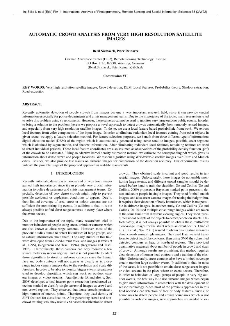
We assume (xi, yi) i ∈ [1, 2, ...,Ki] as FAST local featureswhich are extracted from input image. Here, Ki indicates themaximum number of features extracted from panchromatic bandof the input image. We represent locations of detected local fea-tures for Munich1 test image in Fig. 2.(b). As can be seen inthis image, we have extracted local features on street at placeswhere each individual person exits. Unfortunately, many redun-dant features are also detected generally on building rooftops, andcorners. For detection of people and crowds, first of all local fea-tures coming from other objects should be eliminated. For thispurpose, we apply a feature selection method that we represent in
222
PIA11 - Photogrammetric Image Analysis --- Munich, Germany, October 5-7, 2011
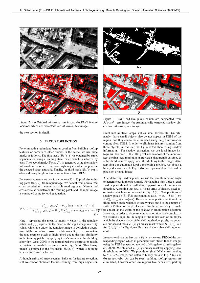
Figure 2: (a) Original Munich1 test image, (b) FAST featurelocations which are extracted from Munich1 test image.
the next section in detail.
3 FEATURE SELECTION
For eliminating redundant features coming from building rooftoptextures or corners of other objects in the scene, we use threemasks as follows. The first mask (B1(x, y)) is obtained by streetsegmentation using a training street patch which is selected byuser. The second mask (B2(x, y)), is generated using the shadowinformation, in order to remove high objects which appear onthe detected street network. Finally, the third mask (B3(x, y)) isobtained using height information obtained from DEM.
For street segmentation, we first choose a 20×20 pixel size train-ing patch (t(x, y)) from input image. We benefit from normalizedcross correlation to extract possible road segment. Normalizedcross correlation between the training patch and the input imageis computed using following equation.
γ(u, v) =
∑x,y
[g(x, y)− gu,v][t(x− u, y − v)− t]
{∑
x,y[g(x, y)− gu,v]
2∑
x,y[t(x− u, y − v)− t]2}0.5
(1)
Here t represents the mean of intensity values in the templatepatch, and gu,v represents the mean of the input image intensityvalues which are under the template image in correlation opera-tion. At the normalized cross correlation result γ(u, v), we obtainthe road segment pixels as highlighted due to the high similarityto the training patch. By applying Otsu’s automatic thresholdingalgorithm (Otsu, 2009) to the normalized cross correlation result,we obtain the road-like segments as in Fig. 3.(a). This binaryimage is assumed as the first mask (B1(x, y)) which is going tobe used for feature selection.
Although estimated street segment helps us for feature selection,still we cannot eliminate features coming from high objects on
Figure 3: (a) Road-like pixels which are segmented fromMunich1 test image, (b) Automatically extracted shadow pix-els from Munich1 test image.
street such as street lamps, statues, small kiosks, etc. Unfortu-nately, those small objects also do not appear in DEM of theregion, and they cannot be eliminated using height informationcoming from DEM. In order to eliminate features coming fromthese objects, in this step we try to detect them using shadowinformation. For shadow extraction, we use local image his-tograms. For each 100× 100 pixel size window of the input im-age, the first local minimum in grayscale histogram is assumed asa threshold value to apply local thresholding to the image. Afterapplying our automatic local thresholding method, we obtain abinary shadow map. In Fig. 3.(b), we represent detected shadowpixels on original image.
After detecting shadow pixels, we use the sun illumination angleto generate our high object mask. For labeling high objects, eachshadow pixel should be shifted into opposite side of illuminationdirection. Assuming that (xs, ys) is an array of shadow pixel co-ordinates which are represented in Fig. 3.(b). New positions ofshadow pixels ((xs, ys)) are computed as xs = xs + l sin(−θ),and ys = ys + l cos(−θ). Here θ is the opposite direction of theillumination angle which is given by user, and l is the amount ofshift in θ direction as pixel value. For better accuracy l shouldbe chosen as the width of the shadow in illumination direction.However, in order to decrease computation time and complexity,we assume l equal to the length of the minor axis of an ellipsewhich fits shadow shape. After shifting shadow pixels, we gener-ate our second mask B2(x, y) binary mask where B2(x, y) = 1for ((xs, ys)). In Fig. 4, we illustrate shadow pixel shifting oper-ation.
In order to obtain the last mask B3(x, y), we use DEM of the cor-responding region which is generated from stereo Ikonos imagesusing the DEM generation method of dAngelo et al. (dAngelo etal., 2009). We obtained B3(x, y) binary mask by applying localthresholding to DEM. We provide original DEM correspondingto Munich1 image, and obtained binary mask in Fig. 5.(a), and(b) respectively. As can be seen, building rooftop regions areeliminated, however other low regions like park areas, parking
223
In: Stilla U et al (Eds) PIA11. International Archives of Photogrammetry, Remote Sensing and Spatial Information Sciences 38 (3/W22)

Figure 4: Illustration of shadow pixel shifting operation.
Figure 5: (a) Digital elevation model corresponding to Munich1
test image which is generated using stereo WorldView-2 satelliteimages. (b) Low regions in Munich1 image obtained by apply-ing local thresholding to DEM.
lots with cars (or sea surface for some other test areas) cannot beeliminated with this mask. Therefore, we use information comingfrom three masks we generated. We assume our interest area asS(x, y) = B1(x, y)∧B2(x, y)
′∧B3(x, y), where ’∧’ representslogical and operation for binary images.
We use detected S(x, y) interest area for removing FAST featureswhich are extracted from other objects. We eliminate a FAST fea-ture which is at (xi, yi) coordinates, if S(xi, yi) = 0. RemainingFAST features behave as observations of the probability densityfunction (pdf) of the people to be estimated. In the next step, weintroduce an adaptive kernel density estimation method, to esti-mate corresponding pdf which will help us to detect dense peoplegroups and also other people in sparse groups.
4 DETECTING INDIVIDUALS AND DENSE CROWDS
Since we have no pre-information about possible crowd locationsin the image, we formulate the crowd detection method using aprobabilistic framework. Assume that (xi, yi) is the ith FASTfeature where i ∈ [1, 2, ...,Ki]. Each FAST feature indicates alocal color change which might be a human to be detected. There-fore, we assume each FAST feature as an observation of a crowdpdf. For crowded regions, we assume that more local featuresshould come together. Therefore knowing the pdf will lead to de-tection of crowds. For pdf estimation, we benefit from a kernelbased density estimation method as Sirmacek and Unsalan rep-resented for local feature based building detection (Sirmacek andUnsalan, 2010).
Silverman (Silverman, 1986) defined the kernel density estimatorfor a discrete and bivariate pdf as follows. The bivariate kernelfunction [N(x, y)] should satisfy the conditions given below;
∑x
∑y
N(x, y) = 1 (2)
N(x, y) ≥ 0, ∀(x, y) (3)
The pdf estimator with kernel N(x, y) is defined by,
p(x, y) =1
nh
n∑i=1
N(x− xi
h,y − yi
h) (4)
where h is the width of window which is also called smoothingparameter. In this equation, (xi, yi) for i = 1, 2, ..., n are obser-vations from pdf that we want to estimate. We take N(x, y) asa Gaussian symmetric pdf, which is used in most density estima-tion applications. Then, the estimated pdf is formed as below;
p(x, y) =1
R
Ki∑i=1
1√2πσ
exp(− (x− xi)2 + (y − yi)
2
2σ) (5)
where σ is the bandwidth of Gaussian kernel (also called smooth-ing parameter), and R is the normalizing constant to normalizepn(x, y) values between [0, 1].
In kernel based density estimation the main problem is how tochoose the bandwidth of Gaussian kernel for a given test image,since the estimated pdf directly depends on this value. For dif-ferent resolution images, the pixel distance between two personswill change. That means, Gaussian kernels with different band-widths will make these two persons connected to detect them as agroup. Otherwise, there will be many separate peaks on pdf, how-ever we will not be able to find large hills which indicate crowds.As a result, using a Gaussian kernel with fixed bandwidth willlead to poor estimates. Therefore, bandwidth of Gaussian kernelshould be adapted for any given input image.
In probability theory, there are several methods to estimate thebandwidth of kernel functions for given observations. One well-known approach is using statistical classification. This method isbased on computing the pdf using different bandwidth parame-ters and then comparing them. Unfortunately, in our field sucha framework can be very time consuming for large input im-ages. The other well-known approach is called balloon estima-tors. This method checks k-nearest neighborhoods of each obser-vation point to understand the density in that area. If the densityis high, bandwidth is reduced proportional to the detected den-sity measure. This method is generally used for variable kerneldensity estimation, where a different kernel bandwidth is used foreach observation point. However, in our study we need to com-pute one fixed kernel bandwidth to use at all observation points.To this end, we follow an approach which is slightly differentfrom balloon estimators. First, we pick Ki/2 number of randomobservations (FAST feature locations) to reduce the computationtime. For each observation location, we compute the distance tothe nearest neighbor observation point. Then, the mean of all dis-tances give us a number l. We assume that variance of Gaussiankernel (σ2) should be equal or greater than l. In order to guar-antee to intersect kernels of two close observations, we assumevariance of Gaussian kernel as 5l in our study. Consequently,bandwidth of Gaussian kernel is estimated as σ =
√5l. For a
given sequence, that value is computed only one time over one
224
PIA11 - Photogrammetric Image Analysis --- Munich, Germany, October 5-7, 2011

image. Then, the same σ value is used for all observations whichare extracted from images of the same sequence. The introducedautomatic kernel bandwidth estimation method, makes the algo-rithm robust to scale and resolution changes.
We use Otsu’s automatic thresholding method on obtained pdf todetect regions having high probability values (Otsu, 2009). Afterthresholding our pdf function, in obtained binary image we elim-inate regions with an area smaller than 1000 pixels since theycannot indicate large human crowds. The resulting binary imageBc(x, y) holds dense crowd regions. Since our Munich1 testimage does not include very dense crowds, in Fig. 7 we illustratean example dense crowd detection result on another Worldview-2satellite test image which is taken over Cairo city when an out-door event occurs.
After detecting dense crowds automatically, we focus on detect-ing individuals in sparse areas. Since they indicate local changes,we assume that detected local features can give information aboutindividuals.
In most cases, shadows of people or small gaps between peoplealso generate a feature. In order to decrease counting errors com-ing double counted people because of their shadows, we followa different strategy to detect individuals. We use a binary maskBf (x, y) where (xi, yi) feature locations have value 1. Then,we dilate Bf (x, y) using a disk shape structuring element with aradius of 2 to connect close feature locations. Finally, we applyconnected component analysis to mask, and we assume mass cen-ter of each connected component as a detected person position. Inthis process, slight change of radius of structuring element doesnot make a significant change in true detected people number.However, an appreciable increase in radius can connect featurescoming from different persons which leads to underestimates.
5 EXPERIMENTS
To test the proposed algorithm, we use a Worldview-2 satelliteimage dataset which consists of four multitemporal panchromaticimages taken over Munich city (Munich1−4 images), and onepanchromatic image taken over Cairo city (Cairo1). Those panchro-matic Worldview-2 satellite images have approximately half me-ter spatial resolution. We also test proposed algorithm on an air-borne image (with 30 cm. spatial resolution) taken from the sameregion in over Munich city, in order to show robustness of thealgorithm to resolution and sensor differences
In Fig. 6, we represent people detection results for Munich1−4
images. For these four multitemporal images, true individual per-son detection performances are counted as 92, 02%, 70, 73%,88, 57%, and 89, 19% respectively. Besides, false alarm ratiosare obtained as 14, 49%, 40, 34%, 24, 29%, and 27, 03% respec-tively. In Fig. 7.(a), we present dense crowd detection and peopledetection results in Worldview-2 satellite image taken over Cairocity. Robust detection of dense crowd boundaries indicate use-fulness of the proposed algorithm to monitor large mass events.Finally, in Fig. 7.(b), we represent people detection results on anairborne image which is taken in the same test area over Munichcity. Obtained result proves robustness of the algorithm to scaleand sensor differences of the input images.
6 CONCLUSION
In order to solve crowd detection and people detection, herein weintroduced a novel approach to detect crowded areas automati-cally from very high resolution satellite images. Although reso-lutions of those images are not enough to see each person with
Figure 6: People detection results on Munich1−4 Worldview-2satellite images.
sharp details, we can still notice a change of color components inthe place where a person exists. Therefore, we developed an algo-rithm which is based on local feature extraction from input image.After eliminating local features coming from different objects orrooftop textures by applying a feature selection step, we gener-ated a probability density function using Gaussian kernel func-tions with constant bandwidths. For deciding bandwidth of Gaus-sian kernel to be used, we used our adaptive bandwidth selectionmethod. In this way, we obtained a robust algorithm which cancope with input images having different resolutions. By auto-matically thresholding obtained pdf function, dense crowds arerobustly detected. After that, local features in sparse regions areanalyzed to find other individuals. We have tested our algorithmon panchromatic Worldview-2 satellite image dataset, and alsocompared with an algorithm result obtained from an airborne im-age of the same test area. Our experimental results indicate possi-ble usage of the algorithm in real-life events. We believe that, theproposed fully automatic algorithm will gain more importance inthe near future with the increasing spatial resolutions of satellitesensors.
REFERENCES
Arandjelovic, O., Sep. 2008. Crowd detection from still images. BritishMachine Vision Conference (BMVC’08).
Burkert, F., Schmidt, F., Butenuth, M. and Hinz, S., Sep. 2010. Peopletracking and trajectory interpretation in aerial image sequences. Interna-tional Archives of Photogrammetry, Remote Sensing and Spatial Infor-
225
In: Stilla U et al (Eds) PIA11. International Archives of Photogrammetry, Remote Sensing and Spatial Information Sciences 38 (3/W22)

(a)
(b)
Figure 7: (a) Dense crowd and people detection result onWorldview-2 satellite image taken over Cairo city, (b) People de-tection result on an airborne image which is taken at the same testarea over Munich city.
mation Sciences (IAPRS), Commission III (Part A) XXXVIII, pp. 209–214.
dAngelo, P., Schwind, P., Krauss, T., Barner, F. and Reinartz, P., 2009.Automated dsm based georeferencing of cartosat-1 stereo scenes. In Pro-ceedings of International Archives of Photogrammetry, Remote Sensing,and Spatial Information Sciences.
Davies, A., Yin, J. and Velastin, S., 1995. Crowd monitoring using imageprocessing. IEEE Electronic and Communications Engineering Journal 7(1), pp. 37–47.
Ge, W. and Collins, R., 2009. Marked point process for crowd counting.IEEE Computer Vision and Pattern Recognition Conference (CVPR’09)pp. 2913–2920.
Ge, W. and Collins, R., 2010. Crowd detection with a multiview sampler.European Conference on Computer Vision (ECCV’10).
Hinz, S., 2009. Density and motion estimation of people in crowded en-vironments based on aerial image sequences. ISPRS Hannover Workshopon High-Resolution Earth Imaging for Geospatial Information.
Lin, S., Chen, J. and Chao, H., Nov. 2001. Estimation of number of peoplein crowded scenes using perspective transformation. IEEE Transactionson Systems, Man, and Cybernetics - Part A: Systems and Humans 31 (6),pp. 645–654.
Otsu, N., 2009. A threshold selection method from gray-level histograms.IEEE Transactions on System, Man, and Cybernetics 9 (1), pp. 62–66.
Regazzoni, C. and Tesei, A., 1994. Local density evaluation and track-ing of multiple objects from complex image sequences. Proceedings of20th International Conference on Industrial Electronics, Control and In-strumentation (IECON) 2, pp. 744–748.
Regazzoni, C. and Tesei, A., 1996. Distributed data fusion for real timecrowding estimation. Signal Processing 53, pp. 47–63.
Rosten, E., Porter, R. and Drummond, T., Nov. 2010. Faster and better:A machine learning approach to corner detection. IEEE Transactions onPattern Analysis and Machine Learning 32 (1), pp. 105–119.
Silverman, B., 1986. Density estimation for statistics and data analysis.1st Edition.
Sirmacek, B. and Reinartz, P., 2011a. Automatic crowd analysis fromairborne images. 5th International Conference on Recent Advances inSpace Technologies RAST 2011, Istanbul, Turkey.
Sirmacek, B. and Reinartz, P., 2011b. Kalman filter based feature analy-sis for tracking people from airborne images. ISPRS Workshop High-Resolution Earth Imaging for Geospatial Information, Hannover, Ger-many.
Sirmacek, B. and Unsalan, C., 2010. A probabilistic framework to detectbuildings in aerial and satellite images. IEEE Transactions on Geoscienceand Remote Sensing.
226
PIA11 - Photogrammetric Image Analysis --- Munich, Germany, October 5-7, 2011