autobinggis (abg)
TRANSCRIPT

AutoBingGIS (ABG)
A Transport Planning Mapping App for
Windows 8.1 & 10
Developed with Newcastle City Council
in association with
The North East Combined Authorities

Automatica Limited
ABG Windows 8-10 OverviewV2 10 December 2015 Page | 1
Overview
ABG is a Microsoft store App that can be run on any Windows tablet, and PC operating Windows 8.1 or 10.
It can also be run on a Windows Server 2012 R2 with Remote Desktop1 licences that enable access to ABG
from any device that runs a Remote Desktop connection, including iPad Air2. In addition it will work on
Windows 7 using Oracle VM (requires a licenced copy of Windows 8.1/10). ABG relies heavily on transport
planning data such as accidents, networks etc. stored in SQL databases. The source of the SQL database
can be a local server, Microsoft Azure2 (a cloud environment), or even local to the tablet/PC.
The backbone of ABG mapping environment is Bing Maps3 (road, aerial and bird’s eye); in addition ABG
also supports OpenStreetMap4 (road), Google Maps5 (road and aerial). However Google Maps is only
available when ABG is displaying public data.
The data displayed by ABG can be public (usually stored on Microsoft’s Azure cloud), meaning anyone with
the ABG app can display the information; or private, in this case the information is restricted to users that
have been granted the necessary privileges by an ABG Simple Web Token6 (SWT); this data can be stored
anywhere.
In addition to displaying static data ABG utilises a number of web services, and web APIs (Application
Program Interface), that enable complex accessibility statistics and routing information to be extracted from
highway and public transport networks as well as accessing realtime information, such as roadside CCTV.
Windows 8 and 10
The first version of ABG was developed for Windows 8, and upgraded to meet the requirements of 8.1
including a major upgrade of Microsoft’s Bing mapping engine, which, unfortunately, was not compatible
with 8, but is fully compatible with 10.
There are major differences in style between 8.1 and 10, as Microsoft addressed the various concerns
about 8 that users had raised, in particular, that it had tried, unsuccessfully, to be both mouse and touch
friendly. In 10 a start button is back and it can operate in either tablet or desktop mode making it easier to
operate with a mouse whilst maintain the touch environment when operating in tablet mode. ABG operates
well in both modes; however getting to grips with the more sophisticated options associated with snapping
two (or even more) apps together, such as ABG and a PDF reader, takes a little bit of patience, particularly
as this functionality operates subtlety differently in tablet and desktop modes. Once this expertise is
acquired 10 does provide an enriched environment for ABG, with or without touch.
Should users upgrade to 10, as far as ABG is concerned, it makes little difference other than in the way
snapping, as mentioned above, operates. However, given that 10, as of 1 September 2015, overtook 8 and
Vista to grab 5.2% of the PC market in just 4 weeks and is likely to overtake 8.1 by Christmas, certainly 10
is the way forward. Hence it would be sensible for any 8 or 8.1, and even 7, users to take advantage, if
offered, of the free upgrade to 10.
Azure
Microsoft’s Azure Cloud offers a vast range of services and facilities in its 200 or more datacentres
throughout the world. From ABG’s viewpoint it enables vast quantities of data to be made available through
the use of SQL Azure and data analysis engines (web services and APIs) hosted in virtual machines at
1 https://technet.microsoft.com/en-gb/library/cc753650.aspx
2 https://azure.microsoft.com/en-gb
3 http://www.bing.com/maps
4 https://www.openstreetmap.org
5 https://maps.google.com
6 https://msdn.microsoft.com/en-us/library/azure/hh781551.aspx

Automatica Limited
ABG Windows 8-10 OverviewV2 10 December 2015 Page | 2
extremely low prices. For example, a 250GB database can be hosted on Azure7 from as little as £10 per
month with a powerful virtual machine (VM) costing around £70 per month when permanently on. However
if a VM is powered down there is virtually no cost while it is in that state; note: database storage cannot be
powered down.
ABG Mapping
ABG supports the following mapping environments:-
Bing Road
Bing Aerial
7 https://azure.microsoft.com/en-gb/pricing/

Automatica Limited
ABG Windows 8-10 OverviewV2 10 December 2015 Page | 3
Note: not all areas have the higher quality resolution.
Bing Bird’s Eye
The view point can be rotated successively by 900 to give 4 different view angles. Not available
everywhere.
OpenStreetMaps
Unlike Bing maps this map can be faded and this can be useful when highlighting a plotted layer,
such as Road Traffic Collisions (RTCs)

Automatica Limited
ABG Windows 8-10 OverviewV2 10 December 2015 Page | 4
Google Road (public data only)
This map can be faded.
Google Aerial (public data only)
This map can be faded.

Automatica Limited
ABG Windows 8-10 OverviewV2 10 December 2015 Page | 5
Bing Traffic
All maps other than Bing Bird’s Eye support the Bing near realtime traffic layer; below is OpenStreetMaps
with traffic:-
The same map with fading

Automatica Limited
ABG Windows 8-10 OverviewV2 10 December 2015 Page | 6
Locating an Address
ABG uses Bing’s address finder as shown below. First tap/click on Find Address then enter an address or
postcode in the box.
Tap/Click Go to pans/zooms to the location and marks it with a +

Automatica Limited
ABG Windows 8-10 OverviewV2 10 December 2015 Page | 7
Display an Address
Tap/click the Display Address button, then tap/click on the map and the address will be displayed in the
Cyan coloured box.
Bing - Traffic and Journey Time
Using current traffic conditions ABG can display a journey time and route between two points, the example
below shows the route and journey times.

Automatica Limited
ABG Windows 8-10 OverviewV2 10 December 2015 Page | 8
Census 2011
Overview
Automatica has created Azure SQL tables containing a subset of the 2011 Census for England, Wales and
Scotland. England and Wales are contained in the same tables, with Scotland having separate tables as
the spatial units are subtlety different north of the border.
The following tables are available:-
English/Welsh regions, age, car ownership, road traffic collisions
English/Welsh MSOAs, age, car ownership, journey to work modal split
English/Welsh LSOAs, age, car ownership, journey to work – origin, destination
English/Welsh OAs, age, car ownership
English/Welsh wards, age, road traffic collisions
Scottish regions, age, car ownership, road traffic collisions
Scottish intermediate zones, age, car ownership
Scottish data zones, age, car ownership
Scottish OAs, age, car ownership
On the next page there are a number of examples:-

Automatica Limited
ABG Windows 8-10 OverviewV2 10 December 2015 Page | 9
Regional Analysis Cars per Person
Regional Analysis by Age
Automatica Limited
ABG Windows 8-10 OverviewV2 10 December 2015 Page | 10
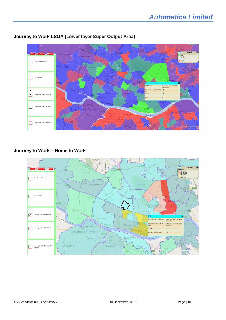
Journey to Work LSOA (Lower layer Super Output Area)
Journey to Work – Home to Work

Automatica Limited
ABG Windows 8-10 OverviewV2 10 December 2015 Page | 11
Journey to Work – Modal Split
Output Area Analysis by Age

Automatica Limited
ABG Windows 8-10 OverviewV2 10 December 2015 Page | 12
Ward Analysis by Age
Road Traffic Collisions - Analysis with Polygon

Automatica Limited
ABG Windows 8-10 OverviewV2 10 December 2015 Page | 13
Regional Analysis by Age Scotland
Road Traffic Collisions Trend Analysis by Scottish Wards

Automatica Limited
ABG Windows 8-10 OverviewV2 10 December 2015 Page | 14
Cycle Road Traffic Collisions in a Scottish Ward

Automatica Limited
ABG Windows 8-10 OverviewV2 10 December 2015 Page | 15
Realtime Data Tyne and Wear
Overview
On behalf of the Tyne and Wear Integrated Transport Authority8, Newcastle City Council commissioned
Mott Macdonald to provide an open data service9 (ODS) to give third party access to transport datasets
sourced from Tyne and Wear’s urban traffic management control (UTMC) system. Mott Macdonald’s role
involved delivering the ODS platform, application programming interface (API) and public website.
Automatica has exploited this ODS by way of a set of APIs hosted on Azure that interface with ABG. The
realtime data that is currently available from within ABG is:-
Carparks
Currently there are only 3 carparks that report realtime information, but others are expected to come online
shortly.
8 The powers of the Tyne and Wear Integrated Transport Authority passed to the North East Combined Authority on 1 April 2014.
9 https://www.mottmac.com/article/6034/the-north-east-combined-authority-open-data-service-uk

Automatica Limited
ABG Windows 8-10 OverviewV2 10 December 2015 Page | 16
Journey Times
CCTV Still Pictures
Images will automatically refresh every 10 minutes or so.

Automatica Limited
ABG Windows 8-10 OverviewV2 10 December 2015 Page | 17
Delays associated with Road Traffic Collisions
Incidents

Automatica Limited
ABG Windows 8-10 OverviewV2 10 December 2015 Page | 18
Roadworks
Weather
Other data sources such as variable sign messages will be coming online shortly.

Automatica Limited
ABG Windows 8-10 OverviewV2 10 December 2015 Page | 19
Accessibility
Overview
ABG has access to two powerful web services, developed by Automatica, one for the highway network and
one for the public transport network. These web services not only produce routeing and journey time
information but also accessibility mapping and statistics.
Highway
Currently ABG supports two types of highway network:-
Ordnance Survey’s ITN10 (Integrated Transport Network) in association with Trafficmaster speed
data11. These are commercial products and can only be used in association with appropriate
licenses from Ordnance Survey and Trafficmaster (a division of Teletrac). Automatica uses SWT
tokens and other methods to control access to this data type when it is stored on Azure or
elsewhere.
Ordnance Survey’s Open Roads12. This network, although simpler than ITN in that, for example,
there is no direction associated with a link, is robust enough to provide an excellent data source for
providing basic highway accessibility statistics. Automatica has estimated average link speeds
based on link type and length. ABG’s network date, April 2015, can be used without any licence.
The example, below, shows an accessibility plot for Boldon, South Tyneside, and identifies 6665
Output Areas (6302 with jobs plus 363 with only population and workers) that can be reached in 45
minutes by car. The accessibility statistic13 of 81.8% reflects access to Jobs, Workers, Population,
stations and airports.
Highway Accessibility
10
https://www.ordnancesurvey.co.uk/business-and-government/products/itn-layer.html 11
http://www.teletrac.co.uk/trafficmaster 12
https://www.ordnancesurvey.co.uk/business-and-government/products/os-open-roads.html#Technical-specification 13
email: [email protected] for a spreadsheet example.

Automatica Limited
ABG Windows 8-10 OverviewV2 10 December 2015 Page | 20
Public Transport
ABG utilises the Traveline National Dataset14 (TNDS) plus the Association of Train Operating Companies15
(ATOC) datasets; these datasets provide a comprehensive view of the vast majority of public transport
services in England, Wales and Scotland. There are some weaknesses in the use of this data in ABG, as a
very small percentage of routes have some invalid properties and have had to be disregarded; most
Demand Responsive Transport (DRT) entries have been excluded as, in general, they only have a notional
representation in TNDS, and not all specialist services such as work/school/etc. are in TNDS. It is,
however, estimated that over 99% of services are correctly represented within the various databases used
by ABG. The current data used by ABG was imported at the beginning of October and has been filtered to
represent active services in the week beginning 28 September 2015.
Below are a couple of examples, the first is a simple route analysis between Edinburgh and Portsmouth,
and the second is an accessibility analysis for the centre of Gateshead.
Public Transport Route Analysis
14
https://data.gov.uk/dataset/traveline-national-dataset 15
http://www.atoc.org

Automatica Limited
ABG Windows 8-10 OverviewV2 10 December 2015 Page | 21
Public Transport Accessibility Analysis
Web Services
Access
The highway and public transport web services, mentioned above, can be accessed independently by ABG
by way of a web API utilising a JSON (JavaScript Object Notation)16. The output of this process is
spreadsheets, or files, in CSV format.
16
email: [email protected] for further information