attention: brenda williams washington, d.c. 20035
TRANSCRIPT
September 29, 2008 Director (210) Attention: Brenda Williams P.O. Box 66538 Washington, D.C. 20035 Sent via U.S. Post, Certified Mail with Return Receipt Requested
Re: Protest of the Price Field Office Proposed Resource Management Plan and Final
Environmental Impact Statement, released August 2008 To Ms. Williams: Please accept this timely protest of the Bureau of Land Management’s Price Field Office Proposed Resource Management Plan and Final Environmental Impact Statement (PRMP). This protest is submitted by the following protestants:
Southern Utah Wilderness Alliance (SUWA) 425 East 100 South Salt Lake City, Utah 84111 (801) 486-3161 The Wilderness Society (TWS) 1660 Wynkoop St., Suite 850 Denver, Colorado 80202 (303) 650-5818 Sierra Club – Utah Chapter 2159 South 700 East, Suite 210 Salt Lake City, Utah 84106 (801) 467-9297 Center for Native Ecosystems 1536 Wynkoop St., Suite 303 Denver, Colorado 80202 (303) 546-0214 Public Employees for Environmental Responsibility (PEER) – Southwest Chapter 738 N. 5th Ave., Suite 210 Tucson, Arizona 85705 (520) 906-2159
1
SUWA and TWS have a long-standing interest in the management of Bureau of Land Management (BLM) lands in Utah and often participate in the decision-making process for project proposals and actions that could potentially affect lands included in the Utah Wilderness Coalition’s wilderness proposal—America’s Red Rock Wilderness Act (ARRWA). SUWA members and staff enjoy a myriad of recreation on BLM-managed public lands, including hiking, biking, nature-viewing, photography, and the quiet contemplation in the solitude offered by wild places. SUWA and TWS have and will continue to participate in the planning process for the Price PRMP. SUWA and TWS submitted separate comments on the Draft RMP in 2005 and collaborated on the Supplemental EIS comments in 2008. See, e.g., SUWA’s comments to the Price Draft RMP (attached as Exhibits A through C1). The additional co-protestants also have interests in BLM’s management of the Uintah Basin and/or have also participated in the planning process for the Price PRMP. We are protesting several different issues and aspects of the PRMP; these issues are listed below along with the location of these discussions in this document. Our discussion of each of these issues concisely states why we believe the State Director’s decisions are wrong and the corresponding portions of the PRMP at issue. I. Applicable Legal Standards........................................................................................................ 4 II. Air Quality................................................................................................................................ 15 III. Climate Change....................................................................................................................... 41 IV. Cultural Resources.................................................................................................................. 53 V. Oil and Gas Development ........................................................................................................ 62 VI. Recreation ............................................................................................................................... 65 VII. ORV Area and Trail Designations and Travel Plan Decisions ............................................. 70 VIII. Riparian Resources .............................................................................................................. 89 IX. Socioeconomic Impacts .......................................................................................................... 94 X. Water Quality......................................................................................................................... 126 XI. Areas of Critical Environmental Concern ............................................................................ 132 XII. Wild and Scenic Rivers ....................................................................................................... 149 XIII. Wilderness Study Areas and Lands with Wilderness Characteristics................................ 157 XIV. Visual Resources................................................................................................................ 173 XV. Habitat Fragmentation and Wildlife Protection .................................................................. 177 XVI. Special Status Species........................................................................................................ 184
1 The attachments and exhibits originally submitted with SUWA’s or TWS’s comments to the Draft and Supplemental RMP are not attached here as hard copies, but are included on the accompanying CD.
2
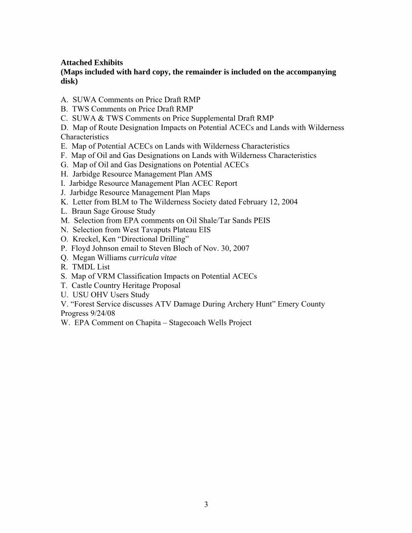
Attached Exhibits (Maps included with hard copy, the remainder is included on the accompanying disk) A. SUWA Comments on Price Draft RMP B. TWS Comments on Price Draft RMP C. SUWA & TWS Comments on Price Supplemental Draft RMP D. Map of Route Designation Impacts on Potential ACECs and Lands with Wilderness Characteristics E. Map of Potential ACECs on Lands with Wilderness Characteristics F. Map of Oil and Gas Designations on Lands with Wilderness Characteristics G. Map of Oil and Gas Designations on Potential ACECs H. Jarbidge Resource Management Plan AMS I. Jarbidge Resource Management Plan ACEC Report J. Jarbidge Resource Management Plan Maps K. Letter from BLM to The Wilderness Society dated February 12, 2004 L. Braun Sage Grouse Study M. Selection from EPA comments on Oil Shale/Tar Sands PEIS N. Selection from West Tavaputs Plateau EIS O. Kreckel, Ken “Directional Drilling” P. Floyd Johnson email to Steven Bloch of Nov. 30, 2007 Q. Megan Williams curricula vitae R. TMDL List S. Map of VRM Classification Impacts on Potential ACECs T. Castle Country Heritage Proposal U. USU OHV Users Study V. “Forest Service discusses ATV Damage During Archery Hunt” Emery County Progress 9/24/08 W. EPA Comment on Chapita – Stagecoach Wells Project
3
I. Applicable Legal Standards The following is a brief synopsis of the legal standards which apply to the claims brought forward in this protest. Detailed descriptions of individual violations follow and will refer to and/or rely upon the information set out below.
A. National Environmental Policy Act The National Environmental Policy Act (NEPA), 42 U.S.C. § 4321 et seq., requires, among other things, agencies to conduct environmental analysis of the direct, indirect, and cumulative impacts of proposed actions, as well as mitigation measures, consider a range of reasonable alternatives (including an alternative that minimizes environmental impacts), and solicit and respond to public comments.
1. Reasonable Range of Alternatives Must Be Considered The range of alternatives is “the heart of the environmental impact statement.” 40 C.F.R. § 1502.14. NEPA requires BLM to “rigorously explore and objectively evaluate” a range of alternatives to proposed federal actions. See 40 C.F.R. §§ 1502.14(a), 1508.25(c). “An agency must look at every reasonable alternative, with the range dictated by the nature and scope of the proposed action.” Nw. Envtl. Defense Center v. Bonneville Power Admin., 117 F.3d 1520, 1538 (9th Cir. 1997). An agency violates NEPA by failing to “rigorously explore and objectively evaluate all reasonable alternatives” to the proposed action. City of Tenakee Springs v. Clough, 915 F.2d 1308, 1310 (9th Cir. 1990) (quoting 40 C.F.R. § 1502.14). This evaluation extends to considering more environmentally protective alternatives and mitigation measures. See, e.g., Kootenai Tribe of Idaho v. Veneman, 313 F.3d 1094, 1122–23 (9th Cir. 2002) (and cases cited therein). For this PRMP, the consideration of more environmentally protective alternatives is also consistent with the Federal Land Policy and Management Act’s (FLPMA) requirement that BLM “minimize adverse impacts on the natural, environmental, scientific, cultural, and other resources and values (including fish and wildlife habitat) of the public lands involved.” 43 U.S.C. §1732(d)(2)(a). NEPA requires that an actual “range” of alternatives is considered, such that the Act will “preclude agencies from defining the objectives of their actions in terms so unreasonably narrow that they can be accomplished by only one alternative (i.e. the applicant’s proposed project).” Col. Envtl. Coal. v. Dombeck, 185 F.3d 1162, 1174 (10th Cir. 1999), citing Simmons v. U.S. Corps of Engineers, 120 F.3d 664, 669 (7th Cir. 1997). This requirement prevents the environmental impact statement (EIS) from becoming “a foreordained formality.” City of New York v. Dep’t of Transp., 715 F.2d 732, 743 (2nd Cir. 1983). See also Davis v. Mineta, 302 F.3d 1104 (10th Cir. 2002).
Further, in defining what is a “reasonable” range of alternatives, NEPA requires consideration of alternatives “that are practical or feasible” and not just “whether the proponent or applicant likes or is itself capable of carrying out a particular alternative”; in
4
fact, “[a]n alternative that is outside the legal jurisdiction of the lead agency must still be analyzed in the EIS if it is reasonable.” Council on Environmental Quality, Forty Most Asked Questions Concerning CEQ’s National Environmental Policy Act Regulations, Questions 2A and 2B, available at http://ceq.hss.doe.gov/nepa/regs/40/40p3.htm; 40 C.F.R. §§ 1502.14, 1506.2(d).
2. Hard Look Must Be Appropriate to Proposed Action and Include
Direct, Indirect, and Cumulative Impacts NEPA dictates that BLM take a “hard look” at the environmental consequences of a proposed action and the requisite environmental analysis “must be appropriate to the action in question.” Metcalf v. Daley, 214 F.3d 1135, 1151 (9th Cir. 2000); Robertson v. Methow Valley Citizens Council, 490 U.S. 332, 348 (1989). In order to take the “hard look” required by NEPA, BLM is required to assess impacts and effects that include: “ecological (such as the effects on natural resources and on the components, structures, and functioning of affected ecosystems), aesthetic, historic, cultural, economic, social, or health, whether direct, indirect, or cumulative.” 40 C.F.R. § 1508.8. (emphasis added). NEPA regulations define “cumulative impact” as:
the impact on the environment which results from the incremental impact of the action when added to other past, present, and reasonably foreseeable future actions regardless of what agency (Federal or non-Federal) or person undertakes such other actions. Cumulative impacts can result from individually minor but collectively significant actions taking place over a period of time.
40 C.F.R. § 1508.7 (emphasis added). To satisfy NEPA’s hard look requirement, the cumulative impacts assessment must do two things. First, BLM must catalogue the past, present, and reasonably foreseeable projects in the area that might impact the environment. Muckleshoot Indian Tribe v. U.S. Forest Service, 177 F.3d 800, 809–10 (9th Cir. 1999). Second, BLM must analyze these impacts in light of the proposed action. Id. If BLM determines that certain actions are not relevant to the cumulative impacts analysis, it must “demonstrat[e] the scientific basis for this assertion.” Sierra Club v. Bosworth, 199 F.Supp.2d 971, 983 (N.D. Ca. 2002). A failure to include a cumulative impact analysis of actions within a larger region will render NEPA analysis insufficient. See, e.g., Kern v. U.S. Bureau of Land Management, 284 F.3d 1062, 1078 (9th Cir. 2002) (analysis of root fungus on cedar timber sales was necessary for an entire area).
3. Baseline Information Must Be Sufficient to Permit Analysis of Impacts Importantly, 40 C.F.R. § 1502.15 requires agencies to “describe the environment of the areas to be affected or created by the alternatives under consideration.” Establishment of
5
baseline conditions is a requirement of NEPA. In Half Moon Bay Fisherman’s Marketing Ass’n v. Carlucci, 857 F.2d 505, 510 (9th Cir. 1988), the Ninth Circuit states that “without establishing . . . baseline conditions . . . there is simply no way to determine what effect [an action] will have on the environment, and consequently, no way to comply with NEPA.” The court further held that “[t]he concept of a baseline against which to compare predictions of the effects of the proposed action and reasonable alternatives is critical to the NEPA process.”
4. Mitigation Measures Must Be Described with Specificity and Must Include Commitments for Action
NEPA requires that BLM discuss mitigation measures in an EIS. 40 C.F.R. §§ 1502.14, 1502.16. Also, under NEPA, BLM’s Finding of No Significant Impact (FONSI) is lawful only if “BLM has made a convincing case that no significant impact will result there from or that any such impact will be reduced to insignificance by the adoption of appropriate mitigation measures.” Defenders of Wildlife, 152 IBLA 1, 6 (2000) (citations omitted). In general, in order to show that mitigation will reduce environmental impacts to an insignificant level, BLM must discuss the mitigation measures “in sufficient detail to ensure that environmental consequences have been fairly evaluated.” Communities, Inc. v. Busey, 956 F.2d 619, 626 (6th Cir. 1992). Simply identifying mitigation measures, without analyzing the effectiveness of the measures, violates NEPA. Agencies must “analyze the mitigation measures in detail [and] explain how effective the measures would be . . . A mere listing of mitigation measures is insufficient to qualify as the reasoned discussion required by NEPA.” Nw. Indian Cemetery Protective Ass’n v. Peterson, 764 F.2d 581, 588 (9th Cir. 1985), rev’d on other grounds, 485 U.S. 439 (1988). NEPA also directs that the “possibility of mitigation” should not be relied upon as a means to avoid further environmental analysis. Council on Environmental Quality, Forty Most Asked Questions Concerning CEQ’s National Environmental Policy Act Regulations, available at http://ceq.hss.doe.gov/nepa/regs/40/40p3.htm; Davis v. Mineta, 302 F.3d at 1125. Further, general statements that BLM will conduct monitoring are also not an appropriate form of mitigation. Simply monitoring for expected damage does not actually reduce or alleviate any impacts.
5. BLM Must Assess Alternatives Using Quality Data and Scientifically Acceptable Methods of Analysis, Which Are Disclosed to the Public for Comment
BLM cannot evaluate consequences to the environment, determine avoidable or excessive degradation, and assess how best to designate and protect Areas of Critical Environmental Concern (ACECs) without adequate data and analysis. NEPA’s hard look at environmental consequences must be based on “accurate scientific information” of “high quality.” 40 C.F.R. § 1500.1(b). Essentially, NEPA “ensures that the agency, in reaching its decision, will have available and will carefully consider detailed information concerning significant environmental impacts.” Robertson v. Methow Valley Citizens
6
Council, 490 U.S. at 349. The Data Quality Act and BLM’s interpreting guidance expand on this obligation, requiring that influential scientific information use “best available science and supporting studies conducted in accordance with sound and objective scientific practices.” Treasury and General Government Appropriations Act for Fiscal Year 2001, Pub.L. No. 106-554, § 515. See also Bureau of Land Management, Information Quality Guidelines, available at http://www.blm.gov/nhp/efoia/data_ quality/guidelines.pdf . BLM’s internal guidance also recognizes the importance of accumulation and proper analysis of data. The agency’s Land Use Planning Handbook emphasizes the importance of using sufficient, high quality data and analytical methods, and making those available to the public. Appendix H of the Land Use Planning Handbook also directs: “The data and resultant information for a land use plan must be carefully managed, documented, and applied to withstand public, scientific, and legal scrutiny.” Appendix F-1 of the Handbook emphasizes the importance of providing a clear explanation of how analysis was conducted, stating: “Regardless of its source, sufficient metadata (data about data) should be provided to clearly determine the quality of the data, along with any limitations associated with its use.” In other words, appropriate analysis of data is as important as the accumulation of sufficient data. Further, both data and analyses must be disclosed to the public, in order to permit the “public scrutiny” that is considered “essential to implementing NEPA.” 40 C.F.R. § 1500.1(b). BLM’s guidelines for implementing the Data Quality Act also reiterate that making data and methods available to the public permits independent reanalysis by qualified member of the public. In this regard, NEPA “guarantees that the relevant information will be made available to the larger audience that may also play a role in both the decisionmaking process and the implementation of that decision.” Robertson v. Methow Valley Citizens Council, 490 U.S. at 349. NEPA not only requires that BLM have detailed information on significant environmental impacts, but also requires that the agency make this information available to the public for comment. Inland Empire Public Lands Council v. U.S. Forest Service, 88 F.3d 754, 757 (9th Cir. 1996). Where there is scientific uncertainty, NEPA imposes three mandatory obligations on BLM: (1) a duty to disclose the scientific uncertainty; (2) a duty to complete independent research and gather information if no adequate information exists unless the costs are exorbitant or the means of obtaining the information are not known; and (3) a duty to evaluate the potential, reasonably foreseeable impacts in the absence of relevant information, using a four-step process. Unless the costs are exorbitant or the means of obtaining the information are not known, the agency must gather the information in studies or research. 40 C.F.R. § 1502.22. Courts have upheld these requirements, stating that the detailed environmental analysis must “utiliz[e] public comment and the best available scientific information.” Colorado Environmental Coalition v. Dombeck, 185 F.3d 1162, 1171-72 (10th Cir. 1999) (citing Robertson v. Methow Valley Citizens’ Council, 490 U.S. at 350); Holy Cross Wilderness Fund v. Madigan, 960 F.2d 1515, 1521-22 (10th Cir. 1992).
7
As the Supreme Court has explained, while "policymaking in a complex society must account for uncertainty," it is not "sufficient for an agency to merely recite the terms 'substantial uncertainty' as a justification for its actions." Motor Vehicle Manufacturers Ass'n v. State Farm Mutual Automobile Ins. Co., 463 U.S. 29, 52 (1983). Instead, in this context, as in all other aspects of agency decision-making, “[w]hen the facts are uncertain,” an agency decision-maker must, in making a decision, “identify the considerations he found persuasive.” Small Refiner Lead Phase-Down Task Force v. EPA, 705 F.2d 506, 520 (D.C. Cir. 1983), quoting Ind. Union Dept., AFL-CIO v. Hodgson, 499 F.2d 467, 476 (D.C. Cir. 1974). BLM must provide the public with an explanation of both the data used in analyzing the potential effects of management alternatives and the methods used to conduct the analysis, as well as an opportunity to provide comments and propose corrections or improvements.
6. BLM Must Respond to Public Comments and Specifically Address Scientific Uncertainty and/or Differing Scientific Opinions
Under Council for Environmental Quality (CEQ) regulations implementing NEPA, BLM must respond to substantive comments made during the public comment period for the EIS. 40 C.F.R. § 1503.4. An agency preparing a final environmental impact statement shall assess and consider comments both individually and collectively, and shall respond by one or more of the means listed below, stating its response in the final statement. Possible responses are to:
1. Modify alternatives including the proposed action. 2. Develop and evaluate alternatives not previously given serious
consideration by the agency. 3. Supplement, improve, or modify its analyses. 4. Make factual corrections. 5. Explain why the comments do not warrant further agency response,
citing the sources, authorities, or reasons which support the agency’s position and, if appropriate, indicate those circumstances which would trigger agency reappraisal or further response.
40 C.F.R. § 1503.4(a). Importantly, while agencies must attach comments considered “substantive” to the EIS (40 C.F.R. § 1503.4(b)), a comment need not be substantive to trigger the agency’s response requirement. NEPA requires that, in preparing a final EIS, BLM must discuss “any responsible opposing view which was not adequately discussed in the draft statement and indicate the agency’s response to the issue raised.” 40 C.F.R. § 1502.9. The Council on Environmental Quality interprets this requirement as mandating that an agency respond in a “substantive and meaningful way” to a comment that addresses the adequacy of analysis performed by the agency. Forty Most Asked Questions Concerning CEQ’s
8

National Environmental Policy Act Regulations. 2 BLM’s NEPA Handbook elaborates upon this requirement, providing that: comments relating to inadequacies or inaccuracies in the analysis or methodologies used must be addressed; interpretations of analyses should be based on professional expertise; and where there is disagreement within a professional discipline, “a careful review of the various interpretations is warranted.” Handbook H-1790-1, Section V.B.4.a., p. V-11. Failure to disclose and thoroughly respond to differing scientific views violates NEPA and obligates an agency to perform a compliant environmental analysis prior to approving a proposed action. See, Robertson v. Methow Valley Citizens Council, supra (EIS should reflect critical views of others to whom copies of draft were provided and respond to opposing views); Sierra Club v. Bosworth, 199 F.Supp.2d 971 (N.D.Cal. 2002) (failure to disclose and analyze scientific opinion that opposed post-fire logging violates NEPA); Seattle Audubon Society v. Lyons, 871 F.Supp. 1291, 1381 (W.D.Wash. 1994) (An EIS must “disclose scientific opinion in opposition to the proposed action, and make a good faith, reasoned response to it.”); Seattle Audubon Society v. Moseley, 798 F.Supp. 1473, 1482 (W.D.Wash. 1992) (NEPA requires that the agency candidly disclose in its EIS the risks of its proposed action, in its EIS the risks of its proposed action, and that it respond to the adverse opinions held by respected scientists.”). Further, as discussed above, where there is scientific uncertainty, BLM cannot simply dismiss opposing scientific opinion and authority, but must provide a discussion of the support for its decision not to rely upon it. Accordingly, BLM must complete a conforming NEPA analysis that fully considers and responds to public comments, including opposing scientific opinion, and justifies any contradicting conclusions.
7. BLM Must Present Environmental Analysis and Information in a Manner that Facilitates, Rather than Impedes, Public Comment
NEPA requires BLM to “[e]ncourage and facilitate public involvement in decisions which affect the quality of the human environment.” 40 C.F.R. § 1500.2(d). A critical part of this obligation is presenting data and analysis in a manner that will enable the public to thoroughly review and understand the analysis of environmental consequences. For this reason, NEPA requires the use of high quality data and the disclosure of the methodology underlying proposed decisions, as discussed above, and also explicitly requires that an EIS “be written in plain language” and presented in a way that “the public can readily understand.“ 40 C.F.R. § 1502.8. These requirements are specifically reinforced for an EIS; the “primary purpose” of this document is “to allow for informed public participation and informed decision making” so its language must be “clear” and “supported by evidence that the agency has made the necessary environmental analyses.” Earth Island Inst. v. U.S. Forest Service, 442 F.3d 1147, 1160 (9th Cir. 2006); 40 C.F.R. § 1502.1.
2 The U.S. Court of Appeals for the Tenth Circuit has found that the “Forty Questions” are “persuasive authority offering interpretive guidance” on NEPA from CEQ. Davis v. Mineta, 302 F.3d 1104, 1125 (10th Cir. 2002).
9
Therefore, “an EIS must be organized and written so as to be readily understandable by governmental decisionmakers and by interested non-professional laypersons likely to be affected by actions taken under the EIS.” Oregon Environmental Council v. Kunzman, 817 F.2d 484, 493 (9th Cir. 1987). Accordingly, where a plan is so unclear as to not permit review and understanding, it may be deemed “incomprehensible” and in violation of NEPA. See, e.g., California, ex rel. Lockyer v. U.S. Forest Service, 465 F.Supp. 2d 942, 949-950 (N.D.Cal. 2006) (management plan for Giant Sequoia National Monument was “incomprehensible” because it referenced but did not explain its reliance on certain law and regulations, and because it contained conflicting statements regarding applicable standards for management, which were never clarified). Where the PRMP and FEIS rely upon existing authority, they must include a sufficient explanation of how such authority actually supports the action taken – especially where such authority (such as the ORV regulations requiring the agency to protect other resources and avoid conflicts with other recreationists) appears to require different actions and where these issues have already been highlighted to BLM in comments. Similarly, where the PRMP and FEIS include conflicting information for the same resources (such as acreage or management prescriptions) or conflicting conclusions about how decisions may harm and protect resources at the same time, the agency must not only correct errors, but also fully explain its conclusions and ultimate management decisions. Numerous inconsistencies in data, conclusions and compliance were raised in our comments on the DRMP and DEIS. The PRMP must correct these deficiencies and fully comply with the requirements of NEPA.
B. Federal Land Policy and Management Act
The Federal Land Policy and Management Act (FLPMA), 43 U.S.C. § 1701 et seq., is BLM’s organic act and guides the agency in managing public lands, drafting land use plans, and ensuring that the public has been involved in such decisions.
1. Duty to Inventory and Land Use Planning Requirements
FLPMA imposes a duty on BLM to identify and protect the many natural resources found on public lands. FLPMA requires BLM to inventory its lands and their resources and values, “including outdoor recreation and scenic values.” 43 U.S.C. § 1711(a). FLPMA also obligates BLM to take this inventory into account when preparing land use plans, using and observing the principles of multiple use and sustained yield. See 43 U.S.C. § 1712(c)(4), (1). Through management plans, BLM can and should protect wildlife, scenic values, recreation opportunities, and wilderness character in the public lands through various management decisions, including by excluding or limiting certain uses of the public lands. See 43 U.S.C. § 1712(e). This is necessary and consistent with FLPMA’s definition of multiple use, which identifies the importance of various aspects of wilderness characteristics (such as recreation, wildlife, and natural scenic values) and requires BLM’s consideration of the relative values of these resources but “not
10
necessarily to the combination of uses that will give the greatest economic return.” 43 U.S.C. § 1702(c). BLM’s obligations in developing a land use plan include: applying principles of multiple use and sustained yield, prioritizing designation and protection for ACECs, considering the relative scarcity of values involved and the availability of alternative means and sites for realization of those values, weighing long-term benefits against short-term benefits to the public, and complying with pollution control laws.
2. Unnecessary or Undue Degradation Standard
FLPMA requires that: “In managing the public lands the [Secretary of Interior] shall, by regulation or otherwise, take any action necessary to prevent unnecessary or undue degradation of the lands.” 43 U.S.C. § 1732(b). In this context, because the imperative language “shall” is used, “Congress [leaves] the Secretary no discretion” in how to administer FLPMA. Natural Resources Def. Council v. Jamison, 815 F.Supp. 454, 468 (D.D.C. 1992). BLM’s duty to prevent unnecessary or undue degradation (UUD) under FLPMA is mandatory, and BLM must, at a minimum, demonstrate compliance with the UUD standard. See Sierra Club v. Hodel, 848 F.2d 1068, 1075 (10th Cir. 1988) (the UUD standards provides the “law to apply” and “imposes a definite standard on the BLM”).
C. Off-Road Vehicle Regulations and Executive Orders BLM must ensure that it is in compliance with Executive Orders and agency regulations implementing these Orders in relation to off-road vehicle (ORV) use on public lands. Executive Order 11644 (1972) as amended by Executive Order 11989 (1977) and BLM’s regulations (43 C.F.R. § 8342.1) require BLM to ensure that areas and trails for off-road vehicle use are located:
• to minimize damage to soil, watershed, vegetation, air, or other resources of the public lands, and to prevent impairment of wilderness suitability;
• to minimize harassment of wildlife or significant disruption of wildlife habitats, and especially for protection of endangered or threatened species and their habitats;
• to minimize conflicts between off-road vehicle use and other existing or proposed recreational uses of the same or neighboring public lands; and
• outside officially designated wilderness areas or primitive areas and in natural areas only if the agency determines that off-road vehicle use will not adversely affect their natural, aesthetic, scenic, or other values for which such areas are established.
These Executive Orders put the burden of proof on BLM to ensure that sensitive and protected conservation lands are not harmed by ORV use. Under these directives, BLM should start from the position of evaluating all uses of lands that may harm or conflict with the values mentioned above as closed to ORV use. The next step is to take a hard
11

look at a reasonable range of alternatives under NEPA with adequate consideration of public input. BLM should provide ample evidence to show how they have located ORV areas and trails to minimize harm, or otherwise keep these areas closed to ORV use. Only after such deliberation has occurred can the agency sufficiently state that they have complied with their legal obligations in deciding how to designate certain ORV management areas.
D. National Historic Preservation Act BLM has special stewardship responsibilities with respect to cultural resources on land that is under the agency’s “jurisdiction or control” under the National Historic Preservation Act (NHPA), 16 U.S.C. § 470 et seq. A federal “undertaking” triggers the Section 106 process under NHPA, which requires the lead agency to identify historic properties affected by the action and to develop measures to avoid, minimize, or mitigate any adverse effects on historic properties. 16 U.S.C. § 470f; 36 C.F.R. §§ 800.4, 800.6. Because the drafting of a land use plan is an “undertaking,” Section 106 review must occur prior to approving the plan in the record of decision. The NHPA stipulates that consultation among agency official(s) and other parties with an interest in the effects of the undertaking on historic properties commence at the early stages of project planning, focusing on the opportunity to consider a broad range of alternatives. 36 C.F.R. § 800.1(c). Compliance with Section 106 is applicable “at any stage where the Federal agency has authority . . . to provide meaningful review of . . . historic preservation goals.” Morris County Trust for Historic Preservation v. Pierce, 714 F.2d 271, 280 (3d Cir. 1983) (emphasis added); Vieux Carre Property Owners v. Brown, 948 F.2d 1436, 1444–45 (5th Cir. 1991). Therefore, the agencies cannot rely on later review process as a justification for refusing to comply with the NHPA. To satisfy the Section 106 compliance requirement, the Responsible Agency Official must consult with the State Historic Preservation Officer(s) (SHPO) and appropriate Tribes and/or Tribal Historic Preservation Officer(s) (THPO). In addition, Section 106 regulations require BLM to “make a reasonable and good faith effort to carry out appropriate identification efforts, which may include background research, consultation, oral history interviews, sample field investigation, and field survey.” 36 C.F.R. § 800.4(b)(1). As part of this duty, BLM must account for information communicated to it by parties expressing an interest in historic properties affected by the undertaking. Pueblo of Sandia v. United States, 50 F.3d 856, 860–61 (10th Cir. 1995). Section 110 of the NHPA obligates agencies to identify sites that may be eligible for listing on the National Register. BLM should analyze the information obtained to identify eligible sites and commit to or require commitments for further inventory and submissions of proposals for listing. BLM should maximize the opportunity to obtain and use information on cultural resources to fulfill its obligations under the NHPA and increase our knowledge and protection of our cultural heritage.
E. Endangered Species Act
12
Congress enacted the Endangered Species Act (ESA) as “a means whereby the ecosystems upon which endangered species and threatened species depend may be conserved.” 16 U.S.C. § 1531(b). As the Supreme Court observed, the statute “afford[s] endangered species the highest of priorities.” Tenn. Valley Authority v. Hill, 437 U.S. 153, 194 (1978). To achieve its objectives, Congress directed the U.S. Fish and Wildlife Service (FWS) to list species that are “threatened” or “endangered,” as defined by the ESA. 16 U.S.C. §§ 1533, 1532(6) & (20). Once a species is listed, Section 7 of the ESA mandates that every federal agency “consult” with FWS or the National Oceanic and Atmospheric Administration, National Marine Fisheries Service (collectively referred to as FWS) when taking any action that “may affect” listed species.” 16 U.S.C. § 1536(a)(2); 50 C.F.R. § 402.14(a). See also Nat’l Wildlife Fed’n v. Nat’l Marine Fisheries Serv., 422 F.3d 782, 790 (9th Cir. 2005). The purpose of the Section 7 consultation process is to insure that no agency actions “jeopardize the continued existence” of a listed species. Id. To facilitate the consultation process, the “action agency” prepares a “biological assessment,” which identifies the listed species in the action area and evaluates the proposed action’s effect on the species. 16 U.S.C. § 1536(c); 50 C.F.R. §§ 402.02, 402.12. The ESA defines agency action broadly. 16 U.S.C. § 1536(a)(2). See also Lane County Audubon Soc’y v. Jamison, 958 F.2d 290, 294 (9th Cir. 1992). It includes “all activities or programs of any kind authorized, funded, or carried out, in whole or in part, by Federal agencies.” 50 C.F.R. § 402.02 (emphasis added). Agency actions include those “actions directly or indirectly causing modifications to the land, water, or air.” 50 C.F.R. § 402.02. Through a biological assessment, the agency determines whether formal or informal consultation is necessary. 50 C.F.R. § 402.13(a). When formal consultation is necessary, FWS prepares a “biological opinion” that determines whether the agency’s action will result in jeopardy to the species. 16 U.S.C. § 1536(b)(3)(A); 50 C.F.R. § 402.14(g). If there is jeopardy, FWS sets forth “reasonable and prudent alternatives” aimed at avoiding jeopardy. 16 U.S.C. § 1536(b)(3)(A). If there is no jeopardy, FWS identifies the reasonable and prudent mitigation measures. 16 U.S.C. § 1536(b)(4). Moreover, all federal agencies are obligated to conserve listed species by “carrying out programs for the conservation of endangered species and threatened species.” 16 U.S.C. § 1536(a)(1). Under the ESA, “conserve” is defined as recovering a species. Therefore, the agencies are not only obligated to avoid jeopardizing the survival and recovery of listed species, but are also required to take steps within its purview to recover these species. 16 U.S.C. § 1532(3) (definition of “conserve”).
F. Clean Air Act and Clean Water Act FLPMA and its implementing regulations—along with the applicable land use plans—require that BLM comply with all federal, state, and local environmental laws. See 43 U.S.C. § 1712(c)(8); 43 C.F.R. §§ 1610.3-2, 2920.7(b)(3). BLM is obligated, by FLPMA to comply with the environmental standards established in the Clean Air Act, 42 U.S.C.
13
§§ 7401, et seq., and the Clean Water Act, 33 U.S.C. §§ 1251, et seq. This means, for example, that BLM may not permit development that will result in exceedances of national ambient air quality standards, prevention of significant deterioration increment limits, air quality related values, and standards for hazardous air pollutants. BLM must conduct a full-scale quantitative analysis of the air quality impacts in the planning area and model these impacts. BLM must also model impacts to water quality and ensure that national and state standards will not be exceeded.
14
II. Air Quality The Price PRMP fails to fully and accurately model the impacts of the activities that it permits on air quality in the planning area. Both NEPA and FLPMA require that BLM properly prepare such analysis. Without doing so BLM will not understand the effects of the pollutants that it has attempted to partially inventory and model in the Price PRMP, thereby violating NEPA and its requirement that BLM understand the environmental impacts of the activities it is permitting. Importantly, the Price PRMP will permit and plans for activities that will likely lead to exceedances of federal and state air quality standards, which BLM may not do. FLPMA requires that BLM manage the planning area according to federal and state air quality standards. See 43 C.F.R. § 2920.7(b)(3) (requiring that BLM “land use authorizations shall contain terms and conditions which shall . . . [r]equire compliance with air . . . quality standards established pursuant to applicable Federal or State law”) (emphasis added); see also 43 U.S.C. § 1712(c)(8) (requiring BLM in land use plans—which would therefore require implementation in daily management—to “provide for compliance with applicable pollution control laws, including State and Federal air . . . pollution standards or implementation plans”). To properly comply with FLPMA, the Price PRMP must affirmatively state that BLM is obligated to “require compliance with air … quality standards established pursuant to applicable Federal or State law.” See 43 C.F.R. § 2920.7(b)(3). BLM must perform comprehensive, complete quantitative modeling now. The fact that the implementation of the PRMP will immediately result in air pollution (e.g., through approval of motorized use on designated routes) requires that such modeling and quantification be undertaken. The routes identified in this plan that will be open to vehicular travel will never face further analysis whereby better estimates might be developed. BLM must conduct these analyses now. This is the time that BLM must conduct comprehensive ozone pollution modeling. BLM cannot ‘punt’ this obligation to some later date. As part of the “hard look” requirement, NEPA demands that BLM determine baseline conditions so that it, and the public, can fully understand the implications of proposed activities. BLM has failed to do this here. It is particularly critical that BLM perform modeling now since it has already determined in some project specific analysis that gas development in and near the planning area are likely to exceed national ambient air quality standards (NAAQS) and prevention of significant deterioration (PSD) limits for various pollutants. See infra. The Price PRMP fails to discuss the potential impacts of oil shale and tar sands development in the planning area and in the nearby Uintah Basin on air quality. This is a significant oversight. It is entirely feasible that oil shale development will take place in or near the planning area during the life of the Price PRMP. Congress is currently considering a bill that would not renew the oil shale leasing moratorium on public lands. See Continuing Resolution likely to be passed during the week of September 22, 2008; see also H.R. 6899 § 171 (2008) (proposing a section that would allow individual states to lift the oil shale moratorium on federal lands within their state boundaries). BLM’s EIS evaluating proposed oil shale development does not acceptably analyze the potential
15
impacts of that activity on air quality. See Letter from Larry Svoboda, Environmental Protection Agency, to Sherri Thompson, BLM (Apr. 17, 2008) (attached as Exhibit M). The U.S. Environmental Protection Agency has made it clear that BLM has not yet adequately considered the impacts of oil shale development on air quality and that waiting for a site specific proposal will result in analysis that fails to consider the full regional impacts of oil shale development. Id. For that reason the BLM must evaluate the impacts of oil shale development on air quality in the Price PRMP. Furthermore, the Price PRMP does not quantify the impacts of the various activities envisioned in this plan on global warming. The Price PRMP fails to quantify the amount of greenhouse gases that will be emitted by these activities. The Price PRMP also fails to account for some of the impacts to the planning area itself from a rise in temperatures. BLM must analyze these changes and attempt to quantify impacts to climate from the development activities that could result from the approval of this PRMP. In summary, the Price PRMP does not adequately analyze the impacts to air quality that will result from the area and route designations, and activities planned and permitted in this document. Because monitoring indicates that the planning area likely already has levels of PM2.5 that exceed NAAQS, and because it appears that ozone could also be exceeding—or close to exceeding—NAAQS, BLM is prevented by FLPMA from approving any activities that would further exacerbate or exceed these levels. These failures are contrary to both FLPMA, which requires that BLM observe air quality standards, and NEPA, which requires that BLM disclose the impacts of the activities it is analyzing. Megan Williams, an air quality expert and former environmental engineer for the Environmental Protection Agency (EPA) (curriculum vitae attached as Exhibit Q) submitted comments to BLM dealing with the revised air quality support documents developed for the Price Supplemental RMP.3 Inexplicably, BLM has completely ignored these comments. BLM must fully and adequately respond to all the points raised by Ms. Williams regarding the updated air quality support documents used for the Price RMP process. Without addressing these comments BLM is ignoring significant issues and concerns that pertain to the integrity of its air quality analysis and the ability of that analysis to understand and scrutinize the impacts of the activities envisioned in this RMP on air quality. Ms. Williams now offers the following specific comments on the Price PRMP:
The BLM has issued a proposed resource management plan and final environmental impact statement (PRMP/FEIS) for the Price Field Office (August 2008). I have thoroughly reviewed this document and the
3 Ms. Williams submitted these comments on January 14, 2008. Although this was one month after the Price Supplemental RMP comment deadline, BLM must still consider them. The reason for this is that BLM revised its air quality support documents without informing the public and without making that explicit in the Supplemental RMP. It was not until November 30, 2007 that BLM made this new air quality support document available to the public. See Email from Floyd Johnson, BLM, to Steve Bloch, SUWA (Nov. 30, 2007) (attached as Exhibit P).
16

analyses relied upon for the decisions and conclusions made therein and based on my experience conclude that the BLM’s planning decisions are not justified. The BLM has not demonstrated compliance with all Clean Air Act (CAA) requirements as required by NEPA. Specifically, the BLM has not completed an analysis of criteria pollutant impacts (including ozone and particulate matter), has not demonstrated compliance with the Prevention of Significant Deterioration requirements and has not demonstrated protection of air quality related values, including visibility. The BLM has not completed a comprehensive cumulative impacts analysis and has failed to establish any mitigation measures for ensuring compliance with CAA requirements. Further, as discussed in numerous comments during the public review process for the Price RMP, the BLM has failed to ensure scientific integrity in its air quality analysis.4 The BLM indicates in several instances that its analysis is sufficient, but the comments that the BLM received on the DRMP and the October 26, 2006 air quality baseline report in the record demonstrate otherwise. The BLM justifies its failure to perform a quantitative analysis of air quality impacts as follows:
“A qualitative emission comparison approach was selected for this RMP air quality
analysis. This approach was used because: (1) sufficient specific data were not available
on future projects; (2) there was limited time available to complete the analysis; (3) as
projects are defined, quantitative analysis will be required; and (4) the State of Utah will
require demonstration of compliance for any future specific projects. There are
limitations associated with this approach. However, given the uncertainties with the
number, nature, and specific location of future sources and activities, the emission
comparison approach is defensible and provides a sound basis to compare alternatives.”
Air Quality Baseline Report at iii.
4 My review included the comment letters submitted to the BLM from me on January 14, 2008 (Williams),Vicki Stamper on November 22, 2004 (Stamper) and the EPA on November 30, 2004 (EPA) and the BLM’s response to those comments in the Public Comments and Responses - Price Draft RMP/EIS. Note: The BLM did not respond to any of the comments I submitted on the supplement to the draft Resource Management Plan and EIS on January 14, 2008.
17

The BLM’s first reason for failing to perform a quantitative analysis - that sufficient specific data are not available on future development projects - is not supported by evidence that the BLM either cannot obtain the needed information without exorbitant cost or cannot present a credible scientific estimation of the needed data based on methods generally accepted in the scientific community. These methods of dealing with unavailable data are required when addressing incomplete or unavailable information under NEPA and must be thoroughly exercised before abandoning a more rigorous analysis. See 40 CFR 1502.22. The BLM’s second reason - arguing that there was limited time available - is without any basis. There is no support in the implementing regulations, and the BLM has not provided reference to any such allowance, for skipping details due to time constraints. Moreover, the Price field office initiated the planning process for this PRMP in the fall of 2001; there clearly was time to prepare such an analysis had the BLM made this a priority.5 The BLM’s third reason – that project-specific analyses will occur as projects are proposed – is not supported in practice by the BLM’s past actions. The BLM has failed time and again to complete the appropriate analyses at the project proposal stage (e.g., for ozone impacts and cumulative impacts), instead saying that certain analyses are best completed at the regional planning stage.6 The BLM cannot continue this pattern of dismissing required analyses at the project proposal stage and then again when the opportunity arises at the planning stage. Finally, the BLM’s fourth reason – that the State of Utah will require compliance demonstrations for any future project – does not relieve the BLM of its own obligation to provide for compliance with all Clean Air Act requirements.7 Not only is putting the required analysis off on the State not allowed under NEPA but the State’s requirements do not necessarily satisfy all of the NEPA requirements (e.g., to perform a cumulative impacts analysis considering all existing and reasonably foreseeable development sources). NEPA requires that the BLM complete a rigorous evaluation of all alternatives and thoroughly present the direct, indirect and cumulative environmental impacts of each alternative in its EIS. 40 CFR §§ 1502.14, 1502.16.
5 See Price RMP/EIS Process and Public Participation Components timeline at http://www.blm.gov/ut/st/en/fo/price/planning/Proposed_RMP_Final_EIS/Schedule.html 6 See, e.g., Enduring Resources Saddletree Draw Leasing and Rock House Development Proposal Environmental Assessment and Biological Assessment, UT-080-07-671, at 6-25 (June 2007) (approving approximately 60 wells); Record of Decision, Questar Exploration & Production (QEP), Greater Deadman Bench Oil and Gas Producing Region (GDBR) 8 (Mar. 31, 2008) (approving 1,368 gas and oil wells and stating that ozone analysis is often based on regional analysis); Record of Decision, EOG Resources, Inc. Chapita Wells – Stagecoach Area Natural Gas Development 6 (Mar. 31, 2008) (approving 627 gas wells and stating the same as the GDBR record of decision). 7 The Federal Land Policy and Management Act (FLPMA) mandates that, “In the development and revision of land use plans, the Secretary shall . . . (8) provide for compliance with applicable pollution control laws, including State and Federal air, water, noise, or other pollution standards or implementation plans...” at 43 U.S.C. § 1712(c)(8). See also 43 CFR § 2920.7(b)(3) (requiring the same for land use authorizations).
18
The BLM, therefore, can and must complete a quantitative assessment of air quality impacts. In fact, for other Utah resource management plans, the BLM has done just that. For example, for the Vernal RMP, the BLM completed a near-field, far-field and cumulative impact analysis using air dispersion models to evaluate the various development alternatives, although it must be noted that the BLM’s analysis did not adequately assess air quality impacts. While notably flawed, the Vernal RMP is proof that a more rigorous evaluation of likely air pollution sources for the Price RMP can be done and, in fact, must be done in order to comply with NEPA. As pointed out by Vicki Stamper in her 2004 comments:
“The BLM likely has some idea of the areas of likely high gas development in the Price region (see, e.g., Maps 3-20 and 3-21 which show areas of “high” and “low” potential occurrence). Further, the BLM could determine the maximum well density that could be allowed under the RMP, estimate total increases in emissions, and perform a regional scale modeling of the emissions increases that could occur under the RMP as well as with all other sources in the region. Yet, the BLM failed to conduct such an analysis and thus failed to comply with NEPA.” Stamper at 3.
And, in fact, since the time that the Price and Vernal Field Offices first proposed draft resource management plans several new projects have been approved and more proposed in these areas giving the BLM much more specific information on development than is disclosed in the Price PRMP/FEIS.8 In addition to failing to complete any form of quantitative modeling exercise, the BLM has completely failed to consider the potentially significant impacts from oil shale and tar sands development in its air quality analysis. The development is reasonably foreseeable and has the potential to cause huge impacts to air quality throughout the planning area. The EPA also noted this fact - that the BLM is not acknowledging this reasonably foreseeable development source in affected EISs - in its recent comments on the final EIS for the EOG Resources Inc., Chapita Wells-Stagecoach Area Natural Gas Development:
“BLM has an obligation under NEPA to take a close hard look at the reasonably foreseeable developments, including proposed tar sands and oil shale activities that
8 See, e.g., the Final Enduring Resources’ Saddletree Draw Leasing and Rock House Development Proposal EA (Rock House EA) released in December 2007, the West Tavaputs Plateau Natural Gas Full Field Development Plan EIS released in February 2008, etc.
19
are likely in the next several decades, as well as the expansion of existing oil and gas operations regardless of whether or not an application for drilling has been submitted to your office.”9
The BLM recently released the final Programmatic EIS for oil shale and tar sands development, which does not include any modeling of impacts from the proposed leasing program. A future commitment is not an acceptable replacement for a comprehensive quantitative assessment of the environmental and public health impacts resulting from considerable increases in air pollution in an area already heavily impacted by the adverse effects of increasing development. The BLM failed to address specific impacts in the programmatic EIS and it has failed to address the foreseeable impacts in the Price PRMP/FEIS. The BLM can and must perform a detailed analysis of the potential impacts from this very significant development sector. Even without performing a quantitative analysis of impacts and without compiling a comprehensive inventory of sources, the BLM’s air quality impacts “analysis”, which relies in part on other EIS analyses of development authorized in the Price planning area, shows potential adverse air quality impacts. Specifically, Table 15 of the Air Quality Baseline Report shows modeled PSD Class II NO2 increment violations from the Ferron Natural Gas proposed action within the Price planning area. Chapter 4 of the PRMP/FEIS describes visibility impairment in several Class I areas based on the Ferron Natural Gas EIS scenario “where all compressors were fueled by natural gas from the operating wells”. According to the modeling results, “[t]he cumulative effect could be to reduce the standard visual range more than 10 percent for 11 days at Capitol Reef National Park and 2 days at Canyonlands National Park. The standard visual range reduction might be from 5 percent to 10 percent for 47 days at Capitol Reef National Park and 16 days at Canyonlands National Park.” PRMP/FEIS at 4-442. Clearly, the air quality analyses that are the basis for the Price PRMP/FEIS show the potential for PSD increment violations and visibility impairment in Class I areas. Yet, the BLM fails to acknowledge the need to mitigate these impacts in the Price PRMP/FEIS. The fact that the Ferron Natural Gas EIS analysis shows air quality impacts back in 1999 and there has been increased gas production in the area since that time is evidence that the BLM must conduct a more comprehensive and updated air quality analysis for the Price planning area that will demonstrate compliance with all CAA requirements. In fact, in February 2008 - six months prior to the release of the PRMP/FEIS - the BLM issued a draft EIS for the West Tavaputs Plateau Natural Gas Full
9 February 4, 2008 letter from Larry Svoboda, EPA region 8, to William Stringer, BLM Vernal Field Office, Re: Final Environmental Impact Statement (EIS) for EOG Resources Inc., Chapita Wells-Stagecoach Area Natural Gas Development, CEQ #20070549, p. 2.
20
Field Development Plan in the Price planning area and yet there is no mention of the air quality impacts identified in that draft EIS (e.g., ozone concentrations that exceed the NAAQS and visibility impairment in Class I areas) in this PRMP/FEIS. A detailed review of the BLM’s failures in fully assessing air quality impacts for the Price PRMP/FEIS follows: The BLM Failed to Assess Ozone Impacts for the PRMP/FEIS The BLM did not assess ozone impacts prior to moving forward with its planning decisions in the PRMP/FEIS. In fact, aside from describing the National Ambient Air Quality Standards (NAAQS) for ozone in Chapter 3 of the PRMP/FEIS and in the Air Quality Baseline Report, the only other mention of an ozone assessment is to disclose that the BLM did not complete one and therefore cannot demonstrate the area’s compliance with the ozone NAAQS:
“Because a quantitative relationship between the expected air emissions calculated above and the subsequent potential impacts on ambient criteria pollutant concentrations, visibility, atmospheric deposition, or ozone is unknown, it is impossible to draw conclusions on potential impacts of alternatives on these air quality values.” Air Quality Baseline Report at 35.
Vicki Stamper and I both commented on the lack of an ozone analysis in comments during the public review period for the draft EIS and the draft SEIS. The BLM entirely failed to acknowledge or address my comments on the lack of an ozone analysis. See Williams 1/14/08 Comment Letter at 17. In response to Ms. Stampers’ comments on the draft EIS, the BLM indicated that “[t]he PFO is being included in the White River RMP Amendment/Oil and Gas EIS ozone modeling effort” (Public Comments and Responses – Price Draft RMP/EIS - Jul-2004 at 389). However, there is no further discussion of the White River RMP Amendment or the more recently developed Uinta Basin Air Quality Study (UBAQS) that is currently being conducted by the Independent Petroleum Association of Mountain States (IPAMS), both of which will assess ozone impacts in the region. The BLM must address the timeline of these efforts and how they are being coordinated if they plan to rely on the results of either of these assessments in demonstrating compliance with the ozone NAAQS in the Price planning area. The IPAMS study is being coordinated with very little, if any, stakeholder input and the EPA has expressed concerns with the BLM’s reliance on this
21
effort in its planning decisions since the BLM is not acting to directly oversee the process:
“While we recognize that the BLM Vernal Field Office initiated an agreement late last year with the Independent Petroleum Association of the Mountain States (IPAMS) to begin an industry-managed study of basin-wide air quality impacts, EPA has concerns with this approach. We think the information to be generated by a basin-wide air quality study will be important for future NEPA analysis and decision making by your office. Therefore, it would be useful to follow the provisions of ‘third- party’ contract management according to 40 CFR 1506.5(c) and have the BLM Vernal Field Office directly manage this basin-wide air quality study rather than industry. “10
The EPA again expressed similar concern in its comments on the draft modeling protocol for the UBAQS, as follows:
“If the study is to be used to inform management decisions by Federal, State, and local entities or in future NEPA actions, the independence of the analysis and assessment will be particularly important. . . . There are many Federal, State, and Tribal Agencies with an invested interest in the modeling study. With an active stakeholder process, BLM will increase the possibility that a reliable, useful, and credible modeling analysis will be completed.”11
And in addition to procedural concerns, the EPA has also expressed specific technical and policy concerns with the UBAQS protocol itself. Of particular concern to EPA, in addition to the need for stakeholder input, appears to be the integrity and comprehensiveness of the emissions inventory, including the capability to perform source attribution analyses in order to develop effective mitigation strategies.12 In fact, the EPA has recently taken a strong position on the need for an ozone assessment in this region. Specifically, in its comments on the modeling protocol for the Uinta Basin Air Quality Study the Agency stated that the BLM “has an obligation under NEPA to fully consider the reasonably foreseeable developments including proposed tar sands and oil
10 February 4, 2008 letter from Larry Svoboda, EPA region 8, to William Stringer, BLM Vernal Field Office, Re: Final Environmental Impact Statement (EIS) for EOG Resources Inc., Chapita Wells-Stagecoach Area Natural Gas Development, CEQ #20070549, p. 3. 11 February 8, 2008 letter from Larry Svoboda, EPA region 8, to William Stringer, BLM Vernal Field Office, Re: Draft Modeling Protocol for the Uinta Basin Air Quality Study, pp. 1-2. 12 February 8, 2008 letter from Larry Svoboda, EPA region 8, to William Stringer, BLM Vernal Field Office, Re: Draft Modeling Protocol for the Uinta Basin Air Quality Study, pp. 3-6.
22
shale activities that are likely in the next several decades, as well as the expansion of existing oil and gas operations regardless of whether or not an application for drilling has been submitted to your office.”13 (Emphasis added). Thus, the EPA no longer supports the BLM waiting until they have project-specific requests before fully assessing air quality impacts, including those to ambient ozone concentrations. The EPA also explicitly recommended, for the proposed West Tavaputs Natural Gas Full Field Development Plan DEIS, that the BLM “prepare a Supplemental Draft EIS that includes modeled demonstrations of both this project and cumulative pollutant emissions sources from other activities in the Uinta Basin demonstrating whether the proposed action will contribute to violations of the ozone NAAQS.”14 In addition to concerns with the reliability of the ongoing efforts by industry and the BLM to assess ozone impacts in the region, the BLM has failed to include in the PRMP/FEIS a comprehensive inventory of emissions that contribute to ozone formation and has failed to explain how the inventoried sources in the DRMP/FEIS will be incorporated into the larger Uinta Basin Air Quality Study or White River RMP Amendment analyses. Following are the issues that remain with the DRMP/FEIS inventory of NOx sources which, together with VOC emissions, will contribute to ozone formation in the region. The PRMP/FEIS Continues to Assume NOx Emissions Controls for Compressor Engines that are not Identified as Enforceable Mitigation Measures As in the draft EIS, NOx emissions from compression in the PRMP/FEIS are based on the assumption that all gas compressors are equipped with the Best Available Control Technology (BACT).15 In my January 14, 2008 comments I said that there should be a discussion of Utah’s BACT requirements and whether state rules require that BACT apply to all compressor engines currently in use.16 Because BACT determinations are made on a case-by-case basis, there is no guarantee that similar BACT emission limits will necessarily be required for every compressor engine. Therefore, the BLM still needs to provide justification that the emission
13 February 8, 2008 letter from Larry Svoboda, EPA region 8, to William Stringer, BLM Vernal Field Office, Re: Draft Modeling Protocol for the Uinta Basin Air Quality Study, p. 1. 14 February 4, 2008 letter from Larry Svoboda, EPA region 8, to William Stringer, BLM Vernal Field Office, Re: Final Environmental Impact Statement (EIS) for EOG Resources Inc., Chapita Wells-Stagecoach Area Natural Gas Development, CEQ #20070549, p. 3. 15 Air Quality Baseline Report at 25 and Price Field Office Air Quality Baseline and Analysis Report Emissions Calculations (“emissions CD”) at, e.g., Price NG Gas Well-Alt D.xls Assumptions Tab. 16 January 14, 2008 letter from Megan Williams to the BLM Price FO, Re: Comments on the Air Quality Analysis for the Supplement to the Draft Price Resource Management Plan Draft Environmental Impact Statement, pp. 10-11.
23
limits assumed for compressor engines will be similar to, and not less stringent, than those assumed for the BLM’s Price RMP inventory. Again, these low emission rates must be clearly documented in the SEIS/RMP if they are the basis for the BLM’s analysis. In addition, compressor engines that transport gas from coalbed methane operations are still assumed to all use electric power. Air Quality Baseline Report at 26. This, too, must be an enforceable requirement in the PRMP/FEIS if the BLM is counting on no combustion emissions from these compressors or any other compressors outside of coalbed methane fields. In fact, the EPA also questioned this assumption and asked for further clarification:
“From our reading of the DEIS and the Air Quality Baseline and Analysis Report, Price Field Office, Resource Management Plan, we infer that: 1) electrification of compressor engines is not necessarily universal at least in the Ferron field, (2) the coal bed natural gas projects contain other emission sources that were not eliminated by electrification, (3) the remaining emissions have not been quantified for the current DEIS, and (4) due to lack of regulatory authority, BLM is not certain whether electrification will continue to apply to future development in the gas fields. Please include more detail and clarify the control of air contaminant emissions from coal bed natural gas development in the FEIS.” EPA at 5.
If in fact these assumptions for emissions controls and operation are not realistic, the resultant under-prediction of NOx emissions places an even greater emphasis on the importance of ensuring compliance with the ozone NAAQS. As I indicated in my comments on the SEIS, these assumptions considered as mitigation from uncontrolled air emissions should be clearly detailed in the PRMP/FEIS, so that government officials that will subsequently be authorizing actions under the resource management plan and issuing air quality permits for the air pollution sources will incorporate those mitigations into permits and other requirements to make sure the mitigations actually occur. Implementation of these measures is not assured otherwise. The Price PRMP/FEIS Emissions Inventories Continue to Likely Underestimate NOx Emissions from Drill Rigs During Oil and Gas Development The BLM did not respond to my comment that it likely underestimated
24
NOx emissions from drill rigs, based on the number of drill rigs assumed and the average size of the drill rigs. See Williams 1/14/08 Comment Letter at 12 for details. As I indicated, drill rig engines are a significant source of NOx emissions from oil and gas development. For example, the emissions from drill rigs for the PRMP/FEIS make up over 40% of all NOx emissions from natural gas development (construction and operation) inventoried.17 Since the BLM has not demonstrated that the development proposed in the PRMP/FEIS provides for compliance with the ozone NAAQS, it is imperative that the BLM use reasonable estimates of emissions of NOx from drill rig engines in a comprehensive assessment of ozone impacts. Ozone Concentrations in the Region are Already a Concern The importance of protecting the air quality for those people who live in the region, most importantly for sensitive populations, including children, the elderly and those with respiratory conditions is huge. Exposure to ozone is a serious concern as it can cause or exacerbate respiratory health problems, including shortness of breath, asthma, chest pain and coughing, decreased lung function and even long-term lung damage.18 According to a recent report by the National Research Council “short-term exposure to current levels of ozone in many areas is likely to contribute to premature deaths”.19 The EPA recently revised the 8-hour ozone standard from 80 ppb to 75 ppb.20 The Clean Air Scientific Advisory Committee (CASAC) recommended substantially lowering the 8-hour standard, though the EPA did not abide by the committees recommendations. Specifically, the CASAC put forth a unanimous recommendation to lower the 8-hour standard from 80 parts per billion (ppb) to somewhere between 60-70 ppb.21 The committee concluded that there is no scientific justification for retaining the current 8-hour standard and that the EPA needs to substantially reduce the primary 8-hour standard to protect human health, especially in sensitive populations. So, even ozone concentrations at levels as low as 60 ppb can be considered harmful to human health and the BLM must consider this when evaluating the air impacts in the planning area. A monitor located in Vernal, UT for most of 2007 collected ozone data for the area. These data confirm that ozone concentrations in the basin already threaten human health.22 The BLM must fully evaluate ozone concentrations in the region before continuing to approve more
17 “Price Field Office Air Quality Baseline and Analysis Report Emissions Calculations” CD for the August 2008 PRMP/FEIS. 18 See EPA’s National Ambient Air Quality Standards for Particulates and Ozone, 62 FR 38,856 (July 18, 1997). 19 http://www.nationalacademies.org/morenews/20080422.html 20 73 FR 16436, Effective May 27, 2008. 21 EPA-CASAC-LTR-07-001, Clean Air Scientific Advisory Committee’s (CASAC) Peer Review of the Agengy’s 2nd Draft Ozone Staff Paper, October 24, 2006 22 The 4th maximum 8-hour average concentration in 2007 was 68 ppb.
25
development that will increase emissions of ozone-forming pollutants in the planning area. As an example, the BLM recently proposed to allow NOx emissions and VOC emissions from the West Tavaputs Plateau Full Field Natural Gas development to add over 1,200 and over 6,000 tons per year of NOx and VOC emissions, respectively, to the area.23 No modeling of the impacts of these emissions on ozone concentrations in the region was presented with that proposal. The BLM has utterly failed to conduct any ozone analysis for the region up to this point (either at the planning stage or at the project-specific proposal stage). The recent West Tavaputs Plateau Natural Gas Full Field Development Project DEIS, which is located within the planning area, attempted to rely on ozone modeling done for southwest Wyoming to demonstrate compliance with the ozone NAAQS but the BLM did not even include project sources from the proposed development in it’s “analysis” and the results of the analysis still showed exceedances of the 8-hour ozone NAAQS.24 The EPA, in fact, gave the BLM’s DEIS for the West Tavaputs Plateau a rating of “Inadequate Information” based on “the lack of adequate information from air quality modeling to disclose the predicted ozone concentration under varying emission scenarios” and stated that the BLM must complete additional air quality modeling to remedy this.25 Along with data collected at Vernal, Utah showing high ozone concentrations, other areas in the region are also already experiencing elevated ozone concentrations - sometimes in excess of the ozone NAAQS - including Canyonlands National Park, Zion National Park, Mesa Verde National Park and the Green River Basin in Wyoming.26 In fact, the proposed RMP for the Richfield planning area, just adjacent to the Price planning area, included very high background concentrations for ozone.27 The State of Wyoming recently issued three ozone advisories for the Pinedale region in the Upper Green River Basin. The Wyoming Department of Environmental Quality has said the cause of the elevated ozone levels is probably the area’s intensive natural gas development.28
23 See Table 2-1 on page 2 of the Air Quality Technical Report (Proposed Action) 24 See Table 4-3.4 on p. 4-18 of the West Tavaputs Plateau Natural Gas Full Field Development Plan DEIS 25 May 23, 2008 letter from Robert E. Roberts, EPA Region 8 Administrator, to Selma Sierra, Utah BLM State Director, Re: West Tavaputs Plateau Natural Gas Full Field Development Plan, Draft Environmental Impact Statement, Carbon County, Utah, CEQ# 20080028, p. 4. 26 See data compiled by the National Park Service at http://www.airquality.utah.gov/Public-Interest/Current-Issues/Oil_and_Gas/Uintah_Basin/comparison.pdf. Also see the draft RMP for the Richfield Field Office (October 2007), Figure 3-4 on p. 3-9,. Also see “4 Corners Air Quality Task Force Existing Monitoring Summary”, May 2006.Also see EPA air monitoring data for Sublette County, Wyoming at http://www.epa.gov/air/data/reports.html. 27 Richfield RMP (October 2007) at 3-9. 28 See http://www.billingsgazette.net/articles/2008/03/11/news/wyoming/40-ozonewarnings.txt and http://billingsgazette.net/articles/2008/03/14/news/wyoming/25-drillerair.txt
26
These data show that ozone levels are already a concern and an even greater one than when the BLM released the draft RMP for the area. Yet the BLM continues to avoid completing an ozone analysis for the region and does not even discuss background concentrations of ozone in the planning area in the PRMP/FEIS. The PRMP/FEIS proposes to increase NOx emissions and VOC emissions over base year emissions by 97% and 226%, respectively (Air Quality Baseline Report Table 13 at 34). In addition, the BLM continues to approve development projects in the area with no ozone assessment. None of the following EAs in the region include an ozone analysis, instead claiming that a regional study should be developed: Enduring Resources Saddletree Draw Leasing and Rock House Development Proposal Environmental Assessment and Biological Assessment, UT-080-07-671, at 6-25 (June 2007) (approving approximately 60 wells); Record of Decision, Questar Exploration & Production (QEP), Greater Deadman Bench Oil and Gas Producing Region (GDBR) 8 (Mar. 31, 2008) (approving 1,368 gas and oil wells and stating that ozone analysis is often based on regional analysis); Record of Decision, EOG Resources, Inc. Chapita Wells – Stagecoach Area Natural Gas Development 6 (Mar. 31, 2008) (approving 627 gas wells and stating the same as the GDBR record of decision). The Price Field Office has approved the following recent projects with no discussion of ozone impacts: Woodside Well #1 Exploratory Project, UT-070-06-55; Environmental Assessment for the West Tavaputs Plateau Drilling Program, Carbon and Duchesne Counties, Utah, UT-070-04-28 (July 2004); Bill Barrett Corporation One Well Drilling Program, UT-070-08-023 (Apr. 15, 2008); Bill Barrett Corporation One Well Drilling Program, UT-070-08-024 (Apr. 15, 2008); Bill Barrett Corporation One Well Drilling Program, UT-070-08-025 (Apr. 15, 2008); Bill Barrett Corporation One Well Drilling Program, UT-070-08-026 (Apr. 2008). At the project specific phase the BLM is saying ozone should be assessed on a regional level and yet the BLM fails to follow through with such an assessment for this regional planning document. The BLM is avoiding its obligation to complete such an assessment at both the planning stage and at the project proposal stage. The BLM Failed to Assess Particulate Matter Impacts in the PRMP/FEIS The DRMP/FEIS does not demonstrate compliance with the particulate matter NAAQS (i.e., PM10 and PM2.5). Of primary concern is the fact that the BLM has failed to complete an air quality analysis to assess predicted near-field impacts of PM2.5 or PM10. Considering the fact that monitored PM2.5 concentrations in the nearby Vernal area are already high it is imperative that the BLM perform a near-field modeling analysis to predict PM2.5 and PM10 concentrations and use the results of the modeling analysis, along with the most current background concentrations for the
27
area, to assure compliance with the PM NAAQS as required by FLMPA. The PRMP/FEIS contains outdated background concentrations of PM10 that are not reflective of actual background concentrations as noted by the state Division of Air Quality (DAQ) in several recent letters to the BLM. Specifically, a 24-hour average background concentration range for PM10 of 11-30 µg/m3 is specified (note, there is no annual background concentration for PM10 provided), along with background concentrations for NO2 and CO, in Table 3-2 of the 2008 PRMP/FEIS (p. 3-7) and, according to the footnote in that table, are based on data from the Final EIS and ROD for the Ferron Natural Gas Development Project in 1999. There is no background concentration for PM2.5 specified in the PRMP/FEIS. The BLM apparently changed the 24-hour background concentration for PM10 from 13 µg/m3 to a range of 11-30 µg/m3 in response to a comment by the EPA during the public comment period for the draft EIS (Public Comments and Reponses – Price Draft RMP/EIS – Jul 2004 at 61). There is absolutely no reason that the BLM could not use a more updated background concentration for all pollutants, including PM2.5. As recently as July 2008 the BLM used a 24-hour average PM2.5 background concentration in the Uinta Basin of 25 µg/m3 and cited the source of this data as “UDEQ-DAQ(2008)”.29 The State of Utah claims it has never provided PM2.5 background concentration data to the BLM for this area because it has not developed such values for studies such as EISs.30 The State has revised its PM10 background concentration for this area to a 24-hour average concentration of 63.3 µg/m3. 31 This value is based on recent PM monitoring data in the Vernal area and the BLM should update the PRMP/FEIS to reflect the State’s recommendation. EPA has also weighed in on the background concentration for PM2.5 for the Vernal area in its comments on the West Tavaputs Plateau Development DEIS. EPA expressed concern with “the use of and basis for the estimated background level for PM2.5” of 25 µg/m3 for a 24-hour average period.32 The EPA goes on to recommend that the BLM update the PM analysis with more current monitoring data. Nearly all of the recent RMPs prepared by the BLM in Utah have used a
29 Petro-Canada Resources (USA) Inc.’s Twin Hollow Exploratory Drilling EA, July 2008, Table 3-2, p. 29. 30 April 28, 2008 letter from John Harja, State of Utah to Brad Higdon, BLM Re: West Tavaputs Plateau Natural Gas Field Development Plan Draft Environmental Impact Statement (DEIS) Project No. 08-8885, p. 3. 31 April 28, 2008 letter from John Harja, State of Utah to Brad Higdon, BLM Re: West Tavaputs Plateau Natural Gas Field Development Plan Draft Environmental Impact Statement (DEIS) Project No. 08-8885, p. 3. 32 May 23, 2008 letter from Larry Svoboda, EPA to Selma Sierra, BLM Re: West Tavaputs Plateau Natural Gas Full Field Development Plan, Draft Environmental Impact Statement, Carbon County, Utah, CEQ# 20080028, p. 6.
28
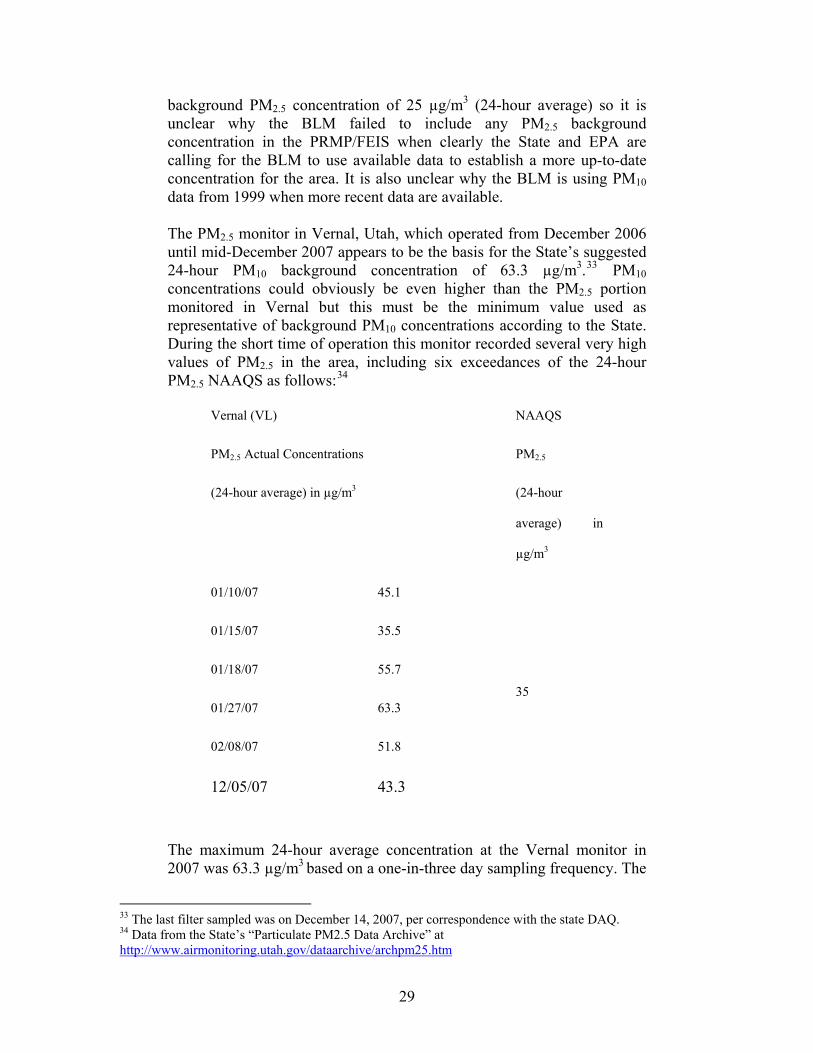
background PM2.5 concentration of 25 µg/m3 (24-hour average) so it is unclear why the BLM failed to include any PM2.5 background concentration in the PRMP/FEIS when clearly the State and EPA are calling for the BLM to use available data to establish a more up-to-date concentration for the area. It is also unclear why the BLM is using PM10 data from 1999 when more recent data are available. The PM2.5 monitor in Vernal, Utah, which operated from December 2006 until mid-December 2007 appears to be the basis for the State’s suggested 24-hour PM10 background concentration of 63.3 µg/m3.33 PM10 concentrations could obviously be even higher than the PM2.5 portion monitored in Vernal but this must be the minimum value used as representative of background PM10 concentrations according to the State. During the short time of operation this monitor recorded several very high values of PM2.5 in the area, including six exceedances of the 24-hour PM2.5 NAAQS as follows:34
Vernal (VL) NAAQS
PM2.5 Actual Concentrations
(24-hour average) in µg/m3
PM2.5
(24-hour
average) in
µg/m3
01/10/07 45.1
01/15/07 35.5
01/18/07 55.7
01/27/07 63.3
02/08/07 51.8
12/05/07 43.3
35
The maximum 24-hour average concentration at the Vernal monitor in 2007 was 63.3 µg/m3 based on a one-in-three day sampling frequency. The
33 The last filter sampled was on December 14, 2007, per correspondence with the state DAQ. 34 Data from the State’s “Particulate PM2.5 Data Archive” at http://www.airmonitoring.utah.gov/dataarchive/archpm25.htm
29
second highest 24-hour average concentration (the “high second high” value) was 55.7 µg/m3. Both of these observed 24-hour average concentrations are more than two times the background concentration of 25 µg/m3 used by the BLM for other RMPs in Utah. Keeping in mind that the concentration to be used as reflective of background should be determined by also evaluating “the meteorological conditions accompanying the concentrations of concern” (see 40 CFR Part 51, Appendix W, § 9.2.2), use of the maximum or high second high 24-hour average concentration from the Vernal monitor as the representative PM2.5 background concentration – either 63.3 µg/m3 or 55.7 µg/m3 – is the best way to ensure public health protection. These observed concentrations, where even the high sixth high concentration exceeds the NAAQS, indicate that the BLM must find a way to reduce PM2.5 emissions in the area in order to avoid violating the short-term PM2.5 NAAQS. Continuing to approve more development that adds fine particle emissions to the area will threaten attainment of the NAAQS. Nowhere in the PRMP/FEIS does the BLM acknowledge these nearby monitored exceedances of the short-term fine particle NAAQS. At these concentrations, any increase in PM2.5 emissions from development in the area (e.g., from off road vehicle use and from oil and gas development) will threaten the area’s compliance with the short-term fine particle NAAQS. In order to meet its obligations under FLPMA, the BLM must demonstrate that the proposed increases in primary and secondary PM2.5 emissions will not cause or contribute to violations of the PM2.5 NAAQS. The BLM has failed to do this in the PRMP/FEIS. The EPA, in its comments to the BLM on the EOG Resources Inc., Chapita Wells-Stagecoach Area Natural Gas Development FEIS stated that it “is particularly concerned with elevated daily PM2.5 concentrations measured in Vernal, Utah during 2007”. In particular, the EPA made the following recommendation:
“EPA recommendation: We suggest that the Record of Decision consider this new air quality information from the Vernal monitoring station and implement additional mitigation that would reduce air emissions or phase the development over a longer time period to maintain air quality within these standards as needed to reduce the risk of adverse health impacts to Vernal area residents.”35
The NAAQS were set to protect the public and the environment from the adverse effects from air pollution. Thus, in determining whether these air quality standards might be exceeded as a result of the BLM’s proposed
35 February 4, 2008 letter from Larry Svoboda, EPA region 8, to William Stringer, BLM Vernal Field Office, Re: Final Environmental Impact Statement (EIS) for EOG Resources Inc., Chapita Wells-Stagecoach Area Natural Gas Development, CEQ #20070549, pp 2-3.
30
action, the RMP must use background concentrations that are truly representative of the maximum concentrations that are currently occurring. Only by using a background concentration that is representative of the maximum concentration for the area will the public be assured that public health and welfare will be protected. Using a concentration that is significantly lower than monitored levels in the area leaves open the possibility (when concentrations as high as the NAAQS occur, as they already have in Vernal) that human health will be adversely affected as a result of future oil and gas development on top of all other air emissions sources in the area. Using a lower background concentration than what has been observed in the area simply ignores the real fact that higher levels can (and likely will continue to) occur in the area. The State describes the Vernal monitor in its PM2.5 area designation recommendations as follows:
“In this case it is not the mobile source emissions that dominate the inventory, nor is there a single large point source that could unduly influence the area. Population growth for the Uintah Basin is estimated at only about one percent per year (see Table 3.) Rather, it is the area source emissions from a source category that is not well understood. This area has long been a source of oil and gas deposits, and with the recent emphasis on exploration and development of domestic energy sources, there has been an upsurge in the industry surrounding this resource.”36
The State attributes the high PM2.5 values from the Vernal monitor to activities related to oil and gas development in the area which lends even more support to the use of these data for background concentrations when determining future impacts from oil and gas development in the area. The EPA recently revised the short-term PM2.5 standard because scientific information showed that the pollutant is a health concern at levels lower than what the previous standard allowed. PM2.5 can become lodged deep in the lungs or can enter the blood stream, worsening the health of asthmatics and even causing premature death in people with heart and lung disease. Fine particles are also a major contributor to visibility impairment. See the EPA’s staff paper on particulate matter (EPA-452/R-05-005a, December 2005) as well as the EPA’s Air Quality Criteria Document for Particulate Matter (EPA/600/P-99/002aF and EPA/600/P-99/002bF, October 2004) for more detailed information on the health effects of fine particles. And even PM2.5 concentrations lower than the current NAAQS are a concern for human health. In fact, the CASAC, in
36 Utah Area Designation Recommendation for the 2006 PM2.5 NAAQS, State of Utah, Department of Environmental Quality, Division of Air Quality, December 18, 2007, p. 34.
31
their recommendations to the EPA on the revised PM2.5 standard, unanimously recommended that the 24-hr PM2.5 standard be lowered from 65 µg/m3 to 30-35 µg/m3 and that the annual standard be lowered from 15 µg/m3 to 13-14 µg/m3.37 EPA set the standard on the high end of the CASAC recommended range for the short-term standard and chose not to lower the annual standard at all. In response, CASAC made it clear in their September 29, 2006 recommendation letter to the EPA that their recommendations were based on “clear and convincing scientific evidence” and that the EPA’s decision not to lower the annual standard does not provide for “an adequate margin of safety … requisite to protect the public health” as required by the CAA and, furthermore, that their recommendations were “consistent with the mainstream scientific advice that EPA received from virtually every major medical association and public health organization that provided their input to the Agency”. The BLM has an obligation, under NEPA, to evaluate all potential health effects from exposure to increased pollution under the various alternatives of an EIS. The fact that the EPA has set the PM2.5 standards at levels that some would claim are not adequate to protect human health should not limit the BLM to using only EPA’s standards. The BLM must assure adequate protection of human health from exposure to fine particles in the area and could certainly use the CASAC recommendations as a guide for achieving this protection. The PRMP/FEIS proposes increasing PM10 emissions and PM2.5 emissions over base year emissions by 67% and 43%, respectively (Air Quality Baseline Report Table 14 at 34). This, along with the fact that the BLM already has and continues to approve oil and gas development projects in the vicinity of the planning area without any comprehensive analysis of PM2.5 impacts makes it almost certain that PM2.5 concentrations in the area will threaten violations of the short-term NAAQS. In fact, the monitoring data from the Vernal monitor in 2007 support this trend. The Enduring Resources’ Saddletree Draw Leasing and Rock House Development Proposal EA (Rock House EA) (December 2007) predicted modeled violations of the 24-hour average PM2.5 and PM10 NAAQS as well as the 24-hour average Class II PM10 increment.38 The modeled PM2.5 NAAQS violations were based on a 24-hour average background concentration of 25 µg/m3. The BLM recently approved over 620 natural gas wells, close to 100 miles of road and an additional 5,000 horsepower of compression for the Chapita-Wells Stagecoach Area Natural Gas Development project as well as over 1,000 natural gas wells, over 200 oil wells, almost 900 well pads, 15 compressor stations and 170 miles of new
37 EPA-CASAC-LTR-06-003, Clean Air Scientific Advisory Committee Recommendations Concerning the Final National Ambient Air Quality Standards for Particulate Matter, September 29, 2006, http://www.epa.gov/sab/panels/casacpmpanel.html 38 See Rock House EA at 6-24 to -25 and Rock House Emissions Inventory, Criteria Summary Tab.
32
road for the Greater Deadman Bench Oil and Gas Producing Region and yet, neither of these EISs included a comprehensive analysis of PM2.5 impacts (i.e., near-field, far-field and cumulative impacts).39 The BLM cannot allow continued growth in fine particle emissions without assuring the public - through a comprehensive analysis of impacts - that concentrations of PM2.5 are not at levels that are harmful to human health. The PM2.5 emissions inventory for the PRMP/FEIS that proposes increases in PM2.5 and PM10 emissions by 67% and 43% likely underestimated emissions and, therefore, underestimates potential increases in emissions projected under the plan. The inventory assumed 50% control of fugitive dust emissions from well pad and resource road construction through water and/or chemical dust suppressants yet there is no enforceable mitigation measure in the FEIS to require this level of control. See Williams 1/14/08 Comment Letter at 10 for more details. New in the PRMP/FEIS is the additional statement that wetting is also assumed for maintenance traffic. Air Quality Baseline Report at 26. Also, the PRMP/FEIS does not address comments made during the SEIS comment period on the use of certain conversion factors for PM that result in potential underestimates of PM emissions from construction activities (Williams 1/14/08 Comment Letter at 11). Finally, and importantly, the BLM did not address concerns with the emissions estimates for off-road vehicles (ORV) - namely that the BLM must complete a more rigorous assessment of the emissions from this source using EPA’s AP-42 emission factors to estimate the fugitive dust emissions from travel of off-highway vehicles on unpaved roads and EPA’s MOBILE6.2 model to estimate ORV exhaust and brake and tire wear emissions.40 The BLM has failed to include any estimates for fugitive dust emissions from this potentially large source category and continues to base tailpipe emissions on a fraction of national 2000 emissions estimates from EPA that likely underestimate emissions in the Price planning area. See Williams 1/14/08 Comment Letter at 13 for more details. Southern Utah Wilderness Alliance (SUWA) specifically addressed deficiencies in ORV impacts in a letter to the BLM on June 19, 2008.41 SUWA provided documentation to support the type of emissions assessment that is needed for evaluating the impacts from this source category (e.g., one based on vehicle miles traveled and emission factors that do not employ dust suppression). Specifically, SUWA specified the need for modeling “ORV use on unpaved routes that would be authorized by its travel plan as well as ORV cross country use and predictable unauthorized use”. The submission from
39 See EOG Resources Inc. Chapita Wells-Stagecoach Area Natural Gas Development Final EIS UTU-080-2005-0010 (May 2007, Modified January 2008) and Greater Deadman Bench Oil and Gas Producing Region Final EIS UT-080-2003-0369V (January 2008) 40 See EPA’s AP-42, Section 13.3.2, Unpaved Roads, for more details on the associated emissions sources and how to estimate their magnitude. http://www.epa.gov/ttn/chief/ap42/ch13/index.html 41 Letter from David Garbett, SUWA, to Floyd Johnson, BLM (June 19, 2008).
33
SUWA identified specific projects where fugitive dust from travel on unpaved roads was a major factor in overall PM emissions, underscoring the importance of including solid estimates of fugitive dust emissions from ORV travel in its air quality analysis:
“In the WTP DEIS the BLM calculated the likely air quality impacts that would result from the travel of pickup trucks on unpaved roads and from the emissions of the truck engines. See Buys & Associates, Inc., Near-Field Air Quality Technical Support Document for the West Tavaputs Plateau Oil and Gas Producing Region Environmental Impact Statement in Appendix J – Air Quality Technical Support Document of the BLM, West Tavaputs Plateau Natural Gas Full Field Development Plan, Draft Environmental Impact Statement, UT-070-05-055 (Feb. 2008). Truck travel on unpaved roads creates significant amounts of fugitive dust, which results in high levels of both PM2.5 and PM10. See id. at 3 of 12 and 12 of 12. In the WTP DEIS modeling fugitive dust from truck traffic on unpaved roads was projected to be the major pollutant during oil and gas development activities. See id. at 3 of 12. In an oil and gas project recently approved by the Vernal Field Office of the BLM, levels of PM2.5 – principally from fugitive dust emissions from truck traffic – were projected to be high enough to exceed NAAQS. See Buys & Associates, Inc., Rock House Emissions Inventory for Enduring Resources’ Saddletree Draw Leasing and Rock House Development Proposal, Final Environmental Assessment UT-080-07-671 (Dec. 2007).” June 19, 2008 letter from SUWA to BLM.
The EPA also commented on deficiencies in the BLM’s PM analysis. Specifically, the EPA stated that it is “concerned that the DEIS does not address possible near-field impacts of fugitive dust that would have a greater potential to approach a NAAQS for particulate matter (such as the 24-hour standard for PM10) than a regional haze threshold” (EPA at 6). The EPA went on to say that the BLM should “discuss potential near-field impacts of fugitive dust in the FEIS” (EPA at 6). The BLM must perform a modeling analysis using the PM2.5 emissions inventory developed for the PRMP/FEIS (incorporating the inventory changes described above) in order to provide for compliance with the PM2.5 NAAQS, as required by FLMPA. And in addition to modeling primary PM2.5 impacts (directly emitted from combustion point sources and from fugitive sources in the planning area) the BLM should also consider secondary sources of PM2.5. Emissions of NOx, VOCs, SO2 and
34
ammonia can form, after emitted into the atmosphere, into PM2.5 and this could potentially be a significant component of ambient PM2.5 concentrations. Estimates of PM2.5 formation from these precursors should also be included in the BLM’s modeling analyses. It is quite possible that the high concentrations of PM2.5 that were recorded at the Vernal monitor are due in large part to the secondary formation of PM2.5 (e.g., sulfates and nitrates), as opposed to directly emitted [primary] PM (e.g., road dust and wood smoke). The high values mostly occurred during the wintertime and could therefore be associated with inversions that limit dispersion and provide conditions (e.g., high relative humidity) that contribute to the formation of secondary PM2.5 in the atmosphere. Since it is possible that the monitored high values in Vernal are due to gaseous pollutants that form fine particles after reacting with other compounds in the air during wintertime inversions then it would be very important for the BLM to consider these PM2.5 sources (e.g., NOx from diesel combustion) in its air quality impact assessment. All of the sources of the primary pollutants that contribute to secondary PM2.5 formation – e.g., NOx, SOx and VOC - from development in the Vernal management area must be accounted for in the BLM’s assessment of PM2.5 impacts. While the discipline of secondary PM2.5 modeling is still evolving there are tools available to support such an analysis. The EPA provides access to certain photochemical modeling applications, including modeling of secondary PM, for regulatory applications. Specifically, the EPA recently developed a model based on the Community Multi-scale Air Quality (CMAQ) model to support the development of the PM2.5 NAAQS. According to the EPA, the model has been shown to “reproduce the results from an individual modeling simulation with little bias or error” and “provides a wide breadth of model outputs, which can be used to develop emissions control scenarios”.42 The Comprehensive Air quality Model with extensions (CAMx) is another tool available to assess secondary PM2.5 formation. CAMx has source apportionment capabilities and can assess a wide variety of inert and chemically reactive pollutants, including inorganic and organic PM2.5 and PM10. The Regional Modeling System for Aerosols and Deposition (REMSAD) can also model concentrations of both inert and chemically reactive pollutants on a regional scale, “including those processes relevant to regional haze and particulate matter”.43 These are just some examples of current models with the capability to assess secondary PM2.5 impacts. It is imperative that the BLM use the available tools to assess the impact of emissions in the planning area that contribute to secondary PM2.5 formation. Resulting PM2.5 concentrations will be higher when
42 See http://www.epa.gov/scram001/reports/pmnaaqs_tsd_rsm_all_021606.pdf 43 See http://remsad.saintl.com/
35
considering the additional impacts from secondary PM2.5. Considering the already high PM2.5 background concentrations in the area and the fact that the BLM has not demonstrated compliance with the 24-hour NAAQS, the secondary PM2.5 impacts are critical to understanding the best way to mitigate health impacts from fine particle pollution within the Price planning area. All of these factors (i.e., the complete failure to model ambient impacts from PM emissions, the use of background concentrations lower than what has been observed in the area and potential underestimates of PM2.5 emissions) result in an incomplete assessment of PM2.5 impacts and therefore fail to meet the requirements of FLPMA to demonstrate compliance with all CAA requirements. It seems quite likely, based on all of the presented information (e.g., the recent monitoring data in Vernal, previous BLM project-specific analyses in the region, etc.) that compliance with the 24-hour PM2.5 NAAQS cannot be demonstrated for the Price planning area. Failing to fully evaluate all known PM2.5 emissions sources in a modeling analysis and failing to use a more representative background concentration when comparing PM concentrations to the NAAQS will result in an inability on the part of the BLM to assess PM2.5 impacts in the planning area. The extent of this unknown could be quite significant considering the recently monitored PM2.5 values recorded in Vernal. The BLM must ensure the scientific validity of this analysis per the requirements of 40 CFR § 1502.24. The BLM Failed to Complete a PSD Increment Analysis for the PRMP/FEIS The BLM has failed to complete an analysis to determine how much of the incremental amount of air pollution allowed in clean air areas (i.e., PSD increment) has already been consumed in the affected planning area and how much additional increment consumption will occur due to the proposed development under the RMP. Without this analysis, the BLM is not ensuring that air quality will not deteriorate more than allowed under the law (Clean Air Act). The BLM received comments from Vicki Stamper and me regarding the need for a comprehensive PSD increment analysis. See Public Comments and Responses – Price Draft RMP/EIS – Jul 2004 at 389 and Williams 1/14/08 Comment Letter at 16. In response to Ms. Stamper’s comments, the BLM claims that “[t]he BLM never does a PSD Increment Consumption Analysis” and that “[t]he BLM does not have the authority or responsibility to do such.” Public Comments and Responses – Price Draft RMP/EIS – Jul 2004 at 389. Yet, the Air Quality Baseline Report includes results from the PSD increment analysis of the BLM’s own Ferron Natural Gas EIS showing Class II NO2 increment violations (Table 15).
36
In fact, the BLM is required, under NEPA, to analyze and disclose all significant air quality impacts, regardless of whether another agency might address an adverse environmental impact in the future. The BLM must consider the PSD increments as important and legally binding Clean Air Act requirements and it must provide for compliance with these requirements in the FEIS. The PSD increments are separate ambient air quality standards not to be exceeded, as set out in §163 of the Clean Air Act, that apply in addition to the national ambient air quality standards in clean air areas. The BLM is required under FLPMA, 43 U.S.C. § 1712(c)(8), to “provide for compliance with” all Clean Air Act requirements, and thus the BLM cannot authorize an action that would allow the PSD increments to be exceeded. See also 43 CFR § 2920.7(b)(3) (requiring the same for land use authorizations). The BLM appears to be relying on the state to track and ensure compliance with PSD increments. However, reliance on the State to track PSD increment consumption and assess PSD increments during new source permit reviews cannot be a substitute for the BLM’s obligation under FLPMA to “provide for compliance” with the NAAQS and PSD increments. The types of oil and gas sources proposed in the RMP development (e.g., area sources and numerous smaller point sources) will likely not trigger the need for the operator(s) to obtain any PSD permits from the State and therefore, none of the referenced state analyses of increment consumption will occur. Utah’s minor source permitting regulations do not require increment consumption analyses (see Utah Administrative Code (UAC) R307-401). There are other provisions of the Clean Air Act and implementing regulations that require the protection of the PSD increments in addition to permitting requirements. The state must also track increment consumption in the area (and in any affected Class I areas) and the State Implementation Plan (SIP) should contain any necessary measures to assure that the increments are not exceeded. Specifically, the state is required to periodically review its plans for preventing significant deterioration (40 CFR 51.166(a)(4)) and if it determines that an applicable increment is being violated, then the state must revise the SIP to correct the violation (40 CFR 51.166(a)(3). However, the fact that the State has a legal responsibility to protect increments does not mean that the BLM is relieved of its responsibility under FLPMA to “provide for compliance” by the State with CAA requirements or its obligation under NEPA to fully describe the cumulative impacts of the proposed project and identify mitigation measures to prevent adverse impacts. In fact, the BLM has no assurance that the State will perform any analysis of increment consumption. If the State had performed such an increment tracking analysis for the area the BLM might properly rely on it to show that existing sources have not caused PSD increment violations. Without such an assessment to rely on,
37
the PRMP/FEIS must include an increment consumption analysis so that BLM’s obligation to develop and adopt sufficient mitigation measures may be included as part of the FEIS analyses and adopted as conditions in the Record of Decision. In the past, the BLM has also indicated that the predicted PSD increment violations in EIS documents should not be considered as real increment violations because they are modeled. However, since only emissions from major stationary sources which commenced construction or modification after the applicable “major source baseline date” and emissions increases from minor, area and mobile sources that occurred after the relevant “minor source baseline date” affect the allowable increment, an air quality monitor cannot distinguish between pollutant concentrations from sources that are part of the baseline and those from sources that consume increment.44 Therefore, it is impossible to use monitoring data to establish compliance with the PSD increments; the only way to determine compliance is to complete a modeling analysis. In comments on the Vernal RMP the State made it clear that the BLM must perform its own defensible PSD increment analysis as part of the planning process for the area.45 The same certainly applies for the Price planning area. The BLM must prepare an inventory of all emissions changes that have occurred since the major and minor PSD baseline dates and model those changes in emissions to determine compliance with the PSD increments. The BLM is required to do this not only to comply with its obligations under the Clean Air Act and the Federal Land Policy and Management Act, but also to comply with its obligations under NEPA to consider the direct and indirect impacts of the action, and its cumulative impacts. See e.g., 40 CFR §§ 1502.2(d), 1508.7, 1508.8. Furthermore, the BLM must base its PSD increment analysis on a comprehensive inventory of sources in order to meet its obligation to ensure the scientific validity of this analysis. 40 CFR § 1502.24. The BLM Failed to Complete a Cumulative Impacts Analysis The inventory of source emissions discussed in the PRMP/FEIS does not represent all sources that can and must be inventoried in order to make a full assessment of cumulative impacts in the areas impacted by sources throughout the planning area. The PRMP/FEIS states that:
The major source baseline dates are January 6, 1975 for SO2 and PM10 and February 8, 1988 for NO2 (40 CFR 52.21(b)(14)(i)). The minor source baseline dates in Utah differ by pollutant and by [baseline] area and were triggered on the date that a complete PSD permit application was received by the State DAQ (or by the EPA for sources proposing to locate in Indian Country). Baseline area designations in Utah include Indian Country (40 CFR 81.345). See definitions of “major source baseline date”, “minor source baseline date” and “baseline area” in the Utah PSD rules and 40 CFR 52.21(b)(14)(i), 52.21(b)(14)(ii) and 52.21(b)(15). 45 See August 2008 Vernal PRMP/FEIS Response to Comments by Resource AQ81 at 25.
38
“The cumulative impact analysis of air quality within and near the PFO includes major sources such as coal-fired power plants and cogeneration facilities. No other RFDs would increase regulated pollutants in the area.” PRMP/FEIS at 4-441.
In fact, there are many other sources, besides “major sources” that would increase pollutants in the area and must be included in a cumulative impacts assessment. Both Vicki Stamper and I identified several shortcomings in the BLM’s inventory, which were not addressed by the BLM in the PRMP/FEIS. 46 The areas impacted by development in the Price planning area have the potential to be impacted by oil shale and tar sands development. This type of development will likely include no “major sources” but rather a large network of smaller sources that, when taken together, will have significant impacts to the region. The BLM must identify all of the potential impacts from oil shale development in the PRMP/FEIS. See Williams 1/14/08 Comment Letter at 13. As mentioned earlier, the BLM‘s final Programmatic EIS for oil shale and tar sands development does not include any modeling of impacts from the proposed leasing program. The BLM also must include reasonably foreseeable future sources of air emissions in the West Tavaputs Plateau development area (again, primarily minor sources) as well as other NEPA projects and recently permitted sources that are not yet operating that could impact the Price planning area (e.g., power plants such as those listed in my 1/14/08 comment letter at 14 and coal mines such as the Lila Canyon and Horizon mines). The BLM failed to consider any of these sources in its so-called cumulative impacts analysis of air quality in the PRMP/FEIS. In fact, the BLM relies primarily on the woefully outdated Ferron Natural Gas and Price Coalbed Methane EISs to assess cumulative impacts. PRMP/FEIS at 4-441 to 4-442. There is no further quantitative (modeling) analysis of cumulative impacts presented in the PRMP/FEIS. The BLM must perform a full assessment of direct, indirect and cumulative impacts of each alternative and use the results as the basis for its planning decisions.47 The BLM must base its cumulative air quality analysis on a comprehensive inventory of sources in order to meet its obligation to ensure the scientific validity of this analysis. 40 CFR § 1502.24.
46 See Public Comments and Responses – Price Draft RMP/EIS – Jul 2004 at 386 and Williams 1/14/08 Comment Letter at 14. 47 BLM, “Land Use Planning Handbook,” H-1601-1, March 11, 2005, 22.
39
The BLM Failed to Assess and Address Impacts to Air Quality Related Values, Including Visibility The PRMP/FEIS does not include a cumulative assessment of impacts to air quality related values (AQRV), including visibility, at affected Class I areas. This type of analysis is needed in order to determine whether the Price RMP sources will cause or contribute to significant adverse impacts on AQRVs at affected Class I areas. The visibility modeling analysis should include a complete emissions inventory (for existing sources and other reasonably foreseeable development in the region as described in the section above) and should assess impacts at all Class I areas that could be impacted by the Price planning area sources, including Arches National Park, Bryce Canyon National Park, Canyonlands National Park, Capitol Reef National Park, Zion National Park, Grand Canyon National Park, Mesa Verde National Park and the Weminuche Wilderness Area. The PRMP/FEIS relies on the 1999 Ferron Natural Gas EIS to describe potential visibility impacts in the Price RMP. Specifically, the BLM says that if the compressors associated with the oil and gas development in the Price planning area are fueled by natural gas, the standard visual range could be reduced by more than 10% for 11 days at Capitol Reef National Park and 2 days at Canyonlands National Park and the standard visual range reduction could range from 5% to 10% for 47 days at Capitol Reef National Park and 16 days at Canyonlands National Park. PRMP/FEIS at 4-442. Since there is no commitment in the PRMP/FEIS to require the use of electric compressor engines these adverse impacts to visibility must be addressed in the FEIS for the Price planning area. Further, the BLM must consider impacts to visibility and other AQRVs (e.g., sulfur and nitrogen deposition) from the Ferron Natural Gas Project along with all other sources in the cumulative source inventory (including reasonably foreseeable development sources) in order to be able to assure the public there will be no adverse impacts to these values in affected Class I areas. The BLM states that “the potential for cumulative visibility impacts (increased regional haze) is a concern” (Air Quality Baseline Report at 23) yet the BLM has utterly failed to complete an analysis that can be used to address this concern.
40
III. Climate Change The PRMP Violates NEPA in Several Respects By Failing To Analyze the Impacts of Climate Change Because BLM chose to treat this issue with such a superficial and abbreviated discussion, important information about the effects of climate change, and the management options available to BLM in this changing environment, are missing from the PRMP. The PRMP provides no estimate of how much temperatures will increase in the Price Resource Area, or even in the Colorado Plateau generally, or how that increase may affect natural resources such as water, vegetation, wildlife, or any other resource managed by BLM. It is reasonable to expect, given that the area will get even hotter under credible climate predictions, that water will become more scarce, native plant and animal life will suffer, and wildfire will become more prevalent. And in light of those consequences, BLM should have provided management alternatives which addressed these predicted impacts. The PRMP addresses climate change for the first time—the draft resource management plan did not discuss climate change or its impacts on the public lands within the Price Field Office at all. However, the extent of the discussion of this important issue in the proposed plan is superficial at best. In a total of just a few paragraphs, the PRMP simply provides a generalized description of the phenomenon and notes that the Intergovernmental Panel on Climate Change predicted global increases of 1 to 4.5 degrees Fahrenheit over the next 50 years. See PRMP, Chapter 3. There is no discussion of climate trends in Utah, although such information is available from a variety of common sources of weather data. The PRMP attempts to explain away its lack of analysis by noting that “BLM does not have an established mechanism to accurately predict the effect of resource management-level decisions from this planning effort on global climate change.” PRMP, Chapter 4. However, the PRMP makes no attempt to utilize existing studies as the basis for any further information about how climate change—with expected warmer weather—may affect the resources of the Price Field Office, noting only that drier soils may be less stable and that species ranges may move north or to higher elevations in response to climate stress. Id. SUWA provided BLM with comments on the Draft RMP that highlighted this gap in the climate information, and included studies with specific information about the impacts of climate change on the Colorado Plateau—which includes the Price Field Office. These impacts are described more fully below, but include shrinking water resources; dust-covered snowpack causing earlier, faster snowmelt; invasion of more flammable non-native plant species; soil erosion; loss of wildlife habitat; and larger, hotter wildfires. As discussed below, BLM ignored these studies in the Price PRMP. Since the deadline to submit comments on the draft Price RMP and the release of the Price PRMP, several federal entities have published additional studies that confirm and reinforce the impacts discussed in SUWA’s comments on the draft and the studies cited
41
in those comments. These recent studies include: 1) U.S. Climate Change Science Program Final Report, Synthesis and Assessment Product 4.4, “Preliminary Review of Adaptation Options for Climate-Sensitive Ecosystems and Resources” (June 2008), available at http://www.epa.gov/ord/npd/pdfs/gcrp-factsheet_SAP-4-4.pdf; 2) Committee on Environment and Natural Resources, National Science and Technology Council, “Scientific Assessment of the Effects of Global Change on the United States” (May 2008), available at http://www.climatescience.gov/Library/scientific-assessment/; and 3) U.S. Climate Change Science Program, Synthesis and Assessment Product 5.2, “Best Practice Approaches for Characterizing, Communicating and Incorporating Scientific Uncertainty in Climate Decision Making,” (April 2008), available at http://www. climatescience.gov/Library/sap/sap5-2/public-review-draft/default.htm. These studies provide significant new information about the impacts of climate change on lands like those in the Price Planning Area, as well as emerging new best management practices to employ in the face of climate change. The June 2008 report, prepared by the Environmental Protection Agency, specifically “identifies strategies to address management challenges posed by climate change for a subset of federally protected lands and waters. These strategies can also be broadly applied to other lands and waters managed by governmental or nongovernmental entities.” U.S. Climate Change Science Program Final Report, Synthesis and Assessment Product 4.4, “Preliminary Review of Adaptation Options for Climate-Sensitive Ecosystems and Resources” (June 2008), available at http://www.epa.gov/ord/npd/pdfs/gcrp-factsheet_SAP-4-4.pdf. This information should have been included in the analysis of the RMP alternatives in order to adequately address climate change.
A. Failure to Take a Hard Look As the U.S. Geological Survey explains, “understanding interactions of landscape with changing environmental conditions, and their relative influence on the severity of drought, are important for natural resources planning and land use sustainability.” USGS, Drought Conditions, 1996 to 2006: USGS Navajo Nation Studies, http://geomaps. wr.usgs.gov/navajo/drought.html (last visited Sept. 1, 2008). Yet, despite the brief acknowledgment in the PRMP that the existence of climate change is no longer a matter of debate but a matter of scientific consensus, the PRMP does not take the logical—and required—next step and analyze what this means for the Price Field Office.
This is an important step. A description of the effects of climate change on existing conditions such as the prevalence of exotic plant species, the availability of water, the health of riparian areas, zones of soil erosion or vulnerability to erosion all provide critical baseline information necessary to BLM’s ability to determine whether the resources can withstand any of the proposed alternatives. Without this basic foundational information about the existing health of the land, it is impossible to make any informed decision about the level, location, and kind of activities it can support in the future. The Intergovernmental Panel on Climate Change noted in 2001 that:
42
for the future of rangelands, it is important to reduce the vulnerability of these systems to climate change. This is likely to be achieved by considering social and economic factors that determine land use by human populations . . . . Soil stability and thus maintenance of water and nutrient cycles are essential in reducing the risk of desertification. Any changes in these processes could make rangelands particularly vulnerable to climate change.
Intergovernmental Panel on Climate Change, Climate Change 2001: Impacts, Adaptation and Vulnerability, available at http://www. grida.no/climate/ipcc_tar/wg2/241.htm (internal citations omitted).
SUWA’s comments on the draft RMP provided specific information about federal studies that had been recently published about the impacts of climate change on public lands and grasslands like those in the Price Field Office. For example, the U.S. Climate Change Science Program working group published a report on September 11, 2007 which predicts and elaborates on the widespread impact of climate change on public lands in areas like the cold deserts of the Colorado Plateau. See U.S. Department of Agriculture, The effects of climate change on agriculture, land resources, water resources and biodiversity, available at http://www.climatescience.gov/Library/sap/sap4-3/default.php. That report notes that “the climate changes that we can expect are very likely to continue to have significant effects on the ecosystems of the United States.” Id. at 3 (emphasis added). These significant impacts include:
• Climate effects on disturbances such as fire, insect outbreaks and wind and ice storms are very likely important in shaping ecosystem structure and function;
• Grasslands will transform into woody shrublands with reduced capacity for water absorption and greater vulnerability to channelization and erosion;
• Droughts early in the 21st Century are likely to increase rates of perennial plant mortality in arid lands, accelerate rates of erosion and create opportunities for exotic plant invasions;
• Proliferation of non-native annual and perennial grasses are virtually certain to predispose sites to fire. The climate-driven dynamics of the fire cycle is likely to become the single most important feature controlling future plant distribution in U.S. arid lands;
• Climate change is likely to result in shrinking water resources and place increasing pressure on montane water sources to arid land rivers, and increase competition among all major water depletions in arid land river and riparian ecosystems;
• Major disturbances like floods and droughts that structure arid land river corridors are likely to increase in number and intensity (with associated increases in erosion and native plant loss);
43
• Land use change, increased nutrient availability, increasing human water demand and continued pressure from exotic species will act synergistically with climate warming to restructure the rivers and riparian zones of arid lands;
• Climate change will increase the erosive impact of precipitation and wind; • Surface soils will become more erodible; • Increases in wind speed and gustiness will likely increase wind erosion.
The report also notes that
[g]iven that many organisms in arid lands are near their physiological limits for temperature and water stress tolerance, slight changes in temperature and precipitation . . . that affect water availability and water requirements could have substantial ramifications for species composition and abundance, as well as the ecosystem goods and services these lands can provide for humans.
Id. at 9. While these findings are dramatic, the report further notes that “[i]t is likely that these changes will increase over the next several decades in both frequency and magnitude, and it is possible that they will accelerate.” Id. at 23. BLM should have discussed all of these predicted effects of climate in Chapter 3’s assessment of existing conditions and in Chapter 4’s discussion of the impacts of the various alternatives. Instead, BLM fails completely to describe the current and predicted impacts of climate change in Chapter 3, and attempt to characterize the state of knowledge regarding the impacts of climate as too thin to require analysis. PRMP 4-5 (“[t]he assessment of climate change pollutant emissions and climate change is in its formative phase; therefore, it is not yet possible to know with confidence the net impact to climate. . . .The lack of scientific tools designed to predict climate change on regional or local scales limits the ability of quantify potential future impacts”). However, at a minimum, a description of the effects of climate change on existing conditions such as the prevalence of exotic plant species, the availability of water and the health of riparian areas, zones of soil erosion or vulnerability to erosion, all provide critical baseline information necessary to BLM’s ability to determine whether public land resources can withstand any of the proposed management alternatives, including thousands of miles of newly-designated ORV routes and roads, and new mining and oil and gas development. Moreover, while wildfires have put unprecedented stress on BLM’s firefighting resources, there is no analysis in the PRMP of the costs of increased wildfire due to the altered conditions that come with climate change. Without this basic foundational information about the existing impacts of climate change on the land, and future expected impacts, it is impossible to make informed decisions about the level, location, and kind of activities the land and its ecosystems can support in the future.
This omission is a significant oversight given that federal departments and agencies including the Department of Interior, the Environmental Protection Agency, and U.S.
44
Geologic Survey have all published documents and/or provided public statements and even congressional testimony acknowledging the impacts of climate change on public lands resources. All of this information was readily accessible to BLM. Together with the failure to incorporate the newer studies cited above, this oversight amounts to a failure to take the necessary “hard look” at the challenge of resource management in the MFO, and an important aspect of that challenge. Importantly, leaders of both the Department of Interior and BLM have elsewhere gone further than simply acknowledging that climate change is a well-accepted phenomenon. On April 26, 2007, over a year before BLM released the Price PRMP, Department of Interior Deputy Secretary Lynn Scarlet testified before the House Interior Appropriations Subcommittee that global climate change could dramatically reshape America’s public lands with increased species extinctions and wildfire. As she put it, “On the ground, we’re seeing a lot of changes . . . some of them dramatic.” Dan Berman, ‘Dramatic’ effects of rising temps being seen on public lands, earthnews, http://www.earthportal.org/news/?p=93. Ron Huntsinger, BLM’s own science coordinator, said,
[w]e can anticipate further reductions in the level of allowable uses on public lands due to the loss of productivity and capacity . . . . The results are more fragile ecosystems, a greater susceptibility to the outbreaks of attacks by parasites and disease, increased vulnerability to wildland fire and erosion and an overall reduction in the carrying capacity of the land.
Id. Clearly, information about the impacts of climate change and the need to make adjustments in land use plans to address climate change were circulating in the Department of Interior and available to BLM at the same time it was developing the Price PRMP. Failure to incorporate this information in the PRMP amounts to a failure to take a hard look at a crucial aspect of the land use plan.
BLM’s bare statement regarding the presence of a level of uncertainty about the precise degree of future change in climate conditions in the Price Field Office does not excuse this failure. First, some degree of uncertainty does not justify a wholesale failure to address an issue. As the EPA report explained:
It is not possible to predict the changes that will occur, but managers can get an indication of the range of changes possible. By working with a range of possible changes rather than a single projection, managers can focus on developing the most appropriate responses based on that range rather than on a ‘most likely’ outcome.
U.S. Climate Change Science Program Final Report, Synthesis and Assessment Product 4.4, Preliminary Review of Adaptation Options for Climate-Sensitive Ecosystems and
45
Resources 9-14 (June 2008), available at http://www.epa.gov/ord/npd/pdfs/gcrp-factsheet_SAP-4-4.pdf. Additionally, NEPA contains specific requirements governing the treatment of uncertain conditions and imposes an obligation to state that existing evidence is inconclusive and to summarize the conclusions of that evidence. With respect to incomplete or unavailable information, 42 C.F.R. § 1502.22 provides in full:
When an agency is evaluating reasonably foreseeable significant adverse effects on the human environment in an environmental impact statement and there is incomplete or unavailable information, the agency shall always make clear that such information is lacking.
(a) If the incomplete information relevant to reasonably foreseeable significant adverse impacts is essential to a reasoned choice among alternatives and the overall costs of obtaining it are not exorbitant, the agency shall include the information in the environmental impact statement.
(b) If the information relevant to reasonably foreseeable significant adverse impacts cannot be obtained because the overall costs of obtaining it are exorbitant or the means to obtain it are not known, the agency shall include within the environmental impact statement:
1. A statement that such information is incomplete or unavailable;
2. a statement of the relevance of the incomplete or unavailable information to evaluating reasonably foreseeable significant adverse impacts on the human environment;
3. a summary of existing credible scientific evidence which is relevant to evaluating the reasonably foreseeable significant adverse impacts on the human environment, and
4. the agency’s evaluation of such impacts based upon theoretical approaches or research methods generally accepted in the scientific community. For the purposes of this section, “reasonably foreseeable” includes impacts which have catastrophic consequences, even if their probability of occurrence is low, provided that the analysis of the impacts is supported by credible scientific evidence, is not based on pure conjecture, and is within the rule of reason.
Given these regulations, BLM cannot rely on the so-called “uncertainties” relating to the impacts of climate change on the area to end the analysis with a simple acknowledgement of the phenomenon and a passing reference to BLM’s claimed
46
inability to “predict the effect of resource management-level decisions from this planning effort on global climate change.” BLM must do more, even where information is uncertain (and in this case, SUWA emphasizes that the information, with the detailed studies cited above, is not particularly uncertain).
But even BLM’s bare-bones excuse has it backwards. The point is not that BLM should predict how “management-level decisions” affect global climate change, but that BLM should factor how climate change affects the Price Field Office and develop management options that reflect the reality of the dramatic change that warming will cause all the resources in the Price Field Office. In other words, the predicted warmer, drier conditions will create fundamental change to the Price Field Office and BLM has simply ignored those coming changes, choosing instead to manage for the past, rather than for the future.
NEPA regulations require that NEPA documents address not only the direct effects of federal proposals, but also “reasonably foreseeable” indirect effects. These are defined as:
Indirect effects, which are caused by the action and are later in time or farther removed in distance, but are still reasonably foreseeable. Indirect effects may include growth inducing effects and other effects related to induced changes in the pattern of land use, population density or growth rate, and related effects on air and water and other natural systems, including ecosystems.”
40 C.F.R. § 1508.8(b).48 Again, the impacts of climate change were simply not discussed; such an omission violates this section of the NEPA regulations. Thus, it is clear that BLM has failed to take a hard look—or virtually any look—at the impacts of climate change on the public lands resources in the Price Field Office. We have noted elsewhere that the PRMP has not discussed the cumulative effects of various uses like ORV area and route designations, motorized recreation, and grazing on important components of the Price Field Office’s native ecosystems like riparian areas. These cumulative effects should be considered in the context of climate change and how
48 This regulation provides:
Effects include . . . Direct effects, which are caused by the action and occur at the same time and place. . . . Effects and impacts as used in these regulations are synonymous. Effects include ecological (such as the effects on natural resources and on the components, structures, and functioning of affected ecosystems), aesthetic, historic, cultural, economic, social, or health, whether direct, indirect, or cumulative.
47
these uses act synergistically with climate change to impact the resources of the Price Field Office.
B. Failure to Include an Alternative that Captures Mitigation Options for Climate Change
An understanding of the predicted impact of climate change should, in turn, shape in important ways the various alternatives under consideration by BLM. For example, given that so many of the predicted outcomes of climate change center on increased soil erosivity, dust storms, shrinking water resources, drier riparian areas, invasion of exotic plants, and the spread of hotter, larger wildfires, it is entirely reasonable to expect BLM to design alternatives that minimize soil disturbance as much as possible. And given that ORVs are associated with both the ignition of wildfires and the spread of exotic weeds, it is likewise reasonable to expect that BLM would design—and even designate as preferable—an alternative with far fewer than the six thousand miles of backcountry ORV routes that the PRMP contains. As noted above, BLM’s own science coordinator noted that the effects of climate change should result in a reduction in the allowed use of certain activities on BLM lands—yet such an option was not presented in management plan options. Instead, without information about the effects of climate change in the area, the plan proposes a mix of exactly the kinds of actions that would compound the deleterious effects of a warming climate. This is most notable in BLM’s overly-expansive network of roads and ORV trails, which was adopted without objective analysis after county officials and ORV groups presented the agency with trail map “wish lists.” Yet experts note that the “response of arid lands to climate change will be strongly influenced by interactions with non-climatic factors at local scales” including pressure related to the use of motorized off-road vehicles and grazing. See Ryan, MG “Land Resources” Section of the Climate Change working group report at 8, Attachment P to SUWA’s comments of the DRMP; See also id. at 35 (noting that grazing may reinforce and accentuate the effects of climate change, a result that is probably true for ORV use as well). In this regard, BLM’s failure to consult the scientific literature, and in particular EPA’s report, resulted in a fatally flawed document with none of the required options for managing a significant impact that will likely have systemic impacts throughout the Price Field Office. U.S. Climate Change Science Program Final Report, Synthesis and Assessment Product 4.4, Preliminary Review of Adaptation Options for Climate-Sensitive Ecosystems and Resources 9-14 (June 2008), available at http://www.epa.gov/ord/npd/pdfs/gcrp-factsheet_SAP-4-4.pdf. BLM should have drawn on EPA’s own research and consulted with EPA staff whose report “provides information on how existing practices could be adjusted, or new strategies developed, to address the effects of climate change on natural resources.” EPA, Global Change Research Program, Science in Action: Building a Scientific Foundation for Sound Environmental Decisions, Assessment Provides Strategies for Managing Natural Resources in a Changing Climate: Findings of the U.S. Climate Change Science Program Synthesis and Assessment Product 4.4 at 2, available at http://www.epa.gov/ord/npd/pdfs/gcrp-factsheet_SAP-4-4.pdf.
48
According to the report itself, these strategies involve increasing the resilience of ecological systems to climate change. Specific strategies include:
• Identifying and protecting key ecosystem features; • Reducing anthropogenic stresses like developments which affect native
vegetation and cause erosion; • Protecting a “portfolio” of several slightly different species or ecosystems,
which increases these chances that one or more will be suited to the new climate conditions;
• Protecting more than one example of a particular kind of ecosystem, which increases the chance of survival of that type if one or more others are lost in a catastrophic event;
• Restoring key intact ecosystems with important functions, like wetlands or riparian areas which confer resilience to flooding and provide necessary habitat for most native plants and wildlife;
• Identifying refugia where key species and ecosystem types have the highest likelihood of survival of climate change.
U.S. Climate Change Science Program Final Report, Synthesis and Assessment Product 4.4, Preliminary Review of Adaptation Options for Climate-Sensitive Ecosystems and Resources 9-18 to -21 (June 2008), available at http://www.epa.gov/ord/npd/pdfs/gcrp-factsheet_SAP-4-4.pdf. Importantly, the first option, reducing human-caused stressors, was judged to be the most effective strategy for increasing resilience to climate change among the three types of terrestrial ecosystems studied in the report. Id. at 9-61. This is also a defining aspect of the plan’s purpose—to manage human impact on the resources in the Price Field Office. Thus, BLM has abdicated an important part of its responsibilities by failing to present valid management options that can, over the long term, best ensure the sustainability of the full range of resources in the Price Field Office.
C. Violation of Secretarial Order 3226
Secretarial Order No. 3226 specifically requires BLM to consider and analyze potential climate change impacts when undertaking long-range planning exercises, when setting priorities for scientific research and investigations, when developing multi-year management plans, and/or when making major decisions regarding the potential utilization of resources under the Department’s purview.49
49 See http://elips.doi.gov/app_so/act_getfiles.cfm?order_number=3226 (emphasis added). By its terms the “Order is effective immediately and will remain in effect until its provisions are converted to the Departmental Manual or until it is amended, superseded or revoked, whichever comes first.” Id. at Section 4. The Order has not been amended, superseded, or revoked.
49
Section 3 of Secretarial Order No. 3226 is comprehensive and includes every type of land management activity under the Interior Department’s jurisdiction. In addition to the provision cited above, the order defines the activities that will trigger a climate change analysis:
Departmental activities covered by the Order include, but are not limited to, programmatic and long-term environmental reviews undertaken by the Department, management plans and activities developed for public lands, planning and management activities associated with oil, gas and mineral development on public lands, and planning and management activities for water projects and water resources.
Id. (emphasis added). As noted above, no analysis of potential climate change impacts was provided in the plan and EIS. BLM simply ignored the Secretarial Order, opting instead for the boilerplate insertion of superficial and incomplete information regarding climate change.
D. BLM Must Prepare a Supplemental Draft Which Addresses the Issue of Climate Change and its Impacts on the Price Planning Area
As noted above, BLM briefly discussed climate change in the PRMP, but entirely failed to mention it in the Draft RMP. But 40 C.F.R. § 1502.9(c)(1) requires BLM to prepare an SEIS if “[t]here are significant new circumstances or information relevant to environmental concerns and bearing on the proposed action or its impact.” The new climate change information should warrant an SEIS because it meets the threshold for “significant” new information, as outlined in 40 C.F.R. § 1508.27. Whether new information is significant is a function of both context and intensity. 40 C.F.R. § 1508.27. Context means that:
the significance of an action must be analyzed in several contexts such as society as a whole (human, national), the affected region, the affected interests, and the locality. Significance varies with the setting of the proposed action. For instance, in the case of a site-specific action, significance would usually depend upon the effects in the locale rather than in the world as a whole. Both short- and long-term effects are relevant.
40 C.F.R. § 1508.27(a). Intensity refers to “the severity of impact,” and should take into account several factors:
(1) Impacts that may be both beneficial and adverse. A significant effect may exist even if the Federal agency believes that on balance the effect will be beneficial.
50
(2) The degree to which the proposed action affects public health or safety. (3) Unique characteristics of the geographic area such as proximity to historic or cultural resources, park lands, prime farmlands, wetlands, wild and scenic rivers, or ecologically critical areas. (4) The degree to which the effects on the quality of the human environment are likely to be highly controversial. (5) The degree to which the possible effects on the human environment are highly uncertain or involve unique or unknown risks. (6) The degree to which the action may establish a precedent for future actions with significant effects or represents a decision in principle about a future consideration. (7) Whether the action is related to other actions with individually insignificant but cumulatively significant impacts. Significance exists if it is reasonable to anticipate a cumulatively significant impact on the environment. Significance cannot be avoided by terming an action temporary or by breaking it down into small component parts. (8) The degree to which the action may adversely affect districts, sites, highways, structures, or objects listed in or eligible for listing in the National Register of Historic Places or may cause loss or destruction of significant scientific, cultural, or historical resources. (9) The degree to which the action may adversely affect an endangered or threatened species or its habitat that has been determined to be critical under the Endangered Species Act of 1973. (10) Whether the action threatens a violation of Federal, State, or local law or requirements imposed for the protection of the environment.
40 C.F.R. § 1508.27(b). In a recent Ninth Circuit case, Center for Biological Diversity v. National Highway Traffic Safety Administration, 508 F.3d 508, 555 (9th Cir. 2007), involving an NHTSA rule for corporate average fuel economy standards for light trucks, the court found that climate change satisfied several of the “intensity” factors in 40 C.F.R. § 5108.27(b). First, the court found that although the NHTSA rule at issue may have an “individually insignificant” effect on climate change, it may nonetheless have a “cumulatively significant” impact, thereby satisfying 40 C.F.R. § 1508.27(b)(7). In addition, the court found that climate change will affect public health and safety, satisfying 40 C.F.R. § 1508.27(b)(2).
51
Caselaw underscores the importance of agency disclosure and public participation in an agency’s decision-making process. See, e.g., Wilderness Watch v. Mainella, 375 F.3d 1085, 1094 (11th Cir. 2004); Am. Iron and Steel Inst. v. U.S. Envt. Prot. Agency, 568 F.2d 284, 291 (3d Cir. 1977) (emphasizing that public participation “enables the agency . . . to educate itself before establishing rules which have a substantial impact on those regulated”); Big Hole Ranchers Ass’n, Inc. v. U.S. Forest Service, 686 F. Supp. 256, 260 (D. Mont. 1988); North Buckhead Civic Ass’n v. Skinner, 903 F.2d 1533, 1540 (11th Cir. 1990). If a proposed action does not fully undergo the NEPA process, NEPA’s purpose is undermined and the agency decision is insulated because final NEPA documents are not subject to a comment period. California v. Block, 690 F.2d 753, 771 (9th Cir. 1982). Here, BLM introduced an important issue concerning the future management of the Price Field Office for the very first time in the final plan. The public, interested parties, and those with expertise in climate change had no opportunity to review the information before the release of the final plan and provide input to BLM about its accuracy or completeness. This is a violation of NEPA’s objective to educate both the public and the decision maker, and as a result, the climate information should be improved and released for public comment in a draft plan and EIS. See Westlands Water Dist. v. U.S. Dep’t of Interior, 275 F. Supp. 2d 1157 (E.D. Cal. 2002) (NEPA process “broke down” where agency’s discussion of impact was not presented until after closure of comment period on draft EIS). See also 40 C.F.R. §§ 1500.2(d), 1503.1(a)(4), 1506.6 (2007) (all requiring public notice and availability of environmental documents so that interested persons and the agencies can be informed); Anderson v. Evans, 371 F.3d 475, 487 (9th 2004) (CEQ regulations require that the “public must be given an opportunity to comment on draft EAs and EISs, and public hearings are encouraged to facilitate input on the evaluation of proposed actions”).
52
IV. Cultural Resources SUWA incorporates the DRMP comments and protest letter for Price PRMP submitted by the Colorado Plateau Archaeological Alliance (CPAA). Based on CPAA’s comments and the management decisions in the PRMP (which did not change significantly from the DRMP) SUWA has the following concerns regarding cultural resource management as proposed in the PRMP.
A. Federal Law FLPMA obligates the Bureau of Land Management (BLM) to protect cultural, geologic and paleontological resource values (43 U.S.C. §§ 1701(a)(8) 1702(c)), whereas the National Historic Preservation Act of 1966 (“NHPA”) (16 U.S.C. § 470 et seq.) provides for enhanced consideration of potential impacts to these resources through a cooperative federal-state program for the protection of historic and cultural resources. In particular, Section 106 (16 U.S.C. § 470f) obligates the BLM to consider the effects of management actions on historic and cultural resources listed or eligible for listing to the National Register of Historic Places, as provided under NHPA. Section 110 of the NHPA requires the BLM to assume responsibility for the preservation of historic properties it owns or controls (16 U.S.C. § 470h-2(a)(1)), and to manage and maintain those resources in a way that gives “special consideration” to preserving their historic, archaeological and cultural values. Section 110 also requires the BLM to ensure that all historic properties under the jurisdiction or control of the agency are identified, evaluated, and nominated to the National Register of Historic Places. Id. § 470h-2(a)(2)(A).
B. Overview: General and Specific Concerns A detailed review of the PRMP has identified minor and major deficiencies as they relate to cultural resources. Among the more specific concerns are the absence of a clearly stated intent to initiate Section 106 compliance prior to the designation of off-road vehicle (ORV) routes; the designation of ORV routes in areas known to have high archaeological site densities but little or no baseline inventory data, and the failure of the agency to more aggressively embrace its Section 110 responsibilities to evaluate and nominate properties under its management jurisdiction to the National Register of Historic Places. 1. NHPA Section 106 CPAA raised the issue of Section 106 compliance prior to designation of routes for off-road vehicles in its comments on the DRMP, noting that the fundamental component of the transportation plan is the BLM’s intent to establish designated trails suitable for OHV travel, and the stated management strategy that Section 106 compliance (e.g., Class III inventories) will not be required prior to designation of routes currently in use. As CPAA noted in its comments, the failure of the BLM to conduct adequate analysis in the past related to OHV impacts along routes currently being used by motorized vehicles was and
53
still remains an abrogation of agency’s Section 106 responsibilities, and the failure of the agency to recognize or correct this deficiency in the proposed plan appears to perpetuate the agency’s failure to comply with Section 106 requirements in the past. Furthermore, the failure to require Class III inventories along routes prior to designation suggests the agency official has made a determination, as per 36 C.F.R. § 800.3(a), that travel route designations in such instances are not an undertaking as defined in 36 C.F.R. § 800.16(y). CPAA and SUWA disagree with any determination that designations of existing routes are not a federal undertaking. Section 36 C.F.R. § 800.16(y) clearly states that an undertaking is “a project, activity or program funded in whole or in part under the direct or indirect jurisdiction of a federal agency” (emphasis added). Clearly, ORV route designation is an activity managed by the BLM, and that BLM resources are being expended to plan for ORV route designation and enforce ORV travel restrictions. As such, it is an activity funded in whole or in part under the direct jurisdiction of a federal agency, and clearly meets the definition of an undertaking. As such, the agency official has a responsibility to determine whether this activity has the potential to cause effects on historic properties (36 C.F.R. § 800(a)) and to initiate the Section 106 process. BLM’s response to CPAA’s concern states that the agency will follow the guidelines set forth in an instruction memorandum (BLM IM-2007-030), and that according to the IM, a Class III inventory is not required prior to route designations on “existing” routes. BLM Response to Comments – WC Supplement, Sorted by Commenter at 42). It is important to note that the BLM’s response, and the IM are silent as to whether the guidance set forth in the IM applies to all “existing routes” or only those that have been the subject of a Class III inventory in the past for a specific project that created the route in the first place (i.e. seismic exploration, oil and gas development, etc). If the BLM interpretation that no surveys are required on all existing routes, the IM would be in direct conflict with the mandates in the statutes and federal regulations that require a Class III inventory for “undertakings.” Route designations are certainly undertakings, and if the routes have not been surveyed prior to the designation, then BLM must conduct a Class III inventory.
The proposed plan represents a conundrum of “conflicting policies.” The NHPA regulations require Section 106 reviews of “underatakings” which include ORV route designations. However BLM’s handbook, as well as the statewide protocol agreement, contend that route designations area exempt from Section 106 review. SUWA agrees with CPAA that federal law takes precedence over BLM guidelines and state protocol agreements that are in direct conflict with federal laws and their implementing regulations. In addition, the Advisory Council on Historic Preservation (ACHP), the independent federal agency created by Congress to implement and enforce the NHPA, has exclusive authority to determine the methods for compliance with the NHPA’s requirements, not the BLM. The PRMP must be modified to clearly state that:
• Designation of all ORV routes must be based on full Section 106 reviews
of all direct and indirect adverse effects resulting from increased
54
availability of route maps, and the associated increased access to backcountry areas and increased use of travel corridors resulting from formal designations.
• The PRMP should articulate that Class III inventory and site evaluations along designated routes will include all areas of indirect impacts, with specific focus on cultural resources in adjacent topographic settings that could be impacted by increased vehicular access. This should include, but not be limited to, the identification of sites with potentially intact cultural deposits that are visible from a designated route regardless of distance, and to all localities within 200 meters of an existing route or camp area (cf. Spangler, Arnold and Boomgarden 2006). The BLM’s response to CPAA that areas of potential effect (APE) will be determined in consultation with the SHPO is disingenuous given that the PRMP states that Section 106 clearances of existing routes is not required and hence no consultation with the SHPO is required.
• Route or area closures are an appropriate and proven management tool to mitigate the adverse impacts of ORVs on and around archaeological sites. The plan should clearly specify such a management strategy. The PRMP should clearly state “activities that contribute to site degradation may have to be limited or prohibited” to allow for area closures when it is determined that such activities are or will damage or otherwise cause adverse effects to cultural resources eligible for listing on the National Register.
• Class III inventories, site assessments and site mitigations must be completed prior to the designation of ORV routes, including existing routes and open ORV areas, and that cultural resource protection will be a fundamental goal of any transportation planning decision.
2. NHPA Section 110 Deficiencies
Section 110 of the National Historic Preservation Act unequivocally specifies the responsibilities of federal agencies to proactively identify, evaluate and nominate National Register-eligible historic properties under their jurisdiction or control. Section 110(2)(a) specifically mandates the agency implement a program to ensure “that historic properties under the jurisdiction or control of the agency are identified, evaluated and nominated to the National Register” (emphasis added). CPAA commented that the PRMP should include more robust Section 110 compliance efforts and expanded priority lists for National Register nominations. Although BLM’s response contends that it can take other actions and get the same result (See Response to Comments – WC Supplement, Sorted by Commenter at 47), the fact remains that Section 110(2)(a) of the NHPA unequivocally requires the BLM implement a program to ensure “that historic properties under the jurisdiction or control of the agency are identified, evaluated and nominated to the National Register.” There is no provision in the law that sites eligible for listing on the National Register need not be nominated if they receive the same protection as sites already on the National Register.
55
Hundreds if not thousands of known archaeological sites in the PFO are clearly eligible for listing under Criterion A in that the sites are associated with broad patterns of human prehistory on the Colorado Plateau; are eligible under Criterion C in that they embody distinctive characteristics of type, period or method of construction, or represent a significant and distinguishable entity, even if the individual sites lack distinction; and most importantly are eligible under Criterion D in that they have yielded or are likely to yield important information about the prehistory of the region. Euroamerican historic sites in the PFO would also be eligible under these three criteria, and potentially under Criterion B if they are associated with important individuals.
The stated intent expressed in the PRMP that the PFO will more aggressively pursue its Section 110 responsibilities through proactive surveys is laudable. However, the historic practice in BLM field offices throughout the West has been to prioritize budgets based on greatest demand, usually to the neglect of non-consumptive management initiatives. Given that non-energy-related BLM budgets have been static or have declined in recent years, there would appear to be little incentive for the PFO to prioritize funding for non-project-driven initiatives, including National Register nominations and non-project-drive Class II and Class III surveys. The PRMP must be modified to state that:
• Section 110 inventories will be prioritized within the field office budgets. • PFO will aggressively pursue the nomination to the National Register of
historic properties under its jurisdiction, including archaeological sites and archaeological districts of local, regional and national significance.
• The BLM will aggressively seek public input regarding which sites should be prioritized for nomination. This could include discussions with interested Native American tribes, the Utah Professional Archaeological Council, local and statewide historical societies, and historic preservation advocacy organizations such as the National Trust for Historic Preservation.
3. Areas of Critical Environmental Concern
As discussed in CPAA’s comments on the DRMP, ACECs are an effective management tool that allows enhanced on-the ground management of cultural resources in archaeologically sensitive areas, as well as an enhanced field office prioritization to address cultural resource concerns.
a. Desolation Canyon In the case of Desolation Canyon, the PRMP articulates the BLM’s intent to manage this area as an existing WSA and as a Special Recreation Management Area. Desolation Canyon is a nationally recognized recreation destination, but its cultural resources remain largely unknown and unstudied. The paucity of baseline data along the Desolation Canyon-Gray Canyon corridor prompted a collaborative partnership between CPAA and
56
the Price Field Office to document the nature, distribution and diversity of cultural resources along the canyon corridor, and to assess the adverse impacts of recreation on those sites (cf. Spangler, Davis et al. 2007; Spangler, Boomgarden et al. 2007; Spangler, Aton and Spangler 2007; Spangler, Jones et al. 2008). These data, derived from sites within and outside the National Historic Landmark boundaries, will facilitate a more proactive management of cultural resources subjected to intense recreational visitation.
While management as a WSA is an important component of future management objectives, the removal of the area from ACEC designation would diminish the priority of this region for aggressive proactive management of the remarkable and nationally significant cultural resources found there. See also Section XIII.A.5 of these comments for discussion of layering ACECs on WSAs. The potential for recreational impacts to archaeological sites of exceptional integrity and scientific/aesthetic value warrants more aggressive BLM management that could be better realized through an ACEC designation whereby limited BLM resources could be directed toward preservation (e.g., sensitive areas with higher-quality cultural resources would be prioritized for future inventories) and protection of high-quality resources. b. Range Creek Similarly, the PRMP would designate Range Creek Canyon as an SRMA rather than an ACEC, noting that 85 percent of federal lands there are protected through WSA prohibitions on development. The cultural resources of Range Creek Canyon have recently vaulted into national prominence, due in large part to the high density of intact sites that remain in remarkably pristine condition (cf. Spangler, Metcalfe and Barlow 2004). The extremely high integrity of these sites has been fostered by the absence of public access to the drainage, which has been gated for more than five decades. The scientific potential of this drainage to an understanding of Utah and Southwestern prehistory cannot be overstated, and its potential as an outdoor research laboratory for future generations of scientists is unprecedented. As such, aggressive BLM management of the Range Creek corridor and the cultural resources found there is clearly justified. The increased prioritization of Range Creek through an ACEC designation affords a rare opportunity for the BLM to proactively embrace its Section 110 responsibilities. It should also be noted that the formal nomination of Range Creek Canyon to the National Register of Historic Places as an archaeological district is nearing completion, and this was not reflected in the PRMP.
By the very nature of the SRMA designation, cultural resources within the Range Creek area would be managed for recreation values rather than for a unique opportunity to preserve and protect the intact scientific values that make this canyon unique. SRMA is a designation internal to the BLM, whereas ACEC designations are authorized by the FLPMA, and must be given priority in the planning process. As such, an ACEC designation can have prescribed management requirements that would provide the BLM with the incentive and tools to manage Range Creek for the preservation of its archaeology. More importantly, it could also require the BLM to develop an archaeological management plan for Range Creek.
57
The PRMP justifies the SRMA designation for Range Creek in two ways. First, the BLM argues that the designation as an SRMA is more consistent with the Utah Division of Wildlife Resource’s (UDWR) interim management plan for the Range Creek Wildlife Management Area (RCWMA), even though the UDWR-managed portion of the canyon is only 1,600 acres (the proposed SRMA is about 40,700 acres). With ninety-six percent (96%) of the lands under BLM management, such deference to a UDWR management plan is a clear abrogation of the federal agency’s responsibility to management properties under its control. This abrogation is further aggravated by the fact UDWR entirely lacks the archaeological expertise to appropriately manage these lands. This is reflected in the gross inadequacies of the interim UDWR management plan for Range Creek, which reflects the agency’s sole mission to foster wildlife and accommodate hunters, but offers little toward long term management of world-class archaeological resources.
Range Creek constitutes an irreplaceable archaeological resource unique in the lower 48 states. It has attracted the attention of National Geographic, Smithsonian Magazine, and countless other publications. The archaeology of Range Creek has already been the subject of two television documentaries with a third to air in 2009. Range Creek deserves, because of its world-class archaeology, the type of management and funding that designating it an ACEC will provide.
Also of considerable concern is the PRMP’s stated intent to manage lands outside of the locked gates differently and less proscriptively than lands inside the locked gates, even though the cultural resources and cultural landscape are the same. There appears to be no consideration of protective management of cultural resources on non-WSA lands outside of the locked gates, but rather they would “generally be protected by application of the cultural resource decisions and site avoidance, where possible, or documentation.” PRMP 4-343. This concern is particularly relevant due to proposed oil and gas development in Range Creek on non-WSA lands at the Turtle Canyon confluence. As demonstrated by recent surveys in this area (Spangler, Arnold and Boomgarden 2006; Spangler, Barlow and Metcalfe 2004), site density exceeds 20 sites per square mile and sites are found in all topographic settings, from the valley floor to high on cliff faces. While some of these sites have been impacted to a greater degree by vandalism than sites inside the locked gates (cf. Spangler, Arnold and Boomgarden 2006), most retain a high degree of site integrity that makes them eligible for listing on the National Register. Given the extremely high density of significant sites, site avoidance is not a realistic expectation. It is also emphasized that management for “documentation,” as stated in the PRMP, is not an option specified in 36 C.F.R. § 800 wherein impacts are to be avoided, minimized or mitigated.
4. Consulting Party Status
58
As discussed in CPAA’s comments on the DRMP, there is no overt indication in the EIS that the PFO intends to preclude public participation in the Section 106 process, nor is there any explicit assurance that officials intend to engage interested publics as consulting parties through the Section 106 process. The BLM’s response to CPAA (Response to Comments at 48) accentuates this concern with the statement that “It is the BLM’s position that the public is afforded ample opportunity to comply (sic) through the NEPA process and that a separate public participation process is not necessary.”
The BLM’s stated “position” undermines the spirit and intent of Section 106 of the National Historic Preservation Act in that it fails to recognize the distinction between the public comment allowed under NEPA and the opportunity for public participation under the NHPA. Under NEPA, interested publics may, at their own instigation, comment on federal actions. Under NHPA, the implementing regulations (36 C.F.R. § 800.2(d)(1) clearly mandate that the federal agencies shall seek out participation from those publics with an interest in the undertaking.
The PFO has systematically precluded public participation in the Section 106 review process, with the caveat that the public has ample opportunities to comment through provisions of the National Environmental Policy Act (Gubbins 2006, see also identical letters denying consulting party status to the Southern Utah Wilderness Alliance and the National Trust for Historic Preservation). SUWA agrees with CPAA that the federal regulations are explicit, that federal agencies shall “seek and consider the views of the public in a manner that reflects the nature and complexity of the undertaking and its effects on historic properties,” as defined in 36 C.F.R. § 800.2(d)(1). The PRMP must be modified to clearly state the intent of the agency to comply with public participation provisions of Section 106 of the National Historic Preservation Act, in addition to provisions for public comment through NEPA. Such participation is at the heart of the National Historic Preservation Act.
5. Best Available Data SUWA emphasizes CPAA’s concern that the PRMP is not based on best available data related to cultural resources. The document cites as a primary source a long-outdated Class I report (Spangler and Forsyth 1993) when there were two subsequent and much more detailed regional analyses available (Spangler 1995, 2002). The PRMP also failed to take into consideration the results of recent research conducted in the region, including Range Creek (Spangler, Barlow and Metcalfe 2004; Spangler Arnold and Boomgarden 2006) and Desolation Canyon (Spangler, Davis et al. 2007; Spangler, Boomgarden et al. 2007; Spangler, Jones et al. 2007). These reports are all on file at the Price Field Office and were available to planners. The failure of the PRMP to incorporate the best available data is reflected in the flawed statement that there are 2,033 cultural resource sites in the SHPO database. As CPAA points out, this number is grossly inaccurate and reflects carelessness on the part of BLM planners. All of Carbon and Emery counties are included within the jurisdiction of the PFO (as well as portions of Duchesne and Uintah counties). As of September 2007, and
59

well within the DRMP planning process, a total of 3,875 sites had been documented in Emery County and 2,661 sites in Carbon County (this does not include many hundred Nine Mile Canyon sites located in Duchesne and Uintah counties managed by the PFO). Given that more than 80 percent of these two counties are federal lands and that the vast majority of sites have been identified through Section 106 compliance activities, it can be stated with confidence that the BLM did not take into consideration in its planning process at least half of the known archaeological and historic properties under its jurisdiction.
60
References Cited Gubbins, Patrick
2006 Letter from Patrick Gubbins, BLM Price Field Office, to the Colorado Plateau Archaeological Alliance denying consulting party status for the West Tavaputs Plateau Natural Gas Fill Field Development Plan, dated April 21, 2006. Original on file, Colorado Plateau Archaeological Alliance, Ogden, Utah.
Spangler, Jerry D.
1995 Paradigms and Perspectives: A Class I Overview of Cultural Resources in the Uinta Basin and Tavaputs Plateau. Revised manuscript on file, Bureau of Land Management, Vernal, Utah.
2002 Paradigms and Perspectives Revisited: A Class I Overview of Cultural Resources in the Uinta Basin and Tavaputs Plateau. Revised manuscript on file, Bureau of Land Management, Vernal, Utah.
Spangler, Jerry D, Shannon Arnold and Joel Boomgarden
2006 Chasing Ghosts: An GIS Analysis and Photographic Comparison of Vandalism and Site Degradation in Range Creek Canyon, Utah. Utah Museum of Natural History Occasional Papers 2006:1. Salt Lake City.
Spangler, Jerry D., James M. Aton and Donna K. Spangler
2006 Baseline Site Condition Assessment of Historic Properties Near the Bureau of Land Management Sand Wash Ranger Station, Uintah County. Colorado Plateau Archaeological Alliance.
Spangler, Jerry D., K. Renee Barlow and Duncan Metcalfe
2004 Summary of the 2002-2003 Intuitive Surveys of the Wilcox Acquisition and Surrounding Lands in Range Creek Canyon. Utah Museum of Natural History Report of Investigations 03-1. Salt Lake City.
Spangler, Jerry D., Joel Boomgarden, Rachelle Green and Jamie Clark 2007 Desolation Canyon Baseline Site Condition and Vandalism Assessments: May 2007. Colorado Plateau Archaeological Alliance, Ogden, Utah. Spangler, Jerry D. and Cynthia Forsythe 1993 Continuity and Change: A Cultural Resource Class I Inventory of the Price River Resource Area, Bureau of Land Management. Manuscript on file, Price Field Office, Bureau of Land Management. Spangler, Jerry D., William Davis, Kristen Jensen , Kevin T. Jones and Joel Boomgarden
2007 An Intuitive Survey and Site Condition Assessment in the Desolation Canyon National Historic Landmark, Carbon County, Utah. Colorado Plateau Archaeological Alliance, Ogden, Utah.
Spangler, Jerry D., Kevin T. Jones, Andy Yentsch, Kristen Jensen, Joel Boomgarden and Shannon Arnold
2008 Desolation Canyon Baseline Site Condition and Vandalism Assessments: October 2007. Colorado Plateau Archaeological Alliance, Ogden, Utah.
61

V. Oil and Gas Development
A. BLM Must Analyze a “No Leasing” Alternative BLM has failed to consider a no leasing alternative in the Price PRMP. As part of its analysis BLM must consider a no leasing alternative—in addition to a no action alternative. Federal courts have made clear that a no leasing alternative should be a vital component in ensuring that agencies have all reasonable approaches before them. See, e.g., Bob Marshall Alliance v. Hodel, 852 F.2d 1223, 1228 (9th Cir. 1988). In particular, the Federal District Court in Utah recently issued a decision confirming that a no leasing alternative is a necessary part of any analysis permitting oil and gas leasing and development. See Southern Utah Wilderness Alliance v. Norton, 457 F. Supp. 2d 1253, 1262–64 (D. Utah 2006). This decision was issued subsequent to the public comment period on the draft RMP. The Price PRMP does not analyze the possibility of a no leasing alternative. See Price PRMP at 2-13 to -14. The prior land use plans for the Price Field Office—the Price River MFP and the San Rafael RMP—never considered a no leasing alternative; a no action alternative is not a no leasing alternative. Management framework plans are not NEPA documents and thus the Price River MRF and any management framework plan predating the San Rafael RMP cannot constitute adequate pre-leasing analyses that consider a no leasing alternative. See Southern Utah Wilderness Alliance, 164 IBLA 118, 123-24 (2004). The Environmental Assessment Supplement on Cumulative Impacts on Oil and Gas Categories, Price River Resource Area (1988), fails to analyze the no leasing alternative. The 1975 Price Environmental Analysis Record does not contain sufficient no leasing alternative analysis and could not be relied upon now for that necessary analysis. See Southern Utah Wilderness Alliance, 457 F. Supp. 2d at 1263–64. Hence, the BLM has never had before it the possibility of totally abandoning oil and gas leasing in the Price planning area, something it is required to consider. See Bob Marshall Alliance, 852 F.2d at 1228. BLM must fully analyze the no leasing alternative. The present analysis is insufficient.
B. The impacts analysis from oil and gas development understates the true effects of these activities; BLM should have considered directional drilling standards
The Price PRMP bases its analysis of oil and gas impacts in the planning area on the assumption that well density will not exceed one well per 80 acres and that most development will only occupy one well pad per 160 acres. See PRMP at M-5. However, this assumption is incorrect, as it is likely that many locations in the planning area will see up to one well per forty acres, a four-fold to two-fold increase in well density. The Independent Petroleum Association of Mountain States insists that 40-acre spacing will be necessary to develop the tight sands of the planning area. BLM, Response to Draft Comments, sorted by Resource, at 148. Furthermore, BLM has evaluated numerous projects in the Price planning area that would implement 40-acre spacing while rejecting full scale directional drilling. See, e.g., West Tavaputs Plateau Natural Gas Full Field
62
Development Plan, Draft Environmental Impact Statement, UT-070-05-055, at 2-11, 2-149 (Feb. 2008) (implementing 40-acre spacing and rejecting full field directional drilling). As a result of this improper assumption the Price PRMP drastically understates the negative impacts that will result to wildlife, wilderness character, air quality, soils and water resources, vegetation, and visual resources from the high density development that is likely to take place in the planning area. If the Price PRMP bases its impacts analysis on a 160-acre spacing assumption then it should limit operators to 160-acre spacing. On the other hand, through directional drilling operators could maintain 160-acre surface spacing and yet achieve 40-acre downhole density (or even greater densities). See Ken Kreckel, Directional Drilling: The Key to Smart Growth of Oil and Gas Development in the Rocky Mountain Region (submitted by The Wilderness Society) (attached as Exhibit O). Mr. Ken Kreckel, a geoscientist with significant experience exploring and drilling oil and gas in the region provided BLM with substantial information on the feasibility of directional drilling in the planning area and of the advantages from imposing directional drilling requirements on operators. See id. BLM failed to fully consider directional drilling standards for the Price PRMP and to require its implementation. This failure was arbitrary and capricious. Likewise, the Price PRMP understates the likely impacts to wildlife, vegetation, soils, and cultural resources because it assumes that all mitigation measures will be implemented. As The Wilderness Society explained in its comments on the Draft RMP, if the BLM relies on mitigation measures to diminish the impacts of oil and gas development on various resources then it must require those mitigation measures and assure itself that such mitigation measures are effective. The Wilderness Society, Comments on Price Draft RMP, at 27-29, 33-35. Without taking these steps the Price PRMP cannot assure the public that the impacts of oil and gas development will be diminished as the plan assumes. The Wilderness Society also provided BLM with substantial amounts of information regarding scientific research on the impacts of oil and gas development on wildlife. See The Wilderness Society, Comments on Price Draft RMP, at 29-33. For example, recent studies have shown that populations of sagebrush birds decline in areas with increased road density. Id. at 29. The Price PRMP completely ignores this research as it did not respond to it or incorporate its findings into its protective stipulations and therefore understates the impacts of oil and gas development on wildlife.
C. BLM Must Thoroughly Consider SUWA’s Proposed Castle County Heritage Alternative
The Price PRMP failed to fully consider and analyze a reasonable, feasible alternative proposed by SUWA in its Castle Country Heritage Plan, at least to the extent that this alternative proposed a definite scheme for oil and gas development. In its response to public comments BLM did not even explain this oversight. BLM has an obligation to fully analyze this reasonable, feasible alternative proposed by SUWA. BLM also failed to consider the Heart of the West Conservation Plan, as discussed in The Wilderness Society’s comments on the Draft RMP. Furthermore, BLM failed to fully consider a
63
directional drilling alternative which would require the implementation of directional drilling to minimize surface impacts. See Kreckel, Directional Drilling.
D. BLM Must Impose More Stringent Standards on Oil and Gas Development to Protect Sage Grouse Populations
BLM has failed to adopt adequate measures to protect sage grouse from the negative effects of oil and gas development. Clait E. Braun’s A Blueprint for Sage-grouse Conservation and Recovery (May 2006) (submitted by The Wilderness Society), attached as Exhibit L, represents the latest in scientific understanding regarding the impacts of oil and gas development on sage grouse populations. Despite this, the Price PRMP has ignored its recommendations. Among other things, Dr. Braun recommends that no surface impacts be permitted within 5.5 kilometers of any sage grouse lek. Braun at 6. He also indicates that timing-based stipulations—those stipulations which prevent development activity during certain periods but allow it during others—do not appear to provide any benefit for sage grouse. Id. BLM has not implemented this information and the Price PRMP would allow development within this protective buffer and relies on timing-based stipulations which will not provide benefits to any sage grouse populations. See, e.g., PRMP at G-2, G-6. BLM must impose more stringent standards on oil and gas development in sage grouse habitat. BLM has heightened obligations, owing to the sage grouse’s status as a sensitive species, to explain how its decisions will not result in a listing decision for the species. If BLM refuses to adopt the procedures and recommendations discussed by Dr. Braun then it must explain how the measures that it adopts will protect the sage grouse.
64
VI. Recreation
A. General Recreation Management
Recreation on public lands comes in a variety of forms, and over time, an increasing number of users seek to use these lands. On a limited quantity of terrain, only so many types of recreation can feasibly coexist without impairing the natural habitat and the qualities that attract users. The PRMP inadequately addresses recreational use within the Price Field Office. BLM fails to fully analyze impacts from ORV use and does not take into account how different uses impact the land and conflict with each other. By allowing a disproportionate level of ORV use within the management planning area, BLM is not maximizing the net benefits that will be received by recreational users of all types. A national study by Roper (2003) looked at participation rates over time (1995-2003) and found that off-road vehicle activities consistently ranked below non-motorized activities with walking, hiking and backpacking accounting for two-thirds or more of recreation visits, while OHV driving accounted for less than ten percent. Data from several states as well as national studies (the USDA Forest Service National Visitor Use Monitoring Program, the National Survey on Recreation and the Environment [see Cordell et al. 2004], and BLM’s Public Lands Statistics)50 all show that motorized use is consistently a small portion of total recreation visits to public lands. In addition, the Recreation Management Inventory System (RMIS) for the state of Utah show that in Fiscal Year 2004, non-motorized visits made up more than 50 percent of all visits. Motorized recreation visits only made up 20 percent.51 Throughout Utah BLM field offices, recreation trends have continually shown that a significant majority of recreation is non-motorized. Motorized recreation, despite the evident bias exhibited by the BLM through decisions made in the PRMP, tends to make up less than a quarter of all recreation. Nationally, regionally, and locally, the trend of recreational use is constant; the majority of recreation occurring on public lands is non-motorized. Stynes and White (2005) have shown that motorized and non-motorized visitors spend the same amount per day on tourism-related services. Therefore, due to higher rates of non-motorized recreation, it is easily extrapolated that traditional recreation forms create greater injections for local economies. Another study has shown that the economic value of a day of non-motorized recreation is, on average, higher than the value for the same day of motorized recreation. See Kaval and Loomis (2003). As discussed below, the Price Field Office is no exception to these general statistics when it comes to recreational uses. The PRMP is deficient in striking a balance for the 50 National Forest Visitor Use Monitoring Program National Project Results, January 2000 through September 2003. http://www.fs.fed.us/recreation/programs/nvum/national_report_final_draft.pdf National Survey on Recreation and the Environment: http://www.srs.fs.usda.gov/trends/Nsre/nsre2.html U.S. Department of the Interior, Bureau of Land Management, Public Lands Statistics: http://www.blm.gov/wo/st/en/res/Direct_Links_to_Publications/ann_rpt_and_pls/2006_pls_index.html 51 Source: Tina McDonald, Outdoor Recreation Planner, Recreation Management Information System (RMIS) Project Manager, USDI Bureau of Land Management, 2850 Youngfield St., Lakewood, CO 80215, Email [email protected]
65
management of the recreation needs in the planning area. Not only has BLM failed to adequately analyze current recreation data for the area, but also the agency does not minimize conflicts among recreational users as required by law.
1. BLM has not taken a hard look at recreational use in the planning area as required by NEPA
The PRMP fails to provide reliable data for recreational uses in the Price Field Office. BLM is quick to point out the flawed nature of the Recreation Management Information System (RMIS), but does not offer any additional data of its own to rely upon. The PRMP provides,
OHV use is perceived as the fastest growing activity in the PFO, but visitation data on recreation use can be particularly difficult to collect because of the dispersed nature of many activities. Improved information on the actual amount and the areas of recreation use would improve management and decrease potential for visitor conflict. PRMP at 3-75.
The PRMP goes on to provide data for recreation visitation in general for FY1991 through FY2001, but due to flaws in the RMIS prior to FY2001, the data for participants and visitor days were overestimated. PRMP at 3-75, Table 3-30. There is no way to tell from the PRMP whether recreation visitation has changed significantly in recent years. Although data from previous years can be helpful in showing changes over the years, the PRMP should contain the most recent and most reliable data available in addition to the data provided. In addition, it is apparent that BLM has made no attempt to update recreational use data or break down how often the field office is used by what kind of recreationist. This data is necessary for the evaluation of how recreational uses will be managed in the planning area. Instead, all that was provided in the PRMP was ORV registration for the state of Utah and for Emery and Carbon counties. This data only shows that there has been a general increase in registered ORVs and is not indicative of actual use. Furthermore, the PRMP does not provide any hard data on non-motorized uses in the planning area. BLM has not taken a hard look at this important use and must go back and provide the agency and the public with such information before issuing the record of decision.
2. BLM has failed to minimize conflicts between ORV use and other uses
BLM’s ORV regulations require the agency to designate areas and trails for ORV use “to minimize conflicts between off-road vehicle use and other existing or proposed recreational uses of the same or neighboring public lands, and to ensure the compatibility of such uses with existing conditions in populated areas, taking into account noise and other factors,” 43 C.F.R. § 8342(c), but the PRMP fails to comply with this duty.
66
Motorized users are affected minimally by non-motorized users. In contrast, non-motorized recreational users often feel displaced by motorized users. The scenic and physical impacts created by motorized users are far more noticeable than impacts caused by non-motorized users, and the noise that ORVs produce severely disrupts the natural experience. As a result, many traditional recreational users avoid areas where ORV use is known to occur. In areas open to both motorized and non-motorized recreation, this can largely exclude the latter. Therefore, not only are recreational opportunities and potential benefits to traditional non-motorized recreationalists reduced in the PRMP, conflicts are increased. The PRMP designates a total of nearly 1,300 miles of ORV routes scattered throughout the field office. PRMP at 274. Adding in the B routes (labeled “BLM/County Roads” on Map 2-74), the number jumps to 2,930 miles of designated routes. Around 400 of these miles were added to the PRMP which were not in the Draft RMP, even after many people described how this use conflicted with their recreational experience within the planning area. See generally, BLM Response to Comments. The BLM also states that the decisions in the PRMP will not minimize conflicts among users. The PRMP clearly points out the recreation conflicts that will be caused by BLM’s decisions in that document:
Because the various recreational pursuits might not always be compatible, recreation management actions could also affect recreation experiences if the action resulted in an increased potential for real or perceived user conflicts, such as users seeking OHV opportunities in the same areas that other users were seeking solitude and primitive recreation opportunities. PRMP at 4-242.
In addition, managing only four routes as open for OHV use within WSAs would provide access for the motorized user to some of the pristine back country in the San Rafael Swell. Because these areas are popular for hiking in the Swell, there would be continued conflicts between motorized and non-motorized users in this area. PRMP at 4-243.
This admission of impacts from motorized use is not minimizing conflicts among recreational users as required by law. Increasing opportunity for non-motorized recreationists should take priority over ORV use and motorized recreation in order to strike the proper balance in the planning area for recreational use and minimize conflicts between foreseeable incompatible uses. One way to do this would be to designate additional acreage for SRMAs for a more primitive experience in the field office, closed to ORV use and unavailable or subject to major constraints for oil and gas development. BLM has the burden during the planning process to explain how it will minimize these conflicts as required by the ORV regulations.
a. Requested Remedy
67
BLM must provide the most recent and reliable data on recreation uses in the planning area in order to fulfill NEPA’s requirement that the agency take a hard look at the costs and benefits of different forms of recreation, especially the benefits from non-motorized recreation, which also protects water, soils, vegetation, air quality and wildlife habitat. The PRMP does not make any attempt to provide this data or supplement any deficiencies from other data for the planning area. In addition, BLM must explain how it will manage recreation to minimize conflicts among users as required by the ORV regulations. The PRMP does not currently show that the BLM has even made a good faith effort to comply with these obligations. The agency could address this deficiency by designating additional special recreation management areas that prioritize non-motorized recreation.
B. Special Recreation Permits (SRPs)
1. The proposed issuance of “Letters of Agreement” must be standardized and enforceable.
We support the Price Field Office for its diligence in creating criteria for the issuance of SRPs. PRMP at Appendix J. We also support the policy of requiring groups of more than 14 people in WSAs and more than 24 people in all other areas to contact the BLM in advance. Id. at J-4. However, the important guidelines for SRPs established in Appendix J could potentially be undermined by the vague standards pertaining to Letters of Agreement, a provision that was not present in the Draft RMP criteria for SRPs. Unlike the detailed and clear flow chart for SRP issuance, the proposed method in the PRMP for issuing Letters of Agreement is ambiguous. Although BLM has created a matrix for determining when a SRP is not necessary, this is not nearly as specific as the matrix for SRP Classifications. Rather, it is focused mostly on health and safety concerns, bonding, and insurance. The two questions that may relate to protecting natural resources are simply, “Is the use appropriate to the site?” and “Does the activity further recreation program goals and objectives?” PRMP at J-4. These questions are vague and do not mandate an accurate assessment of potential damage to resources. Furthermore, the example of a Letter of Agreement provided in Appendix J, which is an overnight, 200-person camporee, directly conflicts with the SRP matrix, which would place this activity between an SRP Class I and Class II. This broad discretion leaves potential for Letters of Agreement to be inappropriately substituted for SRPs and issued based on criteria that do not comply with the BLM’s statutory and regulatory obligations. BLM acknowledges, “There are no Bureauwide or statewide thresholds based on group size, dictating whether an organized group permit is required. Such thresholds or other criteria for organized group permits are established through land use planning.” PRMP at J-4. However, the RMP does not establish specific thresholds for determining when an SRP is necessary, or when a Letter of Agreement will suffice.
68

BLM’s criteria for SRP issuance, set out in Appendix J, is thorough and specific, categorizing SRPs into four distinct classes, ranging from least intensive to most intensive, based on specific factors such as type of equipment, size of area used, number of participants, et cetera. Because the criteria are very specific (for example, surface disturbance of 5-40 acres ranks as “medium intensity”), BLM can easily determine whether to issue an SRP and where, and can better estimate cumulative impacts from such permits. BLM should incorporate Letters of Agreement into this flow chart, establishing specific thresholds for when an SRP is necessary. BLM states that a Letter of Agreement is not authorization to use public lands and is also not enforceable. PRMP at J-5 – J-6. However, a Letter of Agreement is documentation that an SRP is not required, and is therefore permission from BLM to conduct an activity without an SRP. BLM must be able to enforce Letters of Agreement in order to discourage circumventing of the SRP process. As a practical matter, it is unclear why BLM would want to have an additional vague category for organized groups that would normally need to obtain an SRP but are exempt from such use. BLM should take the opportunity provided by the system set out for SRPs to track and monitor how organized groups are using the lands in the planning area. If a group violates the terms of an SRP, but is still within the confines of the law, BLM still has recourse to enforce the SRP’s terms. The same is not true with a Letter of Agreement.
a. Requested Remedy BLM should incorporate issuance of Letters of Agreement into the current flow chart for SRP issuance in Appendix J so as to provide clear guidelines for when a Letter of Agreement may be appropriate in lieu of an SRP; these guidelines should ensure that Letters of Agreement are not substituted where the proposed activity would otherwise fall into Permit Classes I, II, III or IV. In addition, the terms of a Letter of Agreement should be binding and enforceable.
69
VII. ORV Area and Trail Designations and Travel Plan Decisions
A. Federal Law Governing Off-Road Vehicle Management Focuses on Protection of Resources
As SUWA noted in its comments on the DRMP, off-road vehicle (ORV) use on BLM lands is governed by FLPMA, its implementing regulations, and executive orders. Each of these governing authorities is based on concerns about the destructive effects of ORV routes and the use of ORVs, and the need to manage these impacts to protect the environment and other users of the public lands. See, e.g., 43 C.F.R. § 8340.0-2 (“[t]he objectives of these regulations are to protect the resources of the public lands, to promote the safety of all users of those lands, and to minimize conflicts among the various users of those lands”) (emphasis added). Thus, the guiding principle of these authorities is built on the assumption that ORV use may only be approved under certain circumstances and based on specific analysis and findings. Any presumption in favor of ORV use in a particular area, or the approval of ORV use without the requisite findings or analyses, violates the very foundation of these governing authorities. Other laws and policies also come into play regarding BLM’s management of off-road vehicles and the designation of ORV areas and trails, including NEPA, the National Historic Preservation Act, the Clean Air Act, the Clean Water Act, the Utah Riparian Management Policy, and the BLM’s 2006 “Clarification Guidance” for the development of ORV areas and trails.
B. The Price PRMP Fails to Comply with FLPMA and its Implementing Regulations
FLPMA requires that “[i]n managing the public lands the [Secretary of Interior] shall, by regulation or otherwise, take any action necessary to prevent unnecessary or undue degradation of the lands.” 43 U.S.C. § 1732(b). BLM’s duty to prevent unnecessary or undue degradation (UUD) under FLPMA is mandatory, and BLM must, at a minimum, demonstrate compliance with the UUD standard. See Sierra Club v. Hodel, 848 F.2d 1068, 1075 (10th Cir. 1988) (FLPMA land use standards provide the “law to apply” and “imposes a definite standard on the BLM”). FLPMA also mandates that the public lands be managed “without permanent impairment of the productivity of the land or quality of the environment.” 43 U.S.C. § 1702(c). In addition, BLM’s ORV regulations, which incorporate Executive Orders 11644 and 11989, state that the “objectives of these regulations are to protect the resources of the public lands . . . and to minimize conflicts among the various uses of those lands (emphasis added).” 43 C.F.R. § 8340.0-2. These regulations require BLM to ensure that areas and trails for ORV use are located “to minimize damage to soil, watershed, vegetation, air, or other resources of the public lands, and to prevent impairment of wilderness suitability.” Id. § 8342.1(a). Areas and trails “shall be located to minimize harassment of wildlife . . . . Special attention will be given to protect endangered or threatened species and their habitats.” Id. § 8341.2(b). Areas and trails “shall be located
70
to minimize conflicts between off-road vehicle use and other existing or proposed recreational uses of the same or neighboring public lands . . . taking into account noise and other factors.” Id. § 8342.1(c). BLM’s own 8340 manual explains that “minimizing” means that the agency should reduce impacts to the maximum extent feasible. See BLM Manual 8340 – Off-Road Vehicles (General) (1982). Finally, BLM is obligated to close routes to ORV use if ORVs are causing or will cause considerable adverse effects upon soil, vegetation, wildlife, wildlife habitat, cultural resources, historical resources, threatened or endangered species, wilderness suitability . . . or other resources until the adverse effects are eliminated and measures implemented to prevent recurrence.” Id. § 8341.2. Significantly, the PRMP fails to disclose the total miles of route to be designated, as it fails to disclose that an additional 1652 miles of route will be designated for motorized use, which are displayed on Map 2-74 as “BLM/County Roads. These routes are located on public lands, and are included in the BLM’s ORV route designations, according to Map 2-74. Thus, 2928 miles, not 1,276 as stated at PRMP ES-7, will be designated. The PRMP misleads the public and the decision-maker by stating that only 1276 miles of route (670 miles from the San Rafael Route Designation Plan and 606 miles of designated route in the PRMP) will be designated in this PRMP. Id. at 2-74. The PRMP must be corrected in order to provide accurate information to the public and decision-maker prior to the issuance of a final decision. As discussed below in greater detail (See Section C.2), the PRMP fails to minimize impacts to natural and cultural resources and fails to minimize conflicts with other users of the public lands, specifically non-motorized recreationists. Although moving to a designated route system from a generally open system could, conceivably, decrease and/or minimize resource-use conflicts, there is no analysis in the PRMP to support the contention that this is the case in the PFO. Indeed, with nearly 3,000 miles of proposed designated route, there may be little beneficial impacts to non-motorized users, as the web of routes is so dense that there are few places that non-motorized users can go to escape the sights and sounds of motor vehicles, with approximately 80% of the PFO available to ORV use. The Price PRMP transportation decisions and ORV area and trail designations of 2,930 miles of route, including 441 miles of route in agency-identified non-WSA lands with wilderness character, and 46 miles of route in WSAs, fail FLPMA’s UUD standard. See PRMP at ES-7, 2-74, 4-189. The proposed transportation decisions and ORV designations will harm natural and cultural resources in a number of important ways, including: unnecessarily increasing fugitive dust and degrading air quality; unnecessarily fragmenting wildlife habitat; causing unnecessary damage to riparian areas, floodplains, and cultural resources; unnecessarily reducing naturalness in areas with identified wilderness characteristics; and impairing Wilderness Study Areas.52 (Elsewhere in this
52 The PRMP includes a management decision that states that BLM will “[a]llow for reasonable access to non-BLM-managed lands within the PFO.” PRMP at 2-146. The PRMP should include a statement that BLM must comply with the Interim Management Policy (IMP) for wilderness study areas, as access can be
71
protest, we discuss the failings of the PRMP to consider how the proposed actions will exacerbate, and contribute to, the effects of climate change as well.) The PRMP should explicitly include a provision in the Travel Management section for a “closed unless posted open” policy, to minimize adverse effects to resources and other users in areas that are not open for ORV use. Although BLM might issue route and ORV area designation maps, the agency must ensure that its ORV management decisions are being observed on the ground. Implementing a “closed unless posted open” policy will assist BLM in enforcing its area and route designations (ORV users will not likely be tempted to remove “open” signs), and contribute to BLM’s mandate of minimizing impacts from ORV designations to natural and cultural resources. For the reasons discussed above and detailed in Section C.2, below, for individual resources, the PRMP does not comply with FLPMA, the minimization requirements of Executive Order 11644, and BLM’s ORV regulations. Specifically, the PRMP fails to minimize impacts to riparian and wetland areas, cultural resources, soils, vegetation, air quality, water quality, wildlife and wildlife habitat, WSAs, wilderness character areas, and other users. The PRMP, including Response to Comments, fails to disclose the purpose and need for the specific ORV area designations and the individual route designations, and fails to provide BLM’s analysis supporting a determination that each designated ORV area and trail and the transportation decisions minimize impacts to natural and cultural resources, and minimizes conflicts among users. BLM must conduct this analysis and make it available for public review before areas and routes are designated and determined available for use. C. The Price PRMP Fails to Comply with NEPA
1. Alternatives “An agency must look at every reasonable alternative, with the range dictated by the nature and scope of the proposed action.” Nw. Envtl. Defense Center v. Bonneville Power Admin., 117 F.3d 1520, 1538 (9th Cir. 1997). An agency violates NEPA by failing to “rigorously explore and objectively evaluate all reasonable alternatives” to the proposed action. City of Tenakee Springs v. Clough, 915 F.2d 1308, 1310 (9th Cir. 1990) (quoting 40 C.F.R. § 1502.14). This evaluation extends to considering more environmentally protective alternatives and mitigation measures. See, e.g., Kootenai Tribe of Idaho v. Veneman, 313 F.3d 1094, 1122–23 (9th Cir. 2002) (and cases cited therein). NEPA requires that an actual “range” of alternatives is considered, such that the Act will “preclude agencies from defining the objectives of their actions in terms so unreasonably narrow that they can be accomplished by only one alternative (i.e. the applicant’s proposed project).” Colo. Envtl. Coal. v. Dombeck, 185 F.3d 1162, 1174 (10th Cir. 1999) (citing Simmons v. U.S. Corps of Eng’rs, 120 F.3d 664, 669 (7th Cir. 1997)). This provided that is consistent with the IMP as well as the Cotter decision which addresses access to State lands surrounded by public lands.
72
requirement prevents the EIS from becoming “a foreordained formality.” City of New York v. Dep’t of Transp., 715 F.2d 732, 743 (2d Cir. 1983). See also Davis v. Mineta, 302 F.3d 1104 (10th Cir. 2002). The ORV area designations and the travel plan decisions included in this EIS are key examples of the aforementioned citations, with each alternative posing significant resource harms and no alternative that effectively mitigates those harms (i.e. all alternatives designate ORV areas and routes in riparian areas, culturally significant areas, proposed wilderness areas, etc). BLM should have fully considered and analyzed more environmentally protective alternatives consistent with FLPMA’s requirement that BLM “minimize adverse impacts on the natural, environmental, scientific, cultural, and other resources and values (including fish and wildlife habitat) of the public lands involved.” 43 U.S.C. § 1732(d)(2)(A). BLM should have fully analyzed the following three alternatives (or a combination of one or more alternatives that incorporated the resource protections inherent in each of these three alternatives): 1) the Castle Country Heritage Proposal (CCHP) alternative designed to protect natural resources including wilderness character areas and WSAs, and minimize conflicts among users, submitted by SUWA during the public participation process; 2) an alternative that would have minimized impacts to riparian areas by not designating routes or ORV use areas in or near riparian areas; and 3) an alternative that would have minimized impacts to cultural resources by not designating ORV use areas and trails before completing comprehensive surveys for cultural resources for the proposed ORV use areas and routes.53 Instead, the PRMP includes similar alternatives whose differences are not meaningfully distinct. The BLM’s rationale for refusing to include the CCHP as an alternative states, that “it does not meet the purpose and need for the land use plan because it does not address all of the resource values and uses the BLM is required to manage on public lands.” PRMP at 2-12. NEPA does not include this exception to its mandate. BLM is required to assess the CCHP’s reasonable and comprehensive management recommendations for oil and gas development areas, ACECs, ORV route designations and transportation decisions. Although BLM claims “the range of alternatives in the EIS encompasses the CCHP,” this is not the case. While some parts of the CCHP might be partially included in one or more of the alternatives, no alternative strikes the same balance of user needs and resource protection offered by the CCHP. 54
53 In the discussion of BLM’s failure to analyze the impacts of climate change, we also argue in this protest that BLM should have developed an alternative that would have addressed the predicted impacts and challenges of climate change. Development of such an alternative should have included the protection of large tracts of undisturbed ecosystems, as recommended by a study by the Environmental Protection Agency, released in June of 2008. U.S. Climate Change Science Program Final Report, Synthesis and Assessment Product 4.4, “Preliminary Review of Adaptation Options for Climate-Sensitive Ecosystems and Resources” (June 2008), available at http://www.epa.gov/ord/npd/pdfs/gcrp-factsheet_SAP-4-4.pdf. Such an alternative may have resembled the CCHP in significant respects, and more effectively protected valuable riparian areas. 54 SUWA incorporates into this protest our comments that were submitted for scoping and the DRMP, including our route-specific comments in SUWA’s DRMP Comments.
73
BLM must comply with NEPA’s mandate to consider a reasonable range of alternatives, by including the CCHP’s route designations and travel plan proposals in its alternatives analysis. BLM must issue a supplement that includes the CCHP and alternatives that protect riparian areas and cultural resources from impacts from route designation and ORV use, and it must allow the public and the decision-maker to review and comment on these alternatives prior to issuing the Record of Decision.
2. NEPA’s Hard Look and FLPMA’s ORV Regulations “Minimization” Requirement
NEPA requires that BLM take a “hard look” at the environmental consequences of a proposed action and the requisite environmental analysis “must be appropriate to the action in question.” Metcalf v. Daley, 214 F.3d 1135, 1151 (9th Cir. 2000); Robertson v. Methow Valley Citizens Council, 490 U.S. 332, 348 (1989). In order to take the required “hard look, BLM must assess impacts and effects that include: “ecological (such as the effects on natural resources and on the components, structures, and functioning of affected ecosystems), aesthetic, historic, cultural, economic, social, or health, whether direct, indirect, or cumulative.” 40 C.F.R. § 1508.8. (emphasis added). The NEPA regulations define “cumulative impact” as
the impact on the environment which results from the incremental impact of the action when added to other past, present, and reasonably foreseeable future actions regardless of what agency (Federal or non-Federal) or person undertakes such other actions. Cumulative impacts can result from individually minor but collectively significant actions taking place over a period of time.
40 C.F.R. § 1508.7. A failure to include a cumulative impact analysis of actions within a larger region will render NEPA analysis insufficient. See, e.g., Kern v. BLM, 284 F.3d 1062, 1078 (9th Cir. 2002). Additionally, indirect effects are those that are “caused by the action later in time or farther removed in the distance, but are still reasonably foreseeable,” including related effects on air and water and other natural systems, and growth inducing effects (i.e. publishing and distributing route maps will encourage increased ORV use on these designated routes, designating routes and ORV use areas in remote areas that have not been inventoried for cultural resources could be expected to increase damage and vandalism of cultural resources). 40 C.F.R. § 1508.8. In the context of the Price PRMP, the decisions made with regard to designation of ORV areas and trails and travel management fail to fully analyze the effects of those decisions on riparian and wetland areas, cultural resources, soils, vegetation, air quality, water quality, wildlife and wildlife habitat, wilderness character areas, wilderness study areas, and other users, as discussed below.
a. Riparian Resources
74
Riparian areas represent approximately 1%-2% of the total area of the PFO, yet they are one of the most critical components of the ecosystem, as they provide habitat for 75-80% of all wildlife species. FLPMA, the ORV regulations, and the Utah Riparian Policy require BLM to protect and minimize impacts to riparian areas. The objectives listed in the PRMP could be effective to protect the riparian resources and minimize impacts from ORV designation decisions if BLM’s subsequent decisions were consistent with these objectives. However, the proposed decisions fail to live up to the stated objectives. The PRMP fails to include critical baseline and other information, including: 1) a list of the PFO’s perennial stream segments and their associated functioning conditions (i.e. proper, at risk, or not in functioning condition); 2) the number of miles of route within and/or near riparian areas and the number of stream crossings by proposed routes (this information should also be depicted on a map showing riparian areas and route designations); and 3) an objective, scientific analysis of the impacts to riparian areas of designating nearly 3,000 miles of motor vehicle routes. The PRMP’s “analysis” of impacts is limited the superficial general statement: “Compared with the No action Alternative, the Proposed RMP would maintain existing soil, water, and riparian resource conditions by concentrating impacts on already disturbed areas, thereby reducing the extent of soil compaction.” PRMP at 4-19. The PRMP’s comparison between the PRMP and the No Action alternative does not suffice for the hard look and rigorous quantitative analysis NEPA requires. In addition, the PRMP fails to demonstrate how its decision to designate nearly 3,000 miles of route would “minimize” the impacts to critically important riparian areas – the keystone to the ecological health of the public lands managed by the PFO. Impacts from ORV area and route designations can be minimized and often avoided by prohibiting routes and ORV use in and near riparian areas. BLM must provide an analysis of the PRMP’s impacts to riparian areas from the ORV route designation and transportation decisions, and demonstrate how the ORV decisions are consistent with the ORV regulations before issuing its Final RMP.
b. Cultural Resources The PRMP acknowledges that activities that disturb the surface and subsurface can “destroy the cultural material and their spatial relationships” (PRMP at 4-36) and that ORV use “could result in significant impacts on cultural resources in the absence of mitigation [including] implementation of . . . Section 106 of the NHPA.” Id. at 4-37. The PRMP further notes that “[i]ncidental damage to cultural resource sites is generally concentrated within several hundred yards of roads.” Id. at 4-40. Although the “Management Guidance Common to All Alternatives” states that cultural resource inventories would be completed before approving “federal undertakings that could affect cultural resources (PRMP at 2-24), there is no indication in the PRMP that the agency will conduct cultural inventories of the proposed routes before designating the routes
75
open to ORV use. See id. at 2-74 (The PRMP states that the routes shown on Map 2-74 will be designated in the PRMP, and there is no mention of further survey work). The PRMP fails to disclose the routes or number of miles of route that have been previously surveyed for cultural resources, but it is very likely minimal, as less than 10% of all BLM lands have been surveyed for cultural resources, and there is no indication that PFO is different than that. Designating routes absent such inventories violates Section 106 of the NHPA, as well as BLM’s duties under FLPMA (duty to protect) and the ORV regulations (duty to minimize impacts). Although it might be cost-prohibitive to inventory the entire PFO during the RMP process, BLM must inventory all proposed routes prior to officially designating the routes in the RMP and transportation plan. If it is cost prohibitive to inventory all of the proposed routes, BLM must refrain from designating those routes that have not been inventoried in order to comply with FLPMA’s UUD mandate, the NHPA, as well as the ORV regulations’ minimization criteria. Moreover, if BLM is going to base its decision on cost, it must also weigh the high cost of the cultural artifacts that would be lost due to ORV access, damage, and looting. The PRMP concludes that “[c]ultural resources would be protected throughout most of the PFO because OHV use would be limited to designated routes” in approximately 20% more of the PFO area than under the No Action alternative. PRMP at 4-57. The PRMP provides no quantitative analysis of impacts to support the contention that limiting ORV use to designated routes fully protects cultural resources. For example, there is no data on which BLM could conclude that ORV use on existing routes has been anything but damaging to ORVs. A 20% improvement over existing levels of highly destructive use is not a meaningful improvement that adequately protects cultural sites. The change from managing areas as open to cross-country travel might be expected to reduce the impacts from ORV use (See Id. at 4-57), but there is no reason to believe that designating nearly 3,000 miles of route will “minimize” impacts to uninventoried cultural resources.. Without first completing cultural resource surveys for each ORV area and trail that it proposes to designate in the plan, BLM lacks critical information on which to base ORV area and trail designation decisions, and the resulting PRMP is not in compliance with NEPA’s hard look requirement, the NHPA, and FLPMA’s UUD and minimization mandates.
c. Soil and Water
The goals listed in the PRMP for soils and water (“minimize . . . damage to soils, including critical soils and biological soil crusts,” “maintain or restore the chemical, physical, and biological integrity of the area’s soils and waters”) could be effective to minimize impacts from ORV area and route designations if BLM’s subsequent decisions were based on these goals. See id. at 2-17.
76
However, it is doubtful that the travel decisions in the PRMP are consistent with these goals and statutory obligations. And, the lack of baseline information and analysis of the potential impacts make it impossible for the public and decision-maker to make informed decisions about the proposed actions and alternatives. For instance, the PRMP fails to disclose: 1) water quality conditions for water bodies, and the current conditions of riparian areas, sensitive soils, biological soil crusts; and 2) where, and how often designated ORV routes cross open waters (including streams, creeks and rivers), areas with biological soils crusts, and critical erosion areas. The PRMP merely restates the acreage associated with the proposed open, limited and closed areas, and concludes that “[c]ompared with the No Action Alternative, the Proposed RMP would maintain existing soil [and] water . . . conditions by concentrating impacts on already disturbed areas, there by reducing the extent of soils compaction. Maintaining the existing condition of riparian/wetland areas would reduce soils erosion and indirectly maintain water quality.” Id. at 4-19. As with riparian areas discussed above, the PRMP fails to include a map that shows route designations on the same map as open waters, biological soil crusts, and highly erodible soils. Without this information, the decision-maker cannot know if the PRMP minimizes impacts to these resources, as required by FLPMA’s ORV regulations. Reporting that the Proposed plan has more or less acres open or closed to cross-country travel than other alternatives completely fails to meet NEPA’s hard look requirement, and does not comply with FLPMA and the ORV regulations’ minimization requirement. Likewise, stating that by designating routes, the “existing” soil and water conditions would be “maintained” or that soil erosion would be “reduced,” with no supporting analysis, fails the ORV regulations minimization requirement as well as NEPA’s hard look requirement. The BLM should integrate the findings of the USGS ORV report, submitted as an attachment to SUWA’s letter dated June 12, 2008 on file at the PFO, into its impacts analyses, and provide quantitative analysis of the impacts of the ORV trail designations and travel management decisions on soils, including biological soil crusts, and water, and the impacts of these decisions to waters listed on the 303(D) list, to the public and decision-maker prior to issuing the Record of Decision.
d. Vegetation Including Special Status Species As with soils and water, discussed above, the PRMP’s stated goals and objectives regarding management of vegetation resources are sound, e.g., enhance or restore native and naturalized plan species. See id. at 2-19. However, the PRMP fails to include adequate analysis of the impacts that ORV routes and ORV use have on vegetation and the spread of invasive weeds. The PRMP’s “analysis” of the impacts of ORV area and route designations is limited to the following general statements: “Prohibiting cross-country OHV use throughout the PFO and prohibiting all OHV use on 557,000 acres (a 304 percent increase over the No Action Alternative) would greatly reduce the degree of disturbance to vegetation resources and the related changes to the composition and
77

structure of vegetation communities,” (Id. at 4-34); “Recreational and OHV users might trample special status species plants, erode habitats that support special status species plants, or remove pollinator species. These disturbances . . . can lead to increased mortality of plant species . . . [V]ehicles also act as dispersal agents for noxious of invasive weeds that compete with special status species plants or degrade special status species habitat.” Id. at 4-97. The PRMP would designated 2,930 miles of route, yet there is no analysis (quantitative or otherwise) of the impacts of these routes or how the decision – in keeping with the goals and objectives – will enhance native vegetation, or minimize the spread of noxious weeds. The PRMP contains no evidence that its ORV designations and the travel management decisions minimize impacts to vegetation, including the sensitive species. Reporting that the Proposed plan has more acres closed than the current plan, or merely acknowledging that ORV use could impact special status plant species or spread noxious weeds is not adequate for NEPA’s hard look requirement, and does not comply with FLPMA and the ORV regulations’ minimization requirement, and may violate the Endangered Species Act. The BLM must revise its impacts analysis, and include objective scientific analysis, and integrate the findings of the USGS ORV report, submitted as an attachment to SUWA’s letter dated June 12, 2008 on file at the PFO, into this analysis. BLM must disclose the quantitative impacts of the ORV and travel management decisions on vegetation, including special status species, and on the spread of invasive species to the public and decision-maker prior to issuing the Record of Decision.
e. Air Quality As noted in Section II of this protest letter addressing the Air Quality, BLM must perform comprehensive, complete modeling of the potential impacts associated with the PRMP’s ORV route and travel decisions. The fact that the implementation of the PRMP will result in air pollution (e.g., through approval of motorized use on designated routes) requires that such modeling and quantification be undertaken now. The 2,930 miles of route identified for designation in this plan will be open to motor vehicle travel, and will never face further analysis whereby better estimates might be developed. As part of the “hard look” requirement, NEPA demands that BLM determine baseline conditions so that it, and the public, can fully understand the implications of the ORV area and route designations and travel decisions. BLM has failed to do this here. In addition, BLM must assess the fugitive dust and tailpipe emission from motor vehicle routes and ORV activities in the planning area. SUWA specifically addressed this deficiency in a letter to the BLM on June 18, 2008. SUWA provided documentation to support the type of emissions assessment that is needed for evaluating the impacts from this source category (e.g., one based on vehicle miles traveled and emission factors that do not employ dust suppression, and for the fugitive dust generated from the existence of nearly 3000 miles of designated route). BLM has not addressed the potential impacts to air quality in the PRMP. In fact, the PRMP fails to even mention travel decisions and
78
ORV area and trail designations in the section devoted to the impacts to air quality, other than to state: “Use of equipment such as all-terrain vehicles and motorcycles would cause fugitive emissions of PM from traffic on unpaved rails, as well as vehicular emissions of PM, CO, NOx, and hydrocarbons. These impacts is expected to peak during weekends and holidays.” PRMP at 4-5. The existence of designated routes will generate fugitive dust even when not being traveled by vehicles (e.g., by wind blown dust). The PRMP should estimate the rate at which the 2,930 miles of route being designated will generate fugitive dust when not being traveled by vehicles (including wind movement data from the local region and dust production data gathered at incremental distances from the routes), estimate the number of vehicles that will use each route, and the likely fugitive dust generation rate, and generate a model to include those variables to understand the true impacts of fugitive dust emissions – from both the designation of areas and trails, and the associated use of those areas and trails. Dust and emissions studies have been conducted on public lands in the Mojave Desert, and PFO should avail itself of these studies to assist in its analyses. The PRMP’s failure to include an analysis of impacts on air quality from its ORV designations and travel management decisions does not comply with FLPMA’s mandate to comply with federal and state air quality standards, NEPA’s hard look requirement (including baseline information as well as impacts analysis) or with the ORV regulations’ minimization requirements. Implementation of the PRMP will result in air pollution (e.g., through designation of, and approval of motorized use on, designated open areas and routes), which requires that air quality modeling and quantitative analysis be undertaken before the Final RMP is issued.
f. Wildlife and Wildlife Habitat and Special Status Species Although the PRMP’s stated goals for wildlife include protecting and enhancing wildlife habitat (See id. at 2-30), it is not obvious that these goals are being carried out in the ORV route and transportation decisions, as the PRMP makes approximately 80% of the planning area available for ORV use, and will designate 2,930 miles of routes. These decisions leave few areas in which wildlife habitat will not be fragmented by ORV routes and in which wildlife will not be impacted by the disturbances caused by ORV use. The PRMP acknowledges that ORV use has impacts to wildlife:
Impacts resulting from OHV recreational use, even on designated roads and trails, could result in displacement and increased stress fro wildlife when these impacts are located in critical habitat or occur during critical time periods, and could also result in habitat degradation. OHV recreation use can alter the seasonal patterns of many wildlife species. Raptor nesting sites, big-game parturition areas, and all winter habitats are of particular concern. Closing area and establishing timing limitations could minimize these impacts.
Id. at 4-126 (emphasis added), and id. at 4-126 (“Increasing motorized access by 20 percent to 1,922,000 acres (including [2,930] miles of identified route) identified as
79
limited and that may be occupied by special status species could continue to introduce noise disturbance to species during sensitive periods and cause localized disturbance to habitats adjacent to routes.”) Although the PRMP acknowledges that ORVs and routes impact the wildlife resource, there is no analysis (quantitative or otherwise) of the impacts of the travel decision to designate 2,930 miles of route to the wildlife resource, or how the decision – in keeping with the goals and objectives – will protect and enhance wildlife habitat. The impacts analysis in the PRMP generally consists of superficial and analytically unhelpful statements that the Proposed plan has more acres closed than another alternative “ . . . some areas of the SRMA would be closed to OHV use, and in all other areas, OHV use would be limited to designated routes. This would minimize effects on fish and wildlife and their associated habitats, but there could still be short-term displacement from human disturbance.” Id. at 4-150 to -151; “ . . . an even greater area of big-game habitat would be closed to OHV use under the Proposed RMP than under Alternative A and the No Action Alternative.” Id. at 4-151; “continued management . . . would benefit fish and wildlife by limiting OHV use to designated routes in some portions of the area.” Id. at 4-148). In addition, the PRMP fails to disclose the number of miles of route designated in critical habitat, winter habitat, nesting sites, big-game parturition areas, omissions which make it impossible for either the BLM or the public to determine whether impacts to wjldlife are minimized. The PRMP should include a map that displays critical habitat and the other important wildlife avoidance areas with the proposed route designations. Without this information, it is impossible for the decision-maker and the public to determine if the PRMP minimized impacts to wildlife, as required by the ORV regulations. The PRMP contains no evidence that its ORV designations and the travel management decisions (2,930 miles of route, with 80% of the PPA available to ORV use) minimize impacts to wildlife including the special status species. Reporting that the Proposed plan has less impacts than some alternatives considered, but more than other alternatives considered is not adequate for NEPA’s hard look requirement, does not comply with FLPMA and the ORV regulations’ minimization requirement, and may violate the Endangered Species Act. The BLM must revise its impacts analysis to include scientific, quantitative analysis, and must disclose the quantitative impacts of the ORV and travel management decisions on wildlife, including special status species, to the public and decision-maker prior to issuing the Record of Decision.
g. Non-WSA Lands with Wilderness Characteristics Although the stated goals and objectives for managing non-WSA lands with wilderness characteristics is to “[p]rotect, preserve and maintain the wilderness characteristics,” (Id. at 2-46) the PRMP’s ORV and transportation decisions do not protect and preserve the wilderness characteristics of these areas. In particular, the PRMP will designate 441 miles of motor vehicle route (Id. at 4-189) within these areas – including the areas BLM is proposing to manage to protect the wilderness characteristics – even though the PRMP
80
acknowledges that ORV routes affect the naturalness of the area: “OHV routes create visible lines on the landscape. Depending on topography, the vegetation community, and observation point(s), those lines would be visible to varying degree . . . Moreover, removal of vegetation would reveal the underlying soil, which would often contrast in color and texture with the surrounding vegetation. This would further accentuate the change to the landscape.” Id. at 4-77 (emphasis added). In an attempt to play down these impacts, the PRMP states that, “[l]imiting OHV recreation use to these designated routes would minimize disturbance of adjacent lands, protecting the natural character of areas adjacent to these routes . . . [and] [o]ccasional use of the designated routes by OHV users would continue to provide management that allows for the protection, preservation, and maintenance of the wilderness characteristics in these areas.” Id. at 4-211. However, the PRMP fails to provide quantitative support for the assumption that ORV use would be “occasional,” or the conclusions that ORV use on designated routes will “protect” wilderness characteristics. In fact, surveys report that about half of ORV users ride off of designated trails, and that such use results in negative impacts on the naturalness of the area. See e.g. Off Highway Vehicle Uses and Owner Preferences in Utah (Revised), Prepared for Utah Dept. of Natural Resources, Div. of Parks and Recreation, Utah State Univ. (Jan. 18, 2002) at 20 (approximately 50% of ORV users state that they prefer to ride “off-trail” and on their most recent trip, did, in fact, ride off-trail); and Forest Service Discusses ATV Damage During Archery Hunt, Emery County Progress (Sept. 24, 2008) ("We discovered that a full 50 percent of ATV riders chose to ignore the signs and go around a closure.”), attached as Exhibits U (USU survey) and V (EmeryCo Progress article). BLM’s contention that routes in non-WSA lands with wilderness character will not impact the area’s natural character flies in the face of the agency’s own 1980 wilderness inventory documentation that included numerous statements regarding the existence of routes detracting from the naturalness of the area—which subsequently led BLM to drop areas from further wilderness consideration. BLM cannot have it both ways. Designating routes in wilderness character lands will encourage more motorized use of the trails and the existence of a well-used trail bare of vegetation affects the naturalness of the area and its future eligibility for wilderness designation. The PRMP contains no evidence that its ORV designations and the travel management decisions to designate 441 miles of route within wilderness character areas minimize impacts to the wilderness character lands. Stating that impacts from ORV use would be reduced as compared to the No Action alternative (See id. at 2-158) is not adequate for NEPA’s hard look requirement, and does not comply with FLPMA’s UUD provision or the ORV regulations’ minimization requirement. The BLM must revise its impacts analysis to include quantitative scientific analysis of the impacts to non-WSA lands with wilderness characteristics from the ORV and transportation decisions for the various alternatives, and disclose this analysis of the impacts to wilderness character areas from the ORV and travel management decisions to the public and decision-maker prior to issuing the Record of Decision.
81

h. Wilderness Study Areas As discussed in detail in Sec XIII of this protest letter, addressing WSAs and non-WSA lands with wilderness characteristics, BLM’s decision to permit motorized use on approximately 46 miles of “ways” – and possibly on trails that were not identified as “ways” in the BLM’s wilderness inventory – in the Sids Mountain and Desolation Canyon WSAs is arbitrary. PRMP at 4-307 (“approximately 46 miles” of routes would be designated within WSAs). See also Map 2-74. Due to these 46 miles of designated ORV routes, Sids Mountain WSA will be bisected – twice – by motorized routes. And although the PRMP states that all of the WSAs will be closed except Sids Mountain WSA (Id. at 4-307), PRMP Map 2-74 indicates that one or more routes would be designated within the Desolation Canyon WSA. In addition, BLM’s decision to allow motorized vehicles on a trail that was not identified in the BLM’s wilderness inventory as a way (the proposed route currently known as the Devil’s Racetrack) is arbitrary and a violation of the IMP.55 The PRMP fails to state a purpose and need for designating these 46 miles of ways and possible non-ways as open to motor vehicle use.56 The PRMP presents no documentation of the current appearance of these ways, or evidence that current motorized use on these ways is not causing impairment to the WSAs. In fact, the PRMP acknowledges that Sids Mountain WSA, where BLM will designate approximately 46 miles of route, is “popular for hiking . . . [and] there would be continued conflicts between motorized and non-motorized users in this area.” Id. at 4-243 (emphasis added). Subsequently, the PRMP contends, without supporting documentation, that designating routes “would not result in long-term loss of wilderness characteristics.” Id. The PRMP must disclose the adverse effects to the wilderness resources of naturalness, and opportunities solitude and primitive recreation from its proposal to designate 46 miles of ORV routes in the Sids Mountain and Desolation Canyon WSAs, and must explain how designating 46 miles of ways (and several miles of route that was not identified as a way) for ORV use “minimizes” impacts to wilderness suitability, as required by the ORV regulations. BLM’s proposal to designate 46 miles of ways in the Sids Mountain and Desolation Canyon WSAs will certainly encourage motorized use, and such use will eventually denude the trails of all vegetation. As vegetation is worn away and trails become linear swaths of sand and dirt, these trails will become a noticeable impact to the casual visitor and will affect the naturalness of the areas – which could deprive these WSAs of future wilderness designation. See Southern Utah Wilderness Alliance, 164 IBLA 33 (2004)
55 In addition to the PRMP’s failure to provide supporting documentation that the proposed route known as the Devils’ Racetrack is an existing way, there is no evidence that the proposed route location follows the old livestock trail. 56 It should be noted that Monticello PRMP Appendix N states that designating “ways” as open to motor vehicle use should be avoided first and foremost, and that designation requires a “very reasonable and clear justification.” Monticello PRMP Appendix N, at 24.
82
(even ongoing use of existing motorized recreational routes can lead to more damage to other resources, especially as interest in an area increases). Closure and restoration of all ways in WSAs is most consistent with the IMP and with protecting, and minimizing impacts to, natural and cultural resources in the Price Field Office. The proposed plan fails to comply with the IMP and ORV regulations, and the PRMP’s “analysis” fails to take a hard look at this management decision. BLM must revise the PRMP to disclose the potential impacts to WSAs.
i. Other Users There is nothing in the PRMP that demonstrates that the ORV area and trail designations minimize conflicts with other users of the public lands, specifically non-motorized recreationists. The PRMP would allow ORV use in approximately 80% of the PFO, yet presents no survey data to support this misallocation of resources. In fact, the PRMP acknowledges that Sids Mountain WSA, where BLM will designated approximately 46 miles of route, is “popular for hiking . . . [and] there would be continued conflicts between motorized and non-motorized users in this area.” Id. at 4-243 (emphasis added). The PRMP reports that closing areas to ORV use (22% of the planning area) “would decrease OHV recreation opportunities [but] would reduce conflicts with non-motorized recreation and enhance protection of natural resources.” Id. at 4-269. Although it might be true that the proposed decision to close this meager amount of acreage to ORV use will reduce conflicts, there is no indication that this decision will minimize conflicts with other users, as required by the ORV regulations. With nearly 3,000 miles of proposed route – including 46 miles of designated route within WSAs – ORV use is allowed in nearly 80% of the PFO. Thus, there may be little beneficial impacts to non-motorized users; the web of routes is so dense that there are few places that non-motorized users can go to escape the sights and sounds of motor vehicles. Before issuing the PRMP, BLM should conduct a visitor survey, similar to the Moab National Visitor Use Monitoring survey and pay particular attention to the relative use of non-motorized versus motorized recreation. See http://www.suwa.org./site/DocServer/BLMNVUMsurveyMoab.pdf?docID+2821. This study shows that non-motorized recreation is utilized by vastly more visitors to the Moab BLM-managed lands than motorized (ORV-based) recreation. In fact, the Moab survey found that motorized use accounted for less than 7% of visitors’ main activity. Having actual visitor information is essential to guide BLM’s long-term recreation management decisions and ORV area and route designation decisions. Merely stating that there will be beneficial impacts by moving from a predominantly “open” planning area to one that is managed predominantly as limited to designated routes, is not the equivalent of minimizing these impacts. Undertaking a visitor survey to ascertain actual visitor preferences and uses (motorized and non-motorized) would provide PFO with information on which to base informed decision, and comply with the ORV regulations’ minimization criteria. This data must be incorporated into the affected environment and environmental consequences analysis sections to more accurately depict the impacts to
83
non-motorized users of BLM’s ORV area and route designations and travel management decisions. BLM must comply with NEPA and analyze the impacts of its ORV area and trail, and travel management decisions -- including its decision to designate nearly 80% of the PFO available to ORV use, and make this information available to the public. The PRMP must be amended to incorporate adequate analysis and accurate baseline information prior to BLM issuing the Record of Decision.
j. ORV Area and Route Designation Process The PRMP fails to disclose the factors used by BLM to arrive at the various ORV area and trail designations and travel decisions. The PRMP states only that the goals of the transportation decisions are to:
• Upgrade and construct roads to provide essential access for resource management purposes.
• Continue to support Carbon and Emery counties and the State of Utah in providing a network of roads across public lands.57
PRMP at 2-146. The PRMP fails to include in its goals the mandates of BLM’s ORV regulations, which specifically require that ORV route designations be “based on the protection of the resources of the public lands . . . and the minimization of conflicts among various uses.” 43 C.F.R. § 8342.1. In particular, BLM must locate ORV trails “to minimize damage to soil, watershed, vegetation, air, or other resources . . . and to prevent impairment of wilderness suitability. . . . minimize harassment of wildlife or significant disruption of wildlife habitats . . . [and] minimize conflicts between off-road vehicle use and other existing or proposed recreational uses . . .” Id. BLM Instruction Memorandum No. 2004-005 advises BLM to “[c]hoose individual roads and trails” for designation, “rather than using inherited roads and trails.” IM Attachment 2-3 (emphasis added). The reason behind this recommendation is that “[m]ost existing roads and trails on public lands were created over time, rather than planned and constructed for specific activities or needs.” Id. For all proposed routes outside of the San Rafael Motorized Route Designation Plan (SRMRDP), it appears that the PFO did what the IM cautioned against -- “inherited” the existing, haphazard jumble of routes, as BLM proposes to designate 2,260 miles, in addition to the 670 miles in the SRMRDP. See PRMP at 2-74. There is no explanation or analysis in the PRMP that indicates that PFO chose individual routes that would protect resources and minimize impacts to resources and other users as mandated by the
57 To the extent the BLM simply adopted the counties’ or State of Utah’s R.S. 2477 highway claims in the route map, the decision is arbitrary and capricious and ignores the BLM’s own internal process for reviewing non-binding determinations and the claimants’ sole avenue for obtaining property interests against the federal government: the Quiet Title Act..
84
ORV regulations. In addition, the PRMP fails to provide a compelling purpose and need for the area and route designations and travel decisions. There is no information in the PRMP disclosing which areas and/or routes proposed for designation were found to have resource conflicts but were nevertheless included in the proposed plan. In addition, the PRMP Map 2-74 OHV Route Designations depicts proposed routes located in “closed” areas as depicted on Map 2-19 Off-Road Vehicle Area Designations. If this is a mapping error, BLM must correct this error before issuing the Final RMP. If this is not a mapping error and BLM, in fact, is proposing to designate routes within areas that it is purporting to close to ORV use, BLM must issue a supplemental PRMP that clearly states this intention, and provide this supplemental PRMP to the public and the decision-maker prior to issuing the final Record of Decision. Further, the PRMP states that five backcountry airstrips would continue to be open for use (See id at 2-146), yet nowhere in the PRMP is there any analysis of the impacts on WSAs, non-WSA lands with wilderness character, recreationists, and natural and cultural resources. As noted above with respect to route designations in closed areas, BLM must supplement its analysis to consider the impacts of this decision before the ROD is issued. Importantly, the PRMP fails to include an analysis of whether the proposed area and route designations are sustainable over the long term. To ensure that the agency has taken the required hard look, its analysis must be supplemented and provided for public review before the ROD is issued.
k. Incomplete Information The federal regulations address incomplete or unavailable information at 40 C.F.R. § 1502.22. In short, the regulations require that BLM do more than baldly assert that it lacks sufficient information to complete the NEPA analysis. The Price PRMP and DRMP’s lack of information on the impacts from ORV area and trails designations and travel management decisions to air quality, water quality, soils, riparian areas, vegetation, wildlife, non-WSA lands with wilderness character, WSAs, cultural resources, and other users, cannot be used as an excuse by BLM for not providing analysis of the potential and expected impacts from its ORV area and trail designations, and transportation decisions. BLM must do more before it authorizes motorized use in designated areas and on designated trails. Were it otherwise, agencies could simply, and easily, undercut NEPA’s insistence on informed decision making by failing to gather data relating to key determinative issues and then arguing that the information is unavailable or too difficult to obtain. That is precisely what BLM is attempting to do here. Due to this lack of information, the PRMP fails to comply with NEPA’s “hard look” requirement and fails to comply with the minimization criteria as required by FLPMA’s ORV regulations.
3. The PRMP Fails to Adequately Assess the Indirect and Cumulative Impact of ORV Area and Route Designations
85
The PRMP fails to adequately analyze and inform the public and the decision-maker as to the potential indirect and cumulative impacts to the natural and cultural resources from the ORV area and route designations and travel decisions. See e.g. PRMP at 4-441 (no discussion of ORV designations or ORV use in the air quality cumulative impacts analysis); 4-442 (no discussion of ORV designations or ORV use in soils, water, or riparian resource cumulative impacts analysis); 4-442 to -43 (no discussion of ORV designations or ORV use in vegetation cumulative impacts analysis); 4-443 to -444 (no discussion of ORV designations or ORV use in cultural resource cumulative impacts analysis); 4-445 (general statement that the Proposed plan would protect visual resources more than the No Action alternative, but less than Alternative E); 4-445 (no discussion of ORV designations or ORV use in the special status species cumulative impacts analysis); 4-446 (no discussion of ORV designations or ORV use in wildlife cumulative impacts analysis); 4-448 and 4-451 (general statement that cumulative effects on WSA lands and non-WSA lands with wilderness characteristics would vary depending on amount of ORV use allowed under various alternatives); 4-450 (general statement that cumulative effects on recreation and users would vary depending on amount of ORV use allowed under various alternatives); Clearly these statements, or lack thereof, fail to adequately assess the cumulative impact that the dense network of proposed routes have on wildlife, soils, vegetation, riparian areas, air and water quality, WSAs, non-WSAs with wilderness character lands, visual and cultural resources, and other users, when taken in combination with other past, present and reasonably foreseeable actions, including oil and gas development, vegetation treatments, grazing, and climate change. BLM must supplement the PRMP and provide an unbiased, scientific and quantitative analysis of the cumulative and indirect impacts of the ORV designations and transportation decisions, and provide the public a chance to review and comment on the supplemental information before a decision is issued that could significantly affect the very resources BLM is entrusted to protect.
4. The PRMP Does Not Describe the Existing Baseline Conditions and the Impacts of ORV Use in the Price Field Office
In order to evaluate the broad range of impacts required by a NEPA analysis, it is critical that BLM adequately and accurately describe the environment that will be affected by the proposed action under consideration—the “affected environment.” 40 C.F.R. § 1502.15. The affected environment represents the baseline conditions against which impacts are assessed. As SUWA noted in its comments on the DRMP, an accurate description of the baseline conditions of the Price Field Office is crucial to BLM’s analysis and description of the environmental impacts from the proposed action and various alternatives. All management decisions and strategies flow from the description of the current conditions. Unless BLM has an accurate, well-informed understanding of the current conditions, it cannot possibly begin to plan for future resource demands and needs. In particular, BLM cannot objectively decide how much ORV use to allow in the future, and which areas and
86
routes to designate, if BLM does not know how much and what kind of damage such use has caused in the past, and is causing right now. One of the most obvious and consequential flaws in the PRMP is its failure to assess the ongoing impact of existing ORV use in the Price Field Office. Instead of analyzing the current impacts of ORV use, BLM essentially treats existing ORV use as a given which it need not examine. BLM simply presumes that ORV use will continue and contends that such use will cause no damage over and above that which occurs now, and that the existing damage does not need to be studied. In other words, BLM has concluded that current levels of ORV use and the existing trails are consistent with FLPMA, including the UUD and the minimization requirements, even though it does not know what the impacts are. See also PRMP at 4-19 (limiting ORV use to designated routes “would maintain existing soil, water, and riparian resource conditions by concentrating impacts on already disturbed areas, thereby reducing the extent of soil compaction.”). This is a circuitous argument, it is not analysis. BLM must disclose accurate baseline information – concerning the natural and cultural resource – to the public and decision maker regarding the impacts of current ORV use and allow public comment before issuing final decisions for ORV area and trail designations and the travel plan.
5. Scientific Integrity and Public Scrutiny The agency must “insure the professional integrity, including scientific integrity, of the discussions and analyses in environmental impact statements.” 40 C.F.R. § 1502.24. Information regarding reasonably foreseeable significant adverse impacts that is essential to a reasoned choice among alternatives shall be included in an EIS if the costs of obtaining it are not exorbitant. Id. § 1502.22(a). In addition, NEPA requires that environmental information be made available to the public. “The information must be of high quality. Accurate scientific analysis, expert agency comments, and public scrutiny are essential to implementing NEPA.” Id. § 1500.1(b). This type of information and analysis is wholly lacking with regard to off-road vehicle area designations and the travel plan decisions in the PRMP. BLM must include site-specific documentation of the agency’s own analysis of the purpose and need for the area and trail designations, and the potential impacts associated with the designation and use of all proposed ORV areas and trails. This is critical information for the public and the decision maker to determine if BLM’s decisions comply with the mandates of FLPMA, the ORV regulations, and Executive Orders—all of which require that BLM locate ORV areas and trails to minimize damage to riparian areas and floodplains, soils, vegetation, wildlife and wildlife habitat, cultural resources, air and water quality, and to minimize conflicts with other recreationists—and BLM’s obligations under the Clean Air Act, Clean Water Act, Endangered Species Act, and National Historic Preservation Act.
87
The DRMP failed to present this information with respect to the various ORV area and trail designations and the transportation decisions under consideration and the PRMP did not correct these gross omissions. Without this information and data, the public has no way of discerning the basis for BLM’s decisions regarding the specific area and trail designations and travel plan, and cannot confirm that BLM has, in fact, ensured that these designations comply with the minimization requirements and other legal and policy obligations set out above. To address these deficiencies, BLM must provide specific information on the purpose and need for the ORV area and route designations incorporated in each alternative, the potential impacts to natural and cultural resources, the potential conflicts with other users, how those impacts can be mitigated or avoided, enforcement and monitoring requirements and schedules, and the manner in which designation of the areas and routes for ORV use is consistent with the agency’s obligations under FLPMA, CAA, CWA, ESA, NHPA and BLM’s ORV regulations and policy. In addition, the Price PRMP maps fail to adequately portray critical information to the public and decision maker. In order to provide high quality information for the public to review and assess, the PRMP’s ORV area and route designation maps (Map 2-74) must be modified to display the proposed ORV area and route designations with other resource inventories and/or management decisions, such as riparian areas, potential ACECs, wildlife habitat, non-WSA lands with wilderness character areas, wilderness character areas proposed to be managed to protect wilderness character attributes. See e.g. SUWA’s Price PRMP Route Designation Impacts map, attached as Exhibit D. BLM has this information at its disposal. The PRMP maps must be modified and re-issued so that the public and decision-maker can better understand the impacts of the ORV area and route designations on various resources before issuance of a Record of Decision.
88
VIII. Riparian Resources We incorporate by reference herein the comments to the Draft RMP submitted by The Wilderness Society into our protest, and we also discuss our further concerns below. The important role riparian and wetland areas occupy in the health and integrity of ecosystems throughout Utah and the West is recognized by the special protection conferred on them by several Executive Orders and the Utah BLM Riparian Management Policy. As the Utah BLM Riparian Policy explains, “[r]iparian areas comprise less than one percent . . . of public lands . . . in Utah . . . these small but unique areas are among the most important, productive, and diverse ecosystems in the state.” Utah BLM Riparian Management Policy, Instruction Memorandum No. UT 2005-091 at 1. The Utah BLM Riparian Policy continues:
The objective of the policy is to establish an aggressive riparian area management program that will identify, maintain, restore, and/or improve riparian values to achieve a healthy and productive ecological condition . . . .
Utah BLM Riparian Management Policy, Instruction Memorandum No. UT 2005-091 at 1 (emphasis added). To meet this objective, field offices are responsible for “ensuring that all new or revised management plans contain objectives and management actions to maintain or improve riparian resources,” and to the extent possible, “[m]aintain and/or improve riparian areas to Proper Functioning Condition (PFC) by incorporating riparian resource needs in Resource Management Plans (RMPs).” Utah BLM Riparian Policy at 2–3. This policy is binding on the BLM Price Field Office and provides the framework for the RMP process. Further, Executive Order 11990 mandates that BLM “shall take action to minimize the destruction, loss or degradation of wetlands, and to preserve and enhance the natural and beneficial values of wetlands in carrying out the agency’s responsibilities.” Exec. Order No. 11,990, 42 Fed. Reg. 26,961 (May 24, 1977). In addition to required substantive protections, BLM also must provide certain information and analysis, as required by NEPA, FLPMA, and the Utah Riparian Policy. NEPA requires that the environmental assessment process reveal the information required for the public to understand the current condition and proposed management of each riparian area. FLPMA, 43 U.S.C. §§ 1701–1785, § 1701(a)(2) (2000), declares that “the national interest will be best realized if the public lands and their resources are periodically and systematically inventoried.” The Utah BLM Riparian Policy explains that each field office is “responsible for . . . mapping and inventorying all riparian areas in [its] jurisdiction” and “will, to the extent possible . . . [i]nventory and map riparian areas within each office.” Utah BLM Riparian Policy at 3. The policy further explains that this responsibility:
89
will normally be completed during the Resource Management Planning (RMP) process. In order to be useful, the RMP, at a minimum will:
Contain the Field Office riparian area priority list.
Identify key riparian areas using PFC inventory and determine whether or not they are properly functioning systems.
Identify riparian areas for possible acquisition.
Identify riparian areas which meet policy tests for disposal or
exchange.
Identify easement acquisition which will improve Bureau management of existing riparian areas.
Identify riparian areas with outstanding qualities to be considered for
special designation or management.
Contain planning and monitoring objectives for riparian area management.
Utah BLM Riparian Policy at 7–8. The Price PRMP fails to provide much of the required information and analysis, and accordingly fails to reveal to the public the full impact of the Price Field Office’s riparian resource management decisions. In addition to omitting much of the information required by BLM’s own policy, the PRMP also lacks the information necessary to understand a riparian area’s category status, how it will be managed under the RMP, and the relationship between those two designations. The PRMP provides a table summarizing the total number of miles and acres of riparian areas in the decision area that are nonfunctioning, functioning at risk, or in proper functioning condition. PRMP at 3-17; Table 3-6: Condition of Riparian Habitat. This overall snapshot of the status of riparian areas in the entire decision area is helpful, but leaves the reader completely in the dark about which riparian areas are classified as fitting within each functional status category. While Map 3-4 marks each riparian area on a map of the entire decision area, it does not provide the specific information that would help the reader determine each riparian area’s exact location or functioning status. Importantly, although Map 2-19 illustrates the general areas subject to OHV routes and Map 2-74 marks each OHV designated route, the PRMP does not show on a map or even mention whether any of the OHV routes are located in riparian areas—which is likely, given that riding in riparian areas is a common practice in southern Utah. The Utah Riparian Policy disallows “new surface disturbing activities . . . within 100 meters of riparian areas unless it could be shown that: a.) there are not practical alternatives or, b.)
90
all long term impacts can be fully mitigated or, c.) the activity will benefit and enhance the riparian area.” Utah Riparian Policy at 4; see also PRMP at 4-390. The PRMP, however, does not discuss whether any of the OHV routes are within 100 meters, or 330 feet, of a riparian area and if so, whether the OHV use meets one of the three criteria that would allow such an intrusion into the protected riparian zone. Further, the PRMP provides no indication of the cause of the current status of each riparian area. As we stated in our comments to the DRMP, “[t]he Price RMP should identify all riparian and wetland areas, assess their current health and level of function, and analyze how management prescriptions in the various alternatives of the plan will affect the ecological function of such areas.” SUWA Comments to the DRMP at 13. SUWA’s comments urged BLM to “link these findings [of the total miles and percentage of riparian areas currently in proper functioning condition, functioning at risk, or not functioning] with land uses and management.” Id. at 50. Without this information, the public cannot fully understand BLM’s proposed management of riparian areas or meaningfully participate in the decision-making process. We can only guess that BLM created a list of each riparian area, its status, the probable cause of its status, and how it will be managed when gathering the information presented in the table and maps, and utilized this information in making management decisions; this information, including indication of when the inventory was conducted, should have been available to the public by publishing it the PRMP. Until BLM provides this information, the public cannot discern whether BLM has implemented aggressive, protective riparian management decisions, as required by the BLM Utah Riparian Policy. Inclusion of such information in the PRMP is required by statute, the Utah BLM Riparian Policy, and judicial review standards against agency action that is arbitrary, capricious, and contrary to law. Even with the information BLM does provide in the PRMP, BLM does not appear to have complied with its own policy to aggressively protect riparian areas. The Utah Riparian Policy clearly states that “[r]iparian areas are to be improved at every opportunity.” Utah BLM Riparian Policy at 4. The Price Field Office, however, fails to utilize most of the opportunities before it in this RMP process to improve riparian areas. While the Price PRMP explains the benefits of protecting riparian areas, it fails to adequately impose such protections on riparian resources in the Price Field Office. Further, the PRMP repeatedly explains the serious damage OHV use, grazing, and other interference inflict on riparian areas, but still allows such activities in many riparian areas. These failures demonstrate that BLM is falling short of meeting its responsibility to “maintain or improve riparian resources” and to “provide leadership . . . to preserve and enhance the natural and beneficial values of wetlands.” See Utah BLM Riparian Policy at 1; Exec. Order No. 11,990, 42 Fed. Reg. 26,961 (May 24, 1977). For example, the PRMP discusses the ecology of soils and riparian areas, explains generally how OHV use destroys these fragile ecosystems, asserts goals of maintaining and restoring riparian areas, and yet seems to authorize OHV use in and near riparian areas in the Price Field Office. The PRMP clearly states that “[a]ll riparian areas in the PFO are considered sensitive and important habitats,” and “[s]ome soils in the PFO have a . . . high susceptibility to water or wind erosion when disturbed, and high runoff
91
potential.” PRMP at 3-17 (internal parenthetical omitted); 3-9. This problem is exacerbated by surface disturbance. As the PRMP explains “[a]ccelerated erosion occurs when the plant cover is depleted or soil surface conditions are degraded. Management activities that affect vegetation or compact soil surface can also lead to accelerated erosion. . . . trails . . . increase[e] the energy of the erosional forces.” Id. at 3-9 (internal citations omitted). “When the vegetation or biologic crust on these soils is removed, such as by surface disturbance . . . or heavy grazing pressure, the soils are subject to accelerated erosion.” Id. at 3-10. “When the vegetation cover or soil crust is removed, soils are easily transported by wind.” Id. “Using heavy equipment or vehicles on unprotected, wet, or moist soils can lead to compaction or destruction of soil structure and aggregate stability.” PRMP at 3-10. According to the PRMP, surface disturbance increases erosion ten-fold. “Under good vegetation cover, soil loss is less than 1 ton per year . . . [w]hen these soils are disturbed, 10 tons per acre per year could be lost.” Id. at 3-10. “This results in the displacement or loss of topsoil, increased sedimentation, and impacts on ambient air quality from elevated dust levels.” Id. The PRMP asserts that its objectives include “[m]anag[ing] resources to maintain or restore overall watershed health and reduce erosion, stream sedimentation, and salinization of water,” and “[m]anag[ing], maintain[ing], protect[ing], and restor[ing] riparian and wetlands areas to the proper functioning condition,” and yet despite the known, negative impacts OHV use has on riparian areas, the PRMP appears to allow OHV routes to cross and run near riparian areas. Id. at 2-17, Table 2-2: Soil, Water, and Riparian. While the PRMP did not provide the means to clearly see the relationship between OHV routes and riparian areas, comparing Map 2-74: OHV Route Designations Proposed RMP and Map 3-4: Riparian Habitats seems to indicate much overlap between riparian areas and OHV routes. For example, the maps show that BLM has proposed to designate motorized use in the Price River corridor, which is known for its riparian, historical, and cultural resources, and that qualifies for protection as a Wild and Scenic River (T16S 12E, Sections 28 SW, 33 NW, SW and SE, T17S R12E Sections 4 NE, SE, 3 SW and SE). Contrary to claims made in the PRMP, because of the overlap between riparian areas and OHV routes, limiting OHV use to designated routes does not do enough to protect riparian areas. The PRMP says that it “would maintain existing soil, water, and riparian resource conditions by concentrating impacts on already disturbed areas.” PRMP at 4-19. OHV users have been known to ride in streambeds, sometimes unknowingly mistaking them for trails; this trend would render some riparian areas “already disturbed.” The PRMP does not discuss this possibility. Furthermore, the fact that an area has already been affected does not necessarily justify subjecting it to further disturbance. BLM’s responsibility is not just to maintain existing conditions, but also to “protect” and “restore;” allowing OHV use in and near riparian areas does not meet this standard. Another example is the PRMP’s rollback of current protections for the water table in riparian areas. The current management plan assures that “[t]he water table in wetlands and riparian areas would be maintained or restored.” PRMP at 2-18, Table 2-2: Soil, Water, and Riparian. The PRMP, however, states that the water table would be maintained or restored “when feasible.” Id. This rollback could render riparian areas
92
even more vulnerable to OHV use and invasive species, and less able to provide habitat for a myriad of species. Additionally, the PRMP failed to even recognize several stretches of riparian areas. Map 3-4 marks the areas the PRMP acknowledges as riparian areas; this map reveals that sections of waterways, such as the Green River, Price River, and Range Creek, are mysteriously not marked as “riparian areas.” The PRMP definition of “riparian area” states that “[t]ypical riparian areas include lands along, adjacent to, or contiguous with perennially and intermittently flowing rivers and streams.” PRMP at GL-17. The PRMP provides no explanation as to why certain sections of waterways do not meet this definition and therefore will not benefit from the protections afforded the other, recognized riparian areas. Comments to the DRMP submitted by SUWA, The Wilderness Society, and many others urged BLM to seriously protect and monitor riparian areas. As we stated in our comments to the DRMP, protecting riparian areas “is likely to require cessation of ORV use and livestock grazing in all riparian areas.” SUWA Comments to the DRMP at 13. Nationwide, we have lost far too many riparian areas; the Price Field Office has the responsibility to protect the riparian areas that still remain.
93
IX. Socioeconomic Impacts The socioeconomic analyses in the Price Proposed Resource Management Plan (PRMP) are inadequate. Several notable deficiencies in the Draft RMP and the Supplements were brought to the attention of BLM in our comments. These deficiencies have not been addressed in the PRMP, nor does BLM's response adequately address the issues raised in our comments. Several specific areas of concern are listed below and addressed in detail in the following sections:
• The PRPM does not account for errors and inadequacies of the Draft RMP/EIS that were identified in comments addressed to BLM.
• BLM does not account for non-market values associated with undeveloped wild lands.
• The PRMP fails to utilize public comment and the best available scientific information.
• IMPLAN fails to entirely address the potential costs associated with oil and gas drilling and coal mining, as well as off-road motorized recreation.
• The PRMP fail to address or even acknowledge the well documented and significant costs associated with off-road motorized recreation.
• Activities on BLM lands, especially oil and gas operations, will likely result in air quality impacts, which in turn will result in socioeconomic costs which must be accounted for.
A. The PRPM does not account for errors and inadequacies of the Draft RMP
that were identified in comments addressed to BLM. The Wilderness Society provided BLM with substantive comments on the Draft RMP. However, the agency has severely abridged the provided information and issues, and has only responded to these truncated comments, often asserting that they are unsubstantiated or lack documentation. In most cases, the documentation to support requested analyses has been provided to BLM and would be apparent if the comment were reproduced in its entirety. In other instances BLM cites a lack of available data as a rationale for ignoring the requested analysis. This disregards the fact that in most cases, the commenter realizes and acknowledges that BLM lacks the appropriate data. Therein lies the issue. BLM must acquire the data necessary to do a full evaluation of the socioeconomic impacts of the proposed plan. To do otherwise is to proceed without complete, essential information on the impacts of the propose plan. Examples include comments on non-market values, comments concerning impacts on local economies, comments on oil and gas development, and comments on the costs associated with off-road motorized recreation. BLM was supplied with several examples of non-market valuation techniques and methods, ample documentation of the changes in Western economies, citations of considerable research on the negative socioeconomic
94
impacts of oil and gas development and a list of literature documenting the costs of off-road motorized recreation. BLM chose to ignore these portions of the comments from The Wilderness Society.
1. General comments on the economic analysis The Wilderness Society provided BLM with detailed comments on the socioeconomic analyses conducted for the Supplemental EIS on Non-WSA lands with Wilderness Characteristics. These comments were truncated by the responder and taken out of context in several instances. BLM then responded to these abbreviated comments by claiming they were either not substantive or were not supported. To the contrary, our comments were substantive and warrant a proper response by the BLM under 40 C.F.R. 1503.4. See also BLM NEPA Handbook H-1790-1 at 66. The comments submitted by The Wilderness Society included several sections of detailed discussions of the issues in the Draft and Supplement documents including the raising questions of the accuracy of information and the adequacy of the methodology used for the analysis. In every case we have provided detailed analysis or referred to peer-reviewed research to substantiate our requests for improvement. We stand by our assertion:
The impact analysis for the Supplement is based almost entirely on unsubstantiated assertions which are in many cases easily revealed to be false. This is unacceptable for a land management plan that will be in place for decades. Over and over the document makes vague and unsubstantiated statements and predictions that do not have any support, either from actual data collected in the planning area or any evidence from other research results. This level of analysis is inadequate; these land management decisions will have very real and lasting social and economic impacts that should be assessed much more thoroughly.
BLM Response to Comments – WC Supplement, Sorted by Category at 83-84. BLM's response that we provided no specifics to back up our claim that the agency relied on false or unsubstantiated assertions is incorrect. The entire contents of our socioeconomic comments provided example after example of unsubstantiated assertions by BLM, insufficient qualitative analyses, and/or biased analyses. BLM must respond to these specific comments and not just the introductory paragraph of our comments.
2. Comments regarding non-market values Specifically, The Wilderness Society asked that BLM analyze the impacts on non-market values:
Non-market values have been measured and quantified for decades. There is a well established body of economic research on the measurement of
95
non-market values, and the physical changes (decreases in the source of these values) brought about by oil and gas development and motorized recreation are very easy to measure quantitatively. One of the most important purposes of public lands, including those of the BLM in the Price Field Office, is the provision of public goods. Non-market goods often fall into the category of public goods. These are things like opportunities for solitude, outdoor recreation, clean air, clean water, the preservation of wilderness and other undeveloped areas that would be underprovided if left entirely to market forces. The BLM has an inherent responsibility to see that these public goods are provided and in quantities that meet the demand, not just of local residents, but of every U.S. citizen. This analysis is especially important when considering the protection lands with wilderness characteristics since these lands produce benefits and values that are seldom captured in the existing market structure. The literature on the benefits of wilderness is well established and should be used by the BLM to estimate the potential value of the non-WSA lands with wilderness characteristics in the Price Field office. Krutilla (1967) provides a seminal paper on the valuation of wilderness lead the way for countless others who have done research all providing compelling evidence that these lands are worth much more in their protected state. Krieger (2001) and Loomis and Richardson (2000) provide an overviews of the academic literature on market and non-market, use and non-use values of wildlands. See Walsh et al. (1984), Bishop and Welsh (1992), Gowdy (1997), Cordell et al. (1998), Loomis and Richardson (2001) and Payne et al (1992) for several more examples. Peer reviewed methods for quantifying both the non-market and market costs of changing environmental quality have been developed by economists and are readily applicable to the present case. For a catalog of these methods see Freeman (2003). For a complete socioeconomic analysis, BLM should adapt these methods to conditions in the Price Field Office to obtain a complete catalog of estimates of the economic consequences of the proposed Alternatives. Recommendations: BLM must measure and account for changes in non-market values associated with the level of oil and gas drilling and motorized recreation proposed in this RMP. To do otherwise omits a very important socioeconomic impact that is the direct result of management actions. BLM must assess the non-market economic impacts on the owners of the lands in the Price Field Office – all Americans. This analysis must include the passive use values of all lands with wilderness characteristics.
96
The Wilderness Society Comments on Supplement to Price Draft RMP/EIS for Non-WSA Lands with Wilderness Characteristics at 31-32. BLM proceeded to abridge this comment section in the following way:
Non-market values have been measured and quantified for decades. There is a well established body of economic research on the measurement of non-market values, and the physical changes (decreases in the source of these values) brought about by oil and gas development and motorized recreation are very easy to measure quantitatively. The BLM must measure and account for changes in non-market values associated with the level of oil and gas drilling and motorized recreation proposed in this RMP. To do otherwise omits a very important socioeconomic impact that is the direct result of management actions. The BLM must assess the non-market economic impacts on the owners of the lands in the Price Field Office – all Americans. This analysis must include the passive use values of all lands with wilderness characteristics.
BLM Response to Comments – WC Supplement, Sorted by Commentor at 122-123.
The agency then responded to the abridged comment:
The non-market values to which the commentor refers are not available to the BLM. The studies of which the BLM is aware are based on designated wilderness, the results of which may or may not be generalized to other “wild lands”. Even if the studies are generalizable to Wilderness Study Areas (WSAs), the impacts are irrelevant, since WSA management is outside the scope of the current planning effort. The BLM is unaware of any evidence that such studies are generalizable to non-WSA lands with wilderness characteristics. FLPMA Section 202, (c) (4)states: “In the development and revision of land use plans, the Secretary shall…rely, to the extent it is available, on the inventory of the public lands, their resources, and other values.” The BLM does recognize the potential importance of non-market values relative to managing for wilderness characteristics. The lack of available data makes quantification outside the scope of the Proposed RMP/Final EIS. These values are discussed qualitatively in the socioeconomics analysis portion of chapter 4 in the Proposed RMP/Final EIS.
BLM Response to Comments – WC Supplement, Sorted by Commentor at 122-123. This response ignores decades of peer-reviewed, widely-accepted economic research on the non-market values associated with wildlands. The research addresses wilderness quality lands, and the concepts can be easily extended to a variety of wildlands, many of
97
which are present in the Price Field Office. Researchers can and do often apply values estimated in other studies for other areas to new areas. This technique, called “benefit transfer,” has been widely accepted for policy analysis and should be applied to BLM land management decisions given the importance of non-market values as discussed above. BLM attempts to dismiss the relevance of the referenced literature by citing a clause of FLPMA. However, within the very section cited by BLM, FLPMA directs that in developing land use plans, the Secretary shall rely on other values, as well as inventories of public lands and their resources. 43 U.S.C. § 1712(c)(4). Non-market values would certainly fall in this category of other values. What is more, BLM refers back to its own socioeconomic section. This attempt to justify the agency’s inadequate analysis is unacceptable. The Wilderness Society would not have submitted comments if it saw BLM’s analysis as adequate in the first place. There is a significant difference between recognizing non-market values and quantifying them. By failing to quantify them, BLM has made an improper assumption that these values are negligible. If “suitable data” are not available to BLM, then such data should be collected by BLM. To refuse to do an analysis because of a lack of data is inappropriate. These values are likely to be large and should be estimated. Furthermore, studies on the non-market values of designated wilderness can and have been generalized to assess the benefits of lands that have the characteristics of wilderness without the designation (as noted above Walsh et al. 1984 did exactly this). The Wilderness Society is not the only commenter that has requested that BLM analyze non-market values associated with the set of alternatives. There are other individuals and organizations that see the deficiency in the agency’s analysis without assessing these values. If this is clear to the American public, BLM must recognize the validity of the requests and proceed to include non-market valuation in their analysis.
3. Comments regarding impacts on the local economy Comments from The Wilderness Society to BLM requesting that the agency extend the analysis of the impacts on the local economy beyond those resulting from the extraction of natural resources were quite extensive and incorporated extensive recommendations in additional documents which were also supplied to the agency:
More and more evidence has accrued indicating that the West is not a resource-dependent region. The public lands, including those managed by the BLM in the Prince Field Office are increasingly important for their non-commodity resources – scenery, wildlife habitat, wilderness, recreation opportunities, clean water and air. A vast and growing body of research indicates that the economic prosperity of rural Western communities depends more and more on these amenities and less and less on the extraction of natural resource commodities. See Bennett and McBeth 1998, Deller et al. 2001, Duffy-Deno 1998, Johnson and Rasker 1993 and 1995, Johnson 2001, Lorah 2000, Lorah and Southwick 2003,
98
McGranahan 1999, Morton 2000, Nelson 1999, Power 1995 and 1996, Rasker et al. 2004, Reeder and Brown 2005, Rudzitis 1999, Rudzitis and Johansen 1989, Shumway and Otterstrom 2001, Snepenger et al 1995 and Whitelaw and Niemi 1989 for some examples. New residents in the rural West often bring new businesses, and more and more of these are not tied to resource extraction. Some are dependent directly on the recreation opportunities on the surrounding public lands. Other entrepreneurs are attracted to the area for the same resources. The Federal Reserve Bank of Kansas City has found that the level of entrepreneurship in rural communities is correlated with overall economic growth and prosperity (Low 2004). These businesses may be harmed or deterred by the potential single-use industrialization of vast public land areas allowed under the preferred alternative in the Draft RMP. Retirees and other who earn non-labor income are also important to rural western communities. This income is important for the counties impacted by the Price RMP – making up 23% of total personal income in Emery County and 25% in Carbon County, making it among the largest sources of income in both counties. Retirees are attracted by natural amenities that are available on undeveloped public lands. The potential impact that a management plan which is so heavily weighted toward development and motorized recreation will have on this source of income and economic activity must be accounted for. Recommendations: The BLM must make a thorough examination of the full socioeconomic impacts likely to occur if the management alternatives are implemented. These analyses must take into account the impacts that BLM land management actions will have on the surrounding communities, including the added cost of providing services and infrastructure, the long-term costs of the likely environmental damage, and the impacts on other sectors of the economy. The BLM must examine the role that protected public lands (including non-WSA lands with wilderness characteristics) play in the local economy.
The Wilderness Society Comments on Supplement to Price Draft RMP/EIS for Non-WSA Lands with Wilderness Characteristics at 32-33. See also the original The Wilderness Society comments for the complete citations of the literature referenced above. BLM created this abbreviated comment from the provided section:
The BLM must make a thorough examination of the full socioeconomic impacts likely to occur if the management alternatives are implemented. These analyses must take into account the impacts that BLM land management actions will have on the surrounding communities, including the added cost of providing services and infrastructure, the long-term costs
99
of the likely environmental damage, and the impacts on other sectors of the economy. The BLM must examine the role that protected public lands (including non-WSA lands with wilderness characteristics) play in the local economy.
BLM Responses to Comments – WC Supplement, Sorted by Category at 84. BLM’s response to this truncated comment follows:
The BLM has revised the socioeconomic impacts of its alternatives from the Draft RMP/EIS. The BLM stands by its revised socioeconomic analysis in Chapter 4 of the Proposed RMP/Final EIS DRMP/EIS. The commentor asserts that surrounding communities will have additional costs of providing services, but provides no evidence to support this assertion. The commentor asserts that long-term environmental damage from BLM actions are “likely”, but provide no specifics in this comment, let alone evidence. The socioeconomic section of Chapter 4 does analyze the impacts of BLM actions on the “other” sectors of the economy; that is the purpose of that section.
BLM’s Response to Comments – WC Supplement, Sorted by Category at 84-85. The agency's response to this comment makes the de facto claim that they have in fact done an adequate analysis of the impacts to the local economy. However, the impacts that were actually assessed are merely the customary narrow range which includes only the extractive industries and motorized recreation which lies at the heart of the issue raised by the comment in the first place. The manner in which BLM ignores the substance of the comment is unacceptable. The response simply refers the commenter back to the agency’s section that is being questioned. This fails to address or respond to the concerns raised by The Wilderness Society, and is inadequate as a response. This form of response is not an isolated case. There are several comments (from The Wilderness Society, as well as other organizations and individuals) that call into question the validity of analysis performed by the agency. BLM has responded to them almost always by referring the commenter back to BLM’s own section of the Draft RMP. The agency claims within its response that it performed analysis of BLM actions on a variety of sectors of the economy. However, only economic impacts from oil/gas development, grazing, and coal mining were evaluated. BLM does evaluate the effects of these industries on other economic sectors, like trucking, but this does very little to broaden the analysis performed. Economic impacts on recreation, ecological services, and economic diversification have been all but ignored. In addition, BLM dismisses The Wilderness Society’s claim that environmental damage would be likely. The developments that BLM promotes (oil, gas, coal) are all environmentally harmful. The
100
burden of proof is on the agency to show that these activities would not damage the environment. Another comment section submitted by The Wilderness Society raises the issue of economic indicators examined by BLM:
Many of the actions in the proposed RMP are likely to have impacts on the income of residents in the area and this should also be considered a significant impact. As discussed above, many of the area’s residents are attracted by the natural amenities of the BLM lands, including those whose income consists of retirement and investment dividends which are a significant portion of the total personal income in the area. When these lands become severely degraded by motorized recreation and oil and gas and other development some of these residents will likely leave the area, other potential new residents will be deterred from settling in the area. This will reduce the non-labor income flowing into Carbon and Emery Counties as well as income for business which rely on retirees both directly and indirectly. A complete analysis of the economic trends and socioeconomic impacts for the Price Field Office should include an analysis of total personal income, including all sources of income, rather than relying solely on employment and population A full accounting of income is necessary to an understanding of the important role that non-labor income — such as retirement income, interest payments, rents, and profits — plays in the regional economy. Investment and retirement income makes up 23% of total personal income in Emery County and 25% in Carbon County, which would make it one of the top “industries” in the area. An economic impact analysis that excludes this income is inadequate and misleading. Areas with high levels of natural amenities attract residents, many of whom rely on non-traditional sources of income (Duffy-Deno 1998, Nelson 1999, McGranahan 1999, Rudzitis 1999, Shumway and Otterstrom 2001, Lorah and Southwick 2003). When an investor living in a community receives dividends on his or her investments, that money represents an influx of income for the local community. The same thing is true of a retiree's income. Due to the high levels of natural amenities in the coastal and mountain regions of the West, these non-labor sources of income are concentrated in those areas (Nelson 1999). An influx of retirees in those rural communities has been shown to have positive effects on both income and employment (Deller 1995), with non-labor income fueling increases in income and employment for many other sectors including health, financial and real estate services. Figure 2 shows the trend in total personal income for the five-state Rocky Mountain region. Service sector income has been rising in recent years while
101
extractive industry income has fallen. Non-labor income makes up the largest proportion of total personal income. Recommendation: BLM should include the any changes in total personal income (including non-labor income) in the significance criteria.
The Wilderness Society Comments on Supplement to Price Draft RMP/EIS for Non-WSA Lands with Wilderness Characteristics at 33-34. The abbreviated comment published by BLM:
A complete analysis of the economic trends and socioeconomic impacts for the Price Field Office should include an analysis of total personal income, including all sources of income, rather than relying solely on employment and population A full accounting of income is necessary to an understanding of the important role that non-labor income — such as retirement income, interest payments, rents, and profits — plays in the regional economy. Investment and retirement income makes up 23% of total personal income in Emery County and 25% in Carbon County, which would make it one of the top “industries” in the area. An economic impact analysis that excludes this income is inadequate and misleading.
BLM Response to Comments – WC Supplement, Sorted by Commenter at 124. The agency’s response to the abbreviated comment:
Non-labor income has been considered from early in the planning effort, and is contained in the Socioeconomic Baseline Profile. However, there is no evidence that the actions proposed in the alternatives will result in an increase or decrease in such income sources. The commentor’s premise is that the action alternatives will produce degradation to public lands to such an extent as to dissuade individuals (specifically retirees) from relocating to, or staying in, the Price Field Office. The commentor’s assertion that the BLM’s action alternatives will result in such degradation is unsupported by any specific information. Additionally, the commentor’s insinuation that retirees are likely to relocate from or are less likely to locate to the Price Field Office is completely unsupported by any data or evidence. The BLM agrees that retirees are likely to be attracted to areas with natural amenities, but maintains that its planning decisions will not reduce such amenities, but should actually preserve and enhance them. The BLM is unaware of any methodology which reliably projects non-labor income and its components in a specific area over a 20 year period,
102
let alone any method which could predict changes in these components likely to result from the BLM’s action alternatives.
BLM Response to Comments, Sorted by Commenter at 124. BLM claims that non-labor income was considered, but the management plan shows no evidence of this analysis. The agency acknowledges that retiree populations are linked with the abundance and quality of natural amenities. The agency also acknowledges the environmental degradation that may come as a result of energy development and motorized recreation. It seems, therefore, that BLM has ignored that the proposal opening 77 percent of the Price Field Office to oil and gas development and 78 percent to motorized recreation will more than likely have noticeable environmental consequences. If the agency assumes that impacts will not occur, or that they will not be significant, it is its own responsibility to provide evidence supporting this conclusion. This pattern of the agency presenting abbreviated comments to which it then refuses to respond is a violation of the BLM’s responsibilities to consider and respond to public comments, as well as to ensure that those comments inform the ultimate management decisions. Taken in their entirety, the comments above do in fact offer specifics to support The Wilderness Society’s requests, suggested data sources, existing methodologies, and peer-reviewed literature; these comments must be substantively addressed and the PRMP corrected.
4. Comments regarding the costs associated with oil and gas development
The comments submitted to BLM from The Wilderness Society requested that the agency extend the analysis of the economic impacts from oil and gas development included specific recommendations as well as additional documents which were also supplied to the agency:
There is no corresponding analysis of the cost from these potentially damaging activities. See Morton et al. (2004) and the attached document “The Economic and Social Impacts of Oil and Gas Development” for more details on the potential costs of oil and gas development. A detailed discussion of the costs associated with off-road motorized recreation appears later in this comment document. All mineral extraction will impose social and economic costs on the communities in the planning area and these must be assessed and accounted for in the Final RMP. However, neither the Draft RMP nor the Supplement includes any analysis of the economic and social costs of mineral extraction. For the socioeconomic analysis to be complete, this information must be evaluated.
103
The costs of oil and gas drilling are not mere abstractions. The communities of the Rocky Mountain region have been experiencing many economic and environmental costs over the last several years. These costs include the increased traffic from the oil and gas fields – which increases wear and tear on the area’s roads necessitating additional public expenditures. Increased traffic also results in more accidents, which means greater demand for emergency services such as police, ambulance and hospital services. This increased traffic also means there is a need for additional traffic-related law enforcement efforts. These are but a few of the socioeconomic costs associated with increased oil and gas drilling. Other negative impacts include the documented difficulty that local business in towns with high levels or oil and gas drilling are experiencing in hiring and retaining employees, increased housing costs, increased costs of other goods and services, and an overall loss of the quality of life that long-time residents and newcomers alike have come to appreciate in the area. The analysis in the Draft RMP EIS fails to adequately address these and other costs, and this error is not corrected in the Supplement and thus the documents present a biased picture of the long-term impacts of the proposed management alternatives. Recommendation: The BLM must make a full assessment of the social and economic costs that will accrue as a result of implementing the oil and gas drilling in the alternatives as described in “The Economic and Social Impacts of Oil and Gas Development” (attached).
The Wilderness Society Comments on Supplement to Price Draft RMP/EIS for Non-WSA Lands with Wilderness Characteristics at 34. BLM paraphrased this comment in the following way:
All mineral extraction will impose social and economic costs on the communities in the planning area and these must be assessed and accounted for in the Final RMP. However, neither the Draft RMP nor the Supplement includes any analysis of the economic and social costs of mineral extraction. For the socioeconomic analysis to be complete, this information must be evaluated. The BLM must make a full assessment of the social and economic costs that will accrue as a result of implementing the oil and gas drilling in the alternatives as described in “The Economic and Social Impacts of Oil and Gas Development” (attached).
BLM Response to Comments, Sorted by Commenter at 124-125. BLM’s response to the truncated comment follows:
An addititonal [sic] social analysis of the expected impact of minerals development has been added to Chapter 4, section 4.6 of the Proposed RMP/Final EIS. The BLM does not believe that negative social impacts
104
are a likely result of plan decisions in minerals. The BLM's rationale for this conclusion is contained within the addition to Chapter 4 herein referenced. The document cited by the commentor is not a peer-reviewed manuscript, but an advocacy position published by the Wilderness Society. The BLM has reviewed the publication, and has found nothing in it which the BLM would expect to have altered the approach taken in the revised impact analyses of Chapter 4 in the Proposed RMP/Final EIS. The BLM does not feel the obligation to do a point-by-point rebuttal of a lengthy document that has simply been attached to a comment. The BLM believes that it is the commentor's responsibility to indicate which specifics in the attached document are relevant to the BLM’s planning efforts, and where failure to follow the document’s recommendations have resulted in error by the BLM.
BLM Response to Comments, Sorted by Commenter at 124-125. BLM’s response to the comment makes it seem, once again, that all potential social impacts from oil/gas development have been considered, either within the Draft RMP or the PRMP. However, even within the revised socioeconomic analysis in Chapter 4, BLM only performs a superficial qualitative analysis of possible impacts on local communities. The narrow range of analysis barely mentions impacts on recreation opportunities or boom bust cycles. The only detailed quantitative analysis was performed for the marketable costs and benefits of energy development and grazing. The remainder of socioeconomic affects is touched on in brief qualitative judgments by BLM. There is virtually no specific evidence to support the positions taken within the management plan. This narrow view is completely inadequate to address all potential impacts to socioeconomic conditions for local communities, which the PRMP/FEIS is supposed to do in order to assure informed decision-making. BLM has ignored the substance of the comments, preferring to look only at the narrow analysis they performed. At the very least, the agency must respond to any information presented in comments presented to it. Responding by pointing to the analysis in question is completely inappropriate, whether to The Wilderness Society, other organizations, or individuals. Furthermore, BLM’s use of small portions of submitted comments taken out of context highlights the disingenuous approach that the agency is taking to public review and participation. These deficiencies must be corrected before the record of the decision is issued.
5. Comments regarding the costs associated with off-road motorized recreation
In a particularly egregious example, The Wilderness Society presented BLM with a very extensive review of peer-reviewed literature on the costs associated with the impacts of off-road motorized recreation. This comment by The Wilderness Society was several
105
pages long, and includes numerous examples of studies of the costs of off-road motorized recreation or its impacts. See The Wilderness Society Comments on Supplement to Price Draft RMP/EIS for Non-WSA Lands with Wilderness Characteristics at 36-39. See also original The Wilderness Society comments for the complete citations of the literature referenced above). However, despite the issues cited within this section pointing out inadequacies of the Draft RMP/EIS, BLM has not responded to this substantive comment. BLM is required to respond to this comment in one of the ways provided in 40 C.F.R. § 1503.4. The agency must do so prior to issuing the record of decision. The comment presented by The Wilderness Society is legitimate and substantiated with considerable evidence from peer-reviewed economic literature on the socioeconomic costs associated with off-road motorized recreation and its impacts on the environment. This lack of response indicates a general disregard for science provided by The Wilderness Society, and public opinion in general. NEPA requires that BLM discuss “any responsible opposing view which was not adequately discussed in the draft statement and indicate the agency’s response to the issue raised” in preparing a final EIS. 40 C.F.R. § 1502.9. The Council on Environmental Quality interprets this requirement as mandating that an agency respond in a “substantive and meaningful way” to a comment that addresses the adequacy of analysis performed by the agency.58 As such, the agency stands in violation of NEPA. Another issue is BLM’s consideration of motorized recreation—as stated in our comments on the Supplemental EIS for Non-WSA land with wilderness characteristics:
The first incidence occurs on page 4-30 of the Supplement: “Current trends show that the majority of recreational use demand is and will continue to be for motorized and developed forms of recreation.” This assertion is unsubstantiated and is in direct opposition to every study done on American public lands recreation trends done since the latter half of the 20th century. Study after study of Americans’ recreation activities shows that the vast majority of people participate in non-motorized recreation – not motorized. A national study by Roper (2003) looked at participation rates over time (1995-2003) and found that off-road vehicle activities consistently ranked below non-motorized activities with walking, hiking and backpacking accounting for two-thirds or more of recreation visits, while OHV driving accounted for less than ten percent. Data from several states as well as national studies (the USDA Forest Service National Visitor Use Monitoring Program, the National Survey on Recreation and the Environment [See Cordell et al. 2004], and BLM’s
58 The U.S. Court of Appeals for the Tenth Circuit has held that the “Forty Questions” are “persuasive authority offering interpretive guidance” on NEPA from CEQ. Davis v. Mineta, 302 F.3d 1104, 1125 (10th Cir. 2002).
106
Public Lands Statistics)59 all show that motorized use is consistently a small portion of total public lands recreation visits. Data from the Recreation Management Inventory System (RMIS) for the state of Utah show that in Fiscal Year 2004 motorized recreation accounted for just 15% of total visits, while non-motorized recreation visits were over 50% of the total.60 All recreation use is increasing - to propose that over 80% of the planning area should be available to a group which represents 15% of total users is not a balanced management approach. And to imply that protecting lands with wilderness characteristics would somehow harm the off-road motorized recreation community or reduce revenues is simply an unfounded assertion. Stynes and White (2005) have shown that motorized and non-motorized visitors spend the same amount per day on tourism-related services. Given the preponderance of evidence that most visitors are engaging in non-motorized recreation, it is likely that most of the benefit to the local communities from hotel and restaurant spending, as well as other spending by visitors is due to the non-motorized recreation opportunities in the area. It is also likely that as the landscape becomes degraded and overrun by off-road vehicles the “cash cow” tourists seeking non-motorized opportunities are likely to choose other destinations. The impact on the local economy of this shift must be assessed as part of the Final RMP EIS analysis. Making over 80% of the planning area open to off-road vehicles would be inappropriate given the small numbers of participants, the important values which will be lost to all Americans and the potential high costs that will be imposed on Utah and the rest of the region from higher levels of off-road motorized recreation in the Price Field Office.
The Wilderness Society Comments on Supplement to Price Draft RMP/EIS for Non-WSA Lands with Wilderness Characteristics at 35-36. This comment, like others submitted by The Wilderness Society, was abbreviated by the BLM:
59 National Forest Visitor Use Monitoring Program National Project Results, January 2000 through September 2003. http://www.fs.fed.us/recreation/programs/nvum/national_report_final_draft.pdf National Survey on Recreation and the Environment: http://www.srs.fs.usda.gov/trends/Nsre/nsre2.html U.S. Department of the Interior, Bureau of Land Management, Public Lands Statistics: http://www.blm.gov/wo/st/en/res/Direct_Links_to_Publications/ann_rpt_and_pls/2006_pls_index.htm 60 Source: Tina McDonald, Outdoor Recreation Planner, Recreation Management Information System (RMIS) Project Manager, USDI Bureau of Land Management, 2850 Youngfield St., Lakewood, CO 80215, Email [email protected]
107

The Supplement repeatedly and incorrectly asserts that motorized recreation is the dominant recreational use in the Price Field Office. The first incidence occurs on page 4-30 of the Supplement: “Current trends show that the majority of recreational use demand is and will continue to be for motorized and developed forms of recreation.” This assertion is unsubstantiated and is in direct opposition to every study done on American public lands recreation trends done since the latter half of the 20th century. All recreation use is increasing - to propose that over 80% of the planning area should be available to a group which represents 15% of total users is not a balanced management approach. And to imply that protecting lands with wilderness characteristics would somehow harm the off-road motorized recreation community or reduce revenues is simply an unfounded assertion.
BLM Response to Comments, Sorted by Commentor at 120-121. The agency’s response follows:
The FLPMA makes it clear that the term “multiple use” means that not every use is appropriate for every acre of public land and that the Secretary can “make the most judicious use of the land for some or all of these resources or related services over areas large enough to provide sufficient latitude for periodic adjustments in use…” (FLPMA, Section 103(c) (43 U.S.C. §1702(c)).) The FLPMA intended for the Secretary of the Interior to use land use planning as a mechanism for allocating resource use, including energy and mineral development, as well as conserving and protecting other resource values for current and future generations. The Draft RMP/EIS contains alternatives which strike an appropriate balance between environmental protection, a variety of recreation uses, and development of the mineral resources on our public lands consistent with the requirements of the Mining and Mineral law and FLPMA. The Proposed RMP/Final EIS will offer BLM management the flexibility to protect resource values and uses while allowing for acceptable levels of mineral development. The BLM considered a range of alternatives that considers closure of between 138,000 acres (6%) to 1,520,000 acres (61%) of the Price Field Office to OHV use, while allowing OHV use along between 573 miles and 3,210 miles of designated routes. The Proposed RMP/Final EIS offers management flexibility to ensure the resource values are protected while allowing for acceptable levels of motorized access and recreation. The areas proposed for closure are responsive to the issues raised during the scoping period early in the planning process, as are the routes that are designated for continued use.
108
BLM Response to Comments, Sorted by Commentor at 120-122. The agency’s response does not account for the issues raised within the comment submitted by The Wilderness Society. The comment brings to light the false claim that motorized recreation represents the majority of recreational use demand. Numerous studies and surveys, at the national, state, and regional level, have shown repeatedly that the majority of recreational users are non-motorized, with motorized users routinely representing less than a quarter of total visitor days. Multiple use seeks to use the land for the best possible use on each unit, acknowledging that what is best in one area may not be the best everywhere. However, no detailed analysis has been attributed to forms of recreation other than motorized uses. Increases in sales, permits, and users are shown, but no data is presented for non-motorized recreation. This obvious bias does not represent the best science available on the matter and does not attempt to strike a balance multiple uses as required under FLPMA.
6. Requested Remedy BLM must complete a conforming NEPA analysis that fully considers the opposing scientific opinion and justifies its contradicting conclusions. BLM must take into account the full scope of the comments, and not specific points taken out of context. The agency must then revise the Proposed Plan as needed.
B. The PRMP does not account for the non-market values associated with undeveloped wild lands.
One of the most important purposes of public lands, including those of managed by BLM in the Price Field Office, is the provision of public goods. Non-market goods often fall into the category of public goods. These are things like opportunities for solitude, outdoor recreation, clean air, clean water, the preservation of wilderness and other undeveloped areas that would be underprovided if left entirely to market forces. BLM has an inherent responsibility to see that these public goods are provided and in quantities that meet the demand, not just of local residents, but of every U.S. citizen. This analysis is especially important when considering the protection lands with wilderness characteristics since these lands produce benefits and values that are seldom captured in the existing market structure. The literature on the benefits of wilderness is well established and should be used by BLM to estimate the potential value of the non-WSA lands with wilderness characteristics in the Price Field office. Krutilla (1967) provides a seminal paper on the valuation of wilderness lead the way for countless others who have done research all providing compelling evidence that these lands are worth much more in their protected state. Krieger (2001) and Loomis and Richardson (2000) provide an overviews of the academic literature on market and non-market, use and non-use values of wildlands. See Walsh et al. (1984), Bishop and Welsh (1992), Gowdy (1997), Cordell et al. (1998), Loomis and Richardson (2001) and Payne et al (1992) for several more examples. Swanson and Loomis (1996) discuss the importance of non-
109
market values specifically for public lands. This body of literature is well established and credible and BLM should not persist in overlooking these important aspects of multiple use management. Peer reviewed methods for quantifying both the non-market and market costs of changing environmental quality have been developed by economists and are readily applicable to the present case. For a catalog of these methods see Freeman (2003). For a complete socioeconomic analysis, BLM should adapt these methods to conditions in the Price Field Office to obtain a complete catalog of estimates of the economic consequences of the proposed Alternatives.
1. Requested Remedy BLM must measure and account for changes in non-market values associated with the level of oil and gas drilling and motorized recreation proposed in this RMP. To do otherwise omits a very important socioeconomic impact that is the direct result of management actions. BLM must assess the non-market economic impacts on the owners of the lands in the Price Field Office – all Americans. This analysis must include the passive use values of all lands with wilderness characteristics.
C. The PRMP fails to utilize public comment and the best available scientific information
More and more evidence has accrued indicating that the West is not a resource-dependent region. The public lands, including those managed by BLM in the Price Field Office are increasingly important for their non-commodity resources – scenery, wildlife habitat, wilderness, recreation opportunities, clean water and air. A vast and growing body of research indicates that the economic prosperity of rural Western communities depends more and more on these amenities and less and less on the extraction of natural resource commodities. See Bennett and McBeth 1998, Deller et al. 2001, Duffy-Deno 1998, Johnson and Rasker 1993 and 1995, Johnson 2001, Lorah 2000, Lorah and Southwick 2003, McGranahan 1999, Morton 2000, Nelson 1999, Power 1995 and 1996, Rasker et al. 2004, Reeder and Brown 2005, Rudzitis 1999, Rudzitis and Johansen 1989, Shumway and Otterstrom 2001, Snepenger et al 1995 and Whitelaw and Niemi 1989 for some examples. New residents in the rural West often bring new businesses, and more and more of these are not tied to resource extraction. Some are dependent directly on the recreation opportunities on the surrounding public lands. Other entrepreneurs are attracted to the area for the same resources. The Federal Reserve Bank of Kansas City has found that the level of entrepreneurship in rural communities is correlated with overall economic growth and prosperity (Low 2004). These businesses may be harmed or deterred by the potential single-use industrialization of vast public land areas allowed under the preferred alternative in the Draft RMP EIS. Retirees and other who earn non-labor income are also important to rural western communities. This income is important for the counties impacted by the Price RMP – making up 23% of total personal income in Emery County
110
and 25% in Carbon County, making it among the largest sources of income in both counties. Retirees are attracted by natural amenities that are available on undeveloped public lands. The potential impact that a management plan which is so heavily weighted toward development and motorized recreation will have on this source of income and economic activity must be accounted for. The PRMP does not incorporate the above information provided in The Wilderness Society’s comments on the Supplement for Non-WSA lands with wilderness characteristics. BLM is required under NEPA to consider and respond to comments that “present reasonable alternatives other than those analyzed in the EIS or EA.” 40 C.F.R. § 1503.4. In addition, courts have required that a detailed environmental analysis must “utiliz[e] public comment and the best available scientific information.” Colorado Environmental Coalition v. Dombeck, 185 F.3d 1162, 1171-72 (10th Cir. 1999) (citing Robertson v. Methow Valley Citizens’ Council, 490 U.S. at 350); Holy Cross Wilderness Fund v. Madigan, 960 F.2d 1515, 1521-22 (10th Cir. 1992).
1. Requested Remedy Prior to issuing the record of decision, BLM must make a thorough examination of the full socioeconomic impacts likely to occur if the management alternatives are implemented. These analyses must take into account the impacts that BLM land management actions will have on the surrounding communities, including the added cost of providing services and infrastructure, the long-term costs of the likely environmental damage, and the impacts on other sectors of the economy. BLM must examine the role that protected public lands (including non-WSA lands with wilderness characteristics) play in the local economy in order to be in compliance with NEPA and case law.
D. IMPLAN fails to entirely address the potential costs associated with oil and gas drilling and coal mining, as well as off-road motorized recreation.
The socioeconomic analyses conducted for the PRMP/FEIS focus almost exclusively on the potential benefits of increased oil and gas drilling and off-road motorized recreation in the Price Field Office. There is no corresponding analysis of the costs from these potentially damaging activities. See Morton et al. (2004) and the “The Economic and Social Impacts of Oil and Gas Development” (attached to The Wilderness Society's comments on the Draft RMP) for more details on the potential costs of oil and gas development. A detailed discussion of the costs associated with off-road motorized recreation appears later in this comment document. BLM inadvertently highlights the limitations of IMPLAN. The only industries examined are oil and gas drilling, livestock and coal mining. BLM asserts that these are the only industries for which the necessary data for IMPLAN analysis are available. These are not, however the only industries in Price Field Office planning are which may be impacted by the management actions in the plan.
111

IMPLAN is not adequate to fully analyze the socioeconomic impacts of public land management. If BLM continues to use this model it must address the shortcomings which prevent the model from being capable of a complete analysis or must supplement the use of IMPLAN with other models which can assess the impacts on the community of recreation opportunities, the impact of investment and retirement income on local economic health and the impact that the natural amenities of undeveloped BLM lands have on the region's economy. The use of IMPLAN is insufficient to predict future economic impacts from the management of the Price Field Office lands. While the IMPLAN model can be useful as a tool to develop static analyses of the regional economy, the agency and local communities must be aware of the shortcomings and poor track record of the model as a predictive tool. IMPLAN models do not consider the impacts of many important variables that affect regional growth in many rural communities, especially in the West. Attributes such as natural amenities, high quality hunting, fishing and recreational opportunities, open space, scenic beauty, clean air and clean water, a sense of community, and overall quality of life are not measured or accounted for in IMPLAN models; however, these amenities are associated with attracting new migrants as well as retaining long-time residents. Many residents of Western communities (both long-time and new) earn retirement and investment income, and while it is technically feasible, most IMPLAN models completely fail to consider the important economic role of retirement and investment income. Many economists have offered constructive critiques of the IMPLAN model. See for example: Krikelas (1991), Tiebout (1956) (a critique of IMPLANS underlying theory), Haynes and Horne (1997), Hoekstra, et al. (1990), Richardson, 1985 and the Office of Technology Assessment (1992). As Haynes and Horne (1997) note:
Where the economic base approach gets into trouble is when it is used inappropriately as a tool for planning or predicting impacts (emphasis added) of greater than one year in duration; a snapshot of current conditions tells little about the form a region’s future economy may take.
Haynes and Horne (1997) at 1812. These models inherently favor development because of the relative ease of data acquisition for resource extractive sectors contrasted with the difficulty of estimating the impacts of non-labor income and recreation and tourism. Furthermore, the PRMP does not include any analysis of the economic and social costs of mineral extraction. All mineral extraction will impose social and economic costs on the communities in the planning area and these must be assessed and accounted for in the PRMP in order to be in compliance with NEPA. The costs of oil and gas drilling are not mere abstractions. The communities of the Rocky Mountain region have been experiencing many economic and environmental costs over
112
the last several years. These costs include the increased traffic from the oil and gas fields, which increases wear and tear on the area’s roads necessitating additional public expenditures. Increased traffic also results in more accidents, which means greater demand for emergency services such as police, ambulance and hospital services. This increased traffic also means there is a need for additional traffic-related law enforcement efforts. These are but a few of the socioeconomic costs associated with increased oil and gas drilling. Other negative impacts include the documented difficulty that local business in towns with high levels or oil and gas drilling are experiencing in hiring and retaining employees, increased housing costs, increased costs of other goods and services, and an overall loss of the quality of life that long-time residents and newcomers alike have come to appreciate in the area. The analysis in the PRMP/EIS fails to adequately address these and other costs and thus presents a biased picture of the long-term impacts of the proposed management alternatives.
1. Requested Remedy BLM must make a full assessment of the social and economic costs that will accrue as a result of implementing the oil and gas drilling in the PRMP. BLM must expand the economic impact analysis to include industries overlooked in the current document. Even if data aren't readily available to the agency, BLM should conduct its own assessment of impacts.
E. The PRMP fails to address or even acknowledge the well documented and significant costs associated with off-road motorized recreation.
BLM has been presented with an extensive sampling of the literature documenting the environmental and social impacts associated with off-road motorized recreation. This review is incorporated by The Wilderness Society’s Comments on Supplement to Price Draft RMP/EIS for Non-WSA Lands with Wilderness Characteristics at 36-39. We have presented considerable evidence that off-road motorized recreation can impose costs on society. In light of this evidence we have asked BLM to make a complete assessment of these potential costs specific to the Price Field Office. The agency's dismissal of this request is incorrectly justified by the claimed lack of documentation. In the PRMP, BLM attempts to present off-road motorized recreation as an historic activity in the Price Field Office:
OHV use has also been popular in this area and developed out of the need to use motorized vehicles to traverse the sometimes inhospitable terrain in the area. As early four-wheel drive vehicles such as the “jeep” became available, local people immediately recognized the value of these new innovations, and four-wheeling became popular locally, long before its popularity caught on in other parts of the country.
Price PRMP/FEIS at 3-102.
113
This assertion is unsubstantiated. This PRMP has made the majority of the planning area available to off-road motorized recreation without any analysis of the costs of this activity or of the appropriateness of such management.
1. Requested Remedy BLM must go back and discuss the costs of off-road vehicle use in the field office in order to take the requisite “hard look” at impacts under NEPA. The agency must incorporate the extensive and reliable literature provided on the subject as previously presented to the BLM.
F. Activities on BLM lands, especially oil and gas operations, will likely result in air quality impacts, which in turn will result in socioeconomic costs which must be accounted for.
BLM conclusion that oil and gas drilling and other activities in the Price planning area will not result in increased emissions of several regulated pollutants including ozone precursors is dubious:
Given the low ambient concentrations that exist in the PFO for some of the pollutants, the projected emissions for PFO activities are low when compared to existing non-BLM emissions in chapter 3. Therefore, it is expected that the increase in emissions of CO, NOx, CO2, PM10, and PM2.5 for the Proposed RMP would not cause any State or federal ambient air quality standards to be exceeded. PRMP at 4-8.
As noted by the EPA in comments on the Chapita Wells-Stagecoach Area Natural Gas Development (attached Exhibit W), oil and gas development is likely to have significant cumulative impacts on air quality under new standards for both particulate matter and ozone. Furthermore the modeling assumptions used to arrive at a conclusion of no impacts to air quality (that is that there will be uncertainty in the numbers of wells) is in direct conflict with the certainty with which the benefits of the potential development will have (all of which were based on an assumption of over 6,000 new wells in the planning area). The proposed 43% increase in the total number of wells in the planning area is substantial and will likely result in decreased air quality in the planning area. These declines will have socioeconomic costs which must be analyzed by BLM. There is a well-established case in support of the economic benefits of clean air and, by symmetry, the economic costs of deteriorating air quality. This case is demonstrated by a review of three major studies of the economic benefits of air quality improvements. These studies indicate that improvements in air quality have resulted in significant benefits, well in excess of the costs of achieving the improvements. The studies, released in 1997, 1999, and 2005, show five patterns clearly, each of which is explained below. Substantial economic costs are likely to occur if air quality in the areas surrounding BLM lands continues to deteriorate as the result of proposed actions and developments such as
114
increased oil and gas exploration and production. There are tools readily available to assist BLM in conducting a thorough analysis of the health-related costs of increased ozone exposures for citizens living near and visitors to BLM lands, so that these costs can be given due consideration in land management decisions.
1. Improvements in air quality result in substantial economic benefits well in excess of economic costs
Considering only the health-related benefits of reduced ozone pollution, estimated benefits range from $409 billion over a single decade for ozone reductions resulting from initial implementation of the Clean Air Act (EPA 1997) to $7 billion in benefits for a single year from simply meeting the .80 ppm NAAQS standard for ozone (Hubbell et al. 2005). By symmetry, it is likely that deteriorating air quality resulting from accelerated oil and gas development and other pollution-generating activities will result in substantive economic costs
2. The range of known and scientifically-valid health consequences from polluted air in general, and elevated ozone levels in particular, is increasing.
Especially notable is the attribution of some premature mortality to elevated ozone exposure. Premature mortality was attributed solely to elevated particulate matter in both EPA studies reviewed here (EPA 1997 and EPA 1999). Yet, improved understanding of the adverse consequences of ozone exposure, and the associated economic costs, has led the EPA to promulgate increasingly strict ozone standards and prompted Hubbell et al. (2005) to include reductions in premature mortality as one of the health consequences of meeting the 8-hour NAAQS ozone standard.
3. The increasing breadth and depth of valuation research in economics provides evidence that can be used to quantify and monetize the health-related benefits of reduced air pollution.
The research increasingly allows monetization to be specifically targeted to affected populations, both in terms of age and location.
4. High levels of inflation for goods and services related to health care suggest that the economic costs of ozone exposure will grow rapidly in the future, even if NAAQS standards are not further tightened.
While all of the monetized values reported here are in constant 2005 dollars, it should be noted that in 2005 the Consumer Price Index for all medical services stood at 323.2 compared to 162.8 in 1990, an increase of nearly 100 percent (U.S. Census Bureau 2008). The costs of medical care are increasing much faster than the costs of other consumer items.
115
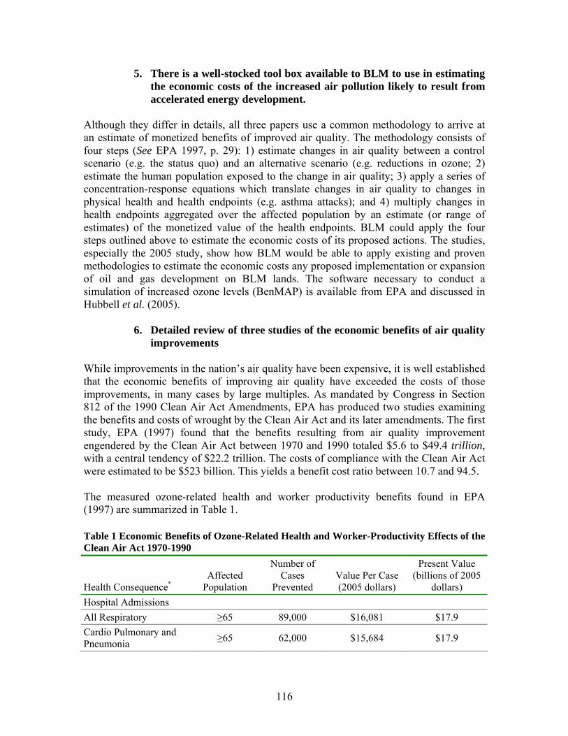
5. There is a well-stocked tool box available to BLM to use in estimating the economic costs of the increased air pollution likely to result from accelerated energy development.
Although they differ in details, all three papers use a common methodology to arrive at an estimate of monetized benefits of improved air quality. The methodology consists of four steps (See EPA 1997, p. 29): 1) estimate changes in air quality between a control scenario (e.g. the status quo) and an alternative scenario (e.g. reductions in ozone; 2) estimate the human population exposed to the change in air quality; 3) apply a series of concentration-response equations which translate changes in air quality to changes in physical health and health endpoints (e.g. asthma attacks); and 4) multiply changes in health endpoints aggregated over the affected population by an estimate (or range of estimates) of the monetized value of the health endpoints. BLM could apply the four steps outlined above to estimate the economic costs of its proposed actions. The studies, especially the 2005 study, show how BLM would be able to apply existing and proven methodologies to estimate the economic costs any proposed implementation or expansion of oil and gas development on BLM lands. The software necessary to conduct a simulation of increased ozone levels (BenMAP) is available from EPA and discussed in Hubbell et al. (2005).
6. Detailed review of three studies of the economic benefits of air quality improvements
While improvements in the nation’s air quality have been expensive, it is well established that the economic benefits of improving air quality have exceeded the costs of those improvements, in many cases by large multiples. As mandated by Congress in Section 812 of the 1990 Clean Air Act Amendments, EPA has produced two studies examining the benefits and costs of wrought by the Clean Air Act and its later amendments. The first study, EPA (1997) found that the benefits resulting from air quality improvement engendered by the Clean Air Act between 1970 and 1990 totaled $5.6 to $49.4 trillion, with a central tendency of $22.2 trillion. The costs of compliance with the Clean Air Act were estimated to be $523 billion. This yields a benefit cost ratio between 10.7 and 94.5. The measured ozone-related health and worker productivity benefits found in EPA (1997) are summarized in Table 1. Table 1 Economic Benefits of Ozone-Related Health and Worker-Productivity Effects of the Clean Air Act 1970-1990
Health Consequence* Affected
Population
Number of Cases
Prevented Value Per Case (2005 dollars)
Present Value (billions of 2005
dollars) Hospital Admissions All Respiratory ≥65 89,000 $16,081 $17.9 Cardio Pulmonary and Pneumonia ≥65 62,000 $15,684 $17.9
116
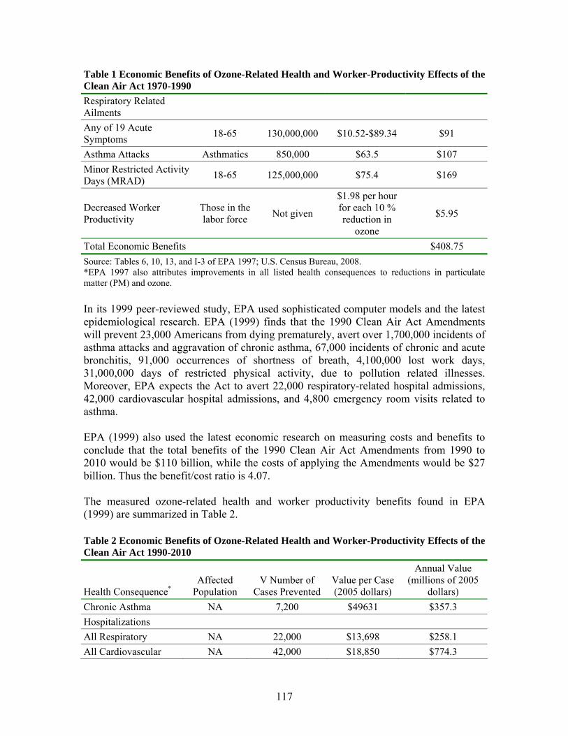
Table 1 Economic Benefits of Ozone-Related Health and Worker-Productivity Effects of the Clean Air Act 1970-1990 Respiratory Related Ailments
Any of 19 Acute Symptoms 18-65 130,000,000 $10.52-$89.34 $91
Asthma Attacks Asthmatics 850,000 $63.5 $107 Minor Restricted Activity Days (MRAD) 18-65 125,000,000 $75.4 $169
Decreased Worker Productivity
Those in the labor force Not given
$1.98 per hour for each 10 % reduction in
ozone
$5.95
Total Economic Benefits $408.75 Source: Tables 6, 10, 13, and I-3 of EPA 1997; U.S. Census Bureau, 2008. *EPA 1997 also attributes improvements in all listed health consequences to reductions in particulate matter (PM) and ozone. In its 1999 peer-reviewed study, EPA used sophisticated computer models and the latest epidemiological research. EPA (1999) finds that the 1990 Clean Air Act Amendments will prevent 23,000 Americans from dying prematurely, avert over 1,700,000 incidents of asthma attacks and aggravation of chronic asthma, 67,000 incidents of chronic and acute bronchitis, 91,000 occurrences of shortness of breath, 4,100,000 lost work days, 31,000,000 days of restricted physical activity, due to pollution related illnesses. Moreover, EPA expects the Act to avert 22,000 respiratory-related hospital admissions, 42,000 cardiovascular hospital admissions, and 4,800 emergency room visits related to asthma. EPA (1999) also used the latest economic research on measuring costs and benefits to conclude that the total benefits of the 1990 Clean Air Act Amendments from 1990 to 2010 would be $110 billion, while the costs of applying the Amendments would be $27 billion. Thus the benefit/cost ratio is 4.07. The measured ozone-related health and worker productivity benefits found in EPA (1999) are summarized in Table 2. Table 2 Economic Benefits of Ozone-Related Health and Worker-Productivity Effects of the Clean Air Act 1990-2010
Health Consequence* Affected
Population V Number of
Cases Prevented Value per Case (2005 dollars)
Annual Value (millions of 2005
dollars) Chronic Asthma NA 7,200 $49631 $357.3 Hospitalizations All Respiratory NA 22,000 $13,698 $258.1 All Cardiovascular NA 42,000 $18,850 $774.3
117

Table 2 Economic Benefits of Ozone-Related Health and Worker-Productivity Effects of the Clean Air Act 1990-2010 Asthma Attack NA 1,700,000 $64 $109.2 Acute Respiratory Symptoms NA NA $36 $2.2
Minor Restricted Activity Days NA 31,000,000 $75 $2,382.3
Emergency Room Visits for Asthma NA 4,800 $385 $2.0
Total Economic Benefits $3,885.4 Source: Tables 5-3, 6-1, 6-3 of EPA 1999; U.S. Census Bureau, 2008. *EPA 1997 also attributes improvements in some listed health consequences to reductions in particulate matter (PM) and ozone. EPA (1999) quantified and monetized health benefits related to respiratory symptoms, minor restricted activity days, hospital admissions, asthma-related emergency room visits, and asthma attacks. However, EPA was not able to quantify ozone-related benefits from reduced premature mortality, lung inflammation, chronic respiratory damage, increased susceptibility to respiratory infection, and non-asthma related emergency room visits (EPA 1999, Table 5.1, p. 53). In addition, EPA (1999) included discussions of both monetized and non-monetized benefits accruing from increased agricultural productivity, increased forest productivity, and improved ecological outcomes. Hubbell, et al. (2005) estimate the economic benefits of reducing ozone levels in such manner that there would be compliance with the then-existing NAAQS of .80 ppm for the 4th highest maximum 8-hour ozone concentration at all the >1000 monitoring stations throughout the country. The Hubbell, et al. methodology includes spatial modeling of the effects of reduced ozone, allowing for the estimation of ozone exposure for various segments of the population (e.g. ≥ age 65). Hubbell et al.’s quantification of economic benefits is summarized in Table 3 below. Table 3 Economic Benefits of Attaining the 8-Hour Ozone Standard
Health Consequence Affected
Population
Economic Value per
Case (2005 dollars)
Number of Cases Avoided
Economic Value (2005 dollars)
Premature Mortality All $8,055,000 750-840 $5.8-$6.8 billion
≥65 years $22,744 2000-2300 $43-$53 million Respiratory Hospital Admissions 0 to <2 years $9593 1900-2100 $15-$20 million
Asthma Related Emergency Medical Visits
All $354.43 460-510 $150,000-$190,000
118
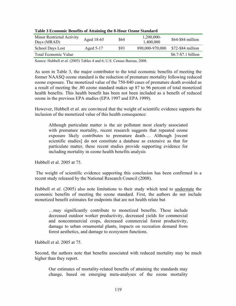
Table 3 Economic Benefits of Attaining the 8-Hour Ozone Standard Minor Restricted Activity Days (MRAD) Aged 18-65 $64 1,200,000-
1,400,000 $64-$84 million
School Days Lost Aged 5-17 $93 890,000-970,000 $72-$84 million Total Economic Value $6.7-$7.1 billion Source: Hubbell et al. (2005) Tables 4 and 6; U.S. Census Bureau, 2008. As seen in Table 3, the major contributor to the total economic benefits of meeting the former NAASQ ozone standard is the reduction of premature mortality following reduced ozone exposure. The monetized value of the 750-840 cases of premature death avoided as a result of meeting the .80 ozone standard makes up 87 to 96 percent of total monetized health benefits. This health benefit has been not been included as a benefit of reduced ozone in the previous EPA studies (EPA 1997 and EPA 1999). However, Hubbell et al. are convinced that the weight of scientific evidence supports the inclusion of the monetized value of this health consequence:
Although particulate matter is the air pollutant most clearly associated with premature mortality, recent research suggests that repeated ozone exposure likely contributes to premature death…. Although [recent scientific studies] do not constitute a database as extensive as that for particulate matter, these recent studies provide supporting evidence for including mortality in ozone health benefits analysis
Hubbell et al. 2005 at 75. The weight of scientific evidence supporting this conclusion has been confirmed in a recent study released by the National Research Council (2008). Hubbell et al. (2005) also note limitations to their study which tend to understate the economic benefits of meeting the ozone standard. First, the authors do not include monetized benefit estimates for endpoints that are not health relate but
…may significantly contribute to monetized benefits. These include decreased outdoor worker productivity, decreased yields for commercial and noncommercial crops, decreased commercial forest productivity, damage to urban ornamental plants, impacts on recreation demand from forest aesthetics, and damage to ecosystem functions.
Hubbell et al. 2005 at 75. Second, the authors note that benefits associated with reduced mortality may be much higher than they report.
Our estimates of mortality-related benefits of attaining the standards may change, based on emerging meta-analyses of the ozone mortality
119
literature. If these meta-analyses confirm [emerging results]…the mean mortality benefits may increase by a factor of 2, suggesting that reductions in premature mortality associated with attainment of the ozone standards might be as high as 1,600 premature deaths avoided annually. This increase would substantially increase the economic value of health impacts as well, potentially up to $10 billion [$12.4 billion in 2005 dollars]
Hubbell et al. 2005 at 81. Also, the authors note that recent research suggests that reduced ozone exposure would increase the monetized benefits of reduced emergency room care by a factor of 4.5 (Hubbell et al. 2005, p. 81). Third, the estimates used to monetize the value of avoided hospital admissions and emergency room visits are downward biased. In the absence of estimates of willingness to pay to avoid these events, Hubbell et al. (2005) used estimates of total medical costs plus the value of lost productivity. These are lower bound estimates of the proper measures, which are willingnesses to pay to avoid the pain and suffering (See Hubbell et al. 2005, p. 78). This review clearly shows that there are readily available tools to assist BLM in conducting a thorough analysis of the health related economic costs of increased ozone exposures for citizens living near and visitors to BLM lands. It also shows that substantial economic cost are likely to occur if air quality in the areas surrounding BLM lands continues to deteriorate as the result of proposed actions and developments such as increased oil and gas exploration and production. BLM should take advantage of the existing tools and scientific research to conduct the proper analysis.
7. Requested Remedy
BLM should apply all available tools and analyses, including the studies reviewed above, to assess the cost of increased air pollution associated with the proposed plan and to adjust the proposed management approach to minimize these costs.
G. Attachments See Exhibit Y - EPA Comments on Chapita Wells-Stagecoach Area Natural Gas Development FEIS February 2008.
H. References BBC Research and Consulting. November 12, 2001. Measuring the Impact of Coalbed Methane Wells on Property Values, Appendix B of the La Plata County Impact Report (Appendix B: http://co.laplata.co.us/pdf/plan_doc/final_impactrpt/final_ir_appb.pdf, Full report: http://co.laplata.co.us/publications.htm )
120
BBC Research and Consulting. 2008. Northwest Colorado Socioeconomic Analysis and Forecasts. Final Report, Prepared for the Associated Governments of Northwest Colorado. Bennett, K. and M.K. McBeth. 1998. Contemporary Western Rural USA Economic Composition: Potential Implications for Environmental Policy and Research. Environmental Management 22(3): Bishop, R. C. and M. P. Welsh. 1992. Existence Values in Benefit-Cost Analysis and Damage Assessment. Land Economics 68(4): 405-417. Bowker, J. M., J. E. Harvard III, J. C. Bergstrom, H. K. Cordell, D. B. K. English, and J. B. Loomis. 2005. The net economic value of wilderness. In: Cordell, H. K., J. C. Bergstrom, and J.M. Bowker (eds), The Multiple Values of Wilderness. State College, PA: Venture Publishing. Brabant, S. and R. Gramling. 1997. Resource extraction and fluctuations in poverty: A case study. Society & Natural Resources 10(1):97-106. Bureau of Land Management. 2008. West Tavaputs Plateau Natural Gas Full Field Development Plan Draft Environmental Impact Statement UT-070-05-055. February 2008. Cordell, H.K., M.A. Tarrant, B.L. McDonald and J. C. Bergrstrom. 1998. How the public views wilderness: More results form the USA survey on recreation and the environment. International Journal of Wilderness 4(3): 28-31. Davenport, J. and J. A. Davenport (eds). 1980. The Boom Town: Problems and Promises in the Energy Vortex. Laramie WY: University of Wyoming, Department of Social Work. Deller, S.C., T. Tsai, D.W. Marcouiller, and D.B.K. English. 2001. The Role of Amenities and Quality of Life in Rural Economic Growth. American Journal of Agricultural Economics 83(2): 352-365. Duffy-Deno, K. T. 1998. The Effect of Federal Wilderness on County Growth in the Intermountain Western United States. Journal of Regional Science 38(1): 109-136. Fortmann, L.P., J. Kusel, and S.K. Fairfax. 1989. Community stability: The foresters' fig leaf. Pages 44-50 in: Le Master, D.C., and J.H. Beuter, Eds. Community Stability in Forest-Based Economies . Timber Press, Portland, OR. Freeman, A.M. III, 2003, The Measurement of Environmental and Resource Values, 2nd Edition, Resources for the Future, Washington, D.C.
121
Freudenburg, W.R. 1992. Addictive economies: extractive industries and vulnerable localities in a changing world economy. Rural Sociology 57:305-332. Freudenburg, W.R. and R. Gramling. 1994. Natural resources and rural poverty: A closer look. Society and Natural Resources 7:5-22 Goldsmith, O.S. 1992. Economic instability in petroleum-based economies. Presented at OPEC/Alaska Conference on Energy Issues in the 1990’s. Anchorage AK, July 23-24, 1992. Gowdy, J. M. 1997. The Value of Biodiversity: Markets, Society, and Ecosystems. Land Economics 73(1): 25-4`. Guilliford, Andrew. 1989. Boomtown Blues: Colorado Oil Shale 1885-1985. Niwot, CO: University Press of Colorado. Hubbell, B., A. Halberg, D.R. McCubbin, E. Post. 2005. Health Related Benefits of Attaining the 8-Hour Ozone Standard. Environmental Health Perspectives. 113(1): 73-82. (electronic or paper copy available upon request) Jacquet. J. 2005. Index Crimes, Arrests, and Incidents in Sublette County 1995-2004: Trends and Forecasts. Report prepared for the Socioeconomic Analyst Advisory Committee, Sublette County, Wyoming (available at: http://www.pinedaleonline.com/socioeconomic/ accessed March 8, 2007) Johnson, J. and R. Rasker. 1993. The Role of Amenities in Business Attraction and Retention. Montana Policy Review 3(2). Johnson, J., and R. Rasker. 1995. The Role of Economic and Quality of Life Values in Rural Business Location. Journal of Rural Studies 11(4): 405-416. Johnson, T.G. 2001. The Rural Economy in a New Century. International Regional Science Review 24(1): 21-37. Krieger, D. J. 2001. Economic Value of Forest Ecosystem Services: A Review. Washington D.C.: The Wilderness Society. Krutilla, J. 1967. Conservation reconsidered. American Economic Review. 57: 787-796. Loomis, J. B. and R. Richardson. 2000. Economic Values of Protecting Roadless Areas in the United States. Washington, D.C.: The Wilderness Society and Heritage Forests Campaign. Loomis, J. B. and R. Richardson, 2001. Economic values of the U.S. wilderness system: Research evidence to date and questions for the future. International Journal of Wilderness 7(1): 31-34.
122
Lorah, P. 2000. Population Growth, Economic Security and Cultural Change in Wilderness Counties. In McCool, S.F., D.N. Cole, W.T. Borrie, and J. O'Loughlin, comps. Wilderness Science in a Time of Change Conference, Volume 2: Wilderness within the Context of Larger Systems, 1999 May 23-27. Missoula, MT. Proceedings RMRS-P-15-VOL 2., U.S. Department of Agriculture, Forest Service, Rocky Mountain Research Station, Ogden, UT. Lorah, P. and R. Southwick. 2003. Environmental Protection, Population Change, and Economic Development in the Rural Western United States. Population and Environment 24(3): 255-272. McGranahan, D.A. 1999. Natural Amenities Drive Rural Population Change. U.S. Department of Agriculture, Economic Research Service, Food and Rural Economics Division. Agricultural Economics Report No. 781. Merrifield, J. 1984. Impact mitigation in western energy boomtowns. Growth and Change 15(2):23-28. Morton, P. 1999. The economic benefits of wilderness: theory and practice. Denver University Law Review, 76(2): 465-518. Morton, P. 2000. Wilderness, the Silent Engine of the West's Economy. The Wilderness Society, Washington, DC. National Research Council. 2008. Estimating Mortality Risk Reduction and Economic Benefits of Controlling Ozone Air Pollution. Washington, DC: National Academies Press. Nelson, P.B. 1999. Quality of Life, Nontraditional Income, and Economic Growth: New Development Opportunities for the Rural West. Rural Development Perspectives 14(2): 32-37. Nichols, Jeremy et al. June 14, 2008. Citizens Petition to Designate the Sublette County Area of Wyoming as Nonattainment for the 8-Hour Ozone National Ambient Air Quality Standard before the Administration of the U.S. Environmental Protection Agency. Payne, C., J. M. Bowker, and P. C. Reed. (compilers) 1992. The economic value of wilderness: Proceedings of the conference; 1991 May 8-11; Jackson, WY. Gen. Tech. Rep. SE-78. Asheville, NC: U.S. Department of Agriculture, Forest Service, Southeastern Forest Experiment Station. 330 pp. Pederson Planning Consultants. 2001. Appendix D in the Wyoming Energy Commission, Preliminary Progress Report to the Wyoming Legislature, Joint Minerals, Business and Economic Development Committee, December 14, 2001. Draft Report commission by the Wyoming Energy Commission. 34 pages.
123
Pinedale Anticline Working Group. 2005. BLM Pinedale Anticline Working Group PAWG Task Groups’ Report. Power, T. 1995. Economic Well-Being and Environmental Protection in the Pacific Northwest: A Consensus Report by Pacific Northwest Economists. University of Montana, Missoula, MT. Power, T. M. 1996. Lost Landscapes and Failed Economies. Island Press, Covelo, CA. Rasker, R., B. Alexander, J. van den Noort, and R. Carter. 2004. Public Lands Conservation and Economic Well-Being. The Sonoran Institute, Tucson, AZ. Available at: http://www.sonoran.org/programs/prosperity.html. Reeder, R. J. and D. M. Brown. 2005. Recreation, Tourism and Rural Well-Being. U.S. Department of Agriculture, Economic Research Service. Economic Research Report Number 7. 38 pp. Rudzitis, G. 1999. Amenities Increasingly Draw People to the Rural West. Rural Development Perspectives 14(3): 9-13. Rudzitis, G., and H.E. Johansen. 1989. Amenities, Migration, and Nonmetropolitan Regional Development. Report to National Science Foundation. Department of Geography, University of Idaho, Moscow, ID. Shumway, J.M. and S.M. Otterstrom. 2001. Spatial Patterns of Migration and Income Change in the Mountain West: the Dominance of Service-Based, Amenity-Rich Counties. Professional Geographer 53(4): 492-501. Smith, E.J. 1986. Boom and bust in energy extraction. Agriculture and Rural Economics Division, Economic Research Service, U.S. Department of Agriculture, Washington, DC. Staff Report No. AGES860423. Snepenger, D.J., J.D. Johnson, and R. Rasker. 1995. Travel-Stimulated Entrepreneurial Migration. Journal of Travel Research 34(1): 40-44 Swanson, C. S., and Loomis, J. B. 1996. Role of Nonmarket Economic Values in Benefit-Cost Analysis of Public Forest Management. Portland, OR: U.S. Department of Agriculture, Forest Service, Pacific Northwest Research Station, General Technical Report, PNW-GTR-361. 32pp. U.S. Census Bureau, Consumer Price Index, Medical Care Services, Statistical Abstract, downloaded from http://www.swivel/com/data_sets/show/10021, accessed July 22, 2008. U.S. Environmental Protection Agency. October 1997. Benefits and Costs of the Clean Air Act, 1970 to 1990, Washington, D.C. available at:
124
http://yosemite.epa.gov/EE/epa/eerm.nsf/vwRepNumLookup/EE‐0295?OpenDocument U.S. Environmental Protection Agency. November 1999. Benefits and Costs of the Clean Air Act, 1990 to 2010. EPA 410-R-99-01. available at: http://www.epa.gov/oar/sect812/1990-2010/fullrept.pdf, last accessed July 22, 2008. U.S. Environmental Protection Agency. March 18, 2008. Fact Sheet: Final Revision to the National Ambient Air Quality Standards for Ozone. Walsh, R. G. J. B. Loomis, and R. A. Gillman 1984. Valuing Option, Existence, and Bequest Demands for Wilderness. Land Economics, 60(1): 14-29. Whitelaw, E., and E.G. Niemi. 1989. Migration, Economic Growth, and the Quality of Life. In Proceedings of the Twenty-Third Annual Pacific Northwest Regional Economic Conference, Corvallis, OR, pp 36-38.
125
X. Water Quality
The Price PRMP fails to analyze and model the impacts of the activities that it permits on water quality in the planning area. Both FLPMA and NEPA require that BLM prepare such analysis. BLM must analyze and model pollutant concentrations in order to understand if the PRMP will comply with federal and state water quality standards, as required by FLPMA. Without conducting water quality analyses and modeling, BLM will not understand the effects of the pollutants generated from activities authorized by the PRMP, and will thereby violate NEPA and its requirement that BLM understand the environmental impacts of the activities it is permitting. A. BLM’s Failure to Analyze and Model Water Quality Violates FLPMA FLPMA, and the Price PRMP, require that BLM manage the planning area according to federal and state water quality standards. PRMP at 2-17, 3-15, 5-36, Table 2-2; 43 C.F.R. § 2920.7(b)(3) (requiring that every BLM “land use authorization shall contain terms and conditions which shall … [r]equire compliance with … water quality standards established pursuant to applicable Federal or State law”) (emphasis added); see also 43 U.S.C. § 1712(c)(8) (requiring BLM in land use plans—which would therefore require implementation in daily management—to “provide for compliance with applicable pollution control laws, including State and Federal … water … pollution standards or implementation plans”) (emphasis added). The above-mentioned water quality standards and water pollution standards include the Clean Water Act’s (CWA’s) water quality standards (WQS) and accompanying Total Maximum Daily Loads (TMDL) limits for waters that do not meet WQS, as well as anti-degradation requirements for waters that do meet WQS. WQS are based on ambient water concentrations of various pollutants. Because the Price PRMP permits activities (e.g., off-road vehicle travel on designated routes) and analyzes potential future activities (e.g. oil and gas leasing etc.) without modeling the effect that these activities will have on concentrations of pollutants in water, the PRMP fails to satisfy its FLPMA obligation. Although BLM acknowledges that the activities authorized in the PRMP, including oil, gas, and mining development, and ORV use will adversely affect water quality, BLM fails to quantify the impact these activities will have on water quality. See, e.g., PRMP at 2-148, 3-13, 3-15, 4-10, 4-20, Table 2-2. Thus, BLM knowingly increases damaging impacts to water quality without providing quantitative analysis as to how these activities will impact water quality. Before permitting activities in the PRMP, and in order to comply with FLPMA, BLM must analyze the baseline water quality for all the water bodies in the planning area. The baseline analysis should provide monitoring of water quality indicators, including temperature, alkalinity, specific conductance, pH, dissolved oxygen, turbidity, hardness, dissolved solids, and suspended solids, as required by the CWA. Knowing the baseline water quality is essential to understanding whether the activities permitted in the PRMP will violate WQS, the CWA, and FLPMA. See 43 C.F.R. § 2920.7(b)(3); 43 U.S.C. § 1712(c)(8). In order to comply with FLPMA, the PRMP should provide a summary of water quality analyses and modeling for the water
126
bodies in the planning area. For an example of appropriate analysis and modeling see West Tavaputs DEIS, Natural Gas Full Field Development Plan, February 2008, at 3-56 to -64 (attached as Exhibit N). In order to comply with FLPMA, BLM must also analyze and model the various pollutant levels (e.g. phosphorus, dissolved oxygen, aluminum, nitrate, chloride, ammonia, selenium, etc.), as identified in the CWA, which will result from decisions made in the PRMP. The PRMP must also quantify contaminant levels to be expected from cumulative effects of any other activity that will cause fugitive dust, run-off, or erosion (e.g. mining, oil and gas development, grazing). These results should then be compared to the CWA standards for protection of WQS, including TMDLs and anti-degradation standards. See, e.g., Exhibit N. Only in this way can BLM know whether it is complying with federal and state water quality standards, as FLPMA, and the Price PRMP, require. BLM must continue to monitor water quality throughout the life of the PRMP. If exceedances occur, BLM must prohibit the exceedance-causing activities until compliance with the CWA and other federal and state water quality standards is met and maintained. By opening the vast majority of land in the planning area to limited ORV use, and designating 2,390 miles of ORV routes, BLM threatens water bodies with significant degradation, even in disregard of its own statements in the PRMP that explain the negative effects of ORV use on water quality. See PRMP at Map 2-19, 4-10 to -11, 4-19. In the vast majority of situations, roads lead to increased erosion and reduced water quality (Froehlich 1978, Burroughs and King 1989). BLM must analyze the baseline water quality in order to accurately estimate total dust emissions, run-off, and erosion concentrations that reach the water. Then, BLM must monitor the water quality of streams and rivers that are located near roads, and that are crossed by roads. Finally, BLM must close routes to ORV traffic when violations of water quality standards occur. FLPMA, 43 U.S.C. § 1712(c)(8). Because BLM failed to analyze water quality baselines and similarly failed to model the water-quality effects of activities in the PRMP, there is no evidence that the Price PRMP will comply with federal and state water quality standards, as required by FLPMA and the BLM itself. i. BLM’s Failure to Analyze and Model Water Quality Violates FLPMA and the Safe Drinking Water Act The Price PRMP should explicitly state that BLM will comply with the Safe Drinking Water Act (SDWA). See, e.g., Vernal PRMP at 2-13, 4-298. BLM should also describe how it will comply with the SDWA, and how the public will know that BLM is complying with the SDWA. 43 U.S.C. § 1712(c)(8); 43 C.F.R. § 2920.7(b)(3). In addition, BLM should list, in the PRMP, the water bodies in the Price planning area that are drinking water sources and determine whether any of these sources currently violate Federal Drinking Quality Standards Primary Maximum Contaminant Level and Federal Drinking Quality Secondary Standards as well as the accompanying Utah Drinking Water
127
Standards. SDWA, 42 U.S.C. § 300(f) et seq.; Utah Admin. Code R309-200 et seq.; see, e.g., Richfield PRMP at 3-24. BLM does not provide any quantitative analysis demonstrating how it will comply with safe drinking water standards, and fails to ensure that drinking water supplies will not be contaminated by activities permitted in the PRMP. By opening 2,390 miles of designated routes to ORV traffic and permitting other activities like extensive oil and gas leasing, BLM will increase various water contaminants in the planning area that may exceed SDWA standards. To comply with the SDWA and FLPMA, BLM must analyze and disclose what the baseline drinking water quality is for every public drinking water source, and then model the anticipated impacts from activities permitted in the Price PRMP. 43 C.F.R. § 2920.7(b)(3); 43 U.S.C. § 1712(c)(8). B. BLM’s Failure to Analyze and Model Water Quality Violates NEPA
NEPA requires that BLM model the impacts from the various activities—and fully inventory the pollutants generated by these activities—permitted by the Price PRMP. “NEPA ‘prescribes the necessary process’ by which federal agencies must ‘take a “hard look” at the environmental consequences’ of the proposed courses of action.” Pennaco Energy, Inc. v. U.S. Dep’t of the Interior, 377 F.3d 1147, 1150 (10th Cir. 2004) (quoting Utahns for Better Transp. v. U.S. Dep’t of Transp., 305 F.3d 1152, 1162-63 (10th Cir. 2002)) (internal citation omitted). The fundamental objective of NEPA is to ensure that an “agency will not act on incomplete information only to regret its decision after it is too late to correct.” Marsh v. Or. Natural Resources Council, 490 U.S. 360, 371 (1990) (citation omitted). All of the shortcomings mentioned in the FLPMA section immediately above also constitute NEPA failures on the part of BLM because it does not understand the impacts of the activities it is permitting on water and water quality standards. Without analyzing baseline concentrations and preparing modeling to determine what impacts permitted activities will have, BLM cannot understand or disclose the impacts on water quality from new activities that will increase pollutants. (For an example of water quality analysis and modeling, see Exhibit N). Thus, BLM’s lack of water quality analysis does not satisfy NEPA’s hard look requirement. The PRMP fails to provide either quantitative analysis of existing water quality or modeling for anticipated water quality impacts from the permitted activities. The PRMP must disclose baseline water quality measurements and then describe how it plans to monitor water quality so that BLM complies with WQS throughout the life of the plan. Furthermore, BLM has failed to discuss the impacts of fugitive dust, engine fluids, run-off, and erosion from increased travel of ORVs over 2,390 miles of designated routes on water quality. A sizable number of the designated ORV routes in the PRMP are located near rivers and streams, and travel on them could significantly impair water quality. See PRMP at Map 2-74. Because dust, engine fluids, run-off, and erosion can all contribute to exceedances of total dissolved and suspended solids counts, as well as increased salinity, it is vital that BLM determine the baseline water quality and quantitative levels of these contaminants, estimate the number of vehicles that will use the proposed
128
designated routes, estimate the level of contaminants generated by that use, and then model those figures to understand the true impacts of fugitive dust emissions, engine fluids, run-off, and erosion on water quality. The PRMP has completely failed to consider such pollutants and their impact on the local water bodies. To comply with NEPA, BLM must take a hard look at the impacts of designating so many new routes, and must provide quantitative water quality analysis and modeling to ensure that its actions will not violate federal and state water quality standards.61 In addition to analyzing the baseline water quality, BLM must continue to monitor water quality throughout the life of the RMP. The PRMP discusses several damaging effects of surface-disturbing activities on water quality, but nonetheless permits these activities to occur. See, e.g., PRMP at 2-148, 4-10, 4-20. If monitoring demonstrates that permitted activities result in violations of WQS, TMDLs, or anti-degradation requirements, BLM must close the exceedance-causing areas to ORVs, oil and gas development, mining, or other activities until it can demonstrate that water quality standards are protected and maintained. BLM admits that oil and gas leasing are particularly damaging to water quality and that once oil and gas development begins, there will be long-term adverse impacts to water quality that could be prevented by No Surface Occupancy or Closed to Leasing stipulations. PRMP at 4-20. BLM chooses to open the vast majority of its land to either standard leasing or to leasing with only minor constraints. PRMP at Map 2-34; Price Oil & Gas Designation Impacts (attached as Exhibit F). Thus, BLM is aware of the impacts of oil and gas leasing on water quality, but ignores many of the impacts and opens most land to leasing with open subject only to minor constraints, even though these actions will likely affect water quality. Because this decision has the potential to violate WQS under the CWA, and thereby NEPA, analysis and modeling must be conducted to ensure that water quality will not be violated; if water quality violations occur, the oil and gas leasing decisions must be overturned. BLM admits that eliminating cross-country ORV use would reduce the risk of increased erosion, but BLM nevertheless proposes to designate 2,390 miles of routes in the Price planning area. See PRMP at 4-11, 4-19. BLM’s subsequent assertion that the PRMP would maintain water quality by “concentrating impacts on already disturbed areas,” is unfounded, as the PRMP Routes Designation Impacts Map, attached as Exhibit D, shows. PRMP at 4-19. The designation of 2,390 miles of routes will increase runoff, erosion, and sedimentation, and introduce pollutants that will adversely affect water quality. BLM is aware of the impacts of ORV use on water quality, but chooses to ignore these impacts and designate thousands of miles of routes, many of which are located in sensitive areas near streams and water bodies.
61 As discussed elsewhere in this protest, ORV impacts such as these are inconsistent with the protective objectives of BLM’s Riparian Area Policy. At any rate, it is hard to see how BLM can judge the impact of ORV use on riparian areas without information about the existing and projected level of water contaminants they cause.
129
BLM understands that halting and reducing surface-disturbing activities, especially near streams and rivers, would improve water quality. PRMP at 4-19 to -20. Nonetheless, the PRMP authorizes excessive surface-disturbing activities near water. See, e.g., PRMP at Map 2-34, Map 2-39, Map 2-74. However, BLM has no way of knowing when water quality violations occur. In order to effectively reduce and/or halt surface-disturbing activities, BLM must provide analysis and modeling so that it knows when activities are violating the CWA and when reducing and/or halting these activities is necessary. Without providing quantitative analysis and modeling, there is no certainty that BLM will comply with the CWA and WQS. Similarly, BLM admits that erosion and siltation are particularly damaging to water quality. PRMP at 2-148 to -149, Table 2-24. Despite this admission, the activities that BLM permits in the PRMP will lead to vastly increased erosion and sedimentation. Without quantitative modeling and analysis, BLM cannot know how damaging the effects will be, when CWA violations occur, which activities are causing the most harm, and which activities it must defer or withdraw in order to maintain or regain compliance with WQS. SUWA appreciates that BLM proposes no surface disturbance or occupancy around natural springs. PRMP at 2-18, Table 2-2. However, no exceptions should be authorized for new surface disturbance within the 100-year floodplain or 100 meters on either side from the centerline of all streams and riparian areas. See PRMP at 2-18 to -19, Table 2-2. Perennial and even intermittent streams are a rarity in the desert southwest, and will become increasingly valuable as the drier and warmer effects of climate change increase in the southwest. These streams and the riparian ecosystems they support are critical to people, animals, plants, and fish and must be protected to the greatest extent possible. The implementation of the Price PRMP will result in water pollution; therefore, modeling and quantitative analysis must be undertaken to ensure compliance with NEPA and the CWA. BLM must prepare a comprehensive water pollutant analysis, which includes fugitive dust, engine fluids, run-off, and erosion rates that will impact water quality, and then model these figures to determine how water quality will be impacted. See, e.g., Exhibit M. Without doing so, BLM cannot know what impacts these activities will have on water quality or whether it is complying with federal and state water quality standards. BLM violates NEPA by failing to take a hard look at how the activities permitted in the PRMP will impact water quality.
C. BLM Must Provide a Current and Accurate List of TMDLs for All of the Water Bodies in the Planning Area and Ensure That Activities Permitted in the PRMP Do Not Violate TMDLs, WQS, or Anti-Degradation Standards
SUWA appreciates that BLM listed the water bodies in the Price planning area that are on Utah’s 303(d) list of impaired waters. PRMP at 3-15 to -16. However, BLM’s information is outdated and should be revised. Although BLM stated that it did not
130
include EPA-approved TMDLs62 in the PRMP, this is inaccurate. See Utah Approved TMDL List, current as of September 2008 (attached as Exhibit R). In 2004, EPA approved a TMDL for total dissolved solids (TDS) for Gordon Creek, Price River Segments 3, 4, and 5, Huntington Creek 4, Lower Cottonwood Creek, Upper San Rafael, Lower San Rafael, and Middle Muddy Creek. Exhibit R at unpaginated 2-4. All of these rivers were listed in the PRMP’s 303(d) Table 3-4. PRMP at 3-15 to -16. Given that TDS are of particular concern in the Price planning area, BLM should take additional precautions to maintain water quality and comply with TDS TMDLs for the streams within the planning area. See PRMP at 3-15. In addition, Price River Segment 5 also has approved TMDLs for iron and dissolved oxygen. Exhibit R at unpaginated 4. BLM should update Tables 3-4 and 3-5 with this new information and conduct water quality analysis and modeling to ensure that the activities it permits in the PRMP do not violate the TMDLs for the above-listed water bodies. BLM must likewise ensure that activities permitted in the PRMP do not violate the CWA by further degrading the water quality of the additional 303(d) water bodies listed in the PRMP. See PRMP at 3-15 to -16, Table 3-4. For each of the water bodies listed on the 303(d) Table on pages 3-15 to -16 of the PRMP, and for the above-mentioned water bodies with approved TMDLs, BLM should disclose in the PRMP what the quantitative TMDL limits are for each pollutant and what the baseline water temperatures and conditions are for the water bodies. For an example of appropriate disclosure, see Exhibit M. The PRMP should also address anti-degradation limits for water bodies that meet WQS. BLM must monitor and analyze water quality in these river segments to ensure that PRMP activities do not violate TMDLs or the anti-degradation requirements for the listed rivers.
62 A TMDL determines the amount of a specific pollutant that a water body can receive without exceeding water quality standards or impairing beneficial uses. 33 U.S.C. § 1313(d); Exhibit M at 3-63.
131
XI. Areas of Critical Environmental Concern When developing a land use plan, such as the Price PRMP, FLPMA mandates that BLM “give priority to the designation and protection of areas of critical environmental concern.” 43 U.S.C. § 1712(c)(3). Such areas, or ACECs, are areas “where special management is required (when such areas are developed or used or where no development is required) to protect and prevent irreparable damage to important historic, cultural, or scenic values, fish and wildlife resources, or other natural systems or processes.” Id. § 1702(a). BLM’s ACEC Manual (1613) provides additional detail on the criteria to be considered in ACEC designation, as discussed in the applicable regulations, as well. See Manual 1613, Section .1 (Characteristics of ACECs); 43 C.F.R. § 8200. An area must possess relevance (such that it has significant value(s) in historic, cultural or scenic values, fish & wildlife resources, other natural systems/processes, or natural hazards) and importance (such that it has special significance and distinctiveness by being more than locally significant or especially rare, fragile or vulnerable). In addition, the area must require special management attention to protect the relevant and important values (where current management is not sufficient to protect these values or where the needed management action is considered unusual or unique), which is addressed in special protective management prescriptions. 43 U.S.C. § 1702(a). An ACEC is to be as large as is necessary to protect the important and relevant values. Manual 1613, Section .22.B.2 (Size of area to receive special management attention). For potential ACECs (those that BLM has identified as meeting relevance and importance), management prescriptions are to be “fully developed” in the RMP. Manual 1613, Section .22 (Develop Management Prescriptions for Potential ACECs). If an area is not to be designated, the analysis supporting the conclusion “must be incorporated into the plan and associated environmental document.” Manual 1613, Section .21 (Identifying Potential ACECs).
A. BLM Failed to Give Priority to Designation and Protection of ACECs
A critical aspect of the statutory language cited above is FLPMA’s requirement that BLM “give priority” to ACEC designation and protection. 43 U.S.C. § 1712(c)(3). In essence, FLPMA directs BLM to prioritize protection and designation of ACECs across all alternatives under consideration, not simply the “conservation” alternative. In the Price PRMP, BLM has neither recognized nor carried out this statutory mandate. To resolve this, once BLM has determined that certain areas in the Price Field Office contain the requisite relevant and important values (R&I values) and that the PRMP does not protect all of the R&I values—which the Price Field Office has already done—the agency must give priority to the designation of those areas as ACECs over other competing resource uses and likewise give priority to the protection of those areas over other competing resource uses. BLM has violated FLPMA by failing to give priority to the designation and protection of ACECs.
132
BLM has determined that there are 883,515 acres, comprising twenty-six existing and potential ACECs, that meet the R&I criteria for ACEC designation. PRMP at 2-97, Table 2-19, 4-312, Appendix L. However, the PRMP proposes to designate thirteen ACECs, totaling only 208,555 acres, approximately one quarter of the acres nominated and found eligible. PRMP at 2-10 to -11. The existing San Rafael RMP of 1991 designated thirteen ACECs totaling 266,660 acres. PRMP at 2-96, Table 2-19, Appendix L-1. Thus, the PRMP would actually reduce the total acreage of ACECs. The PRMP proposes to bring forward only nine of these existing thirteen ACECs and, in some cases, reduces the acreage of individual ACECs despite the fact that all of the existing ACECs meet the relevance and importance criteria, and their R&I values are touted by BLM in the San Rafael RMP. PRMP at 2-10. All of the existing ACECs, as well as the potential ACECs that meet the R&I criteria, should be proposed for designation in the PRMP. By only proposing a small fraction of the acreage that BLM has identified as possessing R&I values, and reducing the acreage of ACECs in total, BLM violates FLPMA’s mandate that “priority” be given to designation of ACECs. And, for the 75% of acreage that BLM did not designate as ACECs, BLM fails to give priority to the protection of the identified R&I values, in some cases allowing oil and gas development and ORV use to occur. In direct violation of FLPMA, BLM prioritizes oil and gas leasing and subsequent development and ORV route designation over protecting R&I values.
B. The Threats from Oil and Gas Leasing and Development and Off-Road Vehicles Highlight the Need to Designate ACECs to Protect Relevant and Important Values
FLPMA requires BLM to prioritize designation and protection of ACECs. Accordingly, where BLM has found special values that meet the R&I criteria, and where impacts could or would occur to these identified values if no special management prescriptions are implemented, BLM violates its FLPMA obligations by failing to designate the areas. BLM has improperly ignored or discounted the threats to special places from oil and gas development and ORV use. BLM has failed to designate and/or failed to incorporate sufficient protections for proposed ACECs to protect R&I values from the irreparable harm that is likely to result from these other activities. BLM has acknowledged the damage from oil and gas development and improper or excessive ORV use to the values of the public lands that can and should be protected by ACEC designation (e.g., spectacular scenic values, endangered species, geologic formations, cultural resources, and naturalness). See, e.g., PRMP at Appendix L-22- to -23, Table L-2. Furthermore, the Interior Board of Land Appeals (IBLA) has found that even ongoing use of existing motorized recreational routes can lead to more damage to other resources, especially as interest in an area increases. See Southern Utah Wilderness Alliance, 164 IBLA 33 (2004). In other words, it is unavoidable and expected that, when BLM establishes routes for ORVs, there will be use beyond those routes, even in violation of route and area designations. As a result, BLM’s failure to limit ORV access to the sensitive lands and special places nominated for ACEC protection is likely to endanger their unique R&I values.
133
The maps attached as Exhibits G and D show the proposed and current ACECs overlaid with designated oil and gas leasing designations and ORV route designations. These maps illustrate the extent to which BLM disregards the R&I values identified in the existing and proposed ACECs, and prioritizes development and ORV use over critical environmental concerns, in direct violation of FLPMA. Price PRMP Oil & Gas Designation Impacts on ACECs, attached as Exhibit G; Price PRMP ACEC Designation and Proposed Routes, attached as Exhibit D; 43 U.S.C. § 1712(c)(3). Where ACEC or potential ACEC values include unique or rare scenic resources or naturalness, they are even more susceptible to irreparable damage from these activities. In some cases, the PRMP proposes a high ORV route density within potential ACECs. Exhibit D; See, e.g., Sids Mountain Existing and Potential ACEC. These route densities could impair and potentially eliminate the scenic, wildlife, and other R&I values identified in these critical areas. BLM must develop a manageable travel plan that will protect all of the potential ACECs and their R&I values from the damage directly associated with ORV use. BLM’s failures to protect R&I values in the Price PRMP may mean that these values are lost forever. In fact, since the issuance of the Price Draft RMP/EIS, development threats have actually increased. For instance, the proposed West Tavaputs project would provide for drilling of approximately 800 new wells. This development highlights the ongoing and increasing risk to ACEC values in the Price Field Office. Areas with R&I values that are jeopardized by oil and gas drilling and ORV use should be designated as ACECs and provided with protective management prescriptions that would include road closures, restoration, and closure to oil and gas development, and/or application of best management practices where lands are already leased (such as no surface occupancy stipulations and timing limitations, which can be imposed by the agency and/or negotiated with leaseholders). Without these protections, BLM violates FLPMA’s mandate to prioritize the designation and protection of ACECs and their identified R&I values. Exhibits G and D; See, e.g., Mussentuchit Badlands Potential ACEC, Lower Green River Potential ACEC, Temple Cottonwood Dugout Potential ACEC all open to leasing.
C. Wilderness Study Area Status, SRMA management, NHPA regulations, Managing for Wilderness Character, and Other Management Prescriptions Are Not a Substitute for ACEC Designation
BLM has acknowledged the threats to lands with R&I values. PRMP at Appendix L-22- to -23, Table L-2, 4-315 to -364. However, BLM has failed to designate ACECs to protect these values. The PRMP repeatedly points to WSA status as a justification for not designating areas ACECs. See, e.g., Desolation Canyon, Range Creek, Beckwith Plateau, Lower Green River, Sids Mountain, San Rafael Canyon potential ACECs. PRMP at 2-105, 4-358, 4-312, Appendix L-12. ACECs may be designated for a range of R&I values, as listed in FLPMA, and Appendix L of the PRMP, which may not be protected by focusing on protecting wilderness character (although they will likely benefit).
134
PRMP at Appendix L-9- to -10. BLM cannot dismiss its obligations under FLPMA with regard to ACECs based on the existence of a WSA. ACEC designation is important in the event that WSAs are released by Congress. The PRMP fails to adequately address what would happen in the event that a WSA is released from its status, although the PRMP does note that WSA protection is only temporary. PRMP at 3-86. Delaying ACEC designation and thorough consideration until the areas are released by Congress could jeopardize the scientific values of these potential ACECs. The PRMP must be explicit that BLM will manage lands released from WSA status to protect their important values, including wilderness characteristics and the other R&I values that the PRMP acknowledges, according to the same standards (IMP) as analyzed and contemplated in the plan. Without asserting this, BLM’s failure to designate all of the potential ACECs that meet the R&I criteria runs afoul of its own ACEC Guidance which requires that the agency specifically detail the “other form of special management” relied upon as support for not designating a potential ACEC. See Areas of Critical Environmental Concern; Policy and Procedures Guidelines, 45 Fed. Reg. 57,318, 57,319 (Aug. 27, 1980). In addition, there is no per se bar to managing and protecting R&I values through overlapping designations such as WSAs and ACECs. For example, BLM’s Jarbidge RMP (and subsequent amendments) in southern Idaho designated the Bruneau/Jarbidge River ACEC and the Salmon Falls Creek ACEC, which overlap the Bruneau River-Sheep Creek WSA, Jarbidge River WSA, and Lower Salmon Falls Creek WSA. See BLM, Jarbidge Field Office, Idaho, Analysis of the Management Situation for the Jarbidge Resource Management Plan: Resource Management Plan/Environmental Impacts Statement at 206, (July 2007), available at http://www.blm. gov/pgdata/etc/medialib/blm/id/plans/jarbidge_rmp/documents/analysis_of_the_management.Par.59385.File.dat/part13.pdf (attached as Exhibit H); see also id. at Figure 39: Locations of Current ACECs, available at http://www.blm.gov/pgdata/etc/medialib/blm/id/jarbidge/rmp/ maps.Par.16971.File.dat/Locations%20of%20Current%20ACECs.pdf (attached as Exhibit I); Figure 40: Wilderness Study Areas, available at http://www.blm.gov/pgdata/etc/medialib/blm/ id/jarbidge/rmp/maps.Par.75489.File.dat/Locations%20of%20Current%20Wilderness%20Study%20Areas.pdf (attached as Exhibit J). These overlapping designations ensure that BLM protects R&I values both through current management and in the event WSAs are released during the life of the plan. The PRMP and responses to comments evidence a resistance to layering ACEC and other special designations—even when such a layering of protection would make good policy to protect all lands in a potential ACEC and ensure that they are consistently managed (since IMP management of WSAs might differ greatly from the special management attention envisioned for the R&I values of a particular ACEC or in the event of congressional WSA release). This is clearly evident in the San Rafael Canyon proposed ACEC boundaries. PRMP at Map 2-49, Map 3-28. BLM indicates that because of IMP
135
management of the WSA acreages, the protection is the same whether or not the WSA portion of the potential ACEC is designated. See PRMP at 2-105, Table 2-19. In addition to conflicting with the directives of FLPMA regarding ACECs and the IMP, BLM’s approach is also belied by the Moab Field Office’s answer to San Juan County’s formal comment that it is “opposed to ‘layering’ or the establishment of ACECs or SRMAs over WSAs and Wild and Scenic Rivers.” To which the BLM responds, appropriately:
“Layering” is planning. Under FLMPA’s multiple use mandate, BLM manages many different resource values and uses on public lands. Through land use planning BLM sets goals and objectives for each of those values and uses, and prescribes actions to accomplish those objectives. Under the multiple use concept, the BLM doesn’t necessarily manage every value and use on every acre, but routinely manages many different values and uses on the same areas of public lands. The process of applying many individual program goals, objectives, and actions to the same area of public lands may be perceived as “layering.” The BLM strives to ensure that the goals and objectives of each program (representing resource values and uses) are consistent and compatible for a particular land area. Inconsistent goals and objectives can lead to resource conflicts, failure to achieve the desired outcomes of a land use plan, and litigation. Whether or not a particular form of management is restrictive depends on a personal interest or desire to see that public lands are managed in a particular manner. All uses and values cannot be provided on every acre. That is why land use plans are developed through a public and interdisciplinary process. The interdisciplinary process helps ensure that area resource values and uses can be considered together to determine what mix of values and uses is responsive to the issues identified for resolution in the land use plan. Layering of program decisions is not optional for BLM, but required by the FLMPA and National BLM planning and program specific regulations.
For example, the BLM has a separate policies and guidelines as well as criteria for establishing ACEC as when the WSAs were established. These differing criteria make it possible that that same lands will qualify for both an ACEC and a WSA but for different reasons. The BLM is required to consider these different policies.
The values protected by the WSA management prescriptions do not necessarily protect those values found relevant and important in ACEC evaluation, and vice versa. The relevant and important values of ACECs within or adjacent to WSAs were noted in ACEC evaluations (Appendix I). The ACECs are evaluated and ranked on the presences and absence of the state R&I values. None of these values include wilderness
136
characteristics. Additionally, the management prescriptions for the ACECs are limited to the scope to protect the R&I values and the BLM maintains that the size of the ACEC areas is appropriate to the R&I values identified.
Moab PRMP Response to Comments, at 121-9. SUWA cannot make this argument any better than BLM does in the preceding paragraphs because BLM clarifies that different designations serve different purposes, and that designations are limited to protect only those values relevant to those particular designations. Therefore, the fact that an ACEC lies within a WSA cannot serve as a justification for failing to designate the ACEC. Similarly, other provisions of FLPMA, the NHPA, SRMAs, and other management prescriptions and regulations do not necessarily protect the R&I values of ACECs. SRMAs are designated to provide recreation opportunities for users of different types, e.g. motorized, equestrian, biking, hiking, etc., and have nothing to do with protecting R&I values of potential ACECs. The NHPA deals only with cultural resources, and applies different management prescriptions than ACECs. Therefore, BLM’s assertions that other designations, such as the NHPA, WSAs, and SRMAs, adequately protect R&I values of potential ACECs is not true, and BLM must designate all of the potential ACECs in order to adequately protect their R&I values.
D. Wilderness Characteristics Can Be Protected Through ACEC Designation
While managing to protect wilderness characteristics will not protect all types of R&I values that may justify designation of ACECs, ACEC designation is a significant option.63 Conversely, management of most common R&I values would preclude most surface disturbing activities, thereby simultaneously giving a significant level of protection to wilderness characteristics—even if wilderness characteristics are not specifically one of the R&I values warranting designation as an ACEC. BLM has admitted that it retains the ability to value wilderness character and protect it, including through ACEC designations. The Instruction Memoranda (IMs) Nos. 2003-274 and 2003-275, which formalize BLM’s policies concerning wilderness study and consideration of wilderness characteristics, contemplate that BLM can continue to inventory for and protect land “with wilderness characteristics,” which are identified as natural or providing opportunities for solitude or primitive recreation, and specifically references ACEC designation. Indeed, BLM’s guidance in IM-2003-275 states that “where ACEC values and wilderness characteristics coincide, the special management associated with an ACEC, if designated, may also protect wilderness characteristics.” Similarly, in a February 12, 2004 letter to William Meadows, President of The Wilderness Society, Assistant Secretaries of the 63 BLM should implement the management prescriptions described in SUWA’s proposed Castle Country Heritage Plan, submitted with SUWA’s comments on the DRMP, and attached as Exhibit T.
137
Interior Rebecca Watson and Lynn Scarlett stated that “through the land use planning process, BLM uses the ACEC designation or other management prescriptions to protect wilderness characteristics or important natural or cultural resources.” (emphasis added) (attached as Exhibit K). As discussed above, BLM has acknowledged the threats to lands with wilderness characteristics from other activities, including ORV use and oil and gas development. However, the Price PRMP fails to support designation of ACECs to protect these values, as FLPMA requires. BLM has identified 937,440 acres of lands with wilderness character. There are an additional 44,256 acres of lands with wilderness characteristics within the Price planning area that are included in America’s Redrock Wilderness Act; detailed descriptions and supporting data have been submitted to BLM proving the wilderness character of these lands. All of these lands represent special resources and values that warrant corresponding protection. Potential ACECs with wilderness characteristics that BLM failed to protect in the PRMP include: Desolation Canyon, Range Creek, Beckwith Plateau, Lower Green River, Temple Cottonwood Dugout, Mussentuchit Badlands, Sids Mountain, more of San Rafael Canyon, White-Tailed Prairie Dog, and Rock Art sites; See Price ACEC Designation and Wildlands Map, Attached as Exhibit E. BLM should designate the above-listed ACECs and consider designating others to protect lands with wilderness characteristics; and these ACECs should include protective management prescriptions, such as closure to oil and gas leasing and ORV use, in order to protect wilderness characteristics.
E. BLM’s Proposed Management Will Not Protect Relevant and Important Values for Potential ACECs Not Proposed for Designation
BLM Manual 1613 requires that, for potential ACECs (those that BLM has identified as meeting relevance and importance), management prescriptions are to be “fully developed” in the RMP. Manual 1613, Section .22 (Develop Management Prescriptions for Potential ACECs). If an area is not to be designated, the analysis supporting the conclusion “must be incorporated into the plan and associated environmental document.” Manual 1613, Section .21 (Identifying Potential ACECs). Because BLM’s proposed management would allow development or ORV activities within the potential ACEC, thereby adversely impacting the R&I values, and because BLM failed to prioritize the designation of the Potential ACECs and failed to provide a sufficient rationale supporting its decision, BLM must designate the following potential ACECs.
1. Lower Green River Potential ACEC The PRMP favorably acknowledges the multiple R&I values of the Lower Green River, namely ecology, scenery, vegetation, and cultural resources. PRMP at 3-90, Appendix L-12. The Lower Green River Potential ACEC is home to some of the rarest type of cultural sites in Utah, provides crucial habitat for sensitive plant and animal species, and is an important desert ecological system. PRMP at 3-90. As discussed in Section C.
138
above, the fact that 35% of the potential ACEC lies with a WSA is immaterial for ACEC designation. Cf. PRMP at 4-338. Likewise, the fact that a portion of the Green River is recommended suitable for inclusion in the National Wild and Scenic River System will not necessarily protect ACEC values. Cf. PRMP at 4-338. As explained in Section C. above, different management prescriptions serve different purposes, and management designations are limited to protect only those values relevant to those particular designations, e.g. outstandingly remarkable values for Wild and Scenic Rivers vs. relevant and important values for ACECs. Furthermore, BLM admits that the scenic R&I values of the Lower Green River could be impacted because the area is largely open to oil and gas leasing. PRMP at 4-338. Nevertheless, BLM proposes to open the area to oil and gas leasing. Exhibit G. In addition, BLM proposes to designate routes that run adjacent to the Lower Green River. Exhibit D. These routes will unquestionably damage the scenic values of the river corridor, as well as the ecology, vegetation, and cultural R&I values and resources in the area. Despite the requirements of the ACEC Manual, BLM has not provided a sufficient explanation as to how the proposed management for this potential ACEC will protect the R&I values and thus cannot justify its decision not to propose designation of the Lower Green River ACEC. BLM Manual § 1613.21 to .22. Because BLM’s proposed management would allow development within the potential ACEC, thereby adversely impacting the R&I values, and because BLM failed to prioritize the designation of the Lower Green River Potential ACEC and failed to provide a sufficient rationale supporting its decision, BLM’s decision not to designate the Lower Green River ACEC must be overturned.
2. Interstate 70 Potential ACEC SUWA appreciates that BLM proposes designating 33,100 acres of the I-70 potential ACEC. PRMP at 4-313, Table 4-41. However, BLM should have proposed the entire 50,650 acres as an ACEC, particularly since this acreage was already designated an ACEC in the San Rafael RMP, which glowingly acknowledges the area’s scenery. PRMP at 4-313, Table 4-41. Opening nearly 8,000 acres of existing ACEC to oil and gas leasing subject only to minor constraints threatens the R&I scenic value of the potential ACEC. Exhibit G. Furthermore, this action violates FLPMA’s priority mandate for ACECs because BLM is prioritizing development over ACEC designation. 43 U.S.C. § 1712(c)(3). And, as discussed in Section C. above, the fact that a portion of the I-70 Potential ACEC lies within a WSA is not justification for failing to designate an ACEC. Cf. PRMP at 4-321. BLM incorrectly asserts that there will be no irreparable impacts to the scenic values of this ACEC. Oil and gas leasing, along with subsequent development will impair the scenic R&I values that make the I-70 corridor potential ACEC worthy of protection. Thus, in violation of BLM Manual 1613 .21 and .22, BLM has not provided a sufficient explanation and cannot justify its failure to designate the entirety of the Interstate 70 ACEC. The BLM guidance is clear that if BLM acknowledges that the proposed management regime will harm the identified R&I values without special
139
management attention, then BLM must designate this ACEC. Manual 1613, Section .33.E.
3. Pictographs/Rock Art Potential ACEC SUWA supports BLM’s decision to propose 5,300 acres of the Pictographs/Rock Art Potential ACEC. PRMP at 4-313, Table 4-41. However, BLM should propose the additional 10,710 acres that also meet the R&I criteria for cultural values. PRMP at 4-313, Table 4-14. BLM should protect more than the 5,300 acres of rock art currently proposed. There are many other significant and irreplaceable cultural resources that meet the R&I criteria and must be protected. In fact, the cultural resources are “world-famous” and increased visitation will likely increase damage to these resources. See PRMP at Appendix L-17. For the entire 16,010 acres that meet the R&I criteria, BLM should require that an archaeological inventory and test excavations are completed before oil and gas developments or route designations occur. See PRMP at 4-324. Development around the rock art and designated routes that lead to the rock art threaten the cultural values. BLM admits that the rock art sites are currently threatened by public use and visitor destruction of the scientific potential of the cultural resources. PRMP at Appendix L-16. Nonetheless, BLM proposes to designate routes that lead directly to the rock art which would increase visitation, threaten the sites and impair the R&I values. Exhibit D. In violation of BLM Manual 1613 .21 and .22, BLM has not provided a sufficient explanation and cannot justify its failure to designate the Pictographs/Rock Art ACEC. The BLM guidance is clear that if BLM acknowledges that the proposed management regime will harm the identified R&I values without special management attention, then BLM must designate this ACEC. Manual 1613, Section .33.E.
4. Sids Mountain Potential ACEC BLM’s failure to propose any of the existing Sids Mountain Potential ACEC violates FLPMA because BLM fails to prioritize the protection of the R&I scenic value of the existing ACEC. By not designating any of the existing 68,720 acres as an ACEC, or any of the expanded 6,670 acres, BLM threatens the area’s scenic values. PRMP at 4-313, Table 4-41. As discussed in Section C. above, the fact that an area lies within a WSA or an SRMA is not a justification for failing to designate an ACEC. Furthermore, BLM does not explain why it changed its decision from proposing the continued designation of Sids Mountain as an ACEC in the DRMP to not proposing designation in the PRMP. PRMP at 1-19. The scenic value of the existing Sids Mountain ACEC has not decreased from the time of the San Rafael RMP or the DRMP. In fact, with increased development throughout Utah, scenic, untouched areas like the existing Sids Mountain ACEC have become increasingly important, and must be protected. Despite this area’s R&I values, BLM proposes to open the western portion of the existing ACEC to oil and gas leasing, subject only to minor constraints, thus violating FLPMA and prioritizing oil and gas leasing and development which could irreparably impair the scenic R&I values, over protecting ACEC values.
140
See PRMP at 4-333; 43 U.S.C. § 1712(c)(3). In violation of BLM Manual 1613 .21 and .22, BLM has not provided a sufficient explanation and cannot justify its failure to designate the Sids Mountain ACEC. In order to protect the valuable scenic resources and to comply with FLPMA’s prioritizing mandate for ACECs, BLM must propose to carry forward the existing Sids Mountain ACEC, and the additional acreage that meets the R&I values. 5. Range Creek Potential ACEC BLM’s failure to propose the Range Creek Potential ACEC violates FLPMA because BLM fails to prioritize the protection of the R&I cultural and natural processes values of the potential ACEC. By not designating any of the potential 65,500 acres as an ACEC, BLM threatens the area’s irreplaceable values. See PRMP at 4-313. As explained in Section C. above, WSA status and SRMA designation are not substitutes for ACEC designation. Cf. PRMP at 4-344- to -345. Likewise, FLPMA and Section 106 of the NHPA do not provide the same type of protection that ACEC designation would. Cf. PRMP at 4-345. Furthermore, BLM does not explain why it changed its decision from recommending designation of the Range Creek Potential ACEC in the DRMP to not recommending designation in the PRMP. PRMP at 1-19. The irreplaceable cultural and natural process R&I values have not changed between the DRMP and the PRMP. This “outdoor classroom” which includes numerous examples of rock art and prehistoric habitation sites must be protected. PRMP at Appendix L-13. BLM explains that this area is “possibly the most pristine and extensive untouched archaeological site in the American West today.” PRMP at Appendix L-13. Furthermore, the ecological system and the rare wetlands of Range Creek provide crucial habitat for several sensitive species. PRMP at Appendix L-14. The cultural sites and the natural, intact ecological system of Range Creek must be protected through designation as an ACEC. Despite these rare and irreplaceable values, BLM proposes to designate a route running along the southern portion of Range Creek before the confluence with the Green River. Exhibit D. This route could directly harm the R&I values of the natural system and the cultural sites in the area by increasing visitation and vandalism of the sites. And, BLM proposes to open the areas outside the WSAs and SRMA to oil and gas leasing with no conditions, and the remaining potential ACEC to oil and gas leasing subject to minor and major constraints. PRMP at 4-345. Opening these areas to leasing and subsequent development threatens the R&I values, in violation of FLPMA’s prioritization mandate. The entire potential ACEC should be closed to mechanical use and oil and gas leasing. Even the areas outside of the gates that are less preserved than those within the gates, nonetheless still include numerous cultural sites and a functioning natural system that must be protected. See PRMP at 4-345. In violation of BLM Manual 1613 .21 and .22 and .33. BLM has not provided a sufficient explanation and cannot justify its failure to designate the Range Creek Potential ACEC, or its decision to change the designation from proposed in the DRMP to potential to in the PRMP. In order to protect the valuable
141
scenic resources and to comply with FLPMA’s prioritizing mandate for ACECs, BLM must propose to designate the Range Creek Potential ACEC.
6. Heritage Sites Potential ACEC The seven sites that comprise the Heritage Sites Potential ACEC meet the R&I criteria for history. PRMP at Appendix L-16. The history contained in these sites is integral to our western heritage and irreplaceable. PRMP at 4-352, Appendix L-16. BLM admits that these sites are increasingly threatened with development, but nevertheless, BLM plans to designate several routes within the potential ACEC, that would increase visitation and the threat to these sites from visitors. Exhibit D; PRMP at Appendix L-16. Likewise, BLM plans to open these areas to oil and gas leasing, which also threatens the historic values of the potential ACEC. Exhibit G. In violation of BLM Manual 1613 .21 and .22, BLM has not provided a sufficient explanation and cannot justify its failure to designate Heritage Sites Potential ACEC. In order to protect the valuable scenic resources and to comply with FLPMA’s prioritizing mandate for ACECs, BLM must designate the Heritage Sites Potential ACEC. 7. Nine Mile Canyon Potential ACEC SUWA appreciates that BLM proposes to designate 26,200 acres of the potential Nine Mile Canyon ACEC. BLM should also designate the remaining 22,800 acres of Nine Mile Canyon Potential ACEC because Nine Mile Canyon is home to incredible cultural R&I values that are currently facing significant threats, and that must be protected. BLM proposes to open much of the potential ACEC to oil and gas leasing and subsequent development with only minor constraints. See Exhibit G. Oil and gas leasing on the West Tavaputs Plateau above Nine Mile Canyon is already damaging rock art in the canyon, and increased development threatens to irreparably damage these cultural treasures. See PRMP at 4-345. Although the PRMP states that there is a decreased density of sites in the upper portion of the canyon, a formal, systematic inventory for cultural resources should be conducted before any disturbance occurs. See PRMP at 4-349. Although BLM asserts that buried sites receive some natural protection, the road through Nine Mile Canyon is continually expanded and graded, and some buried sites are damaged in the process before they have even inventoried. See PRMP at 4-349; Pam Miller, Archaeologist, ABC News interview (September 16, 2008). In order to protect Nine Mile Canyon’s impressive, internationally-significant rock art sites, the entirety of this potential ACEC must be closed to oil and gas development, use of roads should be limited, and some existing roads should be converted to non-motorized trails. In violation of FLPMA, BLM prioritizes development over the designation of ACECs. 43 U.S.C. § 1712(c)(3). In violation of BLM Manual 1613 .21 and .22, BLM has not provided a sufficient explanation and cannot justify its failure to designate the entirety of the Nine Mile Canyon Potential ACEC. 8. San Rafael Canyon Potential ACEC
142
BLM should propose to designate the entire existing San Rafael Canyon ACEC (34,420 acreas), instead of only 15,200 acres which BLM proposes to designate in the PRMP. PRMP at 2-105, Table 2-19, 4-313, Table 4-41. This potential ACEC has extraordinary scenery that meets the R&I criteria. As explained in Section C. above, WSA status is not a justification for reducing or refusing to designate an ACEC. See PRMP at 2-105, Table 2-19, 4-327. BLM should include more protective management prescriptions over the entire existing ACEC, including in the northwest corner of the potential ACEC. In this area, BLM should elevate the protection from VRM Class III to VRM Class I or II and close the area to oil and gas leasing, and should not designate any routes through the potential ACEC. Cf. PRMP at 4-327; See Exhibits G and D. Impacts to the scenery from oil and gas development and designated routes would irreparably damage the R&I values because scenery is the only R&I value for San Rafael Canyon. In violation of BLM Manual 1613 .21 and .22, BLM has not provided a sufficient explanation and cannot justify its failure to designate the entirety of San Rafael Canyon Potential ACEC. In order to protect the valuable scenic resources and to comply with FLPMA’s prioritizing mandate for ACECs, BLM must designate the San Rafael Canyon Potential ACEC. 9. Desolation Canyon Potential ACEC Desolation Canyon meets the R&I criteria for scenery, cultural, and ecological values. Nonetheless, BLM proposes to designate several routes within the potential ACEC, threatening the multitude of cultural and historic sites, as well as habitat for migrating and nesting birds including peregrine falcon, wintering elk, deer, and bald eagles, and year-round habitat for Rocky Mountain bighorn sheep. See PRMP at 3-92; Map 2-48, Map 2-74. VRM Class I scenery should apply to the entire potential ACEC. Extensive oil and gas development on the West Tavaputs Plateau threatens all of these values. Exhibit G. Because Desolation Canyon Potential ACEC meets the R&I criteria, and proposed development and use of the area threatens its values, BLM should designate the area an ACEC. As discussed in Section C. above, the fact that the potential ACEC lies within a WSA is immaterial. Furthermore, nearly 40,000 acres of the potential ACEC is not within a WSA. PRMP at 4-358. BLM must reconsider its decision not to designate the Desolation Canyon ACEC, and must develop protective management prescriptions, including management as VRM Class I, closure to oil and gas development (subject to existing rights, where best management practices should be aggressively applied) and closure to ORVs. In violation of BLM Manual 1613 .21 and .22, BLM has not provided a sufficient explanation and cannot justify its failure to designate Desolation Canyon Potential ACEC. In order to protect the valuable scenic resources and to comply with FLPMA’s prioritizing mandate for ACECs, BLM must designate the Desolation Canyon Potential ACEC.
9. Beckwith Plateau Potential ACEC
Beckwith Plateau meets the R&I criteria for geology and natural processes. PRMP at Appendix L-6, Table L-1. The area possesses spectacular cliffs and erosional features, provides spawning habitat for endangered fish species, serves as a migratory corridor for
143

sensitive bird species, and provides habitat and an important riparian area for other sensitive plant and animal species. PRMP at Appendix L-10 to -12. As discussed in Section C. above, the fact that most of the potential ACEC lies within a WSA is not a justification for failing to designate the ACEC. See PRMP at 4-340. The portions of the potential ACEC that lie outside of the WSA would be open to leasing under standard terms or with only minor constraints. PRMP at 4-340; Exhibit G. Opening these areas to oil and gas leasing and subsequent development threatens the R&I values, particularly the undisturbed natural processes of Beckwith Plateau Potential ACEC. In violation of FLPMA, BLM prioritizes development over the designation of ACECs. 43 U.S.C. § 1712(c)(3). In violation of BLM Manual 1613 .21 and .22, BLM has not provided a sufficient explanation and cannot justify its failure to designate Beckwith Plateau Potential ACEC.
10. Temple-Cottonwood Dugout Wash Potential ACEC Temple-Cottonwood Dugout Wash Potential ACEC meets the R&I criteria for cultural values. PRMP at Appendix L-8, Table L-1. The archaic cultural sites that are buried in the sands of the Cottonwood wash complex are threatened by activities permitted in the PRMP. BLM proposes to designate several routes in the potential ACEC and to open the area to oil and gas leasing with standard stipulations. Exhibits G and D. As explained in Section C. above, other management protections, such as Section 106 of the NHPA, do not adequately protect R&I ACEC values. Cf. PRMP at 4-342. Different regulations protect different values and cannot be used interchangeably. Should BLM proceed with the proposal in the PRMP and open this area to oil and gas leasing, it should require major or, at the very least, minor constraints on leases. Before any surface-disturbing activity occurs, BLM should conduct an inventory of the area for cultural resources, must monitor activities as they occur, and stop any disturbance should a site be discovered. Oil and gas leasing and subsequent surface-disturbing development are simply not compatible with the protection of valuable cultural resources. In violation of FLPMA, BLM prioritizes development over the designation of the Temple-Cottonwood Dugout Wash ACEC. 43 U.S.C. § 1712(c)(3). In violation of BLM Manual 1613 .21 and .22, BLM has not provided a sufficient explanation and cannot justify its failure to designate this potential ACEC.
12. Gordon Creek Potential ACEC
Gordon Creek Potential ACEC meets the R&I criteria for cultural and wildlife values. PRMP at Appendix L-7, Table L-1. Gordon Creek is a “very significant” archaeological and historic area for the prehistoric Fremont culture and early pioneer settlement of the area, and is the only place where study of Fremont culture can take place because it has not been destroyed like other places. PRMP at Appendix L-15 to -16. BLM admits that expanding oil and gas development is increasing ORV use and access to the area, threatening the R&I values. PRMP at Appendix L-16. Despite this admission, BLM fails to protect these values. Instead, BLM proposes to designate routes through much of the area, and even open some of the area to ORV use. PRMP at 4-352; Exhibit D. And
144
BLM proposes to open most of the potential ACEC to oil and gas leasing with only minor constraints. Exhibits G; PRMP at 4-352. As discussed in Section C. above, NHPA and FLPMA requirements are not a substitute for ACEC protection of R&I values. Before any surface-disturbing activity occurs, BLM should conduct an inventory of the area for cultural resources, monitor activities as they occur, and stop any disturbance should a site be discovered. In violation of FLPMA, BLM prioritizes development over the designation of the Gordon Creek ACEC. 43 U.S.C. § 1712(c)(3). In violation of BLM Manual 1613 .21 and .22, BLM has not provided a sufficient explanation and cannot justify its failure to designate this potential ACEC.
13. Uranium Mining Districts Potential ACEC
SUWA supports BLM’s decision to designate 3,470 acres64 of Uranium Mining District ACEC. PRMP at 4-313, Table 4-41. BLM should also designate the remaining acres that also meet the R&I criteria for history as an ACEC. PRMP at Appendix L-8, Table L-1. As explained in Section C. above, NHPA protections are not sufficient to protect the R&I values of potential ACECs. See PRMP at 4-355. BLM should also clarify the acreage of each individual site, and state which sites were included in the total acreage. In violation of FLPMA, BLM fails to prioritize the designation of the Gordon Creek ACEC. 43 U.S.C. § 1712(c)(3). In violation of BLM Manual 1613 .21 and .22, BLM has not provided a sufficient explanation and cannot justify its failure to designate this potential ACEC. 14. White-Tailed Prairie Dog Potential ACEC The White-Tailed Prairie Dog Potential ACEC meets the R&I criteria for wildlife habitat. PRMP at Appendix L-8, Table L-1. Designating this ACEC would not only protect this important area for white-tailed prairie dogs, it would also protect other sensitive species like the burrowing owl and the highly endangered black-footed ferret that rely on prairie dog towns for habitat. PRMP at Appendix L-19. BLM fails to protect this important wildlife habitat, and instead proposes to designate routes through the potential ACEC and to open the area to oil and gas leasing. Exhibits G and D. As the Moab BLM stated, “[w]hite-tailed prairie dog habitat is fragile and very sensitive to OHV abuse, overgrazing, drought and oil and gas disturbance.” Moab PRMP at Appendix I-10 (emphasis added). Despite the sensitive nature of prairie dog habitat, BLM threatens the habitat and the animals that rely on it by violating FLPMA and prioritizing development over the protection of R&I values. 43 U.S.C. § 1712(c)(3). In violation of BLM Manual 1613 .21 and .22, BLM has not provided a sufficient explanation and cannot justify its failure to designate this potential ACEC. 15. Mussentuchit Badlands Potential ACEC
64 BLM should clarify how many acres it proposes to designate as an ACEC. Page 4-355 indicates that the proposed ACEC consist of 3,470 acres, while Table 4-41 indicates that the proposed ACEC consist of 1,500 acres. PRMP at 4-313, 4-355.
145
The Mussentuchit Badlands Potential ACEC meets the R&I criteria for cultural values. PRMP at Appendix L-7, Table L-1. Although BLM understands the threats to cultural values, it nevertheless proposes to open the area to oil and gas leasing, subject almost exclusively only to standard leasing terms. PRMP at 4-361 to -62; Exhibit G. Furthermore, BLM proposes to designate many miles of routes through the potential ACEC, increasing visitor traffic and putting sensitive cultural resources at risk. See Exhibit D. As explained in Section C. above, the NHPA and other management prescriptions do not protect the R&I cultural value. Cf. PRMP at 4-362. Despite the importance of cultural resources, BLM threatens the habitat and the animals that rely on it by violating FLPMA and prioritizing development over the protection of R&I values. 43 U.S.C. § 1712(c)(3). In violation of BLM Manual 1613 .21 and .22, BLM has not provided a sufficient explanation and cannot justify its failure to designate the Mussentuchit Badlands ACEC. 16. Lower Muddy Creek Potential ACEC Lower Muddy Creek Potential ACEC meets the R&I criteria for cultural, historic, and scenic values. PRMP at L-7, Table L-1. Lower Muddy Creek has exceptional scenic values, rare rock structures, high-value habitat for pronghorn, and sensitive plants. PRMP at Appendix L-19 to -20. As discussed in Section C. above, the fact that part of the potential ACEC lies within a WSA, or within land identified as having wilderness characteristics, is immaterial to ACEC designation. Cf. PRMP at 4-364. Opening much of the potential ACEC to oil and gas leasing subject only to minor constraints threatens the scenic and other R&I values of Lower Muddy Creek Potential ACEC. See Exhibit G.g Despite the significance of Lower Muddy Creek’s R&I values, BLM violates FLPMA by prioritizing development over the protection of these values. 43 U.S.C. § 1712(c)(3). In violation of BLM Manual 1613 .21 and .22, BLM has not provided a sufficient explanation and cannot justify its failure to designate the Lower Muddy Creek ACEC.
F. BLM Should Include Additional Potential ACECs
1. Price River Nominated ACEC Although SUWA agrees with BLM that portions of the Price River nominated ACEC meet the R&I criteria, and appreciates that these areas are incorporated into the Desolation Canyon and Beckwith Plateau Potential ACECs, SUWA believes that all of the nominated ACEC meets the R&I criteria. BLM should reconsider its decision not to designate the Price River ACEC and reconsider its failure to develop protective management prescriptions, including management as VRM Class I, closure to oil and gas development (subject to existing rights, where best management practices should be aggressively applied) and closure to ORVs. G. BLM’s Decision-Making Process is Opaque and Violates NEPA’s and the BLM Manual’s Public Disclosure Requirement
146
NEPA and the BLM ACEC Manual require that BLM fully disclose, summarize, and circulate for public review and comment (i.e. before the ROD is issued), all data and information that it used to determine eligibility and suitability. BLM Manual § 1613.31 to .33; 42 U.S.C. § 4321 et seq.; Robertson v. Methow Valley Citizens Council, 490 U.S. at 349; Inland Empire Public Lands Council v. U.S. Forest Service, 88 F.3d 754, 757 (9th Cir. 1996). The BLM ACEC Manual requires that ACECs be given a name that limits confusion, a location described with clear proposed boundaries including the total acreage, and a map of each ACEC. BLM Manual § 1613.33(A). In the Price PRMP, the ACEC evaluation process is presented in a confusing manner that fails to conform to the BLM Manual’s directives. For example, the PRMP does not clarify why the ACEC boundaries for Interstate 70, Rock Art, San Rafael Canyon, Nine Mile Canyon, Uranium Mining District, and Heritage Sites changed between the DRMP and the PRMP. PRMP at 1-19. Furthermore, BLM changed the boundaries of existing ACECs in the San Rafael RMP, and the PRMP, and at times combined existing and potential ACECs without explaining the boundary changes and without including a map detailing the boundary changes. In order to present high-quality information to the public, BLM should insert a table into the PRMP that explains the changes made between the San Rafael RMP, the DRMP, and the PRMP. As the PRMP currently reads, the public must do a substantial amount of addition and subtraction to understand how BLM arrived at the different acreages for the potential and proposed ACECs, particularly since size and boundaries changed between the San Rafael RMP and the PRMP. Because the boundaries and acreages of potential and existing ACECs were changed so many times, it is difficult for the reader to understand which R&I values correspond to which areas. BLM should include a map in the PRMP that overlays the existing, potential, and proposed ACECs so that the reader can understand which areas have been dropped from proposed ACEC designation, and which areas have been added. See, e.g., Exhibits G, E, and D. Similarly, the BLM should include a table that details the acreages of existing, potential, and proposed ACECs and the changes made for each unit.
The BLM ACEC Manual requires that the rationale for ACEC designations must be discussed. BLM Manual § 1613.33(E). However, BLM’s reasoning for determining whether to propose a potential ACEC is obscured. The PRMP does not explain what weight BLM gave to the different R&I values or why it determined to propose certain potential ACECs but not others, even when potential units possessed comparable R&I values. Compare, e.g., Lower Green River Potential ACEC with San Rafael Canyon Proposed ACEC. To present high-quality information, as required by NEPA and the BLM Manual, the PRMP should clearly indicate the weight given to the different factors and values in the ACEC determination process, and should likewise explain and the justifications for recommending certain areas as proposed ACECs, but not others. BLM Manual § 1613.31 to .33; 40 C.F.R. § 1500.1(b).
147
In violation of BLM Manual § 1613.33(E), the PRMP is not clear about why BLM decide to propose some potential ACECs for designation, but not others. For example, three of the seven sites comprising the Heritage Sites Potential ACEC, i.e. Copper Globe, Swasey’s Cabin, and Temple Mountain are existing ACECs. It is not clear how many of the three existing ACECs and how many acres of each ACEC would be carried forward as proposed ACECs in the PRMP. BLM should explain in detail which of the existing ACECs it intends to include in the Heritage Sites Potential ACEC. Then, BLM should clarify which areas comprise the 1,260 acres that BLM would include in Alternative C, but would drop in the PRMP. PRMP at 4-313, Table 4-41. As the PRMP now reads, BLM fails to summarize in a meaningful, understandable way what sites are considered part of the potential ACEC, and whether these sites comprise all or part of the existing ACECs.
148
XII. Wild and Scenic Rivers The Wild and Scenic Rivers Act (WSRA) requires federal agencies, including BLM, to consider the potential for national wild, scenic and recreational river areas in all planning efforts, including in the Price RMP process. 16 U.S.C. § 1276(d)(1). During the first WSRA review phase, BLM must determine which river segments are “eligible” to be considered part of the National Wild and Scenic Rivers System (NWSRS). 16 U.S.C. § 1273(b). Eligible river segments are those that are free-flowing and have at least one outstandingly remarkable value, including but not limited to “scenic, recreational, geologic, fish and wildlife, historic, and cultural” values. 16 U.S.C. §§ 1271, 1273(b). Eligible segments are then given a tentative classification of “wild,” “scenic,” or “recreational,” based on the level of human development associated with that segment. Id. § 1273(b)(1)–(3); BLM Manual § 8351.32 Wild and Scenic Rivers – Policy and Program Direction for Identification, Evaluation and Management (Dec. 22, 1993), hereinafter “BLM Manual.” Eligibility involves solely river values; no other concerns, e.g. manageability or resource conflicts, are considered at this stage.
BLM has determined that thirty-eight river segments within the Price planning area, totaling approximately 650 miles65, are eligible for inclusion in the NWSRS. PRMP at 3-94 to -95, Table 3-38, 4-376, Appendix C-19 to -24; Supplemental RMP/EIS at 2-30. Once BLM determines that a river segment is eligible, “its outstandingly remarkable values shall be afforded adequate protection, subject to valid existing rights, and until the eligibility determination is superseded, management activities and authorized uses shall not be allowed to adversely affect either eligibility or the tentative classification.” BLM Manual § 8351.32(C).
After determining which river segments are eligible, and protecting them accordingly, BLM must then determine which eligible segments are “suitable” for inclusion in the NWSRS. The PRMP recommends five segments of the Green River, totaling 130 miles, for suitability designation. PRMP at 2-127, Table 2-20, Map 2-52. The “suitability” determination considers tradeoffs between river protection and corridor development, including the environmental and economic results of designation. 16 U.S.C. § 1275(a); PRMP at Appendix A3-1 to 3-2. Once BLM determines a segment is suitable, it must manage it so as to preserve the outstandingly remarkable values and not impair any future suitability decision. BLM Manual § 8351.33(C).
65 It is not clear whether the eligible segments total 650 miles or 640.6 miles. Page 2-30 of the Supplemental RMP/EIS indicates that BLM identified 640.6 miles of eligible segments (the total of 272.9 wild miles + 238.2 scenic miles + 129.5 recreational miles = 640.6 eligible miles), while page 4-376 of the PRMP indicates that BLM identified 650 miles of eligible segments (the total of the 520 miles of eligible segments not recommended suitable + 130 miles of eligible segments recommended suitable). To correct this discrepancy, BLM should explicitly state in the PRMP the length of each eligible segment and the total length of the eligible segments.
149
After BLM makes its suitability determinations, the agency must coordinate with the State of Utah, local and tribal governments, and other federal agencies to recommend segments to Congress for inclusion in the NWSRS. Only Congress can designate rivers as part of the NWSRS. 16 U.S.C. §§ 1273(a), 1275(a). To date, not a single river segment in Utah has been included in the NWSRS. Despite Utah’s critical desert riparian habitats and stunning river corridors, Utah is one of only ten states without a single river in the NWSRS. In order to adequately protect Utah’s valuable and spectacular rivers, BLM should emphasize the designation of suitable rivers.
A. BLM’s Failure to Recommend River Segments within WSAs, ACECs, SRMAs, and Other Management Prescriptions as Suitable Violates the WSRA and BLM Manual 8351
BLM violates the WSRA and the BLM Manual by failing to recommend river segments that otherwise qualify for inclusion in the NWSRS simply because the segments are within WSAs, ACECs, SRMAs, and other management prescriptions. See 16 U.S.C. § 1275(a); BLM Manual § 8351.33(A); PRMP at Map 2-52, Map 2-75. Deciding to recommend segments as suitable for inclusion in the NWSRS should not be based on whether a river segment has an alternative method of protection. Rather, suitability determinations are factual determinations that must be based upon the enumerated criteria listed in the BLM Manual and in the WSRA, namely outstandingly remarkable values, land ownership, current uses in the area, reasonably foreseeable potential uses, the federal agency that administers the land, the cost of acquiring land, manageability, and historical or existing rights. BLM Manual § 8351.33(A)(1) – (8); 16 U.S.C. § 1275(a). In determining suitability for the rivers in the Price planning area, BLM considered factors beyond those enumerated in the WSRA and BLM Manual 8351, namely WSA status and the supposed protections of other management prescriptions, including ACECs and SRMAs. See 16 U.S.C. § 1275(a); BLM Manual § 8351.33(A). In the Price PRMP, BLM admits that several eligible segments are recommended non-suitable at least in part because the outstandingly remarkable values identified would be protected by other methods of protection, including by WSA status, SRMAs, and ACECs. See, e.g., PRMP at C-27, C-29, C-31, C-32, C-69. For those rivers where BLM’s non-suitability recommendations are based upon WSA status and other factors outside of the criteria listed in the Manual and the WSRA, these decisions must be overturned and the rivers recommended suitable.66
66 These river segments include Barrier Creek, Bear Canyon Creek, Buckskin Canyon Creek, Cane Wash, Cottonwood Wash, Keg Spring Canyon, Muddy Creek, Nine Mile Creek, North Fork Coal Wash, North Salt Wash, the Price River, Range Creek, Rock Creek, the San Rafael River, and South Fork Coal Wash. PRMP at Appendix C-22 to -24, C-26 to -72, Table C-4.
150
Although the PRMP recognizes that Congress can release WSAs, BLM fails to address what would happen to eligible wild and scenic rivers in the event that a WSA is released from its status. See, e.g., PRMP at Appendix C-27, C-29, C-31, C-32, C-72. WSRA designation is the best and only method of protection for eligible river segments in the event WSAs are released by Congress because. By failing to designate river segments within WSAs that otherwise qualify as suitable, BLM defeats the purpose of the WSRA, which is to protect rivers and their outstandingly remarkable values. 16 U.S.C. §§ 1271, 1272, 1276(d). NWSRS inclusion protects different values than WSA management under the IMP does, and different values than management as an ACEC or an SRMA protects. While the WSRA specifically protects rivers’ outstandingly remarkable values, the IMP, FLPMA, and other regulations does not.
As the Moab BLM stated, “BLM strives to ensure that the goals and objectives of each program (representing resource values and uses) [e.g. Wild and Scenic Rivers, WSAs] are consistent and compatible for a particular land area.” Moab PRMP, BLM Response to Comments, Sorted by Commentor at 142. Thus, BLM works to protect separate values that are highlighted in separate acts and regulations, such as protecting outstandingly remarkable values in the WSRA and the ensuring non-impairment for WSAs. Compare 16 U.S.C. § 1271 et seq. with IMP. Regardless of whether the goals of the different regulations are complementary, the distinct values must be protected separately under the WSRA and the IMP. The Moab BLM Field Office uses the example of WSAs and ACECs to make this same point:
For example, the BLM has separate policies and guidelines as well as criteria for establishing Areas of Critical Environmental Concern (ACECs) as when the Wilderness Study Areas (WSAs) were established. These differing criteria make it possible that that same lands will qualify for both an ACEC and a WSA but for different reasons. The BLM is required to consider these different policies. The values protected by WSA management prescription do not necessarily protect those values found relevant and important in ACEC evaluation, and vice versa . . . The ACECs are evaluated and ranked based on the presence or absence of the stated relevant and important. None of these values include wilderness characteristics. Additionally, the management prescriptions for the ACEC are limited in scope to protect the relevant and important values.
Moab PRMP, BLM Response to Comments, Sorted by Commentor at 143. Thus, BLM admits that different designations serve different purposes, and that designations are limited to protect only those values relevant to those particular designations, e.g. outstandingly remarkable values for Wild and Scenic Rivers versus relevant and important values for ACECs. Therefore, the fact that an eligible river segment lies within a WSA cannot serve as a justification for failing to recommend the segment suitable.
151
Similarly, SRMAs do not protect the eligible river segments and their outstandingly remarkable values. SRMAs are designated to provide recreation opportunities for users of different types, e.g. motorized, equestrian, biking, hiking, etc., and have nothing to do with protecting outstandingly remarkable values for eligible rivers. Therefore, BLM’s assertions that other designations, such as ACECs, WSAs, and SRMAs, adequately protect rivers and their outstandingly remarkable values violates the purpose and mandates of the WSRA and the BLM Manual. 16 U.S.C. §§ 1271, 1272, 1275(a); BLM Manual § 8351.33(A).
B. Downgrading the Recommendation for the San Rafael River from Suitable in the DRMP to Not Suitable in the PRMP Violates the WSRA and the BLM Manual
SUWA strongly supports BLM’s decision to recommend five eligible segments of the Green River as suitable for inclusion in the NWSRS with tentative classifications of wild for sixty-two miles, scenic for sixty miles, and recreational for eight miles. PRMP at 1-19. However, in violation of the WSRA and BLM Manual 8351, BLM downgraded three segments of the San Rafael River from suitable with a tentative classification of recreational in the DRMP to not suitable in the PRMP. DRMP at 2-135; PRMP at 1-19; See BLM Manual § 8351.32(C); 16 U.S.C. §§ 1271, 1273(b). The BLM Manual requires that when a river segment is determined eligible and given a tentative classification, the river’s outstandingly remarkable values must be granted adequate protection. BLM Manual § 8351.32(C). Likewise, the WSRA requires that outstandingly remarkable values and eligibility classifications are protected. 16 U.S.C. §§ 1271, 1273(b). However, Table 2-20 indicates that eligible segments not determined suitable would not be protected. PRMP at 2-125, Table 2-20. In order to provide adequate protection to the San Rafael River, BLM should recommend the three segments that were originally suitable in the DRMP as suitable in the PRMP. DRMP at 2-135. Appendix C of the PRMP provides compelling documentation supporting a suitability recommendation for these segments of the San Rafael River. PRMP at C-40 to -46. As BLM states, the San Rafael River possesses cultural, historic, scenic, recreation, and wildlife outstandingly remarkable values. PRMP at C-66 to -70. Despite BLM’s enthusiastic account of the San Rafael’s outstandingly remarkable values, BLM chooses not to recommend this segment as suitable citing, in part, the fact that most of the river lies within Sids Mountain and Mexican Mountain WSAs, as well as the San Rafael Canyon ACEC. PRMP at C-67. As explained in Subsection A above, neither WSA status nor ACEC designation is a substitute for suitability recommendation. In order to comply with the WRSA and the BLM Manual, BLM should recommend the three segments of the San Rafael River that were originally recommended suitable in the DRMP as suitable in the PRMP. BLM Manual § 8351.32(C); 16 U.S.C. §§ 1271, 1273.
152
C. BLM Should Recommend Additional Suitable Segments
The Price PRMP provides compelling documentation as to why BLM should recommend additional suitable segments. The factors discussed in Appendix C indicate that all of the thirty-three eligible river segments that were not recommended suitable possess outstandingly remarkable values that must be protected. PRMP at Appendix C-8 to -72. BLM admits that, by not recommending these segments suitable, their outstandingly remarkable values could be degraded to the extent that they would be precluded from NWSRS inclusion in the future. PRMP at 4-376. The purpose of the WSRA is to preserve and protect free-flowing rivers and their outstandingly remarkable values before they are degraded. 16 U.S.C. §§ 1271, 1272. BLM should aim to protect the eligible rivers listed in the PRMP and their outstandingly remarkable values to the greatest extent possible. In addition, these rare desert streams will become increasingly important as the devastating effects of climate change progress. The outlook for the climate of the southwest, in the context of global climate change, is warmer and drier. Watershed conservation is becoming a paramount concern and wild and scenic river protections are an important tool available to protect watersheds. Perennial and even intermittent streams are a rarity in the desert southwest. The presence of these streams and the riparian ecosystems they support are an outstandingly remarkable value that must be protected. D. BLM Should Identify Additional Outstandingly Remarkable Values for Several Eligible River Segments BLM must explain why so many outstandingly remarkable values that were originally identified in the DRMP were eliminated from the PRMP. The WSRA and the BLM Manual indicate that the identification process of outstandingly remarkable values is a fact-based process that should not change significantly between the DRMP and the PRMP. See 16 U.S.C. §§ 1271, 1273(b); BLM Manual 8351.32(C). Based on the values identified in the DRMP, Barrier Creek should be eligible for scenery in addition to recreation, cultural, and ecologic outstandingly remarkable values. See DRMP at Appendix 3, Table 4. In addition to cultural and scenic values, Cane Wash should also be eligible for recreation outstandingly remarkable values. See DRMP at Appendix 3, Table 4. In addition to cultural and historic values, Coal Wash should also be eligible for recreation and scenic outstandingly remarkable values. See DRMP at Appendix 3, Table 4. In addition to scenic and cultural values, Keg Spring Canyon should also be eligible for recreation outstandingly remarkable values. See DRMP at Appendix 3, Table 4. In addition to scenic, recreational, historic, and cultural values, all three segments of Muddy Creek should also be eligible for geologic outstandingly remarkable values. See DRMP at Appendix 3, Table 4. In addition to scenic, cultural, and historic values, North Salt Wash and both segments of North Fork Coal Wash should
153
also be eligible for recreation outstandingly remarkable values. See DRMP at Appendix 3, Table 4. In addition to fish values, the Price River from the confluence of Fish Creek and White River to Poplar Street bridge in Helper should be eligible for recreation outstandingly remarkable values. See DRMP at Appendix 3, Table 4. In addition to cultural, geologic, wildlife, and fish values, the Price River segment from the Bookcliffs escarpment to the mouth of the Green River should also be eligible for scenic and recreational values. See DRMP at Appendix 3, Table 4. In addition to cultural, scenic, recreation, historic, and wildlife values, all five segments of the San Rafael River should also be eligible for geologic and fish outstandingly remarkable values. See DRMP at Appendix 3, Table 4. In addition to scenic, cultural, and historic values, both segments South Fork Coal Wash should also be eligible for recreation outstandingly remarkable values. See DRMP at Appendix 3, Table 4. Because the PRMP does not explain why the above-listed outstandingly remarkable values that were originally identified in the DRMP were eliminated in the PRMP, BLM violates the WSRA and the BLM Manual and all of the values included in the DRMP must be added to the PRMP. See 16 U.S.C. §§ 1271, 1273(b); BLM Manual 8351.32(C).
E. BLM’s Decision-Making Process is Opaque and Violates NEPA and the BLM Manual’s Public Disclosure Requirement
NEPA and the BLM Manual require that BLM fully disclose, summarize, and circulate for public review and comment (i.e. before the ROD is issued), all data and information that it used to determine eligibility and suitability. BLM Manual § 8351.06(C); 42 U.S.C. § 4321 et seq.; Robertson v. Methow Valley Citizens Council, 490 U.S. at 349; Inland Empire Public Lands Council v. U.S. Forest Serv., 88 F.3d 754, 757 (9th Cir. 1996). In order to present high-quality information to the public, BLM should insert a table into the PRMP that explains the changes made between the eligibility study and the PRMP. Furthermore, the only way a reader can identify all the eligible segments and their length is to look at the Supplemental RMP/EIS and add together the tentatively classified eligible segments on page 2-30. And, the only way a reader can identify all the suitable segments is to look at page 2-10 of the PRMP and add together the miles of suitable classifications listed there. Instead of presenting information in such a confusing manner, the PRMP should include a table that lists the segments that BLM found eligible and the length of each segment, and another table that lists the segments that BLM proposes to recommend as suitable and the length of each segment. See, e.g., Richfield PRMP at Appendix 2-1 to -2, Table A2-1; Kanab PRMP at Appendix 13-12 to -13, Table A13-3.
Finally, BLM’s reasoning for determining whether to recommend a segment as suitable is obscured. SUWA appreciates that BLM listed the suitability factors that it considered for each segment, as required by the WSRA and the BLM Manual. PRMP at Appendix C-25; 16 U.S.C. § 1275(a); BLM Manual § 8351.33(A). However, the PRMP does not
154
explain what weight BLM gave to these different suitability factors nor how it evaluated the factors and came to a determination about whether to recommend certain segments for suitability. It is not clear why BLM chose to recommend certain segments as suitable but not others, despite comparable facts and comparable outstandingly remarkable values. Compare Green River factors at Appendix C-40 to -46, with San Rafael River factors at Appendix C-66 to -70. Because BLM did not explain its reasoning or the weight given to different segments in the suitability study, BLM did not fully disclose its decision-making process, and the PRMP violates NEPA and the BLM Manual. BLM Manual § 8351.06(C); 40 C.F.R. § 1500.1(b). To present high-quality information, as required by NEPA and the BLM Manual, the PRMP should clearly indicate the weight given to the different factors in the suitability study, and the justifications for recommending certain segments suitable, but not others.
F. BLM’s Failure to Give Priority to River Segments That Face the Greatest
Likelihood of Development Violates the WSRA The WSRA requires the Secretaries of the Interior and Agriculture to prioritize the suitability designation for rivers that face the “greatest likelihood of development which, if undertaken, would render the rivers unsuitable for inclusion in the national wild and scenic rivers system.” 16 U.S.C. § 1275(a)(1)(ii). Nine Mile Creek in particular faces devastating development due to existing gas development and extensive oil and gas proposals on the West Tavaputs Plateau above Nine Mile Creek. Industrial traffic along the road that parallels Nine Mile Creek is already damaging the scenic, cultural, and historic values of the river, and the degradation of the outstandingly remarkable values will likely increase with increased development. Water trucks siphoning water from the Creek and spraying it on dirt roads to control dust could threaten the Creek’s free-flowing nature, while dust from the trucks and the road are already, and will continue to, threaten the cultural, scenic, and historic outstandingly remarkable values of the river. All of this development could render Nine Mile Creek unsuitable for inclusion in the NWSRS, and thus, BLM’s failure to recommend Nine Mile Creek as suitable violates the WSRA. 16 U.S.C. § 1275(a)(1)(ii). Precisely because the free-flowing nature and outstandingly remarkable values of Nine Mile Creek are at greater risk, BLM must recommend the Creek as suitable in order to comply with the WSRA. 16 U.S.C. § 1275(a)(1)(ii).
G. BLM Must Protect the Outstandingly Remarkable Values, Tentative Classifications, and Free-flowing Nature of Eligible Segments Not Recommended Suitable
In the PRMP, BLM added language to Table 2-20 that violates the WSRA and the BLM Manual. PRMP at 2-125, 5-157. BLM added the following sentence: “Any eligible segment not determined to be suitable under an alternative would receive no special protection specifically for its free-flowing values, outstandingly remarkable values, and
155

tentative classifications.” PRMP at 2-125, Table 2-20. This language directly violates the BLM Manual, which requires that once BLM determines that a river segment is eligible, it must protect its outstandingly remarkable values and must not allow management activities to adversely affect either a segment’s eligibility or its tentative classification. BLM Manual § 8351.32(C); 16 U.S.C. §§ 1271, 1273(b). To comply with the WSRA and the BLM Manual, BLM must delete the above-quoted sentence from the PRMP and must work to protect the outstandingly remarkable values, free-flowing nature, and tentative classifications of all eligible segments.
156

XIII. Wilderness Study Areas and Lands with Wilderness Characteristics
A. Wilderness Study Area BLM is obligated to manage the wilderness study areas (WSAs) in accordance with the Interim Management Policy (IMP) for Lands Under Wilderness Review (BLM Manual H-8550-1), which requires that WSAs be managed to protect their wilderness values. The IMP requires management of the WSAs in the Price Field Office in accordance with the non-impairment standard, such that no activities are allowed that may adversely affect the WSAs’ potential for designation as wilderness. As stated in the IMP, the “overriding consideration” for management is that:
. . . preservation of wilderness values within a WSA is paramount and should be the primary consideration when evaluating any proposed action or use that may conflict with or be adverse to those wilderness values. (emphasis in original)
H-8550-1.I.B. The IMP also reiterates FLPMA’s mandate for public lands, including WSAs, that they must be managed to prevent unnecessary or undue degradation. H-8550-1, Introduction at 2. In order for an activity to meet FLPMA’s non-impairment mandate, and thus be permitted to proceed in a WSA, two criteria must be met. First, the activity must be temporary and not cause surface disturbance. H-8550-1.I.B.2.a. (“Surface disturbance is any new disruption of the soil or vegetation requiring reclamation within a WSA. Uses . . . necessitating reclamation (i.e., recontouring of the topography, replacement of topsoil, and/or restoration of native plant cover) are definitely surface disturbing and must be denied.”). Second, after the activity ends, “the wilderness values must not have been degraded so far as to significantly constrain the Congress’s prerogative regarding the area’s suitability for preservation as wilderness.” H-8550-1.I.B.2.b. Thus, the non-impairment test is not an “either/or” proposition and a proposed activity must meet both criteria to be permitted to take place. H-8550-1.I.B.2. Chapter I, section B (6) of the IMP directs that proposed actions may be implemented only if they enhance wilderness values, providing:
If the proposed action would result in a positive or beneficial change in the state or condition of the wilderness value(s) as described, assessed, or calculated on the date of approval of the intensive inventory, then the wilderness value would be enhanced by the proposed action. Conversely, if the proposed action would result in a negative or detrimental change in the state or condition of the wilderness value(s) then that wilderness value would be degraded or impacted and the proposed action must not be allowed.
Additional directives regarding management of ORVs in WSAs can be found in BLM’s regulations, which require BLM to ensure that areas and trails for ORV use are located “to minimize damage to soil, watershed, vegetation, air, or other resources of the public
157
lands, and to prevent impairment of wilderness suitability.” 43 C.F.R. § 8342.1(a) (emphasis added). BLM is also obligated to close routes to ORV use if ORVs are causing or will cause considerable adverse effects on wilderness suitability. 43 C.F.R. § 8341.2.
1. PRMP Must Include an Alternative Designating new Wilderness Study Areas
As discussed in SUWA’s and TWS’s comments on the Price DRMP (TWS’s DRMP comments at 18, SUWA’s DRMP comments at 1-4), BLM violated FLPMA and NEPA when it failed to consider and fully analyze an alternative that would designate new wilderness study areas pursuant to the agency’s broad authority under 43 U.S.C. § 1712. This is a reasonable alternative that was repeatedly proposed in public comments and BLM was required to thoroughly evaluate it in the Price PRMP. The agency’s current policy regarding creation of new WSAs does not relieve BLM from the responsibility of considering this alternative.
2. The PRMP’s Designation of “Ways” in WSAs Does Not Comply with the IMP and the ORV Regulations
Given the legal and policy framework set out above, BLM’s decision to permit motorized use in WSAs on “ways” and possibly on trails that were not identified as “ways” in the BLM’s wilderness inventory is arbitrary. PRMP at 4-307 (“approximately 46 miles” of routes would be designated within WSAs). Due to these 46 miles of designated ORV routes, Sids Mountain WSA will be bisected – twice – by motorized routes. And although the PRMP states that all of the other WSAs will be closed (Id. at 4-307), PRMP Map 2-74 indicates that one or more routes would be designated within the Desolation Canyon WSA. In addition, BLM’s decision to allow motorized vehicles on a trail that was not identified in the BLM’s wilderness inventory as a way (the proposed route currently known as the Devil’s Racetrack) is arbitrary and a violation of the IMP.67 The PRMP presents no documentation of the current appearance of these ways, or evidence that current motorized use on these ways is not causing impairment to the WSAs. The PRMP merely states, with no supporting documentation or analysis, that designating routes “would not result in long-term loss of wilderness characteristics.” Id. The PRMP must disclose the adverse effects to the wilderness resources of naturalness, and opportunities solitude and primitive recreation from its proposal to designate 46 miles of ORV routes in the Sids Mountain and Desolation Canyon WSAs, and must explain how designating ways for ORV use “minimizes” impacts to wilderness suitability, as required by the ORV regulations. BLM’s proposal to designate 46 miles of ways in the Sids Mountain and Desolation Canyon WSAs will certainly encourage motorized use, and such use will eventually denude the trails of all vegetation. As vegetation is worn away and trails become linear
67 In addition to the PRMP’s failure to provide supporting documentation that the proposed route known as the Devils’ Racetrack is an existing way, there is no evidence that the proposed route location follows the old livestock trail.
158

swaths of sand and dirt, these trails will become a noticeable impact to the casual visitor and will affect the naturalness of the areas – which could deprive these WSAs of future wilderness designation. See Southern Utah Wilderness Alliance, 164 IBLA 33 (2004) (even ongoing use of existing motorized recreational routes can lead to more damage to other resources, especially as interest in an area increases). Designating ways as open to ORV use must be compelling in light of the mandates of both the IMP and the ORV regulations to prevent impairment and to minimize damage to wilderness values from motorized use. See Monticello PRMP Appendix N, at 24 (designating “ways” as open to motor vehicle use should be avoided, and a “very reasonable and clear justification must be made for “ways” that BLM proposes to designate in WSAs.” (emphasis added)). The burden of proof is on the BLM to show how these designations fulfill the IMP and ORV regulations. However, the Price PRMP fails to state a purpose and need, let alone a compelling purpose and need, for designating these 46 miles of ways (actual and/or alleged) as open to motor vehicle use. As noted above, a review of BLM’s initial wilderness inventory documentation and maps does not indicate that the proposed route that is now known as “Devil’s Racetrack” was identified as a “way” in the initial wilderness inventory. Designation of any proposed routes that were not identified as a way in the initial wilderness inventory would violate the IMP: “No vehicle designations in a WSA may allow vehicles to travel off existing ways and trails,” (H-8550-1.III.H(11)), and motor vehicles “may only be allowed on existing ways.” Id. at I.B.11 (emphasis in original). Further, the IMP prohibits surface disturbing activities, and states, unambiguously, that “[c]ross-country vehicle use off boundary road and existing ways is surface disturbing because the tracks created by the vehicle leave depressions or ruts, compact the soils, and trample or compress vegetation.” Id. at I.B.3 (emphasis added). To the extent that BLM fully knows the location of inventoried ways in WSAs, SUWA disputes that BLM will follow the proposed action in the PRMP to close or limit use of these routes in the event that BLM determines impairment is being caused by motor vehicle use through the agency’s monitoring and signing efforts so that there will be “no long-term impacts on wilderness values.” PRMP at 4-307. SUWA’s concern is based, in part, on the fact that the PRMP fails to provide baseline information as to the current condition of the proposed routes, and fails to disclose to the public that the Devils’ Racetrack is not an “existing way” in the WSA. See 40 C.F.R. § 1502.15 (requiring agencies to “describe the environment of the areas to be affected or created by the alternatives under consideration.”). The PRMP fails to include a monitoring schedule for the “ways” that will be designated as open routes in the WSAs and clear standards or commitments for closure. Accordingly, the PRMP is neither preventing impairment of wilderness suitability nor meeting the other requirement to protect wilderness character imposed by the IMP and the ORV regulations. A detailed monitoring approach is also required under the BLM’s planning regulations:
159
The proposed plan shall establish intervals and standards, as appropriate, for monitoring and evaluation of the plan. Such intervals and standards shall be based on the sensitivity of the resource to the decisions involved and shall provide for evaluation to determine whether mitigation measures are satisfactory, whether there has been significant change in the related plans of other Federal agencies, State or local governments, or Indian tribes, or whether there is new data of significance to the plan. The Field Manager shall be responsible for monitoring and evaluating the plan in accordance with the established intervals and standards and at other times as appropriate to determine whether there is sufficient cause to warrant amendment or revision of the plan.
43 C.F.R. § 1610.4-9 (emphasis added). In order to fulfill the mandates of the IMP and FLPMA, BLM should select the alternative that causes the least harm and provides the most benefits to the wilderness characteristics in the WSAs – the proposed Plan does not do this. Any ways designated as open in WSAs must meet the criteria of the IMP and BLM’s ORV regulations, showing that they minimize impacts and do not impair wilderness suitability. BLM must also vigilantly monitor the conditions of these routes and their impact on wilderness suitability, and ensure that they are closed if use of the routes impairs wilderness values. BLM Instruction Memoranda 2000-096 directs WSAs be managed as Visual Resource Management (VRM) Class I. The object of VRM Class I is “to preserve the existing character of the landscape” and management is so that the “level of change to the characteristic landscape should be very low and must not attract attention” See, BLM official Visual Resource Management information website at: http://www.blm.gov/nstc/VRM/vrmsys.html (last visited Sept. 28, 2008). The PRMP provides that it will, pursuant to BLM policy (and presumably the IMP), manage WSAs as VRM Class I. See PRMP at 4-307. Although SUWA supports BLM’s proposal to manage the WSAs as VRM Class I, other management decisions made in the PRMP regarding WSAs do not reflect the protection that should be afforded to VRM Class I areas. Specifically, the designation of 46 miles of ways as open routes for motorized vehicles will encourage motorized use of these ways, decreasing vegetation in these ways, and thereby increasing the visual impact of these ways in the WSA. The PRMP states “the appearance of naturalness would be enhanced on the 25 miles where routes would not be identified in the WSAs because signing would not be needed within them.” Id. Thus, by BLM’s own admission, not designating 46 miles of ways (or alleged ways) in the Sids Mountain and Desolation Canyon WSAs would more fully comply with the stated goals of the IMP and BLM’s VRM requirements to make wilderness values paramount to other uses, and the ORV regulation’s mandate to minimize impacts to resources, including visual resources.
160
3. BLM Failed to Take a Hard Look at Impacts to WSAs from Route Designations
The IMP identifies the following wilderness and related values that BLM must analyze in evaluating the impact to wilderness values under the nonimpairment standard when designating ways as official routes:
− How the proposed routes will (or will not) meet the conditions of the being
substantially unnoticeable. − How the proposed routes will reduce or improve the overall wilderness quality of
the WSA. − Soil stability, including erosion impacts. − Condition or trend of the vegetation including plant species composition and
vegetal cover. − Natural biological diversity including numbers and species composition of
microbes, invertebrates, fish, reptiles, amphibians, birds, and mammals. − Key visual resource characteristics (form, line, color and texture) of the landscape. − Naturalness. − Opportunities for solitude. − Opportunities for primitive and unconfined types of recreation, or quality of
existing opportunities for primitive and unconfined types of recreation. − Description of special features. − Quality of surface water including dissolved solids, nutrient levels such as nitrates,
and microbial concentrations. − Threatened or endangered plant and animal species.
See H-8550-1 II.B.6.c. The PRMP fails to disclose baseline information as to current condition of the ways as well as the condition of the ways at the time of the wilderness inventory. The impacts discussion limited to conclusory statements such as “there would be no long-term impacts on wilderness values.” PRMP at 4-307. This is not an analysis. It is insufficient, both under the IMP and under NEPA, for BLM not to analyze all direct, indirect, and cumulative impacts that are likely to occur. BLM must take the requisite hard look at the impacts of its proposal to designate ways and allow ORV use in WSAs, and revise the PRMP to reflect this analysis.
4. The PRMP must designate WSAs closed to ORV use to comply with the IMP.
Closure and restoration of all ways in WSAs is most consistent with the IMP and with protection of the other natural and cultural resources in the Price Field Office. See TWS
161
DRMP Comments at 15, SUWA DRMP Comments at 6. The proposed plan fails to comply with the IMP and ORV regulations.68
5. WSAs, if Released, Should be Managed to Preserve Their Wilderness Character and Should Not be Excluded from other Management Designations
In designating WSAs, the BLM has recognized that these areas have wilderness characteristics. If Congress releases WSAs from management, then such areas can and should be managed to protect these wilderness characteristics. The PRMP provides:
Should any WSA, in whole or in part, be released from wilderness consideration, such released lands would be managed in accordance with the goals, objectives, and management prescriptions established in this RMP, unless otherwise specified by Congress in its releasing legislation. The BLM would examine proposals in the released areas on a case-by-case basis, but would defer all actions that are inconsistent with RMP goals, objectives and prescriptions, until it completes a land use plan amendment.
PRMP at 2-93. Since released WSAs would retain their wilderness characteristics (naturalness, outstanding opportunities for solitude and/or primitive recreation), the PRMP must recognize these values as a resource under 43 U.S.C. § 1711(a) and state clearly that released lands would be managed to protect their wilderness characteristics. See e.g. Vernal PRMP, Alternative E, at 2-73. As currently drafted, the Price PRMP fails to protect the wilderness characteristics of these areas. “[W]ilderness characteristics are a value which, under the FLPMA, the Bureau has the continuing authority to manage, even after it has fulfilled its 43 U.S.C. § 1782 duties to recommend some lands with wilderness characteristics for permanent congressional protection.” Oregon Natural Desert Ass’n v. Bureau of Land Management, 531 F.3d 1114,
1142 (9th Cir. 2008). Therefore, BLM must consider WSAs (in whole or in part) for designation as ACECs, primitive SRMAs, Natural Areas, and Wild and Scenic River segments, in addition to stating that if released, WSAs would be managed to preserve the wilderness characteristics of the areas. As part of these designations, BLM must also provide appropriate management prescriptions to protect wilderness characteristics, including closure to ORV use and oil and gas development. BLM has acknowledged that WSAs can have additional “layers” of management prescriptions to protect the wilderness and other resource values inherent in these areas:
68 As noted above, even though the PRMP states that all WSA, except for Sids Mountain WSA, would be closed to motorized use, Map 2-74 indicates that BLM is proposing one or more routes in the Desolation Canyon WSA.
162
“Layering” is [a] planning tool. Under FLPMA’s multiple use mandate, the BLM manages many different resource values and uses on public lands. Through land use planning BLM sets goals and objectives for each of those values and uses, and prescribes actions to accomplish those objectives. Under the multiple use concept, the BLM doesn’t necessarily manage every value and use on every acre, but routinely manages many different values and uses on the same areas of public lands. The process of applying many individual program goals, objectives, and actions to the same area of public lands may be perceived as “layering.” The BLM strives to ensure that the goals and objectives of each program (representing resource values and uses) are consistent and compatible for a particular land area. Inconsistent goals and objectives can lead to resource conflicts, failure to achieve the desired outcomes of a land use plan, and litigation. Whether or not a particular form of management is restrictive depends on a personal interest or desire to see that public lands are managed in a particular manner. Not all uses and values can be provided on every acre. That is why land use plans are developed through a public and interdisciplinary process . . . . Layering of program decisions is not optional for BLM, but is required by the FLMPA and National BLM planning and program specific regulations.
Price PRMP Response to Comments, Draft RPM at 11. The Price PRMP should take the logical next step, as was done in the Vernal PRMP:
For example, the BLM has separate policies and guidelines as well as criteria for establishing ACEC as when the WSAs were established. These differing criteria make it possible that the same lands will qualify for both an ACEC and a WSA but for different reasons. The BLM is required to consider these different policies.
Vernal PRMP Response to Comments at 553-555, sorted by Resource (emphasis added). Thus, in order to ensure ongoing protection of the wilderness characteristics in the WSAs, the PRMP should provide for the WSAs to be managed to protect wilderness characteristics in the event that all or part of any WSA is released by Congress from further study, and should include layering of ACEC and other protective management designation on lands included in WSAs.
B. Wilderness Character Areas
Pursuant to FLPMA, “The Secretary shall prepare and maintain on a continuing basis an inventory of all public lands and their resource and other values (including, but not limited to, outdoor recreation and scenic values), giving priority to areas of critical environmental concern. This inventory shall be kept current so as to reflect changes in conditions and to identify new and emerging resource and other values.” 43 U.S.C. §1711(a). Wilderness character is a resource for which BLM must keep a current inventory. As the U.S. Court of Appeals for the Ninth Circuit recently held: “wilderness characteristics are among the ‘resource and other values’ of the public lands to be
163
inventoried under § 1711. BLM’s land use plans, which provide for the management of these resources and values, are, again, to ‘rely, to the extent it is available, on the inventory of the public lands, their resources, and other values.’ 43 U.S.C. § 1712(c)(4).” Oregon Natural Desert Ass’n v. Bureau of Land Management, 531 F.3d at 1119. Therefore, BLM is required to consider “whether, and to what extent, wilderness values are now present in the planning area outside of existing WSAs and, if so, how the Plan should treat land with such values.” Id. at 1143. BLM has identified “wilderness characteristics” to include naturalness and providing opportunities for solitude or primitive recreation. See Instruction Memoranda 2003-274, 2003-275, Change 1. These values are to be identified and protected in the land use planning process. See BLM Land Use Planning Handbook (H-1601-1, 2005); Oregon Natural Desert Ass’n v. Bureau of Land Management, supra. Further, BLM’s national guidance provides for management that emphasizes “the protection of some or all of the wilderness characteristics as a priority” over other multiple uses. IM 2003-275, Change 1 (emphasis added). This guidance does not limit its application to lands suitable for designation of WSAs; for instance, the guidance does not include a requirement for the lands at issue to generally comprise 5,000-acre parcels or a requirement that the lands have all of the potential wilderness characteristics in order to merit protection. As SUWA explained in its comments on the Price DRMP and Supplements, BLM should recognize the wide range of values associated with lands with wilderness character, including scenic values, recreation, wildlife habitat, riparian areas, and cultural resources, as well as manage for a balanced use of the lands and resources. See SUWA DRMP Comments at 2-4; SUWA Comments on Wilderness Characteristics Supplement at 15-30; see also 43 U.S.C. § 1711(a), § 1702(c), and § 1712.
1. PRMP Ignores Significant New Resource Information Provided by SUWA
BLM’s failure to consider and/or the agency’s rejection of numerous SUWA provided wilderness character areas that were submitted to BLM during the planning process with supporting narrative, maps, photographs, and other information is arbitrary and capricious. In Oregon Natural Desert Association v. Rasmussen, CV 05-1616-AS, Findings and Recommendations (D. Or. April 20, 2006); Order (D.Or. Dec. 12, 2006), the court found that BLM’s failure to re-inventory lands for wilderness values and to consider the potential impact of decisions regarding management of a grazing allotment violated its obligations under NEPA and FLPMA, then enjoined any implementation of the decision until the agency re-inventoried the lands at issue and prepared an environmental document taking into account the impacts of its decisions on wilderness values. In Oregon Natural Desert Association v. Rasumussen, the district court found that BLM had violated NEPA by failing to consider significant new information on wilderness values and potential impacts on wilderness values, and had also failed to meet its obligations
164
under FLPMA by failing to engage in a continuing inventory of wilderness values. It concluded:
The court finds BLM did not meet its obligation under NEPA simply by reviewing and critiquing [a local environmental group’s] work product. It was obligated under NEPA to consider whether there were changes in or additions to the wilderness values within the East-West Gulch, and whether the proposed action in that area might negatively impact those wilderness values, if they exist. The court finds BLM did not meet that obligation by relying on the one-time inventory review conducted in 1992. Such reliance is not consistent with its statutory obligation to engage in a continuing inventory so as to be current on changing conditions and wilderness values. 43 U.S.C. § 1711(a). BLM’s issuance of the East-West Gulch Projects [environmental analysis] and the accompanying Finding of No Substantial Impact (FONSI) in the absence of current information on wilderness values was arbitrary and capricious, and, therefore, was in violation of NEPA and the [Administrative Procedure Act].
Id. (emphasis added). Prior to the release of the DRMP, SUWA provided to the PFO detailed narratives, maps, and photographic documentation that demonstrated that the full extent of lands with wilderness characteristics in the PFO had not been identified as required by 43 U.S.C. §1711(a) for the following areas/units: Cedar Mountain, Desolation Canyon, Devils Canyon, Eagle Canyon, Flat Tops, Labyrinth Canyon, Lost Spring Wash, Mexican Mountain, Molen Reef, Muddy Creek – Crack Canyon, Mussentuchit Badlands, Price River, Rock Canyon, San Rafael Knob, San Rafael Reef, San Rafael River, Sids Mountain, Sweetwater Reef, Upper Muddy Creek, and Wild Horse Mesa wilderness character units. See SUWA Price RMP Scoping Comments. As part of the DRMP comments, SUWA provided the PFO with additional new information on wilderness characteristics for the following area/units: Cedar Mountain, Desolation Canyon, Devils Canyon, Eagle Canyon, Flat Tops, Labyrinth Canyon, Lost Spring Wash, Mexican Mountain, Mahogany Point, Molen Reef, Muddy Creek – Crack Canyon, Muddy Creek – Nelson Mountain, Mussentuchit Badlands, Price River, Rock Canyon, San Rafael Knob, San Rafael Reef, San Rafael River, Sids Mountain, South Horn Mountain, Sweetwater Reef, Trail Mountain, Upper Muddy Creek, Wild Horse Mesa and Wildcat Knolls wilderness character units. See SUWA Price DRMP Comments at 2-4. In response to the Price Supplemental DRMP, SUWA provided new information for several areas that had not yet been identified by the agency as retaining wilderness characteristics. SUWA submitted new information for: Cedar Mountain, Desolation Canyon, Devils Canyon, Jacks Canyon, Labyrinth Canyon, Mexican Mountain,
165

Mahogany Mountain, Muddy Creek – Crack Canyon, Muddy Creek – Nelson Mountain, Mussentuchit Badlands, Price River, San Rafael Reef, Sids Mountain, South Horn Mountain, Trail Mountain, Upper Muddy Creek, Wildcat Knolls wilderness character units. See SUWA Supplemental DRMP Comments at 4-14. PFO’s Wilderness Inventory Revision Document and its subsequent 2007 Documentation of Wilderness Character Reviews (See Administrative Record located at the PFO) addressed and corrected some, but not all, of the previous shortcomings of the PFO’s wilderness characteristics inventory and identification. As explained in SUWA’s comments on the Price DRMP and Price Supplemental DRMP, BLM’s rejection of contiguous wilderness character areas separated merely by natural features such as rims, cliffs, and washes is arbitrary. As discussed in detail below, SUWA’s new information demonstrates that wilderness values extend beyond these BLM-created boundaries to human-caused impacts, and that due to the BLM-created boundaries the agency fails to identify the full extent of lands with wilderness characteristics. SUWA also questioned how the non-WSA lands with wilderness characteristics decreased from 955,000 acres in the DRMP to 937,440 acres in the Supplement. See SUWA’s Supp. DRMP comments at 22. The PRMP suggests that this acreage loss is due to BLM’s GIS data errors, “[i]n the Draft RMP/EIS there were several discrepancies in acres due to clerical and GIS errors. The BLM has fixed these discrepancies in the Proposed RMP/EIS.” PRMP Response to Comments, Price Draft RMP/EIS WC Supplemental – Sept. 2007, sorted by Category at 154. However, this acreage discrepancy is not insignificant. The PRMP must be supplemented to disclose which wilderness character units are affected by the agency’s GIS “adjustment.” Throughout the PRMP process, SUWA has submitted significant new wilderness resource information documenting wilderness characteristics that remain unidentified by the PFO. As discussed below, the Price PRMP has improperly and illegally ignored this resource information resulting in proposed planning decisions that are not based on the most current information for lands with wilderness characteristics, and fails to consider impacts to all of the lands that retain wilderness character.
a. PRMP Failed to Consider Significant New Resource Information Regarding Boundaries
SUWA’s detailed wilderness character information clearly demonstrated that the Price BLM utilized arbitrary natural features for wilderness characteristic boundaries for the following areas:
Labyrinth Canyon – BLM’s wilderness character boundaries currently utilize natural canyon rims, as well as imaginary boundaries that cross directly over the natural landscape. BLM’s failure to consider SUWA’s wilderness character information has resulted in BLM not identifying the full extent of wilderness characteristics that are present. See SUWA’s Price RMP Scoping Comments at Labyrinth Canyon, Comment A and B.
166
Mexican Mountain – BLM’s wilderness character boundary utilizes an arbitrary cliff base boundary from near Tidwell Draw to Tidwell Bottoms. SUWA has documented that naturalness exists in lands contiguous to BLM’s non-impact boundary. See SUWA’s Price RMP Scoping Comments at Mexican Mountain, Comment B. Price River – In several locations, the BLM’s wilderness character inventory utilizes natural features or section line boundaries that cross the natural landscape, thereby excluding natural lands contiguous with these non-impact boundaries. SUWA has documented that naturalness exists beyond BLM’s arbitrary boundaries, but BLM has failed to evaluate this new information. See SUWA’s Price DRMP Comments at Attachment C, Comments A, B, C, E, F, G, H, and I. San Rafael Reef – BLM’s use of the San Rafael Reef, a natural geologic formation, and current WSA boundary excludes lands to the east that retain naturalness. SUWA demonstrated where naturalness is present adjacent to BLM’s arbitrarily chosen boundary for this wilderness character area. See SUWA’s Price RMP Scoping Comment at San Rafael Reef, Comment A. Sids Mountain – BLM’s use of natural features for boundaries excludes lands that retain an overwhelmingly natural appearance. This is most obvious around Buckhorn Wash and Calf Mesa. See SUWA’s Price RMP Scoping Comment at Sids Mountain, Comment A, B, C, D, E, F and G.
SUWA has demonstrated that BLM’s use of natural features and/or other flawed boundaries has resulted in BLM’s failure to identify all lands that retain wilderness characteristics. However, BLM has chosen to defend its flawed inventory rather than conduct field reviews of SUWA’s new information.
As part of BLM’s wilderness characteristics inventory maintenance, BLM performed a combination of data and on-site reviews. This included specific field inspections, Interdisciplinary team review of data such as range files, County and BLM GIS data, and high resolution aerial photographs. The BLM findings are described in the 1999-2003 wilderness reinventory documentation, as well as the 2007 wilderness characteristic review process (findings from this review are available the Administrative Record). The BLM is confident of high-standard approach used to inventory the public lands and stands by its findings, particularly the findings, which involved wilderness characteristics inventory maintenance.
Response to Comments, Price Draft RMP/EIS Wilderness Character Supplemental – Sep 2007 at 3. This generic response misses the mark as it fails to address particular wilderness character lands and fails to state if or how the agency assessed the substantive new wilderness character information provided by SUWA during the planning process. Had
167
BLM conducted site-specific reviews of the areas discussed in SUWA’s new information, these areas would have been correctly identified as part of the larger wilderness character units. BLM’s failure to consider SUWA’s new information is arbitrary and capricious and must be reversed, as it violates FLPMA’s mandate to maintain a current inventory of resources and NEPA’s requirement to use accurate information in evaluating and making management decisions. BLM must revisit each of these proposed wilderness units and consider SUWA’s new information concerning BLM’s flawed boundaries and consider whether the areas—after appropriate boundary adjustments using human impacts—have the requisite attributes to be wilderness character areas (including areas of less than 5,000 acres). In Committee for Idaho’s High Desert, 85 IBLA 54, 57 (1985), the Interior Board of Land Appeals discussed the standard of review for challenges to factual BLM determinations regarding the wilderness qualities of inventory units (i.e. naturalness, solitude, opportunities for primitive and unconfined recreation), stating:
Suppose an appellant establishes that BLM failed to follow its guidelines, or otherwise creates doubt concerning the adequacy of BLM’s assessment, and the record does not adequately support BLM’s conclusions. In such a situation the BLM decision must be set aside and the case remanded for reassessment. We must point out that evidence of failure to follow guidelines alone is insufficient to require reassessment. An appellant must also point out how the errors affect the conclusions and show that a different determination might result from reassessment.
(quoting Utah Wilderness Ass’n., 72 IBLA 125, 129 (1983)) (internal citations omitted). SUWA meets this standard with respect to the Price PRMP because SUWA has demonstrated that not only did BLM arbitrarily draw ad hoc boundaries using natural features, section lines, and/or BLM-created lines, but also that these decisions had a real and immediate effect on BLM’s conclusion that thousands of acres of public lands documented by SUWA lack wilderness characteristics. If remanded to the Price Field Office, with instructions to reevaluate the areas found not to have wilderness character, it is likely BLM would determine that the areas do retain their wilderness character.
b. BLM Failed to Consider Significant New Resource Information Regarding Wilderness Character Areas Adjacent to Federal Lands Managed by Other Federal Agencies
As discussed in SUWA’s DRMP and Supplemental DRMP comments, there are lands with wilderness characteristics in the PFO that are contiguous to wilderness quality lands (including RARE II lands) managed by the Manti La-Sal National Forest, (Mahogany Point, Muddy Creek – Nelson Mountain, South Horn Mountain, Trail Mountain, and Wildcat Knolls). PFO must acknowledge and identify these public lands as retaining wilderness characteristics. None of these areas are separated from Forest Service lands
168
by man-made impacts, yet PFO has not yet identified the natural values and wilderness characteristics that are present in these lands. The PRMP states that “[n]on-WSA lands with wilderness characteristics are areas having 5,000 acres, or areas less than 5,000 acres that are contiguous to designated wilderness, WSAs, or other lands administratively endorsed for wilderness; or in accordance with the Wilderness Act’s language, areas “of sufficient size as to make practicable its preservation and use in an unimpaired condition.” PRMP at 3-63. The Wilderness Act, however, has no requirement that areas less than 5,000 acres be contiguous to designated wilderness, WSAs, or other lands administratively endorsed for wilderness. The Act states that wilderness has “…at least five thousand acres of lands or is of sufficient size as to make practicable its preservation and use in an unimpaired condition.” 16 U.S.C. 1131(c)(3). Thus, contrary to the PRMP, the Wilderness Act does not preclude BLM from identifying areas of 5,000 acres or less as having wilderness character if the lands are contiguous to roadless lands managed by the USFS that are not administratively endorsed for wilderness. BLM’s explicit deference to management prescriptions of other federal agencies is not supported by BLM’s obligation under FLMPA to identify resource values that include wilderness characteristics. As noted in SUWA’s Supp. DRMP comments, the Bureau’s Manual, Wilderness Inventory and Study Procedures (H-6310-1), from which this practice is derived was rescinded and the current guidance (IM 2003-275) does not contain a requirement that adjacent federal lands to be managed for their wilderness characteristics to comprise a unit of 5,000 acres. Thus, the PRMP’s statement – that contiguous lands must be “administratively endorsed” for wilderness designation in order to permit the agency to consider adjacent federal lands with wilderness characteristics – is not valid and arbitrarily precludes identification of all public lands in the PFO that posses wilderness characteristics. See The Wilderness Society/SUWA DRMP Supp. Comments at 2-3. BLM wilderness character review, and the resulting identification of wilderness characteristics should be based on the Wilderness Act and FLPMA, neither of which contain any requirement that adjacent federal lands must be “administratively endorsed for wilderness” in order to permit BLM to find wilderness characteristics in areas less than 5,000 that are contiguous to roadless lands managed by other federal agencies. The Wilderness Act’s requirement is discussed above; FLMPA Section 201 directs the BLM to inventory its landscape for wilderness character, and Section 603 mandates that the BLM inventory “those roadless areas of five thousand acres or more and roadless islands of the public lands, identified during the inventory required by section 201(a) of this Act as having wilderness characteristics described in the Wilderness Act of September 3, 1964.” 43 U.S.C. §1782(a). BLM must revisit each of the wilderness character areas listed above and must consider whether standing alone they have the requisite attributes to be wilderness character areas of less than 5,000 acres and whether together with adjacent public lands – administratively endorsed for wilderness or not – they constitute 5,000 acres of wilderness quality lands, and appropriately identify all BLM wilderness characteristics
169
areas as required by 43 U.S.C. §1711(a). Absent the erroneous prerequisite that the lands be “administratively endorsed for wilderness management,” it is likely PFO will determine that these areas do retain their wilderness character, consistent with Committee for Idaho’s High Desert.
2. BLM Arbitrarily Eliminated Wilderness Character Areas in Anticipation of Future Impacts and Temporary Intrusions
The PFO made a critical error in the Jack Canyon and Desolation Canyon 2007 Wilderness Character Review by eliminating portions of wilderness character units in anticipation of possible future impacts. The elimination of wilderness character areas prior to the resource being impacted is an arbitrary decision not supported by FLPMA.
Approximately 7000 acres of the Jack Canyon and Desolation Canyon WIAs are found within the project area. Under the reasonable foreseeable developments (RFDs) analyzed in the WRP EA, approximately 37 acres were anticipated to be impacted by surface disturbing activities within both units by 2009. Monitoring and oversight of this development has not quantified the exact acreage affected, to date. This development will affect the naturalness directly for as long as the facilities remain and effective reclamation has become established, which maybe as long as another 50+ years.
BLM’s 2007 Wilderness Character Review – Desolation Canyon (emphasis added). BLM’s Jack Canyon WCR further notes that the northern portion of Jack Canyon should not have been identified as having wilderness character.
The WIA, as described in January 2002, contained 3,331 acres. This review illustrates why an overlooked ROW, a SITLA parcel and 2,035 acres of public land north of a tributary of Jack Creek (which lacks wilderness characteristics) was incorrectly included in that revision.
BLM’s 2007 Wilderness Character Review – Jack Canyon. However, the 2,035 acres within the northern portion of Jack Canyon is contiguous to Desolation Canyon WIA along the east. The only man-made impact in this area is a temporary pipeline that comes down the cliff face and crosses the canyon bottom which cannot be used to justify excluding the natural canyon systems north of Jack Canyon from the wilderness characteristics unit. As PFO knows, temporary features are allowed in wilderness character areas (as well as WSAs). In fact, the PFO has many temporary human features within WSAs and wilderness character areas. Sids Mountain WSA has an extensive amount of signs, fences, kiosks, and barriers located within its boundaries, but according to the BLM, these are temporary intrusions that “reduce” but do not permanently affect the naturalness of the area. See PRMP at 4-307. Thus, the temporary pipeline that currently separates the Jack Canyon area from Desolation Canyon WIA should not be used to exclude a portion of the Jack Canyon area from being identified as
170
retaining naturalness and wilderness characteristics. BLM must correct this error and identify the wilderness characteristics in both the Desolation Canyon and Jack Canyon areas – regardless of any potential future developments that may be anticipated in these areas.
3. Proposed Management of Wilderness Character Lands Does Not Provide Sufficient Protection under FLPMA
The PRMP states that 97,100 acres out of 937,440 acres currently identified as having wilderness characteristics will be managed “…for the protection, preservation, and maintenance of their wilderness characteristics” (emphasis added). PRMP at 2-46. However, BLM proposes to designate 441 miles of ORV routes in identified non-WSA lands with wilderness characteristics, including areas BLM is purporting to manage for “protection” of their wilderness characteristics (PRMP at 2-46, 4-189, and Maps 2-74 and 2-75), even though the PRMP acknowledges that
OHV routes create visible lines on the landscape. Depending on topography, the vegetation community, and observation point(s), those lines would be visible to varying degree . . . Moreover, removal of vegetation would reveal the underlying soil, which would often contrast in color and texture with the surrounding vegetation. This would further accentuate the change to the landscape.
Id. at 4-77 (emphasis added). In an attempt to rationalize these impacts, the PRMP states that, “[o]ccasional use of the designated routes by OHV users would continue to provide management that allows for the protection, preservation, and maintenance of the wilderness characteristics in these areas.” Id. at 4-211. The PRMP also states that the proposed routes designations would “maintain existing soil, water, and riparian resource conditions by concentrating impacts on already disturbed areas.” PRMP at 4-19. However, the PRMP fails to provide quantitative support for the assumption that ORV use would be “occasional,” or the conclusions that ORV use on designated routes will “protect” wilderness characteristics and “maintain existing” soil conditions. If, in fact, BLM’s statements are accurate, then any route, no matter the extent of vehicle use, would retain natural values and thus, and would not preclude an area from being identified as non-WSA lands with wilderness character. Obviously, that is not the case. Vehicle use on routes leads to a visual impact on the “naturalness” of the area, which is described in the Wilderness Act as meaning affected primarily by the forces of nature and “ . . . the imprint of man’s work [is] substantially unnoticeable.” 16 U.S.C. § 1131(c)(1). Designating routes in non-WSA lands with wilderness character will lead to increased use, which will lead to the routes becoming more noticeable and impacting the area’s naturalness. Further, it has been documented that there is non-compliance with ORV designations, and that such use results in impacts on the naturalness of the area. See e.g. Off Highway Vehicle Uses and Owner Preferences in Utah (Revised), Prepared for Utah
171
Dept. of Natural Resources, Div. of Parks and Recreation, Utah State Univ. (Jan. 18, 2002) at 20 (approximately 50% of ORV users state that they prefer to ride “off-trail” and on their most recent trip, did, in fact, ride off-trail); and Forest Service Discusses ATV Damage During Archery Hunt, Emery County Progress (Sept. 24, 2008) ("We discovered that a full 50 percent of ATV riders chose to ignore the signs and go around a closure.”), attached as Exhibits U and V. Clearly, not designating routes in wilderness character areas—especially the areas BLM proposes to manage for “protection”—would minimize impacts from ORV use on wilderness characteristics, based on BLM’s own acknowledgement that motorized uses impact opportunities for both solitude and primitive recreation. BLM must take a hard look and quantify the loss or the potential loss of naturalness due to the increased ORV use on these proposed routes.
4. FLPMA’s Unnecessary or Undue Degradation Standard Applies to Wilderness Character Lands
Finally, as noted in SUWA’s DRMP and DRMP Supplement comments, until the question of wilderness on BLM lands in Utah is settled by legislative means, BLM must, at a minimum, manage all areas with identified wilderness characteristics in a manner so as to prevent actions causing unnecessary or undue degradation to those wilderness characteristics. This management strategy must apply to both non-WSA lands identified as possessing wilderness characteristics by the BLM and non-WSA lands with wilderness characteristics included in wilderness proposals that have been introduced before Congress (i.e. America’s Red Rock Wilderness Act). This type of management would include oil and gas development restrictions that would preclude surface disturbing activities (such as non-waivable no surface occupancy stipulations) and would preclude motorized route designations in areas with wilderness characteristics. Routes greatly impact the sense of naturalness within wilderness character areas, and designating routes for motorized use within these areas will have grievous effects on the wilderness character, unnecessarily and unduly damaging this resource. BLM is proposing to designate 441 miles of ORV route in the 937,440 acres of agency-identified non-WSA lands with wilderness character. Reducing the miles of proposed ORV route by 441 miles, or 15%, to avoid causing unnecessary and undue degradation to wilderness character resources is a reasonable alternative that BLM must consider and analyze before issuing the final Record of Decision.
172
XIV. Visual Resources BLM is directed by federal statutes and BLM policies to protect visual resources. FLPMA directs BLM to prepare and maintain inventories of the visual values of all public lands, 43 U.S.C. § 1711(a), and manage public lands “in a manner that will protect the quality of . . . scenic . . . values,” § 1701(a)(8). NEPA requires BLM to “assure for all Americans . . . aesthetically . . . pleasing surroundings.” 42 U.S.C. § 4331(b)(2). BLM has interpreted these mandates as a “stewardship responsibility” to “protect visual values on public lands” by managing all BLM-administered lands “in a manner which will protect the quality of the scenic (visual) values.” BLM, BLM Manual 8400 – Visual Resource Management .02, .06(A).
BLM utilizes visual resource inventories during the RMP process to establish management objectives, organized into four classes. These objectives are as binding as any other resource objectives contained in the RMP. See Southern Utah Wilderness Alliance, 144 IBLA 70, 84 (1998). BLM may not permit any actions that fail to comply with these objectives. See PRMP at 4-74 (“VRM classes would be prescriptive for all resources. The objective of the VRM classes would be adhered to through project design, mitigation, or avoidance.”). These statutory and regulatory responsibilities are especially important to the areas managed by the Price Field Office, which includes lands world famous for their scenic vistas. BLM should establish Visual Resource Management (VRM) objectives that limit surface disturbance within these special viewsheds. All WSA lands and non-WSA lands managed for wilderness characteristics should be managed as Class I, and other non-WSA lands with wilderness characteristics, such as those contained in the proposed America’s Red Rock Wilderness Act, should be managed as Class II. BLM guidelines for assigning VRM Inventory Classes clearly states that
Class I is assigned to those areas where a management decision has been made previously to maintain a natural landscape. This includes areas such as national wilderness areas, the wild section of national wild and scenic rivers, and other congressionally and administratively designated areas where decisions have been made to preserve a natural landscape.
BLM, BLM Manual 8410 – Visual Resource Inventory at V(A)(1). Lands with popular and easily accessible vantage points should be managed for visual resources, such as VRM Class II, to “retain the existing character of the landscape,” including clear provisions dealing with oil and gas development and other human disturbance. Indeed, the BLM guidelines for assigning VRM Classes include distance zones as one of the three factors considered when assigning VRM Classes. Id.
ACECs and other special management designations and prescriptions should be used to protect scenic landscapes and viewpoints within the resource area with stipulations
173
specifically addressing and managing human development impacts, including VRM Class I to “preserve the existing character of the landscape” or VRM Class II to “retain the existing character of the landscape” as appropriate. Without such classification assignments, the PRMP fails to protect the viewsheds in ACECs. We commend BLM for designating Wilderness Study Areas, the Wild segments of Wild and Scenic Rivers, Desolation Canyon NHL, and some ACECs as VRM Class I. PRMP at 2-28, Table 2-6: Visual Resources; 3-35. However, BLM failed to adequately protect the visual resources in several ACECs, non-WSAs with wilderness characteristics, and other areas throughout the Field Office. While Bowknot Bend, I-70 Scenic, Muddy Creek, San Rafael Swell, Segers Hole, and a small portion of San Rafael Canyon are designated as VRM Class I, the PRMP designates Big Flat Tops, Cleveland Lloyd Dino Quarry, and most of San Rafael Canyon as VRM Class II and Dry Lake, a small portion of San Rafael Canyon, and most of Nine Mile Canyon as VRM Class III. PRMP Map 2-5: Visual Resource Management Classes Proposed RMP; PRMP Map 2-49: Areas of Critical Environmental Concern Proposed RMP. Because Class III allows significant disturbance, it is an improper classification for areas within ACECs. Particularly troublesome is BLM’s designation of most of the Nine Mile Canyon ACEC as Class III, despite national attention focusing on ongoing threats to its fragile archeological resources. As we stated in our comments to the Draft RMP, Nine Mile Canyon ACEC should be managed under VRM Classes I and II to better preserve the natural and scenic character of the landscape. SUWA Comments to the DRMP, at 8. We agree with the comment submitted by Pam Miller that
Nine Mile Canyon, because of its National Backcountry Byway status, must be managed as VRM class II. The proposal to allow downgrading to VRM class III in some areas . . . is not acceptable or in keeping with the byway status or the proposed national register district. . . . Allowing VRM class III in Nine Mile Canyon would impact the scenic, historic, and prehistoric values that Nine Mile Canyon is famous for.
BLM Public Comments and Responses, Comment by Pam Miller, at 669 (internal citations omitted). The PMRP indicates that much of Nine Mile Canyon was inventoried as Class II, but BLM decided to manage this area as Class III, to “allow for greater landscape modification and permit more activities that would decrease visual quality compared with that in the No Action Alternative and the inventory.” PRMP at 4-90. BLM further explains this roll-back of protections by asserting that “VRM objectives in . . . ACECs would be prescribed consistent with the purpose of the area. . . . In the case of Nine Mile Canyon, the SRCMP does identify the area to be managed as VRM II. The Proposed RMP changes some of the area to VRM III to accommodate other objectives in the canyon (e.g. cultural interpretation).” BLM Public Comments and Responses, General Comment Summary, at 33. While possible conflicting uses can be considered when making visual resource management designations, designating ACECs, particularly Nine Mile Canyon, as Class III is inconsistent with the priorities articulated by BLM policy. Additionally, BLM’s listing of “cultural interpretation” in the PRMP as the
174
example of the “other objectives” BLM is accommodating in the Nine Mile Canyon ACEC is misleading. See id. It is a natural gas development project and the heavy traffic of trucks supporting that operation that is the primary threat to Nine Mile Canyon, and not the study or “interpretation” of the area’s cultural resources. BLM Manual H-8410-1 – Visual Resource Inventory explains that a “sensitivity” analysis is one of the three major factors considered when conducting a VRM Inventory, including whether the area is “of concern to local, State, or National groups” and whether it is subject to “[p]ublic controversy.” BLM, BLM Manual H-8410-1 – Visual Resource Inventory at III(A)(3). Nine Mile Canyon and the ancient art it contains has catalyzed an entire non-profit organization solely dedicated to its protection, an ongoing legal battle, and many local, regional, and national news stories. While this Manual focuses on VRM Inventories rather than management classifications, the factors and priorities it emphasizes are instructive. As the Manual explains, “[m]anagement objectives for special areas such as . . . ACEC[s] frequently require special consideration for the protection of the visual values.” Id. at III(A)(5). Also contrary to the concerns addressed in BLM’s Visual Resource Inventory Manual is the PRMP’s designation of most the scenic segments of proposed Wild and Scenic River Suitable Segments as Class II. See PRMP at 2-28, Table 2-6: Visual Resources; PRMP Map 2-52: Suitable Wild and Scenic Rivers Proposed RMP; BLM Map 2-5: Visual Resource Management Classes Proposed RMP. As discussed above, the BLM Manual clearly states that “Class I is assigned to those areas where a management decision has been made previously to maintain a natural landscape. This includes areas such as . . . the wild section of national wild and scenic rivers.” BLM, BLM Manual H-8410-1 – Visual Resource Inventory at V(A)(1). All Wild and Scenic River Suitable Segments should be designated as VRM Class I. The PRMP’s protections for non-WSA lands with wilderness characteristics are also inadequate. Non-WSA lands with wilderness characteristics should all be designated as Class II, to protect the rare, natural vistas these areas provide. However, the PRMP designates many non-WSA lands with wilderness characteristics as Classes III and IV. PRMP at 4-178 to -182, Table 4-6: VRM Class by Inventoried Non-WSA Lands with Wilderness Characteristics. BLM even admits that these designations “could introduce unnatural-looking visual intrusions, reducing the naturalness at a site-specific and landscape level.” PRMP at 4-178. We agree with the comment submitted by Robert Hale that “[w]ilderness quality lands are irreplaceable resources and should be protected in the planning process from disturbance.” BLM Public Comments and Responses, Comment by Robert Hale, at 687. Additionally, the PRMP provides only minimal protections for visual resources outside of Wilderness Study Areas, non-WSA lands managed for wilderness characteristics, ACECs, and Wild and Scenic River Suitable Segments. In response to a comment, the BLM Vernal Field Office asserted
175
VRM Class I can be designated for other areas that are not national wilderness areas, wild and scenic river segments, and other congressionally and administratively designated areas. The language of H-8410-1 states that in areas where the natural landscape is to be maintained includes areas such as WSAs, wild and scenic rivers, etc. This does not eliminate other naturally scenic areas from designation as VRM I. The BLM can designate other areas as VRM I . . .
BLM Vernal PRMP Response to Comments, sorted by Commenter, Form Letters & Government, at 111. This assertion not only supports designating all Wild and Scenic River Suitable Segments as Class I—which BLM failed to do in the Price PRMP—but also suggests that BLM can and should provide stronger protections than it has selected in the Proposed Alternative. As the BLM Vernal Field Office explained in another response to a comment, VRM Classes I and II merely “mean that the BLM has to try harder to accommodate both the visual concerns as well as the valid existing rights.” BLM Vernal PRMP Response to Comments, sorted by Commenter, Form Letters & Government, at 111–12. Given the unique, spectacular visual resources found in the Price Field Office, BLM has failed to adequately protect visual resources or explain why it has chosen against “trying harder” to protect such important resources.
176
XV. Habitat Fragmentation and Wildlife Protection Roads and ORV routes are now widely recognized in the scientific community as having a range of direct, indirect and cumulative effects on habitats and wildlife (Trombulak and Frissell 2000). Such fragmentation from transportation networks is immediate and can lead to a range of risks to the survival of wildlife. Sound science and spatial analysis must be used to evaluate impacts from any network of travel routes before its adoption through a planning process.
2. BLM must not only conduct a thorough analysis of the impacts of habitat fragmentation, but also use this information to adopt a management alternative that mitigates these impacts.
In our comments on the Draft RMP, we recommended BLM analyze the possible benefits to wildlife from reducing habitat fragmentation caused by oil and gas development and ORV routes. Such an analysis would provide BLM with the necessary information to adopt a management alternative that mitigates impacts on wildlife from mineral development and ORV routes and use. In response to this comment, BLM states, “A thorough analysis of habitat fragmentation benefits would require more information than is known at this landscape-level planning document, such as where new roads, pipelines and wellpads will be placed on the habitats” BLM Response to Comments, Sorted by Commenter at 138. It is inappropriate to defer this analysis; avoidance and mitigation of habitat fragmentation are by necessity landscape-level management decisions. In order to mitigate the negative impacts of fragmentation, tracts of habitat must be set aside, and this must be done at the RMP level to ensure its effectiveness. Only by thoroughly analyzing reasonably foreseeable future impacts can BLM take protective measures to preserve habitat. We reiterate our comments on the Draft RMP and Wilderness Characteristics Supplement, and also incorporate the comments of wildlife expert Michael Wolfe, which include species specific recommendations for protection of wildlife and habitat. Simply identifying impacts as probable or unavoidable is not sufficient for habitat fragmentation analysis. BLM must take steps to mitigate these impacts so as to ensure that species within the PFO have adequate habitat, including unfragmented tracts and corridors where necessary.
a. Requested Remedy BLM must complete a thorough habitat fragmentation analysis, accounting for reasonably foreseeable future impacts from mineral development and ORV routes and use, and incorporate this information into reconsideration of the selected management approach and mitigation measures in the Proposed RMP.
177
3. BLM should protect wildlife habitat and reduce fragmentation by managing more lands to protect wilderness characteristics.
PFO proposes to manage only 10 percent of its lands with wilderness characteristics to protect these resources. PRMP at 2-46. Furthermore, PFO plans to open 92 percent of its lands with wilderness characteristics to ORV use and 77 percent of these lands to oil and gas development, despite the fact that oil and gas development and roads as well as routes for ORVs are widely recognized in the scientific community as having a range of direct, indirect, and cumulative effects on wildlife and habitat. This does not represent a balanced approach to land management, and does not fulfill FLPMA’s multiple use mandate. As evident from the comments provided by Michael Wolfe on the Supplemental EIS, there are far-reaching benefits to wildlife from the management of wilderness quality lands and the accompanying protections these lands receive from impacts from ORVs and oil and gas development. Unfortunately, it is apparent from the lack of such protections in the PRMP that BLM did not give the thorough consideration due to Professor Wolfe as an established expert in his field and his thoughtful comments based on sound science and expertise. We recommend BLM study Professor Wolfe’s comments carefully and provide his recommendations with the deference and thorough response that they deserve under NEPA. The comments of Professor Wolfe were also incorporated in SUWA’s comments by reference, and, therefore, we have similar concerns with the PRMP as those detailed in Professor Wolfe’s protest. The Proposed RMP differs from Alternative E not only in the amount of acreage managed for wilderness characteristics, but also in the management prescriptions themselves. In addition to managing more lands with wilderness characteristics to protect these values, BLM should also adopt the more rigorous management practices listed in Alternative E, some of which are omitted from the Proposed RMP. PRMP at 2-46 – 2-47. Lands being managed to preserve their wilderness characteristics should be closed to OHV use and new road construction, and should be exclusion areas for ROWs, as opposed to avoidance areas. Allowing ORVs in areas managed for wilderness characteristics, even if they are limited to designated routes, greatly distresses wildlife and contributes to habitat destruction and fragmentation. In addition, these lands must be managed as VRM Class I, which BLM describes as intended to “preserve the existing character of the landscape” PRMP at Map 2-57. The fact that PFO proposes to manage a mere 4% of its lands to protect wilderness characteristics makes these prescriptions plausible, and all the more important. Only by adopting the management practices in Alternative E will BLM truly be able to carry out its stated goal of protecting, preserving, and maintaining the undeveloped character of these lands. PRMP at 2-46.
a. Requested Remedy The PRMP must include managing more lands outside of WSAs to protect wilderness characteristics, thereby improving habitat and reducing fragmentation. BLM should
178
choose the management prescriptions listed in Alternative E for these lands to provide the proper amount of protection for these areas.
4. BLM has failed to utilize public comment and the best available scientific information
During scoping for the RMP, BLM was presented with a reasonable alternative for proper management with respect to wildlife that were apparently not given serious consideration, incorporated, or even referenced in the plan. See generally Comments of The Wilderness Society, et al., on the Draft RMP. Before issuing the record of decision, BLM must seriously consider the Heart of the West Conservation Plan that was provided and either incorporate aspects of these alternatives to improve management of wildlife habitat or provide an adequate response as to why these recommendations and data were not given adequate consideration. BLM is required under NEPA to consider and respond to comments that “present reasonable alternatives other than those analyzed in the EIS or EA.” 40 C.F.R. § 1503.4. In addition, courts have required that a detailed environmental analysis must “utiliz[e] public comment and the best available scientific information.” Colorado Environmental Coalition v. Dombeck, 185 F.3d 1162, 1171-72 (10th Cir. 1999) (citing Robertson v. Methow Valley Citizens’ Council, 490 U.S. at 350); Holy Cross Wilderness Fund v. Madigan, 960 F.2d 1515, 1521-22 (10th Cir. 1992). BLM has not given our alternative, the Heart of the West Conservation Plan, serious consideration, even though it is a reasonable approach to management and also incorporates the best available scientific information on rangeland health for the planning area. As stated in the comments submitted by The Wilderness Society, Center for Native Ecosystems and Wild Utah Project on the Draft RMP, the Heart of the West Conservation Plan provides a science-based spatial analysis of the relative importance of various wildlife habitat cores and linkages throughout the Heart of the West ecoregion, which includes lands in the Price Field Office. This plan contains vital information for considering the impacts and developing appropriate management for wildlife and their habitat. In response to the presentation of this plan, the BLM stated:
Suggestions from the Heart of the West are incorporated into management where reasonable and compatible with BLM management practices. In addition, BLM supports multiple use of public lands in coordination with UDWR, USFWS and other federal, state and local organizations. Therefore, management of wildlife, habitat and other natural resources is balanced with the need for resource use throughout the field office. PRMP at 5-72.
Despite this statement, Heart of the West is not cited or reference in the entire PRMP. It is also not readily apparent the BLM did actually incorporate the data or recommendations provided in the conservation plan.
179
Under the regulations implementing NEPA, BLM must “identify any methodologies used and shall make explicit reference by footnote to the scientific and other sources relied upon for conclusions in the statement.” 40 C.F.R. § 1502.24. The PRMP does not reflect incorporation of the Heart of the West Conservation Plan. If the data and recommendations from this plan were utilized in the PRMP, BLM must reference the plan and cite to this source as directed by the NEPA regulations..
1. Requested Remedy BLM should seriously consider and provide adequate responses to the scientific and highly relevant information provided in the Heart of the West Conservation Plan. This plan not only provides the agency with a cumulative impact analysis of the ecoregion, but also provides reasonable alternative management practices that BLM can and should implement to provide true protection of the wildlife resources in the planning area. BLM should also assess the values of non-WSA lands with wilderness characteristics for wildlife habitat. Roads and ORV routes are now widely recognized in the scientific community as having a range of direct, indirect and cumulative effects on habitats and wildlife (Trombulak and Frissell 2000). Such fragmentation from transportation networks is immediate and can lead to a range of risks to the survival of wildlife. Sound science and spatial analysis must be used to evaluate impacts from any network of travel routes before its adoption through a planning process.
5. BLM must not only conduct a thorough analysis of the impacts of habitat fragmentation, but also use this information to adopt a management alternative that mitigates these impacts.
In our comments on the Draft RMP, we recommended BLM analyze the possible benefits to wildlife from reducing habitat fragmentation caused by oil and gas development and ORV routes. Such an analysis would provide BLM with the necessary information to adopt a management alternative that mitigates impacts on wildlife from mineral development and ORV routes and use. In response to this comment, BLM states, “A thorough analysis of habitat fragmentation benefits would require more information than is known at this landscape-level planning document, such as where new roads, pipelines and wellpads will be placed on the habitats” BLM Response to Comments, Sorted by Commenter at 138. It is inappropriate to defer this analysis; avoidance and mitigation of habitat fragmentation are by necessity landscape-level management decisions. In order to mitigate the negative impacts of fragmentation, tracts of habitat must be set aside, and this must be done at the RMP level to ensure its effectiveness. Only by thoroughly analyzing reasonably foreseeable future impacts can BLM take protective measures to preserve habitat.
180
We reiterate our comments on the Draft RMP and Wilderness Characteristics Supplement, and also incorporate the comments of wildlife expert Michael Wolfe, which include species specific recommendations for protection of wildlife and habitat. Simply identifying impacts as probable or unavoidable is not sufficient for habitat fragmentation analysis. BLM must take steps to mitigate these impacts so as to ensure that species within the PFO have adequate habitat, including unfragmented tracts and corridors where necessary.
a. Requested Remedy BLM must complete a thorough habitat fragmentation analysis, accounting for reasonably foreseeable future impacts from mineral development and ORV routes and use, and incorporate this information into reconsideration of the selected management approach and mitigation measures in the Proposed RMP.
6. BLM should protect wildlife habitat and reduce fragmentation by managing more lands to protect wilderness characteristics.
PFO proposes to manage only 10 percent of its lands with wilderness characteristics to protect these resources. PRMP at 2-46. Furthermore, PFO plans to open 92 percent of its lands with wilderness characteristics to ORV use and 77 percent of these lands to oil and gas development, despite the fact that oil and gas development and roads as well as routes for ORVs are widely recognized in the scientific community as having a range of direct, indirect, and cumulative effects on wildlife and habitat. This does not represent a balanced approach to land management, and does not fulfill FLPMA’s multiple use mandate. As evident from the comments provided by Michael Wolfe on the Supplemental EIS, there are far-reaching benefits to wildlife from the management of wilderness quality lands and the accompanying protections these lands receive from impacts from ORVs and oil and gas development. Unfortunately, it is apparent from the lack of such protections in the PRMP that BLM did not give the thorough consideration due to Professor Wolfe as an established expert in his field and his thoughtful comments based on sound science and expertise. We recommend BLM study Professor Wolfe’s comments carefully and provide his recommendations with the deference and thorough response that they deserve under NEPA. The comments of Professor Wolfe were also incorporated in SUWA’s comments by reference, and, therefore, we have similar concerns with the PRMP as those detailed in Professor Wolfe’s protest. The Proposed RMP differs from Alternative E not only in the amount of acreage managed for wilderness characteristics, but also in the management prescriptions themselves. In addition to managing more lands with wilderness characteristics to protect these values, BLM should also adopt the more rigorous management practices listed in Alternative E, some of which are omitted from the Proposed RMP. PRMP at 2-46 – 2-47. Lands being managed to preserve their wilderness characteristics should be closed to OHV use and new road construction, and should be exclusion areas for ROWs, as
181
opposed to avoidance areas. Allowing ORVs in areas managed for wilderness characteristics, even if they are limited to designated routes, greatly distresses wildlife and contributes to habitat destruction and fragmentation. In addition, these lands must be managed as VRM Class I, which BLM describes as intended to “preserve the existing character of the landscape” PRMP at Map 2-57. The fact that PFO proposes to manage a mere 4% of its lands to protect wilderness characteristics makes these prescriptions plausible, and all the more important. Only by adopting the management practices in Alternative E will BLM truly be able to carry out its stated goal of protecting, preserving, and maintaining the undeveloped character of these lands. PRMP at 2-46.
a. Requested Remedy The PRMP must include managing more lands outside of WSAs to protect wilderness characteristics, thereby improving habitat and reducing fragmentation. BLM should choose the management prescriptions listed in Alternative E for these lands to provide the proper amount of protection for these areas.
7. BLM has failed to utilize public comment and the best available scientific information
During scoping for the RMP, BLM was presented with a reasonable alternative for proper management with respect to wildlife that were apparently not given serious consideration, incorporated, or even referenced in the plan. See generally Comments of The Wilderness Society, et al., on the Draft RMP. Before issuing the record of decision, BLM must seriously consider the Heart of the West Conservation Plan that was provided and either incorporate aspects of these alternatives to improve management of wildlife habitat or provide an adequate response as to why these recommendations and data were not given adequate consideration. BLM is required under NEPA to consider and respond to comments that “present reasonable alternatives other than those analyzed in the EIS or EA.” 40 C.F.R. § 1503.4. In addition, courts have required that a detailed environmental analysis must “utiliz[e] public comment and the best available scientific information.” Colorado Environmental Coalition v. Dombeck, 185 F.3d 1162, 1171-72 (10th Cir. 1999) (citing Robertson v. Methow Valley Citizens’ Council, 490 U.S. at 350); Holy Cross Wilderness Fund v. Madigan, 960 F.2d 1515, 1521-22 (10th Cir. 1992). BLM has not given our alternative, the Heart of the West Conservation Plan, serious consideration, even though it is a reasonable approach to management and also incorporates the best available scientific information on rangeland health for the planning area. As stated in the comments submitted by The Wilderness Society, Center for Native Ecosystems and Wild Utah Project on the Draft RMP, the Heart of the West Conservation Plan provides a science-based spatial analysis of the relative importance of various wildlife habitat cores and linkages throughout the Heart of the West ecoregion, which includes lands in the Price Field Office. This plan contains vital information for
182
considering the impacts and developing appropriate management for wildlife and their habitat. In response to the presentation of this plan, the BLM stated:
Suggestions from the Heart of the West are incorporated into management where reasonable and compatible with BLM management practices. In addition, BLM supports multiple use of public lands in coordination with UDWR, USFWS and other federal, state and local organizations. Therefore, management of wildlife, habitat and other natural resources is balanced with the need for resource use throughout the field office. PRMP at 5-72.
Despite this statement, Heart of the West is not cited or reference in the entire PRMP. It is also not readily apparent the BLM did actually incorporate the data or recommendations provided in the conservation plan. Under the regulations implementing NEPA, BLM must “identify any methodologies used and shall make explicit reference by footnote to the scientific and other sources relied upon for conclusions in the statement.” 40 C.F.R. § 1502.24. The PRMP does not reflect incorporation of the Heart of the West Conservation Plan. If the data and recommendations from this plan were utilized in the PRMP, BLM must reference the plan and cite to this source as directed by the NEPA regulations..
2. Requested Remedy BLM should seriously consider and provide adequate responses to the scientific and highly relevant information provided in the Heart of the West Conservation Plan. This plan not only provides the agency with a cumulative impact analysis of the ecoregion, but also provides reasonable alternative management practices that BLM can and should implement to provide true protection of the wildlife resources in the planning area. BLM should also assess the values of non-WSA lands with wilderness characteristics for wildlife habitat.
183
XVI. Special Status Species A. The PRMP Fails to Conserve Graham's Penstemon. Page 126 of the Response to Comments on the Wilderness Character Supplement acknowledges that "there is no management specifically targeted only for the Graham’s penstemon". This is true despite the fact that BLM has adopted a Conservation Plan for the penstemon and has signed a Conservation Agreement for the species, and despite the fact that BLM provided extensive comments to the U.S. Fish and Wildlife Service claiming that Endangered Species Act protection was not necessary because the agency would conserve this species. BLM may well be violating the terms of the Conservation Agreement by its failure to actively conserve the penstemon via this RMP revision. Page 7 of the Response to Comments on the 2006 ACEC Supplement states:
Appendix L and Table 3-13 have been changed to show the species as “proposed”. BLM will include Graham’s in its Section 7 consultation with FWS. The Nine Mile Canyon ACEC is NSO in the preferred alternative and most of Desolation Canyon is in a WSA. These two actions provide very specific protections from oil and gas development. Also Graham is receiving the same level of protection as all other ESA species, hence does not need a specific ACEC for its protection.
This information is outdated. Graham's penstemon is no longer Proposed for Endangered Species Act protection. On December 19, 2006 the Service instead withdrew it from the Candidate list. The penstemon does not appear in Appendix D, the Biological Assessment that BLM provided to the Service in conjunction with Section 7 consultation. Since the penstemon currently has no status under the Endangered Species Act, it is not receiving any protections under the Act; therefore, ACEC designation would be all the more significant. Nowhere does BLM attempt to undertake a thorough analysis of whether the RMP would effectively mitigate threats to Graham's penstemon and further the agency's stated goals to conserve this species. For example, in the section quoted above BLM simply states, "most of Desolation Canyon is in a WSA" - obviously the agency has not attempted to determine whether the Graham's penstemon habitat in the nominated ACEC falls inside or outside of the WSA. There is no analysis of whether the proposed management of these two ACECs would adequately conserve Graham's penstemon habitat. This is a grave oversight and a real missed opportunity - the primary values that BLM is considering in these areas are quite different (cultural and scenic values), and it is arbitrary to assume that any protective designation would automatically provide adequate management to conserve this wildflower and its pollinators. B. The PRMP Fails to Conserve the White-tailed Prairie Dog.
184
In the Response to Comments on the Wilderness Character Supplement, BLM makes the completely incredible statement: "The low reasonably foreseeable development for these areas combined with the prescriptions and policies BLM is already required to follow outside the decisions in the RMP, any potential impacts to white-tailed prairie dogs would be mitigated" (See p. 115). It is difficult to imagine what "prescriptions and policies" BLM could be referring to, since the state wildlife agencies agree that BLM's approach to white-tailed prairie dog management, especially in terms of management of oil and gas drilling, could easily lead to the need to protect the prairie dog under the Endangered Species Act:
the threat posed by oil and gas exploration and extraction could justify listing unless it is immediately addressed on public lands managed by the BLM. It is critical that the BLM through its Land Use Plans, manage oil and gas leasing and development in white-tailed prairie dog complexes to maximize prairie dog habitat potential. Land Use Plans must be revised on a state-by-state basis and white-tailed prairie dog protection initiated in order to prevent further, more drastic actions, possibly including listing the white-tailed prairie dog under the ESA. See Seglund, A.E., A.E. Ernst, M. Grenier, B. Luce, A. Puchniak and P. Schnurr. 2004. White-tailed Prairie Dog Conservation Assessment at 83.
The U.S. Fish and Wildlife Service also has indicated that additional management prescriptions are necessary to conserve the species, and these should be incorporated during RMP revision:
The white-tailed prairie dog range also occurs within the jurisdiction of the Price and Moab Field Offices, which do not have directives with regard to white-tailed prairie dog management. However, both of these field offices are currently revising their Land Use Plans and the new plans will consider the white-tailed prairie dog in special status species alternatives (S. Madsen, P. Riddle, BLM, pers. comm., as cited by Seglund et al. 2004), which would carry with it protections similar to those for species protected under the ESA. (See 69 Fed. Reg. 64899 (Nov. 9, 2004))
It is therefore completely arbitrary and capricious for BLM to conclude that all impacts to white-tailed prairie dogs will be mitigated with no new management prescriptions in the Price PRMP. In Appendix L, BLM acknowledges that "The designation of ACECs was also endorsed by the Prairie Dog Conservation Team, a coalition of biologists working for state agencies on prairie dog issues" (See p. L-6). However, page L-19 suggests that white-tailed prairie dog conservation is not necessary because the U.S. Fish and Wildlife Service found that protection under the Endangered Species Act was not warranted. BLM fails to disclose that since that determination was made the Service has admitted that this finding was manipulated by political appointee Julie MacDonald. The Service
185

186
has committed to moving straight to a 12-month finding on our petition to protect the prairie dog, which effectively affirms that there is significant information that listing may be warranted, as the Service's biologists concluded before political interference altered this finding. This section should be updated.