attachment 2.c.1: hazardous waste … · · 2018-01-04attachment 2.c.1: hazardous waste...
TRANSCRIPT

ATTACHMENT 2.C.1: HAZARDOUS WASTE INFORMATION AND MAPS

!!
!!
!!!!!!
""
"
"
"
"
"
"
" ""
"
""
""
"
"" "
"
"
"
" "
"
""
"
"
!!
!!
!!
!!
!!
!!!!
!!
!!
!!
!!
!!
!!
!!
!!
!!!!
!!!!
!!
!!
!!
!!
!!
!!
!!
!!
!!
!!
!!
!!
!!
!! !!!!
!!
!
!
!
!
!
!
!
!
!! !
!!
"
"
"
"
"
"
"
"
"
)
)
)
)
)
)
)
)
)
!
!
!
!!
!!
!
!!
!
!
!
!
!
!
!
! !!
!
!
!
!!
!
!!
!
!
!
!
!!
!
!
!
! !
!
!
!
!
!
!
!
!
!
!!
!
!
!
!
!
!
!
!
!!
!
!!!
!
!
!
!
!
!
!
!
!
!
!
!
!!
!
!!
!
!
!
!
!
!
!
!
!
!
!
!
!
! !!
(
(
(
(
((
((
(
((
(
(
(
(
(
(
(
( ((
(
(
(
((
(
((
(
(
(
(
((
(
(
(
( (
(
(
(
(
(
(
(
(
(
(
((
(
(
(
(
(
(
(
(
((
(
(((
(
(
(
(
(
(
(
(
(
(
(
(
((
(
((
(
(
(
(
(
(
(
(
(
(
(
(
(
( ((
#
#
#
*
*
*
#
#
#
#
""
L I T T L E W A L K E R M O U N T A I N
L I T T L E W A L K E R M O U N T A I N
W A L K E R M O U N T A I N
W A L K E R M O U N T A I N
R O U N D M O U N T A I N
B R U S H Y M O U N T A I N
HOGBA
CK
MO
UN
TAIN
B R U S H Y MO U N T A I N
R I C H M O U N T A I N
C O V E M O U N T A I N
Bland County
Giles County
Bland County
Tazewell C
ounty
Bland County
Wythe County
Bland County
Mercer CountyMercer County
ProgressParkSubstation
Existing BlandSubstation
WytheSubstation
South BluefieldSubstation
Appa
lachian Trail
A ppalachi an Trail
South Bluefield - South Princeton 138 kV
Glen
Lyn
- Wyt
he13
8kV
Jacksons
Ferry - W yo ming 765 kV
Jac ksons Ferry - Wythe 138 kV
South Bluefield - Wythe 69 kV
£¤11
£¤52
¬«600
¬«121
¬«42
¬«61
§̈¦77
§̈¦81
£¤52
¬«42
§̈¦77§̈¦81
§̈¦77
5, 7
1
Rebuild Section
5, 6, 7
6
4
3
1, 2
2
Rebuild Section
Rebuild Section
5
7
Alternative SegmentRebuild
EPA Facilities!( RCRA#* CERCLA") TRI
"Potential Town CreekSubstation SiteUSFS Land
Existing Transmission Lines69 kV
!! 138 kV" 765 kV
Sources:AEP (2014); ESRI (2013); Bland County(2014);
Appalachian Trail (2014); USGS (2014); EPA (2015)
Bland Area Improvements - 138 kV Transmission Line Rebuild Project
EPA Facilities in the Project Vicinity
Projection: Lambert Conformal ConicCoordinate System: State Plane Virginia South (feet)μ 0 0.5 1 1.5
Miles
BlandCounty
WytheCounty
MercerCounty
§̈¦77
§̈¦81
VA
WV

EPA Sites Envirofacts.xlsx
County Class Facility Name Street City State ZIP LAT LONGBLAND RCRA ABB INC 171 INDUSTRY DR. BLAND VA 24315 37.1072 81.1108BLAND RCRA GENERAL INJECTABLES & VACCINES 80 SUMMIT VIEW LANE BASTIAN VA 24314 37.1558 81.1522BLAND RCRA PASCOR ATLANTIC CORP STATE ROUTE 42 BLAND VA 24315 37.1081 81.1111BLAND RCRA VIRGINIA DEPT OF TRANSP BG WLKR MTN TUNL RT 77 5 MI N OF WYTHEVILLE BLAND VA 24315 37.1294 81.0383BLAND RCRA VIRGINIA DEPT OF TRANSP E RIV MTN TUNL RT 77 AT THE VIRGINIA WEST VA ROCKY GAP VA 24366 37.2564 81.0831BLAND RCRA EAST RIVER METALS INCORPORATED 12195 N SCENIC HWY ROCKY GAP VA 24366 37.2383 81.1117WYTHE RCRA ACUMENT GLOBAL TECHNOLOGIES CAMCAR LLC 345 E. MARSHALL ST. WYTHEVILLE VA 243823999 36.9451 81.0738WYTHE RCRA AEP WYTHEVILLE SERVICE CENTER 200 APPALACHAIN DR. WYTHEVILLE VA 24382 36.9648 81.1129WYTHE RCRA AIRCO WELDING PRODUCTS RT 616 RURAL RETREAT VA 24368 36.8941 81.2598WYTHE RCRA AUSTINVILLE LIMESTONE CO INC OFF HWY 619 AUSTINVILLE VA 24312 36.8758 80.9625WYTHE RCRA COALFIELD SERVICES, INC 3203 PEPPERS FERRY ROAD WYTHEVILLE VA 24382 4980 36.9753 81.0090WYTHE RCRA COASTAL MART INC #822 720 W LEE HWY WYTHEVILLE VA 24382 36.9472 81.0963WYTHE RCRA COMMERCIAL PRINTING CO 160 TAZEWELL ST WYTHEVILLE VA 24382 36.9503 81.0840WYTHE RCRA CON WAY FREIGHT NWY 695 LITHIA ROAD WYTHEVILLE VA 243825130 36.9522 81.0516WYTHE RCRA CRISP MFG CO INC INDUTRIAL AVE RURAL RETREAT VA 24368 36.9414 81.2439WYTHE RCRA CVS PHARMACY #6327 1370 EAST MAIN ST WYTHEVILLE VA 24382 36.9506 81.0672WYTHE RCRA EMERSON ELECTRIC CO. ALCO CONTROLS DIV. 555 PEPPERS FERRY RD. WYTHEVILLE VA 24382 36.9621 81.0743WYTHE RCRA FAST FARE INC T/A CROWN VA 531 885 EAST MAIN ST WYTHEVILLE VA 24382 36.9530 81.0748WYTHE RCRA FOX JOHN OLDSMOBILE GMC NISSAN 1305 E MAIN ST WYTHEVILLE VA 24382 36.9509 81.0684WYTHE RCRA HUTCHINSON SEALING SYSTEMS INC 1150 SOUTH 3RD STREET WYTHEVILLE VA 24382 3925 36.9431 81.0722WYTHE RCRA I 81 TRUCK & AUTO GARAGE I 81 EXIT 28 MAX MEADOWS VA 24360 36.9617 80.9050WYTHE RCRA JOHNSON, R P SONS INC 355 E MAIN ST WYTHEVILLE VA 24382 36.9516 81.0813WYTHE RCRA KMART #3706 1480 EAST MAIN ST WYTHEVILLE VA 24382 36.9497 81.0654WYTHE RCRA LIGHTNIN 825 FAIRVIEW RD WYTHEVILLE VA 243820000 36.9705 81.1103WYTHE RCRA LONGWOOD ELASTOMERS INC 365 GEORGE JAMES DR. WYTHEVILLE VA 24382 36.9657 81.1201WYTHE RCRA LONGWOOD ELASTOMERS INC. 655 FAIRVIEW RD. WYTHEVILLE VA 24382 36.9690 81.1090WYTHE RCRA MICHAELS AUTOMOTIVE INC 315 E MONROE ST WYTHEVILLE VA 243822337 36.9519 81.0825WYTHE RCRA MR AXLE 40 RAILROAD AVE RURAL RETREAT VA 24368 36.8936 81.2682WYTHE RCRA NATIONAL CARBIDE RTE 658 IVANHOE VA 24350 36.8522 81.0419WYTHE RCRA PENDLETON CONSTRUCTION CORP 24TH ST & 11 ST WYTHEVILLE VA 24382 36.9853 81.0681WYTHE RCRA PENDLETON CONSTRUCTION CORP PINE ST WYTHEVILLE VA 24382 36.9853 81.0681WYTHE RCRA QUADRANT ENGINEERING PLASTIC PRODUCTS RTE 21 WYTHEVILLE VA 24382 36.9506 81.1121WYTHE RCRA R H SHEPPARD COMPANY INCORPORATED 1400 STAFFORD UMBERGER DR. WYTHEVILLE VA 24382 4483 36.9682 81.1213WYTHE RCRA RITE AID #4777 150 NORTH 11TH ST WYTHEVILLE VA 24382 36.9541 81.0787WYTHE RCRA ROHM & HAAS POWDER COATINGS 2460 N. 4TH ST. WYTHEVILLE VA 24382 36.9609 81.1147WYTHE RCRA RYDER TRANSPORTATION 1905 840 STAFFORD UMBERGER DR WYTHEVILLE VA 24382 4531 36.9703 81.1153WYTHE RCRA SHEETZ, INC. #407 1340 NORTH 4TH STREET WYTHEVILLE VA 24382 36.9588 81.0961WYTHE RCRA SOUTHWESTERN EQUIPMENT HWY 11 NORTH RURAL RETREAT VA 24368 36.9414 81.2439WYTHE RCRA TRACTOR SUPPLY #1384 1380 E. MAIN STREET, SUITE 400 WYTHEVILLE VA 24382 36.9508 81.0677WYTHE RCRA UNIQUE CONSTRUCTION CO 790 E MAIN ST WYTHEVILLE VA 24382 36.9535 81.0763WYTHE RCRA USFS WYTHE DISTRICT 155 SHERWOOD FOREST RD WYTHEVILLE VA 24382 36.9422 81.1142WYTHE RCRA VDOT STRUCTURE 8001 RTE 610, PEPPERS FERRY ROAD WYTHEVILLE VA 24382 36.9622 81.0743WYTHE RCRA WALMART SUPERCENTER #3270 345 COMMONWEALTH DRIVE WYTHEVILLE VA 24382 36.9580 81.0996WYTHE RCRA WYTHE COUNTY ANIMAL CLINIC RT 4 BOX 208 WYTHEVILLE VA 24382 36.9853 81.0681WYTHE RCRA WYTHE COUNTY COMMUNITY HOSPITAL 600 W RIDGE RD WYTHEVILLE VA 243820000 36.9534 81.0954WYTHE RCRA WYTHE FORD MERCURY INC 1135 E MAIN ST WYTHEVILLE VA 24382 36.9520 81.0715WYTHE RCRA WYTHEVILLE COMMUNITY COLLEGE 1000 E MAIN ST WYTHEVILLE VA 243820000 36.9524 81.0730WYTHE RCRA COOK S PROFESSIONAL CLEANERS 1380 E MAIN ST WYTHEVILLE VA 24382 36.9508 81.0677WYTHE RCRA EAST TENNESSEE NATURAL GAS COMPANY 588 SHOAL RIDGE DR RURAL RETREAT VA 24368 36.9254 81.2621WYTHE RCRA ELECTRO FINISHING SERVICES 6817 W LEE HWY RURAL RETREAT VA 24368 36.9089 81.2706WYTHE RCRA MID ATLANTIC MANFACTURING AND HYDRAULICS INC 708 MILK PLANT RD RURAL RETREAT VA 24368 36.8944 81.2588
BLAND TRI ABB INC 171 INDUSTRY DR BLAND VA 24315 37.1072 81.1108BLAND TRI PASCOR ATLANTIC CORP 254 INDUSTRY DR BLAND VA 24315 37.1081 81.1111WYTHE TRI ACUMENT GLOBAL TECHNOLOGIES CAMCAR LLC 345 E MARSHALL ST WYTHEVILLE VA 24382 36.9451 81.0738WYTHE TRI EMERSON ELECTRIC CO. ALCO CONTROLS DIV. 555 PEPPERS FERRY RD. WYTHEVILLE VA 24382 36.9621 81.0743WYTHE TRI HUTCHINSON SEALING SYSTEMS INC 1150 S THIRD ST WYTHEVILLE VA 24382 36.9431 81.0722WYTHE TRI LONGWOOD ELASTOMERS INC. 655 FAIRVIEW RD. WYTHEVILLE VA 24382 36.9690 81.1090WYTHE TRI POLYMER CORP. 2530 N. 4TH ST. WYTHEVILLE VA 24382 36.9506 81.1121WYTHE TRI RH SHEPPARD CO INC 1400 STAFFORD UMBERGER DR WYTHEVILLE VA 24382 36.9682 81.1213WYTHE TRI ROHM & HAAS POWDER COATINGS 2460 N FOURTH ST WYTHEVILLE VA 24382 36.9609 81.1147
Page 1 of 1

!!
!!
!!!!!!
""
"
"
"
"
"
"
" ""
"
""
""
"
"" "
"
"
"
" "
"
""
"
"
!!
!!
!!
!!
!!
!!!!
!!
!!
!!
!!
!!
!!
!!
!!
!!!!
!!!!
!!
!!
!!
!!
!!
!!
!!
!!
!!
!!
!!
!!
!!
!! !!!!
!!
!
!
!
!
!
!
!
!
!! !
!!
!(!(
!(!(
!(
!(
!(
!(
!(
!(!(
!( !(
!(
!(
!(
!(
!(
!(
!(
!(
!(
!(
!(
!(
!(
!(
!(
!(
!(
!(
!(
!(!(
!(
!( !(
!(
!(
!(!(!(!(!(
!(!(
!(
!(
!(
!(
!(
!(
!(!(!(
!(
!(
!( !(
!(
!(
!(!(
!(
!(
!(
!(
!(
!(!(
!(
!(
!(
!(!(
!(
!(
!(!(
!(!(
!(!(
!(
!(!(
!(!(
!(!(
!(
!(!(
!(
!(!(
!(
!(
!(
!(
!(
!(
!(
!(
!(!(
!(
!(
!(
!(
!(
!(
!(
!(!( !(
!(
!(
!(
!(
!(
!(
!(
!(
!(
!(
!(
!(
!(
!(
!(
!(
!(
!(
!(
!(
!(
!(
!(
!(!(!(
!(
!(!(
!(
!(
!(!(
!(
!(
!(
!(
!(
!(
!(
!(!(
!(
!( !(
!(
!(
!(
!(
!(
!( !(
!(
!(
!(
!(
!(
!(
!(
!(
!(
!(
!(
!(
!(!(
!(
!(
!(
!(
!(
!(!(
!(
")")
")")")
")")")
#
#
#
#
""
L I T T L E W A L K E R M O U N T A I N
L I T T L E W A L K E R M O U N T A I N
W A L K E R M O U N T A I N
W A L K E R M O U N T A I N
R O U N D M O U N T A I N
B R U S H Y M O U N T A I N
HOGBA
CK
MO
UN
TAIN
B R U S H Y MO U N T A I N
R I C H M O U N T A I N
C O V E M O U N T A I N
Bland County
Giles County
Bland County
Tazewell C
ounty
Bland County
Wythe County
Bland County
Mercer CountyMercer County
ProgressParkSubstation
Existing BlandSubstation
WytheSubstation
South BluefieldSubstation
Appa
lachian Trail
A ppalachi an Trail
South Bluefield - South Princeton 138 kV
Glen
Lyn
- Wyt
he13
8kV
Jacksons
Ferry - W yo ming 765 kV
Jac ksons Ferry - Wythe 138 kV
South Bluefield - Wythe 69 kV
£¤11
£¤52
¬«600
¬«121
¬«42
¬«61
§̈¦77
§̈¦81
£¤52
¬«42
§̈¦77§̈¦81
§̈¦77
5, 7
1
Rebuild Section
5, 6, 7
6
4
3
1, 2
2
Rebuild Section
Rebuild Section
5
7
Alternative SegmentRebuild
") VA DEQ VPDES Sites") VA DEQ VRP Sites
!(VA DEQPetroleum Release
"Potential Town CreekSubstation SiteUSFS Land
Existing Transmission Lines69 kV
!! 138 kV" 765 kV
Sources:AEP (2014); ESRI (2013); Bland County(2014);
Appalachian Trail (2014); USGS (2014); VA DEQ (2015)
Bland Area Improvements - 138 kV Transmission Line Rebuild Project
VA DEQ Facilities in the Project Vicinity
Projection: Lambert Conformal ConicCoordinate System: State Plane Virginia South (feet)μ 0 0.5 1 1.5
Miles
BlandCounty
WytheCounty
MercerCounty
§̈¦77
§̈¦81
VA
WV

VPDES Sites 051515.xlsx
Class OBJECTID VPDES NM Name MAJ MIN MUN IND Flow LAT LONGVPDES 490 VA0086355 ABB Inc N M 37.1014 -81.1147VPDES 1071 VA0089583 Bastian WWTP N M 37.1875 -81.1428VPDES 1082 VA0067661 Bland County School Board - Bland Schools K - 12 N M 37.1047 -81.1147VPDES 273 VA0052302 Bland County Water Authority - Bland WTP N I 0.00800 37.0906 -81.1111VPDES 654 VA0024490 Edgemont Center Incorporated STP N M 36.9417 -81.0433VPDES 660 VA0068942 George B Kegley Manor STP N M 0.01200 37.1758 -81.1472VPDES 930 VA0053325 VDOT - Big Walker Mountain Tunnel N I 0.02000 37.0344 -81.1211VPDES 992 VA0020281 Wytheville WWTP M M 36.9383 -81.0622
Class OBJECTID VPR Name Site Name Address City ZIP Code LAT LONGVRP 183 VRP00374 Alco Controls Facility Lot 1 (former) 555 Peppers Ferry Road Wytheville 24382 36.9614 -81.0750VRP 184 VRP00375 Alco Controls Facility Lot 3 (former) 555 Peppers Ferry Road Wytheville 24382 36.9614 -81.0750
Class PCNUM RST Name Facility Address City ZIP Code NAME LAT LONGPetroleum Release 20011005 Bland Correctional Center 256 Bland Farm Rd Bland 24315 Bland County 37.1705 -80.8893Petroleum Release 19890219 Sentry Service Station 8870 S Scenic Hwy Bland 24315 Bland County 37.1020 -81.1164Petroleum Release 19890604 Bland Service Station 8870 S Scenic Hwy Bland 24315 Bland County 37.1018 -81.1165Petroleum Release 19891046 Crab Orchard Creek Discharge Main Street Bland 24315 Bland County 37.1015 -81.1159Petroleum Release 19920124 Bland Area HQ 159 Seddon St Bland 24315 Bland County 37.1024 -81.1219Petroleum Release 19960206 Sentry Food Mart #28 8006 S Scenic Hwy Bland 24315 Bland County 37.0996 -81.1314Petroleum Release 19901793 Carroll's Grocery Po Box 125 Rocky Gap 24366 Bland County 37.2422 -81.1084Petroleum Release 19921919 Rocky Gap School Rte 628 Rocky Gap 24366 Bland County 37.2424 -81.1093Petroleum Release 19910219 Sutphin's Grocery 14061 N Scenic Hwy Rocky Gap 24366 Bland County 37.2569 -81.1141Petroleum Release 19910567 Bland Correctional Center 256 Bland Farm Rd Bland 24315 Bland County 37.1658 -80.8885Petroleum Release 19931817 I-77 Exxon Station 74 Indian Village Trail Bastian 24314 Bland County 37.1773 -81.1409Petroleum Release 19950136 Erwin Supply Warehouse Route 2152 Rocky Gap 24366 Bland County 37.2594 -81.1163Petroleum Release 19980355 Colley's Service Station Us Hwy 21 Bastian 24314 Bland County 37.1556 -81.1501Petroleum Release 19901642 Kidd Service Station Rt Box 112 Bastian 24314 Bland County 37.1740 -81.3051Petroleum Release 19910744 Bland Mobil Station 391 Main St Bland 24315 Bland County 37.1020 -81.1162Petroleum Release 19960160 Taylor Property Rte 652 Rocky Gap 24366 Bland County 37.2422 -81.1105Petroleum Release 19932515 Rocky Gap Area HQ 7146 N Scenic Hwy Bastian 24314 Bland County 37.1909 -81.1365Petroleum Release 19970450 Big Walker Mountain Tunnel I-77 Bland 24315 Bland County 37.0350 -81.1261Petroleum Release 20001017 Bland Correctional Center 256 Bland Farm Rd Bland 24315 Bland County 37.1728 -80.8834Petroleum Release 20001030 Bland Correctional Center 256 Bland Farm Rd Bland 24315 Bland County 37.1676 -80.8882Petroleum Release 19990320 Haydon Property On N. side of Rte. 42 Ceres 24318 Bland County 37.0525 -81.2593Petroleum Release 20051050 Murray Kevin Residence 304 Steele Brothers Farm Lane Bastian 24134 Bland County 37.1874 -81.2400Petroleum Release 20041076 Pounding Mill Quarry Corporation/Rocky Gap Plant 707 Quarry Dr Rocky Gap 24366 Bland County 37.2343 -81.0894Petroleum Release 20021096 Lovings Jesse Residence Bland 24315 Bland County 37.1485 -80.9457Petroleum Release 20021095 Tolers Grocery 12704 N Scenic Hwy Rocky Gap 24366 Bland County 37.2418 -81.1034Petroleum Release 20011073 Bowles, Ellie Residence Bland County 37.1463 -81.1573Petroleum Release 20011040 Monk James Residence Southview Subdivision Bland 24315 Bland County 37.1114 -81.0979Petroleum Release 20021058 Bland Fuel Service (Pet. Transport overfill) 480 Main St Bland 24315 Bland County 37.1021 -81.1158Petroleum Release 20071026 Rick Bradshaw Property Dry Fork Road Rocky Gap 24366 Bland County 37.2656 -81.0902Petroleum Release 20071025 Sandy Henderson Residence 416 Dry Fork Road Rocky Gap 24366 Bland County 37.2607 -81.1093Petroleum Release 20071022 VDOT - Rocky Gap Area Headquarters 7146 N Scenic Hwy Bastian 24314 Bland County 37.1909 -81.1358Petroleum Release 20011001 Tultex Bastian Plant US Route 52 Bastian 24314 Bland County 37.1545 -81.1520Petroleum Release 20021006 New Beginnings Hair Salon Bland 24315 Bland County 37.1021 -81.1163Petroleum Release 20011069 Bland Square Citgo 8870 S Scenic Hwy Bland 24315 Bland County 37.1017 -81.1167Petroleum Release 20091038 Larry Akers Rental Property 301 Old Wolf Creek Hwy Rocky Gap 24124 Bland County 37.2451 -81.1015Petroleum Release 20081062 Pantry 3712 8006 S Scenic Hwy Bland 24315 Bland County 37.0997 -81.1315Petroleum Release 20091016 Bland Square Citgo 8870 S Scenic Hwy Bland 24315 Bland County 37.1018 -81.1166Petroleum Release 20101028 Mr. Curtis Sexton Residence (Potable Well) 4425 South Scenic Highway Bland 24315 Bland County 37.0689 -81.1796Petroleum Release 20111009 Pantry 3712 8006 S Scenic Hwy Bland 24315 Bland County 37.0998 -81.1316Petroleum Release 20141010 Morehead Farm 140 No Business Rd Bland 24315 Bland County 37.2168 -80.9647Petroleum Release 20001093 Sentry 26 1682 Lead Mine Rd Austinville 24312 Wythe County 36.8504 -80.8634Petroleum Release 20021010 Petro Stopping Center 139 Factory Outlet Dr Max Meadows 24360 Wythe County 36.9445 -80.9451Petroleum Release 20021020 Flying J Travel Plaza 139 Factory Outlet Dr Max Meadows 24360 Wythe County 36.9443 -80.9468Petroleum Release 20041081 Flying J Travel Plaza 139 Factory Outlet Dr Max Meadows 24360 Wythe County 36.9443 -80.9469Petroleum Release 20001087 Sentry 24 117 Ready Mix Rd Wytheville 24382 Wythe County 36.9357 -80.9948Petroleum Release 20001113 Milstead John Residence 1122 Conners Valley Rd Draper 24324 Wythe County 36.9774 -80.8708Petroleum Release 20031016 Pantry Store #3370 125 Holston Rd Wytheville 24382 Wythe County 36.9610 -81.1001Petroleum Release 20041019 Wytheville Travel Center 1025 Peppers Ferry Rd Wytheville 24382 Wythe County 36.9655 -81.0682Petroleum Release 20051014 Wythe Fuel Service Bulk Plant 150 Railroad Ave Wytheville 24382 Wythe County 36.9425 -81.0753Petroleum Release 20051021 I-81 Auto & Truck Plaza 5722 E Lee Hwy Max Meadows 24360 Wythe County 36.9660 -80.8532Petroleum Release 20061002 Pantry #3710 (Former Sentry) 1682 Lead Mine Rd Austinville 24312 Wythe County 36.8504 -80.8636Petroleum Release 20021092 Flying J Travel Plaza 139 Factory Outlet Dr Max Meadows 24360 Wythe County 36.9442 -80.9469Petroleum Release 20031014 Byrd Deloris Residence 200 Valley St Wytheville 24382 Wythe County 36.9582 -81.0913Petroleum Release 20041057 Crown Station 531 885 E Main St Wytheville 24382 Wythe County 36.9528 -81.0754Petroleum Release 20001079 On The Way Food Store # 9 125 Holston Rd Wytheville 24382 Wythe County 36.9611 -81.1001Petroleum Release 20011098 Former Heath Oil Bulk Plant 1145 S Church Str Wytheville 24382 Wythe County 36.9415 -81.0744Petroleum Release 20011022 Mountain Empire Airport 8223 Lee Highway Rural Retreat 24368 Wythe County 36.8954 -81.3440Petroleum Release 20011059 Wilco (Wytheville) 100 Ready Mix Rd Wytheville 24382 Wythe County 36.9360 -80.9941Petroleum Release 20021089 I-81 Truck Stop 5722 E Lee Hwy Max Meadows 24360 Wythe County 36.9533 -80.8814Petroleum Release 20031012 Sentry Food Mart #21 2622 E Lee Hwy Wytheville 24302 Wythe County 36.9468 -80.9505Petroleum Release 20021022 Sentry Food Mart #22 1020 Peppers Ferry Rd Wytheville 24382 Wythe County 36.9665 -81.0685Petroleum Release 20031023 Lawson Diane Residence 450 Storehill Rd Austinville 24312 Wythe County 36.8500 -80.9136Petroleum Release 20031031 Sun Fuel 2 1900 N 4th St Wytheville 24382 Wythe County 36.9622 -81.1046Petroleum Release 20021060 Wytheville Water Treatment Plant 1025 Grayson Road Wytheville 24382 Wythe County 36.9289 -81.0939Petroleum Release 20021069 Field Liza Residence 360 W Ridge St Wytheville 24382 Wythe County 36.9524 -81.0909Petroleum Release 20031049 I-81 Auto & Truck Plaza 5722 E Lee Hwy Max Meadows 24360 Wythe County 36.9659 -80.8533Petroleum Release 20041011 Wood Doug Residence 1349 Ramsey Mountain Rd Max Meadows 24360 Wythe County 36.9704 -80.9464Petroleum Release 20041034 VDOT - Fort Chiswell Release #2 251 Apache Run Max Meadows 24360 Wythe County 36.9339 -80.9489Petroleum Release 20051010 Huff Ford Incorporated 1135 E Main St Wytheville 24382 Wythe County 36.9512 -81.0714Petroleum Release 20051028 Pioneer Exxon 830 Fort Chiswell Rd Max Meadows 24360 Wythe County 36.9280 -80.9378Petroleum Release 20051046 Flying J Travel Plaza 139 Factory Outlet Dr Max Meadows 24360 Wythe County 36.9450 -80.9446Petroleum Release 20051062 TravelCenters of America - Wytheville 1025 Peppers Ferry Rd Wytheville 24382 Wythe County 36.9651 -81.0683Petroleum Release 20031006 Sentry Food Mart #22 1020 Peppers Ferry Rd Wytheville 24382 Wythe County 36.9665 -81.0685Petroleum Release 20011060 Lowery Lavon Property 1330 West Pine St Wytheville 24382 Wythe County 36.9438 -81.0992Petroleum Release 20011109 Pantry Store #3370 125 Holston Rd Wytheville 24382 Wythe County 36.9611 -81.1001Petroleum Release 20041042 Former Alco Controls Facility 555 Peppers Ferry Rd Wytheville 24382 Wythe County 36.9607 -81.0734Petroleum Release 20051061 Flying J Travel Plaza Release #8 139 Factory Outlet Dr Max Meadows 24360 Wythe County 36.9450 -80.9470Petroleum Release 19980347 Wytheville Travel Center 1025 Peppers Ferry Rd Wytheville 24382 Wythe County 36.9646 -81.0674Petroleum Release 19870356 Sentry Food Mart #34 152 Major Grahams Rd Max Meadows 24360 Wythe County 36.9520 -80.8816Petroleum Release 19932115 Sentry Food Mart #34 152 Major Grahams Rd Max Meadows 24360 Wythe County 36.9518 -80.8815Petroleum Release 19870777 Rural Retreat Amoco Station 207 S Main St Rural Retreat 24368 Wythe County 36.8924 -81.2760Petroleum Release 19870969 Crown Station 885 E Main St Wytheville 24382 Wythe County 36.9527 -81.0753Petroleum Release 19880422 Marsh Store Crockett Crockett 24323 Wythe County 36.8856 -81.1918Petroleum Release 19880822 Complete Truck Service 890 Max Meadows Road Max Meadows 24360 Wythe County 36.9319 -80.9415Petroleum Release 19881065 Long Airdox Plant 708 Milk Plant Rd Rural Retreat 24368 Wythe County 36.8950 -81.2652Petroleum Release 19890147 I-77 Northbound near Exit 6 Site 1.5 miles short of exit 6 on I-77 north Wytheville 24360 Wythe County 36.9262 -80.9055
Page 1 of 3

VPDES Sites 051515.xlsx
Petroleum Release 19890211 Exxon Station # 2-5572 Interstate 81 Max Meadows 24360 Wythe County 36.9493 -80.8808Petroleum Release 19891594 Tourist Mobil Mart 100 Lithia Rd Wytheville 24382 Wythe County 36.9480 -81.0577Petroleum Release 19930112 Happy Store #494 117 Ready Mix Rd Wytheville 24382 Wythe County 36.9361 -80.9953Petroleum Release 19901647 Happy Store #494 117 Ready Mix Rd Wytheville 24382 Wythe County 36.9360 -80.9952Petroleum Release 19901733 Wythe County Jail 270 W Monroe St Wytheville 24382 Wythe County 36.9500 -81.0856Petroleum Release 19910109 Heath Oil Bulk Plant 1145 S Church Str Wytheville 24382 Wythe County 36.9416 -81.0744Petroleum Release 19911425 Virginia Heights Property 1005 N 4th Str Wytheville 24382 Wythe County 36.9548 -81.0931Petroleum Release 19911426 Wytheville Maintenance Shop S 3rd St Wytheville 24382 Wythe County 36.9443 -81.0739Petroleum Release 19911516 Ft. Chiswell Area HQ 251 Apache Run Max Meadows 24360 Wythe County 36.9339 -80.9485Petroleum Release 19911539 White Residence Well Rte 52 & Rte 700 Foster Falls 24329 Wythe County 36.8645 -80.8571Petroleum Release 19911916 Sheffey Elementary School Rte 3 Box 468 Wytheville 24382 Wythe County 36.8876 -80.9911Petroleum Release 19911917 Jackson Memorial School Hwy 52/Rte 1 Box 71 Austinville 24312 Wythe County 36.8627 -80.8649Petroleum Release 19921282 Blue Flash Station 825 E Main Str Wytheville 24382 Wythe County 36.9532 -81.0762Petroleum Release 19921298 Sults Used Cars Rte 21 S Wytheville 24382 Wythe County 36.9015 -81.1232Petroleum Release 19921462 Hoback Residence Rte 664 Wytheville 24382 Wythe County 36.9526 -81.1708Petroleum Release 19922140 Pendleton Construction Maintenance Shop 1210 West Pine St Wytheville 24382 Wythe County 36.9446 -81.0986Petroleum Release 19922330 Triangle Service Station E Main Str & N 11th Str Wytheville 24382 Wythe County 36.9536 -81.0774Petroleum Release 19930318 Fisher Well Rte 650 651 707 Cripple Creek 24322 Wythe County 36.8527 -81.1371Petroleum Release 19930375 Polymer Corporation Plant 2530 North Fourth St Wytheville 24382 Wythe County 36.9636 -81.1181Petroleum Release 19930924 Crown Station 885 E Main St Wytheville 24382 Wythe County 36.9532 -81.0744Petroleum Release 19930944 Wythe Ford Mercury 1135 E Main St Wytheville 24382 Wythe County 36.9514 -81.0709Petroleum Release 19931335 I-81 Truck Stop 5722 E Lee Hwy Max Meadows 24360 Wythe County 36.9661 -80.8528Petroleum Release 19931621 Petro Stopping Center 139 Factory Outlet Dr Max Meadows 24360 Wythe County 36.9447 -80.9441Petroleum Release 19931847 Sentry Food Mart #22 1020 Peppers Ferry Rd Wytheville 24382 Wythe County 36.9665 -81.0685Petroleum Release 19931955 Wythe County Courthouse 275 S Fourth St Wytheville 24382 Wythe County 36.9471 -81.0848Petroleum Release 19932134 Jonas Residence Max Meadows 24360 Wythe County 36.8618 -80.9407Petroleum Release 19940086 Walk Residence Rural Retreat 24368 Wythe County 36.8728 -81.2493Petroleum Release 19940219 Wytheville Area HQ Rte 11 W Wytheville 24382 Wythe County 36.9431 -81.1191Petroleum Release 19940784 Former ETNA Self Service Station 690 E Main St Wytheville 24382 Wythe County 36.9537 -81.0788Petroleum Release 19942219 Estep Tire Store 405 E Main St Wytheville 24382 Wythe County 36.9516 -81.0800Petroleum Release 19940723 Petro Stopping Center 139 Factory Outlet Dr Max Meadows 24360 Wythe County 36.9447 -80.9441Petroleum Release 19942518 Service Gas Bulk Storage Facility 1185 Church St Wytheville 24382 Wythe County 36.9415 -81.0747Petroleum Release 19942708 Longwood Elastimers Plant 635 Fairview Rd Wytheville 24382 Wythe County 36.9675 -81.1114Petroleum Release 19944056 Sentry Food Mart 20 711 E Main St Wytheville 24382 Wythe County 36.9540 -81.0773Petroleum Release 19950126 Fourth Street Exxon Station 215 N 4th Ave Wytheville 24382 Wythe County 36.9492 -81.0863Petroleum Release 19950143 Crockett (Mrs. Rush) Residence Located on SR 610, ~ 0.25 mile from its intersecti Wytheville 24382 Wythe County 36.9732 -81.0508Petroleum Release 19950144 James River Limestone Quarry 223 Newton Church Rd Austinville 24312 Wythe County 36.8480 -80.9189Petroleum Release 19960170 Sentry Food Mart #34 152 Major Grahams Rd Max Meadows 24360 Wythe County 36.9519 -80.8817Petroleum Release 19960174 Gateway Trailer Park U.S. 11, ~ 3 miles east of Grahams Forge Exit on Max Meadows 24301 Wythe County 36.9583 -80.8599Petroleum Release 19960191 Max Meadows Post Office Rte 614 Max Meadows 24360 Wythe County 36.9716 -80.9499Petroleum Release 19960203 Bethany Community 24312 Wythe County 36.8468 -80.8737Petroleum Release 19960209 Duck's Grocery 2100 W Lee Hwy Wytheville 24382 Wythe County 36.9431 -81.1187Petroleum Release 19960213 Jugs Stop and Shop 295 Chapman Rd Wytheville 24382 Wythe County 36.9482 -81.0656Petroleum Release 19960222 Wilderness Road Truckstop 1025 Peppers Ferry Rd Wytheville 24382 Wythe County 36.9655 -81.0681Petroleum Release 19970431 Sprint Facility 175 S First St Wytheville 24382 Wythe County 36.9497 -81.0824Petroleum Release 19970436 Overnite Transportation Corp.-Pulaski Frontage Rd/Rte Fo44/Hwy 11 Max Meadows 24360 Wythe County 36.9707 -80.8480Petroleum Release 19980301 Parkway Gas-Rural Retreat 104 S Main Rural Retreat 24368 Wythe County 36.8932 -81.2755Petroleum Release 19980328 Fourth Street Gasoline Release Located on Fourth Street Wytheville 24382 Wythe County 36.9501 -81.0855Petroleum Release 19980337 Crocketts Antiques Located on SR 690, 0.2 mi past the intersection wi Wytheville 24382 Wythe County 36.8523 -81.1148Petroleum Release 19980358 Sentry Food Mart 33 1900 N 4th St Wytheville 24382 Wythe County 36.9622 -81.1046Petroleum Release 19980366 Shop EEZ 1496 Wysor Hwy Barren Springs 24313 Wythe County 36.8998 -80.7931Petroleum Release 19980374 Hoback Property On N. side of SR 610, about 1.9 mile E. of its int Wytheville 24382 Wythe County 36.9777 -81.0331Petroleum Release 19980381 Graham Property On N. side of Rte. 610, about 1.9 m. E. of int. w/ Wytheville 24382 Wythe County 36.9770 -81.0340Petroleum Release 19990310 Flying J Travel Plaza 3249 Chapman Rd Wytheville 24360 Wythe County 36.9360 -80.9929Petroleum Release 19990353 Town of Rural Retreat Shop 210 E Railroad Ave Rural Retreat 24368 Wythe County 36.8942 -81.2728Petroleum Release 19940142 Wytheville Baptist Church Spring Church St Wytheville 24382 Wythe County 36.9485 -81.0821Petroleum Release 19980329 Dunford Trailer Site Located at the Route 52 intersection with St. Rd. Wytheville 24382 Wythe County 36.9628 -81.0915Petroleum Release 19790395 Poplar Camp Community Int. of I-77 and Rt. 69 Poplar Camp 24312 Wythe County 36.8506 -80.8633Petroleum Release 19910633 Wytheville Service Center 680 W Main St Wytheville 24382 Wythe County 36.9461 -81.0893Petroleum Release 19930019 Hedrick's Motor Company 975 E Main Wytheville 24382 Wythe County 36.9530 -81.0735Petroleum Release 19960223 Wytheville Water Treatment Plant 1025 Grayson Road Wytheville 24382 Wythe County 36.9290 -81.0939Petroleum Release 19970429 Jones (W.T.) Service Center Rte 2 Max Meadows 24360 Wythe County 36.8871 -80.9062Petroleum Release 19990364 Speedwell Market 6752 Grayson Tpke Speedwell 24374 Wythe County 36.8156 -81.1744Petroleum Release 19990370 Tourist Mobil Mart 100 Lithia Rd Wytheville 24382 Wythe County 36.9481 -81.0578Petroleum Release 19990399 Flying J Travel Plaza 3249 Chapman Rd Wytheville 24360 Wythe County 36.9357 -80.9918Petroleum Release 20001003 Suthers Farm Route 2 Wytheville 24382 Wythe County 36.9544 -81.0213Petroleum Release 20001022 Ferrell Residence On Rt. 625 just past the intersection with Rt. 11 Rural Retreat 24382 Wythe County 36.9182 -81.2186Petroleum Release 20001043 Montogomery Residence On N. side of SR 610, about 2 mile E. of its inter Wytheville 24382 Wythe County 36.5680 -80.9381Petroleum Release 20001049 Denny's Stop & Go 3552 Foster Falls Rd Barren Springs 24313 Wythe County 36.9083 -80.8038Petroleum Release 20001054 Carter Mary Residence Max Meadows 24360 Wythe County 36.8963 -80.9032Petroleum Release 19931404 Happy Store #494 117 Ready Mix Rd Wytheville 24382 Wythe County 36.9361 -80.9954Petroleum Release 19940778 Service Cab Office 795 EAST MAIN STREET Wytheville 24382 Wythe County 36.9533 -81.0765Petroleum Release 19940779 Leisure Time Video Store 783 EAST MAIN STREET Wytheville 24382 Wythe County 36.9534 -81.0766Petroleum Release 19910415 Meadowgold/Valley Bell Dairy 1000 Cassell Road Wytheville 24382 Wythe County 36.9542 -81.0642Petroleum Release 19910751 Catron's Store Rte 2 Hwy 11 Rural Retreat 24368 Wythe County 36.8916 -81.3471Petroleum Release 19980364 Wythe County Landfill Rte 773 Wytheville 24382 Wythe County 36.8024 -81.1617Petroleum Release 19950107 Longwood Elastimers Plant 635 Fairview Rd Wytheville 24382 Wythe County 36.9675 -81.1114Petroleum Release 19980315 Sentry Food Mart #20 711 E Main St Wytheville 24382 Wythe County 36.9541 -81.0771Petroleum Release 19980330 McCloud's Grocery Rte 601 E Ivanhoe 24350 Wythe County 36.8382 -80.9635Petroleum Release 19990383 Wilco Fuel Plaza 100 Ready Mix Rd Wytheville 24382 Wythe County 36.9366 -80.9949Petroleum Release 20001066 Sentry Food Mart #22 1020 Peppers Ferry Rd Wytheville 24382 Wythe County 36.9665 -81.0685Petroleum Release 20001069 Umberger James Residence Rt 4 Box 196 Wytheville 24382 Wythe County 36.9318 -81.1735Petroleum Release 20001116 Cripple Creek Grocery St Rte 602 Cripple Creek 24322 Wythe County 36.8202 -81.0983Petroleum Release 20021033 Appco # 39 964 Max Meadows Rd Max Meadows 24360 Wythe County 36.9472 -80.9495Petroleum Release 20031038 Estes Express 5984 E Lee Hwy Draper 24324 Wythe County 36.9709 -80.8481Petroleum Release 20021000 E Z Stop #109 1286 E Lee Hwy Wytheville 24382 Wythe County 36.9383 -80.9946Petroleum Release 20011085 Appco # 39 964 Max Meadows Rd Max Meadows 24360 Wythe County 36.9472 -80.9495Petroleum Release 20061059 Barger Leasing - I-81 Truck Wreck 8434 W Lee Highway Rural Retreat 24368 Wythe County 36.9007 -81.3253Petroleum Release 20061011 Wytheville Commons Shopping Center Lot 9 North 4th Street Wytheville 24382 Wythe County 36.9587 -81.0973Petroleum Release 20061081 Kangaroo #3706 1020 Peppers Ferry Rd Wytheville 24382 Wythe County 36.9665 -81.0685Petroleum Release 20061076 Wilco Hess #606 1318 E Lee Hwy Wytheville 24382 Wythe County 36.9385 -80.9922Petroleum Release 19900456 Wytheville Area HQ Rte 11 W Wytheville 24382 Wythe County 36.9431 -81.1192Petroleum Release 19910936 Costal Mart #822 Rte 11 S Wytheville 24382 Wythe County 36.9470 -81.0976Petroleum Release 20061001 Sentry Food Mart 24 117 Ready Mix Rd Wytheville 24382 Wythe County 36.9360 -80.9951Petroleum Release 20071029 GMAC (Appco #69) Rte 3 Box 250 Max Meadows 24360 Wythe County 36.9300 -80.9417Petroleum Release 20001114 Carpenter Gary Residence Wythe County 36.9837 -81.0104Petroleum Release 20071031 Flying J Travel Plaza 139 Factory Outlet Dr Max Meadows 24360 Wythe County 36.9443 -80.9453Petroleum Release 20071048 Appco # 39 964 Max Meadows Rd Max Meadows 24360 Wythe County 36.9471 -80.9495Petroleum Release 20011093 H. V. Etter Construction Company West Ridge Street Wytheville 24382 Wythe County 36.9457 -81.1007Petroleum Release 20071035 Kangaroo Express 117 Ready Mix Rd Wytheville 24382 Wythe County 36.9359 -80.9956Petroleum Release 20071062 Hilly Haven (Former Shop-EEZ) 1496 Wysor Hwy Barren Springs 24313 Wythe County 36.8998 -80.7932
Page 2 of 3

VPDES Sites 051515.xlsx
Petroleum Release 20081036 Patterson John Rental Property Wytheville 24382 Wythe County 36.9074 -81.2013Petroleum Release 20081042 Ms. Elizabeth Sylvester Property 363-A A Frame Drive Rural Retreat 24368 Wythe County 36.9257 -81.2174Petroleum Release 20081035 Estes Express 5984 E Lee Hwy Draper 24324 Wythe County 36.9709 -80.8497Petroleum Release 20081047 Flying J Travel Plaza 3249 Chapman Rd Wytheville 24360 Wythe County 36.9359 -80.9924Petroleum Release 20081002 Flying J Travel Plaza 3249 Chapman Rd Wytheville 24360 Wythe County 36.9359 -80.9927Petroleum Release 20091025 Travel Centers of America #143 1025 Peppers Ferry Rd Wytheville 24382 Wythe County 36.9655 -81.0682Petroleum Release 20091010 Ms. Augusta Sayles Residence 466 Piney Mountain Road Wytheville 24382 Wythe County 36.8886 -80.9964Petroleum Release 20091027 Williams Farm, Inc. 106 Underpass Dr Wytheville 24382 Wythe County 36.9177 -81.2190Petroleum Release 20091036 Camrett Logistics - Rural Retreat 1 Ambrose Ln Rural Retreat 24368 Wythe County 36.8944 -81.2602Petroleum Release 20091033 Doss Pauline Residence 159 Well Lane Max Meadows 24360 Wythe County 36.9693 -80.9481Petroleum Release 20091018 Leon Melton Property 150 Orphanage Rd Max Meadows 24360 Wythe County 36.8838 -80.8540Petroleum Release 20101011 Kangaroo Express 117 Ready Mix Rd Wytheville 24382 Wythe County 36.9361 -80.9955Petroleum Release 20091007 Appco # 39 964 Max Meadows Rd Max Meadows 24360 Wythe County 36.9472 -80.9495Petroleum Release 20091034 Emily Jones Residence 163 Wells Lane Max Meadows 24360 Wythe County 36.9693 -80.9480Petroleum Release 19930926 Rankin Eddie Residence State Route 619 Austinville 24312 Wythe County 36.8628 -80.9103Petroleum Release 20101041 James Nichols Property 132 Carrington Ln Wytheville 24382 Wythe County 36.9342 -81.0744Petroleum Release 20091006 Pantry 3716 152 Major Grahams Rd Max Meadows 24360 Wythe County 36.9519 -80.8816Petroleum Release 20101040 Flying J J-Care Facility 139 Factory Outlet Dr Max Meadows 24360 Wythe County 36.9445 -80.9445Petroleum Release 20111005 Flying J Travel Plaza 3249 Chapman Rd Wytheville 24360 Wythe County 36.9361 -80.9924Petroleum Release 20111016 Pilot Flying J #750 139 Factory Outlet Dr Max Meadows 24360 Wythe County 36.9449 -80.9446Petroleum Release 20101018 Terry Beamer Residence 290 Fairview Rd Wytheville 24382 Wythe County 36.9655 -81.1027Petroleum Release 20111019 Flying J Travel Plaza 3249 Chapman Rd Wytheville 24360 Wythe County 36.9352 -80.9925Petroleum Release 20091005 Sam Frye Residence 5157 Stony Fork Rd Wytheville 24382 Wythe County 36.9743 -81.1864Petroleum Release 19860373 Ingo Residence Austinville, VA 24312 Wythe County 36.8427 -80.8819Petroleum Release 19830352 Havens Joe Residence Wytheville 24382 Wythe County 36.9452 -81.0974Petroleum Release 19830720 Terry E. E. Dairy Farm Rural Retreat 24368 Wythe County 36.8317 -81.2928Petroleum Release 19840635 Grahams Forge Shell Interstate 81 Max Meadows 24360 Wythe County 36.9520 -80.8816Petroleum Release 20121008 John's Auto Sales (Houseman's Service Station) 675 W Lee Hwy Wytheville 24382 Wythe County 36.9473 -81.0955Petroleum Release 20111030 Pilot - Flying J #750 139 Factory Outlet Dr Max Meadows 24360 Wythe County 36.9445 -80.9452Petroleum Release 20121017 Flying J #754 3249 Chapman Rd Wytheville 24360 Wythe County 36.9355 -80.9923Petroleum Release 20131005 Ms. Nirelle Primm Residence 1171 Lead Mine Road Austinville 24312 Wythe County 36.8439 -80.8791Petroleum Release 20131004 Ron Patt Residence 1168 Lead Mine Road Austinville 24312 Wythe County 36.8441 -80.8796Petroleum Release 20131025 Elliott Residence 690 Tazewell St Wytheville 24382 Wythe County 36.9541 -81.0881Petroleum Release 20131026 Maggie Campbell Residence 348 Phillipi Rd Rural Retreat 24368 Wythe County 36.8849 -81.2429Petroleum Release 20111027 Wilco #605 100 Ready Mix Rd Wytheville 24382 Wythe County 36.9362 -80.9940Petroleum Release 20131032 Flying J #754 3249 Chapman Rd Wytheville 24360 Wythe County 36.9358 -80.9918
Page 3 of 3

CERCLIS Search Results | Envirofacts | US EPA
http://oaspub.epa.gov/...9&miny=37.002553&maxx=-80.889587&maxy=37.265310&ve=10,37.13396835327148,-81.13028717041015&pSearch=Bland County VA[5/14/2015 3:52:52 PM]
ALL EPA THIS AREA Advanced Search
Contact UsEnvirofacts
CERCLIS Links
OverviewSearchModelLawCERCLIS Search User GuideContact UsSuperfund Home
Search Results
CERCLIS
List of Facilities Reporting to CERCLIS in EnvirofactsSuperfund is a programadministered by the EPA to locate,investigate, and clean up the worsthazardous waste sites throughoutthe United States. Before Superfund,Americans were less aware of howdumping chemical wastes mightaffect public health and theenvironment. Hazardous wasteswere often left in the open, wherethey seeped into the ground, flowedinto rivers and lakes, andcontaminated soil and groundwater.Consequently, where these practiceswere intensive or continuous, therewere uncontrolled or abandonedhazardous waste sites. These sitesinclude abandoned warehouses,manufacturing facilities, processingplants, and landfills. Citizen concernabout the extent of this problemprompted Congress in 1980 toestablish the Superfund Program toeliminate the health andenvironmental threats posed byhazardous waste sites.
Search Results for: Bland County VA
The data within the table below canbe downloaded in a comma-seperated value file for use in Excelby clicking here:
*Zoom or pan map to change location.
© 2015 Nokia, © 2015 Mic…
+–
*The search results are based upon the facilities that are visible within the map above. To refine your search to a more targeted area of interest, please visitthe CERCLIS Search Form. To search Envirofacts via an interactive map, please view your results in EnviroMapper for Envirofacts
SITE NAME STREET ADDRESS CITYNAME
COUNTY STATE ZIPCODE
LATITUDE/LONGITUDE SITESMSA
FEDERALFACILITY
NPLSTATUS
BLUESTONE RIVER PCB SITE BLUESTONE RIVERWATERSHED
BLUEFIELD TAZEWELL VA 24605 37.23736/-81.29437 N Not onthe NPL
FORMER JOY POND WASHINGTON ST &CHERRY DR
BLUEFIELD MERCER WV 24701 37.24959/-81.21257 N Not onthe NPL
LIN ELECTRIC COMPANY 1400 BLUEFIELD AVENUE BLUEFIELD MERCER WV 24701-2614
37.26286/-81.24026 N Not onthe NPL
You are here: EPA Home Envirofacts CERCLIS Search Results
Home Multisystem Search Topic Searches System Data Searches About the Data Data Downloads Widgets Services Mobile Other Datasets
Share

CERCLIS Search Results | Envirofacts | US EPA
http://oaspub.epa.gov/...&miny=36.785092&maxx=-80.838776&maxy=37.048601&ve=10,36.91712951660157,-81.07856750488281&pSearch=Wythe County VA[5/14/2015 3:51:24 PM]
ALL EPA THIS AREA Advanced Search
Contact UsEnvirofacts
EPA Home Privacy and Security Notice Contact Us
CERCLIS Links
OverviewSearchModelLawCERCLIS Search User GuideContact UsSuperfund Home
Search Results
CERCLIS
List of Facilities Reporting to CERCLIS in EnvirofactsSuperfund is a programadministered by the EPA to locate,investigate, and clean up the worsthazardous waste sites throughoutthe United States. Before Superfund,Americans were less aware of howdumping chemical wastes mightaffect public health and theenvironment. Hazardous wasteswere often left in the open, wherethey seeped into the ground, flowedinto rivers and lakes, andcontaminated soil and groundwater.Consequently, where these practiceswere intensive or continuous, therewere uncontrolled or abandonedhazardous waste sites. These sitesinclude abandoned warehouses,manufacturing facilities, processingplants, and landfills. Citizen concernabout the extent of this problemprompted Congress in 1980 toestablish the Superfund Program toeliminate the health andenvironmental threats posed byhazardous waste sites.
Search Results for: Wythe County VA
The data within the table below canbe downloaded in a comma-seperated value file for use in Excelby clicking here:
*Zoom or pan map to change location.
© 2015 Nokia, © AND, © …
+–
*The search results are based upon the facilities that are visible within the map above. To refine your search to a more targeted area of interest, please visitthe CERCLIS Search Form. To search Envirofacts via an interactive map, please view your results in EnviroMapper for Envirofacts Total Facilities Returned: 0
Return to more topical information
You are here: EPA Home Envirofacts CERCLIS Search Results
Home Multisystem Search Topic Searches System Data Searches About the Data Data Downloads Widgets Services Mobile Other Datasets
Share

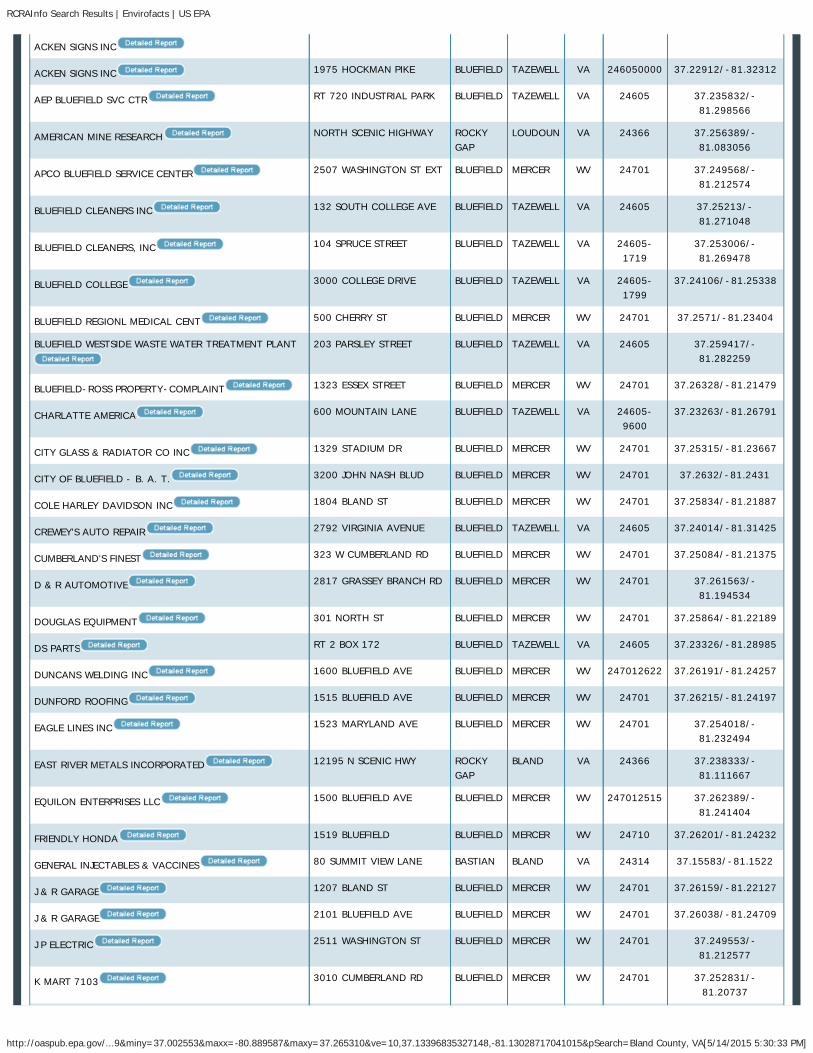
RCRAInfo Search Results | Envirofacts | US EPA
http://oaspub.epa.gov/...&miny=36.785092&maxx=-80.838776&maxy=37.048601&ve=10,36.91712951660157,-81.07856750488281&pSearch=Wythe County, VA[5/14/2015 5:19:33 PM]
ALL EPA THIS AREA Advanced Search
Contact UsEnvirofacts
RCRAInfo Links
OverviewSearchModelLawRCRAInfo Search User GuideContact UsOffice of Resource Conservationand Recovery Home
Search Results
RCRAInfo
List of Facilities Reporting to RCRAInfo in EnvirofactsHazardous waste information iscontained in the ResourceConservation and Recovery ActInformation (RCRAInfo), a nationalprogram management and inventorysystem about hazardous wastehandlers. In general, all generators,transporters, treaters, storers, anddisposers of hazardous waste arerequired to provide informationabout their activities to stateenvironmental agencies. Theseagencies, in turn pass on theinformation to regional and nationalEPA offices. This regulation isgoverned by the ResourceConservation and Recovery Act(RCRA), as amended by theHazardous and Solid WasteAmendments of 1984. You may usethe Hazardous Waste Search todetermine identification and locationdata for specific hazardous wastehandlers, and to find a wide range ofinformation on treatment, storage,and disposal facilities regardingpermit/closure status, compliancewith Federal and State regulations,and cleanup activities. There is alsoinformation on related Laws andregulations.
Search Results for: Wythe County, VA
The data within the table below canbe downloaded in a comma-seperated value file for use in Excelby clicking here:
*Zoom or pan map to change location.
© 2015 Nokia, © AND, © …
+–
*The search results are based upon the facilities that are visible within the map above. To refine your search to a more targeted area of interest, please visitthe RCRAInfo Search Form. To search Envirofacts via an interactive map, please view your results in EnviroMapper for Envirofacts
FACILITY NAME STREET ADDRESS CITY NAME COUNTY STATE ZIP CODE LATITUDE/LONGITUDE
ACUMENT GLOBAL TECHNOLOGIES CAMCAR LLC 345 E. MARSHALL ST. WYTHEVILLE WYTHE VA 243823999 36.945084/-81.073775
AEP WYTHEVILLE SERVICE CENTER 200 APPALACHAIN DR. WYTHEVILLE WYTHE VA 24382 36.96482/-81.11287
You are here: EPA Home Envirofacts RCRAInfo Search Results
Home Multisystem Search Topic Searches System Data Searches About the Data Data Downloads Widgets Services Mobile Other Datasets
Share

RCRAInfo Search Results | Envirofacts | US EPA
http://oaspub.epa.gov/...&miny=36.785092&maxx=-80.838776&maxy=37.048601&ve=10,36.91712951660157,-81.07856750488281&pSearch=Wythe County, VA[5/14/2015 5:19:33 PM]
AIRCO WELDING PRODUCTS RT 616 RURALRETREAT
WYTHE VA 24368 36.89406/-81.259815
AUSTINVILLE LIMESTONE CO INC OFF HWY 619 AUSTINVILLE WYTHE VA 24312 36.875833/-80.9625
COALFIELD SERVICES, INC 3203 PEPPERS FERRY ROAD WYTHEVILLE WYTHE VA 24382-4980
36.975309/-81.008964
COASTAL MART INC #822 720 W LEE HWY WYTHEVILLE WYTHE VA 24382 36.947164/-81.096291
COMMERCIAL PRINTING CO 160 TAZEWELL ST WYTHEVILLE WYTHE VA 24382 36.95026/-81.083965
CON-WAY FREIGHT - NWY 695 LITHIA ROAD WYTHEVILLE WYTHE VA 243825130 36.95217/-81.05158
COOK S PROFESSIONAL CLEANERS 1380 E MAIN ST WYTHEVILLE WYTHE VA 24382 36.9508/-81.06767
CRISP MFG CO INC INDUTRIAL AVE RURALRETREAT
WYTHE VA 24368 36.941389/-81.243889
CVS PHARMACY #6327 1370 EAST MAIN ST WYTHEVILLE WYTHE VA 24382 36.950585/-81.067172
EAST TENNESSEE NATURAL GAS COMPANY 588 SHOAL RIDGE DR RURALRETREAT
WYTHE VA 24368 36.925423/-81.26208
ELECTRO FINISHING SERVICES 6817 W LEE HWY RURALRETREAT
WYTHE VA 24368 36.9089/-81.2706
EMERSON ELECTRIC CO. ALCO CONTROLS DIV. 555 PEPPERS FERRY RD. WYTHEVILLE WYTHE VA 24382 36.96213/-81.07428
FAST FARE INC T/A CROWN VA-531 885 EAST MAIN ST WYTHEVILLE WYTHE VA 24382 36.953/-81.0748
FOX JOHN OLDSMOBILE GMC NISSAN 1305 E MAIN ST WYTHEVILLE WYTHE VA 24382 36.95094/-81.068357
HUTCHINSON SEALING SYSTEMS INC 1150 SOUTH 3RD STREET WYTHEVILLE WYTHE VA 24382-3925
36.943063/-81.072225
I-81 TRUCK & AUTO GARAGE I-81 EXIT 28 MAXMEADOWS
WYTHE VA 24360 36.961667/-80.905
JOHNSON, R P SONS INC 355 E MAIN ST WYTHEVILLE WYTHE VA 24382 36.951561/-81.081273
KMART #3706 1480 EAST MAIN ST WYTHEVILLE WYTHE VA 24382 36.94974/-81.06541
LEE SARA KNIT PRODUCTS CARROLL COUNTY IND PK HILLSVILLE CARROLL VA 24343 36.789444/-80.838889
LIGHTNIN 825 FAIRVIEW RD WYTHEVILLE WYTHE VA 243820000 36.97054/-81.11033
LONGWOOD ELASTOMERS INC 365 GEORGE JAMES DR. WYTHEVILLE WYTHE VA 24382 36.96574/-81.12006
LONGWOOD ELASTOMERS INC. 655 FAIRVIEW RD. WYTHEVILLE WYTHE VA 24382 36.969/-81.10899
MICHAELS AUTOMOTIVE INC 315 E MONROE ST WYTHEVILLE WYTHE VA 243822337 36.951891/-81.082463
MID ATLANTIC MANFACTURING AND HYDRAULICS INC 708 MILK PLANT RD RURALRETREAT
WYTHE VA 24368 36.89441/-81.25882
MR AXLE 40 RAILROAD AVE RURALRETREAT
WYTHE VA 24368 36.8936/-81.26824
NATIONAL CARBIDE RTE 658 IVANHOE WYTHE VA 24350 36.852222/-81.041944
PENDLETON CONSTRUCTION CORP 24TH ST & 11 ST WYTHEVILLE WYTHE VA 24382 36.985278/-81.068056
PENDLETON CONSTRUCTION CORP PINE ST WYTHEVILLE WYTHE VA 24382 36.985278/-81.068056

RCRAInfo Search Results | Envirofacts | US EPA
http://oaspub.epa.gov/...&miny=36.785092&maxx=-80.838776&maxy=37.048601&ve=10,36.91712951660157,-81.07856750488281&pSearch=Wythe County, VA[5/14/2015 5:19:33 PM]
EPA Home Privacy and Security Notice Contact UsLast updated on Thursday, May 14, 2015
QUADRANT ENGINEERING PLASTIC PRODUCTS RTE 21 WYTHEVILLE WYTHE VA 24382 36.950619/-81.112113
R H SHEPPARD COMPANY INCORPORATED 1400 STAFFORD-UMBERGER DR.
WYTHEVILLE WYTHE VA 24382-4483
36.96822/-81.12132
RITE AID #4777 150 NORTH 11TH ST WYTHEVILLE WYTHE VA 24382 36.95413/-81.07866
ROHM & HAAS POWDER COATINGS 2460 N. 4TH ST. WYTHEVILLE WYTHE VA 24382 36.96087/-81.11466
RYDER TRANSPORTATION 1905 840 STAFFORD UMBERGERDR
WYTHEVILLE WYTHE VA 24382-4531
36.970267/-81.115309
SHEETZ, INC. #407 1340 NORTH 4TH STREET WYTHEVILLE WYTHE VA 24382 36.958807/-81.096097
SOUTHWESTERN EQUIPMENT HWY 11 NORTH RURALRETREAT
WYTHE VA 24368 36.941389/-81.243889
TRACTOR SUPPLY #1384 1380 E. MAIN STREET,SUITE 400
WYTHEVILLE WYTHE VA 24382 36.9508/-81.06767
UNIQUE CONSTRUCTION CO 790 E MAIN ST WYTHEVILLE WYTHE VA 24382 36.95345/-81.07626
USFS WYTHE DISTRICT 155 SHERWOOD FORESTRD
WYTHEVILLE WYTHE VA 24382 36.94222/-81.11424
VDOT - STRUCTURE 8001 RTE 610, PEPPERS FERRYROAD
WYTHEVILLE WYTHE VA 24382 36.962151/-81.074259
WALMART SUPERCENTER #3270 345 COMMONWEALTHDRIVE
WYTHEVILLE WYTHE VA 24382 36.95804/-81.09959
WYTHE COUNTY ANIMAL CLINIC RT 4 BOX 208 WYTHEVILLE WYTHE VA 24382 36.985278/-81.068056
WYTHE COUNTY COMMUNITY HOSPITAL 600 W RIDGE RD WYTHEVILLE WYTHE VA 243820000 36.95335/-81.09536
WYTHE FORD-MERCURY INC 1135 E MAIN ST WYTHEVILLE WYTHE VA 24382 36.95197/-81.07148
WYTHEVILLE COMMUNITY COLLEGE 1000 E MAIN ST WYTHEVILLE WYTHE VA 243820000 36.95244/-81.07301
Total Facilities Returned: 46
Return to more topical information

RCRAInfo Search Results | Envirofacts | US EPA
http://oaspub.epa.gov/...9&miny=37.002553&maxx=-80.889587&maxy=37.265310&ve=10,37.13396835327148,-81.13028717041015&pSearch=Bland County, VA[5/14/2015 5:30:33 PM]
ALL EPA THIS AREA Advanced Search
Contact UsEnvirofacts
RCRAInfo Links
OverviewSearchModelLawRCRAInfo Search User GuideContact UsOffice of Resource Conservationand Recovery Home
Search Results
RCRAInfo
List of Facilities Reporting to RCRAInfo in EnvirofactsHazardous waste information iscontained in the ResourceConservation and Recovery ActInformation (RCRAInfo), a nationalprogram management and inventorysystem about hazardous wastehandlers. In general, all generators,transporters, treaters, storers, anddisposers of hazardous waste arerequired to provide informationabout their activities to stateenvironmental agencies. Theseagencies, in turn pass on theinformation to regional and nationalEPA offices. This regulation isgoverned by the ResourceConservation and Recovery Act(RCRA), as amended by theHazardous and Solid WasteAmendments of 1984. You may usethe Hazardous Waste Search todetermine identification and locationdata for specific hazardous wastehandlers, and to find a wide range ofinformation on treatment, storage,and disposal facilities regardingpermit/closure status, compliancewith Federal and State regulations,and cleanup activities. There is alsoinformation on related Laws andregulations.
Search Results for: Bland County, VA
The data within the table below canbe downloaded in a comma-seperated value file for use in Excelby clicking here:
*Zoom or pan map to change location.
© 2015 Nokia, © 2015 Mic…
+–
*The search results are based upon the facilities that are visible within the map above. To refine your search to a more targeted area of interest, please visitthe RCRAInfo Search Form. To search Envirofacts via an interactive map, please view your results in EnviroMapper for Envirofacts
FACILITY NAME STREET ADDRESS CITYNAME
COUNTY STATE ZIP CODE LATITUDE/LONGITUDE
ABB INC 171 INDUSTRY DR. BLAND BLAND VA 24315 37.107232/-81.11082
100 PINE ST BLUEFIELD MERCER WV 24701 37.26502/-81.23753
You are here: EPA Home Envirofacts RCRAInfo Search Results
Home Multisystem Search Topic Searches System Data Searches About the Data Data Downloads Widgets Services Mobile Other Datasets
Share
RCRAInfo Search Results | Envirofacts | US EPA
http://oaspub.epa.gov/...9&miny=37.002553&maxx=-80.889587&maxy=37.265310&ve=10,37.13396835327148,-81.13028717041015&pSearch=Bland County, VA[5/14/2015 5:30:33 PM]
ACKEN SIGNS INC
ACKEN SIGNS INC 1975 HOCKMAN PIKE BLUEFIELD TAZEWELL VA 246050000 37.22912/-81.32312
AEP BLUEFIELD SVC CTR RT 720 INDUSTRIAL PARK BLUEFIELD TAZEWELL VA 24605 37.235832/-81.298566
AMERICAN MINE RESEARCH NORTH SCENIC HIGHWAY ROCKYGAP
LOUDOUN VA 24366 37.256389/-81.083056
APCO BLUEFIELD SERVICE CENTER 2507 WASHINGTON ST EXT BLUEFIELD MERCER WV 24701 37.249568/-81.212574
BLUEFIELD CLEANERS INC 132 SOUTH COLLEGE AVE BLUEFIELD TAZEWELL VA 24605 37.25213/-81.271048
BLUEFIELD CLEANERS, INC 104 SPRUCE STREET BLUEFIELD TAZEWELL VA 24605-1719
37.253006/-81.269478
BLUEFIELD COLLEGE 3000 COLLEGE DRIVE BLUEFIELD TAZEWELL VA 24605-1799
37.24106/-81.25338
BLUEFIELD REGIONL MEDICAL CENT 500 CHERRY ST BLUEFIELD MERCER WV 24701 37.2571/-81.23404
BLUEFIELD WESTSIDE WASTE WATER TREATMENT PLANT 203 PARSLEY STREET BLUEFIELD TAZEWELL VA 24605 37.259417/-81.282259
BLUEFIELD-ROSS PROPERTY-COMPLAINT 1323 ESSEX STREET BLUEFIELD MERCER WV 24701 37.26328/-81.21479
CHARLATTE AMERICA 600 MOUNTAIN LANE BLUEFIELD TAZEWELL VA 24605-9600
37.23263/-81.26791
CITY GLASS & RADIATOR CO INC 1329 STADIUM DR BLUEFIELD MERCER WV 24701 37.25315/-81.23667
CITY OF BLUEFIELD - B. A. T. 3200 JOHN NASH BLUD BLUEFIELD MERCER WV 24701 37.2632/-81.2431
COLE HARLEY DAVIDSON INC 1804 BLAND ST BLUEFIELD MERCER WV 24701 37.25834/-81.21887
CREWEY'S AUTO REPAIR 2792 VIRGINIA AVENUE BLUEFIELD TAZEWELL VA 24605 37.24014/-81.31425
CUMBERLAND'S FINEST 323 W CUMBERLAND RD BLUEFIELD MERCER WV 24701 37.25084/-81.21375
D & R AUTOMOTIVE 2817 GRASSEY BRANCH RD BLUEFIELD MERCER WV 24701 37.261563/-81.194534
DOUGLAS EQUIPMENT 301 NORTH ST BLUEFIELD MERCER WV 24701 37.25864/-81.22189
DS PARTS RT 2 BOX 172 BLUEFIELD TAZEWELL VA 24605 37.23326/-81.28985
DUNCANS WELDING INC 1600 BLUEFIELD AVE BLUEFIELD MERCER WV 247012622 37.26191/-81.24257
DUNFORD ROOFING 1515 BLUEFIELD AVE BLUEFIELD MERCER WV 24701 37.26215/-81.24197
EAGLE LINES INC 1523 MARYLAND AVE BLUEFIELD MERCER WV 24701 37.254018/-81.232494
EAST RIVER METALS INCORPORATED 12195 N SCENIC HWY ROCKYGAP
BLAND VA 24366 37.238333/-81.111667
EQUILON ENTERPRISES LLC 1500 BLUEFIELD AVE BLUEFIELD MERCER WV 247012515 37.262389/-81.241404
FRIENDLY HONDA 1519 BLUEFIELD BLUEFIELD MERCER WV 24710 37.26201/-81.24232
GENERAL INJECTABLES & VACCINES 80 SUMMIT VIEW LANE BASTIAN BLAND VA 24314 37.15583/-81.1522
J & R GARAGE 1207 BLAND ST BLUEFIELD MERCER WV 24701 37.26159/-81.22127
J & R GARAGE 2101 BLUEFIELD AVE BLUEFIELD MERCER WV 24701 37.26038/-81.24709
J P ELECTRIC 2511 WASHINGTON ST BLUEFIELD MERCER WV 24701 37.249553/-81.212577
K MART 7103 3010 CUMBERLAND RD BLUEFIELD MERCER WV 24701 37.252831/-81.20737

RCRAInfo Search Results | Envirofacts | US EPA
http://oaspub.epa.gov/...9&miny=37.002553&maxx=-80.889587&maxy=37.265310&ve=10,37.13396835327148,-81.13028717041015&pSearch=Bland County, VA[5/14/2015 5:30:33 PM]
KENNETH BAILEY'S BODY SHOP 1519 BLUEFIELD AVENUE BLUEFIELD MARION WV 24701 37.26201/-81.24232
KERSEY MFG CO 600 MT LANE BLUEFIELD TAZEWELL VA 24605 37.233254/-81.268271
KMART #4701 3977 CUMBERLAND ROAD BLUEFIELD MERCER WV 24701 37.261805/-81.188149
KOLLMORGEN INLAND MTR BLUEFIELD 720 INDUSTRIAL PARK BLUEFIELD TAZEWELL VA 24605 37.235832/-81.298566
KROGER STORE #176 3032 E CUMBERLAND RD BLUEFIELD MERCER WV 24701 37.25348/-81.20578
LARRYS PNEUMATIC SERVICE 124 MULBERRY ST BLUEFIELD MERCER WV 24701 37.26058/-81.2439
LAWRENCE BROTHERS INC 203 LAWRENCE ROAD BLUEFIELD TAZEWELL VA 246050000 37.218671/-81.350561
MC SIGN COMPANY (BLUEFIELD) 334 INDUSTRIAL PARKROAD
BLUEFIELD TAZEWELL VA 24605 37.23662/-81.30419
MCGRAW EDISON SERVICE 1400 BLUEFIELD AVE BLUEFIELD MERCER WV 24701 37.26286/-81.24026
METCALFE BROTHERS INCORPORATED FURNACE ST BLUEFIELD TAZEWELL VA 246050000 37.24944/-81.27933
MOUNTAINEER BOWLING LANES 3224 CUMBERLAND RD BLUEFIELD MERCER WV 24701 37.25744/-81.19748
PARSON & ASSOCIATES INC RT 290 CUMBERLANDINDUST PARK
BLUEFIELD MERCER WV 24701 37.251496/-81.21291
PASCOR ATLANTIC CORP STATE ROUTE 42 BLAND BLAND VA 24315 37.108056/-81.111111
PEMCO CORPORATION RTE 720 BLUEFIELD TAZEWELL VA 246050000 37.2317/-81.2694
PENSKE AUTO CENTER 3977 CUMBERLAND AVESTE B
BLUEFIELD MERCER WV 24701 37.261805/-81.188149
PERDUE & SONS BODY REPAIR 228 S COLLEGE AVE BLUEFIELD TAZEWELL VA 24605 37.250278/-81.270341
PETROLEUM PRODUCT BLUEFIELD PLANT 081 716 VIRGINIA AVE BLUEFIELD TAZEWELL VA 246050000 37.25375/-81.27432
PETROLEUM PRODUCTS, LLC 757 TOWER STREET BLUEFIELD TAZEWELL VA 24605 37.254947/-81.274058
POUNDING MILL QUARRY CORPORATION - BLUEFIELD
PLANT
171 ST CLAIRS CROSSING BLUEFIELD TAZEWELL VA 24605-9332
37.23659/-81.31882
POUNDING MILL QUARRY INGLESIDE 171 ST. CLAIR'S CROSSING BLUEFIELD MERCER WV 24605 37.23659/-81.31882
PRINTING & ALLIED INDUSTRIES 821 BLUEFIELD AVE BLUEFIELD MERCER WV 24701 37.2653/-81.23475
REALCO LIMITED LIABILITY CO 1125 BLUEFIELD AVE BLUEFIELD MERCER WV 24701 37.26388/-81.23788
S B R INC STORE 127 BLUEFIELD AVE & CHERRYST
BLUEFIELD MERCER WV 24701 37.26374/-81.238165
SAM'S CLUB # 6569 601 COMMERCE DRIVE BLUEFIELD TAZEWELL VA 24605-9221
37.238708/-81.248989
SHERWIN WILLIAMS CO THE 3104 CUMBERLAND RD BLUEFIELD MERCER WV 24701 37.25393/-81.20472
ST LUKES HOSPITAL 1333 SOUTHVIEW DRIVE BLUEFIELD MERCER WV 24701 37.24349/-81.23129
SWOPE CONSTRUCTION SERVICES 1325 BLUEFIELD AVE BLUEFIELD MERCER WV 24701 37.26311/-81.23966
T & T PONTIAC BUICK JEEP EAGLE 1015 BLUEFIELD AVE BLUEFIELD MERCER WV 24701 37.26439/-81.23669
TRACTOR SUPPLY #166 3955 CUMBERLAND RD BLUEFIELD MERCER WV 24701 37.261645/-81.188462
TRUCK CITY PARTS 1713 BLAND ST BLUEFIELD MERCER WV 24701 37.25872/-81.219086

RCRAInfo Search Results | Envirofacts | US EPA
http://oaspub.epa.gov/...9&miny=37.002553&maxx=-80.889587&maxy=37.265310&ve=10,37.13396835327148,-81.13028717041015&pSearch=Bland County, VA[5/14/2015 5:30:33 PM]
EPA Home Privacy and Security Notice Contact UsLast updated on Thursday, May 14, 2015
TURN 4 TRUCK AUTO 1001 BLUEFIELD AVE BLUEFIELD MERCER WV 24701 37.26453/-81.23638
UMBERGERS GARAGE 2408 WASH ST BLUEFIELD MERCER WV 24701 37.25063/-81.213781
UNIQUE CLEANERS OF BLUEFIELD 116 SOUTH ST BLUEFIELD MERCER WV 24701 37.2587/-81.21996
UPTOWN CLEANERS 1231 BLAND ST BLUEFIELD MERCER WV 24701 37.26121/-81.22109
USARC BLUEFIELD/MEM 304TH MP CO (1)(CS) 532 CUMBERLAND RD BLUEFIELD MERCER WV 24701 37.249527/-81.217149
VIRGINIA DEPT OF TRANSP BG WLKR MTN TUNL RT 77 5 MI N OFWYTHEVILLE
BLAND BLAND VA 24315 37.129444/-81.038333
VIRGINIA DEPT OF TRANSP E RIV MTN TUNL RT 77 AT THE VIRGINIAWEST VA
ROCKYGAP
BLAND VA 24366 37.256389/-81.083056
WALMART SUPERCENTER #1763 4001 COLLEGE AVENUE BLUEFIELD TAZEWELL VA 24605 37.246292/-81.242207
Total Facilities Returned: 70
Return to more topical information

TRI Search Results | Envirofacts | US EPA
http://oaspub.epa.gov/...&miny=36.785092&maxx=-80.838776&maxy=37.048601&ve=10,36.91712951660157,-81.07856750488281&pSearch=Wythe County, VA[5/14/2015 5:21:19 PM]
ALL EPA THIS AREA Advanced Search
Contact UsEnvirofacts
TRI Links
OverviewTRI Tools
TRI ExplorerTRI SearchForm R SearchForm R & A DownloadEZ SearchCustomized SearchPollution PreventionData Element Search Tool
TRI Guides
TRI Explorer GuideTRI Search GuideForm R & A Download GuideEZ Search GuideCustomized Search GuidePollution Prevention GuideOperator DefinitionModel
Contact UsTRI Program HomeRSEI Program Home
Search Results
TRI
List of Facilities Reporting to TRI in EnvirofactsThe Toxics Release Inventory (TRI)contains information about morethan 650 toxic chemicals that arebeing used, manufactured, treated,transported, or released into theenvironment. Manufacturers of thesechemicals are required to report thelocations and quantities of chemicalsstored on-site to state and localgovernments. The reports aresubmitted to the EPA and stategovernments. EPA compiles this datain an on-line, publicly accessiblenational computerized database.Using this information, citizens,businesses, and governments canwork together to protect the qualityof their land, air, and water. Notethat Envirofacts does not provideany safety or health informationabout these chemicals andcompounds. You may use the ToxicRelease Search for basic facilityinformation and chemical reports,which tabulate air emissions, surfacewater discharges, releases to land,underground injections, andtransfers to off-site locations. TheTRI National Analysis websiteprovides a brochure with a quickoverview of TRI data for the currentreporting year and general trendsover the past several years.
Search Results for: Wythe County, VA
The data within the table below canbe downloaded in a comma-seperated value file for use in Excelby clicking here:
*Zoom or pan map to change location.
© 2015 Nokia, © AND, © …
+–
*The search results are based upon the facilities that are visible within the map above. To refine your search to a more targeted area of interest, please visitthe TRI Search Form. To search Envirofacts via an interactive map, please view your results in EnviroMapper for Envirofacts
FACILITY NAME STREET ADDRESS CITY NAME COUNTY STATE ZIPCODE
LATITUDE/LONGITUDE SUBMISSIONS RISKSCREENING
ACUMENT GLOBAL TECHNOLOGIES 345 E MARSHALL ST WYTHEVILLE WYTHE VA 24382 36.945084/- 105 Report
You are here: EPA Home Envirofacts TRI Search Results
Home Multisystem Search Topic Searches System Data Searches About the Data Data Downloads Widgets Services Mobile Other Datasets

TRI Search Results | Envirofacts | US EPA
http://oaspub.epa.gov/...&miny=36.785092&maxx=-80.838776&maxy=37.048601&ve=10,36.91712951660157,-81.07856750488281&pSearch=Wythe County, VA[5/14/2015 5:21:19 PM]
EPA Home Privacy and Security Notice Contact Us
CAMCAR LLC 81.073775
EMERSON ELECTRIC CO. ALCO
CONTROLS DIV.
555 PEPPERS FERRYRD.
WYTHEVILLE WYTHE VA 24382 36.96213/-81.07428 56 Report
HUTCHINSON SEALING SYSTEMS INC 1150 S THIRD ST WYTHEVILLE WYTHE VA 24382 36.943063/-81.072225
39 Report
LONGWOOD ELASTOMERS INC. 655 FAIRVIEW RD. WYTHEVILLE WYTHE VA 24382 36.969/-81.10899 14 Report
POLYMER CORP. 2530 N. 4TH ST. WYTHEVILLE WYTHE VA 24382 36.950619/-81.112113
15 Report
RH SHEPPARD CO INC 1400 STAFFORD-UMBERGER DR
WYTHEVILLE WYTHE VA 24382 36.96822/-81.12132 20 Report
ROHM & HAAS POWDER COATINGS 2460 N FOURTH ST WYTHEVILLE WYTHE VA 24382 36.96087/-81.11466 52 Report
Total Facilities Returned: 7
Return to more topical information

TRI Search Results | Envirofacts | US EPA
http://oaspub.epa.gov/...9&miny=37.002553&maxx=-80.889587&maxy=37.265310&ve=10,37.13396835327148,-81.13028717041015&pSearch=Bland County, VA[5/14/2015 5:32:07 PM]
ALL EPA THIS AREA Advanced Search
Contact UsEnvirofacts
TRI Links
OverviewTRI Tools
TRI ExplorerTRI SearchForm R SearchForm R & A DownloadEZ SearchCustomized SearchPollution PreventionData Element Search Tool
TRI Guides
TRI Explorer GuideTRI Search GuideForm R & A Download GuideEZ Search GuideCustomized Search GuidePollution Prevention GuideOperator DefinitionModel
Contact UsTRI Program HomeRSEI Program Home
Search Results
TRI
List of Facilities Reporting to TRI in EnvirofactsThe Toxics Release Inventory (TRI)contains information about morethan 650 toxic chemicals that arebeing used, manufactured, treated,transported, or released into theenvironment. Manufacturers of thesechemicals are required to report thelocations and quantities of chemicalsstored on-site to state and localgovernments. The reports aresubmitted to the EPA and stategovernments. EPA compiles this datain an on-line, publicly accessiblenational computerized database.Using this information, citizens,businesses, and governments canwork together to protect the qualityof their land, air, and water. Notethat Envirofacts does not provideany safety or health informationabout these chemicals andcompounds. You may use the ToxicRelease Search for basic facilityinformation and chemical reports,which tabulate air emissions, surfacewater discharges, releases to land,underground injections, andtransfers to off-site locations. TheTRI National Analysis websiteprovides a brochure with a quickoverview of TRI data for the currentreporting year and general trendsover the past several years.
Search Results for: Bland County, VA
The data within the table below canbe downloaded in a comma-seperated value file for use in Excelby clicking here:
*Zoom or pan map to change location.
© 2015 HERE, © 2015 Mi…
+–
*The search results are based upon the facilities that are visible within the map above. To refine your search to a more targeted area of interest, please visitthe TRI Search Form. To search Envirofacts via an interactive map, please view your results in EnviroMapper for Envirofacts
FACILITY NAME STREETADDRESS
CITYNAME
COUNTY STATE ZIP CODE LATITUDE/LONGITUDE SUBMISSIONS RISKSCREENING
ABB INC 171 INDUSTRY BLAND BLAND VA 24315 37.107232/- 61 Report
You are here: EPA Home Envirofacts TRI Search Results
Home Multisystem Search Topic Searches System Data Searches About the Data Data Downloads Widgets Services Mobile Other Datasets

TRI Search Results | Envirofacts | US EPA
http://oaspub.epa.gov/...9&miny=37.002553&maxx=-80.889587&maxy=37.265310&ve=10,37.13396835327148,-81.13028717041015&pSearch=Bland County, VA[5/14/2015 5:32:07 PM]
EPA Home Privacy and Security Notice Contact Us
DR 81.11082
BLUEFIELD BEVERAGE CO. RTE. 2, BOX173-I
BLUEFIELD TAZEWELL VA 246059998 37.235832/-81.298566
11 Report
PASCOR ATLANTIC CORP 254 INDUSTRYDR
BLAND BLAND VA 24315 37.108056/-81.111111
14 Report
PETROLEUM PRODUCT BLUEFIELD PLANT
081
716 VIRGINIAAVE
BLUEFIELD TAZEWELL VA 24605 37.25375/-81.27432 5 Report
PETROLEUM PRODUCT BLUEFIELD PLANT
082
757 NCOLLEGE AVE
BLUEFIELD TAZEWELL VA 24605 37.241248/-81.260761
1 Report
Total Facilities Returned: 5
Return to more topical information

ATTACHMENT 2.D.1: VDCR, DGIF, AND USFWS CORRESPONDENCE


U.S. Fish and Wildlife Service
Trust Resources List
02/11/2015 Information, Planning, and Conservation System (IPAC) Page 1 of 8
Version 1.4
This resource list is to be used for planning purposes only — it is not an official species list.
Endangered Species Act species list information for your project is available online and listed below for the following FWS Field Offices:
Virginia Ecological Services Field Office6669 SHORT LANEGLOUCESTER, VA 23061(804) 693-6694http://www.fws.gov/northeast/virginiafield/
West Virginia Ecological Services Field Office694 BEVERLY PIKEELKINS, WV 26241(304) 636-6586http://www.fws.gov/westvirginiafieldoffice/
Project Name:Bland_021115

U.S. Fish and Wildlife Service
Trust Resources List
02/11/2015 Information, Planning, and Conservation System (IPAC) Page 2 of 8
Version 1.4
Project Location Map:
Project Counties:Bland, VA | Tazewell, VA | Wythe, VA | Mercer, WV
Geographic coordinates (Open Geospatial Consortium Well-Known Text, NAD83):MULTIPOLYGON (((-81.2400511 37.2415632, -81.2256962 37.2529864, -81.199413 37.2314086, -81.1841129 37.2163736, -81.1512871 37.2242709, -81.1158874 37.1839183, -81.1362128 37.1641465, -81.110259 37.0598991, -81.0721942 37.0038525, -81.0480888 36.9768294, -80.9973596 36.9664691, -81.000909 36.9524412, -81.0703888 36.9638225, -81.1345684 37.052918, -81.1469867 37.1016538, -81.1585655 37.1514806, -81.1736411 37.1733214, -81.1985175 37.1813414, -81.2221404 37.2040538, -81.220881 37.2187515, -81.2400511 37.2415632)))

U.S. Fish and Wildlife Service
Trust Resources List
02/11/2015 Information, Planning, and Conservation System (IPAC) Page 3 of 8
Version 1.4
Project Type:Transmission Line
Endangered Species Act Species List (USFWS Endangered Species Program).There are a total of 6 threatened or endangered species on your species list. Species on this list should be considered in an effectsanalysis for your project and could include species that exist in another geographic area. For example, certain fishes may appear on the species list because a project could cause downstream effects on the species. Critical habitats listed under the Has Critical Habitat column may or may not lie within your project area. See the Critical habitats within your project area section below for critical habitat that lies within your project area. Please contact the designated FWS office if you have questions.
Species that should be considered in an effects analysis for your project:
Flowering Plants Status Has Critical Habitat Contact
Northeastern bulrush (Scirpus ancistrochaetus)
Endangered speciesinfo
Virginia Ecological Services Field Office
Virginia spiraea (Spiraea virginiana)
Threatened speciesinfo
West Virginia Ecological Services Field Office
Mammals
Gray bat(Myotis grisescens)
Population: Entire
Endangered speciesinfo
Virginia Ecological Services Field Office
Indiana bat(Myotis sodalis)
Population: Entire
Endangered speciesinfo
Virginia Ecological Services Field Office,West Virginia Ecological Services Field Office

U.S. Fish and Wildlife Service
Trust Resources List
02/11/2015 Information, Planning, and Conservation System (IPAC) Page 4 of 8
Version 1.4
northern long-eared Bat(Myotis septentrionalis)
Population:
ProposedEndangered
speciesinfo
Virginia Ecological Services Field Office,West Virginia Ecological Services Field Office
Virginia Big-Eared bat (Corynorhinus (=plecotus) townsendii virginianus)
Population: Entire
Endangered speciesinfo
Final designated critical habitat
Virginia Ecological Services Field Office,West Virginia Ecological Services Field Office
Critical habitats within your project area:
There are no critical habitats within your project area.
FWS National Wildlife Refuges (USFWS National Wildlife Refuges Program).There are no refuges found within the vicinity of your project.
FWS Migratory Birds (USFWS Migratory Bird Program).The protection of birds is regulated by the Migratory Bird Treaty Act (MBTA) and the Bald and Golden Eagle Protection Act (BGEPA). Any activity, intentional or unintentional, resulting in take of migratory birds, including eagles, is prohibited unless otherwise permitted by the U.S. Fish and Wildlife Service (50 C.F.R. Sec. 10.12 and 16 U.S.C. Sec. 668(a)). The MBTA has no provision for allowing take of migratory birds that may be unintentionally killed or injured by otherwise lawful activities. For more information regarding these Acts see: http://www.fws.gov/migratorybirds/RegulationsandPolicies.html.
All project proponents are responsible for complying with the appropriate regulations protecting birds when planning and developing a project. To meet these conservation obligations, proponents should identify potential or existing project-related impacts to migratory birds and their habitat and develop and implement conservation measures that avoid, minimize, or compensate for these impacts. The Service's Birds of Conservation Concern (2008) report identifies species, subspecies, and populations of all migratory nongame birds that, without

U.S. Fish and Wildlife Service
Trust Resources List
02/11/2015 Information, Planning, and Conservation System (IPAC) Page 5 of 8
Version 1.4
additional conservation actions, are likely to become listed under the Endangered Species Act as amended (16 U.S.C 1531 et seq.).
For information about Birds of Conservation Concern, go to:http://www.fws.gov/migratorybirds/CurrentBirdIssues/Management/BCC.html.
To search and view summaries of year-round bird occurrence data within your project area, go to the Avian Knowledge Network Histogram Tool links in the Bird Conservation Tools section at: http://www.fws.gov/migratorybirds/CCMB2.htm.
For information about conservation measures that help avoid or minimize impacts to birds, please visit:http://www.fws.gov/migratorybirds/CCMB2.htm.
Migratory birds of concern that may be affected by your project:There are 18 birds on your Migratory birds of concern list. The underlying data layers used to generate the migratory bird list of concern will continue to be updated regularly as new and better information is obtained. User feedback is one method of identifying any needed improvements. Therefore, users are encouraged to submit comments about any questions regarding species ranges (e.g., a bird on the USFWS BCC list you know does not occur in the specified location appears on the list, or a BCC species that you know does occur there is not appearing on the list). Comments should be sent to the ECOS Help Desk.
Species Name Bird of Conservation Concern (BCC)
S p e c i e sProfile
Seasonal Occurrence in Project Area
Bald eagle (Haliaeetus leucocephalus) Yes species info Year-round
Black-billed Cuckoo (Coccyzuserythropthalmus)
Yes species info Breeding
Blue-winged Warbler (Vermivora pinus)
Yes species info Breeding
Canada Warbler (Wilsonia canadensis) Yes species info Breeding
cerulean warbler (Dendroica cerulea) Yes species info Breeding
Fox Sparrow (Passerella liaca) Yes species info Wintering
Golden-Winged Warbler (Vermivora chrysoptera)
Yes species info Breeding
Henslow's sparrow (Ammodramushenslowii)
Yes species info Breeding

U.S. Fish and Wildlife Service
Trust Resources List
02/11/2015 Information, Planning, and Conservation System (IPAC) Page 6 of 8
Version 1.4
Kentucky Warbler (Oporornisformosus)
Yes species info Breeding
Louisiana Waterthrush (Parkesia motacilla)
Yes species info Breeding
Pied-billed Grebe (Podilymbus podiceps)
Yes species info Year-round
Prairie Warbler (Dendroica discolor) Yes species info Breeding
Red-headed Woodpecker (Melanerpeserythrocephalus)
Yes species info Breeding
Rusty Blackbird (Euphagus carolinus) Yes species info Wintering
Swainson's Warbler (Limnothlypisswainsonii)
Yes species info Breeding
Wood Thrush (Hylocichla mustelina) Yes species info Breeding
Worm eating Warbler (Helmitherosvermivorum)
Yes species info Breeding
Yellow-Bellied sapsucker (sphyrapicus varius)
Yes species info Breeding
NWI Wetlands (USFWS National Wetlands Inventory).
The U.S. Fish and Wildlife Service is the principal Federal agency that provides information on the extent and status of wetlands in the U.S., via the National Wetlands Inventory Program (NWI). In addition to impacts to wetlands within your immediate project area, wetlands outside of your project area may need to be considered in any evaluation of project impacts, due to the hydrologic nature of wetlands (for example, project activities may affect local hydrology within, and outside of, your immediate project area). It may be helpful to refer to the USFWS National Wetland Inventory website. The designated FWS office can also assist you. Impacts to wetlands and other aquatic habitats from your project may be subject to regulation under Section 404 of the Clean Water Act, or other State/Federal Statutes. Project Proponents should discuss the relationship of these requirements to their project with the Regulatory Program of the appropriate U.S. Army Corps of Engineers District.
Data Limitations, Exclusions and PrecautionsThe Service's objective of mapping wetlands and deepwater habitats is to produce reconnaissance level

U.S. Fish and Wildlife Service
Trust Resources List
02/11/2015 Information, Planning, and Conservation System (IPAC) Page 7 of 8
Version 1.4
information on the location, type and size of these resources. The maps are prepared from the analysis of high altitude imagery. Wetlands are identified based on vegetation, visible hydrology and geography. A margin of error is inherent in the use of imagery; thus, detailed on-the-ground inspection of any particular site may result in revision of the wetland boundaries or classification established through image analysis.
The accuracy of image interpretation depends on the quality of the imagery, the experience of the image analysts, the amount and quality of the collateral data and the amount of ground truth verification work conducted. Metadata should be consulted to determine the date of the source imagery used and any mapping problems.
Wetlands or other mapped features may have changed since the date of the imagery and/or field work. There may be occasional differences in polygon boundaries or classifications between the information depicted on the map and the actual conditions on site.
Exclusions - Certain wetland habitats are excluded from the National mapping program because of the limitations of aerial imagery as the primary data source used to detect wetlands. These habitats include seagrasses or submerged aquatic vegetation that are found in the intertidal and subtidal zones of estuaries and nearshore coastal waters. Some deepwater reef communities (coral or tuberficid worm reefs) have also been excluded from the inventory. These habitats, because of their depth, go undetected by aerial imagery.
Precautions - Federal, state, and local regulatory agencies with jurisdiction over wetlands may define and describe wetlands in a different manner than that used in this inventory. There is no attempt, in either the design or products of this inventory, to define the limits of proprietary jurisdiction of any Federal, state, or local government or to establish the geographical scope of the regulatory programs of government agencies. Persons intending to engage in activities involving modifications within or adjacent to wetland areas should seek the advice of appropriate federal, state, or local agencies concerning specified agency regulatory programs and proprietary jurisdictions that may affect such activities.
The following wetland types intersect your project area in one or more locations:
Wetland Types NWI Classification Code Total Acres
Freshwater Emergent Wetland PEM1C 1.357
Freshwater Emergent Wetland PEM1A 3.9638
Freshwater Forested/Shrub Wetland PSS/EM1Cb 0.4247
Freshwater Forested/Shrub Wetland PSS1Cb 0.4996
Freshwater Forested/Shrub Wetland PFO1Cb 1.1891
Freshwater Forested/Shrub Wetland PSS1A 1.0251

U.S. Fish and Wildlife Service
Trust Resources List
02/11/2015 Information, Planning, and Conservation System (IPAC) Page 8 of 8
Version 1.4
Freshwater Forested/Shrub Wetland PFO1C 3.8844
Freshwater Forested/Shrub Wetland PSS1C 1.6856
Freshwater Forested/Shrub Wetland PFO1A 6.5965
Freshwater Pond PUBHh 39.0654

U.S. Forest Service Region 8 Sensitive Species Lista with Occupancy Analysis Results
OARb GW J Species Name Common Name Range on or near GWJNFs Habitat Detail TES GRankVA
SRankWV
SRank
VERTEBRATEMammal
5 X XCorynorhinustownsendii virginianus
Virginia big eared bat
Summer: VA Tazewell Co (3 caves), Highland Co(1 cave); WV Pendleton Co (4 caves); Winter:Highland, Rockingham, Bland, and Tazewell Cos(6 caves); Pendleton Co (6 caves). Largest VApopulation in Tazewell Co and largest WVpopulation in Pendleton Co. Small numbers ofbats (usually <10) in a few other widelyscattered caves during summer months. Bath &Pulaski Co records are historic. No occupiedcaves currently known on Forest.
Resides in caves winter and summer. Short distancemigrant (<40 miles) between winter and summercaves. Forages primarily on moths and foraginghabitat is common (fields, forests, meadows, etc.).Forages within 6 miles of summer caves. USFWSCritical Habitat is 5 caves in WV (4 Pendleton Co and1 Tucker Co). Closest Critical Habitat cave to GWJNFis ~3 miles in Pendleton Co, WV..
E G3G4T2 S1 S2
5 X Myotis grisescens Gray bat Ridge & Valley, Clinch R watershed Caves winter and summer, forages widely. E G3 S1
5 X X Myotis leibii Eastern small footed bat Ridge & Valley
Hibernates in caves during winter, roosts in crevicesof large rock outcrops, cliffs, and under large rocks intalus & boulder fields during summer, plus similarman made structures like rip rap and bridges, forageswidely in all forested and open habitat types overboth ridges and valleys.
S G3 S2 S1
5 X X Myotis septentrionalis Northern long eared bat Blue Ridge, Ridge & Valley, Cumberland Mtns
Hibernates in crevices and cracks of cave walls duringwinter (sometimes mines & tunnels), difficult to findand rarely seen. During summer, forages widely androosts singly or in colonies underneath bark, incavities, or in crevices of both live and dead trees.Also may roost in structures like barns, sheds, &houses.
E G2G3 S3 S3S4
5 X X Myotis sodalis Indiana bat Blue Ridge, Ridge & Valley, Cumberland MtnsCaves winter, upland hardwoods summer, forageswidely along riparian areas and open woodlands.
E G2 S1 S1
INVERTEBRATEMussel (Mollusk, Class Bivalvia)
4 X Lasmigona subviridis Green floaterWidely distributed in N & S Fk Shenandoah R,Pedlar R, James R
Aquatic rivers S G3 S2 S2
Amphipod (Crustacean, Order Amphipoda)
5 X Stygobromus abditus James Cave amphipodJames, Sam Bells caves, Pulaski Co; Watsonscave, Wythe Co; and other New River caves
Aquatic caves, water well S G2G3 S2S3
Millipede (Class Diplopoda)
5 X Buotus carolinus A millipedeBrush Mtn, Whitetop Mtn, Apple Orchard Mtn,Tazewell Beartown
Beech leaf litter, deciduous forests. S G3 S3

U.S. Forest Service Region 8 Sensitive Species Lista with Occupancy Analysis Results
OARb GW J Species Name Common Name Range on or near GWJNFs Habitat Detail TES GRankVA
SRankWV
SRank
5 X Cleidogona hoffmaniHoffman's cleidogonidmillipede
Mt Rogers, Whitetop Mtn, Elk Garden; Hamiltoncave (private) Bland Co
Mountaintop species, leaf litter, deciduous forests. S G3 S2S3
5 X Dixioria fowleri Fowler’s millipedeWalker Mtn; Comers Rock on Iron Mtn; LaurelCk, Damascas; 1/2 mile west of NRA office;Tazewell Beartown
Leaf litter, deciduous forests. S G2 S2
Beetle (Insect, Order Cloeoptera)
6 X X Cicindela patruelaNorthern barrens tigerbeetle
Blue Ridge, Ridge & ValleyEroded slopes of exposed sandstone andconglomerate.
S G3 S2 S2S3
Butterfly, Skipper, Moth (Insect, Order Lepidoptera)
3 X X Speyeria diana Diana fritillary Blue Ridge, Ridge & ValleyGrasslands shrublands, near streams with thistlesand milkweeds. Larval host plant, violets, Viola spp.
S G3G4 S3 S2S3
3 X X Erynnis persius persius Persius duskywing Blue Ridge, Ridge & Valley Bogs, wet meadows, open seepages in boreal forests.Larval host plant, lupine, Lupinus perennis, wildindigo, Baptisia tinctoria.
S G5T1T3 S1
VASCULAR PLANT5 X X Allium oxyphilum Nodding onion Monroe, Summers, Mercer, Greenbrier Cos, WV Shale barrens, sandstone glades. S G2Q S1 S2
2 X X Berberis canadensis American barberry Blue Ridge, Ridge & ValleyCalcareous open woods, bluffs, cliffs, and alongfencerows.
S G3 S3S4 S1
5 X Cleistesiopsis bifaria Small spreading pogonia Craig, Dickenson, Scott, Wise CosWell drained, rather open, scrubby hillsides, oakpine heath woodlands, acidic soils.
S G4? S2 S1
5 X X Isotria medeoloides Small whorled pogoniaIn mountains of VA known only from Bedford,Craig, and Lee Cos; other VA occurrences inPiedmont & Coastal Plain
Open, mixed hardwood forests on level to gentlysloping terrain with north to east aspect.
T G2 S2 S1
5 X X Liatris helleri Turgid gayfeather Blue Ridge, Ridge & Valley Shale barrens, mountain hillside openings. S G3 S3 S2
1 X X Monotropsis odorata Sweet pinesap Blue Ridge, Ridge & Valley Dry oak pine heath woodlands, soil usually sandy. S G3 S3 S1
5 X X Phlox buckleyi Sword leaf phlox Blue Ridge, Ridge & ValleyOpen, often dry oak woodlands and rocky slopes,usually over shale in humus rich soils, often alongroadsides.
S G2 S2 S2
5 X X Pycnanthemum torrei Torrey's mountain mint Bland, Bath, Giles, Rockbridge, Wythe CosOpen, dry rocky woods, roadsides, and thickets nearstreams, heavy clay soil over calcareous rock.
S G2 S2? S1
5 X X Scutellaria saxatilis Rock skullcap Blue Ridge, Ridge & ValleyRich, dry to mesic ridgetop woods, 32 counties in VA,likely G4/S4.
S G3 S3 S2
1 X Tsuga caroliniana Carolina hemlock Blue Ridge north to James R. Rocky ridges and slopes, usually dry and well drained. S G3 S3

U.S. Forest Service Region 8 Sensitive Species Lista with Occupancy Analysis Results
OARb GW J Species Name Common Name Range on or near GWJNFs Habitat Detail TES GRankVA
SRankWV
SRank
Abbreviations:
OAR: Occupancy Analysis Results
GW: George Washington National Forest
J: Jefferson National Forest
GWJNF: George Washington and Jefferson National Forest
TES: Federally Listed as Threatened (T), Endangered ( E), or considered a Forest Sensitive Species (S)
GRank: Global Rank
VA SRank: Virginia State Rank
WV SRank: West Virginia State Ranka U.S. Forest Service updated February 24, 2014 (based on Region 8 sensitive species list effective January 1, 2002)b Occupancy Analysis Results Ranks:
1 Habitat present, species was searched for during field survey, but not found.
2 Field survey located species in activity area. Currently considered the 300 foot wide survey corridor.
3 Species not seen during field survey, but possibly occurs in activity area based on habitat observed, or field survey not conducted when species isrecognizable (time of year or time of day). Therefore assume presence and no additional surveys needed.
4 Aquatic species or habitat known or suspected downstream of project/activity area, but inside identified geographic bounds of water resourcecumulative effects analysis area.
5 Indicates surveys are planned or in progress for the 2015 field season
6 Indicates that suitable habitat was identified during botanical surveys conducted in early May 2015 and subsequent surveys are planned or in progressfor the 2015 field season.

1
Wendy Baltzersen
From: [email protected]: Tuesday, June 02, 2015 12:27 PMTo: Wendy BaltzersenSubject: Official Species List for project: AEP Bland Area Improvements 138kV Transmission
Rebuild ProjeAttachments: Official_Species_List_VA ESFO_02_Jun_2015.pdf; ipacProjectShapefile.zip
This email contains a US Fish and Wildlife Service official species list for your project (AEP Bland Area Improvements138kV Transmission Rebuild Proje) from the following office:
Virginia Ecological Services Field Office6669 SHORT LANEGLOUCESTER, VA 23061(804) 693 6694http://www.fws.gov/northeast/virginiafield/
Also attached is a shapefile of the project boundary you defined in IPaC. If you wish to return to IPaC in the future anduse the same project boundary, you can use the IPaC 'Upload' feature on the map toolbar to upload the shapefile.
You may also view your official species list by returning to the IPaC project home page athttps://ecos.fws.gov/ipac/project/HQWDJKF35JHPJLZNRZ4DLHQIPM
If you have any problems opening the document, please contact our help desk at https://ecos.fws.gov/ecp/help
NOTE: The following office(s) also have jurisdictions that overlap your project location. You will receive anautomatically generated official species list for them as well.
West Virginia Ecological Services Field Office694 BEVERLY PIKEELKINS, WV 26241(304) 636 6586http://www.fws.gov/westvirginiafieldoffice/

United States Department of the InteriorFISH AND WILDLIFE SERVICEVirginia Ecological Services Field Office
6669 SHORT LANEGLOUCESTER, VA 23061
PHONE: (804)693-6694 FAX: (804)693-9032URL: www.fws.gov/northeast/virginiafield/
Consultation Code: 05E2VA00-2015-SLI-2199 June 02, 2015Event Code: 05E2VA00-2015-E-02225Project Name: AEP Bland Area Improvements 138kV Transmission Rebuild Proje
Subject: List of threatened and endangered species that may occur in your proposed projectlocation, and/or may be affected by your proposed project
To Whom It May Concern:
The enclosed species list identifies threatened, endangered, proposed and candidate species, aswell as proposed and final designated critical habitat, that may occur within the boundary ofyour proposed project and/or may be affected by your proposed project. The species list fulfillsthe requirements of the U.S. Fish and Wildlife Service (Service) under section 7(c) of theEndangered Species Act (Act) of 1973, as amended (16 U.S.C. 1531 ).et seq.
New information based on updated surveys, changes in the abundance and distribution ofspecies, changed habitat conditions, or other factors could change this list. Please feel free tocontact us if you need more current information or assistance regarding the potential impacts tofederally proposed, listed, and candidate species and federally designated and proposed criticalhabitat. Please note that under 50 CFR 402.12(e) of the regulations implementing section 7 ofthe Act, the accuracy of this species list should be verified after 90 days. This verification canbe completed formally or informally as desired. The Service recommends that verification becompleted by visiting the ECOS-IPaC website at regular intervals during project planning andimplementation for updates to species lists and information. An updated list may be requestedthrough the ECOS-IPaC system by completing the same process used to receive the enclosedlist.
The purpose of the Act is to provide a means whereby threatened and endangered species andthe ecosystems upon which they depend may be conserved. Under sections 7(a)(1) and 7(a)(2)of the Act and its implementing regulations (50 CFR 402 ), Federal agencies are requiredet seq.to utilize their authorities to carry out programs for the conservation of threatened andendangered species and to determine whether projects may affect threatened and endangeredspecies and/or designated critical habitat.

A Biological Assessment is required for construction projects (or other undertakings havingsimilar physical impacts) that are major Federal actions significantly affecting the quality of thehuman environment as defined in the National Environmental Policy Act (42 U.S.C. 4332(2)(c)). For projects other than major construction activities, the Service suggests that a biologicalevaluation similar to a Biological Assessment be prepared to determine whether the project mayaffect listed or proposed species and/or designated or proposed critical habitat. Recommendedcontents of a Biological Assessment are described at 50 CFR 402.12.
If a Federal agency determines, based on the Biological Assessment or biological evaluation,that listed species and/or designated critical habitat may be affected by the proposed project, theagency is required to consult with the Service pursuant to 50 CFR 402. In addition, the Servicerecommends that candidate species, proposed species and proposed critical habitat be addressedwithin the consultation. More information on the regulations and procedures for section 7consultation, including the role of permit or license applicants, can be found in the "EndangeredSpecies Consultation Handbook" at:
http://www.fws.gov/endangered/esa-library/pdf/TOC-GLOS.PDF
Please be aware that bald and golden eagles are protected under the Bald and Golden EagleProtection Act (16 U.S.C. 668 ), and projects affecting these species may requireet seq.development of an eagle conservation plan(http://www.fws.gov/windenergy/eagle_guidance.html). Additionally, wind energy projectsshould follow the wind energy guidelines (http://www.fws.gov/windenergy/) for minimizingimpacts to migratory birds and bats.
Guidance for minimizing impacts to migratory birds for projects including communicationstowers (e.g., cellular, digital television, radio, and emergency broadcast) can be found at:http://www.fws.gov/migratorybirds/CurrentBirdIssues/Hazards/towers/towers.htm;http://www.towerkill.com; andhttp://www.fws.gov/migratorybirds/CurrentBirdIssues/Hazards/towers/comtow.html.
We appreciate your concern for threatened and endangered species. The Service encouragesFederal agencies to include conservation of threatened and endangered species into their projectplanning to further the purposes of the Act. Please include the Consultation Tracking Number inthe header of this letter with any request for consultation or correspondence about your projectthat you submit to our office.
Attachment
2
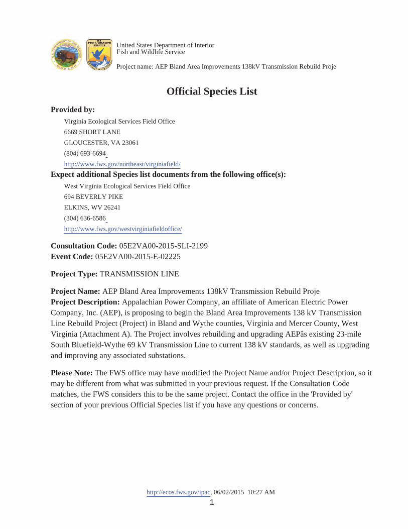
http://ecos.fws.gov/ipac, 06/02/2015 10:27 AM1
Official Species ListProvided by:
Virginia Ecological Services Field Office6669 SHORT LANEGLOUCESTER, VA 23061(804) 693-6694http://www.fws.gov/northeast/virginiafield/
Expect additional Species list documents from the following office(s):West Virginia Ecological Services Field Office694 BEVERLY PIKEELKINS, WV 26241(304) 636-6586http://www.fws.gov/westvirginiafieldoffice/
Consultation Code: 05E2VA00-2015-SLI-2199Event Code: 05E2VA00-2015-E-02225
Project Type: TRANSMISSION LINE
Project Name: AEP Bland Area Improvements 138kV Transmission Rebuild ProjeProject Description: Appalachian Power Company, an affiliate of American Electric PowerCompany, Inc. (AEP), is proposing to begin the Bland Area Improvements 138 kV TransmissionLine Rebuild Project (Project) in Bland and Wythe counties, Virginia and Mercer County, WestVirginia (Attachment A). The Project involves rebuilding and upgrading AEPâs existing 23-mileSouth Bluefield-Wythe 69 kV Transmission Line to current 138 kV standards, as well as upgradingand improving any associated substations.
Please Note: The FWS office may have modified the Project Name and/or Project Description, so itmay be different from what was submitted in your previous request. If the Consultation Codematches, the FWS considers this to be the same project. Contact the office in the 'Provided by'section of your previous Official Species list if you have any questions or concerns.
United States Department of InteriorFish and Wildlife Service
Project name: AEP Bland Area Improvements 138kV Transmission Rebuild Proje

http://ecos.fws.gov/ipac, 06/02/2015 10:27 AM2
Project Location Map:
Project Coordinates: The coordinates are too numerous to display here.
Project Counties: Bland, VA | Wythe, VA | Mercer, WV
United States Department of InteriorFish and Wildlife Service
Project name: AEP Bland Area Improvements 138kV Transmission Rebuild Proje

http://ecos.fws.gov/ipac, 06/02/2015 10:27 AM3
Endangered Species Act Species List
There are a total of 5 threatened or endangered species on your species list. Species on this list should be considered inan effects analysis for your project and could include species that exist in another geographic area. For example, certainfish may appear on the species list because a project could affect downstream species. Critical habitats listed under theHas Critical Habitat column may or may not lie within your project area. See the Critical habitats within yourproject area section further below for critical habitat that lies within your project. Please contact the designated FWSoffice if you have questions.
Flowering Plants Status Has Critical Habitat Condition(s)
Northeastern bulrush (Scirpusancistrochaetus)
Endangered
Mammals
Gray bat (Myotis grisescens) Population: Entire
Endangered
Indiana bat (Myotis sodalis) Population: Entire
Endangered
Northern long-eared Bat (Myotisseptentrionalis)
Threatened
Virginia Big-Eared bat (Corynorhinus(=plecotus) townsendii virginianus) Population: Entire
Endangered Final designated
United States Department of InteriorFish and Wildlife Service
Project name: AEP Bland Area Improvements 138kV Transmission Rebuild Proje

http://ecos.fws.gov/ipac, 06/02/2015 10:27 AM4
Critical habitats that lie within your project areaThere are no critical habitats within your project area.
United States Department of InteriorFish and Wildlife Service
Project name: AEP Bland Area Improvements 138kV Transmission Rebuild Proje

1
Wendy Baltzersen
From: Shane Hanlon <[email protected]>Sent: Friday, June 05, 2015 11:54 AMTo: Wendy BaltzersenCc: Troy AndersenSubject: RE: AEP Bland Area Improvements 138 kV Transmission Rebuild Project
(05E2VA00-2015-SLI-2199)- Plant Study Plan Approval Request
Hi Wendy,
Review of this project is more appropriately conducted by the Virginia Field Office; Troy is the best person to contactregarding this project. Thanks for your coordination.
From: Wendy Baltzersen [mailto:[email protected]]Sent: Friday, June 05, 2015 11:20 AM To: [email protected]: [email protected]: FW: AEP Bland Area Improvements 138 kV Transmission Rebuild Project (05E2VA00-2015-SLI-2199)- Plant Study Plan Approval Request
Hi Shane,
I had previously sent Troy Anderson information regarding species surveys planned for the AEP Bland AreaImprovements 138 kV Transmission Rebuild Project (05E2VA00 2015 SLI 2199). Through review of the initial projectcorrespondence with your office (see attached), I believe you may be the more appropriate contact for discussing studyplans for the Project. The Mid June rare plant survey, which includes search for small whorled pogonia on Federal landsin Jefferson National Forest, is scheduled for June 11 17. Please see original e mail to Troy below and let me know if youcan assist with review and approval of study plans for the project.
Sincerely,Wendy
Wendy Baltzersen, Ph.D. and CWBSenior Project Scientist
Environmental Solutions & Innovations, Inc.101 Old Cove Rd, Ste 108 | Liverpool, NY 13090 | USAOffice: 315.314.7309 Direct: 513.591.4333fax: 315.314.7546 Cell: 315.558.8912 PLEASE NOTE: New Office [email protected] | www.envsi.com
From: Wendy BaltzersenSent: Tuesday, June 02, 2015 1:41 PMTo: '[email protected]'Subject: AEP Bland Area Improvements 138 kV Transmission Rebuild Project (05E2VA00 2015 SLI 2199) Plant StudyPlan Approval Request

2
Dear Mr. Troy Anderson,
On behalf of AEP, ESI will be submitting the 8 Step Project Review Package for AEP Bland Area Improvements 138 kVTransmission Rebuild Project (Project) in Bland and Wythe counties, Virginia. Species surveys for this Project will beconducted by Environmental Solutions and Innovations, Inc. using Virginia approved surveyors. Species surveys arescheduled to be conducted on Federal lands within Jefferson National Forest in 2015, and on private lands (once accessis received) during the 2016 field season.
The species identified in the Official Species List for the Project in Virginia (see attached consultation # 05E2VA00 2015SLI 2199) include federally listed bats (Indiana, northern long eared, Gray and Virginia big eared) and plants(northeastern bulrush). A study plan for conducting surveys for bats on Federal lands in 2015 will be submitted to youfor comment, approval, and site specific authorization within a week.
ESI is already in the process of conducting rare plant surveys on Federal lands within Jefferson National Forest (Forest) toaddress potential impacts on Region 8 forest sensitive species. Through consultation with the Forest staff, we havedetermined that no suitable habitat for the northeastern bulrush is present on Federal lands, and surveys for this specieson private lands will be conducted once access is received and during the appropriate survey period in 2016. Smallwhorled pogonia is not included in the USFWS Official Species List. However, survey for this species in forest habitatson Federal lands has been requested by the Forest staff and the survey is will be conducted in mid June 2015 using aVirginia approved surveyor (Mr. Larry G. Brewer). We are seeking your prompt review of the rare plant study plan thathas been developed through consultation with the Forest, which is attached in this e mail and described below.
The rare plant study plan includes a description of the methods proposed for survey of small whorled pogonia onFederal lands concurrent with other forest sensitive plant species. Please note that the Spring survey described in thisplan has already been conducted and the Virginia Department of Conservation and Natural Resources has also recentlybeen provided a copy of this study plan. ESI respectfully requests your confirmation that the methods and timing ofsurvey for small whorled pogonia is sufficient for addressing the potential occurrence of this species on Federallands. Surveys for this species are planned to commence in Mid June and will include a survey of all forest habitatwithin the 300 foot wide survey corridor for the alignment and areas where access roads will need improvements.
Please let me know if you will require a separate study plan specific for small whorled pogonia on Federal lands inaddition to what is described in the rare plant study plan attached.
Thank you for your attention and assistance regarding study plans for the Project.
Sincerely,Wendy
Wendy Baltzersen, Ph.D. and CWBSenior Project Scientist
Environmental Solutions & Innovations, Inc.101 Old Cove Rd, Ste 108 | Liverpool, NY 13090 | USAOffice: 315.314.7309 Direct: 513.591.4333fax: 315.314.7546 Cell: 315.558.8912 PLEASE NOTE: New Office [email protected] | www.envsi.com

1
Wendy Baltzersen
From: Wendy BaltzersenSent: Thursday, June 11, 2015 3:40 PMTo: 'Troy Andersen'Cc: Kimberly Smith; 'Jared A Webb'Subject: RE: AEP Bland Area Improvements 138 kV Transmission Rebuild Project
(05E2VA00-2015-SLI-2199)- Plant Study Plan Approval Request
Hi Troy,
Thank you for your response and confirming my understanding of the workload time constraints your office isexperiencing.
The rare plant study plan we submitted meets the conditions you specify below for small whorled pogonia. As Imentioned in my voicemail, I received an e mail from your office acknowledging receipt of the rare plant study plan andidentifying the northeastern bulrush as the one federally listed plant to include in the species conclusion table forProject review. I have copied below this prior correspondence for your records. As I noted in my e mail to Mary today,should we observe small whorled pogonia during the mid June survey, we will report the occurrences to youroffice. Although not expected, should we observe any potential habitat for the northeastern bulrush during the midJune survey, we will submit a study plan to you for survey of the species on Federal lands in 2015.
The study plan for bats is forthcoming, as is the 8 step project review request submission.
Sincerely,Wendy
___________________________________________________________________________________________________________________________From: Wendy BaltzersenSent: Thursday, June 11, 2015 11:11 AMTo: 'Virginia Field Office, FW5'Cc: 'Jared A Webb'Subject: RE: AEP Bland Area Improvements 138 kV Transmission Rebuild Project (05E2VA00 2015 SLI 2199) Plant StudyPlan Approval Request
Hi Mary,
Thank you for your response.
Based on your guidance below, we understand that AEP’s survey for small whorled pogonia on Federal lands(coordinated with the U.S. Forest Service) is not part of the Section 7 consultation with the U.S. Fish and Wildlife Servicefor the Bland Area Improvements Project. However, should we observe small whorled pogonia during the mid Junesurvey, we will report the occurrences to your office. Although not expected, should we observe any potential habitatfor the northeastern bulrush during the mid June survey, we will submit a study plan to you for survey of the species onFederal lands in 2015. The study plan for bats is forthcoming, as is the 8 step project review request submission.
Thank you for your assistance on this project.

2
Wendy
Wendy Baltzersen, Ph.D. and CWB Senior Project Scientist
Environmental Solutions & Innovations, Inc. 101 Old Cove Rd, Ste 108 | Liverpool, NY 13090 | USA Office: 315.314.7309 Direct: 513.591.4333 fax: 315.314.7546 Cell: 315.558.8912 PLEASE NOTE: New Office Address [email protected] | www.envsi.com
From: [email protected] [mailto:[email protected]] On Behalf Of Virginia Field Office, FW5Sent: Monday, June 08, 2015 3:17 PMTo: Wendy BaltzersenSubject: AEP Bland Area Improvements 138 kV Transmission Rebuild Project (05E2VA00 2015 SLI 2199) Plant StudyPlan Approval Request
Good afternoon Ms. Baltzersen,
We appreciate the submission of the rare plant study plan associated with the referenced project and will review theproject as a whole when the 8 step project review package is received. This should include a species conclusion tablewith determinations for the listed northeastern bulrush as well as the listed bats species. We look forward tocoordinating with you on this project.
Best,Mary Anne Morrison
Wendy Baltzersen, Ph.D. and CWB Senior Project Scientist
Environmental Solutions & Innovations, Inc. 101 Old Cove Rd, Ste 108 | Liverpool, NY 13090 | USA Office: 315.314.7309 Direct: 513.591.4333 fax: 315.314.7546 Cell: 315.558.8912 PLEASE NOTE: New Office Address [email protected] | www.envsi.com
From: Troy Andersen [mailto:[email protected]]Sent: Thursday, June 11, 2015 1:55 PMTo: Wendy BaltzersenCc: Kimberly SmithSubject: RE: AEP Bland Area Improvements 138 kV Transmission Rebuild Project (05E2VA00 2015 SLI 2199) Plant StudyPlan Approval Request

3
Ma’am:
I received your voicemail yesterday and figured it would be easier to follow up through email.
Due to current manpower constraints, I can’t assign this to a biologist for specific comments. For most plant surveys,provided that they are conducted by an approved surveyor and during the appropriate time of the year (for SWP:Caroline County and counties to the north from June 1 – July 20 or South of Caroline County, from May 25 – July 15), wewould not have any additional comments to offer.
V/RTroy
Troy M. AndersenEndangered Species/Conservation Planning Assistance SupervisorUSFWS – Virginia Field OfficePhone: 804 824 2428Mobile: 804 654 9235Visit us at: http://www.fws.gov/northeast/virginiafield/
From: Wendy Baltzersen [mailto:[email protected]]Sent: Tuesday, June 02, 2015 1:41 PM To: [email protected]: AEP Bland Area Improvements 138 kV Transmission Rebuild Project (05E2VA00-2015-SLI-2199)- Plant Study Plan Approval Request
Dear Mr. Troy Anderson,
On behalf of AEP, ESI will be submitting the 8 Step Project Review Package for AEP Bland Area Improvements 138 kVTransmission Rebuild Project (Project) in Bland and Wythe counties, Virginia. Species surveys for this Project will beconducted by Environmental Solutions and Innovations, Inc. using Virginia approved surveyors. Species surveys arescheduled to be conducted on Federal lands within Jefferson National Forest in 2015, and on private lands (once accessis received) during the 2016 field season.
The species identified in the Official Species List for the Project in Virginia (see attached consultation # 05E2VA00 2015SLI 2199) include federally listed bats (Indiana, northern long eared, Gray and Virginia big eared) and plants(northeastern bulrush). A study plan for conducting surveys for bats on Federal lands in 2015 will be submitted to youfor comment, approval, and site specific authorization within a week.
ESI is already in the process of conducting rare plant surveys on Federal lands within Jefferson National Forest (Forest) toaddress potential impacts on Region 8 forest sensitive species. Through consultation with the Forest staff, we havedetermined that no suitable habitat for the northeastern bulrush is present on Federal lands, and surveys for this specieson private lands will be conducted once access is received and during the appropriate survey period in 2016. Smallwhorled pogonia is not included in the USFWS Official Species List. However, survey for this species in forest habitatson Federal lands has been requested by the Forest staff and the survey is will be conducted in mid June 2015 using aVirginia approved surveyor (Mr. Larry G. Brewer). We are seeking your prompt review of the rare plant study plan thathas been developed through consultation with the Forest, which is attached in this e mail and described below.

4
The rare plant study plan includes a description of the methods proposed for survey of small whorled pogonia onFederal lands concurrent with other forest sensitive plant species. Please note that the Spring survey described in thisplan has already been conducted and the Virginia Department of Conservation and Natural Resources has also recentlybeen provided a copy of this study plan. ESI respectfully requests your confirmation that the methods and timing ofsurvey for small whorled pogonia is sufficient for addressing the potential occurrence of this species on Federallands. Surveys for this species are planned to commence in Mid June and will include a survey of all forest habitatwithin the 300 foot wide survey corridor for the alignment and areas where access roads will need improvements.
Please let me know if you will require a separate study plan specific for small whorled pogonia on Federal lands inaddition to what is described in the rare plant study plan attached.
Thank you for your attention and assistance regarding study plans for the Project.
Sincerely,Wendy
Wendy Baltzersen, Ph.D. and CWB
Senior Project Scientist
Environmental Solutions & Innovations, Inc.101 Old Cove Rd, Ste 108 | Liverpool, NY 13090 | USAOffice: 315.314.7309 Direct: 513.591.4333fax: 315.314.7546 Cell: 315.558.8912 PLEASE NOTE: New Office [email protected] | www.envsi.com

1
Wendy Baltzersen
From: Wendy BaltzersenSent: Thursday, June 11, 2015 11:11 AMTo: 'Virginia Field Office, FW5'Cc: 'Jared A Webb'Subject: RE: AEP Bland Area Improvements 138 kV Transmission Rebuild Project
(05E2VA00-2015-SLI-2199)- Plant Study Plan Approval Request
Hi Mary,
Thank you for your response.
Based on your guidance below, we understand that AEP’s survey for small whorled pogonia on Federal lands(coordinated with the U.S. Forest Service) is not part of the Section 7 consultation with the U.S. Fish and Wildlife Servicefor the Bland Area Improvements Project. However, should we observe small whorled pogonia during the mid Junesurvey, we will report the occurrences to your office. Although not expected, should we observe any potential habitatfor the northeastern bulrush during the mid June survey, we will submit a study plan to you for survey of the species onFederal lands in 2015. The study plan for bats is forthcoming, as is the 8 step project review request submission.
Thank you for your assistance on this project.
Wendy
Wendy Baltzersen, Ph.D. and CWB Senior Project Scientist
Environmental Solutions & Innovations, Inc. 101 Old Cove Rd, Ste 108 | Liverpool, NY 13090 | USA Office: 315.314.7309 Direct: 513.591.4333 fax: 315.314.7546 Cell: 315.558.8912 PLEASE NOTE: New Office Address [email protected] | www.envsi.com
From: [email protected] [mailto:[email protected]] On Behalf Of Virginia Field Office, FW5Sent: Monday, June 08, 2015 3:17 PMTo: Wendy BaltzersenSubject: AEP Bland Area Improvements 138 kV Transmission Rebuild Project (05E2VA00 2015 SLI 2199) Plant StudyPlan Approval Request
Good afternoon Ms. Baltzersen,
We appreciate the submission of the rare plant study plan associated with the referenced project and will review the project as a whole when the 8 step project review package is received. This should include a species conclusion table with determinations for the listed northeastern bulrush as well as the listed bats species. We look forward to coordinating with you on this project.
Best,

ENVIRONMENTAL SOLUTIONS & INNOVATIONS, INC.101 Old Cove Road, Suite 108 Liverpool, NY 13090 Phone: (315) 314-7309; Fax: (315) 314-7546
Wendy Baltzersen 101 Old Cove Road, Suite 108 Liverpool, NY 13090 Phone: (513) 591-4333 [email protected]
United States Fish and Wildlife Service Virginia Ecological Services Field Office 6669 Short Lane Gloucester, VA 23061
June 2015
RE: Online Project Review Request, Bland Area Improvements 138 kV Transmission Line Rebuild Project in Bland and Wythe Counties, Virginia, Consultation Code 05E2VA00-2015-SLI-2199
Appalachian Power Company, an affiliate of American Electric Power Company, Inc. (AEP), is proposing to begin the Bland Area Improvements 138 kV Transmission Line Rebuild Project (Project) in Bland and Wythe counties, Virginia and Mercer County, West Virginia (Attachment A). AEP has retained Environmental Solutions and Innovations, Inc. (ESI) to conduct consultations and surveys for protected species.Previously, Mr. Tim Gaul with Louis Berger Group (LBG) received e-mail correspondence for the Project from Sumalee Hoskin of U.S. Fish and Wildlife Service (USFWS) Virginia Field Office on 04 February 2013, and Shane Hanlon from the USFWS Southwestern Virginia Field Office on 05 December 2014 (see Enclosure 1 for prior USFWS correspondence). This correspondence directed the Project to use the USFWS project review process for Virginia.
ESI has reviewed the above referenced Project using the Virginia Field Office’s online roject review process and have followed all guidance and instructions in completing
the review on 02 June 2015, and are submitting Project review package in accordance with the instructions for further review (Enclosure 2).
AEP’s proposed action consists of rebuilding and upgrading their existing 23.25-mile South Bluefield-Wythe 69 kV Transmission Line to current 138 kV standards, as well as upgrading and improving any associated substations. In Virginia, the preferred rebuild consists of approximately 25.3 linear miles within Bland (~17.5 miles) and Wythe (~7.8 miles) counties. Approximately 6.8 miles of the route in Bland County crosses Federal
www.ENVSI.com

2
lands within the George Washington and Jefferson National Forest Eastern Divide Ranger District (Forest). Within Federal lands, the Project will also require approximately 6.5 total miles of new access roads and approximately 0.20 mile of upgrades to existing access roads. The Project’s defined action area currently includes a potential area of impact defined by a 500-foot-wide corridor corresponding with the Commonwealth of Virginia State Corporation Commission (SCC) filing preferred and alternate alignments, and a 300-foot-wide corridor surrounding proposed Federal land access roads. Roads for accessing property outside of Federal lands will be determined during the final stages of engineering and will be added to the action area as necessary.
The location of the Project and the action area are identified on the enclosed map (Attachment A) and in more detail in a topographic map set (Enclosure 3). Shapefiles of the proposed action, as described above (preferred and alternate alignments and Federal land access roads) are provided in the e-mail concurrent with this Project review request submission (referenced as Enclosure 4).
The Project is anticipated to be completed in 2019 with construction planned to begin in fall 2016, and an in service date of December 2018. AEP is currently conducting environmental surveys for the Project on Federal lands within the Forest in 2015. Surveys on private lands will be conducted as land access for surveys is received. These surveys are anticipated to be conducted no later than during the appropriate survey window in 2016.
This Project review is needed for issuance of an SF-299 Special Use Permit from the USFS for crossing the Forest, as well as Certificate of Public Need and Necessity from the SCC, and other permits for construction of the Project in Virginia.
The enclosed Project review package provides the information about the species, critical habitat, and bald eagles considered in our review, as well as the species conclusions table identifying our current determinations for the resources that may be affected by the Project. Based on ESI review of the Official Species List for Virginia and communication received from Mary Morrison of the USFWS Virginia Field Office on 08 June 2015 (see Enclosure 1), ESI, on behalf of AEP, plans to conduct surveys for four federally listed bats (Indiana bat, northern long-eared bat, gray bat, and Virginia big-eared bat) and northeastern bulrush. Our species determinations based on these survey results and final design of the Project will be provided once available, and through coordination with the Virginia Field Office.
ESI is conducting field surveys for rare, threatened, and endangered species on Federal lands within the Forest in 2015. Rare plant surveys on Federal lands commenced on 1 May 2015, and bat surveys in potential summer habitat are expected to be conducted in mid-July 2015, along with searches for potential portals within the 300-foot-wide survey corridor. ESI plans to submit study plans to USFWS and VDGIF detailing methods and timelines for survey of federally listed bat species planned in 2015. ESI will request

2
individual feedback on these documents and prepare and submit similar survey-specific documents for all species requiring field studies.
In advance and concurrent with these surveys, ESI respectfully requests Project review and feedback from the Virginia Field Office to:
Confirm the status of known occurrences of the northern long-eared bat (seeAttachment D of the VDGIF Project Review Request Package submitted 05 June2015).
Recommend site-specific surveys for federally listed species
Recommend appropriate measures to avoid, minimize, or mitigate potentialimpacts to federally listed species found to occur within the vicinity of theproposed action during the early planning phases on the Project
Provide conservation recommendations for migratory birds
For additional information, please do not hesitate to contact me.
Sincerely,
Wendy Baltzersen, Ph.D. and CWB Senior Project Scientist (315) [email protected]
Attachment A: Project Overview Map
Enclosure:1) USFWS Correspondence Log (Adobe PDF)2) Project Review Package (Steps 1 – 7, Adobe PDF)3) Topographic Map Set (Adobe PDF)4) Project Shapefiles (ESRI ArcView)

ATTACHMENT A
BLAND AREA IMPROVEMENTS 138KV TRANSMISSION LINE REBUILD PROJECT IN BLAND AND WYTHE COUNTIES, VIRGINIA
PROJECT OVERVIEW MAP

Project No. 555²Figure 1. Location of AEP’s Bland Area Improvements 138kV Transmission Line Rebuild Project in Bland and Wythe Counties, Virginia.
ENVIRONMENTAL SOLUTIONS& INNOVATIONS, INC.
0 10,0005,000Meters
Base Map: EsriDoc
umen
t Pat
h: G
:\Cur
rent
\555
_AE
P_W
ythe
_Co_
Virg
inia
\Bat
s\M
XD
\Fig
ure1
_555
_AE
P_W
ythe
_Co_
Loca
tion.
mxd
_̂Virginia
West Virginia
North CarolinaTennessee
Kentucky
Proposed Transmission Line Viable Alternative Route Proposed Road for Federal Land Access

ENCLOSURE 1
BLAND AREA IMPROVEMENTS 138KV TRANSMISSION LINE REBUILD PROJECT IN BLAND AND WYTHE COUNTIES, VIRGINIA
U.S. FISH AND WILDLIFE CORRESPONDENCE

1
From: Sumalee Hoskin [mailto:[email protected]]Sent: Monday, November 24, 2014 4:04 PM To: Gaul, Tim Subject: Appalachian Power Company: Bland Area Transmission Improvements Project
Dear�Mr.�Gaul,�Please�see�the�attached.��Thank�you,�Sumalee��
NOTE: MY EXTENSION HAS CHANGED�*********************************�Sumalee Hoskin�US Fish & Wildlife Service�6669 Short Lane�Gloucester, VA 23061�
Tel: 804-693-6694 ex. 2414�Fax: 804-693-9032�Cell: 804-654-1824�Visit us at http://www.fws.gov/northeast/virginiafield/�


1
From:�Shane�Hanlon�<[email protected]>�Date:�December�5,�2014�at�2:45:28�PM�CST�To:�<[email protected]>�Subject:�Appalachian�Power�Company:�Bland�area�transmission�improvement�project�
Dear�Mr.�Tim�Gaul:�
We�received�your�November�19,�2014�notice�to�review�the�Appalachian�Power�Company:�Bland�area�transmission�improvement�project.��If�you�have�not�already�done�so,�please�use�our�online�review�procedure�to�submit�your�project.��Once�we�receive�your�complete�project�package�via�this�process,�we�will�review�the�project�in�the�order�it�was�received.��Please�see�the�link�below�for�the�online�project�review�process.��Thanks�you.�
http://www.fws.gov/northeast/virginiafield/endangered/projectreviews.html�
Shane�Hanlon�Fish�and�Wildlife�Biologist�US�Fish�and�Wildlife�Service�Southwestern�Virginia�Field�Office�330�Cummings�Street�Abingdon,�VA��24210�Office�Phone:�(276)�623�1233�ext.�25�

1
���������� ���
---------- Forwarded message ---------- From: <[email protected]>Date: Tue, May 5, 2015 at 2:29 PM Subject: Official Species List for project: Bland Area Improvements 138 kV Transmission Line Rebuild Pro To: [email protected]
This email contains a US Fish and Wildlife Service official species list for your project (Bland Area Improvements 138 kV Transmission Line Rebuild Pro) from the following office:
Virginia Ecological Services Field Office 6669 SHORT LANE GLOUCESTER, VA 23061 (804) 693-6694http://www.fws.gov/northeast/virginiafield/
Also attached is a shapefile of the project boundary you defined in IPaC. If you wish to return to IPaC in the future and use the same project boundary, you can use the IPaC 'Upload' feature on the map toolbar to upload the shapefile.
You may also view your official species list by returning to the IPaC project home page at https://ecos.fws.gov/ipac2/project/7ZXGP47YMJCSRP6ERLVXCDJ32Y
If you have any problems opening the document, please contact our help desk at https://ecos.fws.gov/ecp/help

1
Wendy Baltzersen
From: [email protected]: Tuesday, June 02, 2015 12:27 PMTo: Wendy BaltzersenSubject: Official Species List for project: AEP Bland Area Improvements 138kV Transmission
Rebuild ProjeAttachments: Official_Species_List_VA ESFO_02_Jun_2015.pdf; ipacProjectShapefile.zip
This�email�contains�a�US�Fish�and�Wildlife�Service�official�species�list�for�your�project�(AEP�Bland�Area�Improvements�138kV�Transmission�Rebuild�Proje)�from�the�following�office:�
�Virginia�Ecological�Services�Field�Office��6669�SHORT�LANE��GLOUCESTER,�VA�23061�(804) 693�6694http://www.fws.gov/northeast/virginiafield/
Also�attached�is�a�shapefile�of�the�project�boundary�you�defined�in�IPaC.�If�you�wish�to�return�to�IPaC�in�the�future�and�use�the�same�project�boundary,�you�can�use�the�IPaC�'Upload'�feature�on�the�map�toolbar�to�upload�the�shapefile.�
You�may�also�view�your�official�species�list�by�returning�to�the�IPaC�project�home�page�at�https://ecos.fws.gov/ipac/project/HQWDJKF35JHPJLZNRZ4DLHQIPM�
If�you�have�any�problems�opening�the�document,�please�contact�our�help�desk�at�https://ecos.fws.gov/ecp/help�
NOTE:��The�following�office(s)�also�have�jurisdictions�that�overlap�your�project�location.��You�will�receive�an�automatically�generated�official�species�list�for�them�as�well.�
�West�Virginia�Ecological�Services�Field�Office��694�BEVERLY�PIKE��ELKINS,�WV�26241�(304) 636�6586http://www.fws.gov/westvirginiafieldoffice/

United States Department of the InteriorFISH AND WILDLIFE SERVICEVirginia Ecological Services Field Office
6669 SHORT LANEGLOUCESTER, VA 23061
PHONE: (804)693-6694 FAX: (804)693-9032URL: www.fws.gov/northeast/virginiafield/
Consultation Code: 05E2VA00-2015-SLI-2199 June 02, 2015Event Code: 05E2VA00-2015-E-02225Project Name: AEP Bland Area Improvements 138kV Transmission Rebuild Proje
Subject: List of threatened and endangered species that may occur in your proposed projectlocation, and/or may be affected by your proposed project
To Whom It May Concern:
The enclosed species list identifies threatened, endangered, proposed and candidate species, aswell as proposed and final designated critical habitat, that may occur within the boundary ofyour proposed project and/or may be affected by your proposed project. The species list fulfillsthe requirements of the U.S. Fish and Wildlife Service (Service) under section 7(c) of theEndangered Species Act (Act) of 1973, as amended (16 U.S.C. 1531 ).et seq.
New information based on updated surveys, changes in the abundance and distribution ofspecies, changed habitat conditions, or other factors could change this list. Please feel free tocontact us if you need more current information or assistance regarding the potential impacts tofederally proposed, listed, and candidate species and federally designated and proposed criticalhabitat. Please note that under 50 CFR 402.12(e) of the regulations implementing section 7 ofthe Act, the accuracy of this species list should be verified after 90 days. This verification canbe completed formally or informally as desired. The Service recommends that verification becompleted by visiting the ECOS-IPaC website at regular intervals during project planning andimplementation for updates to species lists and information. An updated list may be requestedthrough the ECOS-IPaC system by completing the same process used to receive the enclosedlist.
The purpose of the Act is to provide a means whereby threatened and endangered species andthe ecosystems upon which they depend may be conserved. Under sections 7(a)(1) and 7(a)(2)of the Act and its implementing regulations (50 CFR 402 ), Federal agencies are requiredet seq.to utilize their authorities to carry out programs for the conservation of threatened andendangered species and to determine whether projects may affect threatened and endangeredspecies and/or designated critical habitat.

A Biological Assessment is required for construction projects (or other undertakings havingsimilar physical impacts) that are major Federal actions significantly affecting the quality of thehuman environment as defined in the National Environmental Policy Act (42 U.S.C. 4332(2)(c)). For projects other than major construction activities, the Service suggests that a biologicalevaluation similar to a Biological Assessment be prepared to determine whether the project mayaffect listed or proposed species and/or designated or proposed critical habitat. Recommendedcontents of a Biological Assessment are described at 50 CFR 402.12.
If a Federal agency determines, based on the Biological Assessment or biological evaluation,that listed species and/or designated critical habitat may be affected by the proposed project, theagency is required to consult with the Service pursuant to 50 CFR 402. In addition, the Servicerecommends that candidate species, proposed species and proposed critical habitat be addressedwithin the consultation. More information on the regulations and procedures for section 7consultation, including the role of permit or license applicants, can be found in the "EndangeredSpecies Consultation Handbook" at:
http://www.fws.gov/endangered/esa-library/pdf/TOC-GLOS.PDF
Please be aware that bald and golden eagles are protected under the Bald and Golden EagleProtection Act (16 U.S.C. 668 ), and projects affecting these species may requireet seq.development of an eagle conservation plan(http://www.fws.gov/windenergy/eagle_guidance.html). Additionally, wind energy projectsshould follow the wind energy guidelines (http://www.fws.gov/windenergy/) for minimizingimpacts to migratory birds and bats.
Guidance for minimizing impacts to migratory birds for projects including communicationstowers (e.g., cellular, digital television, radio, and emergency broadcast) can be found at:http://www.fws.gov/migratorybirds/CurrentBirdIssues/Hazards/towers/towers.htm;http://www.towerkill.com; andhttp://www.fws.gov/migratorybirds/CurrentBirdIssues/Hazards/towers/comtow.html.
We appreciate your concern for threatened and endangered species. The Service encouragesFederal agencies to include conservation of threatened and endangered species into their projectplanning to further the purposes of the Act. Please include the Consultation Tracking Number inthe header of this letter with any request for consultation or correspondence about your projectthat you submit to our office.
Attachment
2

http://ecos.fws.gov/ipac, 06/02/2015 10:27 AM1
Official Species ListProvided by:
Virginia Ecological Services Field Office6669 SHORT LANEGLOUCESTER, VA 23061(804) 693-6694http://www.fws.gov/northeast/virginiafield/
Expect additional Species list documents from the following office(s):West Virginia Ecological Services Field Office694 BEVERLY PIKEELKINS, WV 26241(304) 636-6586http://www.fws.gov/westvirginiafieldoffice/
Consultation Code: 05E2VA00-2015-SLI-2199Event Code: 05E2VA00-2015-E-02225
Project Type: TRANSMISSION LINE
Project Name: AEP Bland Area Improvements 138kV Transmission Rebuild ProjeProject Description: Appalachian Power Company, an affiliate of American Electric PowerCompany, Inc. (AEP), is proposing to begin the Bland Area Improvements 138 kV TransmissionLine Rebuild Project (Project) in Bland and Wythe counties, Virginia and Mercer County, WestVirginia (Attachment A). The Project involves rebuilding and upgrading AEPâs existing 23-mileSouth Bluefield-Wythe 69 kV Transmission Line to current 138 kV standards, as well as upgradingand improving any associated substations.
Please Note: The FWS office may have modified the Project Name and/or Project Description, so itmay be different from what was submitted in your previous request. If the Consultation Codematches, the FWS considers this to be the same project. Contact the office in the 'Provided by'section of your previous Official Species list if you have any questions or concerns.
United States Department of InteriorFish and Wildlife Service
Project name: AEP Bland Area Improvements 138kV Transmission Rebuild Proje

http://ecos.fws.gov/ipac, 06/02/2015 10:27 AM2
Project Location Map:
Project Coordinates: The coordinates are too numerous to display here.
Project Counties: Bland, VA | Wythe, VA | Mercer, WV
United States Department of InteriorFish and Wildlife Service
Project name: AEP Bland Area Improvements 138kV Transmission Rebuild Proje

http://ecos.fws.gov/ipac, 06/02/2015 10:27 AM3
Endangered Species Act Species List
There are a total of 5 threatened or endangered species on your species list. Species on this list should be considered inan effects analysis for your project and could include species that exist in another geographic area. For example, certainfish may appear on the species list because a project could affect downstream species. Critical habitats listed under theHas Critical Habitat column may or may not lie within your project area. See the Critical habitats within yourproject area section further below for critical habitat that lies within your project. Please contact the designated FWSoffice if you have questions.
Flowering Plants Status Has Critical Habitat Condition(s)
Northeastern bulrush (Scirpusancistrochaetus)
Endangered
Mammals
Gray bat (Myotis grisescens) Population: Entire
Endangered
Indiana bat (Myotis sodalis) Population: Entire
Endangered
Northern long-eared Bat (Myotisseptentrionalis)
Threatened
Virginia Big-Eared bat (Corynorhinus(=plecotus) townsendii virginianus) Population: Entire
Endangered Final designated
United States Department of InteriorFish and Wildlife Service
Project name: AEP Bland Area Improvements 138kV Transmission Rebuild Proje
http://ecos.fws.gov/ipac, 06/02/2015 10:27 AM4
Critical habitats that lie within your project areaThere are no critical habitats within your project area.
United States Department of InteriorFish and Wildlife Service
Project name: AEP Bland Area Improvements 138kV Transmission Rebuild Proje

1
Wendy Baltzersen
From: Shane Hanlon <[email protected]>Sent: Friday, June 05, 2015 11:54 AMTo: Wendy BaltzersenCc: Troy AndersenSubject: RE: AEP Bland Area Improvements 138 kV Transmission Rebuild Project
(05E2VA00-2015-SLI-2199)- Plant Study Plan Approval Request
Hi�Wendy,�
Review�of�this�project�is�more�appropriately�conducted�by�the�Virginia�Field�Office;�Troy�is�the�best�person�to�contact�regarding�this�project.��Thanks�for�your�coordination.�
From: Wendy Baltzersen [mailto:[email protected]]Sent: Friday, June 05, 2015 11:20 AM To: [email protected]: [email protected]: FW: AEP Bland Area Improvements 138 kV Transmission Rebuild Project (05E2VA00-2015-SLI-2199)- Plant Study Plan Approval Request�
Hi�Shane,�
I�had�previously�sent�Troy�Anderson�information�regarding�species�surveys�planned�for�the�AEP�Bland�Area�Improvements�138�kV�Transmission�Rebuild�Project�(05E2VA00�2015�SLI�2199).���Through�review�of�the�initial�project�correspondence�with�your�office�(see�attached),�I�believe�you�may�be�the�more�appropriate�contact�for�discussing�study�plans�for�the�Project.��The�Mid�June�rare�plant�survey,�which�includes�search�for�small�whorled�pogonia�on�Federal�lands�in�Jefferson�National�Forest,�is�scheduled�for�June�11�17.��Please�see�original�e�mail�to�Troy�below�and�let�me�know�if�you�can�assist�with��review�and�approval�of�study�plans�for�the�project.�
Sincerely,�Wendy�
�Wendy Baltzersen, Ph.D. and CWB��Senior Project Scientist �
Environmental Solutions & Innovations, Inc.�101 Old Cove Rd, Ste 108 | Liverpool, NY 13090 | USA�Office: 315.314.7309 Direct: 513.591.4333�fax: 315.314.7546 Cell: 315.558.8912�
PLEASE NOTE: New Office Address�[email protected] | www.envsi.com�
From:�Wendy�Baltzersen��Sent:�Tuesday,�June�02,�2015�1:41�PM�To:�'[email protected]'�Subject:�AEP�Bland�Area�Improvements�138�kV�Transmission�Rebuild�Project�(05E2VA00�2015�SLI�2199)��Plant�Study�Plan�Approval�Request�

2
Dear�Mr.�Troy�Anderson,�
On�behalf�of�AEP,�ESI�will�be�submitting�the�8�Step�Project�Review�Package�for�AEP�Bland�Area�Improvements�138�kV�Transmission�Rebuild�Project�(Project)�in�Bland�and�Wythe�counties,�Virginia.��Species�surveys�for�this�Project�will�be�conducted�by�Environmental�Solutions�and�Innovations,�Inc.�using�Virginia�approved�surveyors.���Species�surveys�are�scheduled�to�be�conducted�on�Federal�lands�within�Jefferson�National�Forest�in�2015,�and�on�private�lands�(once�access�is�received)�during�the�2016�field�season.�
The�species�identified�in�the�Official�Species�List�for�the�Project�in�Virginia�(see�attached�consultation�#�05E2VA00�2015�SLI�2199)�include�federally�listed�bats�(Indiana,�northern�long�eared,�Gray�and�Virginia�big�eared)�and�plants�(northeastern�bulrush).��A�study�plan�for�conducting�surveys�for�bats�on�Federal�lands�in�2015�will�be�submitted�to�you�for�comment,�approval,�and�site�specific�authorization�within�a�week.��
ESI�is�already�in�the�process�of�conducting�rare�plant�surveys�on�Federal�lands�within�Jefferson�National�Forest�(Forest)�to�address�potential�impacts�on�Region�8�forest�sensitive�species.��Through�consultation�with�the�Forest�staff,�we�have�determined�that�no�suitable�habitat�for�the�northeastern�bulrush�is�present�on�Federal�lands,�and�surveys�for�this�species�on�private�lands�will�be�conducted�once�access�is�received�and�during�the�appropriate�survey�period�in�2016.��Small�whorled�pogonia�is�not�included�in�the�USFWS�Official�Species�List.��However,��survey�for�this�species�in�forest�habitats�on�Federal�lands�has�been�requested�by�the�Forest�staff�and�the�survey�is�will�be�conducted�in�mid�June�2015�using�a�Virginia�approved�surveyor�(Mr.�Larry�G.�Brewer).��We�are�seeking�your�prompt�review�of�the�rare�plant�study�plan�that�has�been�developed�through�consultation�with�the�Forest,�which�is�attached�in�this�e�mail�and�described�below.�
The�rare�plant�study�plan�includes�a�description�of�the�methods�proposed�for�survey�of�small�whorled�pogonia�on�Federal�lands�concurrent�with�other�forest�sensitive�plant�species.��Please�note�that�the�Spring�survey�described�in�this�plan�has�already�been�conducted�and�the�Virginia�Department�of�Conservation�and�Natural�Resources�has�also�recently�been�provided�a�copy�of�this�study�plan.���ESI�respectfully�requests�your�confirmation�that�the�methods�and�timing�of�survey�for�small�whorled�pogonia�is�sufficient�for�addressing�the�potential�occurrence�of�this�species�on�Federal�lands.��Surveys�for�this�species�are�planned�to�commence�in�Mid�June�and�will�include�a�survey�of�all�forest�habitat�within�the�300�foot�wide�survey�corridor�for�the�alignment�and�areas�where�access�roads�will�need�improvements.���
Please�let�me�know�if�you�will�require�a�separate�study�plan�specific�for�small�whorled�pogonia�on�Federal�lands�in�addition�to�what�is�described�in�the�rare�plant�study�plan�attached.�
Thank�you�for�your�attention�and�assistance�regarding�study�plans�for�the�Project.�
Sincerely,�Wendy�
�Wendy Baltzersen, Ph.D. and CWB��Senior Project Scientist �
Environmental Solutions & Innovations, Inc.�101 Old Cove Rd, Ste 108 | Liverpool, NY 13090 | USA�Office: 315.314.7309 Direct: 513.591.4333�fax: 315.314.7546 Cell: 315.558.8912�
PLEASE NOTE: New Office Address�[email protected] | www.envsi.com�

1
Wendy Baltzersen
From: Wendy BaltzersenSent: Thursday, June 11, 2015 3:40 PMTo: 'Troy Andersen'Cc: Kimberly Smith; 'Jared A Webb'Subject: RE: AEP Bland Area Improvements 138 kV Transmission Rebuild Project
(05E2VA00-2015-SLI-2199)- Plant Study Plan Approval Request
Hi�Troy,��Thank�you�for�your�response�and�confirming�my�understanding�of�the�workload�time�constraints�your�office�is�experiencing.����The�rare�plant�study�plan�we�submitted�meets�the�conditions�you�specify�below�for�small�whorled�pogonia.��As�I�mentioned�in�my�voicemail,�I�received�an�e�mail�from�your�office�acknowledging�receipt�of�the�rare�plant�study�plan�and�identifying�the�northeastern�bulrush�as�the�one�federally�listed�plant�to�include�in�the�species�conclusion�table�for�Project�review.��I�have�copied�below�this�prior�correspondence�for�your�records.��As�I�noted�in�my�e�mail�to�Mary�today,�should�we�observe�small�whorled�pogonia�during�the�mid�June�survey,�we�will�report�the�occurrences�to�your�office.���Although�not�expected,�should�we�observe�any�potential�habitat�for�the�northeastern�bulrush�during�the�mid�June�survey,�we�will��submit�a�study�plan�to�you�for�survey�of�the�species�on�Federal�lands�in�2015.����The�study�plan�for�bats�is�forthcoming,�as�is�the�8�step�project�review�request�submission.��Sincerely,�Wendy��___________________________________________________________________________________________________________________________�From:�Wendy�Baltzersen��Sent:�Thursday,�June�11,�2015�11:11�AM�To:�'Virginia�Field�Office,�FW5'�Cc:�'Jared�A�Webb'�Subject:�RE:�AEP�Bland�Area�Improvements�138�kV�Transmission�Rebuild�Project�(05E2VA00�2015�SLI�2199)��Plant�Study�Plan�Approval�Request���Hi�Mary,��Thank�you�for�your�response.����Based�on�your�guidance�below,�we�understand�that�AEP’s�survey�for�small�whorled�pogonia�on�Federal�lands�(coordinated�with�the�U.S.�Forest�Service)�is�not�part�of�the�Section�7�consultation�with�the�U.S.�Fish�and�Wildlife�Service�for�the�Bland�Area�Improvements�Project.��However,�should�we�observe�small�whorled�pogonia�during�the�mid�June�survey,�we�will�report�the�occurrences�to�your�office.���Although�not�expected,�should�we�observe�any�potential�habitat�for�the�northeastern�bulrush�during�the�mid�June�survey,�we�will��submit�a�study�plan�to�you�for�survey�of�the�species�on�Federal�lands�in�2015.��The�study�plan�for�bats�is�forthcoming,�as�is�the�8�step�project�review�request�submission.��Thank�you�for�your�assistance�on�this�project.��
2
Wendy��
Wendy Baltzersen, Ph.D. and CWB Senior Project Scientist
Environmental Solutions & Innovations, Inc. 101 Old Cove Rd, Ste 108 | Liverpool, NY 13090 | USA Office: 315.314.7309 Direct: 513.591.4333 fax: 315.314.7546 Cell: 315.558.8912 PLEASE NOTE: New Office Address [email protected] | www.envsi.com
��From:�[email protected]�[mailto:[email protected]]�On�Behalf�Of�Virginia�Field�Office,�FW5�Sent:�Monday,�June�08,�2015�3:17�PM�To:�Wendy�Baltzersen�Subject:�AEP�Bland�Area�Improvements�138�kV�Transmission�Rebuild�Project�(05E2VA00�2015�SLI�2199)��Plant�Study�Plan�Approval�Request�
Good�afternoon�Ms.�Baltzersen,��We�appreciate�the�submission�of�the�rare�plant�study�plan�associated�with�the�referenced�project�and�will�review�the�project�as�a�whole�when�the�8�step�project�review�package�is�received.�This�should�include�a�species�conclusion�table�with�determinations�for�the�listed�northeastern�bulrush�as�well�as�the�listed�bats�species.�We�look�forward�to�coordinating�with�you�on�this�project.���Best,�Mary�Anne�Morrison�����
Wendy Baltzersen, Ph.D. and CWB Senior Project Scientist
Environmental Solutions & Innovations, Inc. 101 Old Cove Rd, Ste 108 | Liverpool, NY 13090 | USA Office: 315.314.7309 Direct: 513.591.4333 fax: 315.314.7546 Cell: 315.558.8912 PLEASE NOTE: New Office Address [email protected] | www.envsi.com
��
From:�Troy�Andersen�[mailto:[email protected]]��Sent:�Thursday,�June�11,�2015�1:55�PM�To:�Wendy�Baltzersen�Cc:�Kimberly�Smith�Subject:�RE:�AEP�Bland�Area�Improvements�138�kV�Transmission�Rebuild�Project�(05E2VA00�2015�SLI�2199)��Plant�Study�Plan�Approval�Request�
3
�Ma’am:���I�received�your�voicemail�yesterday�and�figured�it�would�be�easier�to�follow�up�through�email.���Due�to�current�manpower�constraints,�I�can’t�assign�this�to�a�biologist�for�specific�comments.��For�most�plant�surveys,�provided�that�they�are�conducted�by�an�approved�surveyor�and�during�the�appropriate�time�of�the�year�(for�SWP:�Caroline�County�and�counties�to�the�north�from�June�1�–�July�20�or�South�of�Caroline�County,�from�May�25�–�July�15),�we�would�not�have�any�additional�comments�to�offer.���V/R�Troy������������������������������������������������Troy�M.�Andersen�Endangered�Species/Conservation�Planning�Assistance�Supervisor�USFWS�–�Virginia�Field�Office�Phone:�804�824�2428�Mobile:�804�654�9235�Visit�us�at:�http://www.fws.gov/northeast/virginiafield/�������From: Wendy Baltzersen [mailto:[email protected]]Sent: Tuesday, June 02, 2015 1:41 PM To: [email protected]: AEP Bland Area Improvements 138 kV Transmission Rebuild Project (05E2VA00-2015-SLI-2199)- Plant Study Plan Approval Request���Dear�Mr.�Troy�Anderson,���On�behalf�of�AEP,�ESI�will�be�submitting�the�8�Step�Project�Review�Package�for�AEP�Bland�Area�Improvements�138�kV�Transmission�Rebuild�Project�(Project)�in�Bland�and�Wythe�counties,�Virginia.��Species�surveys�for�this�Project�will�be�conducted�by�Environmental�Solutions�and�Innovations,�Inc.�using�Virginia�approved�surveyors.���Species�surveys�are�scheduled�to�be�conducted�on�Federal�lands�within�Jefferson�National�Forest�in�2015,�and�on�private�lands�(once�access�is�received)�during�the�2016�field�season.���The�species�identified�in�the�Official�Species�List�for�the�Project�in�Virginia�(see�attached�consultation�#�05E2VA00�2015�SLI�2199)�include�federally�listed�bats�(Indiana,�northern�long�eared,�Gray�and�Virginia�big�eared)�and�plants�(northeastern�bulrush).��A�study�plan�for�conducting�surveys�for�bats�on�Federal�lands�in�2015�will�be�submitted�to�you�for�comment,�approval,�and�site�specific�authorization�within�a�week.����ESI�is�already�in�the�process�of�conducting�rare�plant�surveys�on�Federal�lands�within�Jefferson�National�Forest�(Forest)�to�address�potential�impacts�on�Region�8�forest�sensitive�species.��Through�consultation�with�the�Forest�staff,�we�have�determined�that�no�suitable�habitat�for�the�northeastern�bulrush�is�present�on�Federal�lands,�and�surveys�for�this�species�on�private�lands�will�be�conducted�once�access�is�received�and�during�the�appropriate�survey�period�in�2016.��Small�whorled�pogonia�is�not�included�in�the�USFWS�Official�Species�List.��However,��survey�for�this�species�in�forest�habitats�on�Federal�lands�has�been�requested�by�the�Forest�staff�and�the�survey�is�will�be�conducted�in�mid�June�2015�using�a�Virginia�approved�surveyor�(Mr.�Larry�G.�Brewer).��We�are�seeking�your�prompt�review�of�the�rare�plant�study�plan�that�has�been�developed�through�consultation�with�the�Forest,�which�is�attached�in�this�e�mail�and�described�below.���

4
The�rare�plant�study�plan�includes�a�description�of�the�methods�proposed�for�survey�of�small�whorled�pogonia�on�Federal�lands�concurrent�with�other�forest�sensitive�plant�species.��Please�note�that�the�Spring�survey�described�in�this�plan�has�already�been�conducted�and�the�Virginia�Department�of�Conservation�and�Natural�Resources�has�also�recently�been�provided�a�copy�of�this�study�plan.���ESI�respectfully�requests�your�confirmation�that�the�methods�and�timing�of�survey�for�small�whorled�pogonia�is�sufficient�for�addressing�the�potential�occurrence�of�this�species�on�Federal�lands.��Surveys�for�this�species�are�planned�to�commence�in�Mid�June�and�will�include�a�survey�of�all�forest�habitat�within�the�300�foot�wide�survey�corridor�for�the�alignment�and�areas�where�access�roads�will�need�improvements.�����Please�let�me�know�if�you�will�require�a�separate�study�plan�specific�for�small�whorled�pogonia�on�Federal�lands�in�addition�to�what�is�described�in�the�rare�plant�study�plan�attached.���Thank�you�for�your�attention�and�assistance�regarding�study�plans�for�the�Project.���Sincerely,�Wendy�����
� ��
�
�Wendy Baltzersen, Ph.D. and CWB�
� �Senior Project Scientist �
�
�
Environmental Solutions & Innovations, Inc.�101 Old Cove Rd, Ste 108 | Liverpool, NY 13090 | USA�Office: 315.314.7309 Direct: 513.591.4333�fax: 315.314.7546 Cell: 315.558.8912� PLEASE NOTE: New Office Address�[email protected] | www.envsi.com�
� ����

ENCLOSURE 2
BLAND AREA IMPROVEMENTS 138KV TRANSMISSION LINE REBUILD PROJECT IN BLAND AND WYTHE COUNTIES, VIRGINIA
PROJECT REVIEW PACKAGE STEPS 1 - 7

Bland Area Improvements 138 kV Transmission Line Rebuild Project inBland and Wythe Counties, Virginia
Consultation Code 05E2VA00-2015-SLI-2199
U.S. Fish and Wildlife Service Virginia Online Project Review Process 8 Step Project Review Package: Description of Steps
Step 1: Define the Action Area – Appalachian Power Company, an affiliate of American Electric Power Company, Inc. (AEP), is proposing to begin the Bland Area Improvements 138 kV Transmission Line Rebuild Project (Project) in Bland and Wythe counties, Virginia and Mercer County, West Virginia (Attachment A). The Project involves rebuilding and upgrading their existing 23.25-mile South Bluefield-Wythe 69 kV Transmission Line to current 138 kV standards, as well as upgrading and improving any associated substations. In Virginia, the preferred rebuild consists of approximately 25.3 linear miles within Bland (~17.5 miles) and Wythe (~7.8 miles) counties. Approximately 6.8 miles of the route in Bland County crosses Federal lands within the Jefferson National Forest Eastern Divide Ranger District. Within Federal lands, the Project will also require approximately 6.5 total miles of new access roads and approximately 0.20 mile of upgrades to existing access roads. The Project’s defined action area currently includes a potential area of impact defined by a 500-foot-wide corridor corresponding with the Commonwealth of Virginia State Corporation Commission (SCC) filing preferred and alternate alignments, and a 300-foot-wide corridor surrounding proposed Federal land access roads. Roads for accessing property outside of Federal lands will be determined during the final stages of engineering and will be added to the action area as necessary.
Step 2: Official Species List – The online Information, Planning, and Conservation (IPaC) system does not allow multi-part features to be uploaded at once or detailed features that exceed 1000 vertices. As such, a polygon representing the action area described above was submitted for the Official Species List request in IPaC. As a result of this review, AEP was provided and Official Species List and associated Consultation Code 05E2VA00-2015-SLI-2199.
Step 3: State Coordination – Copies of agency correspondence are included for both the Virginia Department of Game and Inland Fisheries (VDGIF) and Virginia Department of Conservation and Recreation (VDCR).
Step 4: Suitable habitat – A Species Conclusions Table is provided.
Step 5: Critical habitat – A figure displaying the results from review of the USFWS Virginia Field Office Critical Habitat Map Tool are provided, showing that the Project is located more than 4 miles from any Designated Critical Habitat.
Step 6a: Eagle Nests – A figure displaying the results from review of the Center for Conservation Biology (CCB) VaEagles Nest Locator Map is provided showing that the Project is not within 660 feet of any known bald eagle nest.
Step 6b: Eagle Concentration Areas – A figure displaying the results from review of the USFWS Virginia Field Office Bald Eagle Map Tool are provided showing that the Project is not within one mile of any known bald eagle concentration areas.
Step 7: Determinations – A Species Conclusions Table is provided.
Step 8: Project Review Package – We hereby submit all items listed above for Project review and respectfully request feedback from the USFWS as presented in the Project Review Request Letter.

STEP 1-2
BLAND AREA IMPROVEMENTS 138KV TRANSMISSION LINE REBUILD PROJECT IN BLAND AND WYTHE COUNTIES, VIRGINIA
ACTION AREA AND OFFICIAL SPECIES LIST

United States Department of the InteriorFISH AND WILDLIFE SERVICEVirginia Ecological Services Field Office
6669 SHORT LANEGLOUCESTER, VA 23061
PHONE: (804)693-6694 FAX: (804)693-9032URL: www.fws.gov/northeast/virginiafield/
Consultation Code: 05E2VA00-2015-SLI-2199 June 02, 2015Event Code: 05E2VA00-2015-E-02225Project Name: AEP Bland Area Improvements 138kV Transmission Rebuild Proje
Subject: List of threatened and endangered species that may occur in your proposed projectlocation, and/or may be affected by your proposed project
To Whom It May Concern:
The enclosed species list identifies threatened, endangered, proposed and candidate species, aswell as proposed and final designated critical habitat, that may occur within the boundary ofyour proposed project and/or may be affected by your proposed project. The species list fulfillsthe requirements of the U.S. Fish and Wildlife Service (Service) under section 7(c) of theEndangered Species Act (Act) of 1973, as amended (16 U.S.C. 1531 ).et seq.
New information based on updated surveys, changes in the abundance and distribution ofspecies, changed habitat conditions, or other factors could change this list. Please feel free tocontact us if you need more current information or assistance regarding the potential impacts tofederally proposed, listed, and candidate species and federally designated and proposed criticalhabitat. Please note that under 50 CFR 402.12(e) of the regulations implementing section 7 ofthe Act, the accuracy of this species list should be verified after 90 days. This verification canbe completed formally or informally as desired. The Service recommends that verification becompleted by visiting the ECOS-IPaC website at regular intervals during project planning andimplementation for updates to species lists and information. An updated list may be requestedthrough the ECOS-IPaC system by completing the same process used to receive the enclosedlist.
The purpose of the Act is to provide a means whereby threatened and endangered species andthe ecosystems upon which they depend may be conserved. Under sections 7(a)(1) and 7(a)(2)of the Act and its implementing regulations (50 CFR 402 ), Federal agencies are requiredet seq.to utilize their authorities to carry out programs for the conservation of threatened andendangered species and to determine whether projects may affect threatened and endangeredspecies and/or designated critical habitat.

A Biological Assessment is required for construction projects (or other undertakings havingsimilar physical impacts) that are major Federal actions significantly affecting the quality of thehuman environment as defined in the National Environmental Policy Act (42 U.S.C. 4332(2)(c)). For projects other than major construction activities, the Service suggests that a biologicalevaluation similar to a Biological Assessment be prepared to determine whether the project mayaffect listed or proposed species and/or designated or proposed critical habitat. Recommendedcontents of a Biological Assessment are described at 50 CFR 402.12.
If a Federal agency determines, based on the Biological Assessment or biological evaluation,that listed species and/or designated critical habitat may be affected by the proposed project, theagency is required to consult with the Service pursuant to 50 CFR 402. In addition, the Servicerecommends that candidate species, proposed species and proposed critical habitat be addressedwithin the consultation. More information on the regulations and procedures for section 7consultation, including the role of permit or license applicants, can be found in the "EndangeredSpecies Consultation Handbook" at:
http://www.fws.gov/endangered/esa-library/pdf/TOC-GLOS.PDF
Please be aware that bald and golden eagles are protected under the Bald and Golden EagleProtection Act (16 U.S.C. 668 ), and projects affecting these species may requireet seq.development of an eagle conservation plan(http://www.fws.gov/windenergy/eagle_guidance.html). Additionally, wind energy projectsshould follow the wind energy guidelines (http://www.fws.gov/windenergy/) for minimizingimpacts to migratory birds and bats.
Guidance for minimizing impacts to migratory birds for projects including communicationstowers (e.g., cellular, digital television, radio, and emergency broadcast) can be found at:http://www.fws.gov/migratorybirds/CurrentBirdIssues/Hazards/towers/towers.htm;http://www.towerkill.com; andhttp://www.fws.gov/migratorybirds/CurrentBirdIssues/Hazards/towers/comtow.html.
We appreciate your concern for threatened and endangered species. The Service encouragesFederal agencies to include conservation of threatened and endangered species into their projectplanning to further the purposes of the Act. Please include the Consultation Tracking Number inthe header of this letter with any request for consultation or correspondence about your projectthat you submit to our office.
Attachment
2

http://ecos.fws.gov/ipac, 06/02/2015 10:27 AM1
Official Species ListProvided by:
Virginia Ecological Services Field Office6669 SHORT LANEGLOUCESTER, VA 23061(804) 693-6694http://www.fws.gov/northeast/virginiafield/
Expect additional Species list documents from the following office(s):West Virginia Ecological Services Field Office694 BEVERLY PIKEELKINS, WV 26241(304) 636-6586http://www.fws.gov/westvirginiafieldoffice/
Consultation Code: 05E2VA00-2015-SLI-2199Event Code: 05E2VA00-2015-E-02225
Project Type: TRANSMISSION LINE
Project Name: AEP Bland Area Improvements 138kV Transmission Rebuild ProjeProject Description: Appalachian Power Company, an affiliate of American Electric PowerCompany, Inc. (AEP), is proposing to begin the Bland Area Improvements 138 kV TransmissionLine Rebuild Project (Project) in Bland and Wythe counties, Virginia and Mercer County, WestVirginia (Attachment A). The Project involves rebuilding and upgrading AEPâs existing 23-mileSouth Bluefield-Wythe 69 kV Transmission Line to current 138 kV standards, as well as upgradingand improving any associated substations.
Please Note: The FWS office may have modified the Project Name and/or Project Description, so itmay be different from what was submitted in your previous request. If the Consultation Codematches, the FWS considers this to be the same project. Contact the office in the 'Provided by'section of your previous Official Species list if you have any questions or concerns.
United States Department of InteriorFish and Wildlife Service
Project name: AEP Bland Area Improvements 138kV Transmission Rebuild Proje

http://ecos.fws.gov/ipac, 06/02/2015 10:27 AM2
Project Location Map:
Project Coordinates: The coordinates are too numerous to display here.
Project Counties: Bland, VA | Wythe, VA | Mercer, WV
United States Department of InteriorFish and Wildlife Service
Project name: AEP Bland Area Improvements 138kV Transmission Rebuild Proje

http://ecos.fws.gov/ipac, 06/02/2015 10:27 AM3
Endangered Species Act Species List
There are a total of 5 threatened or endangered species on your species list. Species on this list should be considered inan effects analysis for your project and could include species that exist in another geographic area. For example, certainfish may appear on the species list because a project could affect downstream species. Critical habitats listed under theHas Critical Habitat column may or may not lie within your project area. See the Critical habitats within yourproject area section further below for critical habitat that lies within your project. Please contact the designated FWSoffice if you have questions.
Flowering Plants Status Has Critical Habitat Condition(s)
Northeastern bulrush (Scirpusancistrochaetus)
Endangered
Mammals
Gray bat (Myotis grisescens) Population: Entire
Endangered
Indiana bat (Myotis sodalis) Population: Entire
Endangered
Northern long-eared Bat (Myotisseptentrionalis)
Threatened
Virginia Big-Eared bat (Corynorhinus(=plecotus) townsendii virginianus) Population: Entire
Endangered Final designated
United States Department of InteriorFish and Wildlife Service
Project name: AEP Bland Area Improvements 138kV Transmission Rebuild Proje

http://ecos.fws.gov/ipac, 06/02/2015 10:27 AM4
Critical habitats that lie within your project areaThere are no critical habitats within your project area.
United States Department of InteriorFish and Wildlife Service
Project name: AEP Bland Area Improvements 138kV Transmission Rebuild Proje

STEP 3
BLAND AREA IMPROVEMENTS 138KV TRANSMISSION LINE REBUILD PROJECT IN BLAND AND WYTHE COUNTIES, VIRGINIA
STATE COORDINATION

1
Wendy Baltzersen
From: Wendy BaltzersenSent: Wednesday, June 10, 2015 5:55 PMTo: 'Hypes, Rene (DCR)'Cc: 'Jared A Webb'Subject: RE: 15050410343840 AEP Bland Area Improvements - 138 kV Transmission Line Rebuild
Project
Hi�Rene,��The�rare�plant�survey�on�Federal�lands�within�Jefferson�National�Forest�was�delayed�a�few�days.��Larry�Brewer�will�be�conducting�the�survey�starting�June�14.��I�wanted�to�let�you�know�of�the�delay�should�John�have�any�forthcoming�comments�regarding�state�listed�plants.��Sincerely,�Wendy��
Wendy Baltzersen, Ph.D. and CWB Senior Project Scientist
Environmental Solutions & Innovations, Inc. 101 Old Cove Rd, Ste 108 | Liverpool, NY 13090 | USA Office: 315.314.7309 Direct: 513.591.4333 fax: 315.314.7546 Cell: 315.558.8912 PLEASE NOTE: New Office Address [email protected] | www.envsi.com
��
From:�Wendy�Baltzersen��Sent:�Friday,�June�05,�2015�11:51�AM�To:�'Hypes,�Rene�(DCR)'�Cc:�'Jared�A�Webb'�Subject:�RE:�15050410343840�AEP�Bland�Area�Improvements���138�kV�Transmission�Line�Rebuild�Project�
Hi�Rene,��I�was�hoping�you�had�a�chance�to�forward�the�rare�plant�survey�information�along�to�John.��ESI�is�scheduled�to�conduct�the�Mid�June�rare�plant�survey�on�Federal�lands�in�Jefferson�National�Forest�next�week�from�June�11�16.��If�you�anticipate�that�VDCR�will�be�recommending�survey�for�specific�state�listed�plant�species�on�Federal�lands,�please�identify�the�species�and�an�acceptable�survey�window�so�we�can�ensure�to�include�those�species�in�our�surveys.�������Sincerely,�Wendy���
Wendy Baltzersen, Ph.D. and CWB

2
Senior Project Scientist
Environmental Solutions & Innovations, Inc. 101 Old Cove Rd, Ste 108 | Liverpool, NY 13090 | USA Office: 315.314.7309 Direct: 513.591.4333 fax: 315.314.7546 Cell: 315.558.8912 PLEASE NOTE: New Office Address [email protected] | www.envsi.com
��
From:�Wendy�Baltzersen��Sent:�Friday,�May�29,�2015�3:46�PM�To:�'Hypes,�Rene�(DCR)'�Cc:�'Jared�A�Webb'�Subject:�RE:�15050410343840�AEP�Bland�Area�Improvements���138�kV�Transmission�Line�Rebuild�Project�
Hi�Rene,�
�
In�follow�up�to�my�earlier�e�mail,�please�find�attached�the�VDCR�Datasheets�and�associated�map�figures�for�rare�plants�and�significant�natural�features�identified�during�rare�plant�surveys�conducted�on�Federal�lands�within�Jefferson�National�Forest�in�Spring�2015,�as�described�in�the�rare�plant�study�plan�submitted�to�your�office�on�May�27,�2015.�During�this�survey,�ESI�identified�occurrences�of�the�American�barberry,�a�forester’s�special�concern�species�(see�rare�plant�datasheets�and�Figure�1�attached),�and�a�notable�rock�outcrop�with�sandy�substrate�that�could�provide�suitable�habitat�for�the�Northern�barrens�tiger�beetle�(Figure�2�attached).��ESI�is�consulting�with�the�USFS�regarding�these�occurrences.��Should�you�have�additional�comments�regarding�these�occurrences,�please�let�us�know.�
�
Sincerely,�
Wendy�
��
Wendy Baltzersen, Ph.D. and CWB Senior Project Scientist
Environmental Solutions & Innovations, Inc. 101 Old Cove Rd, Ste 108 | Liverpool, NY 13090 | USA Office: 315.314.7309 Direct: 513.591.4333 fax: 315.314.7546 Cell: 315.558.8912 PLEASE NOTE: New Office Address [email protected] | www.envsi.com
��
From:�Wendy�Baltzersen��Sent:�Thursday,�May�28,�2015�10:29�AM�To:�'Hypes,�Rene�(DCR)'�Subject:�RE:�15050410343840�AEP�Bland�Area�Improvements���138�kV�Transmission�Line�Rebuild�Project�

3
Hi�Rene,��Thank�you.����Per�our�conversation�yesterday,�please�find�attached�an�updated�overview�map�and�shapefile�of�the�alignment�for�the�AEP�Bland�Area�Improvements�138�kV�Transmission�Line�Rebuild�Project�to�update�the�Project�review�request�based�on�the�current�alignment.��My�main�concern�regarding�the�extension�of�the�30�day�period�is�that�we�are�conducting�protected�species�surveys�on�Federal�lands�within�Jefferson�National�Forest�in�2015,�for�which�the�survey�season�is�underway.��Any�comments�that�have�already�been�prepared�for�the�original�submission�regarding�known�occurrences�of�state�listed�plants�or�terrestrial�invertebrates�for�which�conservation�measures�and/or�surveys�would�be�recommended�within�Jefferson�National�Forest�would�be�very�helpful.��Surveys�on�private�lands�will�be�conducted�during�the�appropriate�survey�windows�once�land�access�is�received.��We�anticipate�those�surveys�will�occur�in�2016.����As�we�discussed�yesterday,�ESI�has�developed�a�rare�plant�study�plan�through�consultation�with�the�USFS�that�addresses�plants�on�the�forester’s�sensitive�species�list�with�the�potential�to�occur�within�a�300�foot�wide�survey�corridor�for�the�Project.��Although�we�have�a�plant�target�list�specified�in�the�study�plan�specific�to�USFS�consultation,�we�included�searching�for�plants�that�are�Virginia�state�listed�in�the�counties�crossed�by�the�Project�(Bland�and�Wythe).��As�described�in�the�plan,�ESI�will�conduct�surveys�for�plants�during�spring,�summer,�and�autumn.��ESI�already�conducted�the�spring�botanical�survey�on�forest�lands�within�Jefferson�National�Forest�May�1�May�7,�2015.��As�you�requested,�we�are�in�the�process�of�compiling�a�preliminary�report�of�those�findings�that�include�the�VDCR�data�sheets�and�associated�maps.��We�will�provide�those�to�you�and�John�as�soon�as�possible.����ESI�plans�to�conduct�the�summer�plant�survey�in�mid�June�and�the�autumn�survey�in�late�August.��We�want�to�ensure�that�we�survey�for�state�listed�plants�or�potential�habitat�for�terrestrial�invertebrates�that�VDCR�identifies�as�a�specific�concern�for�the�Project.��Our�intent�was�to�also�provide�the�rare�plant�study�plan�to�VDCR�upon�receipt�and�review�of�Project�specific�comments�for�state�listed�species.��However,�due�to�the�Project�update�and�extension�of�the�30�day�review�period,�I�have�attached�the�study�plan�in�this�e�mail�to�ensure�that�we�address�any�specific�comments�you�may�have�regarding�state�listed�plants�on�Federal�lands�within�Jefferson�National�Forest�during�field�surveys�in�2015.��Please�note�that�ESI,�on�behalf�of�AEP,�is�also�in�the�process�of�initiating�consultations�with�VDGIF�and�the�USFWS�for�species�under�their�jurisdiction.��We�appreciate�your�assistance�on�this�Project�and�look�forward�to�your�comments.��Wendy������
Wendy Baltzersen, Ph.D. and CWB
Senior Project Scientist
Environmental Solutions & Innovations, Inc. 101 Old Cove Rd, Ste 108 | Liverpool, NY 13090 | USA Office: 315.314.7309 Direct: 513.591.4333 fax: 315.314.7546 Cell: 315.558.8912 PLEASE NOTE: New Office Address [email protected] | www.envsi.com

4
��
From:�Hypes,�Rene�(DCR)�[mailto:[email protected]]��Sent:�Wednesday,�May�27,�2015�12:50�PM�To:�Wendy�Baltzersen�Subject:�RE:�15050410343840�AEP�Bland�Area�Improvements���138�kV�Transmission�Line�Rebuild�Project�
Hi�Wendy,��Thank�you�for�notifying�us�of�the�modification�to�the�project�footprint.��We�just�finished�coordination�with�our�inventory�staff�for�this�project�so�it�will�need�to�re�coordinated.��You�can�send�us�a�shapefile�of�the�new�route�and�we�will�update�our�files.��Please�note�we�will�extend�the�comment�period�another�30�days�due�to�the�revision�of�the�project�area.�Let�me�know�if�you�have�any�additional�questions.���Rene’���S.�Rene'�Hypes��Project�Review�Coordinator��Department�of�Conservation�and�Recreation��Division�of�Natural�Heritage�600�East�Main�Street,�24th�Floor�Richmond,�Virginia�23219��804�371�2708�(phone)��804�371�2674�(fax)��[email protected]�
���Conserving VA's Biodiversity through �Inventory, Protection and Stewardship�www.dcr.virginia.gov/natural_heritage�Virginia Natural Heritage Program on Facebook��������From: Wendy Baltzersen [mailto:[email protected]]Sent: Wednesday, May 27, 2015 11:41 AM To: Hypes, Rene (DCR) Subject: 15050410343840 AEP Bland Area Improvements - 138 kV Transmission Line Rebuild Project
Hi�Rene,��

5
On�04�May�2015,�ESI�submitted�a�project�review�request�for�the�AEP�Bland�Area�Improvements���138�kV�Transmission�Line�Rebuild�Project�(#15050410343840).��We�recently�received�the�SCC�application�filing�alignment�for�the�project�that�extends�to�the�north�and�south�of�the�original�project�area�we�defined�in�our�submission.��I�am�hoping�to�catch�you�in�time�to�provide�you�with�the�current�project�shapefiles�and�overview�map�to�update�this�project�review�request�rather�than�needing�to�submit�a�new�online�request.����How�do�you�suggest�we�proceed�based�on�the�current�status�of�the�project�review?��Thanks,�Wendy��
Wendy Baltzersen, Ph.D. and CWB
Senior Project Scientist
Environmental Solutions & Innovations, Inc. 101 Old Cove Rd, Ste 108 | Liverpool, NY 13090 | USA Office: 315.314.7309 Direct: 513.591.4333 fax: 315.314.7546 Cell: 315.558.8912 PLEASE NOTE: New Office Address [email protected] | www.envsi.com
��From:�Apache�[mailto:[email protected]]�On�Behalf�Of�[email protected]�Sent:�Monday,�May�04,�2015�10:35�AM�To:�Wendy�Baltzersen�Subject:�AEP�Bland�Area�Improvements���138�kV�Transmission�Line�Rebuild�Project�
Thank you for submitting your request. Upon review of this project, DCR-Natural Heritage will provide comments via email within 30 calendar days. Project reference ID is 15050410343840.
Application: http://www.dcr.virginia.gov/natural_heritage/nhserviceform/?id=2015-05-04-10-34-38-406239-5zy

1
From: Cason, Gladys (DGIF) [mailto:[email protected]]Sent: Friday, December 12, 2014 2:08 PM To: Gaul, Tim Subject: Project Review Request - Appalachian Power Co. - Bland Area Transmission Improvements
Mr. Gaul: Please see attached documentation related to your environmental project review request.Tim: Please consider revise the content of your future correspondence to include the text below to avoid any further delays.
“ Per recent guidance from you, we understand that due to staffing limitations, the Fish and Wildlife Information Services Section is unable to review or provide an assessment of any projects submitted to them for review. We also understand that “No response from VDGIF does not constitute “no comment” nor does it imply support of the project or associated activities. It simply means VDGIF has not been able to respond.” If we do not receive any comments from your office regarding the proposed project within (5, 7, 14, 30 …??) days of this email, we will proceed, including this correspondence in our species evaluation documentation ”.
Thank You, Mrs. Gladys D. CasonEnvironmental Services Section | (804) 367-0909 | [email protected]

Equal Opportunity Employment, Programs and Facilities4010 WEST BROAD STREET, P.O. BOX 11104, RICHMOND, VA 23230-1104
(804) 367-1000 (V/TDD) FAX (804) 367-9147
Department of Game and Inland Fisheries
December 12, 2014
Tim GaulLouis Berger Company
via email: [email protected]
Re: Appalachian Power Company: Bland Area Transmission Improvements Project
Dear Mr. Gaul:
We appreciate your interest in submitting your project(s) for review by VDGIF to ensure the protection of sensitive wildlife resources during project development. Unfortunately, due to staffing limitations, we are unable to review pre-applications or scoping documents submitted to our Department. Please note that lack of a response from VDGIF does not constitute a “no comment” response, nor does it imply support of the project or associated activities. It simply means that VDGIF is unable to review your pre-application submittal.
To review your project site for the location of wildlife resources under our jurisdiction, including threatened and endangered wildlife, we recommend accessing the Virginia Fish and Wildlife Information System (VAFWIS) at http://vafwis.org/fwis/.
If you have further questions or need additional information about VDGIF’s Environmental Programs, please visit: http://www.dgif.virginia.gov/environmental-programs/.
Please feel free to attach a copy of this correspondence to any applications or documents you may submit for your project to state or federal permitting agencies.
Sincerely,
Gladys D. CasonEnvironmental Services Section
Molly J. WardSecretary of Natural Resources
Robert W. DuncanExecutive Director

1
Wendy Baltzersen
From: Wendy BaltzersenSent: Friday, June 05, 2015 5:05 PMTo: '[email protected]'Cc: 'Jared A Webb'; Virgil BrackSubject: Project Review Request - Bland Area Improvements 138 kV Transmission Line Rebuild
Project in Bland and Wythe Counties, Virginia Attachments: AEP_Bland_Wythe_Alignment_Data.zip; 06-05-2015 VDGIF Project Review Request AEP
Bland Area Improvements Project.pdf
Dear�Ms.�Angela�Weller,�
Appalachian�Power�Company,�an�affiliate�of�American�Electric�Power�Company,�Inc.�(AEP),�is�proposing�to�begin�the�Bland�Area�Improvements�138�kV�Transmission�Line�Rebuild�Project�(Project)�in�Bland�and�Wythe�counties,�Virginia�and�Mercer�County,�West�Virginia�(see�project�shapefiles�attached).���The�Project�involves�rebuilding�and�upgrading�AEP’s�existing�23.25�mile�South�Bluefield�Wythe�69�kV�Transmission�Line�to�current�138�kV�standards,�as�well�as�upgrading�and�improving�any�associated�substations.�In�Virginia,�the�preferred�rebuild�consists�of�approximately�25.3�linear�miles�within�Bland�(~17.5�miles)�and�Wythe�(~7.8�miles)�counties.��AEP�is�filing�an�application�with�the�Virginia�State�Corporation�Commission�(SCC)�for�issuance�of�a�Certificate�of�Public�Convenience�and�Necessity�(CPCN)�and�with�the�US�Forest�Service�(USFS)�for�a�Special�Use�Permit�(SF�299)�authorization�for�the�Project.���
AEP�has�retained�Environmental�Solutions�and�Innovations,�Inc.�(ESI)�to�conduct�consultations�and�surveys�for�protected�species�on�the�Project.��On�behalf�of�AEP,�ESI�submits�this�Project�Review�Request�to�VDGIF�requesting�comment�and�feedback�regarding�protected�species�under�their�jurisdiction.��Please�contact�me�should�you�have�any�requests�questions�or�need�additional�information.��
Sincerely,�Wendy�
Wendy Baltzersen, Ph.D. and CWB Senior Project Scientist
Environmental Solutions & Innovations, Inc. 101 Old Cove Rd, Ste 108 | Liverpool, NY 13090 | USA Office: 315.314.7309 Direct: 513.591.4333 fax: 315.314.7546 Cell: 315.558.8912
PLEASE NOTE: New Office Address [email protected] | www.envsi.com

ENVIRONMENTAL SOLUTIONS & INNOVATIONS, INC.101 Old Cove Road, Suite 108Liverpool, NY 13090Phone: (315) 314-7309; Fax: (315) 314-7546
Pesi 555 05 June 2015
Environmental Services SectionVirginia Department of Game and Inland FisheriesP.O. Box 111044010 West Broad StreetRichmond, VA 23230
RE: Project Review Request, Bland Area Improvements 138 kV Transmission Line Rebuild Project in Bland and Wythe Counties, Virginia
Dear Ms. Angela Weller,
Appalachian Power Company, an affiliate of American Electric Power Company, Inc. (AEP), is proposing to begin the Bland Area Improvements 138 kV Transmission Line Rebuild Project (Project) in Bland and Wythe counties, Virginia and Mercer County, West Virginia (Attachment A). The Project involves rebuilding and upgrading AEP’s existing 23.25-mile South Bluefield-Wythe 69 kV Transmission Line to current 138 kV standards, as well as upgrading and improving any associated substations. In Virginia, the preferredrebuild consists of approximately 25.3 linear miles within Bland (~17.5 miles) and Wythe(~7.8 miles) counties. Approximately 6.8 miles of the route in Bland County crosses Federal lands within the Jefferson National Forest Eastern Divide Ranger District. Within Federal lands, the Project will also require approximately 6.5 total miles of new access roads and approximately 0.20 mile of upgrades to existing access roads. Access roads outside of Federal lands will be determined during the final stages of engineering. AEP is filing an application with the Virginia State Corporation Commission (SCC) for issuance of a Certificate of Public Convenience and Necessity (CPCN) and with the US Forest Service (USFS) for a Special Use Permit (SF-299) authorization.
AEP has retained Environmental Solutions and Innovations, Inc. (ESI) to conduct consultations and surveys for protected species on the Project. Previously, Mr. Tim Gaul with Louis Berger Group (LBG) received e-mail correspondence for the Project from Ms. Gladys D. Cason of the Virginia Department of Game and Inland Fisheries (VDGIF) on12 December 2014 (see Attachment B). This correspondence stated that VDGIF was unable to review the pre-application submittal and directed AEP to review the Project site for the location of wildlife resources under VDGIF jurisdiction.
www.ENVSI.com

2
Since the VDGIF Wildlife Environmental Review Map Service (WERMS) contains the most current and complete threatened or endangered species and related environmental review spatial datasets, ESI has reviewed the WERMS data to identify known occurrences of state-listed species within 2 miles of the Project. Through this review, ESI identified four state-listed species with occurrence records in the vicinity of the Project:
� Northern long-eared bat (Myotis soptentrionalis)
� Virginia big-eared bat (Corynorhinus townsendii virginianus)
� Tennessee heelsplitter (Lasmigona holstonia)
� Timber rattlesnake (Crotalus horridus)To facilitate VDGIF review, Maps of these occurrences as recorded in the WERMS data are included as Attachment C. Summaries, reviews and request for concurrence regarding specific northern long-eared bat known occurrences within the Project area are included as Attachment D.
ESI is also consulting with the U.S. Fish and Wildlife Service (USFWS) Virginia and West Virginia Ecological Field Services Offices (EFSO), Virginia Department of Conservation and Recreation (VDCR), and the USFS regarding protected species under their jurisdiction. ESI has not yet received project review correspondence from VDCR to include occurrences reported from the Virginia Natural Heritage Database in this letter of request.
In Virginia, ESI is consulting with the USFWS Virginia ESFO through submission of the Online 8 Step Project Review Process. The federally listed wildlife species identified through review of the USFWS Information Planning and Conservation System (IPaC)include:
� Gray bat (Myotis grisescens)
� Indiana bat (Myotis sodalis)
� Northern long-eared bat
� Virginia big-eared batThe current species consultation table and figures of known bald eagle nests, bald eagle concentration areas, and Designated Critical Habitat (DCH) included in the USFWS submission are provided herein as Attachment E. Based on desk-top review, the waterbodies crossed by the Project are also included as Attachment F.
ESI is conducting field surveys for rare, threatened, and endangered species on Federal lands within Jefferson National Forest in 2015. Rare plant surveys on Federal lands commenced on 1 May 2015, and bat surveys in potential summer habitat are expected to be conducted in June/July 2015, along with searches for potential portals within the 300-foot-wide survey corridor. Currently, the Project does not have access to conductsurveys on private lands. These surveys are anticipated to be conducted no later thanduring the appropriate survey window in 2016. Within a week of the date on this letter,

�
ESI plans to submit study plans to USFWS and VDGIF detailing methods and timelines for survey of federally listed bat species planned in 2015. ESI will request individual feedback on these documents and prepare and submit similar survey-specific documents for all species requiring field studies.
ESI, on behalf of AEP, respectfully requests Project review and feedback from VDGIF in order to:
� Confirm that the federally listed and state-listed species identified above are knownor believed to occur within the vicinity of the proposed action
� Confirm the status of northern long-eared bat and Virginia big-eared bat recordsidentified in Attachment C
� Recommend site-specific surveys for state-listed species known or believed tooccur in within the vicinity of the proposed action
� Recommend appropriate measures to avoid, minimize, or mitigate potentialimpacts to state-listed species found to occur within the vicinity of the proposedaction
� Address VDGIF species-specific concerns in the environmental documentation forthe Project associated with state and federal certificate and permit applications
Per recent guidance from Ms. Cason to Mr. Gaul, we understand that due to staffing limitations, the Fish and Wildlife Information Services Section is unable to review or provide an assessment of any projects submitted to them for review. We also understand that “No response from VDGIF does not constitute “no comment” nor does it imply support of the Project or associated activities. It simply means VDGIF has not been able to respond. If we do not receive comments from your office regarding the proposed Project within 30 calendar days of this e-mail, we will proceed, including this correspondence in our species evaluation documentation.
Thank you for your assistance on this Project. The Project shapefile is being provided via e-mail (Attachment G) along with this Project review request submission. For additional information, please do not hesitate to contact me.
Sincerely,
Wendy Baltzersen, Ph.D. and CWBSenior Project Scientist(315) [email protected]

�
Attachments:A) Project Overview MapB) Prior Virginia Department of Game and Inland Fisheries ProjectCorrespondenceC) Project Location Maps and Species Occurrences as Reported in the WildlifeEnvironmental Review Map ServiceD) Project Summary of Northern Long-eared Bat CapturesE) Species Consultation Table and Figures for Submission to the U.S. Fish andWildlife Service Virginia Ecological Field Services OfficeF) Waterbodies crossed by the ProjectG) Project Shapefiles (ESRI ArcView Attached in E-mail)

ATTACHMENT A
BLAND AREA IMPROVEMENTS 138KV TRANSMISSION LINE REBUILD PROJECT IN BLAND AND WYTHE COUNTIES, VIRGINIA
PROJECT OVERVIEW MAP

Project No. 555²Figure 1. Location of AEP’s Bland Area Improvements 138kV Transmission Line Rebuild Project in Bland and Wythe Counties, Virginia.
ENVIRONMENTAL SOLUTIONS& INNOVATIONS, INC.
0 10,0005,000Meters
Base Map: EsriDoc
umen
t Pat
h: G
:\Cur
rent
\555
_AE
P_W
ythe
_Co_
Virg
inia
\Bat
s\M
XD
\Fig
ure1
_555
_AE
P_W
ythe
_Co_
Loca
tion.
mxd
_̂Virginia
West Virginia
North CarolinaTennessee
Kentucky
Proposed Transmission Line Viable Alternative Route Proposed Road for Federal Land Access

ATTACHMENT B
BLAND AREA IMPROVEMENTS 138KV TRANSMISSION LINE REBUILD PROJECT IN BLAND AND WYTHE COUNTIES, VIRGINIA
PRIOR VIRGINIA DEPARTMENT OF GAME AND INLAND FISHERIES PROJECT CORRESPONDENCE

1
Hott, Rebecca M
From: Gaul, TimSent: Friday, December 12, 2014 2:14 PMTo: Cotton, Douglas E; Hott, Rebecca MSubject: FW: Project Review Request - Appalachian Power Co. - Bland Area Transmission
ImprovementsAttachments: Letter Tim GAUL - Louis Berger.docx
Follow Up Flag: Follow upFlag Status: Flagged
FYR��Tim GaulVice President | Power and Energy
Louis Berger | +1.202.303.2647| louisberger.com�From: Cason, Gladys (DGIF) [mailto:[email protected]]Sent: Friday, December 12, 2014 2:08 PM To: Gaul, Tim Subject: Project Review Request - Appalachian Power Co. - Bland Area Transmission Improvements �
Mr. Gaul: Please see attached documentation related to your environmental project review request.Tim: Please consider revise the content of your future correspondence to include the text below to avoid any further delays.
“ Per recent guidance from you, we understand that due to staffing limitations, the Fish and Wildlife Information Services Section is unable to review or provide an assessment of any projects submitted to them for review. We also understand that “No response from VDGIF does not constitute “no comment” nor does it imply support of the project or associated activities. It simply means VDGIF has not been able to respond.” If we do not receive any comments from your office regarding the proposed project within (5, 7, 14, 30 …??) days of this email, we will proceed, including this correspondence in our species evaluation documentation ”.
Thank You, Mrs. Gladys D. CasonEnvironmental Services Section | (804) 367-0909 | [email protected]
�

Equal Opportunity Employment, Programs and Facilities4010 WEST BROAD STREET, P.O. BOX 11104, RICHMOND, VA 23230-1104
(804) 367-1000 (V/TDD) FAX (804) 367-9147
Department of Game and Inland Fisheries
December 12, 2014
Tim GaulLouis Berger Company
via email: [email protected]
Re: Appalachian Power Company: Bland Area Transmission Improvements Project
Dear Mr. Gaul:
We appreciate your interest in submitting your project(s) for review by VDGIF to ensure the protection of sensitive wildlife resources during project development. Unfortunately, due to staffing limitations, we are unable to review pre-applications or scoping documents submitted to our Department. Please note that lack of a response from VDGIF does not constitute a “no comment” response, nor does it imply support of the project or associated activities. It simply means that VDGIF is unable to review your pre-application submittal.
To review your project site for the location of wildlife resources under our jurisdiction, including threatened and endangered wildlife, we recommend accessing the Virginia Fish and Wildlife Information System (VAFWIS) at http://vafwis.org/fwis/.
If you have further questions or need additional information about VDGIF’s Environmental Programs, please visit: http://www.dgif.virginia.gov/environmental-programs/.
Please feel free to attach a copy of this correspondence to any applications or documents you may submit for your project to state or federal permitting agencies.
Sincerely,
Gladys D. CasonEnvironmental Services Section
Molly J. WardSecretary of Natural Resources
Robert W. DuncanExecutive Director

ATTACHMENT C
BLAND AREA IMPROVEMENTS 138KV TRANSMISSION LINE REBUILD PROJECT IN BLAND AND WYTHE COUNTIES, VIRGINIA
PROJECT LOCATION MAPS AND SPECIES OCCURRENCES AS REPORTED IN THE WILDLIFE ENVIRONMENTAL REVIEW MAP SERVICE DATA
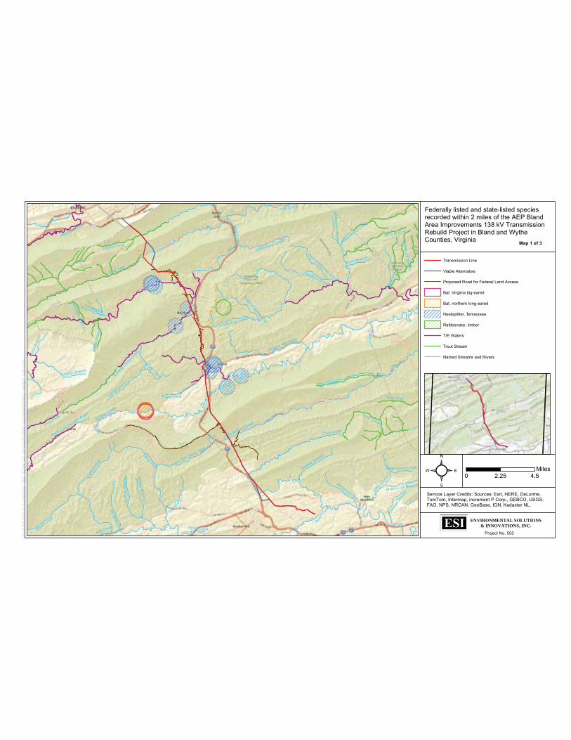
Walker Creek
Wolf C
reek
Clear Fork
Reed Creek
Kimberling Creek
Little Walker Creek
Laurel Creek
Stony Fork
Huntin
g Cam
p Cree
k
Cove Creek
Nobusiness
Creek
Ding Branch
Peak Creek
Spur Branch
Gullion
For
k
Miller C
reek
Town Creek
Dry Branch
Helveys Mill Creek
Bluestone River
Tract Fork
Hutson B
ranch
Snyder Branch
Laure
l Run
Dism
al C
reek
Lick Creek
North Fork Holston River
Wolfpen Branch
Wilderness Creek
McGavock Run
Mudlick Branch
East Fork Stony Fork
Little W
olf Creek
Grippy Branch
Sulphur Spring ForkFox Branch
East Wilderness Creek
Car
ter B
ranc
h
Standrock Branch
Rush Branch
Polet
own
Bran
ch
Gos
e Br
anch
Brown Lick Branch
Wilderness B
ranch
Indianfield Branch
Mill Creek
Beaverdam Creek
Reed C
reek
Wolf Creek
Reed Creek
Laurel Creek
Project No. 555
² 0 4.52.25Miles
Federally listed and state-listed species recorded within 2 miles of the AEP Bland Area Improvements 138 kV Transmission Rebuild Project in Bland and Wythe Counties, Virginia
ENVIRONMENTAL SOLUTIONS& INNOVATIONS, INC.
Transmission Line
Viable Alternative
Proposed Road for Federal Land Access
Bat, Virginia big-eared
Bat, northern long-eared
Heelsplitter, Tennessee
Rattlesnake, timber
T/E Waters
Trout Stream
Named Streams and Rivers
Doc
umen
t Pat
h: G
:\Cur
rent
\555
_AE
P_W
ythe
_Co_
Virg
inia
\WE
RM
S_D
atab
ase\
WE
RM
S_w
orki
ng_m
ap.m
xd
Service Layer Credits: Sources: Esri, HERE, DeLorme,TomTom, Intermap, increment P Corp., GEBCO, USGS,FAO, NPS, NRCAN, GeoBase, IGN, Kadaster NL,
Map 1 of 3

Wolf C
reek
Clear Fork
Hunt
ing C
amp
Creek
Walker Creek
Laurel Creek
Kimberling Creek
Crab O
rchard Creek
Helveys Mill Creek
Wilderness Creek
Sulphur Spring Fork
Town C
reek
North Fork Kimberling Creek
Little W
olf Creek
Wol
fpen
Bra
nch
Car
ter B
ranc
h
Laurel Creek
Project No. 555
² 0 21Miles
Federally listed and state-listed species recorded within 2 miles of the AEP Bland Area Improvements 138 kV Transmission Rebuild Project in Bland and Wythe Counties, Virginia
ENVIRONMENTAL SOLUTIONS& INNOVATIONS, INC.
Transmission Line
Viable Alternative
Proposed Road for Federal Land Access
Bat, northern long-eared
Heelsplitter, Tennessee
Rattlesnake, timber
T/E Waters
Trout Stream
Named Streams and Rivers
Doc
umen
t Pat
h: G
:\Cur
rent
\555
_AE
P_W
ythe
_Co_
Virg
inia
\WE
RM
S_D
atab
ase\
WE
RM
S_w
orki
ng_m
ap.m
xd
Service Layer Credits: Sources: Esri, HERE, DeLorme,TomTom, Intermap, increment P Corp., GEBCO, USGS,FAO, NPS, NRCAN, GeoBase, IGN, Kadaster NL,
Map 2 of 3

Walker Creek
Stony Fork
Cove C
reek
Little Walker Creek
Town Creek
Reed Creek
Laurel Run
East Fork
Stony Fork
Grippy Branch
Mudlick Branch
Laurel Creek
Hutson Branch
Reed C
reek
Project No. 555
² 0 21Miles
Federally listed and state-listed species recorded within 2 miles of the AEP Bland Area Improvements 138 kV Transmission Rebuild Project in Bland and Wythe Counties, Virginia
ENVIRONMENTAL SOLUTIONS& INNOVATIONS, INC.
Transmission Line
Viable Alternative
Proposed Road for Federal Land Access
Bat, Virginia big-eared
Bat, northern long-eared
Heelsplitter, Tennessee
T/E Waters
Trout Stream
Named Streams and Rivers
Doc
umen
t Pat
h: G
:\Cur
rent
\555
_AE
P_W
ythe
_Co_
Virg
inia
\WE
RM
S_D
atab
ase\
WE
RM
S_w
orki
ng_m
ap.m
xd
Service Layer Credits: Sources: Esri, HERE, DeLorme,TomTom, Intermap, increment P Corp., GEBCO, USGS,FAO, NPS, NRCAN, GeoBase, IGN, Kadaster NL,
Map 3 of 3

ATTACHMENT D
BLAND AREA IMPROVEMENTS 138KV TRANSMISSION LINE REBUILD PROJECT IN BLAND AND WYTHE COUNTIES, VIRGINIA
PROJECT SUMMARY OF NORTHERN LONG-EARED BAT CAPTURES

05 June 2015
Environmental Solutions & Innovations, Inc.
Summary of Northern Long-eared Bat Captures along AEP’s Bland Area Improvements Project
ESI reviewed known occurrence data for the northern long-eared bat (NLEB) in the vicinity of AEP’s Bland Area Improvements Project (Project) from multiple sources, including AEP’s Jackson-Wyoming line bat surveys and mitigation-monitoring reports(Duffy et al. 2012; Damm et al. 2014), publically available data, U.S. Fish and Wildlife Service (USFWS) capture and occupied hibernacula records, peer reviewed literature, and Virginia Department of Game and Inland Fisheries (VDGIF) Wildlife Environmental Review Map Service (WERMS). Through this review, ESI identified five separate occurrence reports in the vicinity of the Project, including 3 hibernacula and capture records along AEP’s Jackson-Wyoming line. These records and associated protection buffers include:
• Known P3/P4 hibernacula in West Virginia and associated 5-mile protection buffer
• Sky Dusky Hollow hibernacula in Virginia and associated 5-mile protection buffer • Known hibernacula in Virginia (dated 1985/1986) recorded in the VDGIF
WERMS data and associated 5-mile protection buffer• 2002 captures and associated 3-mile protection buffers from bat surveys
conducted along AEP’s Jackson-Wyoming line• 2007 and 2009 Pond 6 Site captures and associated 3-mile protection buffer
from AEP’s Jackson-Wyoming line mitigation-monitoring project
These known occurrence areas are presented in Figure 1 and described in more detail below. ESI respectfully requests concurrence with the conclusions reached regarding the status of these documented known occurrences and seeks guidance with requirements for survey and conservation measures within current known northern long-eared bat occurrence buffers in Virginia.
P3/P4 Hibernacula in West Virginia
• Affected Project Area: The approximately 5-mile northern portion of the alignment, which begins near the town of Bluefield, West Virginia and extends south into Virginia, is within the 5-mile protection buffer.
• Data Source: USFWS data provided by the West Virginia Ecological Field Services Office (West Virginia USFWS) in April 2015

• Record Status: Valid and current
Sky Dusky Hollow Hibernacula in Virginia
• Affected Project Area: None. The closest portion of the 5-mile protection buffer is located approximately 2.5 miles east of the Project area near the town of Bland, Virginia.
• Data Source: Hibernacula locations referenced in “Post-White-nose syndrome trends in Virginia’s cave bats, 2008-2013” (Powers et al. 2015)
• Record Status: Valid and current
Known Hibernacula in Virginia (1985/1986)
• Affected Project Area: Existing access road located east of the southern end of the line, and Project route crossing approximately 4 miles of private lands paralleling I-77 north between Jefferson National Forest boundaries located south and north of the town of Bland, Virginia.
• Data Source: VDGIF WERMS• Record Status: Likely outdated due to White Nose Syndrome (WNS); Original
record documented from 1985/1986 and two other undated records identified from “Rick Reynolds Study”.
2002 AEP Survey Capture Records
• Affected Project Area: The northern portion of the Project that extends approximately from the town of Bluefield, West Virginia to the town of Bland, Virginia.
• Data Source: 3-mile buffer centered on known captures associated with 2002 bat surveys along AEP’s Jackson-Wyoming line
• Record Status: Outdated (see explanation for Pond 6 site below)
2007-2009 Pond 6 Site Capture Records
• Affected Project Area: The northern portion of the Project extending roughly from 1 mile north of Clear Fork, Virginia to Bastian, Virginia. The Pond 6 Site is located approximately 2 miles east of Hicksville, Virginia.
• Data Source: 3-mile buffer centered on known captures of NLEB associated with the 2007-2013 bat mitigation-monitoring project for AEP’s Jackson-Wyoming line(Duffy et al. 2012). The capture from 2009 is also recorded in the VDGIF WERMS data.
• Record Status: Outdated (see explanation below)
ESI believes that the occurrence records from the AEP Jackson-Wyoming line surveys in 2002 and for the Pond 6 Site monitoring in 2007-2009 are outdated because of the recent declines in NLEB populations as a result of WNS. This conclusion is supported by the fact that all bat captures for AEP’s Jackson-Wyoming bat mitigation-monitoring project declined significantly after 2009, as shown in Figure 2 (Damm et al. 2014). The

75-100% decline in bat captures in Bland County, Virginia has also been recently documented in peer reviewed literature (Powers et al. 2015).
The documented decline in bat captures in the Project area coincides with the arrival of WNS in Bland and Wythe Counties, Virginia (Figure 3). Specific to the Pond 6 Site, which is located within the Project area, 5 NLEB were captured in 2007, 7 in 2009(Duffy et al. 2012; Damm et al. 2014), and none in neither 2011 nor 2013. The only bat capture at Pond Site 6 after 2009 is a single eastern red bat in 2013 (Damm et al.2014).
References
Damm, J., D.C. Brack, D. Sparks Ph.D., and V. Brack Ph.D. 2014. 2007 – 2013 Bat box monitoring for mitigation along AEP’s 765kV Transmission Line in Bland, Wythe, and Pulaski Counties, Virginia. A report submitted to J. Van Hassel (American Electric Power) by Environmental Solutions and Innovations, Inc. on 28 January 2014. 100 pages.
Duffy, J., D. Sparks Ph.D., and V. Brack Ph.D. 2012. 2009 – 2011 Bat box monitoring for mitigation along AEP’s 765kV Transmission Line in Bland and Wythe Counties, Virginia. A report submitted to J. Van Hassel (American Electric Power) by Environmental Solutions and Innovations, Inc. on 12 September 2012. 154 pages.
Powers, K., R. Reynolds, W. Orndorff, W. M. Ford, and C. Hobson. Post-white-nose syndrome trends in Virginia’s cave bats, 2008-2013. Journal of Ecology and the Natural Environment

!( !(!(!(
!(
!(!(
!(!(
!(
!(!(
!(!(
!(!(
!(!(
!(
!(!(
!(
!(!(
!(
!(
!(!(
!( !(!(
!(!(!(
!(
!(
!(
Project No. 555
² 0 52.5Miles
Figure 1. Known Northern long-eared bat occurrences and associated protection buffers in the vicinity of AEP’s Bland Area Improvements 138kV Transmission Line Rebuild Project in Bland and Wythe County, Virginia.
ENVIRONMENTAL SOLUTIONS& INNOVATIONS, INC.
!( Known Hibernacula in Virginia (1985/1986)
!( P3/P4 Hibernacula in West Virginia
!( 2007-2009 Pond 6 Site Capture Records
!( Sky Dusky Hollow Hibernacula in Virginia
!( 2002 AEP Capture Records
Proposed Transmission Line
Viable Alternative Route
Proposed Road for Federal Land Access
Forest Boundary
Private Ownership Boundary
Doc
umen
t Pat
h: G
:\Cur
rent
\555
_AE
P_W
ythe
_Co_
Virg
inia
\Bat
s\M
XD
\For
_Clie
nt_M
eetin
g\55
5_A
EP
_Wyt
he_C
o_B
at_O
ccur
renc
e_M
ap.m
xd
Service Layer Credits: Source: Esri, DigitalGlobe, GeoEye,Earthstar Geographics, CNES/Airbus DS, USDA, USGS,AEX, Getmapping, Aerogrid, IGN, IGP, swisstopo, and the

Figure 2. Total bat captures by survey year on AEP’s Jackson-Wyoming mitigation-monitoring project, 2007-2013. This figure was copied from figure 8 presented in the
final report for the project.

Figure 3. Bat White Nose Syndrome Occurrence by County/District as published by the Pennsylvania Game Commission 29 April 2015.

ATTACHMENT E
BLAND AREA IMPROVEMENTS 138KV TRANSMISSION LINE REBUILD PROJECT IN BLAND AND WYTHE COUNTIES, VIRGINIA
SPECIES CONSULTATION TABLE AND FIGURES FOR SUBMISSION TO THE U.S. FISH AND WILDLIFE SERVICE VIRGINIA ECOLOGICAL FIELD SERVICES OFFICE

Species Conclusions Table
Project Name: AEP Bland Area Improvements 138 kV Transmission Line Rebuild Project in Bland and Wythe Counties, Virginia
Date: 2 June 2015
Species / Resource Name Conclusiona ESA Section 7 / Eagle Act Determination Notes / Documentation Northeastern bulrush(Scripus ancistrochaetus)
Potential habitat present, no current surveys conducted in areas of potential habitat
May affect IPaC Official Species List obtained on 2 June 2015 (05E2VA00-2015-E-02225). No potential habitat on Federal Lands within Jefferson National Forest based on consultation with USFS. Potential habitat for the species was not observed during field survey on Federal lands for rare plants in May 2015.
Gray bat (Myotis grisescens) Potential habitat present, no current surveys conducted
May affect IPaC Official Species List obtained on 2 June 2015 (05E2VA00-2015-E-02225). Planned survey on Federal Lands within Jefferson National Forest in 2015 and private lands when access is received, which is anticipated for field survey season in 2016.
Indiana bat (Myotis sodalis) Potential habitat present, no current surveys conducted
May affect IPaC Official Species List obtained on 2 June 2015 (05E2VA00-2015-E-02225). Planned survey on Federal Lands within Jefferson National Forest in 2015 and private lands when access is received, which is anticipated for field survey season in 2016.
Northern long-eared bat (Myotis soptentrionalis)
Potential habitat present, no current surveys conducted
May affect IPaC Official Species List obtained on 2 June 2015 (05E2VA00-2015-E-02225). Planned survey on Federal Lands within Jefferson National Forest in 2015 and private lands when access is received, which is anticipated for field survey season in 2016.
Virginia big-eared bat (Corynorhinus townsendii virginianus)
Potential habitat present, no current surveys conducted.
May affect IPaC Official Species List obtained on 2 June 2015 (05E2VA00-2015-E-02225). Planned survey on Federal Lands within Jefferson National Forest in 2015 and private lands when access is received, which is anticipated for field

survey season in 2016.
Bald eagle (Haliaeetusleucocephalus)
Unlikely to disturb eagles. Project does not intersect eagle nest or eagle concentration protective buffers
No Eagle Act permit required USFWS Virginia Bald Eagle Mapper and Center for Conservation Biology VaEagles Nest Locator Tool accessed on 6 May 2015.
Critical Habitat No designated or proposed critical habitat present
No effect IPaC Official Species List obtained on 2 June 2015 (05E2VA00-2015-E-02225). USFWS Virginia Ecological Field Services Office Critical Habitat Map Tool accessed on 27 May 2015.
a Species conclusions will be updated based on survey results and a final species conclusions table provided to US Fish and Wildlife Service upon completion of surveys.

TA1001
BL1301
Sources: Esri, HERE, DeLorme, TomTom, Intermap, increment P Corp.,GEBCO, USGS, FAO, NPS, NRCAN, GeoBase, IGN, Kadaster NL,Ordnance Survey, Esri Japan, METI, Esri China (Hong Kong),swisstopo, MapmyIndia, © OpenStreetMap contributors, and the GISUser Community
Project No. 555²
Known bald eagle nest locations near AEP's Bland Area Improvement 138 kV Transmission Line Rebuild Project in Bland and Wythe counties, Virginia
ENVIRONMENTAL SOLUTIONS& INNOVATIONS, INC.
0 6.53.25Mile
Preferred RouteViable Alternative
500-ft BufferAccess Roads
!( Bald Eagle Nest Sites

US Fish and Wildlife Service Bald Eagle Concentration Areas in relation to AEP's Bland Area Improvement 138 kV Transmission Line Rebuild Project in Bland and Wythe counties, Virginia

Sources: Esri, HERE, DeLorme, TomTom, Intermap, increment P Corp.,GEBCO, USGS, FAO, NPS, NRCAN, GeoBase, IGN, Kadaster NL,Ordnance Survey, Esri Japan, METI, Esri China (Hong Kong),swisstopo, MapmyIndia, © OpenStreetMap contributors, and the GISUser Community
Project No. 555²
Known Designated Critical Habitat near AEP's Bland Area Improvement 138 kV Transmission Line Rebuild Project in Bland and Wythe counties, Virginia
ENVIRONMENTAL SOLUTIONS& INNOVATIONS, INC.
0 73.5Mile
Preferred RouteViable Alternative
500-ft BufferAccess Roads
Designated Critical HabitatFluted kidneyshellSlabside Pearlymussel

ATTACHMENT F
BLAND AREA IMPROVEMENTS 138KV TRANSMISSION LINE REBUILD PROJECT IN BLAND AND WYTHE COUNTIES, VIRGINIA
WATERBODIES CROSSED BY THE PROJECT

05 June 2015
Environmental Solutions & Innovations, Inc.
Streams Crossed by AEP Bland Area Improvements 138kV Transmission Rebuild Project
Multiple streams within the New River Basin occur within the proposed Project action area. The New River starts in North Carolina, flows north into Virginia, and loops back into North Carolina before continuing north into Virginia and West Virginia. The most prominent stream features within the Study Area include Wolf Creek and its tributaries (e.g., Laurel Creek, Clear Fork Creek, and Hunting Camp Creek), Walker Creek and its tributaries (e.g., Crab Orchard Creek and Little Walker Creek), and Reed Creek tributaries (e.g., Cove Creek). Wolf, Walker, and Reed creeks are all tributaries to the New River. The list of streams crossed by the preferred route and alternate segments are included in Table 1.
List of Streams crossed by the AEP Bland Area Improvements 138kV Transmission Rebuild Project
Stream HUC 12Wolf Creek 050500020403
Laurel Creek 050500020502 Clear Fork Creek 050500020501
UNT to Clear Fork Creek 050500020501 UNT to Clear Fork Creek 050500020501
UNT to Wolf Creek 050500020403 UNT to Wolf Creek 050500020403 UNT to Wolf Creek 050500020403 UNT to Wolf Creek 050500020403 Hunting Camp Creek 050500020402
UNT to Hunting Camp Creek 050500020402 UNT to Hunting Camp Creek 050500020402 UNT to Hunting Camp Creek 050500020402
UNT to UNT to Hunting Camp Creek 050500020402 UNT to UNT to Hunting Camp Creek 050500020402
Walker Creek 050500020101 Crab Orchard Creek 050500020101
UNT to Crab Orchard Creek 050500020101 Town Creek 050500020101
UNT to Walker Creek 050500020101 Little Walker Creek 050500020202
Reed Creek 050500011001 Cove Creek 050500011002
Saint Lukes Fork 050500011002 UNT to Cove Creek 050500011002
UNT to Reed Creek 050500011001 UNT to UNT to Reed Creek 050500011001
UNT to Reed Creek 050500011001 UNT to UNT to Reed Creek 050500011001
UNT to Reed Creek 050500011001

STEP 4 AND 7
BLAND AREA IMPROVEMENTS 138KV TRANSMISSION LINE REBUILD PROJECT IN BLAND AND WYTHE COUNTIES, VIRGINIA
SPECIES CONCLUSION TABLE

Species Conclusions Table
Project Name: AEP Bland Area Improvements 138 kV Transmission Line Rebuild Project in Bland and Wythe Counties, Virginia
Date: on 2 June 2015 (Last updated by Environmental Solutions and Innovations, Inc. on this date)
Species / Resource Name Conclusiona ESA Section 7 / Eagle Act Determination Notes / Documentation Northeastern bulrush(Scripus ancistrochaetus)
Potential habitat present, no current surveys conducted in areas of potential habitat
May affect IPaC Official Species List obtained on 2 June 2015 (05E2VA00-2015-E-02225). No potential habitat on Federal Lands within Jefferson National Forest based on consultation with USFS. Potential habitat for the species was not observed during field survey on Federal lands for rare plants in May 2015.
Gray bat (Myotis grisescens) Potential habitat present, no current surveys conducted
May affect IPaC Official Species List obtained on 2 June 2015 (05E2VA00-2015-E-02225). Planned survey on Federal Lands within Jefferson National Forest in 2015 and private lands when access is received, which is anticipated for field survey season in 2016.
Indiana bat (Myotis sodalis) Potential habitat present, no current surveys conducted
May affect IPaC Official Species List obtained on 2 June 2015 (05E2VA00-2015-E-02225). Planned survey on Federal Lands within Jefferson National Forest in 2015 and private lands when access is received, which is anticipated for field survey season in 2016.
Northern long-eared bat (Myotis soptentrionalis)
Potential habitat present, no current surveys conducted
May affect IPaC Official Species List obtained on 2 June 2015 (05E2VA00-2015-E-02225). Planned survey on Federal Lands within Jefferson National Forest in 2015 and private lands when access is received, which is anticipated for field survey season in 2016.
Virginia big-eared bat (Corynorhinus townsendii virginianus)
Potential habitat present, no current surveys conducted.
May affect IPaC Official Species List obtained on 2 June 2015 (05E2VA00-2015-E-02225). Planned survey on Federal Lands within Jefferson National Forest in 2015 and private lands when access is received, which is anticipated for field

survey season in 2016.
Bald eagle (Haliaeetusleucocephalus)
Unlikely to disturb eagles. Project does not intersect eagle nest or eagle concentration protective buffers
No Eagle Act permit required USFWS Virginia Bald Eagle Mapper and Center for Conservation Biology VaEagles Nest Locator Tool accessed on 6 May 2015.
Critical Habitat No designated or proposed critical habitat present
No effect IPaC Official Species List obtained on 2 June 2015 (05E2VA00-2015-E-02225). USFWS Virginia Ecological Field Services Office Critical Habitat Map Tool accessed on 27 May 2015.
a Species conclusions will be updated based on survey results and a final species conclusions table provided to US Fish and Wildlife Service upon completion of surveys.

STEP 5
BLAND AREA IMPROVEMENTS 138KV TRANSMISSION LINE REBUILD PROJECT IN BLAND AND WYTHE COUNTIES, VIRGINIA
CRITICAL HABITAT

Sources: Esri, HERE, DeLorme, TomTom, Intermap, increment P Corp.,GEBCO, USGS, FAO, NPS, NRCAN, GeoBase, IGN, Kadaster NL,Ordnance Survey, Esri Japan, METI, Esri China (Hong Kong),swisstopo, MapmyIndia, © OpenStreetMap contributors, and the GISUser Community
Project No. 555²
Known Designated Critical Habitat near AEP's Bland Area Improvement 138 kV Transmission Line Rebuild Project in Bland and Wythe counties, Virginia
ENVIRONMENTAL SOLUTIONS& INNOVATIONS, INC.
0 73.5Mile
Proposed Transmission Line
Viable Alternative Route
Proposed Road for Federal Land Access
Designated Critical HabitatFluted kidneyshellSlabside Pearlymussel

STEP 6
BLAND AREA IMPROVEMENTS 138KV TRANSMISSION LINE REBUILD PROJECT IN BLAND AND WYTHE COUNTIES, VIRGINIA
BALD EAGLE NESTS AND CONCENTRATION AREAS

!(
!(TA1001
BL1301
Sources: Esri, HERE, DeLorme, TomTom, Intermap, increment P Corp.,GEBCO, USGS, FAO, NPS, NRCAN, GeoBase, IGN, Kadaster NL,Ordnance Survey, Esri Japan, METI, Esri China (Hong Kong),swisstopo, MapmyIndia, © OpenStreetMap contributors, and the GISUser Community
Project No. 555²
Known bald eagle nest locations near AEP's Bland Area Improvement 138 kV Transmission Line Rebuild Project in Bland and Wythe counties, Virginia
ENVIRONMENTAL SOLUTIONS& INNOVATIONS, INC.
0 6.53.25Mile
Proposed Transmission Line
Viable Alternative Route
Proposed Road for Federal Land Access !( Bald Eagle Nest Sites

���������US Fish and Wildlife Service Bald Eagle Concentration Areas in elation to AEP's Bland AreaImprovement� 138 kV Transmission Line Rebuild Project in Bland and Wythe �ounties, Virginia

ENCLOSURE 3
BLAND AREA IMPROVEMENTS 138KV TRANSMISSION LINE REBUILD PROJECT IN BLAND AND WYTHE COUNTIES, VIRGINIA
TOPOGRAPHIC MAP SET

5
4
3
2
Project No. 555
² 0 9,2004,600Meters
Topographic Map Set: Bland Area Improvements 138 kV Transmission Line Rebuild Project in Bland and Wythe Counties, Virginia.
Consultation Code 05E2VA00-2015-SLI-2199.
ENVIRONMENTAL SOLUTIONS& INNOVATIONS, INC.
USFWS_Data_Driven_Page
Proposed Transmission Line
Viable Alternative Route
Proposed Access Road
Doc
umen
t Pat
h: G
:\Cur
rent
\555
_AEP
_Wyt
he_C
o_Vi
rgin
ia\U
SFW
S\55
5_U
SFW
S.m
xd
Service Layer Credits: Sources: Esri, HERE, DeLorme,TomTom, Intermap, increment P Corp., GEBCO, USGS,
Map 1 of 5

Project No. 555
² 0 2,4001,200Meters
Topographic Map Set: Bland Area Improvements 138 kV Transmission Line Rebuild Project in Bland and Wythe Counties, Virginia.
Consultation Code 05E2VA00-2015-SLI-2199.
ENVIRONMENTAL SOLUTIONS& INNOVATIONS, INC.
Proposed Transmission Line
Viable Alternative Route
Proposed Access Road
300-foot Access Road Buffer
500-foot Fililng Corridor
Doc
umen
t Pat
h: G
:\Cur
rent
\555
_AEP
_Wyt
he_C
o_Vi
rgin
ia\U
SFW
S\55
5_U
SFW
S.m
xd
Service Layer Credits: Sources: Esri, HERE, DeLorme,TomTom, Intermap, increment P Corp., GEBCO, USGS,
Map 2 of 5

Project No. 555
² 0 2,4001,200Meters
Topographic Map Set: Bland Area Improvements 138 kV Transmission Line Rebuild Project in Bland and Wythe Counties, Virginia.
Consultation Code 05E2VA00-2015-SLI-2199.
ENVIRONMENTAL SOLUTIONS& INNOVATIONS, INC.
Proposed Transmission Line
Viable Alternative Route
Proposed Access Road
300-foot Access Road Buffer
500-foot Fililng Corridor
Doc
umen
t Pat
h: G
:\Cur
rent
\555
_AEP
_Wyt
he_C
o_Vi
rgin
ia\U
SFW
S\55
5_U
SFW
S.m
xd
Service Layer Credits: Sources: Esri, HERE, DeLorme,TomTom, Intermap, increment P Corp., GEBCO, USGS,
Map 3 of 5

Project No. 555
² 0 2,4001,200Meters
Topographic Map Set: Bland Area Improvements 138 kV Transmission Line Rebuild Project in Bland and Wythe Counties, Virginia.
Consultation Code 05E2VA00-2015-SLI-2199.
ENVIRONMENTAL SOLUTIONS& INNOVATIONS, INC.
Proposed Transmission Line
Viable Alternative Route
Proposed Access Road
300-foot Access Road Buffer
500-foot Fililng Corridor
Doc
umen
t Pat
h: G
:\Cur
rent
\555
_AEP
_Wyt
he_C
o_Vi
rgin
ia\U
SFW
S\55
5_U
SFW
S.m
xd
Service Layer Credits: Sources: Esri, HERE, DeLorme,TomTom, Intermap, increment P Corp., GEBCO, USGS,
Map 4 of 5

Project No. 555
² 0 2,4001,200Meters
Topographic Map Set: Bland Area Improvements 138 kV Transmission Line Rebuild Project in Bland and Wythe Counties, Virginia.
Consultation Code 05E2VA00-2015-SLI-2199.
ENVIRONMENTAL SOLUTIONS& INNOVATIONS, INC.
Proposed Transmission Line
Viable Alternative Route
Proposed Access Road
300-foot Access Road Buffer
500-foot Fililng Corridor
Doc
umen
t Pat
h: G
:\Cur
rent
\555
_AEP
_Wyt
he_C
o_Vi
rgin
ia\U
SFW
S\55
5_U
SFW
S.m
xd
Service Layer Credits: Sources: Esri, HERE, DeLorme,TomTom, Intermap, increment P Corp., GEBCO, USGS,
Map 5 of 5

From: Wendy BaltzersenTo: "Troy Andersen"; "[email protected]"; "Overcash, Jesse L -FS"Cc: "Jared A Webb"; Virgil BrackSubject: AEP Bland Area Improvements 138kV Transmission Rebuild Project - Bat Study PlanDate: Friday, June 26, 2015 1:44:00 PMAttachments: AEP Bland Area Improvements Bat Study Plan 26 June 2015.pdf
Dear Mr. Troy Anderson, Mr. Rick Reynolds, and Mr. Jesse Overcash,
Please find attached the bat study plan for the AEP Bland Area Improvements 138kV Transmission Rebuild Project (Project) for your review and approval. ESI, on behalf of AEP, respectfully requests your concurrence regarding the methods in this study plan. As outlined in this plan, ESI plans to begin studies in mid-July 2015. A hardcopy of this plan has also been mailed to each of your offices.
Please contact me with any questions or comments regarding this plan prior to 7 June 2015 to ensure that any necessary revisions to the plan can be addressed and site specific authorization received prior to the planned survey.
Sincerely,Wendy
Wendy Baltzersen, Ph.D. and CWB
Senior Project Scientist
Environmental Solutions & Innovations, Inc.101 Old Cove Rd, Ste 108 | Liverpool, NY 13090 | USAOffice: 315.314.7309 Direct: 513.591.4333fax: 315.314.7546 Cell: [email protected] | www.envsi.com

From: Nystrom, SarahTo: Wendy BaltzersenCc: Virgil BrackSubject: AEP Bland Area Improvements 138kV Transmission Rebuild Project - Bat Study PlanDate: Monday, July 06, 2015 11:05:32 AM
Dear Wendy,
This message responds to your request for comments on the study plan, received June 26, 2015, for the federally listed endangered gray bat (Myotis grisescens), federally listed endangered Indiana bat (Myotis sodalis), federally listed endangered Virginia big-eared bat (Corynorhinus townsendii virginianus) and federally listed threatened Northern long-eared bat (Myotis septentrionalis) associated with a project in Bland and Wythe Counties. The following comments are provided under provisions of the Endangered Species Act of 1973 (16 U.S.C. 1531-1544, 87 Stat. 884), as amended.
Your proposed bat survey plan follows the U.S. Fish and Wildlife Service’s April 2015 Range-wide Indiana Bat Summer Survey Guidance and will follow the most recent White Nose Syndrome Decontamination Protocol. We concur with your proposed bat survey plan. Survey results are valid for a period of three years.
Upon completion of the bat survey, provide the results of the survey as an update to the previously submitted project review package for review.
Thank you,
Sarah
-- Sarah NystromFish and Wildlife BiologistVirginia Field Office - Ecological Services6669 Short LaneGloucester, Virginia 23061 (804) 824-2413

Equal Opportunity Employment, Programs and Facilities4010 WEST BROAD STREET, P.O. BOX 11104, RICHMOND, VA 23230-1104
(804) 367-1000 (V/TDD) FAX (804) 367-9147
Department of Game and Inland Fisheries
December 12, 2014
Tim GaulLouis Berger Company
via email: [email protected]
Re: Appalachian Power Company: Bland Area Transmission Improvements Project
Dear Mr. Gaul:
We appreciate your interest in submitting your project(s) for review by VDGIF to ensure the protection of sensitive wildlife resources during project development. Unfortunately, due to staffing limitations, we are unable to review pre-applications or scoping documents submitted to our Department. Please note that lack of a response from VDGIF does not constitute a “no comment” response, nor does it imply support of the project or associated activities. It simply means that VDGIF is unable to review your pre-application submittal.
To review your project site for the location of wildlife resources under our jurisdiction, including threatened and endangered wildlife, we recommend accessing the Virginia Fish and Wildlife Information System (VAFWIS) at http://vafwis.org/fwis/.
If you have further questions or need additional information about VDGIF’s Environmental Programs, please visit: http://www.dgif.virginia.gov/environmental-programs/.
Please feel free to attach a copy of this correspondence to any applications or documents you may submit for your project to state or federal permitting agencies.
Sincerely,
Gladys D. CasonEnvironmental Services Section
Molly J. WardSecretary of Natural Resources
Robert W. DuncanExecutive Director

1
Wendy Baltzersen
From: dgif-ESS Projects (DGIF) <[email protected]>Sent: Friday, June 19, 2015 12:17 PMTo: Wendy BaltzersenSubject: RE: Project Review Request - Bland Area Improvements 138 kV Transmission Line
Rebuild Project in Bland and Wythe Counties, Virginia
Follow Up Flag: Flag for follow upFlag Status: Flagged
Due to staffing limitations, we are unable to review and provide comments on projects that are not currently involved in one of the regulatory review processes for which we are a consultatory agency (see http://www.dgif.virginia.gov/environmental-programs/environmental-services-section.asp ). If you need a response letter that states such so that you may include that with your project documentation, please let me know and we will furnish that for you.
Please note that Gladys Cason has retired. All submissions should go to [email protected].
Amy
Amy EwingEnvironmental Services Biologist/FWIS ManagerVA Dept. of Game and Inland Fisheries7870 Villa Park Dr., Henrico, VA 23228804 367 2211 DGIF.virginia.gov
From: Wendy Baltzersen [mailto:[email protected]] Sent: Friday, June 12, 2015 11:09 AM To: dgif-ESS Projects (DGIF) Subject: RE: Project Review Request - Bland Area Improvements 138 kV Transmission Line Rebuild Project in Bland and Wythe Counties, Virginia
Dear Ms. Angela Weller,
Can you confirm that you have received this submission?
Thank you,Wendy
Wendy Baltzersen, Ph.D. and CWB Senior Project Scientist
Environmental Solutions & Innovations, Inc. 101 Old Cove Rd, Ste 108 | Liverpool, NY 13090 | USA Office: 315.314.7309 Direct: 513.591.4333 fax: 315.314.7546 Cell: 315.558.8912 PLEASE NOTE: New Office Address [email protected] | www.envsi.com

2
From: Wendy BaltzersenSent: Friday, June 05, 2015 5:05 PMTo: '[email protected]'Cc: 'Jared A Webb'; Virgil BrackSubject: Project Review Request Bland Area Improvements 138 kV Transmission Line Rebuild Project in Bland andWythe Counties, Virginia
Dear Ms. Angela Weller,
Appalachian Power Company, an affiliate of American Electric Power Company, Inc. (AEP), is proposing to begin theBland Area Improvements 138 kV Transmission Line Rebuild Project (Project) in Bland and Wythe counties, Virginia andMercer County, West Virginia (see project shapefiles attached). The Project involves rebuilding and upgrading AEP’sexisting 23.25 mile South Bluefield Wythe 69 kV Transmission Line to current 138 kV standards, as well as upgrading andimproving any associated substations. In Virginia, the preferred rebuild consists of approximately 25.3 linear miles withinBland (~17.5 miles) and Wythe (~7.8 miles) counties. AEP is filing an application with the Virginia State CorporationCommission (SCC) for issuance of a Certificate of Public Convenience and Necessity (CPCN) and with the US ForestService (USFS) for a Special Use Permit (SF 299) authorization for the Project.
AEP has retained Environmental Solutions and Innovations, Inc. (ESI) to conduct consultations and surveys for protectedspecies on the Project. On behalf of AEP, ESI submits this Project Review Request to VDGIF requesting comment andfeedback regarding protected species under their jurisdiction. Please contact me should you have any requestsquestions or need additional information.
Sincerely,Wendy
Wendy Baltzersen, Ph.D. and CWB Senior Project Scientist
Environmental Solutions & Innovations, Inc. 101 Old Cove Rd, Ste 108 | Liverpool, NY 13090 | USA Office: 315.314.7309 Direct: 513.591.4333 fax: 315.314.7546 Cell: 315.558.8912 PLEASE NOTE: New Office Address [email protected] | www.envsi.com

From: Wendy BaltzersenTo: "Troy Andersen"; "[email protected]"; "Overcash, Jesse L -FS"Cc: "Jared A Webb"; Virgil BrackSubject: AEP Bland Area Improvements 138kV Transmission Rebuild Project - Bat Study PlanDate: Friday, June 26, 2015 1:44:00 PMAttachments: AEP Bland Area Improvements Bat Study Plan 26 June 2015.pdf
Dear Mr. Troy Anderson, Mr. Rick Reynolds, and Mr. Jesse Overcash,
Please find attached the bat study plan for the AEP Bland Area Improvements 138kV Transmission Rebuild Project (Project) for your review and approval. ESI, on behalf of AEP, respectfully requests your concurrence regarding the methods in this study plan. As outlined in this plan, ESI plans to begin studies in mid-July 2015. A hardcopy of this plan has also been mailed to each of your offices.
Please contact me with any questions or comments regarding this plan prior to 7 June 2015 to ensure that any necessary revisions to the plan can be addressed and site specific authorization received prior to the planned survey.
Sincerely,Wendy
Wendy Baltzersen, Ph.D. and CWB
Senior Project Scientist
Environmental Solutions & Innovations, Inc.101 Old Cove Rd, Ste 108 | Liverpool, NY 13090 | USAOffice: 315.314.7309 Direct: 513.591.4333fax: 315.314.7546 Cell: [email protected] | www.envsi.com

From: Dressler, Shirl (DGIF)To: Wendy BaltzersenSubject: Bland Area Improvements 138 kV Transmission Line Rebuild ProjectDate: Tuesday, June 30, 2015 11:26:16 AMAttachments: SignedESILetter.pdf
Wendy, Please see the attached. Shirl Dressler, Program Support TechnicianBureau of Wildlife Resources, Statewide ResourcesP O Box 907787870 Villa Park Drive, Suite 400Henrico, VA 23228-0778(804) 367-6913(804) 367-2628 [email protected]@dgif.virginia.gov"Wildlife has a place and that place is in the wild"


From: Wendy BaltzersenTo: Reynolds, Rick (DGIF)Cc: Troy Andersen; Overcash, Jesse L -FS; Jared A Webb; Virgil Brack; Jo SalyersSubject: Re: AEP Bland Area Improvements 138kV Transmission Rebuild Project - Bat Study PlanDate: Thursday, July 02, 2015 3:03:03 PM
Thank you, Rick.
Wendy Baltzersen315-558-8912Sent from my iPhone
On Jul 2, 2015, at 11:31 AM, Reynolds, Rick (DGIF) <[email protected]> wrote:
Works for me. Thanks Rick
From: Wendy Baltzersen [mailto:[email protected]]Sent: Thursday, July 02, 2015 1:23 PMTo: Reynolds, Rick (DGIF); Troy Andersen; Overcash, Jesse L -FSCc: Jared A Webb; Virgil Brack; Jo SalyersSubject: RE: AEP Bland Area Improvements 138kV Transmission Rebuild Project - Bat Study Plan Please find attached the revised bat study plan for the Bland Area Improvements 138kV Transmission Rebuild Project. For your reference, I have copied below the paragraph containing the text revisions (in bold).
Due to a recent change in survey schedules, we are requesting site specific authorization to begin bat surveys on Monday, 06 July 2015.
A prompt authorization would be greatly appreciated.
Sincerely,Wendy
“Concurrent with harp trapping, an acoustic detector (AnaBat [Titley Scientific, LLC]) is placed near the portal entrance. Beginning at dusk, bat passes are monitored and tallied for a minimum of one hour and preferably two. At least one hour will be monitored after 10:00 PM.All files recorded are passed through a noise filter previously provided by the USFWS. A qualified biologist reviews files that pass the filter to eliminate any that were not produced by bats and to note the number of files that contain multiple bats.”

<image001.jpg> Wendy Baltzersen, Ph.D. and CWBSenior Project Scientist
Environmental Solutions & Innovations, Inc.101 Old Cove Rd, Ste 108 | Liverpool, NY 13090 | USAOffice: 315.314.7309 Direct: 513.591.4333fax: 315.314.7546 Cell: [email protected] | www.envsi.com
From: Reynolds, Rick (DGIF) [mailto:[email protected]] Sent: Monday, June 29, 2015 9:50 AMTo: Wendy Baltzersen; Troy Andersen; Overcash, Jesse L -FSCc: Jared A Webb; Virgil BrackSubject: RE: AEP Bland Area Improvements 138kV Transmission Rebuild Project - Bat Study Plan The study plan looks good except for section 4.1.3 “Potential Hibernacula Survey Trapping” The second paragraph states “Bat passes are monitored…for at least one hour after 10:00 p.m.” If you wait until 10:00 to start acoustic surveys you will miss the major exodus if one occurs. This has been pointed out before in other study plans ESI has submitted. Please fix this. Acoustic surveys should start at dusk and run for a minimum of 1 hour and preferably for 2 hours. Thanks Rick ReynoldsWildlife BiologistVirginia Department of Game and Inland FisheriesP.O. Box 996Verona, VA 24482540-248-9360
From: Wendy Baltzersen [mailto:[email protected]]Sent: Friday, June 26, 2015 1:44 PMTo: Troy Andersen; Reynolds, Rick (DGIF); Overcash, Jesse L -FSCc: Jared A Webb; Virgil BrackSubject: AEP Bland Area Improvements 138kV Transmission Rebuild Project - Bat Study Plan Dear Mr. Troy Anderson, Mr. Rick Reynolds, and Mr. Jesse Overcash,
Please find attached the bat study plan for the AEP Bland Area Improvements 138kV Transmission Rebuild Project (Project) for your review and approval. ESI, on behalf of AEP, respectfully requests your concurrence regarding the methods in this study plan. As outlined in this plan, ESI plans to begin studies in mid-July 2015. A hardcopy of this plan has also been mailed to each of your offices.

Please contact me with any questions or comments regarding this plan prior to 7 June 2015 to ensure that any necessary revisions to the plan can be addressed and site specific authorization received prior to the planned survey.
Sincerely,Wendy
<image002.jpg> Wendy Baltzersen, Ph.D. and CWBSenior Project Scientist
Environmental Solutions & Innovations, Inc.101 Old Cove Rd, Ste 108 | Liverpool, NY 13090 | USAOffice: 315.314.7309 Direct: 513.591.4333fax: 315.314.7546 Cell: [email protected] | www.envsi.com

ATTACHMENT 2.E.1: VDHR – HISTORIC RESOURCES PRE-APPLICATION REPORT

PRE-APPLICATION HISTORIC RESOURCES ANALYSISFOR THE
BLAND AREA IMPROVEMENTS138 KV TRANSMISSION LINE REBUILD PROJECT
August 2015

Pre-Application Historic Resources Analysis for the
Bland Area Improvements 138 kV Transmission Line Rebuild Project
inBland and Wythe Counties, Virginia
Prepared for:
Appalachian Power1281 North Electric Road
Roanoke, VA 24022
Prepared by:
The Louis Berger Group, Inc.1250 23rd Street, NW
Washington, DC 20037
August 2015

i
TABLE OF CONTENTS
Section Page
LIST OF FIGURES ...................................................................................................................................... ii
LIST OF TABLES ........................................................................................................................................ ii
LIST OF PLATES ........................................................................................................................................ ii
1.0 INTRODUCTION ........................................................................................................................... 1
2.0 METHODOLOGY AND SCOPE ................................................................................................... 3 2.1 Background Research ......................................................................................................... 3
2.1.1 Architectural Resources ......................................................................................... 3 2.1.2 Archaeological Resources ...................................................................................... 6
2.2 Viewshed Analysis and Photo Simulations ........................................................................ 6 2.3 Field Reconnaissance .......................................................................................................... 6 2.4 Tower Schematics and Visual Character of the ROW ........................................................ 7
3.0 IMPACTS ON HISTORIC RESOURCES ...................................................................................... 8 3.1 Appalachian Trail (VDHR No. 021-5012) ......................................................................... 8
3.1.1 Narrative Description and Environmental Conditions ........................................... 8 3.1.2 Construction ........................................................................................................... 8 3.1.3 Viewshed and Photo Simulations .......................................................................... 8 3.1.4 Analysis ............................................................................................................... 12
3.2 Wythe County Poorhouse Farm (VDHR No. 098-0030) .................................................. 14 3.2.1 Narrative Description and Environmental Conditions ......................................... 14 3.2.2 Construction ......................................................................................................... 14 3.2.3 Viewshed and Photo Simulations ........................................................................ 14 3.2.4 Analysis ............................................................................................................... 14
3.3 Cove Mountain Battlefield (VDHR No. 098-5023).......................................................... 17 3.3.1 Narrative Description and Environmental Conditions ......................................... 17 3.3.2 Construction ......................................................................................................... 17 3.3.3 Viewshed and Photo Simulations ........................................................................ 17 3.3.4 Analysis ............................................................................................................... 22
4.0 SUMMARY OF IMPACTS ON HISTORIC RESOURCES ........................................................ 27 4.1 Architectural Resources .................................................................................................... 27 4.2 Archaeological Resources ................................................................................................. 27
APPENDIX A: PROPOSED STRUCTURES

ii
LIST OF FIGURESFigure Page
1 Historic Resources Overview, Alternative Segments 1, 4, 6 ..................................................... 4
2 Historic Resources Overview, Alternative Segments 2, 3, 5, 7 ................................................. 5
3 Viewshed Analysis and Photo Simulation Locations for the Appalachian Trail .................... 13
4 Viewshed Analysis for Wythe County Poorhouse Farm ......................................................... 16
5 Viewshed Analysis for Cove Mountain Battlefield Rebuild and Segment 5 .......................... 23
6 Viewshed Analysis for Cove Mountain Battlefield Rebuild and Segment 6 .......................... 24
7 Viewshed Analysis for Cove Mountain Battlefield Rebuild and Segment 7 .......................... 25
8 Photo Simulation Locations for Cove Mountain Battlefield ................................................... 26
LIST OF TABLESTable Page
1 Established Study Areas for Known Historic Resources in the Virginia Department of Historic Resources Transmission Line Guideline .................................................................... 3
2 Impacts on Historic Resources ................................................................................................. 26
LIST OF PLATES
Plate Page
Plate 1. View of the Appalachian Trail (VDHR No. 021-5012) looking Northeast .............................. 9
Plate 3. Photo Simulation of the Appalachian Trail (VDHR No. 021-5012) looking Southeast ......... 10
Plate 4. Photo Simulation of the View from the Appalachian Trail (VDHR No. 021-5012) looking Northwest ................................................................................................................................ 11
Plate 5. View of Wythe County Poorhouse Farm (VDHR No. 098-0030) .......................................... 15
Plate 6. View of Cove Mountain Battlefield (VDHR No. 098-5023) looking Southwest toward the Crockett House ........................................................................................................................ 18
Plate 7. View of Cove Mountain Battlefield (VDHR No. 098-5023) from Cove Road looking Southwest toward the Gap of the Cove ................................................................................... 18
Plate 8. Photo Simulation of Cove Mountain Battlefield (VDHR No. 098-5023) at Cove Road looking Northwest toward Rebuild Segment 3 ..................................................................................... 19
Plate 9. Photo Simulation of Cove Mountain Battlefield (VDHR No. 098-5023) from Cove Road looking South toward Segment 6 ............................................................................................ 20
Plate 10. Photo Simulation of Cove Mountain Battlefield (VDHR No. 098-5023) from Cove Road looking Southeast toward Segments 5 and 7 ........................................................................... 21

Pre-Application Analysis Bland Area Improvements138 kV Transmission Line Project Bland and Wythe Counties, Virginia
1
1.0 INTRODUCTION
Louis Berger Group has prepared this Pre-Application Historic Resources Analysis for the proposed Bland Area Improvements 138 Kilovolt (kV) Transmission Line Project (Project) (VDHR File No. 2014-1320) on behalf of Appalachian Power Company (Appalachian). The analysis was completed in accordance with the Virginia Department of Historic Resources’ (VDHR) 2008 Guidelines for Assessing Impacts of Proposed Electric Transmission Lines and Associated Facilities on Historic Resources in the Commonwealth of Virginia (2008 Guidelines). Appalachian is planning system upgrades and improvements to enhance system reliability and operational flexibility for areas in Bland and Tazewell Counties in Virginia, Mercer County, West Virginia as well as Wythe County, Virginia. The existing 22.5 mile-long South Bluefield–Bland-Wythe 69 kV line (sometimes also referred to as the South Bluefield-Wythe 69 kV line), built in the 1920s, has reached the end of its useful life and combined with upcoming generation retirements, must be rebuilt. The existing 69 kV line will be rebuilt as a 138 kV line from the South Bluefield Substation in Bluefield, West Virginia, to the Progress Park Substation in Wythe, Virginia.
The Project consists of the proposed South Bluefield–Town Creek-Progress Park 138kV Transmission Line and the new Town Creek Substation. The existing Bland Substation will be decommissioned and a new substation, to be named Town Creek Substation, will be constructed to support additional space needed for the 138 kV transmission line as well as current and future distribution circuits. The proposed line rebuild consists of two single circuits: South Bluefield–Town Creek 138 kV circuit and Progress Park–Town Creek 138 kV circuit. The proposed South Bluefield–Town Creek–Progress Park 138 kVTransmission Line will terminate at the existing Progress Park 138 kV Substation (built in 2007). The existing South Bluefield–Bland–Wythe 69 kV Transmission Line currently connects to the existing Wythe Substation. Because of the Wythe Substation’s configuration and physical constraints, the proposed 138 kV line cannot terminate at the Wythe Substation. The to-be-retired 69 kV position at Wythe Substation cannot be used by the 138 kV line and no empty 138 kV positions are available.Accordingly, it was determined that ending the new 138 kV line at the nearby Progress Park Substation, where there is adequate space, will be electrically equivalent to terminating the line at the Wythe Substation.
The Project generally will use the ROW of the existing South Bluefield-Wythe 69 kV line, except in three locations, where the Project will diverge from the exiting ROW on to new ROW. These three locations are referred to respectively as the North Focus Area, the Central Focus Area and the South Focus Area. Thus, the Preferred Route for the Project consists of segments using the existing ROW (Rebuild Segments) and one of several alternative segments (Alternative Segments) for each of the North Focus Area, Central Focus Area, and South Focus Area. Within the North Focus Area, Alternative Segment 1 is the Preferred Route. In the Central Focus Area, Alternative Segment 4 is the Preferred Route. In the South Focus Area, Alternative Segment 6 is the Preferred Route. Approximately 62 percent of the Preferred Route will consist of a rebuild on the existing right-of-way (ROW), while 38 percent will be located on new ROW. All structures and conductors for the 138 kV transmission line will be located within the 100-foot ROW1. Structures will be a combination of guyed-V, steel lattice, H-frame, three pole and monopole structures. The use of the different structures will be used based on the topography of the section of the transmission line, and all proposed structures will average approximately 100 feet in height with a proposed average span of approximately 900 feet.
1 In certain limited locations, the ROW may extend beyond 100' in order to accommodate certain conductor blowout areas and to accommodate guy wires for structures.

Pre-Application Analysis Bland Area Improvements138 kV Transmission Line Project Bland and Wythe Counties, Virginia
2
This analysis was conducted to determine the impact of the Project on recorded historic resources; it is intended to guide the design of the Project and aid in the selection of a preferred alternative. Background archival research was conducted regarding surveyed properties within the buffers established by the 2008 Guidelines for the rebuild. Research conducted shows that no historic resources are located within the buffers of Alternative Segments 1, 2, 3, and 4. Within the buffers of Alternative Segments 5, 6, and 7, one National Register of Historic Places (NRHP) listed property (Wythe County Poorhouse Farm) and one battlefield (Cove Mountain Battlefield) are located within the 1-mile buffer, and one archaeological site is located within the ROW. Within the Rebuild Segments, one NRHP-eligible resource (Appalachian Trail) is located within the 0.5-mile buffer of Rebuild Segment 2 and one battlefield (Cove Mountain Battlefield) is located within the 1.0-mile buffer of Rebuild Segment 3. The Project will not affect the Wythe County Poorhouse Farm. The Project will have moderate impacts on the Appalachian Trail and moderate impacts on the Cove Mountain Battlefield. One unevaluated archaeological site, 44WY0203, is located within the ROW of Segments 5, 6 and 7. As currently designed, a structure is located within the boundaries of the unevaluated site. If the site cannot be avoided, additional consultation will be carried out with VDHR. The potential for archaeological resources along Rebuild Segment 3 and Alternative Segments 5, 6 and 7 within Cove Mountain Battlefield may require an identification survey of areas of ground disturbance and the NRHP evaluation of any identified archaeological resources.

Pre-Application Analysis Bland Area Improvements138 kV Transmission Line Project Bland and Wythe Counties, Virginia
3
2.0 METHODOLOGY AND SCOPE
2.1 Background ResearchBackground archival research was conducted regarding surveyed properties according to their locations in the tiered buffer areas (radial buffers or buffers) established by the VDHR 2008 Guidelines for the Project (Table 1). Background research for the Pre-Application Analysis entailed a thorough review of survey data available through VDHR’s Virginia Cultural Resources Information System to identify recorded historic resources listed in or eligible for the NRHP, as well as archaeological sites, National Historic Landmarks, and Civil War battlefields. The boundaries of each resource and its eligibility status were taken from Virginia Cultural Resources Information System.
TABLE 1
ESTABLISHED STUDY AREAS FOR KNOWN HISTORIC RESOURCES IN THE VIRGINIA DEPARTMENT OF HISTORIC RESOURCES
TRANSMISSION LINE GUIDELINES
RADIAL BUFFER(miles) CONSIDERED RESOURCES
1.5 National Historic Landmarks
1.0
Above resources, and: Listed NRHP propertiesBattlefieldsHistoric Landscapes (rural Historic Districts)
0.5 All above resources, and: NRHP eligible resources (as determined by VDHR)
0.0 (within ROW) All above resources, andArchaeological sites
Background archival research conducted for surveyed properties within the buffers established by the 2008 Guidelines for the Project shows that no historic resources are located within the buffers of Alternative Segments 1, 2, 3, and 4. Within the buffers of Alternative Segments 5, 6 and 7, one NRHP-listed property (Wythe County Poorhouse Farm) and one battlefield (Cove Mountain Battlefield) is located within the 1-mile buffer, and one archaeological site is located within the ROW. Within the Rebuild Segments, one NRHP-eligible resource (Appalachian Trail) is located within the 0.5-mile buffer of Rebuild Segment 2 and one battlefield (Cove Mountain Battlefield) is located within the 1-mile buffer of Rebuild Segment 3 (Figure 1 and Figure 2 Architectural Resources).
The three architectural resources located within segments of the Project are the NRHP-eligible Appalachian Trail (VDHR No. 021-5012), the NRHP- and Virginia Landmarks Register-listed Wythe County Poorhouse Farm (VDHR No. 098-0030), and Cove Mountain Battlefield (VDHR No. 098-5023). These architectural resources are discussed in detail in Chapter 3.

Pre-Application Analysis Bland Area Improvements138 kV Transmission Line Project Bland and Wythe Counties, Virginia
4
Figure 1 Historic Resources Overview, Alternative Segments 1, 4, 6

Pre-Application Analysis Bland Area Improvements138 kV Transmission Line Project Bland and Wythe Counties, Virginia
5
Figure 2 Historic Resources Overview, Alternative Segments 2, 4, 5

Pre-Application Analysis Bland Area Improvements138 kV Transmission Line Project Bland and Wythe Counties, Virginia
6
2.1.1 Archaeological ResourcesOne ancient Native American archaeological site, 44WY0203, is located within the 100-foot ROW of Segments 5, 6 and 7. A Phase I reconnaissance survey included surface collection and shovel test pits, but the investigation indicated that subsurface deposits lacked integrity. The artifact assemblage included chert, rhyolite, and quartzite lithic debitage representing all stages of lithic reduction. One biface fragment was also found. The NRHP eligibility of the site has not been determined. As currently designed, a structure is located within the boundaries of the unevaluated site. If the site cannot be avoided, additional consultation will be carried out with VDHR.
Cove Mountain Battlefield (VDHR No. 098-0030) has been identified as an architectural resource, but the area also has the potential to contain archaeological resources associated with the battle. The potential for archaeological resources along Rebuild Segment 3 and Alternative Segments 5, 6 and 7 within Cove Mountain Battlefield (VDHR No. 098-0030) may require an identification survey of areas of ground disturbance and the NRHP evaluation of any identified archaeological resources.
2.2 Viewshed Analysis and Photo SimulationsThe viewshed calculation was performed using a U.S. Geological Survey 10-meter digital elevation model to estimate the ground surface elevation for every 10x10-square-meter area across the entire study area. Using this data source, the effects of terrain on line-of-sight visibility of an area can be modeled, allowing the identification of those areas that can and cannot be seen because of intervening topography.Vegetation was modeled by overlaying forest cover data on top of the elevation data layer assuming an average canopy height of 19 meters or approximately 62 feet. The extent of forest cover was determined by digitizing forested areas based on 2011 imagery. Existing building heights were not taken into consideration as part of the viewshed analysis.
Photo simulations were created to simulate the visual impacts of the proposed route on a given historic structure or district. The photographs selected for simulation demonstrate what was perceived to be the greatest possible obstruction to the property’s viewshed from the proposed route alignment. For each view chosen for simulation, a 3-dimensional (3D) model was created to simulate the proper tower height, type, and location for the rebuild by mimicking the viewing perspective of the photograph. With the towers oriented properly in space, a “camera” was set up in the same 3D space at the photographer’s height and location relative to the proposed line. The camera’s focal length and point of view were set to those of the camera that took the photograph to obtain the correct perspective. Light sources were set up to simulate the lighting conditions and look of the towers in the photograph. Once the perspective and sizing was comparable to the photograph, the 3D-rendered structure was placed in the digital photograph. The process of photo simulation was accompanied by a collaborative review to ensure that the simulated route alignment appeared the way it should in the photograph. Several staff reviewed each photograph to comment on the perspective and look of the simulation so that any necessary alterations could be made to fairly represent the way in which the towers will likely appear.
2.3 Field ReconnaissanceLouis Berger Architectural Historian Sarah Groesbeck conducted a field reconnaissance on May 4, 2015. Photographs were taken at each architectural resource and include views of the elevations of the primary resource, setting, and outbuildings, and views from the resource toward the existing transmission line corridor. A Nikon D5000 digital SLR camera with a Nikon Digital 18-55 mm lens was used for the field reconnaissance.

Pre-Application Analysis Bland Area Improvements138 kV Transmission Line Project Bland and Wythe Counties, Virginia
7
2.4 Tower Schematics and Visual Character of the ROWAppendix A presents the proposed tower types and ROW configuration for the Project. Steel guyed-Vlattice, steel lattice, H-frame, three pole, monopole (single circuit), and monopole (single [and double] circuit with davit arms) structures will be used for the Project.

Pre-Application Analysis Bland Area Improvements138 kV Transmission Line Project Bland and Wythe Counties, Virginia
8
3.0 IMPACTS ON HISTORIC RESOURCES
To determine impacts to the historic resources, Louis Berger completed a viewshed analysis. Based on that analysis, photo simulations were completed for two architectural resources located within the tiered study area. The following text describes the resources, applicable Alternative Segments and/or Rebuild Segments in relationship to historic resources, and locations of photo simulations, and provides an assessment of the impacts. In addition to the photo simulations, figures for each historic resource illustrate the visibility of the routes from the resource and, if applicable, the location and direction of the photo simulations.
3.1 Appalachian Trail (VDHR No. 021-5012)
3.1.1 Narrative Description and Environmental ConditionsThe Appalachian Trail is a National Scenic Trail stretching 2,160 miles from Georgia to Maine. Virginia holds the longest section of the Appalachian Trail of any state, some 576 miles. The trail is located on lands managed by the U.S. Forest Service, including the George Washington and Jefferson National Forests, Mount Rogers National Recreation Area, Shenandoah National Park, and state park and forest lands with some small sections owned and managed only by the Appalachian Trail Office and Appalachian Trail Conservancy.
The Appalachian Trail was the first long-distance hiking trail in the United States; construction began in 1922 in New York’s Harriman and Bear Mountain State Parks and was completed in 1937. The Appalachian Trail was designated a national scenic trail under the National Trails System Act of 1968 (Public Law 90-543, as amended through Public Law 111-11, March 30, 2009) and subsequently became a unit of the National Park System. The trail is eligible for the NRHP under Criterion A as the first long-distance hiking trail and is significant for its design and construction as a cultural landscape (Criterion C). It is unique in its construction as a long-distance hiking path on the East Coast and because it creates natural habitat for plants and animals and preserves natural spaces.
Within the 0.5-mile buffer on either side of the line, the Appalachian Trail is a mixture of gravel road and dirt path (Plates 1 and 2). East of the line, the trail is also used as a gravel fire road until it reaches Route 52. The trail then parallels U.S. Route 52 and County Route 612. West of the line, the trail and fire road follow the same alignment for approximately 0.25 mile before the trail splits from the fire road and becomes a narrow dirt track.
3.1.2 ConstructionThe proposed project entails rebuilding the existing 69 kV line as a 138 kV line generally in the same location and constructing new towers for the transmission line that will average approximately 100 feet tall. The line crosses the Appalachian Trail on Brushy Mountain, southwest of U.S. Route 52 and Interstate 77, approximately 1,000 feet west of where the trail crosses U.S. Route 52. The line runs northwest-southeast, passing over the ridge of Brushy Mountain before continuing in a southerly direction. The structures in the area of the crossing will be steel guyed-V lattice and H-frame towers.
3.1.3 Viewshed and Photo SimulationsThe location of the photo simulation was selected based on significant views from around the portion of the historic resource that is crossed by the transmission line. The photographs for the photo simulation were taken on the Appalachian Trail looking south toward the line and from underneath the line looking northwest (Plates 3 and 4).

Pre-Application Analysis Bland Area Improvements138 kV Transmission Line Project Bland and Wythe Counties, Virginia
9
Plate 1. View of the Appalachian Trail (VDHR No. 021-5012) looking northeast
Plate 2. View of the Appalachian Trail (VDHR No. 021-5012) looking west

Pre-Application Analysis Bland Area Improvements138 kV Transmission Line Project Bland and Wythe Counties, Virginia
10
Plate 3. Photo Simulation of the Appalachian Trail (VDHR No. 021-5012) looking southeast
After
Before

Pre-Application Analysis Bland Area Improvements138 kV Transmission Line Project Bland and Wythe Counties, Virginia
11
Plate 4. Photo Simulation of the View from the Appalachian Trail (VDHR No. 021-5012) looking northwest
After
Before

Pre-Application Analysis Bland Area Improvements138 kV Transmission Line Project Bland and Wythe Counties, Virginia
12
3.1.4 Analysis Based on viewshed analysis, Rebuild Segment 2 will be visible in the immediate area of the line’s crossing the Appalachian Trail and from the trail where it parallels Routes 52 and 612. It will be potentially visible along most of the trail within the 0.5-mile buffer (Figure 3). Photo simulations depicting views south from the trail toward the line indicate that Rebuild Segment 3 will be visible. The most visible structure near the crest of the mountain will be replaced with an 80-foot, guyed-V lattice tower. Towers along the northeast slope of the mountain will be H-frame and lattice towers between 74 and 125 feet tall. Existing visual intrusions within the trail’s viewshed include a cellphone tower south of the trail and southwest of the rebuild segment. To the east of the line, Interstate 77 is visible from the trail. The tower structures will be changed and heights increased as noted above, resulting in an overall increase in the visibility of the route. Therefore, the rebuild segment will have a moderate impact on the Appalachian Trail.

Pre-Application Analysis Bland Area Improvements138 kV Transmission Line Project Bland and Wythe Counties, Virginia
13
Figure 3 Viewshed Analysis and Photo Simulation Locations for the Appalachian Trail

Pre-Application Analysis Bland Area Improvements138 kV Transmission Line Project Bland and Wythe Counties, Virginia
14
3.2 Wythe County Poorhouse Farm (VDHR No. 098-0030)
3.2.1 Narrative Description and Environmental Conditions The Wythe County Poorhouse Farm is 4 miles northeast of Wytheville, on the north side of Peppers Ferry Road. The 9-acre parcel that was listed on the NRHP contains the overseer’s house, the formal yard with the wash house, smokehouse, chicken coop, shed, springhouse, and eight pauper houses (Plate 5). This property was part of a larger 340-acre parcel sold into private ownership by Wythe County in 1957.
The Wythe County Poorhouse Farm was established in 1858, the second such farm in the county (the first operated from 1825 to 1858). It operated from 1858 until 1957, when the property was sold into private ownership. Through the farm, the county provided food, shelter, and medical care for the poor, infirm, and homeless. The Wythe County Poorhouse Farm is listed on the Virginia Landmarks Register and the NRHP. It is significant under Criterion A for its association with social history and the practice of health and medicine. Under Criterion C, the farm is significant for architectural design of the pauper houses. The farm is the only surviving facility of its type in Wythe County and perhaps the best extant example in southwest Virginia since most other poorhouse farms were abandoned in the early twentieth century.
3.2.2 ConstructionThe Alternative Segments 5 and 7 and Alternative Segment 6 (the Preferred Route) will run to the west of the Wythe County Poorhouse Farm. Alternative Segments 5, 6, and 7 run approximately 4645 feet from the resource at the closest point. Alternative Segments 5 and 7 run south, roughly parallel to Interstate 77 until Alternative Segment 5 turns east to follow the same route as Alternative Segment 6. AlternativeSegment 7 continues in a southeasterly direction until just past Peppers Ferry Road, before also turning east. Alternative Segments 5, 6, and 7 all parallel the ROW of the existing Progress Park Extension 138 kV line to Progress Park Substation. They pass to the south of the Wythe County Poorhouse Farm. Tower structures in these segments will be a combination of monopoles (80 to 100 feet in height), monopoles with davit arms (80 to 100 feet in height), and two dead-end monopoles (100 to 130 feet in height).
3.2.3 Viewshed and Photo SimulationsBased on the viewshed analysis, Alternative Segments 5, 6 and 7 will not be visible from the Wythe County Poorhouse Farm; therefore, photo simulations were not completed for the resource (Figure 4).
3.2.4 Analysis Based on the viewshed analysis, Alternative Segments 5, 6 and 7 will not be visible from the Wythe County Poorhouse Farm because of intervening topography. Therefore, Alternative Segments 5, 6 and 7 will have no impact on the Wythe County Poorhouse Farm.

Pre-Application Analysis Bland Area Improvements138 kV Transmission Line Project Bland and Wythe Counties, Virginia
15
Plate 5. View of Wythe County Poorhouse Farm (VDHR No. 098-0030)

Pre-Application Analysis Bland Area Improvements138 kV Transmission Line Project Bland and Wythe Counties, Virginia
16
Figure 4 Viewshed Analysis for Wythe County Poorhouse Farm

Pre-Application Analysis Bland Area Improvements138 kV Transmission Line Project Bland and Wythe Counties, Virginia
17
3.3 Cove Mountain Battlefield (VDHR No. 098-5023)
3.3.1 Narrative Description and Environmental Conditions Cove Mountain Battlefield is located in Wythe County, covering an area of approximately 2,904 acres (Plates 6 and 7). It is located approximately 2 miles northeast of Wytheville, in the vicinity of the intersection of County Routes 600 and 603 and Interstate 77, which runs through the Gap of the Cove (Crockett’s Cove or Grassy Lick). The exact boundaries of the battlefield have not been determined, but the area within the current defined boundaries is generally rural with large farms. The boundaries contain both the area in which the battle was fought and the areas of troop movement—the southern withdrawal of Confederate soldiers toward Wytheville, and the northeastern route of retreat of Union troops to the New River Bridge.
The battle took place on May 10, 1864, when Union and Confederate forces met at the Gap. Union troops under Brigadier General Alfred N. Duffie marching toward Wytheville were met by General John Hunt Morgan’s Confederate troops who were waiting in the Gap in hopes of launching a surprise attack and trapping General Duffie’s troops. The Union advance was halted at the fork in the road near the Crockett House and scouts were sent to investigate the position of Confederate troops. After the scout returned with a report of the strong Confederate position, the advance was abandoned and battle lines were formed in order to draw the Confederate forces out of the Gap. Fighting lasted approximately 4 hours as the Union Army attempted to get through the Gap but was repeatedly pushed back into the valley. On the last attack, Union troops fell back to the Brick Church at the east end of the Cove and the Confederates returned to the Gap to construct fortifications. Union forces left the cove by crossing Little Walker Mountain before resting for the night and joining General George Crook at Dublin.
The battlefield was determined potentially eligible by VDHR based on preliminary survey data from the American Battlefield Protection Program between 1991 and 1993 that indicates that the battlefield is likely eligible for the NRHP and likely deserving of future preservation efforts. While the battlefield has been identified as an architectural resource in the Virginia Cultural Resources Information System, the area also has the potential to contain archaeological resources associated with the battle.
3.3.2 ConstructionRunning through the southwest side of the battlefield boundaries, the existing 69 kV line will be rebuilt as a 138 kV line with steel H-frame poles ranging from 80-100 feet tall. At the point where the line currently turns southwest and crosses Interstate 77, the line will continue to run southeast of Interstate 77.Alternative Segment 6 (Preferred Route) will continue in a southeasterly direction, while Alternative Segments 5 and 7 will turn to the south and parallel Interstate 77. In addition, an existing distribution line that runs under the existing 69 kV line north from the I-77 crossing location and through the battlefield for 2.4 miles will need to be relocated off the 69 kV ROW to its own ROW, generally along the east side of the 100 foot ROW.
3.3.3 Viewshed and Photo SimulationsThe locations of the photo simulations were selected based on significant views from the battlefield from which the line will be visible as well as the locations of the new construction for Alternative Segments 5,6 and 7. The views chosen look north from Cove Road to the line and from the southeast end of the battlefield boundaries toward the Alternative Segments (Plates 8 through 10). Alternative Segments 5 and 7 are the same in this location (see Plate 10).

Pre-Application Analysis Bland Area Improvements138 kV Transmission Line Project Bland and Wythe Counties, Virginia
18
Plate 6. View of Cove Mountain Battlefield (VDHR No. 098-5023) looking Southwest toward the Crockett House
Plate 7. View of Cove Mountain Battlefield (VDHR No. 098-5023) from Cove Road looking Southwest toward the Gap of the Cove

Pre-Application Analysis Bland Area Improvements138 kV Transmission Line Project Bland and Wythe Counties, Virginia
19
Plate 8. Photo Simulation of Cove Mountain Battlefield (VDHR No. 098-5023) at Cove Road looking Northwest toward Rebuild Segment 3. This view shows the relocation of
the distribution line as well.
After
Before

Pre-Application Analysis Bland Area Improvements138 kV Transmission Line Project Bland and Wythe Counties, Virginia
20
Plate 9. Photo Simulation of Cove Mountain Battlefield (VDHR No. 098-5023) from Cove Road looking South toward Alternative Segment 6
After
Before

Pre-Application Analysis Bland Area Improvements138 kV Transmission Line Project Bland and Wythe Counties, Virginia
21
Plate 10. Photo Simulation of Cove Mountain Battlefield (VDHR No. 098-5023) from Cove Road looking Southeast toward Alternative Segment 5/7
After
Before

Pre-Application Analysis Bland Area Improvements138 kV Transmission Line Project Bland and Wythe Counties, Virginia
22
3.3.4 Analysis Based on the viewshed analysis and the photo simulations, Rebuild Segment 3 and Alternative Segments 5 and 6 will be visible from Cove Mountain Battlefield because the line runs through the battlefield (Figures 5 through 8). The integrity of the battlefield has been affected by modern intrusions, such as Interstate 77, residential construction, and existing power lines. These factors will lessen impacts of the Project; however, the integrity of the resource will be affected by new, taller tower structures, which will be more visible on the landscape, by Alternative Segments 5, 6 and 7 adding new structures on the battlefield landscape, and by the relocation of the distribution line to its own ROW. Construction on both the rebuild segment and Alternative Segments 5, 6 and 7 has the potential to uncover archaeological sites associated with the battle. Therefore, Rebuild Segment 3 and Alternative Segments 5, 6 and 7 will have moderate impacts on Cove Mountain Battlefield. The potential for archaeological resources along Rebuild Segment 3 and Alternative Segments 5, 6 and 7 within Cove Mountain Battlefield may require an identification survey of areas of ground disturbance and the NRHP evaluation of any identified archaeological resources.

Pre-Application Analysis Bland Area Improvements138 kV Transmission Line Project Bland and Wythe Counties, Virginia
23
Figure 5 Viewshed Analysis for Cove Mountain Battlefield Rebuild and Segment 5

Pre-Application Analysis Bland Area Improvements138 kV Transmission Line Project Bland and Wythe Counties, Virginia
24
Figure 6 Viewshed Analysis for Cove Mountain Battlefield Rebuild and Segment 6

Pre-Application Analysis Bland Area Improvements138 kV Transmission Line Project Bland and Wythe Counties, Virginia
25
Figure 7 Viewshed Analysis for Cove Mountain Battlefield Rebuild and Segment 7

Pre-Application Analysis Bland Area Improvements138 kV Transmission Line Project Bland and Wythe Counties, Virginia
26
Figure 8 Photo Simulation Locations for Cove Mountain Battlefield

Pre-Application Analysis Bland Area Improvements138 kV Transmission Line Project Bland and Wythe Counties, Virginia
27
4.0 SUMMARY OF IMPACTS ON HISTORIC RESOURCES
4.1 Architectural ResourcesThe impacts to architectural resources from the Rebuild Segments and alternative segments were presented and analyzed in Chapter 3.0. The results of these impacts are summarized in Table 2.
TABLE 2
IMPACTS TO ARCHITECTURAL RESOURCES
RESOURCE NUMBER NAME STATUS ROUTE
DISTANCE (feet) IMPACT
021-5012 Appalachian Trail
NRHP Eligible Rebuild Segment 2 0 Moderate
098-0030 Wythe County Poorhouse Farm
NRHP/Virginia Landmarks Register Listed
Alternative Segments 5, 6 and 7 4,645
No Impact
098-5023 Cove Mountain Battlefield
Potentially Eligible Battlefield
Rebuild Segment 3 and Alternative Segments 5, 6 and 7
0 Moderate
4.2 Archaeological ResourcesOne archaeological site, 44WY0203, is located within the 100-foot ROW of Alternative Segments 5, 6 and 7. The site is located approximately 2,000 feet from the Progress Park Substation. A Phase I reconnaissance survey included surface collection and shovel test pits, but the investigation indicated that subsurface deposits lacked integrity. The artifact assemblage included chert, rhyolite, and quartzite lithic debitage representing all stages of lithic reduction. One biface fragment was also found. The NRHPeligibility of the site has not been determined. As currently designed, a structure is located within the boundaries of the unevaluated site. If the site cannot be avoided then additional consultation will be carried out with VDHR.
The potential for archaeological resources along Rebuild Segment 3 and Alternative Segments 5, 6 and 7 within Cove Mountain Battlefield may require an identification survey of areas of ground disturbance and the NRHP evaluation of any identified archaeological resources.

APPENDIX A:
Proposed Structures
See Exhibit 7 located in Volume 1 of this Application.

ATTACHMENT 2.F.1: VDCR KARST PROGRAM CORRESPONDENCE

1250 23rd Street NW | Washington | DC | 20037 | USA | Tel +1.202.331.7775
louisberger.com
May 7, 2015 Wil Orndorff 8 Radford Street Suite 102 Christiansburg, VA 24073 RE: Appalachian Power Company: Bland Area Improvements 138 kV Transmission Line Rebuild Project Dear Mr. Orndorff, On behalf of Appalachian Power Company (APCo), Louis Berger (LB) is requesting your input on an upcoming transmission line project – the Bland Area Improvements 138 kV Transmission Line Rebuild Project (Project). In order to ensure continued adequate and reliable electric service for areas in Bland and Wythe Counties, VA and Mercer County, WV APCo is planning upcoming system upgrades and improvements. The vast majority of the Project consists of rebuilding an existing transmission line. LB has been contracted by APCo to provide environmental compliance support for the Project. The Project includes the proposed South Bluefield – Town Creek - Progress Park 138 kV Transmission Line and the new Town Creek Substation to replace the existing Bland Substation. APCo respectfully requests that your agency provide a preliminary review of the Potential Segments shown on the Figure. The Project is located within the Bastian, Big Bend, Bland, and Wytheville USGS 7.5-minute quadrangle maps. APCo is interested if your agency has any general or specific concerns about the Project in Bland and Wythe Counties, VA. We appreciate your input and your comments will be incorporated into the case and application with the Virginia State Corporation Commission to be filed in the second quarter 2015. If you have any questions or would like a shape file, please do not hesitate to contact me by e-mail at [email protected], by phone at 202-303-2647 or by mail at 1250 23rd Street NW, Washington, DC 20037. If you wish to speak with an Appalachian Power representative please contact Mr. Scott Kennedy via email at [email protected] or phone at 540-562-7295. Sincerely, Tim Gaul Vice President, Power and Energy Attachment

louisberger.com
ATTACHMENT 1: ALTERNATIVE SEGMENTS

louisberger.com

louisberger.com

louisberger.com

1250 23rd Street NW | Washington | DC | 20037 | USA | Tel +1.202.331.7775
louisberger.com

1
From: "Orndorff, Wil (DCR)" <[email protected]>Date: August 3, 2015 at 3:33:16 PM EDTTo: "[email protected]" <[email protected]>Subject: APCO Bland Area Improvements 138 kV rebuild
Dear Mr. Gaul,
My apologies for the delay in response to your request, which was unfortunately misplaced.
My review is limited to cave and karst resources, and there are none documented that are likely to beadversely impacted by the project. However, general cautions for karst areas still apply, includingprotecting sinkholes from spill, sedimentation, and stormwater discharge during the construction phase.If cave openings are found or develop during the project, please coordinate with me for assessment.
Thanks,
Wil Orndorff

ATTACHMENT 2.G.1: VDOT LETTER

1
From: Necessary, Donny Jr. (VDOT) [mailto:[email protected]]Sent: Monday, December 08, 2014 2:28 PM To: Gaul, Tim Cc: Jordan, Elizabeth (VDOT); Cromwell, James R. (VDOT); Ray, Alfred C. (VDOT); Heath, Pamela, P.E. (VDOT); Cox, Matthew (VDOT) Subject: Appalachian Power Company - Bland and Wythe Transmission Improvement Project
Mr. Gaul:
The Virginia Department of Transportation Planning and Investment Division has reviewed the attached documents forthe transmission system upgrade in Bland and Wythe Counties. Except during construction the project will have noadverse impacts on existing or future transportation infrastructure. All construction within the right of way must be incompliance with the Virginia Work Area Protection Manual. A link to the manual can be found at:http://www.virginiadot.org/business/resources/WAPM 2005 Revised10_05.pdf . Road crossing and right of way permitswill be issued through Ms. Pam Heath [email protected], Phone (276) 645 1601. Please confer with Ms.Heath early in the design and construction processes.
If you have any questions, please advise.
D. A. "Donny" Necessary, Jr.Virginia Department of TransportationBristol District Planner870 Bonham Road Bristol, VA
Office (276) 669-9956Cell (276) 591-9545


