atmosphere-ocean interaction in tropical cyclones - ecmwf · 2016-02-10 · atmosphere-ocean...
TRANSCRIPT

AtmosphereAtmosphere--Ocean Interaction Ocean Interaction in Tropical Cyclonesin Tropical Cyclones
Isaac Isaac GinisGinisUniversity of Rhode IslandUniversity of Rhode Island
ECMWF, November 10ECMWF, November 10--12, 200812, 2008
Collaborators: T. Hara, Y.Fan, I-J Moon, R. Yablonsky.

AirAir--Sea Interaction in Tropical CyclonesSea Interaction in Tropical Cyclones
Two U.S. operational hurricane prediction models are coupled witTwo U.S. operational hurricane prediction models are coupled with ocean h ocean models: GFDL (since 2001) and HWRF (since 2007) models: GFDL (since 2001) and HWRF (since 2007)
..

Critical Aspects Critical Aspects of TCof TC--Ocean InteractionOcean Interaction
• Accurate initialization of ocean mesoscale features.
• Dynamical and microphysical processes near and at the sea surface that influence air-sea momentum and heat fluxes.

Accurate Ocean Initialization of Accurate Ocean Initialization of MesoscaleMesoscale FeaturesFeatures
SST and Surface CurrentSST and Surface Current Temperature and Current at 75 mTemperature and Current at 75 m
Hurricane Katrina GFDL Model Forecast: Initial time August 26, 00 UTC, 2005
FeatureFeature--based ocean initialization assimilates satellite altimeter, based ocean initialization assimilates satellite altimeter, sea surface temperature and in situ data in the Gulf of Mexico sea surface temperature and in situ data in the Gulf of Mexico ((YablonskyYablonsky and and GinisGinis 2008) implemented operationally2008) implemented operationally

GFDL Hurricane Katrina Forecast: GFDL Hurricane Katrina Forecast: SST and Surface CurrentSST and Surface Current
96 h Forecast96 h Forecast72 h Forecast72 h Forecast

Hurricane Katrina Forecast: Hurricane Katrina Forecast: Modified LC and No WarmModified LC and No Warm--core Ringcore Ring
SST and Surface CurrentSST and Surface Current Temperature and Current at 75 mTemperature and Current at 75 m

Hurricane Katrina: Hurricane Katrina: Modified LC and no WarmModified LC and no Warm--core Ringcore Ring
72 h Forecast72 h Forecast 96 h Forecast96 h Forecast

Hurricane Katrina Intensity ForecastsHurricane Katrina Intensity Forecasts
Green– Real-time forecastBlue – Modified LC and no warm-core ring Black - Observations
Central Pressure Maximum Winds

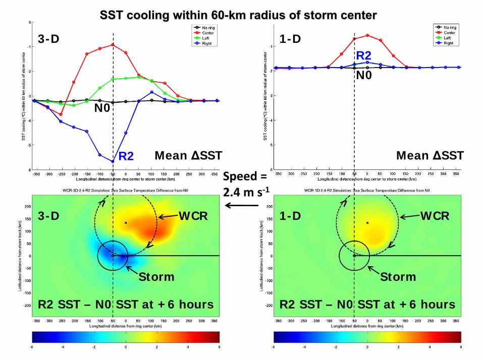
3D vs. 1D Ocean Coupling3D vs. 1D Ocean Coupling
•• Some recent studies (Emanuel et al. 2004; Lin et al. Some recent studies (Emanuel et al. 2004; Lin et al. 2005, 2008; Bender et al. 2007; Davis et al. 2008) 2005, 2008; Bender et al. 2007; Davis et al. 2008) suggest that coupling a 1D ocean model to a TC model suggest that coupling a 1D ocean model to a TC model may be sufficient for capturing the stormmay be sufficient for capturing the storm--induced SST induced SST cooling in the region providing heat energy to the TC.cooling in the region providing heat energy to the TC.
•• If a 1D model is sufficient, valuable computational If a 1D model is sufficient, valuable computational resources can be saved as compared to coupled models resources can be saved as compared to coupled models that employ a fully threethat employ a fully three--dimensional (3D) ocean dimensional (3D) ocean component.component.

Prescribed translation speed
Hurricanevortex
ATMOSPHERE
OCEAN
Homogeneous initial SST
Warm core ringevident in subsurfacetemperature field
Vary position of ring relative to storm track
C0N0L2R2

Difference in SST Response Underneath Difference in SST Response Underneath the TC Core Using a 1D and a 3D Version the TC Core Using a 1D and a 3D Version
of the Same Ocean of the Same Ocean ModelModel
Hurricanes have historically translated Hurricanes have historically translated at < 5 m sat < 5 m s--11 73%73% and < 2 m sand < 2 m s--11 16%16% of the time of the time in the Gulf of Mexicoin the Gulf of Mexico
at < 5 m sat < 5 m s--11 62%62% and < 2 m sand < 2 m s--11 12%12% of the timeof the timein the entire western tropical North Atlanticin the entire western tropical North Atlantic

1.0 m s‐1 2.4 m s‐1 4.8 m s‐1
3‐D
1‐D
AlongAlong--track temperature crosstrack temperature cross--sectionssections

SST and currents 6 hrs after storm passes WCR center longitude: 3-D experiments
L2
C0
R2
N0
Speed =2.4 m s‐1
WCR
WCR
Storm Storm
WCR
Storm Storm

SST and currents 6 hrs after storm passes WCR center longitude: 1-D experiments
L2
C0
R2
N0
Speed =2.4 m s‐1
WCR
WCR
Storm Storm
WCR
Storm Storm
3-D
3-D
1-D
1-D
Speed =2.4 m s‐1
SST cooling within 60SST cooling within 60--km radius of storm centerkm radius of storm center
R2 SST – N0 SST at +6 hours R2 SST – N0 SST at +6 hours
R2
R2
N0
N0
Mean ΔSST Mean ΔSST
WCR WCR
Storm Storm
> >
< <

Tropical Cyclone Model
Ocean Model
Air-Sea Interface
Conventional coupling between TC models Conventional coupling between TC models and ocean modelsand ocean models
( )saDa UUC −= ρτ DC
( )( )sasaHH TTUUCQ −−=
( )( )sasaEP
VE qqUUC
CLQ −−=
Momentum flux (τ)Sensible heat flux (QH )Latent heat flux (QE )
Momentum flux (τ)(Kinetic energy flux)
Drag CoefficientHeat Transfer CoefficientHumidity Transfer Coeff. (Dalton Number)
Wind speed (Ua )Temperature (Ta )Humidity (qa )(at 10 m height)
Surface current (Us )SST (Ts )
HC
EC
(stability correction omitted for simplicity)

DCEC
DE CC /
(CBLAST)
Black et al. (2007)
Black stars: CBLAST dataBlack dash: HEXOS dataGreen: COARE 3.0 (Bulk)
Observations of exchange coefficients

0m/sTSP = 5m/s
10m/s
TSP0m/s
TSP5m/s
Waves Generated by Tropical CyclonesWaves Generated by Tropical Cyclones
Hs
(m)
Hs
(m)
Hs
(m)TSP
10m/s
Wave Field
Wind Field (m/s)
0m/sTSP = 5m/s
10m/s
WAVEWATCH IIIwave model calculations

•• Near the peak : Near the peak : WAVEWATCH III (WW3) modelWAVEWATCH III (WW3) model..•• High frequency part : High frequency part : Equilibrium Spectrum modelEquilibrium Spectrum model
of Hara and of Hara and
Belcher (JFM, 2002)Belcher (JFM, 2002)
maxk0k
2k
1k
mink
1kΔ
3k
2kΔ 0kΔ
012325 - max-1
vk
High frequency partNear peak
Wave Boundary Layer modelWave Boundary Layer modelof Hara and Belcher (JPO, 2004)of Hara and Belcher (JPO, 2004)
KukulkaKukulka
and Hara (JPO, 2008)and Hara (JPO, 2008)
Wind profile and drag coefficientWind profile and drag coefficientover any given seasover any given seas
Explicitly calculates wave-induced stress
Full wave spectrum
Coupled WindCoupled Wind--Wave ModelWave Model

20 30 50U10 (m/s)
400
Powell et al. (2003) Large & Pond (1981)WW3 (upper and lower bound)
3
1
Our results (upper and lower bound)
5
4
2C
D *
1000
Bulk, 0.0185
Calculations are based on Calculations are based on observed hurricane winds in the observed hurricane winds in the Atlantic basin.Atlantic basin.
At high wind speeds, At high wind speeds, CCdd levels levels off and even decrease with wind off and even decrease with wind speedspeed
Sea state dependenceSea state dependence
Extrapolation of Large & Pond (1981)’s formula
Constant zch
(0.0185)
Upper and lower bounds of Cd
from all earlier exp.
GPS GPS sondesonde observation under various observation under various hurricanes (Powell et al., 2003). hurricanes (Powell et al., 2003).

CharnockCharnock Coefficient vs. Wind Speed and Coefficient vs. Wind Speed and Input Wave AgeInput Wave Age
RedRed indicates the range of realizable input wave age for given windindicates the range of realizable input wave age for given wind speedspeed
Input wave age is one of the output parameters of WW3 and is a mInput wave age is one of the output parameters of WW3 and is a measure easure of the development stage of locally wind forced waves, excludingof the development stage of locally wind forced waves, excluding the effects of longthe effects of longswell and waves that are misaligned with the local windswell and waves that are misaligned with the local wind

Sea State Dependence in Coupled Sea State Dependence in Coupled TCTC--Wave ModelWave Model
Zo Cd
Input Wave age
m/sm/s
m/s
m

WindWind
Ocean currentsOcean currents
Surface wavesSurface waves
AtmosphereAtmosphere
OceanOcean
airτrairτr
Sea stateSea state
cτr
CurrentCurrent
CurrentCurrent
cair ττ rr≠
WindWind--WaveWave--Current InteractionCurrent Interaction

c
c
c c
Ocean Currents
EFair
= EFc
+ (EFgrowth + EFdivergence )
( )divergencegrowthcair ττττ rrrr++=
Horizontal wave propagation
(EFdivergence , )divergenceτrWave growth
( EFgrowth , )growthτr
Energy and Momentum Flux Budget Energy and Momentum Flux Budget Across AirAcross Air--sea Interfacesea Interface

Ocean response
WindWind--wavewave--current interactioncurrent interaction
τair Currents W at 90 m

Differences in Momentum Fluxτc in A
/ τair in Control τair in B
/ τair in Control
τair in C
/ τair in Control τc in D
/ τair in Control
Exp A
BudgetNo current→wind
No current→wave
Exp B
No budgetCurrent→windCurrent→wave
Exp C
No budgetCurrent→wind
No current→wave
Exp D
BudgetCurrent→windCurrent→wave
WindWind--wavewave--current interactioncurrent interaction

Effect of WindEffect of Wind--WaveWave--Current Interaction on Current Interaction on Drag CoefficientDrag Coefficient
Cd
WindWind--wave coupling onlywave coupling only WindWind--wavewave--current couplingcurrent coupling
Cd

Effect of AtmosphereEffect of Atmosphere--WaveWave--Ocean Ocean Interaction on TC forecastsInteraction on TC forecasts
(Idealized experiments)Maximum WindsMaximum WindsCentral PressureCentral Pressure
TrackTrack

•• In the TC modelIn the TC model, parameterizations of the air, parameterizations of the air-- sea heat and momentum fluxes and sea spray sea heat and momentum fluxes and sea spray source functions explicitly include source functions explicitly include SST,SST, sea sea state dependencestate dependence, and , and ocean current effects. .
•• The wave modelThe wave model is forced by a) is forced by a) seasea--state state dependent momentum fluxdependent momentum flux and includes and includes ocean current effectsocean current effects.
• The ocean model is forced by sea-state dependent momentum and kinetic energy fluxes calculated from the air-sea flux budget.
AirAir--Sea Coupling Strategies for Tropical ModelsSea Coupling Strategies for Tropical Models

SummarySummary
• Accurate initialization of ocean mesoscale features is critical for skillful coupled TC-Ocean forecasts.
• By neglecting upwelling 1D mixed layer models are inadequate for TCs translating at 5 m/s or less and misrepresent TC-induced SST cooling in the vicinity of oceanic fronts and eddies.
• Improved predictions of TC intensity, structure, and motion will require fully coupled ocean-wave- atmospheric models that explicitly resolve the effects of sea state on air-sea fluxes and spray generation.