assessment of possible damaged areas due to landslide ... · assessment of possible damaged areas...
TRANSCRIPT
Nat. Hazards Earth Syst. Sci., 11, 1341–1350, 2011www.nat-hazards-earth-syst-sci.net/11/1341/2011/doi:10.5194/nhess-11-1341-2011© Author(s) 2011. CC Attribution 3.0 License.
Natural Hazardsand Earth
System Sciences
Assessment of possible damaged areas due to landslide-inducedwaves at a constructed reservoir using empirical approaches:Kurtun (North Turkey) Dam reservoir area
A. Akgun
Karadeniz Technical University, Geological Engineering Department, Trabzon, Turkey
Received: 6 February 2011 – Revised: 16 April 2011 – Accepted: 18 April 2011 – Published: 12 May 2011
Abstract. Landslide-induced wave in lakes or offshore is anatural hazard of significant concern throughout the world.In Turkey, several dam reservoir areas suffer from this prob-lem, motivating for the exploration of this phenomenon. Inthis study, the potential for landslide-induced wave genera-tion and the possible adverse effects of such an event wereinvestigated for the Kurtun Dam reservoir area. This area isprone to translational debris-type landslides, and such slidesrepresent a threat with respect to wave generation. To in-vestigate this problem, a potential landslide was initially in-spected with respect to key geometrical and index parame-ters, such as the internal friction angle and unit weight of thelandslide material. After obtaining these data, the potentialof sub-aerial landslide-induced wave characteristics such aswave height, wave run-up on the opposite slope and wave ve-locity were calculated using existing empirical relationships.Based on the obtained wave properties, a potential damageassessment was performed for vulnerable areas in recogni-tion of the fact that the Kurtun Dam and Kurtun district arethreatened by potential wave occurrence. According to thefindings obtained from the potential damage assessment, itwas determined that the Kurtun district and the Kurtun por-tion of the Kurtun-Gumushane highway are located withinthe run-up impact area. However, the Kurtun Dam was de-termined to be relatively safe due to the distance between thelandslide area and the dam.
Correspondence to:A. Akgun([email protected])
1 Introduction
Rapid landslides can entre reservoirs and, depending on theirvelocity, generate impulsive waves, which propagate, reach-ing sillages and causing considerable destruction, as has oc-curred previously (Pastor et al., 2009). Two dramatic ex-amples of such events are the Vajont Dam disaster and theLituya Bay megatsunami event. In both examples, extremelylarge rock masses slid into reservoirs, and these slides pro-duced waves hundreds of metres in height. The Vajont Damdisaster was particularly serious, as it caused the deaths of2000 people, and this case has become an important exam-ple of such problems, prompting other communities to takeremedial measures (Genevois and Ghirotti, 2005; Bosa andPetti, 2011). To evaluate the risks posed by these waves, itis necessary to use models that can accurately provide in-formation on all slide phenomena such as triggering, propa-gation, entering the reservoir and the propagation of the re-sulting impulsive wave. To model all these aspects, engi-neers and geologists must use several empirical relationshipsand a series of models. The assessment of impulsive wavestriggered by landslides in artificial reservoirs plays an im-portant role in the planning and management of dams andreservoirs. In artificial basins where significant landslide riskexists, water is kept well below the maximum level, therebypreventing the potential impulse wave from overtopping thedam and reducing the wave run-up on the opposite shore-lines (Panizzo et al., 2005). In the literature, there are severalstudies on the modelling of landslide-generated waves andthe adverse impacts of such waves. These studies have beengrouped into three categories, including mathematical the-ory (Stoker, 1957; Prins, 1958; Kranzer and Keller, 1960; LeMehaute and Wang, 1996), physical modelling experiments
Published by Copernicus Publications on behalf of the European Geosciences Union.

1342 A. Akgun: Assessment of possible damaged areas due to landslide-induced waves
(Wiegel, 1955; Wiegel et al., 1970; Kamphuis and Bower-ing, 1970; Slingerland and Voight, 1979, 1982; Huber andHager, 1997; Watts, 1997; Walder et al., 2003; Fritz et al.,2001, 2004; Panizzo et al., 2005; Pastor et al., 2009; Basu etal., 2010), and numerical simulations (Heinrich, 1992; Watts,1997; Monaghan and Kos, 2000; Watts et al., 2005; Wiec-zorek et al., 2007; Romstad et al., 2009; Biscarini, 2010).In this study, empirical relationships based on experimentalmodels proposed by Hall and Watts (1953), Chow (1960),Weigel (1964), Noda (1970), Synolakis (1987) and Huberand Hager (1997) were applied to a landslide developing atthe Kurtun Dam reservoir area (Gumushane, NortheasternTurkey). The potential landslide was first recognized in 2002by the State Hydraulic Works (DSI) during surveys of thereservoir area. The developing landslide could potentiallygenerate a wave extending across the reservoir area. This pa-per aims to describe the potential landslide mass, to discussmonitoring of the landslide movement using geodetic defor-mation measurements, and to investigate empirical modelsfor determination of the height, speed, run-up and adverseeffects of the potential landslide-generated waves. For thispurpose, index parameters and some geometric features ofthe landslide mass were initially determined. Using thesefeatures, the results of modelling waves in the reservoir areausing previously developed models to derive a range of val-ues for potential wave height, run-up, and speed were exam-ined. Then, based on these findings, the areas potentially atrisk were determined in a geographical information system(GIS) environment.
2 Geographical and geological settings
The study area is located in the southern part of the EasternBlack Sea region of Turkey (Fig. 1). Due to the climate char-acteristics of this zone and the hydrodynamic properties ofits rivers, the Eastern Black Sea Region has become the siteof important hydropower structures, such as dams and hy-droelectric power plants. Kurtun dam is located in the East-ern Black Sea Region, 27 km northwest of the town of Torulon the Harsit River in Gumushane province. The main pur-pose of this dam is to provide energy and the facility has anannual output of 198 GWh (State Hydraulic Works, 2010).Construction of the dam embankment began in 1997 and fin-ished in 1999. The reservoir impounding process began on8 February 2002, and the water level reached an elevationof 650 m on 30 April 2002 (Ozkuzukiran et al., 2006). Kur-tun dam is 133 m high from the riverbed, and the crest ex-tends 300 m. The dam is constructed on a relatively narrowvalley with steeply sloping walls approximately 45 m apart.Abutment slopes average 61◦ and 52◦ for the left and rightabutments, respectively.
The lithological units in the study area consist mainly ofthick volcanic, volcano-clastic and intrusive rocks (Fig. 2).According to Guven (1993), the basement unit of the study
Fig. 1. Location map of the study area and a general view ofthe Kurtun Dam (NAF: North Anatolian Fault is presented by reddashed line) (Google Earth).
area is the Turonian-Santonian age Catak formation (Ct),which is composed of clay, sandy limestone and andesite in-terbedded with pyroclastic deposits. The Catak formation isconformably overlain by the Kizilkaya formation (Kz) con-sisting of biomicritic limestone, dacite with marl and pyro-clastics. The Kizilkaya formation is conformably overlain bythe Campanian-Maastrichtian age Caglayan formation (Cg)consisting of clayey sandy limestones, basalts interbeddedwith marls, andesites and pyroclastics. These sequences inthe study area were cross-cut by the Kurtun granitoide (Kr)intruded during the Upper Cretaceous. The intrusion consistsof hornblende and biotite. This intrusion is in turn cross-cutby dikes of quartz porphyry, dacite and dolerite (Ceryan etal., 2008). Considerable hydrothermal alterations at the outer
Nat. Hazards Earth Syst. Sci., 11, 1341–1350, 2011 www.nat-hazards-earth-syst-sci.net/11/1341/2011/

A. Akgun: Assessment of possible damaged areas due to landslide-induced waves 1343
Fig. 2. Generalized geological map of the study area and its vicinity.
zones of the Kurtun granitoid and along the faults can be ob-served in the area.
3 Engineering geology of the Hardisagir landslide
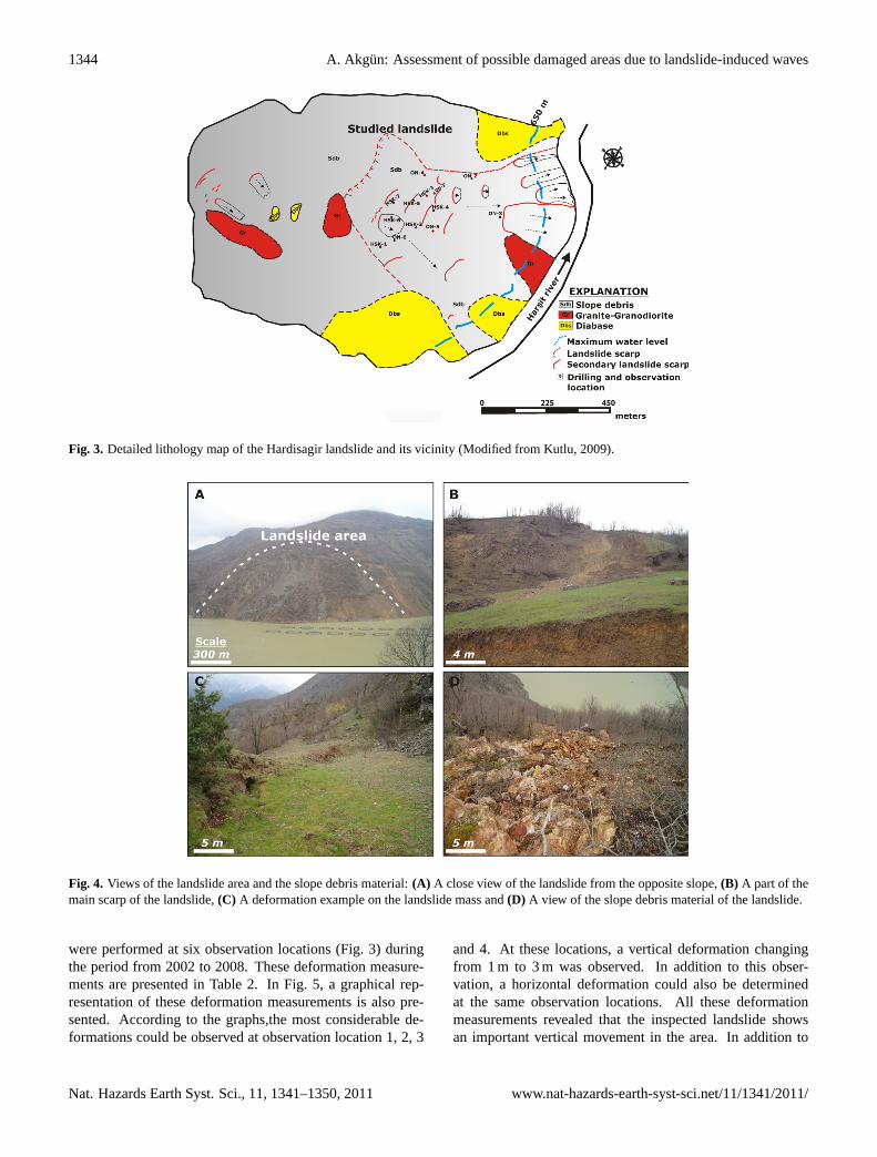
In the Northern part of Turkey, large landslides such as theCatak (Genc, 1993), Dagkoy (Ocakoglu et al., 2002), Kuzulu(Gokceoglu et al., 2005), Tuzla (Gokceoglu et al., 2009) andTortum (Duman, 2009) are frequent. The Hardisagir land-slide, which forms the basis of this study, is a large landslidelocated on the left abutment of the Kurtun Dam reservoirarea. The distance between the dam body and the landslidemass is approximately 1800 m (Fig. 1). The main trigger-ing for the landslide is considered to be precipitation, dueto the fact that major earthquakes have not been recordedat or near the study area in recent times (the North Anato-lian Fault located approximately 150 km south of the studyarea; Fig. 1). A close inspection of the local geology ofthe landslide mass revealed three lithological units (Fig. 3).From bottom to top, diabase, granite-granodiorite and slopedebris units were determined and mapped (Fig. 3). The land-slide occurred mainly on the slope debris material, which
Table 1. The landslide characteristics and the other values used incalculations.
Characteristic Value
Elevation of top of scarp 1035 mElevation of base of scarp 850 mSlide length (base of scarp to toe) 645 mAverage slide width 330 mMaximum slide width 340 mAverage slided mass thickness 26 mLandslide travel distance to shore of reservoir 645 mDensity of slided mass 2.5 t m−3
Maximum slope gradient of landslide to reservoir 35◦
Average slope gradient of opposite shore 45◦
Internal friction angle 35◦
Landslide area 88 000 m2
Maximum volume of landslide mass 1 320 000 m3
Maximum water depth of reservoir 150 m
was composed of granite, granodiorite and diabase blocks(Fig. 4). During field studies, it was observed that the land-slide material belonged to an old landslide mass and thatheavy precipitation caused this material, which was criticallybalanced, to be triggered again. At the top of the landslidetopography, tension cracks 40 and 50 cm in length were ob-served. The triggering point of the landslide, namely the topof scarp, was recorded at an altitude of 1.035 m (Fig. 3; Ta-ble 1). The elevation of the base of scarp was determinedto be 850 m. The distance from the base of scarp to the toeof the mass was 645 m. The geometrical shape of mass wasan ellipsoid (Fig. 3). To facilitate the calculation of potentialwave properties, average and maximum slide widths weremeasured and determined to be 330 and 340 m, respectively(Table 1). From the drilling data collected in the area, the av-erage thickness of the landslide mass was determined to be26 m. The density of the material is one of the basic inputsfor calculating wave properties. In this context, the densityof the slide material was found to be 2.5 t m−3. The surfacearea of the landslide mass was calculated to be 88 000 m2,and using both this surface area and average thickness val-ues, the maximum volume of the landslide mass was ob-tained as 1 320 000 m3 (Table 1). In addition to the afore-mentioned landslide mass, small-scale debris flows and de-bris slides also occurred, both on the slide mass and in itsvery close vicinity (Fig. 3). Some of these movements werelocated near the maximum water level of the reservoir. As aresult, the lower part of these mass movements remained ator below the water level. Therefore, there is also the potentialfor underwater landslide-induced waves to occur.
The first engineering geology studies in the area were per-formed in 1990 by DSI. However, after the aforementionedlandsliding began in 2002, a monitoring programme wasstarted in the area. For this purpose, geodetic measurements
www.nat-hazards-earth-syst-sci.net/11/1341/2011/ Nat. Hazards Earth Syst. Sci., 11, 1341–1350, 2011
1344 A. Akgun: Assessment of possible damaged areas due to landslide-induced waves
Fig. 3. Detailed lithology map of the Hardisagir landslide and its vicinity (Modified from Kutlu, 2009).
Fig. 4. Views of the landslide area and the slope debris material:(A) A close view of the landslide from the opposite slope,(B) A part of themain scarp of the landslide,(C) A deformation example on the landslide mass and(D) A view of the slope debris material of the landslide.
were performed at six observation locations (Fig. 3) duringthe period from 2002 to 2008. These deformation measure-ments are presented in Table 2. In Fig. 5, a graphical rep-resentation of these deformation measurements is also pre-sented. According to the graphs,the most considerable de-formations could be observed at observation location 1, 2, 3
and 4. At these locations, a vertical deformation changingfrom 1 m to 3 m was observed. In addition to this obser-vation, a horizontal deformation could also be determinedat the same observation locations. All these deformationmeasurements revealed that the inspected landslide showsan important vertical movement in the area. In addition to
Nat. Hazards Earth Syst. Sci., 11, 1341–1350, 2011 www.nat-hazards-earth-syst-sci.net/11/1341/2011/

A. Akgun: Assessment of possible damaged areas due to landslide-induced waves 1345
Table 2. Deformation measurements obtained by geodetic records and by observation pipes in the bore holes.
Measurements in 24.05.2002 (A) Measurements in 20.06.2002 (B) Measurements in 04.04.2003 (C) Measurements in 02.06.2005 (D)
Obs. No X Y Z (m) Obs.No X Y Z (m) Obs. No X Y Z (m) Obs.No X Y Z (m)ON1 511 159 4 503 649 924 ON1 511 159 4 503 649 924 ON1 511 160 4 503 649 924 ON1 511 161. 4 503 651 922ON2 511 213 4 503 776 820 ON2 511 213 4 503 776 820 ON2 511 213 4 503 776 820 ON2 511 214. 4 503 651 819ON3 511 016 4 503 804 884 ON3 511 016 4 503 804 884 ON3 511 016 4 503 804 884 ON3 511 016. 4 503 804 884ON4 510 861 4 504 113 890 ON4 510 861 4 504 113 890 ON4 510 861 4 504 113 889 ON4 510 861 4 504 113 890ON5 510 925 4 504 890 673 ON5 510 925 4 504 890 673 ON5 510 925 4 504 890 673 ON5 510 925 4 504 890 673ON6 510 773 4 504 905 719 ON6 510 773 4 504 905 719 ON6 510 773 4 504 905 719 ON6 510 773 4 504 905 719
Measurements in 21.12.2006 (E) Measurements in 26.04.2007 (F) Measurements in 11.07.2008 (G) Measurements in 25.11.2008 (H)
Obs. No X Y Z (m) Obs. No X Y Z (m) Obs. No X Y Z (m) Obs. No X Y Z (m)ON1 511 163 4 503 651 921 ON1 511 164 4 503 652 921 ON1 511 166 4 503 652 920 ON1 511 165 4 503 652 919ON2 511 215 4 503 778 819 ON2 511 215 4 503 778 819 ON2 No measurement ON2 No measurementON3 511 016 4 503 804 884 ON3 511 016 4 503 805 884 ON3 511 016 4 503 804 884 ON3 511 015 4 503 805 885ON4 510 861 4 504 113 889 ON4 510 861 4 504 113 890 ON4 510 861 4 504 113 889 ON4 510 860 4 504 113 890ON5 510 925 4 504 890 673 ON5 510 925 4 504 890 672 ON5 510 925 4 504 890 673 ON5 510 925 4 504 890 673ON6 510 773 4 504 905 719 ON6 510 773 4 504 905 719 ON6 510 773 4 504 905 719 ON6 510 773 4 504 905 719
Bore Hole Deformation Depth (m)
HSK1 23HSK2 24HSK3 16HSK4 –HSK5 No deformationHSK6 –HSK7 12
Fig. 5. Graphs showing the measured deformation results. The A, B, C, D, E, F, G and H are the observation date given in Table 2.
these measurements, seven bore holes were drilled in the area(HSK1 to HSK7), and observation pipes were placed in thesebore holes to determine precisely the slip surface. Accordingto these measurements, the sliding depths were determined tobe 23 m at the HSK-1 bore hole and 12 m at the HSK-7 borehole, respectively (Fig. 3). According to the landslide classi-fication system proposed by Varnes (1978), the landslide was
determined to be a translational debris slide, and the masswas determined to be active based on the WP/WLI (1993)classification system.
www.nat-hazards-earth-syst-sci.net/11/1341/2011/ Nat. Hazards Earth Syst. Sci., 11, 1341–1350, 2011

1346 A. Akgun: Assessment of possible damaged areas due to landslide-induced waves
4 Potential landslide-induced waves
To assess the potential for landslide-induced waves to oc-cur in natural and artificial reservoir areas, many methodshave been applied. Several empirical and numerical mod-els have been suggested to analyse waves generated by land-slides using deductive or inductive approaches (Slingerlandand Voight, 1979). More recently, interactions between land-slides and water bodies have been incorporated in a hydrody-namic model using force terms (Kofoed-Hansen et al., 2001).To evaluate the potential of landslide-induced waves to causedamage in the Kurtun Dam reservoir area, previously devel-oped models were used to derive a range of potential waveheight, run-up and wave speed values. The calculations ofthese data are based upon the measured parameters for thelandslide mass in the study area listed in Table 1.
4.1 Landslide velocity
Landslide impact velocity is one of the primary parametersto be used for modelling landslide-induced waves. For thispurpose, the velocity relationship proposed by Slingerlandsand Vought (1979) was used. According to this relationship,landslide velocity can be modelled as:
vs = v0+[2g s(sinβ − tanφscosβ)]1/2 (1)
wherevs is the slide velocity, computed as a mass sliding ona plane,v0 is the initial slide velocity, which is assumed to be0 ms−1, g is the gravitational constant (9.81 ms−2), s is thelandslide travel distance from the toe of the landslide mass tothe water’s edge,β is slope angle in degrees andφs is the an-gle of internal friction. The angle of internal friction (φs) fora given soil can be determined by plotting the shear stress andthe normal effective stress at which shear failure occurs on aMohr’s Diagram. To accomplish this, direct shear tests withconsolidated-drained (CD) condition were performed on thelandslide material.φs was found to be 35◦ (Table 1). Ac-cording to the relationship given in Eq. (1) and the measuredlandslide characteristics given in Table 1, the impact velocitywas calculated to be 72.40 m s−1.
4.2 Wave height
In the case of a rapid movement of the landslide mass into thereservoir water body, the resulting waves will have a certainheight, and this height will adversely affect both the Kur-tun Dam and the Ozkurtun settlement area. To estimate theadverse effects of landslide-generated waves, the height ofthese possible waves must be determined. To estimate thisheight, three different empirical relationships proposed byNoda (1970), Slingerland and Voight (1979) and Huber andHager (1997) were applied. According to Noda (1970), thewave height can be modelled as:
η = Fλ (2)
whereη is wave height in metres, F is the Froude number,which is expressed as v/(gd)0.5 (v: landslide velocity calcu-lated by Eq. (1),g: acceleration of gravity (9.81 m s−2) andd: water depth of the reservoir), andλ is the maximum thick-ness of the landslide mass. Using the velocity of 72.40 m s−1
and the Froude number of 1.88, Eq. (2) yields a potentialwave height in the reservoir area of 49.07 m.
Slingerland and Voight (1979) used data from a study onMica Reservoir in British Columbia to refine a previously de-veloped model and developed the following regression equa-tion for first wave height:
log(ηmax/d) = a+b log (KE) (3)
wherea andb are constant values, which are−1.25 and 0.71,respectively, and are neither dependent on the site nor on thereservoir geometry, and KE is the dimensionless kinetic en-ergy. KE has a value ranging from 1 to 100 and is expressedby Eq. (4).
KE = 0.5(lhw/d3)(γs/γ )(vs/gd) (4)
wherel is the length of the landslide mass,h is the thicknessof the landslide body,w is the average landslide width,d isthe water depth,γs is the density of the landslide material,γ is the density of water (1.0 g cm−3) andvs is the slide ve-locity. Substituting the above values into Eq. (4) yields a KEvalue of 7.22, which in turn is substituted into Eq. (3) to yielda wave height of 34.36 m. Huber and Hager (1997) proposeda forecasting model for impulse waves into reservoirs. Theinput parameters for their model were the slope angle at theimpact site, the plunging slide volume (Vs) over a finite shoredistance(b), equal to the width of the slide at impact with thewater, the slide velocity and direction at the impact site, thewater depth(d) near the impact site, water body bathymetryand the distance (x) from the impact site to the location underconsideration (Wieczorek et al., 2003). According to Huberand Hager (1997), wave height(H) can be calculated as:
H = 0.88 sinα(γs/γ )0.25(Vs/b)0.5(d/x)0.25. (5)
Using the values previously cited forα, γs , γ , andd, a land-slide volume (Vs) of 1 320 000 m3, a distance (x) of 330 mto the middle of the reservoir area and a finite shore dis-tance (b) equal to the width of the region of impact alongthe shore, which correspond to the average width of the land-slide (340 m), Eq. (5) yields a wave height of 32.11 m. Thewave height(H) is mainly influenced by the impact angleand secondarily by the specific landslide volume (Vs/b). Theremaining factors in Eq. (5) are of minor importance (Wiec-zorek et al., 2003). Based on the above findings for waveheight, an average value of 38.51 m can be proposed for thestudy area.
4.3 Wave velocity
Landslide induced waves propagate in semicircles over anopen water surface, and the wave height varies with this prop-agation direction and the travel distance. The largest waves
Nat. Hazards Earth Syst. Sci., 11, 1341–1350, 2011 www.nat-hazards-earth-syst-sci.net/11/1341/2011/

A. Akgun: Assessment of possible damaged areas due to landslide-induced waves 1347
travel in the direction of maximum momentum, while lat-eral waves travelling along the shore are significantly smaller(Wieczorek et al., 2003). To compute the possible wave ve-locity in the reservoir area, two empirical relationships wereapplied. The first relationship was applied by Wiegel (1964)to determine wave celerity(C). This relationship, given inEq. (6), can be written as:
C = [g(d+H)]0.5 (6)
A water depth,d, of 150 m in the reservoir area and an av-erage wave height,H , of 38.51 m results in a wave velocity(C) of 43.00 m s−1. The second relationship used to calcu-late wave velocity was proposed by Huber and Hager (1997).According to this relationship, theC value can be found us-ing Eq. (7):
C = (g ·d)0.5 (7)
Based on this relationship, a water depth,d, of 150 m resultsin a wave velocity of 38.36 m s−1. These two results showsimilar wave velocity values and the average wave velocityfor the reservoir area can be given as 40.68 m s−1.
4.4 Wave run-up
When a landslide mass suddenly moves into a reservoir, theresulting wave often reaches the opposite slope of the land-slide, and this phenomenon is known as wave run-up in theliterature (Mueller, 1995; Huber and Hager, 1997; Wieczoreket al., 2007). This phenomenon typically destroys all natu-ral landscapes and anthropogenic structures on the oppositeslope. To determine the run-up values of possible waves inthe study area, four empirical relationships were used. Ac-cording to Chow (1960), wave run-up on a slope on the op-posite shore of a landslide can be calculated using Eq. (8):
h = v2s/2 g (8)
wherevs is the landslide velocity, which can be found usingEq. (1), andg is the acceleration of gravity. According tothis equation, a landslide velocity of 72.40 m s−1 results ina wave run-up of 267.16 m. This means that any structurein the reservoir area, such as fishponds, that is in the impactarea of the landslide could be expected to be displaced by asmuch as 267 m. Huber and Hager (1997) also provided a re-lationship for wave run-up. This equation is as given below:
R/d = 1.25(π/2β)0.2(H/d)1.25(H/L)−0.15 (9)
whereR is the wave run-up height over the level of the waterbody,β is the angle of the opposite slope,H is the approach-ing wave height found using Eq. (5),L is the wave length,which is typically 5 times greater than the water depth andd is the water depth (150 m). When calculating wave run-up values, theH value obtained from Eq. (5) was used byconsidering the study of Wieczorek et al. (2003). Wieczoreket al. (2003) suggested that theH value proposed by Huber
Table 3. The values calculated by empirical relationships.
Calculated property and Calculation Method Obtained Value
Landslide VelocityNoda (1970) 72 m s−1
Wave HeightSlingerland and Voight (1970) 34 mNoda (1970) 49 mHuber and Hager (1997) 32 mAverage Wave Height 38±9 mWave Runup on Opposite SlopeChow (1960) 267 mHuber and Hager (1997) 30 mSynolakis (1987) 61 mHall and Watts (1953) 78 mAverage Wave Runup 109±107 mWave VelocityWeigel (1964) 43 m s−1
Huber and Hager (1997) 38 m s−1
Average Wave Velocity 40±3 m s−1
and Hager (1997) should be used because this value representthe wave height in the middle of the reservoir, and this waveheight is considered to be the main source point of the pos-sible wave run-up. Using these values, Eq. (9) yields a waverun-up of 30 m on the shore opposite the landslide. Anotherrelationship for wave run-up calculations was proposed bySynolakis (1987). According to this relationship, the waverun-up can be calculated as:
R/d = 2.831(cot β)0.5(H/d)1.25 (10)
Using 450 for the opposite slope angle, 32.11 m forH and150 m ford, a potential run-up of approximately 61.83 m iscalculated for the slope opposite the studied landslide. Thelast relationship used for calculating wave run-up was pro-vided by Hall and Watts (1953). This relationship is givenbelow:
R/d = 3.1(H/d)1.15 (11)
Based on this relationship, the wave run-up was calculated asapproximately 79 m. All the calculated wave properties aregiven in Table 3.
4.5 Assessment of possible damage to the reservoir area
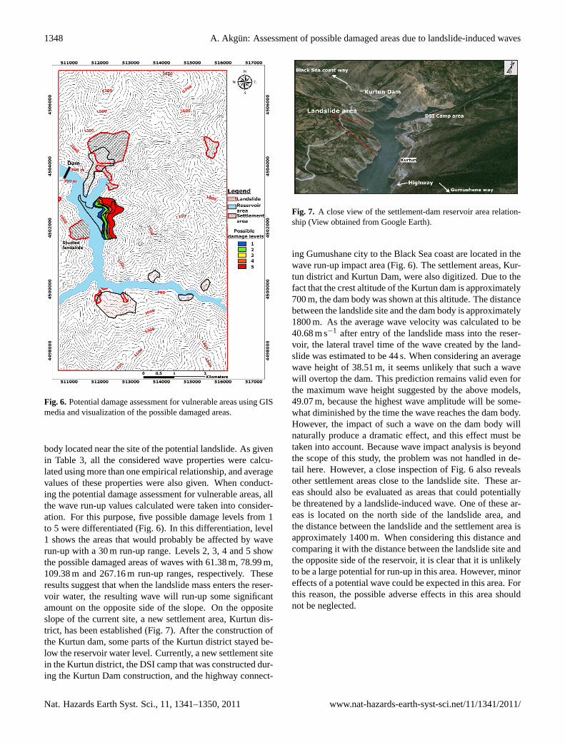
To assess the potential adverse effects of landslide-inducedwaves on the reservoir area, a geographical information sys-tem (GIS)-based assessment was carried out using the wavecharacteristics calculated from the above empirical relation-ships. In this assessment, two wave properties in particu-lar, run-up and wave velocity, were taken into considerationbecause these two parameters are especially likely to affectman-made structures such as settlement areas and the dam
www.nat-hazards-earth-syst-sci.net/11/1341/2011/ Nat. Hazards Earth Syst. Sci., 11, 1341–1350, 2011
1348 A. Akgun: Assessment of possible damaged areas due to landslide-induced waves
Fig. 6. Potential damage assessment for vulnerable areas using GISmedia and visualization of the possible damaged areas.
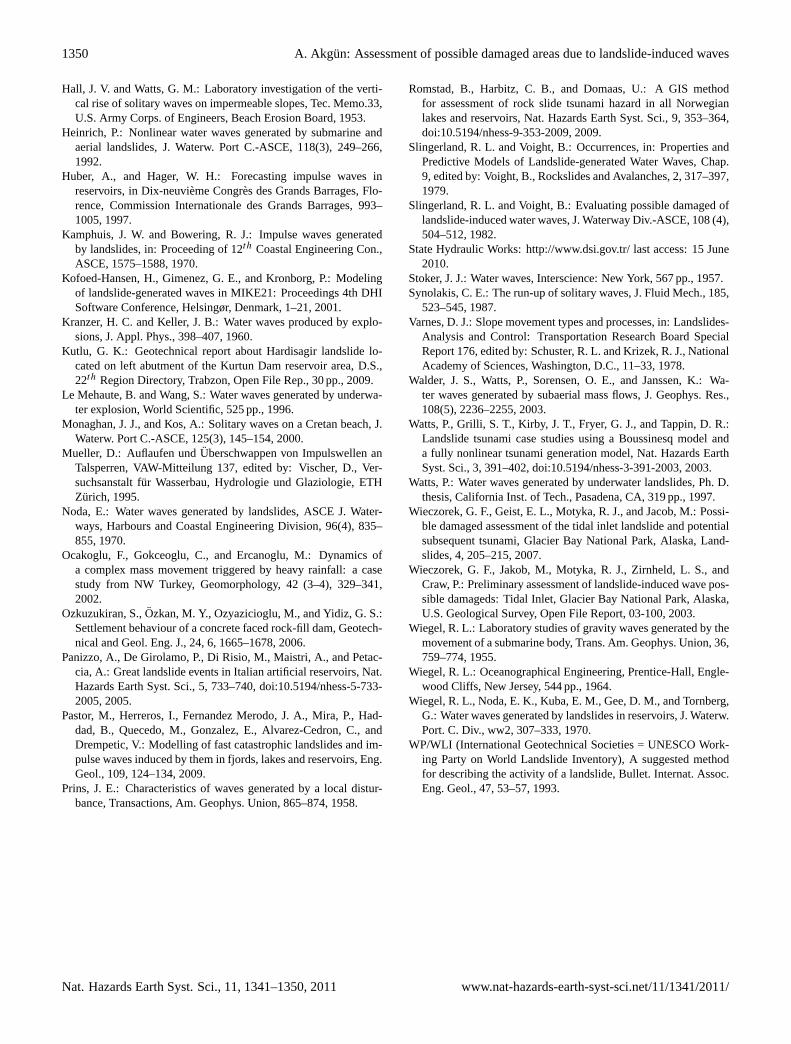
body located near the site of the potential landslide. As givenin Table 3, all the considered wave properties were calcu-lated using more than one empirical relationship, and averagevalues of these properties were also given. When conduct-ing the potential damage assessment for vulnerable areas, allthe wave run-up values calculated were taken into consider-ation. For this purpose, five possible damage levels from 1to 5 were differentiated (Fig. 6). In this differentiation, level1 shows the areas that would probably be affected by waverun-up with a 30 m run-up range. Levels 2, 3, 4 and 5 showthe possible damaged areas of waves with 61.38 m, 78.99 m,109.38 m and 267.16 m run-up ranges, respectively. Theseresults suggest that when the landslide mass enters the reser-voir water, the resulting wave will run-up some significantamount on the opposite side of the slope. On the oppositeslope of the current site, a new settlement area, Kurtun dis-trict, has been established (Fig. 7). After the construction ofthe Kurtun dam, some parts of the Kurtun district stayed be-low the reservoir water level. Currently, a new settlement sitein the Kurtun district, the DSI camp that was constructed dur-ing the Kurtun Dam construction, and the highway connect-
Fig. 7. A close view of the settlement-dam reservoir area relation-ship (View obtained from Google Earth).
ing Gumushane city to the Black Sea coast are located in thewave run-up impact area (Fig. 6). The settlement areas, Kur-tun district and Kurtun Dam, were also digitized. Due to thefact that the crest altitude of the Kurtun dam is approximately700 m, the dam body was shown at this altitude. The distancebetween the landslide site and the dam body is approximately1800 m. As the average wave velocity was calculated to be40.68 m s−1 after entry of the landslide mass into the reser-voir, the lateral travel time of the wave created by the land-slide was estimated to be 44 s. When considering an averagewave height of 38.51 m, it seems unlikely that such a wavewill overtop the dam. This prediction remains valid even forthe maximum wave height suggested by the above models,49.07 m, because the highest wave amplitude will be some-what diminished by the time the wave reaches the dam body.However, the impact of such a wave on the dam body willnaturally produce a dramatic effect, and this effect must betaken into account. Because wave impact analysis is beyondthe scope of this study, the problem was not handled in de-tail here. However, a close inspection of Fig. 6 also revealsother settlement areas close to the landslide site. These ar-eas should also be evaluated as areas that could potentiallybe threatened by a landslide-induced wave. One of these ar-eas is located on the north side of the landslide area, andthe distance between the landslide and the settlement area isapproximately 1400 m. When considering this distance andcomparing it with the distance between the landslide site andthe opposite side of the reservoir, it is clear that it is unlikelyto be a large potential for run-up in this area. However, minoreffects of a potential wave could be expected in this area. Forthis reason, the possible adverse effects in this area shouldnot be neglected.
Nat. Hazards Earth Syst. Sci., 11, 1341–1350, 2011 www.nat-hazards-earth-syst-sci.net/11/1341/2011/

A. Akgun: Assessment of possible damaged areas due to landslide-induced waves 1349
5 Discussions and conclusions
In the present study, the potential properties of landslide-induced waves in the Kurtun Dam reservoir area were cal-culated using several empirical relationships. Specifically,wave height, wave run-up and wave velocity were deter-mined using three, four and two empirical equations, respec-tively. The purpose of using more than one relationship wasto strengthen and to compare the results obtained. When cal-culating the wave height, the use of three empirical relation-ships yielded extremely similar results. The same situationwas encountered when calculating the wave velocity. How-ever, the relationships used for calculating wave run-up val-ues showed a considerable inconsistency among the resultsobtained. For example, while the relationship proposed byChow (1960) gave a very high run-up value, the other rela-tionships used gave plausible values. When examining thewave run-up calculation equations, it will be seen that theequation proposed by Chow (1960) uses only two input pa-rameters to calculate the wave run-up value. In this equation,there is no input parameter with respect to the water body.However, it is very clear that the handling problem is some-what complicated, and to overcome this complexity, moreparameters, including characteristics of the water body andthe opposite slope, should be evaluated. For this reason, otherscientists, such as Huber and Hager (1997), Synolakis (1987)and Hall and Watts (1953) proposed the use of the other equa-tions, which were employed in this study. These factors il-lustrate why the wide range of calculated wave run-up valueswas obtained in this study due to variations in the input pa-rameters considered by different researchers. As a result ofthis situation and to avoid errors in the potential damage as-sessment, all the calculated wave run-up values were takeninto account. In this context, the areas of significant wavethreat were determined and their possible damage levels wereassessed. According to the results of the potential damageassessment for vulnerable areas, Kurtun district and the DSIcamp area are located in the 2nd and 3rd damage level zonesof the potential landslide-induced wave impact area. In ad-dition, the highway that connects Gumushane with the BlackSea coast is also within the same potential damage zone. Al-though the population of Kurtun district is not very high, at3000 people, the vehicle traffic on the aforementioned high-way is relatively dense. For this reason, the occurrence of alandslide-induced wave could result in the injury or death ofmany people, and the road could be damaged by the wave.Based on the calculated wave height and wave velocity val-ues, the likelihood of damage to the Kurtun Dam itself seemsrelatively low, consistent with the relatively large distancebetween the landslide location and dam body location. Fu-ture work is proposed to address this problem using two- orthree-dimensional numerical modelling and simulation. Inthis way, the potential damage estimated in this study maybe evaluated in greater detail and visual results may be pre-sented. Because this is the first scientific study of possible
adverse landslide-induced wave impacts on reservoir areasin Turkey, this study may be used as an example for solvingsimilar problems in other locations.
Acknowledgements.This project is supported by the KaradenizTechnical University Scientific Research Fund. The author isgrateful to the State Hydraulics Works 22nd District Managementfor providing data. The author also thanks Oguzhan Erkan forhis assistance during the field studies and laboratory experiments.Thanks also to the two anonymous reviewers and the journal editorfor their constructive suggestions for improving the scientificquality of this paper.
Edited by: O. KatzReviewed by: two anonymous referees
References
Basu, D., Das, K., Green, S., Janetzke, R., and Stamatakos, J.:Numerical simulation of surface waves generated by a subaeriallandslide at Lituya Bay Alaska, J. Offshore Mech. Arct., 132,10–21, 2010.
Biscarini, C.: Computational fluid dynamics modelling of landslidegenerated water waves, Landslides, 7, 117–124, 2010.
Bosa, S. and Petti, M.: Shallow water numerical model of the wavegenerated by the Vajont landslide, Environ Modell Softw., 26 (4),406–418, 2011.
Ceryan, S., Zorlu, K., Gokceoglu, C., and Temel, A.: The use ofcation packing index for characterizing the weathering degree ofgranitic rocks, Eng. Geol., 98, 60–74, 2008.
Chow, V. T.: Open channel hydraulics, McGraw-Hill, New York,NY, 1960.
Duman, T.: The largest landslide dam in Turkey: Tortum landslide,Eng. Geol., 104 (1–2), 66–79, 2009.
Fritz, H. M., Hager, W. H., and Minor, H. E.: Lituya bay case: rock-slide impact and wave run-up., Sci Tsunami Possible damageds,19(1), 3–22, 2001.
Fritz, H. M., Hager, W. H., and Minor, H. E.: Near field charac-teristics of landslide generated impulse waves, J. Waterw. PortC.-ASCE, 130, 287–300, 2004.
Genc, S.: Structural and geomorphological aspects of the Cataklandslide, NE Turkey, Q. J. Eng. Geol. Hydroge., 26 (2), 99–108,1993.
Genevois, R. and Ghirotti, M.: The 1963 Vaiont Landslide, Giornaledi Geologia Applicata, 1, 41–52, 2005.
Gokceoglu, C., Sonmez, H., Nefeslioglu, H. A., Duman, T., andCan, T.: The 17 March 2005 Kuzulu landslide (Sivas, Turkey)and landslide-possible damaged map of its near vicinity, Eng.Geol., 81 (1), 65–83, 2005.
Gokceoglu, C., Tunusluoglu, M. C., Gorum, T., Tur, H., Gokasan,E., Tekkeli, A. B., Batuk, F., and Alp, H.: Description of dy-namics of the Tuzla Landslide and its implications for furtherlandslides in the northern slope and shelf of the Cinarcik Basin(Marmara Sea, Turkey), Eng. Geol., 106 (3–4), 133–153, 2009.
Guven, I. H.: 1/250000 scaled geological and metallogenical mapof the Eastern Black Sea Reghion, MTA Report (in Turkish, un-published), 1993.
www.nat-hazards-earth-syst-sci.net/11/1341/2011/ Nat. Hazards Earth Syst. Sci., 11, 1341–1350, 2011
1350 A. Akgun: Assessment of possible damaged areas due to landslide-induced waves
Hall, J. V. and Watts, G. M.: Laboratory investigation of the verti-cal rise of solitary waves on impermeable slopes, Tec. Memo.33,U.S. Army Corps. of Engineers, Beach Erosion Board, 1953.
Heinrich, P.: Nonlinear water waves generated by submarine andaerial landslides, J. Waterw. Port C.-ASCE, 118(3), 249–266,1992.
Huber, A., and Hager, W. H.: Forecasting impulse waves inreservoirs, in Dix-neuvieme Congres des Grands Barrages, Flo-rence, Commission Internationale des Grands Barrages, 993–1005, 1997.
Kamphuis, J. W. and Bowering, R. J.: Impulse waves generatedby landslides, in: Proceeding of 12th Coastal Engineering Con.,ASCE, 1575–1588, 1970.
Kofoed-Hansen, H., Gimenez, G. E., and Kronborg, P.: Modelingof landslide-generated waves in MIKE21: Proceedings 4th DHISoftware Conference, Helsingør, Denmark, 1–21, 2001.
Kranzer, H. C. and Keller, J. B.: Water waves produced by explo-sions, J. Appl. Phys., 398–407, 1960.
Kutlu, G. K.: Geotechnical report about Hardisagir landslide lo-cated on left abutment of the Kurtun Dam reservoir area, D.S.,22th Region Directory, Trabzon, Open File Rep., 30 pp., 2009.
Le Mehaute, B. and Wang, S.: Water waves generated by underwa-ter explosion, World Scientific, 525 pp., 1996.
Monaghan, J. J., and Kos, A.: Solitary waves on a Cretan beach, J.Waterw. Port C.-ASCE, 125(3), 145–154, 2000.
Mueller, D.: Auflaufen undUberschwappen von Impulswellen anTalsperren, VAW-Mitteilung 137, edited by: Vischer, D., Ver-suchsanstalt fur Wasserbau, Hydrologie und Glaziologie, ETHZurich, 1995.
Noda, E.: Water waves generated by landslides, ASCE J. Water-ways, Harbours and Coastal Engineering Division, 96(4), 835–855, 1970.
Ocakoglu, F., Gokceoglu, C., and Ercanoglu, M.: Dynamics ofa complex mass movement triggered by heavy rainfall: a casestudy from NW Turkey, Geomorphology, 42 (3–4), 329–341,2002.
Ozkuzukiran, S.,Ozkan, M. Y., Ozyazicioglu, M., and Yidiz, G. S.:Settlement behaviour of a concrete faced rock-fill dam, Geotech-nical and Geol. Eng. J., 24, 6, 1665–1678, 2006.
Panizzo, A., De Girolamo, P., Di Risio, M., Maistri, A., and Petac-cia, A.: Great landslide events in Italian artificial reservoirs, Nat.Hazards Earth Syst. Sci., 5, 733–740,doi:10.5194/nhess-5-733-2005, 2005.
Pastor, M., Herreros, I., Fernandez Merodo, J. A., Mira, P., Had-dad, B., Quecedo, M., Gonzalez, E., Alvarez-Cedron, C., andDrempetic, V.: Modelling of fast catastrophic landslides and im-pulse waves induced by them in fjords, lakes and reservoirs, Eng.Geol., 109, 124–134, 2009.
Prins, J. E.: Characteristics of waves generated by a local distur-bance, Transactions, Am. Geophys. Union, 865–874, 1958.
Romstad, B., Harbitz, C. B., and Domaas, U.: A GIS methodfor assessment of rock slide tsunami hazard in all Norwegianlakes and reservoirs, Nat. Hazards Earth Syst. Sci., 9, 353–364,doi:10.5194/nhess-9-353-2009, 2009.
Slingerland, R. L. and Voight, B.: Occurrences, in: Properties andPredictive Models of Landslide-generated Water Waves, Chap.9, edited by: Voight, B., Rockslides and Avalanches, 2, 317–397,1979.
Slingerland, R. L. and Voight, B.: Evaluating possible damaged oflandslide-induced water waves, J. Waterway Div.-ASCE, 108 (4),504–512, 1982.
State Hydraulic Works:http://www.dsi.gov.tr/last access: 15 June2010.
Stoker, J. J.: Water waves, Interscience: New York, 567 pp., 1957.Synolakis, C. E.: The run-up of solitary waves, J. Fluid Mech., 185,
523–545, 1987.Varnes, D. J.: Slope movement types and processes, in: Landslides-
Analysis and Control: Transportation Research Board SpecialReport 176, edited by: Schuster, R. L. and Krizek, R. J., NationalAcademy of Sciences, Washington, D.C., 11–33, 1978.
Walder, J. S., Watts, P., Sorensen, O. E., and Janssen, K.: Wa-ter waves generated by subaerial mass flows, J. Geophys. Res.,108(5), 2236–2255, 2003.
Watts, P., Grilli, S. T., Kirby, J. T., Fryer, G. J., and Tappin, D. R.:Landslide tsunami case studies using a Boussinesq model anda fully nonlinear tsunami generation model, Nat. Hazards EarthSyst. Sci., 3, 391–402,doi:10.5194/nhess-3-391-2003, 2003.
Watts, P.: Water waves generated by underwater landslides, Ph. D.thesis, California Inst. of Tech., Pasadena, CA, 319 pp., 1997.
Wieczorek, G. F., Geist, E. L., Motyka, R. J., and Jacob, M.: Possi-ble damaged assessment of the tidal inlet landslide and potentialsubsequent tsunami, Glacier Bay National Park, Alaska, Land-slides, 4, 205–215, 2007.
Wieczorek, G. F., Jakob, M., Motyka, R. J., Zirnheld, L. S., andCraw, P.: Preliminary assessment of landslide-induced wave pos-sible damageds: Tidal Inlet, Glacier Bay National Park, Alaska,U.S. Geological Survey, Open File Report, 03-100, 2003.
Wiegel, R. L.: Laboratory studies of gravity waves generated by themovement of a submarine body, Trans. Am. Geophys. Union, 36,759–774, 1955.
Wiegel, R. L.: Oceanographical Engineering, Prentice-Hall, Engle-wood Cliffs, New Jersey, 544 pp., 1964.
Wiegel, R. L., Noda, E. K., Kuba, E. M., Gee, D. M., and Tornberg,G.: Water waves generated by landslides in reservoirs, J. Waterw.Port. C. Div., ww2, 307–333, 1970.
WP/WLI (International Geotechnical Societies = UNESCO Work-ing Party on World Landslide Inventory), A suggested methodfor describing the activity of a landslide, Bullet. Internat. Assoc.Eng. Geol., 47, 53–57, 1993.
Nat. Hazards Earth Syst. Sci., 11, 1341–1350, 2011 www.nat-hazards-earth-syst-sci.net/11/1341/2011/