armasuisse swiss federal office of topography swisstopo etrs89 as reference coordinate system for...
Post on 20-Dec-2015
213 views
TRANSCRIPT

armasuisseSwiss Federal Office of Topography swisstopo
ETRS89 as reference coordinate system for Europe
E. Brockmann
2 Swiss Federal Office of Topography swisstopo
ETRS89 as reference coordinate system for Europe
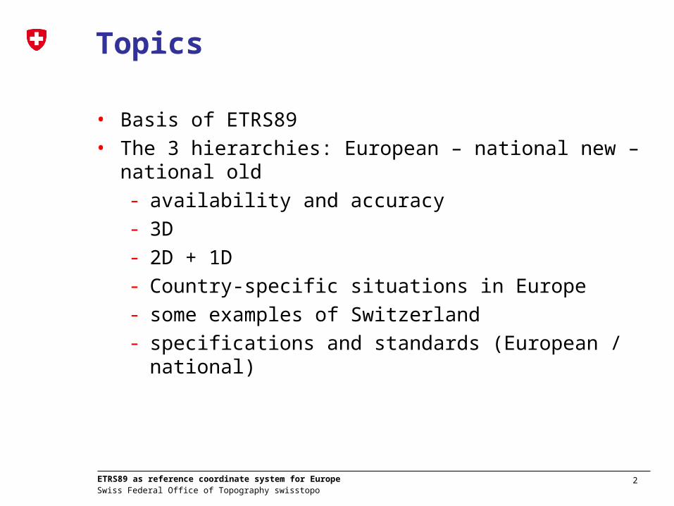
Topics
• Basis of ETRS89• The 3 hierarchies: European – national new – national old
- availability and accuracy- 3D - 2D + 1D- Country-specific situations in Europe- some examples of Switzerland- specifications and standards (European / national)

3 Swiss Federal Office of Topography swisstopo
ETRS89 as reference coordinate system for Europe
Definition ETRS89 (=System)
• Adopted in 1990 by EUREF• ETRS89 was aligned to the international reference
system ITRS at epoch 1989.0. • Whereas European stations have movements of several
centimeters within one year in the ITRS, ETRS89 is fixed to stable part of Europe
• 2003: decision of the European Commission to relate their own geographical data to ETRS89

4 Swiss Federal Office of Topography swisstopo
ETRS89 as reference coordinate system for Europe
Station movements globally
• World-wide (1-10 cm/year) Europe (< 1-2 mm/year)
Europe: 2.5 cm/year -> North -East

5 Swiss Federal Office of Topography swisstopo
ETRS89 as reference coordinate system for Europe
Realization (=Frame)
• “Fixing” / Defining coordinates - High accuracies and world-wide thanks to GPS
• Need for homogeneous national reference frame in Europe (Eurogeographics, INSPIRE, GIS data exchange): ETRF
• National ETRF coordinates were in the past mainly computed from campaigns – today permanent networks define national reference frames
• The ETRFyy realizations are used as the reference frame for Europe an in the countries!
• Umbrella EUREF: EPN web portal gives detailed information on coordinates. Coordinates are mainly “scientific” oriented (weekly an multi-annual coordinate sets)
• In countries “old” / distorted coordinate reference systems exist
Internat./EUREF “mm”
National new “cm”
National old“cm/dm”

6 Swiss Federal Office of Topography swisstopo
ETRS89 as reference coordinate system for Europe
Example: CRS in SwitzerlandITRS
CTS globalkinematic
global kinematic(stable part of the eurasian plate)
ETRS89----------------------------------- -- -- -- -- -- EU kontinental
kinematic
regionalkinematic
CHTRS95(CHKM95)
---------------------------------------------------------(inkl. lokale Kinematik : CHKM95)
CH regional/localkinematic
CH1903+(LV95)
============================== CH lokalstatic
LV03===================================================================… CH lokal
old distorted
time1989 90 91 92 93 94 95 96 97 98 99 2000
Internat./EUREF “mm”
National new “cm”
National old “cm/dm”
Fineltra Transformation cm / dm
Simple 3D-Transformation
No kinematic
ETRF93
Trafo (Boucher, Altamimi)
ITRF20yy

7 Swiss Federal Office of Topography swisstopo
ETRS89 as reference coordinate system for Europe
national CRS ETRS89
North East
Latitude Longitude(ell. height)
XYZ
North East
Latitude Longitude(ell. height)
XYZ
Transformation
Conversion
Conversion
Conversion
Conversion
Transformation - Position
3D
2DMap projection
(+ 1D)height /geoid

8 Swiss Federal Office of Topography swisstopo
ETRS89 as reference coordinate system for Europe
Transformation info for GIS
Definition + transformationhttp://www.crs-geo.eu
Internat./EUREF “mm”
National new “cm”
National old“cm/dm”
Globally also available (European Petroleum Survey Group)http://www.epsg.org/
Reference for many OGC projects
Transformation with Meter accuraccy

9 Swiss Federal Office of Topography swisstopo
ETRS89 as reference coordinate system for Europe
National Coordinate Reference Systems (CRS) in Europe# Country ID Coordinate Reference System
(CRS) Identifier Datum Projection
1 Albania AL AL_ALB87 / AL_TM ALB87 Transverse Mercator
2 Austria AT AT_MGI / AT_TM MGI Transverse Mercator
3 Belgium BE BE_BD72 / Lamb72 BD72 Lambert Conformal Conic
4 Bulgaria BG BG_1942 / GK_3 1942 Transverse Mercator (Gauss-Krüger-System)
BG BG_1942 / TM_6 1942 Transverse Mercator
5 Croatia HR HR_HDKS / GK_3 HDKS Transverse Mercator (Gauss-Krüger-System)
6 Cyprus CY CY_ED50 / UTM ED50 Transverse Mercator (UTM)
7 Czech Republic CZ CZ_S-JTSK / JTSK_OCC S-JTSK Oblique Conformal Conic
8 Denmark DK DK_ED50 / UTM ED50 Transverse Mercator (UTM) 9 Estonia EE EE_EST92 / LambEST92 EST92 Lambert Conformal Conic
10 Finland FI FI_KKJ / FI_TM KKJ Transverse Mercator
11 France FR FR_ED50 / EUROLMB ED50 Lambert Conformal Conic
FR FR_NTF / Lamb NTF Lambert Conformal Conic
12 Germany DE DE_DHDN / GK_3 DHDN Transverse Mercator (Gauss-Krüger-System)
DE DE_RD83 / GK_3 RD83 Transverse Mercator (Gauss-Krüger-System)
DE DE_PD83 / GK_3 PD83 Transverse Mercator (Gauss-Krüger-System)
DE DE_42/83/ TM_6 42/83 Transverse Mercator
13 Gibraltar GI GI_ED50 / UTM ED50 Transverse Mercator (UTM) 14 Great Britain GB GB_OSSN(80) / NG OSSN(80) Transverse Mercator
15 Greece GR GR_GGRS87 / GR_TM GGRS89 Transverse Mercator
16 Hungary HU HU_HD-72 / EOV HD-72 Oblique Conformal Cylindric
17 Iceland IS IS_Hj1955 / UTM Hj1955 Transverse Mercator (UTM)
18 Ireland IE IE_Ireland75 / IrishNG Ireland75 Transverse Mercator
19 Italy IT IT_Roma 40 / East Roma 40 Transverse Mercator
IT IT_Roma 40 / West Roma 40 Transverse Mercator
IT IT_ED50 / UTM ED50 Transverse Mercator (UTM) 20 Latvia LV LV...
21 Lithuania LT LT_LKS94 / LT_TM LKS94 Transverse Mercator
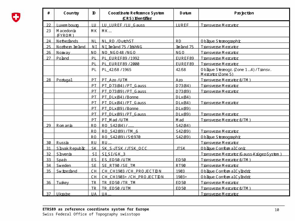
10 Swiss Federal Office of Topography swisstopo
ETRS89 as reference coordinate system for Europe
# Country ID Coordinate Reference System(CRS) Identifier
Datum Projection
22 Luxembourg LU LU_LUREF / LU_Gauss LUREF Transverse Mercator
23 Macedonia(FYROM)
MK MK...
24 Netherlands NL NL_RD / DutchST RD Oblique Stereographic
25 Northern Ireland NI NI_Ireland 75 / IrishNG Ireland 75 Transverse Mercator
26 Norway NO NO_NGO48 / NGO NGO Transverse Mercator
27 Poland PL PL_EUREF89 / 1992 EUREF89 Transverse Mercator
PL PL_EUREF89 / 2000 EUREF89 Transverse Mercator
PL PL_42/58 / 1965 42/58 Oblique Stereogr. (Zone 1...4) / Transv.Mercator (Zone 5)
28 Portugal PT PT_Azo / UTM Azo Transverse Mercator (UTM)
PT PT_D73(84) / PT_Gauss D73(84) Transverse Mercator
PT PT_D73(89) / PT_Gauss D73(89) Transverse Mercator
PT PT_DLx(84) / Bonne DLx(84)
PT PT_DLx(84) / PT_Gauss DLx(84) Transverse Mercator
PT PT_DLx(89) / Bonne DLx(89)
PT PT_DLx(89) / PT_Gauss DLx(89) Transverse Mercator
PT PT_Mad / UTM Mad Transverse Mercator (UTM)
29 Romania RO RO_S42(84) / ..... S42(84)
RO RO_S42(89) / TM_6 S42(89) Transverse Mercator
RO RO_S42(89) / St1970 S42(89) Oblique Stereographic
30 Russia RU RU... Transverse Mercator
31 Slovak Republic SK SK_S-JTSK / JTSK_OCC JTSK Oblique Conformal Conic
32 Slovenia SI SI_SI / GK_3 Transverse Mercator (Gauss-Krüger-System)
33 Spain ES ES_ED50 / UTM ED50 Transverse Mercator (UTM)
34 Sweden SE SE_RT90 / SE_TM RT90 Transverse Mercator
35 Switzerland CH CH_CH1903 / CH_PROJECTION 1903 Oblique Conformal Cylindric
CH CH_CH1903+ / CH_PROJECTION 1903+ Oblique Conformal Cylindric
36 Turkey TR TR_ED50 / TR_TM ED50 Transverse Mercator
TR TR_ED50 / UTM ED50 Transverse Mercator (UTM)
37 Ukraine UA UA... Transverse Mercator

11 Swiss Federal Office of Topography swisstopo
ETRS89 as reference coordinate system for Europe
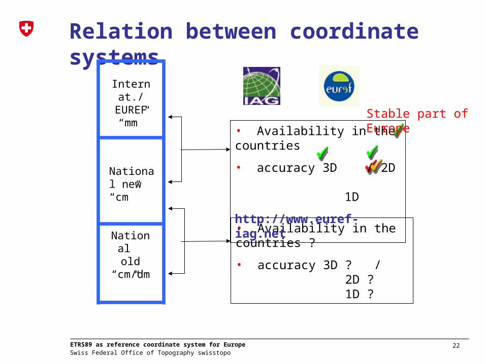
Relation between coordinate systems
• Availability in the countries ?
• accuracy 3D ? / 2D ?1D ?
http://www.euref-iag.net
Internat./EUREF “mm”
National new “cm”
National old
“cm/dm”

12 Swiss Federal Office of Topography swisstopo
ETRS89 as reference coordinate system for Europe
ETRS status (Survey for UIC 3.Oct.2006)
Position HeightContry ID-Nat Survey ID-Railway CRS Description Transf. to ETRS89 CRS Description Transf. to EVRF2000Albania AL published no published publishedAustria AT ÖBB published published published publishedBelgium BE INFRABEL published published published publishedBosnia / Hercegovina BA no no exist existBulgaria BG no published published publishedCroatia HR HZ published published exist existCyprius CY no published no noCzech Republic CZ CD published published exist existDenmark DK BDK published published published publishedEstonia EE published published published publishedFinland FI VR published published published publishedFrance FR SNCF published published published publishedGermany DE DB-AG published published published publishedGibraltar GI published published no noGreat Britain GB Network Rail published published published publishedGreece GR OSE published no exist noHungary HU MAV exist exist published publishedIceland IS no no no noIreland IE IE published published published noItaly IT RFI published published exist existLativia LV published published exist existLthiuania LT published published published publishedLuxembourg LU CFL published published published noMacedonia MK no no no noMalta MT no no no noMoldaviaNetherlands NL PRORAIL published published published publishedNorthern Ireland NI Translink published published exist noNorway NO JBV published published published publishedPoland PL PKP published published exist existPortugal PT REFER published published published publishedRomania RO no no exist existRussia RU no no exist noSlovak Republic SK ZSR published published published publishedSlovenia SI published published published publishedSpain ES ADIF published published published publishedSweden SE BV published published published existSwitzerland CH SBB published published published publishedTurkey TR published published published published
Geodetic Datum

13 Swiss Federal Office of Topography swisstopo
ETRS89 as reference coordinate system for Europe
ETRS status (Survey for UIC 3.Oct.2006)
Position Height
Albania AL published no published publishedAustria AT ÖBB published published published publishedBelgium BE INFRABEL published published published publishedBosnia / Hercegovina BA no no exist existBulgaria BG no published published publishedCroatia HR HZ published published exist existCyprius CY no published no noCzech Republic CZ CD published published exist existDenmark DK BDK published published published publishedEstonia EE published published published publishedFinland FI VR published published published publishedFrance FR SNCF published published published publishedGermany DE DB-AG published published published publishedGibraltar GI published published no noGreat Britain GB Network Rail published published published publishedGreece GR OSE published no exist noHungary HU MAV exist exist published publishedIceland IS no no no noIreland IE IE published published published noItaly IT RFI published published exist existLativia LV published published exist existLthiuania LT published published published publishedLuxembourg LU CFL published published published noMacedonia MK no no no noMalta MT no no no noMoldaviaNetherlands NL PRORAIL published published published publishedNorthern Ireland NI Translink published published exist noNorway NO JBV published published published publishedPoland PL PKP published published exist existPortugal PT REFER published published published publishedRomania RO no no exist existRussia RU no no exist noSlovak Republic SK ZSR published published published publishedSlovenia SI published published published publishedSpain ES ADIF published published published publishedSweden SE BV published published published existSwitzerland CH SBB published published published publishedTurkey TR published published published publishedUkraine UA no no exist no
Position HeightContry ID-Nat Survey ID-Railway CRS Description Transf. to ETRS89 CRS Description Transf. to EVRF2000Albania AL published no published publishedAustria AT ÖBB published published published publishedBelgium BE INFRABEL published published published publishedBosnia / Hercegovina BA no no exist existBulgaria BG no published published publishedCroatia HR HZ published published exist existCyprius CY no published no noCzech Republic CZ CD published published exist existDenmark DK BDK published published published publishedEstonia EE published published published publishedFinland FI VR published published published publishedFrance FR SNCF published published published publishedGermany DE DB-AG published published published publishedGibraltar GI published published no noGreat Britain GB Network Rail published published published publishedGreece GR OSE published no exist noHungary HU MAV exist exist published publishedIceland IS no no no noIreland IE IE published published published noItaly IT RFI published published exist existLativia LV published published exist existLthiuania LT published published published publishedLuxembourg LU CFL published published published noMacedonia MK no no no noMalta MT no no no noMoldaviaNetherlands NL PRORAIL published published published publishedNorthern Ireland NI Translink published published exist noNorway NO JBV published published published publishedPoland PL PKP published published exist existPortugal PT REFER published published published publishedRomania RO no no exist existRussia RU no no exist noSlovak Republic SK ZSR published published published publishedSlovenia SI published published published publishedSpain ES ADIF published published published publishedSweden SE BV published published published existSwitzerland CH SBB published published published publishedTurkey TR published published published published
Geodetic Datum
14 Swiss Federal Office of Topography swisstopo
ETRS89 as reference coordinate system for Europe
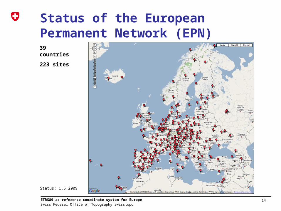
Status of the European Permanent Network (EPN)39 countries
223 sites
Status: 1.5.2009

15 Swiss Federal Office of Topography swisstopo
ETRS89 as reference coordinate system for Europe
Comparison with EPN05 densification:alternative Method using EPN webEPN
National level (e.g. CH)
inte
rnati
on
al
nati
on
al
http://www.epncb.oma.be/_trackingnetwork/coordinates/stationcoordinates4onestation.php?station=ZIMM
- requested to report in the national report
- on sub-mm identical to method using SNX: SSC file rounded to 1 mm

16 Swiss Federal Office of Topography swisstopo
ETRS89 as reference coordinate system for Europe
20/35
10/10
Ok: (xx CRD delivered / EPN sites)
Not yet asked (EPN sites)
4/5
No EPN sites used: (xx CRD delivered / EPN sites)
0/7
1
5
3
1
3
4
4/4
16/19
9/20
Status: 1.5.20093
2
4/5
Partly more site coordinates delivered (additional national + outside of the country)
Greenland:4Israel: 2Morocco: 2Armenia: 1
20/31
1
1
1
5/5
12
1/17
3/6
1
1
6
2/4
7/8
2/2
4
9
12
Number of EPN sites with official national ETRF coordinates
1
All 15 countries sent coordinates
EPN: 39 countries 223 sites

17 Swiss Federal Office of Topography swisstopo
ETRS89 as reference coordinate system for Europe
Comparison with EPN05 densification:Method used
Comparison(Difference)
“EPN05” mm
ITRF ETRF
EPN_ITRF_C1355.SNX EPN_ETRF_C1355.CRD
ITRF2005 ETRF2000
ETRF2000(R05) Transformation,
Epoch 2000.0
ITRF05 Densification solution of the EPN (Nov. 2008): data till week 1355
AUT_20090211.ETRFBEL_20090127.ETRFCHE_20081021.ETRFDEU_20081104.ETRFESP_20090201.ETRFFIN_20090119.ETRFFRA_20090428.ETRFHUN_20090120.ETRFITA_20090101.ETRFNLD_20090325.ETRFPOL_20090129.ETRFPRT_20090402.ETRFSVK_20090421.ETRSWE_20081024.ETRF
ETRF00 ETRF2000 ETRF93 ETRS89 ETRF05 ETRF96ETRF93 ETRF00 ETRF2000ETRF2000(R05) ETRF05(R05)ETRF89ETRF2000ETRF97Different Epochs
“National ETRF” cm
National ETRF coordinates
scientific multi-annual densification solution
official national coordinates

18 Swiss Federal Office of Topography swisstopo
ETRS89 as reference coordinate system for Europe
Comparison of “official” national coordinates with scientific multi-annual EPN05 densification

19 Swiss Federal Office of Topography swisstopo
ETRS89 as reference coordinate system for Europe
Why 2-3 cm differences? Limits of ETRS realizations• different ETRFYY definitions and reference epochs• transition from campaign to permanent stations• different analysis models and software used• different station setups (antenna changes) – most recent
EPN station setup was used for the comparisons• mapping agencies cannot change coordinates frequently • location on “non-stable plate” (South Italy)
• Well done by the national mapping agencies• Limit: stable part of Europe

20 Swiss Federal Office of Topography swisstopo
ETRS89 as reference coordinate system for Europe
2D / 1D in Europe
• Map projections defined since 1999 (Eurogeographics, INSPIRE)
• Height reference frame ETRF2007 - released 2008- transformations not yet available in most of the countries; very
rough transformations available at CRS web page- CH: 1-2 cm Trafo-tool planned (11 cm shift + HTRANS-type
correction to old LHN02 and new LHN95)• Precise European Geoid not yet available: publication planned
2010
Requirement 5INSPIRE will mandate the Lambert Azimuthal Equal Area (ETRS89-LAEA) for spatial analysis and display
Requirement 6NSPIRE will mandate the Lambert Conformal Conic (ETRS89-LCC) for conformal pan-European mapping at scales smaller or equal to 1:500,000
Requirement 7INSPIRE will mandate the Transverse Mercator (ETRS89-TMzn) for conformal pan-European mapping at scales larger than 1:500,000

21 Swiss Federal Office of Topography swisstopo
ETRS89 as reference coordinate system for Europe
Related topics
• Other standards / specifications- ISO19100-family on geographic information- Inspire data specifications - Inspire web service specifications (e.g. coordinate Web
Coordinate Transformation Service (WCTS); Web Processing Service (WPS))
- National specifications (geoservices; CH: e-geo)
“INSPIRE Annex I data specifications”
22 Swiss Federal Office of Topography swisstopo
ETRS89 as reference coordinate system for Europe
Relation between coordinate systems
Internat./EUREF “mm”
National new “cm”
National old
“cm/dm”
• Availability in the countries ?
• accuracy 3D ? / 2D ?1D ?
• Availability in the countries
• accuracy 3D / 2D 1D
http://www.euref-iag.net
Stable part of Europe
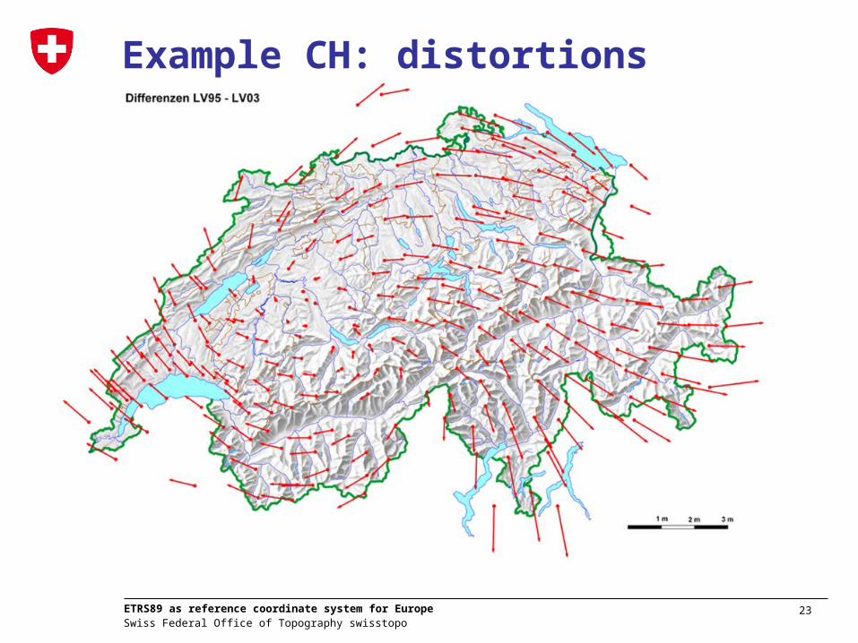
23 Swiss Federal Office of Topography swisstopo
ETRS89 as reference coordinate system for Europe
Example CH: distortions

24 Swiss Federal Office of Topography swisstopo
ETRS89 as reference coordinate system for Europe
New Reference System CHTRS95 (Reference Frame LV95)“old coordinates” 200’000 / 600’000
“new coordinates” 1’200’000 / 2’ 600’000
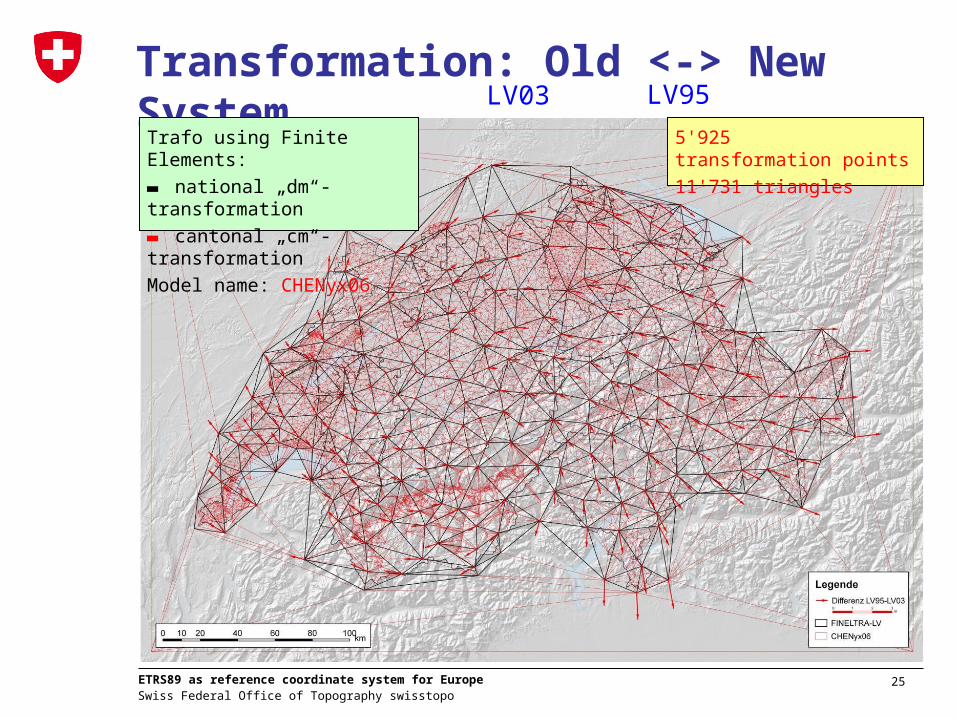
25 Swiss Federal Office of Topography swisstopo
ETRS89 as reference coordinate system for Europe
Transformation: Old <-> New System
Trafo using Finite Elements:
▬ national „dm“-transformation
▬ cantonal „cm“-transformation
Model name: CHENyx06
5'925 transformation points
11'731 triangles
LV03 LV95

26 Swiss Federal Office of Topography swisstopo
ETRS89 as reference coordinate system for Europe
Accuracy of the transformation• 46‘600 control points (CP)
2.2 points per km2
• maximal CP influence 1.5 km• interpolation (using 1/d2
and max. 1.5 km)• Empirical accuracy:
2 cm ± 1 cm
27 Swiss Federal Office of Topography swisstopo
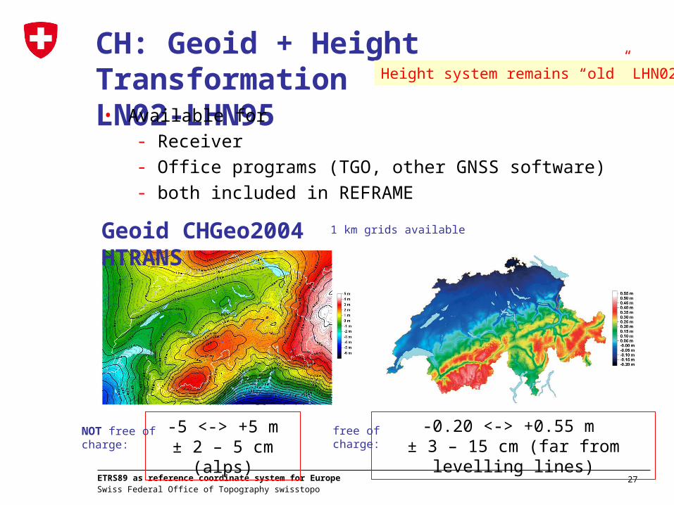
ETRS89 as reference coordinate system for Europe
CH: Geoid + Height Transformation LN02-LHN95• Available for
- Receiver - Office programs (TGO, other GNSS software)- both included in REFRAME
-5 <-> +5 m± 2 – 5 cm (alps)
-0.20 <-> +0.55 m ± 3 – 15 cm (far from levelling lines)
Geoid CHGeo2004 HTRANS1 km grids available
NOT free of charge:
free of charge:
Height system remains “old” LHN02

28 Swiss Federal Office of Topography swisstopo
ETRS89 as reference coordinate system for Europe
Method „Grids“
0 km 20 km 40 km 60 km 80 km 100 km
R eferenzvektoren
1m
2m
• ~ 1 mm identical to dm-FINELTRA (1 km raster)• < 1 cm difference to cm-FINELTRA (1 km raster)
• < 1 cm to HTRANS (1 km raster); high alps < 10 cm

29 Swiss Federal Office of Topography swisstopo
ETRS89 as reference coordinate system for Europe
Example CH: accuracy and usage of transformation
cm: Cantonal Trafo: Depending quality of the areas: 1 cm up to some dm
yesFederal surveying
dm: National Trafo: 1-3 dm (moderate elevations) up to several dm (mountains)
yesGIS
horizontal accuracyavailabilityUsage of transformation data set
m: Simply add 1’000’000 and 2’000’000 yesMapping Navigation

30 Swiss Federal Office of Topography swisstopo
ETRS89 as reference coordinate system for Europe
GeoIG and reference frame
• Geographic information law + 10 ordinances, came into force 1.7.2008
• Transitions phase for LV95: 2016 for geobasis data regulated by federal law; 2020 for all geobasis data
2017 … 20XX2000 … 2006 2007 2008 … 2016
Δ-generation
LV95LV03
work
geobasis data
reference frame
renewalChange of the reference frame
LV03 LV95
Height system remains “old” LHN02
31 Swiss Federal Office of Topography swisstopo
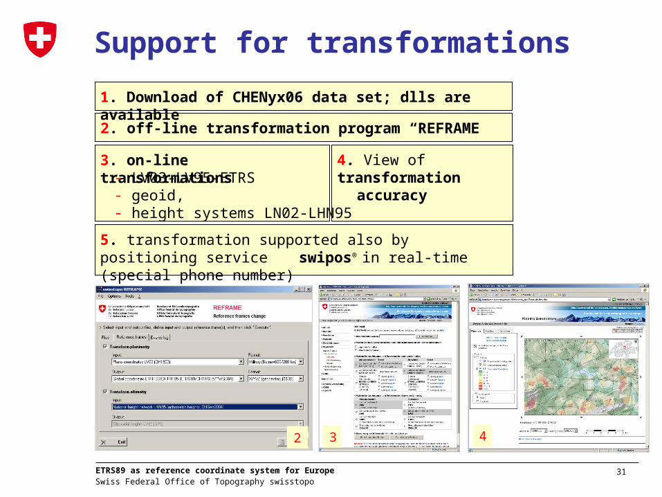
ETRS89 as reference coordinate system for Europe
2. off-line transformation program “REFRAME”
Support for transformations
4. View of transformation accuracy
3. on-line transformations
5. transformation supported also by positioning service swipos® in real-time (special phone number)
- LV03-LV95-ETRS- geoid, - height systems LN02-LHN95
1. Download of CHENyx06 data set; dlls are available
2 3 4

32 Swiss Federal Office of Topography swisstopo
ETRS89 as reference coordinate system for Europe
Examples Grids / FINELTRA usage in third-party software• Leica GPS Software (CSCS): Country specific coordinate systems
• ESRI: FINELTRA dll included
• NTV2 Format as European-wide standard for the transformation

33 Swiss Federal Office of Topography swisstopo
ETRS89 as reference coordinate system for Europe
Grids (plane trafo) in other EU countries• At annual EUREF not a “hot” topic (no big discussions) ->
also available in the countries (but different accuracies)• For UIC (2006) a detailed status was collected for countries
France, Germany, Netherlands, Poland, Spain, Sweden, Switzerland - all countries have slightly different solutions, but the goal of the transformation “old”-”new” is reached.

34 Swiss Federal Office of Topography swisstopo
ETRS89 as reference coordinate system for Europe
Relation between coordinate systems
• Availability in the countries
• accuracy 3D / 2D 1D
• Availability in the countries
• accuracy 3D / 2D 1D
http://www.euref-iag.net
Internat./EUREF “mm”
National new “cm”
National old
“cm/dm”
Solutions country- and software-specific
Stable part of Europe

35 Swiss Federal Office of Topography swisstopo
ETRS89 as reference coordinate system for Europe
Advantages of ETRS
• ONE reference system for Europe• Linked to the international reference system ITRS• Easily accessible with GPS• No distortions in the network / no adoption to neighbouring
points• „Absolute“ coordinates / less maintenance work for local
reference points• Simple handling of coordinates for users (economy,
administration, etc.) • Enables an exchange of geographical data

36 Swiss Federal Office of Topography swisstopo
ETRS89 as reference coordinate system for Europe
Thanks for your attention!
C. Calvert: EUREF–Symposium 2005, Vienna