area management plan - the official website of the state of utah
TRANSCRIPT

Utah State Parks
Flight Park State Recreation AreaArea Management PlanMarch 2008

i

ii
This page intentionally left blank
Flight Park State Recreation Area Area Management Planning Team
Yens Horn – Lieutenant, Utah County Sheriff’s Office
Kim Struthers – Planner, Lehi City Planning Department Ty McCartney – President, Utah Hang Gliding and Paragliding Association
Steve Mayer – Owner, Cloud Nine Soaring Center Dick Bean – President, Intermountain Silent Flyers
Allan McKay – Vice President, Intermountain Silent Flyers Erik Vogel – Intermountain Silent Flyers
Todd Andersen – ATV Representative, Utah State Parks OHV Advisory Council Ed Clayson – Aggregate Superintendent, Geneva Rock Products
Wayne Johnson – Salt Lake County Parks and Recreation Eric Stucki – NW Assistant Region Manager, Utah Division of State Parks and Recreation,
Flight Park SRA Jay Christianson – NW Region Manager, Utah Division of State Parks and Recreation
Other Participants
Rock Smith – Planning Coordinator, Utah Division of State Parks and Recreation
Shannon Peterson – Planner, Utah Division of State Parks and Recreation Jamie Fields – Planner, Utah Division of State Parks and Recreation
Edie Trimmer – Planner, Utah Division of State Parks and Recreation Susan Zarekarizi – Lands and Environmental Coordinator, Utah Division of State Parks and
Recreation
iii
Acknowledgements

iv
This page intentionally left blank

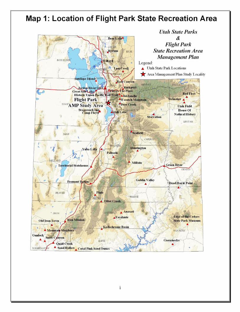
Maps Map 1 Location of Flight Park State Recreation Area Page i Map 2 Flight Park State Recreation Area Facilities Page 41 Map 3 Potential Future Developments at the Flight Park Page 43 Map 4 Ownership of Lands Adjacent to the Flight Park Page 45
v
List of Maps

vi
This page intentionally left blank

Acknowledgements ...................................................................................................................... iii List of Maps ....................................................................................................................................v Executive Summary .......................................................................................................................1 Mission and Vision Statements .....................................................................................................5
Mission Statement......................................................................................................................5 Vision Statement........................................................................................................................5
Area Management Plan Purpose and Process.............................................................................7 Purpose of the Plan ....................................................................................................................7 The Planning Process.................................................................................................................8
About the Park ............................................................................................................................11 Park History .............................................................................................................................11 Physical Setting and Facilities .................................................................................................13
Park Resources.............................................................................................................................15 Geological and Topographical Resources ...............................................................................15 Biological Resources ...............................................................................................................16 Cultural Resources ...................................................................................................................16 Natural Hazards Analysis ........................................................................................................16
Issues and Recommendations .....................................................................................................19 Facility Development...............................................................................................................20 Staffing, Funding, Operations, and Enforcement ....................................................................24 Natural Resource Management................................................................................................29 Anticipated Future Use and Development...............................................................................31
Conclusion ....................................................................................................................................35 References .....................................................................................................................................37 Maps ..............................................................................................................................................39 Appendices....................................................................................................................................47
Appendix A..............................................................................................................................49
vii
Table of Contents

This page intentionally left blank
viii
In November 2006, representatives from the Utah Division of State Parks and Recreation met with community stakeholders involved in the Flight Park to initiate a resource planning effort for Flight Park State Recreation Area. The planning process was based on public input and involvement. The Flight Park State Recreation Area Management Planning Team – a citizen-based team representing community leaders, interested users, local residents and agency representatives – was at the core of the process. The recommendations contained in this document represent several months of work by the Planning Team. The plan provides recommendations founded upon eleven primary vision elements that will guide future management of Flight Park State Recreation Area. These elements focus on the following: • Developing and maintaining good
relationships with adjacent landowners, park user groups, local governments, and local law enforcement and emergency services in order to promote safety and mutual respect among all stakeholders and to allow for access to recreational opportunities
• Improving access, road, and parking lot conditions
• Developing, maintaining, and enhancing facilities that offer safe and convenient support for recreational activities
• Providing appropriate signage • Exploring the legal ramifications of
concession management of gliding activities and membership requirements
• Ensuring the park has adequate funding, staff, equipment, and support
• Getting approval for and enforcing park laws; providing adequate staff and funding for enforcement
• Offering interpretive and educational opportunities for visitors on the history of the park, as well as flight, wind, and place-related information
• Controlling erosion and noxious weeds; planting native vegetation that does not pose a safety threat to park users
• Anticipating future recreational uses of the park and surrounding area and planning for facilities and connections to promote community recreation
• Marketing recreational opportunities at the park to increase visitation
These objectives are geared towards improving and expanding the park’s recreational opportunities, protecting its resources and providing the visitor with a safe, enjoyable experience. Achievement of these vision elements will require the continued support of users, legislative and community leaders, and the Division of State Parks and Recreation. The Planning Team issued a number of specific recommendations in support of the plan’s vision elements. Four issue areas form the basis of the team’s recommendations. Each issue area with its accompanying recommendations is outlined as follows: Facility Development • Improve and maintain park roads and
parking lots as needed; consider paving them once external access roads are paved
• Work with Lehi City and adjacent landowners to ensure access on external roads to the park
• Move the Utah Hang Gliding and Paragliding Association (UHGPGA) landing zone parking lot for pilot safety
1
Executive Summary

• Construct a campground and charge a small camping fee; work with a camp host
• Consider providing restrooms at the landing zone parking lot
• Continue to encourage pack-it-in, pack-it-out behavior for trash
• Neither water nor electricity is available at the park − Consider accessing potable water
and electricity from nearby transmission sources
− Consider providing solar or wind generated electricity
Staffing, Funding, Operations, and Enforcement • Continue the activity management and
maintenance contract with UHGPGA and consider establishing a similar contract with Intermountain Silent Flyers (IMSF)
• Flight instructors currently pay fees to and obtain insurance through the Point of the Mountain Instructors Committee (POMIC). Explore the legal ramifications of this and structure park policies accordingly
• Continue to operate the park without charging an entrance fee at this time Increase staffing levels and budget, an• d ensure that operational funding is included with new developments Seek Board and legislative approv• al for park laws developed by managers and the Planning Team to protect visitor safety Work c• losely with Lehi City and Utah County law enforcement and emergency services Visitors c• an access the park from
ent landowners to
land
d
• ocal organizations nsider
multiple entrances − Work with adjac
determine where the official park entrance will be, develop that entrance, and install a traffic is
with a sign displaying park laws and information
• Park boundaries are not well marked − Research existing boundary surveys
or conduct one if necessary − Consider using sign posts or fences
to keep park visitors from wandering onto adjacent lands
• Provide educational information on the interpretive kiosk near the UHGPGA
launch area Natural Resource Management • Minimize erosion by repairing existing
problems and planting vegetation with low impacts to pilots
• Fill in the “Gash” and flatten the UHGPGA landing zone and the radio-controlled (RC) glider launch and landing area
• Noxious weeds at the park are bad for the soil and cause a tripping hazard for pilots − Work with experts to eliminate
noxious weeds and replace them with native plant species that are safe for pilots
− In the long term, consider re-vegetation of the RC glider area, and the UHGPGA launch, landing, and instruction areas with soft, drought-resistant grasses
Anticipated Future Use and Development
Work with adjacent landowners in • planning for the park and surrounding lands Provid• e spectator facilities
• Develop more diverse recreational opportunities at the park, including providing facilities for spectators anconsidering the designation of a kite-flying area Work with l
2
developing trails in the area; coproviding trailhead facilities at the park

• Consider creating a site plan for the park for possible zoning and future development
• Conduct visitor surveys • Develop and implement a marketing
plan for the park Implementing many of these recommendations will be dependent upon acquiring new funding sources. The funding requests arising from this plan may compete against other projects within the Division and other agencies in state government. The plan’s success is dependent upon the continued support of park stakeholders. Efforts must be made to enhance park resources, interact with local communities, and strive to meet the expectations of park visitors. The recommendations contained within this plan were based upon an open and collaborative process. It is imperative that this collaborative spirit continues as the plan’s components are implemented.
3

4
This page intentionally left blank
Mission Statement Vision Statement Flight Park State Recreation Area will accomplish its mission by:
Developing and maintaining good relationships with adjacent landowners, park user groups, local governments, and local law enforcement and emergency services in order to promote safety and mutual respect among all stakeholders and to allow for access to recreational opportunities
Improving access, road, and parking lot conditions
Developing, maintaining, and enhancing facilities that offer safe and convenient support for recreational activities
Providing appropriate signage Exploring the legal ramifications of
concession management of gliding activities and membership requirements
Ensuring the park has adequate funding, staff, equipment, and support
Getting approval for and enforcing park laws; providing adequate staff and funding for enforcement
Offering interpretive and educational opportunities for visitors on the history of the park, as well as flight, wind, and place-related information
Controlling erosion and noxious weeds; planting native vegetation that does not pose a safety threat to park users
Anticipating future recreational uses of the park and surrounding area and planning for facilities and connections to promote community recreation
Marketing recreational opportunities at the park to increase visitation
A mission statement tells why a park exists. Planning Team members contributed to a mission statement that recognizes that the park is an internationally known location for unique air-based recreation opportunities. Further, the park has been, and continues to be, a central gathering point for the local gliding community.
Vision Statement A vision statement is like a compass; it charts a destination, sets the Planning Team and the park on the correct course of action, and provides the means to determine how closely the Team recommendations will follow that charted course. Utilizing the basic principles developed in the mission statement, the Team contributed to a vision to give structure to the recommendations that balance recreational demands, preservation of the park’s resources, needs for safe and secure facilities, and encourage community involvement.
Mission Statement The mission of Flight Park State Recreation Area is to provide a safe environment for a variety of air and land-based recreation opportunities and to serve as a hub for the local gliding community.
5
Mission and Vision Statements

This page intentionally left blank
6

Purpose of the Plan This area management plan (AMP) is intended to help guide the stewardship obligations of the Utah Division of State Parks and Recreation (Division) for Flight Park State Recreation Area. Planning for the park is essential, given the number and type of recreational activities pursued there and ownership of surrounding lands, which is divided between mineral extraction companies and private housing developments. Because of its location on Point of the Mountain and the wind patterns created by this and other local geographic features, Flight Park State Recreation Area offers unique opportunities for non-motorized, air-based recreational pursuits. Radio-controlled (RC) glider pilots frequent the area and the Intermountain Silent Flyers (IMSF) holds a major soaring event every other year. The park is ideal for learning to hang glide and paraglide and for moving through the beginner and into the intermediate levels of the sport. Particularly because of its international renown and its vital importance to the local gliding community, the park should strive to protect the opportunities offered here and facilitate safe and enjoyable experiences for visitors. Lands adjacent to the park on the northern, southern, and western boundaries are owned by mineral extraction companies who are actively mining at Point of the Mountain. In the absence of thorough planning, management actions, and the development and maintenance of good relationships with landowners, these properties could be threatened by trespasses from park visitors, while visitor safety, wind patterns, and access to the park could be threatened by the mining companies.
Other adjacent lands are slated for residential and business development, including lands through which the access road to the Utah Hang Gliding and Paragliding Association (UHGPGA) launch area runs. Trespasses on these lands by park visitors could pose a safety threat during construction and offend property owners after construction is complete. Planning, responsible management, and the maintenance of good relationships with developers and Lehi City should ensure positive interactions between the park, its visitors and neighbors while fostering excitement among the growing Lehi community about the unique opportunities available just out their back doors.
Governor Huntsman’s Dedication of the Park
Flight Park State Recreation Area was acquired by the Division in 2006. Prior to that time, use of the area for gliding was arranged between UHGPGA and the Utah Department of Transportation (UDOT), which previously owned some of the Flight Park lands, and no resource management or facilities were provided. This has resulted in numerous management issues, including facility needs, erosion problems, noxious weed infestations, and the occurrence of unacceptable uses on park property. Planning for solutions to these concerns and the provision of law enforcement, staff, and a budget is critical to ensure that visitors
7
Area Management Plan Purpose and Process

have safe and enjoyable experiences. Some of these issues are being dealt with through UHGPGA, the concession contracted to manage gliding activities at the park, but UHGPGA does not have the resources or authority to plan and manage for all park issues. The planning process will assist in the development of effective policies, procedures, and regulations for managing Flight Park State Recreation Area, in the wise use of available funding, and in the maintenance of positive relationships among all stakeholders.
Paragliding at the Park
A number of issues, ranging from facilities development to natural resource management, were identified by the Planning Team. Team members aggregated 19 major issues into four distinct categories addressing: (1) Facility Development; (2) Staffing, Funding, Operations, and Enforcement; (3) Natural Resource Management; and (4) Anticipated Future Use and Development. This plan and its recommendations address each of the issue
areas. It will provide flexible guidelines for the management and development of the park over the next five to ten years. More importantly, it will provide this direction on a foundation of public input and consensus of key stakeholders, rather than by the unilateral direction of the Division. The Planning Process Planning for an outstanding recreational resource such as the Flight Park is required for the protection of this unique area and to ensure the efficient and effective expenditure of state and private funds. It is necessary for the long-term protection and public enjoyment of the park’s unique opportunities and resources. This AMP is required by the Utah State Legislature and the Board of the Division to guide short and long-term site management and capital development. The Division’s long-range strategic plan, Vision 2010, outlines the required planning actions needed to effectively meet customer recreational and leisure needs for the next five to ten years. Vision 2010 identifies resource management planning as essential to the effective administration and operation of all parks in the agency’s system. Under the guidance of Vision 2010, each AMP and resource management plan (RMP) is developed around one core concept: meeting the needs and expectations of customers, visitors, and the citizens of the state of Utah, while protecting each park’s unique resource base. In short, the process is customer driven and resource-based.
8
The planning process recommends limits of acceptable change or modification and a future vision for the park. Specifically, the process: (1) recognizes impacts will result from use and enjoyment of the site; (2) defines how much and what types of

impacts may be accommodated while providing reasonable protection of the resources for future visitors; (3) incorporates values of resource sustainability, quality facilities, education and interpretation for visitors; and (4) seeks to determine the conditions under which this can be attained. In August 2006, Division representatives met to discuss planning for the park and generate a list of potential Planning Team participants. Team members were selected for a variety of reasons, ranging from technical expertise to interest in the park. Eight individuals were selected to serve on the Planning Team, and four representatives from the Division served as staff to the Team. All Team members participated on a voluntary basis and expressed a willingness to sacrifice a significant portion of their time and expertise to the process. The Planning Team first met on November 7, 2006 and formed Rules and Off-Highway Vehicle (OHV) Subcommittees, which met on December 5 and 7, 2006, respectively. The Rules Subcommittee determined that no motorized flight should be allowed at the park, all hang glider and paraglider pilots must carry UHGPGA membership insurance or an equivalent insurance to fly at the park, and that all schools for pilot instruction must carry licenses and sign special use permits to use the park. Establishment of these laws will require legislative action. The OHV Subcommittee determined that OHV use within the park would be inappropriate at this time because there are not sufficient staff and resources to control the use, enforce OHV regulations, or provide for public safety. The Team reconvened on January 9, 2007 to develop a comprehensive list of recommendations for the park. Several members of the Team gathered again on December 10, 2007 to review the Team’s recommendations of the previous
year and determine what changes over that time should be reflected in the AMP. The Team reconvened on January 24, 2008 to review a draft of the AMP and finalize their recommendations for park management.
9

10
This page intentionally left blank

Park History Flight Park State Recreation Area is located on the southern side of Point of the Mountain, between Salt Lake and Utah Valleys. The history of flight on this geographical feature goes back to the early 1920s. From the 1920s until the 1950s, pilots used winches, human tows, and Model Ts to launch their sailplanes. Frank Kelsey, a local high school student, began building his own glider in his 1928 shop class, which he first tried to fly at the Point in 1929. This began a lifetime of glider development and modification, including a stint as shop foreman working with other local glider pilots to construct military training gliders during World War II. Kelsey was part of a small but dedicated local gliding community that contributed to glider and sailplane design and to the broader history of flight.
Glider at the Point of the Mountain in 1928 Photo provided courtesy of Mike Haley
The first hang gliding flight at the Point was accomplished in 1971 by “Cowboy Jack” Romanski, and the site itself can be considered a pioneering site for the sport, having hosted many early hang glider pilots. By 1975, the area was well established among the international hang gliding community as a world-class flying site. Paragliding came to the Point in 1987, brought by Fred Stockwell, who was the second person to introduce the sport in the
U.S. The Point was an integral stop in the first U.S. National Paragliding Competition in 2004. The Point, and particularly the part of it that is now Flight Park State Recreation Area, has long been a training ground for new pilots and an excellent location to develop and test new equipment and techniques. The park is best known for its consistent winds and unique conditions, providing more opportunities than most gliding sites in the world for learning to fly. Such conditions have led to the establishment of numerous flight schools in the area, including the largest paragliding school in the nation. Other gliding-related local businesses that were established in the region because of flight opportunities at Point of the Mountain include oxygen equipment providers, retailers, and glider manufacturers who use the Point when testing new products. Important techniques have also been developed at the Point, such as some kiting techniques for paragliders. Kiting involves standing in place and balancing a paraglider overhead in the wind; developing kiting techniques increases pilot safety. Activities that were precursors to the sports of speed flying and kite boarding were also experiments of the pilots at the Point. The 1970s saw advancements in radio technology that allowed for the development of small, unmanned aircraft that were constructed similarly to the way full-sized gliders are built and took advantage of the same engineering technologies, though they run by remote control. The Point has been much used since the 1970s for recreational RC glider flight, but it has also been host to test flights of unmanned aerial vehicles for the U.S. Department of Defense’s research and development organization, the Defense Advanced Research Project Agency (DARPA).
11
About the Park

Air sports at the Point have long been supported and protected by the local gliding community. The University of Utah formed a gliding club in 1929, and its members flew at the Point, in addition to other local flying sites. The Salt Lake Glider Club was established by Kelsey in 1931, and its membership has carried through multiple configurations into the current Utah Soaring Association. These gliders no longer fly from the Point, but they have been integral participants in the history of flight at there. The Intermountain Silent Flyers (IMSF), the local RC gliding club, formed in 1979. Club members fly frequently at the park, and the organization has hosted one of the world’s largest RC slope glider events, aptly titled “Soar Utah,” for more than 20 years, attracting thousands of participants from all 50 states and more than 30 countries.
RC Glider
Photo provided courtesy of Erik Vogel The Fellow Feathers Association for hang gliding became a non-profit organization in 1974, later metamorphosing into the Utah Hang Gliding Association and eventually the Utah Hang Gliding and Paragliding Association (UHGPGA). In addition to being involved in the national gliding community, this group has been actively involved in the local community as well. UHGPGA worked relentlessly to protect the gliding site on the northern side of the Point, which became a Salt Lake County park as a
result of their efforts. The organization was similarly instrumental in the designation of Flight Park State Recreation Area. The park itself was formerly owned in part by Staker and Parson Companies and in part by the Utah Department of Transportation (UDOT); during that time, UHGPGA leased the land from the State and managed flight activities on it. Both Staker and Parson Companies and UDOT donated the park lands in 2006, which was used to satisfy some standing conditions with Land and Water Conservation Fund (LWCF) dollars. The application of LWCF conditions to the land requires that the Flight Park property can only be used for public outdoor recreation; this assures the protection of the internationally-renowned resource for the gliding community and others who want to enjoy the recreational opportunities at the Point. Flight at the Point is famous among pilots around the globe and has been featured in numerous articles in major magazines. According to a 1994 economic impact statement provided by UHGPGA, the impact of gliding activities on the local economy was more than $700,000 per year. At the time of the statement, participation in paragliding was doubling annually. People traveling to the Point for their first certification in gliding typically stay in the area a minimum of two weeks, and numerous experienced pilots travel to the area to enjoy the wind at the Point. Letters supporting the protection of flight at the Point came to UHGPGA from all over the world from both prior and future visitors who care for the Point as passionately as the local community.
12

Physical Setting and Facilities Flight Park State Recreation Area is located along the southern ridge of Point of the Mountain, approximately 23 miles south of Salt Lake City, and about 3 miles off of Interstate 15 at Bluffdale Exit 288. The park covers approximately 147 acres, and its elevation ranges from roughly 4800 to 5200 feet above sea level. The annual average temperature ranges from the high 30s to mid 60s in degrees Fahrenheit, with summer temperatures ranging from the low 50s to the low 90s. Average total precipitation, including snowfall, is about 17 inches annually. Recreation activities at the park include paragliding, hang gliding, RC gliding, RC rock crawling, spectating, and primitive camping. The park is known primarily for its paragliding and hang gliding opportunities, and is internationally recognized as an excellent place for people new to these sports to learn and improve their skills.
Construction of the UHGPGA Launch Area
Restrooms Amenities at the park include maintained dirt and gravel parking lots at the UHGPGA launch area and landing zone, as well as a vault toilet, a storage shed, and an information kiosk at the UHGPGA launch area parking lot. A web cam is located
beside the restrooms, and live internet footage of the park can be accessed through both the UHGPGA and Flight Park websites. The web cam can give pilots and spectators a feeling for what activities are taking place at the park and the wind conditions in real time, in addition to providing some extra measures of security.
13

This page intentionally left blank
14

Recreational activities at Flight Park State Recreation Area are dependent upon the topographical features of the land, and safe participation in those activities requires careful management of the vegetation and soils present in the park. To do this, the planning process calls for an inventory and analysis of park resources. It is essential that management decisions affecting the park’s natural environment be based on reliable scientific information. This section provides an analysis of the Flight Park’s geological, topographical, biological, and cultural resources. A natural hazards analysis is also included. Geological and Topographical Resources Point of the Mountain is part of the Traverse Mountain Range, which separates Salt Lake and Utah valleys and is bisected by the Jordan River at the Jordan Narrows. The Point is a spit created by Pleistocene Lake Bonneville. A spit is created when sediments are transported along a shoreline and deposited on an extension of land pointing into a body of water. In the case of the Point, strong winds pushed waves along the shoreline of Lake Bonneville at the western edge of the Wasatch Mountains and the northern edge of the eastern Traverse Mountains. Rock here was highly fractured due to a long history of faulting, so the waves easily eroded the rock down to sand, gravel, and sediments. These waves moved along the northern Traverse Mountain shoreline from east to west, carrying the sediments from the Wasatch Mountain shoreline, then depositing them at the western point of the eastern Traverse Mountains. The sediment deposits grew upward and outward, creating the ridge of the Point that juts out into the Jordan Narrows. This land was fully exposed about 12,000 to 14,000 years ago as the water
level of Lake Bonneville dropped significantly. Because Point of the Mountain is a large deposit of sand and gravel, it supports two quarries along the northern bench that produce concrete, asphalt, and other construction products, in addition to providing customers with gravel and sand. UDOT once owned the land that is now the park to use as a gravel quarry in case it became financially necessary to do so, during which time the agency leased management of the land to UHGPGA. Just as sand and gravel were carried by waves to create the topographical feature we see today, so were other objects of the Pleistocene era. Gravel quarries along the Bonneville shoreline are common places to find isolated fossils of Ice Age animals, such as mammoth tusks. These fossils would have been washed onto shore, then covered by successive layers of sediments. The Point may be an excellent location to find Ice Age fossils, though such discoveries are only likely to be made through major quarrying projects.
Paragliding at the Park
The unique location and topography of Point of the Mountain create updrafts of winds that come to the Point from across the flat valleys to the north and the south. Winds
15
Park Resources

from the south hit the smooth slopes of the park and rocket upwards over the ridge, creating ideal conditions for paragliding and hang gliding. This is an excellent place for beginners to learn to hang glide or paraglide because the scoop-like slope on the lower part of the hill creates lifting winds near the bottom of the hill that are strong enough to produce the experience of flight without pulling novice pilots to heights, speeds, and wind patterns beyond their skill levels. The consistent wind and predictable weather is a similar benefit to RC glider pilots. Biological Resources The Flight Park supports very few native plants as a result of disturbance from previous mining activities. The prevalence of noxious and invasive weeds reduces available wildlife habitat, so that very few animal species are found on park lands. Flora The Southwest Regional GAP Analysis Program (SWreGAP) characterizes a majority of the land cover of the park as “Recently Mined or Quarried,” and the area has been overtaken by non-native, invasive plant species. Weed inventories have identified cheatgrass, dalmation toadflax, and knapweed at the park. Fauna The Flight Park supports very little wildlife habitat, probably due to the vegetation in the park – predominantly noxious and invasive weeds – and the traditional use of much of Point of the Mountain as a sand and gravel quarry. There are no known sensitive, threatened, or endangered species in the park. A study would need to be conducted to determine if there are any such species present.
Cultural Resources There are no known cultural resources within the park. Cultural resource surveys will be conducted for any ground-disturbing activities that occur in the management of the park, such as building facilities. Natural Hazards Analysis The Utah Division of Homeland Security conducted a natural hazard analysis and developed a Natural Hazard Mitigation Plan for the Flight Park in 2007. The plan discussed the risks associated with flooding, earthquakes, landslides, wildfire, and severe weather. There is minimal flood potential at the park, associated with localized flash flood events or spring snowmelt. Some damage could occur to structures, such as the restroom, to the access road, or to the stability of the slope. Any of these occurrences of damage could impact park use. There is minimal earthquake damage potential at the park, and any earthquake events could cause some damage to structures and the access road. There is little to no danger of landslides at the park, though there are areas prone to landslides to the east of the park. No structures are at risk, though access to the park could be impacted. There is moderate risk of wildfire at the park, and it is surrounded by high risk areas. Buildings and the access road could be damaged by wildfires. Air quality at the park could also be impacted.
16
Weather could impact the park and the use thereof. Severe weather events, including
lightning, cloudbursts, and hail, could threaten the lives of park visitors.
17

18
This page intentionally left blank

A number of issues ranging from improving and maintaining access roads and parking lots to educating visitors and developing new visitor opportunities and facilities, were addressed in the plan. Issues relating to concession contracts, guide and instructor service requirements, public safety, law enforcement, and vegetation, including noxious weed, management were also addressed. Each of these issues was identified by representatives of the various park user groups serving as Planning Team members and staff of Utah State Parks and Recreation. Team members identified 19 major issues that were aggregated into four distinct categories. A specific description or statement summarizing each issue was constructed to clearly identify and articulate each problem or challenge. A number of constraints (e.g. available funding, sufficient staff, facility location and design, federal regulations, etc.) will need to be addressed prior to issue resolution. Team members, planning staff, and division experts identified some of the limiting factors that may hinder implementation of a specific team recommendation.
Hang Gliding at the Park
The Planning Team developed specific recommendations for the identified issues. The Team’s recommendations were arrived at by consensus of opinion. The Team also emphasized that the recommendations be
consistent with the Mission and Vision statements. The four issue areas forming the basis of the Planning Team’s recommendations include: (1) Facility Development; (2) Staffing, Funding, Operations, and Enforcement; (3) Natural Resource Management; and (4) Anticipated Future Use and Development.
19
Issues and Recommendations

Facility Development Flight Park State Recreation Area has limited facilities and few opportunities for visitors that supplement flight opportunities. Roads could be better engineered and require frequent maintenance, parking areas need to be developed and maintained, and there is no camping area to support the need of non-local, overnight visitors. Restroom facilities could become inadequate with increases in visitation, and trash receptacles, potable water, and electricity are not available at the park. Development of new facilities and improvement of existing facilities would enhance visitor experiences and would contribute to an increase in both new and repeat visitation by pilots and people seeking other recreational experiences.
Launching an RC Glider
Photo provided courtesy of Erik Vogel
Issue: Road Access Internal park roads and external roads that access the park are predominantly gravel and require regular maintenance; road conditions can be especially bad in winter. The most maintenance intensive internal road connects the UHGPGA launch area parking lot to the RC glider parking lot. The external road accessing the UHGPGA launch area parking lot from the bottom of the hill is owned by Lehi City and supports the Traverse Mountain Development area as well as the park. This road is too steep in places and has an unstable surface; it has erosion and drainage problems that require major repairs and frequent maintenance. The external road that once connected Flight
20
Issue Area: Facility Development Key Issues and Recommendations:
Improve and maintain park roads and parking lots as needed; consider paving them once external access roads are paved
Work with Lehi City and adjacent landowners to ensure access on external roads to the park
Move the landing zone parking lot for pilot safety
Construct a campground and charge a small camping fee; work with a camp host
Consider providing restrooms at the UHGPGA landing zone parking lot
Continue to encourage pack-it-in, pack-it-out behavior for trash
Neither water nor electricity is available at the park • Consider accessing potable water
and electricity from nearby transmission sources
• Consider providing solar or wind generated electricity

Park State Recreation Area to the Salt Lake County Flight Park is closed because it crosses private property owned by a company quarrying gravel. Pilots and other people recreating in the area would like to be able to travel more easily between the two parks. This access is expected to re-open in five to ten years, though it could be longer, depending on the activity status of that area of the quarry. Short Term Recommendations
1. Continue to share external road maintenance responsibilities between State Parks, UHGPGA, Lehi City, and Traverse Mountain Development, particularly for the road accessing the UHGPGA launch area. Consider supplementing as-needed maintenance with scheduled maintenance in winter.
2. Continue to maintain the internal
park roads as needed, and consider supplementing that with scheduled maintenance in the winter, giving special attention to the road for the RC glider area.
Long Term Recommendations
1. Work with Traverse Mountain Development and Lehi City to determine the new route of the paved road accessing the UHGPGA launch area when the developer is ready to submit a new plan for that area.
2. If Traverse Mountain Development
does not make any progress on changing that road within five years, work with Traverse Mountain and Lehi City to establish a more sustainable route and road surface for access to the park.
3. Once external access roads are paved, explore the feasibility of paving park roads.
4. Continue to develop and maintain
relationships with Utah County, Lehi City, and adjacent landowners to ensure that the roads to the park remain safe and accessible for visitors. Ensure that directional signage is provided along the park entrance road.
5. Work with private landowners, local
governments, and the Salt Lake County Flight Park to re-establish direct access between the two parks.
Issue: Parking UHGPGA launch area parking is a formally established gravel lot that meets current needs, but should be expanded to support increased visitation. The dirt parking area in the RC glider area is small, informal, and uneven. A small section of this parking lot might extend just beyond the park boundary onto private property. The parking area for the UHGPGA landing zone is less formal than the launch area parking lot, though it is maintained occasionally. There is little differentiation between this parking lot and the landing zone, and it is a safety hazard for pilots when visitors drive or park within the landing zone. Parking lot boundaries need to be made clearer for those unfamiliar with or disrespectful to local etiquette.
Short Term Recommendations
21
1. Continue to maintain all parking lots with gravel. Give additional attention to the RC glider area parking lot to provide short-term improvements until more significant changes are feasible. Ensure that this lot remains entirely within park boundaries.
2. Provide a sign or several flexible sign posts at the UHGPGA landing zone parking lot directing visitors to keep their cars within the parking area and out of the landing zone.
Long Term Recommendations
1. Expand the UHGPGA launch area parking lot and continue to maintain it with gravel. Leave the large logs as a parking barrier rather than installing flexible sign posts. If the lot is paved, provide 100 formalized parking stalls.
2. Once the UHGPGA landing zone is
improved (see pages 29-30), move the landing zone parking lot so that it is clearly separate from the landing zone.
3. Provide a more sustainable parking
lot at the RC glider area. Either ensure that the lot remains within park boundaries or work with the adjacent landowner to buy, lease, contract use and management of, or develop a memorandum of understanding (MOU) for use and management of the land necessary to accommodate RC gliding in that area. (See page 27 for details on this issue)
4. If park roads are paved, explore
paving parking lots as well, taking into consideration development and maintenance costs particularly of providing adequate drainage and preventing erosion from run-off.
Issue: Camping There is no formal camping area at the park. Some visitors camp informally in the area, but out-of-town visitors should have the opportunity to stay at the park overnight.
During the planning process, a volunteer summer camp host was invited to stay at the park, which helped to deter vandalism, improved compliance with UHGPGA and park laws, and enhanced visitor experiences. No fee is charged and no length-of-stay limit is established. Recommendations
1. Develop a primitive campground with designated sites in the area north of the UHGPGA launch area restrooms.
2. Continue the camp host program.
Designate a campsite for the host.
3. Establish a small length-of-stay limit (three to five nights).
4. Charge a small fee for camping.
Issue: Restroom Facilities The only permanent restroom facility in the park is a new vault toilet at the UHGPGA launch area parking lot. Restrooms are needed at the UHGPGA landing zone parking lot, particularly because instruction takes place in this area. All restrooms require regular cleaning and maintenance; this responsibility is shared between park staff and UHGPGA. Recommendations
1. Consider contracting restroom care to a third party or providing the park with a pressure washer.
22
2. UHGPGA should provide and maintain one or more portable toilets at the landing zone parking lot until funding can be obtained to install a vault toilet. This toilet should not be installed until UHGPGA landing zone improvements have been made
and the landing zone parking lot is established.
Issue: Trash Receptacles No trash receptacles are provided at the park. Visitors are instructed to pack out what they bring. Recommendations
1. Continue to encourage pack-it-in, pack-it-out behavior, and do not provide trash receptacles.
2. If trash receptacles become
necessary in the future, ensure that they prevent trash from being picked up and blown around by the wind.
Issue: Water and Electricity Water and electricity are not available at the park. Power lines are located just outside the northern park boundary, and with commercial and residential developments planned on adjacent lands, it is conceivable that water and electricity could be made available. Recommendations
1. Determine the necessity of providing water and/or electricity at the park. If use dictates need, consider the feasibility of accessing water and/or electricity through existing sources (power lines and city water infrastructure). As part of providing water service to the park, consider working with Lehi City to accommodate municipal water facilities, such as a water tank or water transmission lines, that would be mutually beneficial to both the City and the park.
2. Consider providing electricity to the
camp host and possibly providing
lighting in the restrooms through on-site solar or wind generation.
23
3. Keep in mind when making decisions about water and electricity that making these amenities available could fundamentally change visitor experiences and the social atmosphere of the park. A visitor survey should be conducted to determine visitor preferences and willingness to pay for such amenities.

Staffing, Funding, Operations, and Enforcement Hang gliding and paragliding activities at Flight Park State Recreation Area are managed through a concession contract with UHGPGA. Staff and funding through Utah State Parks are limited and support UHGPGA’s management efforts primarily through facility development, park law enforcement, and land use planning. Legal questions regarding park management, particularly in terms of guide and instruction services, need to be answered and policies need to be set. Park boundaries need to be ascertained and some may need to be marked in order to prevent trespasses onto adjacent lands. Signage regarding park boundaries and laws could be improved. Funding for projects needs to be obtained, and informal park laws need to be made official in order to improve enforcement.
Gliding Activities at the Park Dedication Ceremony
24
Issue Area: Staffing, Funding, Operations, and Enforcement Key Issues and Recommendations:
Continue the activity management and maintenance contract with UHGPGA and consider establishing a similar contract with IMSF
Flight instructors currently pay fees to and obtain insurance through POMIC. Explore the legal ramifications of this and structure park policies accordingly
Continue to operate the park without charging an entrance fee at this time
Increase staffing levels and budget, and ensure that operational funding is included with new developments
Seek Board and legislative approval for park laws developed by managers and the Planning Team to protect visitor safety
Work closely with Lehi City and Utah County law enforcement and emergency services
Visitors can access the park from multiple entrances • Work with adjacent landowners to
determine where the official park entrance will be, develop that entrance, and install a traffic island with a sign displaying park laws and information
Park boundaries are not well marked • Research existing boundary
surveys or conduct one if necessary
• Consider using sign posts or fences to keep park visitors from wandering onto adjacent lands
Provide educational information on the interpretive kiosk near the UHGPGA
launch area

Issue: Contracts for Management and Use of the Park UHGPGA holds a concession contract for management of flight activities and maintenance of existing facilities at the park. Guide and instruction service providers are required by UHGPGA to belong to the Point of the Mountain Instructors Committee (POMIC), which requires certifications and insurance for all instructors. Additionally, each provider must pay a special membership fee to UHGPGA to use the park. Because these service providers profit from their use of State Park property, it is uncertain whether they can continue to pay fees to the concession, or whether each service provider must operate under a special use permit through Utah State Parks. In either case, fees paid by for-profit businesses using the park should be spent in support of the park. No contract exists with IMSF, though it might be advantageous to require RC glider pilots to carry insurance. Recommendations
1. Continue to contract UHGPGA to manage flight activities and perform maintenance at the park.
2. Explore the legal requirements for
businesses operating on State Park lands and structure park policies accordingly.
3. If instruction service provider fees
can be paid to UHGPGA, work with UHGPGA to use that money to benefit the park and its visitors.
4. Determine whether a concession
contract with IMSF is necessary, and develop one if it is. Similar to the contract with UHGPGA, this contract could require that RC glider pilots be members of IMSF, provide proof of insurance through the
Academy of Model Aeronautics (AMA), or provide proof of other equivalent insurance. Note that AMA provides the only RC flying-specific insurance that is currently available, and verification of AMA insurance provides assurance that an RC pilot is covered.
Issue: Funding The operations budget for the park is small, and costs will increase as facilities, amenities, and opportunities are added. Numerous special projects are proposed in this plan and also need to be funded. Additionally, staff will be needed for management, education, enforcement, and safety. No fees are charged for use of the park, though pilots pay a UHGPGA membership fee in order to fly at the park. Recommendations
1. Refrain from charging park usage fees initially, but explore charging fees and developing additional partnerships for future funding of operations and facilities.
2. Consider undertaking a staffing and
budget analysis to determine current and future staffing and budget needs. Staffing and funding should be increased to a level that allows the park to operate effectively and provide needed services.
3. Use interns, camp hosts, and
volunteers to help supplement park staff.
4. Ensure that sufficient, on-going
operational funding is included with new development.
25
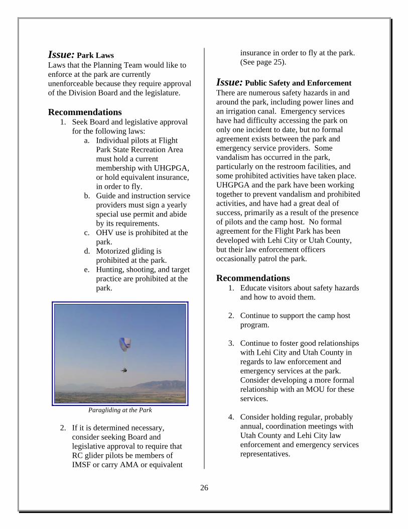
Issue: Park Laws Laws that the Planning Team would like to enforce at the park are currently unenforceable because they require approval of the Division Board and the legislature. Recommendations
1. Seek Board and legislative approval for the following laws:
a. Individual pilots at Flight Park State Recreation Area must hold a current membership with UHGPGA, or hold equivalent insurance, in order to fly.
b. Guide and instruction service providers must sign a yearly special use permit and abide by its requirements.
c. OHV use is prohibited at the park.
d. Motorized gliding is prohibited at the park.
e. Hunting, shooting, and target practice are prohibited at the park.
Paragliding at the Park
2. If it is determined necessary,
consider seeking Board and legislative approval to require that RC glider pilots be members of IMSF or carry AMA or equivalent
insurance in order to fly at the park. (See page 25).
Issue: Public Safety and Enforcement There are numerous safety hazards in and around the park, including power lines and an irrigation canal. Emergency services have had difficulty accessing the park on only one incident to date, but no formal agreement exists between the park and emergency service providers. Some vandalism has occurred in the park, particularly on the restroom facilities, and some prohibited activities have taken place. UHGPGA and the park have been working together to prevent vandalism and prohibited activities, and have had a great deal of success, primarily as a result of the presence of pilots and the camp host. No formal agreement for the Flight Park has been developed with Lehi City or Utah County, but their law enforcement officers occasionally patrol the park. Recommendations
1. Educate visitors about safety hazards and how to avoid them.
2. Continue to support the camp host
program.
3. Continue to foster good relationships with Lehi City and Utah County in regards to law enforcement and emergency services at the park. Consider developing a more formal relationship with an MOU for these services.
4. Consider holding regular, probably
annual, coordination meetings with Utah County and Lehi City law enforcement and emergency services representatives.
26
5. Get information from UHGPGA from their investigation of where Lehi City and Utah County ambulances will take patients, since some prefer to go to Salt Lake hospitals, and the ambulances may not take them there. Provide visitors with this information.
Issue: Signage and Park Boundaries Signboards with park laws are posted at the UHGPGA launch area and RC glider parking lots; these may not be seen or read by all park visitors. Park entrances are indicated by signs along access roads that display the park name. There are multiple ways to enter the park, and because of development on adjacent lands, the entrance that is primarily used by visitors could change. Park boundaries are not marked, and adjacent lands are privately owned, which could pose problems of trespassing, particularly where there are safety hazards. Boundary surveys may have been conducted for portions of the park boundary, but no survey of the entire park boundary exists. Boundary surveys would be needed if fences become necessary for trespass prevention on adjacent lands and where facilities are constructed near park boundaries. Some of the land that is necessary for RC glider recreation is located on an adjacent landowner’s property. The landowner has not, to date, expressed concerns over this, but it would be better for the park to provide this recreational opportunity on property that is owned or legally managed by the Division of State Parks and Recreation. Recommendations
1. When it is clear where the main park entrance road will be, develop a traffic island at the park entrance with a large welcome sign and post park laws there.
2. Consider installing an electronic gate to control access year-round if such control becomes necessary.
3. Supply necessary signs that
UHGPGA will install and maintain.
4. Research existing boundary surveys and work with the Lands Coordinator to determine their accuracy.
5. Communicate with adjacent
landowners and monitor visitor use to determine if trespasses onto private lands become an issue. If so, consider the installation of fences or flexible sign posts; work with UHGPGA to ensure pilot safety.
6. Consider conducting a partial or
complete boundary survey, particularly when development projects occur near park boundaries. This should be done immediately due to price increases each year.
7. Gather more information about the
land on which RC glider pilots recreate that is not owned by the park. Work with the adjacent landowner to buy, lease, contract use and management of, or develop an MOU for use and management of the land necessary to accommodate RC gliding. Potentially also consider the sale of other Flight Park lands that may not be well used for recreation to buy these lands, giving consideration to LWCF requirements. Otherwise, consider finding or developing a suitable alternative location for this activity within park boundaries.
27

Issue: Education and Interpretation A kiosk has been installed at the UHGPGA launch area parking lot, but no information has been provided on it. There are many interesting topics that could be addressed for visitor education at the park. Recommendations
1. Develop interpretive panels to place on the kiosk about the history of flight at Point of the Mountain and the relationship between Utah State Parks and UHGPGA. Provide a bulletin board on one panel of the kiosk for UHGPGA to post club and gliding community information. Provide safety information on the kiosk.
2. Consider providing interpretive
information on the geology of Point of the Mountain and the Jordan River watershed, the entirety of which can be viewed from the park. Also consider providing information on nearby areas where OHV recreation is permitted.
28

Natural Resource Management Natural resources at Flight Park State Recreation Area require improvement projects in order to provide a more safe and enjoyable experience for visitors and to enhance resource quality. Erosion is a concern because of the steep slope of the hill, and vegetation is necessary to hold soils in place. Current vegetation cover is predominantly noxious weeds that can endanger pilots. These should be replaced by a native plant species that will provide soft launches and landings and be more visually appealing to visitors who are not at the park to glide. Additionally, some contouring needs to take place to improve recreational opportunities and visitor safety.
Issue: Erosion Erosion can become a problem on the steep hill, particularly if any vegetation is removed. Recommendations
1. Repair areas where erosion is a problem using native plants and matting to stabilize and reseed the soil.
2. Secure present soils with vegetation
that has a low impact to pilots.
Paragliding at the Park
Issue: Topography The “Gash,” a large gully on the hill, is a safety hazard; some pilots like to do tricks in the updrafts created by the Gash, but at least one person per year is injured as a result. The UHGPGA landing zone is uneven; visitor safety and enjoyment would be improved by flattening it and making the area more obvious. The small hill near the UHGPGA landing zone parking lot is a good place for instruction, and could be better if it were contoured. The launch and landing area for the RC gliders is narrow and uneven, which can cause damage to expensive equipment. This should be flattened and a suitable surface should be found to cover the flattened area; the area is
29
Issue Area: Natural Resource Management Key Issues and Recommendations:
Minimize erosion by repairing existing problems and planting vegetation with low impacts to pilots
Fill in the “Gash” and flatten the UHGPGA landing zone and the RC glider launch and landing area
Noxious weeds at the park are bad for the soil and cause a tripping hazard for pilots • Work with experts to eliminate
noxious weeds and replace them with native plant species that are safe for pilots
• In the long term, consider re-vegetation of the RC glider area, launch area, landing zone, and instruction area with soft, drought-resistant grasses

currently covered with old carpets subject to weather damage. Recommendations
1. Fill in the Gash, possibly using materials from the pile north of the UHGPGA launch area parking lot.
2. Flatten the UHGPGA landing zone
and take appropriate efforts to prevent erosion and noxious weed establishment.
3. Consider contouring the small
instruction hill.
4. Flatten a wider area for the RC glider launch and landing pads, and work with IMSF to assess the need for surfacing the area. Consider providing more weather-resistant pads or drought-resistant grass.
Issue: Vegetation and Noxious Weed Management Noxious weeds and invasive plant species are prevalent in the park. Tall plants, mostly weeds, in the UHGPGA launch, landing, and instruction areas are a tripping hazard for pilots and can damage gliders. The landing zone is being mown as necessary by park staff because of these safety concerns, but mowing weeds generally releases seeds and causes site disturbance that can promote further spread of the weeds. The UHGPGA launch area, landing zone, and RC glider areas would be more attractive to visitors and more enjoyable for pilots if they were vegetated with soft grasses. It is possible that so doing would require irrigation, which would be costly and difficult to accomplish, especially without creating problems of erosion.
Recommendations 1. Work with the Utah County Noxious
Weed Program and State weed removal experts to eliminate noxious weeds and reseed soils with native plants that will not be hazardous for pilots. Consider the use of weed mats.
2. Until weed elimination and re-
vegetation can be accomplished, continue mowing when necessary. UHGPGA will clear weeds from some locations on the slope above the landing zone to provide clear areas for instruction and for pilots not wishing to launch from the top of the hill.
3. In the long term, explore the
feasibility of and make an effort to re-vegetate the RC glider area and UHGPGA launch, landing, and instruction areas with soft, appealing grasses, preferably native, but at least a drought-resistant species.
30

Anticipated Future Use and Development Landowners adjacent to Flight Park State Recreation Area are commercial and residential development companies and gravel quarrying companies. These companies have plans to expand their respective land uses, to include continued quarrying activities, building residential neighborhoods, and the construction of a multi-use development that is expected to include the tallest building in Utah. The park needs to be prepared for the changes in use, community, and visitation that could occur from these plans on adjacent lands. Part of that preparation will be to anticipate and provide opportunities for future recreational uses in the park that will accommodate the existing flight-related activities as well as the activities in which growing local populations will want to participate. More information needs to be collected about current and anticipated future visitors in order to assess their preferences and provide appropriate recreational opportunities at the park.
RC Glider Pilot at the Park
Photo provided courtesy of Erik Vogel
Issue: Adjacent Land Use and Development Geneva Rock and Staker Parson are continuing to quarry for gravel on Point of the Mountain; wind patterns are affected by the topographical changes caused by this activity. The Five Star Hotel and Event Center development expected to be built just south of the park will affect the park’s viewshed and could affect wind patterns. Traverse Mountain Development has plans to continue expanding their residential construction toward and along the southern and eastern boundaries of the park. Recommendations
1. Continue to develop and foster good relationships with adjacent landowners. Make a concerted effort to be involved in the planning of all
31
Issue Area: Anticipated Future Use and Development Key Issues and Recommendations:
Work with adjacent landowners in planning for the park and surrounding lands
Provide spectator facilities Develop more diverse recreational
opportunities at the park, including providing facilities for spectators and considering the designation of a kite-flying area
Work with local organizations developing trails in the area; consider providing trailhead facilities at the park
Consider creating a site plan for the park for possible zoning and future development
Conduct visitor surveys Develop and implement a marketing
plan for the park

surrounding landowners and government entities. Consider establishing MOUs with these landowners.
Preparation for Hang Gliding at the Park
Issue: Recreational Use and Development The southwest area of the park that has been used by OHV riders is an attractive nuisance, and it will continue to attract illegal use if it is not altered in some way. The southeast area where RC rock crawling enthusiasts and OHV riders recreate needs to be looked at closely to determine whether or not these are park-appropriate activities. Several trails are slated for development very close to the park, including the Bonneville Shoreline Trail, the East Railroad Trail, the Murdock Canal Trail, and likely some Lehi City community/commuter trails. Equestrian use of the park was common many years ago, but has not been seen for several years. New recreational opportunities should be provided for visitors not interested in paragliding or hang gliding in order to increase visitation and diversify user groups. Recommendations
1. Consider restoration work in the area where OHV riders have been recreating. Work with RC rock crawling enthusiasts to ensure that their recreational opportunities are not affected by such work.
2. Coordinate with local governments and organizations planning and developing trails, particularly the Bonneville Shoreline Trail, in the area and consider providing trailheads and other facilities and connections.
3. Provide benches and picnic tables for
spectators.
4. Consider designating a kite flying area between the UHGPGA launch area and the RC glider area.
5. Consider managing for the
occasional sledding and snow tubing use that occurs during major winter snowstorms. Consider allowing UHGPGA to develop a zip line at the park.
6. Consider allowing limited, controlled
OHV use at the park if, and only if, the park is gated and resources become available to develop and maintain an OHV area and provide full-time staff to enforce regulations. If considered, this area should most likely be a small area for children to practice safe riding skills under adult supervision.
7. Use visitor surveys and continue
collaborative planning efforts with the Planning Team to determine what other recreational opportunities might be provided at the park to increase visitation and enhance enjoyment of the area.
32
8. Create a development/site plan for the park to show possible future development and zoning for different uses. Consider marking different recreational zones on the ground

with different colored windsocks where it is important to keep different recreational groups separate for visitor safety.
Issue: Visitation and Marketing While UHGPGA membership records can provide limited information about park visitation, most of what is known is anecdotal. Visitation seems to be generally limited to pilots and RC glider and RC rock crawling enthusiasts; many spectators remain outside the park and/or do not know how to access the park. Efforts should be made to increase visitation and promote diverse uses of the park. It should be anticipated that members of the growing residential communities adjacent to the park will use the park as their local recreation area. Recommendations
1. Conduct visitor surveys of current park users and of adjacent residential community members. Use the information gathered to influence park planning and development.
2. Consider installing a road counter.
3. Develop and implement a marketing
plan for the park. Explore partnership opportunities with local and national businesses and organizations, including Cabela’s and the Salt Lake County Flight Park.
4. Explore the possibility of installing a
sign on the interstate directing people to the park.
33

34
This page intentionally left blank

This plan is a blueprint to help implement the Planning Team’s recommendations. As such, it outlines the initial steps to be taken in concert with park visitors, local communities, and other interested users to: properly develop facilities to meet diverse visitor needs; ensure adequate staffing and funding; protect the natural resources of the park; enhance the park’s impact on the community, and the state and local economies; and educate visitors and community members about the park and its resources. The recommendations contained in this plan conform to the Planning Team’s mission of providing a safe environment for a variety of air and land-based recreation opportunities and to serve as a hub for the local gliding community. The plan’s recommendations effectively address the current needs for facility development, resource protection, park operations, land management, and cooperative efforts. However, it is crucial that adequate funding be received to implement these goals and accommodate visitor needs. The plan’s success is dependent upon the continued support of stakeholders. Stakeholders must continue their efforts to support park improvements, preserve park resources, interact with local communities, and strive to meet the expectations of park visitors in the midst of a rapidly growing community of recreation-oriented citizens. The recommendations contained within this plan were based upon an open and collaborative process. It is imperative that this collaborative spirit continues as the plan’s components are implemented. It is also imperative that the document be reviewed on a regular basis to ensure its viability, relevance, and usefulness. This
document has sufficient flexibility to be amended in response to changing resource conditions, visitor needs and expectations, community needs, and agency priorities. Such amendments may occur under the auspices of the Division of State Parks and Recreation. Any such changes will include input from park visitors, local citizens, community leaders, park management, or other stakeholders with interests relevant to the operation and maintenance of the park.
35
Conclusion

36
This page intentionally left blank

Bennett, Holly Godsey. (2003). Glaciers and Lake Bonneville. Draft. (Salt Lake City, UT: Utah Department of Natural Resources. Utah Geological Survey). Biek, Robert F. (2005). Geologic Map of the Jordan Narrows Quadrangle, Salt Lake and Utah
Counties, Utah. (Salt Lake City, UT: Utah Department of Natural Resources. Utah Geological Survey).
Biek, Robert F. (2005). The Traverse Mountains: New Geologic Maps and Explosive Suburban
Growth. Utah Geological Survey: Survey Notes, 37:2, 1-5. (Salt Lake City, UT: Utah Department of Natural Resources. Utah Geological Survey).
Biek, Robert F. and Mark Milligan. (6 November 2007). Park geology. Personal communication. Godsey, Holly S. et al. (2005). Don R. Currey Memorial Field Trip to the Shores of Pleistocene
Lake Bonneville, in J. Pederson and C.M. Dehler, eds. Interior Western United States: Geological Society of America Field Guide, 6, 419-448.
Greenbaum, Jeff. (updated 24 May 2007). Paraglider Kiting with Preset Hands. Available
online. http://www.paragliding-tales-and-reviews.com/paraglider-kiting.html Haley, Mike. (2 January 2008). Park history. Personal communication. Hudonjorgensen, Ken. (circa 1998). Presentation booklet supporting protection of flight at the
Point of the Mountain. Provided by Mike Haley. Hudonjorgensen, Ken. (10 January 2008). Park history. Personal communication. Meakin, Bob. (n/a). History of the Point. Available online.
http://www.uhgpga.org/HistoryofthePoint/tabid/192/Default.aspx Robinson, Doug. (7 June 2001). Coming to the Point: Utah Landmark is Mecca for Gliders
Worldwide. The Deseret News, A09. Schofield, Ian, Paul Jewell, Marhorie Chan, Don Currey, and Matt Gregory. (2004). Shoreline
Development, Longshore Transport and Surface Wave Dynamics, Pleistocene Lake Bonneville, Utah. Earth Surface Processes and Landforms, 29:13, 1675-1690.
Southwest Regional Gap Analysis Program. Land Cover Descriptions. Available online.
http://ftp.nr.usu.edu/swgap/data/landcover/descriptions/landc_database_report.pdf State of Utah. The Ice Age in Utah. Powerpoint presentation. (Salt Lake City, UT: Utah
Department of Natural Resources. Utah Geological Survey). Available online. http://geology.utah.gov/teacher/ppt/iceage.ppt
37
References

Steorts, Lee. (2006). A History of Soaring in Utah 1927-1950, Utah Soaring Association 1964-2006, a Tribute to a Pioneer of Soaring Frank Kelsey. Self-published document.
Vogel, Erik. (31 January 2008). Park history. Personal communication.
38

Map 2: Flight Park State Recreation Area Facilities (showing the existing facilities at the park) Map 3: Potential Future Developments at the Flight Park (showing areas of the park discussed in the Issues and Recommendations section of this document where changes and developments might take place) Map 4: Ownership of Lands Adjacent to the Flight Park (showing the most recent data known about ownership of lands adjacent to the park)
39
Maps

40
This page intentionally left blank

41

42
This page intentionally left blank

43

44
This page intentionally left blank

45

This page intentionally left blank
46

Appendix A: Summary of Public Comments and Responses and Changes Made from the Draft Area Management Plan
47
Appendices

This page intentionally left blank
48

Summary of Public Comments and Responses
and Changes Made from the Draft Area Management Plan
Change: Park History The Draft AMP did not reflect the complete history of ownership and acquisition of the park’s lands. Both Staker and Parson Companies and UDOT donated the park lands in 2006, which was used to satisfy some standing conditions with Land and Water Conservation Fund (LWCF) dollars. The application of LWCF conditions to the land requires that the Flight Park property can only be used for public outdoor recreation. The final AMP reflects this information. Change: Contracts for Management and Use of the Park The Draft AMP stated that consideration should be given to requiring RC glider pilots to be insured through IMSF. Insurance is not offered to RC glider pilots through IMSF in the same way that it is to pilots through UHGPGA. IMSF requires that its members carry insurance through the Academy of Model Aeronautics, which is currently the only RC glider insurance available. The final AMP reflects this information. Change: Funding; Signage and Park Boundaries A recommendation associated with the Planning Team process was to consider selling the park lands in the field south of the current entrance road. Because Flight Park lands are subject to LWCF conditions and limitations, it is possible that the lands in question could only be sold if equivalent lands were bought for recreation at the Flight Park. Park management could explore the feasibility of selling the land in the field that is not likely to be used for recreation in order to buy the off-park land that the RC glider pilots are using for their activity. Change: Funding A planning team recommendation was to avoid charging entrance fees at the park at the time of adoption of the AMP. Fees will not be charged initially, but could become necessary in the future to fund park operations, as well as facility development and maintenance. Partnerships with other organizations and businesses could also fund or facilitate these actions. Change: Park Laws Throughout the document, where park rules were discussed, the text has been changed to park laws. Beginning in 2009, all enforceable regulations in state parks must be approved by both the Division’s Board and the State Legislature, thereby making those regulations state laws rather than park rules.
49
Appendix A

50
This page intentionally left blank
51
