architectural analysis of the moqi inca site by shawn
TRANSCRIPT
ARCHITECTURAL ANALYSIS OF THE MOQI INCA SITE
By
Shawn Vaughan
Submitted to the Faculty of
The Archaeological Studies Program Department of Sociology and Archaeology
in partial fulfillment of the requirements for the degree of Bachelor of Arts
University of Wisconsin- La Crosse
2013
ii
Copyright © 2013 by Shawn Vaughan All rights reserved
iii
ARCHITECTURAL ANALYSIS OF THE MOQI INCA SITE
Shawn Vaughan, B.A.
University of Wisconsin- La Crosse, 2013
In the Andes region of South America grew one of the largest and most powerful empires in the history of the world, the Inca. These master architects, planners, logisticians, and warriors expanded rapidly from the central valleys of Peru and across a wide swath of the South American continent before ultimately falling at the hands of the Spanish invaders. During their approximately one hundred year long reign however, the Inca created a vast administrative network as they expanded and as a result, a number of smaller settlements and outposts were strategically built along the various roads that crisscrossed this mountainous region. One such site is Moqi, located in the Locumba Valley of Southern Peru. It is here that we may find answers surrounding the expansionary tactics of the Inca as well as the systems they put in place to rapidly build an empire from the ground up.

iv
ACKNOWLEDGEMENTS First and foremost, I would like to thank my family and friends for helping me to get this far in
my life. I would not be here without all their help and support. Big thanks to my mom and sister
in particular for just being there for me throughout this very stressful process. And finally,
though he is no longer here to see, a thank you to my dad for always pushing me to learn and
better myself. I probably wouldn’t even have an interest in Archaeology if it weren’t for him, so
I hope I’m doing him proud.
Additionally, I would like to give a very special thank you to Dr. Colleen Zori who has
provided me with a wealth of data and resources with which to actually research my topic and
has been acting as something of a mentor along the way. I literally couldn’t do this without her.
I would also like to thank Dr. Joseph A. Tiffany and Dr. Timothy McAndrews for all
their guidance and advice throughout this project as well as throughout my undergraduate career
at UWL. If it weren’t for Dr. McAndrew’s Archaeology of the Andes class, I likely would not
have even developed an interest in that part of the world. And don’t even get me started on Dr.
Tiffany’s constant wise cracks and lame jokes (truly, I’m going to miss them). And last, but
certainly not least, I would like to thank my peer readers, Kimberly Witalka and Benjamin
Ziegler, for all of their help and advice.
1
INTRODUCTION
The Inca Empire of the Andes region in South America is widely considered one of the most
influential and largest civilizations in the world. They were a highly organized and structured
society that managed to create an expansive road system across their territory and were masters
of logistics, yet they had no writing system of their own (though they did have the quipu).
Because of this, much is still unknown about this once great empire, but through the excavation
and study of Inca archaeological sites, we can find other ways to understand them. One such site
is Moqi, located in the highlands of Southern Peru, to the Northeast of the modern day city of
Tacna. In actuality, the Moqi site is divided into two parts, Moqi Alto and Moqi Bajo. It is
important to distinguish between these divisions because there are visible differences between
them that will factor into this study.
In terms of archaeological study, last summer was the inaugural dig season, an expedition
of which I was a part. Because the work has just begun at this particular location, much about the
site is still unknown, such as its function and purpose in general. The project director for the
Moqi dig, Dr. Colleen Zori of UCLA, believes that the site may have been a hub for the
production, storage, and distribution of Chicha, essentially a beer-like beverage made from corn
that was an important commodity to the Inca. In order to discover if this hypothesis is true, it is
critical to understand the layout of the Moqi site as well as the type and style of architecture there
in relation to other similar Inca settlements that are known to have been growing corn and
producing or storing Chicha.
2
Does Moqi fit into any previously accepted patterns or is it unique? Additionally, what other
possible explanations are there for the purpose of the Moqi site? By looking at architectural
analysis data, maps, GIS survey data, and other field notes and observations, we may begin to
see more clearly the function (or functions) of Moqi and its role in the Inca Empire.
BACKGROUND
The Inca Empire
The Inca created the largest empire in all of pre-Columbian America, and they did so over the
course of only about one hundred years. Between approximately A.D. 1438 and 1533, the Inca
spread outward from the Andean highlands of central Peru and eventually their sphere of
influence covered parts of Ecuador, Colombia, Chile, Argentina, and Bolivia as well (Stanish,
2001). This vast and rapid expansion, which actually rivals ancient Rome in terms of scale, was
done with a mixture of military conquest, peaceful assimilation, and economic dominance. At the
center of all of this was the capital city of Cusco, which is located in the Watanay River Valley
of Central Peru. A single emperor or king called the Sapa Inca, or “child of the sun” in the native
Quechua language led the Inca and was to be worshipped alongside the sun god, Inti (Reinhard
et al. 2010). The Inca did not generally discourage or ban the religious and spiritual practices of
those they had subjugated, however the worship of the Inti and the Sapa Inca was strongly
encouraged (whether this was done through military force or other means is not known). As a
result, they made this the primary religion above other cults such as ones surrounding the
Pachamama, or Mother Earth.
As stated previously, the Inca were known for their ingenuity, architectural prowess, and
high level of organization. They are perhaps most famous for constructing a vast road system
3
that crisscrossed the Andes, connecting Cusco with the furthest edges of the empire. The Inca are
also known for the wondrous site of Machu Picchu, a small city literally built on and carved into
the crest between two mountain peaks. This high level of knowledge and skill allowed the Inca
to quickly and efficiently put into place the infrastructure needed to smoothly manage and
expand their empire; all of which they accomplished without any formal writing system. The
closest thing they had to a written language is known as the quipu, a complex form of accounting
or record keeping made using strings or threads with knots in them to represent different values.
Because there is no written codex associated with the quipu, there is really no way of interpreting
what each individual quipu represents or what sort of values were used in their logistical
practices. Regardless, most Andean scholars assume that it was grounded in a base ten number
system, which was used to keep track of payments and trade goods (Ascher et al. 1981).
In addition to the quipu, the Inca devised a rather brilliant system of taxation called the
mit’a that required individual citizens, usually the men, to pay taxes and tribute to the empire
with labor (McEwan 2006). The Inca could then draft these taxpayers to build public works
projects such as roads or terraces, work in mines or agricultural fields, or produce artisanal wares
such as ceramics or textiles. This system allowed for a very efficient and organized workforce
that could quickly be directed where necessary. Additionally, another system known as the
mitmaq was practiced by the Inca, which allowed them to move groups of people of varying size
throughout the empire at will (McEwan 2006). For example, if the Inca had recently conquered a
region and were still facing civil unrest from the locals, they could either move the locals to a
different part of the empire with more loyal citizens to keep them in check or alternatively move
loyal citizens there to stabilize the region. These two systems were likely often used in concert
with one another in order to maximize the labor output of any given settlement or region. As a

4
means of placating any resistance as well as thanking loyal citizens for their contributions, the
Inca used vast quantities of Chicha as a show of reciprocity and appreciation (Hyslop 1990).
As a result of this, Chicha, a beer like substance fermented from corn, became one of the
primary trade goods in the Inca Empire. Because it was so valuable to the Inca and could be used
for bartering as well as to maintain economic and social control among conquered groups, they
understandably needed to produce it in large quantities. Therefore, it is possible that there may
have been dedicated sites and settlements throughout the empire for the production and storage
of corn as well as the fermentation of Chicha. One such site may have been Moqi.

5
Moqi
The Moqi site is located in the upper Locumba Valley of Southern Peru, approximately 80 miles
northeast of the modern city of Tacna (Figure 1).
Figure 1. Map showing the location of Tacna and the Locumba Valley region. (Map courtesy of
Google Earth and Bluesky).
It is situated on a ridge that juts out between two modern villages, Borogueña and Cambaya,
which are located on either side of the valley opposite one another. It is entirely likely that during
the time that Moqi itself was settled, there were also people living at both locations where the
modern villages of Boroguena and Cambaya are currently located, making the placement of
6
Moqi inherently strategic. Moqi has a spectacular vantage point looking down the valley, as well
as the two villages, and very few ways to actually enter and exit the site from. This made Moqi a
defensible location, which could have served as a forward base of operations during the time the
Inca were expanding into this valley and the surrounding region. Additionally, this made Moqi a
good place to maintain and defend trade routes from once everything had been established.
Furthermore, two streams that eventually merge further down valley to form the Locumba River
flank the central ridge upon which Moqi is located. This is potentially advantageous for a variety
of reasons, being that water is the most precious resource there is in the extremely arid climate of
the region, but chiefly it enabled more versatile and widespread use of irrigation. As previously
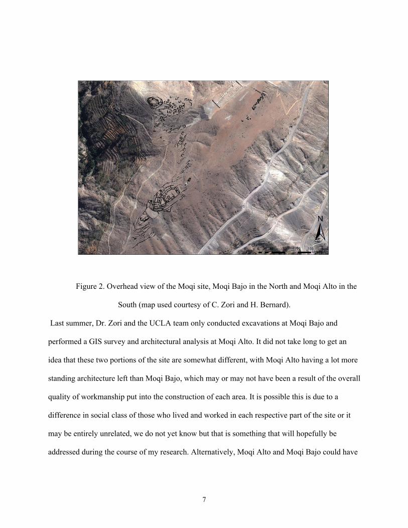
mentioned, the Moqi site is broken down into two parts, Moqi Alto and Moqi Bajo (Figure 2).
7
Figure 2. Overhead view of the Moqi site, Moqi Bajo in the North and Moqi Alto in the
South (map used courtesy of C. Zori and H. Bernard).
Last summer, Dr. Zori and the UCLA team only conducted excavations at Moqi Bajo and
performed a GIS survey and architectural analysis at Moqi Alto. It did not take long to get an
idea that these two portions of the site are somewhat different, with Moqi Alto having a lot more
standing architecture left than Moqi Bajo, which may or may not have been a result of the overall
quality of workmanship put into the construction of each area. It is possible this is due to a
difference in social class of those who lived and worked in each respective part of the site or it
may be entirely unrelated, we do not yet know but that is something that will hopefully be
addressed during the course of my research. Alternatively, Moqi Alto and Moqi Bajo could have
8
each served very different functions and the difference in architectural quality and layout could
be attributed to that. Either way, it is the purpose of this study to find out.
METHODOLOGY
In order to understand best the function and purpose of the Moqi site, it is imperative to look at
other Inca sites to draw comparisons. The sites that I will use for comparative purposes are
Ollantaytambo, a military stronghold, and Huanuco Pampa, a massive administrative center with
documented evidence of Chicha production. It is my view that each site, being wholly different
from one another, will provide the perspectives necessary in defining both Moqi site localities. I
will be using GIS survey data, maps, photos, field notes, various reports and observations from
Moqi, as well as my own notes and work from my time there, to compare to the work of other
archaeologists at the aforementioned sites. By looking at a variety of books, journals, and
dissertations I hope to be able to establish a pattern or set of parameters with which to look better
at and judge the layout of Moqi in relation to access patterns, usage, settlement planning, and
construction. Hopefully, by gaining an understanding of key features, as well as the layouts of
other sites, I will be able to determine what Moqi was used for and if it fits in to any patterns of
Inca imperial expansion. Additionally, it is imperative to at least briefly examine the types of
artifacts found during the excavations around Moqi Bajo. These objects can tell us a little more
about how the people lived and the types of daily activities they may have engaged in, which in
turn may provide clues as to the usage patterns of individual sections and structures at the site.

9
ANALYSIS
When constructing their cities, towns, villages, and outposts the Inca did not typically plan and
build in the same ways that Europeans, such as the Spanish (and the Romans before them) did. In
other words they did not use a square grid in their plans, so cities were not placed on an exact
East-West or North-South alignment, which is the way that almost all modern American cities
are constructed including La Crosse. This grid alignment creates evenly spaced blocks and
streets crossing at right angles, which allows for straight roads and makes it easier to expand the
settlement outwards in any given direction. However, this is not often practical in the Andes
region with its steep mountains and valleys. The extraordinarily uneven terrain poses a number
of problems for anyone trying to live here, let alone build here. In response to challenging
Andean terrain, the Inca devised two different styles of layout plan called the orthogonal plan
and radial plan.
The orthogonal plan results in unevenly spaced, angled rectangular blocks (almost a
rhombus shape) and perpendicular curving streets or paths (Hyslop 1990). This form of
settlement plan allowed the Inca to build with the contours of the topography and more easily
adjust their construction to the terrain variations. In short, the orthogonal plan can closely
resemble an irregular or uneven version of the grid plan, but makes it possible to build on, into,
and along a wider variety of terrain. An example of this is the site of Ollantaytambo, one of the
aforementioned sites that will be discussed later in this thesis.
10
The radial plan, on the other hand, was generally more commonly used and was partially
based on the layout of Cuzco, the capital city. This method of city planning involves radiating all
the roads and paths outward from a large central plaza, which divides the city into different
sectors (Hyslop 1990). An example of this style of planning can be seen at Huánuco Pampa
(Figure 3), the other site chosen for comparison with Moqi.
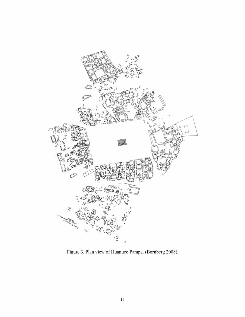
11
Figure 3. Plan view of Huanuco Pampa. (Bornberg 2008).
12
When comparing Figure 3 with Figure 2, it becomes obvious that Moqi likely was likely not
built using a radial plan and is more reminiscent of the orthogonal style due to the very
treacherous and uneven terrain at the location. Huanuco Pampa was built in a flatter location and
thus could be spread out evenly in all directions, much like Cuzco. However, that does not
necessarily mean that Moqi was not similar to Huanuco Pampa in other ways, just that the
topography and environment around a site play a much greater role in determining the layout.
Site Layout
As previously discussed, Moqi consists of two parts; Moqi Alto and Moqi Bajo. These sections
are primarily separated by elevation with Moqi Alto on the higher portion of the central ridge
overlooking the valley, and Moqi Bajo to the North of the ridge on a lower and somewhat flatter
outcropping. This can be seen to some degree in Figure 2, however it is admittedly difficult to
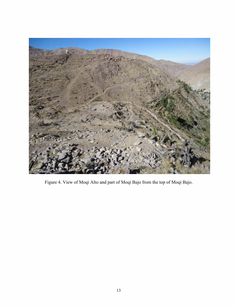
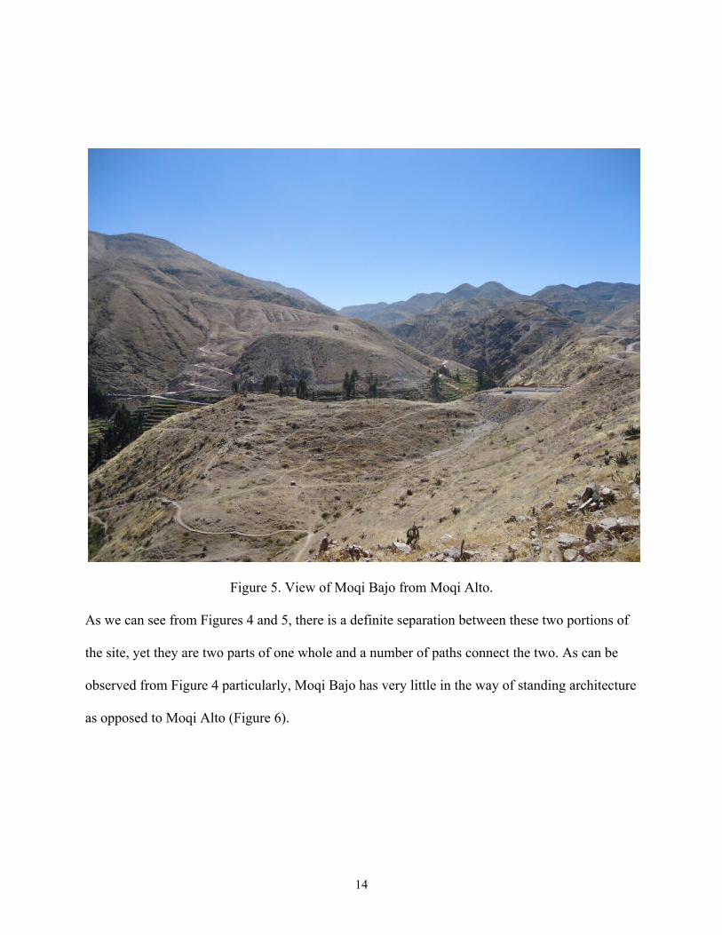
pick out the real scope of the elevation difference from an aerial perspective. Figures 4 and 5 are
taken from Moqi Alto and Moqi Bajo, respectively, facing one another.
13
Figure 4. View of Moqi Alto and part of Moqi Bajo from the top of Moqi Bajo.
14
Figure 5. View of Moqi Bajo from Moqi Alto.
As we can see from Figures 4 and 5, there is a definite separation between these two portions of
the site, yet they are two parts of one whole and a number of paths connect the two. As can be
observed from Figure 4 particularly, Moqi Bajo has very little in the way of standing architecture
as opposed to Moqi Alto (Figure 6).

15
Figure 6. Central Moqi Alto as viewed from the main processional path.
It is quite obvious that Moqi Alto had more grand monumental architecture; which is not to say
that Moqi Bajo was some poorly constructed slum. In fact, part of the reason why much of Moqi
Bajo’s architecture is in a more horizontal state these days is due to the locals using a large
portion of the stones and blocks from there to construct the nearby modern cemetery (it can be
seen partially in the background of Figure 5). It was simply more practical for the people to reuse
the materials from Moqi Bajo because it is a less taxing hike between there and the location of
the cemetery as opposed to walking all the way up and down the steep paths to Moqi Alto. Based
on some of the findings of the excavations at Moqi Bajo, it can be surmised that this portion of
the site was likely domestic in nature, at least in part. It should be noted that the plaza at the top

16
of Moqi Bajo was of a higher quality construction and much of the artifactual evidence collected
indicates that more formalized feasting may have taken place there.
Because of this, some of the structures may also have been made primarily from reeds and other
less permanent materials, which could also explain why the architecture is less monumental. Of
course, without having conducted any excavations at Moqi Alto, it is impossible at this time to
conclude that people were not also living in that portion of the site, because they probably were,
but there may have been a hierarchical difference between them.
In comparison to both the Ollantaytambo and Huanuco Pampa sites, Moqi is significantly
smaller. Ollantaytambo was a large military stronghold to the Northeast of Cuzco in the
Urubamba Valley, which was built along and into the steep valley. It was designed specifically
to be one of the Inca’s last lines of defense and only had two natural approaches, one to the west
leading to Machu Picchu and one to the east from Pisaq. Each of these approaches were heavily
fortified and built to keep enemy armies out (Kaufmann and Kaufmann 2006). On the opposite
end of the spectrum, there is Huanuco Pampa, which is located far to the northwest of Cuzco and
built on a large flat plain. This site served as an administrative center that was also a known
production and storage site for chicha. Moqi is, in some ways, a combination of the two, yet in
others radically different from either. Moqi is built in a location that is easily defensible and can
realistically only be accessed from the East or the West; much like Ollantaytambo, because of
the natural channel of the valley. Due to modern construction and modification as well as the
ravages of time, it is impossible to know for sure where the main roads in and out of Moqi once
were and whether or not they could have been closed off in the event of attack. Regardless, it is
likely that the remaining paths that run up and down the valley are an indication that people
probably came up from the coast (West) and down from the highlands (East). Though Moqi did

17
not necessarily have the massive outer walls of a fortress, the terracing all around the ridge and
on top of the hill may have served a similar enough function to dissuade attackers and protect the
site.
Certainly, the location alone would allow for any respectable military garrison to hold against a
modest siege, maybe even repel it if they were knowledgeable enough in military tactics and
warfare. But alas, the size of the site coupled with the lack of fortifications would seem to
indicate that Moqi was likely not primarily military in function. Moqi probably did have at least
a small garrison and may have acted as an outpost defending the valley and the regional trade
routes between other parts of the empire, as most Inca sites did, but the primary function of Moqi
was probably more mundane.
As previously suggested, although the layout of Moqi is more reminiscent of sites such as
Ollantaytambo (albeit on a much smaller scale), its overall purpose seems to be more in line with
administrative and production functions. This indicates that the layout of the site was probably
dictated and determined more by the topography and layout of the location than it was by its
intended purpose. Additionally, Moqi may have been constructed to look more imposing than it
was as a form of social control or “psychological warfare” in order to keep control of the valley.
This is purely conjecture, but it is easy to picture the Inca encountering resistance in the
Locumba Valley during their expansion into the region, as they did in other parts of their empire,
which would have necessitated the use of arguably more totalitarian administration practices to
maintain peace. There is admittedly little to no evidence to support such an interpretation at
Moqi, for the time being at least, mainly due to the fact that excavations at the site have only just
begun, but it is interesting to consider nonetheless.

18
Architecture
In the construction of various settlements, the Inca employed a few basic forms and styles of
architecture, most of which can be easily observed at Moqi. It is no exaggeration to say that the
Inca were skilled builders and masons; they have earned the distinction through their impeccable
talents at carving and shaping stones of all sizes with remarkable precision using decidedly basic
tools. Of course, the grandiose examples of Inca architecture that often come to mind are usually
only those found in the most monumental architecture at places such as Cuzco or Machu Picchu,
which were in part constructed to show off the wealth and power of the elite. It simply would not
be practical to build every structure in every settlement out of the same materials and using the
same methods as those employed to build the great temples and citadels that the Inca are known
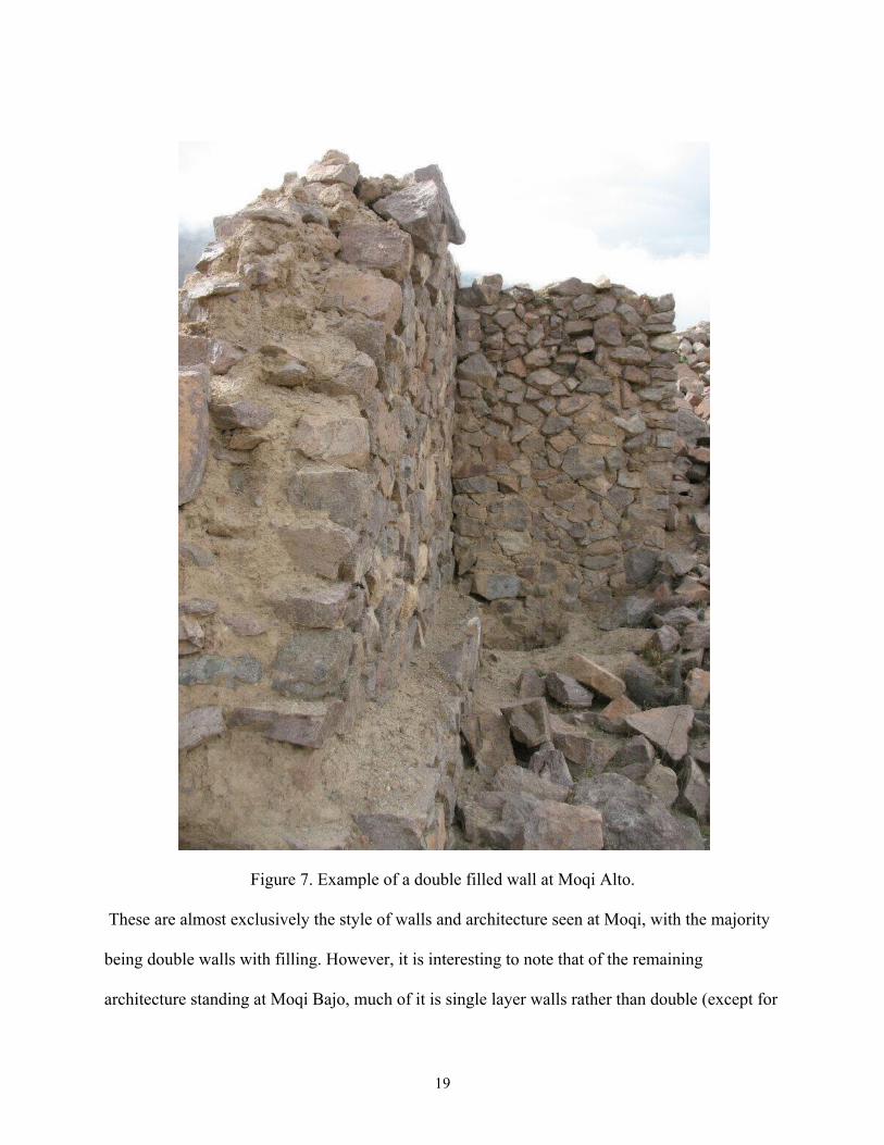
for. Therefore, most Inca structures were built in one of two ways: single layered walls made
with fieldstones and mortar or double layered walls made with semi-worked blocks with a mortar
filling in between the two walls (Hyslop 1990) (Figure 7).
19
Figure 7. Example of a double filled wall at Moqi Alto.
These are almost exclusively the style of walls and architecture seen at Moqi, with the majority
being double walls with filling. However, it is interesting to note that of the remaining
architecture standing at Moqi Bajo, much of it is single layer walls rather than double (except for
20
the structures surrounding the upper plaza which are double filled), which may also be part of the
reason why so little of it is still standing upright. Moqi Alto is composed almost entirely of the
double filled walls and possibly as a result is in much better condition even after hundreds of
years. Even the grandest architecture at Moqi is not made of the massive, perfectly fitted stones
that are often seen at the larger sites throughout the Inca empire (most typically the Inca
heartland in the region surrounding Cuzco), which may be the result of a number of factors
including the types of materials available in the Locumba Valley region. Or perhaps Moqi was in
something of a “backwater” and it was impractical to expend the effort and resources needed to
turn this far flung settlement into something rivaling their greatest marvels. Whatever the reason,
the full truth of it will likely never be known, and in fact it may have been a combination of all of
these factors. Regardless, none of this is to say that Moqi is not significant or that it is somehow
inferior in any way to other Inca sites. On the contrary, this is merely the equivalent of
comparing a small town such as Galesville to a larger one like La Crosse, or even comparing La
Crosse to the Twin Cities. They have different populations and serve different functions.
Aside from these basic styles of construction, the Inca also had two core styles of
building that often made up the majority of settlements: the kancha and the kallanka (Hyslop
1990). The kancha is essentially a rectangular enclosure, usually accomplished using an outer
wall of some sort, that has three or more rectangular structures inside and an open plaza or
courtyard in the center. The kancha can vary in size from relatively small and simplistic to being
quite large. Even the number of buildings enclosed within often varied, some reaching up to
eight structures. At the site of Ollantaytambo, and other sites built using the orthogonal layout
specifically, a kancha or groups of them form the basic “block” units that the city is organized
into. They could be used for anything ranging from domestic houses to temples to workshops.

21
Regardless of the function or scale, the template for the kancha remained essentially the same
throughout the Inca Empire. The other form of basic Inca architecture is the kallanka, long
rectangular halls with gabled roofs that varied in size much like the kancha. These were often
built on the edges of plazas in settlements or alongside main roads and though we can only
speculate on their usage, they may have been used like barracks to house soldiers or even used
for ceremonies, feasts, and festivals (Hyslop 1990). Both forms of architecture are found at
Moqi, at least in some form. There are many kallanka type structures in Moqi Alto, whereas
Moqi Bajo appears to have very few if any at all. The structures at Moqi Bajo appear to be
smaller and fit more with the kancha form, though it can be argued they do not exactly fit that
model either (Figure 8).

22
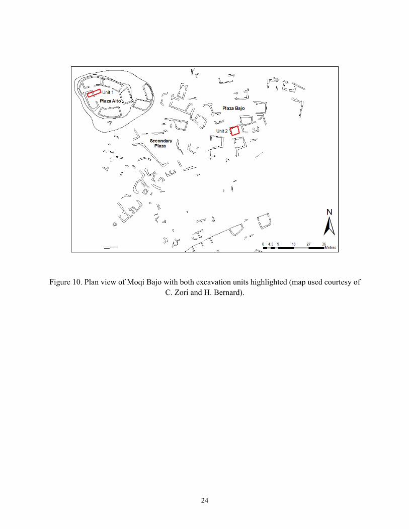
Figure 8. Plan view of Moqi Alto and Moqi Bajo showing just architecture (map used courtesy
of C. Zori and H. Bernard).

23
As we can see from Figure 8, Moqi Alto’s architecture is predominately made up of long,
rectangular structures whereas Moqi Bajo is more scattered and consisting of smaller, more
irregular structures. The top area of Moqi Bajo, which is seen in Figure 8 with a circle
representing terrace walls around it and where excavation unit one was located, does however
seem to be some form of kancha or miniature version of a kallanka, as it is a group of structures
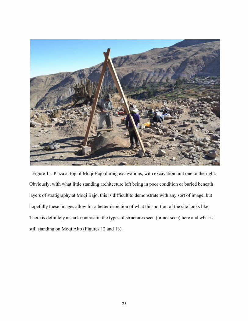
with an open plaza in the middle. Figures 9, 10, and 11 potentially show this from a better
perspective.
Figure 9. Plaza at the top of Moqi Bajo before excavation.
24
Figure 10. Plan view of Moqi Bajo with both excavation units highlighted (map used courtesy of C. Zori and H. Bernard).
25
Figure 11. Plaza at top of Moqi Bajo during excavations, with excavation unit one to the right.
Obviously, with what little standing architecture left being in poor condition or buried beneath
layers of stratigraphy at Moqi Bajo, this is difficult to demonstrate with any sort of image, but
hopefully these images allow for a better depiction of what this portion of the site looks like.
There is definitely a stark contrast in the types of structures seen (or not seen) here and what is
still standing on Moqi Alto (Figures 12 and 13).

26
Figure 12. View of the top of Moqi Alto from the main plaza.

27
Figure 13. Structures on the East edge of Moqi Alto, possibly some form of kallanka.
The aesthetic differences between Moqi Alto and Moqi Bajo are quite apparent based on the
images alone, yet in truth they hardly do the site justice.
Regardless of the forms and styles of structures throughout the Moqi site there is one
constant upon which it is all quite literally built. I am of course referring to the terracing, upon
which the entirety of Moqi is built. The Inca, and many of the other Andean civilizations before
them, used terracing for a great many purposes, not just for agriculture. Terracing is a method of
construction that involves building artificially flat and level platforms, called terraces, on steep
slopes and generally uneven terrain. This creates a series of stair like structures upon which the

28
Inca were able to build or conduct agriculture in locations that would otherwise be entirely
unsuitable or unusable. The location on which Moqi is built is one such place. Without the
terracing, the steep and uneven terrain on and around the ridge of the site would not have been a
viable location to build. Like everything at Moqi Bajo, most of the terracing has eroded away
and is generally in bad shape but at the top of Moqi Alto it is quite apparent that it was necessary
for the Inca to first build a series of flat platforms up the slope and on top of the ridge in order to
build there (Figure 14).
Figure 14. Example of some of the terracing on top of Moqi Alto.
29
In addition to providing a flat and level surface upon which to construct, the terracing also
allowed for different levels within the site. Thus, Moqi and many other similar Inca settlements
were almost being built vertically. Instead of expanding outward, the terracing allowed the Inca
to expand their settlements upwards or downwards on sloping terrain. At such sites, it is common
for the majority of important structures and features to be in the most prominent or central
locations. In the case of Moqi, at the far western end of Moqi Alto is the main plaza and at the
far eastern end is what may be a structure known as an ushnu (Figure 15).

30
Figure 15. The spot where the satellite dish and building are may be an ushnu platform.
An ushnu is a raised ritual structure often built either in the center of a settlement or at a sacred
location within the site itself (or in relation to some other sacred location) (Reinhard and Ceruti,
2010). One of the most well known and documented of these is located in Huanuco Pampa
within the very center of the massive central plaza of the city (Hyslop, 1990). This central raised
31
platform is where many ritual ceremonies would have occurred, as well as other official state and
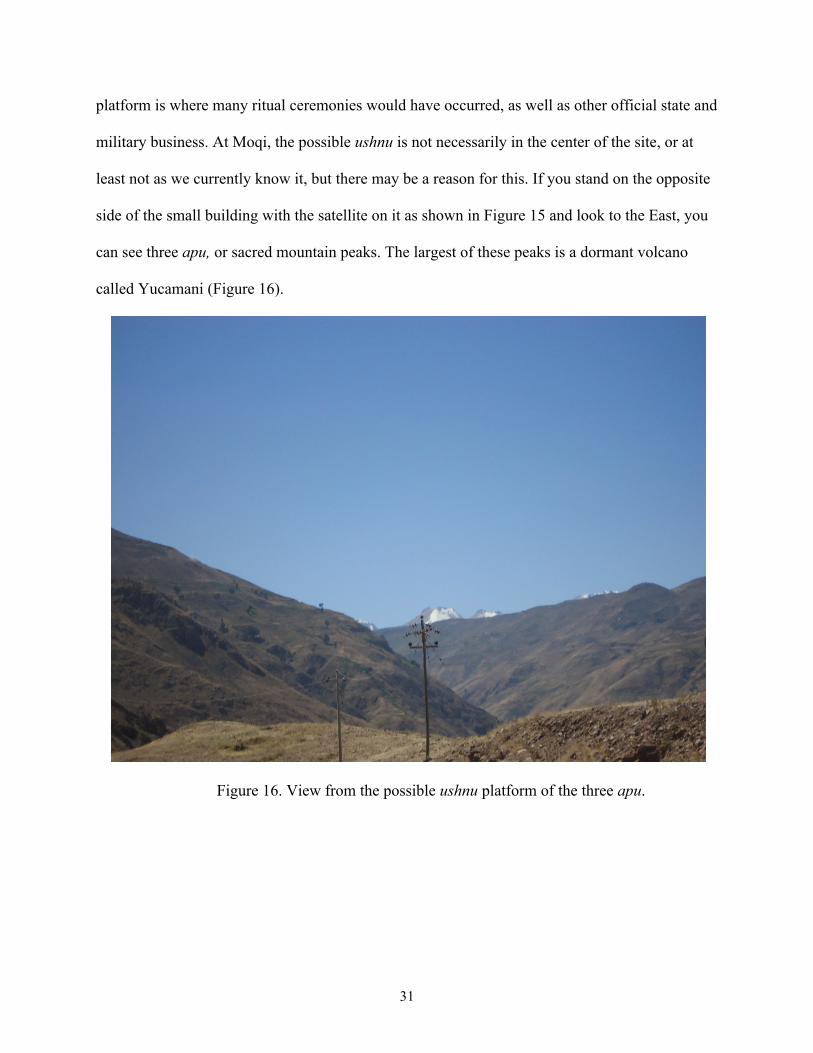
military business. At Moqi, the possible ushnu is not necessarily in the center of the site, or at
least not as we currently know it, but there may be a reason for this. If you stand on the opposite
side of the small building with the satellite on it as shown in Figure 15 and look to the East, you
can see three apu, or sacred mountain peaks. The largest of these peaks is a dormant volcano
called Yucamani (Figure 16).
Figure 16. View from the possible ushnu platform of the three apu.

32
The Inca believed that the mountains were sacred and so Moqi’s orientation with relation to
these three eastern peaks may be at least somewhat intentional. The presence of such a construct
may indicate that Moqi had ritual significance to the Inca, which would mean that it likely had a
fair amount of administrative and bureaucratic power, at the very least at a regional level. It was
often the case that spiritual and religious leaders of the Inca were also part of the governing body
of the empire.
Storage
As previously discussed, Dr. Zori’s current running hypothesis regarding the function of Moqi is
that it may have partly been a chicha production and storage facility. There are a number of
reasons why this may be the case, such as the presence of a large number of stone lined storage
pits (which may have been burials that have since been looted) in and around the site as well as
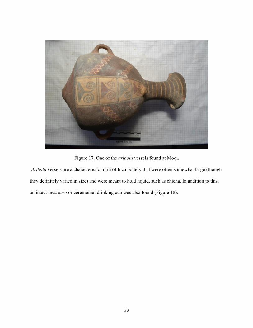
literally hundreds of pottery sherds and fragments from what appear to be Inca aribola vessels.
In fact a couple of nearly intact specimens were recovered from mortuary contexts during the
excavations of Moqi Bajo (Figure 17).
33
Figure 17. One of the aribola vessels found at Moqi.
Aribola vessels are a characteristic form of Inca pottery that were often somewhat large (though
they definitely varied in size) and were meant to hold liquid, such as chicha. In addition to this,
an intact Inca qero or ceremonial drinking cup was also found (Figure 18).

34
Figure 18. The qero ceremonial drinking vessel found at Moqi.
The presence of these artifacts indicates that chicha was indeed being consumed at Moqi, but
that does not necessarily mean it was being produced there, unless of course we take into account
the storage pits. Looking back at Figure 2, near the upper right hand corner of the aerial view of
Moqi is a grouping of outlined structures (actually more like pits with rockfall in and around
them that hint at walls) that are too small to be dwellings or any other sort of habitation. Most of
them are round or slightly square in shape and are not very deep, but due to the all the rockfall
around them, were likely some form of upright standing structure. The most logical assumption
to make here is that they were storage, potentially for agricultural goods. If chicha was being
stored here, then perhaps they were used to store the corn harvest from the nearby terraced fields.
Because this region is still used fairly heavily for agriculture today, it is reasonable to assume
that the Inca also used the Locumba Valley and the area around Moqi for agriculture. During the
35
excavations at Moqi Bajo a large assemblage of burnt and visibly modified corn cobs (as if they
had been chewed on for example) were found. In all likelihood if the Inca were eating this much
corn, they were probably growing at least some of it themselves rather than relying solely on
trade with other sites, so it is not a stretch to imagine that they were also using part of this corn
crop to manufacture chicha in some capacity. Aside from the larger storage pits/structures that
are located in the far Eastern portion of the site, there are also smaller stone lined pits throughout
the site proper as previously mentioned. These may have been used to hold large vessels that had
rounded or otherwise non-flattened bottoms in place. Unfortunately, in order to truly find out if
Moqi was a chicha production and storage facility, further excavations must be conducted at both
Moqi Bajo and Moqi Alto, as well as in and around the aforementioned storage pits. Residue
analysis of the various pottery and sherds found at the site should also be conducted to test for
chicha. Yet as it stands, I must concur with Dr. Zori’s hypothesis that Moqi was in all likelihood
at least partially used for the production or storage (or both) of chicha.
RESULTS AND CONCLUSIONS
Based on all of the data that is currently available on Moqi from the excavations and the various
surveys conducted thus far, it would seem that Moqi likely served a number of functions in its
time. Based on comparisons with the site of Ollantaytambo, Moqi was likely not a grand military
fortress or base despite its commanding view of the Locumba Valley and strategically strong
position. However, Moqi probably did have some soldiers stationed there for defense or
peacekeeping purposes. Furthermore, Moqi was not likely a ritual center for the Inca Empire,
despite the possible presence of an ushnu with a line of sight to three sacred mountain peaks.
However, those apu were almost certainly important to the local population that had already

36
been living in the valley before the arrival of the Inca, so this incorporation of the sacred
landscape into the layout of Moqi was almost certainly intentional. In fact, it may be at least part
of the reason why Moqi was built where it was in the first place. Finally, Moqi may have been a
chicha production and storage facility, and the current evidence seems to support it, but without a
significant amount of additional work done at the site, it is not possible to say. Moqi does
ultimately seem to be more similar to the site of Huanuco Pampa than it is to Ollantaytambo.
Much like at Moqi, a significant number of storage and drinking vessels commonly associated
with chicha production and consumption have been discovered at Huanuco Pampa. Additionally,
Huanuco Pampa’s centralized location along multiple main Inca roads leading to each of the four
corners of the empire, made it a hub for the trade and transport of goods. Moqi may have been a
much smaller site in comparison to Huanuco Pampa, but regardless of differences in aesthetics,
layout, and scale Moqi probably served more administrative and production functions than
anything else. Either way, without further excavations of other parts of the site, this cannot yet be
said for certain.
In relation to the rest of the Inca Empire, Moqi does seem to fit a pattern in terms of
construction styles and architectural forms, yet at the same time seems to subscribe to no singular
vision of the “typical” Inca settlement. It has textbook styles of wall construction, terracing, and
buildings yet doesn’t really seem to fit either the orthogonal or radial patterns of settlement
planning.
We have really only seen the tip of the iceberg at Moqi, with only one year of
excavations and survey complete and many more seasons there in the coming years. It is my
hope, and the hope of the other archaeologists involved with the project, that more of the
mysteries surrounding Moqi and the Inca in general become clear as time goes on.
37
BIBLIOGRAPHY
Ascher, Marcia and Robert Ascher
1981 Mathematics of the Incas: Code of the Quipu. Dover Publications Inc. Mineola, New York.
Bornberg, Renate
2008 Identity by Spatial Design: Topos, a Principle Derived from Historic and Vernacular Cultures. Urban Design International 13:182-200.
Chalcaltana, S., C. Dayton, and M. Barrionuevo
2010 Coastal and Highland Storage Systems of the Colesuyu, South Central Andes. 147-148. In Comparative Perspectives on the Archaeology of Coastal South America, edited by R. Cutright, E. Lopez-Hurtado, and A. Martin, pp. 241-246. University of Pittsburgh Memoirs in Latin American Archaeology, Pittsburgh.
Covey, R. Alan
2000 Inka Administration of the Far South of Peru. Latin American Antiquity 11:119-138.
D’altroy, Terence N., Timothy K. Earle, and Terry Y. Levine
1992 Staple Finance, Wealth Finance, and Storage in the Inka Political Economy. In Inka Storage Systems, edited by Terry Y. Levine, pp: 31-61. University of Oklahoma Press, Norman.
Gasparini, Graziano and Luise Margolies
1980 Inca Architecture. Indiana University Press, Bloomington and London. Hyslop, John
1990 Inka Settlement Planning. University of Texas Press, Austin.
38
Kaufmann, H.W. and J. E. Kaufmann
2006 Fortifications of the Incas: 1200-1531. Osprey Publishing, New York. Levine, Terry Y.
1992 Inka State Storage in Three Highland Regions: A Comparative Study. In Inka Storage Systems, edited by Terry Y. Levine, pp: 107-150. University of Oklahoma Press, Norman.
Levine, Terry Y.
1992 The Study of Storage Systems. In Inka Storage Systems, edited by Terry Y. Levine, pp: 3-28. University of Oklahoma Press, Norman.
McEwan, Gordon F.
2006 The Incas: New Perspectives. ABC-CLIO, Santa Barbara, California. Moore, J.
1992 Patterns and Meaning in Prehistoric Peruvian Architecture: The Architecture of Social Control in Chimu State. Latin American Antiquity 3(2): 95-113.
Reinhard, John and Maria Constanza Ceruti
2010 Inca Rituals and Sacred Mountains: A Study of the World’s Highest Archaeological Sites. Cotsen Institute of Archaeology Press, University of California, Los Angeles.
Snead, James E. and Terry Y. Levine
1992 Imperial Infrastructure and the Inka State Storage System. In Inka Storage Systems, edited by Terry Y. Levine, pp: 62-106. University of Oklahoma Press, Norman.
39
Stanish, Charles
2001 The Origin of State Societies in South America. Annual Review of Anthropology, 30:41-64.