archaeological evaluation - cotswold...
TRANSCRIPT
Manor FarmKirtlington
Oxfordshire
Archaeological Evaluation
for
on behalf of Yiangou Architects
Mr Nick Fry
CA Project: 3490 CA Report: 11180
August 2011
Manor Farm Kirtlington
Oxfordshire
Archaeological Evaluation
CA Project: 3490 CA Report: 11180
prepared by Tim Havard, Project Officer
date 22 August 2011
checked by Richard Young, Project Manager
date 26 August 2011
approved by Simon Cox, Head of Fieldwork
signed
date 31 August 2011
issue 01
This report is confidential to the client. Cotswold Archaeology accepts no responsibility or liability to any third party to whom this report, or any part of it, is made known. Any such party relies upon this report entirely
at their own risk. No part of this report may be reproduced by any means without permission.
© Cotswold Archaeology Building 11, Kemble Enterprise Park, Kemble, Cirencester, Gloucestershire, GL7 6BQ
t. 01285 771022 f. 01285 771033 e. [email protected]
© Cotswold Archaeology
1
Manor Farm, Kirtlington, Oxfordshire: Archaeological Evaluation
CONTENTS
SUMMARY........................................................................................................................ 2
1. INTRODUCTION ................................................................................................. 3
The site ................................................................................................................ 3
Archaeological background.................................................................................. 3
Archaeological objectives .................................................................................... 4
Methodology ........................................................................................................ 4
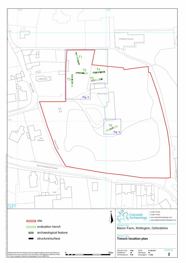
2. RESULTS (FIGS 2-5) .......................................................................................... 5
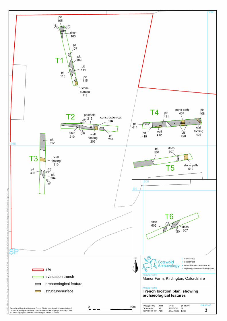
Trench 1 (Figs 2-4) .............................................................................................. 6
Trench 2 (Figs 2-5) .............................................................................................. 6
Trench 3 (Figs 2-4) .............................................................................................. 7
Trench 4 (Figs 2, 3 & 5) ....................................................................................... 7
Trench 5 (Figs. 2-3) ............................................................................................. 8
Trench 6 (Figs 2-4) .............................................................................................. 8
The Finds and Palaeoenvironmental Evidence ................................................... 9
3. DISCUSSION....................................................................................................... 10
4. CA PROJECT TEAM ........................................................................................... 12
5. REFERENCES .................................................................................................... 12
APPENDIX A: CONTEXT DESCRIPTIONS ..................................................................... 13
APPENDIX B: THE FINDS ............................................................................................... 16
APPENDIX C: OASIS REPORT FORM............................................................................ 17
LIST OF ILLUSTRATIONS
Fig. 1 Site location plan (1:25,000)
Fig. 2 Trench location plan (1:1000)
Fig. 3 Trench location plan, showing archaeological features (1:250)
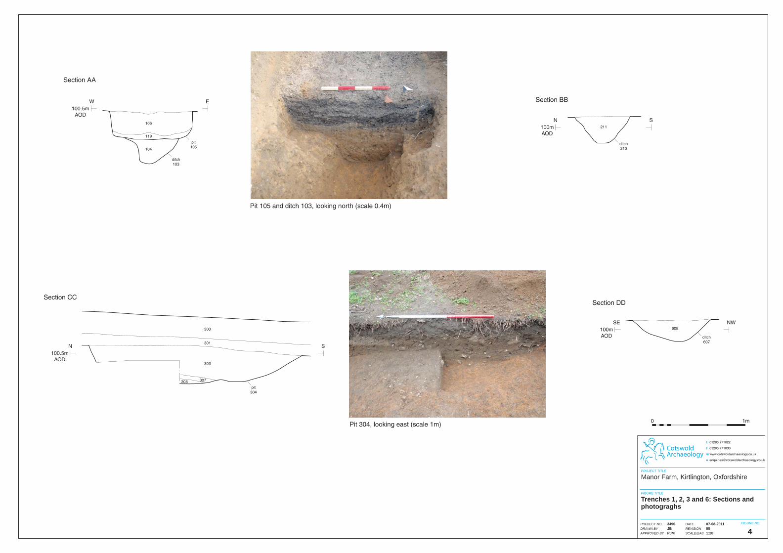
Fig. 4 Trenches 1, 2, 3 and 6: Sections (1:20) and photographs
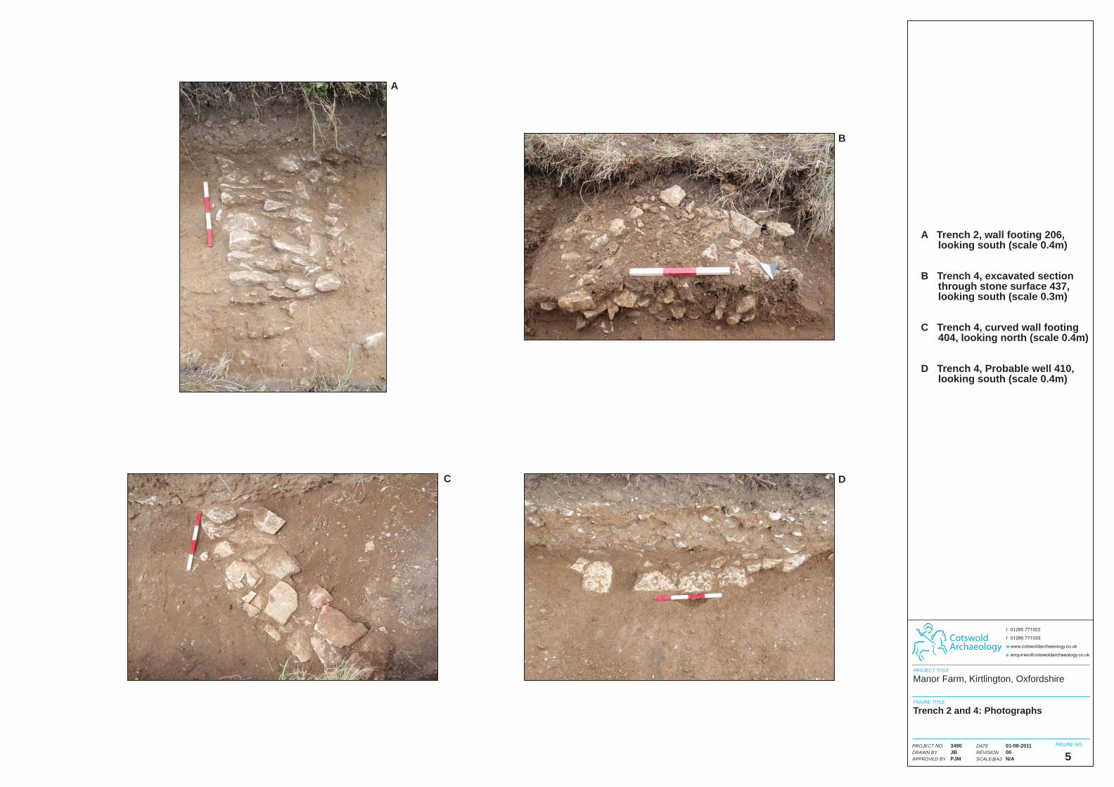
Fig.5 Trenches 2 and 4: Photographs
© Cotswold Archaeology
2
Manor Farm, Kirtlington, Oxfordshire: Archaeological Evaluation
SUMMARY
Project Name: Manor Farm
Location: Kirtlington, Oxfordshire
NGR: SP 5001 1941
Type: Evaluation
Date: 13-18 July 2011
Planning Reference: 10/01716/F
Location of Archive: To be deposited with Oxfordshire County Museum Service
Site Code: MTF 11
An archaeological evaluation was undertaken by Cotswold Archaeology in July 2011 at
Manor Farm, Kirtlington. Six trenches were excavated.
The earliest feature encountered was a pit of probable Roman date. A ditch of Anglo-Saxon
date and a ditch and pit of medieval date were also recorded. At least ten undated pits likely
to represent both storage and quarrying activity were encountered. Undated structural
features comprising a well, wall footings and stone surfaces were observed within the
northern half of the site.
© Cotswold Archaeology
3
Manor Farm, Kirtlington, Oxfordshire: Archaeological Evaluation
1. INTRODUCTION
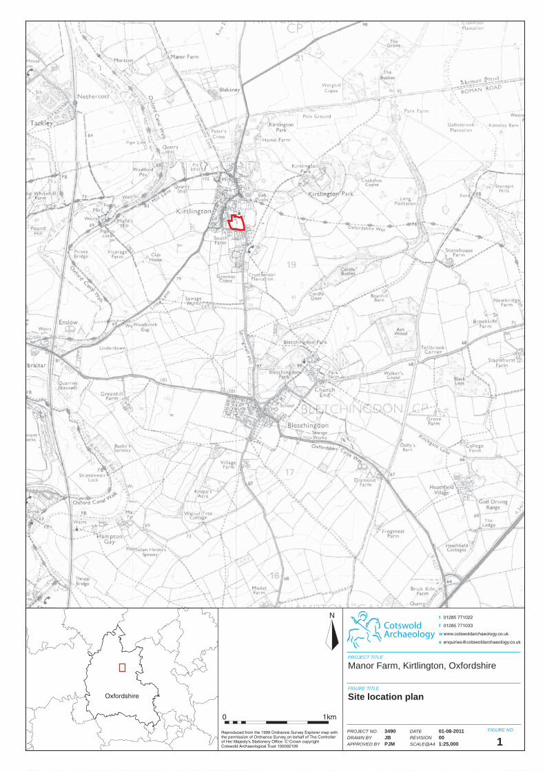
1.1 In July 2011 Cotswold Archaeology (CA) carried out an archaeological evaluation for
Yiangou Architects on behalf of Mr Nick Fry at Manor Farm, Kirtlington (centred on
NGR: SP 5001 1941; Fig. 1). The evaluation was undertaken as a required condition
of planning permission granted by Cherwell District Council (CDC) for the erection of
ancillary buildings providing garaging, pool, gym and ancillary accommodation
(Planning Ref: 10/01716/F).
1.2 The evaluation was carried out in accordance with design brief for archaeological
evaluation (OCAS 2011) prepared by Richard Oram, Planning Archaeologist for
Oxfordshire County Council, the archaeological advisor to CDC, and with a
subsequent detailed Written Scheme of Investigation (WSI) produced by CA (CA
2011) and approved by Richard Oram. The fieldwork also followed the Standard and
Guidance for Archaeological Field Evaluation (IfA 2008), the Management of
Archaeological Projects (English Heritage 1991) and the Management of Research
Projects in the Historic Environment (MORPHE): Project Manager’s Guide (EH 2006).
It was monitored by Richard Oram, including a site visit on 14 July 2011.
The site
1.3 The site comprises a residential property and associated garden covering an area of
1.4ha. It is generally flat and lies at approximately 100m AOD. The development site
is bounded to the north and west by residential properties, to the east by playing
fields and the south by Bletchingdon Road (Fig. 2).
1.4 The underlying solid geology is recorded as Peterborough Member mudstone
(Jurassic era) with the superficial geology recorded as Pleistocene Hanborough
Gravel Member sand and gravel (BGS 2011). Gravelly sand natural substrate was
encountered in all trenches.
Archaeological background
1.5 The site has the potential to contain significant archaeological remains of the Roman
and medieval periods, based on the results of previous archaeological interventions
and its location within the historic core of Kirtlington. Within 500m of the site the
© Cotswold Archaeology
4
Manor Farm, Kirtlington, Oxfordshire: Archaeological Evaluation
Oxfordshire Historic Environment Record (OHER) contains 31 monuments, including
one Scheduled Monument (SAM 154 Moated site – supposed site of John of
Gaunt’s residence) and 20 Listed Buildings.
1.6 A Roman stone building, field system and Saxon settlement were identified during
an evaluation and subsequent excavation c. 250m to the south of the site (OHER
ref: 16989, EOX2269 and EOX2481).
1.7 The site lies c. 100m south-west of the 12th century St Mary’s Church (OHER ref:
5230), where 37 inhumations were observed during a watching brief carried out in
2008 (OHER ref: EOX2634). A possible medieval Shrunken Village was identified to
the west of South Farm (OHER ref: 13284). A watching brief at Long Kensome
identified 11th to 12th century pits (OHER ref: EOX1275).
1.8 Watching briefs at Kirtlington Primary school (OHER ref: EOX1285) and Plot 5, the
Chestnuts (OHER ref: EOX99) produced negative results.
Archaeological objectives
1.9 The objectives of the evaluation are to establish the character, quality, date and
extent of any archaeological remains or deposits surviving within the site. This
information will assist CDC in making an informed judgement on the significance of
the archaeological resource, and the likely impact upon it of the proposed
development.
Methodology
1.10 The fieldwork comprised the excavation of 6 trenches each measuring 15m in length
by 1.5m in width in the locations shown on the attached plan (Fig. 2). Trenches 1, 4
and 6 were positioned over the site of proposed garden features, whilst trenches 2,
3 and 5 were positioned over the footprint of a proposed garage, pool and gym
respectively. Trench 2 was moved approximately 4m to the north from the originally
proposed location due to the presence of an existing well. Trenches were set out on
OS National Grid (NGR) co-ordinates using a Leica 1200 series SmartRover GPS
and surveyed in accordance with CA Technical Manual 4 Survey Manual (2009).
© Cotswold Archaeology
5
Manor Farm, Kirtlington, Oxfordshire: Archaeological Evaluation
1.11 All trenches were excavated by mechanical excavator equipped with a toothless
grading bucket. All machine excavation was undertaken under constant
archaeological supervision to the top of the first significant archaeological horizon or
the natural substrate, whichever was encountered first. Where archaeological
deposits were encountered they were excavated by hand in accordance with CA
Technical Manual 1: Fieldwork Recording Manual (2007).
1.12 Deposits were assessed for their palaeoenvironmental potential in accordance with
CA Technical Manual 2: The Taking and Processing of Environmental and Other
Samples from Archaeological Sites (2003) and no deposits were identified that
required sampling. All artefacts recovered were processed in accordance with
Technical Manual 3 Treatment of Finds Immediately after Excavation (2010).
1.13 The archive and artefacts from the evaluation are currently held by CA at their
offices in Kemble. Subject to the agreement of the legal landowner the artefacts will
be deposited with Oxfordshire County Museum Service along with the site archive. A
summary of information from this project, set out within Appendix C, will be entered
onto the OASIS online database of archaeological projects in Britain.
2. RESULTS (FIGS 2-5)
2.1 This section provides an overview of the evaluation results; detailed summaries of
the recorded contexts and finds are to be found in Appendices A and B respectively.
2.2 A similar stratigraphic sequence was revealed within all trenches. All trenches
contained features cut into the natural substrate and which were sealed by subsoil.
In trenches 1, 3 and 5 some later features were observed to be cut through the
subsoil and sealed by the existing topsoil.
2.3 Following consultation on site with Richard Oram, it was decided that a selection of
features sufficient to characterise the archaeological resource of the site would be
investigated, therefore not every feature was excavated.
© Cotswold Archaeology
6
Manor Farm, Kirtlington, Oxfordshire: Archaeological Evaluation
Trench 1 (Figs 2-4)
2.4 Three intercutting pits, 109, 111 and 113 all measuring approximately 1m in
diameter and cut into the natural substrate were revealed within the southern half of
trench one. These were not excavated but appeared to contain similar silty sand fills
although pit 111 also contained a quantity of limestone rubble. A further
unexcavated pit 115 lay in close proximity to the south of these pits. A single piece
of late medieval/early post-medieval ceramic building material (CBM) was recovered
from the top of the fill 116 of this pit.
2.5 A smaller pit 107 lay to the north and contained a single silty sand fill 108 from which
no artefactual material was recovered.
2.6 Ditch 103 lay on a north-south alignment at the northern end of trench one and
contained a single silty sand fill 104 from which a single sherd of Anglo-Saxon
pottery, a small quantity of animal bone, a single piece of CBM and an intrusive
modern metal toy was recovered.
2.7 All features described above were sealed by subsoil 101 which measured an
average of 0.45m in depth. Pit 105 was cut through the subsoil and truncated the
underlying ditch 103 (Fig. 4). The pit contained a cinder and ash rich fill 106 from
which a small quantity of modern artefactual material was recovered. A probable
pitched stone surface 118 lay at the southern end of the trench and was cut into the
underlying subsoil.
2.8 Both pit 105 and stone surface 118 were sealed by an average of 0.26m of topsoil.
Trench 2 (Figs 2-5)
2.9 A sub-rectangular pit 207 lay towards the eastern end of trench two. This was not
excavated but appeared to contain a silty sand fill 209 mixed with limestone rubble
208. A pitched stone wall 206 footing (Fig. 5) contained within construction cut 204
and a probable posthole 212, lay in close proximity.
2.10 Ditch 210 lay on broadly an east-west alignment in the western half of trench two. It
contained a single silty sand fill 211 from which a small quantity of animal bone was
recovered. The ditch was similar in form, and lay on an alignment perpendicular to
that of ditch 103. The relationship between ditch 210 and wall footing 206 was not
© Cotswold Archaeology
7
Manor Farm, Kirtlington, Oxfordshire: Archaeological Evaluation
investigated as it could not be sufficiently understood within the confines of an
evaluation trench.
Trench 3 (Figs 2-4)
2.11 Pits 304 and 306 lay adjacent to each other in the southern half of trench three and
were cut into the natural substrate. Pit 304 was excavated and contained three
successive silty sand fills, 308, 307 and 303 (Fig. 4). A single sherd of Roman
pottery and single piece of animal bone was recovered from the upper fill 303. Pit
306 was not excavated.
2.12 A large probable quarry pit 312, in the northern half of trench 3 appeared to have
been deliberately backfilled with a mixed stone rubble rich deposit 313. This feature
was not excavated and hand auguring was not successful due to the frequent large
stone inclusions.
2.13 The features in trench three described above were sealed by approximately 0.1m of
subsoil 301. This deposit was cut by construction cut 310 which contained
compacted angular limestone pieces 311 suggestive of a wall foundation rather than
a surface.
Trench 4 (Figs 2, 3 & 5)
2.14 The natural substrate 402 was revealed at approximately 1m below present ground
level (BPGL) and was cut by two possible quarry pits 419 and 420. These both
contained similar homogenous silty sand fills 409 and 408 respectively. Safety
considerations precluded further hand excavation of these pits. However hand
auguring revealed the possible base of pit 420 at 1.8m BPGL whilst in pit 419 refusal
was met at 1.9m BPGL.
2.15 A curved wall footing 404, cut into the upper extent of fill 408 of pit 420, was
revealed at the eastern extent of trench four. This comprised at least one drystone
course of roughly shaped limestone which displayed scorching on the interior, north-
eastern edge of the footing (Fig. 5).
2.16 The northern edge of a possible well 410, cut into fill 409 of pit 419, was revealed in
the western half of trench four (Fig. 5).
© Cotswold Archaeology
8
Manor Farm, Kirtlington, Oxfordshire: Archaeological Evaluation
2.17 Pit 414 at the western extent of trench four was cut into a layer of root disturbed
sand 415 which overlay the natural substrate 402. The pit contained a sandy silt fill
418 sealed by a thin charcoal rich lens 417 which was in turn sealed by a mixed
deliberate backfill 416 of re-deposited natural, silty sand and stone rubble. A single
sherd of medieval pottery of 12th to 13th-century date was recovered from fill 416.
2.18 A probable stone pathway 407 overlay the subsoil 401 and was sealed by the topsoil
400. This feature was also recorded on the same alignment in trench five as 506.
Trench 5 (Figs. 2-3)
2.19 A shallow ditch 507 was recorded in the eastern half of trench five on a north-
east/south-west alignment and contained a single silty fill 508 from which no finds
were recovered.
2.20 A large quarry pit 504 lay towards the western extent of trench five and appeared to
be cut through the subsoil 502. It appeared to have been deliberately backfilled with
stone rubble 505 from which four pieces of post-medieval CBM were recovered.
Safety considerations prevented further excavation of this feature and the frequent
stone inclusions prevented hand auguring.
2.21 A probable stone pathway 506 overlay the subsoil 502 and was sealed by the topsoil
501. A single piece of CBM of 14th to 15th-century date was recovered from within
this feature which was also recorded on the same alignment in trench four as 407.
Trench 6 (Figs 2-4)
2.22 Two ditches 605 and 607 were recorded centrally within trench six on a broadly
similar north/south alignment. These were cut into the natural substrate 503 and
both contained similar sandy silt fills 606 and 608 respectively. Two animal bone
fragments were recovered from 606 and three sherds of medieval pottery of 11th to
12th-century date from 608.
2.23 Both ditches were sealed by a buried subsoil 603. This was in turn sealed by a
buried topsoil 602 measuring on average 0.55m in depth suggesting that it had been
imported.
© Cotswold Archaeology
9
Manor Farm, Kirtlington, Oxfordshire: Archaeological Evaluation
The Finds and Palaeoenvironmental Evidence
2.24 Quantities of artefactual material were recovered from 11 deposits within six
trenches. The finds comprise pottery, dateable from the Roman to the modern
periods, ceramic building material, a modern metal object and a quantity of animal
bone (Appendix B).
Pottery
2.25 A single sherd of Roman pottery was recovered from deposit 303 (fill of pit 304).
This was identified as a bodysherd in a local (Oxfordshire) greyware, which is
dateable to the Romano-British period.
2.26 A sherd in a handmade organic-tempered fabric was recovered from deposit 606 (fill
of ditch 605). The fabric type, firing characteristics and the thickness of the sherd are
suggestive of dating in the Early to Middle Saxon period (5th to 9th centuries AD).
This sherd was recovered together with post-medieval and modern artefacts; a tile
fragment and a miniature spear in white metal, thought to be part of a modern toy.
The post-medieval/modern items from this deposit are considered to be intrusive,
the result of truncation by a modern feature.
2.27 Late Saxon to Early medieval pottery was noted from deposit 608 (fill of ditch 607). It
comprises two bodysherds, one in shell-tempered fabric, Late Saxon Oxford ware
OXB, (Mellor 1995, 37–44) and one in Cotswold type calcareous grave-tempered
fabric OXAC (Mellor 1995, 44–52).
2.28 A medieval pottery sherd was recovered from deposit 416 (fill of pit 504) and was
identified as flint and limestone-tempered fabric, probably East Wiltshire ware OXAQ
(Mellor 1995, 100–106). The form is a jar with internally-expanded ‘developed’ rim.
Dating to the 12th to 13th centuries is likely for this sherd.
2.29 A small quantity of modern unglazed earthenware as ‘garden’ ware was recovered
from subsoil 11 and modern deposit 106 (fill of pit 105).
Ceramic building material
2.30 Quantities of medieval and post-medieval tile were recovered from six deposits. The
medieval tile fragments appear to be re-deposited. This material consists mainly of
roof tiles, including examples of ‘peg tile’ with round perforations. A fragment of
© Cotswold Archaeology
10
Manor Farm, Kirtlington, Oxfordshire: Archaeological Evaluation
medieval glazed ridge tile from subsoil 101 occurs in a fabric with abundant round
quartz inclusions and some sparse clay pellets. It probably dates to the 14th to 15th
centuries, and the fabric comparing to commons types known from Oxford (Cotter
2009, 187–189).
3. DISCUSSION
3.1 The evaluation uncovered activity dating from the Roman to the modern period.
Roman
3.2 Probable Roman activity was suggested by the sherd of Roman pottery recovered
from fill 303 of pit 304. This is likely to relate to Roman activity previously identified
in nearby evaluation and excavation (OHER ref: 16989, EOX2269 and EOX2481).
Anglo Saxon
3.3 A single sherd of Anglo-Saxon pottery recovered from ditch 103 suggests activity of
Saxon date on the site. A modern artefact recovered from this ditch is interpreted as
being intrusive from the later modern pit 105. Ditches 103 and 210 were similar in
form and aligned perpendicular to each other and together they may form an Anglo-
Saxon field boundary or enclosure. The proximity of wall footing 206 and
construction cut 204 suggests they may relate to this but this was not established by
excavation. Anglo-Saxon activity nearby has been attested to by evaluation and
excavation (OHER ref: 16989, EOX2269 and EOX2481).
Medieval
3.4 Pit 414 and ditch 607 were dated as medieval on the basis of pottery of this date
recovered from fills 416 and 608 respectively. These are features typical of those
that may be expected in the centre of a medieval village and in close proximity to a
church with medieval origins. A single piece of medieval CBM recovered from stone
path 506 is likely to be residual in a feature of later date.
Post-medieval
3.5 A possible late-medieval or early post-medieval date for pit 115 was suggested by a
piece of CBM recovered from fill 116 of this pit but this date should be treated with
caution as the pit was only cleaned and defied in plan and not excavated.
© Cotswold Archaeology
11
Manor Farm, Kirtlington, Oxfordshire: Archaeological Evaluation
3.6 A single piece of post-medieval CBM was recovered from fill 505 may have been
residual in a later feature as quarry pit 504 appeared to be cut through the subsoil.
Modern
3.7 Modern artefactual evidence recovered from pit 107 suggests a modern date for this
feature.
3.8 The location and alignment of wall footing 310, which overlay the subsoil,
approximately correlates with a boundary wall depicted on 1923 and 1955 Ordnance
Survey maps (Old Maps 2011). A stone path observed in trenches 4 and 5 as 407
and 512 respectively may represent a trackway leading from Manor Farm to the
adjacent church depicted on the same maps (ibid).
Undated
3.9 Undated pits were recorded in trenches 1, 2, 3, 4 and 5. Those pits are generally
smaller than 1m and can be tentatively interpreted as either refuse or storage pits.
However give the small sample size excavated this is purely speculative. Pits of a
significantly larger size were present in trenches 3, 4 and 5 and possibly represent
sand and gravel extraction pits. The silty nature of the fills of pits 411 and 408
suggested that these have infilled through weathering and silting processes whilst
the stone rich fill encountered in pits 312 and 504 are perhaps indicative of
deliberate backfilling.
3.10 Well 412 remains undated as do wall footings 206 and 404. The latter of these 404,
was perhaps too large to represent a well and the scorching recorded on its interior
would also suggests an industrial use rather than as a well lining.
3.11 Landscaping associated with the gardens of Manor Farm appears not to have had a
detrimental effect upon the preservation of archaeological features. The depth of
topsoil observed in trenches 1 and 6 and the probable deliberate backfilling of pits
312 and 504 are suggestive of ground make-up and levelling rather than truncation.
© Cotswold Archaeology
12
Manor Farm, Kirtlington, Oxfordshire: Archaeological Evaluation
4. CA PROJECT TEAM
Fieldwork was undertaken by Tim Havard, assisted by Jon Pick, Kelly Saunders and
Dan Sausins. The report was written by Tim Havard. The illustrations were prepared
by Jon Bennett. The archive has been compiled by Tim Havard, and prepared for
deposition by James Johnson. The project was managed for CA by Richard Young.
5. REFERENCES
BGS (British Geological Survey) 2011 Geology of Britain Viewer
http://maps.bgs.ac.uk/geologyviewer_google/googleviewer.html Viewed 23 June
2011
CA (Cotswold Archaeology) 2011 Manor Farm, Kirtlington, Oxfordshire: Written Scheme of
Investigation for an Archaeological Evaluation
Cotter, J. 1995, ‘Ceramic building material’, in Norton and Cocking 1995, 187–189.
Mellor, M. et ali 1995, ‘A synthesis of Middle and Late Saxon, Medieval and Early Post-
medieval Pottery in the Oxford Region’, Oxoniensia LIX 1994.
Norton, A. and Cockin, G. 1995, Excavations at the Classic Centre, 65–67 St. Giles, Oxford,
Oxoniensia LXXIII 2008.
Old Maps (Old Maps- the online repository of historic maps) 2011 http://www.old-
maps.co.uk/maps.html Viewed 3 August 2011
© Cotswold Archaeology Manor Farm, Kirtlington, Oxfordshire: Archaeological Evaluation
APPENDIX A: CONTEXT DESCRIPTIONS
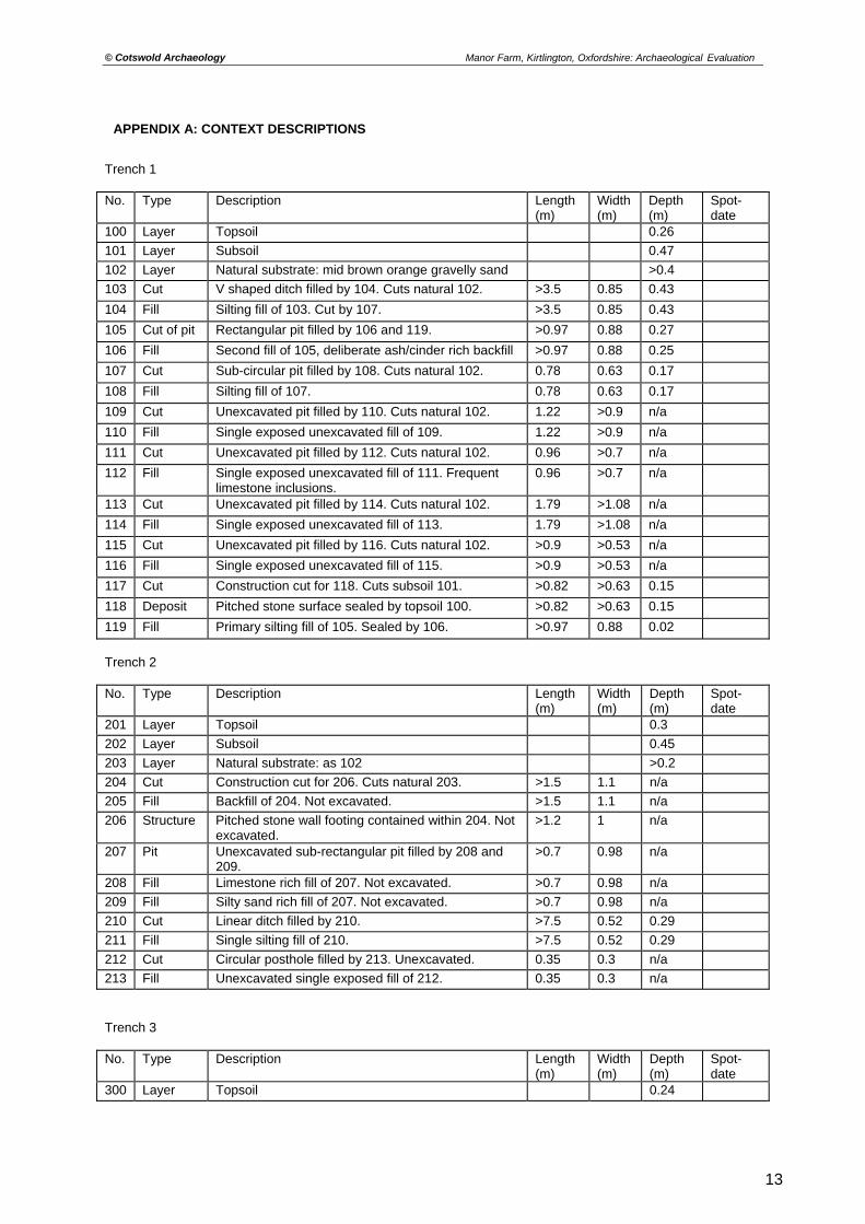
Trench 1 No. Type Description Length
(m) Width (m)
Depth (m)
Spot-date
100 Layer Topsoil 0.26
101 Layer Subsoil 0.47
102 Layer Natural substrate: mid brown orange gravelly sand >0.4
103 Cut V shaped ditch filled by 104. Cuts natural 102. >3.5 0.85 0.43
104 Fill Silting fill of 103. Cut by 107. >3.5 0.85 0.43
105 Cut of pit Rectangular pit filled by 106 and 119. >0.97 0.88 0.27
106 Fill Second fill of 105, deliberate ash/cinder rich backfill >0.97 0.88 0.25
107 Cut Sub-circular pit filled by 108. Cuts natural 102. 0.78 0.63 0.17
108 Fill Silting fill of 107. 0.78 0.63 0.17
109 Cut Unexcavated pit filled by 110. Cuts natural 102. 1.22 >0.9 n/a
110 Fill Single exposed unexcavated fill of 109. 1.22 >0.9 n/a
111 Cut Unexcavated pit filled by 112. Cuts natural 102. 0.96 >0.7 n/a
112 Fill Single exposed unexcavated fill of 111. Frequent limestone inclusions.
0.96 >0.7 n/a
113 Cut Unexcavated pit filled by 114. Cuts natural 102. 1.79 >1.08 n/a
114 Fill Single exposed unexcavated fill of 113. 1.79 >1.08 n/a
115 Cut Unexcavated pit filled by 116. Cuts natural 102. >0.9 >0.53 n/a
116 Fill Single exposed unexcavated fill of 115. >0.9 >0.53 n/a
117 Cut Construction cut for 118. Cuts subsoil 101. >0.82 >0.63 0.15
118 Deposit Pitched stone surface sealed by topsoil 100. >0.82 >0.63 0.15
119 Fill Primary silting fill of 105. Sealed by 106. >0.97 0.88 0.02
Trench 2 No. Type Description Length
(m) Width (m)
Depth (m)
Spot-date
201 Layer Topsoil 0.3
202 Layer Subsoil 0.45
203 Layer Natural substrate: as 102 >0.2
204 Cut Construction cut for 206. Cuts natural 203. >1.5 1.1 n/a
205 Fill Backfill of 204. Not excavated. >1.5 1.1 n/a
206 Structure Pitched stone wall footing contained within 204. Not excavated.
>1.2 1 n/a
207 Pit Unexcavated sub-rectangular pit filled by 208 and 209.
>0.7 0.98 n/a
208 Fill Limestone rich fill of 207. Not excavated. >0.7 0.98 n/a
209 Fill Silty sand rich fill of 207. Not excavated. >0.7 0.98 n/a
210 Cut Linear ditch filled by 210. >7.5 0.52 0.29
211 Fill Single silting fill of 210. >7.5 0.52 0.29
212 Cut Circular posthole filled by 213. Unexcavated. 0.35 0.3 n/a
213 Fill Unexcavated single exposed fill of 212. 0.35 0.3 n/a
Trench 3 No. Type Description Length
(m) Width (m)
Depth (m)
Spot-date
300 Layer Topsoil 0.24
13
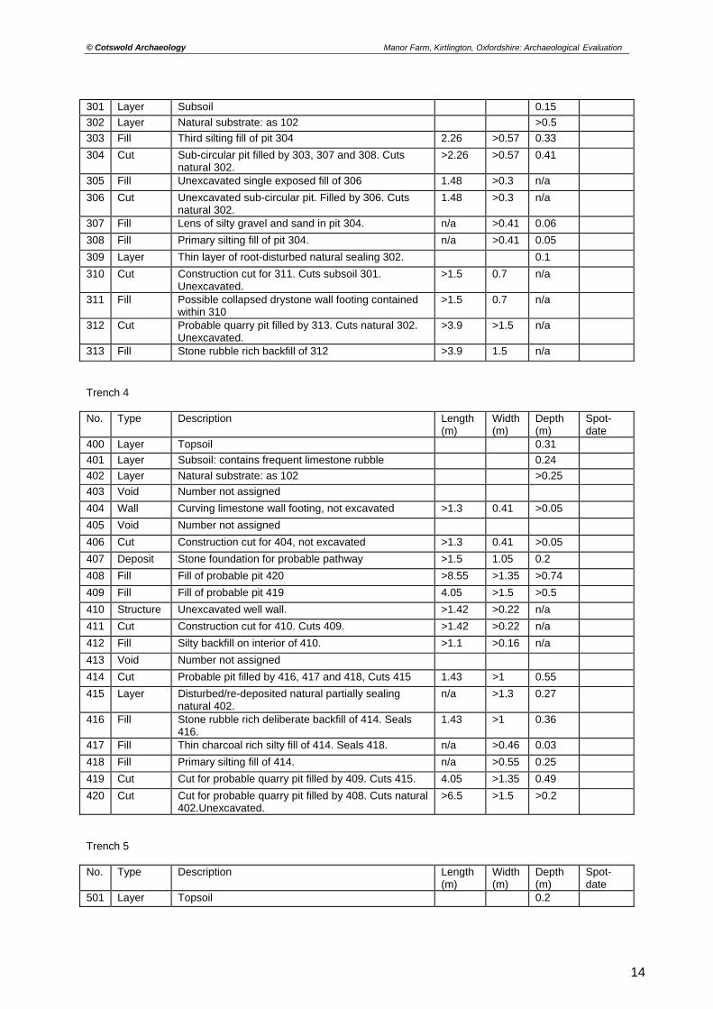
© Cotswold Archaeology Manor Farm, Kirtlington, Oxfordshire: Archaeological Evaluation
301 Layer Subsoil 0.15
302 Layer Natural substrate: as 102 >0.5
303 Fill Third silting fill of pit 304 2.26 >0.57 0.33
304 Cut Sub-circular pit filled by 303, 307 and 308. Cuts natural 302.
>2.26 >0.57 0.41
305 Fill Unexcavated single exposed fill of 306 1.48 >0.3 n/a
306 Cut Unexcavated sub-circular pit. Filled by 306. Cuts natural 302.
1.48 >0.3 n/a
307 Fill Lens of silty gravel and sand in pit 304. n/a >0.41 0.06
308 Fill Primary silting fill of pit 304. n/a >0.41 0.05
309 Layer Thin layer of root-disturbed natural sealing 302. 0.1
310 Cut Construction cut for 311. Cuts subsoil 301. Unexcavated.
>1.5 0.7 n/a
311 Fill Possible collapsed drystone wall footing contained within 310
>1.5 0.7 n/a
312 Cut Probable quarry pit filled by 313. Cuts natural 302. Unexcavated.
>3.9 >1.5 n/a
313 Fill Stone rubble rich backfill of 312 >3.9 1.5 n/a
Trench 4 No. Type Description Length
(m) Width (m)
Depth (m)
Spot-date
400 Layer Topsoil 0.31
401 Layer Subsoil: contains frequent limestone rubble 0.24
402 Layer Natural substrate: as 102 >0.25
403 Void Number not assigned
404 Wall Curving limestone wall footing, not excavated >1.3 0.41 >0.05
405 Void Number not assigned
406 Cut Construction cut for 404, not excavated >1.3 0.41 >0.05
407 Deposit Stone foundation for probable pathway >1.5 1.05 0.2
408 Fill Fill of probable pit 420 >8.55 >1.35 >0.74
409 Fill Fill of probable pit 419 4.05 >1.5 >0.5
410 Structure Unexcavated well wall. >1.42 >0.22 n/a
411 Cut Construction cut for 410. Cuts 409. >1.42 >0.22 n/a
412 Fill Silty backfill on interior of 410. >1.1 >0.16 n/a
413 Void Number not assigned
414 Cut Probable pit filled by 416, 417 and 418, Cuts 415 1.43 >1 0.55
415 Layer Disturbed/re-deposited natural partially sealing natural 402.
n/a >1.3 0.27
416 Fill Stone rubble rich deliberate backfill of 414. Seals 416.
1.43 >1 0.36
417 Fill Thin charcoal rich silty fill of 414. Seals 418. n/a >0.46 0.03
418 Fill Primary silting fill of 414. n/a >0.55 0.25
419 Cut Cut for probable quarry pit filled by 409. Cuts 415. 4.05 >1.35 0.49
420 Cut Cut for probable quarry pit filled by 408. Cuts natural 402.Unexcavated.
>6.5 >1.5 >0.2
Trench 5 No. Type Description Length
(m) Width (m)
Depth (m)
Spot-date
501 Layer Topsoil 0.2
14
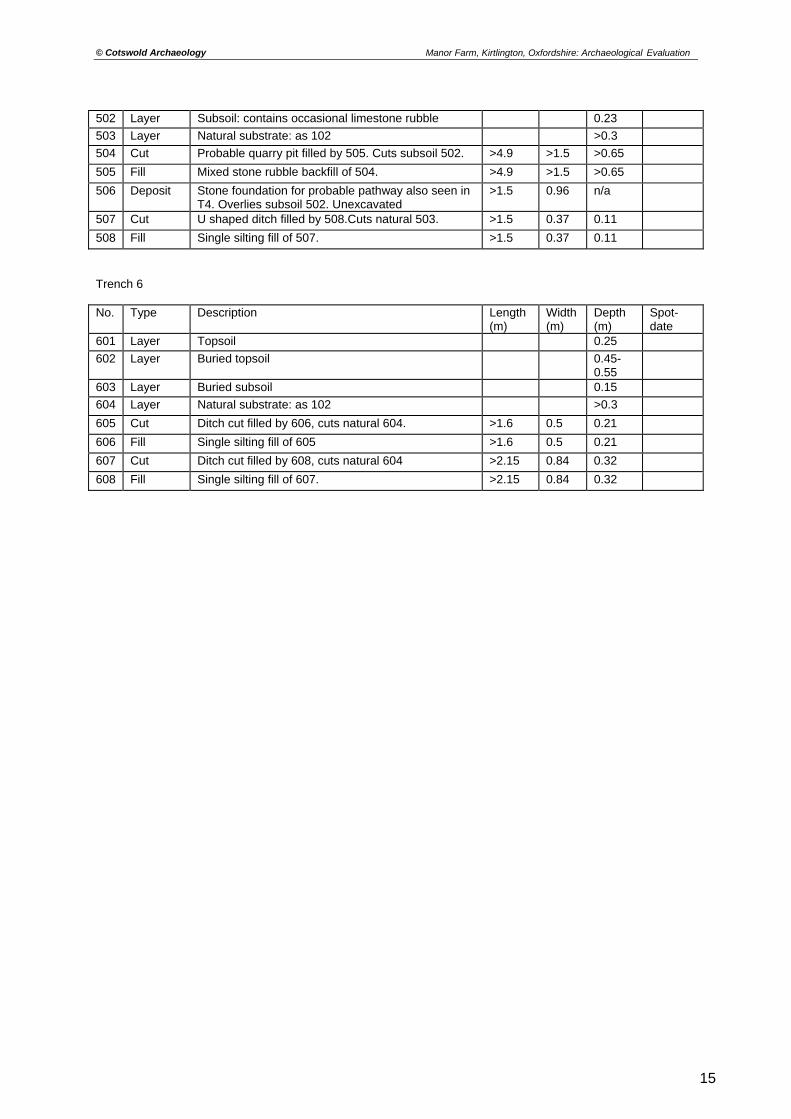
© Cotswold Archaeology Manor Farm, Kirtlington, Oxfordshire: Archaeological Evaluation
502 Layer Subsoil: contains occasional limestone rubble 0.23
503 Layer Natural substrate: as 102 >0.3
504 Cut Probable quarry pit filled by 505. Cuts subsoil 502. >4.9 >1.5 >0.65
505 Fill Mixed stone rubble backfill of 504. >4.9 >1.5 >0.65
506 Deposit Stone foundation for probable pathway also seen in T4. Overlies subsoil 502. Unexcavated
>1.5 0.96 n/a
507 Cut U shaped ditch filled by 508.Cuts natural 503. >1.5 0.37 0.11
508 Fill Single silting fill of 507. >1.5 0.37 0.11
Trench 6 No. Type Description Length
(m) Width (m)
Depth (m)
Spot-date
601 Layer Topsoil 0.25
602 Layer Buried topsoil 0.45-0.55
603 Layer Buried subsoil 0.15
604 Layer Natural substrate: as 102 >0.3
605 Cut Ditch cut filled by 606, cuts natural 604. >1.6 0.5 0.21
606 Fill Single silting fill of 605 >1.6 0.5 0.21
607 Cut Ditch cut filled by 608, cuts natural 604 >2.15 0.84 0.32
608 Fill Single silting fill of 607. >2.15 0.84 0.32
15
© Cotswold Archaeology Manor Farm, Kirtlington, Oxfordshire: Archaeological Evaluation
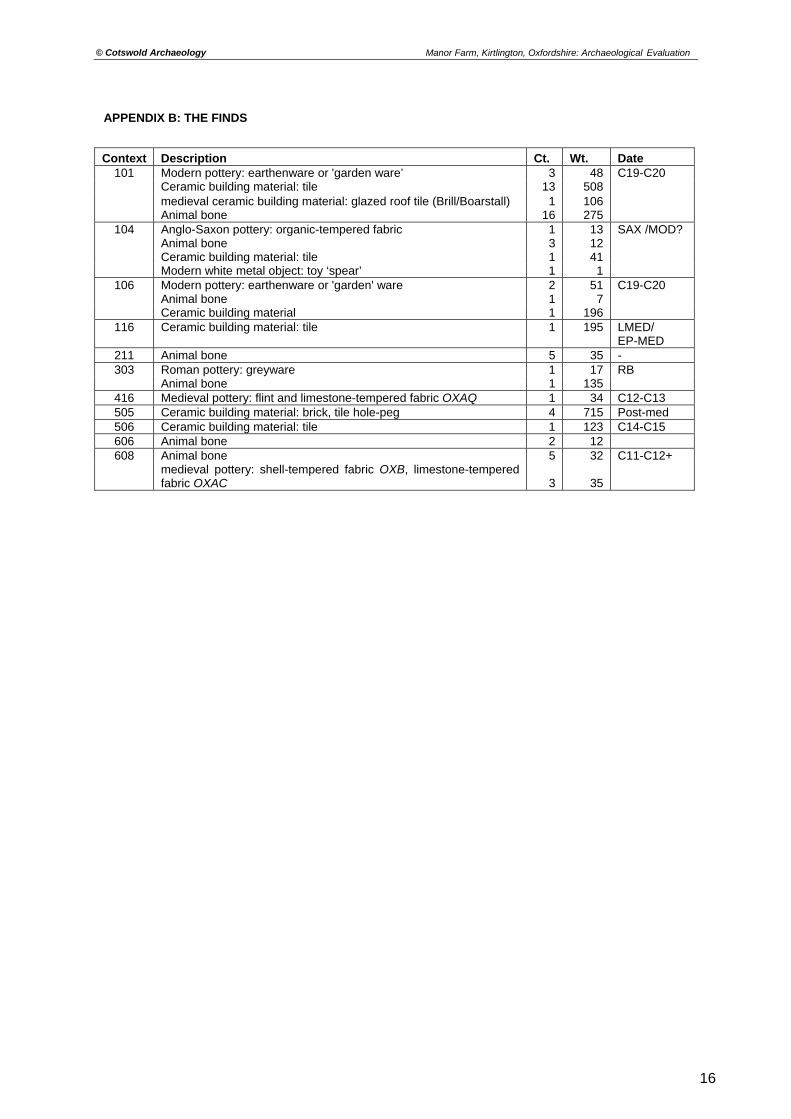
APPENDIX B: THE FINDS
Context Description Ct. Wt. Date 101 Modern pottery: earthenware or 'garden ware’ 3 48 C19-C20
Ceramic building material: tile 13 508 medieval ceramic building material: glazed roof tile (Brill/Boarstall) 1 106 Animal bone 16 275
104 Anglo-Saxon pottery: organic-tempered fabric 1 13 SAX /MOD? Animal bone 3 12 Ceramic building material: tile 1 41 Modern white metal object: toy ‘spear’ 1 1
106 Modern pottery: earthenware or 'garden' ware 2 51 C19-C20 Animal bone 1 7 Ceramic building material 1 196
116 Ceramic building material: tile 1 195 LMED/ EP-MED
211 Animal bone 5 35 - 303 Roman pottery: greyware 1 17 RB
Animal bone 1 135 416 Medieval pottery: flint and limestone-tempered fabric OXAQ 1 34 C12-C13 505 Ceramic building material: brick, tile hole-peg 4 715 Post-med 506 Ceramic building material: tile 1 123 C14-C15 606 Animal bone 2 12 608 Animal bone 5 32 C11-C12+
medieval pottery: shell-tempered fabric OXB, limestone-tempered fabric OXAC 3 35
16
© Cotswold Archaeology
17
Manor Farm, Kirtlington, Oxfordshire: Archaeological Evaluation
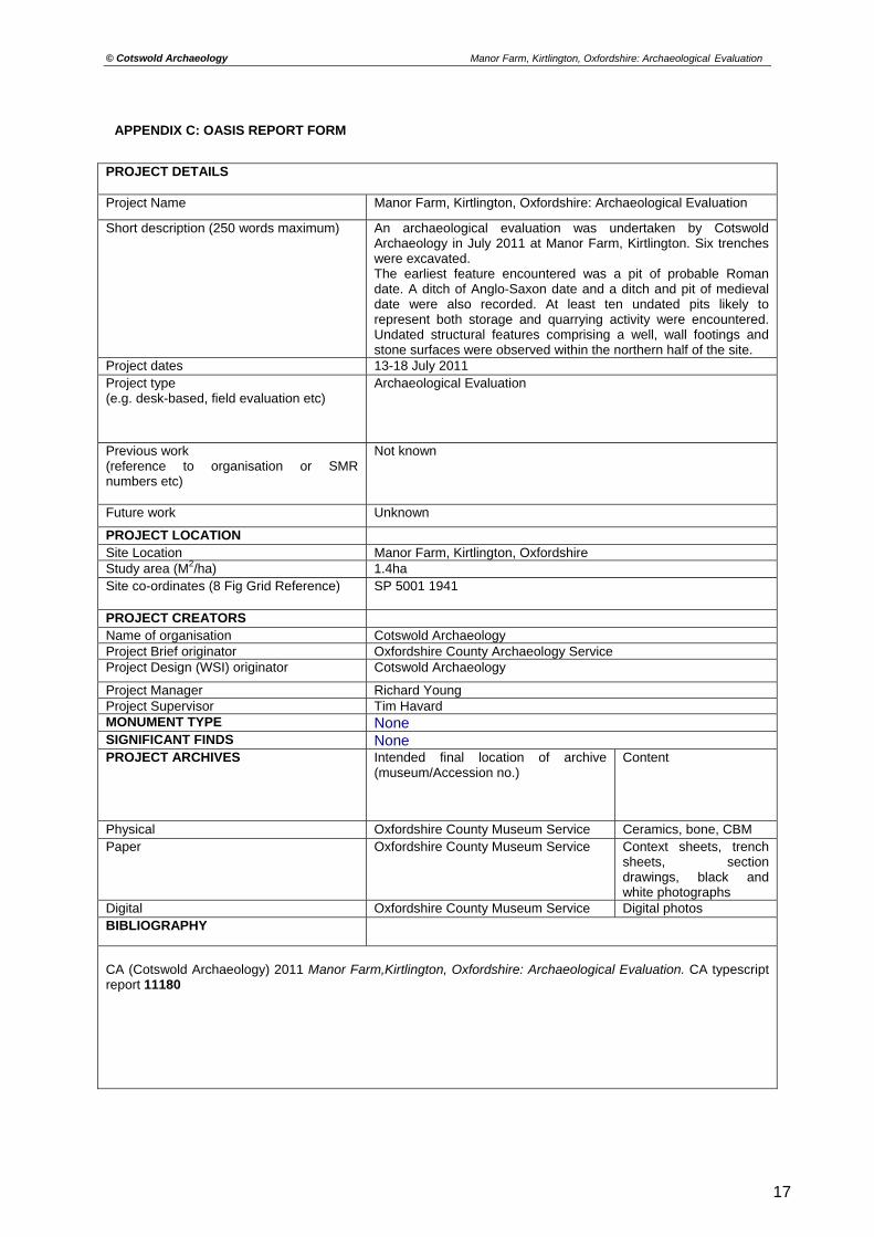
APPENDIX C: OASIS REPORT FORM
PROJECT DETAILS Project Name Manor Farm, Kirtlington, Oxfordshire: Archaeological Evaluation
Short description (250 words maximum)
An archaeological evaluation was undertaken by Cotswold Archaeology in July 2011 at Manor Farm, Kirtlington. Six trenches were excavated. The earliest feature encountered was a pit of probable Roman date. A ditch of Anglo-Saxon date and a ditch and pit of medieval date were also recorded. At least ten undated pits likely to represent both storage and quarrying activity were encountered. Undated structural features comprising a well, wall footings and stone surfaces were observed within the northern half of the site.
Project dates 13-18 July 2011 Project type (e.g. desk-based, field evaluation etc)
Archaeological Evaluation
Previous work (reference to organisation or SMR numbers etc)
Not known
Future work Unknown
PROJECT LOCATION Site Location Manor Farm, Kirtlington, Oxfordshire Study area (M2/ha) 1.4ha Site co-ordinates (8 Fig Grid Reference) SP 5001 1941
PROJECT CREATORS Name of organisation Cotswold Archaeology Project Brief originator Oxfordshire County Archaeology Service Project Design (WSI) originator Cotswold Archaeology
Project Manager Richard Young Project Supervisor Tim Havard MONUMENT TYPE None SIGNIFICANT FINDS None PROJECT ARCHIVES Intended final location of archive
(museum/Accession no.) Content
Physical Oxfordshire County Museum Service Ceramics, bone, CBM Paper Oxfordshire County Museum Service Context sheets, trench
sheets, section drawings, black and white photographs
Digital Oxfordshire County Museum Service Digital photos BIBLIOGRAPHY
CA (Cotswold Archaeology) 2011 Manor Farm,Kirtlington, Oxfordshire: Archaeological Evaluation. CA typescript report 11180
Oxfordshire
CotswoldArchaeology
t 01285 771022
f 01285 771033
w www.cotswoldarchaeology.co.uk
PROJECT TITLE
FIGURE TITLE
FIGURE NO.DATE
REVISION
SCALE@A4
PROJECT NO.
DRAWN BY
APPROVED BY
N
0 1km
Site location plan
Manor Farm, Kirtlington, Oxfordshire
01-08-2011001:25,000
3490JBPJM 1
Reproduced from the 1999 Ordnance Survey Explorer map with the permission of Ordnance Survey on behalf of The Controller of Her Majesty's Stationery Office Crown copyright Cotswold Archaeological Trust 100002109
c
W E
106
119
104
ditch103
100.5mAOD
Section AA
Pit 105 and ditch 103, looking north (scale 0.4m)
Pit 304, looking east (scale 1m)
SE NW
ditch607
608
211
100mAOD
Section DD
N S100.5m
AOD
Section CC
N S100mAOD
Section BB
ditch210
pit304
308 307
303
301
300
pit105
CotswoldArchaeology
t 01285 771022
f 01285 771033
w www.cotswoldarchaeology.co.uk
PROJECT TITLE
FIGURE TITLE
FIGURE NO.DATE
REVISION
SCALE@A3
PROJECT NO.
DRAWN BY
APPROVED BY
0 1m
Trenches 1, 2, 3 and 6: Sections andphotograghs
Manor Farm, Kirtlington, Oxfordshire
07-08-2011001:20
3490JBPJM 4
CotswoldArchaeology
t 01285 771022
f 01285 771033
w www.cotswoldarchaeology.co.uk
PROJECT TITLE
FIGURE TITLE
FIGURE NO.DATE
REVISION
SCALE@A3
PROJECT NO.
DRAWN BY
APPROVED BY
A Trench 2, wall footing 206, looking south (scale 0.4m)
B Trench 4, excavated section through stone surface 437, looking south (scale 0.3m)
C Trench 4, curved wall footing 404, looking north (scale 0.4m)
D Trench 4, Probable well 410, looking south (scale 0.4m)
Trench 2 and 4: Photographs
Manor Farm, Kirtlington, Oxfordshire
01-08-201100N/A
3490JBPJM 5
A
B
C D