changing landscape and society in a cotswold village ...bgas.org.uk/tbgas_bg/v127/bg127233.pdf ·...
TRANSCRIPT

From the Transactions of the Bristol and Gloucestershire Archaeological Society
Changing Landscape and Society in a Cotswold Village: Hazleton, Gloucestershire, to c.1600
by Christopher Dyer and David Aldred2009, Vol. 127, 233-268
© The Society and the Author(s)

Trans. Bristol & Gloucestershire Archaeological Society 127 (2009), 233–268
Changing Landscape and Society in a Cotswold Village:Hazleton, Gloucestershire, to c.1600
By CHRISTOPHER DYER and DAVID ALDRED
How and why did past landscapes and settlements change? This study subjects a section ofCotswold countryside to close examination in the expectation that basic questions can be answeredabout the formation of territories and units of landholding, the origin and decay of settlements(villages, hamlets and farms) in different periods, especially the creation and desertion of medievalvillages, and the shifts in the use and management of land.1 It will describe the changes and putforward some explanations of the choices made, bearing in mind the physical environment andthe social and economic constraints and opportunities.
The Cotswold village of Hazleton was chosen for study because it offered a means of advancingour knowledge of settlement and landscape in the long term, focussing on the medieval period.Hazleton presents a number of puzzles; for example the lack of a well-defined settlement coresuggests a chequered past. The village also offered chances for research, as it contains some oldbuildings, with patches of earthworks from abandoned structures among its irregularly-spacedgroups of houses, while much of the surrounding farmland was cultivated and available forfieldwalking. The landowners welcomed our interest. The archaeological and architectural fieldwork could be conducted alongside the study of documents, as a wide range of evidence hassurvived from the archive of Winchcombe abbey.
This paper is divided into two parts, the first based on the material evidence, the second on thewritten, and the two approaches will be brought together in the conclusion. If the two types ofevidence are interwoven, the historical approach is sometimes said to dominate the story.2 Thefirst part will therefore be mainly concerned with land, boundaries, artefacts, buildings andearthworks, so that the material evidence can be given proper attention; the second will usedocuments to investigate population, lordship, social structure and farming practices.
1. Work on these subjects for other regions which have influenced our thinking include D. Hadley,‘Multiple estates and the origin of the manorial structure of the northern Danelaw’, Jnl. HistoricalGeography 22 (1996), 3–15; R. Jones and M. Page, Medieval Villages in an English Landscape. Beginningsand Ends (Macclesfield, 2006); B.M.S. Campbell, English Seigniorial Agriculture 1250–1450 (Cambridge,2000).
2. e.g. M. Johnson, Ideas of Landscape (Oxford, 2007), 101–5; M. Bowden, ‘The Medieval Countryside’, inN. Holbrook and J. Jur̆ica (eds.), Twenty-five Years of Archaeology in Gloucestershire (CotswoldArchaeology, Bristol and Gloucestershire Archaeol. Rep. 3, 2006), 182.
230524 08 233-268 5/2/10 14:06 Page 233

PART ONE: LANDSCAPE AND ARCHAEOLOGY
Hazleton’s Present State
Hazleton is a small, straggling and little visited village which in the Middle Ages stood near thecentre of the northern section of the ecclesiastical parish of Hazleton. For convenience here thisterritory of 534 ha (1,566 acres) will be called a ‘township’ which refers to the land attached tothe village for agricultural purposes (Figs. 1 and 2).3 The ecclesiastical parish for many centuriesincluded the chapelry of Yanworth, a village situated in a detached and smaller territory a fewkilometres to the south-east, but here we confine ourselves to the township of Hazleton, in whichthere were for centuries three centres of wealth and authority: a manor, a major freeholding anda rectory. The township’s boundaries have not changed in recent times, and probably not in thelast thousand years.
The land lies at a high altitude, reaching a height of 268 m (880 ft) at Pen Hill in the north-west corner of the township (Figs. 2 and 3). Fully a half of the land, on the western side, lies above225 m (738 ft), and it dips down to the east. Five minor water courses begin as springs in the slopes
3. Victoria County History (VCH) Glos. IX , 91–106 provides an authoritative account of the whole parish(including Yanworth) mainly by J. Jur̆ica. See also M. McCarthy, Hazleton. ‘Farmstead near the hazels’(Hazleton, 2000).
234 CHRISTOPHER DYER AND DAVID ALDRED
Fig. 1. Location map, showing Hazleton township, with roads and surrounding villages. The stippled areain the large map shows the extent of the township.
230524 08 233-268 5/2/10 14:06 Page 234

of the higher ground, three of them very near to the modern village, and they converge in a longcentral valley (Fig. 4), a major topographical feature. The flow of water eventually runs into theTurkdean brook on the eastern edge of the township (at 163 m or 535 ft) and ultimately joinsthe Windrush and the Thames. The high ground in the west of the township forms part of thewatershed beyond which rivers such as the Isbourne feed the Severn.
The underlying geology consists of oolite, with soils which tend to be stoney but are quite easilycultivated. Crops are not given an advantage, however, by the low winter temperatures and strongwinds associated with high altitude.4 Much of the parish has been under the plough in the recent
4. ‘…vegetation is not a little retarded’: S. Rudder, A New History of Gloucestershire (Cirencester, 1779), 479.
CHANGING LANDSCAPE AND SOCIETY AT HAZLETON 235
Fig. 2. Hazleton c.2000 AD, showing roads, woods, houses, barns and some significant field names.
230524 08 233-268 5/2/10 14:06 Page 235

past, though a substantial area to the west was left as long-term ‘set aside’ in the 1990s. The onlyareas of apparently permanent pastures lie in the fields immediately to the south and north-eastof the village. Hazleton Grove has been woodland since the Middle Ages. The other coverts,plantations and ‘brakes’ were mainly planted in the last 200 years (Fig. 2).
Hazleton until c.400 AD
We know a great deal about Hazleton’s prehistory because of the thorough excavation in the years1979–82 of the Hazleton North long barrow, which lay in ‘Barrow Ground’ on the slopes of PenHill in the north-west corner of the township (Fig. 5).5 An adjacent second barrow, Hazleton
5. A. Saville, Hazleton North. The Excavation of a Neolithic Long Cairn of the Cotswold-Severn Group (EnglishHeritage Archaeol. Rep. 13, 1990); new dating evidence is published in Current Archaeology 209 (2007), 16.
236 CHRISTOPHER DYER AND DAVID ALDRED
Fig. 3. Hazleton township showing relief and water courses.
230524 08 233-268 5/2/10 14:06 Page 236

South, was also examined but not fully excavated. Before the construction of the burial mound thesite of Hazleton North had been used as a camp by hunter-gatherers in the late Mesolithic period(5th or 6th millennium BC): they left a distinctive deposit of microliths and debris from flintworking. At the beginning of the 4th millennium the site was occupied by people who cultivatedwheat and barley and kept cattle, sheep and pigs. Their settlement was permanent enough to havetimber structures, including a possible building, as well as a hearth and a midden. The settlementstood in a clearing, which included an area of cultivation, in a scrubby landscape dominated byhazel, and when the settlement was abandoned the bushes re-colonised the land.6 Soon after 3700BC the burial mound was built, correctly called a cairn because of its mainly stone construction,and over a century or so about forty people were buried in it. The building process suggests anorganised society, which could recruit many workers for quarrying and depositing the stone. Theconstruction of the dry stone walls as part of the cairn required considerable skill. People weresufficiently effective food producers to spare time and energy for non-utilitarian tasks, and theywere influenced by ideas about the correct treatment of the dead and preparation for an after-life.The relatively few burials suggest either that the local population was not numerous, or that onlymembers of a privileged élite were buried in a prominent and prestigious monument.7 When burial
6. Saville, Hazleton North, 13–22, 218–19, 240–67.7. Ibid. 265–6.
CHANGING LANDSCAPE AND SOCIETY AT HAZLETON 237
Fig. 4. The central valley, seen from the church looking east to Lower Barn (foreground) and Turkdeanin the distance (David Aldred).
230524 08 233-268 5/2/10 14:06 Page 237

ceased in the cairn around 3600 BC, the site reverted to bushes and trees, though a few potsherdsand coins suggest that it came under cultivation in the Iron-Age and Roman periods.8
The excavations help us to understand the results of fieldwalking over the township (as it laterbecame). More than a thousand pieces of worked flint were collected from the surface of themodern arable, most of it consisting of flakes discarded when making implements (Fig. 5). Oneof the most exciting finds from the Hazleton North excavation was the burial of a man aged 30–45,accompanied by a flint core (from which flakes had been struck) and a hammerstone. This‘flintknapper’ had led a hard life, having at some stage suffered fractures which had healed bothin a leg bone and in his foot. He had also suffered from osteoarthritis in his back and hip.9 Perhapsit was appropriate for him to take on this sedentary craft as it became too difficult for him to doheavy work in the fields or strenuous hunting and gathering. The grave allows us to connect thefinds of struck flint with a particular individual, or rather a type of person, as a long succession ofknappers must have created the mass of flints found at Hazleton over the main period of productionin the 4th, 3rd and 2nd millennia BC.
Every modern cultivated field has yielded some struck flint, and especially high densities of thematerial may indicate settlement sites at six places. These are located to the north and to the north-east of Barrow Ground, to the south of the modern village, in the south-west near to GeorgeWood, near to Lower Barn to the east of the village, and on the eastern boundary on the Downs.These concentrations of flint occur both on high ground and at sites at a lower altitude. All six ofthe fields where waste flakes are most numerous have also been the source of small groups ofcompleted tools or weapons, mostly scrapers and arrowheads. This strengthens the belief that thesemay have been settlements where implements were used or kept, or at least camp sites visited byitinerants. If these finds of clusters of three or four implements point to settlement, even whenthe waste flakes are not so abundant, then two sites to the north and south-east of Nut Tree Brake,in the east of the township, may also be candidates for inclusion. The implements suggest a rangeof dates for this activity. Most of the arrowheads are of the leaf-shaped type, which occurred insome number in the Hazleton North cairn, and belong to the earlier part of the Neolithic. Aprobable transverse arrowhead has been found, not dissimilar to one from the cairn. There werealso two barbed and tanged arrowheads, which are dated to the Beaker period and Bronze Age.10
Within this long period from c.4000 to c.1000 BC, the sites identified as possible settlements mayhave existed quite briefly. As the Hazleton North excavation shows, many artefacts could bedeposited in short periods of occupation. We can still draw the conclusion that within the broadspan of three millennia before 1000 BC almost every part of the later township was the scene ofhuman activity, sometimes concentrated in settlements, and sometimes involving less intense useof the land, even cultivation, which could have led to the ubiquitous low-density scatters of flints.
A few sherds of Iron-Age pottery found in the excavations at Hazleton North suggest that theland near the cairn was under cultivation in that period. Occasional finds of Iron-Age pottery havebeen made in fieldwalking in other parts of the later township, but no strong conclusion can bedrawn from their rarity as sherds of that period are prone to disintegrate under the plough. Weknow that other parts of the Cotswolds were extensively settled in the Iron Age, but can do nomore than suppose that this may have been the case at Hazleton.11 Sherds of Iron-Age type havebeen found on two of the farmstead sites occupied in the Roman period, but while these findscould suggest the continuation of settlement between the two periods, the inhabitants of a new
8. Ibid. 135, 152, 240.9. Ibid. 125, 191–3, 262–3.10. H.S. Green, The Flint Arrowheads of the British Isles (BAR British Series 75, 1980).11. T. Moore, ‘The Iron Age’, in Holbrook and Jur̆ica (eds.), Archaeology in Gloucestershire, 69–74.
238 CHRISTOPHER DYER AND DAVID ALDRED
230524 08 233-268 5/2/10 14:06 Page 238

settlement founded after the Roman conquest might have used pottery that was still being madein the Iron-Age tradition in the late 1st century AD.
Widespread scatters of Romano-British pottery tell a familiar story of a much-cultivatedlandscape, with concentrations of finds about a kilometre apart indicating settlement sites (Fig.6). At Hazleton thirty-nine of the forty-two modern cultivated fields from which material has beencollected have produced at least one sherd of Romano-British pottery. Thin scatters, oftenconsisting of between one and a dozen sherds of pottery over a field of 5 ha, are thought to indicateland used as arable in the Roman period. Each of these fields at some time between the 1st and4th centuries received cart loads of domestic rubbish in the course of manuring. Settlements, wherethe finds occur in very high density, have been identified in four places, at Flitgo in the south-west, Hill Barn in the south-east, around Lower Barn in the centre, and north of Canon’s Barn
CHANGING LANDSCAPE AND SOCIETY AT HAZLETON 239
Fig. 5. Hazleton, prehistoric evidence: the cairns and flints from fieldwalking.
230524 08 233-268 5/2/10 14:06 Page 239
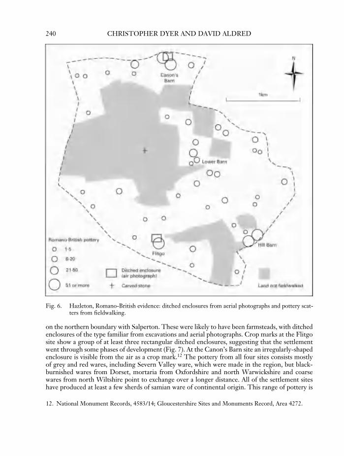
on the northern boundary with Salperton. These were likely to have been farmsteads, with ditchedenclosures of the type familiar from excavations and aerial photographs. Crop marks at the Flitgosite show a group of at least three rectangular ditched enclosures, suggesting that the settlementwent through some phases of development (Fig. 7). At the Canon’s Barn site an irregularly-shapedenclosure is visible from the air as a crop mark.12 The pottery from all four sites consists mostlyof grey and red wares, including Severn Valley ware, which were made in the region, but black-burnished wares from Dorset, mortaria from Oxfordshire and north Warwickshire and coarsewares from north Wiltshire point to exchange over a longer distance. All of the settlement siteshave produced at least a few sherds of samian ware of continental origin. This range of pottery is
12. National Monument Records, 4583/14; Gloucestershire Sites and Monuments Record, Area 4272.
240 CHRISTOPHER DYER AND DAVID ALDRED
Fig. 6. Hazleton, Romano-British evidence: ditched enclosures from aerial photographs and pottery scat-ters from fieldwalking.
230524 08 233-268 5/2/10 14:06 Page 240

more varied than is found on similar sites in north and west Worcestershire, for example, and theimplication must be that the inhabitants of these Cotswold farms could generate a sufficient surplusto obtain non-local vessels, and aspired to tableware for display.13 The people who lived on thefarmsteads were likely to have been of British ancestry, but they adopted Roman methods of foodpreparation, as implied by their mortaria, and no doubt came under other Roman culturalinfluences. The sites can be identified as farmsteads rather than villas because they lack largequantities of building material apart from the occasional fragment of ceramic tile. The buildingsmay have had foundations made from the local oolite, which would be difficult to distinguish fromthe stone found on the surfaces of many fields, but they do not seem to have been provided withhypocausts, mosaics, or roofs of tiles or stone slates. As the area subject to fieldwalking totals 383ha, the settlements are distributed near to a density of one per 100 ha. If the sites were evenlydistributed, the township as a whole, with 634 ha is likely to have contained a total of six or sevensites. Three of the four known sites were located in valleys, but one occupied high ground, so theywere not confined to one type of terrain.
Was there a Hazleton Roman villa? The recent discovery of a large and opulent villa in theadjoining parish of Turkdean shows that new sites still remain to be found.14 A block of stone builtinto the churchyard wall of Hazleton might suggest a high-status building in the vicinity. Thissquared piece of oolite, paler and of finer grain than the local stone, has a visible face c.22.5 by20.0 cm, carved in relief with most of a four-lobed ‘vegetal’ motif. It could have been part of afrieze on an important building.15 It may have been brought from the Turkdean villa (a distanceof 2 km) or from a building in the more immediate vicinity. The adjacent field under permanentpasture to the east (Bury Mead) contains some enigmatic earthworks, which are likely to be pre-medieval in date. At a distance of 850 m to the east, near Lower Barn, a surface find of a piece oftufa suggests that a major building stood near by.
Whether or not a lost villa is waiting to be discovered at Hazleton, the relationship betweenvillas and farmsteads is relevant to understanding the whole settlement pattern. Farmsteads deservemore attention in our general assessments of the countryside of Roman Britain.16 If their densityin Hazleton (and other places which have been intensively fieldwalked) was reproduced across theGloucestershire Cotswolds, the region would be estimated to contain 1,200 farmsteads, comparedwith about sixty villas and ‘villa-like buildings’ so far located. Many more people in total evidentlylived in farmsteads than in villas, and we may suspect that a large area of land was cultivated bythe inhabitants of the farmsteads, if their relatively small presumed groups of fields are addedtogether. But did the farmsteads and villas co-exist as separate but unequal units of landholdingand farming? Or did the farmsteads belong to villa estates, and did the villa owners extract rentfrom their social inferiors in the farmsteads or exercise some control over them? Were the Hazletonfarmsteads attached to a yet undiscovered local villa, or to the villa at Turkdean or another at
CHANGING LANDSCAPE AND SOCIETY AT HAZLETON 241
13. We are grateful for Ed. McSloy’s comments on the pottery; the comparison with Worcestershire sitesis based on, for example, C. Dyer, Hanbury: Settlement and Society in a Woodland Landscape (University ofLeicester Department of English Local History Occasional Paper 4th series 4, 1991), 16.
14. N. Holbrook, ‘Turkdean Roman villa, Gloucestershire: archaeological investigations 1997–1998’,Britannia 35 (2004), 38–76; idem, ‘The Roman Period’, in Holbrook and Jur̆ica (eds.), Archaeology inGloucestershire, 103–6.
15. We are grateful for the advice of Dr Martin Henig; for a parallel see M. Henig, Roman Sculpture fromthe Cotswold Region (Corpus Signorum Imperii Romani 1.7, Oxford, 1993), no. 230.
16. e.g. R. Hingley and D.Miles, ‘The human impact on the landscape: agriculture, settlement, industry,infrastructure’, in P. Salway (ed.), The Roman Era. The British Isles 55 B.C.–A.D. 410 (Oxford, 2002),161–3.
230524 08 233-268 5/2/10 14:06 Page 241

242 CHRISTOPHER DYER AND DAVID ALDRED
Fig.
7.A
irph
otog
raph
ofcr
opm
arks
atFl
itgo
show
ing
atle
astt
hree
adja
cent
ditc
hed
encl
osur
es,f
rom
the
sout
h(E
nglis
hH
erita
ge:©
Cro
wn
copy
righ
tNM
R).
230524 08 233-268 5/2/10 14:06 Page 242

Compton Abdale 3 km to the east? The situation may well have changed over time. The potteryfrom the Hazleton sites suggests that they began in the 1st or 2nd centuries AD, and continuedinto the 3rd and 4th centuries, so they may have been founded before the villas. The Turkdeanvilla, for example, in a characteristic Cotswold fashion seem to have become a really large andwealthy establishment towards the end of the Roman period.17
The landscape of late prehistory and of the Roman period might be regarded as invisible in thelater countryside, or it might be said that the late Roman period had a long-term influence bybequeathing extensive agricultural land, even if the settlements did not survive, nor the fieldsassociated with them. But at Hazleton as elsewhere pre-medieval cultivation terraces may haveinfluenced medieval boundaries. There is a particularly pronounced lynchet marking the southernboundary of the village, now to the south of Priory Farm (Fig. 8 and see below pp. 250, 252); butterraces on sloping ground both to the south of the village (marked ‘a’ on Fig. 9), and to the north-east (‘b’ on Fig. 9), could be the result of medieval cultivation, though their wide spacing andirregularity might suggest an earlier date.18
Legacies from the centuries before 400 AD include some of Hazleton’s roads. The boundarieson two sides of the township are defined by important routes (Fig. 1). The western edge is markedby a north–south road, the north-eastern branch of the White Way taking traffic from theWorcestershire Avon to Cirencester, which here has joined a length of salt way that led acrosscountry from Droitwich to Lechlade. The south-western boundary follows the road nowconnecting Cheltenham to Oxford (the A40), which was the main road from Gloucestershire to
17. Holbrook, ‘Roman Period’, 106–8.18. For the influence of earlier fields on a medieval settlement layout, see J. Bond and C. Lewis, ‘The earth-
works of Hawling’, Trans. BGAS 109 (1991), 169–70.
CHANGING LANDSCAPE AND SOCIETY AT HAZLETON 243
Fig. 8. Schematic village plan, including roads and lynchet, to illustrate the possible ‘framework’ withinwhich the village grew.
230524 08 233-268 5/2/10 14:06 Page 243

London, and known in the 18th century as London Way. A track forming the southern boundarywas once a road of local significance which branched off from the main road at Puesdown and washeaded east towards Farmington and Sherborne. All of these roads must have been functioningbefore the 11th century. The White Way is thought to have been used in the Roman period, andthe salt way is likely to date back to the beginnings of large-scale salt extraction at Droitwich inthe late Iron Age.19 Briquetage, the remains of the clay vessels in which Droitwich salt was carriedand stored, has been found on Iron-Age sites in south Gloucestershire, near to this route.20 Thesalt way on its southward course divides at the Barrow Ground (one imagines the barrows/cairnsserving as landmarks for travellers), with the main route heading past Puesdown to cross the Fossesouth of Northleach and so through Bibury to Lechlade. An alternative route tended towards thesouth-east, but kept to the west of Hazleton village. This north–south road meets the east–westroute from Compton Abdale to Turkdean in a T-junction, and then, after a short diversion,resumes its course to the east of Puesdown to join the road to Sherborne. The north–south roadhas a good claim to predate the foundation of Hazleton village, as it runs straight past thesettlement, 300 m to the west of the church and seems to be related to the framework of boundarieswithin which the village is set (Fig. 8).
The edge of Hazleton Grove and the boundary of a furlong of ridge and furrow visible on anair photograph of 1946 follow a sinuous north–south line parallel to the road.21 That line continuesas the north–south road from the church and Manor Farm to Priory Farm which formed the mainvillage street. A significant east–west element in this simple grid, as well as the village street takingtraffic to Turkdean, was the impressive lynchet on the southern boundary both of the village andalso of the complex of structures which preceded Priory Farm. This lynchet, which was formedby ploughing before any buildings existed on the Priory Farm site, like the branch of the salt wayto the west, has already been identified as a likely survivor of the Romano-British or prehistoriclandscape. The main outlines of the village plan, both streets and other boundaries, were possiblyinfluenced by the routes and lynchets that can be traced back before 400 AD.
Hazleton in the Middle Ages
Hazleton’s long-term development in the centuries after the Roman period takes us, in arevolutionary change, from a dispersed to a nucleated pattern of settlement. Instead of farmsteadsscattered at intervals across the land, presumably working small hedged fields, by c.1000 AD allsettlement was concentrated on a single village, which contained the houses of the peasantcultivators, the church, the rectory and the manor house. The inhabitants of this central settlementworked in the open fields which stretched towards the edge of the territory. We have no precisedating evidence for the origin of the nucleated village or the open fields, but by analogy with datedexamples elsewhere the likely date lies between the 9th and 11th centuries, for which c.1000 ADserves as an indicator.22
Some local evidence suggests that settlements were dispersed in the centuries immediately after400 AD. A single sherd of grass- or chaff-tempered pottery, which is dated between the 5th and10th centuries has been found on each of three of the Hazleton Romano-British settlement sites,suggesting that occupation may have continued into the early Middle Ages. A group of four sherds
244 CHRISTOPHER DYER AND DAVID ALDRED
19. VCH Glos. IX, 33, 92–3; Iron Age and Romano-British Monuments in the Gloucestershire Cotswolds (RoyalCommission on Historical Monuments, England, 1976), xlv–xlviii.
20. Moore, ‘Iron Age’, 80, 83.21. National Monuments Record, 106G/UK/1345, April 1946.22. Jones and Page, Medieval Villages, 89–104.
230524 08 233-268 5/2/10 14:06 Page 244

CHANGING LANDSCAPE AND SOCIETY AT HAZLETON 245
Fig.
9.T
hevi
llage
c.200
0,w
ithex
istin
gro
ads,
build
ings
and
eart
hwor
ks;‘
a’an
d‘b
’mar
kth
ete
rrac
esdi
scus
sed
inth
ete
xt.T
hete
rrac
esat
‘b’
are
cut
bya
late
rho
llow
ay,a
ndth
ere
isso
me
evid
ence
of‘s
lum
ping
’of
soil.
On
the
east
the
mill
site
lies
near
Low
erB
arn,
with
leat
sco
nver
ging
onit.
The
eart
hwor
ksne
arer
the
villa
gear
esh
own
inm
ore
deta
ilin
Figs
.13
and
14.
230524 08 233-268 5/2/10 14:06 Page 245

246 CHRISTOPHER DYER AND DAVID ALDRED
Fig.
10.
The
villa
gew
ithth
eou
tline
ofob
serv
edan
dpr
esum
edpr
e-m
oder
nfe
atur
es.
230524 08 233-268 5/2/10 14:06 Page 246

– a rare number by the standards of a period when pottery was very scarce – has been found nearthe Flitgo Roman site, but separate from the main concentration of Roman pottery, implying thatthe settlement shifted a short distance (a not uncommon event) after c.400 AD, or even that a newsettlement had been founded (Fig. 15). Similar sherds have been found very near to the Turkdeanvilla site.23
At this time a large migration of people brought Germanic material culture and language to thewhole of England. In and near to the Cotswolds known Anglo-Saxon cemeteries are few andscattered. The evidence in the immediate vicinity of Hazleton consists of 5th- and 6th-centuryburials adjacent to prehistoric barrows at Hampnett. Otherwise the nearest are at Upper Swelland Bishop’s Cleeve well to the north-west and north-east.24 This small number of cemeteries maypartly be the result of the migrants’ conversion to Christianity by the British clergy whodiscouraged burial in the pagan manner with weapons and jewellery.25 We must also suppose thatmost inhabitants of the region were of British descent, and that a relatively small number ofmigrants, perhaps because they formed a political élite, exercised a disproportionate culturalinfluence. The most prominent of the invaders are visible historically as the rulers of the sub-kingdom of the Hwicce. This small political unit was subordinated to Mercia, and a bishopric wasestablished in the 7th century to serve it, based in Worcester.26 The inhabitants, both natives andnewcomers, had been deprived by the collapse of the Roman province of manufactured and tradedgoods, and consequently their settlement sites are marked by few material remains, apart from thescarce hand-made pottery. The movement of people to congregate in nucleated villages andcultivate strips in open fields occurred centuries after the migration, the formation of the Hwicceansub-kingdom, and the foundation of the bishopric, and therefore probably had no direct connectionwith that linguistic, political and religious upheaval.
In view of the fragmentary archaeological evidence for the medieval village of Hazleton and itssurroundings, our reconstruction of events depends on assumptions that some elements of themodern village plan had their origin before the first written records. We can also use analogieswith nearby villages such as Hawling and Aston Blank where much more is known of the medievalfield systems.27 Some evidence for the late medieval village still exists today (Figs. 9 and 10). Thechurch is the most complete standing medieval structure. It occupies a prominent position on aspur of high ground. It is not especially large, and like many Cotswold churches it still retains muchfabric from the 12th century, datable from the Romanesque chancel arch and the south door.It was altered in the 14th and 15th centuries, and the porch was added.28 The incorporation intothe 12th-century fabric of some large stones might suggest that materials were being reused froman earlier phase of building. The manor house close to the church (now Manor Farm) has anentirely modern external appearance but includes a room (6.5 by 3.2 m internally) with a door
CHANGING LANDSCAPE AND SOCIETY AT HAZLETON 247
23. A. Reynolds, ‘The Early Medieval Period’, in Holbrook and Jur̆ica (eds.), Archaeology in Gloucestershire,135–8, discusses problems of dating this type of pottery and its occurrence on Roman sites; Holbrook,‘Turkdean Roman Villa’, 55.
24. Reynolds, ‘Early Medieval Period’, 141–7; A. Meaney, A Gazetteer of Early Anglo-Saxon Burial Sites(London, 1964), 90.
25. S. Bassett, ‘How the west was won: the Anglo-Saxon takeover of the West Midlands’, Anglo-SaxonStudies in Archaeology and History 11 (2000), 107–18.
26. D. Hooke, The Anglo-Saxon Landscape: the Kingdom of the Hwicce (Manchester, 1985), 3–23.27. D. Aldred and C. Dyer, ‘A medieval Cotswold village: Roel, Gloucestershire’, Trans. BGAS 109 (1991),
139–70; C. Dyer, ‘The rise and fall of a medieval village: Little Aston (in Aston Blank), Gloucestershire’,Trans. BGAS 105 (1987), 165–81.
28. VCH Glos. IX, 104.
230524 08 233-268 5/2/10 14:06 Page 247

with a four-centred arch of c.1500. An adjoining cellar is lit by a small medieval window.29 GlebeFarm, which stands on a terrace immediately south of the church, contains a four-bay section whichrepresents the rector’s house of the 16th and 17th centuries. Together the church, manor houseand parsonage form an impressive cluster of high-status structures occupying high ground(Fig. 11).
In relation to the rest of the settlement they were superior in both senses of the word. At PrioryFarm there are mouldings, including column bases, set in garden walls, which resemble stoneworkin the parish church so closely that they are likely to have been removed at the restoration of 1866.Mouldings in different stone from windows of c.1500 suggest that a substantial dwelling may havestood on the site. A house on the southern edge of the village contains a well-carpentered pair ofraised crucks which are likely to date from the late 16th or early 17th century, and Hillside, a houseof five bays with a Tudor doorway, stands on the north–south village street. Both are likely tohave occupied the sites of medieval predecessors.30
The present village is divided into four parts, with a knot of houses near the church, anotheraround the T-junction between the north–south and east–west roads next to Priory Farm, and an
29. We are grateful to Mr Hopwood for letting us survey this house.30. VCH Glos. IX, 93, 103.
248 CHRISTOPHER DYER AND DAVID ALDRED
Fig. 11. The complex of high-status structures on rising ground to the north of the village, from the south,with Glebe Farm (originally the rectory) to the right, the church behind, and Manor Farm, the siteof the manor house, to the left (David Aldred).
230524 08 233-268 5/2/10 14:06 Page 248

irregular string of houses running down the lane towards Lower Barn and Turkdean (Fig. 9). Thefourth part, consisting of the 19th-century rectory built on a new site to the west of the manorhouse, and the suburban-style houses of the 20th century to the west of that are too recent to beconsidered here. If we discount also the houses (and the windmill) built since 1826, which includeall buildings to the north of the church, and take note of the house sites marked by earthworks orby empty plots, we see that the earlier village consisted of two streets at right-angles (Fig. 12).31
Houses occupied both sides of the north–south street, though not in regular rows. There werecomplexities of plan such as a holloway running 60 m to the west of the present road towardsNorthleach, through an area of ridge and furrow and almost continuing the line of the north-southstreet, which suggests that there was once a different route out of the village to the south. Thevillage plan could be regarded as ‘polyfocal’, but we cannot be sure that there was a northern grouparound the church, rectory and manor house, where the existing buildings are of 19th- and 20th-century date. Most of the peasant houses, perhaps all, were built to the south of the manor andrectory, with a focus on the T-junction of roads near Priory Farm. This was marked by a stonecross of which the base with a socket for the shaft is preserved in the garden of Priory Farm itself.
The earthworks show a complex of remains of former settlement to the north-east of the T-junction, including building platforms, toft boundaries and sunken yards (marked as ‘c’ on Fig.13). The earthworks of one building were sited well back from the road frontage. Nearer to therectory are larger linear earthworks and a large rectangular enclosure, perhaps connected with
31. A map of 1826, Gloucestershire Archives (GA), Photocopy 1931, has been transcribed by G. Watkin andhas been made available by the Archives.
CHANGING LANDSCAPE AND SOCIETY AT HAZLETON 249
Fig. 12. The medieval village: a speculative reconstruction of the streets and buildings, c.1300.
230524 08 233-268 5/2/10 14:06 Page 249

management of livestock (marked as ‘d’). A palimpsest of earthworks to the south of the T-junctionagain includes tofts and house platforms, including three well-defined house sites, presumed tobe the houses of villagers (marked as ‘e’ on Fig. 14). Below them is a well-preserved stretch ofridge and furrow and the holloway already mentioned. North of the major east–west lynchet whichbisects the field is a series of prominent earthworks (marked as ‘f’ on the plan) including holloways,a circular feature which may be the remains of a dovecot, and the foundations of a major building,probably a barn. These appear to have been part of the outbuildings of the predecessor of PrioryFarm. South of the lynchet, as well as lynchets caused by soil slumping and disturbances associatedwith the modern water works and spring, are three large enclosures marked by grassed-overcollapsed stone walls (marked as ‘g’). The eastern wall has the remains of a small building attachedto it. These are likely to have been closes or paddocks for livestock.
Two straight ditches running eastwards from the village, originally constructed as leats, carrywater from springs to converge at a degraded set of earthworks near the modern Lower Barn,marking the site of a water mill (Figs. 9 and 10). There are slight remains of house sites along thelane that links the village and the mill, suggesting that the settlement projected eastwards for somedistance. The water mill’s site serves as a reminder that the village is located very advantageously
250 CHRISTOPHER DYER AND DAVID ALDRED
Fig. 13. Earthworks on the east side of village. In the western field at ‘c’ platforms, depressions and bound-ary banks mark abandoned house sites; rectangular enclosures at ‘d’ mark pens for livestock (?),probably belonging to the rectory. The eastern field has been cultivated in modern times, and thebadly eroded earthworks hint at earlier settlement and cultivation.
230524 08 233-268 5/2/10 14:06 Page 250

near three springs which rise on the edge of high ground (Fig. 3). The village site has the meritof both convenient water supplies and some shelter from western and northern winds. The village’slayout, if the existing features still in use are combined with the empty plots left by theabandonment of houses, shows it was a more concentrated settlement than its modern successor.The material evidence does not suggest that Hazleton ever had a regular plan resembling the one-street villages with plots of similar size found at nearby Hawling and Aston Blank and at manyother villages in the region.32
Archaeological and topographical evidence throws valuable light on land use and farming. Areasof permanent pasture lay within paddocks and enclosures near the village and on sloping groundto the south and north-east of it. There was meadow to the east of the church (Bury Mead), andin the low lying ground near the mill amounting to at least 6 ha (15 acres). The medieval extentof Hazleton Grove may be marked by the oval area within the present wood enclosed with a bank,which amounted to about 15 ha (37 acres). There are traces of lynchets in the middle of the wood,and one near its eastern edge, so the trees may have grown up after the land had been cultivated,perhaps in the post-Roman period. The earthwork evidence for medieval cultivation is limited bythe extent and intensity of recent farming. The ploughing out of the medieval ridges must go backwell before the expansion of arable after the Second World War, as only one large area of ridgeand furrow is visible on the air photograph of 1946. Fragments of surviving ridges, strip lynchetsnear the village, and faint traces visible from the air, expand the evidence for cultivation, but mostof the survival was around the village and the grove. Traces of the medieval field pattern can beseen in the curving hedges of some fields, for example immediately to the south-east of the villageon land known in modern times as Upper and Lower Severals, a name which implies that fieldswere enclosed out of the open field at an unknown date before the main act of enclosure in 1766(Fig. 2 marks these field names). Similarly on nearby Moor Hill, an 1826 estate map depicts a longnarrow curving field, known as Langgate, which had clearly been formed from the amalgamationand enclosure of perhaps five open-field strips or ridges. All of these clues suggest that the fieldswere once very extensive, which is confirmed by documents which tell us that by 1300 most ofthe township was under the plough.
A thin scatter of pottery of the 12th–14th centuries in the plough soil, found by fieldwalking,provides evidence for cultivation (Fig. 15). A rather dense concentration is found immediately tothe east of the village and to a lesser extent to the west, suggesting that this land was subjected toquite intense manuring. A few sherds occur in fields more than a kilometre from the village.Compared with other medieval villages in the midlands, the quantity of medieval pottery is small,and its distribution over the fields is very restricted.33 There are a number of explanations: thepeople of Hazleton may not have owned much pottery, reflecting either their relative poverty ortheir preference for containers and utensils made from other materials. If the manor house wasunoccupied, its household would not have been contributing to the domestic rubbish spread onthe fields. Some types of locally-made pottery do not survive well in the plough soil. All of thesemay be relevant factors, but husbandry practices may also have played their part, as sheep foldingwould have been a major method of manuring rather than spreading dung and domestic rubbish.
The small quantity of potsherds and their abraded state diminish the chances of establishing achronology for cultivation and manuring. The bulk of the sherds belong to the 12th, 13th and14th centuries, with little from either the beginning or the end of the medieval period. This does
32. For planned villages in the region, C. Dyer, ‘Villages and non-villages in the medieval Cotswolds’,Trans. BGAS 120 (2002), 11, 13.
33. R. Jones, ‘Signatures in the soil: the use of ceramic manure scatters in the identification of medievalarable farming regimes’, Archaeological Jnl. 161 (2004), 159–88.
CHANGING LANDSCAPE AND SOCIETY AT HAZLETON 251
230524 08 233-268 5/2/10 14:06 Page 251

252 CHRISTOPHER DYER AND DAVID ALDRED
Fig.
14.
Ear
thw
orks
toth
eso
uth
ofP
rior
yFa
rm.T
oth
eea
star
etw
oho
use
site
swith
long
bank
eden
clos
ures
runn
ing
dow
nto
the
stre
am.T
here
are
thre
em
ore
aban
done
dho
uses
with
wel
l-pr
eser
ved
eart
hwor
ksat
‘e’,
and
at‘f’
larg
ersc
ale
plat
form
s,en
clos
ures
and
depr
essi
ons,
inte
r-pr
eted
asag
ricu
ltura
lbui
ldin
gsbe
long
ing
toth
epr
edec
esso
rofP
rior
yFa
rm.T
hest
ruct
ures
atbo
th‘e
’and
‘f’ha
veth
eirs
outh
ern
boun
d-ar
yde
fined
byth
em
ajor
east
–wes
tlyn
chet
and
hollo
way
.To
the
sout
har
eth
ree
larg
een
clos
ures
at‘g
’and
,to
the
east
,an
area
ofri
dge
and
furr
owbi
sect
edby
aho
llow
ay.T
his
may
have
been
apr
edec
esso
rto
the
mod
ern
road
60m
toth
eea
st.T
hesm
allt
erra
ces
runn
ing
atri
ghta
ngle
sto
the
boun
dari
esof
the
encl
osur
esat
‘g’a
relik
ely
tobe
the
resu
ltof
soil
slum
ping
dow
nth
ere
lativ
ely
stee
psl
ope.
230524 08 233-268 5/2/10 14:06 Page 252

not tell us much about the period before 1100, when pottery was scarce in the region. The absenceof many sherds from the period after 1400 may reflect changes in agricultural technique in aperiod of contraction, in which manuring may have been reduced or ceased altogether on the areaswhich were converted to pasture. This might also have been connected to a shrinkage in thenumber of village households. The pottery and metal artefacts recovered from the modern ploughsoil remind us incidentally of the complexity of the peasant economy. The villagers, while practisinga degree of self-sufficiency by consuming food grown on their own holdings, were drawn intoexchange through the market. They bought pottery made in specialised centres, presumably fromtraders in nearby market towns. The places of origin of the pottery included Brill(Buckinghamshire), Hanley Castle (Worcestershire) and Minety (Wiltshire) as well as the Cotswoldarea.
CHANGING LANDSCAPE AND SOCIETY AT HAZLETON 253
Fig. 15. Hazleton, medieval evidence: pottery and metalwork from fieldwalking.
230524 08 233-268 5/2/10 14:06 Page 253

The abandonment of houses in the village has left clear earthwork evidence, as there are at leasta dozen sites of former houses, mainly in the vicinity of the T-junction of village streets east ofPriory Farm (Fig. 16). Five buildings with visible collapsed walls can be seen, two platforms withoutsigns of walls, and at least six empty closes or plots (Figs. 9, 10, 13, 14 and 16). The church wasnot radically rebuilt or enlarged in the later Middle Ages, as the walls of the nave and chancel ofthe 12th century were retained. As the porch was added in the 14th century, and a tower (laterrebuilt) in the 15th, the village cannot be said to have been in total decline in the later MiddleAges.
The more modern growth of the village is reflected in the number of houses dated between the17th and 20th centuries, though as we can still see abandoned sites interspersed among the modernhouses the village has evidently not recovered its earlier levels of population. New buildings havebeen sited away from the old village core, to the west and north. Agricultural modernisation hasimposed on large parts of the township straight-edged geometric field shapes, which give no clueof the previous divisions of the land, and as we have seen earthworks associated with earlier fieldshave been removed by intense modern cultivation. In one respect modern agricultural practicedid not change old settlement patterns. Apart from 20th-century houses occupying the sites oftwo field barns, the farms have remained within the village, and we do not see in the far cornersof the township new farms of the 18th and 19th centuries.
254 CHRISTOPHER DYER AND DAVID ALDRED
Fig. 16. The main north–south street of the village, looking south from near the Church (David Aldred).The houses of the 18th and 19th century look on to a field containing the earthwork remains of anabandoned house.
230524 08 233-268 5/2/10 14:06 Page 254

PART TWO: HISTORY FROM DOCUMENTS
History up to 1086
The first written source for Hazleton, Domesday Book, records fourteen villeins and six slavesliving at Hazleton in 1086.34 The slaves were attached to the lord’s demesne and could have beenhoused on the lord’s premises, though he may have settled them in cottages. The villeins representthe peasantry who had been living on the land, in unknown numbers, for centuries. The documentscannot throw light on the origin of these people, except to record the place-names of Hazletonand its neighbours. These were generally in Old English and therefore reflect the linguistic impactof German-speaking migrants from the 5th century onwards, but the survival of the British namePen Hill in the north-west of the township, and the stream name Turce (preserved in Turkdean)on the eastern boundary, suggests that a British population survived long enough to perpetuatethe pre-English names for these prominent natural features.35
We can begin by asking when the territory of Hazleton emerged, with its defined boundaries.No documents relate directly to Hazleton from the period before 1086, but charters and chroniclesprovide a general context for the place. It belonged to the sub-kingdom of the Hwicce from the7th century and consequently was attached to the diocese of Worcester which was set up to servethat kingdom in 680. When the kingdom of Wessex (later England) took over the former Mercianterritories Hazleton became part of Gloucestershire, and it was located within that shire in Bradleyhundred. People living at Hazleton at that time would have been compelled to contribute to taxesand duties to the State, of which we only learn any details in 1086, when it was recalled that itsobligations had within recorded time been assessed on the basis of 10 hides. Their more immediateand frequent payments would have been to a lord, initially of a great estate, and to a minster church.Some well-documented minsters were located near Hazleton, such as Withington to the west,which included in its large parish Notgrove and Aston Blank. Bibury and Cirencester stood to thesouth.36 In the absence of direct charter evidence of a minster, we can establish the connectionsof parish churches in the later middle ages in the hope of reconstructing their early affiliations.These show that Hazleton was not at the lowest level in the hierarchy of parishes because a priestis mentioned in 1086, and later it had a chapelry at Yanworth. Northleach seems more importantbecause in addition to a large parish of its own, it served as mother church for Farmington andStowell, and it may have been a minster church on which Hazleton was dependent (Fig. 1).37
Villages and parishes became detached from the larger units of administration at an early datein this part of the Cotswolds, as is suggested by the naming in charters before 780 of such placesas Cutsdean, Aston Blank, Notgrove, Andoversford and Chedworth.38 Hazleton emerged as aseparate unit of lordship at an unknown date. The place-name was coined well before it was firstrecorded in Domesday Book, and we are not sure of its original form. Its later spellings, endingin –ton, suggest its early recognition as an estate and/or settlement, but the earlier forms such asHaseleden could refer to the valley (denu) which dominates the topography of the eastern side of
34. Liber Censualis seu Domesday Book, ed. A. Farley (London, 1783), fo. 170b.35. A.H. Smith (ed.), The Place-names of Gloucestershire part 1 (English Place-name Society, 38, 1960–1), 177,
183–4.36. S. Bassett, The Origins of the Parishes of the Deerhurst Area (Deerhurst Lecture, 1997), 6–13; J. Blair,
‘Secular minster churches in Domesday Book’, in P. Sawyer (ed.), Domesday Book. A Reassessment(London, 1985), 106–14.
37. VCH Glos. IX, 79, 135, 215. We are grateful to Dr Steven Bassett for his comments on this idea.38. H.P.R. Finberg, Early Charters of the West Midlands (Leicester, 1961), 35–6, 40–1.
CHANGING LANDSCAPE AND SOCIETY AT HAZLETON 255
230524 08 233-268 5/2/10 14:06 Page 255

the territory. The similar valley with which it connects gave its name to Turkdean.39 The hazelbushes, like the nut trees of adjacent Notgrove, suggest that at the time when the names werecoined (8th century or earlier) woods were small and few, as nut bushes or groves would not havestood out as distinguishing features in a landscape densely covered with trees. In 1086 Domesdaytells us that in the vicinity there was ‘not much’ wood.40
The piece of land now called Hazleton probably had its boundaries defined for some centuriesbefore 1086; the field-name Flitgo on the southern edge of the township (an early form was Flytgor)refers to a disputed triangular piece of land. This must recall a controversy over the acutely pointedcorner of Hampnett parish, where it meets Hazleton and Compton Abdale near Puesdown. Onecan expect that in the pre-Conquest period pieces of pasture were subject to intercommoningbetween villages, which led to friction until precise lines were fixed.41
Hazleton’s territory by the late Anglo-Saxon period performed three functions. Firstly it was amanor from which a lord could gain an income from land and people. The first person known tous to have held the lordship (together with Yanworth and Hawling) was Godgifu, sister of Edwardthe Confessor, called Goda in Domesday Book, who died shortly before the Norman Conquest.42
She must have had many predecessors, as the manor had probably come into existence long beforeher time. Secondly Hazleton was also a parish (with Yanworth), with a priest mentioned inDomesday Book, and a church from which stones are probably still visible, built into the 12th-century walls of the present church. And its third function was as a village, in the sense that a groupof peasants had legal and fiscal responsibilities to the hundred and shire and also managed itsown fields.
Domesday Book shows that Hazleton was quite valuable: its old tax assessment of 10 hides hadbeen reduced to 7, for unknown reasons, and it provided an income of £7 per annum for its lord,a similar sum to that generated by neighbouring large manors. The lord, Sigar de Chocques, whohad acquired all three manors that had belonged to Godgifu, must have been a rare visitor to theseoutliers on his estate, but there would still have been a manor house with manorial farm buildings;a large barn, for example, is recorded in 1162.43 No mill was mentioned. The population offourteen villeins and six slaves could, if the slaves had been settled on smallholdings, amount totwenty households, some or all of which may have already been established on the site of thepresent village. A great deal of land was used as arable, as the lord’s demesne employed threeploughs, which could have cultivated 120 ha (300 acres), and the tenants held ten ploughs, whichwould have dealt with about 220–260 ha (550–660 acres), allowing for 50 acres for each peasantplough, or 40 acres per peasant holding, and adding the priest’s glebe of 100 acres.44 Thereforewith near to 340–380 ha (at least 850 acres), Hazleton’s grain-growing capacity was already well-developed, perhaps covering a half of the available land. The grove was not included in theDomesday survey presumably because it was mainly a source of fuel and fencing for local use, anddid not produce a profit for the lord.45 There must also have been unrecorded areas of meadowand pasture.
39. Smith, Place-names, 174; M. Gelling, Place-names in the Landscape (London, 1984), 97–9.40. Domesday, fo. 165a.41. VCH Glos. IX, 82, gives the spelling of 1383; we are grateful for Paul Cullen’s advice on this name.42. Domesday, fo. 170b.43. Landboc sive Registrum Monasterii Beatae Mariae Virginis et Sancti Cenhelmi de Winchelcumba ed. D. Royce
(Exeter, 1892–1903), vol. 2, 308–9.44. The acreages are debatable. See Dyer, ‘ Little Aston’, 170.45. S. Wager, Woods, Wolds and Groves: the Woodland of Medieval Warwickshire (BAR British Series 269,
1998), 10–26.
256 CHRISTOPHER DYER AND DAVID ALDRED
230524 08 233-268 5/2/10 14:06 Page 256

1086–1349
In the two and a half centuries after the Domesday survey the landscape and society of Hazletonwere affected by three major changes. Firstly the population of the village grew, with acorresponding expansion of cultivation. Secondly the lordship of the manor was transferred fromcontinental lay aristocrats to Winchcombe abbey. Thirdly a major freeholding developed, that ofthe Hall family. In addition as documents become more plentiful, we become fully aware of twoof Hazleton’s distinctive features, firstly the wealth and independence of the rectors of the parishchurch, and secondly the nucleated village.
The size and profile of the village community around 1300 can be reconstructed from the 1355rental of the estates of Winchcombe abbey, which incidentally records many features oflandholding from before the Black Death of 1349 and the agrarian crisis of 1315–17.46 Amongthe customary tenants of the abbey manor c.1300 there were twenty-one houses and house sites(called messuages and closes) and 20 virgates or yardlands. The smallholders were few – threecottages, a close where a cottage had stood, and three other smallholdings of 2–4 acres, but withno record of dwellings or former dwellings attached. The two free tenancies consisted of one of11 yardlands, with two messuages and four cottages (in the hands of the Hall family), and anotherwith a messuage and 3½ yardlands. One of the messuages held by the Halls, and their cottages,were likely to have been held by subtenants. This would suggest that the village around 1300contained two wealthy free tenants, about twenty-one customary yardlanders, and eight cottagers.There may have been some more smallholders among the tenants holding small acreages fromthe main manor, and unrecorded subtenants. The village would have contained a little more thanthirty houses, and the fields would have accommodated 34½ tenant yardlands (Fig. 17).
This calculation is not dissimilar from the figures given in a survey of the rector’s assets in 1313,which states that the titheable tenant land consists of 30 yardlands; 17 of them customary and 13free.47 The survey adds the useful information that the yardland contained 40 acres, which wouldallow us to calculate an arable acreage in the hands of tenants of 1,200 or 1,380 acres (480 or 550ha), depending on whether we use the 1313 or 1355 figures. The 1313 document assigns to theglebe a carucate, about 100 acres, and the papal tax valuation of 1291 assesses the Winchcombeabbey demesne at two carucates (200 acres),48 so we arrive at a grand arable total for all landholdersof either 625 or 700 ha (1,500 or 1,680 acres), which as the township contained 634 ha (1,566 acres)leaves very little or nothing for the grove, permanent pasture or meadow. All of these statisticsare flawed of course – the 1313 survey states that a yardland ‘commonly’ contains 40 acres, notthat this was always the case. Surveys of the glebe in the 17th and 18th centuries suggest that the3 yardlands of which it was composed each contained about 30 acres, so that the yardlands mayhave varied between 30 and 40 acres.49 A local or customary acre, smaller than a statute acre, mayhave been used. The conclusion must still be that arable had taken over most of the land availableand that the wood, pasture and meadow were likely to be confined to a very small area – perhapsthe 6 ha of meadow and the 15 ha of wood and pasture closes near the village already identified
46. GA, D 678/rental 1355, fos. 21–22 (it was located in Safe 3 in 2005). By 1355 many holdings had no ten-ants or had been combined with others. The reconstruction is based on the assumption that c.1300 theholdings were separate.
47. The Register of Walter Reynolds, Bishop of Worcester 1308–1313, ed. R.A. Wilson (Dugdale Society 9,1928), 62.
48. Taxatio Ecclesiastice Angliae et Walliae auctoritate P. Nicholai IV circa A.D. 1291 (Record Commission,1802), 234.
49. VCH Glos. IX, 102; GA, P 172/IN1/1; D 6577/3.
CHANGING LANDSCAPE AND SOCIETY AT HAZLETON 257
230524 08 233-268 5/2/10 14:06 Page 257

from field work. The acquisition in the mid 13th century by Winchcombe abbey of a meadow inChedworth, which could have been for use by the managers of the demesne at Yanworth butperhaps for Hazleton too, indicates the shortage of hay felt at that time.50
The figures allow us to be more precise about the expansion of the 12th and 13th centuries.The population of the village evidently increased by 50 per cent, from twenty to thirty families(Fig. 17), and the cultivated area expanded on a rather more accelerated scale, from 850 to 1,500acres (355 or 625 ha), using the two smaller estimates. As there was little wood to clear, theexpansion must have been achieved by taking in former pasture – the ‘newly broken land’mentioned in a tithe agreement in 1301.51 The completeness of the Domesday survey must bedoubted: if rent-paying tenants were omitted, as happened elsewhere, the numbers of people andploughs may be understated, and therefore the growth in tenants and cultivated land between 1086and 1300 becomes less dramatic.52
The second change involved the transfer of the manorial lordship. The de Béthune family, whowere the French descendants of the Domesday holder, Sigar de Chocques, sold their threeGloucestershire manors of Hawling, Hazleton and Yanworth to Winchcombe abbey, initially in1201 retaining a substantial annual rent for themselves of £20 per annum, but then in successivetransactions the rent was reduced and the abbey made its final payment in 1251.53 The motivesfor the sale are not known, and may have been simply financial, as the de Béthunes may have neededa large sum of money at a time of rapid inflation.54 Winchcombe abbey was ambitious to extendits landed estate and acquired other manors and properties in the 13th century, helping it to becomea leading wool producer.55 As a result of the sale Hazleton was to be part of the estate of a majorBenedictine monastery until 1539. What influence did this change of lordship have on the socialand landscape history of the village? A possible line of reasoning might be that an absentee Frenchlord was replaced by a local lord who would supervise and improve the estate. The lay lords,however, were not complete absentees, and cross-channel contacts led to the marriage of John ofHazleton’s daughter Sibilla to Robert de Canasse of Béthune. The de Béthune family had otherEnglish lands, based in Northamptonshire.56 The monks of Winchcombe, on the other hand,though located nearby (at a distance of 11 km), depended like their predecessors on reeves andbailiffs to manage the land. Perhaps we could expect that monks were more dynamic as lords thana not very powerful lay family? The increase in tenant numbers and the area of arable land mayhave occurred under the monks, but the 13th century everywhere saw an acceleration in growth.
A third development was the emergence of the major Hazleton freeholding of the Hall family.It is revealed in 1285–1303 as belonging to the Gayton Fee. The tenancy had not been transferredwith the rest of the manor in 1201 and Robert Hall’s services were granted to Winchcombe c.1235,but the monks did not become the Halls’ lords fully until c.1290.57 We have noted the Halls’ verylarge holding of 11 yardlands in 1355, and it was said to have been almost as big in 1313. It was,
50. Landboc, vol. 2, 365–8, 371–4, 375–6.51. Ibid. 345–6.52. H.C. Darby, ‘Domesday Book and the geographer’, in J.C. Holt (ed.), Domesday Studies (Woodbridge,
1987), 108–10.53. VCH Glos. IX, 95; Landboc, vol. 2, 110–12.54. The financial embarrassment of landowners at this time: E. King, ‘Large and small landowners in
thirteenth-century England. The case of Peterborough Abbey’, Past and Present 47 (1970), 26–50.55. G. Haigh, The History of Winchcombe Abbey (London, n.d. [1948]), 52–65.56. Landboc, vol. 2, 323–5; I.J. Sanders, English Baronies. A Study of their Origin and Descent 1086–1327
(Oxford, 1960), 141–2.57. Landboc, vol. 1, 14; vol. 2, 368–70.
258 CHRISTOPHER DYER AND DAVID ALDRED
230524 08 233-268 5/2/10 14:06 Page 258

however, only reckoned as 5 yardlands in 1285.58 The source of the land may have been a grantmade before 1162, as Domesday assigns three ploughs to the manorial demesne in 1086, but whenthe three manors of Hazleton, Yanworth and Hawling were leased in 1162 by Robert de Béthuneto Walter of Hazleton, his clerk, he included with the lease six ploughs, presumably two for eachmanor, so the Hazleton demesne may have been reduced in size by a ploughland.59 This land,equivalent to 3 or 4 yardlands, could have formed the basis of the Halls’ holding. If this was thecase, the Halls must have acquired other lands, either by ploughing up pasture, or by acquiringholdings from other tenants. The 1355 survey’s statement that they held two messuages and fourcottages points to their subletting of some of the land, in particular to cottagers who would haveprovided them with labour. The overall impression is that they had few tenants and cultivated anextensive holding which could have totalled 9 or 10 yardlands (about 300–400 acres: 120–160 ha).This would have been much larger than the abbey’s demesne of about 200 acres (80 ha). It wasnot uncommon for gentry landowners, among whom the Halls must be judged to belong, to keepa high proportion of their land in direct cultivation.60 The Halls’ holding makes a prominent
58. Ibid. vol. 1, 14.59. Ibid. vol. 2, 308–9.60. R.H. Britnell, ‘Minor landlords in England and medieval agrarian capitalism’, Past and Present 89 (1980),
9–12.
CHANGING LANDSCAPE AND SOCIETY AT HAZLETON 259
Fig. 17. Bar chart showing the numbers of recorded households, 1086–1801. Sources: cited in notes 3, 34,46, 99, 100, and in A. Dyer and D. Palliser (eds.), The Diocesan Population Returns for 1563 and 1603(Records of Social and Economic History, new ser. 31, Oxford, 2005), 167; S. Rudder, A NewHistory of Gloucestershire (Cirencester, 1779), 480).
230524 08 233-268 5/2/10 14:06 Page 259

appearance in the village plan. They had evidently acquired a messuage on the south-west cornerof the settlement, which gave them space for outbuildings and enclosures for livestock on aconsiderable scale, as would be necessary for the management of such a large amount of land. Thestonework found near the presumed site suggests that the Halls or their 16th-century successors,the Bannisters, built a substantial house (see p. 248). Their status and wealth tempts us to call theirholding a submanor, but as they had few tenants and there is no evidence that they held a manorcourt, they should be called substantial freeholders. Their landholding was not confined toHazleton, as William Hall, for example, until 1466 held a 180 acre (75 ha) tenement at Coatesnear Cirencester.61 The other freeholding, which was held by the Watkins family in the early 14thcentury, was also relatively large, with 31/2 yardlands.62 Freehold land, which was not very commonin the Cotswolds, and especially on the manors of large monasteries, accounted for more than 40per cent of the tenant land in Hazleton.
Finally, we must consider the two dimensions of Hazleton’s landscape and society which havetheir origins before 1086. In addition to the large lay holding of the Halls a third major player inthe life of Hazleton was the rector, who enjoyed an unusually large endowment of land and income,and on occasion expressed a strong spirit of independence. The origins of the rector’s wealth mustlie in a generous provision made by a lord of the manor before the Norman Conquest. The surveyof 1313 reveals that he held a ploughland, usually reckoned at 100 acres (40 ha), and this isconfirmed by a glebe terrier of 1615 which recorded enclosures clustered around the church andthe parsonage and 3 yardlands in the open fields.63 In 1766 at inclosure the glebe’s existing closeswere reckoned at 13 acres (5 ha), and its open-field land at 82 acres (33 ha).64
In the late 12th century Walter of Hazleton, clerk, took on a lease of the three de Béthunemanors, and c.1200 John of Hazleton was parson of Hazleton. John was a land holder in his ownright, and a trusted servant of the de Béthune family, and both he and Walter must have beendominant figures in the locality.65 Winchcombe abbey gained the patronage of Hazleton church(which included the chapelry of Yanworth) in 1217, yet was constantly at loggerheads with therectors that it appointed.66 In the late 13th century the abbey had attempted to obtain confirmationof its exemption from paying tithes on its demesne lands on a number of manors, and the disputewith Elias of Gayton, the rector of Hazleton, was settled after two judgements by arbiters in 1301and 1313.67 The agreement eventually gave the rectors grain tithes of the customary tenants andthe small tithes (of wool, lambs, hay, etc.), while the abbey was allowed to keep the grain titheson the demesne and on the holdings of the free tenants.
Henry Benne, rector in 1357 and in 1367, can be seen in conflict with all sections of society inthe manorial court rolls. As the court was held by the abbey, the rolls are not an entirely objectivesource, but the accusations cannot all be the result of monkish hostility. Benne impounded theabbey’s oxen in 1357 and took timber from its manor in the following year.68 Subsequently hewas accused of allowing his livestock to trespass on the demesne and damage crops, once with asmany as twelve oxen, reminding us that rectors were actively involved in agriculture on aconsiderable scale on their glebe. This also led Benne to quarrel with other villagers, by the
61. J.D. Thorp, ‘The manor of Coates’, Trans. BGAS 50 (1928), 189–90.62. GA, D 678/96; 95.63. Reg. Walter Reynolds, 61–3; GA, P 172/IN 1/1.64. GA, D 6577/3.65. Landboc, vol. 2, 308–9, 332–5.66. Ibid. 314.67. Ibid. 345–6, 337–40.68. GA, D 678/65.
260 CHRISTOPHER DYER AND DAVID ALDRED
230524 08 233-268 5/2/10 14:06 Page 260

trespasses of his animals on their land and of their animals on his. The most serious accusationwas that the rector’s dogs had worried the sheep of John Thommes. Benne had borrowed moneyfrom a villager, and from his own servant, Adam, who accused him of breaking into his house. Healso fell out with the churchwardens, who accused him in 1358 of taking unjustly a silver chasuble(church vestment) worth 39s. 11d.69 In 1366 Benne was in trouble with the abbey and the bishopfor failing to appoint a chaplain for Yanworth.70
The large establishment of the rectory has left a mark on the village plan because much of thesloping land to the south of the church is taken up, not just by the site of the rectory itself, nowGlebe Farm, but also by a series of earthwork enclosures. The documents produced in the courseof the tithe disputes in the early 14th century, and the later glebe terriers, tell us of a sheepcot,two barns and other structures, including a dovecot immediately to the east of the rectory.71 Thelocation of the rectory and its outbuildings across the road from the abbey’s manor house gaveplenty of opportunity for the quarrels over straying animals and purloining of goods.
The nucleated village had formed well before the 14th century. The settlement had grownbetween 1100 and 1300 as new houses were added, including the complex of buildings andenclosures of the Halls’ holding. One area of debate among landscape historians is the extent towhich the lords of the manor planned villages on their estates. Hazleton provides some clues.72 Atypical feature was the siting of the church very near the main manor house, because the churchwould have been built by a lord, initially for his household’s use and for his tenants. The Halls’house may have been founded at the opposite end of the settlement because space was available,but it was also appropriate that there should be some distance between the manor house and theresidence of this high-status tenant. At first glance the village’s polyfocal appearance might suggestthat the lords and the Halls were influencing the growth of different parts of the settlement, butin view of the lack of evidence that the Halls had many tenants, the lords of the main manor wouldhave been potentially planners of the whole settlement. One stage of nucleation might haveoccurred when slaves were granted holdings from the demesne, often cottages or smallholdings.The successors of Yanworth’s slaves can be recognised in the bubulci (tenants with the duty ofmanning the lord’s ploughs) who lived there in the 12th century.73 At Hazleton, however, wherethere had been six slaves in Domesday, only four cottagers are recorded as tenants on the mainmanor, so we cannot so readily equate a group of later holdings with the slaves who were ‘housed’c.1100. The lords who could have played the most important part in any village planning wouldhave been members of the Chocques or de Béthune families, as we presume that the settlementhad formed well before the transfer to Winchcombe abbey in 1201. In any case, with no residentlord at any time, the most influential and powerful figures could have been the lessees or officials,like Walter of Hazleton from 1162, or the clergy who were also servants of the de Béthunes, likeJohn of Hazleton at the end of the 12th century.74 The village plan is not very regular, so it maynot have been subject to any particular direction, but grew as peasants established their housesalong the streets in plots of land of varied size and shape.
69. Ibid. The chasuble was probably worth more than 40s., but the court was not competent to recover sucha large sum. Vestments often belonged to the church, not the clergy.
70. Landboc, vol. 2, 346–52.71. Reg. Walter Reynolds, G1–3; GA, P 172/IN 1/1.72. e.g. C. Lewis, P. Mitchell-Fox and C. Dyer, Village, Hamlet and Field, Changing Medieval Settlements in
Central England (Macclesfield, 2001), 172–7.73. Landboc, vol. 2, 333–4; for bubulci, see Charters and Custumals of the Abbey of Holy Trinity Caen, ed. M.
Chibnall (British Academy, Records of Social and Economic History 5, 1982), 59.74. Landboc, vol. 2, 308–9, 332–6.
CHANGING LANDSCAPE AND SOCIETY AT HAZLETON 261
230524 08 233-268 5/2/10 14:06 Page 261

Nucleated villages are commonly associated with open fields, but is there any evidence for thedevelopment of Hazleton’s field system? The place-name Puesdown, on the south-west corner ofthe township, is based on an Old English personal name (it means Pefel’s down or hill) and suggestsan early phase of land organization in which parcels of land were associated with individuals.75
The field name Edychfeld (recorded in 1466) implies an enclosed field, and is most commonly foundin districts in eastern England where ‘old enclosure’ was more common than in the Cotswolds.76
The separate pieces of land, which are implied by these names, were broken down into strips thatwere grouped into furlongs, themselves subdivisions of the large open fields. These were plantedwith crops and provided grazing for the villagers’ animals on the stubble and also in fallow years.By analogy with other villages with this ‘midland’ field system, the date of the formation of theopen fields could have coincided with the nucleation of the village. In the later Middle Ages therewere two open fields at Hazleton, North Field and South Field, presumably with a divisionfollowing the stream valley and the lane leading to Turkdean.77 They were alternately planted withcrops and left fallow. No detailed description of strips and furlongs survives for Hazleton, but atadjoining Shipton Oliffe in 1236 a yardland of 30 acres consisted of twelve parcels in the furlongsof the East Field and twelve in the West Field.78 The logic of scattered strips was that eachcultivator had equal access to all parts of the field system, so the peasant houses were gatheredtogether in a single settlement near to the centre.
The documents can reveal something about the village in its developed form. The survey of 1355,which preserved memories of tenancies dating well before the Black Death of 1349, seems to bearranged in topographical order.79 A number of tenants’ surnames were derived from prominentfeatures such as the cross, lane and well. Beginning at the northern end by the manor house, churchand rectory, the rental makers moved down the main street recording tenants such as JohnThommes, Alice Blays and William Dobbes (Fig. 10). Alice held a cottage, evidently sandwichedbetween the messuages attached to yardlands. When the T-junction was reached John atte Halleappears, with his large holding on the site of Priory Farm, and the next entry in the rental is Richardatte Croys. The cross, the base of which is kept in a nearby garden, stood where the two streetsmet at the heart of the settlement. Richard also held a messuage and 2 yardlands that had beenpreviously held by John in the Lone, who had lived on the lane leading eastwards to Turkdean.Then Thomas atte Welle is listed, whose house was further down the same lane (later calledTownwell Lane), where a modern pond marks the main water supply for the community. At theend of the list – and presumably at the end of the lane – must have come the substantial 31/2 yardlandfreeholding, once belonging to the Watkins family and later called Nether House, and two cottages,one once held by the Treweman family and the other by Agnes Ayllen. This is confirmed by astatement in 1313 that two cottages lay next to the rector’s enclosed meadow ‘outside the vill ofHazleton, on the east side towards Turkdean’. The tax list of 1327 seems to have been compiledin a similar topographical sequence, and ends with the ‘in the Lone’ family.80
75. Smith, Place-names, 174.76. GA, D 678/95; we were advised on this name by Paul Cullen; Gelling, Place-names, 242.77. GA, P 172/IN 1/1; this record of 1615 is taken to apply to earlier centuries.78. Abstract of Feet of Fines relating to Gloucestershire 1199–1299, ed. C. Elrington (Gloucestershire Record
Series 16, BGAS, 2003), 60–1.79. It is being recognized that a number of rentals and tax lists were compiled in this way: Dyer, Hanbury,
39–40; H. Fox, ‘Taxation and settlement in medieval Devon’, Thirteenth-Century England 10 (2005),168–85.
80. Landboc, vol.2, 340; The Taxpayers of Medieval Gloucestershire, ed. P. Franklin (Stroud, 1993), 47.
262 CHRISTOPHER DYER AND DAVID ALDRED
230524 08 233-268 5/2/10 14:06 Page 262
Further along the lane to the east stood the mill, which is an enigma. The leats leading fromsprings in the village provide good physical evidence of a water supply for a mill. It is not howevermentioned in Domesday, or the 1355 survey, or any other document until the late date of 1452,when in the manor court John Couper took on the tenancy of a ‘watermill and an adjacent croft’for his life.81 This was not a new tenement, but when the mill was built is not known: usually millswere established well before 1349. Independent ‘tenant mills’ which became freeholdings in the12th century, and which are found on other estates, made a limited impact in the documents, butit would be surprising that the mill is not recorded at all.82 The mill seems to have declined soonafter we are aware of its existence, as in 1466 John Miller was reported in the manor court to beneglecting repairs to the building.83
Court orders in the 15th century for repairs tell us about the complex of buildings that formedthe peasant messuage, including barns and kitchens as well as houses. Timber was mentioned,which supports the generalisation that the remains of foundations still visible on sites of housesmark low walls which carried a timber frame, rather than high stone walls. Roofs were of thatch,though a find of a ceramic tile made at Minety (Wiltshire) from fieldwalking may indicate thepractice of surrounding the smoke hole in the thatch with tiles, or of setting a row of ridge tileson a thatched roof. This type of timber-framed building with stone foundations, as we know fromexcavated Cotswold villages, can be traced back to the 13th and 14th centuries.84
After the Black Death of 1349
The monastery at Winchcombe suffered internal dissension and poverty in the mid 14th century,and in 1353 royal commissioners were put in charge.85 They made a survey of the estates to helpthem resolve the financial problems, and this was the occasion for the 1355 survey of Hazletonwhich we have used as evidence for the size and layout of the village c.1300. At the same time thevillage was also experiencing difficulties, as the main manor which had about twenty-seven tenantsin the early 14th century (excluding the sub-tenants of the Hall family) had been reduced to onlyten by 1355. Six of the 20 customary yardlands lay in the lord’s hands, that is without any namedtenant, and one tenant held two yardlands and another, John Thommes, held four. If the Halls’tenants are included the number of occupied holdings reaches fifteen (Fig. 17).
The survey might be taken to reflect the disaster of the Black Death, which had no doubt carriedoff dozens of people and left holdings empty in Hazleton as in most other villages in westernEurope.86 Yet in reality the Black Death formed part of a prolonged period of difficulties, in whichmany villages in the Cotswolds and in other regions were experiencing loss of population,abandonment of land and poverty.87 In 1327, when about about twenty yardlanders should havecontributed at Hazleton to the royal lay subsidy, only thirteen people were included. Two of themwere members of the affluent Hall family, though Richard was one of the tax collectors so they
81. GA, D 678/62.82. R. Holt, ‘Whose were the profits of corn milling? An aspect of the changing relationship between the
Abbots of Glastonbury and their tenants 1086–1350’, Past and Present 116 (1987), 3–23.83. GA, D 678/95.84. R.H. Hilton and P.A. Rahtz, ‘Upton, Gloucestershire, 1959–1964’, Trans. BGAS 85 (1966), 100–7.85. Haigh, Winchcombe Abbey, 118–41; R. Hilton, ‘Winchcombe Abbey and the manor of Sherborne’, in R.
Hilton, Class Conflict and the Crisis of Feudalism (London, 1985), 21–6.86. O.J. Benedictow, The Black Death, 1346–1353. The complete history (Woodbridge, 2004), emphasises the
universal impact of the epidemic and the high levels of mortality.87. Dyer, ‘Villages and non-villages’, 29–31.
CHANGING LANDSCAPE AND SOCIETY AT HAZLETON 263
230524 08 233-268 5/2/10 14:06 Page 263

may not have paid as much as one would expect.88 Most of the villagers either evaded or wereexempted on the grounds of inadequate resources. The average individual tax payment was amodest 18d., which was not unusual on the hills, but was well below the 30d. per head found inlowland villages on the Winchcombe estate, such as Long Marston and Admington.89 The smallnumber of tax payers, combined with the low assessments, suggests that the peasants of Hazletonwere not making much profit from their yardland holdings. The same impression is given by thelow rents that they owed, which, judging from the 1355 rental, even before the plague stood inthe region of 3s.–5s.per customary yardland, less than half the rents that could be expectedelsewhere in Gloucestershire at this time.90 In the earliest manorial court roll for Hazleton, in1341, the lord charged the servile tenants with two recognition fines of 9s. and 10s. These wereowed every time there was a change of lord, one when a vacancy followed the resignation of AbbotIddebury, and the other when the new abbot, William of Sherborne, succeeded. Having chargedthe servile community with this sum of 19s., ‘by the lord’s grace’ the payment was remitted ‘becausethey are greatly burdened’.91 In the same year the collectors of the ninth reported that at ShiptonOliffe, the adjoining parish, land was not cultivated because of the poverty of the parishioners,and there were similar signs of distress in other Cotswold parishes.92
From the 1350s until the last surviving court roll in 1466 the Hazleton community showed signsof severe stress. Holdings were engrossed into collections of 3 and 4 yardlands, but they do notseem to have been regarded as very valuable assets, as they were not treasured by families, butpassed from one tenant to another. In 1443 for example a holding of 4 yardlands and two of 3yardlands, that is almost half of the customary land in the manor, changed hands, but only one ofthese composite holdings was inherited. John Mason, the son of John Mason, on the death of hisfather took on his 4 yardlands, but Martin Curteys was succeeded by William Cuyte, and ThomasRoberts by Richard Payn. The three new tenants paid entry fines, not at the rate of 13s. 4d. for ayardland as is recorded in 1341, but mere tokens: two capons, two capons and two pulletsrespectively.93
The monastic lords attempted to make these assets more desirable by allowing the old units tobe broken up. Already by 1355 messuages (and plots where houses had once stood) were beingdetached from yardlands and held as distinct parcels of land, and acres of land were being rentedseparately – 4 acres from Bertram’s yardland, and an acre and a half from Newman’s. A disputein 1391 over a parcel of land revealed that a yardland had been divided between three tenants.94
Tenancy was unstable, as people from different families (or at least with different names) succeededone another. A 3-yardland holding once in the tenure of John Walker was surrendered in 1466by John Miller into the hands of Martin Halle.95
As land was held in composite holdings of 2, 3 or 4 yardlands, only one house, barn, kitchenand sheepcot were needed, and the buildings on the other holdings decayed, leading to the sitesof the former messuages being described as ‘closes’ or ‘tofts’. The discontinuity of tenantsdiscouraged building maintenance. The abbey attempted to force tenants to repair buildings in
88. Taxpayers, 47. Richard ate Halle was a subtaxer, which may have been to the advantage of himself andClement ate Halle, who paid 12d. and 22d. respectively.
89. Ibid. 63, 64.90. H.E. Hallam (ed.), Agrarian History of England and Wales 1042–1300 (Cambridge, 1988), 665.91. GA, D 678/96.92. Nonarum Inquisitiones (Record Commission, 1807), 414.93. GA, D 678/95.94. Ibid. 98C.95. Ibid. 95.
264 CHRISTOPHER DYER AND DAVID ALDRED
230524 08 233-268 5/2/10 14:06 Page 264

the early and mid 15th century, without much success. For example, in the year 1452–3 JohnRymeld, despite being ‘ordered many times’, had allowed his buildings to fall into ruin, and healso had a cottage in disrepair. He was threatened with a penalty of 40s. and the forfeiture of thegoods and chattels on the tenement on which the buildings were defective. His neglect was thoughtto be so serious that the lord’s council was alerted. In spite of this threat, he had the confidencenot to comply, as the scarcity of tenants put the lord in a weak position.96
The court records imply a good deal of friction among the villagers, and between them and theirneighbours at Turkdean, mainly about the straying of animals and disputes over pasture. In theperiod of crisis the numbers of livestock kept by some individuals apparently increased, though itis no surprise to find that William Hall, the wealthiest resident, in 1466 had placed 300 sheep onthe stubble before Martinmas (11 November) in breach of a bye law which allowed the cattle firstbite of the stubble grazing.97 Complaints of ‘overburdening the common’, that is keeping moreanimals than the customary rules allowed, were alleged repetitively and suggest stresses and strainsamong the tenants in the mid 15th century.
Survival
Towards the end of the 15th century Hazleton village was in such severe decline, and its populationso small, that it might well have been totally deserted like nearby Little Aston, Aylworth, Hampen,Roel and Stowell. Instead a series of lists of inhabitants, tax payers and tenants between 1522 and1540 tell a consistent story that land had accumulated in the hands of a few tenants. By 1540 agentleman farmer, Edward Dracote, held the demesne – the ‘site of the manor’; Giles Bannisterof Apperley had the 13 yardlands of the Hall tenement; and Richard Malkyn held 4 yardlands ofthe other freeholding now called Nether House. There were three new accumulations, composedof the customary yardlands, 3 in the hands of Robert Gest, 7 held by William Lorde, and 4 byJohn Holway.98 It is worth asking who provided the labour on these holdings which varied in sizebetween about 90 and 520 acres (38 and 217 ha), not forgetting the 100 acres (40 ha) of the rector’sglebe. In 1524 the six taxpayers assessed on the minimum sum of 20s. on wages must have beeneither servants living in their employers’ houses or labourers occupying cottages as subtenants. In1524 there were four wealthy potential employers, with goods assessed at £10, £10, £20 and £30.99
The labourers must have sublet houses or smallholdings, as no-one rented a tenement containingless than 90 acres (38 ha) from the main manor.
Labour was especially necessary because the land was not, unlike that on other shrunken villages,converted in large measure to pasture. In the values assigned to tithes in 1535, the corn tithe wasreckoned to be worth £7 4s. 0d. per annum, while wool tithes were estimated at £2 8s. 0d. andlambs at a mere 2s.100 Total production can be estimated by multiplying the tithe by ten, so thewool crop was worth a respectable £24 representing the fleeces of 700 sheep, and the corn cropwas being valued at £72, which at current barley prices would amount to the produce of near to250 acres (104 ha). These crops came from the customary holdings only, and we should allow fora greater total from the demesne and the freeholdings.101 Relatively modest numbers of sheep are
96. Ibid. 62.97. Ibid. 95.98. The National Archives (formerly Public Record Office), SC2/175/1, fo. 32.99. Ibid. E179/113/213.100. The Military Survey of Gloucestershire, 1522, ed. R.W. Hoyle, (Gloucestershire Record Series 6, BGAS,
1993), 124; Valor Ecclesiasticus (Record Commission, 1810–34), vol. 2, 437.101. Information about wool prices comes from Westminster Abbey Muniments, 12258; on grain prices J.
Thirsk (ed.), Agrarian History of England and Wales 1500–1640 (Cambridge, 1967), 814–70.
CHANGING LANDSCAPE AND SOCIETY AT HAZLETON 265
230524 08 233-268 5/2/10 14:06 Page 265

mentioned in mid 16th -century wills, when Richard Malkin (died 1545) owned twenty-nine andthe rector in 1546 bequeathed 100. Those making wills in the 16th century regularly referred tooxen, yokes and ploughs, showing that arable farming remained an important part of the villageeconomy.102 The continuation of mixed farming was a factor in the survival of the village, albeitin shrunken form.
CONCLUSION
We began with a series of questions, about the formation of territories, the rise and fall ofsettlements, and the shifting use of land. We have provided the basis for answers from both materialand written evidence.
The territory of the modern township of Hazleton had been defined by the 11th century, thoughit was linked to Yanworth in a single ecclesiastical parish. In earlier times it is likely to havebelonged to larger units of landholding, such as a possible minster parish of Northleach, whichmay also have functioned at some time as a large estate. Before 400 AD the farmsteads of Hazletoncould have belonged to a land unit attached to a Roman villa, such as that at Turkdean. Smallerterritories amounting to 400–800 ha (1,000–2,000 acres) were carved out of great estates in theperiod 800–1000 AD in a process which had profound consequences for the inhabitants, who nowhad a much closer relationship with a lord and whose production was focussed on a restricted area.The relative intensity of cultivation and social obligations that prevailed after c.1000 must haveowed a great deal to the territorial subdivisions of the later part of the first millennium. Theestablishment of boundaries was not achieved without controversy, hence the disputes over thewestern edge of the township recalled in the name of Flitgo. The parish of Hazleton was establishedafter the lord built a church near to his manor house.
The earliest human settlements consisted of seasonal camps in clearings in the scrubby woodlandof the Mesolithic period. Between 4000 and 1000 BC people hunted, gathered, cultivated andsometimes lived in every corner of the territory, leaving traces of their presence in the form offlint flakes. As the episodic history of the Hazleton North site shows, a settlement with a timberbuilding was succeeded by the burial mound and then by wooded country, which in turn wascultivated in the Iron Age. Other sites in the township presumably experienced similar variedhistories. We must not imagine in the period before 1000 that the territory was continuouslyexploited by people living in permanent settlements. On the other hand in the Roman periodperhaps six or seven farmsteads, with their extensive corn fields, filled most of the space available.After 400 AD a dispersed settlement pattern persisted – occupation of three of the Romanfarmsteads, judging from finds of grass-tempered ware, continued for a time, and a new sitedeveloped near Flitgo in apparent succession to a nearby Roman farmstead. The continued useof a British place-name like Pen Hill suggests that the British population survived into the post-Roman period and had some influence on any Anglo-Saxon migrants. The long-term inheritancefrom the Roman period included roads and boundaries, and many acres of cleared and cultivatedland, not all of which reverted to grass and trees. At some point probably in the later part of thefirst millennium AD the manor house, church and houses of peasant farmers clustered at the headof the main valley near a number of springs. Some of the new villagers were slaves working onthe demesne and later to be granted smallholdings by the lord, but most were peasants who moved
102. Gloucester Diocesan Records (in GA) wills 1544/11; 1546/130.
266 CHRISTOPHER DYER AND DAVID ALDRED
230524 08 233-268 5/2/10 14:06 Page 266

presumably from dispersed settlements like that at Flitgo or from outside the neighbourhood. Thelocation of the village within a grid of roads, related to a prominent lynchet, implies planning bysomeone in authority, presumably the lord or his agent. On the other hand the detailed layout ofhouses and the boundaries of their closes lack the geometrical regularity found in other villages,and the informal arrangement suggests a piecemeal growth without much coordination.
If we cannot be sure about the roles of the lord and the peasants in village foundation, then theconnection between the village and the laying out of the fields is very difficult to resolve. Thevillagers cultivated strips in the fields at Hazleton from their central settlement, but we cannottell if this was forced on them by economic necessity or was undertaken in imitation of villagerselsewhere. We can only observe the remarkable specialisation on arable cultivation which ultimatelytook over most of the land in the township.
The theory that expansion before 1300 caused ecological problems and precipitated a crisis ofpoverty and population collapse is now generally criticised, but the model fits the Cotswolds betterthan other areas. It was one of those regions where the collectors of taxes in the year 1340–1reported poverty, uncultivated land and the first stages of depopulation. Hazleton increased itspopulation between 1086 and 1300, and the arable fields were greatly extended to the point thatlittle pasture, meadow and wood survived. The peasants who in theory enjoyed the ample resourcesimplied by their yardlands of 30–40 acres were apparently so poor that they paid minimal rentsand taxes. The lords were not extracting excessive amounts from their tenants, and through realism,not kindness, accepted that they could not afford to pay very much. Most of the peasants made arational assessment of their problems, and abandoned their houses and land until by 1500 only ahandful of substantial tenants made a living from fields that had once supported thirty families.The labour shortage was especially severe. The village teetered on the edge of disaster, but perhapsbecause of the influence of the two substantial free tenants, or through all of the cultivatorsachieving a new and healthier balance between arable and pasture, it survived. Not until the late18th century did the population begin to recover, and even then it did not reach its level of theearly 14th century.
Acknowledgements
We firstly wish to thank people of Hazleton who allowed us to walk over their land and investigatetheir houses and gardens, in particular Caroline Barling, Eric Hopwood, the Hughes family, andDavid and Marian Tongue. We were encouraged by contacts with Mike McCarthy of Hazleton.Ed McSloy of the Cotswold Archaeological Trust gave valuable advice on pottery, and Tim Grubbprovided information from the Gloucestershire Sites and Monuments Record. Steven Bassettcommented on the minster churches of the region; John Jur̆ica and Elizabeth Williamson of theVictoria County History were very helpful in providing advice; Martin Henig commented on thecarved stone; and Paul Cullen discussed the place-names. Paul Hargreaves and Jenny Dyer helpedwith fieldwalking. The Bristol and Gloucestershire Archaeological Society made a generousResearch Grant to pay for the preparation of figures. Andy Isham did the drawings and NancyMoore typed the footnotes.
Postscript
After the research for this article was completed and the article was written in 2008, Mrs Barling,then of Priory Farm, Hazleton, showed us an iron knife in her possession. A label in thehandwriting of a former owner of Priory Farm, George Wood, stated that it had been ‘Found July10th 1915 in the further Home Ground at Hazleton Priory – while making the tank. Also 2 skulls
CHANGING LANDSCAPE AND SOCIETY AT HAZLETON 267
230524 08 233-268 5/2/10 14:06 Page 267

and a quantity of bones’. The find spot is known precisely because the concrete reservoir is stilla feature in the field called Top Home at SP 074177, west of Hazleton village, 300 m east of themain road, the A40. The knife consists of a complete blade and tang, 110 mm long, and the bladeis 10 mm wide. The back of the knife is slightly curved, and the blade is triangular in section. Thepossibility that this marked the site of an Anglo-Saxon burial occurred to us. Expert opinion,however, suggests a date in the 12th century. The knife has now been returned to Mrs Barling,and a report made to the Gloucestershire SMR.
A possible explanation of the find is that the building of the reservoir, which is sited at a highpoint, disturbed the site of a Bronze-Age barrow, burials from which were reported by Mr Wood.The knife had been deposited at the same place by accident. By the 12th century the land nowoccupied by Top Home would have been part of the open fields of Hazleton, so the site mighthave been visited by a villager or employee of the manor during agricultural work. We are gratefulfor comments on the knife by Sally Crawford, Geoff Egan and David Hinton.
268 CHRISTOPHER DYER AND DAVID ALDRED
230524 08 233-268 5/2/10 14:06 Page 268