archaeological assessment and limited condition assessment...
TRANSCRIPT

Archaeological Assessment and Limited Condition Assessment of Montezuma Valley Irrigation Company Flume No. 6
(5MT20000), Montezuma County, Colorado
Submitted to:
Montezuma County
Montezuma County Courthouse 109 West Main Street
Cortez, CO 81321
and
History Colorado Office of Archaeology & Historic Preservation
1200 Broadway Denver, CO 80203
by
Anthony & Associates, Inc. P.O. Box 271400
Fort Collins, Colorado 80527
Principal: Kimberly D. Dugan
September 18, 2012

Anthony & Associates, Inc. i McElmo Creek Flume Archaeological Assessment
TABLE OF CONTENTS
Abstract ....................................................................................................................................1 Introduction ............................................................................................................................1 Project Description ......................................................................................................1 Administrative Data ...................................................................................................2 Historical Background ..........................................................................................................2 Historic Montezuma County .....................................................................................2
The McElmo Creek Flume in Context ......................................................................3
Site Topography and Geology ...................................................................................6
Climate ......................................................................................................................7
Soils and Vegetation .................................................................................................7
Land use History.......................................................................................................7
Previous Work ........................................................................................................................9 Statement of Objectives ......................................................................................................11 Description of the Flume Structure ..................................................................................12
Assessment and Recording Methods ...............................................................................15 LIDAR Documentation ............................................................................................15 Wood Condition Assessment ..................................................................................16 Species Identification ..............................................................................................16 Visual Inspection and Probing ...............................................................................17 Lumber and Timber Grading ..................................................................................18
Decay Quantification ..............................................................................................19
Concrete and Steel Assessment ...............................................................................20
Evaluation and Recommendations ...................................................................................21 General Observations ...............................................................................................21 Wood Conditions ......................................................................................................24 Species .........................................................................................................................25 Lumber and Timber Grade ......................................................................................27 Concrete and Steel Substructure .............................................................................28 McElmo Creek Flume Treatment Options ......................................................................29 Summary ................................................................................................................................32 Bibliography .........................................................................................................................34 Appendix A Limited Condition Assessment Data ........................................................37 Resistance Drilling Results ......................................................................................38 Flume Condition and Grade by Element...............................................................40 Plan View of Structural Elements and Resistance Drilling Locations ...............43 Appendix B LIDAR Scanning Results .............................................................................44
Anthony & Associates, Inc. ii McElmo Creek Flume Archaeological Assessment
LIST OF FIGURES
Figure Page 1. Map of Colorado showing location of McElmo Creek Flume, Montezuma County, Colorado .................................................................................7 2. USGS 1965 Cortez and Point Lookout Quadrangle topographic map of the site location .......................................................................................................8 3. Site Plan of the McElmo Creek Flume ............................................................................9 4. Photos of the Montezuma Valley Irrigation Company’s wood-stave flume ..........12 5. Section view, flume design .............................................................................................13 6. Elevation view, flume design .........................................................................................13 7. McElmo Creek Flume, ca. 2002, view to the south......................................................13 8. Southeast elevation showing parged steel piers and metal I-beam stringers .........14 9. The Flume in its current condition, with displaced staves, round steel rods, and spreaders.............................................................................................................14 10. View of the flume to the northwest .............................................................................14 11. Sample removal from a stringer for species identification ......................................17 12. Insect boreholes on a strut, northwest elevation .......................................................17 13. Example of a large knot on a sill ..................................................................................19 14. Slope of grain on a spreader .........................................................................................19 15. Resistance Drilling of a sill on the southeast end of the flume ...............................20 16. An example of a resistance drilling strip showing no voids ...................................20 17. An example of a resistance drilling strip showing deterioration and a large internal void .................................................................20 18. Flume staves in the arroyo, April 2011 .......................................................................21 19. Organic debris inside the flume that has led to deterioration of some staves ......22 20. End grain of a segment that is weathered but in good condition ...........................22 21. The top face of a sill with weathering and a minor internal decay pocket ...........23 22. A crushed base with visible evidence of deterioration caused by decay ..............23 23. A bent with an extra sill beam (foreground); the sill in the background is a possible replacement ...........................................24 24. Paired central stringers; one may be a replacement beam .......................................24 25. Spalling of cement parging on a pier ..........................................................................28 26. Undermined concrete abutments at the southeast end of the Flume .....................28 27. Undermining on the east concrete diagonal, northwest end of the Flume ...........29

Anthony & Associates, Inc. iii McElmo Creek Flume Archaeological Assessment
LIST OF TABLES
Table Page 1. Condition Summary by Element ...................................................................................25 2. Species Identification Results, McElmo Creek Flume ................................................26 3. Grade for Structural Lumber and Timbers ..................................................................27

Anthony & Associates, Inc. 1 McElmo Creek Flume Archaeological Assessment
Archaeological Assessment and Limited Condition Assessment of Montezuma Valley Irrigation Company Flume No. 6
(5MT20000), Montezuma County, Colorado
ABSTRACT The Montezuma Valley Irrigation Company Flume No. 6, also referred to as the McElmo Creek Flume (the Flume), located near the City of Cortez, Montezuma County, Colorado, is the last remaining flume of a water delivery system designed to irrigate the Montezuma Valley. The original flume system was constructed in the late 1890s; this system was replaced in the 1920s when the Montezuma Valley Irrigation Company (MVI) completed construction on 150 miles of canals and 105 wooden flumes. The McElmo Creek Flume was Flume No. 6 on the Highline Lateral, and was built in 1921 with a “Creo-Wood Flume” from the Continental Pipe Manufacturing Company. In 1955, the Flume’s timber trestles were replaced with parged steel frames, steel I-beam stringers, and diagonal steel braces. This system remained operational until 1992 when construction was completed on the underground laterals from McPhee Reservoir that were built to replace the canals and flumes. Although the system was no longer operational, water continued to flow through the McElmo Creek Flume until 2007. In 2006, runoff from a heavy rainstorm collapsed a portion of the Flume. MVI engineers rerouted the ditch carrying water from a culvert under Highway 160 in August of 2007 to prevent additional damage to the Flume. In 2011, the McElmo Creek Flume was listed on Colorado Preservation Inc.’s Endangered Places List, and in March of 2012, it was listed on the National Register of Historic Places. An archaeological assessment grant from the Colorado State Historical Fund (Project # 2012-AS-006) was awarded in 2012 for a limited archaeological and condition assessment of the Flume in order to help establish preservation objectives. This report represents the results of that assessment, and includes a review of the history of the Flume, a condition-survey of the structure, LIDAR mapping of the existing flume, and recommendations for future stabilization and/or preservation efforts. INTRODUCTION Project Description
The Board of Commissioners of Montezuma County applied for the archaeological assessment grant for the McElmo Creek Flume. The project is funded by a Colorado Historical Society State Historical Fund (Project # 2012-AS-006) grant. The Flume has experienced significant deterioration due to lack of maintenance and high water events. The Flume is historically significant in that it is representative of early Euro-American

Anthony & Associates, Inc. 2 McElmo Creek Flume Archaeological Assessment
settlement and irrigation methods in Montezuma County. The McElmo Creek Flume, the last remaining flume in the county, was placed on the National Register of Historic Places in March, 2012. After archaeological assessment efforts were funded through a grant from the Colorado State Historical Fund, Montezuma County contracted with Anthony & Associates, Inc. (A&A) to provide archaeological assessment and documentation services, as well as to conduct a limited condition assessment of the structure to aid in determining future preservation priorities. Administrative Data
A&A’s primary contact for Montezuma County was Mr. James Dietrich. Ms. Kimberly D. Dugan of A&A served as the Principal Investigator and conducted a limited visual survey of the area and recorded the Flume conditions with a digital camera, field sketches, and notes. The assessment team included Ms. Dugan, Mr. Ronald W. Anthony, President and Wood Scientist of Anthony & Associates, Inc., and Mr. Douglas Porter, Architectural Conservator, School of Engineering, University of Vermont. Ms. Linda Towle, historic preservation consultant from Cortez, provided organizational support, historical background information and photographs, and contributed sections of this report. Mr. James Dietrich, from the Montezuma County Office of Community Services, met with project staff, and also cleared vegetation from under the Flume to facilitate the LIDAR scanning. LIDAR scanning of the flume was completed by Mr. Mike Nulty from the Center of Preservation Research, University of Colorado. The condition assessment was conducted on July 23-24, 2012, with the LIDAR scanning occurring on August 6, 2012. All field notes, photographs, and other records are on file in the A&A office in Loveland, Colorado. No artifacts were collected during this assessment.
HISTORICAL BACKGROUND Historic Montezuma County
Archaeological evidence suggests that the earliest permanent settlement in this area of Southwestern Colorado began around AD 400, when the Ancestral Puebloan people began to occupy the Mesa Verde Questa and the surrounding open land. They depended on horticulture, and later agriculture, for corn, beans and squash, their primary sources of food. There is no permanent water source between the San Juan River to the southeast and the Dolores River to the northeast, so rain and snow were critical to the growth of crops and the long-term survival of the Ancestral Puebloan peoples. Tree-ring data indicate that precipitation averaged approximately 18” per year from AD 1000 to 1400 in the Central Mesa Verde area. Water for crops, animals and humans has always been an issue for people living here, as well as “…variable… temperature regimes [which] affect the timing of maturation and overall productivity of

Anthony & Associates, Inc. 3 McElmo Creek Flume Archaeological Assessment
maize and other domesticates-as well as the accessibility of wild plants” (Wright 2010:82, 83). There is clear evidence through tree-ring dating of both droughts and average or above average years of rainfall, which allowed more than 10,000 people to inhabit this area by AD 1200, the peak of Ancestral Puebloan population. Significant droughts, beginning ca. AD 1250 and continuing beyond 1300, caused a final migration from this area. Evidence indicates that the local population moved south and east where their descendants live today in Rio Grande pueblos, primarily in New Mexico. A century of so after these Puebloan sites were deserted, the nomadic Ute tribes entered the area, and later the Navajos arrived. In the 1760s, Spanish expeditions brought the first Europeans to this part of the Southwest. The first white settlers, which included ranchers, sodbusters and American Indian traders, came to the Montezuma Valley area ca. 1871 (Schwindt et al. 2011:9). James W. Hanna, an entrepreneur from Denver, bought up the water rights on the Dolores River and established the town of Cortez in 1888. There were several early water companies which began to develop a water system to irrigate the Montezuma Valley. Prior to the 1920s, these companies were short-lived ventures; despite a lack of financial success, however, some progress was made toward building a valley-wide irrigation system. The Montezuma Valley Irrigation Company was established in 1921, and completed the water delivery system that included 150 miles of canals and 105 wooden flumes (Gerhold 1981:3). This system remained in effect until the 1990s; completion of the McPhee Reservoir dam by the Bureau of Reclamation in 1985 and the construction of underground laterals following the completion of the dam eventually replaced the canals and flumes.
The McElmo Creek Flume in Context
The Town of Cortez was founded by James W. Hannah in 1888 as part of his irrigation development of the Montezuma Valley. Canal Co. No. 1, a private company founded by Hanna, planned to divert water from the Dolores River to the San Juan River drainage. Although many natural drainages occur in the valley, including McElmo Creek, these drainages are seasonal and could not provide a steady water supply to farmers and settlers. Canal Co. No. 1 began construction on a system of distribution canals to serve land that was being sold to individuals, but went bankrupt shortly after its conception, halting construction work on the system (Parris 2011: 6). “Hanna then organized the Montezuma Water Supply Company (MWS), where the profits came almost entirely through the Cortez Land and Investment Company, both of which Hanna controlled at the time” (Parris 2011: 6). The MWS folded relatively quickly. Hanna then formed the Dolores No. 2 Land and Canal Company in 1887. This

Anthony & Associates, Inc. 4 McElmo Creek Flume Archaeological Assessment
new company started digging a 5,400 foot tunnel through the continental divide. This task was “one of the greatest irrigation enterprises, not only in the state, but in the West” (Johnson 2003:2). The tunnel excavation was the biggest project that needed to be completed in the construction of an irrigation system for the Montezuma Valley (Parris 2011: 6). “In May of 1889, the Dolores No. 2 Land and Canal Company and the Colorado Water Supply Company decided to merge, forming the Colorado Consolidated Land and Water Company” (Parris 2011: 7) (CCLW). Similar to previous companies, the CCLW was plagued by administrative and financial mismanagement of Montezuma Valley irrigation, as was the subsequent iteration, the Montezuma Water and Land Company, which was formed in 1894. Under the organization of the Montezuma Water and Land Company, “canals were dug, flumes were built, and by 1889, the tunnel was complete” (Parris 20122: 7). “This tunnel diverted water from the Dolores River to the San Juan River Basin. The Montezuma Valley, where Cortez and the McElmo Creek Flume are located, is the divide between the Dolores and San Juan River watersheds, and the McElmo [Creek] carried water out of the valley north of Ute Peak to the San Juan River. The initial construction of the canal system was characterized by the construction of wood flumes at each crossing of natural drainage” (Parris 2011: 7). The Montezuma Valley Irrigation System eventually included more than 100 wooden flumes and 150 miles of canals. The McElmo Creek Flume was Flume No. 6 on the Highline Lateral. When the first flume at this location was constructed ca. 1896, the McElmo Creek Flume was described as a “4-feet x 18-feet [sic] “(Engineering World: 1922) wood box flume, “supported by a wood substructure, on the main canal (Canal #2); that flume was in service from ca. 1896 to 1921. A flume was the most common form of open conduit at the time, and the wooden box flume, or rectangular flume, was a popular choice in the West. Covering the surfaces with paint, hot asphalt, or tar was encouraged in order to delay decay, and creosoting was noted as being able to add life to the timber but was generally too expensive in the late nineteenth century” (Parris 2011: 4; Folwell 1899: 405-407). In 1912, the Montezuma Water and Land Company leased the High Line Lateral (also known as the Mesa Verde Lateral) “to the U. S. Government to supply the Southern Ute Indian Tribe with water” (Parris 2011: 7). In 1920, the Montezuma Valley Irrigation Company (MVI) formed and has continued successful operations up to the present time (Parris 2011: 7). Also in 1920, “C. D. Brooks, representing the Continental Pipe Manufacturing Company, proposed to furnish approximately 4,300’ of 10’ diameter Creo-Wood Stave Flume at a price of $7.35 per lineal foot. The Montezuma Valley Irrigation Company considered the bid and ultimately accepted it” (Parris 2011: 7; Montezuma Valley Irrigation Company 1920-1922: 44). In 1921, MVI began upgrading the existing irrigation system. The McElmo

Anthony & Associates, Inc. 5 McElmo Creek Flume Archaeological Assessment
Creek Flume was upgraded from what was most likely a box flume to a semi-circular, Creo-Wood Flume. “In 1921, the Continental Pipe Manufacturing Company, based out of Seattle, Washington, built 4,301’ of semicircular wood-stave flume, to replace the original box flume design of McElmo Flume as well as the others” (Parris 2011: 8) within the Montezuma Valley Irrigation System. “These flumes consisted of wood spreaders, angle washers, round milled steel rods, staves, and a cradle consisting of two struts, two segments, and one base” (Parris 2011: 3). The cradle and the timber sill comprise a bent. The steel rods matched the diameter of the flume and served to support the semi-circular stave configuration. “The wood spreaders were made out of selected lumber of a suitable size and may or may not have been creosoted. The dimensions of the angle washers were carefully selected so that they would resist being pressed into the wood” (Parris 2011: 3) (see Figures 5 and 6 in the subsequent section “Description of The Flume Structure” for additional information). “It appears…the Montezuma Valley Water and Supply Company used the Continental Pipe Manufacturing Company to complete some of the initial construction of flumes in the early 1920s. In April of 1921 a meeting was held between the Montezuma Valley Water Company and the Continental Pipe Manufacturing Company to accept a flume that had been recently erected by the Continental Pipe Manufacturing Company” (Parris 2011: 10; Montezuma Valley Irrigation Company Archives 1920-22: 44). “Continental Creo-Wood Flumes could be made in any diameter desired, however they were readily produced in standard sizes, and intermediate dimensions. The dimensions of the McElmo Creek Flume match the dimensions found in a table of standard sizes and areas. The diameter of the flume measures 120”, with a cross-sectional area of 39.27 square feet. The wood cradles that were used are also of a standard construction, one of four options” (Parris 2011: 3). The flow of water through the McElmo Creek Flume can be determined using a chart calculated in the Continental Pipe Manufacturing Company’s Catalog No. 18 (Goale 1923:9, 15). The McElmo Creek Flume, when at capacity, supplied 100 cubic feet per second of water (Nunn 2011). After the early 1920s, MVI may have begun constructing their own wooden flumes. “A representative from the Gibson Lumber and Coal Co. appeared before the board to determine the company’s needs regarding Oregon fir lumber. The board then requested that a list of dimensions be compiled and a quote prepared by the Continental Pipe Manufacturing Company” (Parris 2011: 10; Montezuma Valley Irrigation Company Archives 1920-1922: 44). It is not clear which flumes or portions of flumes were constructed by MVI with material purchased from Continental Pipe Manufacturing Company and which were constructed with materials purchased

Anthony & Associates, Inc. 6 McElmo Creek Flume Archaeological Assessment
elsewhere by MVI (Parris 2011: 10). It is not known if the McElmo Creek Flume was among those constructed with material from the Continental Pipe Manufacturing Company when they were doing business with MVI in 1921; species identification of the wood staves and the large timber elements suggests that the timber frame came from locally available material, while the staves may indeed have come from a source on the west coast. In 1921, 105 wood flumes were extant on the MVI system. Of these 105 flumes, only 43 existed by 1936, 7 by 1972, 3 by 1981 (Gerhold 1981:3), and only 1 wooden flume, the McElmo Creek Flume, remains as of 2011. The Flume was originally supported by timber trestles, which were replaced by parged steel frames with diagonal braces in 1955 (Parris 2011: 6). The original wood cradles were left in place but made more stable by the installation of the steel and concrete substructure. “On March 5, 1955, MVI contracted the sale of 200 shares of stock at $50.00 per share to supply the Ute Mountain Ute Tribe. The Highline Lateral, on which the McElmo Creek Flume is situated, directly supplied the main village, Towaoc. A reservoir still exists near the northern border of the Ute Mountain Ute Reservation, which had previously supplied potable water to the village through a water treatment plant (no longer extant)” (Parris 2011: 10). “Until 1950, most of the population growth in the Montezuma Valley was a result of the expanding agricultural industry. The [irrigation] system allowed farmers to diversify their crops while at the same time increasing their productivity, which in turn helped to stabilize farm incomes” (Parris 2011: 10-11; United States Soil Conservation Service 1986: 1-25; Gerold 1981). According to Les Nunn, manager of MVI from 1978-2006, “The lower valley, as we called it, everything south of Cortez, and probably 2/3 of that, was irrigated through the McElmo Creek flume. That is almost 1/3 of the acres that are in the Montezuma Valley Irrigation System south of Cortez” (Nunn 2011). The use of the McElmo Creek Flume was discontinued by the Montezuma Valley Irrigation Company in 1992, after the McPhee reservoir and a system of laterals replaced the earlier system. Site Topography and Geology The land surrounding Cortez is commonly referred to as the Great Sage Plain, an area some 1200 square miles that extends into eastern Utah and western Colorado, with the Dakota Sandstorm Formation underlying the soils. McElmo Creek Flume is located in the Montezuma Valley, an area of flat, open land, with arroyos and seasonal creeks. The flume was built to carry irrigation water across the McElmo Creek arroyo, which runs beneath it. The water in McElmo Creek drains off the Mesa Verde Questa located to the southeast.

Anthony & Associates, Inc. 7 McElmo Creek Flume Archaeological Assessment
Climate The climate in Montezuma County where the Flume is located is moderate, with relatively warm winters with some snow. Most of the moisture occurs in March in the form of snow, and in August, during monsoon season. The average precipitation in this area was 10 to 15 inches per year between 1961 and 1990 (USDA-NCRS SNOWTEL stations, 1997). Soils and Vegetation The soils surrounding the flume are classified as Lillings Silt Loam on 1 to 3 percent slopes (SODIC 2012). The vegetation growing on these soils include Fourwing Saltbrush (greasewood) with some Sage Brush, Rabbit Brush, and occasional Juniper trees mixed in on the flat. The McElmo Creek arroyo is dominated by willows with some cottonwood and tamarisks mixed in (Dietrich 2012). Land Use History The property where the Flume is located is owned by Montezuma County. Current land use in the area of the flume includes an informal pullout on the north side which was constructed by CDOT in the 1990s for storage of materials when resurfacing Highway 160. This is now used an informal rest area by travelers. To the southeast are buildings which are part of the Montezuma County Fairgrounds, and to the southwest is an auto race track. Prior to the land being acquired by Montezuma County for the Fairgrounds, it belonged to the State of Colorado (Dietrich 2012). The State currently owns land north of Highway 160 and to the east of the Fairgrounds. It seems likely that the land around the Flume was used primarily for the grazing of cattle and/or sheep in the past.
Figure 1. Map of Colorado showing location of McElmo Creek Flume, Montezuma
County, Colorado.

Anthony & Associates, Inc. 8 McElmo Creek Flume Archaeological Assessment
Figure 2. USGS 1965 – Cortez and Point Lookout Quadrangle topographic map of the site location.
5MT20000

Anthony & Associates, Inc. 9 McElmo Creek Flume Archaeological Assessment
Figure 3. Site plan of the McElmo Creek Flume (image from CoPR, University of
Colorado Denver). PREVIOUS WORK The McElmo Creek Flume was first inventoried in 1982 by Lou Madden, an archaeologist working for the Bureau of Land Management. It was assigned state site # 5MT7519. This inventory likely took place as part of the Dolores Archaeological Project, which conducted archaeological compliance for the construction of the McPhee Reservoir and the lateral canals. At that time, the Colorado State Historic Preservation Office (SHPO) determined that more field data were needed to assess its significance. The Flume was inventoried again in 1994 by O. D. Hand, an archaeologist working for the Colorado Department of Transportation (CDOT). This was likely done in conjunction with the informal pullout which CDOT created in the 1990s adjacent to the flume for the storage of equipment and materials when Highway 160 was resurfaced. At this time, the Colorado SHPO determined that the flume was not eligible for listing (Colorado OAHP 2010).
62
60
62
60
N
0 ft 50 ft 100 ft

Anthony & Associates, Inc. 10 McElmo Creek Flume Archaeological Assessment
In 1997, the Trail of the Ancients National Scenic Byway was created to document the prehistoric Puebloan sites in Southwest Colorado. When the Master Plan was written for this Byway, the McElmo Creek Flume site was included as a future interpretive pullout on the Byway. This section of Highway 160 is also on the San Juan Skyway Scenic Byway. In 2006, “runoff from a hard upstream rainstorm, which drained into the abandoned upstream ditch, carried a load of debris and sediment into the flume. The fume clogged and water overtopped the sides, collapsing the right hand [northern] one-half of the flume” (Porter 2010b). At some point, CDOT had placed a large culvert in the original water delivery ditch which ran under Highway 160, and the water coming south down the ditch still flowed directly into the flume. “Jim Siscoe was with MVI and he agreed to construct the diversion immediately [northwest] of the Flume’s entrance so the ditch water would not enter the Flume” (Francis 2011). Charlie Davidson, MVI Engineer, went to the flume with a backhoe and created the current diversion ditch so that water no longer flows through the flume. He checked his records at MVI and documented that he did this on August 6, 2007 (Davidson 2011). He also provided pictures of this work. The electronic date on the photos is 2004, but that date must be incorrect given the above information. In 2010, John Porter, former President of the Board of Directors of MVI, completed a nomination to Colorado Preservation, Inc.’s Endangered Places List, and the Flume was listed in 2011. By this time, the 2006 flooding had damaged the northern end of it, and loose boards were blown down the arroyo during strong winds in the winters of 2010 and 2011. Once the Flume was listed as an Endangered Place, Rachel Parris, an intern at CPI, researched and wrote a National Register of Historic Places nomination for the Flume. At this time, it was assigned state site # 5MT20000. The Montezuma Valley Irrigation Company Flume No. 6 was determined eligible for the National Register under criterion C in that it embodies the distinctive characteristics of a type, period, or method of construction. The Period of Significance is 1921-1955. The Flume was listed on the National Register on March 27, 2012. In 2012, the Montezuma County Commissioners applied for the current archaeological assessment grant from the State Historic Fund. This assessment is the first preservation work to be completed on the Flume. Also in 2012, the Trail of the Ancients National Scenic Byway was awarded a grant from the National Scenic Byways Program to develop the interpretive pullout at the flume. This grant, for $242,000, will require matching funds. Work on this grant will begin later in 2012.

Anthony & Associates, Inc. 11 McElmo Creek Flume Archaeological Assessment
STATEMENT OF OBJECTIVES Despite cultural resource survey work in the 1980s and 1990s, the McElmo Creek Flume structure itself has not been documented. Since significant deterioration has occurred beginning in 2006 and continuing to the present, it was critical to document the existing structure so that a preservation plan can be developed and rehabilitation funds secured. Documentation of the McElmo Creek Flume site is necessary to identify and document the location and amount of original material that remains as well as its current condition. This is a vital step in developing a preservation plan that identifies preservation options for the flume, and will help to direct the decision-making process in rehabilitation efforts. Based on the findings and resulting planning process, the Flume may either be treated as an archaeological site with no formal intervention for preservation, as a stabilization project to preserve the structure in its current condition and attempt to mitigate future deterioration, or as a rehabilitation project to reconstruct the structure using original materials and new materials as necessary. It is not intended to restore the flume to carry water. This archaeological assessment therefore serves to provide necessary information that will allow sound stabilization and/or preservation decisions to be made. The two stated objectives for the assessment of the McElmo Creek Flume were as follows:
Documentation of the flume and the flume’s components using a comprehensive, detailed mapping system known as LIDAR (Light Detection and Ranging).
Conducting a limited condition assessment of the historic materials that currently remain on the site to allow for decisions to be made regarding preservation options for the flume.
The options currently under consideration include 1) no formal intervention, 2) the development of plans to preserve the structure in its current condition and to mitigate future deterioration, or 3) to reconstruct the flume maximizing the use of original components, along with minimal supplementation with new components, as necessary. A detailed survey to document the existing historic material, both in-situ and displaced from flooding episodes, lack of maintenance, and/or vandalism is a critical foundation needed prior to the development of a preservation plan and future decisions regarding the best preservation option for this irreplaceable historical archaeological resource. However, to make informed decisions regarding the efficacy of the preservation options, a limited condition assessment of the historic materials was conducted as part of the documentation of the Flume. The condition assessment, which focused on visual inspection and resistance drilling of the existing wood elements, is essential to determine the suitability of reuse, should the preservation plan include the reconstruction of the Flume.

Anthony & Associates, Inc. 12 McElmo Creek Flume Archaeological Assessment
DESCRIPTION OF THE FLUME STRUCTURE The McElmo Creek Flume was first constructed in the late 1800s and served to bring irrigation water to farmers in the Montezuma Valley. The original construction was described in historical documents as “4 by 18-ft. wooden flume,” which was replaced in 1921 with “semi-circular wood-stave flume, 10-ft. dia.” (Engineering World 1922). This new flume, constructed with creosoted Douglas-fir staves by the Continental Pipe Manufacturing Company based in Seattle, Washington, was described as spanning ravines on wooden trestles and passing over low land on ground timbers (Engineering World 1922); a photograph of a flume section as constructed in 1922 can be seen in Figure 4, and diagrams of typical semicircular wood-stave flume construction can be seen in Figures 5 and 6. The wood components that make up each bent of the flume are labeled in Figure 5. The 18 bents are comprised of round steel rods, lumber (spreaders and staves) and timber elements (segments, struts, bases, and sills). The bents are spanned by a central timber stringer. See Figure A-1 in Appendix A for more detail on the flume nomenclature and design.
The Flume in its current configuration reflects alterations made in 1955. It is a wood, steel, and concrete structure that spans the McElmo Creek, approximately 4.3 miles to the east of the city of Cortez, Montezuma County, Colorado. The Flume is approximately 10 feet wide by 100 feet long, oriented on an approximate NW-SE axis, and is constructed of 18 timber bents which rest on steel I-beam and timber stringers. The stringers are imbedded in concrete culverts on the NW and SE ends, and are supported from within the creek-bed by three sets of paired parged steel piers. Each pier has two diagonal metal braces for additional support of the steel I-beams. Figure 7 shows the Flume prior to the damage from runoff in 2006 and wind in 2010-2011. Figures 8 through 10 show the Flume in its current condition.
Figure 4. Photos of the Montezuma Valley Irrigation Company’s wood-stave flume,
1921. Images from Engineering World, 1922.

Anthony & Associates, Inc. 13 McElmo Creek Flume Archaeological Assessment
Figure 5. Section view, flume design (from Catalog No. 18: Continental Wire Wound Wood
Pipe, Continental Continuous Stave Wood Pipe, Continental Creo-Wood Flume, 1923).
Figure 6. Elevation view, flume design (from Catalog No. 18: Continental Wire Wound
Wood Pipe, Continental Continuous Stave Wood Pipe, Continental Creo-Wood Flume, 1923).
Figure 7. McElmo Creek Flume, ca. 2002, view to the south (from John Porter).

Anthony & Associates, Inc. 14 McElmo Creek Flume Archaeological Assessment
Figure 8. Southeast elevation showing parged steel piers and metal I-beam stringers.
Figure 9. The Flume in its current condition, with displaced staves, round steel rods,
and spreaders. View to the southeast.
Figure 10. View of the Flume to the northwest.

Anthony & Associates, Inc. 15 McElmo Creek Flume Archaeological Assessment
ASSESSMENT AND RECORDING METHODS The limited condition assessment occurred on July 23 and 24, 2012. LIDAR scanning of the Flume occurred on August 6, 2012. A limited visual survey of the area to be scanned was conducted on the morning of July 23, and the existing flume conditions were photographed with a digital camera. All phases of the assessment were documented with field notes and drawings as well as digital photography. Field drawings that were completed at the end of the excavations include a section and plan view of the Flume as well as a site plan (Figure A-1 in Appendix A and Figure 3 above). The archaeological assessment was limited to documentation of the flume structure itself through LIDAR scanning. Intensive surveying of the surrounding area was outside the scope of this project; additionally, extensive ground disturbance (both historic and recent) in the area of the Flume for flume and canal construction, road construction, and water diversion, have left little archaeological integrity in the immediate area surrounding the flume. Based on a visual survey conducted on July 23, no sites with archaeological potential were identified within the area to be scanned with LIDAR. The condition assessment was intended to investigate existing conditions of the remaining flume structure in order to provide information needed for future preservation efforts. The wood condition assessment was conducted by a wood scientist and a wood specialist from Anthony & Associates, Inc., with additional information provided by Douglas Porter, an architectural conservator with the School of Engineering, University of Vermont. Mr. Porter also conducted a limited assessment of the concrete and steel elements supporting the flume. LIDAR Documentation
LIDAR is an optical remote sensing technology that can measure distance and other properties using pulses of light. LIDAR has been used in archaeological surveys and assessments and is a valuable means of documenting the location of numerous components using limited resources. It provides data that can be easily integrated into GIS systems and can provide detailed mapping and survey information in order to identify the current configuration of the flume and the location of existing historic materials. Because flooding and displacement episodes have led to the partial collapse of the Flume and the loss of some historic material, the elements that remain in-situ and those that are missing or have been displaced but remain nearby were recorded via LIDAR scanning. These scans provide a record of what remains of the Flume in August 2012, should no further action be taken to preserve the structure. LIDAR scanning was conducted through the Center of Historic Preservation Research, University of Colorado Denver. Scanning began at approximately 7:00 am on Monday, August 6th, 2012, and was completed at 4:30 pm on the same day. Seven scan locations

Anthony & Associates, Inc. 16 McElmo Creek Flume Archaeological Assessment
were used to capture the surrounding context of the flume as well as detailed scans of the flume structure itself. Post-processing of the data allowed for the creation of a site plan with AutoCAD. This site plan is a scaled and accurate drawing of the flume and its surrounding context, and was overlaid onto a USGS topographical map of the site with an estimated accuracy of +/- 1 meter. Complete details on the LIDAR scanning process and the scanning results can be found in the report, McElmo Flume LIDAR Scanning Project Report, and The McElmo Flume Site Plan, provided by the Center of Preservation Research and included as Appendix B to this report. Wood Condition Assessment
The wood condition assessment, which focused on visual inspection and resistance drilling of the existing wood elements, was undertaken to determine the suitability of the structural elements for reuse and/or continued service. Although the Flume no longer serves to carry water, the wood elements need to be able to support their own weight in order to reduce the likelihood of additional collapse and loss of historic material. The scope of work for the wood condition assessment included the following tasks:
Removing 12-16 wood species samples to identify the wood species or wood species groups for flume components.
Conducting a condition assessment of the accessible timber elements based on a combination of visual observations, probing, and resistance drilling.
Conducting in-situ visual grading to determine the likely allowable grade of key structural elements.
Species Identification The flume is constructed of dimension lumber and large timbers. Identifying wood species and the structural grade makes it possible to determine design properties for conducting a structural analysis and to identify compatible material for repairs. Wood species were identified by removing small samples from key structural elements of the flume from which the species or species group were identified under microscopic examination (Figure 11).

Anthony & Associates, Inc. 17 McElmo Creek Flume Archaeological Assessment
Figure 11. Sample removal from a stringer for species identification.
Visual Inspection and Probing Visual examination of the wood allows for identifying components that are missing, broken, or in an advanced state of deterioration. Missing components are those which have been removed or have fallen away because of deterioration, structural failure, or vandalism. If missing components were intended to provide structural support or protection from the elements (e.g., to prevent moisture intrusion), their replacement may be essential to prevent long-term damage to the structure. Visual inspection also allows for the detection of past or current moisture problems, as evidenced by moisture stains on the exposed surface of the wood. Further, visual inspection enables detection of external wood decay fungi or insect activity as determined by the presence of decay fruiting bodies, fungal growth, insect bore holes or wood substance removed by wood-destroying insects (Figure 12).
Figure 12. Insect bore holes on a strut, northwest elevation.

Anthony & Associates, Inc. 18 McElmo Creek Flume Archaeological Assessment
Internal decay and insect damage can be difficult to detect due to a lack of evidence on the exposed surface of the wood. Probing the wood with an awl enables rapid detection of voids in the wood that may not be visible on the surface. It can also indicate the approximate depth of any deterioration that is visible on the surface. Visual inspection and probing provides a rapid means of identifying areas that may need further investigation. All existing, accessible structural elements were visually inspected for conditions that may limit their service life. Lumber and Timber Grading Dimension lumber and structural timbers used in new construction are intended to comply with the relevant building code for that jurisdiction. For wood construction, structural engineers rely on design values referenced in the building code to determine an acceptable species, size, and grade for a particular load condition. The design values given in the building code for solid wood products are established by the American Forest & Paper Association and published as the National Design Specification for Wood Construction (AFPA/AWC 2005). The published design values are based on test data and procedures published by the American Society for Testing and Materials (ASTM) that demonstrate the engineering performance of the material (ASTM 2006). Wood products are graded in accordance with procedures promulgated by one of several forest products industry associations, such as the Western Wood Products Association (WWPA 2011). For existing buildings and structures such as the McElmo Creek Flume, the engineer often relies on available species and current standards to determine the adequacy of the wood elements to remain in service. Since many older structures were built before building codes or design values for wood products were established (and, thus, before grade stamps were used), engineers are often in a quandary when determining what design values are appropriate. Frequently an assumed species and grade are assigned, only to show that the wood elements are structurally deficient. The result is often an overly conservative estimate of design values and unnecessary replacement and repair decisions with the associated unnecessary project costs. Lumber grade is determined by species, size of the element(s), and growth characteristics, such as knots and slope of grain. Knots and slope of grain tend to be the grade-limiting characteristics for lumber and timber in older structures. Knots are the remnants of braches that remain when logs are cut into timbers or lumber (Figure 13) and slope of grain is when the fibers of the wood are not aligned parallel to the long axis of the piece (Figure 14). Measurement of knots and slope-of-grain provides an indication of the allowable lumber grade for a given wood species. A&A conducted in-situ visual grading of the structural wood elements of the flume to provide general information for future structural analyses. Knot size and slope of grain were measured or estimated for all of the visible structural elements. Access to the structural elements was limited in some areas; the timbers near the middle of the flume were inaccessible

Anthony & Associates, Inc. 19 McElmo Creek Flume Archaeological Assessment
for direct measurement; some elements, such as those by the gate, were partially or completely hidden by construction details. Therefore, the assigned grades are based on the visible portions of the elements and should be considered as an estimate of the likely allowable grade.
Figure 13. Example of a large knot on a timber sill.
Figure 14. Slope of grain on a spreader.
Decay Quantification In addition to the visual inspection of the wood elements, limited resistance drilling was conducted to determine loss of material due to wood decay (Figure 15). Resistance drilling is a quasi-nondestructive technique for determining the relative density of wood. It is best suited for determining internal problems in timber that does not show obvious signs of deterioration, such as surface decay. Any internal void or early stage of decay at the location drilled can be detected by determining the relative density of the wood. The relative density is printed on a strip of paper as a small diameter needle penetrates the wood (Figures 16 and 17). The technique is very reliable for quantifying

Anthony & Associates, Inc. 20 McElmo Creek Flume Archaeological Assessment
the extent of voids when used in combination with other techniques to rapidly locate areas of probable deterioration. Limited resistance drilling was conducted in selected timbers of the Flume.
Figure 15. Resistance drilling of a sill on the southeast end of the Flume.
Figure 16. An example of a resistance drilling strip showing no voids.
Figure 17. An example of a resistance drilling strip showing deterioration and a large
internal void.
Concrete and Steel Assessment
The concrete and steel assessment was more limited in scope than the wood condition assessment. The assessment included visual inspection by Douglas Porter, with the assistance of Mr. Preston Fisher, Structural Engineer for the National Park Service. The six piers are made of parged steel beams. At either end of the Flume, the steel I-beam stringers are encased in concrete, but are exposed across the span of the arroyo. The

Anthony & Associates, Inc. 21 McElmo Creek Flume Archaeological Assessment
limited assessment was intended to address immediate structural concerns but did not include a complete analysis of the concrete and steel supports. EVALUATION AND RECOMMENDATIONS General Observations
The Flume remained essentially intact for over a decade after it ceased being in active use. A localized flooding event in 2006 washed debris into the flume structure and caused the partial collapse of the northwest end. Subsequent deterioration has occurred since then, with displacement of a significant number of spreaders and flume staves. Several staves are lying on the ground in the arroyo, particularly on the southeast end (Figure 18). Wood deterioration from decay fungi is accelerated when wood is in contact with the ground due to increased moisture absorption and decreased air circulation, so these staves are at high risk for decay.
Figure 18. Flume staves in the arroyo, April, 2011.
Debris build-up within the flume has led to moisture retention and accelerated deterioration of staves and underlying structural elements (Figure 19).

Anthony & Associates, Inc. 22 McElmo Creek Flume Archaeological Assessment
Figure 19. Organic debris inside the flume that has led to deterioration of the staves.
Some of the wood used in the flume is heavily weathered but remains in good condition (Figure 20) while other elements have obvious physical signs of deterioration caused primarily by wood decay fungi (Figure 21).
Figure 20. End grain of a segment that is weathered but in good condition.
Anthony & Associates, Inc. 23 McElmo Creek Flume Archaeological Assessment
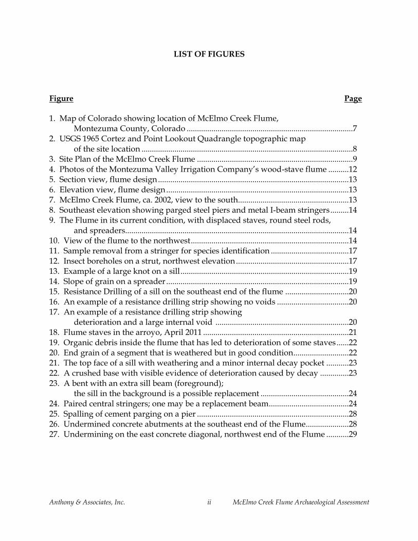
Figure 21. The top face of a sill with weathering and a minor internal decay pocket.
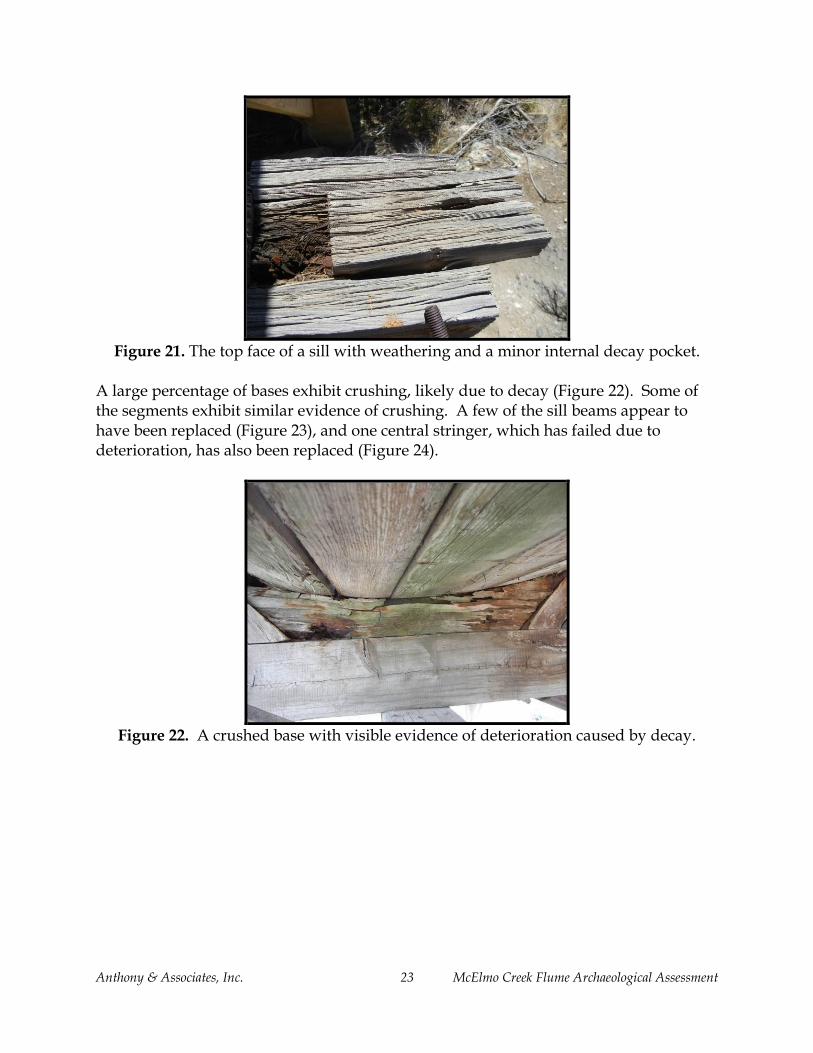
A large percentage of bases exhibit crushing, likely due to decay (Figure 22). Some of the segments exhibit similar evidence of crushing. A few of the sill beams appear to have been replaced (Figure 23), and one central stringer, which has failed due to deterioration, has also been replaced (Figure 24).
Figure 22. A crushed base with visible evidence of deterioration caused by decay.

Anthony & Associates, Inc. 24 McElmo Creek Flume Archaeological Assessment
Figure 23. A bent with an extra sill beam (foreground); the sill in the background is a
possible replacement.
Figure 24. Paired central stringers; one may be a replacement beam.
Wood Conditions The condition of every structural element was assessed and recorded; in most cases, the condition determination was based on visual inspection and probing; resistance drilling was conducted on a limited number of elements. Tables A-1 and A-2 in Appendix A document the condition by element and provide resistance drilling results. The terms, “good,” “fair,” and “poor” were used to describe the condition of the structural wood elements. “Good” is used to describe elements that have no evidence to minor evidence of deterioration due to decay or insect attack. Minor deterioration means that the damage is not visibly obvious and that it is incidental to the element’s ability to perform its current function. These elements may have small, localized areas of intermittent deteriorated wood that can be easily penetrated with an awl on the surface or may be shown to have a limited number of small internal voids. These

Anthony & Associates, Inc. 25 McElmo Creek Flume Archaeological Assessment
determinations may be based on visual inspection, probing, and/or resistance drilling. Structural elements may be determined to be in “fair” condition if there are obvious visible but localized voids or intermittent damage. An element classified as in “poor” condition is one that has significant deterioration, most likely due to wood decay fungi or insect activity, and may be unable to perform as needed. Elements in poor condition may contribute to the failure of the element or supporting structure. In general, the structural elements of the Flume can be considered to be in good to fair condition. Certain elements such as the bases have a higher percentage in poor condition than other elements. The primary factors affecting the condition are debris build-up within the flume structure that inhibits moisture evaporation and supports an environment suitable for wood decay fungi. The displaced elements on the southeast side are also more prone to deterioration because they are in contact with the ground. Weathering is a secondary concern; while the wood exhibits signs of weathering, in most cases the relish at the connections remains intact enough to maintain the integrity of the connection. Approximately 38 percent of the structural timbers (excluding spreaders and staves) are in good condition; approximately 18 percent are in fair condition; approximately 37 percent are in poor condition, and the remainder could not be assessed for condition because they were hidden or inaccessible. The staves were not assessed for condition, but in general appear to be in good to fair condition, except in areas where debris build-up has led to deterioration (primarily the bottom 1/3 of the flume structure). Table 1 provides a summary of noted conditions by element type.
Table 1. Condition Summary by Element
Condition
Element Good Fair Poor Missing Not
Accessible
Spreaders 26 18 16 10 -
Segments 6 5 20 2 3
Struts 28 1 3 3 1
Bases 2 7 9 - -
Sills 3 6 9 - -
Stringers 3 2 1 - -
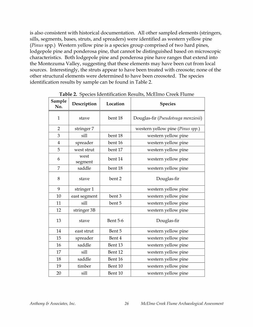
Species Twenty small samples were removed to identify the species of structural elements to aid in conducting any future structural analysis and specifying repairs. Based on microscopic characteristics of the wood, the species used for the flume staves is Douglas-fir (Pseudotsuga menziesii), which is consistent with historical sources. The stave samples removed had evidence of creosote visible in the cellular structure, which
Anthony & Associates, Inc. 26 McElmo Creek Flume Archaeological Assessment
is also consistent with historical documentation. All other sampled elements (stringers, sills, segments, bases, struts, and spreaders) were identified as western yellow pine (Pinus spp.) Western yellow pine is a species group comprised of two hard pines, lodgepole pine and ponderosa pine, that cannot be distinguished based on microscopic characteristics. Both lodgepole pine and ponderosa pine have ranges that extend into the Montezuma Valley, suggesting that these elements may have been cut from local sources. Interestingly, the struts appear to have been treated with creosote; none of the other structural elements were determined to have been creosoted. The species identification results by sample can be found in Table 2.
Table 2. Species Identification Results, McElmo Creek Flume
Sample No.
Description Location Species
1 stave bent 18 Douglas-fir (Pseudotsuga menziesii)
2 stringer 7 western yellow pine (Pinus spp.)
3 sill bent 18 western yellow pine
4 spreader bent 16 western yellow pine
5 west strut bent 17 western yellow pine
6 west
segment bent 14 western yellow pine
7 saddle bent 18 western yellow pine
8 stave bent 2 Douglas-fir
9 stringer 1 western yellow pine
10 east segment bent 3 western yellow pine
11 sill bent 5 western yellow pine
12 stringer 3B western yellow pine
13 stave Bent 5-6 Douglas-fir
14 east strut Bent 5 western yellow pine
15 spreader Bent 4 western yellow pine
16 saddle Bent 13 western yellow pine
17 sill Bent 12 western yellow pine
18 saddle Bent 16 western yellow pine
19 timber Bent 10 western yellow pine
20 sill Bent 10 western yellow pine

Anthony & Associates, Inc. 27 McElmo Creek Flume Archaeological Assessment
Lumber and Timber Grade In-situ visual grading was conducted to identify the quality of material used in the construction of the flume and to help specify material for potential future repairs. The in-situ grading also provided data for potential future engineering analyses, should that be necessary. Knot size and slope of grain were measured or estimated for all of the visible structural elements; detailed results can be found in Table A-2 in the Appendix A.
To be assigned a particular grade, 95 percent of the elements graded should fall within the grade. Since there were a limited number of wood elements, the percentage within a grade can fall below the 95 percent level if only a few elements fail to meet the higher grade. In these cases, the structural engineer may elect to apply the higher grade if knowledge of the grade, wood condition and structural loads warrants it. Based on species identification and observed defects, the staves are essentially clear of grade-limiting defects and can be considered Select Structural Douglas-fir. The other structural elements of the flume, excluding sills and stringers, can be considered No. 2 Western Woods. The sills and stringers do not meet requirements for a structural grade to be assigned. Selective reinforcement or replacement of lower grade joists and stringers would allow for the application of a higher structural grade should future analyses indicate that a higher grade is warranted. Table 3 includes a summary of the allowable grade by element type. Deteriorated elements and supplemental elements were not included in the grading totals.
Table 3. Grade for Structural Lumber and Timbers
Element Total
Graded
Select Structural
(%) No. 1 (%) No. 2 (%) No. 3 (%)
No Grade
(%)
spreaders 28 16 (57.1%) 5 (17.9%) 7 (25.0%) - -
sills 18 2 (11.1%) 8 (44.4%) 5 (27.8%) - 3
(16.7%)
stringers 4 3 (75.0%) - - - 1
(25.0%)
segments 27 18 (66.7%) 5 (18.5%) 4 (14.8%) - -
struts 30 17 (56.7%) 4 (13.3%) 9 (30.0%) - -
bases 14 6 (42.9%) 4 (28.6%) 3 (21.4%) - 1 (7.1%)

Anthony & Associates, Inc. 28 McElmo Creek Flume Archaeological Assessment
Concrete and Steel Substructure
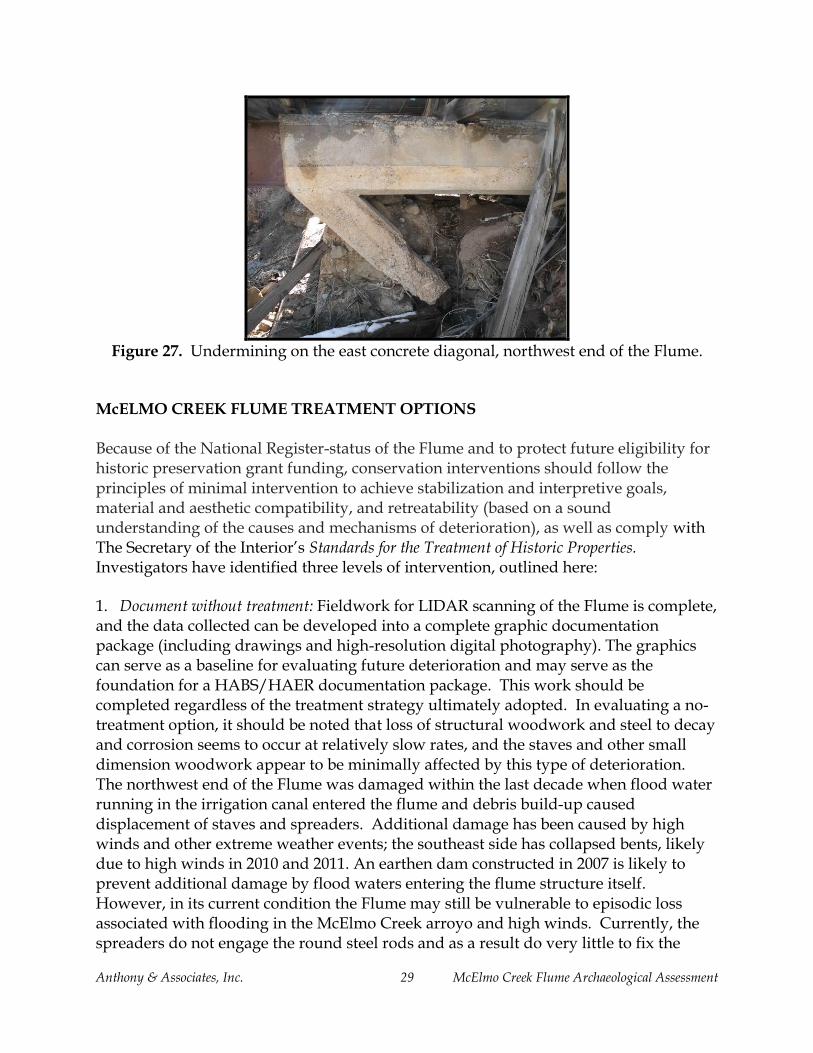
The piers located in the creek bed exhibit spalling of the parging, and some evidence of rust-jacking (Figure 25). The bank of the arroyo has eroded from underneath the parged steel abutments on the southeast end of the Flume, leaving the south supports hanging in space (Figure 26). Additionally, a diagonal concrete brace on the northwest end is also unsupported (Figure 27).
Figure 25. Spalling of cement parging on a pier.
Figure 26. Undermined abutments at the southeast end of the Flume.
Anthony & Associates, Inc. 29 McElmo Creek Flume Archaeological Assessment
Figure 27. Undermining on the east concrete diagonal, northwest end of the Flume.
McELMO CREEK FLUME TREATMENT OPTIONS Because of the National Register-status of the Flume and to protect future eligibility for historic preservation grant funding, conservation interventions should follow the principles of minimal intervention to achieve stabilization and interpretive goals, material and aesthetic compatibility, and retreatability (based on a sound understanding of the causes and mechanisms of deterioration), as well as comply with The Secretary of the Interior’s Standards for the Treatment of Historic Properties. Investigators have identified three levels of intervention, outlined here:
1. Document without treatment: Fieldwork for LIDAR scanning of the Flume is complete, and the data collected can be developed into a complete graphic documentation package (including drawings and high-resolution digital photography). The graphics can serve as a baseline for evaluating future deterioration and may serve as the foundation for a HABS/HAER documentation package. This work should be completed regardless of the treatment strategy ultimately adopted. In evaluating a no-treatment option, it should be noted that loss of structural woodwork and steel to decay and corrosion seems to occur at relatively slow rates, and the staves and other small dimension woodwork appear to be minimally affected by this type of deterioration. The northwest end of the Flume was damaged within the last decade when flood water running in the irrigation canal entered the flume and debris build-up caused displacement of staves and spreaders. Additional damage has been caused by high winds and other extreme weather events; the southeast side has collapsed bents, likely due to high winds in 2010 and 2011. An earthen dam constructed in 2007 is likely to prevent additional damage by flood waters entering the flume structure itself. However, in its current condition the Flume may still be vulnerable to episodic loss associated with flooding in the McElmo Creek arroyo and high winds. Currently, the spreaders do not engage the round steel rods and as a result do very little to fix the

Anthony & Associates, Inc. 30 McElmo Creek Flume Archaeological Assessment
staves in place; the scoured steel columns at the southeast end of the flume may be vulnerable to rotation caused by flood water and floating debris; and the unloaded framing bents may be easily displaced. Graphic documentation package: $TBD 2. Structural stabilization with preservation of the stave pipe in its current condition: With this treatment alternative, repairs would be made to parged steelwork and timber stringers and sills so that support for the superstructure (curved framing bents, staves, and round steel rods) is maintained. The semi-circular flume structure would essentially be preserved in its current condition. Steel and timber repairs will require different crews so these might be treated as separate phases. Ideally, steelwork should be cleaned to remove corrosion, followed by coating of the cleaned metal, and reinstatement of cementitious parging; the scoured columns near the east end of the Flume should be re-supported. Cleaning of the metal is likely to require collection and disposal of the waste products. Coating for corrosion resistance is likely to involve application of zinc-based primers and epoxy topcoats. Reparging will require reinstatement of reinforcing mesh. The short piers at the southeast end of the Flume and their diagonal braces are unsupported due to scour of the bank. The original foundation material has been lost, along with any connections that may have existed between the columns and braces. Despite splices located between the abutment and these piers, loss of support has not resulted in noticeable deflection of the steel beams that carry the wood superstructure. Without water in the Flume, support may not be required in this location, though there is concern that piers and braces are susceptible to rotation caused by debris carried by floodwaters. Design of these repairs is beyond the scope of this assessment, and is likely to require input from structural and geotechnical engineers, and contractors experienced in the cleaning and repainting of steel bridges. As an interim measure, the project team might consider stabilization options that are adequate for the reduced loads on the structure while stopping short of thorough going stabilization of the abutment slopes; options might include fixing of the southeast columns and braces using helical piles and tiebacks, cleaning of only the lower columns and braces where parging is affected by oxide jacking, collection of the waste using tarps laid on the dry riverbed, spot priming of the bare steel, and reinstatement of the parge coat.
Timber repairs will include repair / replacement of decayed stringers and sills. This can be accomplished most safely and efficiently by numbering the staves, round steel rods, and framing bents and removing them from the structure. This way the steel structure

Anthony & Associates, Inc. 31 McElmo Creek Flume Archaeological Assessment
can be decked and used as scaffolding, and the stringers can be repaired from above. Sill repairs can be made on the ground before repaired framing bents are reinstalled on the Flume. Repair options for stringers and sills include the filling of decay pockets with lumber dutchmen, splicing of new timber over supporting elements, and replacement in kind. Under this scenario the staves would be reinstalled in their current positions, but would not be supplemented with new material to complete the Flume. As a consequence, the spreaders would not engage the round steel rods adequately and the staves would still be subject to being dislodged. This might be countered by fastening staves to individual framing bents using nails or screws. The stave construction of the pipe, however, is one of the most interesting features of the Flume, and adapting the staves to another form of attachment is a less desirable option than one that replicates the original construction scheme. *Steel / concrete/ parging repairs: $TBD Woodwork repairs: $120K
3. Structural stabilization with restoration of the stave pipe: In this treatment scenario, structural stabilization would take place as described in Option #2, deteriorated framing bent elements would be repaired / replaced, the stave material would be reinstalled in its current position, and the historic material would be supplemented by replicated staves to complete the Flume. In this option, staves would be connected using the original round steel rods and spreaders; this retains the original construction system, provides the highest level of stability, and enhances the interpretive potential of the site. Framing bents are composed of elements having one of three repetitive profiles. Replacement pieces can be cut from patterns and brought to the site, where they can be used for dutchman repairs, splices, and replacement in kind. Repaired bents can be pre-assembled before returning them to the Flume. Replacement staves can be profiled on a 4-sided moulder to match samples collected in the field. Space will be required for repairing framing bents and for storage of salvaged staves. While Montezuma County (the owner of the Flume) is unable to provide funds for rehabilitation, they may be willing to make work and storage space available at the nearby fairgrounds. Ideally, this would also include camping space for crews, addressing security and housing issues at the same time. The pull-out adjacent to the flume would be used for staging steel repairs (which must be done in situ) and for loading and unloading salvaged / repaired woodwork; the county and CDOT would need to grant permission for these activities. *Steel / concrete/ parging repairs: $TBD Woodwork repairs: $150K

Anthony & Associates, Inc. 32 McElmo Creek Flume Archaeological Assessment
*The budget numbers offered here are preliminary, and are intended for planning purposes. The budgets assume that the School of Engineering at the University of Vermont will be a cooperator in the rehabilitation of the Flume, and that space will be provided by Montezuma County for staging the project (including camping space for the crews). The repair of the parge-coated steel will require the involvement of local subcontractors who have not been identified at this point. SUMMARY The McElmo Creek Flume is the last remaining flume of an extensive irrigation system developed in the late 1800s and early 1900s in Montezuma County. It is representative of a significant infrastructure development that facilitated the settlement of the Montezuma Valley. Constructed in 1921 and modified in 1955, the Flume functioned to carry irrigation water until 1992, when construction was completed for underground laterals associated with the McPhee Reservoir that replaced the original canal system. The Flume remained relatively intact until a flooding event in 2006. Since that time, high winds and additional debris build-up have led to additional deterioration. Flume staves, round steel rods, and spreaders have been displaced, and several bents on the southeast end have toppled, leading to element loss and deterioration. Wood elements that remain in-situ are generally in good-to-fair condition, with the most significant deterioration in the bases and segments. Scouring of the southeast bank of McElmo Creek has led to undermining of the concrete abutments on that end of the Flume; some spalling of the parging and rust-jacking of the parged steel frames has occurred. Steel elements have some oxidation. The condition of the McElmo Creek Flume can be summarized as follows:
LIDAR scanning of the McElmo Creek Flume has generated data that can be developed into a complete documentation package for future stabilization or preservation needs.
Extensive ground disturbance in the area of the Flume indicates there is little archaeological potential in the immediate project area.
The Flume is in a state of partial collapse due to a 2006 flooding event and subsequent deterioration.
The wood staves are creosoted Douglas-fir (Pseudotsuga menziesii), which is consistent with historical documentation that the flume was purchased from the Continental Pipe Manufacturing Company.
The larger structural timbers are western yellow pine (Pinus spp.), a locally available hard pine species group.

Anthony & Associates, Inc. 33 McElmo Creek Flume Archaeological Assessment
Of those larger structural elements with samples removed for species identification, only the struts appear to have been treated with creosote.
The bases have experienced the most significant deterioration; this is due to a combination of factors, including the construction detail that placed considerable loads perpendicular to the grain orientation of the base elements when the Flume was operational, likely resulting in some crushing, as well as the location of the bases at the bottom of the flume where debris accumulation and moisture have led to deterioration caused by wood decay fungi.
Of the sills that are deteriorated, the deterioration is typically caused by moisture intrusion through the top face of the beam that has led to an internal channel of decay.
The grade of the structural elements, excluding stringers and sills, is No. 2 Western Woods. The stringers and sill beams have too many elements that do not meet structural grade requirements to be assigned a structural grade.
Concrete and steel elements show some signs of deterioration, including spalling of the parging and oxidation.
Scouring of the southeast bank has undermined the southeast support piers.
Engineering analyses for the wood flume structure and/or the concrete and metal substructure have not been conducted.

Anthony & Associates, Inc. 34 McElmo Creek Flume Archaeological Assessment
BIBLIOGRAPHY American Forest & Paper Association and American Wood Council 2005 National Design Specification for Wood Construction, Washington, D.C. American Society for Testing and Materials 2006, Annual Book of Standards, Vol. 04.10: D245, “Standard Practice for Establishing
Structural Grades and Related Allowable Properties for Visually Graded Lumber;” D2555, “Standard Test Methods for Establishing Clear Wood Strength Values.” ASTM, West Conshohocken, Pennsylvania.
Colorado State Historic Preservation Office 2010 COMPASS Listing of Historic Sites, Colorado Office of Archaeology and Historic
Preservation, Denver, Colorado. Continental Pipe Manufacturing Company 1923, Catalog No. 18: Continental Wire Wound Wood Pipe, Continental Continuous Stave Wood Pipe, Continental Creo-Wood Flume. Davidson, Charlie 2011 Email Communication. Engineer, Montezuma Valley Irrigation Company,
Cortez, Colorado. Dietrich, James 2012 Email Communication. Landscape Architecture & Planning, Office of Community Services, Montezuma County, Cortez, Colorado. Engineering World 1922. Engineering World: A Journal of Engineering and Construction, 20-21:12. Folwell, Amory Prescott 1899 Water Supply Engineering: The Designing, Construction, and Maintenance of Water-
Supply Systems, Both City and Irrigation. John Wiley & Sons, New York, pp. 405-407.
Francis, Ken 2011 Email Communication. Director of Fort Lewis College, Office of Community
Services, Durango, Colorado. Gerhold, Maureen 1981 “Eastern Capitol and Frontier Initiative: The History of the Montezuma Valley Irrigation System,” in The River of Sorrows: The History of the Lower Dolores River

Anthony & Associates, Inc. 35 McElmo Creek Flume Archaeological Assessment
Valley, Ed. by Gregory D. Kendrick (Washington, DC: U.S. Department of the Interior:), 3. Goale, J. D. 1923 Catalog No. 18: Continental Wire Wound Wood Pipe, Continental Continuous Stave Wood Pipe, Continental Creo-Wood Flume (Seattle: Continental Pipe Manufacturing Co.,), 9, 125. Johnson, Iris Higgins, 2003 “The History of the Montezuma Valley Irrigation System,” Appendix D, MVIC Water Management Plan. Montezuma Valley Irrigation Company 1922 Record of Minutes, No. 1, from October 26, 1920-March 14, 1922, p. 44. 1920-1922 Archives, No. 1, from October 26, 1920-March 14, 1922, p. 31. Nunn, Less 2011 Personal communication with Rachel Parris, July 6, 2011. Parris, Rachel 2011 Draft National Register Nomination for the Montezuma Valley Irrigation
Company Flume No. 6, Colorado Preservation, Inc., Denver, Colorado Porter, John 2010a Personal Communication. Former President of the Board of Directors of
Montezuma Valley Irrigation Company, Cortez, Colorado. 2010b Most Endangered Places Nomination for Montezuma Valley Irrigation
Company’s McElmo Creek Flume. On file, Colorado Preservation, Inc., Denver, Colorado.
Schwindt, Vila, Janet Weeth and Dale Davidson 2011 Images of America: Cortez. Arcadia Publishing, Charleston, South Carolina. Soil Conservation Service 1986 Environmental Assessment for Onfarm Irrigation Improvements: McElmo Creek Unit
Salinity Control Study: Colorado River Basin Salinity Control Program. Soil Conservation Service assisted by Agricultural Stabilization and Conservation Service and Agricultural Research Service of the United States Department of Agriculture. Denver, pp.1-25.
USDA 2012 NRCS SNOTEL Stations, 1997. Electronic document, accessed July, 2012.

Anthony & Associates, Inc. 36 McElmo Creek Flume Archaeological Assessment
Western Wood Products Association 2011 Western Lumber grading Rules, Portland, Oregon. Wright, Aaron M. 2010 “The Climate of the Depopulation of the Northern Southwest,” in Leaving Mesa
Verde: Peril and Change in the Thirteenth-Century Southwest. The University of Arizona Press, Tucson, Arizona.

Anthony & Associates, Inc. 37 McElmo Creek Flume Archaeological Assessment
APPENDIX A
Resistance Drilling Results
Condition Assessment Summary
Plan View of Structural Elements

Anthony & Associates, Inc. 38 McElmo Creek Flume Archaeological Assessment
Table A-1. Resistance Drilling Results
Drilling Number
Bent Element ID Drilling
Direction Location Comments
D1 1 base top to
bottom through staves into base, mid-span stave solid then void
D2 2 base top to
bottom through staves into base, mid-span stave and sill solid, base void
D3 3 base top to
bottom through staves into base, mid-span
0.5" void at bottom of base, otherwise solid
D4 4 base top to
bottom through staves into base, mid-span debris in flume, no void
D5 5 base top to
bottom through staves into base, mid-span stave wet, 7.5" void then solid
D6 6 base top to
bottom through staves into base, mid-span
12" of debris in flume, base crushed, stave, base, and sill are
void
D7 7 base top to
bottom through staves into base, mid-span no void
D8 8 base top to
bottom through staves into base, mid-span
2" void at top of base, 2" void at top of sill
D9 9 base top to
bottom through staves into base, mid-span
1" void at top of base, 2" void at top of sill
D10 10 base top to
bottom through staves into base, mid-span 1" void at bottom of base
D11 11 base top to
bottom through staves into base, mid-span 1" void at top of base

Anthony & Associates, Inc. 39 McElmo Creek Flume Archaeological Assessment
Drilling Number
Bent Element ID Drilling
Direction Location Comments
D12 12 base top to
bottom through staves into base, mid-span saddle complete void, sill solid
D13 13 base top to
bottom through staves into base, mid-span
1.5" void at top of base, 2.5" void at top of sill
D14 14 base top to
bottom through staves into base, mid-span no void
D15 15 base top to
bottom through staves into base, mid-span no void
D16 16 base top to
bottom through staves into base, mid-span
base crushed, base and sill complete void
D17 18 stringer 7 W-E 2.5" from top, mid-span under sill 1" solid, then void
D18 18 stringer 7 W-E 6" from top, mid-span under sill 4" solid, then void
D19 18 stringer 7 W-E 2" from top, mid-span under sill shell only
D20 18 stringer 7 W-E 6" from top, mid-span under sill 3" internal void
D21 2 stringer 1 W-E 2.5" from top, mid-span under sill no void
D22 1 stringer 1 W-E 12" south of base, 2" below top no void

Anthony & Associates, Inc. 40 McElmo Creek Flume Archaeological Assessment
Table A-2. McElmo Creek Flume Condition and Grade Data by Element (green = good condition, orange = fair condition, red = poor condition) Spreaders Staves East Segment West Segment East Strut West Strut Base Sill Stringer
Bent Existing Deteriorated Grade Description Condition Grade Condition Grade Condition Grade Condition Grade Condition Grade Condition Grade Condition Grade
1 5 2 3 - SS, 1 - No. 2
clear, mix of flat and
vertical grain, 2/3 missing
hollow, failed at center
SS
deterioration and shear failure at
stress point
No. 2 good
condition SS
good condition
SS crushed SS decayed at mid-span
No. 2 good condition, no
void when drilled at
bent 2
No Grade - knot
exceeds grade
limitations 2 4 1
2 - SS, 1 - No. 1
clear, mix of flat and
vertical grain, 2/3 missing
no split at stress point
SS
visible deterioration, split at stress
point
No. 2 good
condition No. 2
good condition
SS crushed
no grade due to
extent of deterioration
channeled decay, east end, some
insect damage
No. 1
3 4 1 2 - SS, 1 - No. 2
clear, weathered, in general
in good condition
deteriorated on south side and bottom
SS evidence of
deterioration at bottom
SS good
condition No. 1
good condition
SS visible decay
channel No. 1
channeled decay, east end, some
insect damage
no grade assigned
2 - spans bents 3 to 6,
decay channel on top grow
larger nearing bent 6 - 4" deep at
bent 6
no grade assigned
4 4 0 1 - SS, 3 - No. 2
buried under debris,
condition unknown
split at stress point, visible deterioration
south face
No. 1
visible deterioration, split at stress
point
No Grade
weathered, but good condition
No. 2 good
condition SS
some crushing,
visible surface
deterioration, no void
when drilled
SS shell only at
mid-span No. 1
5 4 0 2 - SS, 2 - No. 1
buried under debris,
condition unknown
likely decay at bottom
No. 2
deterioration likely at
stress point, displaced
1.5" to south
SS good
condition SS
insect damage
No. 2 3" decay channel
No. 1
heavily weathered on ends,
crushing at mid-span, 2" void at top
when drilled
SS
6 4 1
clear, staves on west side in good
condition, east and center buried under debris
likely decay at bottom
No. 2
visible deterioration
at stress point
No. 1 good
condition No. 1
good condition
SS crushed
no grade due to
extent of deterioration
crushing mid-span,
decay channel west
end
No. 1
7 0 NA NA
staves end for gate, staves on west side in good
condition, east and center buried under debris
likely decay at bottom
SS not visible NA deteriorated at gate notch
detail SS
decay channel,
poor condition, partially
hidden by stairs
unknown
moisture staining, no
obvious deterioration,
no void when drilled
No Grade - knot exceeds grade limits
surface deterioration, only visible
on north
No. 2
3A and 3B - span bents 6 to 9; 3A has
failed at bents 6-7, 3B has surface
deterioration but no
evidence of internal decay
3A - no grade due
to condition;
3B - SS

Anthony & Associates, Inc. 41 McElmo Creek Flume Archaeological Assessment
Spreaders Staves East Segment West Segment East Strut West Strut Base Sill Stringer
Bent Existing Deteriorated Grade Description Condition Grade Condition Grade Condition Grade Condition Grade Condition Grade Condition Grade Condition Grade
8 4 2 clear, 30% flat grain
condition unknown -
hidden unknown not visible NA
hidden by gate
construction, condition unknown
unknown
decay channel,
poor condition, partially
hidden by stairs
unknown
heavy moisture staining,
likely deterioration, 2" void when
drilled
SS
surface deterioration, 2" void at top when drilled
No Grade - knot
exceeds grade
limitations
9 4 2 visually
looks good SS
staining at stress point
SS
split on south side, otherwise
good condition
SS
large insect
holes with frass, good condition otherwise
SS crushed, 1" void at top
SS
2" deep channelized deterioration at mid-span,
moisture staining
No. 1
4 - spans bents 9 to 12,
some deterioration and crushing
at bent 9, decay pocket under saddle
at bent 10, good
condition bents 11 and
12
10 4 0
visually looks good
SS
visible deterioration and failure south face
SS good
condition No. 2
good condition
SS crushed, 1"
void at bottom
No. 2 replacement
sill? Good condition
No. 1
11 3 1
clear, good condition, 30% flat
grain
deteriorated on south side and bottom
No. 1
visible deterioration and failure south face
No. 1 good
condition No. 1
weathered, but good condition
SS fair
condition, 1" void at top
No. 1 decay pocket under west
strut
No Grade - knot
exceeds grade
limitations
12 3 1
clear, good condition,
90% vertical grain
visually looks good
SS
evidence of deterioration
at bottom, failure at
stress point
SS weathered, but good condition
No. 2 good
condition SS
crushed, visible
deterioration, complete
void when drilled
SS some
crushing mid-span
No. 2
5 - spans bents 12 to 15, good condition
SS
13 1 0
clear, good condition,
90% vertical grain
visibly deteriorated
west face SS
decay channel at
bottom
No grade
assigned due to decay
good condition
SS
rotated out of plane,
insect damage,
otherwise good
condition
No. 2
some crushing and
visible deterioration,
1.5" void at top when
drilled
no grade assigned
decayed at steel I-beam,
west, 2.5" void at top at
mid-span when drilled
No. 1
14 4 1
fewer staves, clear, in
good condition
deteriorated on south side and bottom
SS
signs of deterioration
at stress point
No. 1
fair condition
due to weathering
No. 1 good
condition SS
visible crushing, but
no voids when drilled
No. 2
appears to be in good
condition, no voids mid-
span
No. 2
15 2 0 displaced
deteriorated on south side and bottom
SS visible
deterioration, crushing
No grade
assigned due to decay
good condition
No. 2 good
condition No. 2
failed, but no voids found when drilled
SS
small stress-failure at
center knot, south side, otherwise
good condition, no voids at mid-
span when drilled
No. 2
6 - spans bents 15 and
16, good condition
SS

Anthony & Associates, Inc. 42 McElmo Creek Flume Archaeological Assessment
Spreaders Staves East Segment West Segment East Strut West Strut Base Sill Stringer
Bent Existing Deteriorated Grade Description Condition Grade Condition Grade Condition Grade Condition Grade Condition Grade Condition Grade Condition Grade
16
10 - displaced through bent 18
4
6 - SS, 2 - No. 1, 2 - No.
2
displaced; those in flume in fair-good condition,
clear
deteriorated on south side and bottom
No grade assigned
on ground, good
condition SS
good condition
SS missing NA
crushed, complete
void when drilled
No. 1
decay channel at mid-span
and at east end,
complete void when drilled at mid-span
No. 1 7 - spans bents 16 to 18, decay channel
visible from top, surface
deterioration, shell at bent 16 and bent
18 when drilled
no grade assigned
17 see
above
displaced; mostly on
the ground, fair-poor
condition, clear
on ground, poor
condition, failed at
stress point
SS good
condition SS
on ground, good
condition SS
good condition
No. 2 visually in
good condition
no grade assigned
rotated 45 degrees,
good condition
SS
18 see
above
missing or on ground, fair-poor
condition, clear
missing NA missing NA missing NA missing NA decayed No. 2 deteriorated at mid-span
No. 1

Anthony & Associates, Inc. 43 McElmo Creek Flume Archaeological Assessment
Figure A-1. Plan view of the McElmo Creek Flume (not to scale) showing structural elements and resistance drilling locations.
NW culvert
SE culvert
Bent 1
Bent 2
Bent 8
Bent 9
Bent 10
Bent 11
Bent 12
Bent 13
Bent 14
Bent 15
Bent 16
Bent 17
Bent 18
Bent 3
Bent 4
Bent 5
Bent 6
Bent 7
Stringer 1 Stringer 6 Stringer 5 Stringer 4 Stringer 3B Stringer 3A Stringer 2 Stringer 7
D1
D2 D3
D4
D5
D8 D6
D7 D10
D11
D12
D13
D14
D15
D16 D17, D18
D19, D20
D21, D22
D9

Anthony & Associates, Inc. 44 McElmo Creek Flume Archaeological Assessment
APPENDIX B
McElmo Flume LIDAR Scanning Project Report
The McElmo Flume Site Plan