aqr geo hcp wildstock final july 2008
TRANSCRIPT
8/2/2019 Aqr Geo Hcp Wildstock Final July 2008
http://slidepdf.com/reader/full/aqr-geo-hcp-wildstock-final-july-2008 1/107
Habitat Conservation Planfor the Washington State
Department of Natural Resources’
Wild Geoduck Fishery
July 2008
Aquatic Resources Program
N
A
T
U
R
A
L
R
E
S
O
U
R
C
E
S

8/2/2019 Aqr Geo Hcp Wildstock Final July 2008
http://slidepdf.com/reader/full/aqr-geo-hcp-wildstock-final-july-2008 2/107
8/2/2019 Aqr Geo Hcp Wildstock Final July 2008
http://slidepdf.com/reader/full/aqr-geo-hcp-wildstock-final-july-2008 3/107
Washington State DNR Aquatic Resources Wild Geoduck HCP ii
Table of Contents
1. Introd uc tion an d Bac kgro un d ...................................................................... 1
1-1 Background ............................................................................................................... 1
1-2 Permit Duration .......................................................................................................... 3
1-3 Plan Area ................................................................................................................... 3
1-4 Species to be Covered .............................................................................................. 3
1-5 Regulatory and Legal Framework ............................................................................. 7
2. Environ me nta l Setting .................................................................................. 9
2-1 Overview .................................................................................................................... 9
2-2 Species of Concern in the Plan Area ...................................................................... 14
2-3 Covered Species ..................................................................................................... 15
2-4 Food Web Interactions ............................................................................................ 25
2-5 Existing Land Use .................................................................................................... 27
3. Pro ject Des crip tion a nd Cove re d Activities .............................................. 29
3-1 Project Description .................................................................................................. 29
3-2 Activities Covered by Permit.................................................................................... 37
3-3 Determining TAC and Managing Geoduck Tracts................................................... 43
3-4 Fishery Enforcement Activities ................................................................................ 45 4. Po ten tial Biolog ical Imp ac ts an d Take As s es s me nt ................................ 47
4-1 Direct and Indirect Effects ....................................................................................... 47
4-2 Impacts to Covered Species.................................................................................... 54
4-3 Cumulative Impacts ................................................................................................. 63
5. Con s erva tion Stra teg y ............................................................................... 65
5-1 Goal for Conservation Purposes ............................................................................. 65
5-2 Mechanisms to Meet the Objectives and Strategies ............................................... 67
5-3 Covered Species ..................................................................................................... 71
5-4 Measures to Mitigate Unavoidable Impacts ............................................................ 78
5-5 Monitoring ................................................................................................................ 79
6. Fund ing ....................................................................................................... 83
6-1 Sources of Funding and Plan Costs ........................................................................ 83

8/2/2019 Aqr Geo Hcp Wildstock Final July 2008
http://slidepdf.com/reader/full/aqr-geo-hcp-wildstock-final-july-2008 4/107
Washington State DNR Aquatic Resources Wild Geoduck HCP iii
7. Alte rnatives ................................................................................................. 85
7-1 Alternative 1. Discontinue Harvest .......................................................................... 85
7-2 Alternative 2. Different Harvest Methods ................................................................ 85
8. Plan Impleme ntation, Chang ed a nd Unfores een Circum s tanc es ............ 87
8-1 Plan Implementation ................................................................................................ 87
8-2 No Surprises Policy .................................................................................................. 89
9. Refere nces ................................................................................................... 93
8/2/2019 Aqr Geo Hcp Wildstock Final July 2008
http://slidepdf.com/reader/full/aqr-geo-hcp-wildstock-final-july-2008 5/107
Washington State DNR Aquatic Resources Wild Geoduck HCP 1
1. Introduction and Background
The Washington Department of Natural Resources (DNR) has developed this Wild Stock
Geoduck Fishery Habitat Conservation Plan (Geoduck HCP) in response to the federal
listings of certain fish and wildlife species under the Endangered Species Act. ThisGeoduck HCP only considers the geoduck fishery that is administered and managed by
Washington DNR.
Washington DNR is seeking authorization for incidental take of certain ESA-listed
species under Section 10 of the ESA. Such authorization is gained through the
development of this Geoduck HCP and the subsequent issuance of Incidental Take
Permits under Section 10 of the ESA from both U.S. Fish and Wildlife Service and theNational Marine Fisheries Service.
1-1 Background
The Washington State Department of Natural Resources manages over 2.4 million acres
of state-owned aquatic lands and their associated biota in marine and freshwater
environments. These are submerged marine and freshwater bedlands, marine tidelands,
and freshwater shorelands that contain a variety of aquatic plants and algae, numerous
animals living on or within the substrate, and other valuable materials in and on the
substrate.
The geoduck clam (Panopea abrupta) is one infaunal species that occurs on state-ownedsubtidal bedlands and tidelands and is managed by DNR. A commercial fishery on the
geoducks has occurred for over 35 years and is the subject of this HCP.
1-1.1 Aqu atic Lan d Man ag em en t, RCWs
As the proprietary manager of state-owned aquatic lands, DNR has unique obligations.
State law recognizes aquatic lands to be a finite natural resource, and charges DNR with
managing the land for the benefit of the public (Revised Code of Washington [RCW]79.105.010). In RCW 79.105.030, the legislature has directed DNR to endeavor to
provide a balance of public benefits that include:
Encouraging direct public use and access;
Fostering water-dependent uses;
Ensuring environmental protection;

8/2/2019 Aqr Geo Hcp Wildstock Final July 2008
http://slidepdf.com/reader/full/aqr-geo-hcp-wildstock-final-july-2008 6/107
Washington State DNR Aquatic Resources Wild Geoduck HCP 2
Utilizing renewable resources; and
Generating revenue in a manner consistent with the other defined benefits.
There are a number of state laws in the RCW and rules in the Washington Administrative
Code (WAC) specifically guiding the use of state-owned aquatic land for geoduck
harvest and specifying certain management parameters of the fishery (Appendix A).
1-1.2 His tory of the Geo du ck Fis he ry
In 1967, the agency that is now the Washington Department of Fish and Wildlife
(WDFW) began conducting subtidal surveys to determine if the geoduck resource could
support commercial harvest. The geoduck resource of Puget Sound and the Strait of Juan
de Fuca was found to have sufficient biomass to support a commercial fishery. In l969,
DNR and WDFW jointly petitioned the Legislature to open a commercial geoduck
fishery. The Legislature created statute to control harvest, and directed DNR and WDFW
to manage the fishery cooperatively.
In 1970, the first harvesting contract was offered for sale. Demand for geoducks waslimited initially, but by the mid-1970s, it grew significantly when the industry found a
market for geoducks in Japan. In the first five years of the fishery (1970-1974), the
average annual harvest was about 491,000 pounds. From 2000 to 2004 it was about
4,130,000 pounds (This is the total
1-1.3 How the Fis he ry is Man ag ed
harvest; tribal and state). The fishery has grown to be
a large and economically important clam fishery on the west coast of North America.
Washington’s geoduck fishery is jointly managed by Washington Department of Natural
Resources, the Washington Department of Fish and Wildlife (WDFW), and the sixteen
tribes that have a right to up to 50 percent of the harvestable surplus of geoducks (as
affirmed in United States v. Washington, 873 F. Supp. 1422 W.D. Wash. 1994 andUnited States v. Washington, 898 F. Supp. 1453 W.D. Wash. 1995). The state agencies
and the tribes are jointly responsible for estimating population size, determining
sustainable yield, and ensuring that adverse effects to the environment are kept to a
minimum.
The commercial geoduck fishery is managed on a sustainable basis and at a conservativelevel. Management of the geoduck resource is designed to be responsive to changes in
market demand, resource economics, and new information on geoduck biology and
population dynamics.
Washington DNR has proprietary rights over the state’s harvest opportunity on half of theharvestable geoducks and offers the right to harvest specific quantities in specific areas to
private companies and individuals. The terms of harvest are stipulated in a harvesting
agreement, which is a legally binding contract between the state and each private harvest
company that participates in the fishery (Appendix B).
Washington Department of Fish and Wildlife is the manager of the biological aspects of
the fishery and has licensing and enforcement responsibilities for the geoduck fishery. It
manages the fishery as part of its larger authority under RCW’s 77.65, 77.12.043 and
77.12.047.

8/2/2019 Aqr Geo Hcp Wildstock Final July 2008
http://slidepdf.com/reader/full/aqr-geo-hcp-wildstock-final-july-2008 7/107
Washington State DNR Aquatic Resources Wild Geoduck HCP 3
Although each state agency has separate and distinct responsibilities, DNR and WDFW
share enforcement responsibility for Washington State laws, regulations, and harvestingagreement conditions as appropriate within the responsibilities and mandates of each
agency. For example DNR is responsible for on-tract compliance of geoduck harvest and
WDFW is responsible for general off-tract enforcement (e.g., poaching curtailment).
1-2 Permit Duration
Washington Department of Natural Resources is requesting Incidental Take Permits for
50 years. Geoduck harvest has been occurring for over 35 years, and has been occurring
at about the same levels since the late 1990’s; about 7 years. The fishery is managed
using a sustainable harvest rate model and it is expected to continue in the future at a
similar harvest level.
1-3 Plan Area
The Geoduck HCP plan area occurs within the submerged lands of Puget Sound, the
Strait of Juan de Fuca and areas north to the Canadian border (Figure 1, which also shows
management regions, discussed in Chapter 3). Within this broad area, commercial
geoduck harvest occurs subtidally in areas that have been surveyed between depth
contours of –18 and –70 feet (corrected to mean lower low water [MLLW]) and found to
contain geoducks at sufficient densities (Figure 2). Following environmental and health
review, specific areas (tracts) are identified as appropriate for commercial harvest.
Details of harvest locations and activities are in Chapter 3.
1-4 Species to be Covered
Washington Department of Natural Resources is requesting coverage under Incidental
Take Permits for seven species currently federally listed as threatened or endangered, and
another eight species with some other listing status (Table 1.1). Throughout the
remainder of this document, the term “covered species” refers to all listed and unlisted
species included in the HCP and listed in Table 1.1.

8/2/2019 Aqr Geo Hcp Wildstock Final July 2008
http://slidepdf.com/reader/full/aqr-geo-hcp-wildstock-final-july-2008 8/107
Washington State DNR Aquatic Resources Wild Geoduck HCP 4
Table 1.1. Spe cies for which DNR is req ue s ting co verag e in Inc ide ntal Take Pe rmits .
Common Name Scientific Name Federal Status State Status
Birds
Bald eagleHaliaeetus leucocephalus
De-listed Threatened
California brownpelican
Pelecanus occidentalis
Endangered Endangered
Marbled murreletBrachyramphus marmoratus
Threatened Threatened
Tufted puffin Fratercula cirrhata Species of Concern Candidate
Fish
Bull troutSalvelinus confluentus
Threatened Candidate
Chinook salmonOncorhynchus
tshawytscha
Endangered/
ThreatenedCandidate
Chum salmon Oncorhynchus keta Threatened Candidate
Coastal cutthroattrout
Oncorhynchus clarki clarki
Species of Concern None
Coho salmonOncorhynchus kisutch
Concern/Candidate Not Listed
Pink salmonOncorhynchus gorbuscha
None None
Pacific herringClupea harengus pallasi
Candidate Candidate
SteelheadOncorhynchus mykiss
Threatened Candidate
Marine Mammals
Southern residentorca
Orcinus orca Endangered Endangered
Invertebrates
Pinto abaloneHaliotis kamtschatkana
Candidate Candidate
Olympia oyster Ostrea conchaphila None Candidate

8/2/2019 Aqr Geo Hcp Wildstock Final July 2008
http://slidepdf.com/reader/full/aqr-geo-hcp-wildstock-final-july-2008 9/107
Washington State DNR Aquatic Resources Wild Geoduck HCP 5

8/2/2019 Aqr Geo Hcp Wildstock Final July 2008
http://slidepdf.com/reader/full/aqr-geo-hcp-wildstock-final-july-2008 10/107
Washington State DNR Aquatic Resources Wild Geoduck HCP 6
8/2/2019 Aqr Geo Hcp Wildstock Final July 2008
http://slidepdf.com/reader/full/aqr-geo-hcp-wildstock-final-july-2008 11/107
Washington State DNR Aquatic Resources Wild Geoduck HCP 7
1-5 Regulatory and Legal Framework
1-5.1 Enda nge red Spe cies Act and As s uranc es
Initially passed in 1973, the Endangered Species Act (16 U.S.C. § 1531-1544, 87 Stat.
884, as amended), provides for the special designation and protection of invertebrates,wildlife, fish and plant species that are in danger of becoming extinct. A fundamental
purpose of the ESA is to protect and recover endangered and threatened species and to
provide a means to conserve the ecosystems on which they depend.
The ESA defines an endangered species as any species that is in danger of becoming
extinct throughout all or a significant portion of its range (16 U.S.C. § 1532(6)). Athreatened species is one that is likely to become endangered in the foreseeable future (16
U.S.C. § 1532(20)).
The U.S. Fish and Wildlife Service, housed within the Department of the Interior, and the
National Marine Fisheries Service, housed within the Department of Commerce, share
responsibility in administering the ESA. Generally, the USFWS is responsible forterrestrial species and freshwater aquatic species and the NMFS is responsible for marine
mammals, anadromous fish and other marine species.
Section 9 of the ESA makes it unlawful to “take” a species that is listed as endangered.
The term “take” under the ESA is defined as: “to harass, harm, pursue, hunt, shoot,
wound, kill, trap, capture, or collect, or to attempt to engage in any such conduct” (16
U.S.C. § 1532 (19)). By federal regulation, the take prohibitions can be extended to
species listed as threatened as well (16 U.S.C. § 1538(a)).
Section 10 of the ESA provides an exception to the Section 9 take prohibition. It states
that the Secretary of the Interior or the Secretary of Commerce (depending on the speciesinvolved) may permit any taking otherwise prohibited by Section 9, if such taking is
incidental to, and not the purpose of, carrying out an otherwise lawful activity (16 U.S.C.
§ 1539(a). A landowner can obtain an Incidental Take Permit under this provision if they
submit a conservation plan (i.e., an HCP) that meets certain requirements.
The plan must specify:
The impact which will likely result from the take;
What steps the applicant will take to monitor, minimize and mitigate such impacts;
the funding available to implement such steps; and as well as the procedures to be
used to deal with changed and unforeseen circumstances;
What alternative actions to such taking the applicant considered and the reasons
why such alternatives are not being utilized; and
Other measures that the Secretary of the Interior and/or Commerce may require as
being necessary or appropriate for purposes of the plan. (16 U.S.C. 1539(a)(2)(A))

8/2/2019 Aqr Geo Hcp Wildstock Final July 2008
http://slidepdf.com/reader/full/aqr-geo-hcp-wildstock-final-july-2008 12/107
Washington State DNR Aquatic Resources Wild Geoduck HCP 8
1-5.2 Is s ua nc e Criteria
When the USFWS and NMFS determine that all criteria for a habitat conservation plan
have been met, and after an opportunity for public comment, an Incidental Take Permit
must be issued if the agencies find that:
The taking will be incidental;
The applicant will, to the maximum extent practicable, minimize and mitigate the
impacts of such taking;
The applicant will ensure that adequate funding for the plan will be provided;
The taking will not appreciably reduce the likelihood of the survival and recovery
of the species in the wild; and
Such measures that the secretaries of the Interior and Commerce may require as
being necessary or appropriate for the purposes of the plan will be met. (16 U.S.C.
1539(a)(2)(B)):
1-5.3 Section 7 Cons ultation
Section 7(a)(2) of the ESA requires Federal agencies in consultation with, and with the
assistance of, the Secretary to ensure that any action authorized, funded, or carried out by
such agency is not likely to jeopardize the continued existence of any endangered species
or threatened species or result in the destruction or adverse modification of designated
critical habitat. The issuance of an Incidental Take Permit requires an analysis under
Section 7 of the ESA. The Section 7 implementing regulations (50 CFR Part 402) require,among other things, analysis of the direct and indirect effects of a proposed action, the
cumulative effects of other activities on listed species, and effects of the action on critical
habitat, if applicable. Consultation under Section 7 of the ESA is the responsibility of theFederal agencies. However, DNR’s Geoduck HCP is designed to assist the Services in
addressing potential effects from geoduck harvest in their Section 7 consultation process.

8/2/2019 Aqr Geo Hcp Wildstock Final July 2008
http://slidepdf.com/reader/full/aqr-geo-hcp-wildstock-final-july-2008 13/107
Washington State DNR Aquatic Resources Wild Geoduck HCP 9
2. Environmental Setting
2-1 Overview
Commercial geoduck harvest occurs within specific water depth boundaries in Puget
Sound and the Strait of Juan de Fuca. Future harvest will occur to the north, in the
vicinity of the San Juan archipelago (Figures 1 and 2).
2-1.1 The Nea rs ho re
The nearshore environment is considered to encompass the shoreline area from extremehigh water seaward to the 66-foot (20 m) bathymetric contour. This encompasses the area
of intertidal and subtidal marine bedlands that receive enough sunlight to (potentially)
support the growth of attached algae (Redman et al. 2005). The –18 to –70 foot water
depths where geoduck harvest takes place occur within the subtidal portion of the
nearshore environment.
Within Puget Sound, the Strait of Juan de Fuca and the San Juan archipelago, nearshore
environments play a critical role in the life history of many organisms. Nearshore marine
waters are important for juvenile and adult food production and serve as critical areas for
salmon migration, nursery areas, residence, and refugia (Mavros and Brennan 2001;
Williams et al. 2001; Brennan et al. 2004). These areas are rich, complex, and importantparts of the ecosystem. Kelp beds, eelgrass meadows, salt marshes, rocky shores, beaches
and tidal flats are important nearshore environments. They support populations of
shellfish, salmon, groundfish, seabirds, and marine mammals.
2-1.2 Eelgrass
Eelgrass is a flowering plant that grows primarily in the shallow, subtidal areas of the
nearshore on sandy or muddy substrate. The plant spreads by rhizomes or rootstock.
Expanses of eelgrass meadows expand during spring and summer then decline in the fall
and winter. Multiple environmental factors influence the distribution of eelgrass,
including light, substrata type, salinity, and wave action (Thom et al. 1998).
Eelgrass is an important component of the nearshore environment. Eelgrass meadows
cushion the impact of waves and currents, preventing erosion. The rhizomes and roots of
the plants hold sediments in place, which helps preserve the highly productive bacteria in
the sediments. These bacteria in turn nourish large numbers of invertebrates such as
isopods, amphipods, polychaete worms, brittle stars, and some clams. The abundance of
invertebrates makes eelgrass meadows excellent foraging areas for fish and marine birds.
Some species of birds, snails, and crabs feed directly on the leaves of eelgrass as well.
Others species (e.g., urchins) feed on detritus from decaying eelgrass plants.

8/2/2019 Aqr Geo Hcp Wildstock Final July 2008
http://slidepdf.com/reader/full/aqr-geo-hcp-wildstock-final-july-2008 14/107
Washington State DNR Aquatic Resources Wild Geoduck HCP 10
During low tides, eelgrass provides shelter from direct sunlight and extreme temperatures
for small animals and plants (Phillips 1984; Hemminga and Duarte 2000; Blackmon et al.
2006).
Eelgrass beds of two species ( Zostera marina and Zostera japonica) occur along 37
percent of Washington’s shorelines. The distribution of Z. marina (the native species) in
Puget Sound is highly aggregated with about 27% of the total located in Padilla and
Samish Bays. Eelgrass has not been observed in the extreme southern reaches of the
Sound such as Budd Inlet, Eld Inlet and Totten Inlet (Dowty et al. 2005).
Eelgrass is light limited and in Puget Sound rarely occurs deeper than –18 feet MLLW.
It can occur deeper where clearer waters allow a greater depth of light penetration.
Data collected from 2002-2004 were used to assess the depth distribution of eelgrass in
Puget Sound. Z. marina, at the sound-wide scale, is most frequently found (measured in
hectares) from 0 ft (MLLW) to –5 ft (MLLW) in depth. In the San Juan area, a
substantially greater proportion of total Z. marina is found below –10 ft (MLLW)
(Selleck et al. 2005).
Ultimately, because of the role of eelgrass as the basic energy source for a variety of food
web interactions, and because of the other functions it provides, the covered species use,
or benefit in some manner from eelgrass.
2-1.3 Othe r Vege tation
Kelp beds are important to fish, invertebrates, marine mammals and marine birdsdependent on nearshore habitats. Floating kelp is most common in rocky, high-energy
environments. For example, floating kelp is common along the rocky outer coast
headlands and along the north coast of the Olympic Peninsula (e.g., around Port
Townsend), but it is rare in Hood Canal. Floating kelp abundance decreases gradually as
energy decreases and rocky habitat is less common. Floating kelp is rare in lower energy
waters that have predominantly sand and mud shallow subtidal substrate. Like floating
kelp, non-floating kelp is most common in areas with relatively high energy rockyshorelines. Non-floating kelp, principally Laminaria saccharina, occurs in protected,
lower energy areas and embayments.
Seaweeds occur throughout the marine nearshore where the water is saline and there is
adequate light to support their growth. Most grow attached to consolidated substrata, butsome green seaweeds can grow without being attached to the bottom. Rocky shores along
the Strait of Juan de Fuca and rocky outcrops on Washington’s outer coast support
hundreds of species of seaweed. In central Puget Sound, the occurrence of intertidal
seaweed at five beaches was surveyed and 157 species identified (Thom et al. 1976).
Common macroalgae in Puget Sound include Laminaria, Alaria, Gracilaria,
Desmarestia, and Neoagardhiella species. They need hard substrate for attachment and
are found in rocky areas and consolidated substrate. Smaller species such as sea lettuce
(Ulva sp.) occur as well. Numerous foliose red algae species are common, and articulated
coraline red algae species occur in the Strait of Juan de Fuca and the San Juan Island
area.
8/2/2019 Aqr Geo Hcp Wildstock Final July 2008
http://slidepdf.com/reader/full/aqr-geo-hcp-wildstock-final-july-2008 15/107
Washington State DNR Aquatic Resources Wild Geoduck HCP 11
Phytoplankton is an important food source for suspension feeders. In Puget Sound,
phytoplankton concentrations generally exceed 0.2 mg chlorophyll-a/cubic meter (m3)throughout the year—one of the highest concentrations found in saltwater environments
(Strickland 1983).
2-1.4 Substrate
Substrate composition in the nearshore is mud, sand, harder consolidated material (clay)
gravel, cobble and boulders. Solid rock outcrops can occur as well.
Unconsolidated sediments play an important role in Puget Sound, harboring
microorganisms and invertebrates important in nutrient cycling and in the food web.
They are the ultimate repository of both natural changes (e.g., grain size changes due to
fluvial input) and human caused contaminants entering the Sound through both point and
nonpoint sources. Sediment quality, in terms of contamination levels, differs dramatically
around Puget Sound. Certain regions in the Sound have degraded conditions as a result of
pollution, while other regions are uncontaminated.
Environmental variables, both natural and human caused, influence sediment conditions,and sediment-dwelling biota. These include the level of dissolved oxygen present in the
sediments, concentrations of nutrients in the sediments and their movement between the
sediment bed and water column, unregulated pollutants including the newly emerging
pollutants of concern such as polybrominated diphenyl ethers (PBDEs) and endocrine
disruptors, effects of reproduction and recruitment of infaunal species, and effects of
predation and oceanographic conditions. The effects of these environmental variables
play a large role in influencing the quality of sediments throughout Puget Sound
(Partridge et al. 2005).
2-1.5 Ben thic Inve rteb rates
A wide variety of animals that are either buried or partly buried in the substrate occur in
the nearshore, and others live on the substrate or are free-living in the waters above the
substrate. These include clam species, anemones, polychaete tube worms, flat worms,ribbon worms, peanut worms, crustaceans and others. Small isopods, amphipods, and
copepods are also common within and on the substrate. These are an important food
source for higher trophic level fish and animals. The structure of benthic infaunal
communities is largely dependent on sediment composition and hydrographic conditions
(i.e. depth, current velocity) so that the abundance and diversity of species found is not
consistent across the substrate.
A number of crab species are common on the substrate in the nearshore. The large
Dungeness crab is particularly abundant in Puget Sound waters north of Vashon Island.Dungeness crabs are often associated with sand/silt substrate, especially near eelgrass
beds. Like most crabs, Dungeness crabs are benthic predators and scavengers. The
graceful crab is also abundant, particularly in southern Puget Sound (Goodwin and Pease
1987).
Red rock crabs are another species widely distributed across Puget Sound. A variety of
smaller crabs such as the kelp crab can also be found in the nearshore.

8/2/2019 Aqr Geo Hcp Wildstock Final July 2008
http://slidepdf.com/reader/full/aqr-geo-hcp-wildstock-final-july-2008 16/107
Washington State DNR Aquatic Resources Wild Geoduck HCP 12
Various pandalid shrimp are present in waters of the nearshore. Common species include
ocean pink shrimp, northern pink shrimp, spot shrimp, and coonstripe shrimp.
Several species of epibenthic mollusks are associated with sandy or muddy substrate,
including the stubby squid, opalescent squid, snails and nudibranchs.
Where boulders, rock outcrops, or objects discarded by humans occur, the large gumboot
chiton and octopus may occasionally be found.
Sea cucumbers are common on silt/sand substrate. Sea stars are also common.
Herbivores such as the green sea urchin can also occasionally be found in nearshore
environments.
2-1.6 Geo du ck Biology and Hab itats
Geoducks are burrowing clams that are found throughout Puget Sound, the Strait of Juan
de Fuca, and the San Juan archipelago. They are abundant in subtidal substrate, but their
distribution is contagious and is affected by water depth, substrate type and predation.
Although they can occur intertidally, they are more common below extreme low tide andhave been found at depths as great as 360 feet (Goodwin and Pease 1991).
Geoducks live in soft mud, sand, and pea gravel or gravel substrate (Goodwin and Pease
1989) and are abundant in mud, sand, and mixed mud and sand substrate. In Puget
Sound, geoduck densities were higher in substrate of mud-sand or sand, compared to mud
or pea gravel or gravel substrate (Goodwin and Pease 1987). Clay, shell and rock can also
be found in the substrate in areas inhabited by geoducks, though hard substrate may
affect recruitment and digging ability of this burrowing clam.
Geoducks cannot completely withdraw their siphon and mantle within their shell, nor can
adults dig within the substrate to avoid predation. Their siphons are long, however, and
can be withdrawn beneath the surface of the seabed throughout their life. In the earlystages of their life cycle, they can eventually burrow into the softer seabed substrate to
depths down to three feet.
Geoducks reach a harvestable size of 1.5 pounds in four to five years, with maximum
growth attained in fifteen to twenty-five years (Hoffmann et al. 2000). In Puget Sound
individual geoducks on average weigh around 2 pounds. The largest geoduck recordedduring dig samples from 1973 and 1985 weighed 7.15 pounds (Goodwin and Pease
1991).
2-1.7 Environ me nt of Geo du ck Trac ts
Commercial harvest occurs in specific areas called tracts. The topography of the tracts
varies, but most are relatively flat or are gently sloping. Some tracts have as much as a
30-degree slope in places.
When initially considering a tract for geoduck harvest, biological surveys are conducted
for geoducks by WDFW divers along standard belt transects. Divers conducting the
surveys also note the most obvious and common animals and plants that are encountered.
To gain a general understanding of the fauna on geoduck harvest tracts, transect data
from 2001-2006 surveys were summarized for each management region. For each animal

8/2/2019 Aqr Geo Hcp Wildstock Final July 2008
http://slidepdf.com/reader/full/aqr-geo-hcp-wildstock-final-july-2008 17/107
Washington State DNR Aquatic Resources Wild Geoduck HCP 13
noted in the transect surveys, the total number of transects where it was seen was tallied.
Using the total number of transects surveyed by region, across the 2001-2006 timeframe,the percentage of transects on which the animal was seen out of the total transects
surveyed was calculated. The most common and obvious animals seen and noted in at
least 50 percent of the surveyed transects in each region were sea pens, tubeworms,
hermit crabs, horse clams, anemones, and sea star species; and Dungeness and graceful
crabs (Appendix C).
Because divers note presence of animals only, these data cannot be used to quantify the
abundance of one species, only the relative distribution of a species across the surveyed
areas.
Commercial geoduck tracts more commonly encompass soft sand or sand and silt
substrate where the larger geoducks and the higher densities occur. Compact substrate,
for example those containing clay, or substrate with large amounts of shell and rock are
difficult to extract geoducks from and harvest cannot occur in such areas efficiently.
Geoducks wedged into shell or gravel deposits can be extremely difficult to remove.
Substrate surfaces are often rippled by the action of waves and currents and non-compacted sediments sometimes form mobile sedimentary bedforms (sandwaves, sand
and gravel ribbons) that can be several feet thick. As these bedforms move slowly across
the tracts (sediment transport), they may smother geoducks and other benthic organisms
(Washington Department of Natural Resources and Washington Department of Fish and
Wildlife 2001).
Relatively few species of submerged aquatic vegetation or macroalgae grow in
abundance on the sand and silt substrate common in commercial geoduck tracts. These
plants generally need a hard substrate to attach to. Smaller vegetation species such as sea
lettuce are often seen both attached and floating within geoduck tracts, along with other
detached algae deposited by water currents (Washington Department of NaturalResources and Washington Department of Fish and Wildlife 2001). When plants were
observed by divers during geoduck surveys, they were most often brown algae( Laminaria sp.), red algae ( Desmarestia sp.), and green algae (sea lettuce, Ulva sp.)
(Appendix C).
Hors e ClamsHorse clams are large bivalves that can grow to over 2.2 pounds (Campbell et al. 1990;
Breed-Willeke and Hancock 1980). They are typically found buried in the substrate to
depths of 1.6 feet, but have been found in Puget Sound as deep as 4.2 feet below the
substrate surface (Goodwin and Shaul 1978). Horse clams have been recorded during
geoduck pre-harvest surveys but they prefer coarser substrate (pea gravel/gravel/shell)
than geoducks, with lesser amounts of sand and silt (Washington Department of NaturalResources and Washington Department of Fish and Wildlife 2001).
Othe r BivalvesButter clams and native littleneck clams can be found in geoduck tracts with gravel
patches. Macoma inconspicua and Transennella tantilla are more difficult for divers to
identify due to their size. Cockles, mya clams, and false geoduck clams may also be
present.

8/2/2019 Aqr Geo Hcp Wildstock Final July 2008
http://slidepdf.com/reader/full/aqr-geo-hcp-wildstock-final-july-2008 18/107
Washington State DNR Aquatic Resources Wild Geoduck HCP 14
PolychaetesThe most abundant group of infauna found in geoduck tracts by Goodwin and Pease
(1987) were polychaete tube worms. Polychaetes live in long, jointed tubes less than four
hundredths of an inch (1 millimeter) in diameter and form dense root like mats in the
sediments, with the mats sometimes used as spawning substrate by herring (Washington
Department of Natural Resources and Washington Department of Fish and Wildlife
2001). Several other worms are found in the substrate in less abundance on geoduck tracts, including ribbon worms and peanut worms (Washington Department of Natural
Resources and Washington Department of Fish and Wildlife 2001). Many of these
worms feed on organic material in the sediments, while others feed on food particles in
the water. Several species are carnivorous, often feeding on other worms.
CnidariansSea pens are the most common cnidarian in geoduck tracts with sandy substrate. Sea
pens are suspension feeders and live partially buried in the sediments utilizing their
polyps to filter plankton from the water. On muddier substrate, burrowing anemones,
plumose anemones, and sea-whips are more common (Washington Department of
Natural Resources and Washington Department of Fish and Wildlife 2001).
ShrimpGhost shrimp are common infauna on geoduck tracts, particularly in Hood Canal. Ghost
shrimp feed on organic detritus, building tunnels in the substrate that are used as habitat
by a variety of small crabs, worms, and fish (Washington Department of Natural
Resources and Washington Department of Fish and Wildlife 2001). In dense
populations, their burrowing can increase turbidity to levels that limit the distribution of
bivalves (Posey 1986; Posey et al. 1991).
Burrowing Se a Cucumb erThe burrowing sea cucumber is sometimes found on geoduck tracts and attains a length
of 2.4 inches.
CrabsDungeness crabs are often associated with sand/silt substrate and are common in geoduck tracts, especially near eelgrass beds. Due to their preference for rock and gravel substrate,
red rock crabs tend to be less common within commercial geoduck tracts, but are widely
distributed throughout Puget Sound.
2-2 Species of Concern in the Plan Area
Many species of birds, fish, mammals, and invertebrates are expected to occur in thevicinity of geoduck harvest activities and within harvest tracts because they move freely
across a larger area than that where harvest occurs.
2-2.1 Birds
Many species of sea birds and migratory birds occur across Puget Sound, the Strait of
Juan de Fuca and in the vicinity of the San Juan archipelago, adjacent to geoduck tracts.

8/2/2019 Aqr Geo Hcp Wildstock Final July 2008
http://slidepdf.com/reader/full/aqr-geo-hcp-wildstock-final-july-2008 19/107
Washington State DNR Aquatic Resources Wild Geoduck HCP 15
Species include bald eagle, marbled murrelet, common loon, and common murre. Puget
Sound also provides important over-wintering habitat for a number of waterfowl species.
2-2.2 Fish
This nearshore environment provides habitat for marine and anadromous fish species.
This habitat provides food resources and foraging areas, refuge (from predation, seasonal
high flows, winter storms, etc.), and migratory corridors.
Salmon, trout and char species use nearshore habitats and may be in the vicinity of
geoduck tracts during juvenile rearing and out-migration times, as well as during adult
migration to and from their spawning grounds.
The principal fishes in nearshore waters are flatfish such as flounder and sole. Fish
species seen in geoduck tracts during geoduck surveys include sanddab, sculpins, flatfish
and flounder, and others (Appendix C).
2-2.3 Marine Mammals
Several species of marine mammals are found in the waters of Puget Sound, the Strait of
Juan de Fuca and the San Juan archipelago. These include harbor seals, California sea
lions, orcas, river otters, and gray whales. Less frequently observed species include
Dall's porpoise and the harbor porpoise.
2-3 Covered Species
2-3.1 BirdsBALD EAGLES
In Washington State, bald eagle nests are most numerous near marine shorelines but also
occur near the state’s lakes, rivers, and reservoirs. In the Puget Sound area, the birds nest
and roost in trees along shorelines and forage in nearby waters. Eagles are present year-
round in Western Washington (Stinson et al. 2001), and can be roosting, foraging, and
nesting in the vicinity of geoduck harvest activities.
In western Washington, most eagles are incubating eggs by the third week in March. The
young hatch by late April (Watson and Pierce 1998). Adults are feeding young from the
time they hatch to fledging, which occurs about mid-July.
Bald eagles are opportunistic feeders and eat fishes, waterfowl and seabirds, mammals,
and carrion (NatureServe 2003a). Feeding behaviors include hunting live prey,scavenging, and pirating food from other birds such as osprey. Watson and Pierce (1998)
observed nesting eagles in Puget Sound capturing fish (78%), birds (19%), and mammals
(3%). Invertebrates (mollusks and crustaceans) were found in prey remains. Other studiesfound different relative abundances of prey types, reflecting the opportunistic nature of
eagle feeding (Stinson et al. 2001).

8/2/2019 Aqr Geo Hcp Wildstock Final July 2008
http://slidepdf.com/reader/full/aqr-geo-hcp-wildstock-final-july-2008 20/107
Washington State DNR Aquatic Resources Wild Geoduck HCP 16
In two studies cited by Stinson et al (2001), many fish species occurred in eagle diets
including flounder, plainfin midshipman, dogfish shark, sculpin, rockfish, ling-cod,walleye pollock, Pacific hake, Pacific cod, cabezon, red Irish lord, and salmonid species
(unidentified).
CALIFORNIA BROWN P ELICAN
The California brown pelican is one of six recognized subspecies of brown pelican.Nesting by this subspecies does not occur in Washington and is restricted to islands in the
Gulf of California and along the outer coast of California. Non-breeding California
brown pelicans range northward along the Pacific Coast as far as Washington and into
southern British Columbia.
Important roosting sites include offshore rocks and islands, river mouths with sand bars,
breakwaters, pilings, and jetties along the Pacific Coast. Feeding occurs primarily in
shallow estuarine waters with the birds seldom venturing more than 20 miles out to sea.Sand spits and offshore sand bars are used extensively as daily loafing and nocturnal
roost areas.
California brown pelicans feed mainly on surface-schooling fish (NatureServe 2006) in
shallow estuarine and inshore waters and may dive for their prey.
MARBLED MURRELET
Marbled murrelets are small, diving seabirds that live in coastal forests and nearshore
marine environments (McShane et al. 2004). Murrelets generally select old-growth
forests for nesting, within 37 miles of the coast. They can be found foraging in waters
throughout Puget Sound, the Strait of Juan de Fuca and the San Juan archipelago. Their
distribution varies spatially and temporally and their overall pattern of abundance
(density) and occurrence in the marine habitats of Puget Sound is best characterized as
variable (Speich and Wahl 1995).
Field observations in Puget Sound, during the course of formal censuses and other
informal observations, suggest that the foraging distribution of marbled murrelets is
closely linked to tidal patterns, in particular to specific locations when tidal flows are
clearly evident. However, tidal activity occurs throughout Puget Sound and is likely the
single dominant and persistent physical process there. More analysis at a detailed level
may give insight into the relative importance of tidal activity in determining the
movements and foraging areas of marbled murrelets (Speich and Wahl 1995).
Marbled murrelets are opportunistic feeders. Small schooling fish and pelagic crustaceans
are important prey items. Pacific sand lance, Pacific herring, capelin, and smelt have been
documented as common prey species (McShane et al. 2004). The birds dive to catch prey
and for the most part forage in relatively shallow nearshore waters (<98 feet deep). They
have been documented diving for foraging purposes as deep as 16 feet, and may even
dive deeper than this (McShane et al. 2004).
TUFTED PUFFIN
Tufted puffins spend most of their lives over offshore marine waters, only returning to
land to nest. Tufted puffins are found primarily off the western Pacific coast of

8/2/2019 Aqr Geo Hcp Wildstock Final July 2008
http://slidepdf.com/reader/full/aqr-geo-hcp-wildstock-final-july-2008 21/107
Washington State DNR Aquatic Resources Wild Geoduck HCP 17
Washington, but can occur along the northern coast of the Olympic peninsula and around
the San Juan Islands. The birds arrive at their nesting colonies in early spring and nest in
ground burrows or under piles of rocks (NatureServe 2003b).
Specifically within Washington’s inland waters, Protection Island in the Strait of Juan de
Fuca and Tatoosh Island, off the northwestern tip of the Olympic Peninsula, provide most
of the nesting habitat for puffins (West 1997). Protection Island is a National Wildlife
Refuge and contains the 48-acre Zella M. Schultz Seabird Sanctuary. A 600-foot buffer
around the island is closed year-round to protect wildlife resources.
Breeding numbers of puffins have fallen. West (1997) reported 13 pairs in the Strait of
Juan de Fuca. Their breeding colonies in Washington’s inland waters are now restricted
primarily to Protection Island.
Breeding occurs from late April to June, with the eggs and young tended by both parents.
Eggs hatch within 42 to 53 days, with the chicks remaining in the nest for a similar time
span (NatureServe 2003b). Birds stay at the nesting colonies until mid-September (Piatt
and Kitaysky 2002; Speich and Wahl 1989). After fledging, adults and the young return
to the open ocean.
Tufted puffins feed on fish, preferring smelts, herring and other small surface-schooling
fish, as well as sea urchins and mollusks. They are diving birds and feed in offshore
waters with tidal upwellings that push prey to the surface (NatureServe 2003b). In
Washington, Haro Strait, San Juan Passage and Rosario Strait are important feeding areas
(Angell and Balcomb 1982).
2-3.2 Fish
Marine fish and anadromous salmonid species depend on intertidal and shallow subtidal
nearshore environments for refuge, food, and migration. Juveniles use marine shoreline
riparian vegetation for shading and cooler water temperatures, as well as a source of food
from terrestrial insects associated with the vegetation. Nearshore vegetative communities
such as eelgrass meadows provide refuge and prey items in the form of smaller fish and
crustaceans, as well as larvae and larger zooplankton. Nearshore areas also provide
foraging areas and migration routes for returning adults.
Where depths were reported in studies of juvenile Chinook, pink, coho, and chum
salmon, the fish were generally found within the top 10-20 feet of the water column,along shorelines (Weitkamp 2000, citing others). Salmonid fry tended to school along
shorelines and move offshore as they grew larger. The juvenile salmonids tended to be
near the water surface, at least during the day.
PACIFIC HERRING
Pacific herring are pelagic schooling fish that depend heavily on the nearshore
environment for the spawning and rearing portions of their lifecycle. They are ubiquitous
in Washington’s marine waters, but separate stocks exist and spawn in specific areas.
Herring spawning grounds are well documented and stocks show strong fidelity to their
particular spawning areas. Pacific herring spawn at eighteen to twenty sites throughout
Puget Sound and the Strait of Juan de Fuca including Squaxin Pass, Cherry Point,
8/2/2019 Aqr Geo Hcp Wildstock Final July 2008
http://slidepdf.com/reader/full/aqr-geo-hcp-wildstock-final-july-2008 22/107
Washington State DNR Aquatic Resources Wild Geoduck HCP 18
Quartermaster Harbor, Port Orchard/Port Madison, South Hood Canal, Port Gamble,
Kilisut Harbor, the San Juan Islands, and Quilcene, Skagit, Fidalgo, Samish-Portage,Semiahmoo, Discovery and Dungeness Bay (Bargman 2001). In addition to specific
spawning sites, each stock has specific growth rates, age structures, spawning timing, and
pre-spawner holding areas (Lemberg et al. 1997).
Most herring stocks in Washington spawn from late January through early April. The
Cherry Point stock spawns later, from early April through early June (WDFW 1997a).
The time of year that spawning occurs is very specific and seldom varies by more than
seven days from year to year (WDFW 2000).
Puget Sound herring spawn in vegetated areas of semi-protected intertidal and shallow
subtidal zones. They generally spawn between 0 and –10 feet, but eggs may be deposited
from the upper limits of high tide to as deep as – 40 feet (WDFW 1997a). Eggs are
deposited on eelgrass and marine algae (WDFW 1997a) and other substrate such as tube
worm mats.
Eggs hatch after about ten to fourteen days. The larval herring are about ½ inch long and
drift in currents for roughly 3 months before metamorphosing into their juvenile andfinally adult forms (WDFW 1997a). Juvenile herring form schools and remain in the
nearshore environment until they migrate to the open ocean during the fall of their second
year, although some herring spend their entire lives within Puget Sound (McCrae 1994;
WDFW 2000). Herring become sexually mature at two to four years of age and return
then to their natal spawning grounds (Bargman 2001).
Fresh et al. (1981) analyzed stomach contents of juvenile herring caught in shallow,
sublittoral habitats, and nearshore pelagic habitats in Puget Sound. The relative
abundance of dietary components differed with fish size, the habitat sampled, andsampling method (beach seine, tow net, purse seine), but calanoid copepods, decapod
crab larvae, chaetognaths, cyclopoid and harpacticoid copepods, euphausiids andbrachyuran crab larvae were important prey species.
Herring at all life stages are an important prey item for seabirds, marine mammals and
other fishes (WDFW 1997a). Deposited eggs are consumed by gulls and diving ducks,
and larval-stage herring are eaten by fish, amphipods and jellyfish. Based on studies in
British Columbia waters, juvenile and adult herring are important prey items for Pacific
cod, Pacific whiting, lingcod, halibut, coho salmon, Chinook salmon, and harbor seals(Lemberg 1997 citing Environment Canada (1994)). West (1997) additionally lists
rockfishes, hake, tufted puffins, marbled murrelets, and other fish and bird species as
predators of herring.
COASTAL CUTTHROAT TROUT
Cutthroat trout prefer coastal habitats and can generally be found within 90 miles of shore
(Wydoski and Whitney 2003). They are found throughout Puget Sound and are common
in Hood Canal and the Strait of Juan de Fuca (Wydoski and Whitney 2003).
Puget Sound cutthroat rear in freshwater for one to six years before outmigrating,
although most reach estuaries at two to three years of age. Outmigration occurs from
March through June, with a peak in mid-May (Johnson et al. 1999). Puget Sound smolts
generally make their first migration at age two and spend the summer close to shore in

8/2/2019 Aqr Geo Hcp Wildstock Final July 2008
http://slidepdf.com/reader/full/aqr-geo-hcp-wildstock-final-july-2008 23/107
Washington State DNR Aquatic Resources Wild Geoduck HCP 19
water less than 10 feet deep (Johnson et al. 1999). Juveniles stay within 31 miles of their
natal stream throughout their marine existence, returning to fresh water after only a fewmonths (Thorpe 1994). Their preferred marine habitat is gravel beaches that are
vegetated above the high tide mark and gravel spits created by tidal currents. Puget
Sound resident cutthroat are typically not found in areas where there is silt, mud, or solid
rock substrate (Hickman and Raleigh 1982) and return to freshwater to feed and seek
refuge during the winter (Johnson et al. 1999). In general, coastal cutthroat do not makelong ocean migrations and they rarely overwinter at sea, instead returning to nearby
streams for the winter.
In estuaries, both juveniles and adults are highly piscivorous (predators of fish) with
euphasiids and decapod larvae of secondary importance. In the ocean, adults eat northern
anchovy, kelp greenling, scorpaenids, salmonids, euphausiids, mysids, and crab
megalapae (Emmett et al. 1991). Larger and presumably mature trout consume almost
exclusively other fish (Brodeur 1990).
A study in South Puget Sound (Jauquet 2003) found that by weight, the overall diet of
coastal cutthroat trout was dominated by salmon eggs and chum salmon fry (46%),
followed by non-salmonid fish (23%), polychaetes (12%), other invertebrates (i.e.amphipods, isopods, shrimp and clam necks) (17%), and other items (2%). In this study,
apparently cutthroat consumed salmon eggs and chum salmon fry when they were
available in the estuary and shifted to alternative food items when they were absent. In
descending order, by weight, the most important non-salmonid fishes in the diet were
shiner perch, Pacific herring, Pacific sand lance and arrow goby. The most important
invertebrates by weight were gammarid amphipods, shrimp, isopods, and clam necks.
BULL TROUT
Anadromous bull trout juveniles and adults forage and mature in nearshore marine
habitats on the Washington coast, Strait of Juan de Fuca, and in Puget Sound and arefound throughout accessible estuarine and nearshore areas. In Puget Sound thedistribution of bull trout in nearshore waters has been hypothesized to be correlated to the
nearshore distribution of forage species such as sand lance, surf smelt, and Pacific
herring. Foraging bull trout may tend to seasonally concentrate in the spawning areas of
forage fish.
Juvenile bull trout feed primarily on aquatic and terrestrial insects, as well as small
crustaceans. Larger juveniles and adults are generally piscivorous. Field observations
found surf smelt, Pacific herring, Pacific sand lance, pink salmon, chum salmon, and a
number of invertebrates to be important prey species for bull trout (Kraemer 1994). Bull
trout at different life stages may target different marine prey species. For example,
younger bull trout (age one to three) that move to marine waters appear to select smallerprey items, such as shrimp. By age four, the diet of anadromous bull trout has shifted
largely to fish.
Information provided by bull trout acoustic radio telemetry and habitat study projects
indicates that bull trout in marine waters are more active at night than during the day,
may prefer deeper nearshore habitat than shallow nearshore habitat, and can be found at
depths as great as 246 feet.

8/2/2019 Aqr Geo Hcp Wildstock Final July 2008
http://slidepdf.com/reader/full/aqr-geo-hcp-wildstock-final-july-2008 24/107
Washington State DNR Aquatic Resources Wild Geoduck HCP 20
Bull trout from different freshwater populations may overlap in their use of marine and
estuarine waters. Although bull trout are likely to be found in nearshore marine watersyear-round, the period of greatest use of nearshore habitat is March through July (Goetz
and Jeanes 2004).
STEELHEAD TROUT
Puget Sound steelhead can be found from the Strait of Juan de Fuca east, including riverbasins as far west as the Elwha River and as far north as the Nooksack River (Busby et al.
1996).
Out-migrating smolts typically leave their natal streams between 2 and 4 years of age
(Groot and Margolis 1991) traveling through most, if not all, of the marine environments,
including estuaries, nearshore habitat and the open ocean. Steelhead juveniles spend very
little time in estuaries and are rarely found along shoreline areas.
Adults spend one to five years at sea before returning to their natal stream to spawn and
typically live from six to eight years (Wydoski and Whitney 2003, Emmett et al. 1991).
Adults are generally piscivorous (Wydoski and Whitney 2003), feeding on juvenilerockfish, sand lance, sculpin, and greenlings. They also feed on invertebrates, especially
euphausiids, amphipods, copepods and squid (Groot and Margolis 1991).
CHINOOK SALMON
Juvenile and adult Chinook salmon of different runs and life-history types can be found
in the waters of Puget Sound, including Hood Canal, the Strait of Juan de Fuca andaround the San Juan Islands. Juveniles use estuarine and nearshore areas throughout
Puget Sound for rearing. Adults move through these areas on their migrations to the
ocean. Because of their different life-history types and lifestages, Chinook salmon can be
found throughout the nearshore marine environment year-round.
Both ocean- and stream-type Chinook salmon exhibit extensive off-shore ocean
migration, with stream-type fish entering freshwater to spawn in early spring or summer
(National Marine Fisheries Service 2004, Myers et al. 1998) and ocean-type returning
from spring to winter.
After moving into salt water, Puget Sound Chinook generally migrate north along the
Canadian coast, although some fall Chinook spend their entire marine residence withinPuget Sound. Ocean-type Chinook generally remain at sea from one to six years before
they mature, with most spending two to four years in the ocean before returning to their
natal streams to spawn (Wydoski and Whitney 2003).
Ocean-type Chinook are dependent on estuarine habitat, feeding and rearing within the
top 6 to 10 feet of the water column for extended periods before moving to pelagic
marine habitats (Williams and Thom 2001). Recreational catch statistics suggest that
smaller juveniles use shoreline areas, while larger juveniles prefer deeper water areas
(Shepard 1981). After juvenile Chinook salmon reach a size of about 2 ½ inches, they are
large enough to avoid predators and forage for food in offshore areas.
In coastal marine and estuarine environments juvenile Chinook primarily feed on
gammarid amphipods, euphausiids, insects, harpacticoid copepods, mysids, decapod

8/2/2019 Aqr Geo Hcp Wildstock Final July 2008
http://slidepdf.com/reader/full/aqr-geo-hcp-wildstock-final-july-2008 25/107
Washington State DNR Aquatic Resources Wild Geoduck HCP 21
larvae and fish. Adults feed primarily on bait fish (herring, sand lance, smelt),
euphausiids, decapod larvae, squid, and other invertebrates (Emmett et al. 1991).
Stomach analysis of juvenile Chinook salmon caught in Puget Sound by tow net in
nearshore pelagic habitats (< 70 feet depth) included euphausiids, decapod larvae, fish,
and polychaetes, with insects dominating in late summer. The prey base of Chinook
salmon collected by purse seine in offshore pelagic habitats (> 70 feet depth) in February
and May was primarily herring, along with some sand lance and crustaceans. Fish were
the major prey species of adult Chinook caught in Puget Sound, with some studies
showing both sub-adults and adults to be primarily piscivorous (Fresh et al. 1981).
Collections with beach seines suggest that juvenile Chinook salmon are oriented to
shallow water habitat located close to shore, and are most abundant in intertidal flats and
shallow subtidal channels near estuarine and tidal marshes and eelgrass meadows
(Williams et al. 2001; Toft et al. 2004).
CHUM SALMON
This species can be found at various life stages throughout Puget Sound, the Strait of Juan de Fuca, and areas north. Chum salmon exhibit a variety of life history strategies
and regional differences in age and size at maturity and so they can occur in these areas
year-round.
Emergent chum salmon have a limited freshwater residence period and an extensive
nearshore and estuarine rearing period. Fry beginning their downstream migration shortly
after hatching. The fish rear in productive, shallow eelgrass beds until they reach 1.8 to
2.4 inches in length and move offshore (Simenstad et al. 1982). Juvenile chum salmon
reside in estuaries longer than most other anadromous salmon species (Wydoski and
Whitney 2003; Quinn 2005).
Chum fry spend an average of ten weeks in sub-littoral habitats near their natal stream(Wydoski and Whitney 2003), generally occupying the water column at depths of –5 to –16 feet in or near eelgrass beds that connect to sub-estuary deltas (Tynan 1997). Eelgrass
beds are extremely important for rearing chum salmon, with two species of copepods that
make up a large portion of juvenile’s diets found in eelgrass (Simenstad et al. 1988).
During this transition period, kelp, other macroalgae and mud and sand flats serve as
migratory corridors between deltas (Simenstad 1998).
Chum salmon rear in the ocean for the majority of their adult lives until they reach
maturity (Groot and Margolis 1991; Wydoski and Whitney 2003). Chum salmon mature
between the ages of 2 and 6, with adults having an average lifespan of 4 years (Wydoski
and Whitney 2003). Migration into the Strait of Juan de Fuca begins in mid-July andcontinues through early September, with adults entering Hood Canal from early August
through late September (Tynan 1997).
Most summer-run chum juveniles remain nearshore, rapidly out-migrating along the
eastern shore of Hood Canal from June to early August (Wydoski and Whitney 2003).
Generally, juvenile chum salmon feed on epibenthic crustaceans, with larger juveniles
preying on terrestrial insects, copepods, amphipods and other zooplankton (Simenstad et
al. 1982). Chum salmon are discriminate feeders and Fresh et al. (1981) found that the

8/2/2019 Aqr Geo Hcp Wildstock Final July 2008
http://slidepdf.com/reader/full/aqr-geo-hcp-wildstock-final-july-2008 26/107
Washington State DNR Aquatic Resources Wild Geoduck HCP 22
primary prey of juveniles caught in the shallow sublittoral zone in Puget Sound included
calanoids in March, harpacticoids in April, euphausiids in May, calanoids in June,decapods and larvaceans in July, and myodocopa in August. Limitations in shallow
water food supplies may cause juveniles to move to deeper waters in search of prey
(Emmett et al. 1991). The rapid seaward migration of summer-run chum is thought to be
influenced by low food availability, as well predator avoidance, and/or accelerated
surface water flow from prevailing south winds (Bax et al. 1978; Bax 1982; Bax 1983;Simenstad et al. 1980).
COHO SALMON
Coho salmon occur in drainages throughout Puget Sound, Hood Canal, the Straits of Juan
de Fuca, the Olympic Peninsula and Columbia River tributaries (Wydoski and Whitney
2003). Coho juveniles move rapidly through estuaries and out to sea. As smolts begin the
ocean phase of their life, they travel through marine environments, including estuaries,
nearshore habitat, and open ocean.
Most coho salmon in Washington spend the first year of their lives in freshwater,
outmigrating from March to June (Wydoski and Whitney 2003). Adults generally returnto spawn in their third year, although some precocious males (jacks) return at age two
(Wydoski and Whitney 2003). The Puget Sound spawning migration begins in August,
with spawning generally occurring from September through January (Weitkamp et al.
1995).
Smolts are believed to prefer pelagic conditions, but utilize intertidal and subtidal habitats
as well (Emmett et al. 1991, Wynoski and Whitney 2003). Most coho juveniles leave
Puget Sound and enter the coastal ocean from April to May (Emmett and Schiewe 1997).
In estuaries coho salmon diets consists primarily of large planktonic or small nektonic
animals (amphipods, insects, mysids, decapods and fish larvae) and other juvenile fish.
As with all salmonids, coho are piscivorous and are considered important predators onchum and pink salmon fry (Emmett et al. 1991). Other documented prey include Pacific
sand lance, surf smelt, anchovy, and a variety of crab larvae. Adult coho feed on
invertebrates but become more piscivorous as they grow larger commonly eating sand
lance, sticklebacks, crab larvae and small herring (Groot and Margolis 1991).
PINK SALMON
Pink salmon occur in northern Puget Sound, southern Puget Sound, Hood Canal and the
Strait of Juan de Fuca (Wydoski and Whitney 2003.) Some Puget Sound populations
spend their entire marine life in marine nearshore habitats (Hard et al. 1996).
Pink salmon migrate downstream almost immediately after emergence and if the distance
to saltwater is short, the migration may occur in one night (Groot and Margolis 1991).
The species spends very little time in estuarine environments, moving quickly to marine
nearshore habitats where they grow rapidly. Juveniles rear in estuaries from March until
June, schooling in nearshore areas for two to three months before beginning their
migration to the open ocean (Wydoski and Whitney 2003, Hard et al. 1996).
Pink salmon fry feed primarily on zooplankton as they move to the open ocean (Thorpe,
1994). In nearshore areas juveniles consume epibenthic prey such as harpacticoid

8/2/2019 Aqr Geo Hcp Wildstock Final July 2008
http://slidepdf.com/reader/full/aqr-geo-hcp-wildstock-final-july-2008 27/107
Washington State DNR Aquatic Resources Wild Geoduck HCP 23
copepods, pelagic zooplankton and other invertebrate larvae. Prey may be benthic or
pelagic in nature, though foraging usually occurs in the water column in nearshore areas,
along beaches or shorelines with complexity (Groot and Margolis 1991).
Pink salmon, the smallest of the Pacific salmon, mature and spawn on a two-year cycle.
In Washington, pink salmon spawn in odd years except for the Snohomish River, which
has both odd and even-year spawners (Wydoski and Whitney 2003).
This species is an opportunistic, generalized feeder, foraging on a variety of fish (herring,
sand lance), crustaceans (crab larvae, copepods, amphipods, euphausiids),
ichthyoplankton and zooplankton (Groot and Margolis 1991). Adults spend a little over a
year in the open ocean before returning to spawn.
2-3.3. Marine Mammals
SOUTHERN RESIDENT ORCAS
Resident orcas (Orcinus orca) can occur throughout Washington’s marine waters. The
southern resident population in particular resides for part of the year (mostly spring,
summer and fall) in the inland waterways of the Strait of Georgia, Strait of Juan de Fuca,
and Puget Sound (Wiles 2004). Some movement occurs to the outer coasts of
Washington and to southern Vancouver Island. The movements of each pod of the
southern resident population (J, K, L) vary (Wiles 2004; Krahn et al. 2004). The total
population of the three southern resident pods combined fluctuates but has been less than
100 animals since 1995.
The orca’s position as a top-level predator makes the species vulnerable to changes in
prey abundance. Orcas feed on a variety of organisms ranging from marine mammals to
squid to fish, but the southern resident population appears to have a specialized diet with
salmon being the preferred prey.
Existing dietary data are preliminary and come mostly from one study that focused on
northern residents, but included a small number of observations from southern residents.
Salmon made up 96 percent of the prey during spring, summer and fall, and Chinook
salmon seemed to be selected over other salmon prey species, comprising 65 percent of
the salmonids taken (Wiles 2004). Toxicology analyses seem to bear this out; Krahn et al.
(2002) determined that the ratios of DDT and its metabolites to various PCB compounds
in the orcas correspond with those of Puget Sound salmon rather than those of other fish.
Rockfish, halibut, lingcod and herring are also eaten, but less frequently than salmon.
The movements of southern resident orcas relate to those of the preferred salmon prey.
Pods commonly seek out and forage in areas where salmon occur, especially areasassociated with migrating salmon (Heimlich-Boran 1986, 1988; Nichol and Shackleton
1996).
2-3.4 Invertebrates
PINTO ABALONE
In Washington waters, this benthic marine gastropod occurs in the Strait of Juan de Fuca
and the San Juan archipelago. It is found on shallow, rocky substrate and feeds mostly on

8/2/2019 Aqr Geo Hcp Wildstock Final July 2008
http://slidepdf.com/reader/full/aqr-geo-hcp-wildstock-final-july-2008 28/107
Washington State DNR Aquatic Resources Wild Geoduck HCP 24
seaweeds. NOAA (2004) reports typical depth ranges from the low intertidal to –30 feet
but with occurrences to –330 feet. West (1997) reports that in Washington waters thespecies occurs on substrate less than 65 feet deep. Adults attach to rocks mostly within
kelp forests and forage over a relatively small range, or remain stationary (West 1997).
Generally some level of water current is preferred. Surveys in the San Juan Islands by
WDFW demonstrate that numbers of abalone are declining in that area. Abalone have not
been encountered in geoduck harvest areas.
OLYMPIA OYSTER
The Olympia oyster (Ostrea conchaphila=Ostrea lurida) is also referred to as “native
oyster” and is currently found throughout its documented historical range within Puget
Sound. Within Hood Canal, south Puget Sound and central Puget Sound the native oyster
is a commonly observed species in the intertidal zone. Scattered intertidal occurrences are
observed in north Puget Sound (WDFW unpublished).
Ranson (1951) postulated that beds of oysters of the genus Ostrea could not persist in the
intertidal zone, due to the inability of these oysters to survive the wide range of
temperatures to which they would be exposed. Based on more recent field observations,and literature review, this claim may not be entirely true for the Olympia oyster in Puget
Sound. O. conchaphila may be found in the intertidal zone from extreme low to plus 2
meters (6 ½ feet) (Baker 1995). In Puget Sound this species has been observed in dikes,
tide pools and lagoons at that upper extreme (pers. obs., B. Blake, WDFW). Subtidally
they have been found as deep as 50 meters (164 feet) (Bernard 1983) and 71 meters (233
feet) (Hertlein 1959) outside of Washington waters. A single specimen was recently
recovered from a depth of approximately 40 feet in Hood Canal (pers. comm., Mark Millard, WDFW). Currently there are relatively few known historic or contemporary
occurrences subtidally in Puget Sound in areas with known intertidal occurrences. Baker
(1995) notes that the native oyster is only rarely reported in benthic invertebrate surveys
of waters more than a few meters deep. The absence of the species from subtidalbiological surveys and collections from Puget Sound is particularly notable. WDFW has
not observed any Olympia oysters during geoduck surveys conducted between the –18
foot and –70 foot water depth contour (corrected to mean lower low water) since 1969
(pers. comm., B. Sizemore, WDFW). WDFW has in recent years discovered several
occurrences where Olympia oysters exist in functionally subtidal habitats in lagoons in
the upper tidal ranges. Whether or not this present tidal distribution is representative of historical distribution or a result of subtidal habitat alterations (such as siltation from
upland or nearshore practices) is a matter of contention amongst those currently involved
in management, conservation and restoration of the species in Puget Sound.
Olympia oyster larvae are free swimming from three to eight weeks before settlement(Baker 1995; Breese 1953). The larvae require hard substrate to settle on, but this
substrate can range widely from small bits of shell, gravel, rocks, boulders, Pacific
oysters, pilings, floating piers, tin, concrete, tires, battery cases and wood (Baker et al.
1999; Baker 1995; pers. obs. B. Blake, WDFW). They are intolerant of siltation and
conditions of high turbidity (Couch and Hassler 1989). WDFW staff has not observed
tidal flow as a factor affecting abundance of Olympia oysters. The maximum size
attained by Olympia oysters, as reported by Hertlein (1959), is 75 mm and WDFW staff
has observed this size to be reached in 3 years.

8/2/2019 Aqr Geo Hcp Wildstock Final July 2008
http://slidepdf.com/reader/full/aqr-geo-hcp-wildstock-final-july-2008 29/107
Washington State DNR Aquatic Resources Wild Geoduck HCP 25
2-4 Food Web Interactions
The waters, substrate, and associated fauna that occur where geoduck harvest occurs,
along with the covered species, are elements of complex interactions of nearshore marineecosystems. Plants and animals here are part of trophic cycles, transferring energy and
nutrients from one or more organisms to others in the nearshore ecosystem.
2-4.1 Forag e Fis h
Fish are a significant component in the diet of many birds, marine mammals, and fish in
Puget Sound. Common forage fish are Pacific herring, surf smelt, and Pacific sand lance.
Salmonid species are also food for birds, orcas, and other fish. These species and others
play an important role as food for some of the species covered in this HCP. Nearshore
habitats provide spawning areas for forage fish including Pacific herring, salmon species,
Pacific sand lance, and surf smelt.
Pacific herring and salmon species that are prey for birds, marine mammals, and other
fish and are discussed in Section 2-3.2.
PACIFIC S AND LANCE
Pacific sand lance are widely distributed and common in Puget Sound, the Straits of Juan
de Fuca and Washington’s coastal estuaries. They are commonly found in localized areas
such as the eastern Strait and Admiralty Inlet. WDFW surveys have documented
spawning activity on about 130 miles of Puget Sound shoreline (Lemberg et al. 1997;
WDFW 1997b). Spawning activity appears to be distributed on shorelines throughout
Puget Sound (Lemberg et al. 1997).
Sand lance spawn on intertidal beaches. In Puget Sound they are thought to prefer
beaches with freshwater seeps, and spawn in upper intertidal areas at tidal elevations of
plus 7 feet to the mean higher-high water line on sand and gravel, or sandy beaches
(Lemberg et al. 1997; WDFW 1997b).
Little is known about sand lance life history. Spawning occurs from November through
February and the eggs incubate for about thirty days. Eggs are dispersed by wave action
over a broad area of the intertidal zone (Lemberg et al. 1997). After hatching, the sandlance larvae (about 2/10 inch long) disperse throughout the top 70 feet of the water
column (WDFW 1997b) and appear to spend daylight hours near the bottom, moving up
through the water column at night (Emmett et al. 1991). They move passively with local
currents and tides until they are nearly an inch long at which time they form schools.
Schooling sand lance are concentrated in nearshore areas of embayments around the
Sound (WDFW 1997b). Both adults and juveniles burrow into the substrate at night,
which protects them from predation. Burrowing areas need to be clean unconsolidated
sand with sufficient oxygen. Such areas generally occur where high bottom water
velocities exist, such as the mouths of estuaries (Emmett et al. 1991). Adults are inactive
during winter, and except when spawning, remain buried (Emmett et al. 1991).

8/2/2019 Aqr Geo Hcp Wildstock Final July 2008
http://slidepdf.com/reader/full/aqr-geo-hcp-wildstock-final-july-2008 30/107
Washington State DNR Aquatic Resources Wild Geoduck HCP 26
All lifestages of sand lance are planktivorous carnivores. Smaller larvae consume
diatoms and dinoflagellates, while larger larvae consume copepods. Juveniles and adultsfeed primarily on copepods and utilize other plankton as a supplementary source of food
(Emmett et al. 1991; Fresh et al. 1981). Sand lance stomach samples analyzed by Fresh et
al. (1981) found calanoids to be the most important prey item.
Sand lance are an important trophic link between zooplankton and larger predators in
local food webs. This species seems to be especially important in the diets of juvenile
salmon. Sixty percent of juvenile Chinook salmon diets can be sand lance (WDFW
1997b). Pacific cod, Pacific hake, and dogfish also feed heavily on both juvenile and
adult sand lance.
SURF SMELT
Surf smelt are a pelagic, schooling fish. They occur in abundance throughout
Washington’s marine waters, including Puget Sound (WDFW 1997c). Although theirmovements within the Sound are unknown, a number of genetically distinct stocks are
thought to occur, based on geographic and temporal distinctions in use of spawning
grounds.
Spawning occurs throughout the year in Puget Sound on intertidal beaches of mixed sandand gravel. Surf smelt appear to have rather specific spawning habitat types. Penttila
(1978) found that the frequency and intensity with which a spawning site would be used
was largely influenced by tidal elevation. In Puget Sound, incubating spawn is generally
found less than 30 feet waterward from mean higher high water. Eggs are deposited near
the water’s edge where water is just a few inches deep, on beaches with various substrate
types often containing a mixture of coarse sand and fine gravel (mostly .04 - .27 inch).
Fertilized eggs adhere to grains of sand for two to four weeks, with hatching time
influenced by temperature and wave energy.
Surf smelt larvae are planktonic and are about 1/10 of an inch long just after hatching.They assume their adult body type after about three months and are just over 1 inch long
by this time. Juveniles continue to rear and school in nearshore areas. Most will mature
and return to the beaches to spawn in their second year but a small portion spawn after
one year (WDFW 1997c; Lemberg et al. 1997; Penttila 1978).
Fresh et al. (1981) analyzed the stomach contents of surf smelt captured in beach seines.
These fish ate primarily pelagic prey such as calanoids, urochordates, carideans, and
euphausiids. Small numbers of harpacticoids in a large number of the sampled fish
suggested surf smelt are also epibenthic feeders.
This species is used as a food source at all life stages (WDFW 1997c). Marine mammals,birds and other fish prey on surf smelt eggs, juveniles and adults.

8/2/2019 Aqr Geo Hcp Wildstock Final July 2008
http://slidepdf.com/reader/full/aqr-geo-hcp-wildstock-final-july-2008 31/107
Washington State DNR Aquatic Resources Wild Geoduck HCP 27
2-5 Existing Land Use
Recreational boating on the waters surrounding commercial geoduck tracts is common.
Other uses that can occur in areas near geoduck harvest activities include othercommercial fisheries such as those for Dungeness crab and salmon, commercial
navigation, and recreational crabbing and clamming and fishing. At a broader scale,aquatic lands are used for other purposes such as port operations and shipping, anchoringand mooring of recreational vessels, log storage and aquaculture. However due to water
depth restrictions geoduck tracts rarely, if ever, encroach on commercial traffic lanes.
Geoduck harvest occurs in an environment that has been, and will continue to be
influenced by many factors that are, for the most part, related to increases in human
population in the surrounding lands. Geoduck beds offshore of urban areas (towns,
marinas, industries) are often subject to pollution from the adjacent uplands, rendering
the geoduck beds non-commercial for health reasons, therefore closed to harvest.

8/2/2019 Aqr Geo Hcp Wildstock Final July 2008
http://slidepdf.com/reader/full/aqr-geo-hcp-wildstock-final-july-2008 32/107
Washington State DNR Aquatic Resources Wild Geoduck HCP 28
8/2/2019 Aqr Geo Hcp Wildstock Final July 2008
http://slidepdf.com/reader/full/aqr-geo-hcp-wildstock-final-july-2008 33/107
Washington State DNR Aquatic Resources Wild Geoduck HCP 29
3. Project Description and CoveredActivities
3-1 Project Description
The project encompasses the commercial harvest of geoducks as administered by DNR
and for which DNR has proprietary rights. Removal of geoducks for research and health
sampling, when performed by DNR or under contract with DNR is included as well.
A final Supplemental Environmental Impact Statement (Washington Department of Natural Resources and Washington Department of Fish and Wildlife 2001) and the 2001
Geoduck Fishery Management Plan (Washington Department of Natural Resources
2001) provide details on the fishery and an environmental analysis and are incorporated
here by reference. As such, they become part of this HCP. Future changes to the 2001
Geoduck Fishery Management Plan will be anticipated and discussed with the Services at
yearly meetings (see Section 8.1) to determine the need for amending this HCP.
This HCP was written to address DNR activities, but management of the fishery is
complex, requiring constant coordination and negotiation between DNR, WDFW and thetreaty tribes that are involved in geoduck harvest. Input from county governments, the
Washington Department of Health and other agencies also factors into the managementof the fishery.
Some of the parameters within which harvest activities occur are specified in state laws
and rules (Appendix A).
3-1.1 Location
Commercial geoduck harvest occurs in western Washington in the general areas of PugetSound and the Strait of Juan de Fuca. Future harvest will continue to occur here, and
harvest activities will expand north to areas in the general vicinity of the San Juan
Islands.
MANAGEMENT REGIONS
For management purposes, the waters of Puget Sound, the Strait of Juan de Fuca and the
San Juan Islands are divided into six management regions (Figure 1 in Chapter 1). The
extent of surveyed geoduck resources potentially available for harvest across all
management regions is in Figure 2 in Chapter 1.

8/2/2019 Aqr Geo Hcp Wildstock Final July 2008
http://slidepdf.com/reader/full/aqr-geo-hcp-wildstock-final-july-2008 34/107
Washington State DNR Aquatic Resources Wild Geoduck HCP 30
Straight of J uan De FucaThe Strait of Juan de Fuca management region encompasses waters east of a line
projected true north from Cape Flattery to the international boundary line; and those
waters west and south of a line projected from Point Wilson to Partridge Point, Whidbey
Island, then westerly to the vessel traffic service buoy "S", north of Dungeness Spit, then
north to the vessel traffic service buoy "R", then due west to the international boundary
line, then westerly along the international boundary line to a point where the internationalboundary line intersects the line projected from Observatory Point. This management
region covers about 449,700 acres. The Strait of Juan de Fuca Region has 5,572 acres of
commercially available geoduck tracts, estimated to contain 12,070,000 geoducks,
weighing an estimated total of 21,271,000 pounds. The average density on commercialtracts in the Strait of Juan de Fuca management region is 0.06 geoducks per square foot.
The average geoduck weight is 2.3 pounds (WDFW 2004).
North Sou ndThe North Sound management region encompasses waters east of Whidbey Island north
of a line projected from Possession Point, Whidbey Island to Picnic Point on the
mainland; south of the railroad bridges at Swinomish channel; and east of the Deception
Pass bridge. Those waters west of Whidbey Island and north of a line projected from
Partridge Point, Whidbey Island westerly to vessel traffic service buoy “S”, north of
Dungeness Spit, then north to the vessel service buoy “R”, then due west to the
international boundary line; and south of a line projected due east from the internationalboundary line to a point one nautical mile west of Pile Point, San Juan Island, then
southeasterly along a line one nautical mile from the southern shores of San Juan Island
and Lopez Island to Davidson Rock near Point Colville, then easterly to a point one
nautical mile south of the buoy at Lawson Reef and then due east to Whidbey Island.
This management region covers about 356,900 acres. The North Sound Region has 1,515
acres of commercially available geoduck tracts, estimated to contain 1,079,000 geoducks,
weighing an estimated total of 4,254,000 pounds. The average density on commercialtracts in the North Sound management region is 0.032 geoducks per square foot. The
average geoduck weight is 2.06 pounds (WDFW 2004).
Central Soun dThe Central Sound management region encompasses waters north of a line projected
from the ferry dock at Point Southworth to Brace Point, not including the waters of Hood
Canal; northeasterly of a line projected from Olele Point to Foulweather Bluff; easterly of
a line projected from Point Wilson to Partridge Point, Whidbey Island; and southerly of a
line projected easterly from Possession Point, Whidbey Island to Picnic Point on the
mainland. This management region covers about 231,700 acres. Central Sound has 8,968
acres of commercially available geoduck tracts, estimated to contain 27,040,000
geoducks, weighing an estimated total of 53,899,000 pounds. The average density oncommercial tracts in the Central Sound management region is 0.09 geoducks per square
foot. The average weight is 2.11 pounds (WDFW 2004).
Hood CanalThe Hood Canal management region encompasses waters south of a line projected from
Olele Point to Foulweather bluff including the area described as Dabob Bay. This
management region covers about 100,400 acres. The Hood Canal management region has
5,165 acres of commercially available geoduck tracts, estimated to contain 26,894,000

8/2/2019 Aqr Geo Hcp Wildstock Final July 2008
http://slidepdf.com/reader/full/aqr-geo-hcp-wildstock-final-july-2008 35/107
Washington State DNR Aquatic Resources Wild Geoduck HCP 31
geoducks, weighing an estimated total of 47,019,000 pounds. The average density on
commercial tracts in the Hood Canal management region is 0.11 geoducks per square
foot. The average geoduck weight is 2.28 pounds (WDFW 2004).
South SoundThe South Sound management region encompasses waters south of a line projected from
the ferry dock at Point Southworth to Brace Point, except waters of Hood Canal. This
management region covers about 172,100 acres. The South Sound Region has 8,688
acres of commercially available geoduck tracts, estimated to contain 42,554,000
geoducks, weighing an estimated total of 91,472,000 pounds. The average density on
commercial tracts in the South Sound management region is 0.12 geoducks per square
foot. The average geoduck weight is 2.29 pounds (WDFW 2004).
San J uan IslandsThe San Juan Islands management region encompasses waters north of a line projected
due east from the international boundary line to a point one nautical mile west of Pile
Point, San Juan Island, then southeasterly along a line one nautical mile from the
southern shores of San Juan Island and Lopez Island to Davidson Rock near Point
Colville, then easterly to a point one nautical mile south of the buoy at Lawson Reef andthen due east to Whidbey Island; and north of the railroad bridge at Swinomish Channel;
and west of the Deception Pass bridge; and south and east of the international boundary
line. This management region covers about 518,100 acres. The San Juan Islands
management region has geoduck beds identified, but most have not been surveyed and do
not have biomass estimates (These are referred to as X-beds.) No commercial harvest iscurrently allowed in the San Juan management region, but it is included in this HCP
because harvest will occur there at some point in the future.
GEODUCK TRACTS AND THE GEODUCK ATLAS
A geoduck tract is any subtidal area with well-defined boundaries which has been
surveyed and found to contain geoducks of commercial quantity and quality. The tract
boundaries are artificial and not tied solely to biological criteria. Geoduck tracts have
been identified by WDFW, DNR, and the Tribes within each of the six management
regions across the extent of the inventoried resource shown in Figure 2. The total acreage
of surveyed tracts (i.e., the entire extent of the surveyed resource) fluctuates some, but is
about 30,000 acres. Future surveys could identify additional commercial tracts. The total
acreage fluctuates because newly discovered beds are added, or the status of an existing
tract is changed. The commercial status of a tract can change if a tract is rendered
unharvestable by pollution, a tract gets fished down to where it is put into recovery status,
or geoduck densities are too low for a viable commercial fishery.
The State of Washington Geoduck Atlas is a tract-specific compilation and update of information on geoduck tracts based on annual dive surveys performed by WDFW. For
each tract, the Geoduck Atlas states the estimated tract size in acres (from GIS data),estimated number of geoducks and biomass (in pounds), average geoduck density
(number of geoducks per square foot) and average weight (in pounds) of geoducks on the
tract.
The Geoduck Atlas also documents other features or conditions of the tract noted during
the survey such as the presence of eelgrass, known water quality issues, the presence of

8/2/2019 Aqr Geo Hcp Wildstock Final July 2008
http://slidepdf.com/reader/full/aqr-geo-hcp-wildstock-final-july-2008 36/107
Washington State DNR Aquatic Resources Wild Geoduck HCP 32
herring spawning areas and other information important in assessing the suitability of the
tract for commercial harvest. The Geoduck Atlas is updated each year by WDFW
(accessible online at http://www.wdfw.wa.gov/fish/shelfish/geoduck/index.htm).
There are nearly 400 individual geoduck tracts identified (384 in the 2004 Geoduck
Atlas). Sometimes large areas are divided into several tracts. Data from the 2004
Geoduck Atlas show individual tracts ranging in size from 4 acres to 1197 acres, but most
(more than 60 percent) are less than 200 acres in size and only 18 tracts are 300 acres or
bigger.
Surveys conducted for assessing tracts for inclusion in the Geoduck Atlas are only
performed within a narrow bathymetric band. Shoreward, the boundary is at the –18 ft
line (corrected to the mean lower low water [MLLW] level). Seaward, surveys stop at the
– 70 ft depth, adjusted to MLLW, because this is the limit at which divers can most
efficiently survey the resource using compressed air SCUBA and the Navy dive table.
Geoducks occur across a broader range, both deeper and shallower, than the current
commercial tract depth limits.
UPPER AND LOWER SUBTIDAL HARVEST BOUNDARIES
Commercial harvest is limited to areas that have been surveyed, and is confined tosuitable subtidal tracts located within a narrow bathymetric band. Shoreward, the harvest
tract boundary is at the –18 ft line (corrected to the mean-lower-low water [MLLW]
level) or deeper. Harvest boats must stay 200 yards (600 feet) seaward from the line of
ordinary high tide, but divers can venture further shoreward, within the constraints of
their dive equipment, but cannot harvest shoreward of the –18 foot boundary. The
shoreward boundary acts to protect geoducks closer to shore, eelgrass beds, and other
nearshore habitats and their inhabitants (e.g., juvenile fish). Seaward, no harvest occursdeeper than –70 feet. As with survey boundary, the seaward, deep-water boundary is the
limit at which harvest divers can efficiently operate for workable periods.The –18 foot shoreward boundary is not absolute. The shoreward boundary is adjusted
deeper to avoid eelgrass (for example), to eliminate rocky areas from the tract, to avoid
conflicts with areas such as aquatic lands adjoining state parks, or for other reasons.
The –70 foot depth boundary is stated in WAC 220-52-019(11). This rule was recently
changed (effective September 2006) to allow the –70 foot boundary to be corrected to
MLLW. Previously, the –70 foot depth contour that establishes this boundary was
uncorrected, meaning it was dependent on the tidal cycle; it would fluctuate with the tide
up to a distance of 4.5 feet. The changed rule clearly identifies a fixed boundary for
harvest tracts that is consistent with the boundary of surveyed areas. Some existing
harvest agreements are still operating under the previous rule language because it isspecified in shoreline permits issued to DNR for geoduck harvest. The shoreline permits
are good for five years. Once they expire and new ones are obtained, harvest agreements
will be issued with language reflecting the updated rule. Not all counties require DNR to
obtain shoreline permits. Only those tracts where shoreline permits are required, and have
been issued with restricted shoreline permit language will be under the old rule.

8/2/2019 Aqr Geo Hcp Wildstock Final July 2008
http://slidepdf.com/reader/full/aqr-geo-hcp-wildstock-final-july-2008 37/107
Washington State DNR Aquatic Resources Wild Geoduck HCP 33
COMMERCIAL HARVEST
Commercial harvest occurs year-round on a small portion of the subtidal geoduck tracts
identified jointly by WDFW, DNR, Dept. of Health, and the Tribes as able to supportcommercial harvest. Harvest areas are rotated within regions according to harvest
agreements between the state and tribes. Commercial harvest is managed so that it occurs
within one management region at a time, and usually on one tract at a time. However
situations can arise that cause harvest to occur in more than one management region at atime. This is driven by circumstances outside DNR’s control, such as PSP occurrences
forcing closure of a tract. In order to keep harvesters fishing, some boats may be moved
to a tract in another region. This is a temporary situation and not desirable from a
management and compliance enforcement standpoint, partly because two compliance
boats must be maintained and fully staffed at two different locations.
Harvest sometimes occurs from more than one tract but only when the tracts are close
enough to each other to allow DNR compliance staff to oversee both harvest operations.
Commercial harvest occurs in those tracts which are shown to have geoducks in
commercial quantities (normally more than 0.04 geoducks per ft2), contain market-quality
geoducks, present no practical difficulties for harvest, and do not conflict with existing
uses such as ferry routes. The tracts also must be certified by the Washington Department
of Health as meeting state and national health standards. This information is gathered
annually via surveys and is summarized in the Geoduck Atlas. Currently, tracts that are identified as commercial are in nearshore substrate adjacent tonine counties (Clallam, Island, Jefferson, King, Kitsap, Mason, Pierce, Snohomish and
Thurston). Surveys may result in additional tracts being designated commercial. Future
surveys or changes in tract status could result in some currently identified commercialtracts being removed from the list. Based on changes in the status of commercial harvest
tracts and the number of identified commercial tracts, the actual amount of harvest varies
and is limited by the equilibrium harvest rate to assure a sustainable fishery.
Prior to harvest activities, DNR marks the boundary limits delineating the tract. Shore
markers and buoys are used. Harvest areas define the boundaries for the purposes of
administering and enforcing harvesting agreements (see Section 3-1.2 below). Tract
boundaries are established to exclude important habitats such as eelgrass beds and herring
spawning areas.
CHARACTERISTICS OF GEODUCK HABITAT AND TRACTS
Commercial harvest activities occur mostly in mud-sand and sand substrate because this
is where geoducks tend to have higher average density and better market quality. A
particular tract might contain rocky areas, but these are either eliminated from the harvestarea, or are avoided by harvesters because they are not conducive to harvest. Geoduck
clams occur in low densities or are absent from these habitats.
3-1.2 Geod uc k Fis he ry Man ag em en t
The commercial geoduck fishery is co-managed by state and tribal entities and there is
joint responsibility for the scientific oversight of the fishery. Washington Department of
Fish and Wildlife and the tribes perform surveys to support the scientific oversight of the

8/2/2019 Aqr Geo Hcp Wildstock Final July 2008
http://slidepdf.com/reader/full/aqr-geo-hcp-wildstock-final-july-2008 38/107
Washington State DNR Aquatic Resources Wild Geoduck HCP 34
fishery. WDFW sets the sustainable level of harvest each year. Based on data gathered
during pre-harvest surveys, the state and tribes agree on stipulations for harvest
boundaries and conditions to protect fish and wildlife habitat.
INTERAGENCY AGREEMENT – WDFW AND DNR
A lot of the preliminary work that goes into assessing a geoduck tract as being suitable
for commercial harvest is performed by WDFW and the information is provided to DNR.WDFW performs studies related to the fishery and biological survey work including
geoduck population density estimates. An interagency agreement specifies the funding
and expectations for field surveys, management studies, collection of biological data, and
analytical work that is needed to support the management of the commercial fishery
(Appendix D). This is a biennial, contractual agreement between the two agencies.
Funding for WDFW’s survey work is provided by DNR (from revenue generated by the
geoduck harvest program) under these interagency agreements. The dollar amount
dedicated to these contracts has increased for the last three biennia (Table 3.1).
Table 3.1. Dollar amount of biennial contracts with WDFW.
Bienn ium Amou nt of Contract Agreeme nt
2001-2003 $276,000
2003-2005 $300,000
2005-2007 $371,816
PRE-HARVEST ENVIRONMENTAL ASSESSMENTS
Tract-specific Environmental Assessments (EAs) are performed and documented on all
tracts proposed for harvest. The assessments describe specific tract boundaries, geoduck densities, and information on substrate, water quality, and biota on the tract (Example in
Appendix E).
The EA is compiled and written by staff at WDFW and incorporates input fromresearchers; Federal, state (DNR, WDFW, Dept. of Health, Dept. of Ecology), andcounty governments; and the participating Tribes. The process of soliciting input consistsof sending a scoping e-mail requesting comments to WDFW specialists (e.g., marine fishbiologist, habitat biologist, bald eagle biologist, WDFW’s threatened and endangeredspecies biologist), county biologists, Tribes and others. The mailing list is modified basedon the location of the tract so that appropriate people for that area are contacted. The e-mail briefly describes the tract, pre-harvest survey results and special conditions (such asthe presence of eelgrass), and the dates of proposed harvest. A general vicinity mapshowing the tract location is attached as well. Potential threats to important species ortheir habitat are identified through this review and language added to the EA to addressthem. For example, a 0.25 mile bald eagle nest buffer was recommended in the vicinity of the Siebert Creek tract in the Strait of Juan de Fuca Region and the recommended bufferincluded and mapped in the EA for that tract. In addition to input solicited through the e-mail scoping, the NMFS Northwest Region’s marine mammal biologist is contacted tosolicit any concerns related to marine mammals.

8/2/2019 Aqr Geo Hcp Wildstock Final July 2008
http://slidepdf.com/reader/full/aqr-geo-hcp-wildstock-final-july-2008 39/107
Washington State DNR Aquatic Resources Wild Geoduck HCP 35
Data from the pre-harvest surveys and language addressing concerns andrecommendations received as a result of scoping are added to the EA. The EA alsocontains background information on the site and defines the harvest conditions andharvestable area for the tract. In addition to establishing limits for the biomass of geoduck to be harvested and restrictions on time, place, and manner of harvest; the EAserves as a baseline for identifying harvest effects and potential long-term impacts.
A Global Positioning System (GPS) is used to plot survey data, depth contours,encroaching shoreline structures, and tract boundaries.
The EA lists the most common and obvious aquatic flora and fauna observed during
surveys including invertebrates, fish, eelgrass and algae. It also notes the birds and
marine mammals that are observed, or may occur in the harvest area. It identifies featuressuch as herring spawning and holding areas, and sand lance and surf smelt occurrences,
and displays the information on maps in relation to the potential harvest tract. The EA
notes the locations of eelgrass in relation to the tract and identifies harvest restrictions
necessary to protect eelgrass or other important species and habitats. It identifies what
measures will be needed for management of that tract, such as timing restrictions to avoid
herring spawning, and boundary restrictions to avoid spawning areas and eelgrass beds.
STATE ENVIRONMENTAL POLICY ACT - S EP A
DNR’s administration of the geoduck fishery must follow the legal requirements underthe State Environmental Policy Act (SEPA) (RCW 43.21C and WAC 197-11), as well asDNR’s Policies and Procedures rules (WAC 332-41).
After completion of the pre-harvest sampling and surveys and the EnvironmentalAssessment for a tract, each proposed auction of geoduck harvest quotas on that tractundergoes an established SEPA process. DNR must also receive all required state andlocal permits before the harvest quotas can be offered. Local permitting requirements
vary by county.
Each time DNR prepares to auction geoduck harvest quotas on specific tracts, the agencyissues a DS (Determination of Significance) and adopts the Final SEIS and the 2001Fishery Management Plan under the DS. In doing this, DNR can incorporate all of themitigation from the Final SEIS and the 2001 Fishery Management Plan into harvestactivities associated with the quotas for a given tract, reducing any potential significantadverse impacts to below a level of significance. Issuing a DS as opposed to issuing adetermination of non
Notification of an upcoming auction of harvest quotas for a tract and the SEPA
documentation is sent primarily to the appropriate Tribes and local governments in thearea. State and federal agencies with management or regulatory authority in the areawhere harvest will occur are also notified. The SEPA documentation provided consistsof:
-significance is the procedure that allows DNR to reference andincorporate mitigation from the Final SEIS and 2001 Fishery Management Plan.
a cover memo advising interested parties of DNR’s lead agency status, thedetermination of significance and adoption of an existing environmental document(the SEIS);
8/2/2019 Aqr Geo Hcp Wildstock Final July 2008
http://slidepdf.com/reader/full/aqr-geo-hcp-wildstock-final-july-2008 40/107
Washington State DNR Aquatic Resources Wild Geoduck HCP 36
a threshold determination that also states the determination of significance andadoption of an existing environmental document (the Final SEIS), identifies wherethe SEIS is available for interested parties to review, and provides contactinformation; and
the Environmental Assessments for the tracts where harvest quotas will be offered.
These documents are also posted on DNR’s external website.
It takes two to seven years to set up a tract, perform all the surveys and assessments, andobtain permits to qualify a geoduck tract for harvest.
During the period that a tract is under contract for harvest, the Environmental Assessmentis reviewed by WDFW and DNR prior to each harvest period or as specific situationsarise that require documentation or a change in harvest parameters.
POS T-HARVES T S URVEYS
Tracts that are eligible for post-harvest surveys are identified jointly by WDFW and
DNR. To be eligible the tract must be fished down to a minimum level of at least 65% of
the pre-harvest biomass estimate. Tracts eligible for post-harvest surveys are placed in
recovery status and may not be fished again until pre-fishing geoduck densities are
achieved, as determined through post-harvest surveys. The intent of post-harvest surveys
is to measure the recovery of the geoduck population but, as with the pre-harvest surveys,
divers also note the most obvious and common animals and plants that are encountered
along the surveyed transects. The same methodology and the same intensity of survey are
performed during pre-and post-harvest surveys, with a few exceptions (Appendix D). Inaddition to an initial post-harvest survey of a tract, a series of additional surveys are
performed to determine rates of geoduck recovery.
HARVES TING AGREEMENTSWashington DNR auctions the right to harvest geoducks from state owned aquatic lands.
Quotas of harvest pounds are awarded to “purchaser” companies that are the highest
responsible bidders at the auctions. About four auctions are held each year. The quotas
are managed under harvesting agreements between DNR and purchaser companies
(Appendix B) which are legally-binding contracts.
The terms under which successful bidders are required to operate are incorporated in the
legally binding harvesting agreement and in specific state laws and regulations. It is
through the harvesting agreement that DNR regulates geoduck harvest. A harvesting
agreement is typically awarded for two to four months for a certain amount (quota in
pounds) of geoducks allowed to be harvested. Washington DNR has the ability, through
authority of the harvesting agreement, to terminate harvest at any time at the agency’s
discretion and can implement a closure within a day.
The harvesting agreement establishes the harvest area boundaries and identifies harvest
ceilings, measured in pounds. It also establishes the duration of harvest and specifies
harvest times (days and hours of operations).

8/2/2019 Aqr Geo Hcp Wildstock Final July 2008
http://slidepdf.com/reader/full/aqr-geo-hcp-wildstock-final-july-2008 41/107
Washington State DNR Aquatic Resources Wild Geoduck HCP 37
Through the harvesting agreement, DNR can change the harvest dates or duration of
harvest and can increase or decrease the harvest ceiling for a harvest area at any time
during the harvest agreement period.
The harvesting agreement also sets conditions for vessel use, the number of vessels, noise
restrictions, number of divers, and other aspects of harvest activities (Appendix B).
Site-specific restrictions or harvest considerations identified in the EnvironmentalAssessment are incorporated into the harvesting agreement, although these are often dealt
with prior to this through the site selection and boundaries established for the tract and
harvest timing. Specific, unique considerations for a tract can be included in the
harvesting agreement, beyond those already addressed in the EA or state law.
Commercial geoduck harvest is carried out by dive harvesters, licensed by WDFW, who
are hired by the purchaser companies.
PLAN OF OPERATIONS
The harvesting agreement requires submission of a Plan of Operations by the successful
bidder. DNR requires the Plan of Operations to include:
(1) Source and identity of divers, vessel operators, tenders, packers, shippers, harvest
vessels, and other harvest equipment.
(2) Legal relationship between purchaser, divers, vessel operators, and tenders;
(3) The identity of any other subcontractors Purchaser will use in engaging work under
the contract;
(4) Location and moorage site of vessel(s); and
(5) The identity of all vehicles used to transport harvested geoducks from the approvedoff load site; and
(6) Steps purchaser will take to ensure compliance with this contract by purchaser,
Purchaser’s employees, and subcontractors.
3-2 Activities Covered by Permit
3-2.1 TimingCommercial geoduck harvest administered by DNR occurs year-round. Harvest is
allowed Monday through Friday, from 8:00 a.m. to 4:30 p.m. and does not occur on State
holidays or weekends. Each harvester operates during the period specified in their
harvesting agreement (generally 2-4 months). It takes several years, and even up to seven
years, to complete harvest on one commercial geoduck tract over the course of several
harvest cycles. About 70 percent of the geoduck biomass is removed then the tract is
allowed to recover to the pre-harvest biomass.

8/2/2019 Aqr Geo Hcp Wildstock Final July 2008
http://slidepdf.com/reader/full/aqr-geo-hcp-wildstock-final-july-2008 42/107
Washington State DNR Aquatic Resources Wild Geoduck HCP 38
3-2.2 Acc es s to Comm ercial Tracts – Ves s els
Commercial geoduck tracts are accessed via boat. The boats range from 25 to 70 feet
long and are anchored during harvest activities. Harvest boats anchor and sit with idling
engines for most of the day. A boat might re-anchor two to three times a day as it
repositions on the tract being harvested. Boats cannot enter the tract boundary prior to the
harvest start time each day and they are not legally allowed to stay on the tracts after the
daily harvest.
Onboard compressors provide air for the divers via hoses about 300 feet long. Onboard
pumps deliver pressurized water for the water jet nozzles used to remove the geoducks.
Dive boats can, and usually do, maintain two divers in the water at a time. A third person
(tender) stays on board to monitor equipment and to bring harvested geoducks onboard.
The tender and divers stay in constant verbal contact using a surface-to-diver
communication system.
Through contract management, DNR limits the number of boats actively harvesting at
one time and place. Typically eight to ten boats are in operation at one time.
Harvesting agreements require vessels to operate at surface noise levels less than 50
decibels measured at 200 yards (600 feet) from the source; a level less than the state
standard.
DNR’S COMPLIANCE BOAT
DNR maintains a commercial dive team whose primary responsibility is the daily on-
water management, enforcement and harvesting agreement compliance of the tract
harvest. Dive team members are skilled in scuba and surfaced-supplied diving
techniques, investigative procedures and boat handling. DNR’s compliance staff has a
boat on the tract at all times during harvest. The compliance boat contains spill
containment materials and can respond to fuel spills and other emergencies.
In addition to ensuring that all harvest restrictions, state fishery laws and regulations, andharvesting agreement conditions are followed, DNR maintains oversight of the condition
and operation of harvest vessels.
See Fishery Enforcement activities, Section 3-4 below.
3-2.3 Harves t Metho ds an d Equ ipm en t
Geoducks are harvested individually by divers using hand operated water jets. The water
jet is a pipe about 18 to 24 inches long with a nozzle on the end which releases water at a
pressure of about 40 to 60 psi – about the same pressure as that from a standard gardenhose. The size of the nozzle on the water jets is limited to a maximum inside tip diameter
of 5/8 inch (by WDFW via WAC 220-52-019(2a)). The water jet is controlled by the
diver. It is inserted in the substrate next to the exposed geoduck siphon or in the hole leftwhen the siphon is retracted. By discharging pressurized water around the clam the
sediment is loosened and the clam is removed by hand.
Each diver carries a mesh bag to collect the harvested geoducks. The bag holds about 180
pounds, or 50-80 clams. Divers periodically surface to unload their bags.

8/2/2019 Aqr Geo Hcp Wildstock Final July 2008
http://slidepdf.com/reader/full/aqr-geo-hcp-wildstock-final-july-2008 43/107
Washington State DNR Aquatic Resources Wild Geoduck HCP 39
A diver can harvest about 800 geoducks per day on a high-density commercial tract with
good digging conditions.
Intakes for supplying water to the onboard pumps are positioned about 10 to 20 feet
below the water surface. Intake openings are 4-6 inches in diameter and are screened to
prevent debris from stalling the pump. The pump delivers pressurized water to the water
jet.
After the geoducks are brought onboard they are weighed and fish receiving tickets
(issued by WDFW) are filled out in the presence of, and authenticated by, DNR
compliance staff. After being unloaded at a pre-approved marina or boat ramp, the
geoducks are transported to a wholesaler or directly to market.
3-2.4 Harvest
The geoduck fishery is an efficient fishery in the locations where it occurs because one
specific area is very intensively fished and also intensively managed.
Tracts selected for harvest are generally concentrated in a single geographic area to makeenforcement easier, allow efficiency in survey efforts, and to more easily identify and
address local concerns.
The fishery operates year-round, but harvest activities on a particular tract do not occur
year-round because harvest is intentionally rotated around the different regions. In
addition, water quality deterioration or PSP occurrence can cause termination or
suspension of harvest on a specific tract. Harvest stops when the tract has been “fished
down” to the thresholds identified in annual management plans; generally about 30
percent of the estimated pre-harvest tract density. Tribal sharing agreements can limit the
biomass taken from a given tract. Harvest on a particular tract can be suspended or
terminated for other reasons as well.
3-2.5 Exten t of Harves t and Limits for the HCP
Prior harvest can be used to understand the fishery rotation from year to year and the
extent of harvest activities (Table 3.2).
Table 3.2. Annual harvest by state fishery.
Mgmt. Region Tract Name Poun ds
harvested1
Tract s ize
(acres)
Area harves ted
(acres)2
2001
Strait of Juan deFuca
Jamestown 1 128,240 331 27
Protection Island 136,994 256 13
Central Sound Olele Point 383,047 225 43
South Sound
Pt. Heyer 582 137 .05
Mahnckes 2-4 393,922 149 16
Treble Point 62,619 40 4
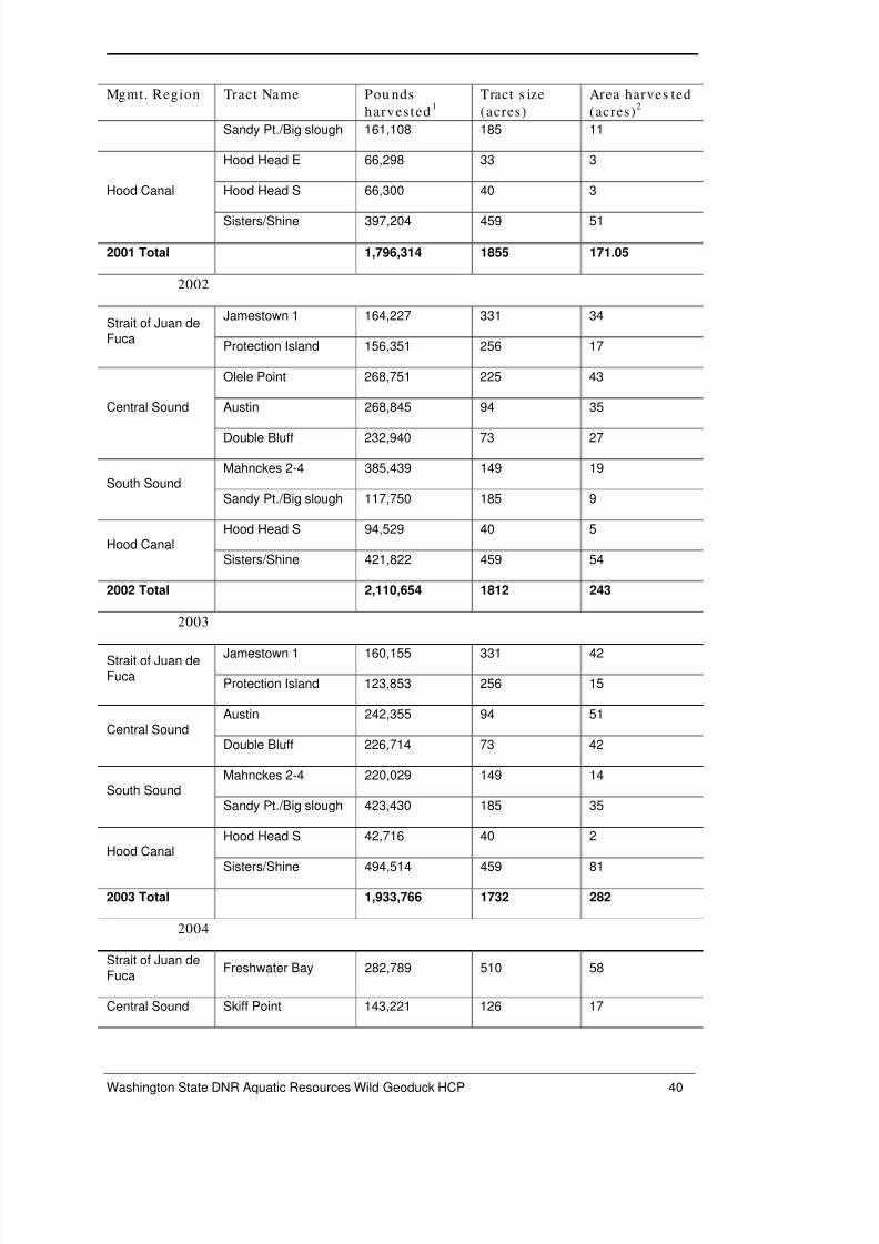
8/2/2019 Aqr Geo Hcp Wildstock Final July 2008
http://slidepdf.com/reader/full/aqr-geo-hcp-wildstock-final-july-2008 44/107
Washington State DNR Aquatic Resources Wild Geoduck HCP 40
Mgmt. Region Tract Name Pou nds
harvested1
Tract s ize
(acres)
Area harves ted
(acres)2
Sandy Pt./Big slough 161,108 185 11
Hood Canal
Hood Head E 66,298 33 3
Hood Head S 66,300 40 3
Sisters/Shine 397,204 459 51
2001 Total 1,796,314 1855 171.05
2002
Strait of Juan deFuca
Jamestown 1 164,227 331 34
Protection Island 156,351 256 17
Central Sound
Olele Point 268,751 225 43
Austin 268,845 94 35
Double Bluff 232,940 73 27
South SoundMahnckes 2-4 385,439 149 19
Sandy Pt./Big slough 117,750 185 9
Hood CanalHood Head S 94,529 40 5
Sisters/Shine 421,822 459 54
2002 Total 2,110,654 1812 243
2003
Strait of Juan deFuca
Jamestown 1 160,155 331 42
Protection Island 123,853 256 15
Central SoundAustin 242,355 94 51
Double Bluff 226,714 73 42
South SoundMahnckes 2-4 220,029 149 14
Sandy Pt./Big slough 423,430 185 35
Hood CanalHood Head S 42,716 40 2
Sisters/Shine 494,514 459 81
2003 Total 1,933,766 1732 282
2004
Strait of Juan deFuca
Freshwater Bay 282,789 510 58
Central Sound Skiff Point 143,221 126 17
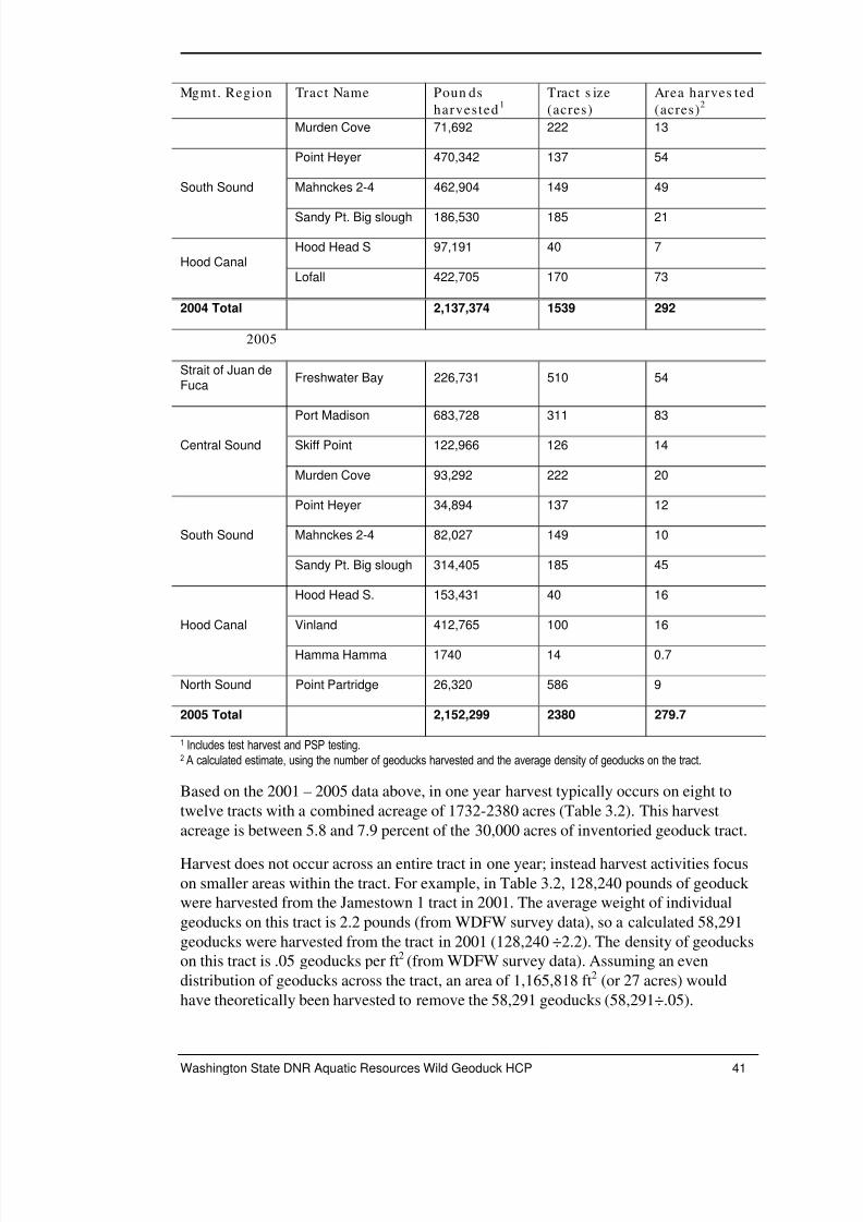
8/2/2019 Aqr Geo Hcp Wildstock Final July 2008
http://slidepdf.com/reader/full/aqr-geo-hcp-wildstock-final-july-2008 45/107
Washington State DNR Aquatic Resources Wild Geoduck HCP 41
Mgmt. Region Tract Name Poun ds
harvested1
Tract s ize
(acres)
Area harves ted
(acres)2
Murden Cove 71,692 222 13
South Sound
Point Heyer 470,342 137 54
Mahnckes 2-4 462,904 149 49
Sandy Pt. Big slough 186,530 185 21
Hood CanalHood Head S 97,191 40 7
Lofall 422,705 170 73
2004 Total 2,137,374 1539 292
2005
Strait of Juan deFuca
Freshwater Bay 226,731 510 54
Central Sound
Port Madison 683,728 311 83
Skiff Point 122,966 126 14
Murden Cove 93,292 222 20
South Sound
Point Heyer 34,894 137 12
Mahnckes 2-4 82,027 149 10
Sandy Pt. Big slough 314,405 185 45
Hood Canal
Hood Head S. 153,431 40 16
Vinland 412,765 100 16
Hamma Hamma 1740 14 0.7
North Sound Point Partridge 26,320 586 9
2005 Total 2,152,299 2380 279.7
1 Includes test harvest and PSP testing.2 A calculated estimate, using the number of geoducks harvested and the average density of geoducks on the tract.
Based on the 2001 – 2005 data above, in one year harvest typically occurs on eight to
twelve tracts with a combined acreage of 1732-2380 acres (Table 3.2). This harvest
acreage is between 5.8 and 7.9 percent of the 30,000 acres of inventoried geoduck tract.
Harvest does not occur across an entire tract in one year; instead harvest activities focus
on smaller areas within the tract. For example, in Table 3.2, 128,240 pounds of geoduck were harvested from the Jamestown 1 tract in 2001. The average weight of individual
geoducks on this tract is 2.2 pounds (from WDFW survey data), so a calculated 58,291
geoducks were harvested from the tract in 2001 (128,240 ÷2.2). The density of geoduckson this tract is .05 geoducks per ft2 (from WDFW survey data). Assuming an even
distribution of geoducks across the tract, an area of 1,165,818 ft2 (or 27 acres) would
have theoretically been harvested to remove the 58,291 geoducks (58,291÷.05).

8/2/2019 Aqr Geo Hcp Wildstock Final July 2008
http://slidepdf.com/reader/full/aqr-geo-hcp-wildstock-final-july-2008 46/107
Washington State DNR Aquatic Resources Wild Geoduck HCP 42
The above calculation assumes an even distribution of geoducks across the entire tract. In
reality, geoducks are commonly concentrated in patches, and the actual area whereharvest occurs is primarily in these patches; an area smaller than that shown in the last
column of Table 3.2., but more widely distributed across the tract. The area harvested on
each tract is likely somewhere between the acreages in the last two columns of Table 3.2.
Note that harvesters return to the same tracts for several years; harvest does not occur on
entirely new tracts each year.
When harvest quotas are offered in the San Juan management region, the total acres
across which harvest occurs will increase because that region will be assigned a total
allowable catch (see Section 3-3 below). The scope of harvest will be similar to that in
the other regions.
The biomass harvested each year fluctuates but remains within the amount allowed to
sustain the geoduck resource. The management of the fishery at conservative, sustainable
biomass levels limits the amount of harvest allowed each year and limits DNR’s ability to
expand the fishery.
ACRE AGE LIMITS
For the purposes of this HCP, DNR is proposing a 6000 acre maximum tract acreagefrom which harvest would occur annually, considering the 50-year timeframe for this
HCP. Harvest from this maximum acreage would be spread across the five management
regions and may eventually include tract acres in the San Juan management region. In
any one year, the harvest would not occur from tracts in one management region but
would be divided between management regions similar to past years (Table 3.2). The
area from which geoducks are harvested annually will not exceed 1500 acres in any one
management region. This 6000 acre maximum is the combined tract sizes on whichharvest activity would occur; as described above the actual amount of tract area
experiencing harvest would be less than the 6000 acre total.The 6000 acre maximum was arrived at by considering the sum total of the two largest
tracts in each management region (Table 3.3). Should harvest in one year occur on these
tracts, the total acreage would be 6286. In practice, this would not occur because in any
one year a given tract may be non-commercial because of low geoduck densities,
pollution, land use conflicts or for other reasons. The logistics or need to harvest from
this large of an area in one year also precludes this scenario in reality. However this
exercise is useful in establishing a maximum upper limit of tract acres from which
harvest would occur for the purposes of this HCP, and is plausible given the 50-year
timeframe of the HCP.
Table 3.3. Two larges t tracts in ea ch ma nag emen t region.
Region Size (acres ) Tract Numbe r Tract Name
Strait of Juan de Fuca1197 00300 Siebert Creek
728 00350 Dungeness spit
Central Sound723 07000 Battle Point North
700 04100 Port Townsend

8/2/2019 Aqr Geo Hcp Wildstock Final July 2008
http://slidepdf.com/reader/full/aqr-geo-hcp-wildstock-final-july-2008 47/107
Washington State DNR Aquatic Resources Wild Geoduck HCP 43
South Sound461 17400 Salom Point
310 17700 Windy Point
Hood Canal459 20300 Sisters/Shine
421 21450 Warrenville
North Sound586 03100 Point Partridge
301 03900 Randall Point
Total – all currently
harvested regions5886
San Juan *200 NA NA
200 NA NA
Total – all regions 6286
* The San Juan management region is a different situation because even though geoduck
beds have been identified, commercial tracts and geoduck biomass have not been quantified.Over the course of the 50-year span of this HCP, harvest could occur here. Based on thecurrently identified extent of geoduck beds in that region compared to that of the otherregions (Figures 1 and 2), an estimate for this exercise of maximum acres is two tracts of 200acres each.
3-2.6 Geoduc k Res earch an d Samp ling
In addition to the sampling done to ensure water quality and shellfish safety prior to and
during harvest, sampling occurs throughout the year for a variety of research efforts
including stock assessment, geoduck aging and geoduck genetics. Samples are collected
throughout the six management regions within the depths utilized for commercial harvest.
Health-related sampling is done within commercial tracts as is most research sampling.
When performed or managed by DNR, these activities will follow the same restrictions as
those for commercial harvest.
3-2.7 Other Practice s
SOUTHERN RESIDENT ORCA
In order to comply with the Marine Mammal Protection Act, DNR has developed a“diver recall” system capable of getting all divers out of the water when orcas are sighted
on the tract being harvested. DNR divers and harvesters remain out of the water until all
marine mammals have left the area. Vessel engines remain switched off until that time.
3-3 Determining TAC and Managing Geoduck Tracts
An annual harvest quota for geoduck clams is calculated for each management region by
multiplying the current regional commercial biomass estimate by a sustainable harvest
rate (2.7 percent). The sustainable harvest rate is derived from a deterministic age-based
8/2/2019 Aqr Geo Hcp Wildstock Final July 2008
http://slidepdf.com/reader/full/aqr-geo-hcp-wildstock-final-july-2008 48/107
Washington State DNR Aquatic Resources Wild Geoduck HCP 44
equilibrium model (Bradbury and Tagart 2000) and a risk-adverse (F40) fishing strategy
selected by geoduck managers. In Washington, the annual quota has been termed “Total
Allowable Catch, or TAC. The TAC is calculated by WDFW.
Total population biomass is the sum of all known wild stock geoducks measured in
pounds. Commercially available biomass is the estimated poundage available for
commercial harvest and is estimated from survey data (see Calculating Harvest, Section
3-3.1 below). Tracts closed due to sediment or water quality impairments, are not
included in the commercial biomass; neither are those areas or tracts where densities of
geoducks have not been quantified (X-beds). Recovery beds (those in recovery from past
harvest) are included.
Tracts that have been fished down to about 30 percent of the pre-fishing density and placed
into recovery status are not fished again until a new survey demonstrates that the average
geoduck tract density has reached or exceeded the previous pre-fishing density. At this
point the tract is considered “recovered” and again made available for commercial harvest.
Based on an equilibrium yield model (see Section 3-3.1 below), currently 2.7 percent of
the commercial biomass in each of the five management regions is allocated for totalfishing effort each year. (The San Juan management region currently does not have
identified commercial biomass.) This is the TAC and it is split equally between the state
and tribes, so the State’s share of the TAC is half of the 2.7 percent, or 1.35 percent of the
commercial biomass. In order to protect the resource further, the State reduces its share
by 2 percent to allow for the potential of unreported harvest mortalities.
After taking the 2 percent reduction, DNR makes the remaining 98 percent of the State’s
share of the annual TAC for each management region available for harvest opportunity at
auction each year, i.e., the State auctions 1.32 percent of the commercial biomass.
Closures of tracts for health reasons, market conditions, weather concerns, timeconstraints and delays in obtaining shoreline permits can result in underharvest of the
TAC. Unharvested portions from one year’s TAC are not carried forward or added to the
next year’s TAC.
By management agreement, overharvest of a party’s share of the TAC will result in a
reduction of the following year’s TAC for that party.
3-3.1 Calcu lating Harves t Amo un ts
Commercial biomass for a tract is the product of geoduck density, weight and tract areaestimates. Geoduck density in a tract is estimated by establishing belt transects in the
tract, and counting the number of siphons seen by divers along the transects. Geoduck counts are corrected with a daily ‘siphon show’ factor that adjusts for the variability in
actual siphons visible compared to the total number of geoducks. The tract weight
estimate is made by removing and weighing ten geoducks from every sixth survey
transect and pooling the samples to calculate an average geoduck weight. The tract area
estimate is made using NOAA water depth contours between –18 and –70 feet (corrected
to MLLW) and subtracting areas that cannot be harvested due to health, ecological,
statutory, substrate or conflicting use constraints. ArcGIS is used to estimate tract area.
(Water surface area is used as a proxy for benthic surface area.)

8/2/2019 Aqr Geo Hcp Wildstock Final July 2008
http://slidepdf.com/reader/full/aqr-geo-hcp-wildstock-final-july-2008 49/107
Washington State DNR Aquatic Resources Wild Geoduck HCP 45
REGIONAL HARVEST CALCULATIONS
Regional commercial biomass estimates are the sum of all commercially harvestable
tracts surveyed within one management region. Tract biomass estimates are adjusted upor down. Harvestable biomass is added when a tract is surveyed and additional biomass is
found. Biomass is subtracted after geoduck harvest has occurred or a survey indicates
reduced biomass. Biomass is either added or subtracted when a tract’s health
classification has been changed by the Department of Health, depending on whether thestatus is changed to approved, conditionally approved, restricted, or prohibited.
EQUILIBRIUM YIELD MODEL
Washington’s geoduck fishery uses an age-based model with a F40 % fishing strategy to
provide an equilibrium harvest rate. A predictive mathematical yield model forecasts the
effect of various harvest rates on wild stock geoduck populations (Bradbury and Tagart,
2000). This model relies on estimates of growth, natural mortality, sexual maturity,
harvest selectivity and other life history parameters. Based on the current model, an
equilibrium rate of 2.7 percent was calculated and agreed to by both State and Tribal
managers in 1997. The 2.7 percent harvest rate is predicted to preserve 40 percent of the
un-fished spawning biomass of wild stock geoduck populations (Bradbury et al. 2000).
3-4 Fishery Enforcement Activities
Commercial tracts selected for harvest are concentrated in a single geographic area of
each management region to facilitate fishery enforcement. DNR’s commercial dive team
is present on the tracts undergoing harvest each day that geoduck harvest operations arebeing conducted. DNR has the authority to cancel a harvest day if weather conditions
present a safety hazard or for other reasons.
At least two compliance staff, one of whom is an enforcement officer, are present on the
compliance vessel, on the tract being harvested. This ensures compliance with the
specified harvest conditions and restrictions. They have a number of responsibilities
which include:
setting and checking tract boundaries and marker buoys;
identifying and documenting the dive harvest vessels and onboard harvest divers
and tenders;
documenting the vessel harvest location with GPS coordinates;
collecting weekly samples of geoduck for testing by Dept. of Health to ensure the
product is safe for human consumption and assisting Dept. of Health in routinely
scheduled water sampling activities;
conducting random vessel inspections to ensure no unreported catch is onboard
and to assess diving safety and vessel safety conditions including any potential
discharges of hazardous materials such as fuel or hydraulic fluids;

8/2/2019 Aqr Geo Hcp Wildstock Final July 2008
http://slidepdf.com/reader/full/aqr-geo-hcp-wildstock-final-july-2008 50/107
Washington State DNR Aquatic Resources Wild Geoduck HCP 46
performing investigative dives and video camera drops to monitor harvest activity
and ensure sound environmental practices are being followed, ensure harvest iswithin tract boundaries, and verify that no unreported harvest mortality is
occurring;
authenticating weigh-out of harvested geoduck at the end of each day;
monitoring noise levels by using a sound meter and taking sound readings at 200yards from vessels, and monitoring harvest vessel distances from shore using an
electronic distance measuring device;
identifying and removing environmental hazards such as derelict fishing nets or
other fishing gear that may be present on a tract and constitute a threat to divers
and marine fauna;
utilizing a diver recall system and engine-off policy for emergency situations and
marine mammal presence/protection;
operating onboard communications systems with the shore and responding to
questions or concerns from the public related to geoduck harvest activities; and,
working cooperatively with WDFW enforcement to investigate reports of illegal
harvest and WDFW biologists to collect information for research and fishery
management purposes.
Vessel inspections occur at random. If the number of inspections was to be averaged it
would be about 1 per day. In practice, one vessel could be inspected or four inspected on
any given day. The same vessel could be inspected several times in a row. Inspections are
noted in daily compliance logs maintained by DNR. These inspections are carried out
continually during the course of the fishery.
The main intent of vessel inspections is to check for unreported geoducks but the general
condition of the boat and its operating equipment, as well as the equipment used toconduct harvest operations is noted as well (E.g., vessel-diver communications, nozzle
sizes, scales for weighing product, etc.).
Compliance dives are conducted randomly at a frequency of about one or two dives per
week or in some cases dives occur two or three times per week. Dives are performed on
tracts after harvesters have worked on them and also in areas that are actively being
harvested. Underwater video camera viewing also occurs but gives a more limited view
of the tract and harvest activities. The type of underwater inspection done (free dives,
tethered dives, video camera drop) depends on the number of DNR compliance staff
working that day, weather conditions, tract location and other variables.
Noise level checks are done on an as needed basis. In harvest areas off shore of shoreline
homes, more noise level checks are done than when harvest occurs in more remote areas.
Situations have occurred where background noise (e.g., from waves hitting the
compliance boat, upland noises, wind hitting the microphone used to measure noise
levels) is loud enough to interfere with the ability to get a reading on the noise coming
from a particular harvest boat.

8/2/2019 Aqr Geo Hcp Wildstock Final July 2008
http://slidepdf.com/reader/full/aqr-geo-hcp-wildstock-final-july-2008 51/107
Washington State DNR Aquatic Resources Wild Geoduck HCP 47
4. Potential Biological Impacts and TakeAssessment
4-1 Direct and Indirect Effects
Geoduck harvest activities, and thus related effects, are localized, meaning that at one
time, harvest activities are occurring on one tract, or sometimes on more than one tract
within one management region. Effects are limited to the tract area and its immediate
vicinity. Geoduck harvest activities could potentially directly disturb individuals of the
covered species. Substrate and water are temporarily affected by disturbance of bottomsediments and suspension of fine sediments during geoduck harvest. Other benthic
organisms (besides geoducks) within harvest tracts may be inadvertently removed and
damaged during harvest and their abundance temporarily reduced within the tract
boundary. The use of motorized boats and mechanized equipment create a risk of
introductions of toxic materials to the water which could impact individuals of the
covered species, and damage habitat, should a spill occur. The noise and general activity
of harvest can also potentially disturb the covered species.
4-1.1 Su rfac e Effec ts
VESSELS
Harvest vessels and DNR compliance vessels are on the water during harvest operations.
Their movement and presence could potentially disturb birds and marine mammals.
Vessels pose a risk of fuel spills or spills of other hazardous materials that could damage
habitat or kill individuals, eggs, or larvae. These risks are reduced through the following
means.
Fuel spill and similar risks are managed through DNR compliance staff which require
harvest vessels in danger of capsizing, or with obvious leaks of toxic or hazardous
materials to move out of the harvest area and return to the docks for necessary repairs
before they can return to the harvest tract.
Harvesters are required, in the harvesting agreement (Appendix B) to comply with all
federal, state, and local laws and regulations concerning the use and disposal of
hazardous, toxic or harmful substances. They are also required to notify the DNR of any
release of hazardous, toxic or harmful substances.
Harvesters are required to provide DNR the right to enter and inspect any harvest vessel
operating under the harvesting agreement. Since 2003, all harvest vessels are required to
carry pollution liability insurance to provide funds in the event of a spill.

8/2/2019 Aqr Geo Hcp Wildstock Final July 2008
http://slidepdf.com/reader/full/aqr-geo-hcp-wildstock-final-july-2008 52/107
Washington State DNR Aquatic Resources Wild Geoduck HCP 48
A Vessel Spill Contingency Plan (Appendix F) provides guidance to DNR compliance
staff in the event of a spill and instructs them to immediately report observed oil sheens
or slicks to Washington State Department of Ecology and the United States Coast Guard.
NoiseNoise from boat operations and dive support equipment could disturb birds and marine
mammals. Geoduck harvest operations generate noise from three sources: the vessel
engine, the pump or compressor engines powering the water jets and diver air supply, and
the two-way diver communication system. Communication between the vessel and divers
is electronic, via their umbilical. Engine noise increases when boats reposition on the
tract.
On-site measurements found maximum surface noise levels of 61 to 58 dBA at a distance
of 100 feet where auxiliary equipment was housed on deck and 55 to 53 dBA where
equipment was housed below deck (Table 4.1).
Sound intensity levels drop off rapidly in air. The inverse square law of sound behaviorsays that, in situations where sound is from a stationary or point source with negligible
obstacles or boundaries on the sound, it will decrease 6 decibels with each doubling of distance from the source. Using this law and the above measured noise levels, noise
levels at other distances can be calculated (Table 4.1).
Table 4.1. Meas ured an d ca lculated noise levels abo ve water at various distance s .
Dis tanc e (ft) Pred icted s urface no is e levels (dBA)
Equipment on dec k Equipment below deck
100 61-58 (measured) 55-53 (measured)
200 55-52 * 49-47 *
400 49-46 * 43-41 *
800 43-40 * 37-35 *
*calculated
Noise levels are enforced at less than 50 decibels measured at a distance of 200 yards
(600 feet) from each vessel. Calculated levels in Table 4.1 above indicate noise from
geoduck boats will usually be below this level. Effects from noise are reduced through
these limits imposed on harvest vessels.
Noise levels are measured by compliance staff. Vessels found to be out of compliance are
not allowed to participate in harvest activities until violations are remedied. Noise levelsfrom harvest activities might cause individuals of the covered species to avoid the harvest
tract and immediate vicinity but are not expected to be great enough to result in impacts
beyond this.
4-1.2 Ben thic Environ me nt Effec ts
Harvest activities, particularly the use of water jets when harvesting, and to a lesser
degree vessel anchoring, diver movement and the dragging of hoses and collection bags,

8/2/2019 Aqr Geo Hcp Wildstock Final July 2008
http://slidepdf.com/reader/full/aqr-geo-hcp-wildstock-final-july-2008 53/107
Washington State DNR Aquatic Resources Wild Geoduck HCP 49
temporarily disturb bottom sediments and unintentionally remove and damage organisms
on and in the substrate in the vicinity of the harvest, and may temporarily reduce theirabundance. Suspension of fine sediments temporarily causes turbidity. These effects are
not expected to be great enough to impact the covered species or their habitat.
The disturbance to the substrate and subsequent turbidity caused by resuspended fine
sediment is reduced through the use of selective, hand held harvest equipment that only
disturbs the immediate harvest vicinity (dig hole). Disturbance is limited to the
proportionally small area that is harvested each year (1732 – 2380 acres), compared to
the extent of the known commercial resource that has been inventoried between depth
contours of –18 and –70 (about 30,000 acres).
VESSEL ANCHORAGE
Vessel anchorage may cause bottom scour and disturb vegetation, if present, and benthic
organisms. These effects are limited to the swing radius of the weighted portion of vessel’s anchor line (usually a heavy chain near the anchor itself). Effects to the bottom
substrate would be temporary; based on comparisons of plants and animals before and
after harvest, these areas recover through recolonization from surrounding areas. Effectsfrom anchoring on eelgrass are avoided by the establishment of nearshore depth
restrictions of –18 feet MLLW and 2-foot vertical harvest buffers around eelgrass beds.
HARVEST ACTIVITIES
Extracting geoducks mixes surface sediments with material found deeper in the geoduck
hole. Harvest activities also temporarily suspend sediment causing localized turbidity
within or near the harvest tract. Coarser sediments tend to fall out of suspension quickly,
while fine particles may remain suspended in the water column until they are re-
deposited away from the hole. As the suspended sediments settle they are redistributed in
the vicinity of the harvest activities and may form a thin layer on the seafloor. The fate of
particles put into suspension depends on particle size and water currents. The harvestactivity does not introduce new sediment into the environment from external sources.
The use of hand-held harvesting equipment limits the area disturbed and therefore
sediment disturbance and turbidity to the area where geoducks are extracted.
Benthic Faun aSoft-bodied animals may be inadvertently damaged and displaced from within the
substrate by the water jets and those brought to the surface are exposed to predation byfish, crab, and other predators and scavengers. Tubeworms may be broken apart, while
very small animals may be suspended and carried away by currents.
The majority of infauna reside within the top 12 inches of the benthos and are likely to bedirectly affected by both mobilization of, and temporary changes in, the granular matrix
of the sediments in harvest areas (Coull 1988; Somerfield et al. 1995). However, unlike
larger scale disturbances that may have prolonged consequences (Morton 1977; van
Dalfsen et al. 2000), small-scale disturbances of seabed sediments and morphology are
likely to result in short-term effects on the benthic community.
Because harvest only affects a portion of the geoduck tract, recolonization of most marine
organisms from surrounding sources within and adjacent to the tract is expected to occur

8/2/2019 Aqr Geo Hcp Wildstock Final July 2008
http://slidepdf.com/reader/full/aqr-geo-hcp-wildstock-final-july-2008 54/107
Washington State DNR Aquatic Resources Wild Geoduck HCP 50
in a short time. For comparison, monitoring of a small maintenance dredging operation
found that the infauna re-adjusted to pre-dredging conditions within 28 days in thedredged area (McCaully et al. 1977). Based on studies of benthic recolonization related to
dredging and sediment cap placements, the substrate on geoduck tracts is expected to be
quickly recolonized after harvest activities (McCaully et al. 1977; Richardson et al. 1977;
Romberg et al. 1995; Wilson and Romberg 1995) and the fauna are expected to be similar
to the existing nearby benthic community. Geoduck harvest methods are less impactivethan dredging, so the recolonization is expected to be similar, or occur faster than that
indicated in studies involving dredging.
More invasive methods for harvesting other bivalves have documented temporary
impacts to the surrounding communities. Kaiser et al. (1996) found that the infaunal
community was restored within 7 months after suction harvesting Manila clams in coarse
sediments and Spencer et al. (1998) found that the benthic community was restored
within 9 to 12 months after suction harvesting in fine muddy sand substrate. Coen (1995)
found that harvesting clams using a mechanical hydraulic dredge causes some mortality
of infaunal and epifaunal organisms directly in its path. However, the community effect
was found to be short term because many of the small benthic organisms regenerate
rapidly, recolonize quickly and have high fecundity.
The effects of geoduck harvest methods on the abundance and diversity of animals
associated with the substrate were assessed by Goodwin (1978). He reported that total
biomass of the infauna in study plots in Hood Canal (excluding geoducks) seven months
after geoduck harvest showed no statistically significant changes over that of pre-harvest
levels. Assessing changes attributable to harvest was complicated by the patchy
distribution and natural variability in abundance of benthic animals. In this study,
seasonal variation may have been an uncontrolled factor. Pre-harvest samples were
collected in November, 1975 and the post-harvest samples were collected in the summer
of 1976. Increases seen in the numbers and weights of benthic animals were likely
attributable to natural seasonal variability. Goodwin noted that: 1) Increases in thebenthos were not as pronounced in the treatment plot as those in the control plot, and 2)geoduck harvest did not create dramatic decreases in standing crops of the major benthic
organisms for which data were collected.
Breen and Shields (1983) also looked at benthic fauna in their study of geoduck harvest
effects at five sites off Vancouver Island, British Columbia. They collected core samples
from control and treatment sites and separated out infaunal organisms. Some species
increased in abundance after the harvest treatment, and some decreased. Changes were
not statistically significant. A greater diversity of species was seen in the more recently
disturbed plot. Only one animal taxon (Harpacticoid copepods) was significantly affected
and its presence increased significantly following geoduck harvest. The authors notedthat the harvest treatments used in this study were more destructive than those used
during commercial geoduck harvests because their treatment attempted to remove every
geoduck.
Substrate AlterationsGoodwin (1978) conducted a study in northern Hood Canal to determine (in part) the
effects of geoduck harvest on substrate particle size. Overall, sediment particle size
distribution appeared to be minimally affected by geoduck harvest; Goodwin (1978)

8/2/2019 Aqr Geo Hcp Wildstock Final July 2008
http://slidepdf.com/reader/full/aqr-geo-hcp-wildstock-final-july-2008 55/107
Washington State DNR Aquatic Resources Wild Geoduck HCP 51
found no statistical difference in the average median sediment grain size between core
samples from test plots (where harvest occurred) and those from control plots. Theaverage percentage of silt and clay in the core samples from test and control cores was
also not significantly different.
Breen and Shields (1983) also assessed the effects of geoduck harvest on sediment
composition. They found no difference in sediment structure, as measured by particle
size, in samples taken at three plots; one an undisturbed control and two that had
previously been completely harvested. The authors noted that the harvest treatments used
in this study were more destructive than those used during commercial geoduck harvests
because their treatment attempted to remove every geoduck.
Harves t HolesHarvesting geoducks temporarily leaves behind a series of depressions, or holes where
the clams are extracted, sediments displaced, and fine particles suspended. The number of depressions created across a harvested area in a tract depends on the density of geoducks.
The fate of these depressions, in terms of the time to refill, depends on the substrate
composition and tidal currents. The time for them to refill can range from several days to
5-7 months (Goodwin 1978).
Most of the material removed during the harvesting of a geoduck ends up falling back
into the hole or forming berms around the holes. The berms eventually erode back into
the harvest holes as a result of grain settling, water current, wave energy and animal
activity (Goodwin 1978).
A decrease in the percentage of fines and coarse sediments was measured by Goodwin
(1978) in the holes after harvest, compared to adjacent, undisturbed sites. Fines
suspended by the water jet harvest did not re-settle in the depression made by harvest.
The average dimensions of the harvest holes measured immediately after harvest by
Goodwin (1978) were 14.7 inches wide and 3.2 inches deep. The depth to whichdisturbance occurred in removing the geoduck was 18 inches (averaged). Goodwin
calculated an average hole volume of about 0.32 ft3, or about 2 ½ gallons of material
displaced.
TurbidityHarvesting geoducks results in temporary, localized increases in turbidity levels. The
level of turbidity depends on the type of substrate that harvest is occurring in. Water
currents also play a role in turbidity, affecting the time for dispersal and distance of
suspended material.
Heavier particles (sand) will settle faster than finer ones (silt or mud). Turbidity plumescould last for hours, or days and could result in short-term (hours to days) reduction in
habitat quality for some benthic species, as well as smothering, or burying primary
producers (diatoms, aquatic vegetation) and consumers (epibenthic organisms) as the
material settles back to the bottom.
Short and Walton (1992) examined total suspended solids (TSS) in plumes generated by
geoduck harvest, in the field and in modeled experiments. They found that at low current
speeds, most material put into suspension settles within the harvest area.

8/2/2019 Aqr Geo Hcp Wildstock Final July 2008
http://slidepdf.com/reader/full/aqr-geo-hcp-wildstock-final-july-2008 56/107
Washington State DNR Aquatic Resources Wild Geoduck HCP 52
Studies by Tarr (1977) of plumes down current from a hydraulic clam harvester found no
significant effect on dissolved oxygen, organic and inorganic phosphates, suspendedsolids, or turbidity beyond 450 feet. The major effect noted was the suspension of fine
material, which increased turbidity down-current 300 feet by an average of 1 mg/L above
the background range of 8 to 25 mg/L. While research indicates that increased turbidity
may increase mortality and decrease growth rates of bivalves (Table 4.2), the increases
attributable to Washington’s commercial geoduck harvest appear to be well below effectthresholds summarized in Table 4.2.
Table 4.2 - Impa cts of inc reas ed tu rbidity on bivalves .
Spec ies Impac t Referenc e
Quahog clam (Mercenaria mercenaria) eggs
Increased abnormal developmentabove 750 mg/L
Davis (1960)
Mercenaria mercenaria larvaeNo effect on growth at 750 mg/L;increased growth below 750 mg/L
Davis (1960)
Mercenaria mercenaria juvenile
Growth reduced at 44 mg/L; noeffect at 25 mg/L
Bricelj et al. (1984)
Eastern Oyster (Crassostrea virginica) eggs
25 percent mortality of eggs at 250mg/L
Loosanoff and Davis(1963)
Adverse effects at 188 mg/L Davis and Hidu (1969)
Crassostrea virginica larvaeDecreased growth at levels above705 mg/L
Loosanoff and Davis(1963)
Mediterranean mussel (Mytilus galloprovincialis) larvae
Increased growth up to 500 mg/L;decreased growth at highconcentrations
Seaman et al. (1991)
Sediment Deposition
Sediment suspended by water jets is dispersed down-current in the vicinity of harvestactivity and eventually settles back out of the water column in calm areas and may form a
thin film on the seafloor. The fate of sediments disturbed by harvest will vary depending
on the substrate composition of the particular harvest tract, and current direction and
speed.
Short and Walton (1992) estimated that the average cumulative thickness of all grain
sizes suspended during a normal commercial geoduck harvest settling on one acre would
be 0.16 inches, while Goodwin (1978) estimated deposition for fines at 0.08 inches. By
comparison, Brundage (1960) measured natural sedimentation deposition rates of .67
inches/year in the Nisqually River delta in south Puget Sound.
Short and Walton (1992) estimated that if all grain sizes put in suspension by commercialgeoduck harvest were to settle on the harvested tract (a conservative scenario) the
deposition would range from 7.9 to 8.83 kg/m2 /year. This is within the natural
background range 2.6 to 12.0 kg/m2 /year for Puget Sound as a whole (Lavelle et al.
1986).
Short and Walton (1992) tracked and quantified suspended sediment down-current from
geoduck harvest in the Nisqually Reach tract, off the Nisqually River delta. They also
developed a numerical particle tracking model, calibrated with field data, to augment

8/2/2019 Aqr Geo Hcp Wildstock Final July 2008
http://slidepdf.com/reader/full/aqr-geo-hcp-wildstock-final-july-2008 57/107
Washington State DNR Aquatic Resources Wild Geoduck HCP 53
observational data. Using the model, they assessed the transport and fate of suspended
sediment under various conditions within the range of conditions typically encounteredon commercial geoduck harvest tracts. Even when scaled upward to approximate the
harvesting intensity that occurs on one area in a year, the cumulative thickness of
material deposited was calculated to be 0.16 inches.
The average settled sediment thickness at different current speeds was found to be
extremely small for the study simulations (25 holes dug in 20 minutes), measuring in
thousandths of an inch. Long-term cumulative sedimentation effects scaled to typical
annual harvest were also small. Their conclusion was that deposition of suspended
material would be inconsequentially small, even when extrapolated over a year.
Short and Walton (1992) also demonstrated that even under worst case conditions of
direct onshore transport , the resulting thickness of material deposited in the intertidal
zone, per hour of harvesting, is extremely small (thousandths of an inch). They
demonstrated that deposition of fine sediment on beaches is unlikely to occur because of
the presence of wave energy. Short and Walton (1992) used their model to calculate the
potential for sediment suspended by geoduck harvest to accumulate onshore. This model
estimated that harvest of 75 geoducks 656 feet from shore could result in a maximum of 0.0004 cm of material accumulating on shore. Many beaches along Puget Sound are
composed of sand or gravel, suggesting that typical wave and current conditions do not
allow the deposition and retention of fines.
4-1.3 Summary
The transport and deposition of sediment put into suspension by harvest activities will
have minimal impacts on the physical environment within the tract and adjacent areas.
The amount of sediment resuspended by harvest activities is negligible and not expected
to impact the covered species or their habitats. Substrate disturbance, subsequent
sediment suspension and eventual deposition, and impacts to fauna on the tracts causetemporary, local (confined to the tract and immediate vicinity) effects. The effects are
measurably small on the tract and nearly immeasurable further away. No significanteffects on dissolved oxygen, organic and inorganic phosphates, suspended solids, or
turbidity are expected.
EFFECTS OF GEODUCK REMOVAL
It has been suggested that geoducks act to filter suspended particulate matter from the
water, providing a perceived benefit to local environmental conditions. In some coastal
systems, dense bivalve populations exert a strong influence on suspended particulate
matter including phytoplankton, zooplankton, and detritus by clearing particles from the
surrounding water (Dame 1996). Transformation and translocation of matter by bivalvesalso appears to exert a controlling influence on nitrogen concentrations in some coastal
regions (Dame et al. 1991) and can provide a means of retaining nutrients, while the
removal of bivalves reduces the rate of nutrient cycling (Jordan and Valiela 1982). A
strong indication that bivalve filter feeders are able to control suspended particulate
matter in some coastal systems comes from documented ecosystem changes that occurred
after large biomass variations in natural and cultured bivalve populations. Population
explosions of introduced bivalve species in San Francisco Bay and dramatic reductions in
oyster populations in Chesapeake Bay have also been implicated as the cause of large

8/2/2019 Aqr Geo Hcp Wildstock Final July 2008
http://slidepdf.com/reader/full/aqr-geo-hcp-wildstock-final-july-2008 58/107
Washington State DNR Aquatic Resources Wild Geoduck HCP 54
changes in phytoplankton biomass and production experienced in these systems (Alpine
and Cloern 1992; Newell 1988; Nichols 1985; Nichols et al. 1990; Ulanowicz and Tuttle1992). However, a loss of biological filtering capacity due to the removal of geoducks
from Puget Sound are localized and likely insignificant because of low harvest rates
within a geographic area and the small proportion of the geoduck population that is
actually harvested. As an example, geoduck filtration rates were estimated for DNR in a
laboratory experiment in 2004 by Taylor Shellfish Farms of Shelton, Washington.Filtration rates under laboratory conditions ranged from 72 to 240 liters per day (20 to 63
gallons), per geoduck. Using these rough estimates, it was calculated that the geoducksharvested by the state in Hood Canal would filter only 0.4 percent of Hood Canal’s
waters each year (Washington Department of Natural Resources 2004).
4-1.4 Sc op e an d Inte ns ity of Effec ts
Presently, harvest activities and associated effects occur on a relatively small portion of
the commercial tracts each year. For example, from 2001 – 2005 geoducks were
harvested from individual tracts ranging in size from 14 to 459 acres (Table 3.2). The
largest tract listed in the 2004 Geoduck Atlas is 1197 acres. Annually, based on 2001 –
2005 data, geoducks are harvested from a total of about 1732 – 2380 acres of commercial
tracts, spread out across the five regions that currently have commercial tracts identified.
This is between 5.8 and 9.4 percent of the total commercial tract acreage of about 30,000
acres. The actual area experiencing harvest activities is smaller than the sum of the tract
acreages (See Section 3-2.5).
At the maximum acreage level proposed for this HCP, harvest would occur annually from
tracts totaling 6000 acres spread across the five regions that currently have commercial
tracts identified, and the San Juan management region. This is 20% of the total
commercial tract acreage of about 30,000 acres. The actual area from which geoducks
would be harvested would be smaller than the 6000 acres (See Section 3-2.5).
The number of boats participating in the State-administered portion of the geoduck
fishery at one time ranges between eight and ten.
When DNR offers harvest quotas in the San Juan region, the total acres across whichharvest occurs will increase because that region will be assigned a TAC. This is already
included in the 6000 acre total tract acreage.
4-2 Impacts to Covered Species
Inadvertent and infrequent encounters between the covered species and geoduck harvest
activities could temporarily disrupt normal feeding, roosting and other behaviors. Thiswould occur locally, in the immediate vicinity of the harvest operations. Known sensitive
habitats, primarily fish spawning habitats but also bird nesting sites, are avoided by
harvest managers so that impacts from harvest activities are reduced or completely
avoided.
8/2/2019 Aqr Geo Hcp Wildstock Final July 2008
http://slidepdf.com/reader/full/aqr-geo-hcp-wildstock-final-july-2008 59/107
Washington State DNR Aquatic Resources Wild Geoduck HCP 55
There are predator-prey interactions between the covered species, and also between the
covered species and other forage fish species. Habitat for forage fish species, especiallyspawning habitat, is generally closer to shore than nearshore boundaries of geoduck
tracts. Known spawning areas are avoided so that impacts to forage fish are reduced or
eliminated.
It should not be assumed that the described impacts could potentially occur from harvest
on each and every tract. For example there are not eagle nests near every tract, nor are
there herring spawning areas, or eelgrass beds near every tract.
Potential impacts to covered species are actively researched and assessed prior to harvest,
to avoid and eliminate potential impacts.
4-2.1 Birds
Boat movement and anchored boats could temporarily alter movements of individual
birds in the vicinity of harvest activities. Harvest activities occur in the vicinity of forage
fish species use by the covered bird species, and forage fish habitat. Impacts to forage
fish, should they cause a decrease in abundance, could affect the covered bird species.
BALD EAGLE
Geoduck harvest, which occurs year-round, may be coincident with bald eagle foraging
and nesting periods. The presence and operation of boats could temporarily disrupt
foraging by individual eagles, at the specific locations where harvest was occurring.
Moving vessels could disrupt foraging activity and stationary boats could causedisplacement of individual eagles. These effects would be temporary and limited to the
area near the harvest tract. Because eagles are opportunistic feeders that prey on a variety
of species, and obtain food in a number of ways (hunting live prey, scavenging, andpirating food) it is unlikely that inadvertent disturbance by harvest activities would have
an impact on them.
Watson et al. (1995) investigated responses of bald eagles within nesting territories to
geoduck harvest activities in Puget Sound in two separate years and found that nesting
bald eagles showed little indication of disturbance from boats involved in the geoduck
fishery. They concluded that harvest activities were unlikely to result in long-term
adverse effects to eagle productivity, but could result in short-term changes in eagle
behavior.
In the study areas, all nests were located less than 984 feet from the Sound. Because
harvest is not allowed on weekends, Watson et al. (1995) were able to study eagle
responses in the presence and absence of harvest activity. Other potential disturbancesfrom recreational boating activity, pedestrian activity, aircraft activity, noise from other
sources (construction, chainsaws, lawnmowers) and automobiles occurred in the study
area as well but the authors surmised that comparisons of eagle behavior between non-
harvest and harvest days reflected actual effects of geoduck harvest activities.
There was a slight trend of reduced foraging attempts by eagles on harvest days
compared to non-harvest days but the difference was not significant. Eagles made about
one less attempt to capture prey during 20 hours of observation time when geoduck
harvest was occurring (Watson et al. 1995).
8/2/2019 Aqr Geo Hcp Wildstock Final July 2008
http://slidepdf.com/reader/full/aqr-geo-hcp-wildstock-final-july-2008 60/107
Washington State DNR Aquatic Resources Wild Geoduck HCP 56
No correlation was found between foraging attempts and time of day on harvest days;
foraging attempts were equitably distributed throughout the observation period on days
when harvest was occurring.
Harvest activities did not appear to affect the spatial distribution of foraging attempts.
For all human activities identified in the study area, only 4 percent resulted in flushing of
eagles and the geoduck harvest activity was an insignificant source of disturbance (1 of 34 flushes). The amount of time that boats were in transit from docks to harvest sites was
small compared to the total time that boats were on the water and no eagles were seen
responding to the moving boats.
Anchored harvest boats are most likely to change the behavior of nesting bald eagles
when harvest occurs within core foraging areas, and during the most intense daily
foraging period (before 10:00 am).
Harvest could potentially affect bald eagle forage fish species (see Sections 4-2.2 and 4-
2.5 below) but this is not expected to cause reductions in overall prey abundance for bald
eagle. Eagles eat a variety of prey types. Potential impacts to forage fish will be avoidedand minimized.
Mechanisms are in place through the Environmental Review process and the delineation
of tract boundaries to identify eagle nests and maintain distance from eagle nests near
shores adjacent to tracts, reducing potential disturbance. Because of restrictions for other
reasons, harvest boats will always be at least 200 yards (600 feet) from shore, so would
be this distance or farther from any nearby eagle nest. Possible disturbance of eagles from
harvest activity is limited to the area near the tract being harvested and is not spread
across a large area.
CALIFORNIA BROWN P ELICANIndividual pelicans could be temporarily displaced from roosting and foraging areas
should these overlap with geoduck harvest activities. This disturbance would be
temporary and would only affect the occasional pelican, should it encounter harvestactivities. Possible disturbance of pelicans is limited to the area near the tract being
harvested and is not spread across a large area.
Harvest activities could potentially affect brown pelican forage fish species (see Section
4-2.2 and 4-2.5 below) but not to the extent that the abundance of forage fish would be
reduced. Potential impacts to forage fish will be avoided and minimized.
MARBLED MURRELETIndividual murrelets could be temporarily displaced while foraging, should they overlap
with geoduck harvest activities. This disturbance is expected to be temporary and only
affect the occasional murrelet, should it encounter harvest activities. Possible disturbance
of murrelets is limited to the area near the tract being harvested and not spread across a
large area.
Harvest activities could potentially affect marbled murrelet forage fish species (see
Sections 4-2.2 and 4-2.5 below) but not to the extent that the abundance of forage fish
would be reduced. Potential impacts to forage fish will be avoided and minimized.

8/2/2019 Aqr Geo Hcp Wildstock Final July 2008
http://slidepdf.com/reader/full/aqr-geo-hcp-wildstock-final-july-2008 61/107
Washington State DNR Aquatic Resources Wild Geoduck HCP 57
TUFTED PUFFIN
Individual puffins could be temporarily displaced while foraging, should they overlap
with geoduck harvest activities. This disturbance is expected to be temporary and onlyaffect the occasional puffin, should it encounter harvest activities. Possible disturbance of
puffins is likely limited to the vicinity of two tracts near Protection Island, where a
nesting colony exists.
Harvest activities on tracts in the vicinity of Protection Island could disturb nesting and
foraging tufted puffins there. The 600-foot buffer around the island provides protection,
and the closest harvestable geoduck tract is about 1320 feet (0.25 mile) offshore, with the
shoreward harvest boundary for the tract set at –31 feet MLLW so disturbance of nesting
birds is unlikely.
Mechanisms are in place through the established 600-foot buffer around Protection
Island, and the Environmental Review process to identify puffin nesting colonies andmaintain distance from them, reducing potential disturbance. Because nesting colony
locations are known, they will be avoided.
Harvest activities could potentially affect tufted puffin forage fish species (see Sections4-2.2 and 4-2.5 below) but not to the extent that the abundance of forage fish would be
reduced. Potential impacts to forage fish will be avoided and minimized.
4-2.2 Fish
The covered fish species spend time as juveniles and adults in the nearshore and rely on
this environment for food and cover, and spawning in the case of Pacific herring.
Geoduck harvest activities occur in the vicinity of juvenile and adult fishes of all the
covered fish species. Generally the fishes occupy nearshore waters and those waters
shallower than the –18 foot shoreward boundary of geoduck tracts. This limits potential
disturbance to fish from harvest activities. Generally, juveniles would be more vulnerableto effects from increased turbidity than migrating adults due to their dependence on
nearshore environments.
Effects from harvest activities such as sediment suspension and turbidity that could
potentially impact fish species would be temporary and localized, and would affect fish
that moved into the vicinity of harvest activities. Possible disturbance of fish species is
limited to the area near the tract being harvested and not spread across a large area.
Young fish generally occupy shallow areas where vegetation provides cover. Older
juveniles and adults that could occur in deeper waters are more mobile and can avoid and
move away from areas of increased turbidity. Should fish encounter harvest activities andassociated suspended sediments they are not expected to be impacted because
concentrations of suspended sediment are below levels that cause harm.
Fishes that live as adults in the open ocean are less likely to be disturbed by harvest
activities because their distribution would only potentially overlap with harvest locations
when they are migrating to or from the ocean.
The possibility of suspended material smothering prey and/or damaging eelgrass isreduced by the temporary, localized nature of harvest; use of selective harvest equipment;

8/2/2019 Aqr Geo Hcp Wildstock Final July 2008
http://slidepdf.com/reader/full/aqr-geo-hcp-wildstock-final-july-2008 62/107
Washington State DNR Aquatic Resources Wild Geoduck HCP 58
the low levels of sediment suspended and deposited; and buffers between harvest
locations and important nearshore habitats.
The potential for harvest activities to impact the foraging and migrating behavior, and
foraging opportunities of the covered fish species is negligible due to the low levels of
sedimentation (100 mg/L at the densest portion of the plume) generated by geoduck
harvest, the relatively small areas harvested, and restrictions on harvest in the nearshoreareas used by juvenile fishes. The potential for suspended sediment to affect the
physiology of the fishes is likewise low.
Injury to gills can occur from increased levels of suspended sediment. Short and Walton
(1992) measured total suspended solid levels immediately surrounding the geoduck dig
hole at 100 mg/L above background levels; well below the levels that caused damage.
Lake and Hinch (1999) found that TSS >40,000 mg/L elicited a stress response that is
correlated to gill damage in coho salmon, with mortalities of 20 percent at TSS
concentrations of 100,000 mg/L. TSS concentrations >4,000 mg/L resulted in erosion of gill filament tips from both angular and rounded sediment (Nightingale and Simenstad
2001). In laboratory experiments, sockeye smolts exposed to suspended sediment levelsof 14,400 mg/L caused a decrease in body moisture compared to a control group.However, plasma chloride levels, which indicated a reduction in osmoregulatory capacity
of the smolts, never reached acute stress levels. In laboratory experiments, Gregory
(1988) concluded that elevated turbidity levels > 200 mg/L have a negative effect on
juvenile Chinook foraging rates.
PACIFIC HERRING
Juvenile and adult herring that encountered geoduck harvest activities would likely move
away from the area. Spawning adults and spawning habitat are avoided through seasonal
harvest closures and minimum depth restrictions.
There are commercial geoduck tracts adjacent to, or coincident with, areas where Pacific
herring spawn. Geoduck harvest could disrupt spawning behavior and impact spawning
habitat and deposited eggs. These impacts are avoided by adjusting tract boundaries to
avoid herring spawning areas, establishing harvest depth buffers in the vicinity of
documented herring spawning habitat, and imposing timing restrictions to avoid geoduck
harvest during spawning times. Critical herring spawning times and locations will be
avoided for documented herring stocks.
The Geoduck Atlas identifies which tracts occur adjacent to herring spawning areas as
well as specifying fishing restrictions during herring spawning times. In addition, herring
spawning or holding areas noted in tract-specific Environmental Assessments will lead to
additional harvest restrictions.
Commercial geoduck harvest in tracts adjacent to herring spawning areas is restricted to
waters deeper than –35 feet MLLW during spawning season and –25 feet during the
remainder of the year. This avoids the 0 to –10 foot depths where most herring spawning
occurs.

8/2/2019 Aqr Geo Hcp Wildstock Final July 2008
http://slidepdf.com/reader/full/aqr-geo-hcp-wildstock-final-july-2008 63/107
Washington State DNR Aquatic Resources Wild Geoduck HCP 59
Deposited herring eggs could potentially by impacted by sediment settling out from
harvest operations, but the likelihood of this is very low, based on available sediment
studies (see Section 4-1.2).
The low level of sediment disturbance and harvest restrictions to avoid herring spawning
areas, and seasonal restrictions during spawning periods act to reduce potential impacts
on herring.
COASTAL CUTTHROAT TROUT
Impacts to coastal cutthroat would be in the form of disturbance if the fish encountered
harvest activities. Disturbance would be localized, in the vicinity of harvest activities
occurring on a given tract, and temporary. Potential interactions between this species and
harvest activities are not likely because cutthroat prefer habitats not generally coincident
with those in harvest tracts. Fish could avoid disturbing activities.
Cutthroat prey items include other fish species that are addressed here (salmon, sand
lance, herring). Impacts to these species are avoided and minimized and are not expected
to occur at a level where their abundance is reduced.
BULL TROUT
Impacts to bull trout would be in the form of disturbance if the fish encountered harvest
activities. Disturbance would be localized, in the vicinity of harvest activities occurring
on a given tract, and temporary. Potential interactions between this species and harvestactivities are not likely because they generally inhabit areas closer to shore. Fish could
avoid disturbing activities.
Bull trout prey items include other fish species that are addressed here (salmon, surf
smelt, sand lance, herring). Impacts to these species are avoided and minimized and are
not expected to occur at a level where their abundance is reduced.
STEELHEAD TROUT
Impacts to steelhead would be in the form of disturbance if the fish encountered harvest
activities. Disturbance would be localized, in the vicinity of harvest activities occurring
on a given tract, and temporary. Potential interactions between this species and harvest
activities are not likely because of their limited use of nearshore environments. Fish could
avoid disturbing activities.
Steelhead prey items include other fish species that are addressed here (sand lance).Impacts to these species are avoided and minimized and are not expected to occur at a
level where their abundance is reduced.
CHINOOK SALMON
Impacts to Chinook salmon would be in the form of disturbance if the fish encountered
harvest activities. Disturbance would be localized, in the vicinity of harvest activities
occurring on a given tract, and temporary. Potential interactions between juveniles and
harvest activities are not likely because they generally inhabit or emigrate in areas closer
to shore. Fish could avoid disturbing activities.

8/2/2019 Aqr Geo Hcp Wildstock Final July 2008
http://slidepdf.com/reader/full/aqr-geo-hcp-wildstock-final-july-2008 64/107
Washington State DNR Aquatic Resources Wild Geoduck HCP 60
Chinook salmon prey items include other fish species that are addressed here (surf smelt,
sand lance, herring). Impacts to these species are avoided and minimized and are not
expected to occur at a level where their abundance is reduced.
Vegetated nearshore areas used by Chinook salmon are avoided during geoduck harvest
and would not be affected.
CHUM SALMON
Impacts to chum salmon would be in the form of disturbance if the fish encountered
harvest activities. Disturbance would be localized, in the vicinity of harvest activities
occurring on a given tract, and temporary. Potential interactions between juveniles and
harvest activities are not likely because they generally inhabit or emigrate in areas closer
to shore. Fish could avoid disturbing activities.
Salo et al. (1980) studied effects of suspended sediments on juvenile chum salmon from
dredging at the U.S. Navy’s Bangor facility in Hood Canal. About 224,000 cubic yards of
bottom sediments were dredged. They found that suspended solids in the dredge area
were not lethal and did not increase the incidence of disease. There was evidence of avoidance of suspended solids by outmigrating salmon. Juvenile chum are also
considered turbidity tolerant compared to other fishes due to their reliance on nearshore
habitat, which typically have high natural turbidity levels (Nightingale and Simenstad,
2001).
Chum salmon prey items include other fish species that are addressed here. Impacts to
these species are avoided and minimized and are not expected to occur at a level where
their abundance is reduced.
Vegetated nearshore areas used by chum salmon are avoided during geoduck harvest and
would not be affected.
COHO SALMON
Impacts to coho salmon would be in the form of disturbance if the fish encountered
harvest activities. Disturbance would be localized, in the vicinity of harvest activities
occurring on a given tract, and temporary. Fish could avoid disturbing activities.
Coho salmon prey items include other species that are addressed here (salmon species,
surf smelt, sand lance, herring). Impacts to these species are avoided and minimized and
are not expected to occur at a level where their abundance is reduced.
Vegetated nearshore areas used by coho salmon are avoided during geoduck harvest and
would not be affected.
PINK SALMON
Impacts to pink salmon would be in the form of disturbance if the fish encountered
harvest activities. Disturbance would be localized, in the vicinity of harvest activities
occurring on a given tract, and temporary. Fish could avoid disturbing activities.
8/2/2019 Aqr Geo Hcp Wildstock Final July 2008
http://slidepdf.com/reader/full/aqr-geo-hcp-wildstock-final-july-2008 65/107
Washington State DNR Aquatic Resources Wild Geoduck HCP 61
Pink salmon prey items include other species that are addressed here (sand lance,
herring). Impacts to these species are avoided and minimized and are not expected to
occur at a level where their abundance is reduced.
Vegetated nearshore areas are avoided during geoduck harvest and would not be affected.
4-2.3 Marine MammalsSOUTHERN RESIDENT ORCAS
Impacts are not expected to orcas because of the low likelihood for interaction between
the species and harvest activities. Possible interaction with orcas is limited to the area
near the tract being harvested. If orcas encountered harvest activities they would likely
continue their activities.
Though the geoduck fishery is not specifically mentioned, it falls within the “Dive,
hand/mechanical collection” fishery group in the NMFS final List of Fisheries for 2005,as required by the Marine Mammal Protection Act (FR Vol. 71 No. 162. 2006). This
fishery group has a Category III designation under the Marine Mammal Authorization
Program for Commercial Fisheries. Category III fisheries are those that have no more
than a “remote” likelihood of a take of marine mammals, defined as “highly unlikely that
any marine mammal will be incidentally taken by a randomly selected vessel in the
fishery in a 20-day period” (50 CFR 229.3(b)(3)).
Harvest activities could potentially affect the prey base of southern resident orcas, which
is generally accepted to be mostly salmon but could included other fish species. Effects to
orca forage species would be those described above for the salmon species or below for
forage fish. Geoduck harvest is not expected to impact these forage species to the point
where it would cause a decrease in the orca prey base because of avoidance and
minimization measures for the forage species and their habitat.
Sounds emanating from engines and air compressors on geoduck harvest vessels may
impair the ability of marine mammals to communicate and echolocate. Harvest vessels
can produce sound at levels comparable to slow moving vessels. Slow moving vessels
are likely to be audible to orcas at distances of 0.6 miles (1 km), cause behavioral
reactions at distances of 164 feet (50 m), and result in temporary hearing loss at distances
of 65 feet (20 m) from the vessels (Richardson et al. 1995). Temporary hearing loss and
noticeable behavioral changes are unlikely to result from harvest support activities
because the vessels are stationary with engines idling during harvest.
Orcas have been observed during harvest operations. In order to comply with the Marine
Mammal Protection Act, DNR has implemented a “diver recall” system capable of getting all divers out of the water when marine mammals are sighted on the tract being
harvested. Implementing the “diver recall” system will lessen the potential for
interactions between people and orcas by reducing noise (boat engines are shut off) and
having divers out of the water.

8/2/2019 Aqr Geo Hcp Wildstock Final July 2008
http://slidepdf.com/reader/full/aqr-geo-hcp-wildstock-final-july-2008 66/107
Washington State DNR Aquatic Resources Wild Geoduck HCP 62
4-2.4 Invertebrates
PINTO ABALONE
No impacts will occur to pinto abalone or its habitat because it occupies rocky substrate
that would not be targeted for geoduck harvest.
OLYMPIA OYSTERTemporary degradation of water quality in the form of suspended sediment could occur
in the vicinity of oysters. Effects from geoduck harvest activities are not expected to
impact Olympia oysters because of the limited, localized areas across which harvest
occurs. Although Olympia oysters may theoretically exist at depths where commercial
geoduck harvest occurs in Puget Sound, it likely to be a rare occurrence based on current
information and observations.
4-2.5 Forage Spe cies Imp ac ts
A number of nearshore species that occur in the vicinity of geoduck harvest areas are
prey resources for the covered species. This includes surf smelt, sand lance, Pacificherring, salmon, and certain invertebrates. Pacific herring and salmon are discussed
separately above. Effects from geoduck harvest would be those described above and will
not occur at a level where the abundance of these species would be reduced. Impacts to
forage species are reduced because harvest activities do not overlap spatially with
spawning habitats. Generally sand lance and surf smelt spawn on beaches and high in the
intertidal zone, not within subtidal areas where harvest activities occur.
PACIFIC S AND LANCE
Impacts to sand lance would be in the form of disturbance when adult fish are
encountered during harvest activities or if harvesters inadvertently removed buried fishfrom the substrate. Disturbance would be localized, in and around the area of harvest
activities occurring on a given tract. Spawning areas and areas used for burrowing by
sand lance are closer to shore than geoduck harvest tracts, and are often in areas near
freshwater inputs, so do not generally overlap with harvest tracts. In the water column,
sand lance can move away from disturbances created by harvest activities. Buried sand
lance would not move away until disturbed by digging where they were buried, or near to
locations where they were buried. Important nearshore areas used by sand lance are
avoided during geoduck harvest and would not be affected.
WDFW biologists note the occurrence of adult and juvenile sand lance seen during the
tract surveys. Sand lance can apparently detect the presence of divers, as they have been
observed leaving the substrate and swimming away when divers approach (pers. comm.
WDFW 2005). In 355 surveyed transects from 2001-2006 in the Strait of Juan de Fuca
region, sand lance were noted in 9 transects; in 129 surveyed transects in the North Sound
region, they were noted in 2 transects. Sand lance were not observed in the other regions
during surveys (Appendix C, note caveats to this data).
Turbidity and deposited sediment could potentially impact sand lance larvae and eggs.
This is reduced by the localized nature of the harvest, through the use of the least
disruptive harvest method available resulting in a small amount of sediment suspended

8/2/2019 Aqr Geo Hcp Wildstock Final July 2008
http://slidepdf.com/reader/full/aqr-geo-hcp-wildstock-final-july-2008 67/107
Washington State DNR Aquatic Resources Wild Geoduck HCP 63
and redeposited, and by the distance between harvest activities and shallower spawning
habitats. The amount of sediment suspended and deposited is insignificant and not
expected to impact larvae and eggs.
SURF SMELT
Impacts to surf smelt spawning habitat would not occur because they spawn in higher
intertidal areas and beaches that do not overlap with geoduck harvest areas. In the openwater, mobile juveniles and adults could avoid disturbances from harvest activities.
Turbidity and deposited sediment could potentially impact larvae and eggs. This is
reduced by the localized nature of the harvest, through the use of the least disruptive
harvest method available resulting in a small amount of sediment suspended and
redeposited, and by the distance between harvest activities and shallower habitats. The
amount of sediment suspended and deposited is insignificant and not expected to impact
larvae and eggs.
4-3 Cumulative Impacts
There are sixteen treaty tribes that also harvest geoducks. Each Tribe is responsible for
managing its own geoduck fishery including the fishery’s schedule, monitoring, and
enforcement. Through annual state-Tribal geoduck harvest plans, the Tribes have
obligated themselves to set and follow environmentally based provisions to conserveelements of the geoduck’s natural environment. For instance, the Tribes have agreed to
impose a two-foot vertical buffer around eelgrass to protect this habitat. The participating
Tribes also consented to comply with the Department of Health’s restrictions imposed for
public health safety. However, because the Tribes are sovereign entities, they are not
bound by existing Federal, state, city or county laws in the exercise of their treaty fishing
rights.
Geoduck tracts proposed for harvest are jointly selected by the treaty tribes, WDFW, and
DNR. Depending on the particular management agreement negotiated between the State
and the tribes that harvest in a management region, some tracts may be fished by both
state and tribal operations during the year. In other cases, harvest occurs on separate
tracts. The treaty tribes harvest an amount of geoducks consistent with half of the TAC
annually.
The tribal harvest cumulatively contributes to the effects described above because it
occurs in the same way, but sometimes in different areas.

8/2/2019 Aqr Geo Hcp Wildstock Final July 2008
http://slidepdf.com/reader/full/aqr-geo-hcp-wildstock-final-july-2008 68/107
Washington State DNR Aquatic Resources Wild Geoduck HCP 64

8/2/2019 Aqr Geo Hcp Wildstock Final July 2008
http://slidepdf.com/reader/full/aqr-geo-hcp-wildstock-final-july-2008 69/107
Washington State DNR Aquatic Resources Wild Geoduck HCP 65
5. Conservation Strategy
DNR’s conservation strategy consists of integrating specific avoidance and minimization
measures into management of the geoduck fishery. Conservation measures will be carried
out through DNR’s administration of the geoduck wild stock fishery as specified in the
objectives and strategies below and as described in Chapter 3.
5-1 Goal for Conservation Purposes
DNR’s goal is to avoid direct impacts to covered species, and minimize and avoid
possible effects to the habitat for covered species. To achieve this goal, DNR has
developed the following objectives and strategies.
5-1.1 Objec tives an d S trateg ies
1. Avoid disturbing nesting bald eagles and reduce or eliminate the possibility of disturbing foraging bald eagles during nesting periods.
Strategies:
a) DNR will adjust harvesting times and shoreward tract boundaries asneeded when harvest is proposed in the vicinity of bald eagle nests.Setback distances from nests will vary on a site-specific basis but harvestboats will always be at least 600 feet from shorelines.
b) Individual tracts will be assessed to determine the need to adjust the tractboundary or timing of harvest in relation to eagle nests and nestingperiods. DNR will obtain information from WDFW staff to determinelocations of eagle nests, the need for setbacks from eagle nests, setback distances, and adjustments to harvest timing.
2. Avoid disturbing tufted puffins at nesting locations and reduce or eliminate thepossibility of disturbing foraging tufted puffins during nesting periods.
Strategies:
a) DNR will adjust the shoreward tract boundary when harvest is proposedin the vicinity of puffin nesting colonies. Established setbacks forNational Bird Sanctuaries such as those on Protection Island will be

8/2/2019 Aqr Geo Hcp Wildstock Final July 2008
http://slidepdf.com/reader/full/aqr-geo-hcp-wildstock-final-july-2008 70/107
Washington State DNR Aquatic Resources Wild Geoduck HCP 66
recognized and no harvest activity will occur within these setback areas.Harvest boats will always be at least 600 feet from shorelines.
b) Prior to harvesting from tracts in the vicinity of National WildlifeRefuges, National Bird Sanctuaries (e.g., Protection Island and SmithIsland), or other discovered puffin nesting colonies, DNR will coordinatewith appropriate USFWS staff to verify setback distances and addressother concerns. This will occur each time these tracts are harvested so thatnew information and science as to nesting locations can be considered inestablishing setbacks prior to harvest activity on the tract.
3. Reduce or eliminate the possibility of disturbing Southern Resident orcas.
Strategy:
a) DNR will avoid potential interactions between orcas, people, and harvestactivities by invoking the “diver recall” system to get divers out of thewater when orcas are sighted near the tract being harvested. DNR divers
and harvesters will remain out of the water, and vessel engines will beturned off and will remain off until all orcas have left the area.
4. Minimize possible disruptions to the covered species from noise related togeoduck harvest.
Strategy:
a) DNR will reduce the likelihood of disturbing species vulnerable tosurface noise by limiting surface noise levels to 50 decibels at a distanceof 200 yards (600 feet) from each vessel.
5. Protect the nearshore prey base of species covered in this HCP. Protect nearshorehabitats that support forage fish, thereby protecting this source of food for thecovered fish species, bird species, and orcas.
Strategy:
a) DNR will protect eelgrass beds adjacent to geoduck harvest tracts byestablishing a 2-foot vertical or 180-foot horizontal (on very gradualslopes) buffer between geoduck tracts and the deepest occurrence of eelgrass.
b) DNR will protect herring spawning habitat and macroalgae habitat that
may provide cover for other fish, and avoid disturbing herring duringspawning times by establishing seasonal shoreward harvest boundaries.On tracts adjacent to documented herring spawning areas (eelgrass,macroalgae, or other substrate), the shoreward harvest boundary will berestricted to waters deeper than –35 feet MLLW during spawning seasonand deeper than –25 feet during the remainder of the year.

8/2/2019 Aqr Geo Hcp Wildstock Final July 2008
http://slidepdf.com/reader/full/aqr-geo-hcp-wildstock-final-july-2008 71/107
Washington State DNR Aquatic Resources Wild Geoduck HCP 67
c) Within one year after obtaining the Incidental Take Permits, DNR willcontact appropriate WDFW and Tribal biologists and arrange a meetingfor the purposes of assessing and reaffirming that the above buffers areadequate to protect nearshore environments, eelgrass, and herringspawning areas. Results and recommendations from the meeting will bereported to the Services at annual meetings.
6. Minimize impacts to covered species caused by disturbances to benthic sedimentand benthic flora and fauna, and caused by turbidity.
Strategy:
a) DNR will limit the area impacted by harvest activities by limiting harvestto designated tracts and enforcing the conditions stated in harvestingagreements for the tracts.
b) DNR will protect nearshore habitats by locating the closest shoreward
harvest boundary at or deeper than the –18 foot MLLW water depthcontour on all tracts.
c) DNR will restrict the harvest method to the removal of individualgeoducks using hand-operated water jets as stipulated in WAC 220-52-019(2a).
d) DNR will limit annual harvest to the State’s half of a TAC of 2.7 percentof the commercial biomass in each region, which is 2 to 3 million pounds.The total tract area from which annual harvest occurs will be no morethan 6000 acres and will not exceed 1500 acres in any one managementregion.
7. Protect the covered species from direct mortality associated with toxic spills;protect habitats from habitat damage associated with toxic spills.
Strategy:
a) DNR will employ specific measures (see Section 5-2.5 below) to reducethe risk of a spill, and to lessen the effects of a spill, should one occur.
5-2 Mechanisms to Meet the Objectives andStrategies
Washington DNR makes the following commitments in order to achieve the conservation
goal, objectives, and strategies stated in Section 5-1 above. The mechanisms to
implement the objectives and strategies exist within DNR’s geoduck fishery management
structure. This section attempts to display the strategies from the above section in the
context of how the fishery program is managed.

8/2/2019 Aqr Geo Hcp Wildstock Final July 2008
http://slidepdf.com/reader/full/aqr-geo-hcp-wildstock-final-july-2008 72/107
Washington State DNR Aquatic Resources Wild Geoduck HCP 68
5-2.1 Administration
All strategies from Section 5-1 will be met to by administering the Geoduck Fishery
HCP. Washington DNR will continue to use contractual harvesting agreements
(described in Section 3-1.2, example at Appendix B) to conduct the fishery within the
legal requirements and to stipulate harvest parameters that implement the HCP.
Washington DNR has the ability to condition harvesting agreements on a site-specificbasis for each harvest tract. Some harvest parameters are stipulated in Washington law
and rule.
SITE-SPECIFIC ENVIRONMENTAL ASSESSMENTS
DNR will avoid and minimize potential harvest-related effects by employing protective
measures when establishing tract boundaries and during harvest activities. Tract
boundaries and protective measures are determined through tract-specific Environmental
Assessments (See Section 3-1.2 and example at Appendix E).
DNR will continue to provide funds for biennial interagency agreements with WDFW
(described in Section 3-1.2, example at Appendix D) that require pre- and post-harvesttract surveys and Environmental Assessments of tracts to be performed by WDFW in
support of management of the geoduck fishery. This allows species and habitat concerns
to be identified and documented on a tract-specific basis so that the objectives and
strategies in Section 5-1 can be met.
PRE- AND POS T HARVES T SURVEYS
DNR will continue to provide funds for biennial interagency agreements with WDFW
(described in Section 3-1.2, example at Appendix D) that require pre- and post-harvesttract surveys to be performed by WDFW in support of management of the geoduck
fishery. This allows collection of data on the most common and obvious animals and
plants encountered along the surveyed transects before a tract is harvested and after the
tract has been fished down.
5-2.2 Harves t Levels
Strategy 6e will be met by managing harvest levels. DNR will limit effects on thesubstrate, benthic organisms, and local water quality (turbidity) to the areas where harvest
occurs on discrete tracts, and will limit the potential for impacts to covered species by
maintaining harvest within certain levels.
DNR will auction harvest quotas within a range consistent with past harvest levels and
within the State’s half of the calculated TAC of 2.7 percent of commercial biomass ineach management region. A calculated sustainable yield will dictate the specific amount
(biomass) of geoducks to be offered for harvest. Annual harvested biomass will be in the
range of 2-3 million pounds. The sum of the tract area in acres from which harvest occurs
will likely be similar to that shown in Table 3.2, but will not exceed 6000 in any year.

8/2/2019 Aqr Geo Hcp Wildstock Final July 2008
http://slidepdf.com/reader/full/aqr-geo-hcp-wildstock-final-july-2008 73/107
Washington State DNR Aquatic Resources Wild Geoduck HCP 69
5-2.3 Harve s t Meth od s
Strategy 6d will be met by enforcing legal harvest methods. DNR will minimize
disturbance to the substrate and associated flora and fauna, and keep turbidity to a
minimum by restricting the harvest method to the removal of individual geoducks using
hand-operated water jets as stipulated in WAC 220-52-019(2a). This selective harvest
method creates the lowest levels of disturbance for this type of harvest (commercial,
benthic, bivalves).
5-2.4 Harve s t Ac tivity Res tric tion s
All strategies, with the exception of 7a will be addressed through site-specific restrictions
appropriate for a specific tract. The following general operating measures apply to all
tracts. DNR will incorporate these into the harvest management of individual tracts.These measures will vary depending on the nature and situation of each tract and
restrictions will be established based on tract-specific surveys documented in
Environmental Assessments performed by WDFW under contract with DNR (See
example at Appendix D and E). Harvest restrictions will be implemented by establishing
tract boundaries and adding appropriate language to harvesting agreements. Theserestrictions include:
GENERAL OPERATING MEASURES
DNR will minimize the area impacted by harvest activities by permitting harvest only
from tracts designated through contract by DNR.
DNR will minimize the area impacted by harvest activities by clearly marking tracts
with easily identifiable stakes and/or buoys, and recording latitude and longitude
positions on all markers.
TRACT BOUNDARY RESTRICTIONS
Nearshore buffers – DNR will protect nearshore habitats from geoduck harvest
activities by locating the closest shoreward harvest boundary at or deeper than the –
18 foot MLLW water depth contour. This protects nearshore habitats where younger
juvenile salmonids and forage species are generally found and where forage fish
species spawn. It also prevents disturbance of migrating adult salmonids.
Eelgrass buffers – DNR will avoid and protect eelgrass by establishing a 2-foot
vertical or 180-foot horizontal (on very gradual slopes) buffer between geoduck tracts
adjacent to eelgrass beds and the deepest occurrence of eelgrass.
This will protect habitat used by the covered fish species for refuge, and will protecthabitat used for spawning and refuge by forage fish species important as prey to the
covered species.
Herring spawning area buffer – DNR will protect herring spawning habitat and
macroalgae habitat that may provide cover for other fish, and avoid disturbing herring
during spawning times by establishing shoreward harvest boundaries. On tracts
adjacent to documented herring spawning areas (eelgrass, macroalgae, or other
substrate), the shoreward harvest boundary will be restricted to waters deeper than

8/2/2019 Aqr Geo Hcp Wildstock Final July 2008
http://slidepdf.com/reader/full/aqr-geo-hcp-wildstock-final-july-2008 74/107
Washington State DNR Aquatic Resources Wild Geoduck HCP 70
–35 feet MLLW during spawning season and deeper than –25 feet during the
remainder of the year.
Within one year after obtaining the Incidental Take Permits, DNR will contact
appropriate WDFW and Tribal biologists and arrange a meeting for the purposes of
assessing and reaffirming that the above buffers are adequate to protect nearshore
environments, eelgrass, and herring spawning areas.
OTHER RESTRICTIONS
Eagle nesting restrictions – DNR will avoid nesting eagles and reduce the possibility
of disturbing nesting and foraging eagles by adjusting harvesting times and tract
boundary setbacks, if needed, in the vicinity of eagle nests.
Setback distances from nests will vary on a site-specific basis but harvest boats will
always be at least 600 feet from shore.
Individual tracts will be assessed to determine the need to adjust the tract boundary or
timing of harvest in relation to eagle nests and nesting periods. DNR will obtain
information from WDFW staff to determine the need for setbacks for eagle nests,setback distances, and adjustments to harvest timing.
Puffin nesting area restrictions – DNR will reduce the possibility of disturbing
nesting and foraging tufted puffins by assessing the need to adjust the shoreward tract
boundary to avoid disturbing birds at nesting colonies. Established setbacks for
National Bird Sanctuaries such as those on Protection Island and other nesting
locations will be recognized and no harvest activity will occur within these setback
areas. Harvest boats will always be at least 600 feet from shore.
When performing Environmental Assessments for tracts in the vicinity of National
Wildlife Refuges or National Bird Sanctuaries, or other areas that may be used fornesting by tufted puffins (e.g., Protection Island and Smith Island), DNR will
coordinate with appropriate USFWS staff to verify setback distances and address
other concerns. This will occur each time these tracts are harvested so that newinformation and science as to nesting locations can be considered in establishing
setbacks.
Diver recall system - DNR will avoid potential interactions between orcas, people,
and harvest activities by invoking the “diver recall” system to get divers out of the
water when orcas are sighted near the tract being harvested. DNR divers and
harvesters will remain out of the water, and vessel engines will be turned off and will
remain off until all orcas have left the area.
Noise restrictions – DNR will reduce the likelihood of disturbing species vulnerable
to surface noise disruptions by limiting surface noise levels to 50 decibels at a
distance of 200 yards (600 feet) from each vessel.
5-2.5 Fue l Sp ill Ris k Mana ge me nt
Strategy 7a will be met by employing the following measures to reduce the risk of a spill,
and to lessen the effects of a spill, should one occur:

8/2/2019 Aqr Geo Hcp Wildstock Final July 2008
http://slidepdf.com/reader/full/aqr-geo-hcp-wildstock-final-july-2008 75/107
Washington State DNR Aquatic Resources Wild Geoduck HCP 71
Fuel spills and similar risks will be managed by DNR compliance staff in
cooperation with harvesters.
Harvest vessels in danger of capsizing, or with obvious leaks of toxic or hazardous
materials will be required to stay out of the harvest area and return to the docks for
necessary repairs before they can return to the harvest tract.
The harvesting agreement will require purchasers and their subcontractors tocomply with all Federal, state, and local laws and regulations concerning the use
and disposal of hazardous, toxic or harmful substances.
Harvesters will be required to notify DNR of any release of hazardous, toxic or
harmful substances.
Harvest vessels will carry pollution liability insurance to provide funds in the
event of a spill.
A Vessel Spill Contingency Plan will provide guidance to DNR compliance staff
in the event of a spill and instruct compliance staff to immediately report observed
oil sheens or slicks to Washington State Department of Ecology and the United
States Coast Guard.
5-2.6 Harves t Complian ce
Washington DNR will provide assurance that harvest occurs in accordance with all
protective and avoidance measures in the HCP by having compliance staff aboard vessels
on harvest tracts each day that commercial geoduck harvest occurs. Compliance staff will
maintain direct oversight of the fishery, and perform enforcement activities as described
in Section 3-4. A DNR enforcement vessel will be on the tract or within visual distance
of the tract daily (except for emergency and operational requirements). Enforcement staff
will ensure that WDFW laws and regulations, DNR contract conditions, and theconservation measures in this HCP are followed. Results of this compliance monitoring
will be reported to the Services at annual meetings (See Section 8-1).
5-3 Covered Species
5-3.1 Birds
BALD EAGLESThe assessment of tracts on a site-specific basis as to their location in relation to nesting
eagles will allow avoidance and minimization measures to be incorporated into harvest
management of the tract.
On tracts near eagle nests, disturbance of nesting and foraging eagles is reduced by
maintaining distances of at least 600 feet between harvest boats and shorelines.

8/2/2019 Aqr Geo Hcp Wildstock Final July 2008
http://slidepdf.com/reader/full/aqr-geo-hcp-wildstock-final-july-2008 76/107
Washington State DNR Aquatic Resources Wild Geoduck HCP 72
Harvesting on one or two tracts at a time reduces the likelihood of disturbing eagles. Only
those in the vicinity of the tract being harvested would potentially be disturbed.
Potential disturbance of eagles due to noise from harvest vessels is minimized by the
established noise restrictions and tract boundary setbacks from eagle nests.
Implementation of measures to avoid and minimize effects to eagles is assured through
the daily presence of compliance staff on the tract monitoring harvest activities.
Other measures address potential effects to forage fish species (see Sections 5-3.2 and 5-
3.5 below). These will reduce potential impacts to eagles resulting from reductions in
their prey base because the abundance of forage species will not be reduced by geoduck
harvest activities.
CALIFORNIA BROWN P ELICAN
Harvesting on one or two tracts at a time reduces the likelihood of disturbing pelicans.
Only those in the vicinity of the tract being harvested would potentially be disturbed.
Potential disturbance of pelicans due to noise from harvest vessels is minimized by theestablished noise restrictions.
Implementation of the above measures to avoid and minimize effects to pelicans is
assured through the daily presence of compliance staff on the tract monitoring harvest
activities.
Other measures address potential effects to forage fish species (see Sections 5-3.2 and 5-
3.5 below). These will reduce potential impacts to pelicans resulting from reductions in
their prey base because the abundance of forage species will not be reduced by geoduck
harvest activities.
MARBLED MURRELET
Harvesting on one or two tracts at a time reduces the likelihood of disturbing murrelets.
Only those in the vicinity of the tract being harvested would potentially be disturbed.
Potential disturbance of murrelets due to noise from harvest vessels is minimized by the
established noise restrictions.
Implementation of the above measures to avoid and minimize effects to murrelets is
assured through the daily presence of compliance staff on the tract monitoring harvest
activities.
Other measures address potential effects to forage fish species (see Sections 5-3.2 and 5-3.5 below). These will reduce potential impacts to murrelets resulting from reductions in
their prey base because the abundance of forage species will not be reduced by geoduck
harvest activities.
TUFTED PUFFIN
The assessment of tracts on a site-specific basis as to their location in relation to puffinnesting colonies will allow avoidance and minimization measures to be incorporated into
harvest management of the tract. The occurrence of tufted puffins nesting colonies will be
8/2/2019 Aqr Geo Hcp Wildstock Final July 2008
http://slidepdf.com/reader/full/aqr-geo-hcp-wildstock-final-july-2008 77/107
Washington State DNR Aquatic Resources Wild Geoduck HCP 73
noted when Environmental Assessments are prepared for harvest tracts. Presently, only
two existing harvest tracts are in the vicinity of one known nesting colony but other
colonies could be discovered.
Disturbance of nesting and foraging tufted puffins is avoided by maintaining distances of
at least 600 feet between harvest boats and shorelines and following setback requirements
of bird sanctuaries.
Harvesting on one or two tracts at a time reduces the likelihood of disturbing puffins.
Only those in the vicinity of the tract being harvested would potentially be disturbed.
Potential disturbance of puffins due to noise from harvest vessels is minimized by the
established noise restrictions.
Implementation of measures to avoid and minimize effects to tufted puffins is assured
through the daily presence of compliance staff on the tract monitoring harvest activities.
Other measures address potential effects to forage fish species (see Sections 5-3.2 and 5-
3.5 below). These will reduce potential impacts to puffins resulting from reductions in
their prey base because the abundance of forage species will not be reduced by geoduck
harvest activities.
5-3.2 Fish
PACIFIC HERRING
The assessment of tracts on a site-specific basis as to their location in relation to herring
spawning areas will allow avoidance and minimization measures to be incorporated into
harvest management of the tract.
Harvesting on one or two tracts at a time reduces the likelihood of disturbing a large
number of herring. Only those in the vicinity of the tract being harvested would
potentially be disturbed.
The removal of individual geoducks using hand-operated water jets will minimize
disturbance to the substrate and associated fauna, and keep turbidity to a minimum. This
will reduce associated impacts to herring in the vicinity.
Shoreward tract boundaries along the –18 foot MLLW depth contour protect shallow
nearshore habitats used by herring for spawning and rearing. This habitat includes
eelgrass, macroalgae, and other substrate.
Buffers around eelgrass and other herring spawning vegetation protect them fromdisturbance. Deeper water restrictions during spawning times (–35 feet) avoids disturbing
herring during spawning times. Buffers of – 25 feet MLLW protect potential herring
spawning habitat during other times of the year.
Implementation of measures to avoid and minimize effects to herring is assured through
the daily presence of compliance staff on the tract monitoring harvest activities.

8/2/2019 Aqr Geo Hcp Wildstock Final July 2008
http://slidepdf.com/reader/full/aqr-geo-hcp-wildstock-final-july-2008 78/107
Washington State DNR Aquatic Resources Wild Geoduck HCP 74
COASTAL CUTTHROAT TROUT
Harvesting on one or two tracts at a time reduces the likelihood of disturbing a large
number of cutthroat trout. Only those in the vicinity of the tract being harvested would
potentially be disturbed.
The removal of individual geoducks using hand-operated water jets will minimize
disturbance to the substrate and associated fauna, and keep turbidity to a minimum. Thiswill reduce associated impacts to coastal cutthroat in the vicinity.
Shoreward tract boundaries along the –18 foot MLLW depth contour protects shallow
nearshore habitats used by coastal cutthroat trout for foraging and rearing. This habitat
includes eelgrass, macroalgae, and other vegetation.
Buffers around eelgrass and other vegetation protect these potential cover and food
sources for cutthroat trout.
Implementation of measures to avoid and minimize effects to coastal cutthroat is assured
through the daily presence of compliance staff on the tract monitoring harvest activities.
Other measures address potential effects to forage fish species (below). These will reduce
potential impacts to coastal cutthroat resulting from reductions in their prey base because
the abundance of forage species will not be reduced by geoduck harvest activities.
BULL TROUT
Harvesting on one or two tracts at a time reduces the likelihood of disturbing a large
number of bull trout. Only those in the vicinity of the tract being harvested would
potentially be disturbed.
The removal of individual geoducks using hand-operated water jets will minimize
disturbance to the substrate and associated flora and fauna, and keep turbidity to aminimum. This will reduce associated impacts to bull trout in the vicinity of the tract.
Shoreward tract boundaries along the –18 foot MLLW depth contour protect shallow
nearshore habitats used by bull trout for foraging and rearing. This habitat includes
eelgrass, macroalgae, and other vegetation.
Buffers around eelgrass and other vegetation protect these potential cover and food
sources for bull trout.
Implementation of measures to avoid and minimize effects to bull trout is assured
through the daily presence of compliance staff on the tract monitoring harvest activities.
Other measures address potential effects to forage fish species (below). These will reduce
potential impacts to bull trout resulting from reductions in their prey base because the
abundance of forage species will not be reduced by geoduck harvest activities.
STEELHEAD TROUT
Harvesting on one or two tracts at a time reduces the likelihood of disturbing a largenumber of steelhead trout. Only those in the vicinity of the tract being harvested would
potentially be disturbed.

8/2/2019 Aqr Geo Hcp Wildstock Final July 2008
http://slidepdf.com/reader/full/aqr-geo-hcp-wildstock-final-july-2008 79/107
Washington State DNR Aquatic Resources Wild Geoduck HCP 75
The removal of individual geoducks using hand-operated water jets will minimize
disturbance to the substrate and associated flora and fauna, and keep turbidity to a
minimum. This will reduce associated impacts to steelhead trout in the vicinity.
Shoreward tract boundaries along the –18 foot MLLW depth contour protect shallow
nearshore habitats potentially used by steelhead trout for foraging and rearing. This
habitat includes eelgrass, macroalgae, and other vegetation.
Buffers around eelgrass and other vegetation protect these potential cover and food
sources for steelhead.
Implementation of measures to avoid and minimize effects to steelhead is assured
through the daily presence of compliance staff on the tract monitoring harvest activities.
Other measures address potential effects to forage fish species (below). These will reduce
potential impacts to steelhead resulting from reductions in their prey base because the
abundance of forage species will not be reduced by geoduck harvest activities.
CHINOOK SALMONHarvesting on one or two tracts at a time reduces the likelihood of disturbing a large
number of Chinook salmon. Only those in the vicinity of the tract being harvested would
potentially be disturbed.
The removal of individual geoducks using hand-operated water jets will minimize
disturbance to the substrate and associated flora and fauna, and keep turbidity to a
minimum. This will reduce associated impacts to Chinook salmon in the vicinity.
Shoreward tract boundaries along the –18 foot MLLW depth contour protect shallow
nearshore habitats used by Chinook salmon for foraging and rearing. This habitat
includes eelgrass, macroalgae, and other vegetation.
Buffers around eelgrass and other vegetation protect these potential cover and food
sources.
Implementation of measures to avoid and minimize effects to Chinook salmon is assured
through the daily presence of compliance staff on the tract monitoring harvest activities.
Other measures address potential effects to forage fish species (below). These will reduce
potential impacts to Chinook salmon resulting from reductions in their prey base because
the abundance of forage species will not be reduced by geoduck harvest activities.
CHUM SALMONHarvesting on one or two tracts at a time reduces the likelihood of disturbing a large
number of chum salmon. Only those in the vicinity of the tract being harvested would
potentially be disturbed.
The removal of individual geoducks using hand-operated water jets will minimizedisturbance to the substrate and associated flora and fauna, and keep turbidity to a
minimum. This will reduce associated impacts to chum salmon in the vicinity.

8/2/2019 Aqr Geo Hcp Wildstock Final July 2008
http://slidepdf.com/reader/full/aqr-geo-hcp-wildstock-final-july-2008 80/107
Washington State DNR Aquatic Resources Wild Geoduck HCP 76
Shoreward tract boundaries along the –18 foot MLLW depth contour protect shallow
nearshore habitats used by chum salmon for foraging and rearing. This habitat includes
eelgrass, macroalgae, and other vegetation.
Buffers around eelgrass and other vegetation protect these potential cover and food
sources.
Implementation of measures to avoid and minimize effects to chum salmon is assuredthrough the daily presence of compliance staff on the tract monitoring harvest activities.
Other measures address potential effects to forage fish species (below). These will reduce
potential impacts to chum resulting from reductions in their prey base because the
abundance of forage species will not be reduced by geoduck harvest activities.
COHO SALMON
Harvesting on one or two tracts at a time reduces the likelihood of disturbing a large
number of coho salmon. Only those in the vicinity of the tract being harvested would
potentially be disturbed.
The removal of individual geoducks using hand-operated water jets will minimize
disturbance to the substrate and associated flora and fauna, and keep turbidity to a
minimum. This will reduce associated impacts to coho salmon in the vicinity.
Shoreward tract boundaries along the –18 foot MLLW depth contour protect shallow
nearshore habitats used by coho salmon for foraging and rearing. This habitat includes
eelgrass, macroalgae, and other vegetation.
Buffers around eelgrass and other vegetation protect these potential cover and food
sources.
Implementation of measures to avoid and minimize effects to coho salmon is assuredthrough the daily presence of compliance staff on the tract monitoring harvest activities.
Other measures address potential effects to forage fish species (below). These will reduce
potential impacts to coho salmon resulting from reductions in their prey base because the
abundance of forage species will not be reduced by geoduck harvest activities.
PINK SALMON
Harvesting on one or two tracts at a time reduces the likelihood of disturbing a large
number of pink salmon. Only those in the vicinity of the tract being harvested would
potentially be disturbed.
The removal of individual geoducks using hand-operated water jets will minimize
disturbance to the substrate and associated flora and fauna, and keep turbidity to a
minimum. This will reduce associated impacts to pink salmon in the vicinity.
Shoreward tract boundaries along the –18 foot MLLW depth contour protect shallownearshore habitats used by pink salmon for foraging and rearing. This habitat includes
eelgrass, macroalgae, and other vegetation.

8/2/2019 Aqr Geo Hcp Wildstock Final July 2008
http://slidepdf.com/reader/full/aqr-geo-hcp-wildstock-final-july-2008 81/107
Washington State DNR Aquatic Resources Wild Geoduck HCP 77
Buffers around eelgrass and other vegetation protect these potential cover and food
sources.
Implementation of measures to avoid and minimize effects to pink salmon is assured
through the daily presence of compliance staff on the tract monitoring harvest activities.
Other measures address potential effects to forage fish species (below). These will reduce
potential impacts to pink salmon resulting from reductions in their prey base because theabundance of forage species will not be reduced by geoduck harvest activities.
5-3.3 Marine Mammals
SOUTHERN RESIDENT ORCAS
Potential interactions between orcas and harvest activities will be avoided by having
divers out of the water and boat engines shut off when orcas are present.
Other measures address potential effects to forage fish species, including salmon. These
measures will reduce potential impacts to orcas resulting from reductions in their prey
base because the abundance of forage species will not be reduced by geoduck harvestactivities.
5-3.4 Invertebrates
PINTO ABALONE
Because the rocky habitat used by pinto abalone does not overlap with that used by
geoduck, no specific conservation measures are proposed.
OLYMPIA OYSTER
Geoduck harvest levels, locations, and methods reduce the potential for effects toOlympia oysters.
5-3.5 Forag e Fis h
PACIFIC HERRING (discussed above)
SALMON SPECIES (discussed above)
PACIFIC S AND LANCE
Shoreward tract boundaries along the –18 foot MLLW depth contour protect intertidal
habitats used by sand lance, and spawning areas. This habitat includes eelgrass,macroalgae, other vegetation and beaches.
Buffers around eelgrass and other vegetation protect these potential cover and food
sources.
Harvesting on one or two tracts at a time reduces the number of sand lance potentially
disturbed. Only those in the vicinity of the tract being harvested would potentially be
disturbed.

8/2/2019 Aqr Geo Hcp Wildstock Final July 2008
http://slidepdf.com/reader/full/aqr-geo-hcp-wildstock-final-july-2008 82/107
Washington State DNR Aquatic Resources Wild Geoduck HCP 78
The removal of individual geoducks using selective, hand-operated water jets will
minimize disturbance to buried sand lance and the substrate and associated flora andfauna. Turbidity is also kept to a minimum. This will reduce impacts to sand lance and
their habitat in the harvest vicinity.
Implementation of measures to avoid and minimize effects to sand lance is assured
through the daily presence of compliance staff on the tract monitoring harvest activities.
SURF SMELT
Shoreward tract boundaries along the –18 foot MLLW depth contour protect intertidal
habitats used by surf smelt, and spawning areas. This habitat includes eelgrass,
macroalgae, other vegetation and beaches.
Buffers around eelgrass and other vegetation protect these potential cover and food
sources.
Harvesting on one or two tracts at a time reduces the number of surf smelt potentially
disturbed. Only those in the vicinity of the tract being harvested would potentially be
disturbed.
The removal of individual geoducks using selective, hand-operated water jets willminimize disturbance to the substrate and associated flora and fauna, and keep turbidity
to a minimum. This will reduce associated impacts to surf smelt in the vicinity.
Implementation of measures to avoid and minimize effects to surf smelt lance is assured
through the daily presence of compliance staff on the tract monitoring harvest activities.
5-4 Measures to Mitigate Unavoidable Impacts
The effects of DNR’s commercial geoduck harvest are reduced through the aboveavoidance and minimization measures. Below are additional environmentally beneficial
activities that are able to occur through revenue generated by the geoduck fishery:
Cleanup and restoration of contaminated sediment in Puget Sound
Inventory of nearshore aquatic habitat in Puget Sound
Control of invasive Spartina
Salmon enhancement projects
WDFW and DNR aquatic enforcement work other than that related to the geoduck
fishery
Grants to local governments for the purchase, conservation and restoration of
aquatic lands for public access and habitat restoration
Establishing aquatic reserves
Creating a programmatic HCP for state-owned aquatic lands

8/2/2019 Aqr Geo Hcp Wildstock Final July 2008
http://slidepdf.com/reader/full/aqr-geo-hcp-wildstock-final-july-2008 83/107
Washington State DNR Aquatic Resources Wild Geoduck HCP 79
The money generated from the sale of geoduck harvest rights is split equally between two
accounts— the Resource Management Cost Account-Aquatics (RMCA-Aquatics) and theAquatic Lands Enhancement Account (ALEA). The RMCA-Aquatics account is used to
fund DNR’s management of state-owned aquatic lands, including management of the
commercial geoduck fishery (See Chapter 6). Money from the ALEA account is used by
a number of state agencies to fund management and protection of state aquatic resources.
Average geoduck revenue is around $6 million annually. The 2003-2005 Biennium
breakdown of the distribution of funds was:
WA Department of Natural Resources 58%:
Geoduck fishery management, enforcement and research; aquatic land management;
Spartina and invasive species control
WA Department of Fish and Wildlife 13%:
Geoduck fishery management, enforcement and research; salmon recovery; shellfish
enhancement projects
WA State Interagency Committee for Outdoor Recreation 24%:
ALEA Public Access and habitat restoration grants (state, tribal and local
governments); habitat acquisition and public access projects
WA Department of Agriculture 4%:
Spartina and invasive species control
WA State Parks 1%:
Boating safety
5-5 Monitoring
5-5.1 Comp lianc e Mon itoring
Monitoring the implementation of the requirements of this HCP is assured because DNRcompliance staff will be on site each day that harvest is occurring, monitoring harvestactivities. Avoidance and minimization measures for a particular tract that have been
incorporated through tract boundary delineation and through specific harvest stipulationswill be monitored for compliance. Daily monitoring and compliance enforcement will beperformed by DNR compliance staff as described in Section 3-4.

8/2/2019 Aqr Geo Hcp Wildstock Final July 2008
http://slidepdf.com/reader/full/aqr-geo-hcp-wildstock-final-july-2008 84/107
Washington State DNR Aquatic Resources Wild Geoduck HCP 80
Commercial tracts selected for harvest will be concentrated in a single geographic area to
facilitate fishery enforcement. DNR’s commercial dive team will be present on the tractsundergoing harvest each day that geoduck harvest operations are being conducted, and at
least one enforcement officer will be present onboard the compliance vessel. They will
perform a number of tasks which include:
setting and checking tract boundaries and marker buoys;
identifying and documenting the dive harvest vessels and onboard harvest divers
and tenders;
documenting the vessel harvest location with GPS coordinates;
collecting weekly samples of geoduck for testing by the Dept. of Health to ensure
the product is safe for human consumption and assisting the Dept.of Health in
routinely scheduled water sampling activities;
conducting random vessel inspections to ensure no unreported catch is onboard
and to assess diving safety and vessel safety conditions including any potential
discharges of hazardous materials such as fuel or hydraulic fluids;
performing investigative dives and video camera drops to monitor harvest activity
and ensure sound environmental practices are being followed, ensure harvest is
within tract boundaries, and verify that no unreported harvest mortality is
occurring;
authenticating weigh-out of harvested geoduck at the end of each day;
monitoring noise levels by using a sound meter and taking sound readings at 200
yards from vessels, and monitoring harvest vessel distances from shore using an
electronic distance measuring device
identifying and removing environmental hazards such as derelict fishing nets or
other fishing gear that may be present on a tract and constitute a threat to divers
and marine fauna;
utilizing a diver recall system and engine-off policy for emergency situations and
marine mammal presence/protection;
operating onboard communications systems with the shore and responding to
questions or concerns from the public related to geoduck harvest activities; and,
working cooperatively with WDFW enforcement to investigate reports of illegal
harvest and WDFW biologists to collect information for research and fishery
management purposes.
Vessel inspections, underwater monitoring and noise monitoring will occur as
described in Section 3-4.

8/2/2019 Aqr Geo Hcp Wildstock Final July 2008
http://slidepdf.com/reader/full/aqr-geo-hcp-wildstock-final-july-2008 85/107
Washington State DNR Aquatic Resources Wild Geoduck HCP 81
5-5.2 Eelgras s Surveys
DNR will contract with WDFW for eelgrass surveys through interagency agreements
(See Section 3-1.2 and example at Appendix D). These surveys will be done as part of
pre-fishing surveys. The entire shoreward boundary will be examined in the vicinity of
the –16-foot (MLLW) water depth contour.
If eelgrass is discovered, surveyors will define the deepest seaward extension of eelgrass.
The shoreward boundary of the harvest tract will then be established two vertical feet
deeper than the deepest and most seaward occurrence of rooted eelgrass, or 180
horizontal feet on very gradual slopes.
5-5.3 Geo du ck Res ou rce Su rve ys
DNR will contract with WDFW for geoduck resource surveys through interagency
agreements (Section 3-1.2 and example at Appendix D). These pre-fishing surveys will
establish belt transects and will systematically collect data on the tract area between the
–18 to –70 foot (MLLW) water depth contour.
Data collected will include geoduck counts, water depth, GPS position, substrate types,
and associated macroscopic flora and fauna (Example of flora and fauna data at
Appendix C).
5-5.4 Bald Eag les
While on the water during harvest times, DNR compliance staff will note the presence of
bald eagle nests within site distance of the tract being harvested. They will note if the nest
is occupied and if eagles appear to leave the nest in response to harvest activities.
5-5.5 Tufted Pu ffinsWhile on the water during harvest times on tracts offshore of puffin nesting areas, DNR
compliance staff will note any occurrences of tufted puffins. They will note if the birds
appear to change their behavior in response to harvest activities.
5-5.6 Othe r Cove red S pe cies
While on the water during harvest times DNR compliance staff will note the presence of
other species covered in this HCP.
5-5.7 Repo rting
DNR will submit reports on the above monitoring items to the Services at yearly
meetings (see Section 8.1)

8/2/2019 Aqr Geo Hcp Wildstock Final July 2008
http://slidepdf.com/reader/full/aqr-geo-hcp-wildstock-final-july-2008 86/107
Washington State DNR Aquatic Resources Wild Geoduck HCP 82

8/2/2019 Aqr Geo Hcp Wildstock Final July 2008
http://slidepdf.com/reader/full/aqr-geo-hcp-wildstock-final-july-2008 87/107

8/2/2019 Aqr Geo Hcp Wildstock Final July 2008
http://slidepdf.com/reader/full/aqr-geo-hcp-wildstock-final-july-2008 88/107
Washington State DNR Aquatic Resources Wild Geoduck HCP 84
Implementation of this HCP and its Conservation Objectives and Strategies (Section 5-1)
will be funded through the annual RMCA-Aquatics allotment to DNR for management of the geoduck fishery program. No additional funds are anticipated to be needed to
implement the HCP because mechanisms are in place within the existing management
structure to implement the plan. Specific costs of implementing the objectives and
strategies in the HCP cannot be separated from the costs of managing the geoduck
fishery.
ADMINISTRATION OF THE FISHERY PROGRAM
Administering the program includes holding auctions for harvest quotas at a level
consistent with that described in Section 5-2.2. It includes establishing contractual
harvest agreements with purchasers that incorporate necessary restrictions to meet HCP
requirements.
BIENNIAL INTERAGENCY AGREEMENTS WITH WDFW.
These agreements are described in Sections 3-1.2, 5-2.1 and Appendix D. Through these
agreements, tract-specific Environmental Assessments, eelgrass surveys and tract
resource inventories will be carried out by WDFW through funding from DNR.
DNR will fund the interagency agreements that require Environmental Assessments,
eelgrass surveys and tract resource inventories to be performed. This will contribute to
implementation of Objectives 1, 2, 5, and 6c.
HARVEST METHODS
See Section 5-2.3. No new funding is needed to continue using the harvest method
established in WAC 220-52-019(2a). Using the established legal harvest method meets
Objective 6d.
HARVES T ACTIVITY RES TRICTIONS
See Section 5-2.4. DNR will fund management of the fishery, which includes
establishing general operating restrictions, establishing tract boundaries, avoidancemeasures for eagles, tufted puffins, and orcas, and noise restrictions. Restrictions needed
to meet the requirements of the HCP will be incorporated into the management of
individual tracts. This will allow implementation of the Conservation Objectives in the
HCP
FUEL S PILL RISK MANAGEMENT
See Section 5-2.5. These practices will occur within the existing funded program.
DNR will fund general administration of the fishery, including funding for compliance
staff that will manage fuel spill risk on the tracts. This provides the means to implement
Objective 7 of the HCP.
HARVES T COMPLIANCE
See Section 5-2.6. DNR’s compliance staff and their duties are funded as part of the
geoduck fishery program. DNR will fund compliance staff so that the Objectives in the
HCP are implemented daily during harvest operations.

8/2/2019 Aqr Geo Hcp Wildstock Final July 2008
http://slidepdf.com/reader/full/aqr-geo-hcp-wildstock-final-july-2008 89/107
Washington State DNR Aquatic Resources Wild Geoduck HCP 85
7. Alternatives
7-1 Alternative 1. Discontinue Harvest
This alternative would consist of the state discontinuing harvest of its share of geoduck
resources. This would eliminate potential take of covered species associated with the
State’s participation in the fishery. This alternative would not affect the Treaty Tribes’
rights to harvest up to 50 percent of the geoduck TAC nor would it affect tracts harvested
by the Treaty Tribes. The tribes could also pursue the unharvested portion through legal
venues.
This alternative was not selected because it is not an economically viable alternative forDNR, nor does it support certain aspects of long-term environmental protection of
aquatic lands. Revenue from geoduck harvest quotas funds the management of state-
owned aquatic land, and funds programs that protect, conserve and restore aquatic habitat
statewide and increase and improve public access to the waterfront. These funds also
enable the study and control of invasive species and the cleanup of contaminated
sediments. Opportunities to conduct biological surveys and research as part of the
geoduck fishery management process would not occur, because they are also funded
through geoduck harvest quotas. Information about geoduck populations and associated
species would not be collected.
7-2 Alternative 2. Different Harvest Methods
One alternative is the use of different harvest methods that are currently available in the
clam harvest industry. This alternative was not selected because these methods are more
disruptive to the substrate and are not considered to reduce the potential for
environmental effects. Employing different harvest methods would require a change in
law and additional permitting requirements. Such methods include mechanical suction
dredges such as the hydraulic escalator harvester used for clam harvesting on the Atlantic
coast, and hand-held suction devices. The hydraulic escalator harvester operates by
loosening the sediment in its path down to the depth of the clam and separating the clamfrom the sediment, while the handheld suction harvester vacuums all the sediment from
around the clam and the clam itself. A reduction in the level of take associated with either
of these methods was not evaluated but they would result in more substrate disturbance
and greater elevated turbidity levels than the water jets presently used for harvest, so
would not meet the intent of a reduction in potential impacts.
No other alternatives are known that would result in a decreased level of potential take.

8/2/2019 Aqr Geo Hcp Wildstock Final July 2008
http://slidepdf.com/reader/full/aqr-geo-hcp-wildstock-final-july-2008 90/107
Washington State DNR Aquatic Resources Wild Geoduck HCP 86

8/2/2019 Aqr Geo Hcp Wildstock Final July 2008
http://slidepdf.com/reader/full/aqr-geo-hcp-wildstock-final-july-2008 91/107
Washington State DNR Aquatic Resources Wild Geoduck HCP 87
8. Plan Implementation, Changed andUnforeseen Circumstances
8-1 Plan Implementation
Washington DNR will implement this HCP through the agency’s existing geoduck
fishery management program housed in the Aquatics Division. Mechanisms to implement
the HCP such as agreements with WDFW to perform surveys and write Environmental
Assessments; legally-binding harvest agreements; and deployment of compliance staff
and staff to establish tract boundaries are currently in place to ensure compliance withthis HCP.
Washington DNR is not requesting an Implementing Agreement, and understands that it
is responsible for implementing this HCP in accordance with the specifications for
conservation strategies, monitoring, reporting, and funding described herein and will
perform all obligations assigned to it in the Section 10 permit and the HCP.
8-1.1 Annu a l Apprais a l with NMFS a nd USFWS
Washington DNR and the Services have agreed to a process of regular, annual meetings
and reporting requirements to assess the implementation and effectiveness of the HCP.This will provide a forum for reporting on compliance with the HCP and for discussing
appropriate adjustments to the conservation strategies and mechanisms.
ANNUAL MEETINGS
DNR will arrange annual meetings with the Services at which time DNR will disseminate
reports and other information pertinent to implementing the HCP. The first such meeting
will be scheduled for summer (between June and August) of 2008.
The geoduck harvest season runs from April 1st to March 31st each year; harvest
management occurs in this timeframe. However data on the fishery are collected,
analyzed, and reported for the calendar year. DNR will report on results from theprevious calendar year, and will also report on the ongoing operations of the current
harvest season.
ANNUAL REPORTING REQUIREMENTS
DNR will provide documentation of the following to the Services at the annual meetings:
The biomass harvested the previous year. Annual harvest amounts (biomassmeasured in pounds) are not static but are determined by the State’s half of the

8/2/2019 Aqr Geo Hcp Wildstock Final July 2008
http://slidepdf.com/reader/full/aqr-geo-hcp-wildstock-final-july-2008 92/107
Washington State DNR Aquatic Resources Wild Geoduck HCP 88
calculated 2.7 percent TAC of each region’s commercial biomass. A range of 2-3
million pounds is expected to be harvested annually under the current 2.7 percent
TAC and would not be considered to exceed the scope of this HCP.
The tracts and tract sizes (acreage) from which geoducks were harvested the
previous year.
Compliance monitoring from the previous year. This is the daily tract monitoringperformed by DNR compliance staff and documented in compliance logs. This
will include notes taken in the field on occurrences of covered species observed
in the vicinity of tracts during harvest.
Anticipated current harvest season tracts to be harvested and harvest quotas to be
offered.
Copies of the Environmental Assessments for each tract from which harvest is
occurring or proposed, for the current harvest season.
Data collected during post-harvest tract surveys performed the previous year.
Copies of the most recent region-specific harvest management plans.
DNR will provide and consider additional information pertinent to implementing this
HCP, including:
New information and new science, such as:
Recommended changes in eelgrass and herring spawning vegetation buffer
distances based on input from WDFW and Tribal biologists as a result of
meeting with them to reassess the buffers,
Results of new studies regarding benthic community structure and changesattributable to the geoduck fishery.
Climate change—Information indicating that climate change is detectable in
Puget Sound and is manifesting in a way that potentially would change the
way the geoduck fishery occurs.
Discovery of new tufted puffin nesting colonies.
Proposed revisions and updates to the 2001 Commercial Geoduck Fishery
Management Plan.
Information that updates the geoduck atlas. For example increases in the acres of geoduck tracts determined to be commercial and available for harvest.
With 30 days advance notice, DNR will provide the opportunity for site visits by
Services staff to observe the fishery in action.
DNR will use the annual meetings to keep the Services informed about intentions
to harvest in the San Juan management region. DNR will inform the Services at
least one year before offering harvest quotas in the San Juan management region

8/2/2019 Aqr Geo Hcp Wildstock Final July 2008
http://slidepdf.com/reader/full/aqr-geo-hcp-wildstock-final-july-2008 93/107
Washington State DNR Aquatic Resources Wild Geoduck HCP 89
and provide Environmental Assessments for the tracts from which harvest will
occur in that Region.
Information on these topics and others pertinent to the fishery will be assessed with the
Services at the annual meetings to ensure that the operating conservation strategies and
mechanisms are still valid.
DNR will arrange additional meetings if reporting information affecting implementationof the HCP cannot be postponed until the next yearly meeting.
DNR and the Services will jointly determine a schedule for subsequent annual meetings
and assess the need to meet annually.
8-2 No Surprises Policy
The purpose of the No Surprises policy (63 FR 8859) is to provide assurances to
landowners such as Washington State that are participating in the ESA Section 10 HCP
process. Specifically, the policy provides regulatory assurances to the holder of an
Incidental Take Permit issued under Section 10(a) of the ESA that no additional land use
restrictions or financial compensation will be required of the permit holder with respect
to species covered by the permit, even if unforeseen circumstances arise after the permit
is issued indicating that additional mitigation is needed for a species covered by the
Incidental Take Permit.
Essentially, under this policy, DNR is assured that if unforeseen circumstances arise, the
Services will not require the commitment of additional land or financial compensation or
additional restrictions on the use of land or other natural resources beyond the level
otherwise agreed to in this HCP, without the consent of DNR. The Services will honorthese assurances as long as DNR is implementing the conservation strategy in this HCP
and the Incidental Take Permits in good faith.
The No Surprises Policy provides economic and regulatory certainty to DNR regarding
the overall cost of species conservation and mitigation, provided that the affected species
are adequately covered by a properly functioning HCP, and DNR is properlyimplementing the HCP and complying with the terms and conditions of the Incidental
Take Permits.
The No Surprises policy speaks to two types of events – “changed circumstances” and
“unforeseen circumstances.” Each type of circumstance is handled differently under theNo Surprises Policy and the HCP must address both types of events.
8-2.1 Chan ge d Circum s tanc es
Changed circumstances are those affecting a species or the geographic area covered bythis HCP that can reasonably be anticipated and that were planned for by DNR and the
Services during the course of developing this HCP. Changed circumstances are not
uncommon and will not require changes to management of the geoduck fishery. DNR andthe Services foresee the possibility that circumstances surrounding harvest and

8/2/2019 Aqr Geo Hcp Wildstock Final July 2008
http://slidepdf.com/reader/full/aqr-geo-hcp-wildstock-final-july-2008 94/107

8/2/2019 Aqr Geo Hcp Wildstock Final July 2008
http://slidepdf.com/reader/full/aqr-geo-hcp-wildstock-final-july-2008 95/107
Washington State DNR Aquatic Resources Wild Geoduck HCP 91
rate or an increase in commercially available biomass, it would be addressed as a
changed circumstance.
The desire to continue operating a sustainable fishery presently holds harvest levels
within a certain range. If in the future DNR considers offering harvest quotas exceeding
those within the present range they will contact the Services and assess potential
additional impacts. DNR, in consultation with the Services, will assess and modify the
HCP’s conservation strategies and mechanisms in order to continue meeting the goals
and objectives of the conservation plan.
HARVES T OUTSIDE –18 TO –70 FOOT BOUNDARIES
Currently, survey data to estimate geoduck biomass and determine the TAC are not
collected outside the – 18 to – 70 foot boundaries. Expanding the survey boundaries, and
thus the potential commercial harvest area is considered a changed circumstance. Should
DNR want to expand harvestable areas to include those outside of the present boundaries,they will contact the Services and amend this HCP to address impacts and create
additional, commensurate conservation measures if determined to be necessary. DNR, in
consultation with the Services, will assess and modify the HCP’s conservation strategiesand mechanisms in order to continue meeting the goals and objectives of the conservation
plan.
Harvesting deeper than –70 feet would require a change in WAC 220-52-019(11), which
stipulates the –70 foot depth. Harvesting shallower than –18 feet MLLW would require a
change to RCW 77.60.070, which stipulates this depth.
CHANGES IN THE STATUS OF COVERED SPECIES
The Services may list additional species under the ESA as threatened or endangered, or
de-list species that are currently listed.
New Lis ting s of Spec ies Covered by the ITP
All species covered by this HCP have been addressed as though they are listed. The ITP
covers several species that currently are not listed as threatened or endangered under the
ESA. Subject to compliance with all other terms of this HCP, no additional conservation
measures will be required should species be listed under the ESA that are addressed in
the HCP and ITP.
New Lis ting s of Spe cies Not Covered by the ITP
If a species that is present or potentially present in the HCP area becomes listed under the
ESA, the Services will determine if there is a potential for incidental take of the speciesfrom commercial geoduck harvest activities, as they are described in this HCP. If so,
DNR will either implement measures to avoid incidental take of the species, or request
the Services add the newly listed species to the ITP in accordance with the provisions in
the HCP, and in compliance with the provisions of Section 10 of the ESA. If DNR
chooses to pursue incidental take coverage for the species, they will amend this HCP orprepare a separate HCP. All parties (DNR, USFWS, NMFS) will enter into discussions to
develop the necessary measures to meet ESA Section 10(a) requirements for incidental
take coverage.
8/2/2019 Aqr Geo Hcp Wildstock Final July 2008
http://slidepdf.com/reader/full/aqr-geo-hcp-wildstock-final-july-2008 96/107
Washington State DNR Aquatic Resources Wild Geoduck HCP 92
8-2.2 Unfores ee n Circum s tanc es
Unforeseen circumstances would be those affecting a species or the geographic area
covered by this HCP that were not, or could not reasonably have been anticipated by
DNR and the Services at the time of developing and negotiating this HCP, and that result
in a substantial and adverse change in the status of a covered species. The burden of
demonstrating that unforeseen circumstances exist falls to the Services.
If additional conservation and mitigation measures are required in response to an
unforeseen event during the life of the HCP, the Services may require additional
measures from DNR where the HCP is being properly implemented. These measures
would be limited to modifications within the HCP area or to the conservation plan for the
species, maintaining the original terms of the HCP to the maximum extent possible.
The Services would not require commitments of additional land, additional funds, or
additional restrictions on the use of the land or resources beyond the level agreed on for
the species in the HCP, without the consent of DNR.
Unforeseen circumstances include:
CHANGES IN THE LAWS OR RULES GOVERNING THE FISHERY
In addition to those stipulating harvest depths, some of the measures presented in this
HCP exist as laws in the Revised Code of Washington and as rules in the WashingtonAdministrative Code. Should a change be proposed to the laws or rules governing
harvest, DNR, in consultation with the Services, will assess and modify the HCP’s
conservation strategies and mechanisms in order to continue meeting the goals and
objectives of the conservation plan.
8/2/2019 Aqr Geo Hcp Wildstock Final July 2008
http://slidepdf.com/reader/full/aqr-geo-hcp-wildstock-final-july-2008 97/107
Washington State DNR Aquatic Resources Wild Geoduck HCP 93
9. References
Alpine, S.E. and J.E. Cloern. 1992. Trophic interactions and direct physical effects
control phytoplankton biomass and production in an estuary. Limnol. Oceanogr.
37: 946-955.
Angell, T. and K.C. Balcomb III. 1982. Marine birds and mammals of Puget Sound.
Washington Sea Grant Program. University of Washington Press. Seattle, WA
Baker, P. 1995. Review of ecology and fishery of the Olympia oyster, Ostrea lurida with
annotated bibliography. Journal of Shellfish Research (14) 2: 501-518.
Baker, P., N. Terwilliger, and N. Richmond. 1999. In Press. Re-establishment of a nativeoyster, following a natural local extinction. Proc. 1st Natl. Conf. Marine
Bioinvasions, MIT Press, Cambridge, MA.
Bargman, G. 2001. WDFW studies causes of Cherry Point herring decline. Fish and
Wildlife Science, an Online Science Magazine. Accessed November 1, 2004:
http://wdfw.wa.gov/science/articles/herring/
Bax, N.J. 1982. Seasonal and annual variations in the movement of juvenile chum salmon
through Hood Canal, Washington. In: Brannon, E.L., and E.O. Salo (eds.),
Proceedings of the salmon and trout migratory behavior symposium, June 3-5,
1981, Seattle, Washington. University of Washington, School of Fisheries,Seattle, WA
Bax, N.J. 1983. Early marine mortality of marked juvenile chum salmon (Oncorhynchus
keta) released into Hood Canal, Puget Sound, Washington, in 1980. Can. J. Fish.
Aquat. Sci. 40:426-435.
Bax, N.J., E.O. Salo, and B.P. Snyder, C.A. Simenstad, and W.J. Kinney. 1978. Salmonid
outmigration studies in Hood Canal. Final Report, Phase VI. FRI-UW-7819.
University of Washington, Fisheries Research Institute, Seattle, WA
Bernard, F.R. 1983. Catalogue of the living Bivalvia of the eastern Pacific Ocean.
Canadian Special Publication in Fishery and Aquatic Sciences.
Blackmon, D., T. Wyllie-Echeverria, and D. Shafer. 2006. The role of seagrasses and
kelps in marine fish support. Wetlands Regulatory Assistance Program. ERDC
TN-WRAP-06-1. February 2006.
Bradbury, A, B Sizemore, D. Rothaus, and M. Ulrich. 2000. Stock assessment of subtidal
geoduck clams (Panopea abrupta) in Washington. Washington Dept of Fish and
Wildlife, Marine Resources Unit, Fish Management Division, Fish Program. 52p.

8/2/2019 Aqr Geo Hcp Wildstock Final July 2008
http://slidepdf.com/reader/full/aqr-geo-hcp-wildstock-final-july-2008 98/107
Washington State DNR Aquatic Resources Wild Geoduck HCP 94
Bradbury, A. and J.V. Tagart. 2000. Modeling geoduck, Panopea abrupta (Conrad,
1849) population dynamics. II. Natural mortality and equilibrium yield. J.
Shellfish Res. 19:63-70.
Breed-Willeke, G.M. and D.R. Hancock. 1980. Growth and reproduction of subtidal and
intertidal populations of the gaper clam Tresus capax (Gould) from Yaquina Bay,
Oregon. Proc. Natl. Shellfish Assoc. 70:1-13.
Breen, P.A. and T.L. Shields. 1983. Age and size structure in five populations of geoduck
clams (Panopea generosa) in British Columbia. Can. Tech. Rep. Fish. Aquat. Sci.
No. 1169. 62 p.
Breese, W.P. 1953. Rearing of the native Pacific oyster larvae, under controlled
laboratory conditions. MS thesis, Oregon State College, Corvallis, Oregon.
Brennan, J.S., K.F. Higgins, J.R. Cordell, and V.A. Stamatiou. 2004. Juvenile salmonid
composition, timing, distribution, and diet in marine nearshore waters of Central
Puget Sound in 2001-2002. King County Department of Natural Resources and
Parks, Seattle, WA. 164 pp.
Bricelj, V.M., R. E. Malouf, and C.de Quillfeldt. 1984. Growth of juvenile Mercenaria
mercenaria and the effect of resuspended bottom sediments. Mar. Biol. 167-173.
Brodeur, R.D. 1990. A synthesis of the food habits and feeding ecology of salmonids in
marine waters of the North Pacific. FRI-UW-9016. University of Washington,
Fisheries Research Institute. Seattle, WA
Brundage, W.L. Jr. 1960. Recent sediments of the Nisqually River delta, Puget Sound,
Washington. Masters Thesis. University of Washington. Seattle, WA
Busby, P.J., T.C. Wainwright, G.J. Bryant, L.J. Lierheimer, R.S. Waples, F.W. Waknitz,
and I.V. Lagomarsino. 1996. Status review of west coast steelhead from
Washington, Idaho, Oregon, and California. U.S. Dep. Commerce. NOAATechnical Memorandum NMFS-NWFSC-27. 261 pp.
http://www.nwfsc.noaa.gov/assets/25/4245_06172004_122523_steelhead.pdf
Campbell, A., N. Bourne, and W. Carolsfeld. 1990. Growth and size at maturity of the
Pacific gaper Tresus Nuttallii (Conrad 1837) in southern British Columbia. J.
Shellfish Res. 9:273-278.
Coen L. D. 1995. A review of the potential impacts of mechanical harvesting on subtidal
and intertidal shellfish resources. South Carolina Department of Natural
Resources Marine Resources Research Institute. 12 January 1995. 46 pp. plusappendices.
Couch, D., and T.J. Hassler. 1989. Species profiles: life histories and environmental
requirements of coastal fishes and invertebrates (Pacific Northwest)--Olympia
oyster. U.S. Fish Wildl. Serv. Biol. Rep. 82(11.124). U.S. Army Corps of
Engineers, TR EL-82-4. 8 pp.

8/2/2019 Aqr Geo Hcp Wildstock Final July 2008
http://slidepdf.com/reader/full/aqr-geo-hcp-wildstock-final-july-2008 99/107
Washington State DNR Aquatic Resources Wild Geoduck HCP 95
Coull B.C. 1988. Ecology of the marine meiofauna. In: Introduction to the Study of
Meiofauna. R.P Higgins and H. Theil (eds). Smithsonian Institute Press.
Washington, DC
Dame, R.F. 1996. Ecology of marine bivalves: An ecosystem approach. CRC Press, Boca
Raton, FL
Dame, R.F., N. Dankers, T. Prins, H. Jongsma and A. Smaal. 1991. The influence of mussel beds on nutrients in the western Wadden Sea and Eastern Scheldt
estuaries. Estuaries 14: 130-138.
Davis, H.C. 1960. Effects of turbidity-producing materials in sea water on eggs and
larvae of the clam [Venus ( Mercenaria) mercenaria]. Biol. Bull. 118:48-54.
Davis, H.C. and H.H. Hidu. 1969. Effects of turbidity-producing substances in sea water
on eggs and larvae of three genera of bivalve mollusks. Veliger 11:316-323.
Dowty, P., B. Reeves, H. Berry,S. Wyllie-Echeverria, T. Mumford, A. Sewell, P. Milos
and R. Wright. 2005. Puget Sound submerged vegetation monitoring project
2003-2004 monitoring report. Nearshore Habitat Program, Aquatic Resources
Division, Washington Department of Natural Resources, Olympia.
Emmett, R.L., and M.H. Schiewe (editors) 1997. Estuarine and ocean survival of
Northeastern Pacific salmon: Proceedings of the workshop. U.S. Department of
Commerce, NOAA Tech. Memo. NMFS-NWFSC-29. 313 p.
http://www.nwfsc.noaa.gov/assets/25/4037_06172004_121750_tm29.pdf
Emmett, R.L., S.L. Stone, S.A. Hinton, and M.E. Monaco. 1991. Distribution andabundance of fishes and invertebrates in west coast estuaries, Volume II: species
life history summaries. ELMR Rep. No. 8. NOAA/NOS Strategic
Environmental Assessments Division, Rockville, MD 329 p.
Fresh, K.L., R.D. Cardwell, and R.R. Koons. 1981. Food habits of Pacific salmon,baitfish and their potential competitors and predators in the marine waters of
Washington, August 1978 to September 1979. State of Wash. Dept. Fish. Progr.
Rep. No. 145. Olympia.
Goetz, F. and E. Jeanes. 2004. Bull trout in the nearshore – preliminary draft. US Army
Corps of Engineers, Seattle District. Seattle, WA
Goodwin, L. 1978. Some effects of subtidal geoduck (Panopea generosa) harvest on a
small experimental plot in Puget Sound, WA. Washington Department of Fish
and Wildlife. Olympia. Progress Report No. 66. 21 pp.
Goodwin, C.L., and B.C. Pease. 1987. The distribution of geoduck (Panopea abrupta)
size, density, and quality in relation to habitat characteristics such as geographic
area, water depth, sediment type and associated flora and fauna in Puget Sound,
Washington. Washington Department of Fisheries. Technical Report 102.
Olympia, WA
Goodwin, C.L. and B.C. Pease. 1989. Species profiles: life histories and environmental
requirements of coastal fishes and invertebrates (Pacific Northwest) –Pacific
8/2/2019 Aqr Geo Hcp Wildstock Final July 2008
http://slidepdf.com/reader/full/aqr-geo-hcp-wildstock-final-july-2008 100/107
Washington State DNR Aquatic Resources Wild Geoduck HCP 96
geoduck clam. U.S. Fish. Wildl.Serv. Biol. Rep. 82(11.120). U.S. Army Corps of
Engineers, TR EL-82-4. 14 pp.
Goodwin, C.L., and B.C. Pease. 1991. Geoduck (Panopea abrupta (Conrad, 1849), size,
density, and quality as related to various environmental parameters in Puget
Sound, Washington. J. Shellfish Res. 10:65-77.
Goodwin, C.L. and W. Shaul. 1978. Some effects of the mechanical escalator shellfishharvester on a subtidal clam bed in Puget Sound, Washington. State of
Washington, Department of Fisheries. Olympia. Progress report No. 53. 21 pp.
Gregory, R.S. 1988. Effects of turbidity on benthic foraging and predation risk in juvenile
Chinook salmon. P. 65-73. In: C.A. Simenstad (ed.). Effects of dredging on
anadromous Pacific Coast fishes. Workshop proceedings, September 8-9, 1998.
Washington Sea Grant Program. University of Washington, Seattle.
Groot, C. and L. Margolis (eds). 1991. Pacific salmon life histories. University of British
Columbia Press. Vancouver.
Hard, J. J., R. G. Kope, W. S. Grant, F. W. Waknitz, L. T. Parker and R. S. Waples.1996. Status review of pink salmon from Washington, Oregon and California.
US Department of Commerce. NOAA Tech. Memo. NMFS-NWFSC-25.
Seattle, WA
Heimlich-Boran, J. R. 1986. Fishery correlations with the occurrence of killer whales in
greater Puget Sound. Pages 113-131 in B. C. Kirkevold and J. S. Lockard,
editors. Behavioral biology of killer whales. Alan R. Liss, New York, New York.
Heimlich-Boran, J. R. 1988. Behavioral ecology of killer whales (Orcinus orca) in the
Pacific Northwest.Canadian Journal of Zoology 66:565-578.
Hemminga, M.A. and C.M. Duarte. 2000. Seagrass ecology. Cambridge University Press.
United Kingdom.
Hertlein, L.G. 1959. Notes on California oysters. Veliger 2:5-10
Hickman, T., and R.F. Raleigh. 1982. Habitat suitability index models: Cutthroat trout.
FWS/OBS-82/10.5. US Fish and Wildlife Service.
Hoffmann, A., A. Bradbury, and C.L. Goodwin. 2000. Modeling geoduck, Panopea
abrupta (Conrad, 1894) population dynamics. J. Shellfish Res. 19:57-62.
Jauquet, J. 2003. The occurrence of diet items in coastal cutthroat trout collected in south
Puget Sound, 1999-2002. Washington Department of Fish and Wildlife.
Proceedings: 2003 Georgia Basin/Puget Sound Research Conference.
Johnson, O. W., M. H. Ruckelshaus, W. S. Grant, F. W. Waknitz, A.M. Garrett, G. J.
Bryant, K. Neely, and J. J. Hard. 1999. Status review of coastal cutthroat trout
from Washington, Oregon, and California. NOAA Technical Memorandum
NMFS-NWFSC-37. US Department of Commerce, NOAA Fisheries. Seattle,
WA

8/2/2019 Aqr Geo Hcp Wildstock Final July 2008
http://slidepdf.com/reader/full/aqr-geo-hcp-wildstock-final-july-2008 101/107
Washington State DNR Aquatic Resources Wild Geoduck HCP 97
Jordan, T.E. and I. Valiela. 1982. A nitrogen budget of the ribbed mussel, Geukensis
demissa, and its significance in the nitrogen flow in a New England salt marsh.
Limnol. Oceanogr. 27: 75-90.
Kaiser, M.J., D.B. Edwards, and B.E. Spencer. 1996. Infaunal community changes as a
result of commercial clam cultivation and harvesting. Aquatic Living Resources
9:57-63.
Kraemer, C. 1994. Some observations on the life history and behavior of the native char,
Dolly Varden (Salvelinus malma) and bull trout (Salvelinus confluentus) of the
North Puget Sound Region. Wash. Department of Wildlife. Draft.
Krahn, M.M., M.J. Ford, W.F. Perrin, P.R. Wade, R.P. Angliss, M.B. Hanson, B.L.
Taylor, G.M. Ylitalo, M.E. Dahlheim, J.E. Stein, and R.S. Waples. 2004. 2004
status review of southern resident killer whales (Orcinus orca) under the
Endangered Species Act. U.S. Department of Commerce, NOAA Technical
Memorandum NMFS-NWFSC-62.
Lake, R.G. and Scott G. Hinch. 1999 Acute effects of suspended sediment angularity on juvenile coho salmon (Oncorhynchus kisutch) Can. J. Fish. Aquat. Sci. 56(5):
862-867.
Lavelle, J.W., G.J. Massoth, and E.A. Crecelius. 1986. Accumulation rates of recent
sediments in Puget Sound, Washington. Marine Geology 72:59-70.
Lemberg, N., M. O'Toole, D. Penttila and K. Stick. 1997. 1996 Forage fish stock statusreport. Washington Department of Fish and Wildlife Stock Status Report 98-1.
Olympia.
Loosanoff, V.L., and H.C. Davis. 1963. Rearing bivalve molluscs. Adv. Mar. Biol. Acad.
Press, London, 1:136.
Mavros, B. and J. Brennan. 2001. Nearshore beach seining for juvenile Chinook (Oncorhynchus tshawytscha) and other salmonids in King County intertidal and
shallow subtidal zones. King County Department of Natural Resources.
McCaully, J.F., R.A. Parr, and D.R. Hancock. 1977. Benthic infauna and maintenance
dredging: A case study. Pergamon Press, Water Research II:233-242.
McCrae, J. 1994. Oregon developmental species. Pacific herring (Clupea Pallasi).
Oregon Department of Fish and Wildlife. Salem, OR
McShane, C., et al. 2004. Evaluation report for the 5-year status review of the marbledmurrelet in Washington, Oregon, and California. Unpublished report. EDAW,
Inc. Seattle, WA. Prepared for the U.S. Fish and Wildlife Service, Region 1.
Portland, OR.
Morton J.W. 1977. Ecological effects of dredging and dredge spoil disposal: A literature
review. Technical Paper 94. United States Department of the Interior, Fish and
Wildlife Service. Washington, DC

8/2/2019 Aqr Geo Hcp Wildstock Final July 2008
http://slidepdf.com/reader/full/aqr-geo-hcp-wildstock-final-july-2008 102/107
Washington State DNR Aquatic Resources Wild Geoduck HCP 98
Mote, P.W., A.K. Snover, L. Whitely Binder, A.F. Hamlet, and N.J. Mantua, 2005:
Uncertain future: Climate change and its effects on Puget Sound - FoundationDocument. Climate Impacts Group, Center for Science in the Earth System, Joint
Institute for the Study of the Atmosphere and Oceans, University of Washington.
37 pages.
Myers, J.M., R.G. Kope, G.J. Bryant, D. Teel, L.J., Lierheimer, T.C. Wainwright, W.S.
Grand, F.W. Waknitz, K. Neely, S.T. Lindley, and R.S. Waples. 1998. Status
review of Chinook salmon from Washington, Idaho, Oregon, and California.
NOAA Tech. Memo. NMFS-NWFSC-35. U.S. Dept. Commerce, NOAA
Fisheries.
National Marine Fisheries Service. 2004. Draft environmental impact statement. Puget
Sound Chinook harvest resource management plan. Prepared by NMFS with
assistance from Puget Sound Treaty Tribes and WDFW. Seattle, WA. April 2004.
NatureServe. 2003a. NatureServe Explorer: An online encyclopedia of life; Version 1.8.
Bald Eagle. NatureServe, Arlington, Virginia. Accessed November 2, 2004:
http://www.natureserve.org/explorer
NatureServe. 2003b. NatureServe Explorer: An online encyclopedia of life; Version 1.8.Tufted Puffin. NatureServe, Arlington, Virginia. Accessed November 2, 2004:
http://www.natureserve.org/explorer
NatureServe. 2006. NatureServe Explorer: An online encyclopedia of life [web
application]. Version 6.0. Brown Pelican. NatureServe, Arlington, Virginia.
Available http://www.natureserve.org/explorer. (Accessed: October 31, 2006).
Newell, R.I.E. 1988. Ecological changes in Chesapeake Bay: Are they the results of overharvesting the American oyster, Crassostrea virginica? Chesapeake Res. Consor.
Pub. 129: 536-546.
Nichol, L.M. and D.M. Shackleton. 1996. Seasonal movements and foraging behaviour
of northern resident killer whales in British Columbia. Canadian Journal of
Zoology 74: 983.
Nichols, F.H. 1985. Increased Benthic Grazing: An alternative explanation for low
phytoplankton biomass in northern San Francisco Bay during the 1976-1977
drought. Estuarine, Coastal, and Shelf Sciences. 21: 379-388.
Nichols, F.H., J.K. Thompson and L.E. Schemel. 1990. Remarkable invasion of San
Francisco Bay (California, USA) by the Asian clam Potamocorbula amurensis II .
Displacement of a former community. Mar. Ecol. Prog. Ser. 66: 95-101.
Nightingale, B., and C. Simenstad. 2001. Dredging activities: Marine issues. White
paper. Aquatic habitat guidelines: An integrated approach to marine, freshwater,
and riparian habitat protection and restoration. Washington Department of Fish
and Wildlife. Olympia.
NOAA. 2004. National Marine Fisheries Service, Office of Protected Resources. Species
of concern and candidate species: Pinto abalone. April 13, 2004.

8/2/2019 Aqr Geo Hcp Wildstock Final July 2008
http://slidepdf.com/reader/full/aqr-geo-hcp-wildstock-final-july-2008 103/107
Washington State DNR Aquatic Resources Wild Geoduck HCP 99
Partridge, V, K. Welch, S. Aasen, and M. Dutch. 2005. Temporal monitoring of Puget
Sound sediments: Results of the Puget Sound ambient monitoring program, 1989-2000. Washington Department of Ecology Environmental Assessment Program
Publication No. 05-03-016. Olympia, Washington 267 pp.
Penttila, D. 1978. Studies of the surf smelt ( Hypomesus pretiosus) in Puget Sound.
Technical Report No. 42. State of Washington, Department of Fisheries.
Olympia. 47 pp.
Phillips, R.C. 1984. The ecology of eelgrass meadows in the Pacific Northwest: a
community profile. FWS/OBS-84/24, US Fish and Wildlife Service.
Washington, DC
Piatt, J. and A. Kitaysky. 2002. Tufted Puffin (Fratercula cirrhata). In: The birds of
North America, No. 708 (A. Poole and F. Gill, eds.). Philadelphia, PA.
Posey, M. 1986. Changes in a benthic community associated with dense beds of a
burrowing deposit feeder, Callianassa californiensis.Mar.Ecol. Prog. Serv.,
31:15-22.
Posey, M., B. Dumbauld, and D. Armstrong.1991. Effects of a burrowing mud shrimp,
Upogebia pugettensis (Dana), on abundance of macro-fauna. J. Exp.Mar. Biol.
Ecol. 148:283-294.
Quinn, T. 2005. The behavior and ecology of Pacific salmon and trout. University of
Washington Press. Seattle.
Ranson, Gilbert. 1951. Les Huitres, Biolgie-Culture. Lechevalier, Paris.
Redman, S., D. Myers, and D. Averill. 2005. Regional nearshore and marine aspects of
salmon recovery in Puget Sound. Delivered for inclusion in the Regional Salmon
Recovery Plan, Shared Strategy for Puget Sound. June 28, 2005.
Richardson, M.D., A.G. Carey, Jr., and W.A. Colgate. 1977. Aquatic disposal field
investigations Columbia River site, Oregon. Appendix C: The effects of dredged
material disposal on benthic assemblages. U.S. Army Corps of Engineers
Waterways Experiment Station, Dredged Material Research Program Technical
Report D-77-30, Vicksburg, Mississippi.
Richardson, W.J., C.R. Greene, Jr., C.I. Malme, and D.H. Thomson. 1995. Marine
mammals and noise. Academic Press. San Diego, CA
Romberg, P., C. Homan, and D. Wilson. 1995. Monitoring at two sediment caps in ElliottBay. Pages 289-299 in Puget Sound Research ‘95: Proceedings. Puget Sound
Water Quality Authority, Olympia, Washington.
Salo, E.O., N.J. Bax, T.E. Prinslow, C.J. Whitmus, B.P. Snyder, and C.A. Simenstad.
1980. The effects of construction of naval facilities on the outmigration of
juvenile salmonids from Hood Canal, Washington. Final Rep. FRI-UW-8006.
University of Washington, Fisheries Research Institute. Seattle. 159 pp.

8/2/2019 Aqr Geo Hcp Wildstock Final July 2008
http://slidepdf.com/reader/full/aqr-geo-hcp-wildstock-final-july-2008 104/107
Washington State DNR Aquatic Resources Wild Geoduck HCP 100
Seaman, M.N.L., E. His, M. Kaskin, and T. Reins. 1991. Influence of turbulence and
turbidity on growth and survival of laboratory-reared bivalve larvae. ICES C.M.,
K:56.
Selleck, J., H. Berry, and P. Dowty. 2005. Depth profiles of Zostera marina throughout
the greater Puget Sound: Results From 2002-2004 monitoring data. Nearshore
Habitat Program. Aquatic Resources Division Washington Department of Natural
Resources. Olympia.
Shepard, M. 1981. Status and review of the knowledge pertaining to the estuarine habitat
requirements and life history of chum and Chinook salmon juveniles in Puget
Sound. Final Report. University of Washington, Washington Cooperative Fishery
Research Unit, College of Fisheries. Seattle, WA
Short, K. S. and R. Walton. 1992. The transport and fate of suspended sediment plumes
associated with commercial geoduck harvesting - Final Report. Washington
Department of Natural Resources. Olympia.
Simenstad. C.A.. 1998. Appendix A: Estuarine landscape impacts on Hood Canal andStrait of Juan De Fuca chum salmon and recommended actions. Report prepared
for the Point No Point Treaty Council.
Simenstad, C.A., W.J. Kinney, S.S. Parker, E.O. Salo, J.R. Cordell, and H. Buechner.
1980. Prey community structure and trophic ecology of outmigrating juvenile
chum and pink salmon in Hood Canal, Washington. A Synthesis of ThreeYears'
Studies, 1977-1979. FRI-UW-8026. Fish. Res. Institute. University of
Washington, Seattle. 113 pp.
Simenstad, C.A., K.L. Fresh and E.O. Salo. 1982. The role of Puget Sound andWashington coastal estuaries in the life history of Pacific Salmon: An
unappreciated function. In: Estuarine comparisons. V. S. Kennedy, editor.Academic Press. New York, New York.
Simenstad, C.A., J.R. Cordell, R.C. Wissmar, K.L. Fresh, S. Schroder, M. Carr, G.
Sanborn and M. Burg. 1988. Assemblage structure, microhabitat distribution, and
food web linkages of epibenthic crustaceans in Padilla Bay National Estuarine
Research Reserve, Washington. NOAA Tech. Rep. Ser. OCRM/MEMD, FRI-
UW-8813, University of Washington, Fisheries Research Institute. Seattle, WA
Somerfield, P.J., Rees, H.L. and Warwick, R.M., 1995. Interrelationships in community
structure between shallow-water marine meiofauna and macrofauna in relation to
dredgings disposal. Mar. Ecol. Prog. Ser., 127: 103-112.
Speich, S.M. and T.R. Wahl. 1989. Catalog of Washington seabird colonies. U.S. Fish
and Wildlife Service Biological Report 88(6). Washington, DC
Speich, S.M. and T.R. Wahl. 1995. Marbled murrelet populations of Washington –
marine habitat preferences and variability of occurrence. In: Ecology andconservation of the Marbled Murrelet. C.J. Ralph, G.L. Hunt Jr., M.G. Raphael,
and J.F. Piatt, editors. USDA Forest Service. Forest Service General Technical
Report PSW-152. Washington DC.

8/2/2019 Aqr Geo Hcp Wildstock Final July 2008
http://slidepdf.com/reader/full/aqr-geo-hcp-wildstock-final-july-2008 105/107
Washington State DNR Aquatic Resources Wild Geoduck HCP 101
Spencer, B.E., M.J. Kaiser, and D.B. Edwards. 1998. Intertidal clam harvesting: Benthic
community change and recovery. Aquaculture Research 29 (6): 429
Stinson, D.W., J.W. Watson, and K.R. McAllister. 2001. Washington State status report
for the bald eagle. Washington Department of Fish and Wildlife. Olympia. 92 pp.
Strickland, R.M. 1983. The fertile fjord. Plankton in Puget Sound. Washington Sea Grant
Program. University of Washington Press. Seattle.
Tarr, M. 1977. Some effects of hydraulic clam harvesting on water quality in Kilisut
Harbor, Port Susan, and Agate Pass, Washington. Washing. Dept. Fish. Progress
Rept. 22. Olympia.
Thom, R.M., J.W. Armstrong, C.P. Staude, K.K. Chew, and R.E. Norris. 1976. A survey
of the attached marine flora at five beaches in the Seattle Washington area. Syesis
9: 267-275.
Thom, R.M., L. Antrim, A. Borde, W. Gardiner, D. Shreffler, P. Farley. 1998. Puget
Sound’s eelgrass meadows: Factors contributing to depth distribution and spatial
patchiness. Proceedings, Puget Sound Research 1998. Puget Sound Water Quality
Action Team. Olympia WA.
Thorpe, J.E. 1994. Salmonid fishes and the estuarine environment. Estuaries
17(1A):76-93.
Toft, J., C. Simenstad, J. Cordell, and L. Stamatiou. 2004. Fish distribution, abundance,
and behavior at nearshore habitats along City of Seattle marine shorelines, with
an emphasis on juvenile salmonids. University of Washington School of Aquatic
& Fishery Science. Located at
http://www.fish.washington.edu/Publications/pdfs/0401.pdf. August 10, 2004.
Tynan T. 1997. Life history characterization of summer chum salmon populations in
the Hood Canal and eastern Strait of Juan De Fuca regions. Volume I. Technical
Report H97-06. Washington Department of Fish and Wildlife. Olympia. 99 pp.
Ulanowicz, R.E. and J.H. Tuttle. 1992. The trophic consequences of oyster stock
rehabilitation in Chesapeake Bay. Estuaries 15: 298-306.
USFWS. 1996. Endangered species habitat conservation planning handbook. U.S. Fish
and Wildlife Service and National Marine Fisheries Service. November 1996.
van Dalfsen J.A., K. Essink, M.H. Toxvig, J. Birklund, J. Romero and M. Manzanera.
2000. Differential response of macrozoobenthos to marine sand extraction in theNorth Sea and the western Mediterranean. ICES Journal of Marine Science 57:
1439–1445.
Washington Department of Fish and Wildlife. 1997a. Washington State forage fish:
Pacific herring. Accessed November 1, 2004:
http://wdfw.wa.gov/fish/forage/herring.htm

8/2/2019 Aqr Geo Hcp Wildstock Final July 2008
http://slidepdf.com/reader/full/aqr-geo-hcp-wildstock-final-july-2008 106/107
Washington State DNR Aquatic Resources Wild Geoduck HCP 102
Washington Department of Fish and Wildlife. 1997b. Washington State forage fish: sand
lance. Accessed November 2, 2004:
http://www.wdfw.wa.gov/fish/forage/lance.htm
Washington Department of Fish and Wildlife. 1997c. Washington State forage fish: surf smelt. Accessed November 2, 2004:
http://www.wdfw.wa.gov/fish/forage/smelt.htm Washington Department of Fish and Wildlife. 2000. Critical spawning habitat for herring,
surf smelt, sand lance, and rock sole in Puget Sound, Washington. Fish Program.
Olynpia. 151 pp.
Washington Department of Fish and Wildlife. 2004. Geoduck Atlas: Atlas of major
geoduck tracts of Puget Sound. Marine Resources Unit. Olympia, Washington.
http://wdfw.wa.gov/fish/shelfish/geoduck/index.htm
Washington Department of Natural Resources and Washington Department of Fish and
Wildlife. 2001. Final supplemental environmental impact statement (SEIS) for
the State of Washington commercial geoduck fishery. Washington Department of Natural Resources, Aquatic Resources Program. Olympia.
Washington Department of Natural Resources. 2001. State of Washington commercial
geoduck fishery management plan. Washington Department of Natural
Resources, Aquatic Resources Program. Olympia. 18 pp.
Washington Department of Natural Resources. 2004. Calculation of the filteration rate of
state commercial harvest of geoduck in Hood Canal. Aquatic Resources Program,
Olympia.
Watson J.W. and D.J. Pierce. 1998. Ecology of bald eagles in western Washington with
an emphasis on the effects of human activity. Final report. WashingtonDepartment of Fish and Wildlife. Olympia.
Watson, J.W., D. Mundy, J.S. Begley, and D. J. Pierce. 1995. Responses of nesting bald
eagles to the harvest of geoduck clams (Panopea abrupta). Final Report.
Washington Department of Fish and Wildlife. Olympia. 23 pp.
Weitkamp, D.E. 2000. Estuarine habitat used by young salmon. An annotated
bibliography. Review draft. Parametrix, Kirkland, WA.
Weitkamp, L.A., T.C. Wainwright, G.J. Bryant, G.B. Milner, D.J. Teel, R.G. Kope, and
R.S. Waples. 1995. Status review of coho salmon from Washington, Oregon, and
California. NOAA Technical Memorandum NMFS-NWFSC-24. National MarineFisheries Service Northwest Fisheries Science Center. Seattle, WA
West, J.E. 1997. Protection and restoration of marine life in the inland waters of
Washington State. Puget Sound/Georgia Basin environmental report series. No. 6.
May 1997, reprinted June 2004.
Wiles, G. J. 2004. Washington State status report for the killer whale. Washington
Department of Fish and Wildlife. Olympia. March 2004. 120 pp.
8/2/2019 Aqr Geo Hcp Wildstock Final July 2008
http://slidepdf.com/reader/full/aqr-geo-hcp-wildstock-final-july-2008 107/107
Williams, G.D. and Thom, R.M. 2001. Marine and estuarine shoreline modification
issues. Washington Department of Fish and Wildlife. Olympia.
Williams, G.D., R.M. Thom, J.E. Starkes, J.S. Brennan (Ed.), and others. 2001.
Reconnaissance assessment of the state of the nearshore ecosystem: Eastern shore
of central Puget Sound, including Vashon and Maury Islands (WRIAs 8 and 9).
King County Department of Natural Resources, Seattle, WA
Wilson, D., and P. Romberg. 1995. Elliott Bay/Duwamish Restoration Program: Pier 53-
55 sediment cap and enhanced natural recovery area remediation project, 1993
data. Prepared for the Elliott Bay/Duwamish Restoration Program Panel by the
King County Department of Metropolitan Services, Seattle, WA.
Wydoski, R. S. and R. L. Whitney. 2003. Inland fishes of Washington. Second Edition.
American Fisheries Society and University of Washington Press. Seattle, WA