apwh chapter 7
TRANSCRIPT
7/29/2019 APWH Chapter 7
http://slidepdf.com/reader/full/apwh-chapter-7 1/20
Networks of
Communicationand Exchange,300 B.C.E.–600 C.E.
CHAPTER OUTLINE
The Silk Road
The Indian Ocean Maritime System
Routes Across the Sahara
Sub-Saharan Africa
The Spread of Ideas
DOMINANCE AND DIVERSITY The Indian Ocean Trading World
ENVIRONMENT AND TECHNOLOGY : Camel Saddles
173
7
14820_07_173-192_r3ws.qxd 4/2/04 3:26 PM Page 173

7/29/2019 APWH Chapter 7
http://slidepdf.com/reader/full/apwh-chapter-7 2/20
Inspired by the tradition of the Silk Road, a Chinese
poet named Po Zhuyi˚ nostalgically wrote:
Iranian whirling girl, Iranian whirling girl—
Her heart answers to the strings,
Her hands answer to the drums.
At the sound of the strings and drums, she raises
her arms,
Like whirling snowflakes tossed about, she turns
in her twirling dance.
Iranian whirling girl, You came from Sogdiana .
In vain did you labor to come east more than ten
thousand tricents.
For in the central plains there were already some
who could do the Iranian whirl,
And in a contest of wonderful abilities, you
would not be their equal.1
The western part of Central Asia, the region around
Samarkand˚ and Bukhara˚ known in the eighth cen-
tury C.E. as Sogdiana, was 2,500 miles (4,000 kilome-
ters) from the Chinese capital of Chang’an˚. Caravans
took more than four months to trek across the mostly
unsettled deserts, mountains, and grasslands.
The Silk Road connecting China and the Middle
East across Central Asia fostered the exchange of agri-
cultural goods, manufactured products, and ideas.
Musicians and dancing girls traveled, too—as did
camel pullers, merchants, monks, and pilgrims. The
Silk Road was not just a means of bringing peoples and
parts of the world into contact; it was a social system.
With every expansion of territory, the growing
wealth of temples, kings, and emperors enticed traders
to venture ever farther afield for precious goods. For
the most part, the customers were wealthy elites. But
the new products, agricultural and industrial processes,and foreign ideas and customs these long-distance
traders brought with them sometimes affected an
entire society.
Travelers and traders seldom owned much land or
wielded political power. Socially isolated (sometimesby law) and secretive because any talk about markets,
products, routes, and travel conditions could help
their competitors, they nevertheless contributed more
to drawing the world together than did all but a few
kings and emperors.
This chapter examines the social systems and his-
torical impact of exchange networks that developed
between 300 B.C.E. and 600 C.E. in Europe, Asia, and
Africa. The Silk Road and the Indian Ocean maritimesystem illustrate the nature of long-distance trade in
this era.
Trading networks were not the only medium for
the spread of new ideas, products, and customs. This
chapter compares developments along trade routes
with folk migration by looking at the beginnings of
contact across the Sahara and the simultaneous spread
of Bantu-speaking peoples within sub-Saharan Africa.
Chapter 5 discussed a third pattern of cultural contact
and exchange, that taking place with the beginning
of Christian missionary activity in the Roman Empire.
This chapter further explores the process by examin-
ing the spread of Buddhism in Asia and Christianity in
Africa and Asia.
As you read this chapter, ask yourself the follow-
ing questions:
●
What role does technology play in long-distancetrade?
● How does geography affect trade patterns?
● How do human groups affect communication be-tween regions?
● Why do some goods and ideas travel more easily than others?
● How do the three modes of cultural contact and ex-change affect patterns of dominance and diversity?
THE SILK ROAD
Archaeology and linguistic studies show that thepeoples of Central Asia engaged in long-distance
movement and exchange from at least 1500 B.C.E. In Ro-man times Europeans became captivated by the idea of a
174
123456789
101112
1314151617181920212223
242526272829303132333435363738394041424344
45464748495051
R 52L 53
2nd Pass Pages
Po Zhuyi (boh joo-yee) Sogdiana (sog-dee-A-nuh)
Samarkand (SAM-mar-kand) Bukhara (boo-CAR-ruh)
Chang’an (chahng-ahn)
14820_07_173-192_r3ws.qxd 4/2/04 3:26 PM Page 174

7/29/2019 APWH Chapter 7
http://slidepdf.com/reader/full/apwh-chapter-7 3/20
trade route linking the lands of the Mediterranean withChina by way of Mesopotamia, Iran, and Central Asia.The Silk Road, as it came to be called in modern times,experienced several periods of heavy use (see Map 7.1).The first began around 100 B.C.E.
The Seleucid kings who suc-ceeded to the eastern parts of
Alexander the Great’s empire inthe third century B.C.E. focused
their energies on Mesopotamia and Syria. This allowedan Iranian nomadic leader to establish an independentkingdom in northeastern Iran. The Parthians , a peopleoriginally from east of the Caspian Sea, had become amajor force by 247 B.C.E. They left few written sources,and recurring wars with Greeks and Romans to the westprevented travelers from the Mediterranean region fromgaining firm knowledge of their kingdom. It seems likely,however, that their being located on the threshold of
Central Asia and sharing customs with steppe nomadsfarther to the east helped foster the Silk Road.
In 128 B.C.E. a Chinese general named Zhang Jian˚made his first exploratory journey across the deserts andmountains of Inner Asia on behalf of Emperor Wu of the Han dynasty. After crossing the broad and desolateTarim Basin north of Tibet, he reached the fertile valley of
Origins andOperations
Ferghana˚ and for the first time encountered westward-flowing rivers. There he found horse breeders whoseanimals far outclassed any horses he had seen. LaterChinese historians looked on General Zhang, who ulti-mately led eighteen expeditions, as the originator of overland trade with the western lands, and they creditedhim with personally introducing a whole garden of new plants and trees to China.
Long-distance travel suited the people of the steppesmore than the Chinese. The populations of Ferghana andneighboring regions included many nomads who fol-lowed their herds. Their migrations had little to do withtrade, but they provided pack animals and controlledtransit across their lands. The trading demands thatbrought the Silk Road into being were Chinese eagernessfor western products, especially horses, and on the west-ern end, the organized Parthian state, which had cap-tured the flourishing markets of Mesopotamia from theSeleucids.
By 100 B.C.E., Greeks could buy Chinese silk from
Parthian traders in Mesopotamian border entrepôts. Yetcaravans also bought and sold goods along the way inprosperous Central Asian cities like Samarkand andBukhara. These cities grew and flourished, often underthe rule of local princes.
General Zhang definitely seems to have broughttwo plants to China: alfalfa and wine grapes. The former
123456789
101112
1314151617181920212223
242526272829303132333435363738394041424344
4546474849505152 R53 L
The Silk Road 175
2nd Pass Pages
C H R O N O L O G Y
Silk Road Indian Ocean Trade Saharan Trade
247 B.C.E. Parthian rule beginsin Iran
128 B.C.E. General Zhang Jianreaches Ferghana
100 B.C.E.–300 C.E. Kushans rule
northern Afghanistan andSogdiana
ca. 400 Buddhist pilgrim Faxiantravels Silk Road
1st cent. C.E. Periplus of the
Erythraean Sea; Indonesianmigration to Madagascar
500 B.C.E.–ca. 1000 C.E.
Bantu migrations
ca. 200 B.C.E. Camel nomads insouthern Sahara
46 B.C.E. First mention of camelsin northern Sahara
ca. 300 Beginning of camel nomadism in northern Sahara
300 B.C.E.
1 C.E.
300 C.E.
Zhang Jian (jahng jee-en) Ferghana (fer-GAH-nuh)
14820_07_173-192_r3ws.qxd 4/2/04 3:26 PM Page 175
d / /

7/29/2019 APWH Chapter 7
http://slidepdf.com/reader/full/apwh-chapter-7 4/20
provided the best fodder for horses. In addition, Chinesefarmers adopted pistachios, walnuts, pomegranates,sesame, coriander, spinach, and other new crops. Chi-nese artisans and physicians made good use of othertrade products, such as jasmine oil, oak galls (used in tan-
ning animal hides, dyeing, and making ink), sal ammo-niac (for medicines), copper oxides, zinc, and preciousstones.
Traders going west from China carried new fruitssuch as peaches and apricots, which the Romans mistak-enly attributed to other eastern lands, calling them Per-sian plums and Armenia plums, respectively. They alsocarried cinnamon, ginger, and other spices that couldnot be grown in the West.
THE SASANID EMPIRE, 224-600
The rise of the Sasanid Empire in Iran brought acontinuation of the rivalry between Rome and the
Parthians along the Euphrates frontier and an intensifi-cation of trade along the Silk Road; but otherwise it dif-fered greatly from its Parthian predecessor. Ardashir, adescendant of an ancestor named Sasan, defeated theParthians around 224. Unlike the Parthians, who origi-nated as nomads in northeastern Iran, the Sasanidscame from the southwest, the same region that earlier
gave rise to the Achaemenids (see Chapter 4).In contrast to the sparse material remains of theParthian period, Sasanid silver work and silk fabricstestify to the sumptuous and sedentary lifestyle of the
warrior elite. Cities in Iran were small walled communi-ties that served more as military strongpoints protecting long-distance trade than as centers of population andproduction.
The Silk Road now brought many new crops to Meso-potamia. Sasanid farmers pioneered in planting cotton,sugar cane, rice, citrus trees, eggplants, and other crops
adopted from India and China. Although the acreage de-voted to new crops increased slowly, these products be-came important consumption and trade items in latercenturies.
The Sasanids established their Zoroastrian faith (seeChapter 4), which the Parthians had not particularly stressed, as a state religion similar to Christianity in theByzantine Empire (see Chapter 5). The proclamation of Christianity and Zoroastrianism as official faiths markedthe fresh emergence of religion as an instrument of pol-itics both within and between the empires. This politi-cization of religion greatly affected the culture of the Silk Road.
Both Zoroastrianism and Christianity practiced in-tolerance. A late-third-century inscription in Iran boastsof the persecutions of Christians, Jews, and Buddhistscarried out by the Zoroastrian high priest. Yet sizableChristian and Jewish communities remained, especially in Mesopotamia. Similarly, from the fourth century on-
ward, councils of Christian bishops declared many theo-logical beliefs heretical—so unacceptable that they were
un-Christian.Christians became pawns in the political rivalry with
the Byzantines and were sometimes persecuted, some-times patronized by the Sasanid kings. In 431 a council of bishops called by the Byzantine emperor declared theNestorian Christians heretics for overemphasizing thehumanness of Christ. The Nestorians believed that a hu-man nature and a divine nature coexisted in Jesus andthat Mary was not the mother of God, as many other
176 Chapter 7 Networks of Communication and Exchange, 300b.c.e.–600 c.e.
12
3456789
101112
1314151617181920212223
242526272829303132333435363738394041424344
45464748495051
R 52L 53
2nd Pass Pages
14820_07_173-192_r3ws.qxd 4/2/04 3:26 PM Page 176
14820 07 173 192 r3ws qxd 4/2/04 3:26 PM Page 177

7/29/2019 APWH Chapter 7
http://slidepdf.com/reader/full/apwh-chapter-7 5/20
12
3456789
101112
1314151617181920212223
242526272829303132333435363738394041424344
4546474849505152 R53 L
The Sasanid Empire, 224-600 177
2nd Pass Pages
14820_07_173-192_r3ws.qxd 4/2/04 3:26 PM Page 177
14820 07 173-192 r3ws.qxd 4/2/04 3:26 PM Page 178

7/29/2019 APWH Chapter 7
http://slidepdf.com/reader/full/apwh-chapter-7 6/20
Christians maintained, but the mother of the humanJesus. After the bishops’ ruling, the Nestorians sought
refuge under the Sasanid shah and engaged in mission-ary activities along the Silk Road.
A parallel episode within Zoroastrianism transpiredin the third century. A preacher named Mani founded anew religion in Mesopotamia: Manichaeism. He preacheda dualist faith—a struggle between Good and Evil—theologically derived from Zoroastrianism. Although atfirst Mani enjoyed the favor of the shah, he and many of his followers were martyred in 276. His religion sur-vived and spread widely, particularly along the Silk Road.
Nestorian missionaries thus competed with Manichaeanmissionaries for converts in Central Asia.
As trade became a more impor-tant part of Central Asian life,the Iranian-speaking peoplesincreasingly settled in trading
cities and surrounding farm villages. By the sixth cen-tury C.E., nomads originally from the Altai Mountainsfarther east had spread across the steppes and become
the dominant pastoral group. These peoples spoke Tur-kic languages unrelated to the Iranian tongues. The no-mads continued to live in the round, portable felt hutscalled yurts that can still occasionally be seen in Central
Asia, but prosperous individuals, both Turks and Irani-ans, built stately homes decorated with brightly colored
wall paintings. The paintings show people wearing Chi-nese silks and Iranian brocades and riding on richly outfitted horses and camels. They also indicate an avidinterest in Buddhism (see below), which competed withNestorian Christianity, Manichaeism, and Zoroastrian-ism in a lively and inquiring intellectual milieu.
Missionary influences exemplify the impact of for-eign customs and beliefs on the peoples along the Silk Road. Military technology affords an example of the op-posite phenomenon, steppe customs radiating into for-eign lands. Chariot warfare and the use of mountedbowmen originated in Central Asia and spread eastwardand westward through military campaigns and folk mi-grations that began in the second millennium B.C.E. andrecurred throughout the period of the Silk Road.
Evidence of the stirrup, one of the most importantinventions, comes first from the Kushan people whoruled northern Afghanistan in approximately the firstcentury C.E. At first a solid bar, then a loop of leather tosupport the rider’s big toe, and finally a device of leatherand metal or wood supporting the instep, the stirrup gaveriders far greater stability in the saddle—which itself wasin all likelihood an earlier Central Asian invention.
The Impact of the Silk Road
Using stirrups, a mounted warrior could supplementhis bow and arrow with a long lance and charge his en-
emy at a gallop without fear that the impact of his attack would push him off his mount. Far to the west, the stir-rup made possible the armored knights who dominatedthe battlefields of Europe (see Chapter 9), and it con-tributed to the superiority of the Tang cavalry in China(see Chapter 10).
THE INDIAN OCEAN
MARITIME SYSTEM
Amultilingual, multiethnic society of seafarers estab-lished the Indian Ocean Maritime System, a trade
network across the Indian Ocean and the South ChinaSea. These people left few records and seldom playeda visible part in the rise and fall of kingdoms and em-pires, but they forged increasingly strong economic andsocial ties between the coastal lands of East Africa,southern Arabia, the Persian Gulf, India, Southeast Asia,
and southern China.This trade took place in three distinct regions: (1) In
the South China Sea, Chinese and Malays (including In-donesians) dominated trade. (2) From the east coast of India to the islands of Southeast Asia, Indians andMalays were the main traders. (3) From the west coast of India to the Persian Gulf and the east coast of Africa,merchants and sailors were predominantly Persians and
Arabs. However, Chinese and Malay sailors could anddid voyage to East Africa, and Arab and Persian tradersreached southern China.
From the time of Herodotus in the fifth century B.C.E.,Greek writers regaled their readers with stories of mar-velous voyages down the Red Sea into the Indian Oceanand around Africa from the west. Most often, they attrib-uted such trips to the Phoenicians, the most fearless of Mediterranean seafarers. Occasionally a Greek appears.One such was Hippalus, a Greek ship’s pilot who was saidto have discovered the seasonal monsoon winds thatfacilitate sailing across the Indian Ocean (see Diversity and Dominance: The Indian Ocean Trading World).
Of course, the regular, seasonal alternation of steady winds could not have remained unnoticed for thousandsof years, waiting for an alert Greek to happen along.The great voyages and discoveries made before writtenrecords became common should surely be attributed tothe peoples who lived around the Indian Ocean ratherthan to interlopers from the Mediterranean Sea. Thestory of Hippalus resembles the Chinese story of Gen-
178 Chapter 7 Networks of Communication and Exchange, 300b.c.e.–600 c.e.
12
3456789
101112
1314151617181920212223
242526272829303132333435363738394041424344
45464748495051
R 52L 53
2nd Pass Pages
14820_07_173 192_r3ws.qxd 4/2/04 3:26 PM Page 178
14820 07 173-192 r3ws.qxd 4/2/04 3:26 PM Page 179
7/29/2019 APWH Chapter 7
http://slidepdf.com/reader/full/apwh-chapter-7 7/20
eral Zhang Jian, whose role in opening trade with Cen-tral Asia overshadows the anonymous contributionsmade by the indigenous peoples. The Chinese may in-deed have learned from General Zhang and the Greeksfrom Hippalus, but other people played important rolesanonymously.
Mediterranean sailors of the time of Alexander usedsquare sails and long banks of oars to maneuver among the sea’s many islands and small harbors. Indian Oceanvessels relied on roughly triangular lateen sails and nor-mally did without oars in running before the wind onlong ocean stretches. Mediterranean shipbuilders nailedtheir vessels together. The planks of Indian Ocean ships
were pierced, tied together with palm fiber, and caulked with bitumen. Mediterranean sailors rarely ventured outof sight of land. Indian Ocean sailors, thanks to the mon-soon winds, could cover long reaches entirely at sea.
These technological differences prove that the worldof the Indian Ocean developed differently from the
world of the Mediterranean Sea, where the Phoeniciansand Greeks established colonies that maintained con-
tact with their home cities (see Chapters 3 and 4). Thetraders of the Indian Ocean, where distances were greater
and contacts less frequent, seldom retained political ties with their homelands. The colonies they established weresometimes socially distinctive but rarely independent of the local political powers.
By 2000 B.C.E. Sumerian recordsindicate regular trade betweenMesopotamia, the islands of the Persian Gulf, Oman, and
the Indus Valley. However, this early trading contactbroke off, and later Mesopotamian trade referencesmention East Africa more often than India.
A similarly early chapter in Indian Ocean history concerns migrations from Southeast Asia to Madagas-car, the world’s fourth largest island, situated off thesoutheastern coast of Africa. About two thousand yearsago, people from one of the many Indonesian islands of Southeast Asia established themselves in that forested,mountainous land 6,000 miles (9,500 kilometers) fromhome. They could not possibly have carried enough sup-
plies for a direct voyage across the Indian Ocean, so theirroute must have touched the coasts of India and south-ern Arabia. No physical remains of their journeys havebeen discovered, however.
Apparently, the sailing canoes of these people pliedthe seas along the increasingly familiar route for severalhundred years. Settlers farmed the new land and enteredinto relations with Africans who found their way acrossthe 250-mile-wide (400-kilometer-wide) Mozambique˚Channel around the fifth century C.E. Descendants of theseafarers preserved the language of their homeland andsome of its culture, such as the cultivation of bananas,
yams, and other native Southeast Asian plants. Thesefood crops spread to mainland Africa. But the memory of their distant origins gradually faded, not to be recovereduntil modern times, when scholars established the lin-guistic link between the two lands.
The demand for products fromthe coastal lands inspired mar-
iners to persist in their long ocean voyages. Africa producedexotic animals, wood, and ivory.
Since ivory also came from India, Mesopotamia, andNorth Africa, the extent of African ivory exports cannotbe determined. The highlands of northern Somalia and
The Impact of Indian OceanTrade
Origins of Contactand Trade
12
3456789
101112
1314151617181920212223
242526272829303132333435363738394041424344
4546474849505152 R53 L
The Indian Ocean Maritime System 179
2nd Pass Pages
Mozambique (moe-zam-BEEK)
_ _ _ q g
14820_07_173-192_r3ws.qxd 4/2/04 3:26 PM Page 180
7/29/2019 APWH Chapter 7
http://slidepdf.com/reader/full/apwh-chapter-7 8/20
180
12
3456789
101112
1314151617181920212223
2425262728293031323334
35363738394041424344
45464748495051
R 52L 53
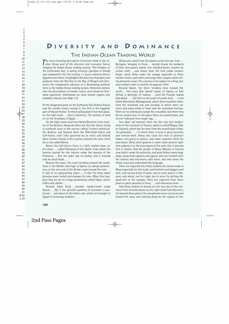
T he most revealing description of ancient trade in the In-dian Ocean and of the diversity and economic forces
shaping the Indian Ocean trading system, “The Periplus of the Erythraean Sea,” a sailing itinerary ( periplus in Greek),was composed in the first century C .E . by an unknown Greco-Egyptian merchant. It highlights the diversity of peoples and products from the Red Sea to the Bay of Bengal and illus-trates the comparative absence of a dominating political force in the Indian Ocean trading system. Historians believe that the descriptions of market towns were based on first-hand experience. Information on more remote regions was probably hearsay (see Map 7.1).
Of the designated ports on the Erythraean Sea [Indian Ocean],and the market-towns around it, the first is the Egyptianport of Mussel Harbor. To those sailing down from that place,on the right hand . . . there is Berenice. The harbors of bothare at the boundary of Egypt. . . .
On the right-hand coast next below Berenice is the coun-try of the Berbers. Along the shore are the Fish-Eaters, livingin scattered caves in the narrow valleys. Further inland arethe Berbers, and beyond them the Wild-flesh-Eaters andCalf-Eaters, each tribe governed by its chief; and behind
them, further inland, in the country towards the west, therelies a city called Meroe.
Below the Calf-Eaters there is a little market-town onthe shore . . . called Ptolemais of the Hunts, from which thehunters started for the interior under the dynasty of thePtolemies . . . But the place has no harbor and is reachedonly by small boats . . . .
Beyond this place, the coast trending toward the south,there is the Market and Cape of Spices, an abrupt promon-tory, at the very end of the Berber coast toward the east. . . .
A sign of an approaching storm . . . is that the deep waterbecomes more turbid and changes its color. When this hap-pens they all run to a large promontory called Tabae, whichoffers safe shelter. . . .
Beyond Tabae [lies] . . . another market-town calledOpone . . . [I]n it the greatest quantity of cinnamon is pro-duced . . . and slaves of the better sort, which are brought toEgypt in increasing numbers. . . .
[Ships also come] from the places across this sea, from . . .Barygaza, bringing to these . . . market-towns the productsof their own places; wheat, rice, clarified butter, sesame oil,cotton cloth . . . and honey from the reed called sacchari[sugar cane]. Some make the voyage especially to thesemarket-towns, and others exchange their cargoes while sail-ing along the coast. This country is not subject to a King, buteach market-town is ruled by its separate chief.
Beyond Opone, the shore trending more toward thesouth . . . this coast [the Somali region of Azania, or EastAfrica] is destitute of harbors . . . until the Pyralax islands[Zanzibar] . . . . [A] little to the south of south-west . . . is theisland Menuthias [Madagascar], about three hundred stadia
from the mainland, low and wooded, in which there arerivers and many kinds of birds and the mountain-tortoise.There are no wild beasts except the crocodiles; but there theydo not attack men. In this place there are sewed boats, andcanoes hollowed from single logs. . . .
Two days’ sail beyond, there lies the very last market-town of the continent of Azania, which is called Rhapta [Dares-Salaam]; which has its name from the sewed boats (rhap-ton ploiarion) . . . ; in which there is ivory in great quantity,and tortoise-shell. Along this coast live men of piratical
habits, very great in stature, and under separate chiefs foreach place. [One] chief governs it under some ancient rightthat subjects it to the sovereignty of the state that is becomefirst in Arabia. And the people of Muza [Mocha in Yemen]now hold it under his authority, and send thither many largeships; using Arab captains and agents, who are familiar withthe natives and intermarry with them, and who know thewhole coast and understand the language.
There are imported into these markets the lances made atMuza especially for this trade, and hatchets and daggers and
awls, and various kinds of glass; and at some places a littlewine, and wheat, not for trade, but to serve for getting thegood-will of the savages. There are exported from theseplaces a great quantity of ivory . . . and rhinoceros-horn. . . .
And these markets of Azania are the very last of the con-tinent that stretches down on the right hand from Berenice;for beyond these places the unexplored ocean curves aroundtoward the west, and running along by the regions to the
D I V E R S I T Y A N D D O M I N A N C E
THE INDIAN OCEAN TRADINGWORLD
180
2nd Pass Pages
14820_07_173-192_r3ws.qxd 4/2/04 3:26 PM Page 181

7/29/2019 APWH Chapter 7
http://slidepdf.com/reader/full/apwh-chapter-7 9/20
12
3456789
101112
1314151617181920212223
2425262728293031323334
35363738394041424344
4546474849505152 R53 L
181
south of Aethiopia and Libya and Africa, it mingles with thewestern sea. . . .
Beyond the harbor of Moscha [Musqat in Oman] . . . amountain range runs along the shore; at the end of which, ina row, lie seven islands. . . . Beyond these there is a barbarousregion which is no longer of the same Kingdom, but now be-longs to Persia. Sailing along this coast well out at sea . . .there meets you an island called Sarapis. . . . It is about twohundred stadia wide and six hundred long, inhabited bythree settlements of Fish-Eaters, a villainous lot, who use theArabian language and wear girdles of palm-leaves. . . .
[T]here follows not far beyond, the mouth of the PersianGulf, where there is much diving for the pearl-mussel. . . . Atthe upper end of this Gulf there is a market-town designatedby law called Apologus, situated near . . . the River Euphrates.
Sailing [southeast] through the mouth of the Gulf, after asix-days’ course there is another market-town of Persiacalled Ommana . . . . [L]arge vessels are regularly sent fromBarygaza, loaded with copper and sandalwood and timbersof teakwood and logs of blackwood and ebony. . . .
Beyond this region . . . there follows the coast district of Scythia, which lies above toward the north; the wholemarshy; from which flows down the river Sinthus [Indus], thegreatest of all the rivers that flow into the Erythraean Sea,bringing down an enormous volume of water. . . . This river
has seven mouths, very shallow and marshy, so that they arenot navigable, except the one in the middle; at which by theshore, is the market-town, Barbaricum. . . . [I]nland behind itis the metropolis of Scythia . . . it is subject to Parthianprinces who are constantly driving each other out.
Now the whole country of India has very many rivers, andvery great ebb and flow of the tides. . . . But about Barygaza[Broach] it is much greater, so that the bottom is suddenlyseen, and now parts of the dry land are sea, and now it is drywhere ships were sailing just before; and the rivers, under the
inrush of the flood tide, when the whole force of the sea isdirected against them, are driven upwards more stronglyagainst their natural current. . . .
The country inland from Barygaza is inhabited by numer-ous tribes. . . . Above these is the very warlike nation of theBactrians, who are under their own king. And Alexander, set-ting out from these parts, penetrated to the Ganges. . . . [T]othe present day ancient drachmae are current in Barygaza,coming from this country, bearing inscriptions in Greek let-ters, and the devices of those who reigned after Alexander. . . .
Inland from this place and to the east, is the city calledOzene [Ujjain]. . . . [F]rom this place are brought down allthings needed for the welfare of the country about Bary-gaza, and many things for our trade: agate and carnelian, In-dian muslins . . . .
There are imported into this market-town, wine, Italianpreferred, also Laodicean and Arabian; copper, tin, and lead;coral and topaz; thin clothing and inferior sorts of allkinds . . . gold and silver coin, on which there is a profit when
exchanged for the money of the country. . . . And for the Kingthere are brought into those places very costly vessels of sil-ver, singing boys, beautiful maidens for the harem, fine wines,thin clothing of the finest weaves, and the choicest oint-ments. There are exported from these places [spices], ivory,agate and carnelian . . . cotton cloth of all kinds, silk cloth. . . .
Beyond Barygaza the adjoining coast extends in a straightline from north to south. . . . The inland country back fromthe coast toward the east comprises many desert regions andgreat mountains; and all kinds of wild beasts—leopards,tigers, elephants, enormous serpents, hyenas, and baboons of many sorts; and many populous nations, as far as theGanges. . . .
This whole voyage as above described . . . they used tomake in small vessels, sailing close around the shores of the
gulfs; and Hippalus was the pilot who by observing the loca-tion of the ports and the conditions of the sea, first discov-ered how to lay his course straight across the ocean. . . .
About the following region, the course trending towardthe east, lying out at sea toward the west is the island Palaes-imundu, called by the ancients Taprobane [Sri Lanka]. . . . Itproduces pearls, transparent stones, muslins, and tortoise-shell. . . .
Beyond this, the course trending toward the north, thereare many barbarous tribes, among whom are the Cirrhadae, a
race of men with flattened noses, very savage; another tribe,the Bargysi; and the Horse-faces and the Long-faces, whoare said to be cannibals.
After these, the course turns toward the east again, andsailing with the ocean to the right and the shore remainingbeyond to the left, Ganges comes into view. . . . And just op-posite this river there is an island in the ocean, the last partof the inhabited world toward the east, under the rising sunitself; it is called Chryse; and it has the best tortoise-shell of all the places on the Erythraean Sea.
After this region under the very north, the sea outsideending in a land called This, there is a very great inland citycalled Thinae, from which raw silk and silk yarn and silk clothare brought on foot. . . . But the land of This is not easy of access; few men come from there, and seldom.
QUESTIONS FOR ANALYSIS
1. Of what importance were political organization and
ethnicity to a traveling merchant?
2. How might a manual like this have been used?3. To what extent can the observations of a Greco-Egyptian
merchant be taken as evidence for understanding how
merchants from other lands saw the trade in the Indian
Ocean?
Source: Excerpts from W. H. Schoff (tr. & ed.), The Periplus of the Erythraean Sea: Travel
and Trade in the Indian Ocean by a Merchant of the First Century (London, Bombay &
Calcutta, 1912).
181
2nd Pass Pages
14820_07_173-192_r3ws.qxd 4/2/04 3:26 PM Page 182

7/29/2019 APWH Chapter 7
http://slidepdf.com/reader/full/apwh-chapter-7 10/20
southern Arabia grew the scrubby trees whose aromaticresins were valued as frankincense and myrrh. Pearls
abounded in the Persian Gulf, and evidence of ancientcopper mines has been found in Oman in southeastern
Arabia. India shipped spices and manufactured goods,and more spices came from Southeast Asia, along withmanufactured items, particularly pottery, obtained intrade with China. In sum, the Indian Ocean trading re-gion had a great variety of highly valued products. Giventhe long distances and the comparative lack of islands,however, the volume of trade there was undoubtedly much lower than in the Mediterranean Sea.
Furthermore, the culture of the Indian Ocean ports was often isolated from the hinterlands, particularly inthe west. The coasts of the Arabian peninsula, the
African side of the Red Sea, southern Iran, and northernIndia (today’s Pakistan) were mostly barren desert. Portsin all these areas tended to be small, and many sufferedfrom meager supplies of fresh water. Farther south inIndia, the monsoon provided ample water, but steepmountains cut off the coastal plain from the interior of the country. Thus few ports between Zanzibar and SriLanka had substantial inland populations within easy
reach. The head of the Persian Gulf was one exception:ship-borne trade was possible from the port of Apologus(later called Ubulla, the precursor of modern Basra) asfar north as Babylon and, from the eighth century C.E.,nearby Baghdad.
By contrast, eastern India, the Malay Peninsula, andIndonesia afforded more hospitable and densely popu-lated shores with easier access to inland populations.Though the fishers, sailors, and traders of the western In-dian Ocean system supplied a long series of kingdomsand empires, none of these consumer societies became
primarily maritime in orientation, as the Greeks andPhoenicians did in the Mediterranean. In the east, incontrast, sea-borne trade and influence seem to havebeen important even to the earliest states of Southeast
Asia (see Chapter 6).In coastal areas throughout the Indian Ocean sys-
tem, small groups of seafarers sometimes had a signifi-cant social impact despite their usual lack of politicalpower. Women seldom accompanied the men on long sea voyages, so sailors and merchants often married lo-
cal women in port cities. The families thus established were bilingual and bicultural. As in many other situa-tions in world history, women played a crucial thoughnot well-documented role as mediators between cul-tures. Not only did they raise their children to be morecosmopolitan than children from inland regions, butthey also introduced the men to customs and attitudesthat they carried with them when they returned to sea.
As a consequence, the designation of specific seafarers
as Persian, Arab, Indian, or Malay often conceals mixedheritages and a rich cultural diversity.
ROUTES ACROSS THE SAHARA
The windswept Sahara, a desert stretching from theRed Sea to the Atlantic Ocean and broken only by the
Nile River, isolates sub-Saharan Africa from the Mediter-ranean world (see Map 7.2). The current dryness of theSahara dates only to about 2500 B.C.E. The period of dry-ing out that preceded that date lasted twenty-five cen-
turies and encompassed several cultural changes. During that time, travel between a slowly shrinking number of grassy areas was comparatively easy. However, by 300B.C.E., scarcity of water was restricting travel to a few difficult routes initially known only to desert nomads.Trade over trans-Saharan caravan routes, at first only atrickle, eventually expanded into a significant stream.
Sprawling sand dunes, sandy
plains, and vast expanses of exposed rock make up mostof the great desert. Stark and
rugged mountain and highland areas separate its north-ern and southern portions. The cliffs and caves of thesehighlands, the last spots where water and grassland couldbe found as the climate changed, preserve rock paint-ings and engravings that constitute the primary evi-dence for early Saharan history.
Though dating is difficult, what appear to be the ear-liest images, left by hunters in much wetter times, include
elephants, giraffes, rhinoceros, crocodiles, and other an-imals that have long been extinct in the region. Overlapsin the artwork indicate that the hunting societies weregradually joined by new cultures based on cattle breed-ing and well adapted to the sparse grazing that remained.Domestic cattle may have originated in western Asia orin North Africa. They certainly reached the Sahara beforeit became completely dry. The beautiful paintings of cat-tle and scenes of daily life seen in the Saharan rock artdepict pastoral societies that bear little similarity to any in western Asia. The people seem physically akin to to-
Early SaharanCultures
182 Chapter 7 Networks of Communication and Exchange, 300b.c.e.–600 c.e.
12
3456789
1011121314151617181920212223
2425262728293031323334
35363738394041424344
45464748495051
R 52L 53
2nd Pass Pages
14820_07_173-192_r3ws.qxd 4/2/04 3:26 PM Page 183

7/29/2019 APWH Chapter 7
http://slidepdf.com/reader/full/apwh-chapter-7 11/20
12
3456789
1011121314151617181920212223
2425262728293031323334
35363738394041424344
4546474849505152 R53 L
Routes Across the Sahara 183
2nd Pass Pages
14820_07_173-192_r3ws.qxd 4/2/04 3:26 PM Page 184

7/29/2019 APWH Chapter 7
http://slidepdf.com/reader/full/apwh-chapter-7 12/20
day’s West Africans, and the customs depicted, such asdancing and wearing masks, as well as the breeds of cat-tle, particularly those with piebald coloring (splotches of black and white), strongly suggest later societies to thesouth of the Sahara. These factors support the hypothe-sis that some southern cultural patterns originated inthe Sahara.
Overlaps in artwork also show that horse herderssucceeded the cattle herders. The rock art changes dra-matically in style, from the superb realism of the cattlepictures to sketchier images that are often strongly geo-
metric. Moreover, the horses are frequently shown draw-ing light chariots. According to the most common theory,intrepid charioteers from the Mediterranean shore drovetheir flimsy vehicles across the desert and establishedsocieties in the few remaining grassy areas of the centralSaharan highlands. Some scholars suggest possible char-iot routes that refugees from the collapse of the Myce-naean and Minoan civilizations of Greece and Crete (seeChapter 3) might have followed deep into the desertaround the twelfth century B.C.E. However, no archaeo-
logical evidence of actual chariot use in the Sahara hasbeen discovered, and it is difficult to imagine large num-bers of refugees from the politically chaotic Mediter-ranean region driving chariots into a waterless, tracklessdesert in search of a new homeland somewhere to thesouth.
As with the cattle herders, therefore, the identity of the Saharan horse breeders and the source of their pas-
sion for drawing chariots remain a mystery. Only withthe coming of the camel is it possible to make firm con-nections with the Saharan nomads of today through thedepiction of objects and geometric patterns still used by the veiled, blue-robed Tuareg people of the highlands insouthern Algeria, Niger, and Mali.
Some historians maintain that the Romans inaugu-rated an important trans-Saharan trade, but they lack firm archaeological evidence. More plausibly, Saharantrade relates to the spread of camel domestication. Sup-porting evidence comes from rock art, where overlaps of
images imply that camel riders in desert costume consti-tute the latest Saharan population. The camel-orientedimages are decidedly the crudest to be found in theregion.
The first mention of camels in North Africa comes ina Latin text of 46 B.C.E. Since the native camels of Africaprobably died out before the era of domestication, thedomestic animals probably reached the Sahara from
Arabia, probably by way of Egypt in the first millenniumB.C.E. They could have been adopted by peoples farther
and farther to the west, from one central Saharan high-land to the next, only much later spreading northwardand coming to the attention of the Romans (see Environ-ment and Technology: Camel Saddles). Camel herding made it easier for people to move away from the Saharanhighlands and roam the deep desert.
184 Chapter 7 Networks of Communication and Exchange, 300b.c.e.–600 c.e.
12
3456789
1011121314151617181920212223
2425262728293031323334
35363738394041424344
45464748495051
R 52L 53
2nd Pass Pages
Tuareg (TWAH-reg)
14820_07_173-192_r3ws.qxd 4/2/04 3:26 PM Page 185

7/29/2019 APWH Chapter 7
http://slidepdf.com/reader/full/apwh-chapter-7 13/20
Linkage between two differenttrading systems, one in the
south, the other in the north,developed slowly. Southern
traders concentrated on supplying salt from large de-posits in the southern desert to the peoples of sub-Saharan Africa. Traders from the equatorial forest zonebrought forest products, such as kola nuts (a condi-ment and source of caffeine) and edible palm oil, totrading centers near the desert’s southern fringe. Eachreceived the products they needed in their homelandsfrom the other, or from the farming peoples of theSahel˚—literally “the coast” in Arabic, the southern bor-derlands of the Sahara (see Map 7.2). Middlemen who
were native to the Sahel played an important role in thistrade, but precise historical details are lacking.
In the north, Roman colonists supplied Italy withagricultural products, primarily wheat and olives. Sur-viving mosaic pavements depicting scenes from daily life show that people living on the farms and in the townsof the interior consumed Roman manufactured goodsand shared Roman styles. This northern pattern beganto change only in the third century C.E. with the decline
of the Roman Empire, the abandonment of many Ro-man farms, the growth of nomadism, and a lessening of trade across the Mediterranean.
SUB-SAHARAN AFRICA
The Indian Ocean network and later trade across theSahara provided sub-Saharan Africa , the portion of
Africa south of the Sahara, with a few external contacts.
The most important African network of cultural ex-change from 300 B.C.E. to 1100 C.E., however, arose withinthe region and took the form of folk migration. These mi-grations and exchanges put in place enduring character-istics of African culture.
Many geographic obstacles im-pede access to and movement
within sub-Saharan Africa (seeMap 7.2). The Sahara, the At-
lantic and Indian Oceans, and the Red Sea form theboundaries of the region. With the exception of the Nile,a ribbon of green traversing the Sahara from south tonorth, the major river systems empty into the Atlantic, inthe case of the Senegal, Niger, and Zaire˚ Rivers, or into
A ChallengingGeography
Trade Across
the Sahara
the Mozambique Channel of the Indian Ocean, in thecase of the Zambezi. Rapids limit the use of these rivers
for navigation.Stretching over 50 degrees of latitude, sub-Saharan
Africa encompasses dramatically different environments. A 4,000-mile (6,500-kilometer) trek from the southernedge of the Sahara to the Cape of Good Hope would takea traveler from the flat, semiarid steppes of the Sahel re-gion to tropical savanna covered by long grasses andscattered forest, and then to tropical rain forest on thelower Niger and in the Zaire Basin. The rain forest gives
way to another broad expanse of savanna, followed by more steppe and desert, and finally by a region of tem-perate highlands at the southern extremity, located as farsouth of the equator as Greece and Sicily are to its north.East-west travel is comparatively easy in the steppe andsavanna regions—a caravan from Senegal to the Red Sea
would have traversed a distance comparable to that of the Silk Road—but difficult in the equatorial rain-forestbelt and across the mountains and deep rift valleys thatabut the rain forest to the east and separate East from
West Africa.
Cultural heritages shared by the educated elites within eachregion—heritages that someanthropologists call “great
traditions”—typically include a written language, com-mon legal and belief systems, ethical codes, and otherintellectual attitudes. They loom large in written recordsas traditions that rise above the diversity of local cus-toms and beliefs commonly distinguished as “smalltraditions.”
By the year 1 C.E. sub-Saharan Africa had become adistinct cultural region, though one not shaped by impe-rial conquest or characterized by a shared elite culture, a“great tradition.” The cultural unity of sub-Saharan Africarested on similar characteristics shared to varying de-grees by many popular cultures, or “small traditions.”These had developed during the region’s long period of isolation from the rest of the world and had been refined,renewed, and interwoven by repeated episodes of migra-tion and social interaction. Historians know little about
this complex prehistory. Thus, to a greater degree than inother regions, they call on anthropological descriptions,oral history, and comparatively late records of various“small traditions” to reconstruct the broad outlines of cultural formation.
Sub-Saharan Africa’s cultural unity is less imme-diately apparent than its diversity. By one estimate,
Africa is home to two thousand distinct languages, many
The Developmentof Cultural Unity
12
3456789
1011121314151617181920212223
2425262728293031323334
35363738394041424344
4546474849505152 R53 L
Sub-Saharan Africa 185
2nd Pass Pages
Sahel (SAH-hel) Zaire (zah-EER)
14820_07_173-192_r3ws.qxd 4/2/04 3:26 PM Page 186

7/29/2019 APWH Chapter 7
http://slidepdf.com/reader/full/apwh-chapter-7 14/20
12
3456789
1011121314151617181920212223
2425262728293031323334
3536373839404142434445464748495051
R 52L 53
As seemingly simple a technology as saddle design can in-dicate a society’s economic structure. The South Arabian
saddle, a Tunisian example of which is shown to the right,was good for riding, and baggage could easily be tied to thewooden arches at its front. It was militarily inefficient, how-ever, because the rider knelt on the cushion behind the
camel’s hump, which made it difficult to use weapons.The North Arabian saddle was a significant improvement
that came into use in the first centuries B.C.E. The two archesanchoring the front end of the South Arabian saddle were sep-arated and greatly enlarged, one arch going in front of thehump and the other behind. This formed a solid wooden frame-work to which loads could easily be attached, but the place-ment of the prominent front and back arches seated the rideron top of the camel’s hump instead of behind it and therebygave warriors a solid seat and the advantage of height over en-
emy horsemen. Arabs in northern Arabia used these saddles totake control of the caravan trade through their lands.The lightest and most efficient riding saddles, shown be-
low, come from the southern Sahara, where personal traveland warfare took priority over trade. These excellent warsaddles could not be used for baggage because they did notoffer a convenient place to tie bundles.
Camel Saddles
2nd Pass Pages
corresponding to social and belief systems endowed with distinctive rituals and cosmologies. There are like- wise numerous food production systems, ranging fromhunting and gathering—very differently carried out by the Mbuti˚ Pygmies of the equatorial rain forest and theKhoisan˚ peoples of the southwestern deserts—to thecultivation of bananas, yams, and other root crops in for-est clearings and of sorghum and other grains in thesavanna lands. Pastoral societies, particularly those de-
pending on cattle, display somewhat less diversity acrossthe Sahel and savanna belt from Senegal to Kenya.
Sub-Saharan Africa covered a larger and more di-verse area than any other cultural region of the first mil-lennium C.E. and had a lower overall population density.Thus societies and polities had ample room to form andreform, and a substantial amount of space separated dif-ferent groups. The contacts that did occur did not lastlong enough to produce rigid cultural uniformity.
In addition, for centuries external conquerors couldnot penetrate the region’s natural barriers and impose auniform culture. The Egyptians occupied Nubia, andMbuti (m-BOO-tee) Khoisan (KOI-sahn)
14820_07_173-192_r3ws.qxd 4/2/04 3:26 PM Page 187
7/29/2019 APWH Chapter 7
http://slidepdf.com/reader/full/apwh-chapter-7 15/20
some traces of Egyptian influence appear in Saharanrock art farther west, but the Nile cataracts and the vast
swampland in the Nile’s upper reaches blocked move-ment farther south. The Romans sent expeditionsagainst pastoral peoples living in the Libyan Sahara butcould not incorporate them into the Roman world. Notuntil the nineteenth century did outsiders gain controlof the continent and begin the process of establishing anelite culture—that of European imperialism.
European travelers who got toknow the sub-Saharan region
well in the nineteenth andtwentieth centuries observed
broad commonalities underlying African life and cul-ture. In agriculture, the common technique was cultiva-tion by hoe and digging stick. Musically, different groupsof Africans played many instruments, especially types of drums, but common features, particularly in rhythm,gave African music as a whole a distinctive character.Music played an important role in social rituals, as diddancing and wearing masks, which often showed great
artistry in their design. African kingdoms varied, but kingship displayedcommon features, most notably the ritual isolation of the king himself (see Diversity and Dominance: PersonalStyles of Rule in India and Mali in Chapter 13). Fixed so-cial categories—age groupings, kinship divisions, distinctgender roles and relations, and occupational groupings—also show resemblances from one region to another,even in societies too small to organize themselves intokingdoms. Though not hierarchical, these categoriesplayed a role similar to the divisions between noble,
commoner, and slave prevalent where kings ruled. Suchindications of underlying cultural unity have led modernobservers to identify a common African quality through-out most of the region, even though most sub-Saharan
Africans themselves did not perceive it. An eminent Bel-gian anthropologist, Jacques Maquet, has called thisquality “Africanity.”
Some historians hypothesize that this cultural unity emanated from the peoples who once occupied thesouthern Sahara. In Paleolithic times, periods of drynessalternated with periods of wetness as the Ice Age thatlocked up much of the world’s fresh water in glaciers andicecaps came and went. When European glaciers receded
with the waning of the Ice Age, a storm belt brought in-creased wetness to the Saharan region. Rushing riversscoured deep canyons. Now filled with fine sand, thosecanyons are easily visible on flights over the southernparts of the desert. As the glaciers receded farther, the
African Cultural
Characteristics
storm belt moved northward to Europe, and dryness setin after 5000 B.C.E. As a consequence, runs the hypothe-
sis, the region’s population migrated southward, becom-ing increasingly concentrated in the Sahel, which may have been the initial incubation center for Pan-Africancultural patterns.
Increasing dryness and the resulting difficulty insupporting the population would have driven some peo-ple out of this core into more sparsely settled lands tothe east, west, and south. In a parallel development far-ther to the east, migration away from the growing aridity of the desert seems to have contributed to the settling of the Nile Valley and the emergence of the Old Kingdomof Egypt (see Chapter 1).
Archaeology confirms that agri-culture had become commonbetween the equator and theSahara by the early second mil-lennium B.C.E. It then spread
southward, displacing hunting and gathering as a way of life. Moreover, botanical evidence indicates that banana
trees, probably introduced to southeastern Africa fromSoutheast Asia, made their way north and west, retracing in the opposite direction the presumed migration routesof the first agriculturists.
Archaeology has also uncovered traces of coppermining in the Sahara from the early first millenniumB.C.E. Copper appears in the Niger Valley somewhat later,and in the Central African copper belt after 400 C.E. Mostimportant of all, iron smelting began in northern sub-Saharan Africa in the early first millennium C.E. andspread southward from there.
Many historians believe that the secret of smelting iron, which requires very high temperatures, was dis-covered only once, by the Hittites of Anatolia (modernTurkey) around 1500 B.C.E. (see Chapter 3). If that is thecase, it is hard to explain how iron smelting reachedsub-Saharan Africa. The earliest evidence of ironwork-ing from the kingdom of Meroë, situated on the upperNile and in cultural contact with Egypt, is no earlier thanthe evidence from West Africa (northern Nigeria). Evenless plausible than the Nile Valley as a route of techno-logical diffusion is the idea of a spread southward fromPhoenician settlements in North Africa, since archaeo-logical evidence has failed to substantiate the vagueGreek and Latin accounts of Phoenician excursions tothe south.
A more plausible scenario focuses on Africans’ dis-covering for themselves how to smelt iron. Some histori-ans suggest that they might have done so while firing
The Advent of Iron and theBantu Migrations
12
3456789
1011121314151617181920212223
2425262728293031323334
353637383940414243444546474849505152 R53 L
Sub-Saharan Africa 187
2nd Pass Pages
14820_07_173-192_r3ws.qxd 4/2/04 3:26 PM Page 188

7/29/2019 APWH Chapter 7
http://slidepdf.com/reader/full/apwh-chapter-7 16/20
pottery in kilns. No firm evidence exists to prove or dis-prove this theory.
Linguistic analysis provides the strongest evidenceof extensive contacts among sub-Saharan Africans in thefirst millennium C.E.—and offers suggestions about thespread of iron. More than three hundred languages spo-ken south of the equator belong to the branch of theNiger-Congo family known as Bantu, after the wordmeaning “people” in most of the languages.
The distribution of the Bantu languages both northand south of the equator is consistent with a divergencebeginning in the first millennium B.C.E. By comparing core words common to most of the languages, linguistshave drawn some conclusions about the original Bantu-speakers, whom they call “proto-Bantu.” These peopleengaged in fishing, using canoes, nets, lines, and hooks.They lived in permanent villages on the edge of the rainforest, where they grew yams and grains and harvested
wild palm nuts from which they pressed oil. They pos-sessed domesticated goats, dogs, and perhaps other ani-mals. They made pottery and cloth. Linguists surmisethat the proto-Bantu homeland was near the modernboundary of Nigeria and Cameroon.
Because the presumed home of the proto-Bantu liesnear the known sites of early iron smelting, migration by Bantu-speakers seems a likely mechanism for the south-
ward spread of iron. The migrants probably used ironaxes and hoes to hack out forest clearings and plantcrops. According to this scenario, their actions wouldhave established an economic basis for new societies ca-pable of sustaining much denser populations than couldearlier societies dependent on hunting and gathering alone. Thus the period from 500 B.C.E. to 600 C.E. saw amassive transfer of Bantu traditions and practices south-
ward, eastward, and westward and their transformation,through intermingling with preexisting societies, intoPan-African traditions and practices.
THE SPREAD OF IDEAS
Ideas, like social customs, religious attitudes, and artis-tic styles, can spread along trade routes and through
folk migrations. In both cases, documenting the dissem-ination of ideas, particularly in preliterate societies,poses a difficult historical problem.
Historians know about someideas only through the survivalof written sources. Other ideasdo not depend on writing but
Ideas andMaterial Evidence
are inherent in material objects studied by archaeologistsand anthropologists. Customs surrounding the eating of
pork are a case in point. Scholars disagree about whetherpigs became domestic in only one place, from which thepractice of pig keeping spread elsewhere, or whetherseveral peoples hit on the same idea at different timesand in different places.
Southeast Asia was an important early center of pig domestication. Anthropological studies tell us that theeating of pork became highly ritualized in this area andthat it was sometimes allowed only on ceremonial occa-sions. On the other side of the Indian Ocean, wild swine
were common in the Nile swamps of ancient Egypt.There, too, pigs took on a sacred role, being associated
with the evil god Set, and eating them was prohibited.The biblical prohibition on the Israelites’ eating pork,echoed later by the Muslims, probably came from Egyptin the second millennium B.C.E.
In a third locale in eastern Iran, an archaeologicalsite dating from the third millennium B.C.E. provides evi-dence of another religious taboo relating to pork. Al-though the area around the site was swampy and hometo many wild pigs, not a single pig bone has been found.
Yet small pig figurines seem to have been used as sym-bolic religious offerings, and the later Iranian religion as-sociates the boar with an important god.
What accounts for the apparent connection betweendomestic pigs and religion in these far-flung areas? Thereis no way of knowing. It has been hypothesized that pigs
were first domesticated in Southeast Asia by people whohad no herd animals—sheep, goats, cattle, or horses—and who relied on fish for most of their animal protein.The pig therefore became a special animal to them. Thepractice of pig herding, along with religious beliefs and
rituals associated with the consumption of pork, couldconceivably have spread from Southeast Asia along themaritime routes of the Indian Ocean, eventually reach-ing Iran and Egypt. But no evidence survives to supportthis hypothesis. In this case, therefore, material evidencecan only hint at the spread of religious ideas, leaving thedoor open for other explanations.
A more certain example of objects’ indicating thespread of an idea is the practice of hammering a carveddie onto a piece of precious metal and using the result-ing coin as a medium of exchange. From its origin in theLydian kingdom in Anatolia in the first millennium B.C.E.(see Chapter 4), the idea of trading by means of struck coinage spread rapidly to Europe, North Africa, and In-dia. Was the low-value copper coinage of China, made by pouring molten metal into a mold, also inspired by thispractice from far away? It may have been, but it mightalso derive from indigenous Chinese metalworking.There is no way to be sure.
188 Chapter 7 Networks of Communication and Exchange, 300b.c.e.–600 c.e.
12
3456789
1011121314151617181920212223
2425262728293031323334
3536373839404142434445464748495051
R 52L 53
2nd Pass Pages
14820_07_173-192_r3ws.qxd 4/2/04 3:26 PM Page 189

7/29/2019 APWH Chapter 7
http://slidepdf.com/reader/full/apwh-chapter-7 17/20
While material objects associ-ated with religious beliefs and
rituals are important indica-tors of the spread of spiritual
ideas, written sources deal with the spread of today’smajor religions. Buddhism grew to become, with Chris-tianity and Islam (see Chapter 8), one of the most popu-lar and widespread religions in the world. In all threecases, the religious ideas spread without dependency ona single ethnic or kinship group.
King Ashoka, the Maurya ruler of India, and Kan-ishka, the greatest king of the Kushans of northern
Afghanistan, promoted Buddhism between the third cen-tury B.C.E. and the second century C.E. However, monks,missionaries, and pilgrims who crisscrossed India, fol-lowed the Silk Road, or took ships on the Indian Oceanbrought the Buddha’s teachings to Southeast Asia, China,Korea, and ultimately Japan (see Map 7.1).
The Chinese pilgrim Faxian˚ (died between 418 and423 C.E.) left a written account of his travels. Faxian beganhis trip in the company of a Chinese envoy to an unspec-ified ruler or people in Central Asia. After traveling fromone Buddhist site to another across Afghanistan and In-
dia, he reached Sri Lanka, a Buddhist land, where he livedfor two years. He then embarked for China on a merchantship with two hundred men aboard. A storm drove theship to Java, which he chose not to describe since it wasHindu rather than Buddhist. After five months ashore,Faxian finally reached China on another ship.
Less reliable accounts make reference to missionar-ies traveling to Syria, Egypt, and Macedonia, as well as toSoutheast Asia. One of Ashoka’s sons allegedly led a bandof missionaries to Sri Lanka. Later, his sister brought acompany of nuns there, along with a branch of the sa-
cred Bo tree under which the Buddha had received en-lightenment. At the same time, there are reports of othermonks traveling to Burma, Thailand, and Sumatra.
Ashoka’s missionaries may also have reached Tibet by way of trade routes across the Himalayas.
The different lands that received the story and teach-ings of the Buddha preserved or adapted them in dif-ferent ways. Theravada Buddhism, “Teachings of theElder,” was centered in Sri Lanka. Holding closely to theBuddha’s earliest teachings, it maintained that the goalof religion, available only to monks, is nirvana, the totalabsence of suffering and the end of the cycle of rebirth(see Chapter 6). This teaching contrasted with Maha-
yana, or “Great Vehicle” Buddhism, which stressed thegoal of becoming a bodhisattva, a person who attainsnirvana but chooses to remain in human company tohelp and guide others.
The Spread of
Buddhism
The post-Roman developmentof Christianity in Europe is dis-cussed in Chapter 9. The Chris-tian faith enjoyed an earlier
spread in Asia and Africa before its confrontation withIslam (described in Chapter 8). Jerusalem in Palestine,
Antioch in Syria, and Alexandria in Egypt became cen-ters of Christian authority soon after the crucifixion, butthe spread of Christianity to Armenia and Ethiopia illus-trates the connections between religion, trade, and im-perial politics.
The Spread of Christianity
12
3456789
1011121314151617181920212223
2425262728293031323334
353637383940414243444546474849505152 R53 L
The Spread of Ideas 189
2nd Pass Pages
Faxian (fah-shee-en)
14820_07_173-192_r3ws.qxd 4/2/04 3:26 PM Page 190

7/29/2019 APWH Chapter 7
http://slidepdf.com/reader/full/apwh-chapter-7 18/20
Situated in eastern Anatolia (modern Turkey), Arme-nia served recurrently as a battleground between Iran-ian states to the south and east and Mediterranean statesto the west. Each imperial power wanted to control thisregion so close to the frontier where Silk Road tradersmet their Mediterranean counterparts. In Parthian times,
Armenia’s kings favored Zoroastrianism. The inventionof an Armenian alphabet in the early fifth century opened the way to a wider spread of Christianity. The
Iranians did not give up domination easily, but within acentury the Armenian Apostolic Church had become the
center of Armenian cultural life.Far to the south Christians similarly sought to out-
flank Iran. The Christian emperors in Constantinople(see Chapter 5) sent missionaries along the Red Seatrade route to seek converts in Yemen and Ethiopia. Inthe fourth century C.E. a Syrian philosopher traveling
with two young relatives sailed to India. On the way back the ship docked at a Red Sea port occupied by Ethiopi-ans from the prosperous kingdom of Aksum. Being thenat odds with the Romans, the Ethiopians killed everyoneon board except the two boys, Aedisius—who later nar-
rated this story—and Frumentius. Impressed by theirlearning, the king made the former his cupbearer andthe latter his treasurer and secretary.
When the king died, his wife urged Frumentius togovern Aksum on her behalf and that of her infant son,Ezana. As regent Frumentius sought out Roman Chris-tians among the merchants who visited the country andhelped them establish Christian communities. When hebecame king, Ezana, who may have become a Christian,permitted Aedisius and Frumentius to return to Syria.
The patriarch of Alexandria, on learning about theprogress of Christianity in Aksum, elevated Frumentiusto the rank of bishop, though he had not previously beena clergyman, and sent him back to Ethiopia as the firstleader of its church.
The spread of Christianity into Nubia, the land southof Egypt along the Nile River, proceeded from Ethiopiarather than Egypt. Politically and economically, Ethiopiabecame a power at the western end of the Indian Oceantrading system, occasionally even extending its influ-ence across the Red Sea and asserting itself in Yemen
(see Map 7.2).
CONCLUSION
Exchange facilitated by the early long-distance trading systems differed in many ways from the ebb and flow
of culture, language, and custom that folk migrationsbrought about. Transportable goods and livestock andideas about new technologies and agricultural productssometimes worked great changes on the landscape andin people’s lives. But nothing resembling the Africanity observed south of the Sahara can be attributed to the so-cieties involved in the Silk Road, Indian Ocean, or trans-Saharan exchanges. Not only were few people directly involved in these complex social systems of travel andtrade compared with the populations with whom they
190 Chapter 7 Networks of Communication and Exchange, 300b.c.e.–600 c.e.
12
3456789
10111213
14151617181920212223
2425262728293031323334
3536373839404142434445464748495051
R 52L 53
2nd Pass Pages
14820_07_173-192_r3ws.qxd 4/2/04 3:26 PM Page 191

7/29/2019 APWH Chapter 7
http://slidepdf.com/reader/full/apwh-chapter-7 19/20
were brought into contact, but their lifestyles as pastoralnomads or seafarers isolated them still more. Communi-
ties of traders contributed to this isolation by their reluc-tance to share knowledge with people who mightbecome commercial competitors.
The Bantu, however, if current theories are correct,spread far and wide in sub-Saharan Africa with the delib-erate intent of settling and implanting a lifestyle basedon iron implements and agriculture. The metallurgicalskills and agricultural techniques they brought with thempermitted much denser habitation and helped ensurethat the languages of the immigrants would supplantthose of their hunting and gathering predecessors. Where
the trading systems encouraged diversity by introducing new products and ideas, the Bantu migrations brought adegree of cultural dominance that strongly affected later
African history. An apparent exception to the generalization that
trading systems have less impact than folk migrationson patterns of dominance lies in the intangible area of ideas. Christianity and Buddhism both spread along trade routes, at least to some degree. Each instance of spread, however, gave rise to new forms of cultural diver-
sity even as overall doctrinal unity made these religionsdominant. As “great traditions,” the new faiths based onconversion linked priests, monks, nuns, and religiousscholars across vast distances. However, these same reli-gions merged with myriad “small traditions” to providefor the social and spiritual needs of peoples living inmany lands under widely varying circumstances.
■ Key TermsSilk Road
ParthiansSasanid Empire
stirrup
Indian Ocean Maritime System
trans-Saharan caravan routes
Sahel
sub-Saharan Africa
steppes
savanna
tropical rain forest
“great traditions”“small traditions”
Bantu
Armenia
Ethiopia
■ Suggested ReadingFor broad and suggestive overviews on cross-cultural exchangesee Philip D. Curtin, Cross-Cultural Trade in World History
(1985), and C. G. F. Simkin, The Traditional Trade of Asia (1968).
Readable overviews of the Silk Road include Luce Boulnois, The Silk Road (1966), and Irene M. Franck and David M. Brown-stone, The Silk Road: A History (1986). For products tradedacross Central Asia based on an eighth-century Japanese col-
lection, see Ryoichi Hayashi, The Silk Road and the Shoso-in
(1975). Xinru Liu, Silk and Religion (1996), covers one specificproduct. Owen Lattimore gives a first-person account of travel-ing by camel caravan in The Desert Road to Turkestan (1928).More generally on Central Asia, see Denis Sinor, Inner Asia,
History-Civilization-Languages: A Syllabus (1987), and KarlJettmar, Art of the Steppes, rev. ed. (1967). Richard Foltz, Reli-
gions of the Silk Road (1999), is an excellent brief introduction.
For a readable but sketchy historical overview see August Tous-saint, History of the Indian Ocean (1966). Alan Villiers recounts what it was like to sail dhows between East Africa and the Per-sian Gulf in Sons of Sinbad (1940).
On a more scholarly plane, see K. N. Chaudhuri’s Trade and Civilization in the Indian Ocean: An Economic History from the Rise of Islam to 1750 (1985). Archaeologist Pierre Vérin treats
the special problem of Madagascar in The History of Civilisa-tion in North Madagascar (1986). For Rome and India see E. H. Warmington’s The Commerce Between the Roman Empire and India (1974); J. Innes Miller’s The Spice Trade of the Roman Em-pire, 29 B.C . to A.D . 641 (1969); and Vimala Begley and RichardDaniel De Puma’s edited collection of articles, Rome and India:The Ancient Sea Trade (1991), along with the primary sourceThe Periplus Maris Erythraei: Text with Introduction, Transla-
tion, and Commentary (1989), edited and translated by LionelCasson. George F. Hourani’s brief Arab Seafaring in the IndianOcean in Ancient and Early Medieval Times (1975) covers mate-rials in Arabic sources.
Nicholas Tarling, ed., The Cambridge History of Southeast Asia,vol. 1 (1992); D. R. Sardesai, Southeast Asia:Past and Present,3ded. (1994); and Milton E. Osborne, Southeast Asia: An Introduc-tory History (1995), provide general accounts of Southeast Asian history. Lynda Shaffer, Maritime Southeast Asia to 1500
(1996), focuses on the world historical context. Also useful isKenneth R. Hall, Maritime Trade and State Development inEarly Southeast Asia (1985).
On art see Maud Girard-Geslan et al., Art of Southeast Asia
(1998), and Daigoro Chihara, Hindu-Buddhist Architecture inSoutheast Asia (1996).
Richard W. Bulliet’s The Camel and the Wheel (1975) deals withcamel use in the Middle East, along the Silk Road, and in North Africa and the Sahara. For a well-illustrated account of Saharanrock art see Henri Lhote, The Search for the Tassili Frescoes: The Story of the Prehistoric Rock-Paintings of the Sahara (1959).
J. F. A. Ajayi and Michael Crowder, A History of West Africa, vol. 1(1976), and G. Mokhtar, ed., General History of Africa II:Ancient
12
3456789
10111213
14151617181920212223
2425262728293031323334
353637383940414243444546474849505152 R53 L
Conclusion 191
2nd Pass Pages
14820_07_173-192_r3ws.qxd 4/2/04 3:26 PM Page 192

7/29/2019 APWH Chapter 7
http://slidepdf.com/reader/full/apwh-chapter-7 20/20
Civilizations of Africa (1981), include many articles by numer-ous authors; the latter work specifically treats ironworking and
the Bantu migrations. On African cultural unity see JacquesMaquet, Africanity:The Cultural Unity of Black Africa (1972).
Of special importance on Christianity in Asia and Africa is GarthFowden, Empire to Commonwealth:Consequences of Monothe-ism in Late Antiquity (1993). For specific topics treated in thischapter see Stuart Munro-Hay, Aksum: An African Civilisationof Late Antiquity (1991); Xinru Liu, Ancient India and Ancient China: Trade and Religious Exchanges, A.D . 1–600 (1998); Rolf A.Stein, Tibetan Civilization (1972); and Tilak Hettiarachchy, His-
tory of Kingship in Ceylon up to the Fourth Century A.D . (1972).The Travels of Fahsien (399–414 A.D .), or, Record of the Buddhis-
tic Kingdoms, trans. H. A. Giles (1923; reprint, 1981) recountsthe experiences of a Chinese pilgrim.
■ Notes1. Victor H. Mair, ed., The Columbia Anthology of Traditional
Chinese Literature (New York: Columbia University Press,1994), 485; translated by Victor H. Mair.
192 Chapter 7 Networks of Communication and Exchange, 300b.c.e.–600 c.e.
12
3456789
10111213
14151617181920212223
2425262728293031323334
3536373839404142434445464748495051
R 52L 53
2nd Pass Pages
DOCUMENT 5
The Indian Ocean Trading World (Diversity andDominance, pp. 180–181)
DOCUMENT 6
Camel Saddles (photo, p. 186)
DOCUMENT 7
Statue of a Bodhisattva at Bamian (p. 189)
The author of Document 5 is a Greco-Egyptianmerchant.What experiences would have shaped this merchant’s view of Indian Ocean trade? What additional types of documents would help youassess the reliability of Document 5?
Document-Based Question
Indian Ocean and Silk RoadTrade Before 1100 C.E.Using the following documents,analyze the character of communication and exchange on the Indian Ocean and Silk Road trade routes.Consider the geography of the trade routes,the modes of transportation, the people involved, and the nature of goods and ideas exchanged.
DOCUMENT 1
Indian Ocean Sailing Vessel (photo, p. 173)
DOCUMENT 2
Excerpt from Po Zhuyi (p. 174)
DOCUMENT 3
Iranian Musicians from Silk Road (photo, p. 176)
DOCUMENT 4
Map 7.1 Asian Trade and Communication Routes (p. 177)