application study: western lights area ... study: western lights area pedestrian access february...
TRANSCRIPT

SUSTAINABLE STREETS – SIDEWALKS
APPLICATION STUDY:
WESTERN LIGHTS AREA
PEDESTRIAN ACCESS
February 2016

2
This document was prepared with financial assistance from the Federal Highway Administration and the Federal Transit Administration of the U.S. Department of Transportation through the New York State Department of Transportation. The Syracuse Metropolitan Transportation Council is solely responsible for its contents.
___________________________________________________________________
For additional information, contact:
Aaron McKeon, Project Manager
James D’Agostino, Director
Syracuse Metropolitan Transportation Council
126 N. Salina Street, 100 Clinton Square, Suite 100, Syracuse, NY 13202
PHONE: 315.422. 5716
SUSTAINABLE STREETS PHASE 1
APPLICATION STUDY:
WESTERN LIGHTS AREA PEDESTRIAN ACCESS Syracuse Metropolitan Transportation Council
FINAL REPORT

3
TABLE OF CONTENTS 1.0 INTRODUCTION ..........................................................................................................................6
1.1 BACKGROUND .....................................................................................................................6
1.2 STUDY AREA ..........................................................................................................................7
2.0 EXISTING CONDITIONS ..............................................................................................................8
2.1 NEIGHBORHOODS/MUNICIPAL BOUNDARIES .................................................................8
2.2 NATURAL FEATURES ..............................................................................................................8
2.3 ROADS ...................................................................................................................................10
2.4 SIDEWALKS ...........................................................................................................................10
2.5 INTERSECTIONS .....................................................................................................................11
2.6 ADA REQUIREMENTS ............................................................................................................12
2.7 PEDESTRIAN COUNTS ...........................................................................................................13
2.8 TRANSIT FACILITIES ................................................................................................................15
2.9 ACCIDENT DATA ..................................................................................................................15
2.10 ONONDAGA BOULEVARD: NORTH SIDE DESTINATIONS ...............................................18
2.11 ONONDAGA BOULEVARD: SOUTH SIDE DESTINATIONS ...............................................20
2.12 AREA DESTINATIONS ..........................................................................................................21
3.0 ASSESSMENT ...............................................................................................................................22
3.1 STUDY ADVISORY COMMITTEE & PUBLIC INPUT ...............................................................22
3.2 NYSDOT COMPLETE STREETS CHECKLIST ...........................................................................22
4.0 POSSIBLE IMPROVEMENTS ........................................................................................................24
4.1 MINOR IMPROVEMENTS ......................................................................................................24
4.2 MID-SIZED IMPROVEMENTS .................................................................................................24
4.3 MAJOR IMPROVEMENTS .....................................................................................................31
CONCLUSION ..................................................................................................................................35
APPENDIX A—MEETING NOTES
APPENDIX B—NYSDOT COMPLETE STREETS CHECKLIST
APPENDIX C—INTERSECTION DIAGRAMS

4
LIST OF FIGURES
TABLE 1 — POPULATION ................................................................................................................. 8
TABLE 2 — STUDY AREA TRAFFIC VOLUMES ................................................................................. 10
LIST OF TABLES
FIGURE 1 — PEDESTRIAN DEMAND MODEL ................................................................................. 6
FIGURE 2 — STUDY AREA LOCATION ............................................................................................ 6
FIGURE 3 — STUDY AREA ................................................................................................................ 7
FIGURE 4 — NEIGHBORHOOD & MUNICIPAL BOUNDARIES ...................................................... 8
FIGURE 5 — TOPOGRAPHY & FLOODPLAIN ................................................................................ 9
FIGURE 6—SIDEWALK INVENTORY................................................................................................. 11
FIGURE 7—INTERSECTION SKETCH, VELASKO AVENUE/GRAND AVENUE ................................ 12
FIGURE 8—FIVE HOUR PEDESTRIAN COUNT TOTALS ................................................................... 14
FIGURE 9—BUS ROUTES IN THE STUDY AREA ................................................................................ 16
FIGURE 10—PEDESTRIAN/VEHICLE COLLISIONS, 2009—2013 .................................................... 17
FIGURE 11—DESTINATIONS, NORTH SIDE OF ONONDAGA BOULEVARD ................................ 18
FIGURE 12—DESTINATIONS, SOUTH SIDE OF ONONDAGA BOULEVARD ................................. 20
FIGURE 13—POSSIBLE IMPROVEMENTS ........................................................................................ 25
FIGURE 14—INSTITUTE OF TRANSPORTATION ENGINEERS—STREETSIDE ZONE WIDTHS ........... 28
FIGURE 15—STREETSIDE ZONES, ONONDAGA BOULEVARD ...................................................... 29
FIGURE 16—VELASKO ROAD/WESTERN LIGHTS DRIVEWAY—POSSIBLE IMPROVEMENT ........ 31
FIGURE 17—ONONDAGA BOULEVARD PHOTOSIMULATION .................................................... 32
FIGURE 18—MT. HOPE BOULEVARD REDEVELOPMENT, BEFORE & AFTER ............................... 34

5
EXECUTIVE SUMMARY The Western Lights Pedestrian Access Study is the second part of the Metropolitan Transporta on Council’s (SMTC) Sus-tainable Streets - Sidewalks Project. The first part of this project included an inventory of the region’s sidewalks, compila-
on of a reference manual addressing sidewalk issues, and the development of a pedestrian demand model. A study of pedestrian facili es in the Western Lights area was recommended by the Town of Geddes.
This study’s purpose is to examine condi ons and iden fy possible improvements to pedestrian access in this area. The many retail stores in this rela vely small area (including a pharmacy and two 24-hour supermarkets) represent a significant des na on for people walking to and from nearby neighborhoods. This was borne out by a count of pedestrian traffic, which iden fied a significant pa ern of east-west pedestrian movement, par cularly between the Skunk City neighbor-hood and the shopping plaza.
The Study Advisory Commi ee (SAC) for this study included representa ves from the City of Syracuse, Onondaga County Department of Transporta on (OCDOT), the Syracuse-Onondaga County Planning Agency (SOCPA), the Onondaga County Department of Water Environment Protec on (WEP), the Town of Geddes, Westhill High School, and the New York State Department of Transporta on (NYSDOT). Two SAC mee ngs were held, as well as a mee ng with the Town of Geddes’ Public Safety Commission.
NYSDOT’s Complete Streets Checklist was used to evaluate exis ng pedestrian facili es in this area. Sidewalks, crosswalks and pedestrian signals are present in this area, but not along all roadways or at all intersec ons. The ability to create a more pleasant pedestrian environment is constrained in some areas by topography, with steep grades dropping off on the south side of Grand Avenue and the west side of Velasko Road. Similarly, the steep topography along the roads north of Grand Avenue impedes north-south pedestrian access.
The SAC iden fied numerous possible improvements to pedestrian access, classifying them as “minor”, “mid-sized” and “major”, depending on their rela ve complexity.
Possible minor improvements:
Ensure that all signalized intersec ons have visible crosswalks, ADA-compliant curb ramps and pedestrian signals. Relocate Centro’s mid-block bus stops on Onondaga Boulevard.
Possible mid-sized improvements:
Widen, realign and re-stripe Homer Avenue in the Town of Geddes. Add streetside zones to Onondaga Boulevard and, where possible, along Velasko Road and Grand Avenue. Add a crosswalk across Grand Avenue near the Western Lights Plaza driveway. Analyze the poten al impacts of crea ng a raised center median on a por on of Onondaga Boulevard, limi ng one driveway each at both the Western Lights and Wegmans Plazas to right-in, right-out movements only.
Possible major improvements:
Modify Western Lights Plaza’s Velasko Road driveway to reinforce its current right-in, right-out only design. Overhaul access to Wegmans Plaza, including the reloca on of this plaza’s signal. Develop a long-term plan for access management on the south side of Onondaga Boulevard, to consolidate driveways and promote pedestrian-oriented redevelopment.

6
1.1 BACKGROUND In March 2014, the Syracuse Metropolitan Transporta on Council (SMTC) asked towns, villages and the City of Syracuse to submit ideas for studies that would analyze exis ng problem areas for pedestrian access in their municipali es. The only s pula on made in this request was that studies would need to focus on one of the Priority Zones iden fied in Phase 1 of the Sustainable Streets Project. These Priority Zones were a product of the SMTC’s Pedestrian Demand Model, which used a variety of inputs to iden fy walkable “hotspots” in the Metropolitan Planning Area (Figure 1 shows a por on of the resul ng hotspot map for the region).
The Town of Geddes iden fied pedestrian access to Western Lights Shopping Plaza as a possible study. (See Figure 2 for a loca on map.) This shopping plaza, located at the intersec on of Onondaga Boulevard and Velasko Road, is a major des na on for residents of the City of Syracuse’s Skunk City neighborhood and for adjacent neighborhoods in the Towns of Geddes and Onondaga.
A Priority Zone had been previously defined for this area. Figure 3 shows this Priority Zone (do ed green line), but as this figure also shows, the Study Area boundaries selected for this project are significantly different from the Priority Zone limits, primarily because of the observed foot traffic running east-west through this area.
Because there are a number of commercial uses (primarily retail) along Onondaga Boulevard in addi on to Western Lights Plaza, this study will include an evalua on of pedestrian access to businesses in this corridor, collec vely referred to as the Western Lights Area.
The goals of this study are:
To review exis ng condi ons and iden fy obstacles to pedestrian access.
To apply concepts from Phase I of the Sustainable Streets Study.
To iden fy possible improvements to pedestrian access in the Study Area.
Figure 2—Study Area Location
Figure 1—Pedestrian Demand Model
Output from the SMTC’s Pedestrian Demand Model developed for Phase 1 of the Sustainable Streets Project. Priority Zones are shown in blue.
Western Lights Area Priority Zone
1.0 INTRODUCTION

7
1.2 STUDY AREA This study is focused on pedestrian access along Velasko Road/Avery Avenue, Grand Avenue and Onondaga Boulevard in the Western Lights Plaza area, including access to the Plaza. The study is primarily concerned with pedestrian movement along and across these roads. The Pedestrian Demand Model for this area (see the Greater Syracuse Pedestrian Planning Applica on available online) shows the Skunk City neighborhood to the east of Western Lights as a poten al source of pedestrians, based on the demographics built into the model (such as car ownership, means of travel to work and popula on density).
Figure 3 shows the Study Area for this study. For purposes of conduc ng pedestrian counts and inventorying facili es, the study focuses on the three signalized intersec ons in the area, Grand Avenue at Velasko Road, Velasko Road at Onondaga Boulevard and the Wegmans/Western Lights intersec on with Onondaga Boulevard. Addi onally, a pedestrian count was conducted at the Western Lights Plaza driveway that provides access to Grand Avenue.
The Study Area contains the only two supermarkets as well as the only pharmacy within more than a mile radius. Total employment in the study area is on the order of 800 to 1,000 full- and part- me jobs. One-hundred and thirty units of subsidized senior housing are located within a half-mile radius of the Rite-Aid on Onondaga Boulevard.
Figure 3—Study Area

8
2.1 NEIGHBORHOOD AND MUNICIPAL BOUNDARIES The Western Lights Area draws people from several different nearby areas. The boundary line for the City of Syracuse runs north-south through the Study Area, just west of Velasko Road (see Figure 4). Syracuse’s Skunk City neighborhood is a low- to moderate-income neighborhood located due east of the Study Area. Skunk City is separated from the Western Lights commercial area by wetlands, open space and a recrea onal field that occupy the east frontage along Velasko Road.
The city’s Winkworth and Strathmore neighborhoods are located on the south and southeast sides of the Study Area, respec vely. Both are moderate- to upper-income neighborhoods that are primarily residen al.
Western Lights Plaza and many of the businesses on Onondaga Boulevard are within the Town of Geddes’ limits. The residen al
neighborhoods to the north of the Plaza are also in the Town of Geddes.
Westhill High School and the homes and businesses west of Wegmans along Onondaga Boulevard are in the Town of Onondaga.
2.0 EXISTING CONDITIONS
Figure 4—Neighborhood and Municipal Boundaries
Table 1: Popula on
Popula on
City of Syracuse 145,170
City Neighborhoods
Skunk City 2,561
Strathmore 8,283 Winkworth 743
Town of Geddes 17,120 Town of Onondaga 23,100
Source: 2013 American Community Survey data

9
2.2 NATURAL FEATURES Onondaga Boulevard runs along a shallow valley, with a steep slope to the north that rises to Tipperary Hill, and a more gradual slope to the south. Onondaga Boulevard, the Skunk City neighborhood, and Downtown Syracuse all sit at roughly the same eleva on, while much of the residen al area in Geddes and Syracuse’s Winkworth neighborhood sit at slightly higher eleva ons. This makes it rela vely easy for Skunk City residents to walk back and forth along Onondaga Boulevard, while their neighbors in the Town of Geddes must traverse an eleva on change of 100 feet to get between their homes and nearby shopping.
Harbor Brook runs east-west through the area, origina ng in the Loomis Hill area in the Town of Onondaga, southwest of the Study Area. Harbor Brook runs north of Onondaga Boulevard in the Study Area, crossing under Velasko Road through a large culvert.
As Figure 5 shows, por ons of Velasko Road and much of the Skunk City neighborhood are in the 100-year floodplain. Flooding of homes in Skunk City was a recurring issue prior to the construc on of Harbor Brook Deten on Basin, which sits between Skunk City and Western Lights. Onondaga County’s Department of Water Environment Protec on (WEP) recently completed construc on of a wetland area within this deten on basin.
Prior to construc on of the deten on basin, Rowland Street ran from Velasko Road to Skunk City. Today, Rowland Street is used by OCWEP as a vehicle access road through the deten on basin. A gate prevents public access to the deten on basin from Velasko Road. The access road is heavily used as a pedestrian walkway between the Western Lights area and Skunk City.
There is a steep slope between Grand Avenue and the residential areas to the north.
Source: Google, 2014 imagery
WESTERN LIGHTS
GRAND AVE
A chain link fence controls access to the dirt access road that runs through Harbor Brook Detention
Basin (seen here from Velasko Road).
Figure 5— Topography and Floodplain

10
2.3 ROADS Generally speaking, arterials and collectors present the greatest challenge to pedestrian movement, because they carry higher traffic volumes and have higher speed limits than local roads. Typically, pedestrians trying to cross an arterial or collector face a wider road, more vehicles and fewer gaps in traffic than on a local road.
2.3.1 Minor Arterials
Minor Arterials are roads that carry moderate traffic volumes and connect neighborhoods to one another. There are three Minor Arterial roadways in the study area: Onondaga Boulevard, Velasko Road and Grand Avenue.
As Table 2 shows, Onondaga Boulevard has the highest traffic volumes in the study area, with nearly 13,000 vehicles per day. Onondaga Boulevard is the only roadway in the study area with four through lanes with no center turn lane. It is lined with bus stops and a mix of commercial and residen al des na ons
Velasko Road is the western boundary of the Skunk City neighborhood. Velasko Road is the second busiest road in the Study Area, with roughly 11,000 vehicles per day.
Within the study area, Grand Avenue has only a few commercial driveways, including the former Marble Farms Dairy building. While the dairy is closed, a seasonal produce stand operates in an adjacent lot. Grand Avenue also provides a rear access driveway to Western Lights Plaza.
2.3.2 Collectors
Avery Avenue, West Onondaga Street and Bellevue Avenue are classified as “Collector” roadways: they provide connec ons between the local road network and the arterial roadways.
West Onondaga Street forms the southern boundary of Skunk City and the northern boundary of the Strathmore neighborhood.
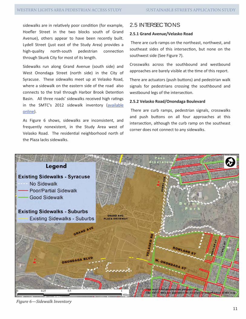
2.4 SIDEWALKS Sidewalks are present but are inconsistent throughout the study area, as shown in the sidewalk inventory map presented in Figure 6. See the SMTC’s Sidewalk Reference Manual for a more complete descrip on of “poor”, “par al” and “good” sidewalk ra ngs.
Sidewalks within Skunk City, like many residen al areas in the city, tend to have varying levels of upkeep, walkability, and connec vity. While some blocks’
Table 2: Study Area Traffic Volumes
Road Name Onondaga
Blvd. W. Onondaga
St.
Speed Limit (mph) 35 30 AADT (vpd) 12,790* 5,365
Through Lanes 4 2
Road Name Velasko Road Grand
Avenue
Speed Limit (mph) 35 30 AADT (vpd) 10,758 4,025
Through Lanes 2 2
Road Name Avery Ave Bellevue Ave
Speed Limit (mph) 30 30
AADT (vpd) 7,925 2,990
Through Lanes 2 2
AADT = Annual Average Daily Traffic, a widely-used es mate of the normal daily traffic volume on a roadway segment.
*Es mated using 2009 peak period turning movement count data. Other AADT counts are from NYSDOT data.
11
sidewalks are in rela vely poor condi on (for example, Hoefler Street in the two blocks south of Grand Avenue), others appear to have been recently built. Lydell Street (just east of the Study Area) provides a high-quality north-south pedestrian connec on through Skunk City for most of its length.
Sidewalks run along Grand Avenue (south side) and West Onondaga Street (north side) in the City of Syracuse. These sidewalks meet up at Velasko Road, where a sidewalk on the eastern side of the road also connects to the trail through Harbor Brook Deten on Basin. All three roads’ sidewalks received high ra ngs in the SMTC’s 2012 sidewalk inventory (available online).
As Figure 6 shows, sidewalks are inconsistent, and frequently nonexistent, in the Study Area west of Velasko Road. The residen al neighborhood north of the Plaza lacks sidewalks.
2.5 INTERSECTIONS 2.5.1 Grand Avenue/Velasko Road
There are curb ramps on the northeast, northwest, and southeast sides of this intersec on, but none on the southwest side (See Figure 7).
Crosswalks across the southbound and westbound approaches are barely visible at the me of this report.
There are actuators (push bu ons) and pedestrian walk signals for pedestrians crossing the southbound and westbound legs of the intersec on.
2.5.2 Velasko Road/Onondaga Boulevard
There are curb ramps, pedestrian signals, crosswalks and push bu ons on all four approaches at this intersec on, although the curb ramp on the southeast corner does not connect to any sidewalks.
Figure 6—Sidewalk Inventory

12
2.5.3 Onondaga Boulevard/Western Lights Plaza/Wegmans Plaza
This signalized intersec on is located about 2,000 feet west of the Onondaga/Velasko intersec on. There are no curb ramps, crosswalks or pedestrian signals at this intersec on.
2.5.4 Grand Avenue/Western Lights Driveway
There are no curbs ramps crosswalks or pedestrian signals at this unsignalized intersec on. Shoulders along Grand Avenue vary between five and six feet, with some sec ons having much wider shoulders.
2.6 ADA REQUIREMENTS Title II of the Americans with Disabili es Act (ADA) does not require that all roads have sidewalks, but it does require curb ramps for all exis ng facili es where sidewalks are present, as well as for all new construc on and altered facili es.
Curb ramps should include detectable warnings, consis ng of a two-foot strip that extends the width of the ramp. Under the ADA, detectable warnings use a material that contrasts visually with the adjoining surface.
If sidewalks are constructed, they need to be designed to ADA standards. That includes:
Five feet or greater in width OR at least three feet in width with 5’x5’ level landings no more than 200 feet apart
Cross slopes of 2% or less
Any height differen als along a sidewalk that are greater than 1/4” in height are beveled at a 2:1 slope (up to 1/2”) or ramped with a slope of 8.33% or less (for differen als greater than 1/2”)
Figure 7—Intersection Sketch, Velasko Avenue/Grand Avenue
The intersection of Velasko Road and Onondaga Boulevard is fully-loaded with pedestrian amenities (view from northbound approach).

13
“Choke points” where the sidewalk intersects signage, u li es or other obstruc ons maintain at least a 32” width for travel and are no more than two feet long
A level pedestrian access route is provided across commercial driveways, including:
Three-foot minimum width
Cross slope of two percent or less
Does not have to be marked, but provides a straight line between adjoining sidewalks or ramps
Curb ramps have the following characteris cs:
Minimum of 36-inch width
Running slope no greater than 8.33 percent.
Curb ramps should also include detectable warnings: dome-shaped bumps on the ramp to alert the visually impaired that they are transi oning from the sidewalk to the street.
The only ADA-accessible connec on between Skunk City and Western Lights Plaza is at the Velasko Road/ Onondaga Boulevard intersec on, where curb ramps and detectable warnings are provided, in addi on to pedestrian signals and crosswalks.
2.7 PEDESTRIAN COUNTS Pedestrian traffic was counted from 11:00 AM to 1:00 PM and from 2:30 PM to 5:30 PM on Wednesday, October 1, 2014. Figure 8 summarizes the total numbers of pedestrians counted over this five-hour period.
Pedestrians were also included in traffic counts at the Wegmans/Western Lights Plaza traffic signal on Thursday, May 30, 2013 from 7:00 AM to 9:00 AM and from 4:00 PM to 6:00 PM, and on Saturday, June 1, 2013, from 11:00 AM to 1:00 PM. Since this traffic count did not include mid-block crossings, it likely undercounted total pedestrian ac vity. A total of 21 pedestrians were counted over six hours in this traffic count. Based on the October 2014 counts,
pedestrian ac vity is substan ally lower at this intersec on than at nearby mid-block crossing points.
2.7.1 Onondaga Blvd/Velasko
The Onondaga Boulevard/Velasko Road intersec on is the busiest intersec on in the study area in terms of pedestrian ac vity. Over the five-hour period of the count, 94 people crossed the southbound approach (traveling east-west) of Velasko Road at this intersec on. An addi onal 15 people crossed the northbound approach.
Generally speaking, people tend to walk east-west through this area, between the Western Lights area and the Skunk City neighborhood, rather than north-south along Velasko Road.
Mid-Block Crossings
The second-busiest crossing point in the study area is the mid-block crossing of Velasko Road between Grand and Onondaga. While there are no pedestrian crossing signs, crosswalks, or other ameni es in this por on of Velasko, it is adjacent to the trail through the Harbor Brook Deten on Basin, making it a natural crossing point for Skunk City residents walking to Western Lights Plaza.
Addi onally, 40 pedestrians were observed crossing Onondaga Boulevard (north-south) at mid-block loca ons west of the Velasko Road intersec on.
2.7.2 Onondaga Blvd/Wegmans/Western Lights
A traffic signal controls the intersec on of Onondaga Boulevard, the westernmost Wegmans driveway and one of the Western Lights Plaza driveways. This intersec on has no pedestrian facili es (crosswalks, curb ramps or signals) but is one of the busiest in the Study Area for pedestrian ac vity. During the five-hour count, 23 people were observed crossing Onondaga Boulevard at or near the signalized intersec on. Thirty-three people were observed crossing Onondaga Boulevard mid-block east of the intersec on. In many cases, people were trying to reach a bus stop on the opposite side of the road.

14
LEGEND
#
#
Pedestrians counted crossing approach
Pedestrians counted crossing midblock in street segment
Onondaga Blvd / Wegmans Driveway
Wegm
ans Onondaga
Blvd W
estern Lights
6
0
10 13 33 4
Onondaga Blvd / Velasko Rd
Onondaga Blvd
Velasko Road
94
15
21 14 40
8
67
Velasko Rd/Grand Ave Grand Ave/Western Lights Driveway
Grand Ave
Velasko Road
0
1
2 13 Grand Ave
5
9
1 6
Western
Lights D
riveway
Figure 8— Five Hour Pedestrian Count Totals

15
2.7.3 Grand Avenue/Velasko Road
Pedestrian ac vity at Grand Avenue and Velasko Road is made up primarily of pedestrians using the sidewalk on the south side of Grand Avenue and along the east side of Velasko Road. A rela vely large number of pedestrians cut out the corner in this movement and walked directly across the open lawn on the southeast corner of the intersec on. Fi een pedestrians made the north-south movement across Grand Avenue, all but two using the crosswalk and pedestrian signal on the east side of the intersec on. Only one pedestrian made the east-west movement through this intersec on.
2.7.4 Grand Avenue/Western Lights Driveway
A driveway connects Western Lights to Grand Avenue, on the plaza’s north side. There were 25 pedestrian movements into and out of the plaza by way of this driveway, with the majority of pedestrians coming from and going to the east.
While several pedestrians were counted using Grand Avenue east of the Plaza driveway, only one pedestrian was counted at the Velasko Road intersec on farther to the east, sugges ng that most of this foot traffic originates in the residen al area just north of Western Lights.
2.8 TRANSIT FACILITIES As Figure 9 shows, Centro’s bus routes run throughout the study area, with service along Grand Avenue, Velasko Road and Onondaga Boulevard/West Onondaga Street, as well as service within both Western Lights Plaza and Wegmans Plaza.
Centro Routes 64 and 66 provide service throughout the study area, including stops in both the Wegmans and Western Lights Plazas. Between the two bus routes, a bus runs from the Study Area to the Transit Hub every 40 minutes (on average) on weekdays, with headways as low as seven minutes during the morning commute period (7:00 to 9:00 AM). Average weekday ridership on the two routes is 1,670 riders. With the excep on of a bus shelter near Providence House apartments on West Onondaga Street, there are no bus shelters in the study area.
Route 64 (and its subroutes, 164 and 264) provides service along West Onondaga Street and Onondaga Boulevard, making the trip from Price Chopper to the Transit Hub in roughly 25 minutes and running from 5:20 AM to 11:00 PM on weekdays and 7:15 AM to 11:00 PM on weekends. Subroute 164 provides service to a senior living center and subroute 264 serves the Centers at St. Camillus.
Bus stops are located at regular intervals (between 400 and 900 feet apart) on Onondaga Boulevard. There is also a bus pull out and stop, serving Route 66, on Velasko Road just north of the Velasko/Onondaga intersec on.
Route 66 provides service between the Transit Hub and Western Lights Plaza along Grand Avenue, with subroute 166 providing service to the Centers at St. Camillus.
Route 138 between Syracuse and Auburn via Skaneateles, runs along Grand Avenue in the Study Area. Six buses run eastbound (three during the morning commute and three in the a ernoon and evening) and four run westbound (all between 4:30 PM and 9:30 PM) with no weekend service.
2.9 ACCIDENT DATA There were 11 recorded pedestrian-vehicle collisions in
During pedestrian counts and site visits, large numbers of pedestrians (some pushing strollers) were noted making mid-block cross-ings of Velasko Road.

16
the Study Area in the five-year period from January 2009 to the end of 2013. Eight occurred along Onondaga Boulevard, one in the Western Lights Plaza parking lot, one on Avery Avenue and one on Yale Avenue, in the residen al area north of Grand Avenue. None of these collisions were at intersec ons and none were fatal; a total of nine injuries were reported as a result of these 11 accidents.
Three collisions occurred near the signalized Wegmans/ Western Lights driveway and four occurred between that signal and the Velasko Road/Onondaga Boulevard signal. See Figure 10 for specific loca ons.
The records provided to the SMTC by New York State list the “apparent factor” of each collision. In five cases, the apparent factor was driver ina en on. In two cases, it was pedestrian error or confusion.
In four cases, the collision was the result of a driver backing up unsafely and colliding with a pedestrian. While these “backing unsafely” collisions are recorded as occurring on streets (three on Onondaga Boulevard and one on Yale Avenue), it seems likely that these collisions occurred between pedestrians and parked cars in parking lots (or, in the case of Yale Avenue, a driveway).
Figure 9—Bus routes in the Study Area
There is a bus pull-out for northbound buses stopping on Velasko Road just north of Onondaga Boulevard.

17 Figure 10— Pedestrian/Vehicle Collisions, 2009—2013 Source: ALIS Records

18
2.10 ONONDAGA BOULEVARD: NORTH SIDE DESTINATIONS 2.10.1 Western Lights Plaza Western Lights Plaza is a 243,000-square foot shopping center situated on 46 acres at the northwest corner of Velasko Road and Onondaga Boulevard. (Figure 11). Driveways into the plaza are available on Velasko Road, Grand Avenue and mul ple access points on Onondaga Boulevard.
This plaza was redeveloped in the late 1990s, with aging buildings (including a K-Mart and a Chappell’s clothing store) demolished, new structures built and new tenants added. The centerpiece of this redevelopment was the construc on of a 68,000-square foot Price Chopper supermarket.
Other stores and services available include:
A.J. Wright
Aspen Dental
Dollar Tree
Li le Caesars Pizza
NYS Department of Motor Vehicles office
Supercuts
Valu Home Centers.
Figure 11—Destinations, North Side of Onondaga Boulevard
The presence of multiple retailers makes Western Lights Plaza a destination for Study Area residents

19
2.10.2 Other Des na ons
Commercial Des na ons
The Rite Aid on the northwest corner of Velasko and Onondaga features a drive-thru pharmacy.
McDonald’s, Munro Muffler and Brake, Advance Auto Parts, and the former Tim Horton’s restaurant site are all located on parcels separate from Western Lights Plaza. Each of these des na ons has its own driveway to access Onondaga Boulevard, as well as access to Western Lights’ parking lot.
West of Western Lights Plaza are three professional buildings, housing a dental prac ce, medical offices, and legal offices. West of these offices is a residen al subdivision whose lots back up on Onondaga Boulevard.
Westhill High School
Westhill High School, with enrollment of 630 students in grades 9 through 12, is located on the north side of Onondaga Boulevard just over a mile west of the Onondaga Boulevard/Velasko Road intersec on. Discussions with school officials indicate that most students are bussed or drive themselves to school.
Providence House
Providence House is a seven-story building with 100 subsidized apartments for residents age 62 or older. It is located about a third of a mile to the east of the Velasko/Onondaga intersec on on the north side of Onondaga Boulevard. Providence House is owned and operated by Christopher Community, Inc., a non-profit that specializes in housing for seniors.
Catholic Chari es
Catholic Chari es’ headquarters building is located at 1654 West Onondaga Street, in the former House of Providence building, just east of Providence House. This non-profit offers a variety of services to area residents, including counseling, paren ng programs, and medical care coordina on.

20
2.11 ONONDAGA BOULEVARD: SOUTH SIDE DESTINATIONS 2.11.1 Wegmans Plaza
Wegmans opened its store on the south side of Onondaga Boulevard in 1970. The store has two driveways on Onondaga Boulevard, the westernmost of which is signalized. This signal is shared with a Western Lights plaza driveway.
In addi on to housing a Wegmans supermarket, this plaza is home to A Bright Furniture, a furniture leasing business, and Goodwill, a thri store and dona on center (Figure 12).
2.11.2 Other Des na ons
There are several restaurants and fast food businesses on the south side of Onondaga Boulevard. In some cases, there are driveways between these businesses (access notes provided in parentheses):
Dunkin’ Donuts, southwest corner of Velasko and Onondaga (isolated parking lot).
Pizza Hut (delivery only) and Beijing Chinese Food (take out) are both located in a building on the south side of
Multiple businesses operate out of a single building on the south side of On-ondaga Boulevard (4736—4738 On-ondaga Boulevard )
Figure 12—Destinations, South Side of Onondaga Boulevard

21
Onondaga (a driveway connects this parcel to Burger King’s parking lot to the west).
Burger King, south side of Onondaga (a driveway connects Burger King to an access road that connects to both the Bank of America and Wegmans parking lots to the west).
Limp Lizard Barbecue, south side of Onondaga (accessible to Wegmans parking lot to the east by way of an access road).
Other commercial des na ons include a carwash, Premier Rental (a furniture leasing business) and two banks: M&T Bank and Bank of America.
Onondaga Boulevard Senior Apartments, like Providence House, is a senior living center operated by Christoper Community. There are 30 subsidized units in this building.
2.12 AREA DESTINATIONS The following des na ons are near enough to the study area to have an influence on the area’s overall demographic and employment data.
Rosamond Gifford Zoo: Run by Onondaga County, the zoo is located northeast of the study area in Burnet Park. The zoo draws staff and visitors from across the region.
Parkview Junior Academy: Located at 412 South Avery Avenue, this is a private school for grades K through 9. As the only school in the Syracuse area operated by the Seventh-Day Adven st Church, it draws enrollment from across the region.
Bishop Ludden Junior/Senior High School: This private school has enrollment of approximately 330. It is physically separated from the rest of the study area by Harbor Brook.
Centers at St. Camillus: this facility offers both in-pa ent and out-pa ent services to seniors. While it sits just north of Grand Avenue, steep topography has prevented the development of access between St. Camillus and Grand Avenue. Recently, the Town of Geddes and the Centers at St. Camillus began discussing the possibility of an access road that would run between St. Camillus and Grand Avenue. Such an access road would be extremely beneficial as an alternate route for emergency vehicles and might present an opportunity to create an off-road mul -use trail linking Geddes neighborhoods to the Western Lights area.
Velasko Rd.

22
3.0 ASSESSMENT 3.1 STUDY ADVISORY COMMITTEE &
PUBLIC INPUT This project was guided by input from a Study Advisory Commi ee (SAC) made up of representa ve of SMTC member agencies and key stakeholders. As an “applica on study”, intended to apply pedestrian plan-ning principles to a specific situa on, this study did not involve extensive SAC interac ons or a large-scale public involvement effort.
SAC members included representa ves of:
Town of Geddes
Syracuse-Onondaga County Planning Agency (SOCPA)
Onondaga County Department of Transporta on (OCDOT)
City of Syracuse Department of Public Works (DPW)
New York State Department of Transporta on
Onondaga County Department of Water Environment Protec on (WEP)
Westhill High School.
Two SAC mee ngs were convened, one in December 2014 and one in May 2015. Mee ng notes are included in Appendix A.
Formal public involvement consisted of a presenta on to the Town of Geddes’ May 2015 Public Safety Commi ee mee ng. The SMTC staff discussed exis ng pedestrian access, pedestrian ac vity and possible improvements and received feedback from Town representa ves. Mee ng notes are provided in Appendix A.
3.2 COMPLETE STREETS CHECKLIST Chapter 18 of the New York Start Department of Transporta on’s (NYSDOT) Highway Design Man-ual includes a Complete Streets Checklist to be used during capital project development. Under New York State’s 2012 Complete Streets law, all transporta on projects that are undertaken by the NYSDOT and all projects that receive state and federal funding that are subject to Depart-ment of Transporta on oversight must consider pedestrians, cyclists and transit users. Using an assessment tool like NYSDOT’s Complete Streets Checklist can help ensure that roadway projects comply with state law.
The checklist consists of three steps: the first step determines the checklist’s applicability to the project, the second helps iden fy issues/opportuni es for the Ini al Project Proposal (IPP) phase and the third step digs deeper into design phase issues.
Appendix B of this study includes a completed check-The grass along Onondaga Boulevard in front of the Wegmans Plaza is clearly worn down by foot traf ic. There are no side-walks in this area.

23
list for the Study Area. For the purposes of this study, which has an unconven onally large study area, the checklist is assumed to be applicable and only the second and third steps are presented.
The following are noted, based on this checklist:
The Study Area has a variety of pedestrian generators.
Although there are no known public plans that call for add-ing more pedestrian facili es to the area, the fact that this area was iden fied as a Pedestrian Priority Zone by the SMTC’s Pedestrian Demand Model indicates that addi onal facili es are appropriate. Addi onally, there is ample physi-cal evidence of pedestrian ac vity in this area, including are-as where the grass along roadway shoulders has been worn down by pedestrians.
The ra o of capacity (four through lanes) to volume (under 15,000 vehicles daily) may make Onondaga Boulevard a good candidate for a road diet at some point in the future.
Street furniture is not cri cal in this area; pedestrian-level ligh ng should be considered and would be a major im-provement.
Driveway consolida on should be considered where possi-ble.
Green infrastructure should be added where possible.
Not all of the issues iden fied in the Complete Streets Checklist were appropriate to this study. For example, the road diet con-cept is well outside the scope of this analysis. However, this checklist was extremely beneficial as a way to develop a com-plete picture of what facili es are present, which are absent, and which are most appropriate to the area. Most of the ideas brought up in this checklist are addressed in the lis ng of “possible improvements” in Chapter 4.

24
4.0 POSSIBLE IMPROVEMENTS 4.1 MINOR IMPROVEMENTS 4.1.1 Add Crosswalk Striping, ADA-compliant Curb Ramps and Pedestrian Countdown Signals at Signalized Intersec ons
Figure 13 provides an overview of possible improve-ments for the Study Area.
There are no striped crosswalks, pedestrian signals, or curb ramps at the Wegmans/Western Lights intersec-
on. The Grand Avenue/Velasko Road intersec on lacks crosswalks, curb ramps with detectable warnings, and pedestrian signals on its eastbound and north-bound approaches.
The Wegmans/Western Lights intersec on would likely see signifi-cant benefits to pedestrians as a result of this improvement. During the five-hour pedestrian count period, there were more than 70 mid-block crossings of Onondaga Boulevard west of Velasko Road. Add-ing pedestrian signals to this intersec on would encourage legal crossings of this road.
4.1.2 Relocate Bus Stops
The exis ng Route 64 bus stops on Onondaga Boulevard are situated in the middle of the block, near the McDonalds and Burger King. While these stops are accessible in terms of walkability to mul ple des na ons in the Study Area, they are not located near street crossings. During site visits, pedestrians were observed making mid-block crossings in order to reach bus stops quickly. Reloca ng these stops to the vicinity of the exis ng Wegmans/Western Lights signal would give pedestrians a protected street crossing. The relocated bus stops should be upgraded to include concrete pads and benches.
4.2 MID-SIZED IMPROVEMENTS 4.2.1 Homer Avenue Improvements
Homer Avenue and Hillside Avenue run north-south, providing ac-cess between Grand Avenue and the residen al neighborhoods in Geddes north of Western Lights. Hillside Avenue does not currently have either sidewalks or shoulders. There is a short segment of curb and sidewalk that runs par ally up the eastern side of Homer Ave-nue.
Adding pedestrian facilities to the Wegmans/Onondaga Boulevard signalized intersection would be a major improvement for pedestrian access in the area.


27
Widening Homer Avenue and adding a continuous edge line (unbroken white line) to establish a shoulder would provide a de ined area for pedestrian use that would also be easy to maintain through the winter months.
Both are low-volume town-owned streets that primarily serve local traffic.
Homer and Hillside Avenues traverse a change in eleva on of more than 50 feet in a distance of under a tenth of a mile, with slopes approaching 19 percent just above their intersec ons with Grand Avenue. Hillside Avenue’s skewed intersec on with Grand makes it an especially challenging intersec on for motor vehicles, making pedestrian improvements to this street undesir-able.
Improvements to Homer Avenue could include widening the street and using longitudinal striping (e.g., a white edge line) to delineate a four or five-foot side shoulder for pedestrian use. In this case, adding a shoulder would be preferred to construc ng sidewalks, since maintenance of sidewalks on this slope in the winter months would be extremely difficult.
4.2.2 Onondaga Boulevard: implement streetside zones
Where possible, new sidewalks along Onondaga Boulevard and Velasko Road should consistently be separated from the road-way by an “Edge Zone” and “Furnishing Zone”. Figure 14 shows an illustra on of the Ins tute of Transporta on Engineers (ITE) recommended streetside zone dimensions for commercial boulevards and for “constrained” spaces.
For a commercial boulevard in a suburban se ng, the ITE rec-ommends a separa on of 9.5 feet (1.5 feet for the Edge Zone and eight feet for the Furnishings Zone) between the sidewalk and the road’s shoulder. Under this system, sidewalks are built in the Throughway Zone. The ITE guidance recommends a six-foot minimum for sidewalks in commercial areas.
In the Study Area, it would be difficult to provide an 8.5-foot sep-ara on between the traveled way and the sidewalk along all ma-jor roads. On Onondaga Boulevard, this cross-sec on would re-quire minor parking lot adjustments for some of the businesses but could mean extensive parking re-configura ons for others. For example, the 17 parking spaces on the far western side of Western Lights Plaza are all within eight feet of the curb. On Velasko Road, adding sidewalks on the western side of the street is made challenging by the steep slope just beyond the edge of the traveled way. Adding even a narrow furnishing zone in addi-
on to sidewalks would present significant obstacles.
The ITE’s guidance includes a set of streetside zone dimensions

28
for “constrained” condi ons, such as limited right-of-way. The constrained dimensions for commercial areas are illus-trated on the south side of Onondaga Boulevard in Figure 15. As Figure 14 shows, the Edge and Furnishings Zones are combined and compressed into a single four-foot strip, the six-foot pedestrian Throughway Zone is maintained and a wider Frontage Zone (two feet) is recommended.
Where a furnishing zone is possible, landscaping should be added according to the guidelines presented in the appro-priate municipality’s ordinances. The Geddes Town Code specifies that trees cannot be planted within a foot of the curb line or within six feet of the center of the sidewalk, meaning that a six-foot sidewalk would require a minimum four-foot separa on between curb and sidewalk to accom-
modate trees. The City of Syracuse’s tree placement stand-ards require that trees be two feet from the edge of the road’s right of way, two feet from sidewalks and no less than 25 feet apart for the kind of low growing (30-foot) trees that would be appropriate in this area. The presence of overhead u li es in this area, which alternate between the north and south sides of Onondaga Boulevard, makes the use of low growing trees necessary.
The ITE’s guidance and other sources support plan ng trees in a space as narrow as four feet, provided that the trees themselves are “small caliper” – specifically, no more than four inches in diameter at maturity. Trees should not be planted within ten feet of u lity poles, 25 feet of street lights and 30 feet of traffic control signs.
Figure 14—Institute of Transportation Engineers, Streetside Zone Widths
Recommended streetside zone widths for Suburban Commercial Boulevards (top) and for “constrained” commercial spaces (bottom).

29
4.2.3 Modify Streetside Zones: Velasko Road and Grand Ave
South of the Harbor Brook Deten on Basin access road, there are streetside zones on the east side of Velasko Road: there is a vegetated Edge/Furnishing zone roughly four-feet wide that separates the four-foot Throughway zone from the street. Elsewhere along Velasko Road and Grand Avenue, where sidewalks are present they are ad-jacent to the roadway.
Staff observa ons indicate that the steep topography on the west side of Velasko Road makes the development of
streetside zones on this side of the road between Onon-daga Boulevard and Grand Avenue imprac cal, given the road’s current width and alignment. In the event of a fu-ture reconstruc on of Velasko Road, the City of Syracuse should consider developing a complete, 17-foot wide sub-urban streetside zone on the road’s eastern side (see Fig-ure 14 for zone dimensions).
Staff also observed that the topography along Grand Ave-nue is likely to make the development of a nine to ten-foot streetside zone impossible along the south side of the roadway within the Study Area. The grade is fairly steep to the south of Grand between Velasko and the en-
Figure 15—Streetside Zones, Onondaga Boulevard
Implementing streetside zones would create a more pedestrian-friendly environment along Onondaga Boulevard.

30
trance to Western Lights Plaza. However, between Hillside Avenue and the plaza entrance, the topogra-phy on the north side of Grand Avenue is sufficiently level to allow development of a “constrained” twelve-foot streetside zone (see Figure 14 for zone dimen-sions). This design concept could be considered as part of future nego a ons with the owner of the property adjacent to the north side of the roadway.
4.2.4 Grand Avenue Crossing
A sidewalk on the north side of Grand Avenue between Velasko Road and the Western Lights driveway would provide east-west access for pedestrians coming from the residen al neighborhoods just north of Western Lights. Safely ge ng across Grand Avenue at the rear plaza entry requires a mid-block crossing. As a ma er of policy, the Onondaga County Department of Trans-porta on (OCDOT) does not install mid-block crossings, but does allow developers and municipali es to apply for permits to install crossings, provided that they are properly studied, sited and become the long-term maintenance responsibility of the permi ee and that OCDOT is indemnified against legal responsibility for the crosswalk. In this case, either the owner of West-ern Lights Plaza or the Town of Geddes could apply to OCDOT for permission to add a mid-block crossing at this loca on. A sight distance study would also be nec-essary to ensure that the slight horizontal curve on Grand Avenue west of the Plaza entrance does not pre-vent eastbound traffic from seeing the crosswalk from a safe stopping distance. The American Associa on of State Highway and Transporta on Officials (AASHTO) recommended stopping sight distance for driveways on this facility is 200 feet, based on its 30 MPH speed limit, but if vehicles on this facility regularly exceed this speed limit, a longer sight distance (from 250 to 300 feet, depending on speeds) is needed.
Figure 13 (excerpt provided at le ) shows a point for a Grand Avenue crossing that is roughly 80 feet east of the Western Lights driveway. A detailed engineering study of this site was not conducted, but considera-
ons at the planning level included the Harbor Brook
Some roadway segments have limitations that would make a wide streetside zone extremely dif icult or impossible. The south side of Grand Avenue (pictured here) and the west side of Velasko Road sit adjacent to steep, sloping topography.
A mid-block crossing of Grand Avenue near the entrance to Western Lights Plaza could be proposed by the Town of Geddes or the Plaza’s owner. Considerations include sight distance and the proximity of the Harbor Brook culvert, which constrains pedestrian access on the north side of Grand Ave.

31
culvert, which creates a difficult chokepoint for sidewalk construc on on the north side of Grand Avenue, and sight distance for east-bound traffic. A sidewalk extending from the midblock crossing to the Plaza‘s buildings would provide the shortest possible route for pedestrians coming from and going to points to the east of the Plaza (rather than walking along the driveway). Maintenance of this walkway (i.e., snow removal) would be the responsibility of the Plaza’s owner.
4.2.5 Study Possible Median Extension to Limit Wegmans & Western Lights Access to Right-in / Right-out
Pedestrian movement along Onondaga Boulevard in the Study Area is hampered by the many commercial driveways along the road. Significantly altering parcel access in this area would require a major redesign and/or parcel consoli-da on (see Major Improvements, sec on 4.3.1). One op-portunity to reduce pedestrian-vehicle conflicts is to elimi-nate le -turn access to the easternmost Wegmans and Western Lights driveways. By adding a raised, landscaped median (possibly with grass or small shrubs) to the por on of Onondaga Boulevard between these two driveways would make it possible to limit access to these driveways to right turns only. This would reduce the number of poten al conflict points between vehicles entering/exi ng the plaza and pedestrians crossing the driveway. A traffic study would be required to assess this improvement’s impacts on nearby intersec ons, which would see an increase in le -turning vehicles. Addi onally, the length of a raised median in this segment of Onondaga Boulevard would be limited by the need to accommodate a le -turn bay for westbound traffic at the Wegmans signal. Further study would be re-quired.
4.3 MAJOR IMPROVEMENTS 4.3.1 Redesign Velasko Road entrance to Western Lights & add mid-block crossing
During pedestrian counts, the second-highest number of pedestrians observed crossing any street were the 64 peo-ple counted making midblock crossings of Velasko Road be-
Figure 16—Velasko Road/Western Lights Driveway, Pos-sible Improvement
Velasko Road would need to be widened in order to ac-commodate a raised median. Adding a raised median (shown here as a violet oval) at the Western Lights drive-way would provide a pedestrian refuge, calm traf ic , and prevent left turn traf ic into and out of the plaza. (Left turns are currently prohibited at this intersection.)
A raised median with vegetation could be added at the Velasko Road/Western Lights Plaza driveway intersection, given a minor road widening.

32
EXISTING CONDITION: Multiple driveways and a lack of sidewalks on the south side of Onondaga Boulevard near the Onondaga / Velasko intersection make for a hazardous and unappealing pedestrian environment.
PHOTOSIMULATION: In this photosimulation, an edge zone, furniture zone and pedestrian throughway have been added and all of the commercial uses on the south side of Onondaga Boulevard are accessed by one hypothetical driveway.
Figure 17—Onondaga Boulevard Photosimulation
Existing conditions on the south side of Onondaga Boulevard and photosimulation of possible improvements .

33
tween Grand Avenue and Onondaga Boulevard. The trail through Harbor Brook Deten on Basin leads directly from the Skunk City neighborhood to Velasko Road, slightly north (200 feet) of the entrance to Western Lights Plaza.
Chapter 18 of NYSDOT’s Highway Design Manual recom-mends pedestrian crossings spaced between 330 to 500 feet apart in high pedestrian traffic zones. As a Pedestrian Priority Zone, with 21 pedestrians finding a way across Ve-lasko during the peak hour, a mid-block crossing some-where in the 1,000 feet segment between Grand Avenue and Onondaga Boulevard is appropriate. This por on of Velasko Road is owned by the City of Syracuse; mid-block crossings of city streets are more common than on county-owned roads (for example, the mid-block Creekwalk cross-ings of Walton and West Faye e Streets).
A re-configura on of the Velasko Road entrance to West-ern Lights Plaza presents an opportunity to create a raised, landscaped median at this loca on. This would serve as a pedestrian refuge for a mid-block crossing at this point. It would also strengthen the exis ng prohibi on of le turns into and out of this driveway, which has been noted as be-ing frequently ignored by drivers. A widening of Velasko Road would be needed in order to accommodate the addi-
onal roadway width needed for a properly designed medi-an.
4.3.2 Relocate Wegmans’ signalized intersec on and crosswalks
The presence of a signal at the Wegmans/Western Lights/Onondaga Boulevard intersec on means that much of the traffic coming and going from Western Lights Plaza is di-rected along the roadway that runs between the store-fronts on the plaza’s western side and the parking lot. This guarantees conflicts between cars and people walking to and from the parking lot.
Discussions with the Town of Geddes’ Public Safety Com-mi ee indicated that representa ves of Wegmans Food Markets, Inc., had approached the Town in the past about reloca ng this signal to the east, possibly to the exis ng easternmost Wegmans Plaza driveway. Unfortunately, un-like the exis ng signal loca on, the eastern Wegmans Plaza driveway does not align with an exis ng Western Lights
Plaza driveway. Reloca ng the signal to this driveway would eliminate signalized access to Western Lights Plaza, making it more difficult to make le -hand turns into and out of the plaza.
Moving the signalized intersec on to the east and crea ng a new point of access to Wegmans Plaza between the two exis ng driveways may provide more benefits to both pe-destrians and vehicles. Assuming that the new intersec on has crosswalks, pedestrian signals, and curb ramps, and that the bus stops are also relocated to be near this signal, this would give pedestrians a more centralized point at which to cross Onondaga Boulevard. The two exis ng Wegmans Plaza driveways would be narrowed, with the western driveway providing right-in access and the eastern driveway exclusively for right-hand turns leaving the plaza. And this reloca on would u lize an exis ng unsignalized Western Lights Plaza driveway. See the lower-right hand corner of Figure 13 for an illustra on of how this driveway re-configura on could take shape.
A signal reloca on of this kind would involve a collabora-on between mul ple stakeholders, including Wegmans
Food Markets, the owner of Western Lights Plaza, Ononda-ga County Department of Transporta on and the Town of Geddes.
4.3.3 Access control for seven commercial proper es (4734 – 4748 Onondaga Boulevard; 416 Velasko)
The seven commercial parcels at the southwestern corner of the Onondaga Boulevard/Velasko Road intersec on could be considered for an access control and driveway consolida on plan. These parcels are:
4734 Onondaga Boulevard – Burger King 4736 – 4738 Onondaga Boulevard – Pizza Hut, UPS & other commercial tenants 4740 Onondaga Boulevard – Premiere Rental/Purchase Furniture 4744 Onondaga Boulevard – Pale & Bucket Pub 4746 Onondaga Boulevard – Bubble Up Carwash 4748 Onondaga Boulevard – Valley Cleaners 416 Velasko Road – Colonial Laundromat.

34
Under exis ng condi ons, each parcel has its own driveway, mean-ing that 240 feet of these parcels’ combined 550 feet of street front-age on Onondaga Boulevard is taken up by driveways. This creates an una rac ve, uncomfortable and hazardous condi on for pedes-trians, in addi on to the lack of sidewalks.
The Town of Geddes and the City of Syracuse can jointly develop a long-term plan for the redevelopment of these seven parcels. Such a plan could pursue either shared access or parcel consolida on. See Figure 17 for photosimula ons of this street frontage, given access control and the implementa on of streetside zones.
Another possibility could include developing a long-term plan for the redevelopment of the Onondaga Boulevard corridor. As exis ng us-es are vacated, parcels could be consolidated. Redevelopment of this kind would require support from mul ple stakeholders, includ-ing neighbors, the business community and the Town of Geddes’ Planning Board and Town Board. Figure 18 shows before and a er photos of a redevelopment project in Rochester that combined site redevelopment and pedestrian ameni es along these lines.
Figure 18—Mt. Hope Redevelopment, Before & After
Before (top) and after (bottom) photos of Mt. Hope Avenue in Rochester demonstrate the dra-matic aesthetic improvement that can be achieved by combining site redevelopment with pedestrian-friendly roadway improvements. A landscaped median, on-street parking and streetside zones make this a more attractive area for both residents and shoppers.

35
5.0 CONCLUSION Hundreds of people walk to, through, or within the Study Area on an average day (when the weather is agreeable). For the most part, the facili es that they use are func on-al. A re ree living at Providence House on West Ononda-ga Street can take advantage of sidewalks, curb ramps and pedestrian signals to make the five-minute walk to Rite-Aid or for a cup of coffee at McDonald’s. But the ten-minute walk for lunch at Limp Lizard Barbecue would mean using a combina on of unpaved shoulders, parking lots with minimal pedestrian accommoda on, and/or walking through the grassy strips that separate parcels. Walking through this area is possible, but is rarely pleas-ant.
One of the mo va ons for developing a large retail cen-ter in this area in the late 1960s was that the space availa-ble for parking made it accessible to lots of people with cars. When Western Lights Plaza opened in 1967 a news-paper account specifically pointed out that, while there would be “throngs of visitors”, no one should be con-cerned about accessibility because of the “kingsized space for autos”. (The Post–Standard, Thursday, Novem-ber 16, 1967, page 54) Pedestrian access, even from nearby Skunk City, was not a concern.
In recent years, the NYSDOT, OCDOT, the City of Syracuse and the region’s towns and villages have become increas-ingly aware of the need to accommodate pedestrians, cyclists and transit users in the public right-of-way. New York State’s Complete Streets law took effect in 2012, ensuring that all roadway users will be considered when state and federal funds are used to build or reconstruct a road, provided that the cost of these facili es is propor-
onal to their need. In the case of the Study Area, the SMTC’s pedestrian demand model, the NYSDOT Complete Streets Checklist and the large numbers of people ob-served walking in and around the Study Area indicate that more and be er facili es are warranted for people on foot. If Grand Avenue, Onondaga Boulevard or Velasko Road were being built today, they would likely look very different, with bicycle lanes, streetside zones and consid-
era ons for transit users incorporated into the roadway from the earliest design stages.
Retrofi ng exis ng roads with sidewalks is substan ally more difficult than building them into the streetscape. However, the Town of Geddes has already made progress in requiring individual property owners to include side-walks when they improve their proper es. Pedestrian access should be a part of all future transporta on, trans-it and property development project in this area.
Developing pedestrian facili es will pay off in the form of:
Safety: there were 11 pedestrian-vehicle collisions in the study area between 2009 and 2013, including one on Western Lights Plaza’s internal roadway system. Eight of these resulted in injuries to the pedestrian (there were no fatali es); five of these eight occurred on Onondaga Boulevard. These collisions were a ributed to a mix of driver ina en on and pedestri-an error. Adding sidewalks, crosswalks and pedestri-an signals can help reduce both ina en on and pe-destrian confusion.
Aesthe cs: From the point of view of the pedestrian, the Study Area does not look invi ng. Pedestrian routes, where present, are typically not separated from the travelled way and do not guide the pedestrian through the parking lot (the retail site formerly occu-pied by Tim Horton’s is an excep on). Crea ng new facili es with streetside zones and appropriate plan ngs would drama cally improve the Study Ar-ea’s visual appeal.
Economics: The Western Lights area has been a valuable commercial center for more than 40 years. A mul -jurisdic onal planning effort, focused on pedestrian access and site redevelopment, involving OCDOT, the Towns of Onondaga and Geddes and the City of Syra-cuse, would encourage more high-quality investment in this area.
Health/well-being: Many sources have iden fied the health benefits associated with walking on a regular

36
basis (see Sidewalk Reference Manual Chapter 5 for a lis of references). Infrastructure improvements can make it easier, safer and more a rac ve for residents and employees of this area to walk to lunch or to pick up a bag of groceries.
The variety of goods and services offered in this area mean that it func ons, in some ways, just as the central business district of a small village would. If the Study Ar-ea is viewed not as an auto-oriented commercial strip but as a varia on on the form of a village center, the possible improvements to pedestrian facili es iden fied in this study present themselves logically. People need safe places to cross busy streets, and signalized intersec ons can provide this, as long as they include curb ramps, pe-destrian countdown signals and crosswalks. Walking next to a busy road can be unpleasant, so it makes sense to provide a buffer between the sidewalk and the traveled way. Adding landscaping, including trees, makes the streetscape more visually appealing. Walking across driveways exposes pedestrians to turning vehicles: reduc-ing the number of movements into and out of driveways, and elimina ng driveways if possible, will increase pedes-trian comfort.
The Study Area has a great deal of poten al to be incre-mentally re-designed as a walkable suburban center, giv-en its proximity to densely-populated neighborhoods in the City of Syracuse. As roadway projects and develop-ment proposals are ini ated in this area, stakeholders have the opportunity to realize this poten al by taking steps to improve pedestrian accessibility.
37
APPENDIX A—MEETING NOTES

County Sustainable Streets Phase 2: Western Lights Pedestrian Access Study Study Advisory Committee Meeting #1 SMTC Lower Level Conference Room
December 3, 2014 10:00 a.m.
Draft Meeting Summary
Attendees
Name Affiliation Megan Costa SOCPA Julianne Delsole NYSDOT Kevin Kosakowski SMTC Danielle Krol SMTC Paul Legnetto OCWEP Aaron McKeon SMTC Bill Morse Town of Geddes Chris Rauber OCDOT John Reichert NYSDOT Steve Smith Westhill Central School District Meghan Vitale SMTC
Introductions
Meeting attendees introduced themselves. Mr. Legnetto stated that, effective 12/12/14, he will no longer be with OCWEP, but will make sure to pass information onto the person taking his place. He will become the Highway Superintendant for the Town of Camillus.
Study Background
Mr. McKeon discussed the antecedents for the Western Lights Pedestrian Access Study, specifically the Onondaga County Sustainable Streets project, the development of the pedestrian demand model, the definition of “priority zones” and the call to municipalities to identify pedestrian access issues within these priority zones for further study.
The current study, focused on access to the Western Lights Plaza and other commercial destinations on Onondaga Boulevard, was nominated by the Town of Geddes.
Mr. Legnetto asked about the data in the pedestrian demand model; specifically, would it reflect newer development such as Township Five in Camillus. Mr. McKeon stated that this was one of the limitations of the model acknowledged early on in the process: it could not speculate on future development. On the other hand, it can be re-run based on new data.

Western Lights Pedestrian Access Study SAC Meeting #1
2
Mr. Legnetto also asked if SMTC had examined “beaten down paths” as an indicator of pedestrian demand. Mr. McKeon stated that this was not part of the model, but would be part of any pedestrian planning project at the corridor or neighborhood scale.
Study Area
Mr. McKeon presented an exhibit showing a draft concept for the study area and asked for input.
Mr. Legnetto advanced the discussion, questioning the appropriateness of a crosswalk across Velasko, mid-block between Grand and Onondaga, and identifying possible issues. OCWEP has not encouraged pedestrian access through the constructed wetland/floodwater retention basin along Harbor Brook. The area is known to flood and could present a danger to pedestrians. At the same time, it is acknowledged that Skunk City residents use the path through the wetland area to get to Western Lights. Also, improvements to make the wetland area more visible (e.g., benches) have been proposed inside the detention basin. As a side note, Mr. Legnetto mentioned that one community group, the Syracuse Chargers Rugby Club, has use of the gate that provides access to the route through the wetland area in order to get to the rugby field at the corner of Onondaga and Velasko.
When asked about the prospects of providing pedestrian access by way of a larger capital improvement, e.g., elevating the pedestrian access route out of the flood plain, Mr. Legnetto pointed out that the area is a flood zone and not the best place to encourage access. A neighborhood group (Syracuse United Neighbors, or SUN) would like to see access provided. Pedestrians currently cross the southwest end of the dam near Rowland Street, which presents a liability issue. There is a continuous stone path from Rowland to Velasko. Mr. Legnetto acknowledged that pedestrians will take the path of least resistance, cutting corners and flat lands. If they used the existing sidewalk on Grand Avenue and realize it adds a negligible amount to their total travel time, they may be likely to utilize the sidewalk infrastructure that exists.
Encouraging pedestrians in the basin is a liability issue. OCWEP has discussed constructing a trail around the basin’s perimeter in the past. Ms. Vitale noted that would not provide neighborhood residents with the access they’re interested in.
Data Collection
Mr. McKeon explained the pedestrian counts done in early October 2014 and the results.
Pedestrian Access Issues
Mr. Legnetto identified possible pedestrian access issues, such as a lack of sidewalks along Avery and access from the neighborhood north of the plaza.
Mr. Morse identified some Town-owned land along the very steep slope between Grand and the subdivision to the north. Mr. Reichert said that this may have been the result of land acquisition dating back to NYSDOT’s planning for a southwest loop freeway.

Western Lights Pedestrian Access Study SAC Meeting #1
3
Mr. Rauber pointed out that residents on the side streets south of Onondaga Boulevard have an allowed, informal means of accessing the Wegmans parking lot.
Draft Public Involvement Plan
Mr. McKeon asked attendees about their preferences regarding public involvement. Mr. Legnetto recommended meeting with SUN and suggested the Rosamund Gifford Zoo as a meeting place; there is a large meeting room there that has been used successfully in the past.
Mr. McKeon pointed out that there are two senior citizen apartment buildings in the Study Area run by a non-profit called Christopher Community.
Mr. Smith summarized Westhill High School’s administration’s perspective: they do not want kids crossing Onondaga. He said he would bring up this project at a Board of Education meeting on December 15th and ask them if they want to be cut out of the study area. Mr. Morse asked if Mr. Smith knew of any students who work in the businesses at Western Lights. Mr. Smith was not sure.
Ms. Costa said she would ask Andrew Maxwell if someone from the City-side of the SOCPA office should volunteer to be on the SAC.
Mr. Legnetto suggested inviting County Parks to join the SAC.
No SAC members objected to holding a few small scale stakeholder meetings. Mr. Morse suggested that putting the project on the Town Board’s Agenda meeting may be an option. This was ultimately determined to mean trying to squeeze too much information into too small a time slot.
Mr. Smith suggested that Westhill High School could potentially be a meeting location site.
Mr. McKeon brought up the possibility of handing out surveys, specifically targeting workers in the area. Mr. Legnetto recommended doing surveys of pedestrians in the field. He also suggested looking for tracks after a snowfall.
Next Steps
Mr. McKeon said that the next SAC meeting is planned for January and will include more details on the public involvement plan, as well as a summary of existing conditions and data collected to date.

County Sustainable Streets Phase 2: Western Lights Pedestrian Access Study Study Advisory Committee Meeting #2
SMTC First Floor Conference Room May 18, 2015
10:00 a.m. Draft Meeting Summary
Attendees
Name Affiliation Megan Costa SOCPA Julianne Delsole NYSDOT Kevin Kosakowski SMTC Aaron McKeon SMTC Meghan Vitale SMTC Bill Morse Town of Geddes Paul Mercurio City of Syracuse
Meeting Purpose
The purpose of this SAC meeting was to discuss possible improvements to pedestrian access in the Western Lights Area, prior to SMTC’s meeting with the Town of Geddes Public Safety Committee. SMTC will be presenting the project and possible improvements to the Committee at its regular monthly meeting, May 27, 2015.
Possible Improvements
The improvements discussed are shown in the attached map. In addition to sidewalk improvements, possible concepts include greatly increased access control to the businesses on the south side of Onondaga Boulevard and the addition of three unprotected midblock crossings on Grand Avenue, Onondaga Boulevard and Velasko Road.
St. Camillus
Mr. Morse prefaced the discussion of possible improvements by pointing out a possible change in access being requested by the St. Centers at St. Camillus, a healthcare center and residence for seniors located due west of the study area. Currently there is no direct connection between St. Camillus and Grand Avenue: access to St. Camillus is on Fay Road, which intersects Grand Ave roughly three-fourths of a mile west of the Study Area. A new road/driveway from St. Camillus to Grand Ave would improve emergency access to this facility. It may also open up possibilities for pedestrian access to the residential areas in Geddes to the north of Western Lights. Mr. Morse pointed out that steep slopes may make this infeasible.

Western Lights Pedestrian Access Study SAC Meeting #2 May 18, 2015
2
Discussion
The Onondaga County DOT representative (Chris Rauber) was not able to attend the SAC meeting, but had provided comments via e-mail prior to the meeting and these were shared with the SAC. The key points in these comments were as follows:
Upgrade Wegmans / Onondaga Boulevard signal to have pedestrian crossing infrastructure OCDOT does not support a road diet (two-way left turn lane) on Onondaga because there are several commercial driveways that receive high left turning volumes OCDOT does not support unprotected midblock crossings on Onondaga, Velasko or Grand. The preference is for pedestrians to cross at signals. Place no timeframes on map or in the study for when these improvements will be done, or by whom. Crosswalks should only be placed at intersections, not at driveways.
Timeframes / Scale
SAC members generally felt that the improvements shown need some sort of classification scheme. If timeframes are not acceptable, then improvement “scale” will be used: small, medium, large-scale improvements.
Velasko Road Ownership
During the meeting, Mr. Mercurio clarified with Syracuse DPW staff that the portion of Velasko Road and its signals in the study area are owned and operated by the City.
Regarding the possibility of a mid-block crossing on Velasko Road, Paul suggested relocating it from a point north of the Western Lights driveway on Velasko to make it part of this driveway, extending across the street from the existing splitter island. This could be combined with a median barrier on Velasko to ensure that access at this driveway is limited to right-in/right-out only traffic. However, this would be a “medium” to “large”-scale improvement, since it would require some widening of Velasko Road in this area to accommodate a median barrier.
Grand Avenue / Hillside / Homer
Mr. Morse discussed access issues for residents living north of Western Lights, with steep slopes on Hillside and Homer presenting the greatest obstacle to improved access. Sidewalk maintenance and access during the winter months would be extremely difficult given the grades on these roads.

Western Lights Pedestrian Access Study SAC Meeting #2 May 18, 2015
3
Onondaga Boulevard – Wegmans / Western Lights
Adding crosswalks, curb ramps and ped signals to this intersection seems to be the most beneficial small-scale improvement in this study area, particularly if it were combined with a relocation of bus stops from mid-block to far side stops at this signalized intersection.
A major improvement discussed for this intersection was the ultimate relocation of this signal, possibly to the more easterly Wegmans driveway, with a new driveway into Western Lights feeding into it.
SAC members were ambivalent about an unprotected mid-block crossing on Onondaga Boulevard; generally, a protected crossing would be preferred. There was agreement that adding crosswalks and relocating bus stops to a signalized intersection would be an improvement.
Onondaga Boulevard – Road Diet & AADT
OCDOT’s objections to a road diet on Onondaga Boulevard were noted. SAC members were interested in the hypothetical feasibility of a reduction to two lanes with a center turn lane. Based on NYSDOT tube count data for this corridor, volumes are low enough to make this feasible, however, Ms. Vitale pointed out that the counter for this count was located much farther to the west, where volumes are likely lower. Mr. Mercurio and Mr. Morse both stated that they had more recent turning movement counts and would provide them.
Onondaga Boulevard – Sidewalks
Mr. McKeon mentioned that the “possible improvements” did not include a sidewalk to Westhill High School. Mr. Mercurio pointed out that linking destinations is one way to break these improvements into more manageable, and more grant-friendly, projects. For example: High School to Senior Apartments to Wegmans.
As to which side of Onondaga should have sidewalks, the SAC agreed that it would make sense to put them on the more commercial southern side of the road, with a crosswalk to the high school at the signal near Bellevue.
Onondaga Boulevard – Access Control
The south side of Onondaga Boulevard, particularly the segment between Velasko and Wegmans, is characterized by very wide curb cuts that are not pedestrian friendly. Pedestrian-vehicle conflict points abound, with no defined sidewalk. The “possible improvements” showed narrowed driveways for these parcels and possible shared access. Mr. Morse pointed out that a single shared access scheme for the seven parcels in question would only be possible if all of the parcel owners were to request permits from the Town at the same time.
In the short-term, the SAC agreed that defining driveways is a good idea. SAC members proposed that the long-term solution might be for a single owner to consolidate several of these parcels and redevelop

Western Lights Pedestrian Access Study SAC Meeting #2 May 18, 2015
4
them. Redevelopment could be oriented toward the pedestrian environment, with access consolidated at a single driveway and parking provided in the rear.
Vegetation
Ms. Costa suggested that median barriers be shown as including “vegetation”. Mr. Mercurio recommended showing trees along sidewalks, with 30 feet being the City’s preferred distance between trees and trees planted in a minimum six-foot wide lawn.
Next Steps
Mr. McKeon stated that he would compile the SAC’s modifications and present them to the Town of Geddes Public Safety Committee on May 27. Based on this committee’s recommendations, appropriate modifications would be made and a revised set of possible improvements would be forwarded to SAC members for comment.

County Sustainable Streets Phase 2: Western Lights Pedestrian Access Study Town of Geddes Public Safety Committee
Community Room - Town Offices May 27, 2015
6:00 PM Meeting Summary
Attendees
Name Affiliation Aaron McKeon SMTC Meghan Vitale SMTC Bill Morse Town of Geddes Mark Kolakowski Town Councilor, Committee Chair Edward Weber Town Councilor John Fall Village of Solvay Fire Department Anthony Modafferi Village of Solvay Fire Department Vic Gillette Chief of Police, Town of Geddes
Meeting Purpose
The SMTC was invited to attend the Town’s monthly Public Safety Committee meeting to discuss possible improvements to pedestrian access in the Western Lights area. Mr. Kolakowski began the meeting at 6:00 and introduced Mr. McKeon and Ms. Vitale.
Mr. McKeon gave a brief overview of the Western Lights Pedestrian Access Study and of the larger Sustainable Streets project. He directed meeting attendees’ attention to a draft map showing the Western Lights area and possible improvements, including access control improvements, sidewalks and mid-block crossing points (see attached map).
Discussion
Onondaga Boulevard
Mr. McKeon also pointed out the results of the pedestrian counts, which showed lots of mid-block crossing activity on Onondaga Boulevard. Mr. Morse pointed out that pedestrians are drawn to the bus stops on this road.
Committee members generally supported adding crosswalks at the Wegmans signal. Mr. McKeon pointed out that, based on traffic counts received from the Town of Geddes and the City of Syracuse (following the May 18, 2015 SAC meeting), traffic volumes on Onondaga Boulevard may be too high to allow an unprotected midblock crossing, based on NYSDOT standards.

Western Lights Pedestrian Access Study Public Safety Committee Meeting May 27, 2015
2
Mr. Weber said that it was his understanding that Wegmans was interested in relocating their signal (owned by Wegmans) from its current location to the store’s eastern driveway. Ms. Vitale pointed out that this would leave Western Lights Plaza with no signalized access. Mr. Morse opined that a signal to the east of the currently signalized Western Lights driveway might provide sufficient traffic control to allow left-turns to and from this driveway.
Sidewalks
Regarding the addition of sidewalks, Mr. Morse explained that as property owners and developers come to the Town’s Planning Board requesting approvals, the Town is requiring that they add sidewalks. As a result, sidewalks have been expanding in this corridor, particularly on the north side of Onondaga Boulevard where new development has been approved (e.g., Tim Hortons).
Mr. Kolakowski asked about sidewalk maintenance, pointing out that in Camillus the sidewalk improvements have meant Town maintenance. Mr. Morse said that property owners would primarily be responsible.
Mr. Morse noted that the area along Hillside Ave. and Homer Ave. is eligible for Community Development Block Grant funding. Given the grade along these streets, particularly Hillside, it may not be feasible to build and maintain sidewalks. However, a widened Homer Ave. could be striped for pedestrians and maintained through winter months with a snowplow. Committee members agreed with this proposal.
Mr. Morse asked Committee members if they thought people who live north of Western Lights would be more likely to walk along Grand Avenue if there were sidewalks. Generally, the opinion was that this would increase pedestrian activity.
There was a question about how improvements would be funded. Mr. Morse reiterated that property owners have been funding improvements. Mr. McKeon stated that, if OCDOT were to undertake a major reconstruction of Onondaga Boulevard, improvements being discussed could be included and built with federal transportation funds.
Emergency Access
Mr. Weber raised several points about the need for more consideration of emergency services during facility planning. He expressed his hope that additional funding for staffing (police and fire) would be made available in conjunction with improvements to the New York State Fair and the amphitheater. He also requested information on the status of the SMTC’s study of bicycle and pedestrian access between Lakeland and Onondaga Lake Park. Mr. McKeon stated that this had been put on indefinite hold as a result of the uncertainty around state-funded improvements near the lake.
Closing
The Committee thanked the SMTC’s representatives for their time.
APPENDIX B—NYSDOT COMPLETE STREETS CHECKLIST
COMPLETED BY SMTC STAFF

STEP 2 - IPP LEVEL QUESTIONS (At Initiation) YES NO COMMENT/ACTION
2.1
Are there public policies or approved known devel-opment plans (e.g., community Complete Streets policy, Comprehensive Plan, MPO Long Range and/or Bike/Ped plan, Corridor Study, etc.) that call for consideration of pedestrian, bicycle or transit facilities in, or linking to, the project area? Contact municipal planning office, Regional Plan-ning Group and Regional Bicycle/Pedestrian Coor-dinator.
x
The Study Area's inclusion in one of the SMTC's Pedestrian Priority Zones indicates that pedestri-an ameni es are appropriate in this area.
2.2 Is there an existing or planned sidewalk, shared use path, bicycle facility, pedestrian-crossing facili-ty or transit stop in the project area?
x Several of the streets and intersec ons in the Study Area include sidewalks, crosswalks and pedestrian signals.
2.3
a. Is the highway part of an existing or planned State, regional or local bicycle route? If no, pro-ceed to question 2.4. If yes, go to part b of this question.
x At this point, there are no exis ng or planned bike routes in the Study Area.
b. Do the exis ng bicycle accommoda ons meet the minimum standard guidelines of HDM Chap-ter 17 or the AASHTO “Guide for the Develop-ment of Bicycle Facili es”? * Contact Regional Bicycle/Pedestrian Coordinator
N/A
* Per HDM Chapter 17- Section 17.4.3, Minimum Standards and Guidelines.
2.4 Is the highway considered important to bicycle tourism by the municipality or region? x
No bike facili es exist or are planned on roads in the Study Area.
2.5 Is the highway affected by special events (e.g., fairs, triathlons, festivals) that might influence bicy-cle, pedestrian or transit users? Contact Regional Traffic and Safety
x No known special event traffic influences non-motorized access to this area.
2.6
Are there existing or proposed generators within the project area (refer to the “Guidance” section) that have the potential to generate pedestrian or bicycle traffic or improved transit accommoda-tions? Contact the municipal planning office, Re-gional Planning Group, and refer to the CAMCI Viewer, described in the “Definitions” section.
x
There are mul ple pedestrian and bicycle traffic generators in the area, including major retail centers, mul ple-family residences.
2.7
Is the highway an undivided 4 lane section in an urban or suburban setting, with narrow shoulders, no center turn lanes, and existing Annual Average Daily Traffic (AADT) < 15,000 vehicles per day? If yes, consider a road diet evaluation for the scop-ing/design phase. Refer to the “Definitions” section for more information on road diets.
x
A road diet on Onondaga Boulevard is not part of this analysis but should be considered by Onon-daga County Department of Transporta on dur-ing future analyses of this route.
2.8 Is there evidence of pedestrian activity (e.g., a worn path) and no or limited pedestrian infrastruc-ture?
x
There are worn footpaths on the south side of Onondaga Boulevard, where there are no side-walks. Large numbers of pedestrians are also known to u lize the Harbor Beook Deten on Basin access route, which is not designed for pe-destrian use.

STEP 3 - PROJECT DEVELOPMENT LEVEL QUESTIONS
(Scoping/Design Stage) YES NO COMMENT/ACTION
3.1 Is there an identified need for bicycle/pedestrian/transit or “way finding” signs that could be incorporated into the project?
x
Pedestrian wayfinding signage would be a fair-ly low priority in this area, since it is a neigh-borhood commercial center not a tourist or regional des na on
3.2 Is there a history of bicycle or pedestrian crash-es in the project area for which improvements have not yet been made?
x
Eleven accidents were reported between 2009 and 2013, consis ng largely of either driver ina en on and pedestrian error. Adding pe-destrian facili es would likely reduce the likeli-hood of such accidents.
3.3 Are there existing curb ramps, crosswalks, pe-destrian traffic signal features, or sidewalks that don’t meet ADA standards per HDM Chapter 18?
x
The majority of the intersec ons in the Study Area have curb ramps w/detectable warnings, striped crosswalks and pedestrian signals. As noted in the study's report, there are excep-
ons - notably, at the Wegmans/Western Lights driveway (no pedestrian accommoda-
ons) and at the Velasko Road/Grand Avenue intersec on (no detectable warnings). Other ADA issues are noted elsewhere.
3.4 Is the posted speed limit is 40 mph or more and the paved shoulder width less than 4’ (1.2 m) (6’ in the Adirondack or other State Park)? Refer to EI 13-021.
x
Speed limits are under 40 mph throughout the Study Area. Shoulder widths vary along the minor arterials in the area. Onondaga Boule-vard's shoulders vary from three to six feet, with the excep on of the segment in front of Rite-Aid, where there is no shoulder. Velasko Road between Onondaga and Grand has no striped shoulder. Grand Avenue west of Homer Avenue has ample shoulders, varying from four to six feet to Fay Road. East of Homer Avenue, shoulders on Grand are vary narrow/non-existent.
3.5
Is there a perceived pedestrian safety or access concern that could be addressed by the use of traffic calming tools (e.g., bulb outs, raised pe-destrian refuge medians, corner islands, raised crosswalks, mid-block crossings)?
x
Midblock crossings are a perceived safety is-sue—par cularly crossings of Velasko and On-ondaga Boulevard. Adding a short median island and crosswalk to Velasko and adding crosswalks and pedestrian signals to the Wegmans/Western Light intersec on would address this issue.
3.6 Are there conflicts among vehicles (moving or parked) and bike, pedestrian or transit users which could be addressed by the project?
x
Pedestrians currently make do with the facili-es that are available, but conflict points
should be addressed by future projects, as noted in the Possible Improvements sec on.

YES NO COMMENT/ACTION
3.8 Does the community have an existing street furni-ture program or a desire for street appurtenances (e.g., bike racks, benches)?
x
Given exis ng commercial setbacks in this area (no store fronts are less than 30 feet from the edge of the roadway and most are separated from the roadway by large parking lots), street furniture such as benches and bike racks are not cri cal and, in most of the Study Area, not need-ed. There are currently benches along the Bur-net Park side of Grand Avenue. Addi onal benches may be appropriate in this park-like area.
3.9
Are there gaps in the bike/pedestrian connections between existing/planned generators? Consider locations within and in close proximity of the pro-ject area. (Within 0.5 mi (800 m) for pedestrian facilities and within 1.0 mi (1600 m) for bicycle
x
See the Pedestrian Facili es sec on of the re-port.
3.1
Are existing transit route facilities (bus stops, shel-ters, pullouts) inadequate or in inconvenient loca-tions? (e.g., not near crosswalks) Consult with Traffic and Safety and transit operator, as appro-priate
x
Reloca ng the midblock Centro stops on Onon-daga Boulevard to align with the Wegmans / Western Lights driveway would provide a safer and more convenient point of crossing for trans-it riders.
3.11 Are there opportunities to improve vehicle parking patterns or to consolidate driveways, (which would benefit transit, pedestrians and bicyclists) as part of this project?
x See the Possible Improvements sec on. Drive-way consolida on should be a long-term goal for the south side of Onondaga Boulevard.
3.12 Is the project on a “local delivery” route and/or do area businesses rely upon truck deliveries that need to be considered in design?
x
As a commercial center with two full-service su-permarkets, truck traffic can be expected on a regular basis. No significant conflicts between trucks and pedestrians were noted.
3.13 Are there opportunities to include green infrastruc-ture which may help reduce stormwater runoff and/or create a more inviting pedestrian environ-ment?
x Where possible, a vegetated Furnishings Zone should be added to street frontages in the Study Area.
3.14 Are there opportunities to improve bicyclist opera-tion through intersections and interchanges such as with the use of bicycle lane width and/or sign-ing?
x
A detailed study of possible bicycle lane im-provements was not conducted as part of this analysis. See Ques on 3.4 for a review of ex-is ng shoulder widths.
NOTE: This checklist has been modified from its original format. "Step 1: Applicability of Checklist" was removed for purposes of this assessment.

APPENDIX C—INTERSECTION DIAGRAMS

INTERSECTION DIAGRAMLocation
DrawnBy
Date
Onondaga Boulevard and Wegmans Western Lights
N
Diagram is for presentation purposes only.
SMTC does not guarantee the accuracy or completeness
of this diagram.
## (Feet)
Prepared By
SMTC
Task
OCDOT Signal Optimization
Note:
Only actual pavement markings were drawn. An absence of
arrows/striping indicates no pavement markings.
Legend
Diagram is not to scale
Utility
Pole
Traffic
Signal
ONLY
ONLY
23’
12’5’
13’
4’12’
12’
11’
11’15’
Raised Median with Trees
4’
142’
64’
70’
165’
44’
3’11’
12’11’
11’16’
4’
35
35
On
on
dag
a Blvd
On
on
dag
a B
lvd
Wegmans
Undeveloped
Plaza
Plaza
Undeveloped
Shoulder
Wegmans
Shoulder
Shoulder
NO
TUR
N
ON
RED
3
July 2013
KB/DA
Data Source: SMTC, 2013.
Phase III

INTERSECTION DIAGRAMLocation
DrawnBy
Date
Onondaga St and Velasko Rd
N
Diagram is for presentation purposes only.
SMTC does not guarantee the accuracy or completeness
of this diagram.
## (Feet)
Prepared By
SMTC
Task
OCDOT Signal Optimization
Note:
Only actual pavement markings were drawn. An absence of
arrows/striping indicates no pavement markings.
No Shoulders: Curbs on all edges of Lemoyne Ave
LegendUtility
Pole
Traffic
SignalSidewalk
Diagram is not to scale
ONLY
ONLY
ONLY
ONLY
ONLY
On
on
da
ga
St
On
on
da
ga
St
30
Velasko Rd
Velasko Road
Commercial
Service
Station
Pump
Station
Undeveloped
June 2014
DA
Data Source: SMTC, 2013.
Phase III
cen
tro
ACCESSIBLE
STOP
centro
ACCESSIBLE
STOP
centro
ACCESS
IBLE
STOP
ONLY O
NLY
ONLY
ONLY
ONLY
ONLY
No
Sh
ou
lder
No Shoulder
No Shoulder
No
Sho
uld
er
No
Sho
uld
er
No
Sho
uld
er
No Shoulder
Variable Shoulder - Max 5’
4’ Sidewalk
(imprinted brick pattern)
5’ Sidewalk
4.5’ Sidewalk
10’
13’12’
14.5’
11
’1
1’
11
’1
2’
12
’
10’ 11’
12
’1
0’
19
’
5’ Sidewalk
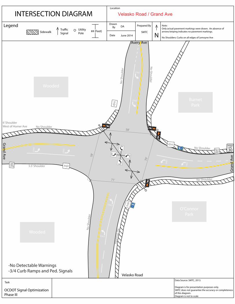
INTERSECTION DIAGRAMLocation
DrawnBy
Date
Onondaga St and Velasko Rd
N
Diagram is for presentation purposes only.
SMTC does not guarantee the accuracy or completeness
of this diagram.
## (Feet)
Prepared By
SMTC
Task
OCDOT Signal Optimization
Note:
Only actual pavement markings were drawn. An absence of
arrows/striping indicates no pavement markings.
No Shoulders: Curbs on all edges of Lemoyne Ave
LegendUtility
Pole
Traffic
SignalSidewalk
Diagram is not to scale
ONLY
ONLY
ONLY
ONLY
ONLY
ONLY
ONLYONLY
Gra
nd
Ave
Gra
nd
Ave
30
Avery Ave
Velasko Road
Wooded
Wooded
O’Connor
Park
Burnet
Park
June 2014
DA
Data Source: SMTC, 2013.
Phase III
cen
tro
ACCESSIBLE
STOP
ONLY
ONLY
ONLY
ONLY
NO
TU
RN
O
NR
ED
centro
ACCESSIBLESTOP
NOTURN ON
RED
NO
TU
RN
O
NR
ED
NOTURN ON
RED
No
Sh
ou
lde
r
No
Sh
ou
lde
r
No Shoulder
No Shoulder
No
Sh
ou
lde
r
No
Sh
ou
lde
r
5.5’ Shoulder
No Shoulder
6’ ShoulderWest of Homer Ave
58
’
58’
70
’
71’
-No Detectable Warnings
-3/4 Curb Ramps and Ped. Signals
Velasko Road / Grand Ave