application of 3d-trend modelling feature in petrel to
TRANSCRIPT

RulliyansyahGeoscientist - West Area Exploration – PT Pertamina EP([email protected])
Application of 3D-trend modelling feature in Petrel to
obtain robust geological model and improve history
matching accuracy in Pagardewa field.
Prepared for Schlumberger Global Forum 2019

Application of 3D Trend modeling – PT Pertamina EP
Highlights of Paku Gajah Area
• Located 60 km from Prabumulih
City, South Sumatera.
• Total area of POD-I extent: 355 km2.
Areal extent : 14.46 km
Current prod. (2019) : 16 mmscf Gas & 99
bcpd Condensate.
Cumulative prod. : 53.6 bscf Gas & 857
mstb Condensate*
*(per 31 July, 2019).
Number of productive wells: 6
Reservoir : Baturaja Formation (BRF)
Gross thickness : 55 – 110 m (Avg. 72.5 m)
Porosity : 5 – 22 %
Permeability : 0.001 – 150 mD
: POD Pakugajah Phase-1 & POFD Kuang Phase-2
: POD Pakugajah Phase-2
: Pagardewa Structure
Tx-001
Tx-004
Tx-008Tx-005
Tx-006
Tx-007
Tx-003
Paku Gajah POD Complex: Phase-I (2012 – 2017)
Jakarta

Application of 3D Trend modeling – PT Pertamina EP
Geological setting, subsurface data, and modeling
Low-Relief carbonates plafform with gentle slope topograph
Rock types data (Winland;
R35)
Lithology (core) and
petrographic description
Tx-004 Txs-001
Tx-004 Txs-001
Txs-001
Tx-004
Txs-001
Tx-004
Facies model Porosity model Permeability model
Facies / Rock Type driven: poorly defined reservoir body, loss in porous area,
difficult to match volume and pressure, longer simulation runtime.
Using better algorithm i.e.: Truncated Gaussian Simulation (TGS) → better
result: smooth property increment, nevertheless, still significant loss of porous
area occurred.
Using trend from Acoustic Impedance and other seismic surface attributes
was not successful in obtaining large Porous area.
Previous modeling attempts

Application of 3D Trend modeling – PT Pertamina EP
Challenges in Reservoir Modeling
No Porosity log in
Tx-003 despite
excellent
production rate.
Some major challenges include:
1. Maintain large porous area
2. Prevent early water breakthrough
3. Maintain smooth property
increment away from wells
Production drop too
early, failed in HM
Too-early water
breakthrough
Gas production rate (field)
Water production rate (field)
Tx-008
Tx-004
Tx-005
Tx-001
Tx-006
Tx-007
Tx-003

Application of 3D Trend modeling – PT Pertamina EP
Problems Statement
• Significant loss of porous area, how to obtain and preserve it better in our
model ?
• Maintain porous area as optimum as possible by creating trend that will preserve it better.
• Use Variogram + 3D trend concurrently during facies and property modeling.
• How to overcome pervasive water breakthrough from the area below HC
contact?
• Create trend that will define clearly Phreatic vs. Vadose zone → lower porosity and
permeability in the phreatic zone, hence, limiting the hydrodynamic of water.

Application of 3D Trend modeling – PT Pertamina EP
Resolving Reservoir Geometry: Porous Area
Example for
analogues:
Recent carbonate
shoals (platforms) in
the Bahamas
•The abundant of micritic matrix & Neomorphism indicates Early diagenesis, in dominantly Phreatic setting (freshwater/marine).
•Change in porosity laterally may not be as heterogeneous as previously thought. Need to maintain smooth increment of property away from wellbore.
•The extent of porous & permeable facies are more than what could be resolved by Variogram or Seismic Attribute. Need to increase the area of porous carbonate body.
Application of 3D Trend modeling – PT Pertamina EP
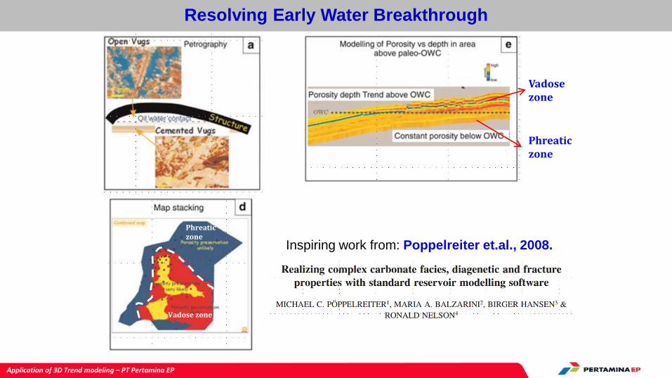
Resolving Early Water Breakthrough
Vadose zone
Phreaticzone
Inspiring work from: Poppelreiter et.al., 2008.
Phreaticzone
Vadose zone

Application of 3D Trend modeling – PT Pertamina EP
Proposed solution: isolating Phreatic from Vadose
Free water level
H above contact
Gas water contact
Porous zone
Free-water level / height= 0
Free-water level / height= 0
Free-water level / height= 0
GWC @ 1513 tvdss
Vadose
zone
Phreatic
zone
Tx-003 Tx-004 Tx-005 Tx-006 Tx-007 Tx-008

Application of 3D Trend modeling – PT Pertamina EP
Adaptive Workflow using Petrel’s 3D Trend modeling tool
Estimate depth of free water
level (FWL) at well log
Create Height above FWL
on 3D model
Plot the limit of porous vs non-
porous area on 3D model
Create 2D trend Map, assign
value (manually) from 0 to 1
Convert 2D map into 3D
Property, use Linear
Combination
Use 3D trend as Trend in
Property & Facies modeling
2D Trend Map
3D volume trend
2D Trend Map
3D volume trend

Application of 3D Trend modeling – PT Pertamina EP
Results: Static Reservoir Properties
More homogeneous facies and
property model have been
obtained in Pagardewa Structure.
The smooth change in facies and
porosity- permeability has been
able to optimize porous and
permeable distribution area
throughout the structure.
Utilization of 3D Trend modelling
tool has been proven to be useful
in maintaining accurate property
distribution, porous area, and
reduce hydrodynamic of water
below HC contact.
Tx-003
Tx-008
Tx-006
Tx-007
Tx-004
Tx-005
Tx-003
Tx-008
Tx-006
Tx-007
Tx-004
Tx-005
Tx-003
Tx-008
Tx-006
Tx-007
Tx-004
Tx-005
Tx-003
Tx-008
Tx-006
Tx-007
Tx-004
Tx-005

Application of 3D Trend modeling – PT Pertamina EP
Results: Dynamic Simulation
Pressure matchingTotal Liquid Production matching
Gas production rate matching in all wells
Volume matching: static & dynamic
Results after running
Dynamic Simulation and
History matching show
good agreement on Static
Volumetric vs. Dynamic
Volume.
There is also reasonably
good level of matching in
Pressure and Production
Rate in all wells and the
whole field.
IGIP = 112.17 Bscf
114.23112.17 113.70

Application of 3D Trend modeling – PT Pertamina EP
Conclusion
• Implementing fundamental concepts of carbonate sedimentology and how the
diagenesis works has brought significant impact in improving level of accuracy of the
geological model. This has been tested and verified during reservoir simulation and history
matching processes.
• What’s more important, is to bring all the concepts into a suitable/unique workflow that
is technically feasible to be executed by software, and can be easily replicated by other
workers or other field with reasonably similar case.
• An enhanced modelling tool that may resembles specific reservoir body and enable
geoscientists to build unique geometry of porous body and inserting particular diagenetic
information (i.e. carbonates setting), may be the next ‘big leap’ in the competitive world of
commercial earth-modeling software.

Application of 3D Trend modeling – PT Pertamina EP