applicant: mr les knight application no: 15/66415/ful
TRANSCRIPT

APPLICATION No: 15/66415/FUL APPLICANT: Mr Les KnightLOCATION: Land Bounded By Gore Street, Trinity Way And Chapel Street,
SalfordPROPOSAL: Demolition of existing building and redevelopment of site to
provide: three residential buildings ranging from 13 to 22 storeys comprising 364 apartments (Use Class C3) sitting on twostorey podiums containing commercial and retail floorspace (727 sqm) (Use Classes A1, A2, A3, A4, A5 and/or B1), car parking (104 spaces) and related servicing and plant; eleventownhouses; new access and landscaping and associated works.
WARD: Ordsall
Background
This application was previously presented to the Planning and Transportation Regulatory Panel on 3 March 2016, at which the resolution of the Panel was that planning permission be granted, subject to (a) the planning conditions listed within the Main Report and the Amendment Report, (b) authority to discharge condition 7 (materials) being delegated to the Assistant Director Planning in consultation with the Chair, and (c) condition 10 (archaeology) to be amended to require a scheme to be submitted for consideration of the inclusion of a display on site relating to the archaeology found or historical usage which was present on site, and that:
(i) The Strategic Director of Environment and Community Safety be authorised to enter into alegal agreement under Section 106 of the Town and Country Planning Act to secure thefollowing heads of terms:

- a financial contribution of £800,000 towards improvements to the Trinity Way/Chapel Streetjunction and public realm works to create a pedestrian and cycle route through the adjacentrailway arches and the inclusion of a full clawback mechanism;
(ii) The applicant be informed that the Council is minded to grant planning permission, subject tothe conditions stated in the Main Report and in the Amendment Report, on completion of sucha legal agreement;
(iii) The authority be given for the decision notice relating to the application to be issued (subjectto the conditions and reasons stated in the Main Report and in the Amendment Report) oncompletion of the above-mentioned legal agreement.
Following this resolution to grant permission, the applicant has been undertaking detailed design and feasibility work. Through the course of this, the applicant identified that there would need to be amendments to the detailed design of the scheme in order to ensure that the scheme is financially viable and capable of delivery. As part of this, Council officers have been engaged in a series of discussions with the applicant and their architect team to ensure that the proposed design amendments are acceptable and do not detract from the standard of design that was previously agreed.
As part of these discussions, the applicant has also identified that the scheme is no longer able to support the scale of financial contribution that was agreed when the application was previously presented to Panel, and as such the applicant is now proposing a reduced scale of contribution to the heads of terms that were previously agreed.
On the basis of these changes, it is necessary to bring the scheme back to Panel for determination, recognising that the scheme has been amended subsequent to that which was previously presented to Panel and on which their minded to approve determination was reached. No grant of consent has been issued to date as this is contingent on the completion of a legal agreement, and this has been on hold pending the resolution of the proposed changes to the scheme.
For reference, the full officer report as previously reported to Panel on 3 March 2016 is set out at the end of this report. The section of the report below focuses on those amendments to the scheme that have been made subsequent to this. A conclusion and officer recommendation is then drawn on the basis of the proposed amendments, and conditions are proposed drawing on those that were previously endorsed by Panel in their resolution to grant consent subject to completion of a legal agreement.
Amendments to scheme previously presented to Panel on 3 March 2016
The key amendments that have been made to the scheme that was presented to Panel on 3 March 2016 are as follows:
Materials
The scheme previously presented to Panel was to be faced with fair faced concrete cladding panels together with gold anodised aluminuium cladding, with the use of blue/black brick at lower levels on the southern elevations of the development to reference the brick of the adjacent railway viaduct.
One of the key reasons for having to amend the design of the scheme is that detailed costings demonstrated that the use of fair faced concrete cladding would result in a significant impact on the viability of the scheme, resulting from the cost of the material itself, together with the associated construction cost implications due to the foundation strengthening required to support this, the timescales and crane requirements associated with its erection, and other cost related risks associated with its procurement.
As such, the fair faced concrete cladding panels have been removed from the scheme design. The principal elevations of the residential blocks would comprise grey composite aluminium cladding and bronze metallic aluminium cladding. The use of blue/black brick has been extended across the podium level elevations, and would be articulated up the blocks in vertical elements as part of the lift / stair cores for each building.
Other detailed design revisions include: Projecting shopfronts on the commercial units have been replaced with full width, full height shopfronts set
within deep reveals. The design approach to the podium columns has been revised. These are now proposed to be articulated as
square columns creating a colonnade element which interacts with the public realm, and the design approach is read as creating a stronger podium base from which the residential blocks rise as discrete elements.
The projecting oriel windows in the gable end of blocks have been moved back in line with the general building
line, with aluminium canopies for privacy. Projecting balconies have been introduced to Block A East, Block B East and Block C West elevations. Chamfered panels have been introduced to the top two storeys of Block C on its Chapel Street elevation in
order to provide a visual ‘top’ to the building.
Notwithstanding that the original intention in revisiting the design was driven by cost pressures, it is considered that through a series of detailed negotiations, Council officers have worked with the applicant and their architect team to achieve design revisions which taken together result in a high quality scheme. The design revisions better articulate the building’s form with more strongly defined podium elements, which provide a more robust pediment base from which the discrete tower elements of the three blocks rise. This has also resulted in expanding the colonnade element to those parts of the podium which front the new areas of public realm, creating an attractive feature which interacts with the public realm in this regard and provides areas of shelter beneath the colonnade. The design approach and proposed materials will deliver a high quality scheme that effectively responds to the site’s highly prominent location at the intersection of Chapel Street and Trinity Way.
Fire safety of proposed building materials is not a planning consideration, but notwithstanding this the applicant has confirmed that the proposed cladding materials would be fully compliant in this regard.
Layout
Car parking
The scheme previously presented to Panel comprised a basement level beneath the western podium (beneath Blocks A and B) which accommodated car parking serving the proposed development. This was in addition to parking at ground and first floor level within the western podium, and a double height internal service yard area within the eastern podium (beneath Block C). This basement level parking has been removed from the revised scheme, which again reflects the increased costs associated with basement parking provision. In order to ensure that a similar level of parking provision is achieved across the scheme as a whole, the revised scheme has redesigned the double height internal service yard area within the eastern podium so that this would accommodate car parking at both ground floor and additional parking at first floor via the installation of an internal deck. The western podium would continue to accommodate parking at both ground and first floor levels. The impact of this revised arrangement results in a small reduction in the total number of car parking spaces within the proposed development. This is discussed below under ‘Car parking and cycle parking provision’. In terms of layout, the only implication of this change is the introduction of an additional vehicular access point to the eastern podium in order to provide access to the ramp to the first floor parking deck. This vehicular access point would be located at the south eastern corner of the development, via Gore Street, and would lie adjacent to the entrance to the ground floor parking level. This is in the same location as the vehicular access to the internal service yard area as proposed within the scheme previously presented to Panel, and is considered to be acceptable in this regard.
Private Rented Sector (PRS) concierge / commercial units
The scheme previously presented to Panel comprised a substantial area of floorspace at the north west corner of the western podium that was designed to accommodate the reception and associated facilities serving the PRS function of the development (all units are to be private rented sector tenure). This was designed to accommodate a reception and concierge, together with a café/servery and kitchen, a lettings office, and a series of associated facilities. The applicant’s more detailed discussions with the confirmed PRS operator have confirmed that a reduced level of floorspace is required to serve the PRS function. This would essentially reflect a reception and concierge area. As such, the quantum of floorspace assigned to the PRS reception element has been reduced. The floorspace that has been freed up at the north west corner of the western podium would be occupied by a commercial unit, in order to ensure activity to the area of public realm which it fronts. In addition there have been a number of minor revisions to the floorplate of some of the commercial units to reflect the changes required to accommodate the revised parking arrangement within the podium bases.
Scale / height
The revised scheme would result in a small reduction in the overall height of each of the residential blocks, compared to the scheme previously presented to Panel. This is due to the applicant making minor adjustments to the overall height of each floor of residential accommodation, to reduce this from 2m to 1.85m per floor. In addition, the previous scheme proposed that the top floor of accommodation would be in the form of penthouses with 1.5 storey height, to allow for a greater internal floor to ceiling height within these units. Following additional testing of market demand, the provision of 1.5 storey height penthouse apartments has been removed from the scheme. The top floor of accommodation would therefore have the same floor to ceiling height as all other floors of residential accommodation within the blocks. The cumulative impact of these amendments is a small reduction in the overall height of each of the residential blocks. Block A would reduce from 41.9m to 40.5m, Block B would reduce from 53.9m to 51.9m, and Block C would reduce from 68.7m to 66.1m. The number of storeys within each block would
however remain the same. It is not considered that the effect of these reductions is significant, and as such the conclusions reached in the assessment of the previous scheme with regard to the scale and height remain relevant, and the height and scale is considered appropriate in this context.
Quantum of development
Dwelling mix
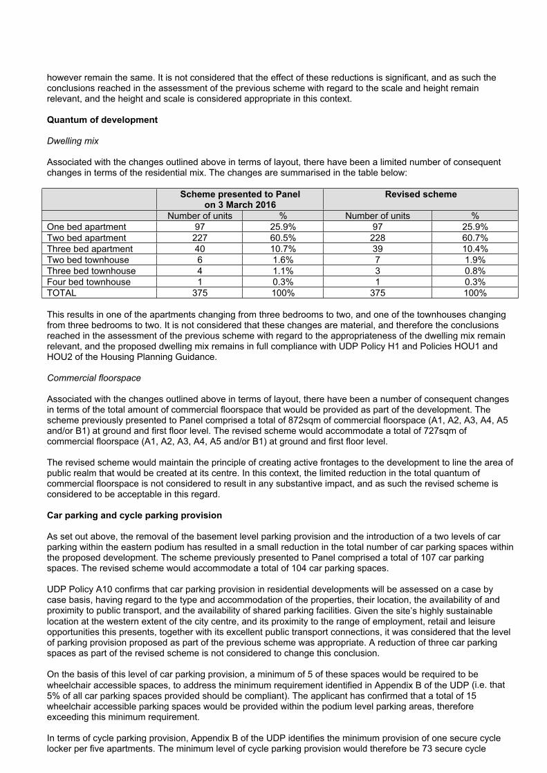
Associated with the changes outlined above in terms of layout, there have been a limited number of consequent changes in terms of the residential mix. The changes are summarised in the table below:
Scheme presented to Panel on 3 March 2016
Revised scheme
Number of units % Number of units %One bed apartment 97 25.9% 97 25.9%Two bed apartment 227 60.5% 228 60.7%Three bed apartment 40 10.7% 39 10.4%Two bed townhouse 6 1.6% 7 1.9%Three bed townhouse 4 1.1% 3 0.8%Four bed townhouse 1 0.3% 1 0.3%TOTAL 375 100% 375 100%
This results in one of the apartments changing from three bedrooms to two, and one of the townhouses changing from three bedrooms to two. It is not considered that these changes are material, and therefore the conclusions reached in the assessment of the previous scheme with regard to the appropriateness of the dwelling mix remain relevant, and the proposed dwelling mix remains in full compliance with UDP Policy H1 and Policies HOU1 and HOU2 of the Housing Planning Guidance.
Commercial floorspace
Associated with the changes outlined above in terms of layout, there have been a number of consequent changes in terms of the total amount of commercial floorspace that would be provided as part of the development. The scheme previously presented to Panel comprised a total of 872sqm of commercial floorspace (A1, A2, A3, A4, A5 and/or B1) at ground and first floor level. The revised scheme would accommodate a total of 727sqm of commercial floorspace (A1, A2, A3, A4, A5 and/or B1) at ground and first floor level.
The revised scheme would maintain the principle of creating active frontages to the development to line the area of public realm that would be created at its centre. In this context, the limited reduction in the total quantum of commercial floorspace is not considered to result in any substantive impact, and as such the revised scheme is considered to be acceptable in this regard.
Car parking and cycle parking provision
As set out above, the removal of the basement level parking provision and the introduction of a two levels of car parking within the eastern podium has resulted in a small reduction in the total number of car parking spaces within the proposed development. The scheme previously presented to Panel comprised a total of 107 car parking spaces. The revised scheme would accommodate a total of 104 car parking spaces.
UDP Policy A10 confirms that car parking provision in residential developments will be assessed on a case by case basis, having regard to the type and accommodation of the properties, their location, the availability of and proximity to public transport, and the availability of shared parking facilities. Given the site’s highly sustainable location at the western extent of the city centre, and its proximity to the range of employment, retail and leisure opportunities this presents, together with its excellent public transport connections, it was considered that the level of parking provision proposed as part of the previous scheme was appropriate. A reduction of three car parking spaces as part of the revised scheme is not considered to change this conclusion.
On the basis of this level of car parking provision, a minimum of 5 of these spaces would be required to be wheelchair accessible spaces, to address the minimum requirement identified in Appendix B of the UDP (i.e. that 5% of all car parking spaces provided should be compliant). The applicant has confirmed that a total of 15 wheelchair accessible parking spaces would be provided within the podium level parking areas, therefore exceeding this minimum requirement.
In terms of cycle parking provision, Appendix B of the UDP identifies the minimum provision of one secure cycle locker per five apartments. The minimum level of cycle parking provision would therefore be 73 secure cycle

lockers. The proposed development makes provision for a number of cycle stores located within the parking areas of both the western and eastern podiums, and the applicant has confirmed that a total of 200 secure cycle parking spaces would be provided within these, thereby considerably exceeding the minimum requirement. Of these, 60 spaces would be provided at ground floor level within the parking area of the western podium, and the remaining 140 spaces would be provided at first floor level within the parking area across both the eastern and western podiums.
In addition, the scheme would provide 30 public cycle parking stands within the new area of public realm that would be created. This remains the same as the scheme previously presented to Panel.
As such the proposed development is considered to be in accordance with the requirements of UDP Policy A10. A condition is proposed (as previously recommended in relation to the previous scheme) to require the provision and laying out of car and cycle parking spaces in advance of first occupation of the development.
Planning obligation contribution
In relation to the scheme previously presented to Panel, the agreed heads of terms regarding the financial contribution to be secured via legal agreement were as follows: a financial contribution of £800,000 towards improvements to the Trinity Way/Chapel Street junction and public
realm works to create a pedestrian and cycle route through the adjacent railway arches and the inclusion of a full clawback mechanism.
This figure was agreed at the time following the submission of viability evidence and its review by the Council’s consultant surveyors.
In relation to the revised scheme that is now before Panel, the applicant has submitted information to demonstrate that this previously agreed level of financial contribution together with a requirement for clawback can no longer be delivered in financial viability terms. As such, the developer has made a revised offer in terms of a financial contribution of £700,000. This would be paid in a two staged payment, with £350,000 payable ahead of commencement, and the remaining £350,000 payable upon practical completion. The applicant has made clear that a substantive start on site would be made imminently following any grant of consent, and as such has requested that the clawback provision be omitted as the contractual arrangement associated with the scheme’s delivery means that there would be no overage for any clawback to arise.
The Planning Obligations SPD confirms that where a developer considers that there are site-specific issues which mean that the cumulative effect of policy requirements and planning obligations would compromise development viability in relation to a particular scheme, the Council will enter into negotiations with a developer to agree a reduced contribution where appropriate (paragraph 4.28). In relation to the approach to phasing of payments, the Planning Obligations SPD also confirms that where a developer considers that the approach to phasing of payments would compromise the deliverability of a scheme, the Council will negotiate with developers and seek to agree an alternative approach to the phasing of payment that has regard to the particular cashflow issues of the development scheme (paragraph 11.9).
The Government’s Planning Practice Guidance provides additional guidance in relation to scheme viability considerations, and how this should be taken into account in the determination of planning applications. The Planning Practice Guidance provides specific advice in relation to private rented sector (PRS) schemes in this context: “The economics of such schemes differ from build to sale and should be determined on a case by case basis. To help ensure these schemes remain viable while improving the diversity of housing to meet local needs, local planning authorities should consider the appropriate level of planning obligations, including for affordable housing, and when these payments are required” (Viability Chapter, paragraph 018). The Planning Practice Guidance also confirms that “where an applicant is able to demonstrate to the satisfaction of the local planning authority that the planning obligation would cause the development to be unviable, the local planning authority should be flexible in seeking planning obligations” (Viability Chapter, paragraph 019).
The applicant’s position has been reviewed by the Council’s consultant surveyor who considers that the submitted information represents a reasonable reflection of the financial viability of the scheme. In relation to the issue of clawback, they have confirmed that the contractual agreement between the developer and its partners is such that there would be no surplus monies available to the developer as the contract is on a fixed basis. The Council’s consultant surveyor has advised that as such, there would not be any clawback available due to the current fixed contract arrangement and therefore the development would not generate a surplus payable to the Council, even where a clawback mechanism was in place within the legal agreement. As such, the Council’s consultant surveyor recommends that the revised offer of £700,000 with no clawback provision is justified in relation to this specific scheme.

Conclusion and planning balance
Section 38(6) of the Planning and Compulsory Purchase Act, 2004 requires the determination of this application to be made in accordance with the development plan, unless material considerations indicate otherwise.
In terms of the design amendments, for the reasons set out above it is considered that the revised design approach and proposed materials will deliver a high quality scheme that responds to its prominent setting at this key intersection of Chapel Street and Trinity Way. In terms of the associated amendments in terms of layout, quantum of development, and parking provision, for the reasons set out above, it is not considered that these changes represent any substantive change to the scheme previously presented to Panel and as such these changes are not considered to alter the position in terms of the acceptability of the proposed development in this context.
In terms of the revised planning obligation financial contribution offer, this would result in a £100,000 reduction in the value of the previously agreed heads of terms, and would result in the removal of the clawback mechanism. The previously agreed contribution was to be directed towards improvements to the Trinity Way/Chapel Street junction and public realm works to create a pedestrian and cycle route through the adjacent railway arches towards the New Bailey area. The reduction in the value of the planning obligation contribution would mean that the scheme makes a reduced contribution to the value of these identified works. These works were identified as being necessary to make the development acceptable in planning terms in accordance with the tests of Regulation 122 of the Community Infrastructure Levy Regulations 2010 in this regard. As such, by making a reduced financial contribution towards the identified works, this must weigh against the revised proposal in terms of compliance with UDP Policy DEV5 and the Planning Obligations SPD.
It is important to assess this in the context of the wider benefits that the scheme would deliver, to consider the impact of a reduced financial contribution as part of the wider planning balance. The development would result in the redevelopment of this prominent gap site at the intersection of Chapel Street and Trinity Way which has been in use for surface car parking for an extensive period of time, and would realise a high quality mixed use redevelopment scheme. The scheme would deliver extensive areas of public realm on site, that would create a new plaza area fronting Chapel Street, and would create an area of public realm through the site to facilitate a new north/south route to connect with a future link through the railway viaducts to the New Bailey area. The public realm areas would be animated with commercial units at ground floor and first floor, which have the potential to spill out on to the public realm area and contribute to its activity, supporting the objectives for the Chapel Street area to create a vibrant mixed use area. The scheme would deliver 375 new homes, together with commercial floorspace which would result in associated economic benefits.
Taking into account the considerable benefits that the scheme would deliver, it is considered that on balance these outweigh the harm associated with the reduced financial contribution. It is recognised that the Council’s consultant surveyor considers that the applicant’s submitted case for reducing the contribution to £700,000 can be justified having regard to the viability evidence. In addition, it must be recognised that the previously agreed £800,000 contribution would itself fall below the total value of the required works, and as such (without a substantial revision to the extent of the proposed works) would require additional funding to be secured from other sources in order to deliver these works. The proposed reduction in the value of the financial contribution from £800,000 to £700,000 must be understood in this context. As such, it is considered that on balance, the benefits of the scheme would outweigh the harm associated with this reduction in the value of the financial contribution.
Recommendation
Planning permission be granted subject to the following planning conditions and that:
1) The Strategic Director of Environment and Community Safety be authorised to enter into a legal agreement under Section 106 of the Town and Country Planning Act to secure the following heads of terms:
- a financial contribution of £700,000 towards improvements to the Trinity Way/Chapel Street junction and public realm works to create a pedestrian and cycle route through the adjacent railway arches.
2) That the applicant be informed that the Council is minded to grant planning permission, subject to the conditions stated below, on completion of such a legal agreement;
3) The authority be given for the decision notice relating to the application be issued (subject to the conditions and reasons stated below) on completion of the above-mentioned legal agreement.
1 The development must be begun not later than three years beginning with the date of this permission.

Reason: Required to be imposed by Section 91 of the Town and Country Planning Act 1990 (as amended).
2 The development hereby permitted shall be carried out in accordance with the following approved plans:
LIST OF PLANS TO BE CONFIMED WITHIN PANEL AMENDMENT REPORT
It should be noted that the applicant’s architect team is currently updating the relevant layout and elevation plans to reflect the detailed design amendments. Whilst these are not available prior to the publication of the Panel papers, they will be made available in advance of the Panel meeting, and Condition 2 will be updated accordingly as part of the Amendment Report.
Reason: For the avoidance of doubt and in the interest of proper planning.
3 Prior to the first occupation of the development the proposed car and cycle parking spaces shall be laid out and provided in accordance with the approved plans and retained as such at all times.
Reason: In the interests of the safe and efficient operation of the highway network and to minimise potential conflicts between pedestrians, cyclists and other road users in accordance with policies DES2, A2 and A8 of the City of Salford Unitary Development Plan and the National Planning Policy Framework.
4 Within six months of the first occupation of the development a full Travel Plan shall be submitted to and agreed in writing with the Local Planning Authority. The agreed Travel Plan shall be implemented and reviewed in accordance with the timetable embodied therein.
Reason: To ensure that the travel arrangements to the development are appropriate and to limit the effects of the increase in travel movements in accordance with policies ST14 and A8 of the City of Salford Unitary Development Plan.
5 Notwithstanding any information submitted with the application, no development shall take place until an investigation and risk assessment has been submitted to and approved in writing by the Local Planning Authority. The assessment shall investigate the nature and extent of any contamination on the site(whether or not it originates on the site). The assessment shall be undertaken by competent persons anda written report of the findings submitted to and approved in writing by the Local Planning Authority before any development takes place. The submitted report shall include:
i) a survey of the extent, scale and nature of contamination ii) an assessment of the potential risks to:* human health,* property (existing or proposed) including buildings, crops, livestock, pets, woodland, and service lines and pipes,* adjoining land,* groundwaters and surface waters,* ecological systems,* archaeological sites and ancient monuments;
iii) where unacceptable risks are identified, an appraisal of remedial options and proposal of the preferred option(s) to form a remediation strategy for the site.
The development shall thereafter be carried out in full accordance with the duly approved remediation strategy.
Reason: To prevent pollution of the water environment and to ensure the safe development of the site in the interests of the amenity of future occupiers in accordance with Policy EN17 of the City of Salford Unitary Development Plan and the National Planning Policy Framework.
6 Persuant to condition 5 and prior to first use or occupation a verification report, which validates that all
remedial works undertaken on site were completed in accordance with those agreed with the Local Planning Authority, shall be submitted to and approved in writing by the Local Planning Authority.
Reason: To prevent pollution of the water environment and to ensure the safe development of the site in the interests of the amenity of future occupiers in accordance with Policy EN17 of the City of Salford Unitary Development Plan and the National Planning Policy Framework.
7 Notwithstanding any description of materials in the application no above ground construction works shall take place until samples or full details of materials to be used externally on the building(s) have been submitted to and approved in writing by the Local Planning Authority. Such details shall include the type, colour and texture of the materials. Only the materials so approved shall be used, in accordance with any terms of such approval.
Reason: In order to ensure a satisfactory appearance in the interests of visual amenity in accordance with Policy DES1 of the City of Salford Unitary Development Plan and the requirements of the National Planning Policy Framework.
8 Prior to any vibro-impact works on site, a risk assessment and method statement shall be submitted to and approved in writing by the Local Planning Authority. The agreed method statement shall be adhered to during construction works.
Reason: To prevent any piling works and vibration from de-stabilising or impacting the railway.
9 No development shall commence until a strategy for surface water drainage of the site using sustainable drainage methods has been submitted to and approved in writing by the Local Planning Authority. Included in the strategy should be provision for future maintenance and a party who will undertake maintenance should be nominated. The development shall be implemented in accordance with the approved strategy.
Reason: To minimise the risks of flooding in accordance with Policy EN19 of the City of Salford Unitary Development Plan
10 No development shall take place until a programme of archaeological works in accordance with a Written Scheme of Investigation (WSI) has been submitted to and approved in writing by the local planning authority. The development shall not be occupied until the programme of archaeological works has been completed in accordance with the approved WSI. The WSI shall cover the following:
(a) A phased programme and methodology of site investigation and recording to include:- targeted field evaluation trenching- (depending upon the evaluation results) a strip map and record exercise- targeted open area excavation(b) A programme for post investigation assessment to include:- analysis of the site investigation records and finds- production of a final report on the significance of the archaeological and historical interest represented. - display on site of finds and/or archaeological and historic interest of the site and immediate wider area(c) Provision for publication and dissemination of the analysis and report on the site investigation.(d) Provision for archive deposition of the report, finds and records of the site investigation.(e) Nomination of a competent person or persons/organisation to undertake the works set out within the approved WSI.
Reason: To protect the significance of any archaeological remains on the site in accordance with Policy CH5 of the city of Salford Unitary Development Plan and the National Planning Policy Framework.
11 a) Notwithstanding the details shown on the approved plans, the development hereby permitted shall not be occupied until full details of both hard and soft landscaping works have been submitted to and approved in writing by the Local Planning Authority. The details shall include the formation of any banks, terraces or other earthworks, hard surfaced areas and materials, boundary treatments,
external lighting, planting plans, specifications and schedules (including planting size, species and numbers/densities), existing plants / trees to be retained and a scheme for the timing / phasing of implementation works.
(b) The landscaping works shall be carried out in accordance with the approved scheme for timing / phasing of implementation or within 18 months of first occupation of the development hereby permitted, whichever is the later.
(c) Any trees or shrubs planted or retained in accordance with this condition which are removed, uprooted, destroyed, die or become severely damaged or become seriously diseased within 5 years of planting shall be replaced within the next planting season by trees or shrubs of similar size and species to those originally required to be planted, unless the Local Planning Authority gives its consent in writing to any variation.
Reason: To ensure that the site is satisfactorily landscaped having regard to its location and the nature of the proposed development and in accordance with Policies DES1 and DES9 of the City of Salford Unitary Development Plan and the National Planning Policy Framework.
12 No above ground works shall take place until a further noise report has been submitted to and approved in writing by the Local Planning Authority. The noise report shall update the submitted report with regard to the changes made to the application and shall take into account train noise and the impacts of changes to train services on the adjacent railway.
Reason: To safeguard the amenity of existing, neighbouring and/or future occupants of the development hereby approved in accordance with policy EN17 of the City of Salford Unitary Development Plan and the National Planning Policy Framework.
13 The rating level (LAeq,T) from all fixed plant and machinery associated with the development, when operating simultaneously, shall not exceed the background noise level (LA90,T) by more than -5 dB at any time when measured at the boundary of the nearest noise sensitive premises. Noise measurements and assessments shall be carried out according to BS 4142:2014 "Methods for rating and assessing industrial and commercial sound". 'T' refers to any 1 hour period between 07.00hrs and 23.00hrs and any 15 minute period between 23.00hrs and 07.00hrs.
Reason: To safeguard the amenity of existing, neighbouring and/or future occupants of the development hereby approved in accordance with policy EN17 of the City of Salford Unitary Development Plan and the National Planning Policy Framework.
14 The following noise standards shall be attained with respect to residential accommodation on the site as stipulated in BS8233:2014 - Guidance on Sound Insulation and Noise Reduction for Buildings:(i) internal noise levels of less than 30 dB LAeq,8hour within bedrooms between 23.00 hours and 07.00 hours(ii) internal noise levels of less than 35 dB LAeq,16 hour within living rooms between 07.00 hours and23:00 hours(iii) internal noise levels of less than 40 dB LAeq,16hour within other living areas (e.g. dining rooms)between 07.00 and 23.00 hours(iv) typical individual noise events from passing road traffic, shall not be in excess of 45 dB LAmax in bedrooms between 23.00 and 07.00 hours(v) external noise levels of less than 55 dB LAeq,16 hour in gardens, patios and private communal gardens between 07:00 and 23:00 hours
The use of ventilation measures which removes the need for future residents to open windows for general ventilation shall be identified and submitted to the Local Planning Authority for approval. The ventilation measures identified shall ensure the above standards are not compromised.
The noise mitigation measures shall be approved in writing by the Local Planning Authority and installed prior to occupation of the development. Prior to occupation of the development a Site Completion Report shall be submitted to the Local Planning Authority for approval. The Site Completion Report shall validate that all works undertaken on site were completed in accordance with those agreed by the Local Planning Authority. All mitigation measures shall thereafter be retained.
Reason: To safeguard the amenity of existing, neighbouring and/or future occupants of the development hereby approved in accordance with policy EN17 of the City of Salford Unitary
Development Plan and the National Planning Policy Framework.
15 No development shall take place, including any works of excavation or demolition, until a Construction Method Statement has been submitted to, and approved in writing by, the local planning authority. The approved Statement shall be adhered to throughout the construction period. The Statement shall provide for:(i) the times of construction activities on site(ii) the parking of vehicles of site operatives and visitors(iii) loading and unloading of plant and materials(iv) storage of plant and materials used in constructing the development(v) the erection and maintenance of security hoarding including decorative displays and facilities for public viewing, where appropriate(vi) wheel washing facilities(vii) measures to control the emission of dust and dirt during construction(viii) a scheme for recycling/disposing of waste resulting from demolition and construction works(ix) measures to prevent disturbance to any adjacent living accommodation from noise and vibration, including any piling activity(x) measures to prevent the pollution of watercourses.
Reason: To safeguard the amenity of existing, neighbouring and/or future occupants of the development hereby approved in accordance with policy EN17 of the City of Salford Unitary Development Plan and the National Planning Policy Framework.
16 Use of air extraction equipment shall not commence until detailed plans and specifications of the equipment, including measures to alleviate noise, vibration, fumes and odours (and incorporating active carbon filters, silencers and anti vibration mountings where necessary), have been submitted to and approved in writing by the Local Planning Authority. The ventilation system shall be installed in accordance with the approved plans and specifications before the use of the equipment commences and shall be permanently retained thereafter in accordance with the approved specifications.
Reason: To safeguard the amenity of existing, neighbouring and/or future occupants of the development hereby approved in accordance with policy EN17 of the City of Salford Unitary Development Plan and the National Planning Policy Framework.

Notes to Applicant
1. STANDING ADVICE - DEVELOPMENT LOW RISK AREA
The proposed development lies within a coal mining area which may contain unrecorded coal mining related hazards. If any coal mining feature is encountered during development, this should be reported immediately to The Coal Authority on 0345 762 6848.
Further information is also available on The Coal Authority website at:www.gov.uk/government/organisations/the-coal-authority
This Standing Advice is valid from 1st January 2017 until 31st December 2018
2. As the proposals involve work in the adopted Public Highway on Gore Street, the applicant will need to liaise with the Engineering and Highways division of Urban Vision on 0161 779 4046 to obtain the necessary permits/licenses prior to undertaking any works in the highway.
The sections of adopted highway to be incorporated into the residential development will require a permanent road/footway closure (Stopping Up Order). As such the applicant will need to liaise with Ken Jones on 0161 779 4970 for details on progressing a Section 247 Stopping Up Order for this section of highway.
The applicant will need to liaise with the Traffic and Transportation section of Urban Vision on 0161 7796165 in respect of the proposed Loading Bay Traffic Regulation Orders and amendments/extensions to the existing Traffic Regulation Order (Double Yellow lines) on Gore Street.
The applicant will need to liaise with Transport for Greater Manchester in respect of provision of the bus stands along Gore Street.
3. The applicant’s attention is drawn to the contents of the consultation response from Network Rail dated22 June 2015.
4. For further discussions regarding the requirements of the Contaminated Land Condition, the applicant/developer is advised to contact the Pollution Control Section of the Environment Directorate (Tel: 0161 604 7767).
5. It is an offence under the Wildlife and Countryside Act 1981, as amended, to introduce, plant or cause to grow wild any plant listed in Schedule 9 part 2 of the Act. Species such as Cotoneaster spp present on the site are included within this schedule.
6. No removal of trees, shall be carried out between the months of March to August inclusive, unless nesting birds have been shown to be absent.
7. The applicant's attention is drawn to the contents of the attached letter from the Environment Agenc

Description of Site and Surrounding Area
This application relates to the existing surface car parking on Gore Street which accommodates approximately165 car but is not formally laid out. The site is generally flat. The site contains a small, vacant warehouse building. The site is bounded by Trinity Way to the west, Gore Street to the south beyond which is the elevated railway viaduct and by Chapel Street to the north where there is commercial floorspace at ground floor at back of pavement with apartments above. To the east is the existing three storey office development that fronts Chapel Street.
Beyond the railway viaduct to the south the new multi-storey car park has recently been constructed and an office development further to the east is under construction. The surrounding area contains a mix of commercial and residential uses.
The site lies within the area covered by the Salford Central Planning Guidance.
There are a number of heritage assets within the vicinity of the site:The Independent Chapel on Chapel Street (former Salford Cinema) (grade II) The former William Deacon Bank at 247 Chapel Street (grade II)Chapel Street and Hope United Reformed Church (grade II) The northern railway viaduct on New Bailey Street (grade II) The central railway viaduct on New Bailey Street (grade II)The southern railway viaduct and colonnade on New Bailey Street (grade II*)Egerton Arms public house on Gore Street (locally listed) No.6 and Salford House, Bloom Street (grade II)Kings Arms public house, Bloom Street (grade II) Arlington House, Bloom Street (grade II)Adelphi and Bexley Square Conservation Area
Description of Proposal
The application originally submitted included hotel accommodation but due to a lack of demand this element has been removed from the scheme and replaced with additional residential accommodation.
It is proposed to redevelop the site to provide a total of 375 new dwellings. The dwellings will be for private rent (PRS). In addition there is flexible commercial/retail space at ground floor, a cafe, residents’ lounge, gym, meeting room and 24 hour concierge/security. 107 car parking spaces are provided along with 138 secure cycle spaces. 30 public cycle parking stands are provided in the new public pedestrian route through the site.
The majority of the dwellings are provided in three blocks:Block A – a 13 storey block parallel to Trinity Way and set back from the Chapel Street junctionBlock B – to the rear of the site this 15 storey block is aligned at 90 degrees to Gore StreetBlock C – a ‘T’ shaped block 22 storeys in height parallel to Chapel Street and then a 15 storey arm projecting south back into the site framing the public route through the site with block B.
Additionally townhouses are provided adjacent to the boundary with the adjacent office development and turning the corner of the Trinity Way and Gore Street junction. These are accessed at either ground or podium level.
Six small commercial units are provided at ground level, the largest located on Chapel Street adjacent to the existing office building, the remaining five lining the pedestrian route through the site.
The mix of dwellings is as follows:
One-bed apartments – 97 (25.9%)Two-bed apartments – 227 (60.5%) Two-bed townhouses – 6 (1.6%) Three-bed apartments – 40 (10.7%) Three-bed townhouses – 4 (1.1%) Four-bed townhouses – 1 (0.3%)
Five of the townhouses are accessed at street level on Gore Street.
Access to the site is from Gore Street.

The scheme provides significant at grade public realm through the centre of the site linking Chapel Street to Gore Street where it is envisaged that in the future the adjacent railway arch will be opened to form a public pedestrian route.
The proposed materials are as follows:Fair-faced concrete framing to the buildingsBasalt claddingGold anodised aluminium claddingDark brick to lower levels
Relevant Site History
13/64094/FUL Continued use as a public car park, including resurfacing, erection of 1.1m high boundary fencing and three Pay and Display Machines. Approved May 2014 with a condition stating that the use herebypermitted shall be discontinued on or before 14th May 2015.
09/57950/EIAHYB - Outline application for a comprehensive phased regeneration of Salford Central, including selective demolition, for a mixed-use development of new, improved, altered and replacement buildings, for offices/commercial use (use classes A2 and B1, maximum 197,010sq.m), retail, food and drinkand entertainment (use classes A1, A3, A4 and A5, maximum 24,255sq.m), leisure (class D1), hotels (class C1 maximum 140 and 250 bedrooms) and residential use (maximum 849 dwellings) together with associated car parking, landscaping and infrastructure. Detailed application for highway and associated works to Chapel Street (between Oldfield Rd and Trinity Way) and the laying out of public space at Stanley Street. Approved July2010.
09/57724/FUL - Continued use of land at Gore Street as a surface level car park. Refused July 2009.
06/52233/ADV - Display of internally illuminated advertisement hoarding. Refused March 2006.
05/50255/ADV - Display of one non-illuminated free standing advertising hoarding on the rear of the depot. Refused April 2005 but a subsequent appeal was upheld.
05/50126/ADV - Retention of one 96 sheet and three 48 sheet advertisement hoardings. Refused March 2005 and a subsequent appeal was dismissed
05/50010/FUL - Continued use of land as a temporary car park. Refused March 2005 and a subsequent appeal was dismissed.
04/48111/FUL - Continued use of land as a car park (Renewal of temporary planning permission). ApprovedMay 2004 with a condition stating that the use hereby permitted shall cease on or before 28th February 2005.
00/40359/FUL - Renewal of temporary planning for car parking. Refused March 2000
Publicity
Site Notice: Non HH Article 15 Date Displayed: 12 June 2015Reason: Article 13 affect public right of way, Affecting Setting of Listed Building
Press Advert: Salford Advertiser Date Published: 4 June 2015Reason: Affecting Setting of Listed Building, Article 13 Affect Public right of Way
Neighbour Notification
The occupiers of 286 neighbouring properties have been notified of the application.
Representations
Six objections have been received. The following grounds are raised:The development will dwarf other buildings and will be out of keeping with the character of the area

Loss of lightIncrease in light disturbance at nightLoss of privacyNoise disturbance both during construction and once the works are completeIncrease in traffic congestion, noise and pollutionLack of car parkingLack of demand for further apartmentsThere will be significant reduction in the quality of life for residents of City Point 2.
Consultations
Highways - It is noted that the site is accessible via a variety of sustainable modes; close to the regional centre and the Metrolink network, well served by public transport with a number of bus services available within 200m of the site, within 100m of Salford Central railway station and within walking distance of local amenities..
With regard to trip generation the submitted transport assessment demonstrates that the development could potentially generate a total of 80 two-way trips in the morning peak hour and 62 two-way trips in the evening peak hour, which equates to roughly one additional vehicle every minute on the highway network. When comparing the proposed development against the current car park use, the proposed use would be expected to result in a net decrease in 10 two-way trips in both the morning and evening peaks. This can therefore not be considered a significant highway impact over and above the existing use of the site.
It can be argued that as this development is proposing a low level of parking provision, this is likely to result in fewer trips than identified above, with a wider modal split and more reliance on public transport. Given the highly accessible location of the site, within close proximity of the regional centre and therefore well served by public transport, it is likely that any traffic impacts will be further reduced.
It can therefore be concluded that the proposals will be unlikely to result in a severe highway impact as defined in paragraph 32 of the NPPF.
With regard to servicing it is proposed to provide dedicated loading bays and layover spaces for local bus services and for the rail replacement service on Gore Street. The proposed loading bays and subsequent loading restrictions will need to be agreed with the local highway authority and the bus stands in consultation with TfGM.
A vehicle swept path drawing demonstrates that a refuse vehicle can enter and exit the proposed service yard in a forward gear, carrying out manoeuvres within the service yard, via the proposed eastern access on Gore Street. Therefore the proposed servicing arrangements are acceptable.
Senior Engineer Flood Risk Management – The site is located within Flood Zone 1 and a Flood Risk Assessment has been submitted. There is no record of fluvial flooding at the site. A condition is recommended with regard to surface water drainage.
Design For Security – Subject to the recommendations made in section 3.3 of the Crime Impact Statement being implemented we have no further comments to make on the proposals.
Historic England – Does not wish to comment on this occasion.
Environment Agency - No objections subject to conditions regarding contamination and piling.
Greater Manchester Archaeological Advisory Service – In accordance with NPPF the application is supported by an archaeological desk based assessment. This study identifies three key elements of archaeological interest and potential across the site:
Relict plough soils from the pre-industrial period18th and 19th century remains of workers’ housing and industryGraves relating to the former Swedenborgian Church (New Jerusalem Temple)
The report correctly identifies that the archaeological potential of the site should be evaluated through a scheme of trial trenching. This will determine the depth, extent, character, date and relative significance of

archaeological deposits. Further, more detailed historical research will be undertaken to inform interpretation. Should significant remains be found that will be damaged or destroyed by development ground works then further more detailed archaeological excavation and recording will be necessary. Once the site investigations have been completed the archaeology will require a programme of post excavation analysis, report writing, archive deposition and dissemination of the results to the local and wider community. It is recommended that the archaeological evaluation is undertaken at an early stage to inform development timetabling and costs. In particular, the archaeological excavation and appropriate treatment of human remains could be costly and time consuming. A Ministry of Justice licence will be needed for these works.
Archaeological recording works should be secured through a planning condition.
Greater Manchester Ecological Unit – No significant ecological constraints were identified by the developer’s ecological consultant. Minor issues relating to invasive species and nesting birds were identified which can be resolved via condition. A bat assessment of the building found no evidence of bat roosts and assessed the building as being very low risk.
Transport For Greater Manchester - Express concern regarding the access arrangements for the proposed hotel and the impact on the Chapel Street/Trinity Way junction.
City of Manchester - No comments received to date
Network Rail – Has submitted detailed comments regarding Ordsall Chord and detailed impact of any future development on railway structures. A condition is attached with regard to piling and vibro-compaction. Conditions are also requested with regard to surface water, levels and ground excavation. These are already addressed or are not considered necessary given that the application site is separated from the railway structures by Gore Street. An informative is attached.
Urban Vision Environment (Air and Noise) - The application site is located within the City Council’s Air Quality Management Area (AQMA) as a consequence of emissions from heavy road traffic on the locality’s road network. Road traffic also gives rise to high levels of on- site noise, particularly from Trinity Way and fromChapel Street. In addition, train noise impacts the development site as a consequence of Salford Central Station and rail network to the south.
The original application included details of a 20 storey hotel, but this has since been revised to replace the hotel with another residential building.
The application is supported by an amended air quality assessment report and by an acoustic planning report.
With regard to noise the report takes into account the amended plans. It assesses existing and future air quality,both with and without the development, for the operational phase of the development. It also considers the airquality impacts from the development’s demolition/construction phase.
Notwithstanding the fact that the application site is within the City Council’s AQMA the report finds that future air pollutant levels will be below the relevant air quality standards and that no specific mitigation measures are required. The report concludes that from the operational phase the impact of vehicle exhaust emissions are predicted to be insignificant at any of the sensitive locations within the vicinity.
In terms of the demolition/construction phase the air quality impacts will be negligible providing mitigation measures are deployed. The report details the recommended mitigation measures.
In summary I agree with the findings of the REC air quality assessment report.
The report details existing environmental sound levels at the proposed development due to surrounding transportation sound sources, and it provides a preliminary environmental sound impact assessment of the proposed site layout (with the hotel) and the overall level of sound insulation required by the building facades in order to achieve internal noise level standards.
The report goes on to say that a detailed assessment of the individual facade elements should be undertaken during the detailed design stage.
Additionally, the preliminary assessment indicates that the majority of the communal garden areas should achieve the external daytime requirement. However, there are some areas that will not achieve the standard (i.e. those in close proximity to the main roads.

In terms of ground borne sound and vibration from trains, the report concludes that there is a low probability of there being adverse comment from future residents and that mitigation is not considered to be necessary from current train movements.
While I am of the opinion that the site is generally suitable for residential development, I consider the noise assessment needs to be updated to take into account the changes in the application. The changes could affect the modelled sound levels across the site as previously detailed.
The acoustic planning report only provides a preliminary assessment and it accepts that there are gaps to be addressed e.g. confirmation of passenger train movements and freight train movements, and the likely impact of the Ordsall Chord project.
Conditions are recommended to ensure an acceptable noise environment is delivered.
Urban Vision Environment (Land Contamination) – The ARUP desk study and preliminary assessment identifies a number of potentially contaminating historical industrial land uses that previously occupied the site and surrounding area.
A number of potential receptors have been identified in the conceptual site model and a condition is recommended.
Planning Policy
Development Plan Policy
Unitary Development Plan A10 - Provision of Car, Cycle, Motorcycle ParkingThis policy states that there should be adequate provision for disabled drivers, cyclists and motorcyclists, in accordance with the Council’s minimum standards; maximum car parking standards should not be exceeded; and parking facilities should be provided consistent with the provision and maintenance of adequate standards of safety and security.
Unitary Development Plan A2 - Cyclists, Pedestrians and the DisabledThis policy states that development proposals, road improvement schemes and traffic management measures will be required to make adequate provision for safe and convenient access by the disabled, other people with limited or impaired mobility, pedestrians and cyclists
Unitary Development Plan A8 - Impact of Development on Highway NetworkThis policy states that development will not be permitted where it would i) have an unacceptable impact upon highway safety ii) cause an unacceptable restriction to the movement of heavy goods vehicles along Abnormal Load Routes.
Unitary Development Plan CH2 - Dev. Affecting Setting of Listed BuildingsThis policy states that development will not be granted that would have an unacceptable impact on the setting of any listed building.
Unitary Development Plan DES1 - Respecting ContextThis policy states that development will be required to respond to its physical context and respect the positive character of the local area in which it is situated and contribute towards a local identity and distinctiveness.
Unitary Development Plan DES10 - Design and CrimeThis policy states that developments must be designed to discourage crime, antisocial behaviour, and the fear of crime. Development should i) be clearly delineated ii) allow natural surveillance iii) avoid places of concealment iv) encourage activity within public areas.
Unitary Development Plan DES2 - Circulation and MovementThis policy states that the design and layout of new development will be required to be fully accessible to all people, maximise the movement of pedestrians and cyclists through and around the site safely, be well related to public transport and local amenities and minimise potential conflicts between pedestrians, cyclists and other road users.

Unitary Development Plan DES5 - Tall BuildingsThis policy states that tall buildings will be permitted where: the scale of the development is appropriate; the location is highly accessible; the building would positively relate to adjacent public realm; is of high quality design; makes a positive contribution to the skyline; would not detract from important views; would not cause unacceptable overshadowing or overlooking, detrimental to the amenity of neighbouring occupiers; be no unacceptable impact on the setting of a listed building or value of a conservation area; be no unacceptable impact on microclimate; be no unacceptable impact on telecommunications; and there would be no unacceptable impact on aviation safety.
Unitary Development Plan DES7 - Amenity of Users and NeighboursThis policy states that all new development, alterations and extensions to existing buildings will be required to provide potential users with a satisfactory level of amenity in terms of space, sunlight, daylight, privacy, aspect and layout. Development will not be permitted where it would have an unacceptable impact on the amenity of occupiers or users of other development.
Unitary Development Plan DEV5 - Planning Conditions and ObligationsThis policy states that development that would have an adverse impact on any interests of acknowledged importance, or would result in a material increase in the need or demand for infrastructure, services, facilities and/or maintenance, will only be granted planning permission subject to planning conditions or planning obligations that would ensure adequate mitigation measures are put in place.
Unitary Development Plan DEV6 - Incremental DevelopmentThis policy states that planning permission for incremental development will not be granted on sites within or immediately adjacent to an area identified for major development that would unacceptably hamper or reduce the development options for that wider area.
Unitary Development Plan EN12 - Important Landscape FeaturesThis policy states that development that would have a detrimental impact on, or result in the loss of, any important landscape feature will not be permitted unless the applicant can clearly demonstrate that the importance of the development plainly outweighs the nature conservation and amenity value of the landscape feature and the design and layout of the development cannot reasonably make provision for the retention of the landscape feature. If the removal of an important existing landscape feature is permitted as part of adevelopment, a replacement of at least equivalent size and quality, or other appropriate compensation, will berequired either within the site, or elsewhere within the area.
Unitary Development Plan EN17 - Pollution ControlThis policy states that in areas where existing levels of pollution exceed local or national standards, planning permission will only be granted where the development incorporates adequate measures to ensure that there is no unacceptable risk or nuisance to occupiers, and that they are provided with an appropriate and satisfactory level of amenity.
Unitary Development Plan EN19 - Flood Risk and Surface WaterThis policy states that any application for development that it is considered likely to be at risk of flooding or increase the risk of flooding elsewhere will need to be accompanied by a formal flood risk assessment. It should identify mitigation or other measures to be incorporated into the development or undertaking on other land, which are designed to reduce that risk of flooding to an acceptable level.
Unitary Development Plan S1 - Retail Leisure Development in Town and Neighbourhood CentresThis policy states that planning permission will only be granted for retail and leisure where it would be of an appropriate scale to the centre; is or can be accessible by a choice of means of transport, walking and cycling; would not give rise to unacceptable levels of traffic congestion or highway safety; make car park facilities, where practicable available to all short stay visitors; be of a high standard of design; would not have an unacceptable impact on environmental quality or residential amenity.
Unitary Development Plan ST15 - Historic EnvironmentalThis policy states that historic and cultural assets that contribute to the character of the city will be preserved and wherever possible and appropriate, enhanced.
Unitary Development Plan ST4 - Key Tourism AreasThis policy states that the following areas will be protected and enhanced as tourism destinations and tourism development will be focused primarily within 1. Salford Quays 2. Chapel Street 3. Worsley Village, Barton Swing Aqueduct and the Bridgewater Canal Corridor.
Other Material Planning Considerations
National Planning Policy
National Planning Policy Framework
Local Planning Policy
Supplementary Planning Document - Sustainable Design and ConstructionThis policy document expands on policies in Salford’s Unitary Development Plan to provide additional guidance for planners and developers on the integration of sustainable design and construction measures in new and existing developments.
Supplementary Planning Document - DesignThis document reflects the need to design in a way that allows the city to support its population socially and economically, working with and inviting those affected into an inclusive decision making process. Equally, development must contribute to the creation of an environmentally sustainable city supporting the natural environment minimising the effects of, and being more adaptable to, the potential impact of climate change.
Supplementary Planning Document - Design and CrimeThis policy document contains a number policies used to assess and determine planning applications and is intended as a guide in designing out crime.
Supplementary Planning Document - Planning ObligationsThis policy document expands on the policies in Salford’s Unitary Development Plan to provide additional guidance on the use of planning obligations within the city. It explains the city council’s overall approach to the use of planning obligations, and sets out detailed advice on the use of obligations in ensuring that developments make an appropriate contribution to: the provision of open space; improvements to the city’s public realm, heritage and infrastructure; the training of local residents in construction skills; and the offsetting of greenhouse gas emissions.
Planning Guidance - Salford CentralThis Guidance, adopted in 2008, seeks to ensure that new development, public realm and infrastructure in Salford central is fully planned, connected and of high design quality, that it is integrated with the surrounding area and that linkages between regeneration initiatives in the regional centre are successfully achieved. The Guidance was prepared to contribute to the planning of the area in a comprehensive manner in order to secure successful regeneration.
Planning Guidance - Salford Central Development FrameworkThis Development Framework promotes a comprehensive approach to regenerating Salford Central to ensure that the vision is delivered and that Salford is indeed transformed from the ‘World’s first industrial city to city beautiful’.
The site lies within the Salford Central Station Area and Corporate Centre character area of the Framework. This area is intended to be a new commercial hub and corporate centre in the heart of Salford. The majority of the area lies to the south of the railway viaduct.
It is not considered that there are any local finance considerations that are material to the application
Appraisal
It is considered that the main planning issues to be considered in the determination of this application are as follows:
Whether the proposed development is acceptable in principleWhether the scheme accords sufficiently with the Salford Central Development Framework

Whether the scale and massing is acceptable in principleWhether the impact on neighbours is acceptable Whether the detailed design is of sufficiently high quality Whether the mix of dwellings is acceptableWhether the effect on the setting of heritage assets is acceptableWhether sufficient car parking is provided and the effect on the highway network is acceptableWhether the scheme sufficiently mitigates its impacts in accordance with the planning obligations SPD
Following the publication of the National Planning Policy Framework (NPPF) it is necessary to consider the weight which can be afforded to the policies of the Council's adopted Unitary Development Plan (paragraph 215NPPF 27th March 2012).
In terms of this application it is considered that the relevant policies of the UDP can be afforded due weight for the purposes of decision making as the relevant criteria within the UDP policies applicable to the proposed development are consistent with the policies contained in the NPPF.
Principal of the Proposed Development
The site is previously developed land in an accessible location within easy walking distance of the regional centre and major public transport routes and nodes. There is a long planning history and the Council has long sought the cessation of the surface parking use on this key site. As such the development is welcomed in principle, making use as it does of a long under-utilised brownfield site. The capacity of the site to deliver a significant number of dwellings is set out in the most recently published version of Salford’s Strategic Housing Land Assessment (August 2015), which states that the site is capable of accommodating 234 new dwellings. It is considered that if the city is to continue to meet its housing targets then high density residential development will be required in sustainable locations such as this in order to relieve pressure on greenfield sites in more suburban locations.
With regard to the mix of uses this is addressed in greater detail later in the report. The commercial floorspace that is provided animates the public space and is in accordance with policy MX1 of the UDP.
One of the core principles of the NPPF is that planning should proactively drive and support economic development to deliver homes that the country needs (paragraph 12). The proposed development willcontribute to significantly boosting the supply of housing in accordance with the requirements of paragraph 47 of the NPPF.
The extent to which the development accords with the Salford Central Development Framework is set out below but it is considered that the proposed development is acceptable in principle.
Salford Central Development Framework
The Salford Central Development Framework contains much specific guidance on how this site should be developed. Figure 12 sets out an urban structure plan which is fixed. It shows a key route through the site linking Chapel Street to the new office quarter and the Spinningfields footbridge. The proposed development provides this key route and so accords with this aspect of the Framework.
Figure 14 sets out uses and this plot, along with the Vimto Gardens plot and others along Chapel Street is allocated for mixed use. The Framework clarifies that residential use is acceptable. The proposed development therefore accords with this aspect of the Framework.
Scale and massing is addressed below but it is considered that the layout and uses of the proposed development accord with the Salford Central Development Framework.
Scale and massing
In addition to those policies that relate to design within the UDP and the Design SPD it is also important to bear in mind the Guidance on Tall Buildings originally issued by the Commission for Architecture and the Built Environment (CABE – now part of the Design Council) and English Heritage. It states that in the right place, tall buildings can make positive contributions to city life and can serve as beacons of regeneration, and stimulate
further investment. In contrast though it also points out that by virtue of their size and prominence, such buildings can also harm the qualities that people value about a place and that in many cases one of the principal failings is that many were designed with a lack of appreciation about the context in which they were to sit.
The principle of tall buildings is one that the City Council has previously accepted within the wider area – the 31 storey tower at the One Greengate site at the corner of Greengate and New Bridge Street; the 40 storey Chapel Wharf tower adjacent to the Lowry Hotel; the 21 storey building on the Wilburn basin site; the recently approved34 storey building on the Norton Court site at the junction of the River Irwell and Trinity Way, all four of which are within the setting of heritage assets in Manchester in the form of the grade II listed former post office, the Parsonage Gardens Conservation Area and the Grade I heritage assets associated with Stephenson and the earliest origins of the commercial railway network respectively.
The advice with regard to scale and massing on this site is comparatively precise. The Salford Central Development Framework states that within the Salford Central Station and Corporate Centre area heights generally ranging from six to seven stories with potential for an additional set back storey to the north of the railway viaduct are promoted. It goes on to state that the potential for taller developments at the junction of Trinity Way and Chapel Street exist with the western building set back approximately 5m to emphasise the new link under the railway arches immediately to the south.
The clear scenario set out is that a taller building opposite the existing development on the north side of Chapel Street is envisaged and considered appropriate. While amenity is addressed in more detail below the scale and height of the proposed development is considered to broadly accord with the Salford Central Development Framework.
Amenity
The proposed development lies directly to the south of the City Point apartments on the opposite side of Chapel Street. The proposed 22 storey element of the scheme would be between 18m and 23m from habitable room windows to the north where the City Point development is set at back of pavement and has habitable room windows at first floor and above. There will therefore be a significant impact on the amenity that the residents of these apartments currently enjoy. The impacts will include reductions in the daylight and sunlight amenity to the habitable rooms overlooking the development site. The impacts will range from minor daylight and sunlight losses to the upper floors, to greater losses to the first and second floor flats. These losses to the lower floor would be experienced even by smaller scale proposed developments, as the site is currently open. The taller proposal will cause impacts further up the building than a smaller scale development, however it is likely that even a modest massing would cause large losses of daylight and sunlight amenity to the lower floors.
The applicant has submitted information addressing the impact on neighbours of the proposed development.
It acknowledges that while there are no formal standards adopted by the City Council, daylight and sunlightneeds to be reviewed objectively. The applicants review of daylight and sunlight has been undertaken with reference to the following documents:
Building Research Establishment (BRE) Report “Site layout Planning for daylight and Sunlight – a guide to good practice, 2nd edition, 2011 (the BRE guide)BS8206 – Part 2:2008 Code of Practice for daylighting
The BRE guide aims to provide advice on site layout planning to achieve good sunlight and daylight. The advice given is not mandatory and it is intended to help rather than constrain the designer. The guide recognises that in an urban area, with modern high rise buildings, a higher degree of obstruction may be unavoidable. Given the undeveloped nature of the site it is inevitable that there will be a degree of obstruction to the existing levels of daylight and sunlight to the surrounding residential buildings, and in particular, City Point.
The guide recognises the difficulties in applying the numerical guidelines in the main body of the report, which are designed for low level suburban development, to urban high rise development. Due to widely acknowledged conflicts with urban development, it was revised in 20011 to allow alternative targets to be generated by considering the special requirements of the proposed development or its location.

Such alternative targets can be used in situations where an existing building, such as City Point, has windows that are taking more than a fair share of light, particularly over undeveloped urban sites, as is the case here. The report states that numerical daylight and sunlight targets could be set for these existing windows to those that would be received if a ‘mirror-image’ building of the same height and size, and equal distance away opposite the existing building, had been constructed.
The report concludes that the alternative benchmark would provide a more objective context to the losses of daylight and sunlight to surrounding buildings. It states that it should be considered that at present, the lower residential levels of City Point currently receive unusually high levels of daylight and sunlight for a development of this nature and location. This potential impact is not unusual in city centre developments, particularly where existing buildings are next to underdeveloped sites, such as City Point. The potential impact caused by this development will not be dissimilar to the impacts experienced by the existing surrounding residential buildings to the Renaker One Greengate scheme (impact on The Sorting Office) and the recently approved Norton Court scheme (potential impact on Abito).
The Salford Central Development Framework states that heights generally ranging from six to seven stories with potential for an additional set back storey are promoted across the majority of the site. Importantly though it identifies the opportunity for taller or landmark buildings (which are not necessarily tall) in two locations on the site either side of the route through the centre of the site. The taller or landmark element adjacent to TrinityWay is clearly set back from the Chapel street frontage but the other is clearly indicated at back to pavement on the Chapel Street frontage.
The loss of amenity to residents of City Point must be balanced against the clear potential for a taller building that is set out in the adopted Development Framework and against other material planning considerations such as the regeneration of the area and the provision of homes in a highly sustainable location.
On balance it is therefore considered that the proposed scheme is acceptable.
With regard to future residents a minimum interface distance of 14m between habitable room windows is provided. Given the city centre location of the site it is considered that this degree of separation is appropriate and acceptable.
Detailed Design
The detailed design of the proposed development has been significantly improved through the pre-application and application processing and in particular through the involvement of Places Matter!
Places Matter! consider this to be an important site and that the proposal takes a well-conceived approach. The importance of the link through the site was highlighted. It was considered that a great deal of consideration was given to the placement of various elements on the site and that routes through and around the podiums are logical and clever. Places Matter! was particularly keen on the townhouses that finish off the south western corner of the site. Concerns were addressed about café sitting out spaces and this concern has been subsequently addressed by the architects.
Places Matter! also expressed concern about the main road junction itself and how it should be treated in order to give pedestrians a clear, safe path through – this is the ideal location for the use of shared surfaces or super crossings. This point is addressed further below with regard to planning obligations.
Places Matter! expressed some concern about overlooking on Trinity Way. In response the café has been opened up to turn the corner so that greater visual contact with this street is provided. Concern was also expressed about the solid treatment of the Trinity Way frontage and this has also been altered to a series of raised planters that cascade down from the raised courtyard garden and present a softer green edge.
Places Matter! agreed that the use of a dark brick was a good choice as it creates a strong drama.
With regard to materials it is considered that these are of high quality. The dark brick and basalt in particular appropriately reference the dark brick of the adjacent railway viaduct.
It is considered that the buildings exhibit architectural quality in accordance with the requirements of the design policies of the UDP, the Design SPD and the NPPF.

Dwelling Mix
Paragraph 50 of the NPPF sets out that local planning authorities should deliver a wide choice of high quality homes and create sustainable, inclusive and mixed communities. Policy H1 of the UDP states that all new housing developments will be required to contribute towards the provision of a balanced mix of dwellings within the local area in terms of size, type, tenure and affordability. This policy is supplemented by policies in the Housing Supplementary Planning Guidance. Policy HOU1 of the Housing SPG states that within the Regional Centre, the very high level of accessibility, the scale of the existing buildings, and the need to support the areas development as a vibrant city centre location means that apartments will normally be the most appropriate form of housing provision. Policy HOU2 of the Guidance seeks to ensure that where apartments are considered appropriate they should provide a broad mix of dwelling sizes, both in terms of number of bedrooms and the net residential floorspace. Studios and one bed apartments should not predominate and a significant proportion of three bedroom apartments should be provided. The reasoned justification clarifies that the majority of apartments should have two or three bedrooms with a floorspace of 57sq.m or more.
In this instance there are 26% one bed properties and over 12% three bed or more. This mix therefore clearly complies with policy HOU2 of Housing Planning Guidance. In terms of dwelling sizes the one bed apartments are 46.7sq.m in size, the two bed apartments 67.2sq.m and the three bed are 83.5sq.m in floor area.
Heritage assets
Section 66 of the Planning (Listed Buildings and Conservation Areas) Act 1990 states that when considering whether to grant planning permission for development that affects a listed building or its setting “special regard” will be given to the “desirability of preserving the building or its setting or any features of special architectural or historic interest which it possesses”.
Councils also have a special statutory duty imposed by Section 72(1) of the Planning (Listed Buildings and Conservation Areas) Act 1990 that requires Local Planning Authorities to pay, "special attention in the exercise of planning functions to the desirability of preserving or enhancing the character or appearance of a conservation area."
The effect of these sections is that decision-makers considering harm to heritage assets cannot simply treat the desirability of preserving the setting of a listed building as a mere material consideration to which they can simply attach the weight they see fit in their judgment. The statutory duty provided by section 66(1) of the Act goes beyond that and treats the preservation of the setting of a listed building as presumptively desirable. The effect of the statutory requirement is to impose a duty on decision-makers to give “considerable importance and weight” or “high priority” to the desirability of preserving listed buildings and their settings.
One of the core principles of the NPPF is to “conserve heritage assets in a manner appropriate to their significance”.
Paragraph 131 of the National Planning Policy Framework states that in determining planning applications, local planning authorities should take account of:
The desirability of sustaining and enhancing the significance of heritage assets and putting them to viable uses consistent with their conservation;The positive contribution that conservation of heritage assets can make to sustainable communities including their economic vitality; andThe desirability of new development making a positive contribution to local character and distinctiveness.
Paragraph 132 states that when considering the impact of a proposed development on the significance of a designated heritage asset, great weight should be given to the assets conservation. It goes on to point out that significance can be harmed or lost through development within its setting.
Paragraph 133 states that where substantial harm occurs, permission should be refused, unless it can be demonstrated that the substantial harm is necessary to achieve substantial public benefits that outweigh the harm or where a number of criteria apply that includes where the harm is outweighed by the benefit of bringing the site back into use.
Paragraph 134 states there where a development proposal leads to less than substantial harm to the significance of a designated heritage asset, this harm should against the public benefits of the proposal, including securing its optimum viable use.
Policy CH2 of the UDP states that permission will not be granted for development that would have an unacceptable impact on the setting of any listed building.
The significance of a heritage asset relates to the value of the asset because of its heritage interest which may be archaeological, architectural, artistic or historic. However, significance derives not only from an assets physical presence but also from its setting.
In the annex to the NPPF the setting of a heritage asset is described as “the surroundings in which a heritage asset is experienced. Its extent is not fixed and may change as the asset and its surroundings evolve. Elements of a setting may make a positive or negative contribution to the significance of an asset, may affect the ability to appreciate that significance or may be neutral”.
In this instance the site lies to the east of the Adelphi/Bexley Square Conservation Area, separated from it by the main road junction at Chapel Street and Trinity Way. Within the vicinity are a number of nationally and locally listed heritage assets:
The Independent Chapel on Chapel Street (former Salford Cinema) (grade II) The former William Deacon Bank at 247 Chapel Street (grade II)Chapel Street and Hope United Reformed Church (grade II) The northern railway viaduct on New Bailey Street (grade II) The central railway viaduct on New Bailey Street (grade II)The southern railway viaduct and colonnade on New Bailey Street (grade II*) Egerton Arms public house on Gore Street (locally listed)No.6 and Salford House, Bloom Street (grade II) Kings Arms public house, Bloom Street (grade II) Arlington House, Bloom Street (grade II)Adelphi and Bexley Square Conservation Area
These designated heritage assets are considered generally to be of high significance. The site lies outside of the conservation area and is separated from the former cinema by a distance of 34m across the main road junction formed by Chapel Street and Trinity Way. Trinity Way provides a clear visual separation from the designated heritage asset. The building has considerable significance but its main façade faces Chapel Street. Late twentieth century alterations to the highway layout to accommodate Trinity Way have left the former cinema lacking its original setting although in urban design terms the increased prominence of the building combined with its open cupola means it now lends some definition and a sense of enclosure to the major highway junction at the corner of Chapel Street and Trinity Way.
Given the disposition of blocks B and C which deliberately open up the corner of the site closest to the listed building views of the building are retained along existing public routes and the new pedestrian route through the site will add to the views of the heritage asset. Existing closer buildings that are considerably taller than the former cinema have not had any detrimental effect on the buildings setting and it is considered that the proposed development will not have a material impact on the significance or setting of this heritage asset.
The former bank is separated from the development site by a neighbouring residential building and by Trinity Way. Therefore while the building is an important heritage asset it is not considered that the proposed development would have any material impact on the significance or setting of this listed building.
The United Reformed Church is some 96m from the site and is set back from the Chapel Street frontage behind its neighbouring buildings. The building retains its original character and significance and although it is a positive feature in the street scene it was designed to be part of a terrace and series of buildings rather than(like many churches) to be a dominant feature. The 11 storey Fresh apartment scheme is a more dominant feature in the context of the setting of the Church. Due to the distances involved and the listed buildings set back it is not considered that the proposed development would have any material impact on the significance or setting of this heritage asset.
The impact of the proposed development on the three listed buildings on Bloom Street can be assessed together. The nature of the townscape in this location means that the setting of the three listed buildings is experienced largely from within Bloom Street itself. The three to five storey scale of the buildings along Bloom Street with the building line at back of pavement means that from street level, the east west views are largely contained to Bloom Street itself as can be demonstrated by the minimal impact of the closer recently constructed Alto apartment scheme on the Sillavan Way site. Permission has recently been granted for development of the one remaining gap site on Bloom Street. In this context, and given the separation which exists between the application site and the heritage assets, it is not considered that there would be any detrimental impact on their significance or setting.
The grade II and II* railway structures were designed and engineered to be read as part of a busy industrial city, not as prominent features in their own right surrounded by cleared land, as was until recently the case. The Northern and Central viaducts can only be viewed from new Bailey Street itself due to the relationship ofexisting buildings. The development will rise above the listed grade II*structure when viewed from the south but it is considered that this closer built backdrop enhances the setting of the listed colonnade. The vacant site is not considered to enhance the setting of the listed structures.
The Egerton Arms is a locally listed structure that lies approximately 30m to the east of the site along Gore Street. It was designed to form part of a block of buildings. It is considered that the reinstatement of development on this part of Gore Street enhances the setting of this heritage asset.
With regard to the impact on the Adelphi Bexley Square Conservation Area the site lies approximately 100m to the east but given the scale of the proposed development and its siting, it will be highly visible from within the conservation area. The 2007 conservation area appraisal identified that the special interest of the conservation area relates to its historic interest as a record of Salford’s westward expansion along the key east-west route of Chapel Street in the late 18th and early 19th centuries, and to its architectural and townscape qualities.
The conservation area appraisal identifies that “views along Chapel Street, views into squares from the main route and views along walkways between the major building groups link the key spaces of the conservation area. Varied and prominent skyline features on both the north and south frontages of Chapel Street are significant components of these views, which connect the conservation area with both its immediate and wider setting. The visual dominance of the landmark spire of St. John’s Cathedral and the bell tower of St. Philip’s Church creates a distinctive sense of place”. The conservation area appraisal identifies a number of key views both towards, and outwards from, the conservation area. These include views eastwards along Chapel Street from the conservation area, and views westwards along Chapel Street towards the conservation area.
The application site lies at the junction of Chapel Street and Trinity Way and the proposed development would therefore represent a very prominent landmark in the streetscape when travelling eastwards along Chapel Street. The 22 storey block would effectively terminate the vista as it would occupy the centre of viewseastwards along Chapel Street. The other blocks would also form part of the visual massing at this location. The development would be visible when travelling eastwards along the Crescent, and from the junction of Oldfield Road and Chapel Street eastwards it would become a prominent feature in the landscape. Therefore along the entire southern boundary of the conservation area, the proposed development would be a visible landmark with its visual prominence increasing as you move eastwards.
Notwithstanding this, the spire of the Grade II* listed St John’s Cathedral would continue to be the dominant structure when viewed from the east along Chapel Street. Given that the Cathedral is situated approximately300m east of the application site, when travelling eastwards along Chapel Street from its junction with Oldfield Road, the Cathedral spire would continue to be the dominant feature in the landscape until you move beyond the Cathedral whereupon the proposed development would become the most prominent visual landmark.
The proposed development would have limited impact on views westward along Chapel Street towards the conservation area. The development would not obscure views westwards along Chapel Street, and whilst the 22 storey block would frame views westwards, once having moved beyond this block the development would have no impact on views along Chapel Street towards the conservation area.
The conservation area appraisal highlights the importance of the towers of St Philip’s Church and St John’s Cathedral on the skyline of Salford, “not only by their prominence in the immediate area, but also by the distant views afforded to these landmarks. Clear views are provided to these towers from Manchester where the railway viaduct screens other civic buildings located along Chapel Street”. As recognised within the Heritage

Statement, the proposed development may reduce some distant views of the spire of St John’s Cathedral and the tower of St Philip’s Church from Manchester. However, the existence of these views from Manchester has been in part contingent on the existence of open undeveloped sites within Salford, such as the surface car parking site at New Bailey Street. The Salford Central Planning Guidance and Development Framework provides the spatial planning context for the redevelopment of these sites lying between the railway viaduct andthe River Irwell to form a new corporate centre with higher density commercial and residential development. The effect of such development would necessarily reduce views of the towers of St Philip’s Church and St John’s Cathedral from central Manchester.
It must also be noted that the Salford Central Development Framework identifies the application site at the junction of Chapel Street and Trinity Way as a suitable location for a landmark or taller building.
In this context, whilst the proposed development will establish a prominent feature within the urban landscape, it is not considered that it would result in a significant material impact on the significance or setting of the Adelphi Bexley Square Conservation Area.
For the reasons set out above it is considered that the proposed development has a less than substantial harm on the setting of the designated heritage assets.
Highways and Parking
The existing surface car park caters for approximately 165 vehicles. The proposed development provides 107 parking spaces. Clearly, the development would attract new activity whilst also resulting in a reduction in parking spaces I this area. However, given the very central and sustainable location of the proposed development it is considered that the proposed level of car parking is appropriate and acceptable in accordancewith policy A10 of the UDP. Sufficient cycle parking is provided and space for visitors is provided within the new public realm.
The comments of Transport for Greater Manchester relate to the originally submitted scheme which included a217 bedroom hotel, which included a new left in and left out access on to Chapel Street. As this aspect of the originally submitted scheme has been removed their concerns fall away. The City Council is separately looking at how Gore Street operates in terms of traffic, including buses. It is not considered that the proposed development of the site has any significant effect on the operation of the local highway network.
There are no objections in highway terms to the proposed development.
Sustainability
The City Council’s Sustainable Design and Construction SPD seeks to ensure that sustainable design and construction measures are integrated into new developments. Compliance with this SPD is demonstrated through submission of a sustainability checklist. The applicant has provided details of how the design and construction of the scheme would minimise energy consumption and maximise sustainability. The following measures are proposed:
Mechanical ventilation heat recovery units to all apartments Photo-voltaic panels to the roofs of each of the blocks Green roofs to the town housesWater meters
It is considered that the development will meet the City Council's aspirations in terms of sustainability and the requirements of the SPD.
Planning Obligations
The application proposes the redevelopment of a site that has been used for many years for surface car parking to provide 375 dwellings and ancillary retail space. Given the scale of the development an assessment of its impact on nearby transport infrastructure, public realm and open space is required. If considered necessary, planning obligations will be sought to mitigate the impact of the development in accordance with UDP policy DEV5 and the planning Obligations SPD

It is noted that, in accordance with the NPPF, planning obligations should only be sought where they are considered necessary to make a development acceptable in planning terms, directly related to the development; and fairly and reasonably related in scale and kind to the development.
The construction of 375 dwellings with ancillary retail floorspace will result in an increased use of the local highway network, of the public realm and of open space in the local area. The pedestrian use of the crossings on the Trinity Way and Chapel Street junction will also increase as a result of the development. Planning obligations have therefore been sought to mitigate these impacts in accordance with the Planning Obligations SPD.
The applicant considers that the scheme itself through the provision of the public route through the site goes some considerable way to mitigating the impacts outlined above. However, as the applicant is not contributing the full amount considered by the City Council as necessary to mitigate the impacts of the development a viability appraisal has been submitted in support of their position.
The applicant’s viability appraisal has been assessed by the City Council’s surveying consultants. Despitesome disagreement as to the market value of the site, it has been agreed that a contribution of £800,000 can be made to mitigate the impacts listed above without rendering the scheme unviable.
It is considered that the above contribution is acceptable taking into account the public realm that the site does deliver, the removal of surface car parking and the development of a long under-utilised site and the provision of new homes.
Value Added
The application has been improved through pre-application discussions and during the processing of the application with regard to detailed layout of the on-site public realm. The level of financial contribution to mitigate the impacts of the development has also been increased through the process.
Recommendation
That planning permission be granted subject to the following planning conditions and that:
1) The Strategic Director of Environment and Community Safety be authorised to enter into a legal agreement under Section 106 of the Town and Country Planning Act to secure the following heads of terms:
a financial contribution of £800,000 towards improvements to the Trinity Way / Chapel Street junction and the inclusion of a clawback mechanism.
2) That the applicant be informed that the Council is minded to grant planning permission, subject to the conditions stated below, on completion of such a legal agreement;
3) The authority be given for the decision notice relating to the application be issued (subject to the conditions and reasons stated below) on completion of the above-mentioned legal agreement;
