appendix i engineering servicing report
TRANSCRIPT

APPENDICES
URBIS
20180424 PA1313 - LOT 408 (NO. 19) NEERABUP ROAD CLARKSON ACTIVITY CENTRE PLAN - FINAL
APPENDIX I ENGINEERING SERVICING REPORT
LOCAL STRUCTURE PLAN REPORT
BUNNINGS CLARKSON APRIL 2018

P:\6287 Bunnings Clarkson\6287-00\LSP Report\Bunnings Clarkson LSP Engineering Report - April 18.docx 2
CONTENTS 1. Executive Summary ........................................................................................................................................................ 3
2. Introduction .................................................................................................................................................................... 4
3. SITE DESCRIPTION ........................................................................................................................................................... 4
3.1 Acid Sulphate Soils .................................................................................................................................................... 4
3.2 Geology and Landform ............................................................................................................................................. 5
3.3 Groundwater ............................................................................................................................................................. 5
4. SITEWORKS & EARTHWORKS ......................................................................................................................................... 6
5. DRAINAGE STRATEGY ..................................................................................................................................................... 7
5.1 Integrated Urban Water Management ................................................................................................................... 7
1.5.1 Stormwater Management ................................................................................................................................ 7
1.5.2 Water Quality Management ............................................................................................................................. 7
5.2 Stormwater Collection and Management ............................................................................................................... 7
6. Roadworks & Footpaths ................................................................................................................................................. 8
6.1 Traffic and Transportation ....................................................................................................................................... 8
6.2 Development Roads ................................................................................................................................................. 8
6.3 Footpaths .................................................................................................................................................................. 8
6.4 Public Transport ........................................................................................................................................................ 8
6.5 Noise Attenuation ..................................................................................................................................................... 8
7. WASTEWATER ................................................................................................................................................................. 9
8. WATER RETICULATION ................................................................................................................................................... 9
9. ELECTRICAL POWER SUPPLY ........................................................................................................................................ 10
9.1 Existing Electrical Power Network ......................................................................................................................... 10
9.2 Initial Electrical Power Supply ................................................................................................................................ 10
10. GAS SUPPLY ................................................................................................................................................................ 11
11. TELECOMMUNICATIONS ............................................................................................................................................ 11
12. STAGING ...................................................................................................................................................................... 12
13. CONCLUSION .............................................................................................................................................................. 12
Appendix A ......................................................................................................................................................................... 13
Earthwork Drawing 6287-LSP-SK01 ............................................................................................................................. 13

P:\6287 Bunnings Clarkson\6287-00\LSP Report\Bunnings Clarkson LSP Engineering Report - April 18.docx 3
1. Executive Summary This report has been prepared by Cossill & Webley Pty Ltd (CW) for the Bunnings Clarkson Local Structure Plan (BCLSP). It summarises the results of a review of the civil engineering issues which have influenced the form of the structure plan and which are related to the future servicing of the developed land.
This report provides details for each major infrastructure type and a servicing strategy for implementation required for the development of the Bunnings Clarkson site. The level of detail is consistent with the requirements of a local structure plan and acknowledges further more detailed work will be required at the time of land subdivision.
The engineering review has covered siteworks, roadworks, stormwater drainage, sewerage, water supply and utility services.
The investigation has found the land is capable of development in accordance with the proposed Local Structure Plan with logical progressive extension of infrastructure and base capacity.
The ground conditions and past uses will not limit the proposed urban development. The soil is free draining, and has sufficient cover to groundwater for infiltration of stormwater on site, through swales, soak wells and underground storage. A LWMS is not required for the site as the ultimate layout and configuration of development within the site is unknown. The detail of stormwater detention and infiltration will be resolved as part of the detailed Development Application over the site, once it has been prepared.
The existing road access, via Marmion Avenue, Neerabup Road, Key Largo Drive, and Pensacola Terrace will provide road access with the external arterial road system capable of accommodating the expected traffic demand.
Sewer infrastructure will be provided via a connection to the existing sewer reticulation surrounding the site.
Water supply will be provided via an extension of the existing pipe infrastructure in either Marmion Avenue or Keys Largo Drive.
Initial electrical supply can be provided by the existing Transformer on site. Further power demands will be determined through the development and will be offset to some extent by the adoption of best practice in relation to ‘green’ power generation and conservation.
Telecommunications and gas are available from existing services in Marmion Avenue. We understand there is capacity in the existing network to service the proposed development.
The investigations and preparation of this report is largely based on preliminary advice from the various service authorities. The information is current as of April 2018 and is subject to change as development proceeds in the Perth north-west corridor.
P:\6287 Bunnings Clarkson\6287-00\LSP Report\Bunnings Clarkson LSP Engineering Report - April 18.docx 4
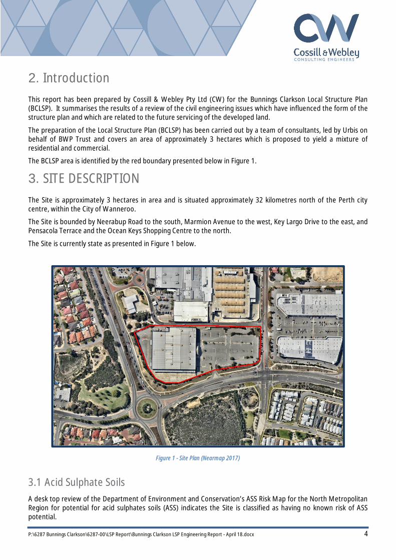
2. Introduction This report has been prepared by Cossill & Webley Pty Ltd (CW) for the Bunnings Clarkson Local Structure Plan (BCLSP). It summarises the results of a review of the civil engineering issues which have influenced the form of the structure plan and which are related to the future servicing of the developed land.
The preparation of the Local Structure Plan (BCLSP) has been carried out by a team of consultants, led by Urbis on behalf of BWP Trust and covers an area of approximately 3 hectares which is proposed to yield a mixture of residential and commercial.
The BCLSP area is identified by the red boundary presented below in Figure 1.
3. SITE DESCRIPTION The Site is approximately 3 hectares in area and is situated approximately 32 kilometres north of the Perth city centre, within the City of Wanneroo.
The Site is bounded by Neerabup Road to the south, Marmion Avenue to the west, Key Largo Drive to the east, and Pensacola Terrace and the Ocean Keys Shopping Centre to the north.
The Site is currently state as presented in Figure 1 below.
Figure 1 - Site Plan (Nearmap 2017)
3.1 Acid Sulphate Soils A desk top review of the Department of Environment and Conservation’s ASS Risk Map for the North Metropolitan Region for potential for acid sulphates soils (ASS) indicates the Site is classified as having no known risk of ASS potential.

P:\6287 Bunnings Clarkson\6287-00\LSP Report\Bunnings Clarkson LSP Engineering Report - April 18.docx 5
3.2 Geology and Landform The Geological Survey of Western Australia Perth Metropolitan Region Soils Maps indicates the majority of the Site is generally characterised by Limestone (LS1) light yellowish brown, fine to coarse grained with a small portion of the Site possibly characterised by Sand (S7) pale and olive yellow, medium to coarse grained.
This soil type is well suited to urbanisation, and is generally very permeable, allowing for the on-site disposal of runoff from newly created roads and lots. Figure 2 below presents the geology across the Site.
We anticipate, based on the above geological conditions, that the majority of the Site will be Class A under the Australian Standard AS2870 – Residential Slabs and Footings code.
Based on our experience on similar projects within the area, the Site is well suited for future urban development in terms of topography and soils and will provide a suitable foundation for roads, infrastructure and future development.
Figure 2 - Geotechnical Information (Geological Survey of WA)
3.3 Groundwater A desk top review of the Department of Waters Perth Groundwater Atlas indicates that the Average Annual Maximum Groundwater Levels are less than RL1.0m AHD across the Site.
Given the natural ground levels are substantially higher than this, it is anticipated that ground water levels will have no impact on proposed earthworks design levels or infrastructure construction.

P:\6287 Bunnings Clarkson\6287-00\LSP Report\Bunnings Clarkson LSP Engineering Report - April 18.docx 6
4. SITEWORKS & EARTHWORKS Natural topography varies across the Site from the western interface with Marmion Avenue at an elevation of approximately RL36m AHD to the western boundary abutting the Key Largo Drive at approximately RL 41m AHD. Natural surface elevations across the Site from the Department of Water are presented in Figure 3 below.
Siteworks for urban development on site will generally comprise of demolition of existing infrastructure, clearing of existing vegetation, removal of redundant services within the site, and earthworking the existing ground to facilitate a required form of development. Brajkovich Demolition & Salvage have provided advice that the existing infrastructure within the Site can be demolished and removed off-site at a cost in the order of $200,000 excl. GST. Additional costs would however apply for the disconnection of utility services to the existing building if not already done so.
The extent of siteworks will be dictated by the density and nature of development.
The BCLSP has been designed in accordance with the following objectives:
To allow for roads and development sites to be graded to best follow the existing topography
To minimise the amount of retaining and import fill.
A preliminary earthworks strategy has been prepared for the BCLSP area and is presented in Appendix A in Drawing 6287-LSP-SK01.
Preliminary finished levels have been based on tying into existing levels on Neerabup Road, Pensacola Terrace and Keys Largo Drive.
Figure 3 - Elevation Contours (MNG Survey 2017)

P:\6287 Bunnings Clarkson\6287-00\LSP Report\Bunnings Clarkson LSP Engineering Report - April 18.docx 7
5. DRAINAGE STRATEGY
5.1 Integrated Urban Water Management Stormwater drainage management for the Site is proposed by adopting a Water Sensitive Urban Design (WSUD) approach. Objectives of WSUD include:-
Detention of stormwater rather than rapid conveyance; Use of vegetation for filtering purposes; and Water efficient landscaping.
For the BCLSP, the main WSUD practices which should be incorporated into the ongoing implementation of the site as follows:
1.5.1 Stormwater Management
Stormwater recharge of the shallow aquifer should be maximised through the adoption of ‘Best Management Practices’, which promote the dispersion and infiltration of runoff. These include the use of porous paving for roads and car parks, the diversion of runoff into road-side swales, drainage soakwells and underground storage to infiltrate runoff from buildings and carpark area.
1.5.2 Water Quality Management
The maximisation of the quality of recharge water through the adoption of “Best Management Practices”, which promote the disposal of runoff via water pollution control facilities (including vegetated swales, detention storage and gross pollutant traps) and the implementation of non-structural source controls (including urban design, street sweeping, community education, low fertiliser landscaping regimes, etc.).
5.2 Stormwater Collection and Management The BCLSP land is generally free draining sand with substantial cover to the prevailing groundwater. Overall, therefore, the land is highly suited to the implementation of the WSUD management practices outlined above.
It is anticipated that runoff will be contained on-site. Stormwater disposal will be via soakwells or other infiltration facilities, including underground storage, which form part of the building development.
Infiltration could also be via gully pits with permeable bases, slotted drainage pipes, porous road pavements, under road storages etc. subject to the City of Wanneroo approval and consideration of whole of life costs including the ongoing maintenance.
Runoff from storms up to 60% AEP would be infiltrated on site via a combination of surface infiltration and underground pipe/storage system consistent with the requirements of the City of Wanneroo.
Flows up to 20% AEP storm event would be directed to an infiltration swale located at a low point within the Site along the western edge.
The dispersion of stormwater disposal will maximise the area of recharge down through the soil profile to the shallow aquifer, thereby, maximising the potential for nutrient stripping and water quality improvements.
It is proposed that a stormwater drainage strategy be finalised as part of the civil engineering approval process with the City of Wanneroo.
P:\6287 Bunnings Clarkson\6287-00\LSP Report\Bunnings Clarkson LSP Engineering Report - April 18.docx 8
6. Roadworks & Footpaths
6.1 Traffic and Transportation An assessment of the traffic and transport planning for the BCLSP has been undertaken by GTA.
The results of this include a recommended hierarchy for the roads surrounding the BCLSP and within the future subdivision development together with recommendations for public transport services, pedestrian and cyclist facilities.
In all cases the engineering review has taken account of the recommendations outlined in the GTA Consultant report and they will be incorporated into future detailed subdivision planning and design.
6.2 Development Roads The BCLSP proposes the construction of a road through the site to connect Pensacola Terrace with Neerabup Road.
In all cases the road cross-sections will be designed to cater for utility services, on standard verge alignments, street trees, parking embayments where appropriate, off-street and on-street cycling lanes in accordance with the overall pedestrian and cycling network.
The engineering design of roads will be carried out to comply with the Department of Planning’s Liveable Neighbourhoods recommendations for design speeds and sight distances and with the requirements of the City of Wanneroo. Roadworks will generally consist of kerbed and asphalted pavements.
In particular, it is proposed that the development roads be designed to suit lower vehicle operating speeds to ensure safer operation and improved pedestrian movement. The lower speeds on local roads will also support initiatives to adopt smaller street truncations and associated intersection curve radii where suitable.
6.3 Footpaths Footpaths will be provided in accordance with Liveable Neighbourhoods and the City of Wanneroo standards and will consist of one path in every road, and dual use paths in Neighbourhood Connector roads.
6.4 Public Transport There is currently a bus service utilising Marmion Avenue to connect Yanchep – Two Rocks to destinations south of the site as well as a bus service that utilizes Ocean Keys Boulevard to connect the public to the Perth CBD via the Clarkson train line.
6.5 Noise Attenuation Future traffic volumes for Marmion Avenue are likely to exceed 20,000 vehicles per day, and in accordance with State Planning Policy 5.4 “Noise Considerations”, Herring Storer has been engaged to prepare an Acoustic Report to assess the requirements for the site.
Some noise mitigation strategies will be required for these interfaces and could consist of noise bunds, noise walls and in-house acoustic mitigation techniques.

P:\6287 Bunnings Clarkson\6287-00\LSP Report\Bunnings Clarkson LSP Engineering Report - April 18.docx 9
7. WASTEWATER The site is currently provided with a 225mm wastewater connection in the north-western corner of the site which is assumed to have previously serviced the Bunnings building. Existing 225mm and 150mm sewer mains run along the western and southern boundaries of the site respectively. The existing sewerage is depicted in red in Figure 4 below.
A hydraulic consultant will be required to complete an onsite investigation to determine the flows within the proposed development. However, given the proposed yield of the development, it is anticipated that the existing 225 PVC sewer connection in the North West corner of the site and surrounding infrastructure has sufficient capacity.
Standard Water Corporation sewerage headworks will apply.
Figure 4 - Existing Water & Wastewater Infrastructure (Water Corporation, 2017)
8. WATER RETICULATION The site is currently abutted by a 600mm steel water main along its western boundary within Marmiom Avenue and by a 150mm water main along its eastern boundary within Key Largo Drive. Given the existing infrastructure surrounding the site, the proposed development will be able to be serviced with water reticulation. The existing water reticulation infrastructure is depicted in blue in Figure 4 above.
Standard Water Corporation water headworks will apply to the development.

P:\6287 Bunnings Clarkson\6287-00\LSP Report\Bunnings Clarkson LSP Engineering Report - April 18.docx 10
9. ELECTRICAL POWER SUPPLY
9.1 Existing Electrical Power Network There is an existing high voltage overhead distribution powerline along Marmion Avenue (western verge) abutting the Site. According to the Western Power Forecast Remaining Capacity 20136 there is less than 5MVA available in the system. Following discussions with Western Power they did not see this as a critical issue, and they are currently witnessing a reduction in power consumption as a result of new power technology.
The proposed development should also adopt the latest improvements in on site power generation and conservation in order to minimise the power infrastructure requirements. Western Power will continue to manage their power capacity, and have advised that this will not be an impediment to future development of the site.
9.2 Initial Electrical Power Supply
Initial power supply will be available from an existing 1000kVa Transformer which is located on the site and was adopted by the previous land use. This Transformer may require upgrading to 200kVA depending on ultimate power use. An estimate of power use based on a square meter rate is provided below, and results in a total load requirement of 1565kVA.
Power/m2 Total Power Req Supermarket 2500m2 110VA/m2 275kVA Food and Beverage 1000m2 140VA/m2 140kVA Showrooms 5000m2 80-100VA/m2 500kVA Retail/Service 1500m2 100-120VA/m2 180kVA Residential 100 dwellings 4.7kVA/lot 470kVA

P:\6287 Bunnings Clarkson\6287-00\LSP Report\Bunnings Clarkson LSP Engineering Report - April 18.docx 11
10. GAS SUPPLY There is existing gas infrastructure along the along its western boundary within Marmiom Avenue and by a 150mm water main along its eastern boundary within Key Largo Drive as presented in Figure 5 below.
Atco Gas has confirmed that the surrounding infrastructure has the capacity to supply the proposed development with natural gas. Depending on the final layout and staging of the development, a mains extension might be required to bring gas to the site.
Gas reticulation will be supplied and funded by Atco Gas and installed by the Contractor concurrent with other service installation.
Figure 5 - Gas Reticulation (Atco Gas, 2017)
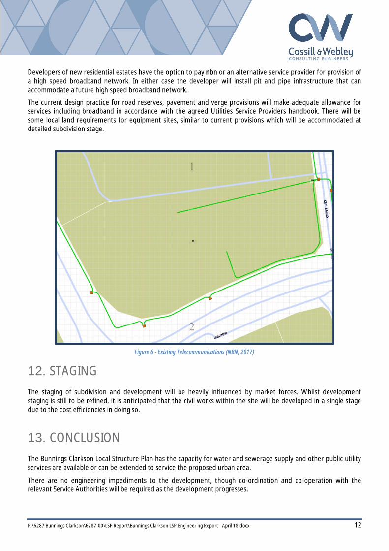
11. TELECOMMUNICATIONS The Site is within nbn’s fixed line footprint, and hence can be serviced with optic fibre. There is currently an existing service within the site as seen in Figure 6 below that will have to be relocated as part of the development works.
Under the Federal Government’s new Telecommunications in New Developments Policy, developers are responsible for contributing to the cost of delivering the nbn™ network in new developments. This includes contributing to part of the costs of the build (civils and any backhaul required) as well as a $600 per lot deployment change.
Through the nbn, the ownership issues of delivering the wholesale fibre to the home system have been transferred to the Government with a number of retail service providers offering services over the network. There are other private telecommunication providers that can also offer similar services.
P:\6287 Bunnings Clarkson\6287-00\LSP Report\Bunnings Clarkson LSP Engineering Report - April 18.docx 12
Developers of new residential estates have the option to pay nbn or an alternative service provider for provision of a high speed broadband network. In either case the developer will install pit and pipe infrastructure that can accommodate a future high speed broadband network.
The current design practice for road reserves, pavement and verge provisions will make adequate allowance for services including broadband in accordance with the agreed Utilities Service Providers handbook. There will be some local land requirements for equipment sites, similar to current provisions which will be accommodated at detailed subdivision stage.
Figure 6 - Existing Telecommunications (NBN, 2017)
12. STAGING The staging of subdivision and development will be heavily influenced by market forces. Whilst development staging is still to be refined, it is anticipated that the civil works within the site will be developed in a single stage due to the cost efficiencies in doing so.
13. CONCLUSION The Bunnings Clarkson Local Structure Plan has the capacity for water and sewerage supply and other public utility services are available or can be extended to service the proposed urban area.
There are no engineering impediments to the development, though co-ordination and co-operation with the relevant Service Authorities will be required as the development progresses.

P:\6287 Bunnings Clarkson\6287-00\LSP Report\Bunnings Clarkson LSP Engineering Report - April 18.docx 13
Appendix A
Earthwork Drawing 6287-LSP-SK01

DATEREVCKD
COPYRIGHT
The concepts and information contained in
this document are the Copyright of Cossill &
Webley Pty Ltd. Use or copying of the
document in whole or part without the written
permission of Cossill & Webley Pty Ltd
constitutes an infringement of copyright.
This plan is not to be used for construction
unless issued as revision 0 or higher
REV DRNDATE
CLIENT
DESIGNEDAPPROVED
SCALE
TITLE
PROJECT
WAPC No. REVISIONDRAWING No.
Subiaco WA 6904
(08) 9422 5800 ET F [email protected]
PO Box 680
(08) 9422 5801
Subiaco WA 6008
B12 (Level 2) 431 Roberts Road
Street AddressMailing Address
APP CKDDRN APP
A1
OR
IG
IN
AL
SIZ
E
CHECK PRINT
AMENDMENT AMENDMENT
P:\6
28
7 B
un
nin
gs C
la
rkso
n\6
28
7-0
0\A
ca
d\6
28
7-L
SP
-S
K0
1.d
wg
, 9
/0
4/2
01
8 1
0:1
0:1
4 A
M, h
arm
v, D
ig
ita
l S
ig
nin
g P
DF
.p
c3
, 1
:1
, - C
W R
efe
re
nce
09.04.18

URBIS 20180424 PA1313 - LOT 408 (NO. 19) NEERABUP ROAD CLARKSON ACTIVITY CENTRE PLAN - FINAL
APPENDICES

APPENDICES
URBIS
20180424 PA1313 - LOT 408 (NO. 19) NEERABUP ROAD CLARKSON ACTIVITY CENTRE PLAN - FINAL
