appendix f runway safety action plan
TRANSCRIPT
Charles M. Schulz - Sonoma County Airport
Draft Environmental Impact Report July 2011 F-1
APPENDIX F
RUNWAY SAFETY ACTION PLAN

Appendix F – Runway Safety Action Plan
Charles M. Schulz - Sonoma County Airport
Draft Environmental Impact Report July 2011 F-2
THIS PAGE INTENTIONALLY LEFT BLANK

DRAFT DRAFT
Charles M. Schulz/Sonoma County Airport
Runway Safety Action Plan
March 24, 2010
On March 24, 2010, the FAA Runway Safety Field Operations Group, Western-Pacific Region
(AJS-4WP), visited Charles M. Schulz/Sonoma County Airport (STS) in Santa Rosa, California.
During the visit, the team met with airport management, airfield operations, air traffic
management, and airport users for the purpose of updating the existing Runway Safety Action
Plan (RSAP) for the airport. Initially, the Runway Safety Action Team (RSAT) conducted an
evening pilot meeting and gathered local pilot observations and recommendations concerning
airport surface safety. On the following day, the RSAT team toured the airport to view the
airfield (NACO airport diagram appended to end of document). STS has over 300 based general
aviation aircraft including jets, helicopters, and gliders. The airport handles in excess of 3,000
air carrier operations per year, and is estimated to handle about 109,833 total operations
annually, with an FAA Air Traffic Control Tower in operation daily from 0700 to 2000 PST.
The airport’s overall safety design planning group goals (Airport Design Code (ARC)) are noted
in current planning documents such as the Airport Layout Diagram (ALP) as C-II/C-III
respectively for two runways, both slightly longer than 5000 feet each.
The previous RSAT visit was conducted on March 22 and 23, 2005. The following is a
breakdown of the Runway Incursions/Surface Incidents that occurred during the time period
following the last RSAT and leading up to the present one (3/24/2005 through 3/23/2010).
Runway Incursion/Surface Incident Breakdown by Type Category
Type Category Non-Runway Incursions Runway Incursions Totals
OE/D 0 0 0
PD 0 2 2
V/PD 4 3 7
Totals 4 5 9
Runway Incursion Breakdown by Severity Category
Type Category A B C D Unrated Totals
OE/D 0
PD 2 2
V/PD 2 1 3
Totals 0 0 2 3 5
Total estimated operations for the time period 3/24/2005 through 3/23/2010 are 549,164, or an
average of approximately 109,833 per year. The Runway Incursion Rate for this period is 0.91
per 100,000 operations. (An operation is defined as an aircraft taking off or landing.)

DRAFT – Charles M. Schulz/Sonoma County Airport
2
The following individuals were among those in attendance at the meetings:
Dave Kurner, FAA Runway Safety, Regional Program Manager
Patrick McFarland, FAA Runway Safety, Pilot Analyst
Jon Stout, Sonoma County, Airport Manager
Steve Lange, Sonoma County, Assistant Airport Manager
Elliot Brann, FAA, Air Traffic Representative
Art Hayssen, FAASTeam, Lead Representative Oakland
Garry Brown, FAA Western Service Center, Quality Control/RSAT Specialist
Lucy Lorenzen, FAA Western Service Center, QC Safety Specialist
David Dietz, Mead & Hunt, Senior Airport Planner
Bill Gin, FAA San Francisco ADO, Program Manger
Stephen Miller, STS Air Traffic Control, Front Line Manager
Allie Metcalf, STS Air Traffic Control, Air Traffic Manager
Jana Pitre, STS Air Traffic Control, NATCA Representative
Michael Smith, California DOT, Aviation Safety Officer
Kurt Haukohl, FAA Runway Safety, Airport Operations Analyst
The following safety concerns were noted:
1) Non-standard markings and lack of black outlining on light-colored pavements
2) Non-standard and incorrectly placed signs, some of which are in poor condition
3) Confusion concerning the location of movement areas on the airfield
4) Incorrect Airport Master Record (5010) data
5) Inaccuracies on the NACO and Jeppesen airport diagrams
6) Increased runway occupancy time due to the necessity to back-taxi on runways
7) Elevated risk for wrong runway departures due to co-located runway thresholds
8) Agricultural operations and excessive growth of vegetation that have led to tower
line-of sight issues as well as obscuration of airfield signs
9) Noted hot spot areas
The following is a list of new action items developed by the Regional Runway Safety Action
Team in cooperation with airport and air traffic management, in an effort to mitigate these nine
identified safety concerns.
Action Item No: STS-2010-001
Estimated Completion Date (ECD): 10/30/2010
Status: Open
Observation: It was noted that many surface painted markings on the airfield are non-standard,
have become faded or discolored, and are inconsistently sized and highlighted. The RSAT Team
also noted inconsistencies concerning marking placements such as Hold Position Lines, with
some perpendicular to the taxiway while others are parallel with the associated protected runway.
Airfield marking discrepancies contribute to pilot confusion, and increase the risk potential for a
runway incursion to occur.

DRAFT – Charles M. Schulz/Sonoma County Airport
3
Action Item: Recommend the airport develop a consistent and comprehensive airfield marking
plan, as is required as part of the Airport Certification Manual (ACM) and Airport Certification
under FAA Part 139. Additionally, surface markings associated with signs should be re-
evaluated throughout the Airport Operating Area (AOA) to determine the correct location for the
marking, moving signage as necessary to coordinate with those markings. The RSAT Team also
recommends that the airport evaluate the consistency of marking placements such as Hold
Position Line markings perpendicular to the taxiway or parallel with the associated protected
runway. Additionally, it was noted that enhanced taxiway surface painted lead-in lines have not
been completed throughout the airport. Please refer to FAA Advisory Circular (AC) 150-5340-
1J, entitled “Standards for Airport Markings,” for details, dimensions, and specifications on each
type of airfield marking. Additionally, requirements of the ACM may be found in Title 14, Code
of Federal Regulations (CFR), Part 139 and “Certification of Airports.”
Remarks: The ECD above is the deadline by which a plan of action should be determined by
the airport.
Responsible Local Entity Contact
STS Airport Manager Jon Stout
Responsible FAA Regional Entity Contact
FAA Airports Division Program Manager Bill Gin
FAA Airport Certification Safety Inspector Tony Garcia
Action Item No: STS-2010-002
Estimated Completion Date: 10/30/2010
Status: Open
Observation: It was noted that many airport signs, both aboveground and surfaced painted, are
non-standard, incorrectly placed, or in poor condition. The RSAT Team also noted
inconsistencies regarding sign placements, such as the Mandatory Runway Holding Position
Signs, with some having been positioned perpendicular to the taxiway while others have been
positioned parallel with the associated protected runway. Airfield signage discrepancies and sign
orientations may contribute to pilot confusion, and increase the risk potential for a runway
incursion to occur.
Action Item: Recommend the airport develop a complete and consistent airfield sign plan, as is
required as part of the ACM and Airport Certification under FAA Part 139. A comprehensive
sign plan may include retro-reflective (reflector) systems where the expense or utilization of a
fully electrified sign is not justified or required. Additionally, it has been noted that in many
locations, a variety of sign types, sizes, and formats were provided, but were incomplete and
inconsistently positioned. Please refer to FAA Advisory Circular (AC) 150-5340-18E, entitled
“Standards for Airport Sign Systems,” for details, dimensions, and specifications on each type of
airfield sign. Additional requirements within the AOA for a sign plan for the ACM and the
airport may be found in Title 14, CFR, Part 139, and “Certification of Airports.” Details on

DRAFT – Charles M. Schulz/Sonoma County Airport
4
FAA signage may be found in “Specifications for Taxiway and Runway Sign,” FAA AC 150-
5345-44H. The following are specific signage recommendations noted by the RSAT Team:
1) Taxiway Z, while marked, is not identified by aboveground signage and may
benefit from either aboveground or surface painted signs. Alternatively, parallel
ramp Taxiway Z may be eliminated completely west of Taxiway Y (see STS-
2010-003 below).
2) Suggest the installation of Runway 14 and Runway 19 destination signs, to be
installed on Taxiway Y and just south of the intersection of Taxiway A, visible to
pilots taxiing north on Taxiway Y, as well as on Taxiway A, just east of the
intersection of Taxiway Y, visible to pilots taxiing west on Taxiway A.
3) Recommend that Taxiway Y be more clearly indentified with aboveground
signage. The RSAT Team noted the fronts and the backs of four “VSTR” signs
along Taxiway Y that could be utilized to provide location or directional
information (see pictures below). Taxiway Y is predominantly marked by exit
signs that are typically difficult for pilots to read.
Information sign, back side of which could
provide direction or location information
Information sign, back side of which could
provide direction or location information
4) A combination of direction and location signs, elevated and surface painted,
should be installed to guide pilots operating on Taxiways C, Y, and Z, near the
intersection of those taxiways, since no signage is currently available in this area.
Additionally, taxilane identifiers on the hangar rows near this area may assist
pilots and ATC when giving location or destination information.
5) Taxiway X on the western side of the Airport Layout Plan and Airport Diagram
should be given a new designation, since “X” refers to closed pavement and is not
a standard taxiway designator.
6) Mandatory white on red surface painted signs are incomplete throughout the
remainder of the airport taxiway-runway intersections and are required by
December 2010. Additionally, the mandatory surface painted sign on Taxiway Y
leading to Runway 19 and Runway 14 should indicate both runways.
7) A black on yellow direction sign at the apex of Runway 14 and Runway 19 (photo
below) may be inappropriate or non-standard due to its location in the Runway
Safety Area (RSA), with the absence of any mandatory sign for Runway 1/19.
Recommend the airport review the sign type, placement, and location with its
Certification Safety Inspector. The RSAT Team recommends that the airport
request to have its sign plan reviewed and approved for its ACM, with the photo

DRAFT – Charles M. Schulz/Sonoma County Airport
5
below (left) providing an example of standard signage for this area. Please note
the runway location signs, which the RSAT Team feels are crucial for the
prevention of wrong-runway departures.
Excerpts: AC 5340-18E Runway 14 + Runway 19 direction signs
8) An area in the AOA marked with a white-on-red “No entry” sign appears to be
permanently closed on Taxiway W. Entry from the west side of Runway 1/19 is
blocked via orange cones (see pictures below). However, this abandoned area has
a Mandatory Runway Holding Position Sign and associated Hold Position Line
marking. The markings and signage may partially imply that the area is taxiway
available for aircraft use. The airport should consult its Certification Safety
Inspector for appropriate signage and marking of this area to prevent any
confusion about its availability for normal aircraft use. This may include
removing the Runway Holding Position Sign and hold bar markings.
Closed Taxiway W, west of Runway 1/19
Hold Position Line with orange cones “No entry” sign to Taxiway W from D
9) Taxiway E and F do not appear on the Airport Diagrams published by NACO or
Jeppesen. The RSAT Team suggests the airport take action to ensure these
taxiways are included on the next cycle of publication for NACO and Jeppesen
airport diagrams.

DRAFT – Charles M. Schulz/Sonoma County Airport
6
Taxiway E not on Airport Diagram Taxiway F not shown on Airport Diagram
Remarks: The ECD above is a date by which a plan for completion should be determined by
the airport. This action item replaces items previously reported as complete in
STS-2005-002 and STS-2005-003.
Responsible Local Entity Contact
STS Airport Manager Jon Stout
Responsible FAA Regional Entity Contact
FAA Airports Division Program Manager Bill Gin
FAA Airport Certification Safety Inspector Tony Garcia
Action Item No: STS-2010-003
Estimated Completion Date: 10/30/2010
Status: Open
Observation: The RSAT Team noted inconsistencies as well as confusion among pilots
regarding the location of movement and non-movement areas on the airport. Many pilots may
very well be unaware that they are in a non-movement area when operating on portions of
Taxiways A, B and D west of Runway 14/32. Tower visibility to some areas of the airport AOA
has become blocked by hangars. Additionally, large areas of the airport are a significant distance
from the tower, further increasing the difficulty of viewing those locations. Although the non-
movement area boundary marking is not a required marking, it is highly beneficial in that it
removes any confusion a pilot may have as to when he/she is entering the movement area. It
also ensures that those pilots are aware of when they need to be in radio contact with ATC and
when they are being provided separation from other aircraft. Removing or reducing pilot
confusion decreases the overall risk potential for a surface incident to occur. Pilot orientation
reference where ATC separation and control begins and ends is essential to reducing
disorientation and preventing or reducing the risk of runway incursions, surface incidents, and
aircraft collisions.
Action Item: Recommend the airport meet with the FAA project manager, air traffic manager,
and Airports Certification Safety Inspector to discuss those areas of the airport that can be clearly
seen and controlled from the tower, and where separation should normally be provided by ATC.
The RSAT Team specifically recommends that Taxiway(s) B, D, and A west of Runway 14/32

DRAFT – Charles M. Schulz/Sonoma County Airport
7
become movement area to the maximum extent possible. Areas that cannot be clearly observed
from the tower should be appropriately marked and signed as non-movement or non-visibility
areas, as determined by the Local RSAT (LRSAT). All of Taxiway B, for example, is visible
from the tower and is a frequent route of travel for aircraft from runway to runway. However,
the portion of the taxiway between Runway 1/19 and 14/32 has been designated as non-
movement area, and no non-movement area boundary markings were applied to the taxiway
surface to clarify this fact. Additionally, the airport should consider designating the section of
Taxiway Z that is east of Taxiway Y as non-movement area. Reference AC 150/5340-1J,
Standards for Airport Markings (Note that a Letter of Agreement [LOA] is normally developed
to clarify understanding between the tower and the airport sponsors as to the actual physical
location of the movement area.)
Responsible Local Entity Contact
STS Airport Manager Jon Stout
Responsible FAA Regional Entity Contact
FAA Airports Division Program Manager Bill Gin
FAA Airport Certification Safety Inspector Tony Garcia
Action Item No: STS-2010-004
Estimated Completion Date: 10/30/2010
Status: Open
Observation: It was noted that the Hold Position Line Markings on Taxiways A and Y east of
Runway 14/32 are white (see picture below). Non-standard or discolored hold position line
markings may lead to pilot confusion over what might be the associated surface painted
markings’ true purpose, and may lead to an increased potential for runway incursions.
Taxiway Y hold position line marking
should be yellow

DRAFT – Charles M. Schulz/Sonoma County Airport
8
Action Item: Recommend the airport paint the hold position line markings on Taxiways A and
Y east of Runway 14/32 yellow, with reflective beads, in accordance with FAA AC 150/5340-1J,
Standards for Airport Markings. Enhanced markings using black highlighting where contrast
can be improved is also recommended.
Remarks: The ECD above is a date by which a plan for completion should be determined by
the airport. This action item replaces items previously reported as complete in
STS-2005-004.
Responsible Local Entity Contact
STS Airport Manager Jon Stout
Responsible FAA Regional Entity Contact
FAA Airports Division Program Manager Bill Gin
FAA Airport Certification Safety Inspector Tony Garcia
Action Item No: STS-2010-005
Estimated Completion Date: 10/30/2010
Status: Open
Observation: It was noted that the airport FAA Airport Master Record (5010) incorrectly
reports Declared Distances for Runway 1/19, and that 5010-61 reports the Take Off Distance
Available (TODA) as 5202 feet for Runway 19. The RSAT Team noted there was insufficient
pavement available to produce a physical takeoff distance of 5202 feet, and later verified this
was a data entry error. Pilots calculating aircraft performance and required distance for takeoff
may be misled into thinking that there is more room available for takeoff than physically exists.
This may present a risk of overshooting or excursion from the runway surface. Additional risks
resulting from this situation include pilots selecting STS as a destination and having insufficient
actual space to depart the airport.
Action Item: Recommend the airport verify the accuracy of all reported 5010 data, correcting as
necessary. The RSAT Team is assisting the airport with this item, and has shared its findings of
inaccuracy with the airport’s Part 139 Certification Safety Inspector, the airport consultant,
airport management, and the Washington DC data branch of the FAA, for correction.
Responsible Local Entity Contact
STS Airport Manager Jon Stout
Responsible FAA Regional Entity Contact
FAA Airports Division Program Manager Bill Gin
FAA Airport Certification Safety Inspector Tony Garcia
Action Item No: STS-2010-006
Estimated Completion Date: 10/30/2010
Status: Open

DRAFT – Charles M. Schulz/Sonoma County Airport
9
Observation: The RSAT Team noted several discrepancies between NACO and Jeppesen
airport diagrams. Pilot awareness and safety during taxi operations is greatly increased through
the use of accurate airport diagrams.
Action Item: Recommend STS airport provide AJS-4WP Office of Runway Safety, in
electronic form, a current and up-to-date copy of the airport diagram, preferably in PDF or
AutoCad format. AJS-4WP will assist by providing accurate data to the National Flight Data
Center (NFDC). The RSAT Team noted the following items for possible clarification or
correction on the airport’s diagrams:
1) Suggest the airport confirm that Taxiway X will be re-designated or removed.
2) Closed portions of Taxiway W, B, and D should be depicted as closed.
3) Non-visibility areas of the airport diagrams should be suitably marked for pilots.
4) Hold position line markings are not normally depicted on airport diagrams and
may clutter or confuse pilots who may consider these as the only mandatory
holding points on Runway 14/32. The RSAT Team recommends that these
markings be removed from the airport’s diagrams.
Remarks: The ECD above is a date by which a plan for completion should be determined by
the airport. This action item replaces items previously reported as complete in
STS-2005-007.
Responsible Local Entity Contact
STS Airport Manager Jon Stout
Responsible FAA Regional Entity Contact
Runway Safety Assistant Program Manager Chris Diggons
Action Item No: STS-2010-007
Estimated Completion Date: 10/30/2010
Status: Open
Observation: The RSAT Team observed, and ATC affirmed, that frequent back-taxiing on
Runway 1/19, often including full-length back-taxiing, is required by aircraft selecting a Runway
1 departure or landing on Runway 19. Back-taxi operations on runways increase the risk of
losing separation between both landing and departing aircraft, especially when the tower is
closed. The risk of runway excursions while aircraft turn around, as well as head-on collision
conflicts, increases dramatically when airport runways must be utilized as taxiways.
Action Item: Recommend the airport evaluate and consider projects to reduce or eliminate
runway back-taxiing and runway crossings. Alternatives outlined in the Airport Layout Plan
include connection of Taxiway D to the Runway 1 threshold, and the completion of an extension
to Taxiway Y to cross Runway 14/32. The RSAT Team supports projects that reduce or
eliminate non-essential back-taxiing and direct 90º taxiway entrances to runway thresholds.

DRAFT – Charles M. Schulz/Sonoma County Airport
10
Please refer to FAA Engineering Brief No. 75, “Incorporation of Runway Incursion Prevention
into Taxiway and Apron Design.”
Responsible Local Entity Contact
STS Airport Manager Jon Stout
Responsible FAA Regional Entity Contact
FAA Airports Division Program Manager Bill Gin
FAA Airport Certification Safety Inspector Tony Garcia
Action Item No: STS-2010-008
Estimated Completion Date: 10/30/2010
Status: Open
Observation: The Runway Safety Team discussed the current airport configuration, which
consists of co-located thresholds at the Runway 1/19 and Runway 14/32 intersection. A high
frequency of pilot confusion involving departures on the wrong runway has occurred in the past,
and remains an ongoing, identified airport risk. Additionally the AOA area surrounding
Taxiway A, Y and the co-located thresholds has proven to be a high workload area for ATC.
Wrong-runway takeoffs represent an unacceptably risky situation for runway incursions,
including head-on aircraft collisions as well as conflicts with landing aircraft.
Action Item: Recommend STS pursue and implement alternative runway configuration(s)
projects with the FAA Airports District Office (ADO) Program Manager and Engineering to
eliminate the present condition of co-located Runway 14/32 and Runway 1/19 thresholds. The
RSAT Team encourages projects to extend or shorten one or both runways with their associated
connections. The primary goal is an overall airport objective to reduce or eliminate potential
pilot runway confusion, and to present preferable safe mechanical configurations to the present
threshold overlap. The RSAT Team also recommends projects to provide immediate
mitigation(s) of the present risk, including surface painted signage, aboveground signage,
markings, in-pavement lighting, in-pavement lead-in lighting, runway guard lights, and enhanced
markings. Large-sized format signs may also be utilized in locations such as the Taxiway Y
entrance to the runway apex so that, for example, pilots may more easily read where the
departure point for Runway 19 is located when crossing both thresholds. The RSAT Team
encourages STS to work with its Part 139 Certification Safety Inspector to approve appropriate
signage, markings, locations, and plans. Please refer to FAA Minimum Design Safety Standards
and FAA AC 150-5300-13, FAA Advisory Circular (AC) 150-5340-18E, entitled “Standards for
Airport Sign Systems” for details, dimensions, and specifications on each type of airfield sign.
Additional requirements within the AOA for a sign plan for the ACM and the airport may be
found in Title 14, CFR, Part 139 and “Certification of Airports.” Details on FAA signage may
be found in “Specifications for Taxiway and Runway Signs,” FAA AC 150-5345-44H.
Responsible Local Entity Contact
STS Airport Manager Jon Stout

DRAFT – Charles M. Schulz/Sonoma County Airport
11
Responsible FAA Regional Entity Contact
FAA Airports Division Program Manager Bill Gin
FAA Airport Certification Safety Inspector Tony Garcia
Action Item No: STS-2010-009
Estimated Completion Date: 10/30/2010
Status: Open
Observation: The RSAT Team noted tall brush, including small trees, and agricultural
operations that may interfere with both visibility of signs and line-of-sight to the tower. Pilots
may completely miss seeing parts or all of important signs or markings, and ATC may lose sight
of aircraft that are taxiing on the airport, increasing the potential risk for a runway incursion or
surface incident.
Action Item: Recommend STS increase its frequency of trimming around signs and lights, as
well as removal of shrubs, trees, and brush blocking pilot visibility of signs and markings and the
tower’s visibility of the movement area. Additionally, the RSAT Team recommends that the
airport clearly identify any areas of agricultural activity, ensuring that they do not conflict with
the movement of aircraft or airport operations, or become habitat for wildlife. Please refer to
FAA AC 150-5300-13, “Airport Design,” Appendix A17-1, “Minimum Distances Between
Certain Airport Features and On-Airport Agriculture Crops.”
Responsible Local Entity Contact
STS Airport Manager Jon Stout
Responsible FAA Regional Entity Contact
FAA Airports Division Program Manager Bill Gin
FAA Airport Certification Safety Inspector Tony Garcia
Action Item No: STS-2010-010
Estimated Completion Date: 10/30/2010
Status: Open
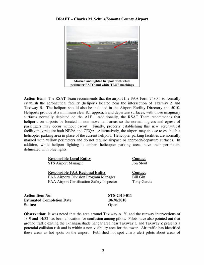
Observation: It was noted that a lighted and marked heliport on the airport apron near the
intersection of Taxiway Z and Taxiway B is not listed in the Airport Master Record (5010) and
has been marked with a white FATO (see picture below). Also noted adjacent to the heliport
were several improved helicopter parking pads. The RSAT Team was unable to locate a record
or finding related to an airspace determination or established traffic pattern, including approach
and departure paths associated with this facility. In this instance, heliport incursions and/or
surface incidents may occur where fixed-wing or rotor aircraft simply pass through the white
marked area without ATC clearance. The risk to helicopter pilots at night, when the tower is
closed, is that they may incorrectly assume that adequate protection from incursions is provided
by virtue of the facility’s layout alone.
DRAFT – Charles M. Schulz/Sonoma County Airport
12
Marked and lighted heliport with white
perimeter FATO and white TLOF markings
Action Item: The RSAT Team recommends that the airport file FAA Form 7480-1 to formally
establish the aeronautical facility (heliport) located near the intersection of Taxiway Z and
Taxiway B. The heliport should also be included in the Airport Facility Directory and 5010.
Heliports provide at a minimum clear 8:1 approach and departure surfaces, with those imaginary
surfaces normally depicted on the ALP. Additionally, the RSAT Team recommends that
heliports on airports be located in non-movement areas so the normal ingress and egress of
passengers may occur without escort. Finally, properly establishing this new aeronautical
facility may require both NEPA and CEQA. Alternatively, the airport may choose to establish a
helicopter parking area in place of the current heliport. Helicopter parking facilities are normally
marked with yellow perimeters and do not require airspace or approach/departure surfaces. In
addition, while heliport lighting is amber, helicopter parking areas have their perimeters
delineated with blue lights.
Responsible Local Entity Contact
STS Airport Manager Jon Stout
Responsible FAA Regional Entity Contact
FAA Airports Division Program Manager Bill Gin
FAA Airport Certification Safety Inspector Tony Garcia
Action Item No: STS-2010-011
Estimated Completion Date: 10/30/2010
Status: Open
Observation: It was noted that the area around Taxiway A, Y, and the runway intersections of
1/19 and 14/32 has been a location for confusion among pilots. Pilots have also pointed out that
ground traffic exiting the T-hangar/shade hangar area near Taxiway C and Taxiway Z presents a
potential collision risk and is within a non-visibility area for the tower. Air traffic has identified
these areas as hot spots on the airport. Published hot spot charts alert pilots about areas of

DRAFT – Charles M. Schulz/Sonoma County Airport
13
frequent confusion and improve orientation and operational safety, and decrease risks associated
with those highlighted areas.
Action Item: AJS-4WP Office of Runway Safety to coordinate with STS air traffic and airport
management for the purpose of creating a hot spot chart for the airport. Coordination will be
made with NACO and Jeppesen for inclusion in their publications.
Responsible Local Entity Contact
STS Airport Manager Jon Stout
Responsible Regional Entity Contact
Runway Safety Assistant Program Manager Chris Diggons
The only remaining open action item from previous visits, STS-2005-005, was noted as still on
course, with the current estimated completion date of 06/30/2012 remaining the same.
The following action items from previous visits are complete:
STS-2005-001 STS-2005-006
The following action items from previous visits have been closed and rolled into new action
items:
STS-2005-002 STS-2005-003 STS-2005-004 STS-2005-007
[See airport diagram on following page]

DRAFT – Charles M. Schulz/Sonoma County Airport
14