appendix b eden landing preliminary … landing deis-r/app b...south bay salt pond restoration...
TRANSCRIPT

Appendix B
APPENDIX B
EDEN LANDING PRELIMINARY ALTERNATIVES ANALYSIS REPORT
South Bay Salt Pond Restoration Project, Eden Landing Phase 2 August 2017 Draft Environmental Impact Statement/Report

Appendix B
South Bay Salt Pond Restoration Project, Eden Landing Phase 2 August 2017 Draft Environmental Impact Statement/Report
This page intentionally left blank
South Bay Salt Pond Restoration Project Eden Landing Preliminary Alternatives Analysis Report
June 2014


Eden Landing Preliminary Alternatives Analysis Report June 2014
South Bay Salt Pond Restoration Project, Phase 2 i
Table of Contents Introduction ..................................................................................................................................... 1
Section 1. Purpose ........................................................................................................................... 3
Section 2. Components and Preliminary Alternatives .................................................................... 5
2.1 Background and Goals ..................................................................................................... 5
2.2 Components and Variations ............................................................................................. 6
2.3 Development of Alternatives ........................................................................................... 9
Section 3. Alternative Development Process and Methods .......................................................... 27

June 2014 Eden Landing Preliminary Alternatives Analysis Report
ii South Bay Salt Pond Restoration Project, Phase 2
Tables Table 1. Restoration and Flood Control Components and Variations ............................................ 8 Table 2. Recreation and Public Access Alternative Components ................................................... 9 Table 3. Restoration and Flood Protection Preliminary Alternatives ........................................... 20 Table 4. Recreation and Public Access Preliminary Alternatives ................................................ 20 Table 5. Preliminary Alternatives for Evaluation in DEIS/R as SBSP Restoration Project, Phase
2 Actions at Eden Landing ............................................................................................. 26 Figures Figure 1. Restoration and Flood Protection Preliminary Alternatives - Rest1 (No Action
Alternative) ................................................................................................................... 11 Figure 2. Restoration and Flood Protection Preliminary Alternatives – Rest2............................. 12 Figure 3. Restoration and Flood Protection Preliminary Alternatives – Rest3............................. 13 Figure 4. Restoration and Flood Protection Preliminary Alternatives – Rest4............................. 14 Figure 5. Restoration and Flood Protection Preliminary Alternatives – Rest5............................. 15 Figure 6. Recreation and Public Access Preliminary Alternatives – Access1 (No Action
Alternative) ................................................................................................................... 16 Figure 7. Recreation and Public Access Preliminary Alternatives – Access2 .............................. 17 Figure 8. Recreation and Public Access Preliminary Alternatives – Access3 .............................. 18 Figure 9. Recreation and Public Access Preliminary Alternatives – Access4 .............................. 19 Figure 10. Preliminary Alternatives for Phase 2 Actions at Eden Landing – Eden 1 (No Action
Alternative) ................................................................................................................... 22 Figure 11. Preliminary Alternatives for Phase 2 Actions at Eden Landing – Eden 2 ................... 23 Figure 12. Preliminary Alternatives for Phase 2 Actions at Eden Landing – Eden 3 ................... 24 Figure 13. Preliminary Alternatives for Phase 2 Actions at Eden Landing – Eden 4 ................... 25

Eden Landing Preliminary Alternatives Analysis Report June 2014
South Bay Salt Pond Restoration Project, Phase 2 1
Introduction In 2003, Cargill Salt (Cargill) sold 15,100 acres of solar salt production ponds that had been owned and operated by Cargill in the southern San Francisco Bay. The sale and transfer to the U.S. Fish and Wildlife Service (USFWS) and the California Department of Fish and Wildlife (CDFW) became known as the South Bay Salt Pond Restoration Project (SBSP Restoration Project). The first phase of the SBSP Restoration Project will be completed in 2014. Phase 2 of the SBSP Restoration Project involves the selection, restoration design, environmental compliance, permitting, and construction activities at several former salt pond complexes under the ownership and management of USFWS or CDFW. The Alviso and Ravenswood complexes lie within the boundaries of the Don Edwards San Francisco Bay National Wildlife Refuge (Refuge), which is owned by USFWS. The Eden Landing complex, within the Eden Landing Ecological Reserve, is owned by CDFW.
The complexes consist of many individual salt ponds; several groups or “clusters” of these ponds are being analyzed for inclusion into the SBSP Restoration Project’s Phase 2 actions. Phase 2 actions at the Alviso and Ravenswood complexes are being undertaken by the Refuge and are described in other reports and environmental compliance documents. At the Eden Landing complex, Phase 2 of the SBSP Restoration Project involves the restoration and enhancement of the ponds south of Old Alameda Creek. The preliminary alternatives for the ponds at the Eden Landing complex are the subject of this report.
This document presents the purpose, methods, and results of developing the preliminary alternatives at Eden Landing for Phase 2 of the SBSP Restoration Project, developing screening criteria for those alternatives, and applying those criteria to select specific alternatives for inclusion in the SBSP Restoration Project’s Draft Environmental Impact Statement/Environmental Impact Report (DEIS/R).
The organization of the document is as follows:
• Section 1 discusses the purpose of an alternatives development and screening process and places this work in the context of the National Environmental Policy Act (NEPA), the California Environmental Quality Act (CEQA), and the SBSP Restoration Project’s three primary goals of habitat restoration, improved recreation and public access, and maintenance or improvement of current levels of flood risk protection.
• Section 2 presents the alternatives developed for this portion of Phase 2. Specifically, Section 2 discusses the individual components, the optional variations on those components, and the combinations of them that constitute the alternatives developed for inclusion in the DEIS/R. The DEIS/R will include evaluations and impact analyses of the habitat restoration, recreation and public access, and flood risk protection components. Based on those analyses and the comments received, some individual components of one or more of the draft alternatives may be selected and recombined into a Preferred Alternative for inclusion and analysis in the Final EIS/R.
• Section 3 presents the processes and methods by which the initial component actions were developed, modeled, analyzed, refined, and then selected. Section 3 includes more details about some of the key components, such as breach sizes, numbers, and locations.

June 2014 Eden Landing Preliminary Alternatives Analysis Report
2 South Bay Salt Pond Restoration Project, Phase 2
This page intentionally left blank

Eden Landing Preliminary Alternatives Analysis Report June 2014
South Bay Salt Pond Restoration Project, Phase 2 3
Section 1. Purpose This document presents the methods, process, and results of the SBSP Restoration Project’s Phase 2 alternatives development and screening process.
The alternatives themselves are developed in compliance with NEPA and CEQA. NEPA requires development and consideration of a range of “reasonable alternatives.” CEQA requires alternatives that would “minimize significant impacts.” In addition, the alternatives considered in a NEPA/CEQA document must meet the project’s stated goals, purpose, need, and objectives. The SBSP Restoration Project has three primary goals: habitat restoration, improved recreation and public access, and maintenance or improvement of current levels of flood protection. Previously, as part of NEPA and CEQA compliance, the project lead agencies completed a Programmatic EIS/R (PEIS/R) for the project as a whole. The PEIS/R developed long-term, end-project “target” habitat designations for each of the ponds in the project for each of two different programmatic action alternatives and a programmatic No Action Alternative:
• Programmatic Alternative A: no actions taken on the programmatic level; maintenance and operation of the ponds would proceed under “business as usual” conditions.
• Programmatic Alternative B: 50% (by acreage) restoration to tidal marsh and 50% managed ponds
• Programmatic Alternative C: 90% restoration to tidal marsh and 10% managed ponds Programmatic Alternative C was selected and used for planning and implementation of Phase 1 actions. As part of the adaptive management approach to the project, the decision about when to cease restoration of tidal marshes may be reconsidered at a future time. When the total acreage of tidal marsh restoration is at or near 50%, there would be more specific decisions about whether to cease restoration of ponds to tidal marsh or continue to work toward the 90% target.
The intent of SBSP Restoration Project Phase 2 actions is to tier off of the PEIS/R. The preliminary alternatives considered were those that worked toward the end-project target habitat designation in the 50%-50% scenario presented in the PEIS/R. Even full implementation of these Phase 2 actions (i.e., restoring all of southern Eden Landing to tidal marsh) would not achieve the 50% tidal marsh threshold for the SBSP Restoration Project as a whole.
This document demonstrates the SBSP Restoration Project’s success in meeting requirements to develop and consider a broad range of project action alternatives and a No Action Alternative for the Eden Landing ponds considered under Phase 2. This document includes map figures to explain and illustrate each of the preliminary alternatives and matrices to summarize each alternative’s components. These alternatives encompass the full range of actions that may eventually be implemented as part of SBSP Restoration Project Phase 2 actions at Eden Landing.

June 2014 Eden Landing Preliminary Alternatives Analysis Report
4 South Bay Salt Pond Restoration Project, Phase 2
This page intentionally left blank

Eden Landing Preliminary Alternatives Analysis Report June 2014
South Bay Salt Pond Restoration Project, Phase 2 5
Section 2. Components and Preliminary Alternatives The Eden Landing complex is in the Eden Landing Ecological Reserve (ELER), which is owned and operated by CDFW. This complex is near the eastern end of the San Mateo Bridge and is south of State Route (SR) 92 where it passes through Hayward in Alameda County. The Phase 2 actions at Eden Landing are focused on the ponds in the southern half of the ELER (specifically, the area south of the Old Alameda Creek channel and north of the federally constructed Alameda Creek Flood Control Channel [ACFCC]). Public access components include alignment of the San Francisco Bay Trail “spine” such that the trail connects from the existing San Francisco Bay Trail within the northern half of ELER to the existing Alameda Creek Regional Trail operated by the East Bay Regional Park District (EBRPD) along ACFCC.
2.1 Background and Goals The southern portion of ELER includes 11 ponds that are described here in three groups based on their locations within the Eden Landing complex and their proximity and similarity to each other. As noted in Section 1, all of these ponds are intended to be restored to tidal marsh under both Programmatic Alternative B (a 50%-50% mix of tidal marsh and managed ponds) and Programmatic Alternative C (a 90%-10% mix of tidal marsh and managed ponds). These groups of ponds are addressed in the habitat restoration, added and improved public access and recreation opportunities, and flood risk protection measures considered in Phase 2. The groups are as follows:
• The Bay Ponds: Ponds E1, E2, E4, and E7 are the four large ponds closest to San Francisco Bay.
• The Inland Ponds: Ponds E5, E6, and E6C are somewhat smaller ponds in the northeast portion of the complex.
• The Southern Ponds: Also called the C-Ponds, Ponds E1C, E2C, E4C, and E5C are in the southeastern portion of the complex. They are separated from the Inland Ponds and the Bay Ponds by an Alameda County–owned freshwater outflow channel and diked marsh areas known collectively as “the J-ponds.” The Southern Ponds surround a natural hill known as Turk Island that is on a private inholding.
The groups of ponds are intended to simplify the discussion of the ponds and the restoration alternatives rather than repeating names of individual ponds. These groups are discussed in more detail in the sections that follow.
Phase 1 actions at the Eden Landing complex were focused on the northern half of Eden Landing (north of Old Alameda Creek). They included adding managed pond improvements to Ponds E12, E13, and E14; restoring Ponds E8A, E8X, and E9 to tidal marsh; adding a kayak launch into Mt. Eden Creek; and adding and improving several trails and interpretive features.
Under the PEIS/R, all of the ponds in southern Eden Landing are intended to be restored to tidal marsh. This remains the plan and the expectation for these ponds; however, the Adaptive Management Plan developed by the SBSP Restoration Project and used to adjust both short-term management actions and long-term restoration planning depends on leaving open the possibility of some portions of southern Eden Landing remaining as managed ponds to achieve broader project goals. One example of these goals could be a need to retain pond habitat for diving birds, dabbling ducks, or other wildlife species. Further, much of the restoration may be constructed in stages and may require features to improve coastal flood risk protection to address “de facto”

June 2014 Eden Landing Preliminary Alternatives Analysis Report
6 South Bay Salt Pond Restoration Project, Phase 2
coastal flood protection that is currently provided by the intact southern Eden Landing ponds. This protection will be provided either by constructing levee improvements, a flood wall system, or other improvements to address coastal flood risk protection on the inboard sides of the ponds or by building a land mass on the outboard sides of the Bay Ponds. At least one of these two solutions must be in place in the ponds prior to restoring full tidal action into the pond complex.
The PEIS/R also laid out several goals for the major recreation and public access facilities at southern Eden Landing. These goals varied depending on whether Programmatic Alternative B or C was chosen. Alternative C was selected, but the Adaptive Management Plan could stop restoration and related project activities at any point between Alternative B and Alternative C. Thus, the exact list of program-level recreation and public access goals addressed in the Phase 2 actions may vary, but they will be drawn from the options in the PEIS/R or designed to achieve similar purposes.
Some recreation/public access options from the PEIS/R included in Phase 2 consideration at southern Eden Landing are:
• Maintain the existing trail that runs along the top of the large federal levee that forms the southern edge of the complex (i.e., the northern edge of ACFCC) (This option would involve constructing bridge(s) over any breaches that would be opened in that levee.)
• Complete the Bay Trail spine along the eastern edge of the pond complex • Add a spur trail along the northern edge of Pond E6 from the Bay Trail spine to the site
of the former Alvarado Salt Works • Convert the above-referenced spur trail into a loop by building a footbridge over Old
Alameda Creek and a trail back to the Bay Trail spine
2.2 Components and Variations For Eden Landing, the recreation/public access components under consideration are developed, described, screened, and combined into partial alternatives separately from the habitat restoration and flood control components. The recreation/public access components are considered separately because the conceptual designs for the recreation/public access components can more easily be developed if done separately from the restoration and flood control components. Later in this document, these two different sets of components are developed into full alternatives for inclusion and analysis in the Phase 2 DEIS/R.
Coastal Flood Risk Protection Components Primary coastal flood risk protection can be provided by standard approaches, such as constructing engineered levee improvements and/or a flood wall on the backside of the complex between the developed areas and the Inland Ponds and Southern Ponds. A new approach under development by Alameda County provides coastal flood risk protection by means of a “land mass”—a wide and high earthen feature—that would be constructed along the existing outboard levees of Ponds E1 and E2. The land mass feature would be designed to preclude catastrophic failures that sometimes occur on traditional levee features and may also include a broad slope that provides habitat elements such as an upland transition zone (UTZ). The land mass would function like a barrier island. More detail on the land mass is presented in Appendix A. Each of the alternatives developed below has either an engineered levee or a land mass to provide coastal flood risk protection.
Eden Landing Preliminary Alternatives Analysis Report June 2014
South Bay Salt Pond Restoration Project, Phase 2 7
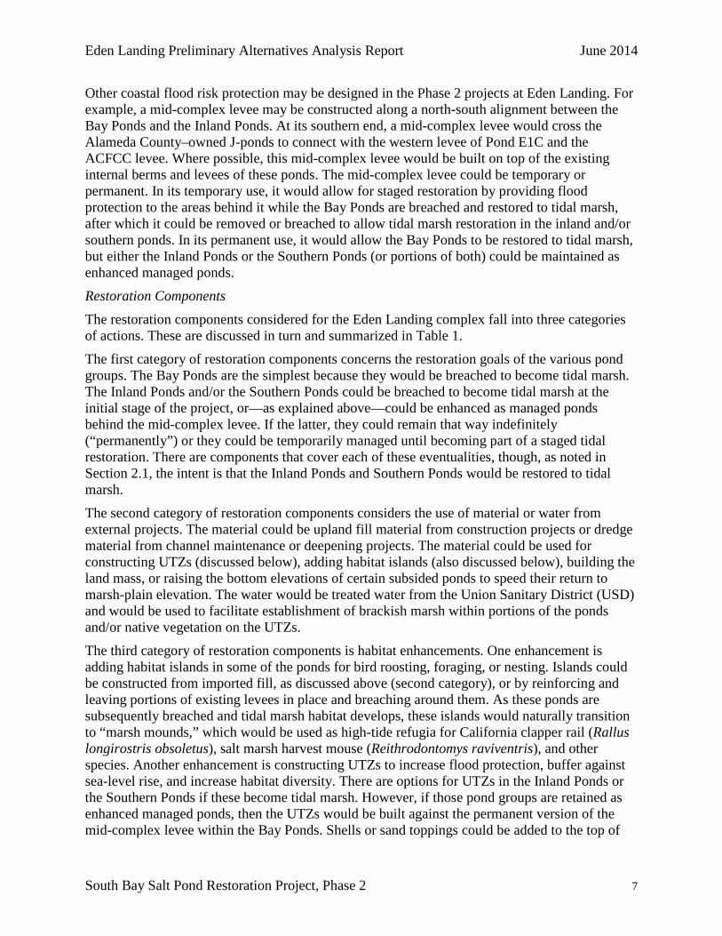
Other coastal flood risk protection may be designed in the Phase 2 projects at Eden Landing. For example, a mid-complex levee may be constructed along a north-south alignment between the Bay Ponds and the Inland Ponds. At its southern end, a mid-complex levee would cross the Alameda County–owned J-ponds to connect with the western levee of Pond E1C and the ACFCC levee. Where possible, this mid-complex levee would be built on top of the existing internal berms and levees of these ponds. The mid-complex levee could be temporary or permanent. In its temporary use, it would allow for staged restoration by providing flood protection to the areas behind it while the Bay Ponds are breached and restored to tidal marsh, after which it could be removed or breached to allow tidal marsh restoration in the inland and/or southern ponds. In its permanent use, it would allow the Bay Ponds to be restored to tidal marsh, but either the Inland Ponds or the Southern Ponds (or portions of both) could be maintained as enhanced managed ponds.
Restoration Components The restoration components considered for the Eden Landing complex fall into three categories of actions. These are discussed in turn and summarized in Table 1.
The first category of restoration components concerns the restoration goals of the various pond groups. The Bay Ponds are the simplest because they would be breached to become tidal marsh. The Inland Ponds and/or the Southern Ponds could be breached to become tidal marsh at the initial stage of the project, or—as explained above—could be enhanced as managed ponds behind the mid-complex levee. If the latter, they could remain that way indefinitely (“permanently”) or they could be temporarily managed until becoming part of a staged tidal restoration. There are components that cover each of these eventualities, though, as noted in Section 2.1, the intent is that the Inland Ponds and Southern Ponds would be restored to tidal marsh.
The second category of restoration components considers the use of material or water from external projects. The material could be upland fill material from construction projects or dredge material from channel maintenance or deepening projects. The material could be used for constructing UTZs (discussed below), adding habitat islands (also discussed below), building the land mass, or raising the bottom elevations of certain subsided ponds to speed their return to marsh-plain elevation. The water would be treated water from the Union Sanitary District (USD) and would be used to facilitate establishment of brackish marsh within portions of the ponds and/or native vegetation on the UTZs.
The third category of restoration components is habitat enhancements. One enhancement is adding habitat islands in some of the ponds for bird roosting, foraging, or nesting. Islands could be constructed from imported fill, as discussed above (second category), or by reinforcing and leaving portions of existing levees in place and breaching around them. As these ponds are subsequently breached and tidal marsh habitat develops, these islands would naturally transition to “marsh mounds,” which would be used as high-tide refugia for California clapper rail (Rallus longirostris obsoletus), salt marsh harvest mouse (Reithrodontomys raviventris), and other species. Another enhancement is constructing UTZs to increase flood protection, buffer against sea-level rise, and increase habitat diversity. There are options for UTZs in the Inland Ponds or the Southern Ponds if these become tidal marsh. However, if those pond groups are retained as enhanced managed ponds, then the UTZs would be built against the permanent version of the mid-complex levee within the Bay Ponds. Shells or sand toppings could be added to the top of

June 2014 Eden Landing Preliminary Alternatives Analysis Report
8 South Bay Salt Pond Restoration Project, Phase 2
the land mass, to remaining levees, or to constructed habitat islands to improve their suitability for nesting western snowy plover (Charadrius alexandrines nivosus). A final component in this category is creating deepwater channels to direct flows into different portions of the ponds and to improve the habitat quality and connectivity for fish species.
Table 1 lists all of these coastal flood risk protection and restoration components and the variations being considered for each of them. Some components have only two variations or options: implement or do not implement. An example of this component is armoring or otherwise controlling the sizes of the breaches. The armoring option would be implemented where the breach needs to remain at its constructed width, most notably wherever breach size affects coastal flood risk protection or where a bridge may be necessary to span the breach to provide ongoing access for operations and maintenance or for public access. Other components have a range of degrees of implementation or a range of locations where they are implemented: for example, how many UTZs are constructed and in which places. The alphanumeric codes in Table 1 are provided as a shorthand way to refer to certain configurations. For example, building the land mass would be component 1b; building the backside levee would be component 1c.
The combination of these various components into preliminary alternatives is discussed below. Table 1. Restoration and Flood Control Components and Variations Code Restoration and Flood Component Variations Letter
# Control Components a b c d e 1 Primary Flood Control As-Is Land Mass Backside Levee 2 Mid-Complex Levee No Yes - Temporary Yes - Permanent
3 Upland Transition Zone No In Inland Ponds In Bay Ponds In Southern Ponds Against Land Mass
4 Inland Ponds As-Is Tidal Marsh Temporary Managed Ponds
Permanent Managed Ponds
5 Southern Ponds As-Is Tidal Marsh Temporary Managed Ponds
Permanent Managed Ponds
6 Breach Control No Yes (at bridges)
7 Accept Dredge / Upland Material No Yes - for Land
Mass Yes - for UTZ Yes - for Pond Bottoms
Yes - Inland Yes - Inland Ponds Yes - Southern 8 Freshwater from USD No Ponds - Brackish – Brackish Marsh Ponds - Brackish
Marsh and/or UTZ Marsh and/or UTZ
9 Deepwater Pilot Channels No Yes
10 Islands/Mounds in Ponds No Yes - Managed Pond Islands Yes - Marsh Mounds
11 Shell Topping on Land Mass No Yes
Recreation and Public Access Components Seven primary components address public access and recreation, and two of these components have variations to achieve a similar goal and recreational experience or opportunity. Almost all of these components can be decided on independently. Any or none of these components may ultimately be chosen based on their feasibility and potential impacts. No components directly conflict with others, and very few are dependent on others being implemented. The exceptions are noted below. The recreational and public access components are:

Eden Landing Preliminary Alternatives Analysis Report June 2014
South Bay Salt Pond Restoration Project, Phase 2 9
1. Complete Bay Trail spine through Phase 2 Area o 1a – Bay Trail spine alignment placed on ELER levees on eastern side of (from
north to south) Ponds E6, E5, E6C, and E4C; the southernmost portion of the alignment would be constructed on a levee east of Cargill Pond 3C (CP3C) (the trail would be on county-owned land to the east or be placed on CDFW land)
o 1b – Bay Trail runs along an alternate route to the east of ELER on land owned by the county or landowners other than CDFW or Cargill
2. Spur trail on south side of Old Alameda Creek to Alvarado Salt Works 3. Maintain existing trail to bay on ACFCC Levee – this is essentially a bridge over an
armored breach or alteration of the ACFCC levee to maintain the current trail 4. Trail around portions of the Southern Ponds; some components require acquiring the
Cargill inholdings (Pond 3C, Turk Island, and Cal Hill) o 4a – Loop trail from Bay Trail spine around northern and western ends of the
Southern Ponds; connects with the ACFCC trail o 4b – Cuts across the southern end of the Southern Ponds along the border of
Cargill Pond 3C; then turns south to join the ACFCC trail o 4c – Turk Island Summit Loop Trail; initially, the same trail as component 4a but
turns south over the Turk Island summit and then goes southeast to ACFCC 5. Pedestrian and bicycle bridge over ACFCC; this component would connect with the trail
system in Coyote Hills Regional Park to the south 6. Trail on north side of Old Alameda Creek; this component requires component 2 to be
chosen; it would run along the northern side of Old Alameda Creek and include a bridge to cross the creek and connect to the spur trail at the Alvarado Salt Works
7. Add recreational information and/or an interpretive feature along the ACFCC levee trail at a location to be determined
Table 2 lists these recreation and public access components. The combination of these various components into alternatives is discussed below. Table 2. Recreation and Public Access Alternative Components
Code No. Component Description 1 a – Complete Bay Trail spine through Phase 2 Area
b – Bay Trail alternate route (east of ELER)
2 Spur trail on south side of Old Alameda Creek to Salt Works 3 Retain existing trail to bay on ACFCC levee (includes bridge over breach)
a – Loop trail around perimeter of Southern Ponds
4 b –Trail through Southern Ponds
c – Turk Island summit loop trail
5 Pedestrian / bicycle bridge over ACFCC 6 Trail on north side of Old Alameda Creek with bridge to #2 7 Recreation info and/or interpretive feature near Southern Ponds breach or culvert location
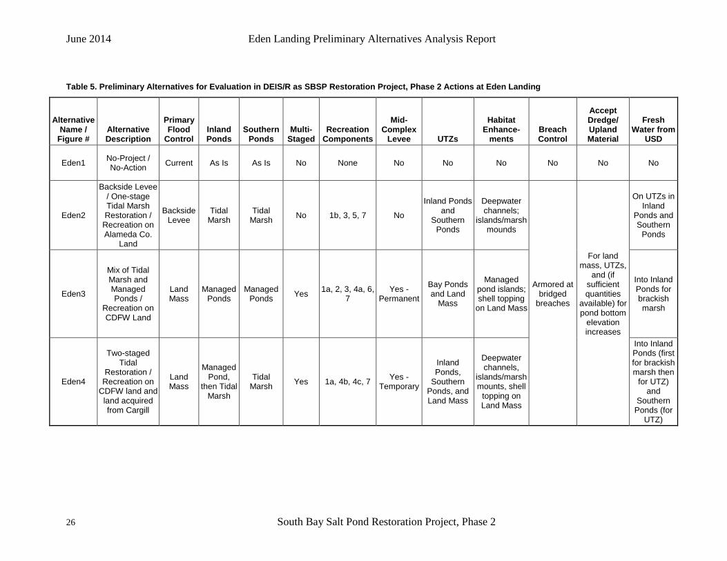
2.3 Development of Alternatives Table 3 shows the combination of the above restoration and flood control components into four preliminary alternatives to achieve the SBSP Restoration Project goals plus a No-Action Alternative (“No Action” is the NEPA term; the equivalent term under CEQA is “No-Project

June 2014 Eden Landing Preliminary Alternatives Analysis Report
10 South Bay Salt Pond Restoration Project, Phase 2
Alternative”). The names and numbers of the alternatives are for purposes of planning and internal discussion only. The names and numbers provide an indexing system and a brief description of the overall intent or effect of each alternative. They do not convey any order of preference or priority. Maps of these alternatives are presented on Figures Rest1 through Rest5.
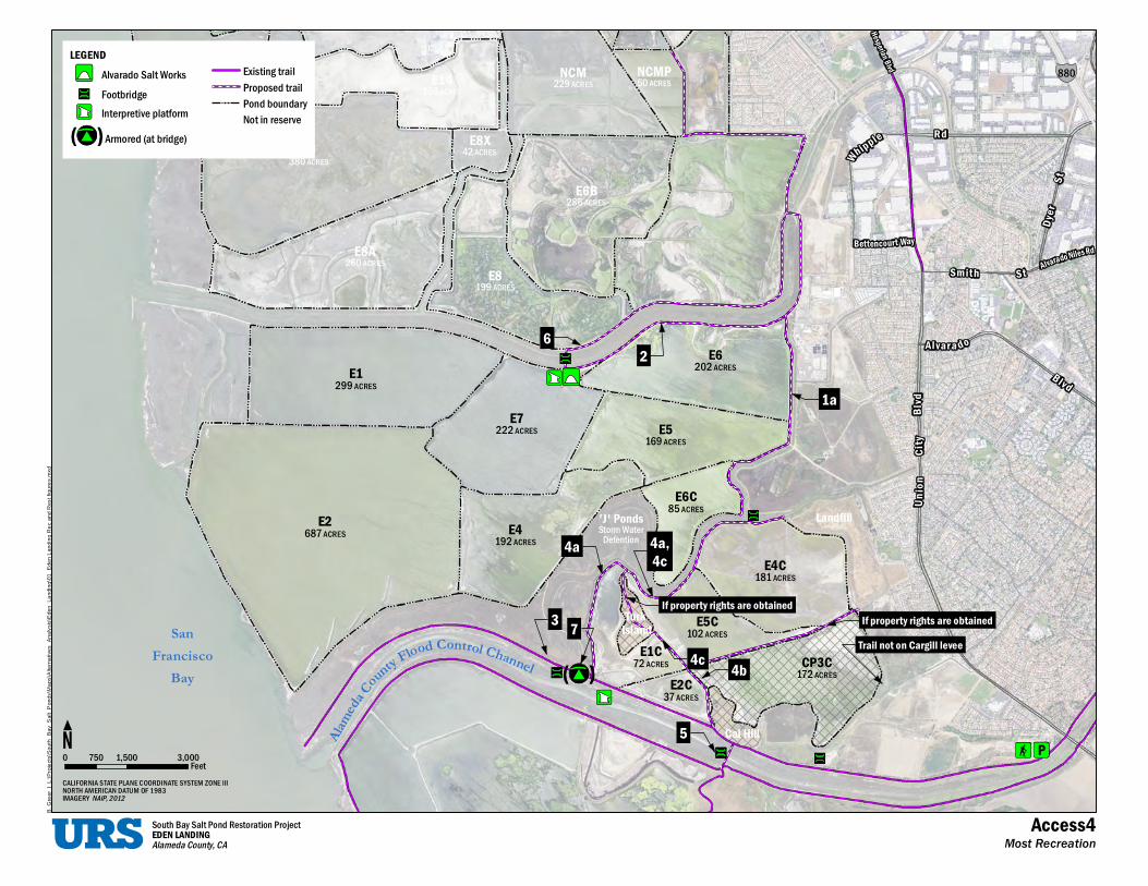
Similarly, Table 4 shows the combination of the recreation and public access components into three preliminary alternatives and a no-project alternative. These alternatives are named and ordered in an array that reflects the provision of the fewest new access and recreation features to the greatest number of new features in this interim step of developing alternatives; they do not reflect any preference or priority. Maps of these alternatives are presented on Figures Access1 through Access4.
The figures are presented on the pages that follow.

'J' Ponds LandfillStorm Water
Detention
Turk IslandSan o tood C n roll Cr F haF ancisco y nt nen luBay oCademaAl Cal Hill
dvlBy ti C
n o in U
dAlvarado Blv
Smith St
Bettencourt Way
E8X42 ACRES dR
E9380 ACRES e
E6B lpp286 ACRES i hW
E8A260 ACRES
E8199 ACRES
E6202E1 ACRES
299 ACRES
E7222 ACRES E5
169 ACRES
E6C85 ACRES
E2687 ACRES E4
192 ACRES
E4C181 ACRES
E5C102 ACRES
E1C72 ACRES CP3C
172 ACRESE2C
37 ACRES
dxm
s.erugif tseR dna
c eR gnidnaL ned
E_10\gnidnaL_nedE
s\siylan
A_sveitanretl
As\pa
M\sdnoP_tla
Sy_a
B_htuoS
s\ctejor
P\:L | reerG .
B
South Bay Salt Pond Restoration ProjectEDEN LANDINGAlameda County, CA
LEGENDAlvarado Salt Works Existing trail
Pond boundaryNot in reserve
0 750 1,500 3,000FeetCALIFORNIA STATE PLANE COORDINATE SYSTEM ZONE IIINORTH AMERICAN DATUM OF 1983IMAGERY NAIP, 2012
Rest1No Project / No Action Alternative

'J' Ponds LandfillStorm Water
Detention
Turk IslandSan o tood C n roll Cr F haF ancisco y nt nen luBay oCademaAl Cal Hill
dvlBy ti C
n o in U
dAlvarado Blv
Smith St
Bettencourt Way
E8X42 ACRES dR
E9380 ACRES e
E6B lpp286 ACRES i hW
E8A260 ACRES
E8199 ACRES
E6202E1 ACRES
299 ACRES
E7222 ACRES E5
169 ACRES
E6C85 ACRES
E2687 ACRES E4
192 ACRES
E4C181 ACRES
E5C102 ACRES
E1C CP3C72 ACRES 172 ACRESE2C
37 ACRES
dxm
s.erugif tseR dna
c eR gnidnaL ned
E_10\gnidnaL_nedE
s\siylan
A_sveitanretl
As\pa
M\sdnoP_tla
Sy_a
B_htuoS
s\ctejor
P\:L | reerG .
B
South Bay Salt Pond Restoration ProjectEDEN LANDINGAlameda County, CA
LEGENDAlvarado Salt WorksFootbridgeProposed control gate
Breach
Armored (at bridge)
Existing trailPond boundaryNot in reserveChannel excavationPermanent levee
Pilot channelIsland/ moundEcotoneTidal marsh
0 750 1,500 3,000FeetCALIFORNIA STATE PLANE COORDINATE SYSTEM ZONE IIINORTH AMERICAN DATUM OF 1983IMAGERY NAIP, 2012
Rest2Flood Protection from Backside Levee

'J' Ponds LandfillStorm Water
Detention
Turk IslandSan o tood C n roll Cr F haF ancisco y nt nen luBay oCademaAl Cal Hill
dvlBy ti C
n oi n U
dAlvarado Blv
Smith St
Bettencourt Way
E8X42 ACRES dR
E9380 ACRES e
E6B lpp286 ACRES i hW
E8A260 ACRES
E8199 ACRES
E6202E1 ACRES
299 ACRES
E7222 ACRES E5
169 ACRES
E6C85 ACRES
E2687 ACRES E4
192 ACRES
E4C181 ACRES
E5C102 ACRES
E1C CP3C72 ACRES 172 ACRESE2C
37 ACRES
dxm
s.erugif tseR dna
c eR gnidnaL ned
E_10\gnidnaL_nedE
s\siylan
A_sveitanretl
As\pa
M\sdnoP_tla
Sy_a
B_htuoS
s\ctejor
P\:L | reerG .
B
South Bay Salt Pond Restoration ProjectEDEN LANDINGAlameda County, CA
LEGENDAlvarado Salt WorksFootbridgeProposed control gateBreach
Armored (at bridge)
Existing trailPond boundaryNot in reserveChannel excavationPermanent leveePilot channel
Island/moundEcotoneShell/Sand ToppingLandmassManaged Pond, PermanentTidal marsh
0 750 1,500 3,000FeetCALIFORNIA STATE PLANE COORDINATE SYSTEM ZONE IIINORTH AMERICAN DATUM OF 1983IMAGERY NAIP, 2012
Rest3Mix of Marsh & Ponds

'J' Ponds LandfillStorm Water
Detention
Turk IslandSan o tood C n roll Cr F haF ancisco y nt nen luBay oCademaAl Cal Hill
dvlBy ti C
n oi n U
dAlvarado Blv
Smith St
Bettencourt Way
E8X42 ACRES dR
E9380 ACRES e
E6B lpp286 ACRES i hW
E8A260 ACRES
E8199 ACRES
E6202E1 ACRES
299 ACRES
E7222 ACRES E5
169 ACRES
E6C85 ACRES
E2687 ACRES E4
192 ACRES
E4C181 ACRES
E5C102 ACRES
E1C CP3C72 ACRES 172 ACRESE2C
37 ACRES
dxm
s.erugif tseR dna
c eR gnidnaL ned
E_10\gnidnaL_nedE
s\siylan
A_sveitanretl
As\pa
M\sdnoP_tla
Sy_a
B_htuoS
s\ctejor
P\:L | reerG .
B
South Bay Salt Pond Restoration ProjectEDEN LANDINGAlameda County, CA
LEGENDAlvarado Salt WorksFootbridgeProposed control gateBreach
Armored (at bridge)
Existing trailPond boundaryNot in reserveChannel excavationTemporary leveePilot channel
Island/ moundEcotoneShell/Sand ToppingLandmassManaged Pond, then tidal marshTidal marsh
0 750 1,500 3,000FeetCALIFORNIA STATE PLANE COORDINATE SYSTEM ZONE IIINORTH AMERICAN DATUM OF 1983IMAGERY NAIP, 2012
Rest4Full Tidal Restoration (phased)

Alameda
County Flood Control ChannelSan
FranciscoBay
'J' PondsStorm Water
Detention
Turk Island
Cal Hill
Landfill
Union
City
B lvd
Alvarado Blvd
Smith St
Bettencourt Way
Whipp
leRd
E6B286 ACRES
E8199 ACRES
E8X42 ACRES
E9380 ACRES
E8A260 ACRES
E2C37 ACRES
CP3C172 ACRES
E1C72 ACRES
E4C181 ACRES
E5C102 ACRES
E6C85 ACRES
E5169 ACRES
E6202 ACRES
E4192 ACRES
E7222 ACRES
E1299 ACRES
E2687 ACRES
B. G
reer
| L
:\Pro
ject
s\S
outh
_Bay
_Sal
t_P
onds
\Map
s\A
ltern
ativ
es_A
naly
sis\
Ede
n_La
ndin
g\01
_Ede
n La
ndin
g R
ec a
nd R
est f
igur
es.m
xd
South Bay Salt Pond Restoration ProjectEDEN LANDINGAlameda County, CA
LEGENDAlvarado Salt WorksFootbridgeProposed control gateBreach
Armored (at bridge)
Existing trailPond boundaryNot in reserveChannel excavationPilot channelIsland/ mound
EcotoneShell/Sand ToppingLandmassTidal marsh
0 1,500 3,000750 FeetCALIFORNIA STATE PLANE COORDINATE SYSTEM ZONE IIINORTH AMERICAN DATUM OF 1983IMAGERY NAIP, 2012
Rest5Full Tidal Restoration (unphased)
'J' Ponds LandfillStorm Water
Detention
Turk San Island
od ControlFrancisco oFl Chaty nnn elBay uoCademaAl Cal Hill
RidaAlv ra o N les d
dvlBy ti C
noinU
Smith St
Al vara do
Blvd
Bettencourt Way
Hesperian Blvd
e RdplphiW
NCM NCMPE14 229 ACRES 50 ACRES168 ACRES
E8XE9 42 ACRES380 ACRES
tSE6B286 ACRES reyD
E8A260 ACRES
E8199 ACRES
E6202E1 ACRES
299 ACRES
E7222 ACRES E5
169 ACRES
E6C85 ACRES
E2687 ACRES E4
192 ACRES
E4C181 ACRES
E5C102 ACRES
E1C72 ACRES CP3C
172 ACRESE2C37 ACRES
880
dxm
s.erugif tseR dna
c eR gnidnaL ned
E_10\gnidnaL_nedE
s\siylan
A_sveitanretl
As\pa
M\sdnoP_tla
Sy_a
B_htuoS
s\ctejor
P\:L | reerG .
B
South Bay Salt Pond Restoration ProjectEDEN LANDINGAlameda County, CA
LEGENDAlvarado Salt Works Existing trail
Pond boundaryNot in reserve
0 750 1,500 3,000FeetCALIFORNIA STATE PLANE COORDINATE SYSTEM ZONE IIINORTH AMERICAN DATUM OF 1983IMAGERY NAIP, 2012
Access1No Project / No Action Alternative

'J' Ponds LandfillStorm Water
Detention
Turk San Island
od ControlFrancisco oFl Chaty nnn elBay uoCademaAl Cal Hill
RidaAlv ra o N les d
dvlBy ti C
noinU
Smith St
Al vara do
Blvd
Bettencourt Way
Hesperian Blvd
e Rdp lphiW
NCM NCMPE14 229 ACRES 50 ACRES168 ACRES
E8XE9 42 ACRES380 ACRES
tSE6B286 ACRES reyD
E8A260 ACRES
E8199 ACRES
E6202E1 ACRES
299 ACRES
E7222 ACRES E5
169 ACRES
E6C85 ACRES
E2687 ACRES E4
192 ACRES
E4C181 ACRES
E5C102 ACRES
E1C72 ACRES CP3C
172 ACRESE2C37 ACRES
880
1b
3
5
dxm
s.erugif tseR dna
c eR gnidnaL ned
E_10\gnidnaL_nedE
s\siylan
A_sveitanretl
As\pa
M\sdnoP_tla
Sy_a
B_htuoS
s\ctejor
P\:L | reerG .
B
South Bay Salt Pond Restoration ProjectEDEN LANDINGAlameda County, CA
LEGENDAlvarado Salt WorksFootbridgeArmored (at bridge)
Existing trailProposed trailPond boundaryNot in reserve
0 750 1,500 3,000FeetCALIFORNIA STATE PLANE COORDINATE SYSTEM ZONE IIINORTH AMERICAN DATUM OF 1983IMAGERY NAIP, 2012
Access2Least Recreation

'J' Ponds LandfillStorm Water
Detention
Turk San Island
od ControlFrancisco oFl Chaty nnn elBay uoCademaAl Cal Hill
RidaAlv ra o N les d
dvlBy ti C
noinU
Smith St
Al vara do
Blvd
Bettencourt Way
Hesperian Blvd
e RdplphiW
NCM NCMPE14 229 ACRES 50 ACRES168 ACRES
E8XE9 42 ACRES380 ACRES
tSE6B286 ACRES reyD
E8A260 ACRES
E8199 ACRES
E6202E1 ACRES
299 ACRES
E7222 ACRES E5
169 ACRES
E6C85 ACRES
E2687 ACRES E4
192 ACRES
E4C181 ACRES
E5C102 ACRES
E1C72 ACRES CP3C
172 ACRESE2C37 ACRES
880
Trail not on Cargill leveeIf property rights are obtained3
5
2
1a
4b
7
dxm
s.erugif tseR dna
c eR gnidnaL ned
E_10\gnidnaL_nedE
s\siylan
A_sveitanretl
As\pa
M\sdnoP_tla
Sy_a
B_htuoS
s\ctejor
P\:L | reerG .
B
South Bay Salt Pond Restoration ProjectEDEN LANDINGAlameda County, CA
LEGENDAlvarado Salt WorksFootbridgeInterpretive platformArmored (at bridge)
Existing trailProposed trailPond boundaryNot in reserve
0 750 1,500 3,000FeetCALIFORNIA STATE PLANE COORDINATE SYSTEM ZONE IIINORTH AMERICAN DATUM OF 1983IMAGERY NAIP, 2012
Access3Medium Recreation
'J' Ponds LandfillStorm Water
Detention
Turk San Island
od ControlFrancisco oFl Chaty nnn elBay uoCademaAl Cal Hill
RidaAlv ra o N les d
dvlBy ti C
noinU
Smith St
Al vara do
Blvd
Bettencourt Way
Hesperian Blvd
e RdplphiW
NCM NCMPE14 229 ACRES 50 ACRES168 ACRES
E8XE9 42 ACRES380 ACRES
tSE6B286 ACRES reyD
E8A260 ACRES
E8199 ACRES
E6202E1 ACRES
299 ACRES
E7222 ACRES E5
169 ACRES
E6C85 ACRES
E2687 ACRES E4
192 ACRES
E4C181 ACRES
E5C102 ACRES
E1C72 ACRES CP3C
172 ACRESE2C37 ACRES
880
Trail not on Cargill leveeIf property rights are obtained
If property rights are obtained3
5
2
1a
4b
7
6
4a 4a,4c
4c
dxm
s.erugif tseR dna
c eR gnidnaL ned
E_10\gnidnaL_nedE
s\siylan
A_sveitanretl
As\pa
M\sdnoP_tla
Sy_a
B_htuoS
s\ctejor
P\:L | reerG .
B
South Bay Salt Pond Restoration ProjectEDEN LANDINGAlameda County, CA
LEGENDAlvarado Salt WorksFootbridgeInterpretive platformArmored (at bridge)
Existing trailProposed trailPond boundaryNot in reserve
0 750 1,500 3,000FeetCALIFORNIA STATE PLANE COORDINATE SYSTEM ZONE IIINORTH AMERICAN DATUM OF 1983IMAGERY NAIP, 2012
Access4Most Recreation

June 2014 Eden Landing Preliminary Alternatives Analysis Report
20 South Bay Salt Pond Restoration Project, Phase 2
Table 3. Restoration and Flood Protection Preliminary Alternatives
Fig. #
Preliminary Alternative Name (or
Description, Purpose)
Primary Flood
Control Inland Ponds Southern
Ponds
Multi-Staged Resto-ration
Mid-Complex
Levee UTZs
Habitat Enhance-
ments Breach Control
Accept Dredge/ Upland Material
Fresh Water from USD
Rest1 No Action (No-Project )
Current (1a) As Is (4a) As Is (5a) No No (2a) No (3a) No (9a, 10a,
11a) No (6a) No (7a) No (8a)
Rest2 Flood Protection from Backside Levee
Backside Levee (1c)
Tidal Marsh (4b)
Tidal Marsh (5b) No No (2a) Yes (3b,
3d) Yes (9b,
10c) Yes (6b) Yes (7c, 7d)
Yes (8c, 8d)
Rest3 Mix of Tidal Marsh and Managed Ponds
Land Mass (1b)
Managed Ponds (4d)
Managed Ponds (5d) Yes Yes – Perm.
(2c) Yes (3c,
3e) Yes (9b, 10b, 11b) Yes (6b) Yes (7b,
7c, 7d) Yes (8b)
Rest4 Full Tidal Restoration (staged)
Land Mass (1b)
Tidal Marsh (4c then 4b)
Tidal Marsh (5c then
5b) Yes Yes – Temp.
(2b) Yes (3b,
3d) Yes (9b,
10b/c, 11b) Yes (6b) Yes (7b, 7c, 7d)
Yes (8b then 8c,
8d)
Rest5 Full Tidal Restoration (one-stage)
Land Mass (1b)
Tidal Marsh (4b)
Tidal Marsh (5b) No No (2a) Yes (3b,
3d) Yes (9b, 10b, 11b) Yes (6b) Yes (7b,
7c, 7d) Yes (8c,
8d)
Table 4. Recreation and Public Access Preliminary Alternatives
Fig. # Preliminary Alternative Name
(Description*) Recreation/Public Access Options
Access1 No-Project / No-Action None
Access2 Least Recreation 1b, 3
Access3 Medium Recreation 1a, 2, 3, 4b, 5, 7
Access4 Most Recreation 1a, 2, 3, 4a, 4c, 5, 6, 7
*The use of terms such as “least” or “most” recreation is not intended to reflect a preference for or bias toward any particular degree of recreation. Rather, the terms are descriptions of the number of recreation and public access components included in that assemblage of components.

Eden Landing Preliminary Alternatives Analysis Report June 2014
South Bay Salt Pond Restoration Project, Phase 2 21
These components (i.e., those specific to restoration and flood control or to recreation/ public access) were then combined to form alternatives that would address all three project goals. These alternatives are those that would be carried forward into conceptual design and for consideration in the DEIS/R that will be prepared for Phase 2 activities at Eden Landing.
Two other adjustments were made. First, the recreation and public access components were reconfigured according to land ownership as follows:
• No Action Alternative • New recreation on Alameda County (and some CDFW) land • New recreation entirely on CDFW land • New recreation on lands acquired from Cargill & existing CDFW land
Note that the ownership was not used as a way to select the alternatives or the individual components. Rather, it was used as a way to group components and to illustrate how the range of options to include in the eventual selection of a Preferred Alternative would change based on the land that is available or that becomes available at that time.
Second, the backside levee and associated components in Rest2 were combined with the one-stage tidal recreation and associated components in Rest5. This combination reduced the number of preliminary alternatives to be carried forward without losing any individual component.
• No Action Alternative • Flood protection from backside levee / one-stage tidal restoration • Flood protection from land mass / mix of tidal marsh and managed ponds • Flood protection from land mass / staged tidal restoration
Following those adjustments, the components were then combined into three preliminary action alternatives and a No Action (No-Project) Alternative. These preliminary alternatives will be refined as needed and evaluated in the DEIS/R for Phase 2 at Eden Landing. They are named Eden1 through Eden4, as noted in Table 5, which describes these preliminary alternatives and the components that make them up. Maps of these preliminary alternatives are presented as Figures Eden1 through Eden4 on the pages that follow.


Alameda
County Flood Control Channel
SanFrancisco
Bay
'J' PondsStorm Water
Detention
Turk Island
Cal Hill
Landfill, Private Parcel
CP3C
E6A325 ACRES
NCMP50 ACRES
E6B286 ACRES
E8199 ACRES
E14B34 ACRES
E15B28 ACRES
E16B85 ACRES
E11125 ACRESE10
220 ACRESE12
117 ACRES
E13134 ACRES
E14168 ACRES
20B66 ACRES
E2C37 ACRES
E1C72 ACRES
E4C181 ACRES
E5C102 ACRES
E6C85 ACRES
E5169 ACRES
E6202 ACRES
E4192 ACRES
E7222 ACRES
E1299 ACRES
E2687 ACRES
UR
S O
akla
nd C
A 6/
20/2
014
USER
Mai
anna
_Vog
e PA
TH L
:\Pro
ject
s\S
outh
_Bay
_Sal
t_P
onds
\Map
s\A
ltern
ativ
es_A
naly
sis\
Ede
n_La
ndin
g\01
_Ede
n La
ndin
g C
OM
BIN
ED
Rec
and
Res
t fig
ures
.mxd
Alvarado Salt Works Existing trailBoundary of current or former ELER pond
ELER Boundary (CDFW)Phase 1
Enhanced managed pondTidal marsh
OwnershipMap label color corresponds to owner ofPhase 2 & adjacent properties
CA Department of Fish and WildlifeCargillCounty
0 2,000 4,0001,000 FeetCALIFORNIA STATE PLANE COORDINATE SYSTEM ZONE III
NORTH AMERICAN DATUM OF 1983IMAGERY NAIP, 2012
Eden1South Bay Salt Pond Restoration ProjectEDEN LANDINGAlameda County, CA

Alameda
County Flood Control Channel
SanFrancisco
Bay
'J' PondsStorm Water
Detention
Turk Island
Cal Hill
Landfill, Private Parcel
CP3C
E6A325 ACRES
NCMP50 ACRES
E6B286 ACRES
E8199 ACRES
E14B34 ACRES
E15B28 ACRES
E16B85 ACRES
E11125 ACRESE10
220 ACRESE12
117 ACRES
E13134 ACRES
E14168 ACRES
20B66 ACRES
E2C37 ACRES
E1C72 ACRES
E4C181 ACRES
E5C102 ACRES
E6C85 ACRES
E5169 ACRES
E6202 ACRES
E4192 ACRES
E7222 ACRES
E1299 ACRES
E2687 ACRES
UR
S O
akla
nd C
A 6/
20/2
014
USER
Mai
anna
_Vog
e PA
TH L
:\Pro
ject
s\S
outh
_Bay
_Sal
t_P
onds
\Map
s\A
ltern
ativ
es_A
naly
sis\
Ede
n_La
ndin
g\01
_Ede
n La
ndin
g C
OM
BIN
ED
Rec
and
Res
t fig
ures
.mxd
Alvarado Salt WorksFootbridgeInterpretive platformProposed control gateBreach
Armored (at bridge)
Existing trailProposed trailBoundary of current or former ELER pondChannel excavation
Permanent leveePilot channelIsland/ moundUpland transition zone
Phase 2 GoalTidal marsh
ELER Boundary (CDFW)Phase 1
Enhanced managed pondTidal marsh
OwnershipMap label color corresponds to owner ofPhase 2 & adjacent properties
CA Department of Fish and WildlifeCargillCounty
0 2,000 4,0001,000 FeetCALIFORNIA STATE PLANE COORDINATE SYSTEM ZONE III
NORTH AMERICAN DATUM OF 1983IMAGERY NAIP, 2012
Eden2South Bay Salt Pond Restoration ProjectEDEN LANDINGAlameda County, CA
CoFl od ontrol Channty neluoCademlaA
SanFrancisco
Bay
'J' PondsStorm Water
Detention
Turk Island
Cal Hill
Landfill, Private Parcel
CP3C
E6A325 ACRES
NCMP50 ACRES
E6B286 ACRES
E8199 ACRES
E14B34 ACRES
E15B28 ACRES
E16B85 ACRES
E11125 ACRESE10
220 ACRESE12
117 ACRES
E13134 ACRES
E14168 ACRES
20B66 ACRES
E2C37 ACRES
E1C72 ACRES
E4C181 ACRES
E5C102 ACRES
E6C85 ACRES
E5169 ACRES
E6202 ACRES
E4192 ACRES
E7222 ACRES
E1299 ACRES
E2687 ACRES
xdm
s.erugif ste
R dnac e
R D
ENI
BM
OC gnidnaL ned
E_10\gnidnaL_nedE
s\siylan
A_sveitanretl
As\pa
M\sdnoP_tla
Sy_a
B_htuoS
s\ctejor
P\:L HTAP egoV_annaia
M RESU 4102/02/6 AC dna
klaO
SR
U
Alvarado Salt WorksFootbridgeInterpretive platformProposed control gateBreach
Armored (at bridge)
Existing trailProposed trailBoundary of current or former ELER pondChannel excavation
Permanent leveePilot channelIsland/moundUpland transition zoneLandmass
Phase 2 GoalManaged Pond, PermanentTidal marsh
ELER Boundary (CDFW)Phase 1
Enhanced managed pond
OwnershipMap label color corresponds to owner ofPhase 2 & adjacent properties
Tidal marsh CA Department of Fish and WildlifeCargillCounty
0 1,000 2,000 4,000FeetCALIFORNIA STATE PLANE COORDINATE SYSTEM ZONE III
NORTH AMERICAN DATUM OF 1983IMAGERY NAIP, 2012
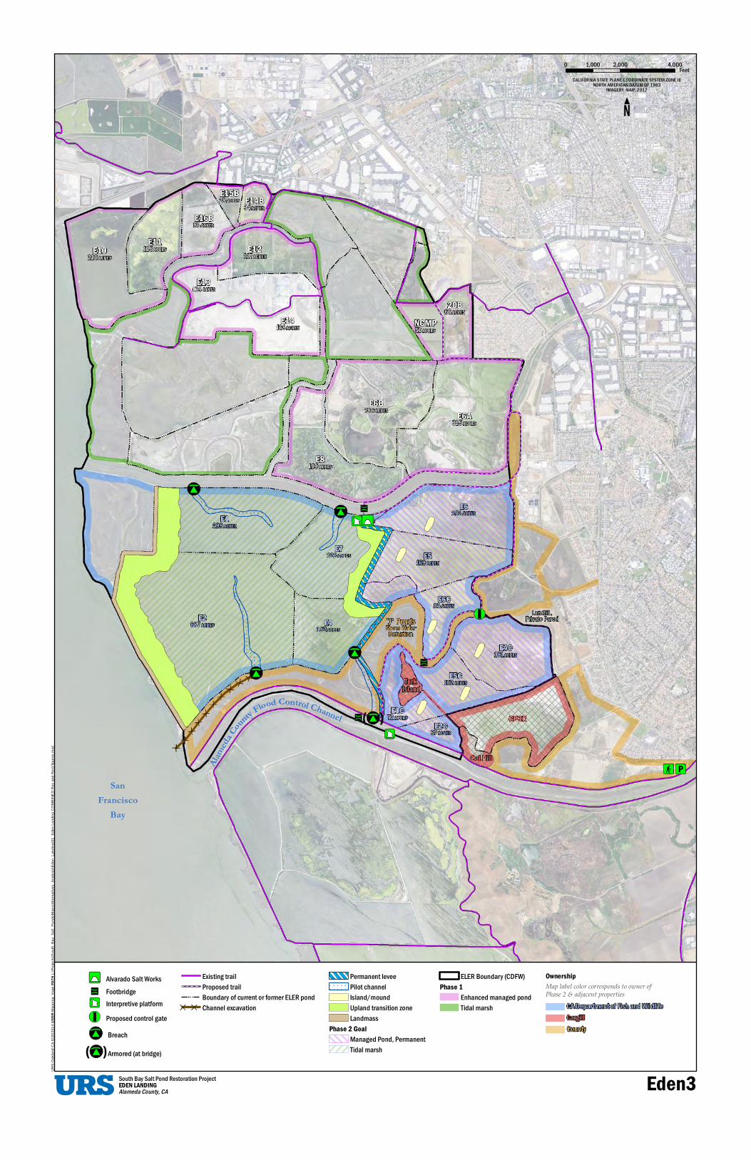
South Bay Salt Pond Restoration ProjectEDEN LANDINGAlameda County, CA Eden3

CoFl od ontrol Channty neluoCademlaA
SanFrancisco
Bay
'J' PondsStorm Water
Detention
Turk Island
Cal Hill
Landfill, Private Parcel
CP3C
E6A325 ACRES
NCMP50 ACRES
E6B286 ACRES
E8199 ACRES
E14B34 ACRES
E15B28 ACRES
E16B85 ACRES
E11125 ACRESE10
220 ACRESE12
117 ACRES
E13134 ACRES
E14168 ACRES
20B66 ACRES
E2C37 ACRES
E1C72 ACRES
E4C181 ACRES
E5C102 ACRES
E6C85 ACRES
E5169 ACRES
E6202 ACRES
E4192 ACRES
E7222 ACRES
E1299 ACRES
E2687 ACRES
xdm
s.erugif ste
R dnac e
R D
ENI
BM
OC gnidnaL ned
E_10\gnidnaL_nedE
s\siylan
A_sveitanretl
As\pa
M\sdnoP_tla
Sy_a
B_htuoS
s\ctejor
P\:L HTAP egoV_annaia
M RESU 4102/02/6 AC dna
klaO
SR
U
Alvarado Salt WorksFootbridgeInterpretive platformProposed control gateBreach
Armored (at bridge)
Existing trailProposed trailBoundary of current or former ELER pondChannel excavation
Temporary leveePilot channelIsland/ moundUpland transition zoneLandmass with shell/sand topping
Phase 2 GoalManaged Pond, then tidal marshTidal marsh
ELER Boundary (CDFW)Phase 1
Enhanced managed pond
OwnershipMap label color corresponds to owner ofPhase 2 & adjacent properties
Tidal marsh CA Department of Fish and WildlifeCargillCounty
0 1,000 2,000 4,000FeetCALIFORNIA STATE PLANE COORDINATE SYSTEM ZONE III
NORTH AMERICAN DATUM OF 1983IMAGERY NAIP, 2012
South Bay Salt Pond Restoration ProjectEDEN LANDINGAlameda County, CA Eden4
June 2014 Eden Landing Preliminary Alternatives Analysis Report
26 South Bay Salt Pond Restoration Project, Phase 2
Table 5. Preliminary Alternatives for Evaluation in DEIS/R as SBSP Restoration Project, Phase 2 Actions at Eden Landing
Alternative Name /
Figure # Alternative Description
Primary Flood
Control Inland Ponds
Southern Ponds
Multi-Staged
Recreation Components
Mid-Complex
Levee UTZs
Habitat Enhance-
ments Breach Control
Accept Dredge/ Upland Material
Fresh Water from
USD
Eden1 No-Project / No-Action Current As Is As Is No None No No No No No No
Eden2
Backside Levee / One-stage Tidal Marsh Restoration /
Recreation on Alameda Co.
Land
Backside Levee
Tidal Marsh
Tidal Marsh No 1b, 3, 5, 7 No
Inland Ponds and
Southern Ponds
Deepwater channels;
islands/marsh mounds
On UTZs in Inland
Ponds and Southern
Ponds
Eden3
Mix of Tidal Marsh and Managed Ponds /
Recreation on CDFW Land
Land Mass
Managed Ponds
Managed Ponds Yes 1a, 2, 3, 4a, 6,
7 Yes -
Permanent
Bay Ponds and Land
Mass
Managed pond islands; shell topping
on Land Mass
Armored at bridged
breaches
For land mass, UTZs,
and (if sufficient quantities
available) for pond bottom
elevation increases
Into Inland Ponds for brackish marsh
Eden4
Two-staged Tidal
Restoration / Recreation on
CDFW land and land acquired from Cargill
Land Mass
Managed Pond,
then Tidal Marsh
Tidal Marsh Yes 1a, 4b, 4c, 7 Yes -
Temporary
Inland Ponds,
Southern Ponds, and Land Mass
Deepwater channels,
islands/marsh mounts, shell
topping on Land Mass
Into Inland Ponds (first for brackish marsh then
for UTZ) and
Southern Ponds (for
UTZ)

Eden Landing Preliminary Alternatives Analysis Report June 2014
South Bay Salt Pond Restoration Project, Phase 2 27
Section 3. Alternative Development Process and Methods Section 2 explained the development of the individual components and their rearrangement into preliminary alternatives. That discussion focused largely on the components, what they were intended to achieve, and their different combinations into preliminary alternatives for analysis in the DEIS/R. Other components and combinations of components not discussed in Section 2 had previously been created, developed, discussed, and eventually screened out as being unfeasible, prohibitively costly, or unacceptable from the position of one or more stakeholders.
In contrast, Section 3 presents the methods and processes by which some of the important details of these components were developed and selected. That is to say, Section 2 focuses on the “what,” while Section 3 focuses on the “how” and “why.” These ideas are presented in different sections to make the alternatives easier to find and compare with the maps that illustrate them, while separating out the details of the larger process, the modeling that went into certain aspects of the design, and so on.
The initial concepts for the preliminary conceptual designs were first drawn from the PEIS/R and the end state for each pond under Programmatic Alternative C. Then, the SBSP Restoration Project conducted an assessment of more recently developed ideas for enhancing restoration efforts by combining them with an innovative new idea for coastal flood risk protection—the land mass concept (discussed below)—and different staging options for restoration actions and recreation/public access improvements.
These options were explored and summarized in an Opportunities and Constraints Memorandum (O/C Memo), which was reviewed by the SBSP Restoration Project’s Project Management Team (PMT) and key stakeholders within it, including Alameda County. The memorandum was made available to outside stakeholders through the SBSP Restoration Project website. The O/C Memo was revised based on stakeholder input and several revised conceptual designs were presented at the Project’s annual Stakeholder Forum meeting.
In parallel with these efforts, the Alameda County Flood Control District (ACFCD) was conducting modeling and analysis on its own to determine the potential “solution space” for coastal flood risk protection using various combinations of breach numbers, sizes, and locations and what the associated tidal elevations were on the eastern edge of the Eden Landing complex. These models were run with and without a land mass in place.
The land mass, as has been presented at SBSP Restoration Project meetings, Stakeholder Forums, and other events by Rohin Saleh (MS, PE, Supervising Civil Engineer Watershed Planning Section, Alameda County Flood Control District), is a concept intended to obviate the need for a traditional backside levee placed directly between a developed area and a tidal body of water. The land mass would be a large earthen feature placed at some distance from the developed community, much like a barrier island is, with a smaller body of water between it and the developed land. The land mass would achieve with its large size (greater than 100 feet width at the top elevation and extending several thousand feet lengthwise) what more formally engineered levees achieve with tighter compaction of materials, footings, internal structures, and so on. ACFCD modeling efforts indicate that building a land mass on the western edge of Eden Landing and limited breaching of the levees within the interior of ELER to a small number of

June 2014 Eden Landing Preliminary Alternatives Analysis Report
28 South Bay Salt Pond Restoration Project, Phase 2
locations would dampen even the largest tidal flows and provide the necessary coastal flood risk protection to the developed lands behind the ponds. “Necessary”, here, is defined as providing sufficient flood protection such that the Federal Emergency Management Agency (FEMA) does not place those properties in its 100-year flood event inundation maps. Importantly, ACFCD also maintains that this protection could be provided at a lower cost than what it would take to build an engineered levee near the developed area. These costs include but are not limited to land or easement acquisition, design, construction, and certification.
A goal of ACFCD’s modeling was to determine feasible numbers, sizes, and locations of breaches in the exterior, perimeter, and interior levees that may be sufficient to provide adequate tidal exchange while maintaining coastal flood risk protection. Through this modeling, together with a series of workshops and meetings, the ACFCD, CDFW, and the SBSP Restoration Project were able to determine the feasibility of combined habitat restoration and coastal flood risk protection actions.
This determination led to the selection of up to four suitable sites for breaches on the northern and southern boundaries of southern Eden Landing. The breach locations were chosen to capitalize on the historical slough locations (as seen on digitized maps from before the levees were built for salt production). A breach in the northern ACFCC levee could be up to 100 feet wide and armored to allow a bridge to be placed on it (thus maintaining the current trail access to San Francisco Bay on that levee). The ACFCC armored breach would allow tidal flow from ACFCC into Pond E4 and provide adequate drainage. This breach may be fitted with a culvert, fish passage guide, or other infrastructure to help migrating steelhead or other salmonids enter and exit the high-value nursery and forage habitat that the pond interiors would become; this decision is for a future design stage and after additional negotiation with the National Marine Fisheries Service.
A second breach near the bay front would connect Pond E2 with the bay through an excavated channel through tidal marsh at the western end of the J-ponds. The excavated channel would be approximately 3,000 feet long.
The two northern breaches along Old Alameda Creek into Ponds E1 and E7 would not be armored or controlled, so their initial breach sizes (100 to 200 feet wide) could increase over time. Smaller breaches would be created along interior pond levees and could also be left unarmored and allowed to widen over time.
Working within that solution space, the Project then looked for habitat enhancements that could meet the habitat requirements of various species or guilds to provide habitat complexity and connectivity and to take advantage of opportunities for beneficial reuse of dredged material or material from upland construction projects or of treated water from the Union Sanitary District. The locations and combinations of these and other enhancements were discussed in Section 2.
The SBSP Restoration Project held a number of workshops to consider specific placement of the UTZs that had been previously described in the PEIS/R. Habitat islands for high-tide refugia and for use by nesting birds were added, drawing on the early results of the SBSP Project Science Program and applied studies. These islands would be created from grading remaining portions of levees or by constructing entirely new islands, but
Eden Landing Preliminary Alternatives Analysis Report June 2014
South Bay Salt Pond Restoration Project, Phase 2 29
this decision is for a later design stage. The results from applied studies were discussed at workshops and were used to combine habitat features with suitable recreation and public access features.
The recreation and public access components were developed in collaboration with CDFW, the State Coastal Conservancy (SCC), EBRPD, the Association of Bay Area Governments (ABAG), other stakeholders, and the Project’s contractors. Much like the restoration and habitat-enhancement features, the ideas for these components were initially pulled from the PEIS/R, included in the O/C Memo, and augmented with the Bay Trail Plan, the San Francisco Bay Conservation and Development Commission (BCDC) guidelines, and other sources. The recreation/public access components included some ideas that had not been previously considered because they are private land holdings that are not part of Eden Landing complex.
Several options would depend on the SBSP Restoration Project acquiring fee-title from Cargill for Pond 3C (also referred to as “CP3C”) or uplands known as Turk Island and Cal Hill. The full list of many different recreation/public access components was presented at several working sessions. Some were infeasible because of access problems, expense, or conflict with restoration or flood control goals. Those were removed, but those that could become feasible if ownership changes or access easements were acquired were left in.
As noted in Section 2, consideration of all possible combinations of the restoration, recreation, and flood protection components would not have been feasible to present and analyze in an EIS/R. To narrow the options, CDFW, Alameda County, the PMT and other stakeholders decided to combine feasible restoration and coastal flood risk protection actions in such a way as to provide suitable locations for a reasonable range of recreation/public access improvements. This decision allowed development and screening of components and their combination into feasible preliminary alternatives that meet the SBSP Restoration Project goals to implement integrated habitat restoration, high-quality public access improvements, and coastal flood risk protection. These preliminary alternatives were presented to the PMT, the Stakeholder Forum, and other stakeholders; were refined as necessary; and combined into the most feasible preliminary alternatives for SBSP Restoration Project Phase 2 actions at Eden Landing. The combination of components required an analysis of feasibility (i.e., which restoration/public access components were technically possible to combine with the various restoration and flood control components), and the results of this analysis eliminated some, but not many, of the combinations.
Three primary combinations of restoration and flood control components were judged as most appropriate to include together: the backside levee would provide all necessary flood protection, so it was combined with full, one-stage tidal restoration. The land mass concept for flood protection allows tidal restoration with the improvement/construction of a mid-complex levee. That levee may be either temporary, which would leave the Inland Ponds and Southern Ponds as managed ponds for some time before they become tidal. If the Adaptive Management Plan findings show the need for more managed ponds, then the mid-complex levee could instead remain permanent, leaving the Inland Ponds, the Southern Ponds, or a subset of those ponds as enhanced managed ponds. These three

June 2014 Eden Landing Preliminary Alternatives Analysis Report
30 South Bay Salt Pond Restoration Project, Phase 2
main combinations of restoration and flood control components were then modified with enhancements like islands, UTZs, reuse of treated water, various fill materials, and so on.
Because it is extremely difficult and expensive to analyze more than three or four alternatives in an EIS/R, the process was similarly limited to three action alternatives for recreation/public access (ranging from new recreation opportunities on existing CDFW lands, on Alameda County lands, or a combination of both, as well as possible opportunities on other lands that may be acquired from Cargill). Those public access improvements were combined with the three primary action alternatives for habitat restoration and coastal flood risk protection to form the Preliminary Alternatives Eden2, Eden3, and Eden4, as described in Section 2. Combined with the No-Action/No-Project Alternative, this resulted in the preliminary Eden Landing Alternatives described in Section 2 and shown in the map figures. That list was presented to the PMT and stakeholders for their review, comment, and approval before being officially selected for analysis in the DEIS/R.
The DEIS/R will include evaluations and impact analyses of each of the individual components for habitat restoration, public access/recreation, and flood management. From those analyses and the comments received, some individual components of one or more of the draft alternatives may be selected and recombined into a Preferred Alternative for inclusion and analysis in the Final EIS/R.