appendix a initial study/notice of preparation and … general plan update eir...notice of...
TRANSCRIPT

Appendix A Initial Study/Notice of Preparation and
Comment Letters

CITY OF NEWPORT BEACH GENERAL PLAN UPDATENotice of Preparation/Initial Study
Prepared forCity of Newport BeachPlanning Department
3300 Newport Boulevard Newport Beach, California 92658-8915
Prepared byEIP Associates
12301 Wilshire Boulevard, Suite 430 Los Angeles, California 90025
January 2006

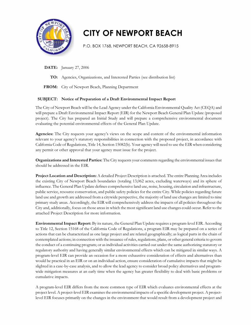
CITY OF NEWPORT BEACH P.O. BOX 1768, NEWPORT BEACH, CA 92658-8915
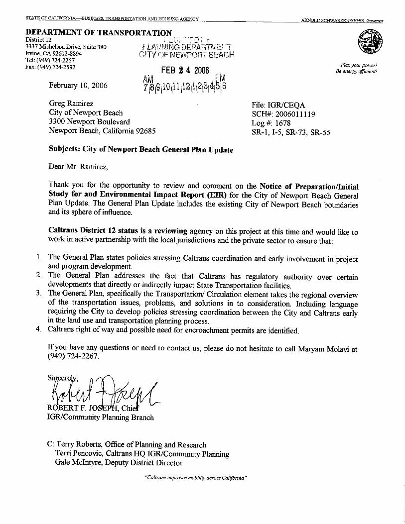
DATE: January 27, 2006
TO: Agencies, Organizations, and Interested Parties (see distribution list)
FROM: City of Newport Beach, Planning Department
SUBJECT: Notice of Preparation of a Draft Environmental Impact Report
The City of Newport Beach will be the Lead Agency under the California Environmental Quality Act (CEQA) and will prepare a Draft Environmental Impact Report (EIR) for the Newport Beach General Plan Update (proposed project). The City has prepared an Initial Study and will prepare a comprehensive environmental document evaluating the potential environmental effects of the General Plan Update.
Agencies: The City requests your agency’s views on the scope and content of the environmental information relevant to your agency’s statutory responsibilities in connection with the proposed project, in accordance with California Code of Regulations, Title 14, Section 15082(b). Your agency will need to use the EIR when considering any permit or other approval that your agency must issue for the project.
Organizations and Interested Parties: The City requests your comments regarding the environmental issues that should be addressed in the EIR.
Project Location and Description: A detailed Project Description is attached. The entire Planning Area includes the existing City of Newport Beach boundaries (totaling 13,062 acres, excluding waterways) and its sphere of influence. The General Plan Update defines comprehensive land use, noise, housing, circulation and infrastructure, public service, resource conservation, and public safety policies for the entire City. While policies regarding future land use and growth are addressed from a citywide perspective, the majority of land use changes are limited to nine primary study areas. Accordingly, the EIR will comprehensively address the impacts of all policies throughout the City and, additionally, focus on those areas in which the most significant land use changes could occur. Refer to the attached Project Description for more information.
Environmental Impact Report: By its nature, the General Plan Update requires a program-level EIR. According to Title 12, Section 15168 of the California Code of Regulations, a program EIR may be prepared on a series of actions that can be characterized as one large project and are related geographically; as logical parts in the chain of contemplated actions; in connection with the issuance of rules, regulations, plans, or other general criteria to govern the conduct of a continuing program; or as individual activities carried out under the same authorizing statutory or regulatory authority and having generally similar environmental effects which can be mitigated in similar ways. A program-level EIR can provide an occasion for a more exhaustive consideration of effects and alternatives than would be practical in an EIR or on an individual action, ensure consideration of cumulative impacts that might be slighted in a case-by-case analysis, and to allow the lead agency to consider broad policy alternatives and program-wide mitigation measures at an early time when the agency has greater flexibility to deal with basic problems or cumulative impacts.
A program-level EIR differs from the more common type of EIR which evaluates environmental effects at the project level. A project-level EIR examines the environmental impacts of a specific development project. A project-level EIR focuses primarily on the changes in the environment that would result from a development project and

examines all phases of the project including planning, construction, and operation. Generally, the analysis contained in a program-level EIR is not as detailed as the analysis in a project-level EIR.
Potential Environmental Effects: The City has prepared an Initial Study that describes the potential environmental effects of the proposed project. An EIR will be prepared to evaluate the project’s potential impacts on the environment and analyze alternatives. As identified in the Initial Study, the environmental issues listed below will be addressed in the EIR. With the exception of Agricultural Resources, the EIR will include all of the environmental issue areas contained in the CEQA Guidelines.
Aesthetics and Visual Resources Biological Resources Air Quality Cultural and Historic Resources Geology and Soils Hazards and Hazardous Materials Hydrology and Water Quality Land Use and Planning Mineral Resources NoisePopulation and Housing Public Services, including
› Fire Protection › Police Protection › Schools› Parks› Other public facilities
RecreationTransportation/TrafficUtilities and Service Systems, including
› Sewer› Water System and Storm Drainage › Solid Waste
Document Availability: The Notice of Preparation, Initial Study, and Project Description are available for review at the following locations:
City of Newport Beach, Planning Department 3300 Newport Boulevard Newport Beach, CA 92658-8915 Telephone: 949.644.3225
Newport Beach Public Library 1000 Avocado Avenue Newport Beach, CA 92660 Telephone: 949.717.3800
Responses and Comments: If you would like to submit written comments on the Notice of Preparation, please send them to the City of Newport Beach at the address shown below. Please be specific in your statements describing your environmental concerns. Due to the time limits mandated by state law, your written response must be sent at the earliest possible date, but not later than February 27, 2006, which is 30 days from the date of this notice.
Project Title: Newport Beach General Plan Update Project Applicant: City of Newport Beach Send Responses to: Gregg B. Ramirez, Senior Planner Planning Department, Community and Economic Development City of Newport Beach 3300 Newport Boulevard P.O. Box 1768 Newport Beach, CA 92658-8915 Telephone: 949.644.3219 Facsimile: 949.644.3229

The City Newport Beach
Newport Beach General Plan Update EIR Initial Study i
CONTENTS
Project Description...........................................................................................................................1Environmental Setting and Location................................................................................................................. 1Statement of Objectives ...................................................................................................................................... 2Project Characteristics ......................................................................................................................................... 9
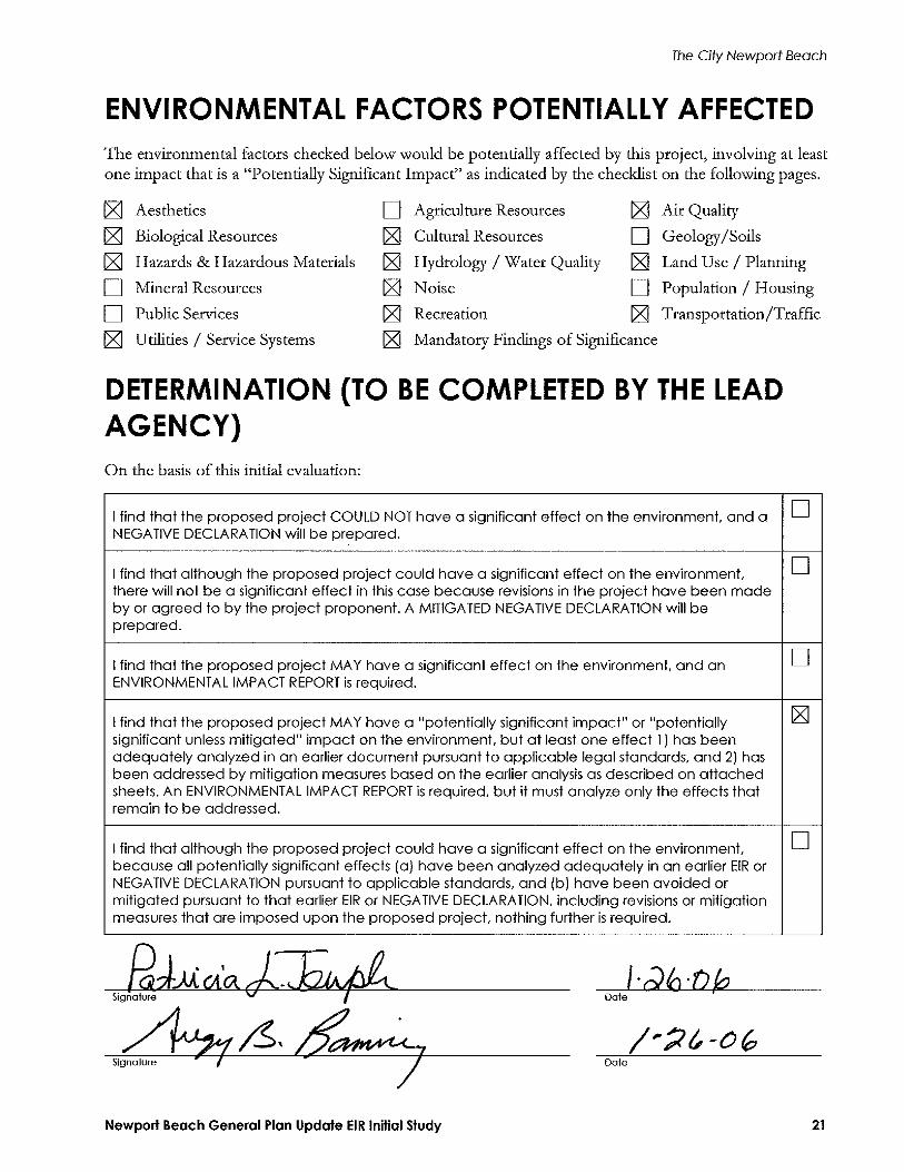
Environmental Factors Potentially Affected .................................................................................. 21
Determination (to be completed by the Lead Agency).................................................................. 21
Evaluation of Environmental Impacts ...........................................................................................22I. Aesthetics ...............................................................................................................................................22II. Agriculture Resources ..........................................................................................................................23III. Air Quality .............................................................................................................................................24IV. Biological Resources.............................................................................................................................25V. Cultural Resources ................................................................................................................................27VI. Geology and Soils .................................................................................................................................28VII. Hazards and Hazardous Materials......................................................................................................30VIII. Hydrology and Water Quality .............................................................................................................33IX. Land Use and Planning ........................................................................................................................36X. Mineral Resources.................................................................................................................................37XI. Noise.......................................................................................................................................................37XII. Population and Housing ......................................................................................................................39XIII. Public Services.......................................................................................................................................39XIV. Recreation ..............................................................................................................................................41XV. Transportation/Traffic ........................................................................................................................41XVI. Utilities and Service Systems ...............................................................................................................43XVII. Mandatory Findings of Significance...................................................................................................45
FiguresFigure 1 Regional Location...........................................................................................................................3Figure 2 Planning Area ..................................................................................................................................5Figure 3 Subareas ...........................................................................................................................................7
TablesTable 1 Current Elements of the General Plan........................................................................................2Table 2 Existing Land Use ........................................................................................................................11Table 3 City of Newport Beach General Plan Update Existing and Proposed Land Use...............12Table 4 Transportation Improvements under Proposed General Plan Update ................................17


The City Newport Beach
Newport Beach General Plan Update EIR Initial Study 1
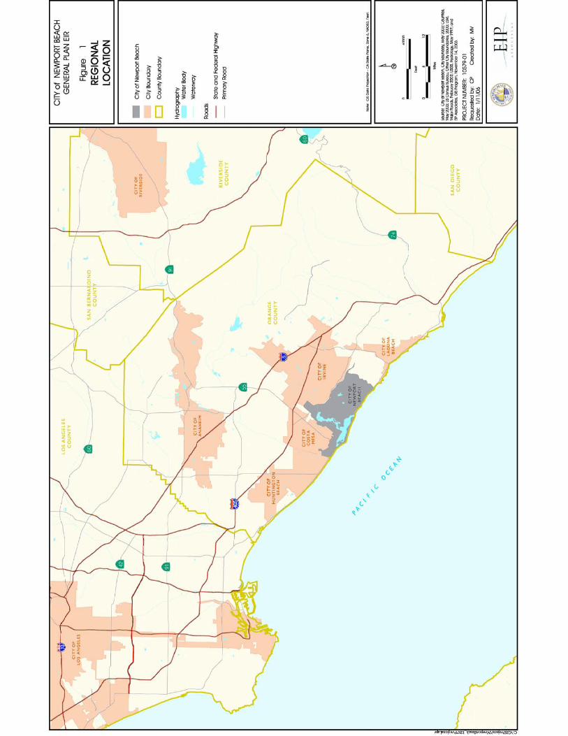
PROJECT DESCRIPTION ENVIRONMENTAL SETTING AND LOCATION Located in the Southern California region, Newport Beach is at the western edge of Orange County, adjacent to the Pacific Ocean, as shown in Figure 1. Generally, Newport Beach is bordered by Costa Mesa to the northwest, Huntington Beach to the west, Irvine to the northeast, and unincorporated portions of Orange County to the southeast.
Regional access to the City is provided by several freeways. The 405 Freeway runs north to south within Southern California, and intersects both State Routes 73 and 55. State Route 55 extends south from State Route 91 and terminates in the City of Newport Beach. State Route 73 extends along the northern boundary of the City, connecting the 55 and 405 Freeways with Interstate 5. Highway 1 (Coast Highway) runs along the California coast and all the way through Newport Beach.
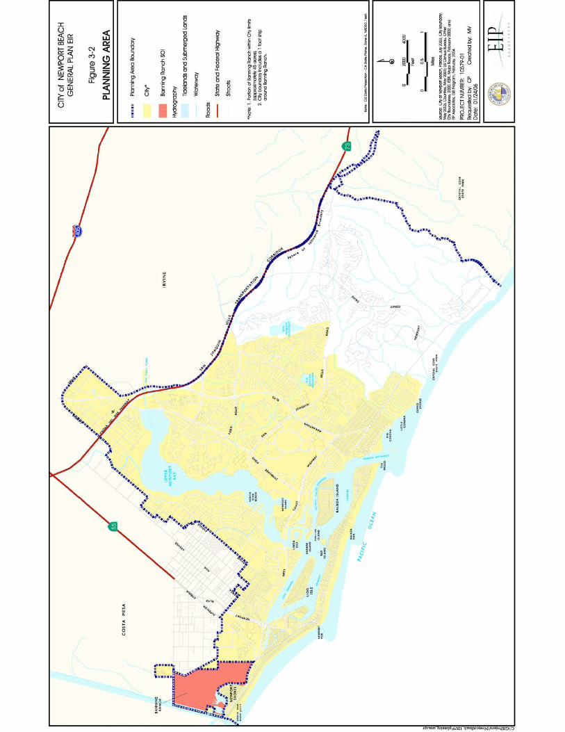
The entire Planning Area includes the existing City boundaries and its sphere of influence (SOI). The current City boundaries total 13,062 acres, excluding waterways. Approximately 53 acres of the area known as Banning Ranch is within the City boundaries, with another 361 acres of this property in the City’s SOI, subject to Orange County jurisdiction. The entire property is surrounded by a one-foot strip within the City’s jurisdiction. The Planning Area is illustrated in Figure 2. The City of Newport Beach General Plan Technical Background Report (TBR) provides existing data for the entire Planning Area. The TBR was published June 2004 and is available for review at the Planning Department and Central Library.
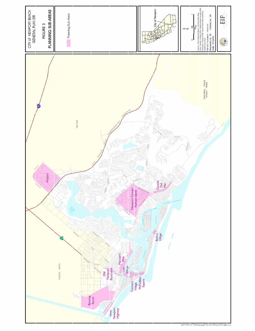
The General Plan Update provides comprehensive land use, housing, circulation and infrastructure, public service, resource conservation, and public safety policies for the entire city. While policies regarding future land use and development are addressed from a citywide perspective, the majority of land use changes are limited to nine primary study areas, which include about 10.5 percent of the City’s land area. Accordingly, the EIR will comprehensively address the impacts of all policies throughout the City and, additionally, focus on those areas in which the most significant land use changes could occur. These areas are illustrated in Figure 3.
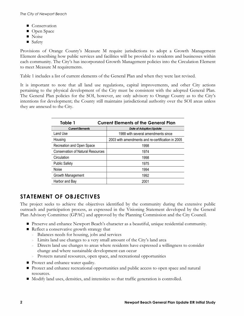
Background
General Plan The General Plan is a state-required legal document (Government Code Section 65300) that provides guidance to decision makers regarding the conservation of resources and the future physical form and character of development for the city. It is the official statement of the jurisdiction regarding the extent and types of development of land and infrastructure that will achieve the community’s physical, economic, social, and environmental goals. The General Plan expresses the City’s goals and articulates the City’s intentions with respect to the rights and expectations of the general public, property owners, community interest groups, prospective investors, and business interests. Although the General Plan consists of individual sections, or “elements,” that address a specific area of concern, it also embodies a comprehensive and integrated planning approach for the jurisdiction.
Under state law, each General Plan must contain seven elements:
Land Use CirculationHousing
The City of Newport Beach
Newport Beach General Plan Update EIR Initial Study 2
ConservationOpen Space NoiseSafety
Provisions of Orange County’s Measure M require jurisdictions to adopt a Growth Management Element describing how public services and facilities will be provided to residents and businesses within each community. The City’s has incorporated Growth Management policies into the Circulation Element to meet Measure M requirements.
Table 1 includes a list of current elements of the General Plan and when they were last revised.
It is important to note that all land use regulations, capital improvements, and other City actions pertaining to the physical development of the City must be consistent with the adopted General Plan. The General Plan policies for the SOI, however, are only advisory to Orange County as to the City’s intentions for development; the County still maintains jurisdictional authority over the SOI areas unless they are annexed to the City.
Table 1 Current Elements of the General Plan Current Elements Date of Adoption/Update
Land Use 1988 with several amendments since Housing 2003 with amendments and re-certification in 2005 Recreation and Open Space 1998Conservation of Natural Resources 1974Circulation 1998Public Safety 1975Noise 1994Growth Management 1992Harbor and Bay 2001
STATEMENT OF OBJECTIVES The project seeks to achieve the objectives identified by the community during the extensive public outreach and participation process, as expressed in the Visioning Statement developed by the General Plan Advisory Committee (GPAC) and approved by the Planning Commission and the City Council.
Preserve and enhance Newport Beach’s character as a beautiful, unique residential community. Reflect a conservative growth strategy that > Balances needs for housing, jobs and services > Limits land use changes to a very small amount of the City’s land area > Directs land use changes to areas where residents have expressed a willingness to consider
change and where sustainable development can occur > Protects natural resources, open space, and recreational opportunities Protect and enhance water quality. Protect and enhance recreational opportunities and public access to open space and natural resources.Modify land uses, densities, and intensities so that traffic generation is controlled.


The City Newport Beach
Newport Beach General Plan Update EIR Initial Study 9
Improve traffic flow without changing the character of the City. Preserve and enhance parks, art, cultural and education facilities and programs that contribute to residents’ quality of life. Ensure the City has adequate municipal revenue to provide first rate municipal services, such as police, fire, lifeguard, library, recreation, refuse collection and recycling, and infrastructure maintenance. Attract visitors to Newport Beach’s harbor, beaches, hotels, restaurants, and shops with as little impact as possible on residents and natural resources. Encourage revitalization of older and economically challenged commercial areas so that the areas continue to be community resources and have a positive impact on the value of nearby property and the local economy. Maintain Newport Harbor as one of the premier small boat recreational boating harbors in the world, while causing little or no impact on the environment. Control and contain noise and traffic impacts from operations at John Wayne Airport to protect the residents’ quality of life and property values. Modify the Land Use Element and other elements to reflect changes in the law and planning practices that have occurred in the 17 years since the last comprehensive amendments were approved.Provide effective means to ensure compliance with Section 423 of the Charter.
PROJECT CHARACTERISTICS Elements and Components of the Proposed General Plan The proposed General Plan is a comprehensive update of the current General Plan. Elements of the existing General Plan have been re-organized by thematic topic for clarity and to avoid redundancy, as encouraged by the State’s General Plan Guidelines. The updated City of Newport Beach General Plan is organized into the following elements:
Land Use HousingCirculationRecreationNatural Resources SafetyNoiseHistoric Resources Arts and Cultural Resources
Goals and policies in the existing Harbor and Bay Element will be retained in a separate element or incorporated in the Land Use, Circulation, Recreation, Safety, and Natural Resources Elements. Growth Management Element goals and policies are incorporated into the Circulation/Mobility Element. Goals and polices for the protection of the City’s open spaces, currently found in the Recreation and Open Space Element, are incorporated into the Natural Resources Element.
Updated General Plan Potential Land Use Changes Existing land uses by major category and potential land use changes resulting from the update of the General Plan are described below.

The City of Newport Beach
Newport Beach General Plan Update EIR Initial Study 10
Existing Land Uses Information regarding existing land uses and potential development within Newport Beach is presented below. More detail regarding the existing uses is presented in the General Plan TBR. The City of Newport Beach Planning Area contains 26,676 acres or 41.7 square miles. These are net acres and do not include streets and roadways, which account for approximately 20 percent of the total gross land acreage. Approximately 42 percent (11,119 acres) of the Planning Area is water, which includes the Upper and Lower Newport Bay and its channels, and the Pacific Ocean. The following discussion pertains to the 13,062 acres of developed and undeveloped land in the Planning Area.
Existing land uses in the Planning Area have been classified into seven primary categories:
Residential—Residential uses include a mix of housing developed at varying densities and types. Residential uses in the Planning Area include single-family, multiple-family, condominium, mobile, and senior housing. Commercial/Office—This category includes commercial uses that offer goods for sale to the public (retail) and service and professional businesses housed in offices (accountants, architects, etc). Retail and commercial businesses include those that serve local needs, such as restaurants, neighborhood markets and dry cleaners, and those that serve community or regional needs, such as auto dealers and furniture stores. Visitor-serving retail uses such as regional shopping centers and hotels are also included in this category. Industrial—The industrial category includes a mix of manufacturing and light industrial uses, some of which are found in business, research, and development parks. Light industrial activities include warehousing and some types of assembly work. This category also includes wholesaling and warehousing.Governmental, Educational, and Institutional Facilities (GEIF)—Government buildings, libraries, schools and other public institutions are found in this category. Uses in this category support civic, cultural, and educational needs of residents. Open Space—This category encompasses public and private recreational spaces, local and regional parks, and beaches. Recreational areas, such as golf courses, also contribute to open space uses in the Planning Area. Vacant—Vacant lands are undeveloped lands (as of June 2003) that are not preserved in perpetuity as open space or for other public purposes. Water—The bay, harbor, channels and reservoirs are included in this category.
Existing land uses are listed below in Table 2.
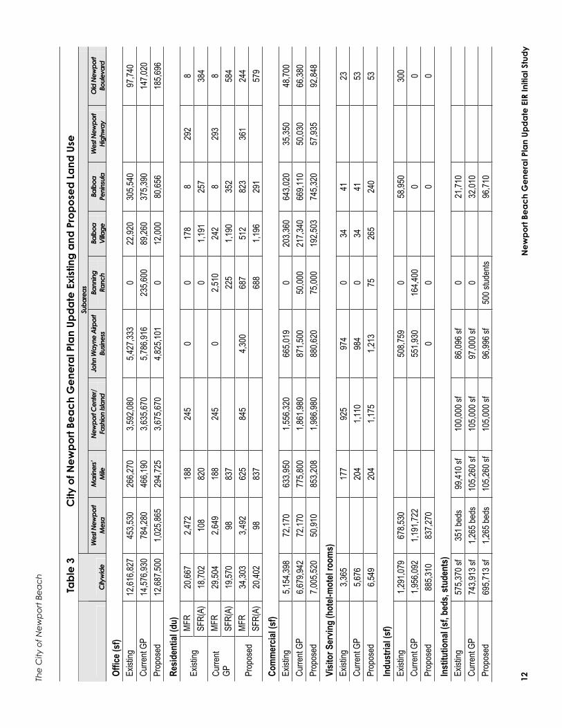
Proposed Land Use Changes Table 3 presents the proposed land uses for Newport Beach. As shown, City-wide changes would occur in the following land use categories: Residential (single- and multi-family), Commercial, Office, Industrial, Visitor Serving, Institutional, and Parks/Open Space.
Newport Beach is almost fully developed. Therefore, the General Plan focuses on how limited population and employment growth can be strategically accommodated to preserve the distinguishing and valued qualities of the community. For most of the City, the updated General Plan conserves the existing pattern of uses and intensity of development, and establishes policies for protection and long-term maintenance of established neighborhoods.

The City Newport Beach
Newport Beach General Plan Update EIR Initial Study 11
Table 2 Existing Land Use Land Use Acres Percent of City's Total
Residential 5,436.0 41.6% Single-Family Detached 3,932.8 Single-Family Attached 625.3 Two-Family Residential 360.9 Multi-Family Residential 480.0 Mixed Residential 37.0
Commercial 1,154.6 8.8% Retail 382.0 Administrative, Professional, and Financial 473.0 Marine and Auto Related 73.7 Visitor-serving 225.9
Industrial 114.4 0.9% Industrial 68.9 Multi-Tenant Industrial 20.5 Industrial Business Park 25.0
Other 6,356.7 — Government, Educational, Institutional Facilities 446.6 3.4%
Quasi-Public 53.5 0.4% Right of Way/Undesignated 4.8 <1%
Recreation & Environmental Open Space 4,516.4 34.6%Vacant Land 1,260.2 9.6%Water 75.2 0.6%
Total 13,061.7 100% SOURCE: EIP Associates GIS 2003
Generally, new development in accordance with the updated General Plan would result as re-use of economically underperforming properties and obsolete development, conversion of uses in response to market demand (e.g., office and industrial to residential) and more intense use of land in limited, defined areas. Several subareas within Newport Beach determined to have special planning considerations were the subjects of special study during the update process. These areas are described below. Largely, the existing General Plan provides adequate guidance for development outside of these subareas within the City and changes have been made only to select locations where circumstances warrant. The land use changes in each of the special study subareas, and citywide totals are presented in Table 3. It should be noted that the amount of development that could occur within the subareas does not add up to the citywide total because the subareas represent only 10.5% of the total land area of the City.
The
City
of N
ewp
ort B
each
New
port
Beac
h G
ener
al P
lan
Upda
te E
IR In
itial
Stu
dy
12
Tabl
e 3
City
of N
ewpo
rt Be
ach
Gen
eral
Pla
n Up
date
Exi
stin
g an
d Pr
opos
ed L
and
Use
Suba
reas
City
wid
e W
est N
ewpo
rt M
esa
Mar
iners’
M
ileNe
wpo
rt Cen
ter/
Fash
ion
Islan
d Jo
hn W
ayne
Airp
ort
Busin
ess
Bann
ing
Ranc
h Ba
lboa
Vi
llage
Ba
lboa
Pe
ninsu
la
Wes
t New
port
High
way
O
ld N
ewpo
rt Bo
uleva
rd
Offic
e (sf
) Ex
isting
12
,616,8
27
453,5
30
266,2
70
3,592
,080
5,427
,333
0 22
,920
305,5
40
97
,740
Curre
nt GP
14
,576,9
30
784,2
80
466,1
90
3,635
,670
5,786
,916
235,6
00
89,26
0 37
5,390
147,0
20
Prop
osed
12,68
7,500
1,0
25,86
5 29
4,725
3,6
75,67
0 4,8
25,10
1 0
12,00
0 80
,656
18
5,696
Re
siden
tial (
du)
MFR
20,66
7 2,4
72
188
245
0 0
178
8 29
2 8
Exist
ing
SFR(
A)
18,70
2 10
8 82
0
0
1,191
25
7
384
MFR
29,50
4 2,6
49
188
245
0 2,5
10
242
8 29
3 8
Curre
ntGP
SFR(
A)
19,57
0 98
83
7
22
5 1,1
90
352
58
4 MF
R34
,303
3,492
62
5 84
5 4,3
00
687
512
823
361
244
Prop
osed
SFR(
A)
20,40
2 98
83
7
68
8 1,1
96
291
57
9 Co
mm
ercia
l (sf
) Ex
isting
5,1
54,39
8 72
,170
633,9
50
1,556
,320
665,0
19
0 20
3,360
64
3,020
35
,350
48,70
0 Cu
rrent
GP
6,679
,942
72,17
0 77
5,800
1,8
61,98
0 87
1,500
50
,000
217,3
40
669,1
10
50,03
0 66
,380
Prop
osed
7,005
,520
50,91
0 85
3,208
1,9
86,98
0 88
0,620
75
,000
192,5
03
745,3
20
57,93
5 92
,848
Visit
or S
ervin
g (h
otel-
mot
el ro
oms)
Ex
isting
3,3
65
17
7 92
5 97
4 0
34
41
23
Cu
rrent
GP
5,676
204
1,110
98
4 0
34
41
53
Pr
opos
ed6,5
49
20
4 1,1
75
1,213
75
26
5 24
0
53
Indu
stria
l (sf
) Ex
isting
1,2
91,07
9 67
8,530
50
8,759
0
58
,950
30
0 Cu
rrent
GP
1,956
,092
1,191
,722
551,9
30
164,4
00
0
0
Prop
osed
885,3
10
837,2
70
0 0
0
0
Inst
itutio
nal (
sf, b
eds,
stud
ents
) Ex
isting
57
5,370
sf
351 b
eds
99,41
0 sf
100,0
00 sf
86
,096 s
f 0
21
,710
Curre
nt GP
74
3,913
sf
1,265
beds
10
5,260
sf
105,0
00 sf
97
,000 s
f 0
32
,010
Prop
osed
695,7
13 sf
1,2
65 be
ds
105,2
60 sf
10
5,000
sf
96,99
6 sf
500 s
tuden
ts
96,71
0

The
City
New
port
Beac
h
New
port
Beac
h G
ener
al P
lan
Upda
te E
IR In
itial
Stu
dy
13
Tabl
e 3
City
of N
ewpo
rt Be
ach
Gen
eral
Pla
n Up
date
Exi
stin
g an
d Pr
opos
ed L
and
Use
Suba
reas
City
wid
e W
est N
ewpo
rt M
esa
Mar
iners’
M
ileNe
wpo
rt Cen
ter/
Fash
ion
Islan
d Jo
hn W
ayne
Airp
ort
Busin
ess
Bann
ing
Ranc
h Ba
lboa
Vi
llage
Ba
lboa
Pe
ninsu
la
Wes
t New
port
High
way
O
ld N
ewpo
rt Bo
uleva
rd
Park
s/Ope
n Sp
ace (
acre
s)
Exist
ing
128.4
0.2
0
Cu
rrent
GP
127.8
0.2
0
Pr
opos
ed18
3.8
1
60
The City of Newport Beach
Newport Beach General Plan Update EIR Initial Study 14
Subareas
The proposed Land Use Element identifies the special study subareas as districts or corridors, depending on their physical form, functional role, and how they relate to the land or water adjoining them.
D i s t r i c t s Districts are uniquely identifiable by their common functional role, mix of uses, density/intensity, physical form and character, and/or environmental setting. Generally, they encompass areas that extend equally in length and breadth. While Newport Beach contains many subareas, the General Plan policies in the following areas focus on those that are likely to change over the next 20 years as existing viable land uses are enhanced, underperforming properties are revitalized, and opportunities are provided to accommodate the City’s fair share of regional housing needs. Policies are directed to the management of these changes to assure that they complement the characteristics that are valued by Newport Beach’s residents.
W E S T N E W P O R T M E S A
The Plan allows for the establishment of a number of distinct and cohesive districts. Adjoining Hoag Hospital and on the Newport Technology Center site, properties would be designated for medical-related uses including offices, labs, convalescent and long-term care facilities, and limited retail sales. At its northern edge abutting the City of Costa Mesa, properties would be encouraged to retain light manufacturing and research and development uses. Multi-family housing would be maintained and newly developed on underutilized residential, commercial, and industrial properties between these nodes.
N E W P O R T C E N T E R / F A S H I O N I S L A N D
The Plan allows for expanded retail opportunities at Fashion Island, including an additional anchor department store and ancillary shops, another hotel or additions to existing hotels, and 600 additional housing units. Limited new capacity for office development (40,000 square feet) would be limited to minor expansion of existing buildings and could not be converted to retail use. Plan policies encourage improved pedestrian connections and streetscape amenities connecting the area’s diverse districts
J O H N W A Y N E A I R P O R T A R E A
The Plan allows for the maintenance and/or limited expansion of the currently developed mix of uses, including office, airport-supporting commercial, hotel, and public uses. Additionally, it allows the opportunity for the development of new residential neighborhoods as replacement of existing and allowed future uses and, in some cases, on underutilized surface parking lots. Policies establish criteria for the development of cohesive residential neighborhoods oriented around neighborhood parks and local-serving convenience commercial facilities and interconnected by a network of pedestrian-oriented streets.
B A N N I N G R A N C H
The updated General Plan prioritizes the retention of the Banning Ranch property as open space, consolidating existing oil operations, restoring wetlands and habitat, and development of a community park with active playfields to serve adjoining neighborhoods. Should the property not be acquired for open space, the Plan considers the possible development of a mixed-density residential village, with housing oriented around a neighborhood park, convenience commercial, and small hotel, and preservation of the majority of the site as open space. Policies stipulate that any development would have to be located and designed to protect views, the bluffs, natural drainage, and important habitat.

The City Newport Beach
Newport Beach General Plan Update EIR Initial Study 15
B A L B O A P E N I N S U L A
The Plan differentiates Balboa Peninsula into a series of commercial, residential, mixed-use, and water-oriented districts. The Plan encourages enhancement of Lido Village as a pedestrian-oriented district of small retail shops, bay supporting uses, small lodging facilities (bed-and-breakfast and inns), and mixed-use buildings that integrate housing with retail uses. Properties inland of the bay front in Cannery Village containing a fragmented mix of housing, commercial, and industrial uses could be re-used as a primarily residential village of two family and townhome residential, with mixed-use and live/work structures at intersections. Bay fronting properties east of Lafayette Avenue would continue to support water-dependent and marine-related uses. The Plan supports the retention of McFadden Square as an ocean and pier-oriented village containing visitor-serving retail, small overnight lodging facilities, and mixed-use buildings. The Newport Boulevard Corridor would contain retail commercial and mixed-use buildings. Policies provide for the development of improved streetscapes and a waterfront promenade to link the districts. Cumulatively, the updated General Plan would allow for reductions in the area’s commercial and industrial capacity, which would be replaced by opportunities for new housing. For Balboa Village, the General Plan would allow for the consolidation of commercial uses to enhance the area’s economic vitality, which would be replaced by medium density housing (including townhomes and small-lot, attached single family) and mixed-use structures that would integrate housing with ground-level retail uses. Bay-fronting properties would be prioritized for marine-related and water-dependent uses. Programs for streetscape enhancements would be continued.
H A R B O R A N D B A Y
The goals and policies in the existing Harbor and Bay Element will be retained, either in a separate element or incorporated in the Land Use, Circulation, Recreation, Safety, and Natural Resources Elements of the General Plan Update. The goals and policies pertaining to Harbor and Bay issues are intended to guide the content of regulations related to development of, and the activities conducted on, the water. Additional goals and policies recognize the important component of land use decisions related to waterfront property around Newport Harbor. The aim of Harbor and Bay related goals and policies is to preserve the diversity and charm of existing uses without unduly restricting the rights of the waterfront property owner. Goals and policies related to the Harbor and Bay have been organized to address both water and land related issues.
C o r r i d o r s Corridors share common characteristics of districts by their identifiable functional role, land use mix, density/intensity, physical form and character, and/or environmental setting. They differ in their linear configuration, generally with shallow depth parcels located along arterial streets. They are significantly impacted by traffic, often inhibiting access during peak travel periods. While the City is crossed by a number of commercial corridors, the General Plan’s policies focus on those in which change is anticipated to occur during the next 20 years. Additionally, they provide guidance for the maintenance of corridors in which it is the objective to maintain existing types and levels of development.
W E S T N E W P O R T H I G H W A Y
Visitor- and neighborhood-serving commercial uses would be allowed in the area concentrated on the Pacific Coast Highway, near the Orange and Prospect Avenue intersections, with the intervening highway fronting properties developed for multi-family housing. The Plan encourages properties at the entry to the City to be enhanced as a “gateway” for amenities supporting Orange County River Park and/or new multi-family residential.

The City of Newport Beach
Newport Beach General Plan Update EIR Initial Study 16
O L D N E W P O R T B O U L E V A R D
The Plan allows for a mix of medical office and retail uses supporting Hoag Hospital, convenience retail, and mixed-use buildings that integrate housing with ground level retail or office uses on Old Newport Boulevard.
M A R I N E R S ’ M I L E
The Plan provides for the differentiation of Mariners’ Mile into distinct commercial, water-related, and mixed-use districts. Bayfronting properties would be prioritized for water-dependent and marine-related uses, including restaurants and service uses, with the development of housing on a limited portion of the properties. The Coast Highway frontages of all inland properties would be restricted to community-serving and marine-related commercial uses. Interior sites, generally between Riverside Avenue and the extension of Irvine Avenue, would be developed for neighborhood-serving commercial uses, mixed-use buildings with housing above retail, and multi-family residential buildings. Streetscape improvements are proposed to enhance the area’s pedestrian character, as well as its identity along Coast Highway. Policies also support the relocation of the City’s parking lot and the Postal Distribution Center.
C O R O N A D E L M A R
The Plan encourages development along this corridor to include a pedestrian-oriented “village” serving as the center of community commerce, culture, and social activity and providing identity for Corona del Mar.
O t h e r L a n d U s e C h a n g e s While land use changes would be accommodated in other areas of the City by the updated Plan, these are generally small and retain the basic land use character as provided by the existing General Plan. For example, the General Plan would allow for land use changes in the Dover Drive area. These changes include redesignating the area from Administrative, Professional, and Financial Commercial uses to “mixed use,” allowing a mix of office and multi-family residential uses.
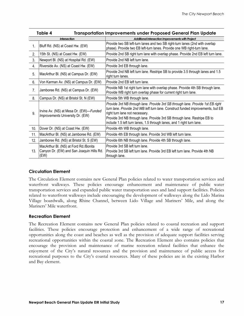
Transportation Improvements Several transportation-related improvements are included in the proposed General Plan. The improvements listed in Table 4 would be implemented under the proposed General Plan to ensure that impacts resulting from buildout of the General Plan Update are minimized.
Goals and Policy Changes The General Plan Update includes new policies in the Land Use Element, the Circulation Element, the Safety Element, the Natural Resources Element, and the Recreation Element. The new policies are briefly described below.
Land Use Element The Land Use Element contains new General Plan policies related to Community Character. These policies encourage maintenance and enhancement of Newport Beach’s residential neighborhoods, commercial districts, employment centers, corridors, and open spaces, and help assure that new development complements and reinforces these characteristics.
New policies related to Urban Form are also contained in this Element. These policies establish and reinforce particular area’s scale and development pattern. These policies are included in the General Plan Update to help establish or maintain physical and visual continuity and a sense of complete and identifiable neighborhoods and established strategies for areas of the City that require enhancement and revitalization.
The City Newport Beach
Newport Beach General Plan Update EIR Initial Study 17
Table 4 Transportation Improvements under Proposed General Plan Update Intersection Additional Intersection Improvements with Project
1. Bluff Rd. (NS) at Coast Hw. (EW) Provide two SB left-turn lanes and two SB right-turn lanes (2nd with overlap phase). Provide two EB left-turn lanes. Provide one WB right-turn lane.
2. 15th St. (NS) at Coast Hw. (EW) Provide 2nd SB right turn lane with overlap phase. Provide 2nd EB left turn lane. 3. Newport Bl. (NS) at Hospital Rd. (EW) Provide 2nd NB left turn lane. 4. Riverside Av. (NS) at Coast Hw. (EW) Provide 3rd EB through lane.
5. MacArthur Bl. (NS) at Campus Dr. (EW) Provide 2nd NB left turn lane. Restripe SB to provide 3.5 through lanes and 1.5 right turn lanes.
6. Von Karman Av. (NS) at Campus Dr. (EW) Provide 2nd EB left turn lane.
7. Jamboree Rd. (NS) at Campus Dr. (EW) Provide NB 1st right turn lane with overlap phase. Provide 4th SB through lane. Provide WB right turn overlap phase for current right turn lane.
8. Campus Dr. (NS) at Bristol St. N (EW) Provide 5th WB through lane.
9. Irvine Av. (NS) at Mesa Dr. (EW)—FundedImprovements University Dr. (EW)
Provide 3rd NB through lane. Provide 3rd SB through lane. Provide 1st EB right turn lane. Provide 2nd WB left turn lane. Construct funded improvements, but EB right turn lane not necessary. Provide 3rd NB through lane. Provide 3rd SB through lane. Restripe EB to include 1.5 left turn lanes, 1.5 through lanes, and 1 right turn lane.
10. Dover Dr. (NS) at Coast Hw. (EW) Provide 4th WB through lane. 11. MacArthur Bl. (NS) at Jamboree Rd. (EW) Provide 4th EB through lane. Provide 3rd WB left turn lane. 12. Jamboree Rd. (NS) at Bristol St. S (EW) Provide 6th NB through lane. Provide 4th SB through lane.
13.MacArthur Bl. (NS) at Ford Rd./Bonita Canyon Dr. (EW) and San Joaquin Hills Rd. (EW)
Provide 3rd SB left turn lane. Provide 3rd SB left turn lane. Provide 3rd EB left turn lane. Provide 4th NB through lane.
Circulation Element The Circulation Element contains new General Plan policies related to water transportation services and waterfront walkways. These policies encourage enhancement and maintenance of public water transportation services and expanded public water transportation uses and land support facilities. Policies related to waterfront walkways include encouraging the development of walkways along the Lido Marina Village boardwalk, along Rhine Channel, between Lido Village and Mariners’ Mile, and along the Mariners’ Mile waterfront.
Recreation Element The Recreation Element contains new General Plan policies related to coastal recreation and support facilities. These policies encourage protection and enhancement of a wide range of recreational opportunities along the coast and beaches as well as the provision of adequate support facilities serving recreational opportunities within the coastal zone. The Recreation Element also contains policies that encourage the provision and maintenance of marine recreation related facilities that enhance the enjoyment of the City’s natural resources and the provision and maintenance of public access for recreational purposes to the City’s coastal resources. Many of these policies are in the existing Harbor and Bay element.

The City of Newport Beach
Newport Beach General Plan Update EIR Initial Study 18
Safety Element New General Plan policies related to hazardous materials, disaster planning, and coastal hazards are contained in the Safety Element. Policies related to hazardous materials minimize exposure of people and the environment to hazardous materials associated with methane gas extraction, oil operations, leaking underground storage tanks, and hazardous waste generators. Policies related to disaster planning include measures for effective emergency response to natural or human-induced disasters that minimizes the loss of life and damage to property, while also reducing disruptions in the delivery of vital public and private services during and following a disaster. Policies related to coastal hazards are included to ensure that adverse effects of coastal hazards related to tsunamis and rogue waves to people and property are minimized.
Natural Resources Element New General Plan policies related to water quality are contained in the Natural Resources Element. These policies establish the goal of enhancing and protecting the water quality of all natural water bodies, including coastal waters, creeks, bays, harbors, and wetlands. Additionally, the General Plan Update contains new policies related to management of the Upper Newport Bay. These policies help achieve the goal of protection and management of Upper Newport Bay commensurate with the standards applicable to our nation’s most valuable natural resources. Many of these policies are in the existing Harbor and Bay Element. Other new policies in this element include measures related to air quality, archaeology and paleontology, and energy conservation. Air Quality policies serve to reduce mobile source emissions, reduce air pollution emissions from stationary sources, and reduce air pollution emissions from aircraft.
Historical Resources Element This new Element addresses the protection and sustainability of Newport Beach’s historic and paleontological resources. Goals and policies presented within this Element are intended to recognize, maintain, and protect the community’s unique historical, cultural, and archaeological sites and structures.
Arts and Cultural Resources Element The goals and policies of the Arts and Culture Element are intended to be a guide for meeting the future cultural needs of the community. This Element is intended to serve as a mechanism for integrating these resources in order to provide improved and expanded arts and cultural facilities and programs to the community.
Alternatives In accordance with Section 15126.6 of the CEQA Guidelines, alternatives to the proposed General Plan are analyzed. Four alternatives that would feasibly attain the most basic project objectives while avoiding or substantially lessening some of the significant effects of the project were analyzed. An environmentally superior alternative is also identified. These alternatives include the following:
No Project/No Development—With this alternative, development under the proposed General Plan would not occur. The Planning Area would remain developed with existing land uses. No Project/No Action Alternative—With this alternative, development under the proposed General Plan would not occur. Development would be guided by continued implementation of the existing General Plan. Alternative A: GPAC Recommendations—With this alternative, development under the General Plan would consist of the land use recommendations formulated by GPAC. The

The City Newport Beach
Newport Beach General Plan Update EIR Initial Study 19
Alternatives Chapter of the EIR will provide a detailed breakdown of the proposed land uses under this Alternative. Alternative B: Subarea Only Minimum—With this alternative, development under the General Plan would consist of a mixture of land-use intensities for the various subareas. The Alternatives Chapter of the EIR will provide a detailed breakdown of the proposed land uses under this Alternative.

The City of Newport Beach
Potentially Significant Impact
Less Than Significant with Mitigation Incorporated
Less Than Significant Impact
NoImpact
Newport Beach General Plan Update EIR Initial Study 22
EVALUATION OF ENVIRONMENTAL IMPACTS
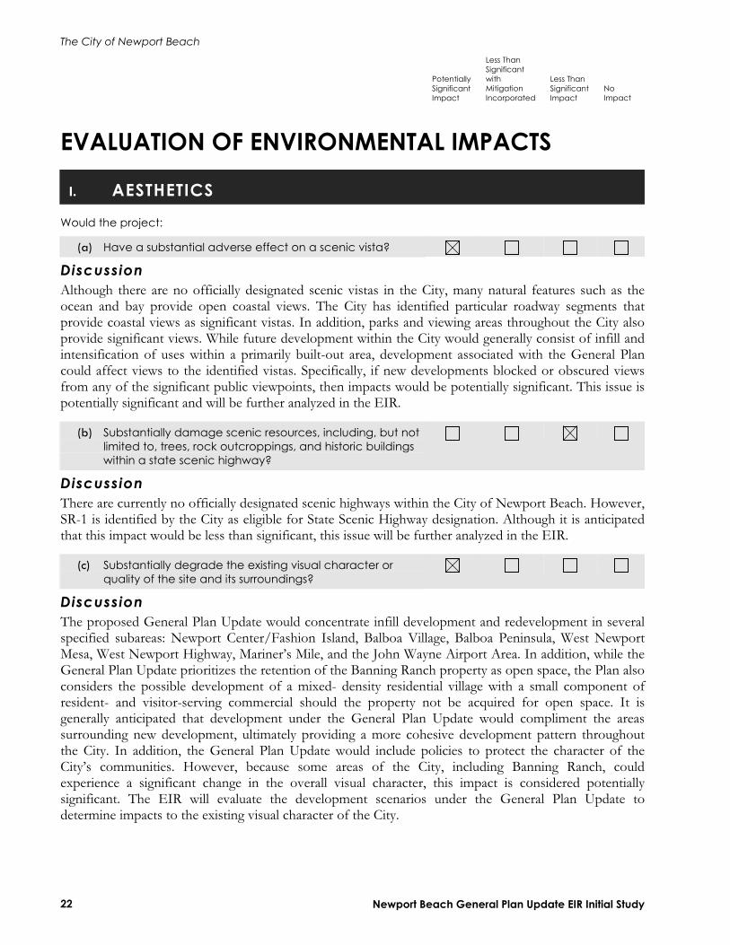
I. AESTHETICS
Would the project:
(a) Have a substantial adverse effect on a scenic vista?
DiscussionAlthough there are no officially designated scenic vistas in the City, many natural features such as the ocean and bay provide open coastal views. The City has identified particular roadway segments that provide coastal views as significant vistas. In addition, parks and viewing areas throughout the City also provide significant views. While future development within the City would generally consist of infill and intensification of uses within a primarily built-out area, development associated with the General Plan could affect views to the identified vistas. Specifically, if new developments blocked or obscured views from any of the significant public viewpoints, then impacts would be potentially significant. This issue is potentially significant and will be further analyzed in the EIR.
(b) Substantially damage scenic resources, including, but not limited to, trees, rock outcroppings, and historic buildings within a state scenic highway?
DiscussionThere are currently no officially designated scenic highways within the City of Newport Beach. However, SR-1 is identified by the City as eligible for State Scenic Highway designation. Although it is anticipated that this impact would be less than significant, this issue will be further analyzed in the EIR.
(c) Substantially degrade the existing visual character or quality of the site and its surroundings?
DiscussionThe proposed General Plan Update would concentrate infill development and redevelopment in several specified subareas: Newport Center/Fashion Island, Balboa Village, Balboa Peninsula, West Newport Mesa, West Newport Highway, Mariner’s Mile, and the John Wayne Airport Area. In addition, while the General Plan Update prioritizes the retention of the Banning Ranch property as open space, the Plan also considers the possible development of a mixed- density residential village with a small component of resident- and visitor-serving commercial should the property not be acquired for open space. It is generally anticipated that development under the General Plan Update would compliment the areas surrounding new development, ultimately providing a more cohesive development pattern throughout the City. In addition, the General Plan Update would include policies to protect the character of the City’s communities. However, because some areas of the City, including Banning Ranch, could experience a significant change in the overall visual character, this impact is considered potentially significant. The EIR will evaluate the development scenarios under the General Plan Update to determine impacts to the existing visual character of the City.

The City of Newport Beach
Potentially Significant Impact
Less Than Significant with Mitigation Incorporated
Less Than Significant Impact
NoImpact
Newport Beach General Plan Update EIR Initial Study 23
(d) Create a new source of substantial light or glare which would adversely affect day or nighttime views in the area?
DiscussionThe City of Newport Beach is primarily built-out, and a significant amount of ambient light from urban uses already exists. However, new development permitted under the proposed General Plan Update could create new sources of light and glare from any of the following: exterior building lighting, lighted recreation facilities (such as outdoor ball fields), parking lots/structures, glare from reflective building surfaces, or the headlights of vehicular traffic. As a result, these new sources of light or glare could affect the day or nighttime views of adjacent sensitive land uses. This impact is considered potentially significant. With the incorporation of appropriate mitigation measures, this impact could be reduced to a less-than-significant level.
II. AGRICULTURE RESOURCES
In determining whether impacts to agricultural resources are significant environmental effects, lead agencies may refer to the California Agricultural Land Evaluation and Site Assessment Model (1997) prepared by the California Dept. of Conservation as an optional model to use in assessing impacts on agriculture and farmland. Would the project:
(a) Convert Prime Farmland, Unique Farmland, or Farmland of Statewide Importance (Farmland), as shown on the maps prepared pursuant to the Farmland Mapping and Monitoring Program of the California Resources Agency, to nonagricultural use?
(b) Conflict with existing zoning for agricultural use, or a Williamson Act contract?
(c) Involve other changes in the existing environment, which, due to their location or nature, could result in conversion of Farmland, to nonagricultural use?
Discussiona–c: The City of Newport Beach does not contain any significant agricultural resources as the City is almost entirely built out. No impact would occur on agricultural resources and this issue area will not be analyzed in the EIR.
The City of Newport Beach
Potentially Significant Impact
Less Than Significant with Mitigation Incorporated
Less Than Significant Impact
NoImpact
Newport Beach General Plan Update EIR Initial Study 24
III. AIR QUALITY
Where available, the significance criteria established by the applicable air quality management or air pollution control district may be relied upon to make the following determinations. Would the project:
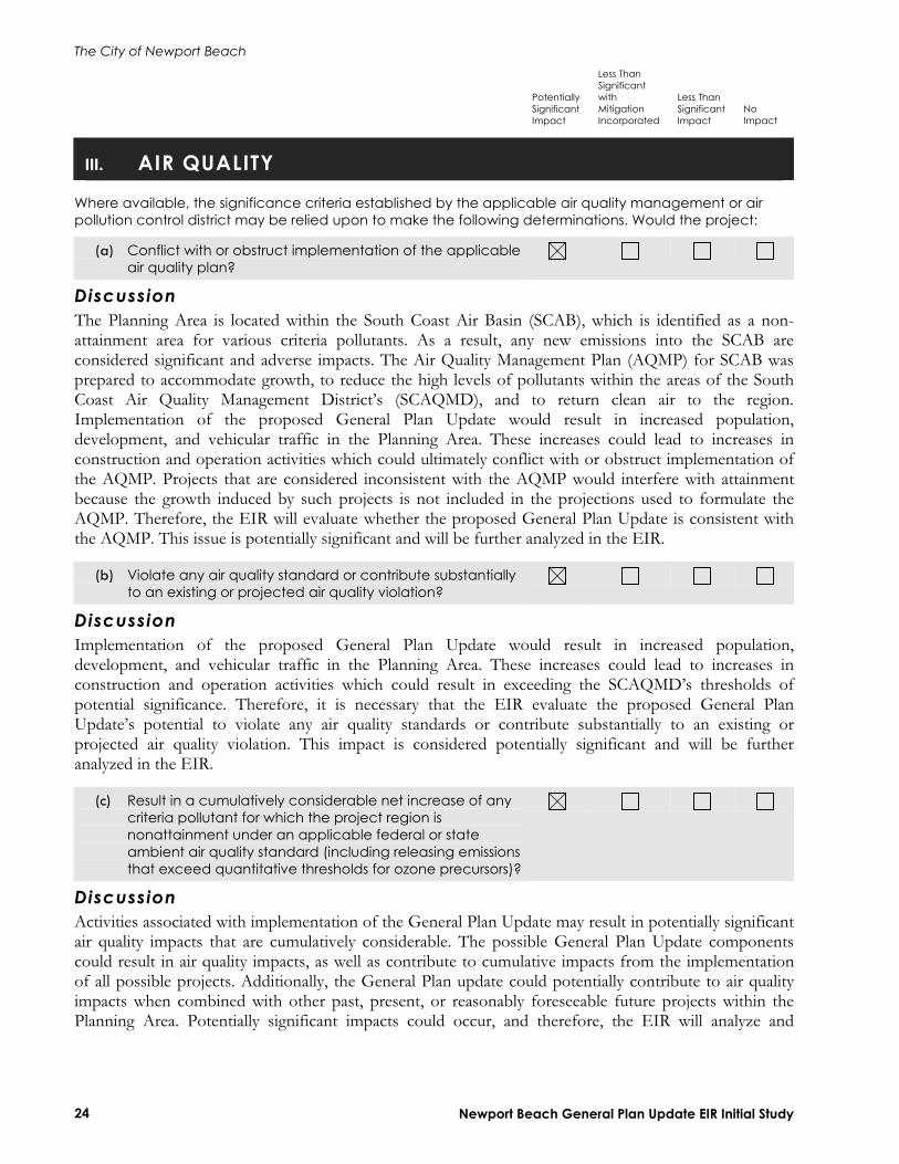
(a) Conflict with or obstruct implementation of the applicable air quality plan?
DiscussionThe Planning Area is located within the South Coast Air Basin (SCAB), which is identified as a non-attainment area for various criteria pollutants. As a result, any new emissions into the SCAB are considered significant and adverse impacts. The Air Quality Management Plan (AQMP) for SCAB was prepared to accommodate growth, to reduce the high levels of pollutants within the areas of the South Coast Air Quality Management District’s (SCAQMD), and to return clean air to the region. Implementation of the proposed General Plan Update would result in increased population, development, and vehicular traffic in the Planning Area. These increases could lead to increases in construction and operation activities which could ultimately conflict with or obstruct implementation of the AQMP. Projects that are considered inconsistent with the AQMP would interfere with attainment because the growth induced by such projects is not included in the projections used to formulate the AQMP. Therefore, the EIR will evaluate whether the proposed General Plan Update is consistent with the AQMP. This issue is potentially significant and will be further analyzed in the EIR.
(b) Violate any air quality standard or contribute substantially to an existing or projected air quality violation?
DiscussionImplementation of the proposed General Plan Update would result in increased population, development, and vehicular traffic in the Planning Area. These increases could lead to increases in construction and operation activities which could result in exceeding the SCAQMD’s thresholds of potential significance. Therefore, it is necessary that the EIR evaluate the proposed General Plan Update’s potential to violate any air quality standards or contribute substantially to an existing or projected air quality violation. This impact is considered potentially significant and will be further analyzed in the EIR.
(c) Result in a cumulatively considerable net increase of any criteria pollutant for which the project region is nonattainment under an applicable federal or state ambient air quality standard (including releasing emissions that exceed quantitative thresholds for ozone precursors)?
DiscussionActivities associated with implementation of the General Plan Update may result in potentially significant air quality impacts that are cumulatively considerable. The possible General Plan Update components could result in air quality impacts, as well as contribute to cumulative impacts from the implementation of all possible projects. Additionally, the General Plan update could potentially contribute to air quality impacts when combined with other past, present, or reasonably foreseeable future projects within the Planning Area. Potentially significant impacts could occur, and therefore, the EIR will analyze and
The City of Newport Beach
Potentially Significant Impact
Less Than Significant with Mitigation Incorporated
Less Than Significant Impact
NoImpact
Newport Beach General Plan Update EIR Initial Study 25
evaluate air quality impacts related to potential increases of criteria pollutants for which the General Plan Update region is in non-attainment under federal or state ambient air quality standards.
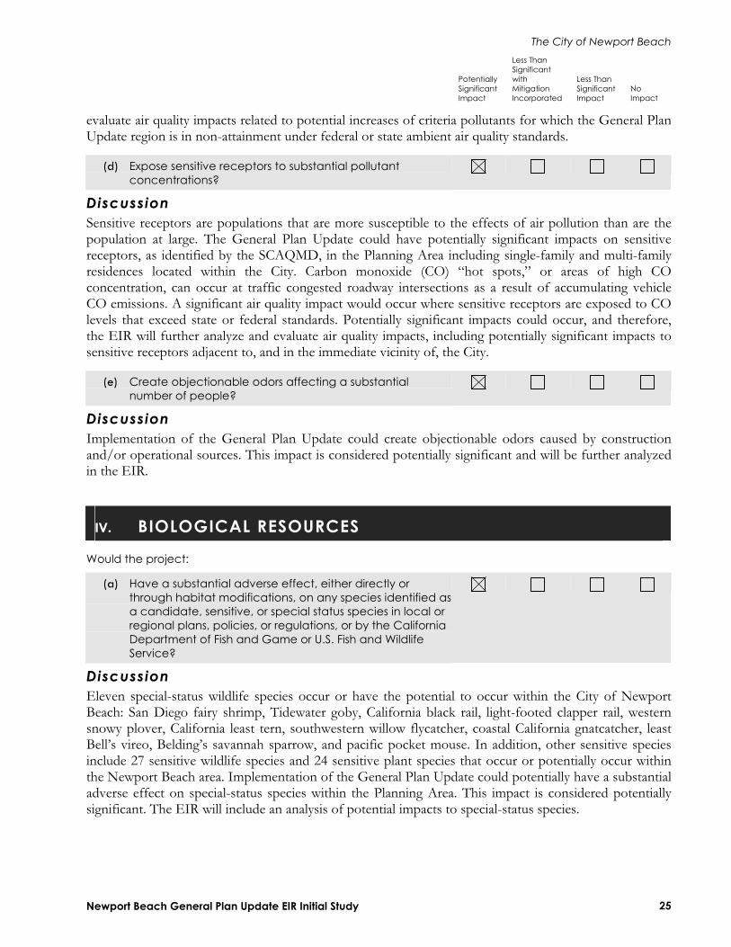
(d) Expose sensitive receptors to substantial pollutant concentrations?
DiscussionSensitive receptors are populations that are more susceptible to the effects of air pollution than are the population at large. The General Plan Update could have potentially significant impacts on sensitive receptors, as identified by the SCAQMD, in the Planning Area including single-family and multi-family residences located within the City. Carbon monoxide (CO) “hot spots,” or areas of high CO concentration, can occur at traffic congested roadway intersections as a result of accumulating vehicle CO emissions. A significant air quality impact would occur where sensitive receptors are exposed to CO levels that exceed state or federal standards. Potentially significant impacts could occur, and therefore, the EIR will further analyze and evaluate air quality impacts, including potentially significant impacts to sensitive receptors adjacent to, and in the immediate vicinity of, the City.
(e) Create objectionable odors affecting a substantial number of people?
DiscussionImplementation of the General Plan Update could create objectionable odors caused by construction and/or operational sources. This impact is considered potentially significant and will be further analyzed in the EIR.
IV. BIOLOGICAL RESOURCES
Would the project:
(a) Have a substantial adverse effect, either directly or through habitat modifications, on any species identified asa candidate, sensitive, or special status species in local or regional plans, policies, or regulations, or by the California Department of Fish and Game or U.S. Fish and Wildlife Service?
DiscussionEleven special-status wildlife species occur or have the potential to occur within the City of Newport Beach: San Diego fairy shrimp, Tidewater goby, California black rail, light-footed clapper rail, western snowy plover, California least tern, southwestern willow flycatcher, coastal California gnatcatcher, least Bell’s vireo, Belding’s savannah sparrow, and pacific pocket mouse. In addition, other sensitive species include 27 sensitive wildlife species and 24 sensitive plant species that occur or potentially occur within the Newport Beach area. Implementation of the General Plan Update could potentially have a substantial adverse effect on special-status species within the Planning Area. This impact is considered potentially significant. The EIR will include an analysis of potential impacts to special-status species.

The City of Newport Beach
Potentially Significant Impact
Less Than Significant with Mitigation Incorporated
Less Than Significant Impact
NoImpact
Newport Beach General Plan Update EIR Initial Study 26
(b) Have a substantial adverse effect on any riparian habitat or other sensitive natural community identified in local or regional plans, policies, or regulations or by the California Department of Fish and Game or US Fish and Wildlife Service?
DiscussionMany plant habitats can be found in Newport Beach that includes scrub, chaparral, grassland, and riparian habitats. Implementation of the General Plan Update could affect riparian habitat or other sensitive natural communities identified in local or regional plans, policies, regulations, or by the California Department of Fish and Game or U.S. Fish and Wildlife Service. This impact is considered potentially significant. The EIR will address the potential effects to riparian habitat or other sensitive natural communities as a result of build-out under the General Plan Update.
(c) Have a substantial adverse effect on federally protected wetlands as defined by Section 404 of the Clean Water Act (including, but not limited to, marsh, vernal pool, coastal, etc.) through direct removal, filling, hydrological interruption, or other means?
DiscussionThe marine resources of the City and surrounding ocean waters are very diverse. They include plants and animals of marshes and wetlands living in Upper Newport Bay, the developed channels, beaches, and areas of Lower Newport Bay (Newport Harbor), and the intertidal and subtidal landforms (sandy beaches, rocky intertidal, sandy subtidal, and subtidal reefs) along the coast of Newport Beach between the Santa Ana River and the boundary between the City and unincorporated Orange County. Many of these areas are considered wetland habitat by the State of California and federal wetland definitions are protected by a no-net loss wetlands policy. Implementation of the General Plan Update could have a significant impact on these resources. This impact will be further analyzed in the EIR.
(d) Interfere substantially with the movement of any native resident or migratory fish or wildlife species or with established native resident or migratory wildlife corridors, or impede the use of native wildlife nursery sites?
DiscussionUndeveloped areas supporting natural habitats that may be capable of supporting sensitive biological resources within the City are referred to as Environmental Study Areas (ESAs) by the Local Coastal Plan. An ESA may support species and habitats that are sensitive and rare within the region or may function as a migration corridor for wildlife. There are 28 identified ESAs within the City of Newport Beach. Implementation of the General Plan Update could potentially interfere with the movement of native resident or migratory fish or wildlife species within these corridors. This impact is considered potentially significant and will be further analyzed in the EIR.
The City of Newport Beach
Potentially Significant Impact
Less Than Significant with Mitigation Incorporated
Less Than Significant Impact
NoImpact
Newport Beach General Plan Update EIR Initial Study 27
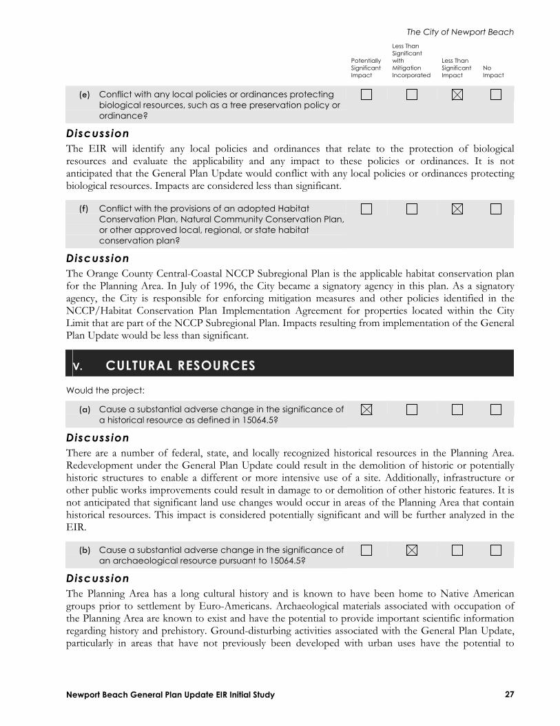
(e) Conflict with any local policies or ordinances protecting biological resources, such as a tree preservation policy or ordinance?
DiscussionThe EIR will identify any local policies and ordinances that relate to the protection of biological resources and evaluate the applicability and any impact to these policies or ordinances. It is not anticipated that the General Plan Update would conflict with any local policies or ordinances protecting biological resources. Impacts are considered less than significant.
(f) Conflict with the provisions of an adopted Habitat Conservation Plan, Natural Community Conservation Plan, or other approved local, regional, or state habitat conservation plan?
DiscussionThe Orange County Central-Coastal NCCP Subregional Plan is the applicable habitat conservation plan for the Planning Area. In July of 1996, the City became a signatory agency in this plan. As a signatory agency, the City is responsible for enforcing mitigation measures and other policies identified in the NCCP/Habitat Conservation Plan Implementation Agreement for properties located within the City Limit that are part of the NCCP Subregional Plan. Impacts resulting from implementation of the General Plan Update would be less than significant.
V. CULTURAL RESOURCES
Would the project:
(a) Cause a substantial adverse change in the significance of a historical resource as defined in 15064.5?
DiscussionThere are a number of federal, state, and locally recognized historical resources in the Planning Area. Redevelopment under the General Plan Update could result in the demolition of historic or potentially historic structures to enable a different or more intensive use of a site. Additionally, infrastructure or other public works improvements could result in damage to or demolition of other historic features. It is not anticipated that significant land use changes would occur in areas of the Planning Area that contain historical resources. This impact is considered potentially significant and will be further analyzed in the EIR.
(b) Cause a substantial adverse change in the significance of an archaeological resource pursuant to 15064.5?
DiscussionThe Planning Area has a long cultural history and is known to have been home to Native American groups prior to settlement by Euro-Americans. Archaeological materials associated with occupation of the Planning Area are known to exist and have the potential to provide important scientific information regarding history and prehistory. Ground-disturbing activities associated with the General Plan Update, particularly in areas that have not previously been developed with urban uses have the potential to
The City of Newport Beach
Potentially Significant Impact
Less Than Significant with Mitigation Incorporated
Less Than Significant Impact
NoImpact
Newport Beach General Plan Update EIR Initial Study 28
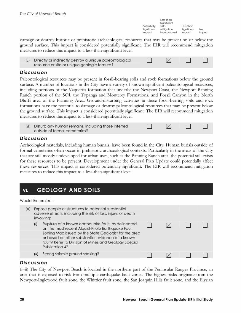
damage or destroy historic or prehistoric archaeological resources that may be present on or below the ground surface. This impact is considered potentially significant. The EIR will recommend mitigation measures to reduce this impact to a less-than-significant level.
(c) Directly or indirectly destroy a unique paleontological resource or site or unique geologic feature?
DiscussionPaleontological resources may be present in fossil-bearing soils and rock formations below the ground surface. A number of locations in the City have a variety of known significant paleontological resources, including portions of the Vaqueros formation that underlie the Newport Coast, the Newport Banning Ranch portion of the SOI, the Topanga and Monterey Formations, and Fossil Canyon in the North Bluffs area of the Planning Area. Ground-disturbing activities in these fossil-bearing soils and rock formations have the potential to damage or destroy paleontological resources that may be present below the ground surface. This impact is considered potentially significant. The EIR will recommend mitigation measures to reduce this impact to a less-than-significant level.
(d) Disturb any human remains, including those interred outside of formal cemeteries?
DiscussionArcheological materials, including human burials, have been found in the City. Human burials outside of formal cemeteries often occur in prehistoric archaeological contexts. Particularly in the areas of the City that are still mostly undeveloped for urban uses, such as the Banning Ranch area, the potential still exists for these resources to be present. Development under the General Plan Update could potentially affect these resources. This impact is considered potentially significant. The EIR will recommend mitigation measures to reduce this impact to a less-than-significant level.
VI. GEOLOGY AND SOILS
Would the project:
(a) Expose people or structures to potential substantial adverse effects, including the risk of loss, injury, or death involving: (i) Rupture of a known earthquake fault, as delineated
on the most recent Alquist-Priolo Earthquake Fault Zoning Map issued by the State Geologist for the areaor based on other substantial evidence of a known fault? Refer to Division of Mines and Geology Special Publication 42.
(ii) Strong seismic ground shaking?
Discussion(i–ii) The City of Newport Beach is located in the northern part of the Peninsular Ranges Province, an area that is exposed to risk from multiple earthquake fault zones. The highest risks originate from the Newport-Inglewood fault zone, the Whittier fault zone, the San Joaquin Hills fault zone, and the Elysian

The City of Newport Beach
Potentially Significant Impact
Less Than Significant with Mitigation Incorporated
Less Than Significant Impact
NoImpact
Newport Beach General Plan Update EIR Initial Study 29
Park fault zone, each with the potential to cause moderate to large earthquakes that would cause ground shaking in Newport Beach and nearby communities. The area faults could significantly impact the City but these impacts generally can be addressed through adherence to applicable regulations (i.e., Uniform Building Code) and design, grading, and structural recommendations. The EIR will include an analysis of impacts associated with seismic hazards associated with implementation of the General Plan Update and will recommend mitigation measures to reduce or eliminate these impacts.
(iii) Seismic-related ground failure, including liquefaction?
DiscussionAreas of Newport susceptible to liquefaction and related ground failure (i.e., seismically induced settlement) include areas along the coastline that includes Balboa Peninsula, in and around the Newport Bay and Upper Newport Bay, in the lower reaches of major streams in Newport Beach, and in the floodplain of the Santa Ana River. It is likely that residential or commercial development will never occur in many of the other liquefiable areas, such as Upper Newport Bay, the Newport Coast beaches, and the bottoms of stream channels. However, implementation of the General Plan Update could affect other areas susceptible to liquefaction. This impact is considered potentially significant. The EIR will recommend mitigation measures to reduce this impact to a less-than-significant level.
(iv) Landslides?
DiscussionMuch of the area in eastern Newport Beach has been identified as vulnerable to seismically induced slope failure. Approximately 90 percent of the land from Los Trancos Canyon to the Crystal Cove State Park boundary is mapped as susceptible to landsliding by the California Geologic Survey. Additionally, the sedimentary bedrock that crops out in the San Joaquin Hills is locally highly weathered. In steep areas, strong ground shaking can cause slides or rockfalls in this material. Rupture along the Newport-Inglewood Fault Zone and other faults in Southern California could reactivate existing landslides and cause new slope failures throughout the San Joaquin Hills. Slope failures can also be expected to occur along stream banks and coastal bluffs, such as Big Canyon, around San Joaquin Reservoir, Newport and Upper Newport Bays, and Corona del Mar. Thus, impacts resulting from development under the General Plan Update are considered potentially significant. The EIR will recommend mitigation measures to reduce this impact to a less-than-significant level.
(b) Result in substantial soil erosion or the loss of topsoil?
DiscussionErosion is a significant concern in Newport Beach, especially along the shoreline, where beach sediments and coastal bluffs are highly susceptible to erosion by wave action. Other parts of the City, including bluffs along Upper Newport Bay, canyon walls along tributary streams leading to the Bay, and slopes (both natural and man-made) within the San Joaquin Hills are also susceptible to erosion. This impact is considered potentially significant and will be further analyzed in the EIR.

The City of Newport Beach
Potentially Significant Impact
Less Than Significant with Mitigation Incorporated
Less Than Significant Impact
NoImpact
Newport Beach General Plan Update EIR Initial Study 30
(c) Be located on a geologic unit or soil that is unstable, or that would become unstable as a result of the project, and potentially result in on- or off-site landslide, lateral spreading, subsidence, liquefaction, or collapse?
DiscussionCompressible soils underlie a significant part of the City, typically in the lowland areas and in canyon bottoms. These are generally young sediments of low density with variable amounts of organic materials. Under the added weight of fill embankments or buildings, these sediments will settle, causing distress to improvements. Low-density soils, if sandy in composition and saturated with water, will also be susceptible of the effects of liquefaction during a moderate to strong earthquake. This impact is considered potentially significant and will be further analyzed in the EIR. The EIR will recommend mitigation measures to reduce this impact to a less-than-significant level.
(d) Be located on expansive soil, as defined in Table 18-1-B of the Uniform Building Code (1994), creating substantial risks to life or property?
DiscussionSome of the geologic units in the Newport Beach area, including both surficial soils and bedrock, have fine-grained components that are moderate to highly expansive. These materials may be present at the surface or exposed by grading activities. Man-made fills can also be expansive, depending on the soils used to construct them. This impact is considered potentially significant and will be further analyzed in the EIR. The EIR will also recommend mitigation measures to reduce this impact to a less-than-significant level.
(e) Have soils incapable of adequately supporting the use of septic tanks or alternative waste water disposal systems where sewers are not available for the disposal of waste water?
DiscussionThe City of Newport Beach is almost entirely built out with established utility services and new development would not require the use of septic tanks. For this reason, this impact is not further analyzed in the EIR.
VII. HAZARDS AND HAZARDOUS MATERIALS
Would the project:
(a) Create a significant hazard to the public or the environment through the routine transport, use, or disposal of hazardous materials?
DiscussionImplementation of the General Plan Update would concentrate infill development and redevelopment in several specified subareas: Newport Center/Fashion Island, Balboa Village, Balboa Peninsula, West Newport Mesa, West Newport Highway, Mariner’s Mile, and the John Wayne Airport area. In addition,
The City of Newport Beach
Potentially Significant Impact
Less Than Significant with Mitigation Incorporated
Less Than Significant Impact
NoImpact
Newport Beach General Plan Update EIR Initial Study 31
while the General Plan Update prioritizes the retention of the Banning Ranch property as open space, the Plan also considers the possible development of a mixed-density residential village with a small component of resident- and visitor-serving commercial should the property not be acquired for open space. Implementation of these land use changes would not generally involve the transportation, use, or disposal of hazardous materials. Further, industrial uses within the City would decrease upon implementation of the General Plan Update and any development that would handle or use hazardous materials would be required to comply with the regulations, standards, guidelines established by the EPA, State of California, Orange County, and the City of Newport Beach. For these reasons, this impact is considered less than significant and will not be further analyzed in the EIR.
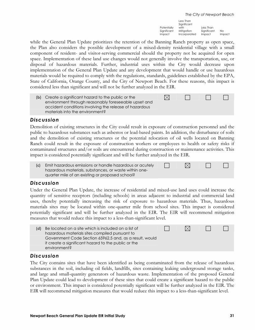
(b) Create a significant hazard to the public or the environment through reasonably foreseeable upset and accident conditions involving the release of hazardous materials into the environment?
DiscussionDemolition of existing structures in the City could result in exposure of construction personnel and the public to hazardous substances such as asbestos or lead-based paints. In addition, the disturbance of soils and the demolition of existing structures or the potential relocation of oil wells located on Banning Ranch could result in the exposure of construction workers or employees to health or safety risks if contaminated structures and/or soils are encountered during construction or maintenance activities. This impact is considered potentially significant and will be further analyzed in the EIR.
(c) Emit hazardous emissions or handle hazardous or acutely hazardous materials, substances, or waste within one-quarter mile of an existing or proposed school?
DiscussionUnder the General Plan Update, the increase of residential and mixed-use land uses could increase the quantity of sensitive receptors (including schools) in areas adjacent to industrial and commercial land uses, thereby potentially increasing the risk of exposure to hazardous materials. Thus, hazardous materials sites may be located within one-quarter mile from school sites. This impact is considered potentially significant and will be further analyzed in the EIR. The EIR will recommend mitigation measures that would reduce this impact to a less-than-significant level.
(d) Be located on a site which is included on a list of hazardous materials sites compiled pursuant to Government Code Section 65962.5 and, as a result, would it create a significant hazard to the public or the environment?
DiscussionThe City contains sites that have been identified as being contaminated from the release of hazardous substances in the soil, including oil fields, landfills, sites containing leaking underground storage tanks, and large and small-quantity generators of hazardous waste. Implementation of the proposed General Plan Update could lead to development of these sites that could create a significant hazard to the public or environment. This impact is considered potentially significant will be further analyzed in the EIR. The EIR will recommend mitigation measures that would reduce this impact to a less-than-significant level.
The City of Newport Beach
Potentially Significant Impact
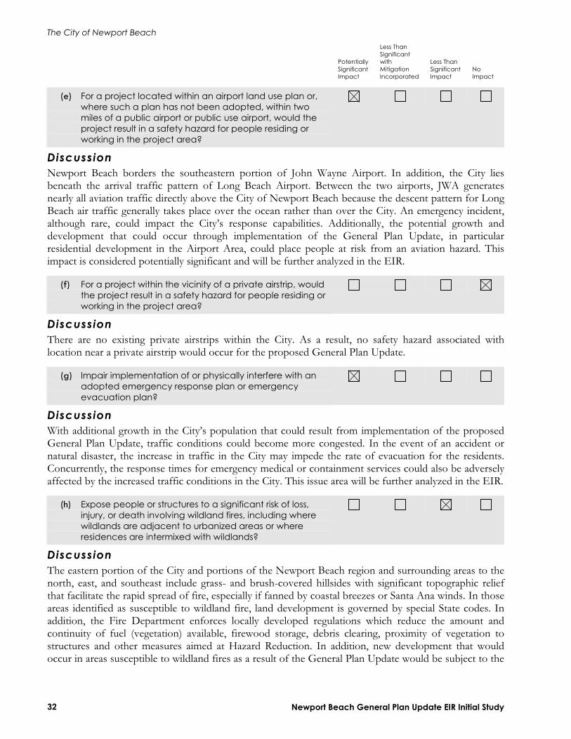
Less Than Significant with Mitigation Incorporated
Less Than Significant Impact
NoImpact
Newport Beach General Plan Update EIR Initial Study 32
(e) For a project located within an airport land use plan or, where such a plan has not been adopted, within two miles of a public airport or public use airport, would the project result in a safety hazard for people residing or working in the project area?
DiscussionNewport Beach borders the southeastern portion of John Wayne Airport. In addition, the City lies beneath the arrival traffic pattern of Long Beach Airport. Between the two airports, JWA generates nearly all aviation traffic directly above the City of Newport Beach because the descent pattern for Long Beach air traffic generally takes place over the ocean rather than over the City. An emergency incident, although rare, could impact the City’s response capabilities. Additionally, the potential growth and development that could occur through implementation of the General Plan Update, in particular residential development in the Airport Area, could place people at risk from an aviation hazard. This impact is considered potentially significant and will be further analyzed in the EIR.
(f) For a project within the vicinity of a private airstrip, would the project result in a safety hazard for people residing or working in the project area?
DiscussionThere are no existing private airstrips within the City. As a result, no safety hazard associated with location near a private airstrip would occur for the proposed General Plan Update.
(g) Impair implementation of or physically interfere with an adopted emergency response plan or emergency evacuation plan?
DiscussionWith additional growth in the City’s population that could result from implementation of the proposed General Plan Update, traffic conditions could become more congested. In the event of an accident or natural disaster, the increase in traffic in the City may impede the rate of evacuation for the residents. Concurrently, the response times for emergency medical or containment services could also be adversely affected by the increased traffic conditions in the City. This issue area will be further analyzed in the EIR.
(h) Expose people or structures to a significant risk of loss, injury, or death involving wildland fires, including where wildlands are adjacent to urbanized areas or where residences are intermixed with wildlands?
DiscussionThe eastern portion of the City and portions of the Newport Beach region and surrounding areas to the north, east, and southeast include grass- and brush-covered hillsides with significant topographic relief that facilitate the rapid spread of fire, especially if fanned by coastal breezes or Santa Ana winds. In those areas identified as susceptible to wildland fire, land development is governed by special State codes. In addition, the Fire Department enforces locally developed regulations which reduce the amount and continuity of fuel (vegetation) available, firewood storage, debris clearing, proximity of vegetation to structures and other measures aimed at Hazard Reduction. In addition, new development that would occur in areas susceptible to wildland fires as a result of the General Plan Update would be subject to the
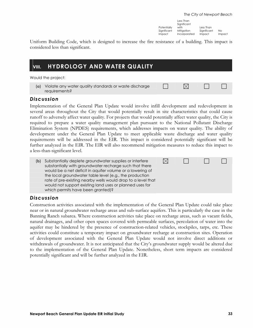
The City of Newport Beach
Potentially Significant Impact
Less Than Significant with Mitigation Incorporated
Less Than Significant Impact
NoImpact
Newport Beach General Plan Update EIR Initial Study 33
Uniform Building Code, which is designed to increase the fire resistance of a building. This impact is considered less than significant.
VIII. HYDROLOGY AND WATER QUALITY
Would the project:
(a) Violate any water quality standards or waste discharge requirements?
DiscussionImplementation of the General Plan Update would involve infill development and redevelopment in several areas throughout the City that would potentially result in site characteristics that could cause runoff to adversely affect water quality. For projects that would potentially affect water quality, the City is required to prepare a water quality management plan pursuant to the National Pollutant Discharge Elimination System (NPDES) requirements, which addresses impacts on water quality. The ability of development under the General Plan Update to meet applicable waste discharge and water quality requirements will be addressed in the EIR. This impact is considered potentially significant will be further analyzed in the EIR. The EIR will also recommend mitigation measures to reduce this impact to a less-than-significant level.
(b) Substantially deplete groundwater supplies or interfere substantially with groundwater recharge such that there would be a net deficit in aquifer volume or a lowering of the local groundwater table level (e.g., the production rate of pre-existing nearby wells would drop to a level that would not support existing land uses or planned uses for which permits have been granted)?
DiscussionConstruction activities associated with the implementation of the General Plan Update could take place near or in natural groundwater recharge areas and sub-surface aquifers. This is particularly the case in the Banning Ranch subarea. Where construction activities take place on recharge areas, such as vacant fields, natural drainages, and other open spaces covered with permeable surfaces, percolation of water into the aquifer may be hindered by the presence of construction-related vehicles, stockpiles, tarps, etc. These activities could constitute a temporary impact on groundwater recharge at construction sites. Operation of development associated with the General Plan Update would not involve direct additions or withdrawals of groundwater. It is not anticipated that the City’s groundwater supply would be altered due to the implementation of the General Plan Update. Nonetheless, short term impacts are considered potentially significant and will be further analyzed in the EIR.
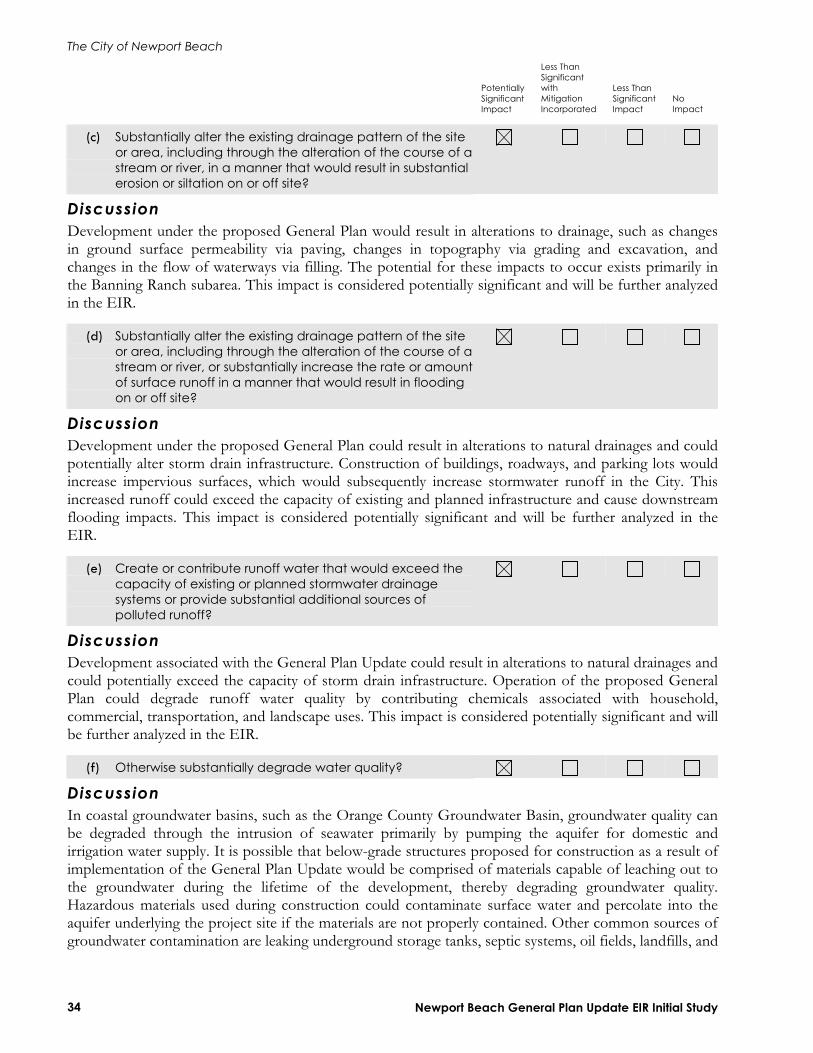
The City of Newport Beach
Potentially Significant Impact
Less Than Significant with Mitigation Incorporated
Less Than Significant Impact
NoImpact
Newport Beach General Plan Update EIR Initial Study 34
(c) Substantially alter the existing drainage pattern of the site or area, including through the alteration of the course of astream or river, in a manner that would result in substantial erosion or siltation on or off site?
DiscussionDevelopment under the proposed General Plan would result in alterations to drainage, such as changes in ground surface permeability via paving, changes in topography via grading and excavation, and changes in the flow of waterways via filling. The potential for these impacts to occur exists primarily in the Banning Ranch subarea. This impact is considered potentially significant and will be further analyzed in the EIR.
(d) Substantially alter the existing drainage pattern of the site or area, including through the alteration of the course of astream or river, or substantially increase the rate or amountof surface runoff in a manner that would result in flooding on or off site?
DiscussionDevelopment under the proposed General Plan could result in alterations to natural drainages and could potentially alter storm drain infrastructure. Construction of buildings, roadways, and parking lots would increase impervious surfaces, which would subsequently increase stormwater runoff in the City. This increased runoff could exceed the capacity of existing and planned infrastructure and cause downstream flooding impacts. This impact is considered potentially significant and will be further analyzed in the EIR.
(e) Create or contribute runoff water that would exceed the capacity of existing or planned stormwater drainage systems or provide substantial additional sources of polluted runoff?
DiscussionDevelopment associated with the General Plan Update could result in alterations to natural drainages and could potentially exceed the capacity of storm drain infrastructure. Operation of the proposed General Plan could degrade runoff water quality by contributing chemicals associated with household, commercial, transportation, and landscape uses. This impact is considered potentially significant and will be further analyzed in the EIR.
(f) Otherwise substantially degrade water quality?
DiscussionIn coastal groundwater basins, such as the Orange County Groundwater Basin, groundwater quality can be degraded through the intrusion of seawater primarily by pumping the aquifer for domestic and irrigation water supply. It is possible that below-grade structures proposed for construction as a result of implementation of the General Plan Update would be comprised of materials capable of leaching out to the groundwater during the lifetime of the development, thereby degrading groundwater quality. Hazardous materials used during construction could contaminate surface water and percolate into the aquifer underlying the project site if the materials are not properly contained. Other common sources of groundwater contamination are leaking underground storage tanks, septic systems, oil fields, landfills, and
The City of Newport Beach
Potentially Significant Impact
Less Than Significant with Mitigation Incorporated
Less Than Significant Impact
NoImpact
Newport Beach General Plan Update EIR Initial Study 35
general industrial land uses. This impact is considered potentially significant and will be further analyzed in the EIR.
(g) Place housing within a 100-year flood hazard area as mapped on a federal Flood Hazard Boundary or Flood Insurance Rate Map or other flood hazard delineation map?
DiscussionThe 100-year flood zone generally lies in and along the edges of Newport Bay and along the coastline of the Planning Area. Because development associated with the General Plan Update includes an increase in residential development throughout the City, it is possible residential uses could be sited in the flood zone. This impact is considered potentially significant and will be further analyzed in the EIR.
(h) Place within a 100-year flood hazard area structures that would impede or redirect flood flows?
DiscussionFlood flows primarily travel along Newport Bay and across the coastline. Although structures that substantially impede flood flows, such as dams and levees, would not be constructed under the proposed General Plan, overall intensification of development could alter existing passages through which flood waters flow. This impact is considered potentially significant and will be further analyzed in the EIR.
(i) Expose people or structures to a significant risk of loss, injury or death involving flooding, including flooding as a result of the failure of a levee or dam?
DiscussionSeveral dams are located within and in the vicinity of the City of Newport Beach. Portions of Newport Beach are threatened by inundation resulting from failure of Prado Dam, Santiago Creek Reservoir, Villa Park Reservoir, San Joaquin Reservoir, Big Canyon Reservoir, and Harbor View Reservoir. This impact is considered potentially significant and will be further analyzed in the EIR.
(j) Inundation by seiche, tsunami, or mudflow?
DiscussionSeiching in large, enclosed bodies of water, such as the reservoirs in the City and, to an extent, Newport Harbor and Newport Bay, would inundate immediate areas surrounding the body of water. Prolonged rainfall during certain storm events would saturate and could eventually loosen soil, resulting in the flow of mud down steep slopes and slope failure. In addition, the proximity to the ocean leads to natural risk of tsunamis from offshore and distant seismic events. This impact is considered potentially significant and will be further analyzed in the EIR.
The City of Newport Beach
Potentially Significant Impact
Less Than Significant with Mitigation Incorporated
Less Than Significant Impact
NoImpact
Newport Beach General Plan Update EIR Initial Study 36
IX. LAND USE AND PLANNING
Would the project:
(a) Physically divide an established community?
DiscussionThe implementation of the proposed General Plan Update would not physically divide an established community as it would provide increased development in various separate locations with the intention of increasing the cohesiveness of the city. This impact is considered less than significant but will be further analyzed in the EIR.
(b) Conflict with any applicable land use plan, policy, or regulation of an agency with jurisdiction over the project (including, but not limited to the general plan, specific plan, local coastal program, or zoning ordinance) adopted for the purpose of avoiding or mitigating an environmental effect?
DiscussionThe General Plan Update contains updated land use polices that govern development in the City and the Planning Area for the next 20 years. It also provides for new land use and development patterns, which are different from the City’s existing General Plan and Zoning Code for some areas, such as the Airport Area and Newport Center/Fashion Island. This impact is considered potentially significant and will be further analyzed in the EIR.
(c) Conflict with any applicable habitat conservation plan or natural community conservation plan?
DiscussionThe Orange County Central-Coastal NCCP Subregional Plan is the applicable habitat conservation plan for the Planning Area. In July of 1996, the City became a signatory agency in this plan. As a signatory agency, the City is responsible for enforcing mitigation measures and other policies identified in the NCCP/Habitat Conservation Plan Implementation Agreement for properties located within the City Limit that are part of the NCCP Subregional Plan. Impacts resulting from implementation of the General Plan Update would be less than significant.
The City of Newport Beach
Potentially Significant Impact
Less Than Significant with Mitigation Incorporated
Less Than Significant Impact
NoImpact
Newport Beach General Plan Update EIR Initial Study 37
X. MINERAL RESOURCES
Would the project:
(a) Result in the loss of availability of a known mineral resourcethat would be of value to the region and the residents of the state?
(b) Result in the loss of availability of a locally-important mineral resource recovery site delineated on a local general plan, specific plan, or other land use plan?
Discussion(a–b) Two separate production and reserve areas exist within the Planning Area: the Newport oil field and the West Newport oil field. The Newport Oil Field is located in the western portion of the Planning Area, and is estimated to have oil reserves of approximately 35 million barrels (Mbbl) and produces approximately 55 billion cubic feet of gas. The West Newport oil field, located in the Banning Ranch area, produces approximately 20.5 billion cubic feet of gas with a daily production per oil well of approximately 5 bbl. Estimated oil reserves within this field are approximately 728 Mbbl.
Thirty-three abandoned oil wells are located in numerous sites throughout the City, concentrated along the northwest boundary. Other than oil and gas resources, there is no active mining within the Newport Beach area. Mineral Resource Zones (MRZ) within the City are either classified as containing no significant mineral deposits (MRZ-1), or the significance of mineral deposits has not been determined (MRZ-3). Section 1401 of the City’s Charter does not allow new drilling, or production or refining of oil, gas, or other hydrocarbon substances within the City. However, the Section does not prohibit these activities within any area annexed to the City after the effective date of the Charter if these activities were already in operation. The City’s Municipal Code does allow for slant drilling activities for oil, gas, tar, and other hydrocarbon substances within a designated area of Newport Beach. Thus, this impact is considered potentially significant and will be further analyzed in the EIR.
XI. NOISE
Would the project result in:
(a) Exposure of persons to or generation of noise levels in excess of standards established in the local general plan or noise ordinance, or applicable standards of other agencies?
DiscussionWith implementation of the General Plan Update, it is expected that there would be increases noise levels throughout the City. Noise levels associated with construction activities could temporarily exceed noise level standards established by the City. In addition, the increase population, commercial and retail, and corresponding traffic could cause operational increases in noise levels which could be in excess of established standards. This impact is considered potentially significant and will be further analyzed in the EIR.

The City of Newport Beach
Potentially Significant Impact
Less Than Significant with Mitigation Incorporated
Less Than Significant Impact
NoImpact
Newport Beach General Plan Update EIR Initial Study 38
(b) Exposure of persons to or generation of excessive groundborne vibration or groundborne noise levels?
DiscussionImplementation of the General Plan Update would include construction activities associated with development. Construction activities typically create an increase in groundborne vibrations and noise levels. Groundborne vibrations and noise generated by construction activities associated could increase noise levels intermittently at nearby sensitive receptors, which generally include residential and school land uses. Groundborne vibration impacts are considered potentially significant. This issue will be further analyzed in the EIR.
(c) A substantial permanent increase in ambient noise levels in the project vicinity above levels existing without the project?
(d) A substantial temporary or periodic increase in ambient noise levels in the project vicinity above levels existing without the project?
Discussion(c–d) Implementation of the General Plan Update could increase ambient noise in the City above existing levels. This would be due to the increase in population, traffic flow and patterns, increased business, and increased construction throughout the City. Some of these sources would be regulated by existing noise ordinances, but could still exceed existing levels. This impact is considered potentially significant and will be further analyzed in the EIR.
(e) For a project located within an airport land use plan or, where such a plan has not been adopted, within two miles of a public airport or public use airport, would the project expose people residing or working in the project area to excessive noise levels?
DiscussionThe General Plan Update covers an area that has flight paths directly overhead from John Wayne Airport. Although aircraft noise can be heard throughout Newport Beach, the highest noise levels are experienced just south of the airport, in the Airport Area, Santa Ana Heights Area, Westcliff, Dover Shores, the Bluffs, and Balboa Island, and are generated by aircraft departures. Development in these locations within the Planning Area would expose an increased a greater number of residents and visitors to noise generated by operations at John Wayne Airport. This impact is considered potentially significant and will be further analyzed in the EIR.
(f) For a project within the vicinity of a private airstrip, would the project expose people residing or working in the project area to excessive noise levels?
DiscussionThere are no private airstrips in the vicinity of the City and would have no impact. This impact will not be further discussed in the EIR.
The City of Newport Beach
Potentially Significant Impact
Less Than Significant with Mitigation Incorporated
Less Than Significant Impact
NoImpact
Newport Beach General Plan Update EIR Initial Study 39
XII. POPULATION AND HOUSING
Would the project:
(a) Induce substantial population growth in an area, either directly (for example, by proposing new homes and businesses) or indirectly (for example, through extension of roads or other infrastructure)?
DiscussionDevelopment associated with implementation of the General Plan Update would induce substantial population growth in the Planning Area. It is not anticipated that the population growth that would result from the General Plan Update would be greater than regional population projections since many of the land use changes in the General Plan Update would serve to accommodate these already-identified increases in population. The EIR will evaluate the changes in population resulting from proposed changes in land use designations. This impact is considered less than significant but will be further analyzed in the EIR.
(b) Displace substantial numbers of existing housing, necessitating the construction of replacement housing elsewhere?
(c) Displace substantial numbers of people, necessitating the construction of replacement housing elsewhere?
Discussion(b–c) Implementation of the General Plan Update would result in the development of single and multi-family residential uses. The increase in residential land uses in the City would serve to accommodate the increase in population that would occur as a result of State and regional population growth. Implementation of the General Plan would not displace substantial numbers of existing housing and/or people. This impact is considered less than significant.
XIII. PUBLIC SERVICES
(a) Would the project result in substantial adverse physical impacts associated with the provision of new or physically altered governmental facilities, need for new or physically altered governmental facilities, the construction of which could cause significant environmental impacts, in order to maintain acceptable service ratios, response times or other performance objectives for any of the public services: (i) Fire protection?
DiscussionThe Newport Beach Fire Department, the Orange County Fire Authority, and the Costa Mesa Fire Department provide fire protection services for the City and Planning Area. Development under the proposed General Plan would increase over existing conditions in the Planning Area. Any development
The City of Newport Beach
Potentially Significant Impact
Less Than Significant with Mitigation Incorporated
Less Than Significant Impact
NoImpact
Newport Beach General Plan Update EIR Initial Study 40
increase that would occur as a result of implementation of the proposed General Plan would have a corresponding increase in traffic volumes and congestion problems on surface streets, which could hinder response times for calls for service (for both fire protection and emergency medical service). This impact is considered potentially significant and will be further analyzed in the EIR. The EIR will recommend mitigation measures that would reduce this impact to a less-than-significant level.
(ii) Police protection?
DiscussionThe Newport Beach Police Department, the Orange County Sheriff Department, and the Costa Mesa Police Department provide police services to the City and the Planning Area. Increases in population resulting from build out of the General Plan Update could affect the ratio of law enforcement officers per 1,000 residents. This impact is considered potentially significant and will be further analyzed in the EIR. The EIR will recommend mitigation measures that would reduce this impact to a less-than-significant level.
(iii) Schools?
DiscussionThe Newport-Mesa Unified School District provides educational services to the City of Newport Beach as well as the City of Costa Mesa and other unincorporated areas of Orange County. The Airport Area is served by the Santa Ana Unified School District. Population increases resulting from implementation of the General Plan Update would increase the demand for school services which could ultimately result in an exceedance of capacity at the District’s schools. This impact is considered potentially significant and will be further analyzed in the EIR. The EIR will recommend mitigation measures that would reduce this impact to a less-than-significant level.
(iv) Parks?
DiscussionThe City contains approximately 278 acres of developed parks. Implementation of the proposed General Plan Update would increase the population of the Planning Area and could ultimately increase demand on the City’s parkland resources. This impact is considered potentially significant and will be further analyzed in the EIR. The EIR will recommend mitigation measures that would reduce this impact to a less-than-significant level.
(v) Other public facilities?
DiscussionAn increase in population resulting from implementation of the General Plan Update would increase demand on other public facilities including libraries. This impact is considered potentially significant and will be further analyzed in the EIR. The EIR will recommend mitigation measures that would reduce this impact to a less-than-significant level.

The City of Newport Beach
Potentially Significant Impact
Less Than Significant with Mitigation Incorporated
Less Than Significant Impact
NoImpact
Newport Beach General Plan Update EIR Initial Study 41
XIV. RECREATION
(a) Would the project increase the use of existing neighborhood and regional parks or other recreational facilities such that substantial physical deterioration of the facility would occur or be accelerated?
DiscussionThe City has approximately 286 acres of developed parks and approximately 90 acres of active beach recreation acreage, for a total of 376.8 acres. Although the City of Newport Beach appears largely built out, there are a number of vacant parcels available for future development. An increase in population resulting from implementation of the proposed General Plan Update may place an even higher demand on these existing facilities such that deterioration of these facilities would be accelerated. This impact is considered potentially significant and will be further analyzed in the EIR.
(b) Does the project include recreational facilities or require the construction or expansion of recreational facilities that might have an adverse physical effect on the environment?
DiscussionDevelopment under the General Plan would include construction of recreational facilities that would serve current and future City residents. Construction of such facilities could have an adverse effect on the environment. This impact is considered potentially significant and will be further analyzed in the EIR. The EIR will recommend mitigation measures to reduce this impact to a less-than-significant level.
XV. TRANSPORTATION/TRAFFIC
Would the project:
(a) Cause an increase in traffic which is substantial in relation to the existing traffic load and capacity of the street system (i.e., result in a substantial increase in either the number of vehicle trips, the volume to capacity ratio on roads, or congestion at intersections)?
(b) Exceed, either individually or cumulatively, a level of service standard established by the county congestion management agency for designated roads or highways?
Discussion(a–b) Development associated with the General Plan Update would result in an increase in traffic and modifications to existing roadways. A traffic analysis technical report will be prepared to assist in the evaluation of the potential impacts related to traffic that would result from project implementation. The General Plan Update would generate additional vehicular trips that could potentially result in a substantial traffic increase in the City. This increase in traffic would further add to the existing traffic load and could impact the existing capacity of the street system. The potential impacts due to increased
The City of Newport Beach
Potentially Significant Impact
Less Than Significant with Mitigation Incorporated
Less Than Significant Impact
NoImpact
Newport Beach General Plan Update EIR Initial Study 42
trip generation, changes to the volume-to-capacity ratio on roads, and congestion at intersections will be analyzed in the EIR.
(c) Result in a change in air traffic patterns, including either an increase in traffic levels or a change in location that results in substantial safety risks?
DiscussionNewport Beach borders the southeastern portion of John Wayne Airport. The increased in population and traffic volume resulting from implementation of the General Plan Update is, however, not anticipated to increase use of this airport to a level that would significantly increase air traffic levels or require a change in air traffic patterns. Impacts are considered less than significant.
(d) Substantially increase hazards due to a design feature (e.g., sharp curves or dangerous intersections) or incompatible uses (e.g., farm equipment)?
DiscussionImplementation of the General Plan Update would include several roadway improvement measures, but would not include design features that would result in roadway hazards. The General Plan would also include goals and policies that would govern the safety of the City’s roadways. This impact is considered less than significant and will be further evaluated in the EIR.
(e) Result in inadequate emergency access?
DiscussionDevelopment associated with the General Plan Update would be required to comply with the Municipal Code and other applicable polices that set forth guidelines for emergency access to and from development sites. However, on a City-wide scale, significant increases in traffic volumes on roadways could impede access for emergency vehicles such as ambulances and police cars. This impact is considered potentially significant and will be further analyzed in the EIR.
(f) Result in inadequate parking capacity?
DiscussionThe implementation of the General Plan Update would cause an increased demand for parking as new residential and commercial land uses would increase. However, new development that would occur under the General Plan would be required to adhere to the Municipal Code standards as well as any applicable parking policies for the area. This impact is considered less than significant and will not be further analyzed in the EIR.
(g) Conflict with adopted policies, plans, or programs supporting alternative transportation (e.g., bus turnouts, bicycle racks)?
DiscussionThe General Plan Update will not conflict with any policies, plans, or programs which support alternative transportation in the City. The General Plan Updates contains updated policies regarding alternative transportation modes in the City. The General Plan Update contains updated transportation polices that

The City of Newport Beach
Potentially Significant Impact
Less Than Significant with Mitigation Incorporated
Less Than Significant Impact
NoImpact
Newport Beach General Plan Update EIR Initial Study 43
guide circulation issues in the City over the next 20 years. Thus, by its nature, the General Plan Update would not conflict with any adopted policies, plans, or programs supporting alternative transportation. No impact would result and no further analysis is required.
XVI. UTILITIES AND SERVICE SYSTEMS
Would the project:
(a) Exceed wastewater treatment requirements of the applicable Regional Water Quality Control Board?
DiscussionAny development resulting from implementation of the General Plan Update would be required to obtain a National Pollution Discharge Elimination System permit from the Regional Water Quality Control Board (RWQCB) that would contain requirements for wastewater discharge, Best Management Practices, and a Stormwater Pollution Prevention Program. Within the NPDES permit the effluent quality criteria shall be specified in the permit as determined by the RWQCB. Compliance with requirements set forth by the RWQCB would reduce impacts to a less-than-significant level.
(b) Require or result in the construction of new water or wastewater treatment facilities or expansion of existing facilities, the construction of which could cause significant environmental effects?
DiscussionDomestic water for the City is supplied by both groundwater and imported surface water. Groundwater is provided from the Orange County Groundwater Basin and the remaining water supply is provided to the City by the Metropolitan Water District. Wastewater generated in the City is treated by the Orange County Sanitation District (OCSD). Development resulting from implementation of the General Plan Update would result in increased demands on water and wastewater treatment facilities which could ultimately result in the construction of new facilities. This impact is considered potentially significant and will be further analyzed in the EIR. The EIR will recommend mitigation measures to reduce this impact to a less-than-significant level.
(c) Require or result in the construction of new storm water drainage facilities or expansion of existing facilities, the construction of which could cause significant environmental effects?
DiscussionThe City provides storm drain facilities to the Planning Area. Undeveloped areas within the Planning Area, including Banning Ranch, do not currently have storm water facilities and would require new facilities if development were to occur under the General Plan Update. Construction of new facilities or expansion of existing facilities could have adverse environmental effects in currently undeveloped areas. This impact is considered potentially significant and will be further analyzed in the EIR.

The City of Newport Beach
Potentially Significant Impact
Less Than Significant with Mitigation Incorporated
Less Than Significant Impact
NoImpact
Newport Beach General Plan Update EIR Initial Study 44
(d) Have sufficient water supplies available to serve the project from existing entitlements and resources, or are new or expanded entitlements needed?
DiscussionDomestic water for the City is supplied by both groundwater and imported surface water. Currently, about 64 percent of the water supplied to both the City and Costa Mesa’s service area is from groundwater from the Orange County Groundwater Basin (administered by the Orange County Water District or OCWD), and the remaining 36 percent of water supply is provided by the Metropolitan Water District (MWD), which delivers surface water imported from the Colorado River and State Water Project. Increases in population resulting from implementation of the General Plan Update could place a demand on water suppliers that would exceed existing entitlements and resources. This impact is considered potentially significant and will be further analyzed in the EIR. The EIR will recommend mitigation measures to reduce this impact to a less-than-significant level.
(e) Result in a determination by the wastewater treatment provider that serves or may serve the project that it has adequate capacity to serve the project’s projected demand in addition to the provider’s existing commitments?
DiscussionWastewater treatment is provided by the OCSD. Increases in wastewater generation resulting from implementation of the General Plan could exceed the capacity of the existing treatment facilities. The EIR will include an analysis of the current and future capacity of OCSD facilities to determine whether impacts would result from implementation of the General Plan Update. If applicable, mitigation measures will be recommended to reduce any potentially significant impacts to a less-than-significant level.
(f) Be served by a landfill with sufficient permitted capacity toaccommodate the project’s solid waste disposal needs?
(g) Comply with federal, state, and local statutes and regulations related to solid waste?
Discussion(f–g) Implementation of the General Plan would result in increased generation of solid waste. The EIR will include an analysis of the ability for existing landfills to accommodate future solid waste disposal needs in the Planning Area. In addition, the EIR will discuss compliance with federal, state, and local statutes and regulations related to solid waste. If applicable, mitigation measures will be recommended to reduce any potentially significant impacts to a less-than-significant level.

The City of Newport Beach
Potentially Significant Impact
Less Than Significant with Mitigation Incorporated
Less Than Significant Impact
NoImpact
Newport Beach General Plan Update EIR Initial Study 45
XVII. MANDATORY FINDINGS OF SIGNIFICANCE
(a) Does the project have the potential to degrade the quality of the environment, substantially reduce the habitat of a fish or wildlife species, cause a fish or wildlife population to drop below self-sustaining levels, threaten toeliminate a plant or animal community, reduce the number or restrict the range of a rare or endangered plant or animal or eliminate important examples of the major periods of California history or prehistory?
DiscussionThe General Plan Update could potentially convert open land within the City and already developed land to higher density development which could have the above listed impacts. As discussed above, the General Plan Update could potentially affect aesthetics, air quality, biological resources, cultural resources, hazards and hazardous materials, hydrology and water quality, land use and planning, noise, recreation, transportation, and utilities and service systems. Additionally, impacts to any of the issue areas described above (which have potentially significant impacts identified) could be considered to affect the quality of the environment. This impact is considered potentially significant and will be further analyzed in the EIR.
(b) Does the project have impacts that are individually limited, but cumulatively considerable? (“Cumulatively considerable” means that the incremental effects of a project are considerable when viewed in connection with the effects of past projects, the effects of other current projects, and the effects of probable future projects)?
DiscussionThe implementation of the General Plan Update along with cumulative development in surrounding cities is considered the cumulative scenario, as the City as well as surrounding areas are the whole of the area that could be impacted. Because of this, each issue area will include an analysis of cumulative impacts. This impact is considered potentially significant and will be further analyzed in the EIR.
(c) Does the project have environmental effects that will cause substantial adverse effects on human beings, either directly or indirectly?
DiscussionAs previously discussed, the proposed project could potentially result in environmental effects that may cause adverse effects on human beings with regard to aesthetics, air quality, biological resources, cultural resources, hazards and hazardous materials, hydrology and water quality, land use and planning, noise, recreation, transportation, and utilities and service systems. Impacts are considered potentially significant and will be further analyzed in the EIR.


MEMORANDUM
To: Gregg Ramirez, Senior Planner, City of Newport Beach
From: Environmental Quality Affairs Citizens Advisory Committee City of Newport Beach
Subject: Notice of Preparation (“NOP”) for the City of Newport Beach General Plan Update (the “Project”)
Date: February 28, 2006
Thank you for the opportunity to comment on the NOP for the captioned Project. We offer the following comments in the hopes of improving the Draft Environmental Impact Report (“DEIR”) and the Project.
A. Project Description:
The NOP contains an incomplete and confusing Project description which the DEIR should complete and clarify. Nine planning subareas are identified, including Banning Ranch. Page 7, Figure 3 However, the subareas/districts discussion on pages 14-17, adds “West Newport Mesa” and “Harbor and Bay” subareas. The DEIR should use consistent terminology throughout the document.
The Statement of Objectives further refers to allowing growth where sustainable development can occur. The DEIR should define sustainable development and explain whether it will reduce or eliminate potential environmental impacts from the Project.
The Project Description conflicts with other parts of the NOP. The NOP states that Orange County Measure M Growth Management policies are incorporated in the Circulation Element of the NOP. However, the discussion of Circulation Element on Page 17 does not mention the Measure M requirement. Page 2, paragraph 1 If Measure M Growth Management policies are incorporated in the Circulation Element, that should be specifically identified in the DEIR.
Also, the term “Circulation” reportedly describes how “public services and facilities will be provided to businesses and residents,” but no mention of it is included in Section XV (Transportation/Traffic) and XVI (Utilities/Service Systems) on Pages 41-44. The DEIR should clarify the relationship of Circulation requirements to these areas.

EQAC City of Newport Beach Page 2 February 27, 2006
The Alternatives Section of the Project description states that Alternative A: GPAC Recommendations and Alternate B: Subarea Only Minimum will be analyzed in the EIR. Pages 18-19 However, all four alternatives should also be analyzed for comparison purposes.
Figure 3 should be revised to include all the subareas. For example, West Newport Mesa and Balboa Peninsula are not depicted on the map. Further, the DEIR should include a discussion of whether the subarea Corona del Mar is intended to include only the properties with frontage on Pacific Coast Highway, or the larger area commonly referred to as Corona del Mar.
Figure 3-2 should be revised to depict Newport Coast within the city limits of the City of Newport Beach.
Table 3 should be revised to include all subareas, such as Corona del Mar, and provide a column that identifies the Existing, Current General Plan, and Proposed General Plan land use for the balance of the City.
The proposed General Plan Update will add approximately 15,000 dwelling units to the existing City inventory. At approximately 2.75 people per unit, this equals 42,000 additional residents. According to Table 3, only 61 additional park acres will be provided (60 acres in Banning Ranch). Using the Quimby Act park dedication ratio of 5 acres per 1,000 people, approximately 200 park acres is needed.
In order to further Project objectives to protect and enhance recreational and open space opportunities, the DEIR should evaluate whether additional Parks/Open Space land use is warranted and amend the land use table with the applicable open space acreage.
B. Environmental Checklist and Discussion:
I. Biological Resources:
The NOP states that there are eleven special-status wildlife species and states that there are 27 sensitive wildlife and 24 sensitive plant species that occur or potentially occur within the Newport Beach area. The Discussion states that the EIR will include an analysis of potential impacts to special-status species. The DEIR should include an analysis of potential impacts on the 27 sensitive wildlife and 24 sensitive plant species, including location, quality of habitat and risks, including the impacts associated with lighting, noise, etc.
II. Hazards and Hazardous Materials:
This section recognizes that the Project may create significant impacts unless mitigation occurs.

EQAC City of Newport Beach Page 3 February 27, 2006
Sub-sections (c) and (d) address the potential for hazardous emissions within one-quarter mile of an existing or a proposed school and the potential to locate development on a site which is included on a list of hazardous materials sites. These two sub-sections are designated as “Less Than Significant With Mitigation Incorporated” on the Environmental Checklist.
This language is confusing. If the impact is currently “potentially significant,” the potential impacts should be analyzed as such. It is especially critical that there is a thorough evaluation of all the impacts associated with the potential to develop a school or a housing development on a hazardous materials site. It is especially The DEIR may point out what can or cannot be done about them and what specific mitigation measures can be taken for some of these impacts. However, it appears to be premature to determine that these potentially significant impacts can be mitigated to a less than significant level. It should not be predetermined that these potentially significant impacts will not be completely discussed in the DEIR.
The DEIR must identify the potential impacts, thoroughly examine these potential impacts, discuss the threshold of significance, study the significance of the potential impacts and, if necessary, propose mitigation.
III. Hydrology and Water Quality:
As with the discussion of Hazards and Hazardous Materials, sub-section (a) states that even though implementation of the General Plan Update “could cause runoff to adversely affect water quality, this potential impact is ‘Less Than Significant With Mitigation Incorporated.’” Without the full identification of the potential impacts, it appears premature to determine that these potentially significant impacts can be mitigated to a less than significant level.
The DEIR must identify the potential impacts to hydrology and water quality of the proposed Project, including the flooding impacts associated with urban streams, thoroughly examine these potential impacts, discuss the threshold of significance, study the significance of the potential impacts and, if necessary, propose mitigation.
IV. Land Use and Planning:
Sub-section (a) of the Land Use and Planning Section states that the purpose for increasing development in select areas of the City is to increase cohesiveness in the City.However, the objectives of the Statement of Objectives does not include the phrase “cohesiveness.” The DEIR should fully define the meaning of cohesiveness and discuss its relationship to the objectives of the General Plan Update.
In the John Wayne Airport area where 4,300 dwelling units are proposed, there are no public parks. Much of Newport Beach developed over the past 40 years with a single landowner and master planned neighborhoods. Acquisition of public parks in the

EQAC City of Newport Beach Page 4 February 27, 2006
John Wayne Airport area presents a significant challenge because it is built-out and has numerous landowners that will make master planning and aggregation of property for neighborhood parks difficult.
The DEIR should include mitigation measures that provide creative methods to consolidate and acquire multiple properties into a large neighborhood park for the residents of the John Wayne Airport area. The DEIR should also identify whether the City’s vision is for each project to meet its park dedication requirement with on-site private parks. If park dedication is dependent entirely upon on-site private parks, residents in the John Wayne Airport area will be left with very little choice over the parks available to them. This will lead to further use of existing public parks elsewhere in the City.
The NOP describes the addition of approximately 1,200 additional dwelling units on Balboa Peninsula and Balboa Village. This equates to approximately 3,300 additional residents, and 16 acres of additional parkland using the Quimby Act formula. Similar to the challenge of providing public parks in the John Wayne Airport Area, the DEIR should identify the means to acquire public parkland for residents to use in this area of the City. The same issue presents itself with approximately 1,000 additional dwelling units in West Newport Mesa.
The DEIR should disclose whether the Newport-Mesa Unified School District has formulated a strategy for accommodating students from 11,000 additional homes permitted under the proposed Project outside the John Wayne Airport Area.
The DEIR should evaluate the cumulative traffic, school, and park impacts of additional dwelling units in Irvine’s IBC proposed through General Plan Amendments, Zoning Entitlement, Preapplications, and other criteria for appropriate mitigation measures. Solutions to school capacity issues in the Irvine Business Complex may be applicable to residential development in the John Wayne Airport Area.
The proposed Project will add approximately 1,000 hotel rooms within the subareas, and 2,100 additional hotel rooms throughout the rest of the City. The addition of 2,100 hotel rooms outside the subareas is a significant increase over the current hotel room inventory. The DEIR should identify the location of the additional hotel rooms outside the subareas and evaluate the environmental impacts of them.
The proposed land use plan redesignates large portions of the subareas from nonresidential to residential land uses. The transition from nonresidential to residential will take many years. The DEIR should evaluate whether this transition may cause blight if properties will become nonconforming uses, or if nonresidential buildings are not maintained because they will be recycled to residential use sometime in the future.
The NOP describes the plan for West Newport Mesa as encouraging the retention of light industrial. The DEIR should describe whether Newport Beach’s plan is

EQAC City of Newport Beach Page 5 February 27, 2006
compatible with Costa Mesa’s plan for its property adjacent to West Newport Mesa, and provide mitigation measures that will ensure the two neighboring areas will become cohesive as each City implements its General Plan Update.
The NOP describes the plan for Corona del Mar as a pedestrian oriented village. Corona del Mar already meets this description. The DEIR should clearly contrast the new plan with the existing neighborhood and provide mitigation measures to ensure that the existing character of the neighborhood is maintained.
V. Transportation and Circulation:
Sub-sections (a) and (b) recognize that the proposed Project may create significant traffic impacts. Reference is made to increased traffic congestion due to the proposed Project and that these impacts will be analyzed in the DEIR. However, no critical areas of congestion are identified for analyses. If Table 4 on Page 17 is used as a guide for this analysis, it seems to be seriously lacking in understanding of the traffic impacts on Balboa Peninsula.
The proposed Project would add 471 hotel-motel rooms and 75,000 sq. ft. of institutional use on the Peninsula, but the NOP does not identify a need for additional Peninsula Transportation Improvements per Table 4. This appears to be a major oversight, which requires in-depth analysis the DEIR.
Sub-section (d) states that “less than significant” impacts will result from roadway improvements associated with implementation of the proposed Project. This assessment is premature and needs to be re-evaluated when the roadway improvements are actually identified in the DEIR analysis.
Sub-section (e) recognizes a “potentially significant impact” in emergency access resulting from implementation of the proposed Project. However, it is not specifically stated that certain areas within the City are vulnerable to this situation, including the Balboa Peninsula and the Airport Area. The DEIR should thoroughly analyze emergency access throughout the City and, if necessary, propose mitigation for Project impacts.
The discussion promises a traffic study, and if necessary, mitigation or Project features which may address potential impacts related to traffic that would result from the proposed Project implementation. The DEIR should incorporate the analysis promised by the NOP and also discuss, analyze and if necessary propose mitigation for Project impacts.
The DEIR should analyze whether the proposed Project adequately addresses alternative modes of transportation.

EQAC City of Newport Beach Page 6 February 27, 2006
VI. Utilities and Service Systems:
The Discussion for Sub-section (b) notes that the potential need for new or expanded wastewater treatment facilities is “potentially significant” and states that this need will be analyzed in the DEIR. It is assumed that the analysis will lead to mitigation measures to reduce potential impact to “Less Than Significant With Mitigation Incorporated.” As stated previously, this designation appears to be premature. The NOP should designate this potential impact as “potentially significant” until the DEIR analysis is completed.
Sub-section (d) refers to availability of water supplies to support the proposed Project and should be designated as “potentially significant” until the EIR analysis shows otherwise. The DEIR analysis should consider how the proposed Project could be designed to make maximum use of recycled water to minimize the need for fresh water.
Sub-sections (e) and (f), which address wastewater generation and increased general of solid waste, should also be designated as “potentially significant” until the EIR analysis proves otherwise.
C. Conclusion:
Thank you for the opportunity to comment on this important Project. We hope that these comments will assist the City in the DEIR and the final Project.
GREENLIGHTPO Box 3362
Newport Beach, CA 92659 (949) 721-1272
February 23, 2006 Mr. Greg Ramirez, Senior Planner Planning Department City of Newport Beach 3300 Newport Blvd. P.O. Box 1768 Newport Beach, CA 92658-8915
References:1.) City of Newport Beach, General Plan Update, Notice of Preparation/Initial Study (NOP)2.) Draft Circulation Element 01232-28b.doc
Dear Mr. Ramirez:
The following eight points need to be addressed in the EIR prepared on the basis of Ref. 1. NOP. Importantly the EIR must assess its proposed mitigation measures for the traffic growth created by the General Plan Update and its handling by the city along with traffic growth permitted under the current General Plan and planned huge traffic growth in the Irvine Business Complex.
As a baseline, the latest city traffic studies currently show that six intersections in the city are unsatisfactory i.e. operate at LOS E or above. This means that the city does not have the funding to correct current discrepancies in its Circulation System.
(1.) The NOP projects major and expensive intersection and in some cases roadway improvements that are totally unfunded. The proposed improvements, whose funding is highly questionable as further described below, still leave four intersections remaining that are not operating at a satisfactory level (LOS D or below). These four intersections are shown in the Ref.2.) Traffic Study to operate at LOS E and above and therefore are in violation of the state requirement that the Land Use Element match the capacity of the Circulation Element.
An even larger problem presents itself in the proposed mitigation of the 13 intersections and/or arterials named in the NOP. Newport Beach City Law (The Traffic Phasing Ordinance) was changed to meet constitutional rulings that developments can be charged only for their proportional share of the cost of mitigating unsatisfactory traffic created by their project.
While many of the developments authorized by the General Plan Update will be built within a few years of its approval, it will take many years for additional developments to be built that will furnish sufficient additional funding to actually enlarge an intersection and/or roadway. It will also be that in many cases very close to a full additional load will be placed upon an intersection but the funds to complete the improvements will be lacking. During that interim period, that is indeterminate in length, the roadways will be more congested than would bee indicated by the false assumption that all the intersections were improved as of the date of the EIR study.

(2.) A further problem presents itself in the city’s proposed plan to enlarge 13 intersections. Most of these proposed improvements require widening of the intersection to add more turn lanes or through lanes. This widening will require expensive condemnation of land. Where is the funding for these actions plus noise abatement walls and the actual construction of the additional lanes?
(3.) Therefore, the EIR must examine a phased implementation of Circulation system improvements and the resultant traffic congestion until the time in the future when the city will be able to accumulate sufficient funding to actually improve all intersections. A summary of the proposed thirteen intersection and arterial street improvement costs is needed along with a timeline display of when the improvements will actually be made along with the projected construction rate of the proposed developments. (4.) Also of great concern, the widening of intersections will place traffic closer to residential areas. Noise mitigation that is acceptable to the homeowners is also required.
(5.) Has the traffic generated by the huge residential dwelling complex in the City of Irvine on Jamboree Road near Campus Drive been included in the traffic calculations?
(6.) The City of Irvine has changed its General Plan and completed an EIR to permit the construction of approximately 10,000 more dwelling units in the Irvine Business Complex. The Circulation system traffic numbers and subsequent proposed mitigation must include provisions for a good portion of this excess traffic that will unquestionably use Newport Streets in the Airport Area, and Bristol, Campus, McArthur and Jamboree Roads. While the city of Newport Beach has announced it is looking into measures to block or mitigate this City of Irvine plan at this late date, the Newport EIR must contain provisions for this traffic even if only as an alternate case.
(7.) The intersection of Goldenrod and PCH has been shown in traffic studies conducted over the last five years to operate at unsatisfactory levels. Recently, a statement was issued that this intersection would operate at LOS F because it couldn’t be mitigated. An explanation is needed as to how the traffic in this intersection was claimed to have been recalculated and the problem eliminated.
(8.) The impacts of summer traffic need to be studied and mitigation measures proposed. In particular, given the proposed 245 units of housing plus mixed use commercial projected for the Mariner’s Mile section of Pacific Coast Highway, what will be the summer season impacts on Pacific Coast Highway, Newport Blvd and impacted arterials between the freeways and beach access locations. Given the 3300 housing units proposed for the airport area, how will summer traffic mix with those units plus the 10,000 additional city of Irvine Dwelling Units?
Thank you, Greenlight
Philip Arst