appendix a: glossary of terms - subcommittee on...
TRANSCRIPT

Geometric Design Guide for Transit Facilities on Highways and Streets A-1
Appendix A: Glossary of Terms
This glossary defines the terms most frequently associated with planning, designing, funding, implementing, marketing, operating, enforcing, and evaluating HOV facilities.
Activity Center—A geographic area characterized by a significant amount of retail, commercial, business, industrial, or other land uses. Activity centers may be located in any area, but usually include the downtown or a suburban area.
Access—The ability to enter or approach a facility or to make use of a facility.
Accessibility—Measure of the ability or ease of individuals to travel among all origins and destinations in an area.
Access Mode—Mode or type of transportation used to reach the major mode of transportation used to reach a destination. Walking, bicycling, or driving to a park-and-ride lot are all examples of access modes.
Add-a-Lane——Term used to describe when an HOV facility is created by adding roadway capacity. The additional capacity may be accomplished by widening a freeway or arterial street, modifying a median or a shoulder, or by adding a new facility on a separate right-of-way.
Advanced Public Transportation Services (APTS)—A categorization of Intelligent Transportation Systems (ITS) and other advanced technologies focusing on enhancing public transit management and service delivery. Technologies may include Automatic Vehicle Location (AVL) systems, advanced customer information systems, and other elements.
Advanced Transportation Management Systems (ATMS)—A categorization of Intelligent Transportation Systems (ITS) and other advanced technologies focusing on improving the overall management of the transportation system, including freeways, HOV facilities, arterial streets, and other elements. Technologies and approaches include transportation management centers, video cameras and other monitoring devices, weather monitoring, and incident detection systems.
Advanced Traveler Information Systems (ATIS)—A categorization of Intelligent Transportation Systems (ITS) and other advanced technologies to provide real-time traffic, transit, weather, and other information to commuters, commercial operators, and travelers. Technologies and approaches include in-vehicle systems, changeable message signs, and computers in the home and office.
Advanced Vehicle Control Systems (AVCS)—A categorization of Intelligent Transportation Systems (ITS) and other advanced technologies focused on enhancing vehicle control and operation, including elements such as intelligent cruise control, lateral and longitudinal control function, collision avoidance systems, and completed automated vehicles.
Air Rights—The ability to sell, lease, or otherwise use the air space over property owned by another source. This technique may be used for developments over or below transportation facilities.
Appendix A Glossary of Terms
A-2 Geometric Design Guide for Transit Facilities on Highways and Streets
Alignment—The horizontal and vertical ground plan of a roadway, HOV lane, transit route, rail system or other transportation facility as it appears in plan and profile.
Alternatives Analysis—A detailed study of alternative transportation improvements to address specific issues in a corridor. All feasible alternatives are investigated, and the best approach is selected for implementation. An Alternatives Analysis was required by the Federal Transit Administration (ETA) as the first step in the Environmental Impact Statement process before Major Investment Studies.
Alternative Transportation—Modes of transportation other than the single-passenger motor vehicle, including but not limited to carpools, vanpools, buspools, public transit. walking, and bicycling.
Alternative Work Schedule—Work policies and programs such as flexible and staggered work hours, variable work hours, flextime, and compressed work weeks that allow employees to avoid commuting during the most congested or peak travel periods in the morning and afternoon.
Ambient Air Quality—The concentration of chemicals and other elements in the air determined over a set time period.
Arterial Street or Roadway—A major thoroughfare serving higher speed through trips, with limited access to adjacent property.
Articulated Bus—An extra-long, high-capacity bus. The rear portion of the vehicle is connected to the forward portion by an articulated section. Articulated buses have passenger seating for 60 to 80 persons, with additional space for standees. Vehicle length is from 60 to 70 feet. The turning radius for an articulated bus is usually less than that of a standard urban or intercity bus.
Automated Highway System (AHS)—A categorization of Intelligent Transportation Systems (ITS) focusing on a fully automated system of vehicles traveling on a roadway or freeway.
Automatic Vehicle Location (AVL) System—The use of advanced technologies to monitor the location and movement of vehicles, included buses.
Average Daily Traffic (ADT)—The average number of vehicle trips generated during a 24-hour period from a specific site or area. This term also applies to traffic volumes on a roadway over a 24-hour period.
Average Vehicle Occupancy (AVO)—The total number of persons in all vehicles divided by the number of vehicles traveling past a selected point during a predetermined time period. AVO is usually expressed to two or three significant decimal places, such as 1.2 or 1.26.
Average Vehicle Ridership (AVR)—The average number of employees who report to a work site divided by the average number of vehicles driven by these employees, calculated for an established time period. This calculation recognizes vehicle trip reductions from telecommuting, compressed work weeks, and non-motorized transportation.
Barrier-Separated HOV Facility—An HOV lane that is physically separated from the adjoining general-purpose lanes by some type of barrier. A concrete barrier is the most commonly used approach, but wide buffers, movable barriers, and pylons may be used. A barrier-separated HOV lane may be a one-direction/reversible facility or a two-lane bi-directional facility.
Appendix A Glossary of Terms

Geometric Design Guide for Transit Facilities on Highways and Streets A-3
Benefit-Cost Ratio—Analysis tool used to estimate the anticipated benefits for a specific project. Estimated by dividing the dollars of discounted benefits achievable by the discounted costs.
Bicycle Lane or Bike Lane—A portion of a roadway reserved for preferential or exclusive use by bicycles through striping, signing, and pavement markings.
Bicycle Path or Bike Path—A path or trail reserved for exclusive use by bicycles and physically separated from motorized vehicle traffic by an open space or barrier. A bicycle path may be in a separate right-of-way, such as the use of an abandoned railroad line, or in a roadway right-of way. Bicycle paths or trails may also be open to other user groups such as walkers, joggers, or in-line skaters.
Bicycle Route—A system of bicycle lanes or paths designated and signed by a jurisdiction.
Bicycle Facilities—Shelters, racks, storage facilities, and other elements for bicycles.
Bi-Directional HOV Facility—An HOV facility accommodating two-way traffic.
Buffer-Separated HOV Facility—An HOV lane that is separated from the adjacent mixed-flow freeway lanes by a designated buffer. Different widths of buffers are currently in use with various HOV lanes.
Bus—A self propelled, rubber-tired vehicle designed to carry a substantial number of passengers.
Bus Bay—A designated area at a bus stop or transit station for buses to pull into to pick up and drop off passengers.
Bus Bulb—A section of the sidewalk that has been extended through the parking lane on an arterial street.
Bus Lanes—HOV lanes on freeways, arterials, or in separate rights-of- way restricted to buses only.
Bus Mall or Transit Mall—An arterial street, usually in the downtown area, restricted to buses only.
Buspool—A form of bus service set up to serve one large employer or group of employers with limited origin and destination points. Buspools are often subsidized by the employer they serve, provide guaranteed seats for passengers, and have limited service.
Bus Priority Systems—Techniques and strategies to improve the movement of buses in heavily traveled corridors, usually on arterial streets, which may include priority at traffic signals, phasing and coordinating traffic signals, and other treatments.
Busway—A preferential roadway designed exclusively for use by buses. Busways are usually constructed in separate rights-of-way, but may be located within a freeway or roadway right-of way.
Capacity—The maximum number of vehicles (vehicular capacity) or persons (person capacity) that can pass over a given section of roadway in one or both directions during a given period of time under a prevailing management strategy that assures an acceptable level of free-flow service, usually expressed as vehicles per hour or persons per hour.
Appendix A Glossary of Terms

A-4 Geometric Design Guide for Transit Facilities on Highways and Streets
Capital Cost—The costs associated with the purchase, development or construction of fixed assets such as land, roadways, guideways, stations, buildings, and vehicles.
Carbon Dioxide (CO2)—A colorless gas that enters the atmosphere as a result of the combustion processes. CO2 is a normal component of ambient air.
Carbon Monoxide (CO)—An invisible, odorless, tasteless and toxic gas, which is primarily generated by motor vehicles, but is found in trace quantities in the natural atmosphere.
Carpool or Carpooling—Any automobile or private vehicle containing two or more occupants including the driver.
Carpool Lane—Another term used to describe an HOV lane, especially in areas with lower levels of bus service and high numbers of carpools.
Casual Carpool—Term used to describe the formation of a carpool on a periodic basis, with no formal arrangement for regular riders, or where drivers pick up random passengers at predetermined locations. Often used interchangeably with informal and instant carpooling.
Central Business District (CBD)—The major concentration of business activity in a downtown area. Formally defined by the Census Bureau.
Central City—The major or largest city in a metropolitan area, usually containing the CBD. Formally defined by the Census Bureau.
Change of Mode—The transfer from one type of transportation vehicle to another. For example, changing from driving alone to taking a bus at a park-and-ride lot represents a change of mode.
Commute Trips—Trips that are made on a daily or regular basis to work, including those with intermediate stops to and from a work site.
Commute Alternatives—Alternatives to driving alone such as carpooling, vanpooling. transit, bicycling, and walking, or alternative work schedules that shift commute trip to less congested periods, or remove work trips from the system altogether.
Commuter Assistance Programs—Programs which provide services to help commuters identify and use alternative modes, such as ridesharing and transit, and provide support facilities and services.
Commuter Rail and Commuter Rail Transit—Passenger rail service which is often operated on existing railroad rights-of-way or on trackage shared with freight railroads. Commuter rail is characterized by long distance trips, faster operating speeds, and limited service, with longer distances between stops.
Compliance Rate—The number of eligible vehicles using an HOV facility. Calculated as the number of vehicles in the HOV lane obeying the occupancy restrictions divided by the total vehicles in the lane and expressed as a percent.
Compressed Work Week—One alternative work schedule technique that consists of condensing the standard five-day work week into a fewer number of longer workdays. Common schedules include four ten-hour days with one day off a week, and nine nine-hour days, with one day off every two weeks.
Concurrent Flow HOV Lane-—An HOV lane that is operated in the same direction as the adjacent mixed-flow lanes, and is designed for use by HOVs during all or a portion of the day. The lane is separated from the adjacent general-purpose freeway lanes by a
Appendix A Glossary of Terms

Geometric Design Guide for Transit Facilities on Highways and Streets A-5
standard lane stripe or a buffer. Concurrent flow HOV lanes are usually found on the inside lane, but may also be on the outside lane.
Congestion Pricing—The concept of charging for the use of a transportation facility, such as a roadway, based on the level of traffic congestion. The greater the level of congestion, which usually occurs during the morning and afternoon peak-periods, the higher the cost to use the facility.
Contraflow HOV Lane—An HOV lane operating in a direction opposite to the normal flow of traffic designated for peak direction travel during at least a portion of the day. Contraflow lanes are usually separated from the off-peak direction general-purpose lanes by plastic pylons or moveable barriers.
Corridor—A geographical area usually defined by a freeway, roadway, or other physical element and its immediate surrounding area (including collector routes) that has similar characteristics.
Cost-Benefit Analysis—An analytical technique that computes the costs and benefits, measured in monetary terms, of a proposed transportation improvement or policy action. Identified losses and gains experienced by society are included, and the net benefits created by an action are calculated. Alternative actions are compared to assist in the selection of those that yield the greatest net benefits or benefit-cost ratio.
Crosstown Transit Service or Routes—Transit service that does not serve a downtown area. Routes are laid out in a non-radial fashion.
Deadheading—The segment of a trip made by a transit vehicle when not in revenue service. A bus traveling from a garage to the start of a route in the morning is one common example of deadheading.
Delay—The increased travel time experienced by a person or a vehicle due to circumstances that impede the desirable movement of traffic. Delay is measured as the time difference between the experienced travel time and the travel time during free-flow conditions.
Demand—The quantity of a good or service, such as transportation, desired. The desire for a good or service may be different based on different costs or benefits.
Demand Estimation and Demand Forecasting—Procedures for determining the desire for travel by potential users of the transportation system, including the number of travelers, the time of day, and the travel routes.
Demand Modeling—The development and use of computer models to represent the relationships between land use and the transportation system to conduct demand estimation analyses.
Demand-Responsive Transit Services—A bus, van, or other vehicle that is dispatched and operated only in response to a specific request for a passenger.
Destination—The point, area, or zone in which a trip terminates.
Dial-A-Ride—Another term used for demand response services in which a bus, van, taxi, or other type of vehicle is dispatched in response to a passenger request.
Diamond Lane—A term sometimes used to refer to an HOV lane due to the diamond symbol on signing and pavement markings.
Appendix A Glossary of Terms

A-6 Geometric Design Guide for Transit Facilities on Highways and Streets
Diamond Symbol—The diamond symbol is commonly used on signing and pavement markings to designate an HOV lane or a restricted lane.
Directional Split—The distribution of traffic flows on a two-way facility, usually expressed as a percentage of the total two-way traffic.
Disincentive—Programs, policies, and techniques aimed at discouraging a specific type of behavior, such as driving alone.
Effectiveness—The extent to which the desired or stated goals and objectives are being met or the stated results are being achieved. The general idea of “doing the right things”
Efficiency—Providing the desired results with the minimum of resources or the ratio of output to input. The general idea of “doing things right.”
Egress—The provision of access out of an HOV lane, freeway, or roadway. Providing access into the lanes is ingress.
Emergency Vehicle—Any vehicle used to respond to an incident or accident. Examples include police cars, fire engines, ambulances, tow trucks, and maintenance vehicles.
Eminent Domain—The power to take private property for a public use. Compensation must be provided to the property owner.
Employee Transportation Coordinator (ETC)—An individual designated by a company or a group of companies to develop, implement, and administer an employee transportation demand management program. Duties may include coordinating vanpool and carpool programs, providing information on commute options, promoting the use of public transit, monitoring employee participation, and other related activities.
Enforcement—The function of ensuring that the rules and regulations relating to the use of an HOV facility, such as vehicle occupancy levels, are abided by. The state police, transit police, or local police are usually responsible for enforcement activities.
Enforcement Area—An area for enforcement vehicles and personnel to monitor the HOV lane and to stop vehicles to issue citations. Enforcement areas may be delineated within an available shoulder or provided at specific locations such as entrances and exits.
Environment—The physical characteristics of an area including land, air, water, plants, animals, noise, historic structures, and other elements.
Environmental Assessment (EA)—A study to determine the potential impacts on the environment from a project as required by the National Environmental Policy Act of 1969.
Environmental Impact Statement (EIS)—A comprehensive study of all the potential impacts of a project funded with federal dollars as required by the National Environmental Policy Act of 1969.
Equity—A normative measure of the fairness of a transportation project or a strategy among all users.
Estimated Trip Reduction—The estimated percentage of vehicle trips to be reduced through implementation of various commute alterative strategies, usually at one worksite or a small area.
Appendix A Glossary of Terms

Geometric Design Guide for Transit Facilities on Highways and Streets A-7
Express Bus Service—Bus service characterized by high-speed travel with a limited number of stops. Express service may be oriented from a neighborhood or from a park-and-ride lot. Most bus service provided on freeway HOY lanes is express.
Fare—The payment required to ride public transit. A variety of payment methods or media may be used including cash, tokens, tickets, passes, and other techniques.
Farebox Recovery Ratio—The amount of the cost of operating a transit system paid for through fares, calculated as the ratio of fare revenue to operating expenses.
Far-Side Stop—A transit stop located beyond an intersection.
Feasibility Study—A study to determine the suitability of alternative projects or actions.
Fixed Guideway Transit System—Any transit system with vehicles that operate on a permanent or a fixed guideway. Examples include heavy rail, light rail, transit, monorail, and other related systems.
Fixed Route-Transit—services that operate on a set route and a set schedule.
Fleet—Vehicles belonging to a transit system.
Flexible Work Hours and Flextime—One alternative work schedule technique that gives employees the option of varying their starting and stopping times each workday. The intent is to allow employees more flexibility to adjust their work hours to individual needs and to avoid congested travel periods. Most policies specify a core period in the middle of the workday, such as 10:00 A.M. to 3:00 P.M., when all employees are required to be present.
Forecasting—The planning process of estimating future conditions, such as population and employment levels, demographic characteristics, and demand for roadway and transit facilities.
Freeway—A divided highway with full access control and grade separation intended to serve through traffic and long distance trips.
Frequency of Service—The number of vehicles on a route traveling in the same direction often expressed as the number of vehicles that will pass a certain point in the route within an hour period.
Fringe Parking—A parking facility located adjacent to a downtown area or other major activity area. Fringe parking facilities are intended to expand the number of parking spaces in an area and are usually connected to the heart of the activity center by transit services and pedestrian facilities such as skywalks.
Frontage Road—A street located adjacent to a freeway or expressway that provides access to the local street system and property.
General-Purpose Lanes—The travel lanes on a freeway or roadway that are open to all motor vehicles.
Goals—General value or vision statements that reflect a desired end state.
Grade—A raise in elevation within a specific distance. A one-percent grade is a one-meter raise in elevation over 100 meters of horizontal distance.
Grade Separation—The vertical separation of an intersecting transportation facility to prevent conflicts.
Appendix A Glossary of Terms

A-8 Geometric Design Guide for Transit Facilities on Highways and Streets
Guaranteed Ride Home Program—Programs that provide commuters who rideshare, take transit, or use other alternative modes with a way to get home or to another location in the case of an emergency. A Guaranteed Ride Home program may be offered by an employer, a group of employers, a transit agency, or other groups, and a variety of techniques may be used to provide the service.
Guideway—An exclusive track or other facility that supports and guides transit vehicles.
Headway—The time interval between buses operating on a route or out of a transit facility.
High-Occupancy Toll (HOT) Lane—Concept of using congestion or priority pricing on a toll or HOV facility. An example would be charging variable toll rates depending on the number of people in a vehicle and the time of day.
High-Occupancy Vehicle (HOV)—Motor vehicles with at least two or more persons, including carpools, vanpools, and buses. Individual HOV facilities may require different vehicle occupancy levels, which are usually expressed as either two or more (2+), three or more (3+), or four or more (4+) passengers per vehicle.
High-Occupancy Vehicle (HOV) Facility—Term used to refer to any type of treatment that gives priority to buses, vanpools, and carpools, including HOV lanes, park-and-ride lots, and other elements.
High-Occupancy Vehicle (HOV) Lane—A lane designated for exclusive use by high-occupancy vehicles (HOVs) for all or a portion of the day. An HOV lane may be on a freeway, roadway. arterial street, or in a separate right-of-way.
High-Occupancy Vehicle (HOV) Network—Planning, designing, implementing, and operating HOV lanes, park-and-ride facilities, transit services and facilities, and other elements. Usually developed in an incremental, but coordinated, manner.
High-Occupancy Vehicle (HOV) System—The development and operation of a coordinated approach of physical improvements, such as HOV lanes and park-and-ride lots, and supporting services and policies.
Home-Based Trip—A trip where either the origin or the destination is the traveler’s home.
Hydrocarbon (HC)—A chemical compound containing the elements hydrogen and carbon.
Inbound—A trip toward a downtown, CBD, or major activity center.
Incentive—Programs, policies, and techniques aimed at a specific type of behavior, such as taking the bus or carpooling.
Informal Carpool—The composition of the carpool passengers varies from one day to another and there is no formal arrangement for regular riders. Often used interchangeably with casual and instant carpooling.
Infrastructure—All fixed components of a transportation system including roadways and bridges, park-and-ride lots, fixed transit components, and other elements.
Ingress—The provision of access into an HOV lane, freeway, or roadway. Providing access out of a lane is egress.
Appendix A Glossary of Terms

Geometric Design Guide for Transit Facilities on Highways and Streets A-9
Intelligent Transportation Systems (ITS)—The application of a wide range of advanced technologies to enhance the operation and management of the surface transportation system.
Interchange—The system of grade-separated ramps connecting two or more freeways, toll roads. or other exclusive roadways, or connecting a roadway to an interstate.
Intermodal—The integration of multiple modes in a corridor or area.
Instant Carpool—A form of carpooling in which drivers pick up random passengers at predetermined locations along the route. The composition of the passengers typically varies from one day to another. Instant carpool passengers sometimes use this commute mode in one direction and take public transit in the other. Often used interchangeably with informal and casual carpooling.
Jitney—A privately-owned vehicle operated on a fixed or semi-fixed schedule for a fare.
Joint Development—Projects that involve the joint use or improvement of a piece of property. Joint developments usually involve the public and private sectors working together on a project, but they may also include public/public partnerships.
Kiss-and-Ride Lot or Facility—Short-term parking spaces and pick-up/drop-off areas for commuters who are driven to a transit station or park-and-ride lot and are then picked up on the return trip.
Lane—A portion of a street or highway, usually indicated by pavement markings, that is intended for one line of vehicles.
Lane Conversion—Term used to refer to the implementation of an HOV lane created by converting a general-purpose lane on a freeway or arterial street. Used interchangeably with Take-a-Lane.
Level of Service (LOS)—A qualitative measure that describes the operational conditions of a road or intersection, as defined by the Highway Capacity Manual. The various service levels are defined by a range from A to F, with A representing free-flow traffic conditions and F representing stop-and-go traffic.
Light Rail Transit (LRT}—A mode of transit that operates on steel rails and obtains its power from overhead electrical wires. LRT may operate in single or multiple cars on separate rights-of-way or in mixed traffic.
Line-Haul—That portion of a commute trip that is express or non-stop between two points. The term is usually used to define the express portion of a transit trip.
Local Bus Service or Local Routes—Bus routes and services characterized by frequent stops and relatively slow operating speeds that usually link neighborhood areas and downtowns or major activity centers using the local street system.
Main Lane—A mixed-flow freeway or general-purpose lane on a freeway that is open to all motor vehicles.
Main-Lane Metering—Regulating the flow of vehicles on a general-purpose or mixed-flow freeway lanes or freeway-to-freeway connection through the use of traffic signals that allow vehicles to proceed at a predetermined rate.
Market—Consumers—both actual and potential—for a type of transportation service or mode.
Appendix A Glossary of Terms

A-10 Geometric Design Guide for Transit Facilities on Highways and Streets
Market Analysis—A market research technique to identify the transportation needs and characteristic of specific groups.
Marketing—A comprehensive approach to identifying the need of various user groups, matching services to meet those needs, and promoting the use of specific services.
Market Research—Broad term used to describe a general approach to identifying markets and their characteristics and the marketing services to those markets. May include a variety of techniques and approaches.
Mass Transit and Mass Transportation—Transportation provided by public or private operators by bus, rail, ferry, or other mode that operates on a regular basis, and serves large numbers of riders.
Measures of Effectiveness (MOEs)—Criteria or measures that identify the threshold level of change or benefits anticipated from a transportation improvement or project. MOEs are used in evaluating the impact of an HOV facility or other project.
Median—The area of a divided freeway or roadway that separates the opposing directions of traffic.
Mid-Block Stop—A transit stop located in the middle of a block.
Mixed-Flow Lanes—Travel lanes on a freeway or arterial street open to all traffic and vehicles. Used interchangeably with general-purpose lanes.
Mobile Source—A source of pollutants generated by self-propelled transportation vehicles such as over-the-road motor vehicles, boats, ships, locomotives, aircraft, or off-road motor vehicles.
Mode—A particular form of travel conveyance, including buses, automobiles, carpools, vanpools, single-occupant vehicles, walking, bicycling, rail, air, and water-borne vessels.
Mode Shift—The act of changing from one mode, such as driving alone, to another mode, such as taking the bus.
Mode Split—The proportion of total person-trips using the various modes of travel.
Multimodal—More than one mode operating in a corridor or area.
National Ambient Air Quality Standards (NAAQS)—The air quality standards established by the Environmental Protection Agency (EPA) for various air pollutants. Standards have been established for ozone, carbon monoxide, nitrogen dioxide, non-methane hydrocarbons, lead, and particulate matter.
Network—A system that comprises all transportation elements.
Near-Side Stop—A transit stop located on the approach to or before an intersection.
Non-Attainment Area—A geographic area that does not meet the National Ambient Air Quality Standards for one or more pollutants.
Non-Commute Trips—Vehicle-trips made for purposes other than work-related reasons. Examples of non-commute trip purposes include shopping, personal business, medical, school, day care, and recreation.
Objective—A measurable and attainable level of achievement. Used to establish a level, time period, and responsibilities to achieve a desired goal.
Appendix A Glossary of Terms

Geometric Design Guide for Transit Facilities on Highways and Streets A-11
Off-Line Station—A mode transfer facility located off of an HOV lane, or other fixed guideway system, either adjacent to the facility or a short distance away.
Off-Peak Direction of Travel—The direction of travel in a corridor experiencing lower demand during a peak commuting period. In a radial corridor, the off-peak direction has traditionally been away from the central business district in the morning and toward the central business district in the evening. This situation is no longer the case in many metropolitan areas and in suburban areas, circumferential freeways often experience congestion in both directions.
Off-Peak Period—The period of time outside the peak commuting period, usually the midday, evening, night, and early morning.
On-Line Station—A mode transfer facility located along a HOV lane or a fixed guideway system.
On-Time Performance—The measure, usually a percentage, of times that a transit vehicle meets the published schedule arrival time within a policy window.
Operating Ratio—The ratio of operating expenses to operating revenue.
Operating Revenue—The total funds received by a transit operator from regular passenger fares, charters, and other sources.
Operating Cost—The ongoing costs associated with administering, operating, enforcing, and maintaining HOV facilities and related facilities and services.
Operation Plan—A comprehensive plan documenting the policies and procedures for administering, operating, enforcing, and maintaining an HOV facility and related facilities and services.
Operator—Driver of a transit vehicle or other transit mode.
Origin—The point or zone where a trip starts.
Origin-Destination Study—Analysis of the starting and ending points or zones of people or vehicles.
Outside Lane—The lane on a freeway or roadway closest to the shoulder or farthest from the median.
Oxides of Nitrogen (NOx)—A collective term for chemical compounds containing nitrogen and oxygen. The two most common oxides of nitrogen found in the atmosphere are nitric oxide (NO) and nitrogen dioxide (NO2).
Ozone—A highly reactive form of oxygen with a pungent odor that is formed in the atmosphere by a series of photochemical reactions involving oxides of nitrogen and reactive organic gases in the presence of sunlight. National Ambient Air Quality Standards have been established for ozone.
Paratransit—Transit services that are operated on demand, rather than on a fixed route and fixed schedule. Examples include dial-a-ride, jitney services, and shared-ride taxis.
Paratransit Vehicle—Usually smaller vehicles than conventional buses used on fixed route services. Examples include taxis, jitneys, vans, mini-vans, and small buses.
Appendix A Glossary of Terms

A-12 Geometric Design Guide for Transit Facilities on Highways and Streets
Park-and-Pool Lot and Park-and-Pool Facility—A facility where individuals can park their private vehicle and join a carpool or vanpool. The facility is not normally served by public transportation.
Park-and-Ride Lot and Park-and-Ride Facility—A facility where individuals can park their private vehicle for the day and access public transportation or rideshare for the major portion of their trip. Park-and-ride lots are found with HOV facilities, LRT, heavy rail, commuter rail systems, and ferry services.
Parking Management—Policies and programs aimed at managing both the supply of and the demand for parking at employment sites and major activity centers. May include strategies focusing on pricing, space availability and location, and priority treatments for carpools and vanpools. Measures that favor carpools and vanpools, including parking charges for drive-alone commuter parking, preferential parking for pool vehicles, and the elimination of free, low-cost, or on-street parking in employment areas.
Parking Pricing—Using pricing mechanisms to control the demand for parking and to encourage carpooling and vanpooling. Approaches include charging higher rates for driving alone, reducing or eliminating fees for carpools and vanpools, parking cash-out programs, and other approaches.
Parking Reduction Ordinances—Local government ordinances addressing parking managing policies and programs, including regulations allowing changes in zoning and other requirements for off-street parking, often in return for developer-sponsored transportation management efforts.
Peak Direction and Peak Direction of Travel—The direction of higher travel demand during a peak commuting period. In a radial corridor, the peak direction has traditionally been toward the central business district in the morning and away from the central business district in the evening. This situation is no longer the case in many metropolitan areas and in suburban areas, circumferential freeways often experience congestion in both directions.
Peak Hour—The hour in the morning and in the afternoon when the maximum demand occurs on a given transportation facility or corridor.
Peak Period—The time period in the morning and in the afternoon when the heaviest demand occurs on a given transportation facility or corridor. Usually two or more hours.
Peripheral Parking—Parking lot or garage located adjacent to the downtown area or other major activity center.
Person Throughput—Term used to describe the number of persons, not vehicles, being carried on a facility. Usually measured at a specific point on the roadway facility for a predetermined period of time.
Pollutant Standard Index (PS1)—A number between 0 and 500 used to indicate the air quality at a given time and location relative to the National Ambient Air Quality Standards.
Preferential Parking—Parking lots, spaces, or other areas reserved for carpools and vanpools. Preferential parking is usually located closer to the destination, in a parking garage, or in some other area which is more desirable.
Appendix A Glossary of Terms
Preferential Treatment—Providing special privileges to a specific mode or modes of transportation, such as bus lanes or signal priority for buses at intersections.

Geometric Design Guide for Transit Facilities on Highways and Streets A-13
Preliminary Engineering or Preliminary Design—Development of specific criteria and specifications at a detail to allow final design.
Priority Lane—Lane providing preferential treatment to buses, carpools, and vanpools.
Priority Lane Pricing—Concept of using congestion pricing or priority pricing on an HOV lane. Examples might include charging single-occupant vehicles for use of an HOV lane or charging 2+ carpools and allowing 3+ carpools to use the facility for free.
Priority Pricing—Term used to describe the same concept as congestion pricing; that is charging for use of a transportation facility by time of day, level of congestion, or distance traveled, as well as providing lower rates for HOVs.
Public Transit and Public Transportation—Passenger transportation service to the public on a regular basis using vehicles that transport more than one person for compensation, usually but not exclusively over a set route or routes from one fixed point to another. Routes or schedules of this service may be predetermined by the operator or may be determined through a cooperative arrangement.
Queue—A line of vehicles or persons.
Queue Bypass or HOY Bypass (HOV)—An HOV facility that provides a bypass around a queue of vehicles waiting at a ramp or at a mainline traffic meter, toll plaza or other bottleneck location.
Queue Jump—A short section of roadway reserved for buses, and sometimes carpools and vanpools, providing access around a major congestion point.
Rail Transit—General term used for all types of rail transit systems including light rail transit (LRT), heavy rail, and commuter rail.
Ramp—A roadway that allows vehicles to enter and exit a freeway or provides connections between freeways.
Ramp Meter Bypass—A form of preferential treatment at a ramp meter in which one or more bypass lanes are provided for the exclusive use of high-occupancy vehicles.
Ramp Metering—A system used to reduce congestion on a freeway facility by managing vehicle flow from local-access on-ramps. An on-ramp is equipped with a traffic signal that allows vehicles to enter the freeway at predetermined intervals.
Revenue Service—The time a transit vehicle is operating service that is open to passengers.
Reverse Commute—Regular travel between home and work or school in the opposite direction of the peak direction of traffic. Travel from a central city area to a suburb is one example of a reverse commute trip.
Reversible HOV Facility—An HOV facility in which the direction of traffic flow can be changed at different times of day to match the peak direction of travel during periods of peak demand.
Ridesharing—The function of sharing a ride with other passengers in a common vehicle. The term is usually applied to carpools and vanpools.
Appendix A Glossary of Terms
Right-of-Way—The area or property reserved for a specific transportation function such as a roadway or transit guideway.

A-14 Geometric Design Guide for Transit Facilities on Highways and Streets
Route—The path a bus or other vehicle takes.
Satellite Office—An office used for employees who telecommute as a means of decentralizing part of a company’s operations to a remote location, thereby reducing commute distances.
Schedule—A listing of trips and time points for buses or other transit vehicles for a given route.
Service Frequency—The number of buses or other transit vehicles on a given route, passing a specific point within a given time period.
Shared Ride—A trip other than by public transit where more than one person occupies the same vehicle.
Single Occupant Vehicle (SOV}—A motor vehicle occupied by only one person.
Smog—A general term used to describe the irritating haze produced by photochemical reactions in the atmosphere.
Staggered Work Hours—One alternative work scheduling technique that allows employees to begin and end work at times different than the normal 8:00 A.M. to 5:00 P.M. schedule. Work hours are usually staggered over a range from 15 minutes to two hours. Most staggered work hour programs require that employees maintain a set schedule, such as 7:30 A.M. to 4:30 P.M., on a regular basis.
Station—A major facility servicing one or more transit mode.
Subscription Bus Service—Pre-arranged use of a regularly scheduled bus service, for which passengers generally agree to pay a weekly or monthly fee. Often focused on a major employer or group of employers.
Support Facility—A physical improvement that enhances HOV operations, including park-and-ride lots, park-and-pool lots, transit centers and elements.
Support Program—Policies, programs, and services that enhance the public acceptance or usage of an HOV facility, including ridesharing programs, employer-sponsored incentives, public information, and marketing activities.
Surveillance Control and Communication (SC&C)—A remotely operated system for monitoring and managing operation of an HOV facility, freeway, or roadway facility to enhance the overall management and operation, better assure acceptable traffic operation, improve responsiveness to incidents, and improve communication with motorists.
Take-a-Lane—Term used to refer to the implementation of an HOV lane created by convening a general-purpose lane on a freeway or arterial street. Used interchangeably with lane conversion.
Taxi and Taxicab—A vehicle to be operated by a professional and licensed driver for hire for a fee.
Telecommunications—The conveyance of information by electronic means. Examples include the telephone, interactive cable facilities, computer networks, and video conference centers.
Telecommuting—A work arrangement program whereby employees work at a location other than the conventional office or central headquarters, usually from home
Appendix A Glossary of Terms
Geometric Design Guide for Transit Facilities on Highways and Streets A-15
or an office close to home. Telecommuting can remove commute trips from the roadway system or reduce the length of commute trips.
Throughput—The volume of vehicles or passengers passing a specific point during a predetermined period of time.
Timed Transfer System—Bus or transit system set up to provide quick and convenient transfers among routes. Schedules are designed so that vehicles on different routes arrive and depart from a station or transfer point at the same time.
Traffic Assignment—The planning and modeling process of allocating trips by different modes and to different origins and destinations and routes.
Traffic Assignment Zone or Traffic Analysis Zone (TAZ) —The division of a study area into subunits or zones allowing for a more detailed level of analysis.
Traffic Volume—The number of vehicles on a freeway, roadway, HOV lane, or other transportation facility.
Transfer—The act of changing from one vehicle or route to another. Also, the paper provided to a passenger by a transit operator upon paying a fare that allows the individual to board the second vehicle without paying another fare.
Transit—General term referring to all vehicles and systems that move more than one individual, includes carpools, vanpools, minibuses, buses, coaches, LRT, heavy rail, and commuter rail.
Transit Center or Transit Station—A facility serving transit buses and other modes such as automobiles and pedestrians. Centers and stations provide locations for individuals to access transit services and to transfer between buses or between buses and other modes.
Transit Dependent—An individual or group of individuals that are dependent on public transit to meet their private mobility needs because they are unable to drive, do not own a car, are not licensed to drive, or choose not to drive. Groups often considered transit dependents include the elderly, the young, low-income individuals, and households without an automobile available.
Transitway—Term used to describe an HOV lane or facility. In some cases, it refers to bus-only facilities, but in other cases, it may be used on a facility open to all HOVs.
Transportation Control Measure (TCM)—A series of vehicle trip reduction measures focusing on reducing travel by single-occupant vehicles and increasing the use of buses, carpools, vanpools, and other alternative commute modes.
Transportation Demand Management and Travel Demand Management (TDM)—A variety of strategies and techniques aimed at increasing the use of buses, carpools, vanpools, and other alternative commute modes, reducing single-occupant vehicles, and spreading travel to less congested time periods. Strategies may include both incentives, such as employer subsidized bus passes, and disincentives, such as higher parking rates for single-occupant vehicles.
Transportation Management Association/Organization (TMA/TMO)—Organizations comprised of some combination of employers. developers, building owners, and local government representatives formed to help address local transportation problems and to encourage greater use of high-occupancy vehicles and other strategies.
Appendix A Glossary of Terms

A-16 Geometric Design Guide for Transit Facilities on Highways and Streets
Transportation System Management (TSM)—Improvements focused on enhancing the management of the transportation system, including various elements of the transportation system. Examples of TSM projects include ramp metering, HOV ramp meter bypasses, and signal improvements.
Travel Time—The length of time it takes to travel between two points.
Travel Time Reliability—Term referring to the lack of variability in travel time that can be expected using different facilities.
Travel Time Savings—The time saved by use of an HOV facility rather than driving alone. Calculated by the difference in travel times between two points using the HOV facility and the general-purpose lane,
Trip Generation Rates—The number of vehicular trips to and from a development, cited per unit of measure such as square foot, thousand square feet, housing unit, or acre. The trip rates published by the Institute of Transportation Engineers (ITE) or developed by local jurisdictions are used to identify the potential impacts of new projects and to develop approaches to mitigate negative impacts.
Trip Reduction Ordinances—Laws or policies enacted by local governments that require developers, property owners, and employers to manage the number of vehicle-trips from a work site or development and to assist in financing necessary for transportation improvements.
Unlinked Trip—Trip that goes directly from origin to destination and does not include any intermediate stops or waiting or walking time.
Validation—Process of testing a travel demand model, regression equations, computer simulation model, or other model with actual data from an area to ensure that it accurately reflects the conditions in the area.
Vanpool—A prearranged ridesharing function in which a number of people travel together on a regular basis in a van, usually designed to carry six or more persons.
Variable Work Hours—One alternative work schedule technique that allows employees to select work starting and ending times different than the normal 8:00 A.M. to 5:00 P.M. schedules. Most variable work hour programs require that employees maintain a set schedule, such as 7:30 A.M. to 4:30 P.M., on a regular basis.
Vehicle—Any motorcycle, car, truck, van, bus, or rail car designed to carry passengers or goods.
Vehicle Kilometers of Travel (VKT}—The total distance traveled in kilometers by all motor vehicles of a specific group in a given area at a given time.
Vehicle Miles of Travel (VMT)—The total distance traveled in miles by all motor vehicles of a specific group in a given area at a given time.
Vehicle Occupancy—The number of people in a car, truck, bus, or other vehicle.
Violation of HOV Facility Requirements—An infraction of the rules and regulations for use of an HOV facility or other transportation system. On an HOV facility, not having the required number of people in a vehicle is a violation.
Violation Rate—The number of vehicles that do not meet the minimum vehicle-occupancy level required to use an HOV facility. Usually expressed as a percentage of the total vehicles using the lane during a predetermined time period.
Appendix A Glossary of Terms

Geometric Design Guide for Transit Facilities on Highways and Streets A-17
Volume to Capacity Ratio—The ratio of demand flow rate to capacity for a given type of transportation facility. The flow rate is typically given in terms of the number of vehicles passing a point for a given unit of time and the capacity is given in terms of vehicles for the same period of time.
Zoning—Land use regulations that divide a community into districts which have different allowable uses, development requirements, and regulations.
Appendix A Glossary of Terms

A-18 Geometric Design Guide for Transit Facilities on Highways and Streets
Appendix A Glossary of Terms

Geometric Design Guide for Transit Facilities on Highways and Streets B-1
Appendix B: List of References
“Access by Design-Transit’s Role in Land Development”, Maryland Department of Transportation, September 1988.
“Accessible Rights of Way: A Design Guide,” Access Advisory Committee, US Access Board, November, 1999.
“Building a True Community-Final Report, Public Access Rights of Way Access Advisory Committee, US Access Board, January 2001.
"Bus Use of Highways, State of the Art," Levinson, Herbert S. NCHRP Report No. 143, Highway Research Board, National Research Council, Wilbur Smith and Associates, New Haven, Connecticut, 1973.
“Creating Livable Communities Through Transit Oriented Design and Development,” Florida Department of Transportation, Public Transit Office, 1999.
“Design and Implementation of Transit Priority at Signalized Intersections: A Primer for Transit Managers and a Review of North American Experience”, Strategic Transit Research Program Report 15, Canadian Urban Transit Association, November 2000
“Design Criteria for Metro Park & Ride and Transit Center Facilities,” Metropolitan Transit Authority of Harris County, Texas, November 2000
"Design Features of High Occupancy Vehicle Lanes," Publication No. IR-055, Institute of Transportation Engineers, Washington, D.C., 1992.
“Design Guidelines for Busway Transit,” Overseas Road Note 12, Overseas Development Administration, London, England, 1993.
“Enforcement of Priority Treatment for Buses on Urban Streets,” Synthesis of Practice, NCHRP, Transportation Research Board, Washington, D.C., May 1982.
“Guide for the Design of High Occupancy Vehicle Facilities”, AASHTO, 1992
“Geometric Design Guide for Canadian Roads,” Transportation Association of Canada, September 1999.
“Geometric Design Standards for Bus Operation on Freeway Shoulders,” Ministry of Transportation of Ontario.
“Geometric Design Standards for the Interface of Freeway and Local Bus Service at Parclo A Interchanges,” McCormick Rankin for the Surveys and Design Office, Ministry of Transportation of Ontario, Sept 1990.
"Guide for the Design of High Occupancy Vehicle Facilities," American Association of State Highway and Transportation Officials, Washington, D.C., 1992.
"Guide for the Design of High Occupancy Vehicle and Public Transfer Facilities," American Association of State Highway and Transportation Officials, Washington, D.C., 1983.
Appendix B List of References
"Guide for the Design of Park-and-Ride Facilities," American Association of State Highway and Transportation Officials, Washington, D.C., 1992.

B-2 Geometric Design Guide for Transit Facilities on Highways and Streets
“Guide for the Development of Bicycle Facilities,” American Association of State Highway and Transportation Officials, 1999.
“Guidelines for Transit Facility Signing and Graphics,” TCRP 012, Transportation Research Board, 1996.
“High-Occupancy Vehicle Facilities: A Planning, Design, and Operation Manual,” Fuhs, Charles A. Parsons Brinckerhoff Inc., New York, New York, December 1990.
"High-Occupancy Vehicle (HOV) Guidelines for Planning, Design, and Operations," California Department of Transportation, Division of Traffic Operations, Sacramento, California, July 1991 as amended.
“Highway Capacity Manual: Special Report 209,” Transit Cooperative Research Board/National Research Council, 1994.
“Highway Capacity Manual,” Transit Cooperative Research Board/National Research Council, 2000.
“HOV Design Guide,” Washington State Department of Transportation, Olympia, Washington, 1998 as amended.
“HOV Direct Access Design Guide” (Draft), M22-98, Washington State Department of Transportation, Olympia, Washington, April 1998.
“HOV Facilities on Provincial Freeways – Best Practices for Ontario Manual,” Ministry of Transportation of Ontario, April 1997.
“HOV Systems Manual, National Cooperative Highway Research Program #414,” Transportation Research Board, Washington, D.C., February 1998.
“Lynx Central Mobility Design Manual,” Lynx Transit, Orlando, Florida, 1994-95.
M2 Motorway Busway Project, Sydney, Australia – New South Wales Roads and Traffic Authority, 2000.
"Manual for Planning, Designing and Operating Transitway Facilities in Texas," Mounce, John M. and Robert W. Stokes. Research Study 2-8/10-84-425, prepared for the Texas State Department of Highways and Public Transportation, Texas Transportation Institute, College Station, Texas, March 1985.
"Manual on Uniform Traffic Control Devices for Streets and Highways," U.S. Department of Transportation, Federal Highway Administration, Washington, D.C. (Millennium Edition, 2000).
“Operational Design Guidelines for HOV Lanes on Ontario Provincial Freeways,” McCormick Rankin for Ontario Ministry of Transportation, Toronto, Ontario, Canada, January 1993.
“The Ottawa Busway Design Manual,” Ottawa-Carleton Transit Authority, Ontario.
“Pace Development Guidelines,” Pace Transit, June 1995.
“Park-and-Ride Planning and Design Guidelines,” Spillar, Robert. published by Robert Spillar, 1997.
“Park-and-Ride TSM HOV Development Study,” Wilbur Smith Associates with K.T. Analytics and C.W. Kim, prepared for the Metropolitan Transit Development Board, San Diego, December 12, 1990.
Appendix B List of References

Geometric Design Guide for Transit Facilities on Highways and Streets B-3
"The Performance of Busway Transit in Developing Cities" (Research Report 329), Gardner, G. and P.R. Cornwall. Transport and Road Research Laboratory, UK, Department of Transport, 1991.
“The Pittsburgh Airport Busway Design Manual,” Port Authority of Allegheny County, Pittsburgh, Pennsylvania, August 1994.
“A Policy of Geometric Design of Highways and Streets,” American Association of State Highway and Transportation Officials “Green Book,” Washington, D.C., 2001.
"Preferential Lane Treatments for High Occupancy Vehicles," National Cooperative Highway Research Program Synthesis 185, Transportation Research Board, 1993.
“Proceedings of the Bus Rapid Transit Deployment Strategy Workshop,” U.S. Department of Transportation, Washington, D.C., March 14, 2001.
"Ramp Meter Design Guidelines," California Department of Transportation, Division of Traffic Operations, Sacramento, California, July 1989 and July 1991.
“Ramp Meter Design Guidelines,” California Department of Transportation, Sacramento, California, September 1993 as amended.
“Specification and Design of Saw-Tooth Parking Bays for Buses/NTSB Recommendation H-98-3,” 2000.
“TCRP Report 19: Guidelines for the Location and Design of Bus Stops,” Transit Cooperative Research Board/National Research Council, 1996.
“TCRP Report 26: Operational Analysis of Bus Lanes and Arterials,” Transit Cooperative Research Board/National Research Council, 1997.
“Technical Direction – Signs and Markings for Transit (HOV) Lanes, Roads and Traffic Authority,” Road Safety and Traffic Management Directorate, New South Wales, Australia.
"Transit Capacity and Quality of Service Manual/TCRP Web Document 6 (Project A-15)," Kittelson & Associates in association with Texas Transportation Institute & Transport Consulting Limited. : Prepared for the Transit Cooperative Research Program, January 1999.
“Transit Design Guidelines,“ Orange County Transit Commission, 1986 as amended.
“Transit Facility Design Guidelines and Standards,” Sound Transit Regional Express, February 2002.
“Transit Friendly Streets: Design and Traffic Management Strategies to Support Liveable Communities, TCRP #033, Transit Cooperative Research Project, Transportation Research Board, 1998.
“Transitway Design Manual,” Ottawa-Carleton Transit Authority, Ontario, Canada, versions up to September 1993.
“Traveler Response to Transportation System Changes-Interim Handbook, TCRP #B-12, Richard Pratt et al, Transportation Research Board, March 2000.
Appendix B List of References
"Urban Public Transportation Glossary," Transportation Research Board, National Research Council, Washington, D.C, 1989.
“Underwood Bus Station,” South East Transit Project, Queensland, Australia

B-4 Geometric Design Guide for Transit Facilities on Highways and Streets
“With-Flow Bus Lanes: Economic Justification Using a Theoretical Model”, Oldfield, R.H., Bly, P.H. and Webster, F.V. Transport and Road Research Laboratory Report No. 809, Crowthorne, Berkshire, 1977
Appendix B List of References

Geometric Design Guide for Transit Facilities on Highways and Streets C-1
Appendix C: Inventory of Current Projects
Operational Characteristics of Selected Freeway/Expressway HOV Facilities, current as of January 2002
Listing of Proposed Major Freeway/Expressway HOV Facilities, current as of January 2002
Appendix C HOV Project Information

C-2 OPERATIONAL CHARACTERISTICS OF SELECTED FREEWAY/EXPRESSWAY HOV FACILITIESJANUARY 2002
HOV Facility
Number
of Lanes
Project Length
km (miles)
HOV
Operation Period1
General
Eligibility Requirements
Changes in Rules Since
Opening
Busway Miami, FL (US 1, southwest corridor) 1 each direction 5 (3) 24 hours Buses only Feeds Metro rail line Ottawa, Ontario, Canada 32.2 km (19.3 miles)
Southeast Transitway 1 each direction 10 (6) 24 hours Buses only No West Transitway 1 each direction 8.5 (5.1) 24 hours Buses only No Southwest Transitway 1 each direction 3.6 (2.2) 24 hours Buses only No East Transitway 1 each direction 6.6 (4) 24 hours Buses only No Central Transitway 1 each direction 3.5 (2.1) 24 hours Buses only No
Pittsburgh, PA East Patway 1 each direction 9.9 (6.2) 24 hours Buses only No South Patway 1 each direction 6.6 (4.1) 24 hours Buses only No Airport Busway 1 each direction 8 (5) 24 hours Buses only No Wabash reversible HOV/busway 1 reversible 1.6 (1) Peak periods 2+ HOVs No
Minneapolis, MN Univ. of Minnesota Intercampus Busway 1 each direction 5 (3.1) 24 hours Buses only No
Dallas, TX Southwest Texas Medical Center busway
1 each direction 1 (0.6) 24 hours Buses only No
Seattle, WA E-3 Busway/downtown bus tunnel 1 each direction 3.5 (2.1) 24 hours Buses only No
Barrier-Separated (concrete): Two-Way Los Angeles, CA
I-10 (El Monte) San Bernardino Fwy. 1 each direction 6.4 (4) 24 hours 3+ HOVs Changed to 3+ peak hours, 2+ off peak
I-105/I-110 fwy/fwy connectors 1 each direction 1.6 (1) 24 hours 2+ HOVs No Orange County, CA I-5 1-2 each direction 7.2 (4.5) 24 hours 2+ HOVs No Houston, TX I-610/US 290 elevated, opposing flow not separated
1 each direction 2.4 (1.5) 5 am to 12 noon, 2-9 pm
2+ HOVs No
Seattle, WA Seattle, WA I-90 1 each direction 2.4 (1.5) 24 hours 2+ HOVs No Seattle, WA I-5/I-90 ramps to bus tunnel 1 each direction 1 (0.7) 24 hours 2+ HOVs
peak buses only reverse
peak
No
Barrier-Separated: Reversible-Flow Denver, CO I-25 2 lanes reversible 11.1 (6.6) 5-10 am SB, M-
F, 12 pm-3 am M-F& Sat-Sun
2+ HOVs Extended thru US 36 intchg. on 3/01
Northern Virginia I-95/I-395 (Shirley Hwy.) 2 lanes reversible 48 (30) 6-9 am NB,
3:30-6 pm SB 3+ HOVs Yes, from 4+ to 3+
currently, mixed use on weekends
7/23/2002

(Continued) C-3OPERATIONAL CHARACTERISTICS OF SELECTED FREEWAY/EXPRESSWAY HOV FACILITIES JUNE 2001
HOV Facility
Number
of Lanes
Route Length
km (miles)
HOV
Operation Period1
General
Eligibility Requirements
Changes in Rules Since
Opening
Dallas, TX
I-35E RL Thornton/Marvin D. Love Fwy. 1 lane reversible, downtown ramps
18.5 (11.1) Peak periods 2+ HOVs Opened 2000 & 2001
Houston, TX I-10 (Katy Freeway)
HOV/toll facility (priced for 2-occupant buy-in during 3+ only operation periods)
1 reversible 25.8 (16) 5 am-12 noon EB, 5 am-5 pm WB; Sat. WB,
Sun EB 5 am-9 pm.
3+ peak hours, 2+
other times, 2-occ. priced
in peaks
Yes, started for authorized vehicles,
then 3+, then 2+ prior to current operation
I-45 (Gulf Freeway) 1 reversible 21 (13.1) 5 am to 12 noon, 1-9 pm
2+ HOVs Peak periods expanded 12/99
US 290 (Northwest Freeway) 1 reversible 21.6 (13.5) same as I-10 above
same as I-10 above
same as I-10 above, 2-occ priced
I-45 (North Freeway) 1 reversible 31.6 (19.7) 5 am to 12 noon, 1-9 pm
2+ HOVs Peak periods expanded 12/99
US 59 (Eastex Freeway) 1 reversible 8 (5) 5 am to 12 noon, 1-9 pm
buses only Peak periods expanded 12/99
US 59 (Southwest Freeway) 1 reversible 20 (12.5) 5 am to 12 noon, 1-9 pm
2+ HOVs Peak periods expanded 12/99
Barrier-Separated: Reversible-Flow (Continued) San Diego, CA I-155
HOV/toll facility 2 reversible 16.3 (9.8) 6-9 am SB,
3-6:30 pm NB 2+ HOVs/ toll SOVs
HOV/tolling demo in effect since 1996
Minneapolis, MN I-394 2 reversible 4.3 (2.7) 6-1 pm, 2-12 am weekends vary
2+ HOVs No
Pittsburgh, PA I-279/579 1-2 reversible 6.6 (4.1) 5-9 am, noon-8 pm
2+ HOVs, all traffic NB after 8 pm
during sports games
Changed from 3+
Norfolk, VA I-64/I-564 2 reversible 12.8 (8) Peak hours only 2+ HOVs Peak hours reduced in 1999
Seattle, WA I-5 North (Express Lanes) 2-4 reversible SB 6.9
(4.3), NB 3.1 (1.9)
5-11 am SB, noon-11 pm NB
GP in 3-4 lane section, 2+ HOVs on ramps and 2-lane portion
Changed from 3+ NB
I-90 2 reversible 9.9 (6.2) 5-11 am, noon –11 pm
GP to Mercer Island, 2+
HOVs beyond
No
7/23/2002

C-4 (Continued) OPERATIONAL CHARACTERISTICS OF SELECTED FREEWAY/EXPRESSWAY HOV FACILITIES
JUNE 2001
HOV Facility
Number
of Lanes
Route Length
km (miles)
HOV
Operation Period1
General
Eligibility Requirements
Changes in Rules Since
Opening
Concurrent-flow: Buffer-Separated and Non-Separated
Phoenix, AZ (all buffer separation) I-10 W 1 each direction 33.6 (21) 6-9 am, 4-7 pm 2+ HOVs Changed from 3+ I-10 E (91st to Chandler Rd.) 1 each direction 8 (5) 6-9 am, 4-7 pm 2+ HOVs No SR 202 1 each direction 14.4 (9) 6-9 am, 4-7 pm 2+ HOVs Changed hours I-17 1 each direction 11.2 (7) 6-9 am, 4-7 pm 2+ HOVs Changed hours
Vancouver, BC, Canada H-99 1 each direction SB 6.4 (4),
NB 1.6 (1) 24 hours 3+ HOVs Changed from buses
only Los Angeles County, CA (all buffer separation)
I-10 (El Monte) San Bernardino Fwy.-(wide buffer separation)
1 each direction 12.8 (8) 24 hours 3+ HOVs Changed from buses only in 1978
I-105 1 each direction 25.6 (16) 24 hours 2+ HOVs No I-110 2 each direction 17.8 (10.7) 24 hours 2+ HOVs No I-210 1 each direction 35.8 (21.5) 24 hours 2+ HOVs No I-405 1 each direction 75.6 (44.6) 24 hours 2+ HOVs No I-405 (San Fernando Valley) 1 each direction 5 (8) 24 hours 2+ HOVs Opened Jan. 7, 2002 I-605 1 each direction 29 (17) 24 hours 2+ HOVs No SR-145 1 each direction 10.8 (6.4) 5-9 am SB
3-7 NB 3+ peaks, 2+ HOVs off-pk
Now 3+ during peaks, 2+ off peak as of
1/015 SR-30 1 each direction 10 (6) 24 hours 2+ HOVs No, ext. opened ‘01 SR 57 1 each direction 7.6 (4.5) 24 hours 2+ HOVs No SR 60 1 each direction 12 (7) 24 hours 2+ HOVs No SR 91 1 each direction 22.9 (14.3) 24 hours 2+ HOVs from peak periods
only SR 118 1 each direction 18.2 (11.4) 24 hours 2+ HOVs No SR 134 1 each direction 22.1 (13.3) 24 hours 2+ HOVs No SR 170 1 each direction 9.8 (6.1) 24 hours 2+ HOVs No
Orange County, CA (all buffer separation) I-5 1-2 each direction 58 (34.3) 24 hours 2+ HOVs ext. opened to SR 91 I-405 1 each direction 38.4 (24) 24 hours 2+ HOVs No SR 55 1 each direction 19.7 (12.3) 24 hours 2+ HOVs No SR 57 1 each direction 19.2 (12) 24 hours 2+ HOVs No SR 91 1 each direction 15.7 (9.3) 24 hours 2+ HOVs No SR 91 toll lanes2 2 each direction 16.2 (10.1) 24 hours Toll SOVs w/
low HOV toll On 12/97 tolls were placed on 3+ HOVs,
7/23/2002
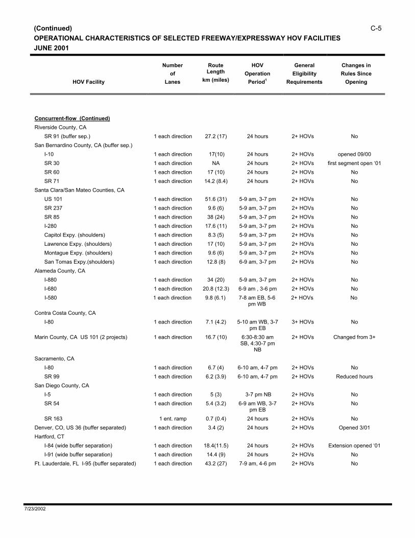
(Continued) C-5OPERATIONAL CHARACTERISTICS OF SELECTED FREEWAY/EXPRESSWAY HOV FACILITIES JUNE 2001
HOV Facility
Number
of Lanes
Route Length
km (miles)
HOV
Operation Period1
General
Eligibility Requirements
Changes in Rules Since
Opening
Concurrent-flow (Continued) Riverside County, CA
SR 91 (buffer sep.) 1 each direction 27.2 (17) 24 hours 2+ HOVs No San Bernardino County, CA (buffer sep.)
I-10 1 each direction 17(10) 24 hours 2+ HOVs opened 09/00 SR 30 1 each direction NA 24 hours 2+ HOVs first segment open ‘01 SR 60 1 each direction 17 (10) 24 hours 2+ HOVs No SR 71 1 each direction 14.2 (8.4) 24 hours 2+ HOVs No
Santa Clara/San Mateo Counties, CA US 101 1 each direction 51.6 (31) 5-9 am, 3-7 pm 2+ HOVs No SR 237 1 each direction 9.6 (6) 5-9 am, 3-7 pm 2+ HOVs No SR 85 1 each direction 38 (24) 5-9 am, 3-7 pm 2+ HOVs No I-280 1 each direction 17.6 (11) 5-9 am, 3-7 pm 2+ HOVs No Capitol Expy. (shoulders) 1 each direction 8.3 (5) 5-9 am, 3-7 pm 2+ HOVs No Lawrence Expy. (shoulders) 1 each direction 17 (10) 5-9 am, 3-7 pm 2+ HOVs No Montague Expy. (shoulders) 1 each direction 9.6 (6) 5-9 am, 3-7 pm 2+ HOVs No San Tomas Expy.(shoulders) 1 each direction 12.8 (8) 6-9 am, 3-7 pm 2+ HOVs No
Alameda County, CA I-880 1 each direction 34 (20) 5-9 am, 3-7 pm 2+ HOVs No I-680 1 each direction 20.8 (12.3) 6-9 am , 3-6 pm 2+ HOVs No
I-580 1 each direction 9.8 (6.1) 7-8 am EB, 5-6 pm WB
2+ HOVs No
Contra Costa County, CA I-80 1 each direction 7.1 (4.2) 5-10 am WB, 3-7
pm EB 3+ HOVs No
Marin County, CA US 101 (2 projects) 1 each direction 16.7 (10) 6:30-8:30 am SB, 4:30-7 pm
NB
2+ HOVs Changed from 3+
Sacramento, CA I-80 1 each direction 6.7 (4) 6-10 am, 4-7 pm 2+ HOVs No SR 99 1 each direction 6.2 (3.9) 6-10 am, 4-7 pm 2+ HOVs Reduced hours
San Diego County, CA I-5 1 each direction 5 (3) 3-7 pm NB 2+ HOVs No SR 54 1 each direction 5.4 (3.2) 6-9 am WB, 3-7
pm EB 2+ HOVs No
SR 163 1 ent. ramp 0.7 (0.4) 24 hours 2+ HOVs No Denver, CO, US 36 (buffer separated) 1 each direction 3.4 (2) 24 hours 2+ HOVs Opened 3/01 Hartford, CT
I-84 (wide buffer separation) 1 each direction 18.4(11.5) 24 hours 2+ HOVs Extension opened ‘01 I-91 (wide buffer separation) 1 each direction 14.4 (9) 24 hours 2+ HOVs No
Ft. Lauderdale, FL I-95 (buffer separated) 1 each direction 43.2 (27) 7-9 am, 4-6 pm 2+ HOVs No
7/23/2002

C-6 (Continued) OPERATIONAL CHARACTERISTICS OF SELECTED FREEWAY/EXPRESSWAY HOV FACILITIES
JUNE 2001
HOV Facility
Number
of Lanes
Route Length
km (miles)
HOV
Operation Period1
General
Eligibility Requirements
Changes in Rules Since
Opening
Miami, FL
I-95 1 each direction 52 (32) 7-9 am SB, 4-6 pm NB
2+ HOVs No
I-95 freeway/freeway ramp 2-way 5 (3) 7-9 am SB, 4-6 pm NB
2+ HOVs No
Orlando, FL I-4 1 each direction 48 (30) 7-9 am SB 4-6 pm NB
2+ HOVs No
Atlanta, GA (buffer separated) I-20 1 each direction 14 (8.5) WB 6:30-9:30
am, EB 4:30-7 pm
2+ HOVs No
I-75/I-85 central section 1 each direction 12.5 (7.5) 24 hours 2+ HOVs No I-75 1 each direction 19.3 (11.6) 24 hours 2+ HOVs No I-85 1 each direction 41 (23.9) 24 hours 2+ HOVs No
Concurrent-flow (Continued) Honolulu, HI
Moanaloa Fwy. 1 each direction 3.8 (2.4) 6-8 am, 3:30-6 pm
2+ HOVs No
Kalanianaole Hwy. 1 (WB only) 3.2 (2.0) 5-8:30 am 2+ HOVs No H-1 1 each direction 12.8 (8) 6-8 am,
3:30-6 pm 2+ HOVs No
H-2 1 each direction 13.1 (8.2) 6-8 am, 3:30-6 pm
2+ HOVs No
Montgomery County, MD (buffer separated) US 29 (shoulders) 1 each direction 4.8 (3) Peak periods
only Buses only No
I-270 1 each direction 25.8 (15.5) SB 6-9 am, NB 3:30-630 pm
2+ HOVs No
I-270 (western spur) 1 each direction 5 (3) SB 6-9 am, NB 3:30-630 pm
2+ HOVs No
Maryland: I-270 (eastern spur) 1 each direction 5 (3) SB 6-9 am, NB 3:30-630 pm
2+ HOVs No
Boston, MA I-93 North 1 (SB only) 1.8 (1.1) 6:30-9:30 am 2+ HOVs Changed from 3+ Minneapolis, MN
I-35W 1 each direction NB 9.2 (5.7), SB 10.1 (6.3)
NB 6-9 am & 3-6 pm, SB 6-9 am
& 3-6 pm
2+ HOVs No
I-394 1 each direction EB 12.4 (7.7), WB 9.8 (6.1)
EB 6-9 am, WB 3-6 pm
2+ HOVs No
New Jersey Turnpike 1 each direction 16 (10) Peak periods only
3+ HOVs No
New York City, NY.6 Gowanus Expy 1 inbound only 2.2 (1.3) 6-10 am 2+ HOVs No Staten Island Expy 1 inbound only 1.6 (1) 6-10 am Bus only Opened in 2000
7/23/2002

(Continued) C-7OPERATIONAL CHARACTERISTICS OF SELECTED FREEWAY/EXPRESSWAY HOV FACILITIES JUNE 2001
HOV Facility
Number
of Lanes
Route Length
km (miles)
HOV
Operation Period1
General
Eligibility Requirements
Changes in Rules Since
Opening
Suffolk and Nassau County, NY I-495 (buffer separated)
1 each direction 50 (30) 6-10 am, 3-8 pm 2+ HOVs Yes, changed hours 10-mile ext. opened in
1999 Portland, OR, I-5 1 northbound 5 (3) NB peak period
only 2+ HOVs Opened 10/98, partial
lane conversion Ottawa, Ontario, Canada
Hwy. 417 Kenta (EB shoulder) 1 (EB only) 4.8 (3) 7-9 am Buses only No Hwy. 17 Orleans (WB shoulder) 1 (WB only) 4.8 (3) 7-9 am Buses only No
Memphis, TN I-40 1 each direction 13 (8) 7-9 am WB, 4-6 PM EB
2 + HOVs No
Nashville, TN I-65 (South) 1 each direction 11.5 (7.2) 7-9 am NB,
4-6 pm SB 2+ HOVs No
I-40 1 each direction 8.3 (5) 7-9 am WB, 4-6 pm EB
2+ HOVs No
Dallas, TX (buffer separated) US 67 Marvin D. Love Fwy. 1 each direction 6.4 (4.0) 24 hours 2+ HOVs Opened Aug. 2000 I-35E (Stemmons Freeway) 1 each direction SB 11.7
(7.3), NB 9.7 (6.0)
24 hours 2+ HOVs No
I-635 (LBJ Freeway) 1 each direction EB 11 (6.8), WB 9.8 (6.1)
24 hours 2+ HOVs No
Houston, TX I-10 Katy (narrow buffer separated) 1 each direction 9.3 (5.5) 5 am-12 noon
EB, 2-9 pm WB, Sat WB, Sun.
EB.
3+ peak hours, 2+
other times
Opened March 2001
Concurrent-flow (Continued) Salt Lake City, UT, I-15 1 each direction 10 (16) Peak periods
only 2+ HOVs opened in summer ‘01
Northern Virginia (buffer separated) I-66 (outside Capital Beltway) 4 1 each direction 30 (18.5) EB 5:30-9:30 am
WB 3-7 pm 2+ HOVs Changed operating
periods I-66 (inside Capital Beltway) Exclusive HOV during restricted period
2-3 each direction 15.4 (9.6) EB 6:30-9 am, WB 4-6:30 pm
2+ HOVs Changed operating periods and from 4+
SR 267 (Dulles Toll Road) 1 each direction 16 (10) EB 6:30-9 am, WB 4-6:30 pm
2+ HOVs No
Norfolk/Virginia Beach, VA SR 444 1 each direction 8 (5) Peak hours only 2+ HOVs Hours reduced in ‘99 I-264 1 each direction 6.4 (4) Peak hours only 2+ HOVs Hours reduced in ‘99
7/23/2002

C-8 (Continued) OPERATIONAL CHARACTERISTICS OF SELECTED FREEWAY/EXPRESSWAY HOV FACILITIES
JUNE 2001
HOV Facility
Number
of Lanes
Route Length
km (miles)
HOV
Operation Period1
General
Eligibility Requirements
Changes in Rules Since
Opening
Seattle, WA
I-5 North 1 each direction 22.5 (13.3) 24 hours 2+ HOVs North end changed from 3+ in 1993
I-5 South 1 each direction 32 (18.9) 24 hours 2+ HOVs No I-90 1 each direction 10.6 (6.3) 24 hours 2+ HOVs No I-405 (median only-used to be right side in some sections)
1 each direction 45 (26.5) 24 hours 2+ HOVs Median conversion occurred in 1999
SR 167 1 each direction 16.1 (10) 24 hours 2+ HOVs No SR 520 (median east of I-405) 1 each direction 9 (5.4) 24 hours 2+ HOVs Opened Feb. ‘00 SR 520 (shoulder) 1 WB only 3.7 (2.3) 24 hours 3+ HOVs Changed from bus
only in AM peak period
Vancouver, WA, 1-5 1 each direction 6 (4) 24 hours 2+ HOVs Opened Oct. 2001 Vancouver, British Columbia, Canada
Trans Canada Highway 1 each direction 12.8 (8) NA NA No
Contraflow Honolulu, HI
H-1(moveable barrier) 1 EB 10 (6) AM period only 3+ HOVs Opened 8/98 Kalanianaole Hwy. 1 WB 7 (4.4),
EB 1.6 (1) 5-8:30 am, 4-6:30 pm
2+ HOVs Changed from 3+
Kahekili Hwy. 1 1.8 (1.1) 5:30-8:30 am, 3:30-7 pm
2+ HOVs No
New Jersey, Rte. 495 (to Lincoln Tunnel) 1 EB only 4 (2.5) 6-10 am Buses only No New York City, NY
I-495 Long Island Expy. 1 6.4 (4) 7-10 am Buses, vanpools taxis
Moveable barrier pending
Gowanus Expressway/Brooklyn Battery Tunnel, (moveable barrier)
1 inbound only 10.4 (6.2) 6-10 am 2+ HOVs Originally buses & taxis only
Dallas, TX I-30, (East R.L. Thornton Fwy.) moveable barrier
1 each peak direction
8.3 (5.2) 6-9 am, 4-7 pm 2+ HOVs No
Boston, MA I-93 Southeast Expy. (moveable barrier)
1 each peak direction
9.6 (6) 6-10 am, 3-7 pm 2+ HOVs Additional hour added in AM period, lowered to 2+ HOVs on 6/99
Montreal, Quebec, Canada Rte. 10/15/20 Champlain Bridge
1 6.9 (4.3) 6:30-9:30 am NB, 3:30-7 pm
SB
Buses only Speed limit reduced
Queue Bypasses Bay Area, CA
S.F./Oakland Bay Bridge toll plaza, I-80 and I-880
3 1.4 (0.9) 5-10 am, 3-7 pm 3+ HOVs Number and location of lanes reoriented
Dumbarton Bridge toll plaza, SR 84 1 3.2 (2) 5-10 am, 3-6 pm 2+ HOVs Changed from 3+ San Mateo Bridge toll plaza, SR 92 1 3.2 (2) 5-10 am, 3-6 pm 2+ HOVs Changed from 3+ SR 4 1 0.8 (0.5) Peak periods 3+ HOVs No SR 160 Antioch Bridge 1 NA 5-10 am, 3-6 pm 3+ HOVs No
7/23/2002

(Continued) C-9OPERATIONAL CHARACTERISTICS OF SELECTED FREEWAY/EXPRESSWAY HOV FACILITIES JUNE 2001
HOV Facility
Number
of Lanes
Route Length
km (miles)
HOV
Operation Period1
General
Eligibility Requirements
Changes in Rules Since
Opening
SR 80 Carquinez Bridge 1 0.1 5-10 am, 3-7 pm 3+ HOVs No SR 680 Benicia/Martinez Bridge 1 0.1 5-10 am, 3-7 pm 3+ HOVs No Various freeway entrance ramps 1 0.2 (0.1) When demand
warrants 2+ HOVs No
Los Angeles and Orange Counties, CA Over 250 freeway entrance ramps 1 0.2 (0.1) When demand
warrants 2+ HOVs No
San Diego, CA Various entrance ramps As warranted 2+ HOVs No Coronado Bridge toll plaza 1 (WB only) 0.2 (.1) 24 hours 2+ HOVs No A Street entrance ramp to I-5 freeway 1 0.6 (0.4) 24 hours Buses only No I-5/Mexico port of entry 4 gates 0.2 (0.1) 24 hours M-F 4+ HOVs No
Honolulu, HI, H-2 1 (SB only) 1.3 (0.8) 6-8 am, 3:30-6 pm
2+ HOVs No
Illinois, Chicago, I-90 toll plaza 1 (EB only) 0.8 (0.5) Peak periods Buses only No Minneapolis, MN, Various entrance ramps 75 entrance
ramps varies Peak periods 2+ HOVs No
New Jersey Ft. Lee, I-95 (to George Washington Br.) 1 (EB only) 1.6 (1) 7-9 am 3+ HOVs No
Dallas, TX, I-35E Stemmons reversible lane 1 (NB and SB) 1.0 (0.7) 6-9 am, 4-7 pm 2+ HOVs No Union, Rte. 495 (Lincoln Tunnel toll plaza)
1 (WB only) 0.5 (0.3) 6-10 am Buses only No
Seattle, WA SR 509 shoulder 1 (NB only) 1.3 (0.8) 24 hours 2+ HOVs Changed from 3+ SR 526 1 0.8 (0.5) 24 hours Buses only No Freeway entrance ramps (69)3 1 0.2 (0.1) 24 hours 2+ HOVs No Ferry terminal docks, downtown and other locations
2 0.2 (0.1) Peak hours Registered car/ vanpools
only
No
Footnotes 1 Part-time periods are 5-day week, typically in peak directions as noted. 2 This project is a privatized toll road with congestion pricing. Registered 3+ HOVs can travel free. 3 Included are 39 metered ramps and 30 non-metered ramps. 4 Portions of HOV lane are converted from left side general purpose lane, while outside shoulder becomes a general purpose lane. 5 Due to AB 1871 legislation, the SR 14 HOV lanes are undergoing an 18-month demonstration project of part-time hours. The demonstration started
January 2001. The southbound hours are 5-9 am and the northbound hours are 3-7 pm. .6 A number of HOV lanes were operated temporarily over various New York City bridge and tunnel crossings following the 9-11 terrorist attack. Most of
these lane treatments had been suspended by the end of 2001 and are not reported in this inventory.
7/23/2002

C-10 LISTING OF PROPOSED MAJOR FREEWAY/EXPRESSWAY HOV FACILITIES JANUARY 2002 (Listed by State/Province)
Project
Project Length
Status or Anticipated Opening
Route-kilometers
(miles)
Lane-kilometers
(miles)
California, Bay Area (Alameda, Marin, Santa Clara, Sonoma Counties)
US 101 (Marin County) concurrent-flow lanes 7.6 (4.5) 15 (9) 2002 US 101 (Sonoma County) concurrent-flow lanes 4.8 (3) 9.6 (6) 2002-2008 I-880 (Alameda County) concurrent-flow lanes 4 (2.3) 22 (13) 2004 SR 87 (Santa Clara County) concurrent-flow lanes 7 (4) 13 (8) 1999-2003 I-680 (Santa Clara County) concurrent-flow lanes 11.2(7) 22.4(14) 2003 I-680 (Contra Costa County) concurrent-flow lanes
7(4.4) 14(8.7) 2004
I-580 (Alameda Co.) concurrent-flow lanes TBD TBD in planning I-880 (Alameda Co.) concurrent-flow lanes 3 (1.7) 5.8 (3.4) in design US 101 (Sonoma Co.) concurrent-flow lanes 5 (2.9) 9.8 (5.8) 2006
California, Los Angeles County
I-5 concurrent-flow lanes 155 (45.6) 309 (91.2) 2004-2007 I-10 (San Bernardino Fwy.) concurrent-flow lanes 51 (30) 102 (60) 1999-2003 I-10 (Santa Monica Fwy.) concurrent-flow lanes 15 (9.3) 30 (18.6) Beyond 2020 I-405 concurrent-flow lane extensions 32 (18.8) 64 (37.6) 2000-2004 I-605 concurrent-flow lanes 7 (3.6) 12.9 (7.6) 2004 I-710 concurrent-flow lanes 13 (8) 26 (16) Planning studies underway SR 14 concurrent-flow lanes southbound only 33.5 (19.8) 33.5 (19.8) Under Const, Opening
04/01 SR 14 concurrent-flow lanes 33.3 (20) 66.7 (39.4) 2005 SR 30 concurrent-flow lanes 10 (6) 20 (12) Open Jan 2002-04 SR 60 concurrent-flow lanes 12.5 (7.5) 25 (15) 2002 SR 133 concurrent-flow lanes 7.5(4.7) 15(9.4) Pending, Not known SR 241 concurrent-flow lanes 39.4(24.6) 78.8(49.3) Pending, Not known SR 231 concurrent-flow lanes 9.9(6.2) 19.8(12.4) Pending, Not known
California, Orange County I-5 concurrent-flow lanes (Harbor to SR 39) 3.7 (2.2) NA 2006 I-605 concurrent-flow lane extension 2.7 (1.6) 5.5 (3.3) Planning studies SR 55/405 HOV interchange ramps NA NA Under const, est. 2003 SR 73 concurrent-flow lanes 25 (15) 49.8 (29.4) Planning studies SR 22 concurrent-flow lanes 19 (12.5) 38 (25) Design pending SR 133 concurrent-flow lanes 7.9 (4.7) 15.9 (9.4) Not known SR 241concurrent-flow lanes 42.5 (24.7) 83 (49.3) Not known SR 261concurrent-flow lanes 10.5 (6.2) 21 (12.4) Not known
California, San Bernardino County
I-215 concurrent-flow lanes 16 (9.3) 32 (18.6) 2001-2002 SR 30 concurrent-flow lanes 36 (22.1) 72.4 (44.2) Through 2003
7/23/2002

LISTING OF PROPOSED MAJOR FREEWAY/EXPRESSWAY HOV FACILITIES C-11 JANUARY 2002 (Listed by State/Province)
Project
Project Length
Status or Anticipated Opening
Route-kilometers
(miles)
Lane-kilometers
(miles)
California, Riverside County
SR 30 concurrent-flow lanes 37 (23) 77.2 (45.6) Not known SR 60 concurrent-flow lanes 8 (4.7) 15.9 (9.4) March 2001 SR 71 concurrent-flow lanes 5 (3) 10 (6) Pending, Not known SR 9I concurrent-flow lanes 8.3 (4.9) 17 (9.8) 2003 I-215 concurrent-flow lanes 5.4 (3.2) 10.8 (6.4) 2008
California, Sacramento Area
I-5 concurrent-flow lanes 11.5(7.2) 23(14.4) Pending, Not known US 50 concurrent-flow lanes 44 (27.3) 88 (54.7) 2005-2010 I-80 concurrent-flow lanes (Placer Co., Davis) 48 (28) 97 (57.4) Not known US 50/I-80 concurrent-flow lanes 17.8(11.1) 35.5(22.2) Pending, Not known
California, San Diego County1
I-5 concurrent-flow and managed lanes 91 (53.8) 182 (107.6) Unknown I-15 managed lanes (4) 32 (18.9) 64 (37.8) 2011 SR 125 concurrent-flow lanes 7.5 (4.4) 15 (8.8) Unknown SR 52 concurrent-flow lanes 19 (11.2) 38 (22.5) 2011 SR 94 concurrent-flow lanes 3 (1.8) 1.5 (3.6) 2011 SR 125 concurrent-flow lanes 8 (5) 16.4 (9.7) Unknown I-805 concurrent-flow lanes 5.6(3.5) 11.2(7) Unknown
Colorado, Denver I-25 North between SH 7 and SH 66 (14) (28) Under const., HOV future
designation only US 36 concurrent-flow lane extension/busway (2) (4) First segment open thru
2005 Connecticut, Hartford
New Britian busway 15 (9.6) 32 (20) Preliminary engineering Florida, Orlando
I-4 exclusive 2-way HOV/managed lanes 64 (40) 141 (88) Unknown
Florida, Ft. Lauderdale
I-75 express lanes NA NA Planning studies pending I-95 concurrent-flow lanes 17.7 (11) 93 (58) Beyond 2005
Florida, Miami
Miami, FL South Dade busway extension 18 (11.5) 36 (23) Preliminary engineering
7/23/2002

C-12 LISTING OF PROPOSED MAJOR FREEWAY/EXPRESSWAY HOV FACILITIES JANUARY 2002 (Listed by State/Province)
Project
Project Length
Status or Anticipated Opening
Route-kilometers
(miles)
Lane-kilometers
(miles)
I-95 reversible managed lanes (replaces concurrent flow lanes downtown to Golden Glades interchange)
14 (8) 28 (16) Beyond 2005
Georgia, Atlanta (total of 220 route-miles planned)
I-85 South concurrent-flow lane extensions 25.4 (15.9) 50.8 (31.8) 2020-2025 I-85 North concurrent-flow lane extensions 14.6 (9.1) 29.2 (18.2) 2015 I-75 South concurrent-flow lane extensions 57.3 (35.8) 114 (71.6) 2010-2025 I-20E concurrent-flow lanes 27 (17) 54 (34) 2010-2020 I-20W concurrent-flow lanes 42 (26) 84 (52) 2010-2025 I-285 concurrent-flow lanes 42 (26.5) 84 (53) 2015-2020 I-575 concurrent-flow lanes 29 (18.2) 58 (36.4) 2005, 2025 SR 316 concurrent-flow lane extensions 25 (15.4) 50 (30.8) 2015 SR 400 concurrent-flow lanes 30 (18.5) 60 (37) Interim project under study US 78 concurrent-flow lanes 38 (23.5) 74 (27) 2020
Maryland
SR 5/US 301 concurrent-flow lanes 18 (11) 36 (22) Beyond 2005 I-95/495 Capital Beltway concept TBD NA NA Planning studies I-95/495 Capital Beltway Potomac bridge NA NA Under construction I-95, I-495 to I-695 39 (24) 78 (48) Beyond 2005 I-95 North of Baltimore NA NA Delayed US 50 NA NA 2002 I-270 concurrent flow lane extension to Frederick 35 (22) 70 (44) Planning studies
Massachusetts, Boston
I-93 north contraflow lanes 12.8 (8) 26 (16) 2004 SR 3 south concurrent-flow lanes 18 (11) 36 (22) Planning studies I-93 Central Artery concurrent-flow lanes 6.4 (4) 12.8 (8) 2004 Route 128 (I-95) concurrent-flow lanes 22 (13.7) 44 (27.4) 2004 Route 3 North (concept to be determined) 35 (22) 70 (44) Beyond 2005 I-90 Massachusetts Turnpike queue bypasses 1.6 (1) 1.6 (1) Pending
Minnnesota, Minneapolis
I-35W concurrent-flow lanes 8 (5) 16 (10) 2005 New Hampshire
I-93 concurrent-flow lanes 32 (20) 64 (40) Planning studies, TBD
7/23/2002

LISTING OF PROPOSED MAJOR FREEWAY/EXPRESSWAY HOV FACILITIES C-13 JANUARY 2002 (Listed by State/Province)
Project
Project Length
Status or Anticipated Opening
Route-kilometers
(miles)
Lane-kilometers
(miles)
New York, New York
I-495 Long Island Expy. concurrent-flow lanes 48 (30) 96 (60) Staged through 2003 Gowanus Expy., concurrent-flow lanes 3.3 (2) 3.3 (2) Pending, Beyond 2000
North Carolina, Charlotte
I-77 north concurrent flow & reversible lanes 6 (10) 12 (24) Design started, 2004-2006 NE University Corridor bus lanes on shoulder 24.8 (15.5) 49 (31) Phased 2003-2023 West - Airport Corridor busway 16 (10) 32 (20) Phased 2003-2023 North Corridor HOV lanes/bus lanes on shoulder 32 (20) 64 (40) Phased 2003-2023 Independence Blvd. Corridor busway (Phase 1) 5.6 (3.5) 11 (7) 2004 Independence Blvd. Corridor busway (Extensions) 16 (10) 32 (20) Beyond 2005
North Carolina, Raleigh-Durham-Chapel Hill
I-40 and adjoining corridors NA NA Planning studies underway Ontario, Ottawa, Canada
Highway 17-Orleans concurrent lane in EB shoulder
5 (3) 5 (3) Beyond 2002
Highway 417-Kenta concurrent lane in WB shoulder
3.3 (2) 3.3 (2) Beyond 2002
Pennsylvania, Pittsburgh
East Busway extension NA NA Under construction, open ‘04 Tennessee, Nashville
I-24 concurrent flow lanes 15 (9) 30 (18) Under construction Texas, Austin
Loop 1 South Mopac Expy. reversible lane 5.5 (9) 5.5 (9) Planning studies, 2004 US 183 reversible or concurrent flow lanes NA NA Planning studies, 2015- I-35 reversible lane(s) NA NA Design underway, 2009-
Texas, Dallas/Ft. Worth (193 route miles planned)
US 75 North reversible lane N of I-635 15 (9) 15 (9) Advanced planning I-635 HOV/managed lanes (3 ea. direction.) 30 (18) 180 (108) Planning studies complete I-30 reversible lanes (replaces contraflow lane) 10 (6) 20 (12) Planning studies in progress SH 183/I-35 E (Stemmons) dual reversble lanes 17 (10) 34 (20) Corridor study complete Loop 12/IH 35E dual reversible lanes 3 (2) 6 (4) Corridor study complete Various corridors (see regional total above) NA NA Through 2025
7/23/2002

C-14 LISTING OF PROPOSED MAJOR FREEWAY/EXPRESSWAY HOV FACILITIES JANUARY 2002 (Listed by State/Province)
Project
Project Length
Status or Anticipated Opening
Route-kilometers
(miles)
Lane-kilometers
(miles)
Texas, Houston US 59 (Eastex Fwy.) reversible-flow lane extensions
5 (8) 5 (8) 2002-2003
I-10 (Katy Fwy.) 4-lane 2-way managed lanes (replaces single reversible lane for 11 miles)
42 (25) 96 (58) 2006-08
US 59 (Southwest Fwy) concurrent flow lane exts. 8 (5) 16 (10) 2002 Texas, San Antonio
I-35 North Pan Am Fwy. HOV/Express lanes NA NA Planning studies Utah, Salt Lake City
I-15 concurrent-flow lanes-extensions 32 (10) 64 (20) Under const., 2002-2005 Virginia, Norfok/Virginia Beach
SR 44 concurrent-flow lanes 32 (10) 64 (20) Not known
Virginia, Washington D.C. Area I-66 concurrent-flow lanes 6 (4) 12 (8) 2004 I-95/495 Capital Beltway concept TBD 32 (20) 64 (40) NEPA Phase I-95, Reversible flow lanes 6 (4) 12 (8) Study Pending
Washington, Seattle/Tacoma/Everett *
I-405 managed lanes: 2 each direction replaces concurrent flow lanes
NA NA Planning studies
I-5 South, extensions to concurrent-flow lanes 33 (20.5)) 66 (41.1) Unfunded I-5 North, extensions to concurrent-flow lanes 8.05 (5) 16.1 (10) Unfunded SR 520 concurrent-flow lanes TBD TBD Unfunded SR 167 extensions to concurrent-flow lanes 14 (8.5) 28 (16.9) Unfunded SR 16 concurrent-flow lanes 20 (12.4) 39.7 (24.7) Unfunded SR 526 queue bypass 1.6 (1) 1.6 (1) NA Various direct access ramps and transit stations NA NA Preliminary engineering
NA Not available or known
* Major Corridor Study
1A regional HOV study is currently underway in San Diego County to assess all corridors. Preliminary information suggests that some corridors will be recommended for concurrent flow HOV lanes, and other corridors will be recommended for two managed lanes in each direction.
7/23/2002