appendix 14-v
TRANSCRIPT

EAST-WEST TIE TRANSMISSION PROJECT AMENDED ENVIRONMENTAL ASSESSMENT REPORT
February 2018 Report No. 1536607/2000/2219
APPENDIX 14-V Caribou Management Direction from Forest Management Plans

APPENDIX 14-V CARIBOU MANAGEMENT DIRECTION FROM FOREST MANAGEMENT PLANS
February 2018 Project No. 1536607/2000/2219 1
1.0 INTRODUCTION There are provisions for woodland caribou management, applicable to the Lake Superior Coast Range and the uplands discontinuous linkage (discontinuous range), within Forest Management Plans (FMPs). The East-West Tie Transmission Project (the Project) intersects eight Forest Management Units that overlap with the Lake Superior Coast Range and/or the discontinuous range:
Kenogami Forest (Lake Superior Coast Range and discontinuous range);
Pic River Forest (Lake Superior Coast Range and discontinuous range);
Big Pic Forest (Lake Superior Coast Range and discontinuous range);
Algoma Forest (Lake Superior Coast Range and discontinuous range);
White River Forest (Lake Superior Coast Range and discontinuous range);
Black Spruce Forest (discontinuous range);
Lake Nipigon Forest (discontinuous range); and
Lakehead Forest (discontinuous range).
The following sections describe caribou management direction within each FMP. All information presented within this appendix was obtained from approved FMPs:
Kenogami Forest 2011-2021 Forest Management Plan (TBPI 2011);
Forest Management Plan for the Pic River Forest Management Unit (GMI 2013);
Big Pic Forest 2007-2017 Forest Management Plan (MPI 2007);
Algoma Forest (CFMI 2010);
White River Forest 2008-2018 Forest Management Plan (Domtar 2008);
Forest Management Plan for the Black Spruce Forest (ACI 2011);
Lake Nipigon Forest 2011-2021 Forest Management Plan (LNFMI 2011); and
Lakehead Forest Management Plan 2007-2017, Phase II (GFI 2012).
1.1 Kenogami Forest The Kenogami Forest intersects the Lake Superior Coast Range, the discontinuous range, and the northern area of continuous caribou distribution. Two operational management zones were established on the Kenogami Forest: the Caribou Habitat Management Zone and the Kenf Management Zone.
Caribou Habitat Management Zone – covers the northern area of continuous caribou distribution. Caribou habitat is managed through the implementation of Dynamic Caribou Habitat Schedules (DCHS), also known

APPENDIX 14-V CARIBOU MANAGEMENT DIRECTION FROM FOREST MANAGEMENT PLANS
February 2018 Project No. 1536607/2000/2219 2
as a caribou mosaic. This management zone and management direction are not applicable to the Project as it occurs north of the discontinuous range outside the caribou regional study area (RSA).
Kenf Management Zone – covers the discontinuous range and the Lake Superior Coast Range. Within the discontinuous range, the Kenogami FMP and strategy includes maintaining/enhancing connectivity between the northern continuous range and the southern coastal zone. The zone is not managed through DCHS, rather, the Forest Management Guidelines for the Provision of Marten Habitat (Watt et al. 1996) were used to ensure that the FMP provides suitable habitat conditions for marten and other species with similar requirements through time. Over 75% of the forested area within the Lake Superior Coast Range is deferred from harvest as a marten core habitat area, and no other harvest will is planned.
The Kenogami FMP does not have objectives, indicators or targets related to caribou in the Lake Superior Coast Range or the discontinuous range. Caribou objectives apply to the northern area of continuous distribution only, which is outside the caribou RSA for the Project.
1.2 Pic River Forest Most of the Pic River Forest overlaps with the discontinuous caribou range, and a small portion of the Lake Superior Coast Range.
Within the discontinuous range, the objective is to seek opportunities through habitat management to provide for and improve future connectivity between isolated local populations and the continuous population to the north. To meet this objective, the Pic River FMP implemented the Neys/Killala linkage in the discontinuous range (Figure 14-V-1). The linkage is a 29,264 hectare (ha) area that is deferred from harvest and road building activities for a 20 year period; the remainder of the forest in the discontinuous range is open for harvest. The Neys/Killala linkage deferral area maintains, over the short and medium term, key habitat features necessary to sustain caribou in the Lake Superior Coast Range. The area provides a linkage between Neys Provincial Park and the Killala Lake Conservation Reserve and contains suitable winter foraging habitat on bedrock ridges and areas of suitable refuge habitat. According to the Pic River FMP, the MNRF intends to continue assessing caribou use and habitat value of the deferral area over the next 20 year period. The assessment should improve understanding of the area required to provide continued linkage between the Lake Superior Coast Range population and northern continuous caribou population.
The objective in the Lake Superior Coast Range is protection and management of habitat to encourage connectivity to populations in the north. Habitat within the Lake Superior Coast Range is managed through the application of deferrals (Figure 14-V-1). A narrow strip of habitat along the Lake Superior shoreline is designated as an Enhanced Management Area deferral, and the rest of the range is designated as open harvest areas and deferral areas (Figure 14-V-1). Where harvesting activities are permitted in the Lake Superior Coast Range, they are typically focused in the first and second terms of the FMP (i.e., in the first 10 years). Harvesting in the Santoy East Block (Figure 14-V-1) is available in the next 20 years. The FMP applies specific operational strategies to achieve regeneration of forest cover and to create future caribou habitat within the Lake Superior Coast Range. A road strategy is also implemented to minimize impacts of new roads in the Lake Superior Coast Range.
The Pic River FMP includes one caribou-specific objective, under Indicator 2.2.3 – Area of preferred habitat for woodland caribou in Ontario. The target is to maintain the area of preferred habitat for woodland caribou on the Crown productive forest at or above 90% of the area projected in the Natural Benchmark each term.

APPENDIX 14-V CARIBOU MANAGEMENT DIRECTION FROM FOREST MANAGEMENT PLANS
February 2018 Project No. 1536607/2000/2219 3
Figure 14-V-1: Pic River Forest Deferrals in the Discontinuous Caribou Range and Lake Superior Coast Range, from GMI
2013
APPENDIX 14-V CARIBOU MANAGEMENT DIRECTION FROM FOREST MANAGEMENT PLANS
February 2018 Project No. 1536607/2000/2219 4
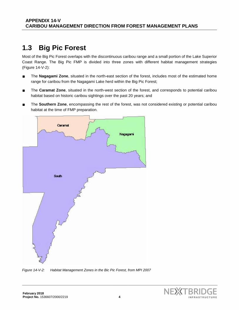
1.3 Big Pic Forest Most of the Big Pic Forest overlaps with the discontinuous caribou range and a small portion of the Lake Superior Coast Range. The Big Pic FMP is divided into three zones with different habitat management strategies (Figure 14-V-2):
The Nagagami Zone, situated in the north-east section of the forest, includes most of the estimated home range for caribou from the Nagagami Lake herd within the Big Pic Forest;
The Caramat Zone, situated in the north-west section of the forest, and corresponds to potential caribou habitat based on historic caribou sightings over the past 20 years; and
The Southern Zone, encompassing the rest of the forest, was not considered existing or potential caribou habitat at the time of FMP preparation.
Figure 14-V-2: Habitat Management Zones in the Bic Pic Forest, from MPI 2007

APPENDIX 14-V CARIBOU MANAGEMENT DIRECTION FROM FOREST MANAGEMENT PLANS
February 2018 Project No. 1536607/2000/2219 5
Small portions of the caribou RSA overlap with the Nagagami and Caramat zones. The Project intersects the Southern Zone.
The Nagagami Zone management strategy implements large deferrals (10,000 ha or greater) to maintain caribou habitat, although smaller deferrals were deemed acceptable when they could be spatially joined to caribou habitat on an adjacent forest unit. The caribou habitat deferrals are applied for 40 or 80 years, with the assumption that areas of current operations will become caribou habitat in the next 80 to 120 years. Current harvesting patterns within this ‘far future’ habitat will focus on “cleaning up” some of the recent operating blocks with the intent of increasing the size of recent cuts to approach the 10,000 ha even-aged target for caribou habitat. Assigned silvicultural practices are prescribed with the intent of maintaining or increasing the number of conifer dominated stands (i.e., future caribou habitat). Newly constructed operational roads will be decommissioned, where practicable, after silviculture activities have been completed.
To maintain caribou habitat in the Caramat Zone, the FMP implements larger than normal marten core deferrals, which range in size from 5,000 ha to 10,000 ha. This strategy was adopted because of the paucity of caribou sightings in the area. Although caribou have been reported in this zone in the past, they rarely consist of more than single animals and sightings have been intermittent. The FMP states that larger marten cores should address the habitat requirements of any animals that may travel into the northwest part of the forest.
The Southern Zone, which overlaps with the discontinuous caribou range, was not considered existing or potential caribou habitat at the time of FMP preparation and therefore is not subject to any special harvest considerations.
The special considerations implemented in the Bic Pic FMP in 2007 were intended to be interim measures in place until a provincial caribou strategy was developed. Implementation of provincial management strategies were considered a possibility for the 2017 FMP. The FMP does not include caribou specific objectives, indicators or targets.
1.4 Algoma Forest Small parts of the Algoma Forest overlap with the Lake Superior Coast Range and the discontinuous range; most of the Algoma Forest occurs outside caribou range. The FMP does not include caribou-specific objectives, indicators or targets.
A caribou area of concern (AOC) prescription was developed for a large area west of Wawa (i.e., within the Lake Superior Coast Range), where recovery efforts require measures to improve genetic connectivity with caribou occupying the more northern area of continuous caribou distribution (i.e., beyond the caribou RSA). The AOC is described as a 13 kilometre wide buffer area located north of Lake Superior, from Pukaskwa National Park to the Ontario Hydro Transmission Line and the Michipicoten Reserve. The AOC also includes a provision for a 400 metres (m) reserve on suitable identified calving sites. The Algoma FMP does not include specific provisions for the discontinuous caribou range.
The AOC operational prescription in the Lake Superior Coast Range includes the following:
Normal harvesting conditions as per the approved Silvicultural Ground Rules (SGRs). Partial harvesting is an option to reduce stocking, and promote lichen growth. Winter operations are preferred. Operations should avoid, where possible, areas with a high concentration of ground or tree lichen identified by the MNRF.

APPENDIX 14-V CARIBOU MANAGEMENT DIRECTION FROM FOREST MANAGEMENT PLANS
February 2018 Project No. 1536607/2000/2219 6
Prescriptions that differ from the approved SGRs will be identified in the annual work schedule and subject to MNRF approval.
The Forest Management Guide for Natural Disturbance Pattern Emulation is applied as a coarse filter management tool except where fine filter adjustments are required for caribou habitat enhancement. Residual forest cover targets at the stand and block level is kept to a minimum to reduce moose habitat. Large disturbances are encouraged as this type of harvesting pattern will provide for better caribou habitat.
Regeneration to conifer is the preferred method where possible to reduce browse for moose. Areas regenerated to conifer at or above the silvicultural ground rule stocking requirements may be commercially thinned to reduce stocking for lichen production when stand structure permits, or is economically feasible. Areas receiving stand conversion from a hardwood dominated forest to conifer may be regenerated to reduce stocking levels (40-70%) to increase lichen growth potential when the opportunity permits and can be made economical.
Tending operations will occur on areas artificially regenerated or areas naturally regenerating to conifer when possible.
Specific road considerations for the caribou AOC within the Lake Superior Coast Range:
All roads should be planned to minimize possible impacts on caribou to the extent practical.
All weather gravel roads should be kept to a minimum, and used only to access operating blocks if practical. Operational roads within blocks should be temporary where feasible.
Road location should avoid areas with extensive ground and tree lichen where possible. An attempt should be made to locate roads at least 1 kilometer from potential calving sites.
Access restrictions on roads should be kept to a minimum to promote increased moose hunting, bear hunting, and trapping of wolves and beavers.
Category 14 Gravel Pits are permitted within the modified zone.
1.5 White River Forest A small part of the White River Forest overlaps with the Lake Superior Coast Range, most of the forest is within the discontinuous range.
According to Domtar (2008) there was no clear direction for forest management in the Lake Superior Coast Range; therefore, the strategy implemented removed all regular and contingency harvest areas and planned roads within the Lake Superior Coast Range until further direction is provided. Domtar (2008) notes that future harvest operations within the Lake Superior Coast Range will be dictated by caribou habitat regulation, which was expected to be completed in 2013. The Project does not intersect the Lake Superior Coast Range within the White River Forest.
Within the discontinuous range, the FMP aims to maintain and enhance the landscape connectivity between the Lake Superior Coast Range and the Pagwachuan Range (to the north, outside the caribou RSA). Given the alignment of the Project along existing roads within the White River Forest, the Project will have negligible risks

APPENDIX 14-V CARIBOU MANAGEMENT DIRECTION FROM FOREST MANAGEMENT PLANS
February 2018 Project No. 1536607/2000/2219 7
on the ability of the sustainable forest licence holder to meet their habitat connectivity objectives. The FMP objectives will be achieved by implementing the following strategies:
Connectivity was enhanced through the creation of a total of 20 marten core deferrals on the White River Forest including all but three marten core deferrals within the discontinuous range.
A total of 18.4% of the land base (93,037 ha) was reserved from harvesting, including 26,461 ha of parks and protected areas, 31,804 ha of protection and 34,772 ha of management reserves. The White River Forest is also adjacent to Pukaskwa National Park (1,878 km2), which protects parts of the Lake Superior Coast Range and the discontinuous range.
The Obakamiga and North Pukaskwa Wildland Areas are identified as potential areas to be excluded from management to enhance the connectivity in the discontinuous range. There is still a Phase 2 planned harvest area within the potential Obakamiga and North Pukaskwa Wildland Areas, but should these potential areas become new parks or protected areas they will be removed from planned operations.
Planned Phase 2 harvest areas were designed to maintain connectivity by concentrating harvest in some areas to help create future caribou habitat tracts and by deferring harvest in other areas to provide current caribou tracts.
There were 13 lakes distributed across the White River Forest (mostly in the discontinuous range) that MNRF will manage as natural self-sustaining lake trout water bodies. Unless approved by the MNRF, new primary and branch roads are not allowed within 1,000 m of these lakes and there are no operational roads allowed within 400 m (skid trails only between 200 m and 400 m).
There are five tourism lake AOCs that provide substantial reserves, reduced road densities and modified operations zones that will improve connectivity around lakes for caribou in the discontinuous range.
One primary road and a minimal amount of branch road construction are planned during Phase 2 operations. All new planned primary and branch roads within the discontinuous range were reviewed to confirm there were no more new roads planned than necessary with the intent of reducing road densities and maintaining connectivity as much as possible to benefit caribou.
Operational roads will also be minimized as much as possible and many operational roads will be constructed in winter or will be rehabilitated to avoid permanent roads.
Roads will be constructed at a lower class if possible to minimize the creation of linear features and help reduce road densities to the benefit of caribou.
Access restrictions through gates and signage will be used to reduce public travel also benefiting caribou.
Mitigation measures will be implemented to limit access when required. This can include measures to discourage access such as road de-commissioning, winter roads, water crossing removal, slash disposition, limiting artificial renewal treatments and accelerated renewal schedules.
Roads no longer required for forest management will be de-commissioned and rehabilitated whenever possible. This would normally include removing water crossings and creating berms and permitting the roads to naturally regenerate. Occasionally it could include site preparing and planting the road.

APPENDIX 14-V CARIBOU MANAGEMENT DIRECTION FROM FOREST MANAGEMENT PLANS
February 2018 Project No. 1536607/2000/2219 8
Promote conifer renewal as much as possible to avoid forest unit successional shifts to hardwood and mixedwood dominated forests after harvesting.
Aboriginal Traditional Knowledge will be used whenever possible to help define and refine caribou population, range, habitat information, and mitigate the impacts of operations on caribou.
1.6 Black Spruce Forest A small part of the Black Spruce Forest occurs within the discontinuous range, and part of the forest occurs within the northern area of continuous caribou distribution (i.e., north of the caribou RSA). The Project overlap with Black Spruce Forest occurs outside the caribou RSA (i.e., outside caribou range); therefore, the Project will not affect the FMP’s caribou management strategy, which includes implementation of DCHS.
1.7 Lake Nipigon Forest The Lake Nipigon Forest overlaps with the discontinuous range, and part of the forest occurs within the northern area of continuous caribou distribution (i.e., north of the caribou RSA). The Project is located inside the discontinuous caribou range within the Lake Nipigon Forest.
Within the discontinuous range, the management direction is to maintain/enhance connectivity between the northern area of continuous caribou distribution and the southern Lake Superior Coast Range. The FMP aims to achieve this objective by maintaining sufficient size and arrangement of mature forest patches throughout the discontinuous range. There are a number of marten core deferrals and reserved forest areas (parks and conservation reserves) in the discontinuous range. The location and sizes of these were examined by the FMP team and regional biologist, and were determined to be sufficient “stepping stones” to allow for habitat connectivity between the two areas of continuous caribou distribution. No additional deferrals or limitations on harvest areas or roads are applied to the area.
The Project will have negligible risks on the ability to meet habitat connectivity objectives in the FMP as the Project follows an existing hydro line across the Lake Nipigon Forest. The Project will not affect the ability to meet the FMP’s caribou-related objectives, indicators and targets.
1.8 Lakehead Forest The Lakehead Forest is partially located within the discontinuous area of caribou distribution, beginning on the eastern edge of the Lakehead Forest, south including the Black Bay Peninsula then north along the Black Sturgeon River to the northwest.
The Lakehead FMP has few provisions for caribou management. The FMP management strategy within the Black Bay Peninsula Enhanced Management Area Strategy (within the discontinuous range) is to enhance moose habitat. The FMP is not intended to create new caribou habitat in the discontinuous range, rather the emphasis is on maintaining or improving conifer cover to support caribou travel or short-term occurrence. The FMP indicates that small improvements could be made during harvest by increasing conifer cover through silviculture practices; however, the spatial arrangement of harvest layout will not change. In addition, road strategies such as physical decommissioning of roads and conifer regeneration may be used where practicable. These types of management actions will be considered during planning. Further, in consultation with Nipigon District staff, GreenForest

APPENDIX 14-V CARIBOU MANAGEMENT DIRECTION FROM FOREST MANAGEMENT PLANS
February 2018 Project No. 1536607/2000/2219 9
Management Inc. will seek opportunities to help achieve caribou management goals in the discontinuous range by:
considering road placement;
reviewing assigned SGRs and making modifications to increase the size and/or connectivity of conifer patches on the landscape; and
considering the Caribou Conservation Plan when determining road decommissioning methods, if a road is decommissioned.
The Project is unlikely to affect the ability to achieve the FMP caribou management strategies, particularly because the Project footprint follows an existing hydro line across much of the Lakehead Forest.
2.0 REFERENCES ACI (AbiBow Canada Inc.). 2011. Forest Management Plan for the Black Spruce Forest. Thunder Bay District,
Northwest Region.
CFMI (Clergue Forest Management Inc.). 2010. Forest Management Plan for the Algoma Forest. Sault Ste. Marie and Wawa Districts, Northeast Region.
Domtar (Domtar Inc.). 2008. White River Forest 2008-2018 Forest Management Plan. Wawa District, Northeast Region.
GFI (Greenmantle Forest Inc.). 2012. Lakehead Forest Management Plan 2007-2017, Phase II: Planned Operations 2012-2017. Thunder Bay and Nipigon Districts, Northwest Region.
GMI (GreenForest Management Inc.). 2013. Forest Management Plan for the Pic River Forest Management Unit. Wawa District, Northeast Region.
LNFMI (Lake Nipigon Forest Management Inc.). 2011. Lake Nipigon Forest 2011-2021 Forest Management Plan. Nipigon District, Northwest Region.
MPI (Marathon Pulp Inc.). 2007. Big Pic Forest 2007-2017 Forest Management Plan. Wawa District, Northeast Region.
TBPI (Terrace Bay Pulp Inc.). 2011. Kenogami Forest 2011-2021 Forest Management Plan. Nipigon District, Northwest Region.
Watt, W.R., J.A. Baker, D.M. Hogg, J.G. McNicol, and B.J. Naylor. 1996. Forest Management Guidelines for the Provision of Marten Habitat. Version 1.0. 24 pp.