apec, tsukuba –tokio, 2012 proposed of mathematical activities with modeling approach to culture...
TRANSCRIPT
APEC, TSUKUBA –TOKIO, 2012
PROPOSED OF MATHEMATICAL ACTIVITIES WITH MODELING APPROACH TO CULTURE OF
DISASTER PREVENTION - PERU

PROPOSE FOR CYCLE V(6th grade of primary level)

HOW PROTECT US IN AN EARTHQUAKE?

CAPABILITIES
MATH: Solve problems which requires the interpretation of a data table, measure of central tendency and the use of Global Positioning System (GPS).
ENVIRONMENTAL SCIENCE: Investigate on the natural disaster effects (earthquakes and tsunami) and take precautionary measures before them.
TASK PROGRAMMING
TASK 1
A You Tube video about Pisco earthquake dated on august 15th, 2007 is presented in class for 7 minutes.
TASK 2
2.1 Group of four students answer the following questions on their notebooks:
a) What did you see on the video?b) How should be prepared to act in an
earthquake? (13 minutes)
2.2 Share the answer with the whole class (25 minutes)
TASK 3
Investigate among people of the community and take note of:
•What are the signs to show that a tsunami or earthquake is coming?
•Has there been a tsunami or earthquake which affected to the community? When? Which were their effects?
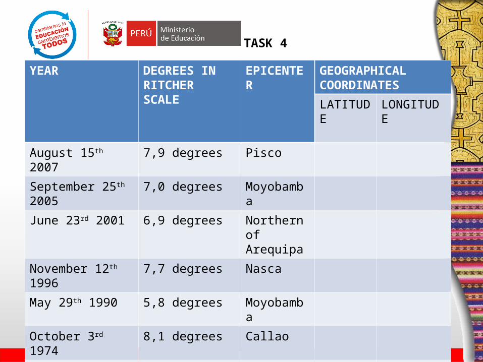
YEAR DEGREES IN RITCHER SCALE
EPICENTER GEOGRAPHICAL COORDINATES
LATITUDE LONGITUDE
August 15th 2007 7,9 degrees Pisco
September 25th 2005 7,0 degrees Moyobamba
June 23rd 2001 6,9 degrees Northern of Arequipa
November 12th 1996 7,7 degrees Nasca
May 29th 1990 5,8 degrees Moyobamba
October 3rd 1974 8,1 degrees Callao
May 31st 1970 7,5 degrees Casma
TASK 4
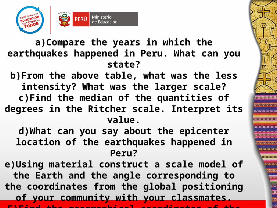
a)Compare the years in which the earthquakes happened in Peru. What can you state?
b)From the above table, what was the less intensity? What was the larger scale?
c)Find the median of the quantities of degrees in the Ritcher scale. Interpret its value.
d)What can you say about the epicenter location of the earthquakes happened in Peru?
e)Using material construct a scale model of the Earth and the angle corresponding to the coordinates from the global positioning of your community with your
classmates.F)Find the geographical coordinates of the epicenter:
latitude and longitude? Write them on the table.
TASK 5
During the first 15 minutes, students of each group exchange ideas about the answers of task 5.
During the rest 25 minutes, the whole class share answers of task 5. In turns, a student of each group exposes the group answer to a certain question.
TASK 6
During the last 10 minutes the teacher asked the students:
a)How should you be prepared to survive when there is an earthquake?
b)What is the budget you need to invest for the family in that case?
TASK 7
During the last 20 minutes, every student answers on a printed sheet the
following question:What did you learn in the classes of
the module/ unit “How to be protected in case of a earthquake?”

PROPOSE FOR CYCLE VII(3th grade of secondary level)
Where and when there will be an earthquake?

TASK 1
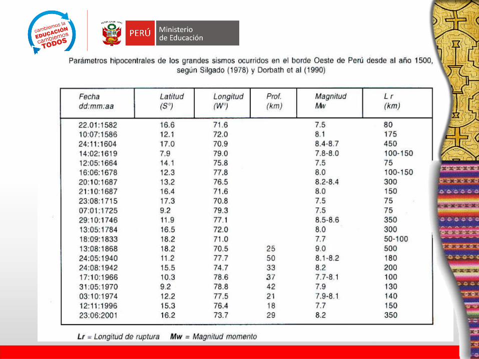
After reflecting on the effects of the last earthquakes in Ica- Peru, let’s see
the following table with some data: What type of information are there in this table?, where these happened?,
which were the effects?
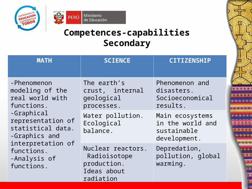
Competences-capabilitiesSecondary
MATH SCIENCE CITIZENSHIP
-Phenomenon modeling of the real world with functions.-Graphical representation of statistical data.-Graphics and interpretation of functions. -Analysis of functions.
The earth’s crust, internal geological processes.
Phenomenon and disasters.Socioeconomical results.
Water pollution. Ecological balance.
Main ecosystems in the world and sustainable development.
Nuclear reactors. Radioisotope production.Ideas about radiation protection.
Depredation, pollution, global warming.
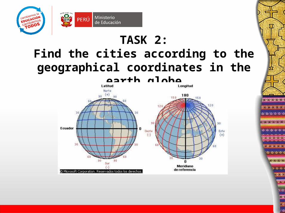
TASK 2:Find the cities according to the geographical
coordinates in the earth globe

TASK 4:Identify the region of Peru where these coordinates belong to
Año Región Latitud Magnitud (Mw)
Ruptura (Km)
1582 Ica 14 7,5 80
1586 Ica 14 8,1 175
1604 Tacna 17 8,5 450
1619 La Libertad 8 8 130
1664 Ica 14 7,5 75
1678 Lima 11 8 130
1687 Ayacucho 13 8,3 300
1687 Cusco 14 8 150
1715 Moquegua 17 7,5 75
1868 Tacna 17 9 500
1974 Lima 11 8 140
1996 Nazca/Ica 14 7,7 150
2001 Arequipa 16 8,2 350

TASK 5:
The earthquake magnitude is referred to the quantity of liberated energy.
Reflection in groups: • What does this energy mean?• What is the source of this energy?• What is the unit of measure of the energy? • What effects does this liberated energy have on the environment?• What type of transformations does this liberated energy suffer?

TASK 6: Draw a graphic: year,length, geographical region
What observations could you take notes?... In Ica there are more breaches.
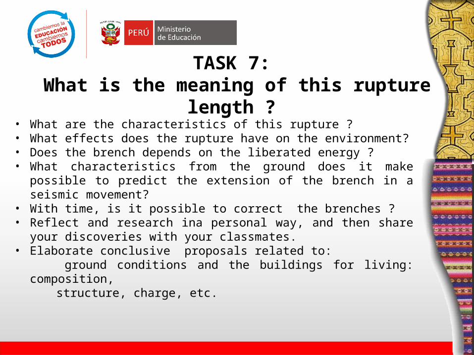
TASK 7: What is the meaning of this rupture length ?
• What are the characteristics of this rupture ?• What effects does the rupture have on the environment?• Does the brench depends on the liberated energy ?• What characteristics from the ground does it make possible to
predict the extension of the brench in a seismic movement?• With time, is it possible to correct the brenches ?• Reflect and research ina personal way, and then share your
discoveries with your classmates. • Elaborate conclusive proposals related to: ground conditions and the buildings for living: composition, structure, charge, etc.
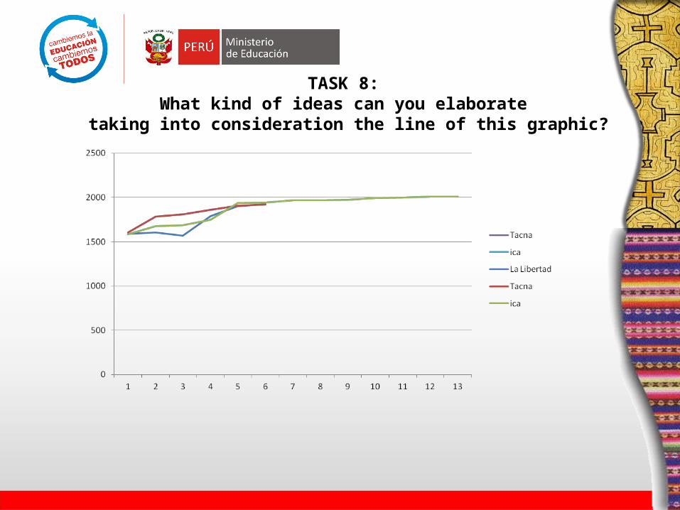
TASK 8: What kind of ideas can you elaborate
taking into consideration the line of this graphic?
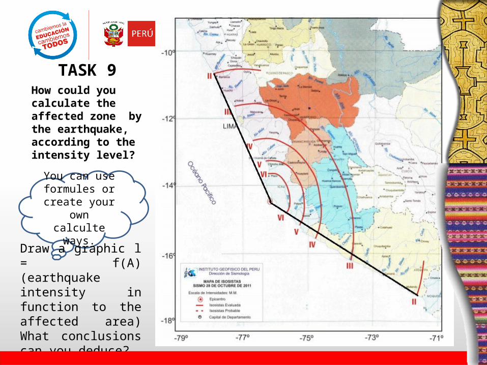
How could you calculate the affected zone by the earthquake, according to the intensity level?
You can use formules or
create your own calculte ways.
Draw a graphic l = f(A) (earthquake intensity in function to the affected area) What conclusions can you deduce?
TASK 9
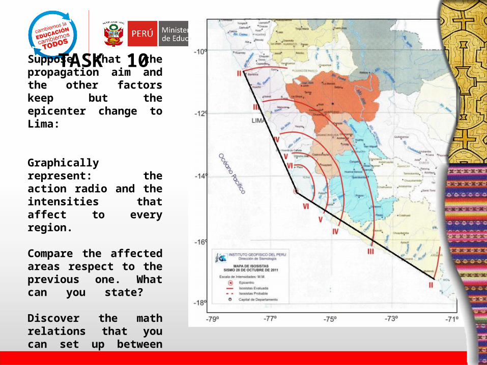
Suppose that the propagation aim and the other factors keep but the epicenter change to Lima:
Graphically represent: the action radio and the intensities that affect to every region.
Compare the affected areas respect to the previous one. What can you state?
Discover the math relations that you can set up between these two cases.
TASK 10

TASK 11: From the developed activities:
•What are the areas you consider more seismic in Peru?
•Could you predict a next earthquake? If the answer is affirmative, say the probable epicenter and argue your answer.
•What can you say about about the radial expansion of the telluric movement?

TASK 12: Compare the rupture length and the geographical location to predict
• After 2001, a strong earthquake is expected near the cities located at 18° latitude. These corresponding to Tacna and the north part of Chile.
• In the same way, you can estimate for the cities located between latitudes 13° and 14°, which corresponding to the south part of Lima and north of Ica.
The most important thing is in these activities it is not the students’
mistakes but that the students learn strategies to be able to solve
problems, through the math relations, finding regularities and y approximation of models.

Thank you very much