an exhibit to remove proposed m-83 extendedwoodlandhillsmd.com/docs/seneca_tributaries... · this...
TRANSCRIPT

Data & Photographs Present Compelling Evidence to Support the Removal of “Proposed M-83 Extended”
from the Master Plan of Highways & Transitways for Montgomery County, MD
ANN SMITH: Author, Biologist & PhotographerEDNA MILLER: Editor & Graphic Artist
TAME COALITION: Sponsor
AN EXHIBIT TO REMOVE PROPOSED M-83 EXTENDED
tamecoalition.blogspot.com

This exhibit focuses on the floodplains in Great Seneca Stream Valley Park & North Germantown Greenway Park. Floodplain benefits revealed during peak flood events are captured on April 30 & May 16, 2014.
Maps show where proposed M-83 Master Plan Alignment would impact multiple floodplain areas within Great Seneca Creek Watershed. To construct M-83 through these forested ecosystems would accelerate peak storm water discharge downstream.
TAME Coalition is raising public awareness about the destructive environmental impacts of proposed Mid-County Highway Extended
2

In this “Exhibit To Remove M-83 Extended”
• GOOGLE MAPS LOCATE: – Site of each peak flood event photographed from three Watkins Mill Road bridges
over tributaries of Great Seneca Creek.– Route proposed for M-83 Extended through the length of Great Seneca Stream Valley
Park & across North Germantown Greenway Park. – The proximity of Dawsonville Gauge at the confluence of Little Seneca Creek with
Great Seneca Creek as comparable with the elevation drop (gradient) of Exhibit sites marked bridges “A”, “B” & “C”.
• PHOTOGRAPHS SHOW: compelling examples of peak flood water spreading across floodplains, which slows down velocity and drops sediment.
• CHARTS CONNECT: Dates from the Dawsonville Gauge readings in cubic feet per second (CFS) align with this Exhibit’s photography dates.
3

A
B
CMONTGOMERY
VILLAGE AVENUE
FLOW
I-270ROUTE
355
ROUTE118
ROUTE355 WATKINS
MILL ROAD
GREATSENECASTREAMVALLEY
PARK
M-83 IMPACTS FLOODPLAINS
The floodplain degradation and deforestation of building M-83 would cause increased storm water runoff surges in the following tributaries:1) Dayspring Creek runs through North
Germantown Greenway Park2) Wildcat Branch converges with Great Seneca
Creek above Brink Road 3) Brandermill Run enters Great Seneca west of
Bridge “C”4) Cabin Branch Stream enters Great Seneca
west of Bridge “B” 5) Whetstone Run enters Great Seneca west of
Bridge “A”6) Walkers Run enters Whetstone Run southeast
of Bridge “A”Proposed M-83 would NOT reduce sediment
loads into the Potomac River & Chesapeake Bay.
INTRODUCTION TO IMPACTED FLOODPLAINS OF GREAT SENECA CREEK & ITS TRIBUTARIES IF M-83 EXTENDED IS CONSTRUCTED
4

It was alarming to see how close floodwaters came up to this Watkins Mill Road bridge, over a tributary of Great Seneca Creek.
Great Seneca Creek starts at Mount Lebanon in Damascus, (787 Ft. Elevation), runs through this mid-point location along Watkins Mill Road & ends at the Potomac.
DISCOVERING FLOODPLAINS AT CAPACITY
5
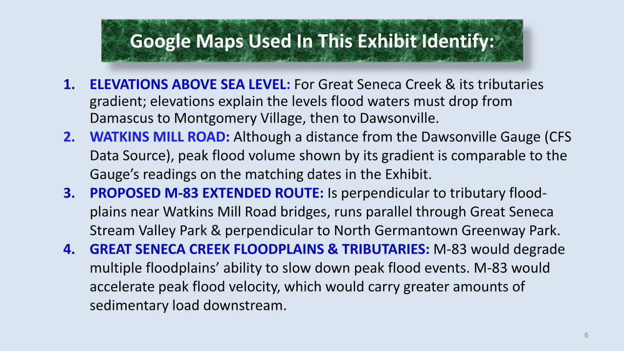
1. ELEVATIONS ABOVE SEA LEVEL: For Great Seneca Creek & its tributaries gradient; elevations explain the levels flood waters must drop from Damascus to Montgomery Village, then to Dawsonville.
2. WATKINS MILL ROAD: Although a distance from the Dawsonville Gauge (CFS Data Source), peak flood volume shown by its gradient is comparable to the Gauge’s readings on the matching dates in the Exhibit.
3. PROPOSED M-83 EXTENDED ROUTE: Is perpendicular to tributary flood-plains near Watkins Mill Road bridges, runs parallel through Great Seneca Stream Valley Park & perpendicular to North Germantown Greenway Park.
4. GREAT SENECA CREEK FLOODPLAINS & TRIBUTARIES: M-83 would degrade multiple floodplains’ ability to slow down peak flood events. M-83 would accelerate peak flood velocity, which would carry greater amounts of sedimentary load downstream.
Google Maps Used In This Exhibit Identify:
6

Elevations from Damascus to “Proposed M-83” represent a larger gradient drop than those leading from Montgomery Village to the Dawsonville Gauge
ROUTE 28
DAWSONVILLEGAUGE
Elevation 308 ft
DRY SENECA CREEK
LITTLE SENECA CREEK
GREAT SENECA CREEK
MT. LEBANON DAMASCUS
Elevation
787 ft
POOLESVILLEElevation
413 ft
BOYDSElevation
559 ft
MONTGOMERY VILLAGE Elevation
317 ft
GERMANTOWN Elevation
550 ft
FUTURE EXIT 12
GREATSENECA STREAMVALLEY
PARKWATKINS
MILL ROAD
PROPOSED M-83
ROUTE
STREAM FLOW
CONTROLED RELEASE
7
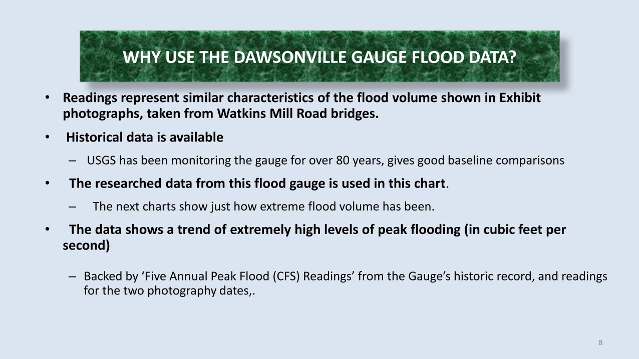
• Readings represent similar characteristics of the flood volume shown in Exhibit photographs, taken from Watkins Mill Road bridges.
• Historical data is available– USGS has been monitoring the gauge for over 80 years, gives good baseline comparisons
• The researched data from this flood gauge is used in this chart. – The next charts show just how extreme flood volume has been.
• The data shows a trend of extremely high levels of peak flooding (in cubic feet per second)
– Backed by ‘Five Annual Peak Flood (CFS) Readings’ from the Gauge’s historic record, and readings for the two photography dates,.
WHY USE THE DAWSONVILLE GAUGE FLOOD DATA?
8
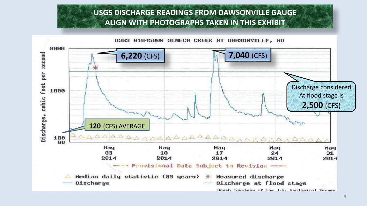
USGS DISCHARGE READINGS FROM DAWSONVILLE GAUGE ALIGN WITH PHOTOGRAPHS TAKEN IN THIS EXHIBIT
Discharge considered At flood stage is2,500 (CFS)
6,220 (CFS) 7,040 (CFS)
120 (CFS) AVERAGE
9

10
The last years have shown a dramatic increase in peak flood volume, which does not correlate to annual precipitation changes.
This effect may be better correlated to land use changes in the watershed area.
Larger and larger floods may be anticipated if more buffering area is removed.
Historical precipitation data: NOAA (noaa.gov)
2930
2150
2890
7600
8280
1167.384883.412
1191.006824.23
1123.696
2009 2010 2011 2012 2013
PEAK FLOOD VOLUME AND PRECIPITATION
VOLUME PRECIP MM
Peak Flood Volume Data Shows the Beginning of a Trend
Cubi
c Ft P
er S
econ
d
0
1000
2000
3000
4000
5000
6000
7000
8000
28-A
pr
29-A
pr
30-A
pr
1-M
ay
2-M
ay
3-M
ay
4-M
ay
5-M
ay
6-M
ay
7-M
ay
8-M
ay
9-M
ay
10-M
ay
11-M
ay
12-M
ay
13-M
ay
14-M
ay
15-M
ay
16-M
ay
17-M
ay
18-M
ay
19-M
ay
20-M
ay
21-M
ay
22-M
ay
23-M
ay
24-M
ay
25-M
ay
26-M
ay
27-M
ay
28-M
ay
29-M
ay
MAX ft3/sec
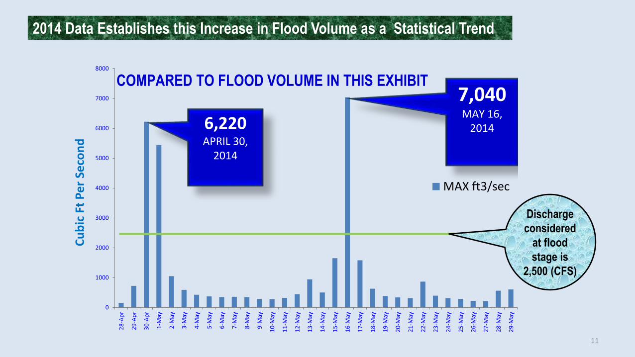
6,220APRIL 30,
2014
7,040 MAY 16,
2014
COMPARED TO FLOOD VOLUME IN THIS EXHIBIT
Discharge considered
at flood stage is
2,500 (CFS)
2014 Data Establishes this Increase in Flood Volume as a Statistical Trend
11
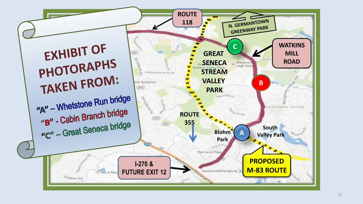
ROUTE 355
WATKINS MILL
ROAD
PROPOSED M-83 ROUTE
A
B
CGREAT SENECASTREAMVALLEY
PARK
ROUTE 118
I-270 &FUTURE EXIT 12
SouthValley ParkBlohm
Park
12
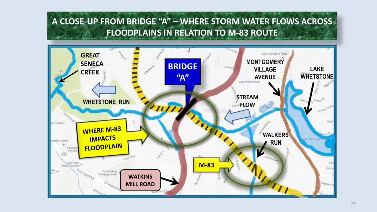
A CLOSE-UP FROM BRIDGE “A” – WHERE STORM WATER FLOWS ACROSS FLOODPLAINS IN RELATION TO M-83 ROUTE
BRIDGE “A”
STREAM FLOW
GREATSENECACREEK LAKE
WHETSTONE
WHETSTONE RUN
WALKERS RUN
MONTGOMERY VILLAGE AVENUE
M-83WATKINS
MILL ROAD
13

An example of a stream’s capacity inside the banks of a snake curve showing a natural meander that slows water and drops sediment.
VIEW FROM BRIDGE “A” – CAPTURED AT WHETSTONE RUN & BLOHM PARK
14
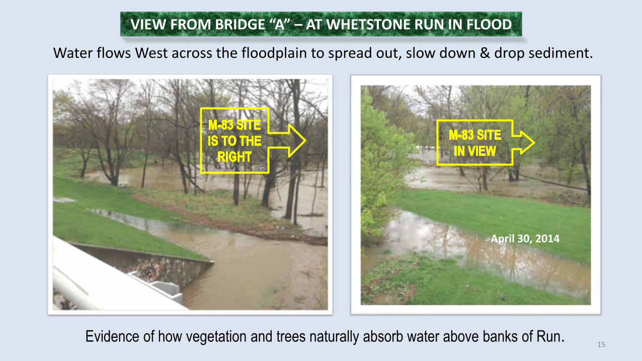
Water flows West across the floodplain to spread out, slow down & drop sediment.
Evidence of how vegetation and trees naturally absorb water above banks of Run.
VIEW FROM BRIDGE “A” – AT WHETSTONE RUN IN FLOOD
April 30, 2014
15

Example of sediment & debris that settled after a flood at the Blohm Park, showing the efficiency of trees, shrubbery and grasses to relieve storm water of its load.
VIEWED FROM BRIDGE “A” – AT WHETSTONE RUN & BLOHM PARK
16
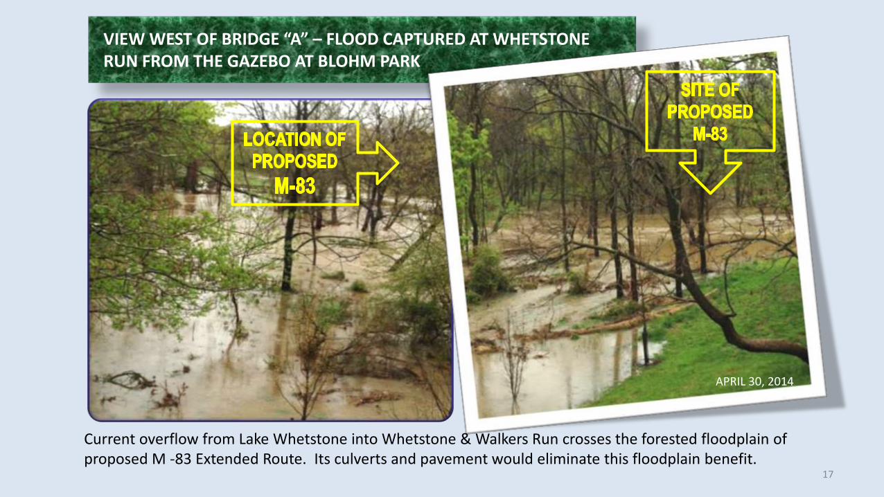
VIEW WEST OF BRIDGE “A” – FLOOD CAPTURED AT WHETSTONE RUN FROM THE GAZEBO AT BLOHM PARK
Current overflow from Lake Whetstone into Whetstone & Walkers Run crosses the forested floodplain of proposed M -83 Extended Route. Its culverts and pavement would eliminate this floodplain benefit.
APRIL 30, 2014
17

Flood reaches ‘South Valley Park Ball Field’ in Montgomery Village
Peak storm water spreading across floodplain where trees, grasses &
vegetation filter sediment.
VIEW IS EAST OF BRIDGE “A” – CAPTURED DURING THE SECOND FLOOD EVENT
18
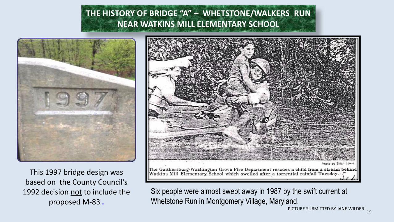
THE HISTORY OF BRIDGE “A” – WHETSTONE/WALKERS RUN NEAR WATKINS MILL ELEMENTARY SCHOOL
This 1997 bridge design was based on the County Council’s
1992 decision not to include the proposed M-83 .
Six people were almost swept away in 1987 by the swift current at Whetstone Run in Montgomery Village, Maryland.
PICTURE SUBMITTED BY JANE WILDER 19

MAP SHOWS BRIDGE “B” – WATER FLOW OF CABIN BRANCH & GREAT SENECA CREEKCabin Branch Stream flowing across Montgomery Village Golf Course
BRIDGE “B”
MONTGOMERY VILLAGE GOLF COURSE
CABIN BRANCH STREAM
GREATSENECA CREEK
WATKINS MILL ROAD
WHERE M-83 IMPACTS
FLOODPLAINS
STREAM FLOW
GREATSENECASTREAMVALLEYPARK
20

Two Geese and a Heron enjoy the flooded landscape
High levels of flood waters cross the floodplain, as water spreads out sediment drops.
Composite ImageApril 30, 2014
ADJACENT TO BRIDGE “B” – VIEWS OF MONTGOMERY VILLAGE GOLF COURSE
21
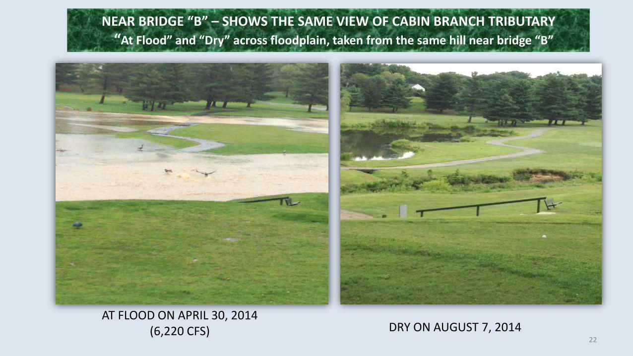
NEAR BRIDGE “B” – SHOWS THE SAME VIEW OF CABIN BRANCH TRIBUTARY “At Flood” and “Dry” across floodplain, taken from the same hill near bridge “B”
AT FLOOD ON APRIL 30, 2014(6,220 CFS) DRY ON AUGUST 7, 2014
22
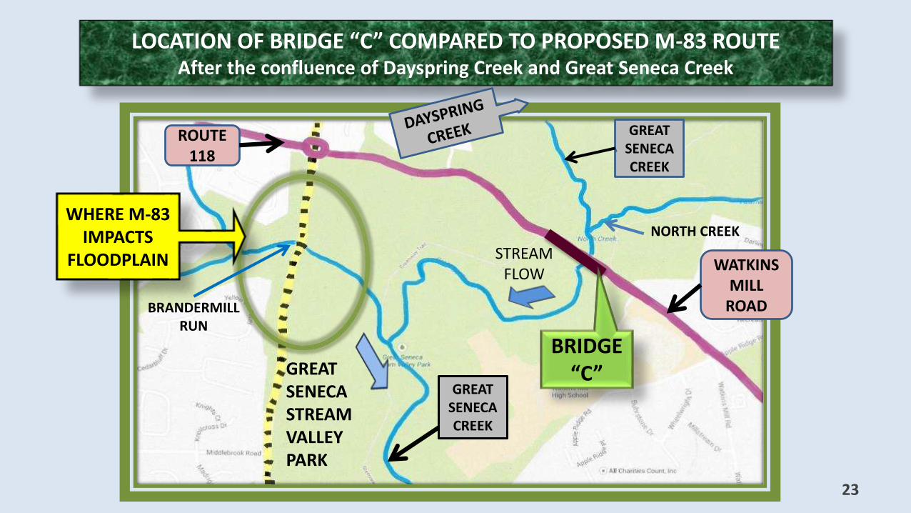
LOCATION OF BRIDGE “C” COMPARED TO PROPOSED M-83 ROUTEAfter the confluence of Dayspring Creek and Great Seneca Creek
23
BRIDGE “C”
GREAT SENECA CREEK
NORTH CREEK
GREAT SENECA STREAMVALLEY PARK
BRANDERMILLRUN
WHERE M-83 IMPACTS
FLOODPLAIN STREAM FLOW
GREAT SENECA CREEK
ROUTE 118
WATKINS MILL
ROAD

VIEWS OF BRIDGE “C” DURING SECOND FLOOD EVENT
These pictures show flood event at capacity below the confluence of Great Seneca Creek and North Creek. Also shows the accumulative affect of storm watermoving down Great Seneca Creek that started near Damascus at Mt. Lebanon. 24
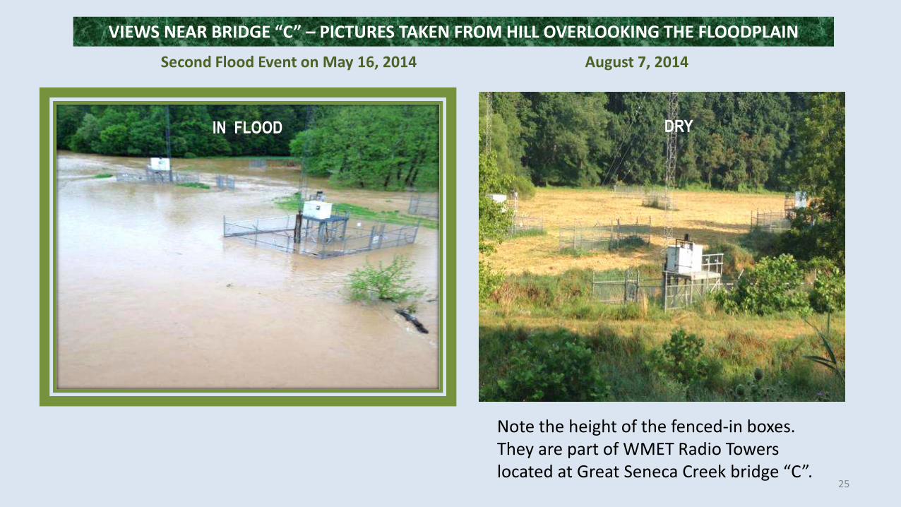
Second Flood Event on May 16, 2014 August 7, 2014
Note the height of the fenced-in boxes.They are part of WMET Radio Towers located at Great Seneca Creek bridge “C”.
IN FLOOD
VIEWS NEAR BRIDGE “C” – PICTURES TAKEN FROM HILL OVERLOOKING THE FLOODPLAIN
DRY
25
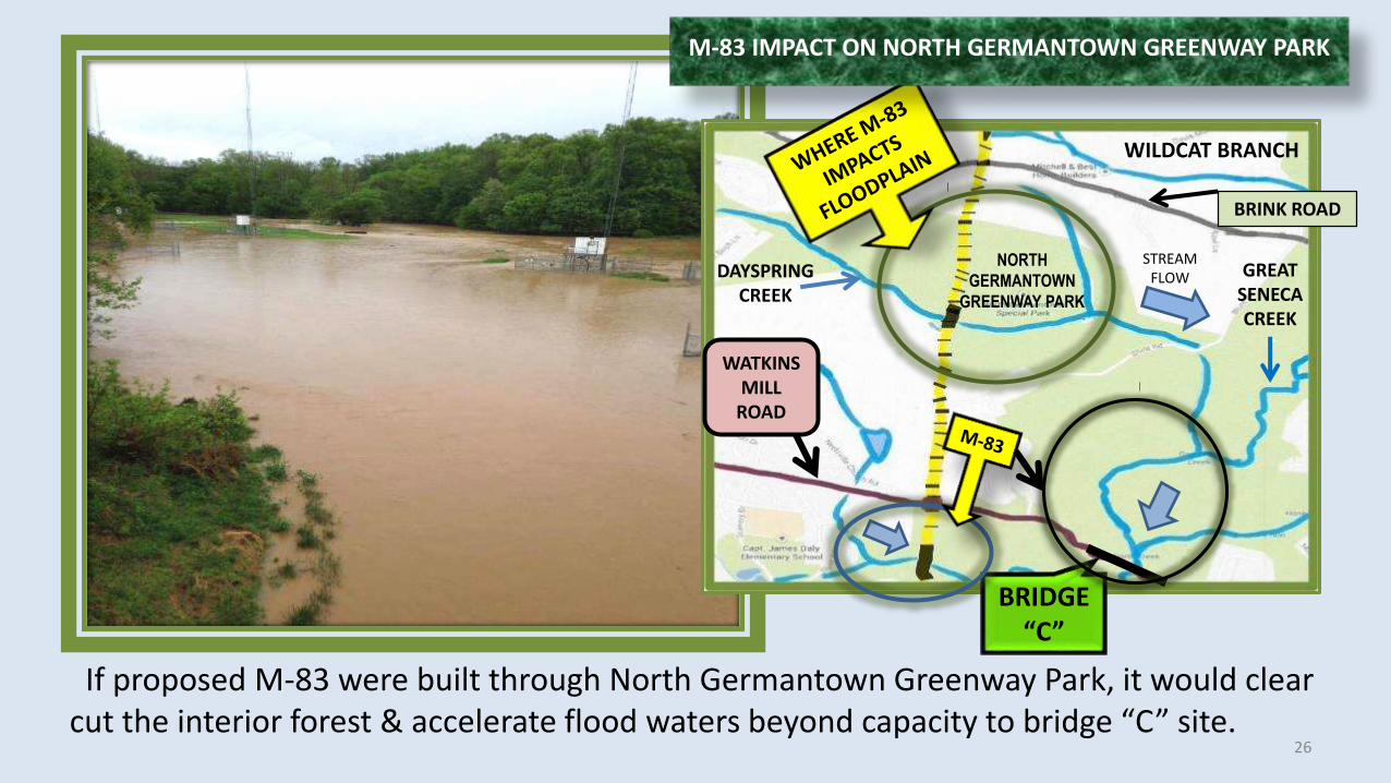
If proposed M-83 were built through North Germantown Greenway Park, it would clear cut the interior forest & accelerate flood waters beyond capacity to bridge “C” site.
WILDCAT BRANCH
NORTHGERMANTOWN
GREENWAY PARK
BRIDGE “C”
BRINK ROAD
GREAT SENECACREEK
WATKINS MILL
ROAD
DAYSPRING CREEK
M-83 IMPACT ON NORTH GERMANTOWN GREENWAY PARK
STREAMFLOW
26
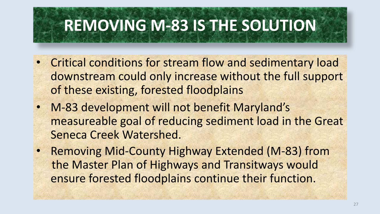
REMOVING M-83 IS THE SOLUTION
• Critical conditions for stream flow and sedimentary load downstream could only increase without the full support of these existing, forested floodplains
• M-83 development will not benefit Maryland’s measureable goal of reducing sediment load in the Great Seneca Creek Watershed.
• Removing Mid-County Highway Extended (M-83) from the Master Plan of Highways and Transitways would ensure forested floodplains continue their function.
27

• State Law: ww.mde.state.md.us/Seneca_Sed_TMDL_093011_Final.pdf• EPA: www.epa.gov/Seneca Creek Sediment TMDL_combo.pdf
28
ACKNOWLEDGEMENT OF THANKS TO TAME COALITION TEAM VOLUNTEERS:Margaret Schoap, Richard & Jane Wilder,
Bing Garthright & Patty King, Lauren & Dale Smith