an analysis of the cadastral non-coincidence occurrence ... · cadastral maps and cadastral actual...
TRANSCRIPT

An Analysis of the CadastralNon-Coincidence Occurrence Situationof the Urban Regeneration Project Area
Yeon-Su Bak1, Ki-Heon Park2
and Sung-Eon Hong3
1Korea Land and Geospatial Informatix Corporation,149, Yeche-ro, Seowon-gu, Cheongju-si,Chungcheongbuk-do, 28564, KOREA
2Professor,Department of real estate & cadastre,
Kyungil University, 50 Gamasil-gil, Hayang-eup,Kyungsan- si, Gyeongsangbuk-do, 38428, KOREA
3Professor,Department of Land Management Cheongju University,
298, Daeseong-ro, Cheongwon-gu, Cheongju-si,Chungcheongbuk-do, 28503, KOREA
February 1, 2018
Abstract
This study aims to present the possibility of linking withthe cadastral resurvey project by analyzing the current stateof the cadastral non-coincidence in the urban regenerationproject district. We analyzed the characteristics of urbanregeneration projects for each target region and analyzedthe details of the cadastral non-coincidence area and sug-gested the possibility of linking with the cadastral resurveyproject. The urban regeneration project district is locatedin the Chungju and Jecheon cities of Chungcheongbuk-do,
1
International Journal of Pure and Applied MathematicsVolume 118 No. 19 2018, 1327-1339ISSN: 1311-8080 (printed version); ISSN: 1314-3395 (on-line version)url: http://www.ijpam.euSpecial Issue ijpam.eu
1327

Chungcheongnam-do, Asan and Gongju in KOREA. Theresults of the analysis on the occurrence of cadastral non-coincidence in the urban regeneration project district wereas follows. In Chungju City, 38 parcels of 194 parcels,20 parcels of 391 parcels in Jecheon City, 94 parcels of457 parcels in Asan City and 105 parcels of 381 parcelsin Gongju City were found to be cadastral non-coincidence.It was found that all of the four districts identified in thestudy had collective cadastral non-coincidence more than10 parcels. In addition, the characteristics of cadastral non-coincidence area in the region are shown as the irregulartype including the bias type in the case of Chungju, andit is analyzed that it shows the result error of the blockand inner boundary. Based on the analyzed data, the char-acteristic of the declining urban area is that the cadas-tral non-coincidence is generated in all urban regenerationproject districts, and the occurrence characteristics also ap-pear as irregular type which is caused by overlapping of sev-eral types of non-coincidence. There is generated collectivecadastral non-coincidence more than 10 parcels in each ofthe four targets, the type also has the irregular shape. Thearea can be judged to meet the designation requirements ofthe cadastral resurvey project.
Key Words : Cadastral Non-Coincidence, Urban Re-generation, Cadastral Record, Cadastral Surveying, Cadas-tral Resurvey.
1 INTRODUCTION
The cadastral resurvey project is to replace the existing cadastralrecord with the new digital cadastral record by survey and survey-ing and at the same time, Refers to a national project that is car-ried out to rectify the registration of cadastral record if it does notmatch the actual status of the land(Mun et al., 2014). The cadas-tral resurvey project is being implemented based on the ”SpecialLaw on Cadastral Resurvey” enacted on September 16, 2011, andthe planning period is about 20 years from 2012 to 2030, and the6th year project(Kim and Choi, 2014).
The central government and a local government are promot-
2
International Journal of Pure and Applied Mathematics Special Issue
1328
ing urban regeneration projects to improve the quality of people’slives by preventing the city from significantly degrading its roleand functions and restoring the community by enhancing the city’scompetitiveness(Jun et al., 2010). The urban regeneration projectsare being promoted based on the ”Special law on Urban Regener-ation Activation and Support” enacted on June 4, 2013 to expandthe city’s natural growth base and enhance the city’s competitive-ness(Lee, 2013).
Urban regeneration projects and cadastral resurvey projects arecommon in that they are related to business entities, governmentbudgets, and property rights of citizens. In particular, the twoprojects have a commonality in that the success or failure of thebusiness is decided by the participation of the residents and theresidents are the main business by inducing the participation ofthe residents. On the other hand, urban regeneration projects uti-lize the local resources of the city, economic, social, physical, asthe project is being promoted for the purpose of environmental ac-tivation, the boundary line maintenance of the land is excluded.The cadastral resurvey project is a project to properly maintainand register that land boundaries of realities registered in cadas-tral records are not identical, rather than maintenance of urbanfacilities including buildings(Son and Koh, 2011). As such, the twoprojects are promoted with different characteristics in terms of theimprovement of the boundary of the land and the improvement ofthe environment of the city facilities, but it is considered that thereare many common aspects in the aspect of project subjects, bud-get support and inhabitants’ participation. If the two projects arelinked to each other through complementary features, the efficiencyof the two projects will be maximized.
Currently, the previous study(Kwon et al., 2004; Cho and Huh,2015; Moon et al., 2006) on cadastral non-coincidence is mainlyfocused on investigation, search, and arrangement, and there is noprecedent research related to urban regeneration site. In addition,precedent research on urban regeneration projects is mainly focusedon policies, indicators(Kim et al., 2015) and case studies(Kwon andJoo, 2015) of urban regeneration.
Therefore, in order to link the two projects in this study, it isnecessary to analyze the current state of cadastral non-coincidencein pre-urban regeneration area. In other words, the common factor
3
International Journal of Pure and Applied Mathematics Special Issue
1329

of the two projects is that it is possible to link with the cadastralresurvey project if the cadastral non-coincidence is generated in theurban regeneration project district. Therefore, this study aims topresent the possibility of linking with the cadastral resurvey projectby analyzing the current state of the cadastral non-coincidence inthe urban regeneration project district.
2 RESEARCH METHODS AND AREA
A. Research method
In order for the urban regeneration project to be linked to the cadas-tral resurvey project, collective cadastral non-coincidence should begenerated within the urban regeneration project district. The Ur-ban Regeneration Project District is located in the Chungju andJecheon cities of Chungcheongbuk-do, Chungcheongnam-do, Asanand Gongju. Information related to cadastre was processed withKorea Land and Geospatial Informatix Corporation. We analyzedthe characteristics of urban regeneration projects for each target re-gion and analyzed the details of the cadastral non-coincidence areaand suggested the possibility of linking with the cadastral resurveyproject.
B. Research area
The study area is as follows:
1. Chungju City is promoting urban regeneration projects formembers of Seongseo-dong, Seongnae-dong and declining com-mercial districts. The area is about 212,000 square meters.This project is being promoted in 2016 and is aiming to becompleted by 2020. It is being promoted to promote re-vitalization of the city through restoration of cultural andeconomic functions by the neighborhood renewal type acti-vation plan. Figure 1 (a) shows the Chungju City Regen-eration Project Area and the review area for the cadastralnon-coincidence status.
2. Jecheon City is promoting the urban regeneration project formembers of Insoung-dong (Jungangno 1-ga, 2-ga, Myeong-dong), Namhyeon-dong (Namcheon-dong, part of Gyo-dong).
4
International Journal of Pure and Applied Mathematics Special Issue
1330

The area is about 212,000 square meters(Jungangno 123,000m2,Myeong-dong 52,000m2, Gyo-dong 180,000m2). This projectis being promoted in 2016 and is aiming to be completedby 2020. Figure 1 (b) shows the Jeacheon City Regenera-tion Project Area and the review area for the cadastral non-coincidence status.
3. Chungcheongnam-do, Asan is promoting the urban regenera-tion project for mumbers of Gongsu-ri, Baebang-eup, Buksu-ri. The area is about 440,000 square meters. This projectis being promoted in 2015 and is aiming to be completed by2025. Figure 1 (c) shows the Asan city regeneration projectarea and the review area for the cadastral non-coincidencestatus.
4. Chungcheongnam-do, Gongju is promoting the urban regen-eration project for members of Ungjin-dong, Junghak-dong,Ongnyong-dong. In the case of Gongju City, the decline of thecity due to relocation provincial office and the developmentof the new city center is the cause of the urban regenerationproject. This project is being promoted in 2014 and is aim-ing to be completed by 2017. Figure 1 (d) shows the GongjuCity Regeneration Project Area and the review area for thecadastral non-coincidence status.
5
International Journal of Pure and Applied Mathematics Special Issue
1331

3 RESULTS AND DISCUSSION
We used the cadastral actual state surveying data and the landregister for the urban regeneration district of Chungju city to graspthe situation of the cadastral non-coincidence. The total requiredwas 194 parcels. Figure 2 shows an overlay analysis of individualcadastral maps and cadastral actual state surveying data.
As a result of reviewing the present situation, as shown in Table1, the target district is a densely populated area, and there is collec-tive cadastral non-coincidence of 38 parcels among 194 parcels. If acadastral resurvey project is in progress, about 20% of the parcelswill be subject to boundary and area adjustments. In particular, itis difficult to distinguish the current status of neighborhoods fromold towns in this area. It is necessary that the adjustment for eachblock and edge separation should proceed as well. In addition, 20%of the total parcels are adjusted, but the difficulties of adjustmentdue to block and edge separation is expected to be doubled.
6
International Journal of Pure and Applied Mathematics Special Issue
1332

In case of Jecheon City, 291 parcels were required. Figure 3shows an overlay analysis of individual cadastral maps and cadas-tral actual state surveying data.
As a result of reviewing the present situation, as shown in Table2, the target district(Namchun-dong) is a densely populated area,and 20 of the 391 parcels have collective cadastral non-coincidence.If a cadastral resurvey project is in progress, approximately 7%of parcels will be subject to adjustment of boundaries and area.This area is an area that needs to be adjusted on a block-by-blockbasis, and 7% of the total parcels must be adjusted. In addition,
7
International Journal of Pure and Applied Mathematics Special Issue
1333

it is predicted that the amount of cadastral non-coincidence willbe increased because the whole can be adjusted if it is practicallyadjusted by block.
In case of Asan city, 457 parcels were analyzed. Figure 4 showsan overlay analysis of individual cadastral maps and cadastral ac-tual state surveying data in Asan.
As a result of reviewing the present situation, as shown in Table3, the target district(Namchun-dong) is a densely populated area,and the 94 parcels of the 457 parcels are adjusted to 94 parcelswhen the cadastral resurvey project is implemented. It is the casethat the entrance road, which is the most common case in the citycenter, is formed in a densely populated area, and it is necessary tosolve the problem of without road and to secure a moving passage.There are a lot of parcels that are subject to area correction, andmany difficulties due to the adjustment of the parcel that occupiesmore than the present situation. In order to solve the road part,it is predicted that the adjustment will be calculated and paid byexchanging with the government official or by purchasing as muchas the occupancy part.
8
International Journal of Pure and Applied Mathematics Special Issue
1334
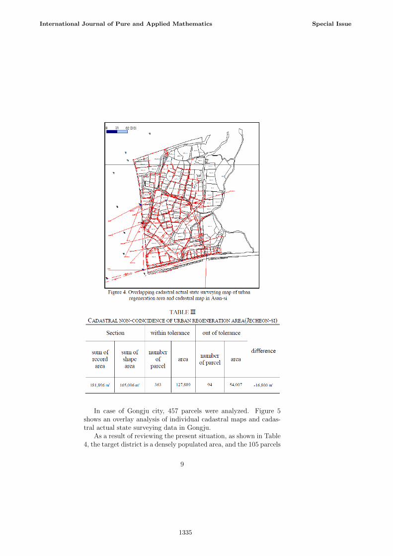
In case of Gongju city, 457 parcels were analyzed. Figure 5shows an overlay analysis of individual cadastral maps and cadas-tral actual state surveying data in Gongju.
As a result of reviewing the present situation, as shown in Table4, the target district is a densely populated area, and the 105 parcels
9
International Journal of Pure and Applied Mathematics Special Issue
1335

of the 381 parcels are adjusted to 105 parcels approximately 28%is subject to adjustment requirements when the cadastral resurveyproject is implemented. In this area, individual parcels as well asblock-by-block adjustments and it is necessary that the adjustmentfor edge separation should proceed as well. Therefore, 28% of thetotal parcels are adjusted, but in reality, the problem of adjustmentis expected to be even greater.
10
International Journal of Pure and Applied Mathematics Special Issue
1336

4 CONCLUSION
In this study, we analyzed the current state of cadastral non-coincidencein the urban regeneration project area, which is currently being pro-moted, and suggested the possibility of linking with the cadastralresurvey project. In Chungju City, 38 parcels of 194 parcels, 20parcels of 391 parcels in Jecheon City, 94 parcels of 457 parcels inAsan City and 105 parcels of 381 parcels in Gongju City were foundto be cadastral non-coincidence. Therefore, it was found that allof the four districts identified in the study had collective cadastralnon-coincidence more than 10 parcels. In addition, the character-istics of cadastral non-coincidence area in the region are shown asthe irregular type including the bias type in the case of Chungju,and it is analyzed that it shows the result error of the block andinner boundary.
In Jecheon City, all the parcels showed irregular type, and theresult errors of block and inner boundary were occurred as sameas Chungju. Asan city has irregular type and it is recognized thaterrors occur in individual parcel. Gongju city showed that irregulartype with bias type of cadastral non-coincidence was generated byapplying each the block result.
Based on the analyzed data, the characteristic of the decliningurban area is that the cadastral non-coincidence is generated in allurban regeneration project districts, and the occurrence character-istics also appear as irregular type which is caused by overlappingof several types of non-coincidence.
Therefore, there are generated collective cadastral non-coincidencemore than 10 parcels in each of the four target based on the currentstatus of the project district designated as the cadastral resurveyproject district, the type also has the irregular shape which is themost difficult to repair, so the area can be judged to meet the des-ignation requirements of the cadastral resurvey project.
References
[1] Cho, S.H., & Huh Y., Detecting Cadastral Discrepancy Methodbased on MMAS, Journal of cadastre & land informatix, 2015,45(2), pp. 149-160.
11
International Journal of Pure and Applied Mathematics Special Issue
1337

[2] Jun, S.I., Kim, M.O., Kim, M.Y., Choi, M.J., & Kim, M.H.,Potential Resources for Urban Regeneration in Korea, Journalof the Korean Urban Geographical Society, 2010, 13(2), pp.59-72.
[3] Kim, K.C., Kim, G.Y., & Lee, J.S., A Study of EvaluationIndexes of Site Selection for the Urban Regeneration Scheme-Focused on the Special Actson the Promotion and Supportfor Urban Regeneration, Korea Real Estate Academy Review,2015, 61, pp. 31-45.
[4] Kim, U.N., & Choi, S.P., Study on the Way of Improvement byAnalyzing the Problem Revealed in Current Cadastral ResurveyProject, Journal of the Korean Society of Surveying, Geodesy,Photogrammetry, and Cartography, 2014, 32(4-2), pp. 431-442.
[5] Kwun, H.J., Choi, Y.S., & Ji, J.D., Improving the Projectsfor Solving Cadastral Mismatch Problems, Journal of KoreanSociety of Cadastre, 2004, 20(2), pp. 147-156.
[6] Kwon, Y.K., & Joo, S.H., Study of Urban Regeneration Strat-egy Based on Creating Shared Value - In Case of DowntownProject, City Of Las Vegas, USA, Journal of Urban DesignInstitute of Korea, 2015, 16(6), pp. 35-51.
[7] Lee, S.W., Urban Regeneration Project and Its Relationship toProperty Rights, Public Law, 2013, 42(1), pp. 241-269.
[8] Moon, M.S., Choi, Y.S., & Cho, S.K., A Study on the Arrange-ment of Cadastral Non-coincidence - Focused on Gyeonggi DoCase, Journal of Korean Society of Cadastre, 2006, 22(1), pp.1-9.
[9] Mun, S.J., Jung, H.I., & Yang, G.O., How successfully to ad-vance on Cadastre reform based on a national policy, Journalof Korean Society of Cadastre, 2014, 30(1), pp. 111-123.
[10] Son, J.Y., & Koh, J.H., A Study on Current Issue and Strat-egy of Korean Cadastral Resurvey Project, Journal of KoreanAssociation of Cadastre Information, 2011, 13(2), pp. 143-157.
12
International Journal of Pure and Applied Mathematics Special Issue
1338

1339

1340