amac kevin hickson, martin carney - hunter living … · kevin hickson, martin carney and kelly...
TRANSCRIPT

FINAL ARCHAEOLOGICAL
REPORT
Kevin Hickson, Martin Carney
and Kelly Strickland
Archaeological Management & Consulting Group
for
Newcastle City Council
April 2014
AMAC
Archaeological
Shortland Esplanade, Newcastle, NSW
Cliff Stabilisation Works

Disclaimer The veracity of this report is not guaranteed unless it is a complete and original copy. This report may be inaccurate, incomplete, not original, or modified, if it appears in monochrome form and the signature below is a copy. Martin Carney Director (mobile 0411 727 395)
AEGIS HERITAGE Pty Ltd ACN 121 655 020 Cover Image Completion of retention covering in Work Element 3. AMAC Group (2014, digital 1762)
AMAC Archaeological
Archaeological Management & Consulting Group
Ph (02) 9568 6093 Fax (02) 9568 6093 Mob 0411 727 395 E-mail [email protected]

Final Archaeological Report – Shortland Esplanade, Newcastle
Archaeological Management & Consulting Group April 2014
1
CONTENTS PAGE
EXECUTIVE SUMMARY 3
TABLE OF FIGURES 5
1.0 INTRODUCTION 11 1.1 BACKGROUND 11 1.2 STUDY AREA 11 1.3 SCOPE 11 1.4 AUTHOR IDENTIFICATION 11 1.5 STATUTORY CONTROLS AND HERITAGE STUDIES 11
1.5.1 NSW Heritage Act 1977 (as amended) 11 1.5.2 National Parks and Wildlife Act (1974) 12 1.5.3 State Heritage Register and Inventory 13 1.5.4 National Heritage List 13 1.5.5 National Trust Register 13 1.5.6 Commonwealth Heritage List 13 1.5.7 Newcastle Local Environment Plan 2012 14
1.6 RELEVANT STUDIES AND PREVIOUS REPORTS 14 1.6.1 Coffey Geosciences Pty Ltd (2005) Investigation of Convict Coal
Mining Workings beneath Collier’s Point, Newcastle East, Results of Drilling Investigation 14
1.6.2 Suters Architects in association with Dawbin Architects (May 2008) Fort Scratchley Historic Site Heritage Management Plan, Newcastle, NSW, for Newcastle City Council 14
1.6.3 Cardno Geotechnical Solutions (July 2013) Draft Geotechnical Schematic Design and Scope of Works Cliff Stabilisation Project, Shortland Esplanade and Fort Drive, Newcastle East, for Newcastle City Council 14
1.7 ACKNOWLEDGMENTS 14
2.0 SITE HISTORY 15 2.1 SIGNAL HILL 15 2.2 DEVELOPMENT 17
3.0 PHYSICAL EVIDENCE 25 3.1 BACKGROUND 25 3.2 MONITORING 29
3.2.1 Work Element 1 29 3.2.2 Work Element 2 32 3.1.3 Work Element 3 36 3.1.4 Work Element 4 36 3.1.5 Work Element 5 36 3.1.6 Work Element 6 and 7 42 3.1.7 Work Element 8 42 3.1.8 Work Element 9 42
3.3 DISCUSSION 47
4.0 RESPONSE TO RESEARCH DESIGN 48
5.0 PERMIT COMPLIANCE 51
6.0 REVISED ASSESSMENT OF SIGNIFICANCE 55 6.1 METHODOLOGY 55 6.2 IDENTIFICATION OF SIGNIFICANCE 56 6.3 STATEMENT OF CULTURAL SIGNIFICANCE 56

Final Archaeological Report – Shortland Esplanade, Newcastle
Archaeological Management & Consulting Group April 2014
2
7.0 RESULTS AND RECOMMENDATIONS 57 7.1 RESULTS 57
7.1.1 Documentary Research 57 7.1.2 Physical Evidence 57 7.1.3 Significance 57
7.2 RECOMMENDATIONS 58 7.3 ARTEFACTS AND RECORDS STORAGE 58 7.4 PUBLIC INFORMATION 58
8.0 BIBLIOGRAPHY 59
9.0 APPENDICES 61 9.1 HERITAGE DIVISION EXCAVATION PERMIT 61 9.2 PHOTOGRAPHIC REGISTER 65

Final Archaeological Report – Shortland Esplanade, Newcastle
Archaeological Management & Consulting Group April 2014
3
EXECUTIVE SUMMARY
Documentary Research The greater area of the study site was used and occupied by Europeans during the initial settlement of Newcastle. Signal Hill, now Fort Scratchley, and the coast of the southern peninsula was a focal point for coal exploitation during the intermittent occupation of the area by the military and later opportunistic private traders. Mining ceased at Signal Hill in approximately 1817. A second mine shaft was completed in Watt Street after this time. The areas under Signal Hill and south-west to the future Watt Street and the Bowling Green site were worked between 1801 and 1824 and were all eventually abandoned as dangerous, flooded and worked out. Signal Hill was an advantageous for navigation and defence due to its height and position. The top of the hill hosted a coal beacon signal station from at least 1813 to the mid-19th century. Also situated at the top of the hill was a flagstaff and stoker’s residence. By the mid-19th century Signal Hill was no longer the only situation available for navigation purposes, the buildings associated with the signal station were modified by 1860 for the use of Newcastle’s Harbour Master, Captain D. T. Allan. Formal fortifications were not established on the hill until Fort Scratchley in the 1880s. Physical Evidence Archaeological monitoring was conducted over several days in February and March 2014. Nine separate work areas (Work Element 1-9) presented no evidence for any archaeological deposits, features or relics of significance associated with the occupation of Signal Hill and later Fort Scratchley. All artefacts visually inspected were small, modern fragments of glass or modern rubbish discarded from passing vehicles or pedestrians. Two distinct dumping phases of building rubble was present at the cliff edge of Work Element 5 and along the slope of Wok Element 2. Building materials included both sandstock and dry press brick fragments and concrete fragments. It can be suggested that the presence of the rubble may have been for the retention of the slope behind, although it is more likely that it forms an isolated rubbish dump. Whether the building materials originally derive from a structure at Fort Scratchley is unknown. Significance The study site was initially assessed as holding unknown potential for significant archaeological material pertaining to early 19th century mining practices and the late 19th century development of the road now known as Fort Drive. Overall the greater area of the site remains State significant as it forms part of the first major military fort in Newcastle and one of the earliest mining areas of Newcastle during the initial development of the settlement. The initial assessment found no conclusive evidence to suggest historical development occurred on the study site and archaeological monitoring yielded no data to contradict this. As such the study site is not considered significant at a local or state level in an archaeological context, though the land of the study site still occurs within the Coal River Precinct state significant listing.

Final Archaeological Report – Shortland Esplanade, Newcastle
Archaeological Management & Consulting Group April 2014
4
Recommendations This report should be submitted to the Heritage Division as the Final Archaeological Report for the study site along with any photographic records. No further archaeological action is recommended under the present endorsement within this designated works area. Based on the early occupation date of the wider area of the study site, any future development works within Fort Scratchley should be subject to an archaeological assessment and an s60 permit application. Application should be made to the Heritage Division prior to any excavation works at Fort Scratchley.

Final Archaeological Report – Shortland Esplanade, Newcastle
Archaeological Management & Consulting Group April 2014
5
TABLE OF FIGURES
Figure 1.1 Study area, outlined in red. .................................................................. 7 Figure 1.2 Overall scope of works, highlighted in red. ........................................... 8 Figure 1.3 Study area highlighted in blue within General Conservation Area,
Newcastle LEP 2012............................................................................ 9 Figure 1.4 State Heritage Register Plan 1940 of Coal River Precinct boundaries.
.......................................................................................................... 10 Figure 2.1 Newcastle with a distant view of Port Stephens in 1812. .................... 19 Figure 2.2 View of Newcastle in 1820 shows the flagstaff on Signal Head and
another structure to the south. ........................................................... 19 Figure 2.3 View of Newcastle in 1820 showing Nobbys Island and Signal Hill in
background. ....................................................................................... 20 Figure 2.4 View of Signal Hill and Nobby’s Island 1823, facing north. ................. 20 Figure 2.5 View of Newcastle c. 1840-6 showing look out house and flagstaff. ... 21 Figure 2.6 Cross section of Signal Hill in 1854 showing mine work and coal
seams. ............................................................................................... 21 Figure 2.7 Signal Hill with Harbour Master in occupation and structures on the
eastern slopes. .................................................................................. 22 Figure 2.8 Signal Hill shown as Harbour Masters Residence in 1878. ................ 22 Figure 2.9 Engraving of Newcastle 1889 showing Signal Hill occupied by Fort
Scratchley. ......................................................................................... 23 Figure 2.10 Signal Hill in 1890 bounded by Metal Road and Military Road. .......... 23 Figure 2.11 Fort Scratchley in 1900. ..................................................................... 24 Figure 2.12 Signal Hill 1936 bounded by Fort Drive, Nobbys Road and Beach
Drive. ................................................................................................. 24 Figure 3.1 Site location map, showing the various work areas around the Fort
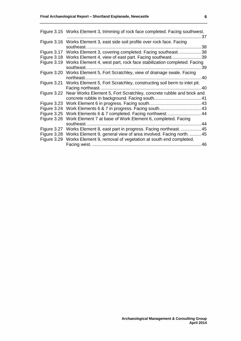
Scratchley site. .................................................................................. 26 Figure 3.2 Slope from Fort Drive down to Shortland Esplanade (area of Work
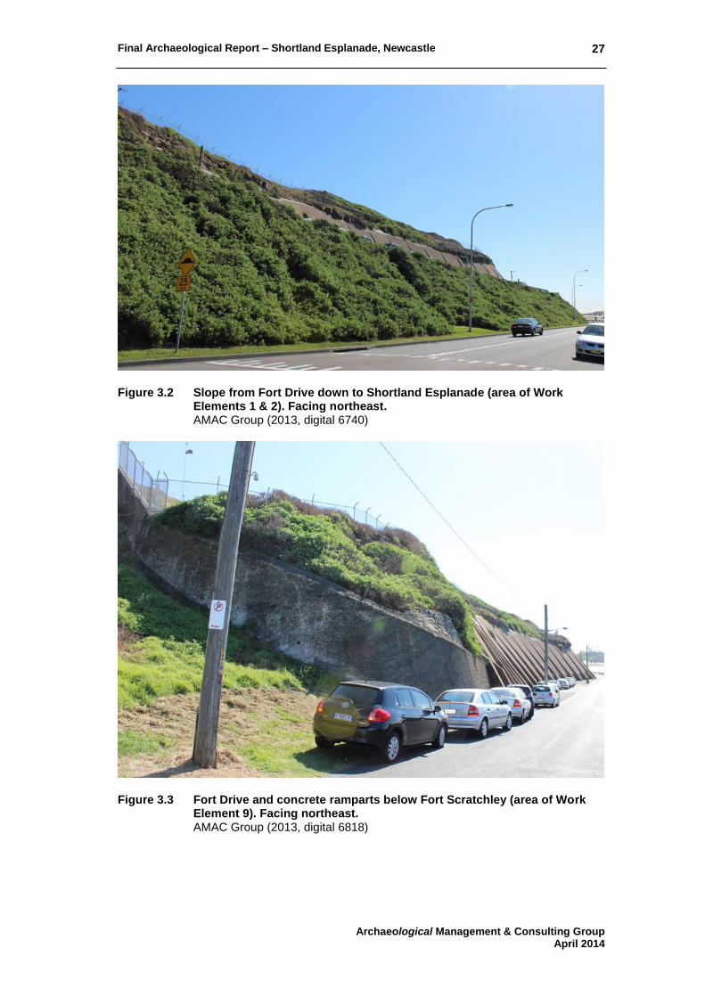
Elements 1 & 2). Facing northeast. .................................................... 27 Figure 3.3 Fort Drive and concrete ramparts below Fort Scratchley (area of Work
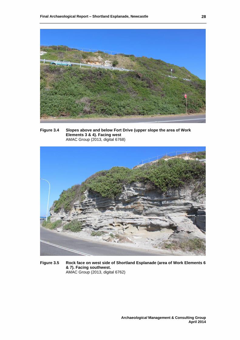
Element 9). Facing northeast. ............................................................ 27 Figure 3.4 Slopes above and below Fort Drive (upper slope the area of Work
Elements 3 & 4). Facing west ............................................................ 28 Figure 3.5 Rock face on west side of Shortland Esplanade (area of Work
Elements 6 & 7). Facing southwest. ................................................... 28 Figure 3.6 Work Element 1, machine trimming of eroded slope completed. Facing
northeast. ........................................................................................... 30 Figure 3.7 Work Element 1, machining component completed. Facing west. ...... 30 Figure 3.8 Work Element 1 completed with installation of cover materials for
replanting. Facing west. ..................................................................... 31 Figure 3.9 Work Element 2 (north), machine trimming of slope completed. Facing
east. ................................................................................................... 33 Figure 3.10 Work Element 2 (south), machine trimming of slope completed. Facing
west. .................................................................................................. 33 Figure 3.11 Work Element 2 (north), completed with installation of cover materials
for replanting. Facing west. ................................................................ 34 Figure 3.12 Work Element 2 extended, machine trimming of slope in progress.
Facing southwest. .............................................................................. 34 Figure 3.13 Work Element 2 extended, machine trimming of slope in progress.
Facing west. ...................................................................................... 35 Figure 3.14 Works Element 3, commencement of vegetation removal. Facing
southwest. ......................................................................................... 37
Final Archaeological Report – Shortland Esplanade, Newcastle
Archaeological Management & Consulting Group April 2014
6
Figure 3.15 Works Element 3, trimming of rock face completed. Facing southwest. .......................................................................................................... 37
Figure 3.16 Works Element 3, east side soil profile over rock face. Facing southeast. .......................................................................................... 38
Figure 3.17 Works Element 3, covering completed. Facing southeast. ................. 38 Figure 3.18 Works Element 4, view of east part. Facing southeast. ...................... 39 Figure 3.19 Works Element 4, west part, rock face stabilization completed. Facing
southeast. .......................................................................................... 39 Figure 3.20 Works Element 5, Fort Scratchley, view of drainage swale. Facing
northeast. ........................................................................................... 40 Figure 3.21 Works Element 5, Fort Scratchley, constructing soil berm to inlet pit.
Facing northeast. ............................................................................... 40 Figure 3.22 Near Works Element 5, Fort Scratchley, concrete rubble and brick and
concrete rubble in background. Facing south. .................................... 41 Figure 3.23 Work Element 6 in progress. Facing south. ........................................ 43 Figure 3.24 Work Elements 6 & 7 in progress. Facing south. ................................ 43 Figure 3.25 Work Elements 6 & 7 completed. Facing northwest. .......................... 44 Figure 3.26 Work Element 7 at base of Work Element 6, completed. Facing
southeast. .......................................................................................... 44 Figure 3.27 Works Element 8, east part in progress. Facing northeast. ................ 45 Figure 3.28 Works Element 9, general view of area involved. Facing north. ......... 45 Figure 3.29 Works Element 9, removal of vegetation at south end completed.
Facing west. ...................................................................................... 46

Final Archaeological Report – Shortland Esplanade, Newcastle
Archaeological Management & Consulting Group April 2014
7
Figure 1.1 Study area, outlined in red. Google Maps (2013).

Final Archaeological Report – Shortland Esplanade, Newcastle
Archaeological Management & Consulting Group April 2014
8
Figure 1.2 Overall scope of works, highlighted in red.
Cardno Geotech Solutions (September 2013) Drawing Number CGS1684 – DS – 01 Rev1.
Geo-Hazard 5A
Geo-Hazard 4B1-3
Geo-Hazard 4A
Geo-Hazard 5B

Final Archaeological Report – Shortland Esplanade, Newcastle
Archaeological Management & Consulting Group April 2014
9
Figure 1.3 Study area highlighted in blue within General Conservation Area, Newcastle LEP 2012
Fort Scratchley within General Conservation Area as Item 1480, Fort Drive and Shortland Esplanade within Archaeological Conservation Area. Heritage Map, Sheet HER_004K, Newcastle Local Environmental Plan 2012

Final Archaeological Report – Shortland Esplanade, Newcastle
Archaeological Management & Consulting Group April 2014
10
Figure 1.4 State Heritage Register Plan 1940 of Coal River Precinct boundaries.
Includes Fort Drive and Shortland Esplanade Heritage Council of New South Wales (http://www.environment.nsw.gov.au/heritageapp/HeritageItemImage.aspx?ID=5053900#ad-image-5)

Final Archaeological Report – Shortland Esplanade, Newcastle
Archaeological Management & Consulting Group April 2014
11
1.0 INTRODUCTION
1.1 BACKGROUND
Newcastle City Council has commissioned the Archaeological Management and Consulting Group to prepare a Final Archaeological Report for Shortland Esplanade, Newcastle. Archaeological monitoring was completed under permit 2013/S60/105 in accordance with the accompanying archaeological assessment by AMAC Group (September 2013). The report conforms to Heritage Office Guidelines for Archaeological Assessment.1
1.2 STUDY AREA
The study site for this report is located on the southern and eastern slopes of Fort Scratchley. The street address is Fort Drive and Shortland Esplanade, Newcastle, Parish of Newcastle, County of Northumberland.
1.3 SCOPE
This report does not consider the potential Aboriginal archaeology of the study site. However, any Aboriginal sites and objects are protected by the National Parks and Wildlife Act (see Section 1.5.2). The heritage value of the structures currently standing on the study site is not assessed as part of this report. The discovery of unknown and unassessed remains will require additional assessment.
1.4 AUTHOR IDENTIFICATION
This report was written by Kevin Hickson with the assistance of Kelly Strickland. The report was reviewed by Martin Carney. The historical section 2.0 has been summarised from the history present in the s60 Permit Application by AMAC Group (September 2013). Archaeological monitoring was supervised by the Excavation Director Martin Carney, and Kevin Hickson. The collections used were the Mitchell Library, National Library of Australia, the Newcastle Region Library, State Records of NSW, Hunter Photobank and University of Newcastle Cultural Collections.
1.5 STATUTORY CONTROLS AND HERITAGE STUDIES
1.5.1 NSW Heritage Act 1977 (as amended)
The NSW Heritage Act 1977 affords automatic statutory protection to relics that form archaeological deposits or part thereof. The Act defines relics as:
Relic means any deposit, artefact, object or material evidence that: (a) relates to the settlement of the area that comprises New South Wales, not being Aboriginal settlement, and
(b) is of State or local heritage significance
1 Heritage Office and Department of Urban Affairs and Planning (1996).

Final Archaeological Report – Shortland Esplanade, Newcastle
Archaeological Management & Consulting Group April 2014
12
Sections 139 to 145 of the Act prevent the excavation or disturbance of land for the purpose of discovering, exposing or moving a relic, except by a qualified archaeologist to whom an excavation permit has been issued by the Heritage Council of NSW. 1.5.2 National Parks and Wildlife Act (1974)
The National Parks and Wildlife Act 1974 (as amended) affords protection to all Aboriginal objects and is governed by the NSW, Office of Environment and Heritage. These objects are defined as:
any deposit, object or material evidence (not being a handicraft made for sale) relating to the Aboriginal habitation of the area that comprises New South Wales, being habitation before or concurrent with (or both) the occupation of that area by persons of
non-Aboriginal extraction, and includes Aboriginal remains.2
It is an offence to destroy Aboriginal objects or places without the consent of the Director-General.3 Section 86 discusses ‘Harming or desecration Aboriginal objects and Aboriginal places:
(1) A person must not harm or desecrate an object that the person knows is an
Aboriginal object. Maximum penalty: (a) in the case of an individual-2,500 penalty units or imprisonment for 1 year, or
both, or (in circumstances of aggravation) 5,000 penalty units or imprisonment for 2 years, or both, or
(b) in the case of a corporation-10,000 penalty units. (2) A person must not harm an Aboriginal object. Maximum penalty:
(a) in the case of an individual-500 penalty units or (in circumstances of aggravation) 1,000 penalty units, or
(b) in the case of a corporation-2,000 penalty units. (3) For the purposes of this section, "circumstances of aggravation" are:
(a) that the offence was committed in the course of carrying out a commercial activity, or
(b) that the offence was the second or subsequent occasion on which the offender was convicted of an offence under this section.
This subsection does not apply unless the circumstances of aggravation were identified in the court attendance notice or summons for the offence.
(4) A person must not harm or desecrate an Aboriginal place. Maximum penalty:
(a) in the case of an individual-5,000 penalty units or imprisonment for 2 years, or both, or
(b) in the case of a corporation-10,000 penalty units. (5) The offences under subsections (2) and (4) are offences of strict liability and the
defence of honest and reasonable mistake of fact applies. (6) Subsections (1) and (2) do not apply with respect to an Aboriginal object that is
dealt with in accordance with section 85A. (7) A single prosecution for an offence under subsection (1) or (2) may relate to a
single Aboriginal object or a group of Aboriginal objects. (8) If, in proceedings for an offence under subsection (1), the court is satisfied that, at
the time the accused harmed the Aboriginal object concerned, the accused did not know that the object was an Aboriginal object, the court may find an offence proved
under subsection (2).4
1.5.2.1 Due Diligence Code of Practice for the Protection of Aboriginal Objects in NSW
2 Part 1 Section 5, National Parks and Wildlife Act 1974. 3 Part 6 Section 90 (1) National Parks and Wildlife Act 1974. 4 Part 6 Section 86, National Parks and Wildlife Act 1974.

Final Archaeological Report – Shortland Esplanade, Newcastle
Archaeological Management & Consulting Group April 2014
13
In October 2010 DECCW, now the Office of Environment and Heritage, introduced the “Due Diligence Code of Practice for the Protection of Aboriginal Objects in NSW”.5 This code should be used by individuals or organisations who are contemplating undertaking activities which may harm Aboriginal objects. This code provides a process whereby a reasonable determination can be made as to whether or not Aboriginal objects will be harmed by an activity, whether further investigation is warranted and whether the activity requires an Aboriginal Heritage Impact Permit (AHIP) application. If through this or any other process that meets the standards of this code, such as an environmental impact assessment, reasonable steps have been already taken to identify Aboriginal objects in an area subject to a proposed activity and it is already known that Aboriginal objects will be harmed or are likely to be harmed by an activity, then an application should be made for an AHIP. Individuals or organisations who are contemplating undertaking activities which could harm Aboriginal objects should consult this code or engage the services of an appropriately qualified Archaeological consultant to carry out a due diligence study on any proposed development. This code of conduct was released in response to changes in the NPW Act which now states “A person must not harm or desecrate an object that the person knows is an Aboriginal object” or that “A person must not harm or desecrate an Aboriginal place” (NPW Act, Amendment 2010). 1.5.3 State Heritage Register and Inventory
The NSW State Heritage Register and Inventory are lists which contains places, items and areas of heritage value to New South Wales. These places are protected under the New South Wales Heritage Act 1977. State significant items are listed with the register, locally significant items are listed with the inventory. The study site is listed on the State Heritage Register within the Coal River Precinct (Figure 1.4). This listing is included in full as Appendix 9.1. 1.5.4 National Heritage List
The National Heritage List is a list which contains places, items and areas of outstanding heritage value to Australia. This can include places and areas overseas as well as items of Aboriginal significance and origin. These places are protected under the Australian Government's EPBC Act. The study site is not listed on the National Heritage List. 1.5.5 National Trust Register
National Trust Register is a list of heritage items regulated by the National Trust of Australia. The study site is included on the register as part of the curtilage for the Fort Scratchley Group Item R4378. 1.5.6 Commonwealth Heritage List
The Commonwealth Heritage List can include natural, Indigenous and historic places of value to the nation. Items on this list are under Commonwealth ownership
5 DECCW, http://www.environment.nsw.gov.au/resources/cultureheritage/ddcop/10798ddcop.pdf

Final Archaeological Report – Shortland Esplanade, Newcastle
Archaeological Management & Consulting Group April 2014
14
or control and as such are identified, protected and managed by the federal government. The study site is not listed on the Commonwealth Heritage List. 1.5.7 Newcastle Local Environment Plan 2012
The study area is protected in the Newcastle LEP as part of the general and archaeological items of Newcastle East as shown in Figure 1.3. The Heritage Map is found within ‘Schedule 5: Environmental Heritage’ of the Newcastle LEP 2012.6
1.6 RELEVANT STUDIES AND PREVIOUS REPORTS
1.6.1 Coffey Geosciences Pty Ltd (2005) Investigation of Convict Coal Mining Workings beneath Collier’s Point, Newcastle East, Results of Dri l l ing Investigation
Core drilling was conducted along Fort Drive to confirm the existence and location of the first coal mine in Australia. The position of the boreholes were to coincide with the locations of the three drift entries identified by the surveyors, Monteath & Powys Pty Ltd, from an early plan of Flag Staff Hill Newcastle (1856) Archives Authority Map No. 4604. The coal seam identified by the testing ranged in height from reduced level 12.0-12.9m AHD and its lower extent was found at RL 10.2m. This range places the coal seam and its workings completely within the bounds or below the concrete ramparts along Fort Drive. 1.6.2 Suters Architects in associat ion with Dawbin Architects
(May 2008) Fort Scratchley Historic Site Heritage Management Plan, Newcastle, NSW, for Newcastle City Council
The initial permit application report assessed Suters Architects report concerning the physical material and significance and of Fort Scratchley in order to inform the management of heritage conservation of the site. The document incorporates content from previous Conservation Management Plans by Godden Mackay in 1992 and 1996. The report also makes recommendations regarding the implementation of strategies for the redevelopment and future use of the site. 1.6.3 Cardno Geotechnical Solutions (July 2013) Draft
Geotechnical Schematic Design and Scope of Works Cliff Stabilisation Project, Shortland Esplanade and Fort Drive, Newcastle East, for Newcastle City Council
The initial permit application report included results of geotechnical investigation by Cardno regarding several sections of sandstone escarpment along the southern and eastern boundary of the Fort Scratchley hill along Shortland Esplanade and Fort Drive, Newcastle. The cliff had deteriorated in places and the investigation assesses the damage and presents both temporary and long term stabilisation options with a range of different impacts to the ground surface.
1.7 ACKNOWLEDGMENTS
Thank you to Tony Kiernan, Sarah Cameron and the Coal River Working Party for their assistance during this project.
6 Newcastle LEP 2012 - http://www.legislation.nsw.gov.au/maintop/view/inforce/epi+255+2012+cd+0+N (Accessed 28/08/2013)

Final Archaeological Report – Shortland Esplanade, Newcastle
Archaeological Management & Consulting Group April 2014
15
2.0 SITE HISTORY
The following history has been summarised from the historical section within the original archaeological assessment by AMAC Group (September 2013). The original history was compiled from previous and related studies by Suters Architects in association with Dawbin Architects (2008). The account was further supplemented by new research conducted by Archaeological Management and Consulting Group (AMAC September 2013). Please refer to the original archaeological assessment for a full history.7
2.1 SIGNAL HILL
During the early history of Newcastle, the settlement, river and its various landscape features underwent many name changes. They include Braithwaite Head, Collier’s Point, Beacon Hill, Coal Head, Fort Fiddlesticks, Signal Hill, Flagstaff Hill, South Head, Fortification Hill, and Allen’s Hill. The study area acquired its current name, Fort Scratchley, when fortifications were completed in the late 1880s. Therefore the study area will be referred to as Signal Hill when discussing the site in the period from 1797 to the 1880s and as Fort Scratchley in the period from the late 1880s to the present time in order to maintain consistency with the Suters Architects and Dawbin Architects (2008) report.8 Signal Hill and the coast of the southern peninsula was a focal point for coal exploitation during intermittent occupation of the area by the military and later opportunistic private traders. During the period of government absence between 1802 and 1804, private parties excavated mines in an ad hoc and “shameful manner…never leaving proper supports, leaving them to fall in”.9 After the renewed efforts to settle in 1804 a General Order claimed all coal and timber from Newcastle as crown property.10 Soon after arriving Lieutenant Menzies wrote to Governor King that “an excellent mine has been opened, the strata of which continues a yard six inches thick”.11 This mine was named ‘New Discovery’ and geologist D. F. Branagan suggests the strata which Lieutenant Menzies refers to is the lower split of the Dudley seam, also referred to as the ‘Dirty’ seam as shown in Figure 2.6. The entrance to this mine is placed near the present intersection of Hunter and Brown streets.12 A harbour side opening to this mine has been tentatively situated by Ground Penetrating Radar (GPR) analysis as being located near the Fort Drive roundabout.13 Branagan also asserts that a vertical shaft would have been necessary to reach the inland coal seams. 14 As such, it is no coincidence that the early mining ventures remained close to the coastline around Collier’s Point and Signal Hill as seams were easy to access with horizontal or inclined adits and tunnels.15 Mining within this area ceased in approximately 1817 when a second
7 AMAC Group (September 2013). 8 Suters Architects & Dawbin Architects (2008) Fort Scratchley Historic Site, Newcastle, Heritage Management Plan for Newcastle City Council, p. 15. 9 Lt Menzies to Governor King, 19th April in HRNSW, vol.V, p. 367. 10 Government and General Order, 24th March 1804 in HRNSW, vol.V, pp. 363-4. 11 Lt Menzies to Governor King, 19th April in HRNSW, vol.V, p. 367 12 Branagan (1972) p. 23; 26. 13 Eklund, E. (2005) In Search of the Lost Coal Mines of Newcastle, p. 5. 14 Branagan (1972) p. 27. 15 Branagan (1972) p. 27.

Final Archaeological Report – Shortland Esplanade, Newcastle
Archaeological Management & Consulting Group April 2014
16
mine shaft was completed in Watt Street.16 The greater mining areas operated between 1801 and 1824. The mine shaft at Signal Hill and south-west to the future Watt Street and Bowling Green site were all eventually abandoned as either dangerous, flooded or worked out. The mines were likely stripped of any useful items and roughly sealed.17 As the walls of Fort Scratchley were formed in 1885, the first coal entrances were covered over and “…finally blotted out of sight for ever by a deep thick wall of concrete and masonry”.18 Signal Hill was also advantageous for navigation and defence due to its height and position. Lieutenant Thomas Skottowe, Commander of Newcastle between 1811 and 1814, “erected a coal beacon and a new flagstaff to aid ships attempting to find the port” on Signal Hill in 1813. This structure was recorded in 1819 as “a small stone tower with Lighthouse” (Figure 2.2 - Figure 2.3).19 Later in 1821-22, the Acting Engineer Lieutenant Edward Close oversaw construction of structures on Signal Hill, including a “neat looking pagoda-house for the signal man and stoker’s residence” and basic fortification. Lieutenant Close was also possibly responsible for erecting a beacon stand at Signal Hill “on which a coal fire was lit every evening”; this beacon stand possibly replaced the one erected by Skottowe in 1813 (Figure 2.4, Figure 2.5).20 According to John Bingle, a resident of Newcastle between 1822 and 1882, the coal fire “was established on a hill called the Beacon Hill to be a warning and a guide to mariners”. The coal fire was lit:
“Every evening at sunset on the point of land near the fort and signal station, simply on top of a mound a few feet above the surface. This fire consumes about ½ ton of coal per night, and gives a large, clear light, which can be seen in fine weather about
20 miles at sea.”21
The mound is depicted in use as late as 1840-46 (Figure 2.5). The adjacent flagstaff was also used for harbour navigation by means of hoisting coloured flags assigned with different meanings.22 The flagstaff is shown in use from as early as 1812 (Figure 2.1). In 1818, work began to connect Nobbys Island to the mainland through the construction of a causeway; it was to be known as Macquarie Pier, in honour of the Governor. Stone for this major engineering work was quarried from Signal Hill.23 When the pier connection was completed, construction of a new lighthouse began on Nobbys Head in 1857. This left the 1822 coal beacon on Signal Hill redundant and it was last lit on the 31st December 1857. As the hill was no longer the only situation available for navigation purposes, the buildings associated with the signal station were modified by 1860 for the use of Newcastle’s Harbour Master, Captain D
16 Huntington, History of Newcastle and Northern Districts 1897, p. 74 cited in Graham Wilson and Martin Davies, c1983, p. 4. 17 Eklund, E. (2005) p. 4. 18 Newcastle Morning Herald (29th January 1885). 19 Bingle, J. (1873) Past & Present Records of Newcastle, p. 5. Huntington, History of Newcastle and Northern Districts 1897, p. 101. Historical Records of Australia 1 Vol 9 pp. 697-8 20 Suters Architects & Dawbin Architects (2008), p. 16 21 Bingle, J. (1828), p.15. Dangar, H. (1828) Emigrant’s Guide for 1828, p. 54. Suters Architects and Dawbin Architects (2008) p. 17. 22 Dangar, H. (1828) “Emigrant’s Guide for 1828”, p. 54. 23 Diary of Lachlan Macquarie, Tuesday 4 August 1818: http://www.lib.mq.edu.au/digital/lema/1818/1818aug.html

Final Archaeological Report – Shortland Esplanade, Newcastle
Archaeological Management & Consulting Group April 2014
17
T Allan and his family (Figure 2.7 - Figure 2.8).24 Up until the mid- 19th century the general Signal Hill area was not utilised for domestic settlement, however as shown in plans dated from 1873 onwards, people were taking up residence at the bottom of the northern slope (Figure 2.7 - Figure 2.11). It is suggested that some dwellings may have expanded into this area as the growth of Newcastle was being limited in the west by the A. A. Co and Signal Hill was convenient for nearby Pilot Station. The fortification advantages of Signal Hill were apparent from the outset of the 1804 settlement. The commander, Lieutenant Charles Menzies, noted that “a few guns could be placed to great advantage on a commanding height above the Town as to prevent any vessel, in case of being seized by Convicts while up Paterson’s River, from getting out of the Harbour”.25 However no serious developments in the way of defence of Newcastle took place until the formal establishment of Fort Scratchley during the 1880s.26 The history of the fort and its development is well established and best covered in the Suters and Dawbin account as the documentary history of the site is extensive and not conclusively linked to the development of the current study site.27
2.2 DEVELOPMENT
Signal Hill lay to the east of the Newcastle settlement, its landscape too exposed and steep for the construction of dwellings. However the hill and its surrounds were a convenient location for resource exploitation due to its exposed and accessible coal seams, stone, sand and lime in the form of oyster shells. As such, human activity and high disturbance earth works took place at many known and unknown locations in the vicinity of the study site. Early mining is the major development and disturbance factor of relevance. The earliest resource exploitation of Newcastle in 1796 was in the form of surface collection of coals, though this would not qualify as a development or impact. However, some haphazard private excavation in unknown locations took place intermittently between then and 1804. Following this, the coal resources of Newcastle were claimed by the crown and mining was formalised on the study site until 1817. Horizontal adits and tunnels are the most likely method that convict miners would have used to access the coal seams of Signal Hill which would have significantly disturbed the hillside. The current study site is located on the southern and eastern slopes of Fort Scratchley, however the precise locations of all the earliest mining activities are not known.28 The cross section of Signal Hill drawn in 1854 suggests there were two mine openings on the southern side of Signal Hill. The entrance labelled “Government Workings” may be in the vicinity of the study site element known as “Geo-Hazard 4B1-4B3 (Figure 1.2 and Figure 2.6).
24 Suters Architects and Dawbin Architects (2008), p. 17. 25 HRA Series 1 Volume 5 pp. 367-8 E. Flowers, 'Menzies, Sir Charles (1783–1866)', Australian Dictionary of Biography, National Centre of Biography, Australian National University, http://adb.anu.edu.au/biography/menzies-sir-charles-2447/text3265, accessed 2 September 2013. Wilson, G. and Davies, M. (1983) Fort Scratchley Report: 2. Historical Report, unpublished report for J. Birmingham, archaeological consultant to the Department of Construction, Canberra, 3-4. Suters Architects and Dawbin Architects (2008), p. 17 26 Suters Architects and Dawbin Architects (2008), p. 21 27 Suters Architects and Dawbin Architects (2008), p. 15-76 28 Eklund, E. (2005), p. 4-5

Final Archaeological Report – Shortland Esplanade, Newcastle
Archaeological Management & Consulting Group April 2014
18
Signal Hill also hosted the earliest navigation infrastructure for the settlement in the form of the flagstaff and later coal beacon and ‘stoker’s residence’. Over time these structures were updated and replaced, however as they are not located within the bounds of the study site they are not considered an integral part of its development. No further known development occurs in the Signal Hill area which has potential to occur within the study site until 1873, when residential growth is shown at the northern base of the hill (Figure 2.7). The easternmost structures depicted in Figure 2.7 occur in the of the northern and eastern slope region of Signal Hill. Depending on how distorted the distances are in the historic plans, those belonging to ‘Jno’ (John) Williams, ‘Jno’ (John) Bedford and ‘Jas’ (James) Francis might well occur near or within the northern extent of Geo-Hazard 5B on the current study site or under Fort Drive (Figure 1.2 and Figure 2.7). However, the relative position of these structures changes slightly with each consecutive plan until Figure 2.10; as a result their location remains unconfirmed. Fort Scratchley is the major development to have taken place on Signal Hill, however its buildings and infrastructure are limited to the hilltop and do not occur within the current study site (Figure 2.9). A 20th century gun emplacement is located in the area of the study site but has been deliberately excluded from the works zone. However, there may be incidental impacts to the study site during its construction. As stone was quarried from Signal Hill for the construction of Macquarie Pier to Nobby’s Island, it is possible that more quarrying was conducted on the hill and perhaps in the vicinity of the study site, to provide stone building material for Fort Scratchley itself. Between mining, erosion, quarrying, fort construction and road building the original shape of the hill has been substantially altered. This is most evident on the slopes of the hill which have been steepened and reinforced with concrete in the north or terraced for roads such as Fort Drive. The first formal road around Signal Hill occurs at the bottom of its northern slope as early as 1873, coinciding with the development of housing in the area. It is shown as Military Road in 1890, later renamed Nobbys Road in 1936 (Figure 2.7, Figure 2.10, and Figure 2.12). It is not until 1890 that the first road is shown connecting Nobbys Road to the eastern and southern extent of the hill, first named Metal Road, however by 1936 it was known as Fort Drive (Figure 2.10, Figure 2.12). Given the position of the road and the profile of the hillside shown in a photograph of the hill from the north in 1900, it is thought that Fort Drive has been cut into the slope (Figure 2.11). The second southern road does not appear in plan until 1936, known then as Beach Drive it is today Shortland Esplanade (Figure 2.12).

Final Archaeological Report – Shortland Esplanade, Newcastle
Archaeological Management & Consulting Group April 2014
19
Figure 2.1 Newcastle with a distant view of Port Stephens in 1812.
Patches of dense vegetation and extensive clearing in the settlement area. Signal Hill study site with no large vegetation and the flagstaff. Browne, T.R. (1812)
Figure 2.2 View of Newcastle in 1820 shows the flagstaff on Signal Head and
another structure to the south. Mitchell Library, DGSV1B10 Digital Order No. a928877

Final Archaeological Report – Shortland Esplanade, Newcastle
Archaeological Management & Consulting Group April 2014
20
Figure 2.3 View of Newcastle in 1820 showing Nobbys Island and Signal Hill in
background. Signal Hill is occupied by the flagstaff, a possible tower to the south and another smaller structure to the north. Preston, Walter “Newcastle, Hunter’s River, New South Wales” (Newcastle Region Art Gallery).
Figure 2.4 View of Signal Hill and Nobby’s Island 1823, facing north.
Note a pagoda like structure on Signal Hill and partially complete pier for the connection of Nobby’s Island to the mainland. Roberts, Charles Harry “The entrance to the harbour at Newcastle” (National Library of Australia http://nla.gov.au/nla.pic-an6239008).

Final Archaeological Report – Shortland Esplanade, Newcastle
Archaeological Management & Consulting Group April 2014
21
Figure 2.5 View of Newcastle c. 1840-6 showing look out house and flagstaff.
Top left inscription reads “pile of coals used as a lighthouse” Westcott, Robert Marsh “The coal mines of Newcastle” (National Library of Australia http://nla.gov.au/nla.pic-an3724031)
Figure 2.6 Cross section of Signal Hill in 1854 showing mine work and coal
seams. Keene, William “Copy of Stratigraphic Sketch of the Coast from Nobby’s Island Newcastle to Burwood showing the Coal Seams and their Order of Superposition” State Records (SZ325 N.1.1553)

Final Archaeological Report – Shortland Esplanade, Newcastle
Archaeological Management & Consulting Group April 2014
22
Figure 2.7 Signal Hill with Harbour Master in occupation and structures on the eastern slopes. Plan of the City of Newcastle (1873); National Library of Australia (Map F 48b).
Figure 2.8 Signal Hill shown as Harbour Masters Residence in 1878. Port of Newcastle Reduced from Surveys by Officers of the Harbours and Rivers Department (1878).

Final Archaeological Report – Shortland Esplanade, Newcastle
Archaeological Management & Consulting Group April 2014
23
Figure 2.9 Engraving of Newcastle 1889 showing Signal Hill occupied by Fort
Scratchley. Gibbs, Shallard and Co. Artists and Engravers, Sydney.
Figure 2.10 Signal Hill in 1890 bounded by Metal Road and Military Road.
Newcastle and Suburbs (1896, Sheet 2).

Final Archaeological Report – Shortland Esplanade, Newcastle
Archaeological Management & Consulting Group April 2014
24
Figure 2.11 Fort Scratchley in 1900.
Newcastle Cultural Collections, Hunter Photo Bank (Reference ID 05600339).
Figure 2.12 Signal Hill 1936 bounded by Fort Drive, Nobbys Road and Beach Drive.
Note south west access road to hilltop and Shortland Esplanade beginning in bottom left corner. City of Newcastle (1936)

Final Archaeological Report – Shortland Esplanade, Newcastle
Archaeological Management & Consulting Group April 2014
25
3.0 PHYSICAL EVIDENCE
3.1 BACKGROUND
Archaeological monitoring was undertaken over several days during February and March 2014. The project consisted of Work Elements (WE) 1 to 9, and primarily involved the stabilisation of eroding rock and soil faces along Shortland Esplanade and above the higher positioned Fort Drive. With the exception of Work Element 4 not requiring the removal of vegetation, all work areas were readily visible. The landscape and topography of Work Elements 5-8 allowed for closer inspection, however accessibility was problematic for Work Elements 1-3 and 9. Table 3.1 provides a brief description of each Work Element, with the abbreviations ‘FD’ and ‘SE’ denoting Fort Drive and Shortland Esplanade respectively. Figure 3.2 - Figure 3.5 show general views of the work areas prior to commencement of the development. Table 3.1 Site work locations and description
Work Element (WE)
Location Description
1 Below FD Clearance of vegetation, slope trimming for replanting
2 FD to SE Clearance of vegetation, slope trimming for replanting
3 Above FD Clearance of vegetation, slope trimming for replanting
4 Above FD Removal of loose rock, localized rock face stabilization
5 Above FD Improvement of drainage swale
6 Above SE Clearance of vegetation, rock face stabilization
7 SE Clearance of vegetation and rock fall, construction of concrete catch zone/surface drainage (below WE6)
8 FD Litter containment barrier
9 Above FD Clearance of vegetation, repair of stone retaining structure, rock face stabilization
Standard archaeological excavation techniques, utilised by this company and in accordance with the Heritage Division were employed throughout monitoring. The excavation and recording methodology is based on the AMAC Group Site Manual (2006). More specifically, monitoring of all works were undertaken in accordance with the methodology set out in the s60 Permit Application for the redevelopment.29 Records include a field diary and digital photography. Protocols for archaeological relics were not instituted as none were unearthed during monitoring.
29 AMAC Group (September 2013), p. 71.

Final Archaeological Report – Shortland Esplanade, Newcastle
Archaeological Management & Consulting Group April 2014
26
Figure 3.1 Site location map, showing the various work areas around the Fort
Scratchley site. Aerial photograph obtained from Six Maps, Land and Property Information NSW (accessed 1st May 2014)
Final Archaeological Report – Shortland Esplanade, Newcastle
Archaeological Management & Consulting Group April 2014
27
Figure 3.2 Slope from Fort Drive down to Shortland Esplanade (area of Work
Elements 1 & 2). Facing northeast. AMAC Group (2013, digital 6740)
Figure 3.3 Fort Drive and concrete ramparts below Fort Scratchley (area of Work
Element 9). Facing northeast. AMAC Group (2013, digital 6818)
Final Archaeological Report – Shortland Esplanade, Newcastle
Archaeological Management & Consulting Group April 2014
28
Figure 3.4 Slopes above and below Fort Drive (upper slope the area of Work
Elements 3 & 4). Facing west AMAC Group (2013, digital 6768)
Figure 3.5 Rock face on west side of Shortland Esplanade (area of Work Elements 6
& 7). Facing southwest. AMAC Group (2013, digital 6762)

Final Archaeological Report – Shortland Esplanade, Newcastle
Archaeological Management & Consulting Group April 2014
29
3.2 MONITORING
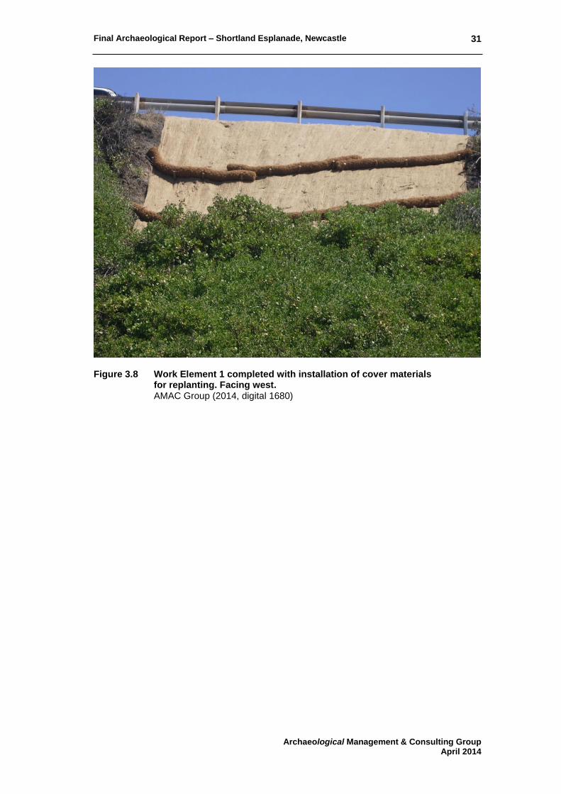
3.2.1 Work Element 1
Positioned to the south of all other work areas, Work Element 1 was located at the top of the slope from Fort Drive and leading down to Shortland Esplanade. Figure 3.6 - Figure 3.8 show views of the work in progress and following its completion. The trimmed slope exhibited a profile of six deposits: (1) Surface gravel (2) Soft, loose brown/grey sandy soil with pebbles (3) Stone rubble (evident at surface level in places) (4) Soft, loose brown/grey sandy soil with pebbles (5) Pinkish, coarse material with small angular stones, limited in extent (6) Light creamy brown, sandy and/or dry, crumbly clayey soil with rock (appeared to
be sandstone). Visible in Figure 3.7 as the greyish horizon below the guardrail, deposits (1) to (4) formed approximately the top 80 centimetres of the stratigraphic profile and appeared to be fills. The nature of deposit (5) was unclear however may be a patch of fill. Layer (6), forming the remainder of the reveal, may reflect a clean rocky fill or natural formation.30 The geotechnical profile for this location described the sequence as sandy clayey gravel overlying residual clay with tuff fragments over coal.31 The first description appears to coincide with layer (6) but contrary to the works indicating that clay over coal should have been revealed, neither was visible within in the slope profile. No Aboriginal relics were observed in soils (1) to (6). No historical remains or artefacts were observed in deposits (1-3) except for two fragments of an amber bottle which were visible at the level of soil (4). While both possibly fell from a higher fill layer, one seemed to be embedded. Retrieval was not possible but both appeared to form a modern beer bottle (at least post-19th century). No historical material was observed in soils (5) and (6).
30 The rock face at Work Element 3 showed one area of similarly crumbly light brown material. 31 Cardno Geotech Solutions Drawing No.CGS1684-DS-02, Section 5A3. Reproduced in AMAC 2013, Figure 3.14.

Final Archaeological Report – Shortland Esplanade, Newcastle
Archaeological Management & Consulting Group April 2014
30
Figure 3.6 Work Element 1, machine trimming of eroded slope
completed. Facing northeast. AMAC Group (2014, digital 1647)
Figure 3.7 Work Element 1, machining component completed. Facing west.
AMAC Group (2014, digital 1656)
Final Archaeological Report – Shortland Esplanade, Newcastle
Archaeological Management & Consulting Group April 2014
31
Figure 3.8 Work Element 1 completed with installation of cover materials
for replanting. Facing west. AMAC Group (2014, digital 1680)

Final Archaeological Report – Shortland Esplanade, Newcastle
Archaeological Management & Consulting Group April 2014
32
3.2.2 Work Element 2
Work Element 2 was situated north of Work Element 1, located on the same slope for remediation of two informal walking tracks (Figure 3.9 - Figure 3.10). Development works involved trimming the slope and creating a step at the top for a manually excavated anchor trench (0.2 x 2 metres, depth 0.2 metres) to hold the covering which was to be laid. Trimming of the northern track showed a crest fill containing loose, soft and friable light brown sandy soil with numerous rounded pebbles and small angular rocks. The same was evident at the southern track with some large rocks also present. Depths were not measurable however this deposit was approximately one metre thick. The anchor trench for the northern track revealed soft sandy grey soil at its base which appeared to be the same soil forming the face of the remainder of the slope. Both areas were covered following completion (Figure 3.11). After completion of the two areas within Work Element 2, Council commissioned the contractor to further work within the area in between the north and south pathways. Figure 3.12 and Figure 3.13 show the slope trimming in progress following the removal of vegetation. While the existing stony deposit at the Fort Drive level was visible along the extended area, the face deposit showed considerable variation (see Figure 3.13). A soft grey sandy soil was predominant; also evident were areas of brown sandy, reddish brown sandy, light brown sandy and light grey sandy soils. The slope was scattered with modern rubbish, primarily alcohol and soft drink cans and bottles. Small to medium size rocks also were present and building materials included sandstock and dry press bricks, concrete, ceramic drainpipe and a fragment of asbestos cement pipe. These were evident towards the bottom of the slope but whether this was the original place of deposition or a result of displacement is uncertain. No Aboriginal relics were observed in the soils. No historical artefacts or features were apparent and apart from the older sandstock brick fragment.

Final Archaeological Report – Shortland Esplanade, Newcastle
Archaeological Management & Consulting Group April 2014
33
Figure 3.9 Work Element 2 (north), machine trimming of slope completed. Facing
east. AMAC Group (2014, digital 1642)
Figure 3.10 Work Element 2 (south), machine trimming of slope completed. Facing
west. AMAC Group (2014, digital 1654)

Final Archaeological Report – Shortland Esplanade, Newcastle
Archaeological Management & Consulting Group April 2014
34
Figure 3.11 Work Element 2 (north), completed with installation of cover materials
for replanting. Facing west. AMAC Group (2014, digital 1677)
Figure 3.12 Work Element 2 extended, machine trimming of slope in progress.
Facing southwest. AMAC Group (2014, digital 1783)

Final Archaeological Report – Shortland Esplanade, Newcastle
Archaeological Management & Consulting Group April 2014
35
Figure 3.13 Work Element 2 extended, machine trimming of slope in progress.
Facing west. AMAC Group (2014, digital 1785)

Final Archaeological Report – Shortland Esplanade, Newcastle
Archaeological Management & Consulting Group April 2014
36
3.1.3 Work Element 3
This area was located on the southern slope above the northern part of Fort Drive and involved trimming the rock face and covering for stability. Figure 3.14 shows the location at the commencement of vegetation removal, while Figure 3.15 was taken after machining was completed. The eastern side contained a profile of grey sandy soil which was partially removed. The soil in part may be filling from the top of the slope however the deposit appeared more likely to be a combination of eroded rock, soil falling down from the above Fort grounds and aeolian sand captured by the vegetation. No Aboriginal relics or historical features or artefacts were observed in the soil removed or in the section profiles remaining. Figure 3.16 shows the completion of remediation covering. 3.1.4 Work Element 4
Including the location of Work Element 3, Work Element 4 encompassed the northern part of Fort Drive running to Nobby’s Road. The majority of the area required only the removal of loose rock on the surface of the slope below Fort Scratchley, without removal of vegetation (Figure 3.18). One section of rock face above the road intersection required stabilising with mesh (Figure 3.19). With vegetation intact and the area inaccessible, there remains an unknown presence or absence of Aboriginal objects and/or historical material. In terms of soil cover, it appears that the situation along this area would be similar to the visible areas adjacent to Work Element 3 (Figure 3.16). 3.1.5 Work Element 5
Work Element 5 was located above Fort Drive at the northeast corner of the Fort Scratchley precinct. As shown in Figure 3.20, the landscape was either a natural swale or at some stage formed into a large drainage feature between earth berms, directing stormwater into a concrete pit at the cliff edge. The latter being the case seems probable as the description of work instructed to “extend compacted earth drainage swale berm”.32 Remediation simply required removal of existing turf and constructing the berm extension with imported soil to improve channelling of water (Figure 3.21). Exposed through turf removal, the soil in this area is a rich dark grey/black sandy loam. No Aboriginal objects or historical material were observed in the surface of this soil. In close vicinity to Work Element 5 at the southeast, the Fort perimeter dropped in two ledges, the lower ledge containing the safety fence. As shown in Figure 3.22, at the western side of the safety fence ledge resides a deposition of bricks and concrete. Several bricks also sit inside and outside of the fence; one positioned on the inside of the fence was a sandstock brick type with shell lime mortar attached.
32 Cardno Geotech Solutions Drawing No.CGS1684-DS-05. Reproduced in AMAC 2013, Figure 3.17.

Final Archaeological Report – Shortland Esplanade, Newcastle
Archaeological Management & Consulting Group April 2014
37
Figure 3.14 Works Element 3, commencement of vegetation removal. Facing
southwest. AMAC Group (2014, digital 1670)
Figure 3.15 Works Element 3, trimming of rock face completed. Facing southwest.
AMAC Group (2014, digital 1698)

Final Archaeological Report – Shortland Esplanade, Newcastle
Archaeological Management & Consulting Group April 2014
38
Figure 3.16 Works Element 3, east side soil profile over rock face. Facing southeast.
AMAC Group (2014, digital 1703)
Figure 3.17 Works Element 3, covering completed. Facing southeast.
AMAC Group (2014, digital 1762)

Final Archaeological Report – Shortland Esplanade, Newcastle
Archaeological Management & Consulting Group April 2014
39
Figure 3.18 Works Element 4, view of east part. Facing southeast.
AMAC Group (2014, digital 1711)
Figure 3.19 Works Element 4, west part, rock face stabilization completed. Facing
southeast. AMAC Group (2014, digital 1761)

Final Archaeological Report – Shortland Esplanade, Newcastle
Archaeological Management & Consulting Group April 2014
40
Figure 3.20 Works Element 5, Fort Scratchley, view of drainage swale. Facing northeast. AMAC Group (2014, digital 1732)
Figure 3.21 Works Element 5, Fort Scratchley, constructing soil berm to inlet pit. Facing northeast. AMAC Group (2014, digital 1744)

Final Archaeological Report – Shortland Esplanade, Newcastle
Archaeological Management & Consulting Group April 2014
41
Figure 3.22 Near Works Element 5, Fort Scratchley, concrete rubble and brick and
concrete rubble in background. Facing south. AMAC Group (2014, digital 1740)

Final Archaeological Report – Shortland Esplanade, Newcastle
Archaeological Management & Consulting Group April 2014
42
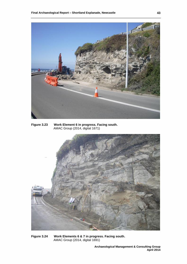
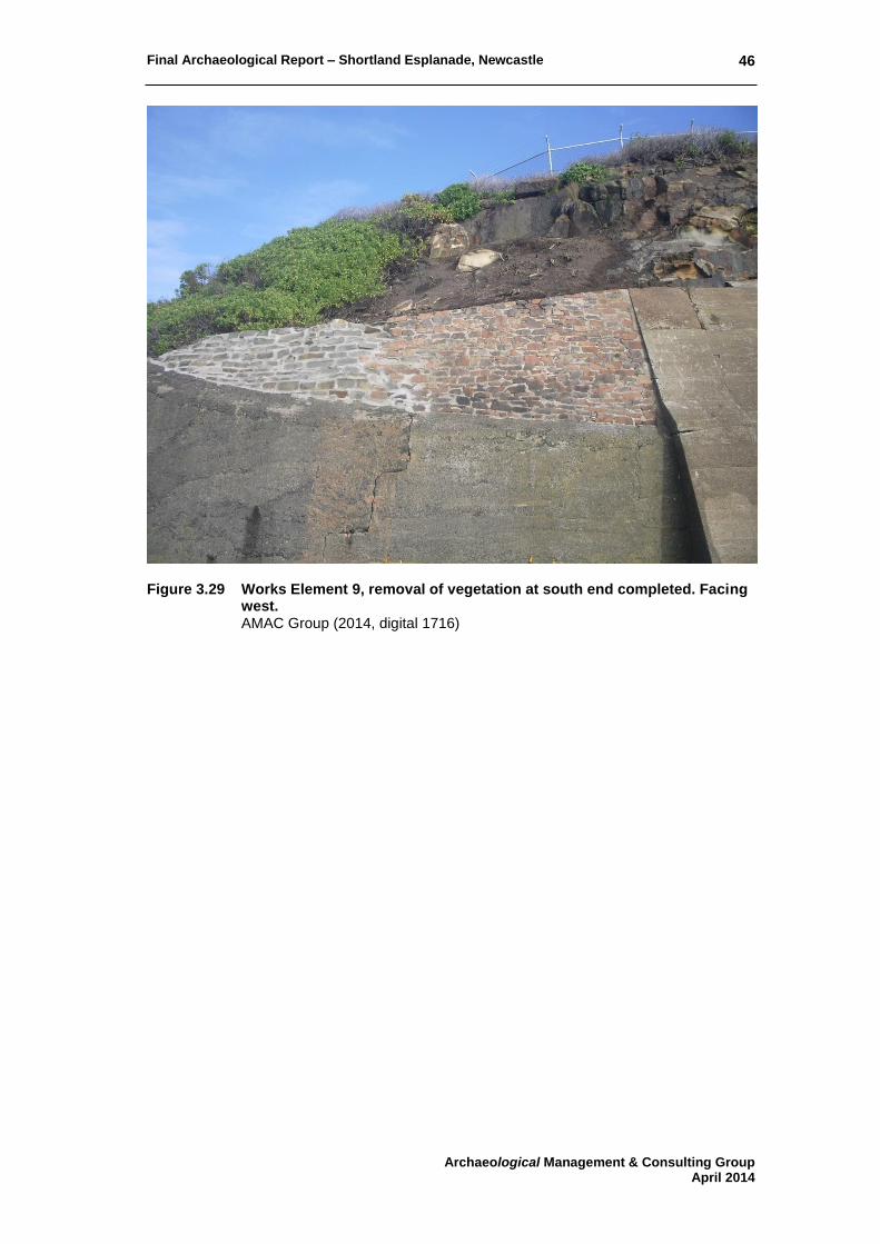
3.1.6 Work Element 6 and 7
These two work areas were located at the rock face adjacent to Shortland Esplanade and to the slight east of the Nobby’s beach pavilion. Remediation of the rock face (Work Element 6) involved removal of vegetation and stabilisation through trimming and removing all loose rock (Figure 3.23 - Figure 3.24). Work Element 7 included construction of a concrete rock fall catch zone which also served for surface drainage (Figure 3.25 - Figure 3.26). No Aboriginal objects or historical remains or artefacts were observed in this area.
3.1.7 Work Element 8
Work Element 8 involved the installation of a litter trap on the eastern side of Fort Drive, along its western turn and running towards Nobby’s Road. As shown in Figure 3.27, this consisted of steel mesh partly set in a trench excavated into the verge below the guardrail. The trench was approximately 25 centimetres wide and 20 centimetres deep and the verge soil was consistent to its full depth; grey/brown sandy loam with small pebbles and small angular rocks. No Aboriginal relics or historical remains were observed along the length of the trench. Visible artefacts were very few; several small modern fragments of clear glass and a corroded crown seal. The trench was filled with concrete. 3.1.8 Work Element 9
This area was located above the concrete ramparts, along the eastern side of Fort Scratchley (Figure 3.28). Having been inaccessible to monitor, works predominantly involved the removal of vegetation, clearance of loose rock and minor trimming of the rock face directly above the ramparts. At the southern end a sandstone block retaining wall required re-mortaring and this was the only section of the area which contained any significant amount of soil (Figure 3.29). The profile of the soil appeared to be grey sandy loam; further inspection following its reinterment into Work Element 5 indicated that it contained modern rubbish. The deposit may in part be fill, perhaps also with an element of captured aeolian sand. However its location suggests that the majority is more likely an accumulation of soil coming over the crest.
Final Archaeological Report – Shortland Esplanade, Newcastle
Archaeological Management & Consulting Group April 2014
43
Figure 3.23 Work Element 6 in progress. Facing south.
AMAC Group (2014, digital 1671)
Figure 3.24 Work Elements 6 & 7 in progress. Facing south.
AMAC Group (2014, digital 1691)

Final Archaeological Report – Shortland Esplanade, Newcastle
Archaeological Management & Consulting Group April 2014
44
Figure 3.25 Work Elements 6 & 7 completed. Facing northwest.
AMAC Group (2014, digital 1729)
Figure 3.26 Work Element 7 at base of Work Element 6, completed. Facing
southeast. AMAC Group (2014, digital 1727)

Final Archaeological Report – Shortland Esplanade, Newcastle
Archaeological Management & Consulting Group April 2014
45
Figure 3.27 Works Element 8, east part in progress. Facing northeast.
AMAC Group (2014, digital 1694)
Figure 3.28 Works Element 9, general view of area involved. Facing north.
AMAC Group (2014, digital 1717)
Final Archaeological Report – Shortland Esplanade, Newcastle
Archaeological Management & Consulting Group April 2014
46
Figure 3.29 Works Element 9, removal of vegetation at south end completed. Facing
west. AMAC Group (2014, digital 1716)

Final Archaeological Report – Shortland Esplanade, Newcastle
Archaeological Management & Consulting Group April 2014
47
3.3 DISCUSSION
Monitoring over all work areas revealed no evidence for any archaeological deposits, features or relics of significance associated with the occupation of Signal Hill or Fort Scratchley. All artefacts visually inspected were small, modern fragments of glass or modern rubbish discarded from passing vehicles or pedestrians. All fill layers appeared to reflect the natural soil profile or a large, singular fill event for the extension of roadways or the verge formation. Extensions for the verge formation were clearly visible during monitoring work in Work Element 1, and partially visible in Work Element 2. The majority of all stratigraphic layers exposed and visible at the base of elevated work areas tended to be either natural sand layers or rock, dependent on their location. It is also possible that some of the sand present could be the result of dumping sandy fills over the edge of Fort Drive in an effort to create a gentle slope rather than the sharp cliff face. This concept may have occurred at Work Element 2, as a number of colour variations within the sand is visible across the exposed stratigraphic profile. The overall evenness of the slope at Work Element 1 and 2 can be suggested to be the result of machining at some point in time, or a number of sand fills having been dumped over the edge of the slope and subsequently burying the natural topography. Two distinct dumping phases of building rubble was present at the cliff edge of Work Element 5 and along the slope of Wok Element 2. Building materials included both sandstock and dry press brick fragments and concrete fragments. It can be suggested that the presence of the rubble may have been for the retention of the slope behind, although it is more likely that it forms an isolated rubbish dump. Whether the building materials originally derive from a structure at Fort Scratchley is unknown.

Final Archaeological Report – Shortland Esplanade, Newcastle
Archaeological Management & Consulting Group April 2014
48
4.0 RESPONSE TO RESEARCH DESIGN
The following discussion is in response to the original research design by AMAC Group (September 2013). It has been compiled to incorporate data from the documentary research as well as new evidence found during monitoring phases. Table 5.1 Historical Themes concerning the study site
Australian Theme NSW Theme
1 Tracing the natural evolution of Australia
Environment: naturally evolved
2 Peopling – Peopling the continent
Convict – Activities relating to incarceration, transport, reform, accommodation and working during the convict period in NSW (1788-1850) – does not include activities associated with the conviction of persons in NSW that are unrelated to the Imperial ‘convict system’: Use the theme of Law & Order for such activities
3 Economy – Developing local, regional and national economies
Activities relating to the creation and conveyance of information
3 Economy – Developing local, regional and national economies
Activities associated with the identification, extraction, processing and distribution of mineral ores, precious stones and other such inorganic substances.
7 Defence Activities associated with defending places from hostile takeover and occupation
General Questions:
Does evidence exist to indicate the original flora and topography of the study site prior to European occupation of Newcastle?
No evidence for the original flora and topography of the site prior to European occupation was identified during monitoring.
Has the original soil horizon survived in any location? No evidence for the original soil horizon was visible within the areas monitored.
Is there any evidence of Aboriginal occupation or use of the site or of the area? Any such evidence is protected by the NPW Act.
No evidence for Aboriginal occupation or use of the site was identified during monitoring.
What archaeological evidence is there of the features that are known to have existed on the site?
No archaeological features or relics were identified on the study site during monitoring.

Final Archaeological Report – Shortland Esplanade, Newcastle
Archaeological Management & Consulting Group April 2014
49
What evidence is there of previously unknown features? No archaeological features or relics were identified on the study site during monitoring.
How has development affected the earlier remains on the site? No archaeological features or relics were identified on the study site during monitoring, therefore comments cannot be made regarding the effects of development on earlier remains.
What evidence exists for the inferred taphonomic process? Based on the nature of works and access to associated areas, detailed inspection and discussion of the exposed stratigraphic profiles in relation to the taphonomic process is not possible.
How have those taphonomic processes impacted the archaeology? No archaeological features or relics were identified on the study site during monitoring which would have been affected by taphonomic processes.
Early exploration and official settlement to 1817
Does archaeological evidence exist to suggest the nature and extent of resource exploitation, particularly mining, conducted by private individuals prior to 1804?
No archaeological features or relics were identified on the study site during monitoring.
Is there any archaeological evidence of activity on the site related to government mining ventures between 1804 and 1817?
No archaeological features or relics were identified on the study site during monitoring.
Signal Hill navigation phase 1812-1857
At what levels are archaeologically sensitive materials found? No archaeological features or relics were identified on the study site during monitoring.
Is there any evidence of refuse or deposition from the use of the coal beacon?
No archaeological features or relics were identified on the study site during monitoring.
Is there any evidence to suggest how much of the original slope of the hill was affected by historic and natural processes?
Due to the nature of the works archaeological monitoring was conducted from a distance, therefore precise measurements of the current slope could not be

Final Archaeological Report – Shortland Esplanade, Newcastle
Archaeological Management & Consulting Group April 2014
50
obtained. The original cut for construction of Military Road (now Fort Drive), its modifications and improvements would have caused a significant impact to the original slope of the hill. Its elevated position and close proximity to the ocean has exposed the cliff face to constant erosion which has also impacted the original slope of the hill over the last 200 years.
How have later developments on the site affected the subsurface remains, can comment be offered on their condition?
No archaeological features or relics were identified on the study site during monitoring.
Is there any evidence of undocumented use of the study site? No archaeological features or relics were identified on the study site during monitoring. It appears that the base of the slope within Work Element 2 and the cliff face at Work Element 5 were used as a refuse dump for building materials which may have initially derived from Fort Scratchley, although its origin remains unidentifiable.
Fort Scratchley 1885 - present
Is there any evidence of undocumented use of the study site? No archaeological features or relics were identified on the study site during monitoring.
At what levels are archaeologically sensitive materials found?
No archaeological features or relics were identified on the study site during monitoring.

Final Archaeological Report – Shortland Esplanade, Newcastle
Archaeological Management & Consulting Group April 2014
51
5.0 PERMIT COMPLIANCE
Archaeological monitoring work undertaken in 2014 was completed under permit 2013/S60/105. The following conditions form guidelines created by the Heritage Division to which all archaeological works on the site are required to comply with.
1. All stabilisation works including the archaeology programme shall be in accordance with the plan of works detailed in the stamped, endorsed report “Archaeological Component Permit Application- Research Design, Excavation Methodology and Heritage Impact Statement: Shortland Esplanade, Newcastle- Cliff Stabilisation Works”, by AMAC Archaeological, dated September 2013.
Except as amended by the following conditions:
2. This permit covers the removal of locally significant archaeology, only. No archaeological features or relics were identified on the site during monitoring.
3. This approval is valid for five years from the date of approval. Requests for
extensions beyond this time must be made in writing prior to expiry of the permit.
All development works were completed during February and March 2014.
Fieldwork:
4. The Heritage Council of NSW or its delegate must be informed of the commencement and completion of the archaeological program at least five days prior to the commencement and within five days of the completion of work on site. The Heritage Council and staff of the Heritage Division, Office of Environment and Heritage authorised under section 148(1) of the ‘Heritage Act, 1977’, reserve the right to inspect the site and records at all times and to access any relics recovered from the site.
The Heritage Division were informed prior to commencement and after completion of the archaeological program.
5. The Applicant must ensure that if substantial intact archaeological deposits
and/ or State significant relics not identified in “Archaeological Component Permit Application- Research Design, Excavation Methodology and Heritage Impact Statement: Shortland Esplanade, Newcastle- Cliff Stabilisation Works” by AMAC Archaeological, Dated September 2013, are discovered, work must cease in the affected area(s) and the Heritage Council of NSW must be notified. Additional assessment and approval may be required prior to works continuing in the affected area(s) based on the nature of the discovery.
No archaeological features or relics were identified on the site during monitoring
6. Should any Aboriginal ‘objects’ be uncovered by the work, excavation or
disturbance of the area is to stop immediately. The Excavation Director must inform the Office of Environment and Heritage in accordance with Section 89A of the National Parks and Wildlife Act, 1974 (as amended). Works affecting Aboriginal ‘objects on the site must not continue until the Office of Environment and Heritage has been informed. Aboriginal ‘objects’ must be managed in accordance with the National Parks and Wildlife Act, 1974.

Final Archaeological Report – Shortland Esplanade, Newcastle
Archaeological Management & Consulting Group April 2014
52
No Aboriginal ‘objects’ were found on site during monitoring.
7. The Heritage Council of NSW must approve any substantial deviations from the approved works and archaeology programme outlined in “Archaeological Component Permit Application- Research Design, Excavation Methodology and Heritage Impact Statement: Shortland Esplanade, Newcastle- Cliff Stabilisation Works” by AMAC Archaeological, Dated September 2013, including extent and techniques of excavations, as an application for the variation or revocation of a permit under section 65A of the ‘Heritage Act, 1977’.
No deviations were made from the approved works and archaeological program outlined in the original assessment by AMAC Group (September 2013).
8. The Applicant must ensure that the approved Primary Excavation Director
nominated in the section 60 application 2013/S60/105, Martin Carney, is present at the site supervising all archaeological fieldwork activity likely to expose significant relics.
The Excavation Director, Martin Carney, was present during all fieldwork activity believed to hold the possibility of revealing archaeological features, although the original assessment deduced that there stood limited potential for significant relics. This concept was borne out in the archaeological monitoring.
9. The Applicant must ensure that the approved Primary excavation Director
nominated in the section 60 application 2013/S60/105, Martin Carney, takes adequate steps to record in detail relics, structures and features discovered on the site during the archaeological works in accordance with relevant Heritage Council guidelines.
No archaeological features or relics were identified on the site during monitoring
10. The Applicant must ensure that the nominated Excavation Director briefs all
personnel involved in the project about the requirements of the NSW ‘Heritage Act 1977’ in relation to the commencement of on-site excavation works.
All personnel were briefed prior to the commencement of on-site excavation works.
11. The Applicant must ensure that the nominated Excavation Director and the
excavation team is given adequate resources to allow full and detailed recording to be undertaken to the satisfaction of the Heritage Council.
The monitoring team were given any further resources which they required.
12. The Applicant must ensure that the site under archaeological investigation is
made secure and that the unexcavated artefacts, structures and features are not subject to deterioration, damage, destruction or theft during fieldwork.
Due to the nature of the site, its elevation and proximity to roadways, the site could not be secured by fencing. However no archaeological features or relics were identified on the site during monitoring.

Final Archaeological Report – Shortland Esplanade, Newcastle
Archaeological Management & Consulting Group April 2014
53
13. The Applicant is responsible for the safe-keeping of all relics recovered from the site.
No archaeological features or relics were identified on the site during monitoring.
Views:
14. New work must not block, obscure or diminish significant views or vistas of Signal Hill to Fort Scratchley. At the conclusion of works, the appearance of the site must be ‘made good’ to ensure that views to Fort Scratchley are not impacted by the works.
Development work was focused around the sloping cliff faces and subsequently did not impede any existing views to Fort Scratchley.
Analysis and Reporting:
15. The Applicant must ensure that the approved Primary Excavation Director or an appropriate specialist, cleans, stabilises, labels, analyses, catalogues and stores any artefacts recovered from the site in a way that allows them to be retrieved according to both type and provenance.
No artefacts were identified or collected during monitoring.
16. The Applicant must ensure that a final excavation report is written by the
approved Primary Excavation Director nominated in the section 60 application 2013/S60/105, Martin Carney, to publication standard, within one year of the completion of the field based archaeological activity unless an extension of time or other variation is approved by the Heritage Council of NSW in accordance with 65A of the ‘Heritage Act, 1977’.
This document forms the final excavation report.
17. The Applicant must ensure that one electronic copy of the final excavation
report is submitted on CD to the Heritage Council of NSW together with two printed copies of the final excavation report. These reports are required in accordance with section 146(b) of the ‘Heritage Act, 1977’. The Applicant must also ensure that further copies are lodged with the local library and/or another appropriate local repository in the area in which the site is located. It is also required that all digital resources (including reports, context and artefact data, scanned field notes, other datasets and documentation) should be lodged with a sustainable, online and open-access repository.
Two hard copies and an electronic copy of the report have been provided to the Heritage Division.
18. The Applicant must ensure that the information presented in a final
excavation report includes the following: a) An executive summary of the archaeological programme; Refer to page 2 of this report. b) Due credit to the client paying for the excavation, on the title page; Due credit has been paid to the client on the front cover and in Section 1.0 of this report. c) An accurate site location and site plan (with scale and north arrow) and
including geo-reference data;

Final Archaeological Report – Shortland Esplanade, Newcastle
Archaeological Management & Consulting Group April 2014
54
As no archaeological features or relics were identified on the site during monitoring, a scaled site plan was not produced.
d) Historical research, references and bibliography; Refer to Section 2.0, 7.0 and 8.0 of this report. e) Detailed information on the excavation including the aim, the context for the
excavation, procedures, treatment of artefacts (cleaning, conserving, sorting, cataloguing, labelling, scale photographs and/or drawings, location of repository) and analysis of the information retrieved;
Refer to Section 3.0 of this report. f) Nominated repository for the items; No artefacts were identified or collected during monitoring. g) Detailed response to research questions (at minimum those stated in the
Heritage Council approved Research Design); Refer to Section 4.0 of this report. h) Conclusions from the archaeological program. This information must include
a reassessment of the site’s heritage significance, statement(s) on how archaeological investigations at this site have contributed to the community’s understanding of the early Newcastle mining sites; recommendations for future management of the site and how much of the site remains undisturbed;
Refer to Section 7.0 of this report. i) Details of how this excavation has been publicly disseminated (for example,
provide details about Public Open Days and include copies of press releases, public brochures and information signs produced to explain the archaeological significance of the site).
A copy of this report will be given to Newcastle Regional Library as a matter of public information.

Final Archaeological Report – Shortland Esplanade, Newcastle
Archaeological Management & Consulting Group April 2014
55
6.0 REVISED ASSESSMENT OF
SIGNIFICANCE
6.1 METHODOLOGY
The current standard for assessment of significance of heritage items in NSW is the publication ‘Assessing Significance for Historical Archaeological Sites and ‘Relics’’ produced by the Heritage Branch of the NSW Department of Planning (December 2009). This production is an update to the NSW Heritage Manual (1996), and the criteria detailed therein are a revised version of those of the Australia ICOMOS Burra Charter, formulated in 1979, which was based largely on the Venice Charter (for International Heritage) of 1966. Archaeological heritage significance can also be viewed in light of the framework set out by Bickford and Sullivan in 1984.33 Bickford and Sullivan, taking into consideration the “archaeological, scientific or research significance” of a site posed three questions in order to identify significance:
1. Can the site contribute knowledge which no other resource can? 2. Can the site contribute knowledge which no other site can? 3. Is this knowledge relevant to general questions about human history or other
substantive problems relating to Australian history, or does it contributes to other
major research questions?34
These questions have been broadly used to shape the response to the heritage significance criteria as described in Section 4.2 and 4.3. The criteria and the definitions provided by ‘Assessing Significance for Historical Archaeological Sites and ‘Relics’’ have been adhered to in assessing the cultural significance of the potential archaeological site at Shortland Esplanade, Newcastle. An assessment of significance, under each of the criteria, is made possible by an analysis of the broad body of archaeological sites previously excavated both locally and elsewhere, in conjunction with the historical overview of the study site in particular. The Criteria used to assess Heritage Significance in NSW are the following: Table 6.1 Criteria for Assessing Heritage in NSW Criterion Description Significance
Criterion A An item is important in the course, or pattern, of NSW’s or the local area’s cultural or natural history
State significant or locally significant
Criterion B An item has strong or special association with the life or works of a person, or group of persons, of importance in NSW’s or a local area’s cultural or natural history
State significant or locally significant
Criterion C An item is important in demonstrating aesthetic characteristics and/or a high degree of creative or technical achievement in NSW or the local area
State significant or locally significant
Criterion D An item has strong or special association with a particular community or cultural group in NSW or a local area for social, cultural or spiritual reasons
State significant or locally significant
33 Bickford and Sullivan (1984) 34 Bickford and Sullivan (1984), p.23-4

Final Archaeological Report – Shortland Esplanade, Newcastle
Archaeological Management & Consulting Group April 2014
56
Criterion E An item has potential to yield information that will contribute to an understanding of NSW’s or a local area’s cultural or natural history
State significant or locally significant
Criterion F An item possesses uncommon, rare or endangered aspects of NSW’s or a local area’s cultural or natural history
State significant or locally significant
Criterion G An item is important in demonstrating the principal characteristics of a class of NSW’s or a local area’s - cultural or natural places; or - cultural or natural environments
State significant or locally significant
The following assessment deals only with sub-surface archaeological features and deposits. The built environment is not considered in this study.
6.2 IDENTIFICATION OF SIGNIFICANCE
Archaeological Research Potential (NSW Heritage Criterion E) The study site did not demonstrate archaeological significance according to this criterion. Associations with individuals, events or groups of historical importance (NSW Heritage Criteria A, B and D) The study site did not demonstrate archaeological significance according to this criterion. Aesthetic or technical significance (NSW Heritage Criterion C) The study site did not demonstrate archaeological significance according to this criterion. Ability to demonstrate the past through archaeological remains (NSW Heritage Criteria A, C, F & G) The study site did not demonstrate archaeological significance according to this criterion.
6.3 STATEMENT OF CULTURAL SIGNIFICANCE
The study site was initially assessed as holding unknown potential for significant archaeological material pertaining to early 19th century mining practices and the late 19th century development of the road now known as Fort Drive. Overall the greater area of the study site is of State significance as it forms part of the first major military fort in Newcastle and one of the earliest mining areas of Newcastle during the initial development of the settlement. The initial assessment found no conclusive evidence to suggest historical development occurring directly on the study site, and archaeological monitoring confirmed this perception. As a result, the study site is considered of neither local nor State significance in its isolated form, however still forms part of a wider State significant listing which remains in place regardless of the absence of archaeological finds during this development.

Final Archaeological Report – Shortland Esplanade, Newcastle
Archaeological Management & Consulting Group April 2014
57
7.0 RESULTS AND RECOMMENDATIONS
7.1 RESULTS
7.1.1 Documentary Research
Documentary research provides evidence for occupation of the greater study area as early as the initial settlement of Newcastle. Signal Hill, now Fort Scratchley, and the coast of the southern peninsula was a focal point for coal exploitation during the intermittent occupation of the area by the military and later opportunistic private traders. Mining ceased at Signal Hill in approximately 1817, whereby a second mine shaft was completed in Watt Street. The areas worked between 1801 and 1824, under Signal Hill and south-west to the future Watt Street and Bowling Green site, were all eventually abandoned as dangerous, flooded and worked out. Signal Hill was also advantageous for navigation and defence due to its height and position. The top of the hill was used for the location of a coal beacon from at least 1813 to the mid-19th century. Also situated at the top of the hill was a flagstaff and stoker’s residence. By the mid-19th century Signal Hill was no longer the only situation available for navigation purposes, the buildings associated with the signal station were modified by 1860 for the use of Newcastle’s Harbour Master, Captain D. T. Allan. The fortification advantages of Signal Hill were apparent from the outset of the 1804 settlement. However formal fortifications were not established on the hill until Fort Scratchley in the 1880s. 7.1.2 Physical Evidence
Archaeological monitoring was conducted over several days in February and March 2014. Nine separate work areas (Work Element 1-9) presented no evidence for any archaeological deposits, features or relics of significance associated with the occupation of Signal Hill and later Fort Scratchley. All artefacts visually inspected were small, modern fragments of glass or modern rubbish discarded from passing vehicles or pedestrians. Two distinct dumping phases of building rubble was present at the cliff edge of Work Element 5 and along the slope of Wok Element 2. Building materials included both sandstock and dry press brick fragments and concrete fragments. It can be suggested that the presence of the rubble may have been for the retention of the slope behind, although it is more likely that it forms an isolated rubbish dump. Whether the building materials originally derive from a structure at Fort Scratchley is unknown. 7.1.3 Significance
The study site was initially assessed as holding unknown potential for significant archaeological material pertaining to early 19th century mining practices and the late 19th century development of the road now known as Fort Drive. Overall the greater area of the site remains State significant as it forms part of the first major military fort in Newcastle and one of the earliest mining areas of Newcastle during the initial development of the settlement. The initial assessment found no conclusive evidence to suggest historical development occurred on the study site, and archaeological monitoring yielded no data to contradict this. As a result, the study site is considered of neither local nor State significance in its isolated form, however still forms part of a wider State
Final Archaeological Report – Shortland Esplanade, Newcastle
Archaeological Management & Consulting Group April 2014
58
significant listing which remains in place regardless of the absence of archaeological finds during this development.
7.2 RECOMMENDATIONS
This report should be submitted to the Heritage Division as the Final Archaeological Report for the study site along with any photographic records. No further archaeological action is recommended under the present endorsement within this designated works curtilage of Fort Scratchley. Future Works Based on the early occupation date of the wider area of the study site, any future development works within Fort Scratchley should be subject to an archaeological assessment and an s60 permit application. Application should be made to the Heritage Division prior to any excavation works at Fort Scratchley.
7.3 ARTEFACTS AND RECORDS STORAGE
A copy of this report will be given to the client, along with any archival photographs. No artefacts were collected during monitoring. Other site records will be stored with AMAC Group.
7.4 PUBLIC INFORMATION
A copy of the report will be submitted to Newcastle Regional Library as a matter of public information.

Final Archaeological Report – Shortland Esplanade, Newcastle
Archaeological Management & Consulting Group April 2014
59
8.0 BIBLIOGRAPHY
Archaeological Management and Consulting Group (September 2006) Site Manual Plazawest Comprehensive Archaeological Programme 384-394 Church Street and 18-22 Victoria Road Parramatta.
Archaeological Management and Consulting Group (2012) ‘Draft Final
Archaeological Report Lee Wharf Development Square-about and Lot 24, Honeysuckle Drive, Newcastle, NSW’, for Lee Wharf Developments and Caverstock Group.
Archaeological Management and Consulting Group (September 2013),
‘Archaeological Component Permit Application- Research Design, Excavation Methodology and Heritage Impact Statement: Shortland Esplanade, Newcastle- Cliff Stabilisation Works’, for Newcastle City Council.
Australian Dictionary of Biography, online resource, http://adb.anu.edu.au/ Bingle, J. (1873) Past & Present Records of Newcastle Branagan, D. F. (1972) Geology and Coal Mining in the Hunter Valley 1791-1861,
Newcastle History Monographs No. 6, Newcastle Public Library. Cardno Geotechnical Solutions (July 2013) Draft Geotechnical Schematic Design
and Scope of Works Cliff Stabilisation Project, Shortland Esplanade and Fort Drive, Newcastle East, for Newcastle City Council.
Coffey Geosciences Pty Ltd (2005), ‘Investigation of Convict Coal Mining Workings
beneath Collier’s Point, Newcastle East, Results of Drilling Investigation’, for Newcastle City Council.
Dangar, H. (1828) Index and Directory to the Map of the Country bordering upon the
River Hunter, London. Eklund, E. (2005) In Search of the Lost Coal Mines of Newcastle. Paper presented
by Dr Erik Eklund on the 1st of April 2005, University of Newcastle. Google Maps, online resource, https://www.google.com.au/maps/preview Historical Records of Australia (1915) Vol 3, The Library Committee of the
Commonwealth Parliament, Government Printer, Sydney. Huntington (1897) History of Newcastle and Northern Districts. Photocopy of a
series appearing in the Newcastle Morning Herald August 1897-July 1898. Macquarie, Lachlan (1818) Tuesday 4 August 1818:
http://www.lib.mq.edu.au/digital/lema/1818/1818aug.html National Parks and Wildlife Act (1974). Newcastle and Suburbs (1897), accessed through Newcastle Region Library.

Final Archaeological Report – Shortland Esplanade, Newcastle
Archaeological Management & Consulting Group April 2014
60
Newcastle Cultural Collections, Hunter Photobank, online resource, http://collections.ncc.nsw.gov.au/keemu/pages/nrm/index.htm
Newcastle Local Environment Plan (2012), online resource,
http://www.newcastle.nsw.gov.au/building_and_planning/planning_controls/lep_2012
Newcastle Morning Herald (29th January 1885) NSW Heritage Office (1996) Skeletal Remains: Guidelines for Management of
Human Skeletal Remains in NSW Heritage Manual, Sydney. NSW Heritage Office (2009) Assessing Significance for Historical Archaeological
Sites and Relics, Heritage Office of the Department of Planning. NSW Department of Planning and Heritage Council of NSW (2006) Historical
Archaeology Code of Practice, Heritage Office of the Department of Planning.
NSW Heritage Office (2001) Assessing Heritage Significance, Heritage Office of the
Department of Planning. NSW Heritage Office (2001 with revisions 2006) Photographic Recording Of
Heritage Items Using Film or Digital Capture, Heritage Office of the Department of Planning.
NSW Heritage Office Department of Urban Affairs and Planning (1996)
Archaeological Assessment: Archaeological Assessment Guidelines. State Records of NSW, Online resource, http://www.records.nsw.gov.au/state-
archives/indexes-online/indexes-online Suters Architects & Dawbin Architects (2008) ‘Fort Scratchley Historic Site,
Newcastle, Heritage Management Plan’, for Newcastle City Council. Turner, J. W. (1980) Manufacturing in Newcastle 1801-1900. Newcastle History
Monographs No. 8, Newcastle Region Public Library. Turner, J. W. (1982) Coal Mining in Newcastle 1801-1900, Newcastle History
Monographs No. 9 Turner, J. (1997) “Newcastle 1804-1993, an Overview”, in Suters Architects Vol.1,
10-25. Wentworth, W. C. (1819) A Statistical, Historical and Political Description of the
Colony of New South Wales. General & W. B. Whittaker, London.
Wilson, G. and Davies, M. (1983) Fort Scratchley Report: 2. Historical Report, unpublished report for J. Birmingham, archaeological consultant to the Department of Construction, Canberra.

Final Archaeological Report – Shortland Esplanade, Newcastle
Archaeological Management & Consulting Group April 2014
61
9.0 APPENDICES
9.1 HERITAGE DIVISION EXCAVATION PERMIT

Final Archaeological Report – Shortland Esplanade, Newcastle
Archaeological Management & Consulting Group April 2014
62

Final Archaeological Report – Shortland Esplanade, Newcastle
Archaeological Management & Consulting Group April 2014
63

Final Archaeological Report – Shortland Esplanade, Newcastle
Archaeological Management & Consulting Group April 2014
64

Final Archaeological Report – Shortland Esplanade, Newcastle
Archaeological Management & Consulting Group April 2014
65
9.2 PHOTOGRAPHIC REGISTER
Digital Works Area
Description Facing Date
1633 - Fort Drive south from site offices S 3.2.14
1634 - Fort Drive north from site offices N 3.2.14
1635 - Cliff along east side of Fort Drive SE 3.2.14
1636 - Ditto NE 3.2.14
1637 - Ditto E 3.2.14
1638 - Concrete ramparts along west side of Fort Drive
SW 3.2.14
1639 - Ditto NW 3.2.14
1640 - Ditto NW 3.2.14
1641 2 View downslope (from Fort Drive) E 4.2.14
1642 2 Ditto E 4.2.14
1643 2 View downslope E 4.2.14
1644 2 Ditto, stepping at top E 4.2.14
1645 2 Ditto E 4.2.14
1646 1 View along the slope NE 4.2.14
1647 1 View downslope NE 4.2.14
1648 1 Ditto SE 4.2.14
1649 1 Ditto E 4.2.14
1650 1 Ditto E 4.2.14
1651 2 View upslope (from Shortland Esplanade) W 4.2.14
1652 2 Ditto W 4.2.14
1653 2 View upslope W 4.2.14
1654 2 Ditto W 4.2.14
1655 2 Ditto, upper part W 4.2.14
1656 1 View upslope W 4.2.14
1657 1 Ditto W 4.2.14
1658 1 Ditto W 4.2.14
1669 9 Commencement of works (vegetation removal)
S 10.2.14
1670 3 In progress, initial removal of vegetation SW 10.2.14
1671 6 Shortland Esplanade, in progress, removal of rock
SE 10.2.14
1672 6 Ditto S 10.2.14
1674 6 Ditto - detail of rock W 10.2.14
1675 6 Ditto NW 10.2.14
1676 6 Ditto - detail of rock, also showing remnant reinforcement rod (previous insertion)
NW 10.2.14
1677 2 Covering of slope clearance (north) W 10.2.14
1678 2 Covering of slope clearance (south) W 10.2.14
1679 1 Covering of slope clearance W 10.2.14
1680 1 Ditto W 10.2.14
1681 1 Ditto W 10.2.14
1682 9 Above Fort Drive, in progress W 14.2.14
1683 9 Ditto NW 14.2.14

Final Archaeological Report – Shortland Esplanade, Newcastle
Archaeological Management & Consulting Group April 2014
66
Digital Works Area
Description Facing Date
1684 9 Ditto NW 14.2.14
1685 9 Ditto NW 14.2.14
1686 9 Ditto W 14.2.14
1687 9 Ditto NW 14.2.14
1688 3 Fort Drive, in progress S 14.2.14
1689 6-7 Shortland Esplanade, in progress NW 14.2.14
1690 6 In progress W 14.2.14
1691 6-7 Shortland Esplanade, in progress SE 14.2.14
1692 - Structural debris (W side of Shortland Esplanade)
W 14.2.14
1694 8 Fort Drive, in progress NE 18.2.14
1695 8 Ditto – detail of trenching E 18.2.14
1696 8 Ditto E 18.2.14
1697 8 Ditto – detail of trenching E 18.2.14
1698 3 Machined profile SW 18.2.14
1699 3 Ditto SE 18.2.14
1700 3 Ditto – west side S 18.2.14
1701 3 Ditto – central area S 18.2.14
1702 3 Ditto – east side S 18.2.14
1703 3 Profile of soils removed E 18.2.14
1704 9 Above Fort Drive, vegetation removal in progress
SW 21.2.14
1705 9 Ditto SW 21.2.14
1706 9 Ditto SW 21.2.14
1707 9 Above Fort Drive, south end vegetation removal completed
NW 26.2.14
1708 9 Ditto W 26.2.14
1709 8 Fort Drive, completed NE 26.2.14
1710 3 Machined profile SW 26.2.14
1711 4 View of east part SE 26.2.14
1712 4 Ditto S 26.2.14
1713 4 View of central part SW 26.2.14
1714 4 View of west part S 26.2.14
1715 4 Ditto SW 26.2.14
1716 9 Above Fort Drive, south end, vegetation removal completed
W 4.3.14
1717 9 Ditto NW 4.3.14
1718 9 Ditto, central area W 4.3.14
1719 3 Retention covering in progress SW 4.3.14
1720 3 Ditto S 4.3.14
1721 3 Ditto SE 4.3.14
1722 4 West end, rock face stabilization E 4.3.14
1723 4 Ditto E 4.3.14
1724 4 Ditto E 4.3.14
1725 4 Ditto E 4.3.14
1726 6 Completed SE 4.3.14
Final Archaeological Report – Shortland Esplanade, Newcastle
Archaeological Management & Consulting Group April 2014
67
Digital Works Area
Description Facing Date
1727 6-7 Completed SE 4.3.14
1728 6-7 Completed SE 4.3.14
1729 6-7 Ditto NW 4.3.14
1730 5 Start of works near inlet pit NE 4.3.14
1731 5 Ditto NE 4.3.14
1732 5 View of drainage swale NE 4.3.14
1733 5 Ditto NE 4.3.14
1734 5 Ditto NE 4.3.14
1735 5 Ditto NE 4.3.14
1736 5 View from fort to baths, also showing shelving at top of cliff above Fort Drive
SE 4.3.14
1737 5 Shelving at top of cliff above Fort Drive E 4.3.14
1738 5 Lower ledge, sandstock brick with shell lime mortar
- 4.3.14
1739 5 Ditto, bricks outside safety fence E 4.3.14
1740 5 Ditto, concrete and brick rubble S 4.3.14
1741 5 Ditto S 4.3.14
1742 5 Constructing low berm with imported soil NE 4.3.14
1743 5 Ditto NE 4.3.14
1744 5 Ditto NE 4.3.14
1760 4 West end, rock face stabilization completed SE 10.3.14
1761 4 Ditto SE 10.3.14
1762 3 Retention covering completed SE 10.3.14
1773 2 Increased area of slope works (from Fort Drive)
NE 11.3.14
1774 2 Ditto NE 11.3.14
1775 2 Ditto NE 11.3.14
1776 2 Ditto, south end E 11.3.14
1777 2 Ditto NE 11.3.14
1778 2 Ditto SE 11.3.14
1779 2 Ditto, north end E 11.3.14
1780 2 Ditto, central area E 11.3.14
1781 2 Ditto (from Shortland Esplanade) SW 11.3.14
1782 2 Ditto SW 11.3.14
1783 2 Ditto SW 11.3.14
1784 2 Ditto, north part W 11.3.14
1785 2 Ditto, central part W 11.3.14
1786 2 Ditto, south part W 11.3.14
1787 2 Ditto W 11.3.14
1789 2 Ditto, central part W 11.3.14
1790 2 Ditto, north part W 11.3.14
1791 2 Ditto W 11.3.14
1792 2 General view of slope formation NW 11.3.14
1793 2 Ditto NW 11.3.14
1794 2 Sample of rubbish from the slope - 11.3.14
1795 2 Ditto - 11.3.14

Final Archaeological Report – Shortland Esplanade, Newcastle
Archaeological Management & Consulting Group April 2014
68
Digital Works Area
Description Facing Date
8149 - View to ocean baths SE 5.2.14
8150 - Ditto SE 5.2.14
8151 - House on Beach Street S 5.2.14
8152 - View along Beach Street W 5.2.14
8153 - View to ocean baths SE 5.2.14
8154 - Site entry on Fort Drive NE 5.2.14
8155 - Ditto SE 5.2.14
8156 6 Vegetation removal, north end E 5.2.14
8157 6 Ditto – central area NW 5.2.14
8158 6 Ditto - south end S 5.2.14
8159 2 View upslope (from Shortland Esplanade) W 5.2.14
8160 6 Commencement of rock removal W 5.2.14
8161 6 Ditto NW 5.2.14