altai-sayan ecoregion conservation...
TRANSCRIPT

Altai-Sayan Ecoregion Conservation Strategy
FINAL DRAFT VERSION, approved by the Altai-Sayan Steering Committee on 29 June 2012, considering the amendments and
comments made during the teleconference of 29 June 2012, as described in the meetings notes of that meeting

ii
COLOFON Altai-Sayan Ecoregion Conservation Strategy Full Version © WWF, July 2012 Cover photo: Desert steppe Tuva region (Hartmut Jungius/ WWF-Canon)

Table of Contents
Contribution to WWF Global Conservation Programme .................................................................................................................. 1
Abbreviations .................................................................................................................................................................................... 2
Executive Summary .......................................................................................................................................................................... 3
1- Introduction .................................................................................................................................................................................. 7
2- Outlining the Altai-Sayan Ecoregion ............................................................................................................................................. 9
2.1 Background ................................................................................................................................................................................. 9
2.2 Geographic Scope ..................................................................................................................................................................... 10
2.3 Conservation Targets and Goals ............................................................................................................................................... 12
3- Situation analysis ........................................................................................................................................................................ 19
3.1 Threats ...................................................................................................................................................................................... 19
3.2 Context analysis ........................................................................................................................................................................ 27
4- Conservation Strategy ................................................................................................................................................................ 31
4.1 Vision ........................................................................................................................................................................................ 31
4.2 Goal ........................................................................................................................................................................................... 31
4.3 Strategies .................................................................................................................................................................................. 32

iv
5- Monitoring and Evaluation ......................................................................................................................................................... 43
5.1 Monitoring ................................................................................................................................................................................ 43
5.2 Evaluation ................................................................................................................................................................................. 43
6- Operational Plan: Human Capacity and Financial Requirements ............................................................................................... 45
6.1 Human and other capacity requirements ................................................................................................................................. 45
6.2 Financial requirements and fundraising strategy ..................................................................................................................... 47
6.3 Risk Assessment and mitigation strategy ................................................................................................................................. 48
6.4 Project lifespan and exit strategy ............................................................................................................................................. 49
7- Annexes ...................................................................................................................................................................................... 51
Annex 1 – ASER Strategy Development Team ................................................................................................................................ 51
Annex 2 – WWF Standards of Conservation Project and Programme Management ..................................................................... 53
Annex 3 – Socio-Economic Background .......................................................................................................................................... 55
Russia ..................................................................................................................................................................................... 55
Mongolia ................................................................................................................................................................................ 57
Annex 4 - Viability Assessment ....................................................................................................................................................... 61
Annex 5 – Threat ranking ................................................................................................................................................................ 67
Annex 6 – Conceptual model .......................................................................................................................................................... 69
Annex 7 – Results chains................................................................................................................................................................. 71
Annex 8 - Logframe ASER Strategy ................................................................................................................................................. 80
Annex 9 - Key areas for species conservation................................................................................................................................. 89
Annex 10 – A3 map Existing and Planned Infrastructure in the ASER (MottMacDonald, 2012) .................................................... 91
Works Cited .................................................................................................................................................................................... 93

FINAL DRAFT VERSION, approved by the Altai-Sayan Steering Committee on 29 June 2012, considering the amendments and comments made during the teleconference of 29 June 2012, as described in the meetings notes
1
Contribution to WWF Global Conservation Programme
WWF is one of the world’s largest conservation organizations, but, even with the
help of its numerous partners, it has only finite resources and must focus its efforts.
Since its establishment in 1961, WWF has used a variety of methods and strategies
to prioritize its activities. In an effort to focus efforts and resources, WWF has
developed a Global Programme Framework to act as an outline strategy for its future
work. The Global Programme Framework serves the dual purpose of informing
external audiences on what WWF does, and of providing internal guidance on the
development of priority conservation programmes.
Global Programme 2020 goals
Planned contribution of ASER Strategy goals and objectives
Biodiversity goal - priority places > Altai-Sayan Montane Forests: “Biodiversity is protected and well managed in the world’s most outstanding natural places”
Goal 1: By 2020, the area of ecosystems in the ASER that remain unconverted does not decrease compared to 2010, ensuring ecosystems’ biological capacity to harbor biodiversity of global significance.
2020 biodiversity goal - priority species > Flagship species - Asian big cats: Snow leopard > Footprint-impacted species: Argali wild sheep and Saiga antelope: “Populations of the most ecologically, economically and culturally important species are restored and thriving in the wild”
Goal 3: By 2020, the population size of Altai Argali in key areas is increased by at least 8% in the Mongolian part and at least 20% in the Russian part of the ASER compared to 2010; and the area of occupied habitat by Altai Argali in the Mongolian part of the ASER is increased by at least 15% compared to 2010. Goal 4: By 2020, the population size of Mongolian Saiga is increased by at least 25% compared to 2010 in key areas; and the area of occupied habitat by Mongolian Saiga is increased with at least 4% compared to 2010.
Goal 5: By 2020, the population size of Snow Leopard in key areas remains stable in the Mongolian part and is increased by at least 25% in the Russian part of the ASER compared to 2010; and the area of occupied habitat by Snow Leopard remains stable in the Mongolian part and is increased by at least 31% in the Russian part of the ASER compared to 2010.
2020 footprint goal: “By 2020, humanity’s global footprint falls below its 2000 level and continues its downward trend, specifically in the areas of energy/carbon footprint, commodities (crops, meat, fish and wood) footprint and water footprint”
Goal 2: By 2020, the ratio ‘km of free flowing key rivers/ total km of key rivers´ is maintained at least 0,89 for Khovd river and 0.65 for Zavkhan river in Mongolian part and 0,85 in Russian part of the ASER; and the annual average flow volume for at critical locations on the key rivers in the ASER (Zavkhan, Khovd, Buyant, Katun, Biya, Tom, Abakan, Ulug-Khem and Enisey) does not change compared to 2010.
Note
The WWF Global Programme Framework states that the establishment of protected
areas are important as indicator for measuring success for the biodiversity goal. This
is in line with the two objectives of the Econet Strategy of the ASER Strategy:
Objective 4.1: By 2020, a network of protected areas (‘econet’)
encompasses 20% of key biomes in the ASER.
Objective 4.2: By 2020, a network of protected areas (‘econet’)
encompasses at least 35% of Altai Argali habitats, at least 35% of Snow
Leopard habitats, and at least 20% of Mongolian Saiga habitats.

FINAL DRAFT VERSION, approved by the Altai-Sayan Steering Committee on 29 June 2012, considering the amendments and comments made during the teleconference of 29 June 2012, as described in the meetings notes
2
Abbreviations
ASER Altai-Sayan Ecoregion
CBNRM Community based natural resource management
Econet Ecological Network (protected area network)
EIA Environmental Impact Assessment
FSC Forest Stewardship Council
GFTN The Global Forest & Trade Network
IRBM Integrated river basin management
LE Law enforcement
PA Protected area
REILI Responsible extractive industries and linear infrastructure
SEA Strategic Environmental Assessment
SFM Sustainable forest management
WWF World Wide Fund for Nature

FINAL DRAFT VERSION, approved by the Altai-Sayan Steering Committee on 29 June 2012, considering the amendments and comments made during the teleconference of 29 June 2012, as described in the meetings notes
3
Executive Summary
The global significance of the Altai-Sayan Ecoregion (ASER) has been recognized
through the designation of two UNESCO World Heritage Sites and its listing as a
Global 200 Ecoregion. The Global 200 is a science-based global ranking of the Earth’s
most biologically outstanding terrestrial, freshwater and marine habitats. The ASER,
still largely untouched by human activities, is facing changes in the years to come,
due to climate change and developments in economic sectors like hydropower
generation, mining and tourism. WWF committed itself in 2010 to develop a joint
Strategy to ensure and further strengthen conservation efforts for the long-term.
The ASER Strategy is WWF’s overall plan for conservation, and it offers perspective
and direction for future actions.
The ASER Strategy is the foundation of a fundraising approach that is based on the
idea of rallying donors behind a joint ecoregional vision and the competitive
advantages of WWF. Through this Strategy, WWF is taking conservation of the Altai-
Sayan to the next level, aiming to unite key donors behind the integrated
management of large-scale, largely intact conservation landscapes.
The process for developing the ASER Strategy involved thorough discussions on
biological targets, threats, and suitable strategies for ecoregional conservation,
building upon the experience of WWF staff in the region. The development process
was designed to be internal, aimed at reaching consensus within the WWF Network.
The ASER Strategy will serve as the starting point for conversations and consultations
with numerous partners, stakeholders and possible funders within and outside the
region, to identify strategic priorities for future programmes and projects in the
Ecoregion. The WWF vision for the ASER is that “The Altai-Sayan Ecoregion harbors
globally significant biodiversity and provides ecosystem services in an inexhaustible
manner, as well as benefits to local communities”.
The geographic scope of the ASER Strategy covers the whole of the Altai-Sayan
Ecoregion, an enormous area of 1.065.000 km2, approximately the size of Bolivia and
situated in the center of Eurasia. The Ecoregion covers parts of four countries, with
62% of its land being situated in Russia, 29% in Mongolia, 5% in Kazakhstan, and 4%
in China. The area contains geographically distinct biomes, consisting of glaciers,
mountain tundra, alpine grassland, forest, wetland, steppe, desert and semi-desert
that share a large majority of their species, dynamics and environmental conditions.
ASER gives life to two of the world’s ten largest rivers – the Ob’ and the Yenisey, with
a total watershed of over 5.5 million km2. The ASER holds important populations of
the Altai Argali, the Snow Leopard, and the Mongolian Saiga (WWF flagship species).
A key initial part of the strategic planning process was to specify the biological
conservation targets, specific elements that a project has decided to focus on and
whose condition the project ultimately seeks to impact. For the ASER Strategy, ten
targets were selected to represent and encompass the full suite of biodiversity and
to embody the ecological attributes and functions that are most critical to
maintaining the functionality of the whole Altai-Sayan Ecoregion in the long term.
The following ecosystems and focal species were selected as biodiversity targets:
Forest steppe; Freshwater ecosystems; Glaciers; Mountain tundra and alpine
meadow; Semi desert and desert; Steppe; Mountain forests; Altai Argali, Mongolian
Saiga; and Snow Leopard. For each target WWF assessed its viability, the ability to
withstand or recover from most natural or anthropogenic disturbances and thus to
persist for many generations or over long time periods. Overall the viability of the
biodiversity targets in the Altai-Sayan Ecoregion are rated ‘very good’, to ‘good’. This
means that the target is within the acceptable range of natural variation. This does
not mean that conservation action is not needed, on the contrary! Conservation of
the ASER offers a unique opportunity to protect a large-scale, essentially intact
landscape and keep it intact for future generations.

FINAL DRAFT VERSION, approved by the Altai-Sayan Steering Committee on 29 June 2012, considering the amendments and comments made during the teleconference of 29 June 2012, as described in the meetings notes
4
Photo 1: Local Herder, Darvi Mountains (Frans Schpers/ WWF-Netherlands)
Given the many dynamics in a region as enormous as the ASER, WWF performed a
situation analysis and a priority-setting exercise that ranked which direct human
activities or direct threats, are believed will have the greatest impact on each
conservation target over the next 10 years. Thirteen direct threats were identified, of
which climate change, pasture degradation from overgrazing and poaching were
ranked highest. Other threats include arson; dams and levees; extractive industries;
illegal logging; linear infrastructure; multi-tracking (unpaved and illegal roads);
unregulated tourism development; unregulated hunting; unsustainable use of water
resources; and water pollution. The overall threat rating for the ASER is “high”. This
means that, in general, the threats are likely to be widespread in their scope,
affecting the targets across 30-70% of its occurrence or population; that within the
scope the threats are likely to seriously degrade or reduce the targets within ten
years or three generations and; that the effects of the direct threats can technically
be reversed and the target restored, but it is not practically affordable or would take
a very long time to achieve.
The pressures on the ecosystems and species in the ASER can be traced back to
several main factors. One of these factors is the international, domestic and local
need for economic growth, employment, raw materials and agricultural products.
The need for economic growth and development, also among the people in the
ASER, many living in poverty, leads to an increased demand, harvest and use of
natural resources and intensified agricultural practices. A high(er) demand does not
have to be a problem in itself, but due to other factors, there is insufficient
protection and resources are being used unsustainably. These factors are:
lack and inconsistency of legislation and regulations;
weak governance, integrity, and monitoring of governmental policies;
lack of (transboundary) cooperation and communication between
stakeholders;
low awareness and lack of knowledge about conservation and sustainable
use of natural resources;
weak law enforcement;
ineffective public participation;

FINAL DRAFT VERSION, approved by the Altai-Sayan Steering Committee on 29 June 2012, considering the amendments and comments made during the teleconference of 29 June 2012, as described in the meetings notes
5
inadequate land use planning incorporating conservation and;
weak management capacities of water and protected areas bodies.
Some of these factors are beyond the reach of WWF, but many factors can be
tackled by WWF and its partners, and eight strategies were developed accordingly.
The Law enforcement strategy promotes law enforcement in- and outside of the
protected areas network through sufficient training and capacity of law enforcement
agencies, coordination and cooperation of stakeholders, prosecution, funding,
transboundary cooperation and legislation to ensure protection and conservation.
The Climate Adaptation strategy is about increasing knowledge and awareness of
relevant stakeholders and governments about climate change and its adverse effects
and to develop regular climate change monitoring in the ASER and incorporate
adaptation measures into relavant transboundary and regional projects.
The Econet strategy aims ensuring full representation of ecosystems and species in
the protected area network and at making the network able to address threats and
conserve the full range of biodiversity within its boundaries by effective
management practices, improved governance, enforcement and prosecution,
professionalism of inspectors, effective communication channels, funding and
transboundary cooperation.
The Integrated River Basin Management (IRBM) strategy is about ensuring that
water-use policy becomes integrated in the local development agenda, improving
the Environmental Impact Assessment (EIA) framework for hydropower
development, setting up a water-pricing system and safeguarding the financial self-
sustainability of basin level water management authorities.
The Community Based Natural Resource Management (CBNRM) strategy aims to
allow communities to effectively manage forests, pastures, water, game, fish and
other natural resources to prevent degradation of ecosystems. Important issue is the
empowerment and motivation of communities by providing them with the legislative
and regulatory mandate to manage their own lands, by creating increased capacity
through training, by making funds available for community initiatives through
microfinancing and by establishing enabling conditions for relevant agencies (funds
and capacity) to monitor the results of CBNRM schemes.
The Responsible Extractive Industries and Linear Infrastructure (REILI) strategy
aims at decreasing the negative impacts of construction and existing projects and
reducing the impact of multi-tracking by strengthening the legal environment and
the role of the public in the implementation of EIA and Strategic Environmental
Assessment (SEA) processes and by establishing the enabling conditions for landuse
planning that incorporates conservation.
The Sustainable Forest Management (SFM) strategy aims to promote sustainable
forest management, decrease pioneer logging and arson throughout the ASER,
through Forest Stewardship Council (FSC) certification and ensuring the legality of
timber and educational fire prevention campaigns.
Finally, WWF will develop an ASER Vision Map. This map is based on a geographic
assessment of the current and future economic developments in the ASER. Together
with ecological knowledge of biodiversity hotspots it will create the Vision Map,
which will be used as an internal screening tool to pinpoint conflict areas and focus
WWF conservation efforts regarding landuse planning.
From 2006 to 2011 WWF spend, on average, more than 0,9 million dollar per year on
conservation activities in the ASER, of which on average 50% came from government
aid agencies, foundations and other donors. For the implementation of the ASER
Strategy, WWF envisions the need to scale up at least 75% beyond the current staff
capacity, and more partners need to be engaged. The ASER Strategy will help aid
WWF in finding key partners to join forces for conservation in the ASER.

FINAL DRAFT VERSION, approved by the Altai-Sayan Steering Committee on 29 June 2012, considering the amendments and comments made during the teleconference of 29 June 2012, as described in the meetings notes
6
Photo 2: Sedum evers, endemic medicinal plant (Hartmut Jungius/ WWF-Canon)
Box 1: Short history of WWF conservation activities in the ASER
WWF commenced its conservation activities in the ASER in 1996, initially in
Mongolia, then in 1998 in Russia. The first project, funded by WWF Netherlands,
aimed at ‘Ensuring Long-Term Conservation of Biodiversity of Altai-Sayan
Ecoregion’, covered Altaiski krai and Republics of Altai, Tuva, Khakassia in Russia
and four aimaks in Mongolia. The goal of the project was to conserve the
biodiversity in the ASER for the next 50 years and beyond. The activities that
were initially initiated by WWF were further supported by the Global
Environment Facility (GEF) through cooperation with United Nations
Development Programme (UNDP) country offices in Mongolia, Russia and
Kazakhstan. To forge a common understanding and vision for sustainable
development and conservation in the ASER, WWF facilitated an international
conference called the Altai-Sayan Forum in Belokurikha, Russia on 2-9 October
1999. The idea of developing a comprehensive Ecoregional Conservation Action
Plan, based on national-level Conservation Action Plans, was suggested. Also, the
Altai-Sayan Millennium Initiative, to conserve biological diversity as a global
favour to all humankind, was accepted at this event. It was signed by the
governor of Republic of Khakassia, heads of four Mongolian aimaks, the director
of WWF Russia and by the heads of all regions of the project, making it an
important political document. In 2000, an agreement was signed between WWF,
UNDP-GEF and the Russian Ministry for Natural Resources (MNR) for the
development of a GEF “PDF-B” funding proposal, resulting in WWF being
commissioned to draft the Altai-Sayan Ecoregion Conservation Action Plan
(ASECAP) for the Russian part of ASER, with work starting in April 2002. WWF
Mongolia played a similar crucial role in preparing the UNDP-GEF project in
Mongolia. ASECAP provided a framework for donors and institutions to pursue
specific actions. In the same year (2002), a Regional Steering Committee was
established to support the UNDP/ GEF programme implementation on
international level with the purpose to ensure strategic planning and financial
coverage for project activities.

FINAL DRAFT VERSION, approved by the Altai-Sayan Steering Committee on 29 June 2012, considering the amendments and comments made during the teleconference of 29 June 2012, as described in the meetings notes
7
1- Introduction
Conservation of the Altai-Sayan Ecoregion (ASER) offers a unique opportunity to
preserve a gigantic, practically pristine landscape and thus secure it, and the
ecological functions it fulfils, for future generations. The Altai-Sayan Ecoregion differs
greatly from most other ecoregions in that respect, that many are already severely
threatened by a multitude of factors and where predicted area losses sometimes
amount to over 50% by 2030 (WWF International, 2007). Hence our work in the
Altai-Sayan is of a different nature and challenges us to show that there are
alternative but sustainable ways to manage large areas.
The environment of the ASER is threatened by economic developments, which are
likely to increase during the next decades. Hydropower generation, destructive
mining, degradation of pastures, deforestation, forest degradation, and tourism
development are pressing issues, and the negative effects could worsen due to
climate change (Kokorin (ed.), et al., 2011). These threats and their underlying
causes should be minimized to conserve the region’s unique biological features and
intactness. WWF commenced its conservation activities in the ASER in 1996, initially
in Mongolia, then in 1998 in Russia (Box 1; previous page). The two WWF offices in
Mongolia and Russia, together with WWF China and partners in Kazakhstan, are
committed to develop a joint ASER Strategy to ensure and further strengthen
conservation efforts for the long-term. The ASER Strategy is WWF’s overall plan for
conservation, and it offers perspective and direction for future actions. The strategic
planning process for the ASER Strategy commenced at the end of 2010 and was
finalized in 2012 after an intensive period of online meetings, workshops1 and e-mail
communication within the ASER Development team (Annex 1).
The process for developing the ASER Strategy involved thorough discussions on
biological targets, threats, opportunities and suitable strategies for ecoregional
conservation, building upon the experience of WWF staff in the region. The
development process was designed to be internal, aimed at reaching consensus
1 Three multi-day planning workshops were organized, namely in December 2010 in Moscow,
Russia; in June 2011 in Ulaanbataar, Mongolia and in October 2011 in Zeist, the Netherlands.
within the WWF Network. The ASER strategy will serve as the starting point for
conversations and consultations with numerous partners, stakeholders and possible
funders within and outside the region, to identify strategic priorities for future
programmes and projects in the Ecoregion.
The ASER Strategy was developed using the WWF Standards of Conservation Project
and Programme Management (PPMS, Annex 2), which are in turn based on the Open
Standards for the Practice of Conservation (The Conservation Measures Partnership,
2007). The Standards are rooted in a long history of project and programme planning
and management in WWF, across other conservation organizations, and in other
disciplines.
The ASER Development team would like to thank all of those who provided input and
support in preparation of the ASER Strategy and hopes that all who were involved
will continue to be a supporter of the Altai-Sayan Ecoregion and contribute to the
implementation of the Strategy to conserve the unique biodiversity and largely
untouched landscapes.

FINAL DRAFT VERSION, approved by the Altai-Sayan Steering Committee on 29 June 2012, considering the amendments and comments made during the teleconference of 29 June 2012, as described in the meetings notes
8
Photo 3: The Ukok Plateau, Republic of Altai (Denis Bogomolov/ WWF-Russia

FINAL DRAFT VERSION, approved by the Altai-Sayan Steering Committee on 29 June 2012, considering the amendments and comments made during the teleconference of 29 June 2012, as described in the meetings notes
9
2- Outlining the Altai-Sayan Ecoregion
2.1 Background
The global significance of the Altai-Sayan Ecoregion has been recognized through the
designation of two UNESCO World Heritage Sites, the listing of one site for
nomination (UNESCO World Heritage Convention, 2012) and its listing as a Global
200 Ecoregion (Olson & Dinerstein, 2002); Box 2. Furthermore, the ASER holds
important populations of the Near-Threatened Altai Argali (Ovis ammon ammon),
the Endangered Snow Leopard (Panthera uncia), and the Critically-Endangered
Mongolian Saiga (Saiga tatarica ssp. mongolica) (IUCN Red List, 2011). These species
are often viewed as flagship species2 and indicators for the overall health of the
Ecoregion (WWF, 2011b; WWF Mongolia, 2010a; Felidae Conservation Fund, 2009;
WWF Mongolia, 2010b).
The ASER is distinctive with its diverse ethnic and cultural heritages. There are
several indigenous peoples groups that hold traditional knowledge on natural
resources management. The population of the AESR is sparsely located, with an
average population density of 2.7 people/ km2, varying regionally between 0.5 and
26.2 people/ km2. In general, the population in the ASER is decreasing, even up to -
37.4% in the Zavhan region (Mongolia), see Figure 2, next page. Biodiversity
conservation should be achieved with participation of the local people, who live with
and rely on the natural resources for their livelihoods. For the past several years, the
economy in the ecoregion has fallen behind and stagnated compared to the national
average and people’s reliance on natural resource exploitation is increasing (more
information on the socio-economic background can be found in Annex 3).
2 A flagship species is a species selected to act as an ambassador, icon or symbol for a defined
habitat, issue, campaign or environmental cause.
Box 2: The Global 200 Ecoregions
Biodiversity is not spread evenly across the earth, but follows patterns
determined by climate, geology and the evolutionary history of the planet. One
expression of these patterns are ‘ecoregions’, relatively large units of land or
water that contain a distinct assemblage of natural communities sharing a large
majority of species, dynamics, and environmental conditions. Ecoregions are
suitable units for conservation planning because they correspond to the major
driving ecological and evolutionary processes that create and maintain
biodiversity. In 1997, WWF embarked on ecoregion conservation and identified
the most valuable and vulnerable ecoregions in the world. The list of priority
ecoregions, known as ‘The Global 200 Ecoregions’, provides a science-based
ranking for biodiversity conservation at a global scale (WWF, 2011a).
Figure 1: G200: ecoregions map (WWF Global, 2000)

FINAL DRAFT VERSION, approved by the Altai-Sayan Steering Committee on 29 June 2012, considering the amendments and comments made during the teleconference of 29 June 2012, as described in the meetings notes
10
Figure 2: Spatial distribution of population change in % (MottMacDonald, 2012).
2.2 Geographic Scope
The geographic scope of the ASER Strategy covers the whole of the Altai-Sayan
Ecoregion, an enormous area of 1.065.000 km2, approximately the size of Bolivia
(Wikipedia, 2011) and which is situated in the center of Eurasia. The ecoregion
covers four countries, with 62% of its land being situated in Russia, 29% in Mongolia,
5% in Kazakhstan, and 4% in China. The ASER encompasses the Altai and Sayan
Mountains including a number of mountain ranges separated by intermountain
depressions. The ASER stretches 2000 km from west to east, starting from the
Kazakhstan steppes to Baikal Lake, and 1500 km from north to south, from the
transition zone from taiga forests in the north and ending on the border of Gobi
desert in the south (Figure 3).
The area contains geographically distinct biomes, consisting of glaciers, mountain
tundra, alpine grassland, mountain forest, riparian ecosystems, steppe, desert and
semi-desert that share a large majority of their species, dynamics and environmental
conditions. The Altai and Sayan Mountains are extremely rugged, with forests
stretching high into the mountain valleys and with glaciers in the higher valleys.
Forests and forest steppe occupy approximately one half of the area (39%), with
boreal species prevalent in the higher elevations and deciduous species found in the
foothills and lower elevations. Steppes occupy 24% of the area, which are found
primarily in the intermountain depressions and on southern slopes. Mountain tundra
and alpine and sub-alpine meadows occupy 17%, deserts and semi-deserts account
for 6%, and riparian biomes and lakes are found in only 4% of the area (Figure 4).
ASER gives life to two of the world’s ten largest rivers – the Ob’ and the Yenisey, with
a combined total watershed of over 5,5 million km2. These two rivers are crucial for
the quality and health of freshwater ecosystems for an area as large as Europe.
According to the Millennium Ecosystem Assessment (2005) the ASER is “one of the
world centers of plant diversity. Its biological, landscape, historical, cultural and
religious diversity is unique”. The ASER holds more than 3700 species of vascular
plants, forming hundreds of different types of plant communities. Among them are
700 threatened or rare species, more than 300 endemic species and more than 600
sub-endemic species, whose ranges exceed the boundaries of the region to some
extent (Siberian Environmental Center, 2008; Millenium Ecosystem Assessment,
2005). Fauna consists of over 650 vertebrate species of which 6% are endemic.

FINAL DRAFT VERSION, approved by the Altai-Sayan Steering Committee on 29 June 2012, considering the amendments and comments made during the teleconference of 29 June 2012, as described in the meetings notes
11
Figure 3: Geographic map of Altai-Sayan Ecoregion (MottMacDonald, 2012)

FINAL DRAFT VERSION, approved by the Altai-Sayan Steering Committee on 29 June 2012, considering the amendments and comments made during the teleconference of 29 June 2012, as described in the meetings notes
12
2.3 Conservation Targets and Goals
A key initial part of the strategic planning process was to specify the biological
conservation targets, which are representative of the ecology and threat conditions
of the Ecoregion. For the ASER Strategy ten targets were selected to represent and
encompass the full suite of biodiversity and that embody the ecological attributes
and functions that are most critical to maintaining the functionality of the whole
ASER in the long term, see Figure 4 for distribution of the targets. The following
ecosystems and focal species were selected as biodiversity targets, listed
alphabetically:
Ecosystems:
Forest steppe;
Freshwater ecosystems;
Glacier;
Mountain forest;
Mountain tundra and alpine meadow;
Semi desert and desert;
Steppe;
Species:
Altai Argali;
Mongolian Saiga;
Snow Leopard;
For each target WWF assessed its viability. Target viability is the ability of a
biodiversity target to withstand or recover from most natural or anthropogenic
disturbances and thus to persist for many generations or over long time periods.
Furthermore, Key Ecological Attributes (KEAs) were determined for each target:
aspects of a target’s biology or ecology that, if missing or altered, would lead to the
loss of that target over time (20-50 years). Any given key ecological attribute will
vary naturally over time. The range of variation of a key ecological attributes
indicators is “acceptable” when it would allow the target to persist over time. Based
on the estimate of the acceptable range of variation, a viability rating scale can be
built. This scale involves establishing the following boundaries for an indicator based
on calculated thresholds:
Very Good – Ecologically desirable status; requires little intervention for
maintenance.
Good – Indicator within acceptable range of variation; some intervention
required for maintenance.
Fair – Outside acceptable range of variation; requires human intervention.
Poor – Restoration increasingly difficult; may result in extirpation of target.
Identification of KEAs, and associated measurable indicators, allows the target
viability to be clearly assessed and monitored for success of conservation actions.
Please consult Annex 4 for a detailed summary of the Viability Assessment, which
presents in table format for each target: the key ecological attributes, relevant
indicators, current and desired viability rating.

FINAL DRAFT VERSION, approved by the Altai-Sayan Steering Committee on 29 June 2012, considering the amendments and comments made during the teleconference of 29 June 2012, as described in the meetings notes
13
Figure 4: Maps of Altai-Sayan Ecoregion showing the distribution of eight ecosystem types, and three key species (WWF Russia, 2012a)

FINAL DRAFT VERSION, approved by the Altai-Sayan Steering Committee on 29 June 2012, considering the amendments and comments made during the teleconference of 29 June 2012, as described in the meetings notes
14
Overall the viability of the biodiversity targets in the ASER is rated ‘very good’, to
‘good’ (Table 1). This means that the indicator measuring the changes of the key
ecological attribute is within the acceptable range of natural variation, but that some
human intervention may be required for maintenance for the conservation of the
biological target. This reflects the healthy state and often pristine quality of habitats
across much of ASER. In order to maintain this healthy rating, it is important to
protect the ASER from deterioration. In the ASER the socio-economic development is
dependent on the utilization of natural resources. Due to poverty of local people and
the expected (international) interest for ASER's natural resources, increased pressure
for industrial and infrastructure projects will apply to the ASER (Mongolia Ministry of
Nature Environment (MNET), 2009; UNDP, Government of Russian Federation, &
GEF, 2005).
Table 1: Summary of Viability assessment for current state (2010) per country in the
ASER (details Annex 4); Key: RU = Russia, MNG = Mongolia, KZ = Kazachstan, CH =
China, VG = Very Good, G = Good, F = Fair, n.a. = not applicable
Target RU MNG KZ CH
Forest steppe VG VG VG G
Freshwater ecosystems G G G G
Glacier VG VG VG G
Mountain forest VG VG G VG
Mountain tundra and alpine meadow VG VG VG G
Semi-desert and Desert VG VG VG G
Steppe VG VG G G
Altai Argali G G F F
Mongolian Saiga n.a. F n.a. n.a.
Snow Leopard F G F F
In the following paragraphs each target is described in some detail, including its
desired state (viability rating) and the conservation goal3.
2.3.1 Forest Steppe
The Altai Mountain Forest Steppe is found in intermountain depressions where it
forms the transition zone between steppe and mountain forests. It covers about 10%
of the ASER. Principal threats include logging for fire wood and problems associated
with livestock, e.g., pasture degradation from overgrazing (World Wildlife Fund &
Devee, 2001a) and fires. The current state of this biome is rated ‘very good’, and
‘good’ in the Chinese part of the ASER.
Goal: By 2020, the area of unconverted4 forest steppe in the ASER does not decrease
compared to 2010.
2.3.2 Freshwater ecosystems
The ASER gives life to two of the world’s largest ten rivers, the Ob and the Yenisey
(WWF Russia, 2009), as well as many smaller rivers and streams and their associated
riparian vegetation. Much of the freshwater is accumulated in ice and snow. In the
ASER there are a number of freshwater basins with unique biodiversity, such as the
Great Lakes Basin, Khovsgol Lake, Darkhad Depression and Bulgan River Basin, which
are important for the survival of some rare and endangered migratory birds like the
Swan Goose (Anser cygnoides) (Batnasan, 2003). The freshwater ecosystems are
highly vulnerable to human activity such as agriculture, animal husbandry and
hydropower development. The current state of the freshwater ecosystems is rated
‘good’.
3 A goal is a specific statement detailing a desired impact of a project. It should be ambitious
and yet realistic. A good goal is - Linked to Targets; - Impact Oriented; - Measurable; - Time Limited; - Specific. 4 Unconverted means that the area contains predominantly natural vegetation, even though it
may be altered via grazing activities.

FINAL DRAFT VERSION, approved by the Altai-Sayan Steering Committee on 29 June 2012, considering the amendments and comments made during the teleconference of 29 June 2012, as described in the meetings notes
15
Goal: By 2020, the ratio ‘km of free flowing key rivers/ total km of key rivers´ is
maintained at least 0,89 for Khovd river and 0.65 for Zavkhan river in Mongolian part
and 0,85 in Russian part of the ASER; and the annual average flow volume for at
critical locations on the key rivers in the ASER (Zavkhan, Khovd, Buyant, Katun, Biya,
Tom, Abakan, Ulug-Khem and Enisey) does not change compared to 2010.
2.3.3 Glacier
While glacier only form 1% of the ASER, the Altai contains about 70% of the area of
all south-Siberian glaciers, which provide fresh water to the upper tributaries of the
Ob river (Surazakov, Aizen, Aizen, & Nikitin, 2007). The water from Ob and Yenisey
rivers accounts for 40% of the total river inflow into the Arctic Ocean. There are
2,340 glaciers, covering 0.8% of the ASER. During the last 30 years the rate of glacier
area loss increased by factor 1.8. In the Mongolian part of the ASER glacier
reductions of 10-30% are found (Kadota & Davaa, 2004). In the Russian part of the
ASER glaciers have been in continuous retreat, small glaciers by 20-40% (some
vanished) and large glaciers by 8-20% (Kokorin (ed.), et al., 2011). In the Mongolian
part of the ASER the area of glacier decreased by 6% between 1945 to 1985, but the
retreat of glaciers has intensified in the last decades. Amongst the three glaciers
Kharkhiraa, Turgen and Tsambagarav the area decreased by respectively 27.3, 32.5
and 31.9% between 1940 to 2002 [Davaa et al., 2005] in (Davaa, Oyunbaatar, &
Sugita, 2007). Despite these changes, the current state of the glaciers is rated ‘very
good’ and ‘good’ in the Chinese part of the ASER.
2.3.4 Mountain forest
Mountain forests cover about 39% of the ASER. These forests have high biodiversity
because they are the transitional zone for vegetation, including plants from two
types of habitat: Siberian taiga and Mongolian steppe. The flora consists of about
800 species (World Wildlife Fund & Carpenter, 2001a) and the fauna is characterized
by forest ungulates species such as reindeer (Rangifer tarandus), red deer (Cervus
elaphus) and Siberian musk deer (Moschus moschiferus). The mountain forests are
threatened by (illegal) logging activities and forest fires. The current state of this
target is rated ‘very good’ and ‘good’ in the Kazach part of the ASER.
Goal: By 2020, the area of unconverted mountain forest in the ASER does not
decrease compared to 2010.
2.3.5 Mountain tundra and alpine meadow
Mountain tundra and alpine meadow are a relatively large part of the Altai-Sayan
landscape comprising 17% of the Ecoregion. Lichens, mosses and vascular plants,
well-adapted to the extreme tundra environment, form the principal ground cover.
Below 1.800m, open stands of Siberian pine, Siberian fir and dwarf birch form
mosaics in the landscape. Several species and subspecies are endemic to this area,
e.g. Siberian zokor (Myosplax myospalax) and the birch mouse (Sicista
pseudonapaea). Mountain tundra and alpine meadow cover 17% of the ASER. Most
of this area remains quite untouched, although mining occurs in some areas (World
Wildlife Fund & Carpenter, 2001b). The viability assessment of mountain tundra and
alpine meadow is ‘very good’ and ‘good’ in the Chinese part of the ASER.
Goal: By 2020, the area of unconverted mountain tundra and alpine meadow in the
ASER does not decrease compared to 2010.
2.3.6 Semi-desert and desert
The semi-desert and desert occur in the Great Lakes Basin in western Mongolia,
comprising 6% of ASER and representing a unique ecosystem. The lower parts are
separated by wide, dry valleys scattered with salt pans and small lakes and in the
eastern parts dunes occur. Several globally endangered species survive in the region,
including the Mongolian Saiga. The vegetation is sparse and mainly characterized by
semi-shrubs, shrubs and some grasses. There are 13 endemic plant species in the
(semi-)desert area (World Wildlife Fund & Devee, 2001b). Some of the last vast
reedbeds of central Asia remain here, and the sharp contrast of the semi-arid desert-
steppe bordering the diverse wetlands makes the Great Lakes Basin a distinctive
landscape. Overgrazing and overstocking around the open water sources,

FINAL DRAFT VERSION, approved by the Altai-Sayan Steering Committee on 29 June 2012, considering the amendments and comments made during the teleconference of 29 June 2012, as described in the meetings notes
16
deforestation of riparian areas, multiple tracks and hydropower development
threaten the (semi-) desert area (World Wildlife Fund & Devee, 2001b). The current
state is rated ‘very good’ and ‘good’ in the Chinese part of the ASER.
Goal: By 2020, the area of unconverted semi-desert and desert in the ASER does not
decrease compared to 2010.
2.3.7 Steppe
Steppe systems, comprising 24% of ASER, are key habitats for ungulates such as
Mongolian Saiga, Goitered and Mongolian gazelle (Gazella subgutturosa and
Procapra gutturosa respectively). Altai Argali is also strongly linked to the High
Mountain Steppe. Traditional herding practices have co-existed with rich biodiversity
for thousands of years, while modern herding has led to an increase of livestock and
its concentration around the settlements and water sources. This has caused pasture
degradation from overgrazing of grazing lands in some places. Steppe’s viability is
rated ‘very good’ in the Russian and Mongolian and ‘good’ in the Kazakh and Chinese
part of the ASER.
Goal: By 2020, the area of unconverted steppe in the ASER does not decrease
compared to 2010.
2.3.8 Altai Argali
The Altai Argali is the largest wild sheep in the world and it occurs in the highland
pastures of the Altai Mountains of Mongolia and adjacent regions of Russia, China
and Kazakhstan (Maroney, 2005). The Argali sheep is threatened due to competition
for pastures with domestic livestock and poaching (Maroney, 2005). Total population
of Argali within ASER is estimated at 4.000 – 4.500 individuals, from which a
substantial part, about 20%, is located along Russian-Mongolian border. The current
status of Altai Argali is ‘good’ in the Russian and Mongolian and ‘fair’ in the Kazakh
and Chinese part of the ASER.
Goal: By 2020, the population size of Altai Argali in key defined areas is increased by
at least 8% in the Mongolian part and at least 20% in the Russian part of the ASER
compared to 2010; and the area of occupied habitat by Altai Argali in the Mongolian
part of the ASER is increased by at least 15% compared to 2010. * Key areas are:
Sielkhem mountain range, Gulzat and Tsagaan shuvuut mountain, Khokh Serkh
mountain range, Munkhkhairkhan range, Myangan Ugalzat mountain range,
Sailugem, Chikchacheva Ridges, Momgun-Taiga massif and Tsagan-Shibetu Ridge.
2.3.9 Mongolian Saiga
The Mongolian subspecies of Saiga is endemic to western Mongolia. The species is
vulnerable to habitat competition with livestock, poaching, and extreme natural
disasters such as cold winters and droughts. All three factors together led to an
observed population decline of over 80%, to about 750 animals in 2004 (Mallon,
2008). Severely skewed sex ratios are leading to reproductive collapse; furthermore,
more than 95% of the total population of Mongolian Saiga exists in one location
(Mallon, 2008). Today, Mongolia Saiga can be found in Uushiin Gobi, Durgun steppe,
Khuisiin Gobi, and Shargiin Gobi in the Great Lakes’ depression to the south of Khar
Us Lake in Western Mongolia. Mongolian Saiga is the flagship species of desert
steppe in the Great Lake depression. About 3000 individuals were recorded in 2008
and about 8.000 in 2010 (Large Herbivore Network, 2011). Although the status of the
species has improved significantly, high numbers of livestock and unsustainable
pasture management continue to be big threats for the Mongolia Saiga. The viability
rating for Mongolian Saiga is ‘fair’
Goal: By 2020, the population size of Mongolian Saiga is increased by at least 25%
compared to 2010 in key areas*; and the area of occupied habitat by Mongolian
Saiga is increased with at least 4% compared to 2010. * Key areas are: Sharga, Khuis
gobi, Chandmani Khuren tal.

FINAL DRAFT VERSION, approved by the Altai-Sayan Steering Committee on 29 June 2012, considering the amendments and comments made during the teleconference of 29 June 2012, as described in the meetings notes
17
2.3.10 Snow Leopard
The Snow Leopard inhabits the high mountains of Central Asia, often at very high
altitudes with extremely low winter temperatures, steep and rocky terrain and far
away from sheltering forests. But in the ASER this wild cat can live at the elevation of
500-600 m above sea level in suitable habitats. Across its range and over the last two
decades the Snow Leopard population in Central Asia decreased approximately 20%,
due to habitat and prey loss, poaching and retaliation killing (Jackson, Mallon,
McCarthy, Chundaway, & Habib, 2008). Population size of Snow Leopard in the ASER
is estimated between 650-950 individuals. The Snow Leopard hunts mainly wild
ungulates, but also livestock such a sheep, goats, and occasionally horses or cattle.
Suitable habitat of snow leopard overlaps with other important species like the
Siberian ibex (Capra sibirica), Altai Argali, and Altai snowcock (Tetraogallus altaicus),
therefore the Snow Leopard can be seen as an umbrella species for the high
mountainous areas. Viability rating for Snow Leopard is 'fair’ in the Kazakh, Chinese
and Russian part and ‘good’ in the Mongolian part of the ASER.
Goal: By 2020, the population size of Snow Leopard in key areas remains stable in
the Mongolian part and is increased by at least 25% in the Russian part of the ASER
compared to 2010; and the area of occupied habitat by Snow Leopard remains stable
in the Mongolian part and is increased by at least 31% in the Russian part of the
ASER compared to 2010. * Key areas are: Sielkhem mountain range, Gulzat and
Tsagaan shuvuut mountain, Turgen & Kharkhiraa Mountain, Altan Khukhii,
Tsambagarav Mountains, Jargalant-Bumbat, Baatarkhairkhan mountain range, Argut
River Watershed, Chikhachev Ridge, Mongun-Taiga Massif, Tsagan-Shibetu Ridge,
Sayano-shushensky Nature Reserve and its buffer zone, Sengelen Ridge, Tunkinsky
Ridge.
Photo 4: Snow Leopard (Naturepl.com/ Lynn M. Stone/ WWF)

FINAL DRAFT VERSION, approved by the Altai-Sayan Steering Committee on 29 June 2012, considering the amendments and comments made during the teleconference of 29 June 2012, as described in the meetings notes
18
Table 2: Prioritization of Threats; Key: R = Russia, C = China, K = Kazachstan, M = Mongolia and L = low threat, M = medium threat, H = high threat, VH = very high threat.
RU CH KZ MN RU CH KZ MN RU CH KZ MN RU CH KZ MN RU CH KZ MN RU CH KZ MN RU CH KZ MN RU CH KZ MN RU CH KZ MN RU CH KZ MN RU CH KZ MN
ArsonM M M L M M M L M M M M M M L
Climate ChangeL M M M H H H H H H VH M H H M M L M L M L M M M M L M M M M L M H M M H H H
Dams and LeveesL H M M H L L M M L M
Extractive IndustriesL M M L L M M L L L L L L L L L L L L L L L L L M M L L L M M M L M
Illegal LoggingL M M M M L M M M L M M M
Linear infrastructureL M H L L L M M L L M M L L M L M M M H L L M L M M M
Multi-tracking
(unpaved & illegal
roads)
M M L L L M L M L M M M M M L M M M
Pasture Degradation
from OvergrazingL M L M H L L L M M H L M H M M M M H H M M M M M M H
PoachingH H VH L H H H VH H H H VH H
Unregulated HuntingL M L M
Unregulated Tourism
DevelopmentL M L M M M L L L L M L L M L L M L L M L L L L L L L M L L
Unsustainable Use of
Water ResourcesL M M M L M M L
Water PollutionL M H H L M H M
Summary Target
Ratings:L M M M M M M H H H H H L M M L M L M L M M M M M M M M M M M H M M M H H H H H
Mo
un
tain
fo
rest
s (t
aiga
)
Gla
cier
Sno
w le
op
ard
Sum
mar
y Th
reat
Rat
ing
Mo
un
tain
Tu
nd
ra &
Alp
ine
Mea
do
w
Mo
ngo
lian
Sai
ga
Threats \ Targets
Step
pe
Alt
ai A
rgal
i
Fore
st s
tep
pe
Sem
i-d
eser
t &
des
ert
Fres
h w
ater
eco
syst
ems

FINAL DRAFT VERSION, approved by the Altai-Sayan Steering Committee on 29 June 2012, considering the amendments and comments made during the teleconference of 29 June 2012, as described in the meetings notes
19
3- Situation analysis
The purpose of this chapter is to present those dynamics that are at odds with the
long-term ecological viability of the region. On the following pages, WWF explores
the negative implications of the current developments in the ASER, the related
driving social, economic, political, and institutional processes affecting biodiversity
targets, and what opportunities for conservation exist.
3.1 Threats
To gain a better understanding of the many dynamics in a region as enormous as the
ASER, WWF executed a study to map the current and future economic developments
of the ASER to provide insights in the severity and scope of threats like hydropower
generation, mining and infrastructure development. Next, WWF performed a
priority-setting exercise that ranked which direct human activities or direct threats5,
have the greatest impact on the biome as a whole. Table 2, on previous page,
presents the results of this exercise. It represents an absolute threat ranking, based
on expert opinion (WWF staff working in ASER), for each target, projected from 2010
over the next ten years. Each threat was assessed by the team of experts, who
determined for each target the extent of the threat on a country level. Three criteria
were used to characterize each threat-target pair, and each cell in the Table 2 is
based on a combination of:
1. Scope: what % of each target is affected;
2. Severity: where the threat occurs, how much is the target affected; and
3. Irreversibility: how reversible are the impacts themselves.
Details on how the threat ranking was completed can be found in Annex 5.
5 A direct threat is a human action that immediately degrades one or more biodiversity
targets. For example: ´logging´ or ´fishing´.
Thirteen direct threats were identified, in alphabetic order:
1. Arson; 2. Climate change; 3. Dams and levees; 4. Extractive industries;
5. Illegal logging; 6. Linear infrastructure; 7. Multi-tracking (unpaved and
illegal roads); 8. Pasture degradation from
overgrazing;
9. Poaching; 10. Unregulated hunting; 11. Unregulated tourism
development; 12. Unsustainable use of water
resources; 13. Water pollution.
Poaching, pasture degradation from overgrazing, water pollution and climate change
are ranked highest for the ASER. Table 2 also shows that Snow Leopard, Mongolia
Saiga, freshwater ecosystems and glaciers are perceived to be the most threatened
targets over the next 10 years. The overall threat rating for the ASER is “high”. This
means that, in general,
the threats are likely to be widespread in their scope, affecting the targets
across 30-70% of its occurrence or population;
that within the scope the threats are likely to seriously degrade or reduce
the targets by 30-70% within ten years or three generations (of the specific
species) and;
that the effects of the direct threats can technically be reversed and the
target restored, but it is not practically affordable or would take 21-100
years to achieve this (The Conservation Measures Partnership, 2007).
Please be aware that the overall threat rating is produced from an algorithm
combining all direct threats on all of the targets. Even though individual threats
might not be ranked as ‘high’ or ‘very high’, together all threats make the case for
conservation action, especially for a region which is still largely intact.

FINAL DRAFT VERSION, approved by the Altai-Sayan Steering Committee on 29 June 2012, considering the amendments and comments made during the teleconference of 29 June 2012, as described in the meetings notes
20
Figure 5: Existing and Planned Infrastructure in the ASER (MottMacDonald, 2012); A3 printable version in Annex 10.

FINAL DRAFT VERSION, approved by the Altai-Sayan Steering Committee on 29 June 2012, considering the amendments and comments made during the teleconference of 29 June 2012, as described in the meetings notes
21
In the following paragraphs each threat is briefly described, based on input from
WWF field officers and experts, literature and the results of the study by
MottMacDonald (2012), which mapped and describes the current and future
economic developments of the ASER; (Figure 5, previous page).
3.1.1 Arson
Illegal fire, or arson, is seen as a moderate threat for the forest and steppe
ecosystems in the ASER, and it is expected that the impact will increase in the future
(Millenium Ecosystem Assessment, 2005), in part due to climate change. Both forest
and steppe are sensitive to fires, especially during periods of high temperature and
low precipitation. According to the satellite monitoring system 17.928 fires were
recorded in the Russian portion of the ASER covering 8.3 million hectares. Yearly the
area is exposed to 1.700 fires, of which 1.100 occur in forest areas and damage 50 to
70 thousand hectares (Shishikin, et al., 2012). It is estimated that over 87% of the
fires in the ASER are caused by humans (Jacob & Tobiasen, 2011; Brukhanov, 2009).
Arson is a 'medium' threat in the Russian and a 'low' threat in the Mongolian part of
the ASER.
3.1.2 Climate Change
Both WWF Russia and WWF Mongolia have completed climate vulnerability change
assessments. WWF Russia focused on the impacts on ecosystems, population and
economy in the Russian part of the ASER (Kokorin (ed.), et al., 2011). WWF Mongolia
looked at the opportunities and challenges of climate change in the freshwater
systems of Great Lakes Basin (Batima, Batnasan, & Lehner, 2004) and a
governmental assessment was published in 2010 (Dagvadorj, Natsagdorj, Dorjpurev,
& Namkha, 2010). Results of these assessment show that warming is taking place.
The average rate of warming during 1976 and 2008 in the Russian part of the ASER
was 1,850C, which is judged quite significant (Kokorin (ed.), et al., 2011). Additionally,
forecasts predict the increase of the annual maximum temperatures to continue
with another 3-40C during the next 20-30 years, with regional variations (Kokorin
(ed.), et al., 2011). In Mongolia an increase of the annual mean air temperature of
2,140C during 1940-2008 was measured (Dagvadorj, Natsagdorj, Dorjpurev, &
Namkha, 2010). Besides temperature increase, the ASER is impacted by increased
period of droughts, reduced precipitation, permafrost degradation, earlier dates of
river ice break, decreased thickness of ice cover, changes in annual precipitation
leading to changes in water run-off and increased probability of dangerous floods,
increase of evaporation, and acidification of lakes (Kokorin (ed.), et al., 2011).
Climate change affects all biological targets in the ASER, but in different ways and
with different severities, from 'low' to 'very high.'
3.1.3 Dams and levees
In general, dams and other water infrastructures affect freshwater ecosystems by
severing or changing connections between different parts of the river (WWF Global
Freshwater Programme, 2005). They:
Disconnect rivers from their floodplains and wetlands;
Reduce speed of water flow;
Affect migratory patterns and reproductive ability of aquatic species;
Prevent natural downstream movement of sediments affecting coastal
fisheries for example;
Eliminate seasonal runoff and flood pulses;
Affect the quality (e.g. temperature) of the water;
Affect the waste processing capacity of rivers.
Damming is perceived as a ‘medium’ to ‘high’ threat to the freshwater ecosystems in
the ASER.
The Siberian rivers have been heavily dammed and regulated during the Soviet era
with some of the world’s largest dams and impounded areas on the Yenisei and Ob
Rivers. These dams are both inside and beyond the northern boundaries of the ASER
(Figure 6; next page). The largest of these hydroelectric dams (and reservoirs) are the
Krasnoyarskoye Reservoir (6.000 MW), Sayano-Shushenskaya Dam (2.560 MW),
Novosibirsk Reservoir (400 MW), Maynskaya HPP (320 MW), Irkutsk HPP (662.4
MW), Bratsk Reservoir (4.500 MW), Ust-Ilimsk HPP (3.840 MW) and Kureyska

FINAL DRAFT VERSION, approved by the Altai-Sayan Steering Committee on 29 June 2012, considering the amendments and comments made during the teleconference of 29 June 2012, as described in the meetings notes
22
Reservoir (600 MW). Russia is planning to develop further hydropower dams on the
Siberian Rivers of a similar scale to the existing dams. Almost all these dams are in
Northern Siberia, downstream of the pre-existing dam structures. The exceptions are
the Altai dam on the Katun River (Russia), the Chibit Dam on the Chuya River (Russia)
and the Bulgan River Dam and Erdeneburen Dam (Khovd) , which are within the
ASER area (MottMacDonald, 2012).
Kazakhstan also has several large dams on the edge of the ASER which impound the
Irtysh River. They are the Ust-Kamenogorsk HPP (315 MW), Bukhtarma HPP (750
MW) and Shulbinsk HPP (702 MW) (MottMacDonald, 2012).
China has a large number of relatively small dams (for irrigation and hydropower)
within and on the edge of the ASER.
In contrast, the Mongolia rivers have very few existing dams which reflects the poor
potential for hydropower in Mongolia (where flow rates are highly fluctuating and
rivers freeze solid for 5 months a year). These dams are generally small run-of-the-
river hydropower schemes which have very small impounded areas and limited
electricity generation capacity. Despite this, Mongolia is proposing several sites for
hydropower development with two recent dams being built in Gobi-Altai and Khovd
provinces (MottMacDonald, 2012). The Mongolian government has policy in place to
develop small and medium sized hydropower projects, as hydropower is regarded as
a feasible option for energy supply (Dagvadorj, Natsagdorj, Dorjpurev, &
Namkhainyam, 2009) and considered as one of the climate change adaptation tools
for retaining melting glaciers water at high altitudes. Most of the proposed sites are
relatively small (in the order of 50 – 200 MW), although two proposed sites (one
downstream of Lake Khuvsgul and another on the Orkhon River) outside the ASER
are larger. Both sites received Chinese funding but both, at the timing of writing, had
been cancelled by the Mongolian government due to opposition following feasibility
studies (MottMacDonald, 2012).
Whether all the proposed dams will be constructed is impossible to tell although one
dam in Russia is currently under construction and will be completed before 2020.
Figure 6: Map showing dams in and downstream the ASER (MottMacDonald, 2012)
In summary, in total 52 existing and proposed dams were identified inside the ASER
with another 35 surrounding the ASER. Of the 52 only three can be considered
‘large’. These are the Sayano–Shushenskaya Dam, Maynskaya Dam and the
Krasnoyarskoye Dam which all impound the Yenisei River. The relatively small
Chinese area of the ASER contains 29 of the 52 dams. These are mainly small dams
impounding water for irrigation purposes (MottMacDonald, 2012).

FINAL DRAFT VERSION, approved by the Altai-Sayan Steering Committee on 29 June 2012, considering the amendments and comments made during the teleconference of 29 June 2012, as described in the meetings notes
23
3.1.4 Extractive industries
The mining sector is a growing threat in the ASER. Although mining itself may only
occupy a small area, the negative effects of mining on ecosystems are numerous:
reduced air quality (noise, burning and dust), (unsustainable) use of water resources,
pollution of soil and (ground) water, deterioration and destruction of species
habitats and the development of mining-related settlements and infrastructure
(Jacob & Tobiasen, 2011; UNDP, Government of Russian Federation, & GEF, 2005),
leading to loss and fragmentation of habitats.
Figure 5 shows where existing and planned mining is located in the ASER. However,
mining proved to be very difficult to map due to the scarcity of publicly available
documentation, primarily due to its status as a nationally sensitive activity in all four
countries. The study by MottMacDonald (2012) revealed a large number of existing
mine sites (85 at the time of publication) although, in the absence of complete
national databases, it is unlikely that all mines were captured. It should be expected
that in reality there may be many more existing and planned mining sites than
depicted in Figure x. Furthermore, many of the small illegal mine sites were and will
not be publicized nor are they detectable from remote sensing.
Mining in the ASER is predominantly centered in the Russian region of Kemerovo
which contains the largest coal mines in Russia. They are centered on the Kuzbass
basin around the city of Kemerovo which has deep mines and the surface pit mines
around Kiselyovsk, Zhernovo, Novokuznetsk and Myski. The coal basin lies between
Kuznetsk Alatau and Salair mountain ranges, with the coal outcropping at the surface
near Kiselyovsk and Prokopyevsk (in the southwest) and Myski and Osinniki (in the
southeast). The area also contains coalbed methane that is currently being explored
by Gazprom with the intention of extracting it. It is reasonable to presume that the
entire basin is under a mining license (whether surface or subsurface) for
exploitation. Whether it is currently commercially viable to exploit the coal reserves
is another matter. Furthermore, plans for industrial development in the Altai
Republic, Republic of Khakassia and Tuva Republic shows a willingness to expand the
mining operations. These are predominantly metal ores. Furthermore the Asbestos
Mine at Ak-Dovurak in Tuva Republic is described as one of the world’s largest open
pit Asbestos mines. The Republic of Khakassia’s mineral resources include coal, iron,
gold, molybdenum, polymetallic ores (lead and zinc), marble, barites, bentonites,
limestone, rock phosphorites, asbestos, uranium, gypsum, jadeite and nephrite. It
has been reported that there are good prospects for discovering manganese,
wolfram, antimony, cobalt, oil, gas and gas condensate.
Kazakhstan has mining activities in the ASER centered around Ridder (formerly
Leninogorsk). These are for non-ferrous metal ores, zinc, lead and gold. Active gold
mining was identified in the middle reaches of the River Kurchum. This river flows
directly into Lake Zaysan from the southern Altai Mountains. The mining here
involves the removal of parts of the river bed and alluvial sediments along the
channel to access the gold deposits.
Mining will become a major contributor to the Mongolian economy over the next
ten years. Growth topped 20% in 2011 due to the inward investment in the mining
sector. This investment is predominantly for the Oyu Tolgoi gold and copper mine
and the Tavan Tolgoi coal mine both in the Southern Gobi, the Boroo Gold Mines
around Darkhan and Ulaanbaatar and other smaller gold and rare earth mines. These
mines are all outside the Altai Sayan Ecoregion but it is expected that profits and
investment will also result in new roads, transport infrastructure, tourism and
property development throughout Mongolia. The economic importance of the sector
leads the Mongolian Government to prioritize mining and accommodate the
interests of mining companies, without quality environmental and social impact
assessments (Enkhbat, 2003). The unregulated illegal mining activities in Mongolia,
known colloquially as ‘Ninja’ mining, are a particular environmental problem. The
huge distances and low population density, coupled with the low investment in
regulatory mechanisms, makes combating the illegal mining difficult. The illegal
mining of gold placer deposits (along rivers) is often associated with the spillage of
arsenic, mercury and sodium cyanide (used in the gold refining process), in stream
sedimentation, water usage, pastureland damage and erosion. Locating such illegal
mining sites is extremely difficult as they do not appear on official maps and can only
be verified via ground-truthing (manual verification on the ground). The information
on mining exploration license areas for Mongolia should be used with caution as the
new Mongolian laws on environmental protection have resulted in the cancellation
of many exploration licenses.

FINAL DRAFT VERSION, approved by the Altai-Sayan Steering Committee on 29 June 2012, considering the amendments and comments made during the teleconference of 29 June 2012, as described in the meetings notes
24
Regarding mining in the Chinese part of the ASER, the study by MottMacDonald
(2012) was not able to find published records of mines in the ASER nor was it
possible to obtain national databases or maps of mining areas of China.
A potential gas field is associated with the Kuzbass Coal Field (Kuznetsk), and this
area has been mapped in Figure 5 as a ‘mining license’ area. Gazprom are also
investigating whether it is commercially viable to extract coal bed methane. No
records were found about any other specific gas/oil production sites in the ASER. The
Transneft oil pipeline seems to follow the route of the transiberian railway and
therefore does not go through the ASER. There are oil production fields in
Krasnoryarsk and Irkutsk Regions, but these are outside of the ASER
(MottMacDonald, 2012).
3.1.5 Illegal logging
Illegal logging is a serious problem in the Russian Federation. Bruckhanov (2009)
mentions that “all over Russia timber is stolen by logging companies through invalid
inventory and timber quantity and quality assessments, over logging and logging
beyond boundaries of felling areas; illegal customs operations”. WWF estimations
suggest that 10-35% of all timber logged in Russian is illegal, while in certain regions
up to 50 % of timber is illegal or suspicious (WWF Russia, 2012b). In Mongolia the
forestry sector is dominated by illegal trade and in the capital, Ulaanbataar, 85-90%
of consumed wood is illegal (Erdenechuluun, 2006).
The main impacts to biodiversity are fragmentation and degradation of intact forests
and negative changes to water quality, stressing forest ecosystems that are key for
the survival of reindeer, red deer and musk deer. The overall threat posed by illegal
logging ranges from 'low' to 'medium'.
3.1.6 Linear infrastructure
Linear infrastructure poses a ‘low’ to ‘medium’ threat to a variety of conservation
targets in the ASER. It concerns roads, railways, gas pipelines and power
transmissions lines, often related to the extractive industries sector (Jacob &
Tobiasen, 2011; Mongolia Ministry of Nature Environment (MNET), 2009). Linear
infrastructure can effectively divide, fragment and even isolate wildlife populations,
especially in the case of fenced railroads, disrupting (seasonal) migration and
reducing genetic diversity (Jacob & Tobiasen, 2011) and it creates disturbance
through increased noise. Furthermore, linear infrastructure facilitates the
transportation of illegal goods, poaching, illegal logging and illegal tourism activities
(Jacob & Tobiasen, 2011; UNDP, Government of Russian Federation, & GEF, 2005).
Figure 5 gives an overview of linear infrastructure in the ASER.
Northern Siberia is a main source of the world’s oil and gas supplies, so the
investment in pipelines is to be expected over the coming years. Recently fuel
shortages in Mongolia reflect the precarious nature of the fuel supply which is
currently transported by train between Irkutsk, Ulaanbaatar and to the Chinese
border. There are currently plans for a gas pipeline between Russia and China with
three possible routes. One in the far east directly between Russia and China, another
following the Trans-Mongolian Railway through Ulaanbaatar and a third between
Russia and China through the Altai Region. Gazprom (the Russian oil/gas company) is
planning to implement the third option, the Altai Gas Pipeline project. It seems that
the Altai gas pipeline is the option preferred by Gazprom due to its relatively short
length and that it does not pass through a third country. The pipeline will cut
through the ASER (specifically the Akok Plateau) crossing the border at the Kanas
Pass in the Altai Mountains (Figure 7, next page). The pipeline will probably pass
through the Ukok Quiet Zone protected area of Russia and the Hanasi (Kanas)
protected area of China.
The Russian sector of the ASER is already well served with the Trans-siberian railway
(which touches the northern boundary of the ASER) and the branch lines which serve
Abakan, Abaza and the industrial cities in the Kemerovo valley (which are within the
ASER). There are proposals to extend the route, but the study could not find any
public information regarding plans to extend the rail infrastructure into the Tuva
Republic which currently has no rail links to the Russian part of the ASER
(MottMacDonald, 2012).

FINAL DRAFT VERSION, approved by the Altai-Sayan Steering Committee on 29 June 2012, considering the amendments and comments made during the teleconference of 29 June 2012, as described in the meetings notes
25
Figure 7: Proposed gas pipeline (MottMacDonald, 2012)
The Mongolian government has well publicized plans to construct railways
connecting the new mines in the Gobi to the Chinese border and the rail head to
Choibalsan in the far east of the country. These plans are given in the ratified State
Policy on Railway Transportation. The planning for this infrastructure is termed
Phase 1 and Phase 2. A less well publicized plan is Phase 3 which will link the Chinese
border and the mines to the western provinces. These routes will cut through the
Mongolian part of the ASER. The timing of Phase 3 is not known and it is not clear
whether feasibility studies have been completed and thus whether such expense can
be justified (bearing in mind that there are no railheads on the Russian side of the
border). It can be expected that any such infrastructure will not be constructed
before 2020 (if ever) as the rail link between the mines and the Chinese and Russian
Borders is clearly the priority.
Regarding road infrastructure, a brief review of the region from remote sensing and
existing maps shows that China, Russia and Kazakhstan are relatively well covered by
paved highways, whereas Mongolia has a very poor road infrastructure with the
western and eastern provinces having almost no paved roads.
There is a well publicized government plan to link all the provinces of Mongolia with
paved roads by 2020. This project will start with the main east-west arterial road
known as the ‘Millennium Road’. This new arterial network is expected to
dramatically cut transport times and costs, thus opening up the far western and
eastern provinces for tourism and commerce. Construction of this road in the center
of the country has begun already and is due to accelerate with the increased inward
investment resulting from the country’s mining boom. A difficulty for the assessment
of planned infrastructure is the differing scheduling for this road development. The
MottMacDonald study (2012) discovered at least three different plans for the
Millennium road scheme with different timings and in some cases different routes,
which are all presented on the map. It should be noted that the exact routes planned
cannot be strictly verified as no engineering designs are available (and probably not
yet developed).
No information on planned new routes was found for Kazakhstan, China or Russia
which may reflect the prior establishment of paved routes throughout their regions.
Information provided by WWF Kazakhstan described a proposed water transfer
scheme which will take water from the northern reservoir of Bukhtarma (Lake
Zaysan) on the south-western boundary of the Altai Sayan Ecoregion and transfer it
via pumped water pipes and gravitational flow canals to Lake Balkash to the south-
west. This will increase water availability in Lake Balkash but may reduce water

FINAL DRAFT VERSION, approved by the Altai-Sayan Steering Committee on 29 June 2012, considering the amendments and comments made during the teleconference of 29 June 2012, as described in the meetings notes
26
availability downstream of Bukhtarma. This may have a detrimental effect on the
Irtysh and Ob River downstream of Bukhtarma. From the information provided, it is
not clear whether the water transfer scheme has a firm schedule for construction or
whether funding has been obtained (MottMacDonald, 2012).
3.1.7 Multi-tracking
Despite low human population density in the Mongolia part of the ASER, the rate of
land loss caused by multiple tracks of unpaved and illegal roads increased since
1995, with the growth of herding families and concentration of economic activities
closer to settlements. It is estimated that about 300.000 ha of pastureland has been
lost between 1991 and 2001 due to ‘multi-tracking’, the multiplication of tracks
caused by vehicles traveling off-road, many carving new tracks, affecting about 0.5%
of the total area of productive land in Mongolia (ADB, 2005). Multi-tracking is a
‘medium’ threat in the Mongolian part and a ‘low’ threat in the Russian part of the
ASER.
3.1.8 Pasture degradation from grazing
Pasture degradation from overgrazing is ranked ‘high’ for the Mongolian ASER and
'medium' for the other countries. In Mongolia the number of livestock has increased
since the 1980’s (Suttie, 2000), whereas in Russia the number of livestock has been
decreasing (Blagoveshchenskii, Popovtsev, Shevtsova, Romanenkov, & Komarov,
2006). The increase in goats is especially impacting areas in the Mongolian part of
the ASER, as they are more aggressive grazers than other livestock. Populations of
Altai Argali and Mongolia Saiga have co-existed with nomadic herders and their
livestock for centuries, but nowadays the influence of animal husbandry in shaping
the landscape is especially intense in the steppe ecosystems. In summary, livestock
grazing development in the ASER has several environmental consequences:
• habitat degradation for Altai Argali, Mongolian Saiga and Snow Leopard;
• habitat decrease due to competition for grazing lands for Altai Argali and
Mongolia Saiga and prey species of Snow Leopard;
• water pollution and;
• soil erosion and change in sedimentation patterns.
3.1.9 Poaching
Illegal hunting is a constant drain on populations of wild species, many of which have
suffered massive declines and reductions in range over the last twenty years
(Wingard & Zahler, 2006). Poaching is a significant threat to Snow Leopard (Jackson,
Mallon, McCarthy, Chundaway, & Habib, 2008), Mongolian Saiga (Mallon, 2008) and
Altai Argali (Harris & Reading, 2008). Yearly, about 10-15 Snow Leopards and 30-50
Mongolian Saiga are poached in Mongolia along with approximately 3-5 Snow
Leopards and 7-15 Altai Argali in Russia.
3.1.10 Unregulated hunting
Legal but unregulated trophy hunting poses a risk to Altai Argali, because the quota
for hunting the species are set too high leading to overharvesting, threatening
population dynamics. Unregulated hunting practices also form an indirect threat for
Snow Leopard, as the number of prey species, including Altai Argali, ibex and other
mammals, decreases.
3.1.11 Unregulated Tourism Development
While the threat projection is still 'low', in both countries the tourism sector, mainly
based on wildlife and wilderness, has been developing for the last 20 years (BirdLife
Asia, 2009; Jacob & Tobiasen, 2011).This growth is putting an increasing pressure on
certain protected areas and the ASER targets and is leading to ‘aesthetic pollution’,
as a result from more and dense infrastructure, increased frequency of forest fires,
accumulation of garbage and waste and uncontrolled development of
accommodations (UNDP, Government of Russian Federation, & GEF, 2005).

FINAL DRAFT VERSION, approved by the Altai-Sayan Steering Committee on 29 June 2012, considering the amendments and comments made during the teleconference of 29 June 2012, as described in the meetings notes
27
3.1.12 Unsustainable use of water resources
Ecosystems, their associated biodiversity and local communities are affected by the
unsustainable use of ground and surface water. Exacerbated by climate change
(increased air temperatures), extraction or diversion for industrial, urban and
agricultural use, many rivers, marshlands, and lakes are drying up, resulting in
degradation and loss of habitat for fish and bird species (Jacob & Tobiasen, 2011). A
recent analysis in Mongolia shows that 852 rivers, 1181 lakes, and 2277 springs have
gone dry, some permanently, due to poor resource management and global
warming (Mongolia Ministry of Nature Environment (MNET), 2009).
3.1.13 Water pollution
Rivers and other water bodies are polluted by solid waste, and waste water from
urban settlements, industrial and agricultural sources, killing the aquatic flora and
fauna (Jacob & Tobiasen, 2011). Overconcentration of livestock and their dead
carcasses along small rivers and around open water sources is the main source of
increased nitrate (NH4+)
levels in rivers, causing eutrophication. In Mongolia, where
the threat is rated ‘high’, less than 50% of the total wastewater is being treated due
to lack of maintenance of waste water treatment facilities. In Kazakhstan water
pollution is also rated ‘high’ and the water quality is assessed ‘extremely dirty’ from
January to March for the Breksa and Glubotchnka rivers, Figure 8 (Institute of
Geography of the Republic of Kazakhstan). Water pollution is ranked 'low' in Russia.
Figure 8: Water quality in four rivers in Kazakhstan in the ASER; Key: 0,3 - 1,0 = clean,
1,0 - 2,5 = slightly polluted, 2,5 - 4,0 = polluted, 4,0 - 6,0 = dirty, 6,0 - 10,0 = very dirty,
> 10,0 = extremely dirty
3.2 Context analysis
The context analysis creates a common understanding of the situation in the ASER –
including the biological environment and the social, economic, political, and
institutional systems present opportunities that affect threats and ultimately the
biodiversity targets WWF wants to conserve. These factors and the relationships
among them are summarized in a simplified conceptual model diagram6 - in Figure 9
and in a more detailed version in Annex 6.
6 A conceptual model diagram is a visual method of representing a set of causal relationships
between factors that are believed to impact one or more biodiversity targets. The model links
the biodiversity targets (green ovals) to the direct threats impacting them (pink boxes), and
the factors (indirect threats and opportunities; orange boxes) influencing the direct threats.

FINAL DRAFT VERSION, approved by the Altai-Sayan Steering Committee on 29 June 2012, considering the amendments and comments made during the teleconference of 29 June 2012, as described in the meetings notes
28
Figure 9: Conceptual Model (simplified)

FINAL DRAFT VERSION, approved by the Altai-Sayan Steering Committee on 29 June 2012, considering the amendments and comments made during the teleconference of 29 June 2012, as described in the meetings notes
29
The simplified conceptual model reveals that the pressures on the ecosystems and
species in the Altai-Sayan Ecoregion can be traced back to several main factors (seen
on the far left of the model in Figure 9). Local communities have co-existed with
their natural surroundings for thousands of years, but in recent decades global
development changed people’s values and economic situation, opening the national
economy to the global markets and leading to communities switching from
subsistence use of the local resources to their commercial exploitation (in other
words: the international, domestic and local need for economic growth,
employment, raw materials and agricultural products. Together with high
unemployment (Millenium Ecosystem Assessment, 2005; UNDP, Government of
Rusisian Federation, & GEF, 2005), this causes the unsustainable use of natural
resources, especially as alternative livelihood options are not readily available.
People have increased the number of livestock, especially goats, leading to pasture
degradation from grazing of vast areas of pasture land and deterioration of
vegetation cover (Mongolia Ministry of Nature Environment (MNET), 2009; Murray,
Hunnam, Damjin, Munkhtushin, & Olson, 2009), placing pressure on wildlife who
must then compete for grazing areas. High demand for animal parts on the Chinese
medical market (UNDP, Government of Rusisian Federation, & GEF, 2005) creates
high prices on the black market that in turn boost poaching and trade activities of
Snow Leopard, Altai argali and Mongolian saiga, even against the risk of high
penalties. The need for economic growth and development, which leads to increased
demand, harvest and use of natural resources and intensified agricultural practices
do not have to be a problem on their own, but due to several other factors, there is
insufficient protection of the ecosystems and species of the ASER and resources are
being used unsustainably and are threatened. These factors are:
lack and inconsistency of legislation and regulations;
weak governance, integrity, and monitoring of governmental policies;
lack of (transboundary) cooperation and communication between
stakeholders;
low awareness and lack of knowledge about conservation and sustainable
use of natural resources;
weak law enforcement;
ineffective public participation;
inadequate land use planning incorporating conservation and;
weak management capacities of water and protected areas bodies.
Some of these factors are beyond the reach of WWF, like the international, domestic
and local need for economic growth and employment. Other factors can be tackled
by WWF and its partners. In other cases, addressing the driving factors makes more
sense than working on the symptoms. In the next chapter eight strategies and tools
are described.

FINAL DRAFT VERSION, approved by the Altai-Sayan Steering Committee on 29 June 2012, considering the amendments and comments made during the teleconference of 29 June 2012, as described in the meetings notes
30

FINAL DRAFT VERSION, approved by the Altai-Sayan Steering Committee on 29 June 2012, considering the amendments and comments made during the teleconference of 29 June 2012, as described in the meetings notes
31
4- Conservation Strategy
This chapter describes the specific interventions or strategies that will be undertaken
to achieve conservation in the ASER. Through a series of well-developed actions,
goals and sufficient financial and human input, WWF will be able to realize it´s vision
for the ASER. Intermediate objectives have been devised so that indications of
success or failure will be apparent before too much time has passed. These
strategies are mutually supporting, and thus do not stand alone. Please find an
overview of the vision, goals, and intermediate objectives in the Logframe (Annex 8).
4.1 Vision
The ASER Strategy vision is:
“The Altai-Sayan Ecoregion harbours globally significant biodiversity and
provides ecosystem services in an inexhaustible manner, as well as benefits to local
communities”
4.2 Goal
The ASER Strategy overarching goal is:
“Species diversity (richness and abundance) is supported and
natural ecosystem dynamics and resilience are ensured”
Additionally, the ASER Strategy defines five conservation goals:
Goal 1: “By 2020, the area of ecosystems* in the ASER that remain unconverted*
does not decrease compared to 2010, ensuring ecosystems’ biological capacity to
harbor biodiversity of global significance.” *Ecosystems are: forest steppe; mountain
tundra and alpine meadow; semi-desert and desert; steppe; and mountain forest.
*Unconverted means that the area contains predominantly natural vegetation, even
though it may be altered via grazing activities.
Goal 2: “By 2020, the ratio ‘km of free flowing key rivers/ total km of key rivers´ is
maintained at least 0,89 for Khovd river and 0.65 for Zavkhan river in Mongolian part
and 0,85 in Russian part of the ASER; and the annual average flow volume for at
critical locations on the key rivers in the ASER (Zavkhan, Khovd, Buyant, Katun, Biya,
Tom, Abakan, Ulug-Khem and Enisey) does not change compared to 2010.”
Goal 3: “By 2020, the population size of Altai Argali in key areas is increased by at
least 8% in the Mongolian part and at least 20% in the Russian part of the ASER
compared to 2010; and the area of occupied habitat by Altai Argali in the Mongolian
part of the ASER is increased by at least 15% compared to 2010.” *Key areas are:
Sielkhem mountain range, Gulzat and Tsagaan shuvuut mountain, Khokh Serkh
mountain range, Munkhkhairkhan range, Myangan Ugalzat mountain range,
Sailugem, Chikchacheva Ridges, Momgun-Taiga massif and Tsagan-Shibetu Ridge.
Goal 4: “By 2020, the population size of Mongolian Saiga is increased by at least 25%
compared to 2010 in key areas*; and the area of occupied habitat by Mongolian
Saiga is increased with at least 4% compared to 2010.” * Key areas are: Sharga, Khuis
gobi, Chandmani Khuren tal.
Goal 5: “By 2020, the population size of Snow Leopard in key areas remains stable in
the Mongolian part and is increased by at least 25% in the Russian part of the ASER
compared to 2010; and the area of occupied habitat by Snow Leopard remains stable
in the Mongolian part and is increased by at least 31% in the Russian part of the
ASER compared to 2010.” * Key areas are: Sielkhem mountain range, Gulzat and
Tsagaan shuvuut mountain, Turgen & Kharkhiraa Mountain, Altan Khukhii,
Tsambagarav Mountains, Jargalant-Bumbat, Baatarkhairkhan mountain range, Argut
River Watershed, Chikhachev Ridge, Mongun-Taiga Massif, Tsagan-Shibetu Ridge,

FINAL DRAFT VERSION, approved by the Altai-Sayan Steering Committee on 29 June 2012, considering the amendments and comments made during the teleconference of 29 June 2012, as described in the meetings notes
32
Sayano-shushensky Nature Reserve and its buffer zone, Sengelen Ridge, Tunkinsky
Ridge.
4.3 Strategies
WWF has a constructive role to play in the future of the Altai-Sayan, and it needs a
well-planned approach to tackle the most critical threats. This chapter provides a
description of the seven selected strategies and a supplementary planning tool.
1. ASER Vision Map (supplementary (landuse) planning tool);
2. Law enforcement (LE) strategy;
3. Climate adaptation strategy;
4. Econet strategy;
5. Integrated River Basin Management (IRBM) strategy;
6. Community Based Natural Resource Management (CBNRM) strategy;
7. Responsible extractive industries and linear infrastructure (REILI) strategy;
8. Sustainable Forest Management (SFM) strategy.
Each section provides a brief description of the strategy followed by brief summary
of what threats and factors each strategy addresses. Then it focuses on the main
components of the strategy (referred to as sub-strategies), their associated theories
of change (how does the strategy work in practice?), objectives7 and the potential
lines of action. Each strategy’s rationale and logic is visualized and clarified by a
results chain8, presented in Annex 7.
7 An objective is a formal statement detailing a desired outcome of a project such as reducing
a critical threat. Realization of a project’s objectives should lead to the fulfillment of the project’s goals and ultimately its vision. 8 A results chain is a graphical depiction of a project’s core assumption, the logical sequence
linking project activities to one or more targets. In scientific terms, it is equal to a ‘hypothesis’.
4.3.1 ASER Vision Map
Description
Landuse planning that incorporates conservation is currently weak in the ASER. This
indirectly influences the environmental impacts of several sectors, including
extractive industries, linear infrastructure development, hydropower development
and pasture management. While each of these specific sectors is dealt with in
strategies described below, the development of an ASER Vision Map that shows
where the priority areas are for conservation and economic developments will help
WWF to define areas of conflict. The vision map can be used as an ecoregional and
national planning and lobbying tool and for strategic prioritization.
Theories of change
The ASER Vision map will help WWF focus on geographic areas where economic
development is conflicting with conservation. The map will help WWF to prioritize its
energy, to decide which stakeholders to engage with, and it will help improve
discussions with governments. In the end, also through other strategies, it will help
to ensure that extractive and development activities are sited appropriately.
Intermediate Objectives
1.1 By 2013, WWF possesses an ASER Vision Map, which highlights the areas of
conflict and interest for WWF interventions and strategies, based on hotspots of
high conservation value and of economic development (infrastructure,
extractive industries, and hydropower development).
1.2 By 2020, WWF has developed additional threat mitigation strategies for the
ASER, based on the ASER Vision Map, using public participation.

FINAL DRAFT VERSION, approved by the Altai-Sayan Steering Committee on 29 June 2012, considering the amendments and comments made during the teleconference of 29 June 2012, as described in the meetings notes
33
4.3.2 Law enforcement strategy
Description
Weak law enforcement (LE) is one of the driving factors for unsustainable resource
management and inadequate implementation of conservation measures in the ASER.
This is in turn caused by
a. lack and inconsistency of legislation and regulations;
b. low awareness of laws amongst communities and local government
officials;
c. insufficient human and technical capacity of law enforcement agencies;
d. insufficient funding to implement law enforcement and;
e. lack of cooperation and coordination between agencies on (transboundary)
issues like trade and monitoring and evaluation.
Due to these issues it’s difficult to combat threats like poaching, illegal wildlife trade,
lack or inadequate implementation of SEA’s and EIA’s, illegal logging and water
pollution.
Theories of change
The LE strategy addresses the above issues with six sub-strategies.
The LE policy sub-strategy is focused on improving legislation to increase the
mandate of park authorities and to ensure more severe punishments for illegal
wildlife trade, storage and transportation.
To create more capacity in law enforcement, two sub-strategies have been defined.
One is to increase public participation by offering training, equipment and
government reward incentives to volunteer rangers, community inspectors and the
WWF supported anti-poaching units. In addition, the LE capacity building sub-
strategy will focus on increasing the skills and knowledge of government inspectors
by offering special training such as detection and prevention of environmental
crimes into the curriculum, and to improve the ability of law enforcement agencies
to generate (governmental) funds for effective control.
The LE financial sub-strategy is a short term strategy, and focuses on improving the
funding by offering temporal grants to several nature protection agencies and anti-
poaching brigades to undertake law enforcement.
Finally, the LE transboundary customs and LE inter-agency sub-strategy concentrate
on increasing cooperation, coordination and coherence amongst agencies and
between inspectors, both on international and transboundary issues like customs,
but also national issues like collaboration of different agencies for effective control.
WWF will work closely with law enforcement agencies (State Specialized Inspection
Agency, police and border patrol units) to create operational structures at local and
national levels to close the illegal wildlife trade network and to suppress the trade in
CITES-listed species derivatives and illegal timber products.
WWF's hypothesis is that the sum of the six sub-strategies, namely policy, public
participation, capacity building, financial, inter-agency and transboundary will lead to
the situation where law enforcement agencies have enough human capacity, skills,
funds and legislation to reduce or eliminate the effects of some of the threats. These
are unregulated tourism development, unsustainable use of water resources,
inadequate legislation for EIA and SEA for dams, infrastructure development,
extractive industries, illegal logging, poaching, unregulated hunting, arson and
pasture degradation from overgrazing.
The LE strategy feeds into many of the other strategies, wherever law enforcement is
an issue. More information and objectives can be found in the related paragraphs.
Intermediate Objectives
2.1 By 2015, Russia has effective legislation that includes criminal prosecution that
covers all elements in the illegal wildlife trade supply chain.
2.2 By 2016, meetings of customs officers and information exchange on wildlife
trade takes place at least once per three years, leading to more effective
cooperation.
FINAL DRAFT VERSION, approved by the Altai-Sayan Steering Committee on 29 June 2012, considering the amendments and comments made during the teleconference of 29 June 2012, as described in the meetings notes
34
2.3 By 2020, on average each year at least 100 inspectors* are trained in a
dedicated training course in effective anti-poaching and wildlife trade
prevention. *inspectors = police, governments officials, customs.
2.4 By 2020, poaching is decreased by 50%* compared to 2010 for Snow Leopard,
Altai Argali and Mongolian Saiga, including transboundary territories.
*Measured by three year running average.
4.3.3 Climate adaptation strategy
Description
Climate change is a global issue, which is created mostly outside of the ASER.
Mitigation of anthropogenic greenhouse gas emissions is extremely important to
limit the change, but the world is already committed to a certain amount of warming
and the need for adaptation to the changes is inevitable (Morrison & Lombana,
2011). The ASER is confronted with climate change and will experience change in
precipitation, temperature and vegetation shifts (Kokorin (ed.), et al., 2011;
Natsagdorj, Batima, Tumursukh, Ulziisaikhan, & Mijiddorj, 2011). WWF recognizes
the dynamic nature of the system and needs to plan accordingly, resulting in a
climate adaptation strategy. Climate adaptation measures are “adjustments in
natural or human systems in response to actual or expected climatic stimuli or their
effects, which moderates harm or exploits beneficial opportunities” (Parry, Canziani,
Palutikof, van der Linden, & Hanson, 2007).
Theories of change
WWF Russia and WWF Mongolia both recently completed a vulnerability assessment
in terms of climate change for their part the ASER (Kokorin (ed.), et al., 2011; Batima,
Batnasan, & Lehner, 2004). These reports provide much needed insights, but also
make clear that more data is needed and that monitoring of climatic events is
crucial. Therefore, additional assessments, and future comprehensive climate
change monitoring (data) are needed to identify specific and appropriate climate
adaptation measures for the ASER. When detailed climate adaptation strategies are
developed, adaptation measures will likely include an education component, a
capacity-building component for governmental staff on climate change and climate
change modeling, and possibly targeted climatic or ecological modeling. The main
thrust of climate adaptation strategies would not be to develop stand-alone
adaptation projects, but to integrate climate adaptation into the day-to-day and
year-to-year planning and management of environmental and development agencies
and incorporate it in other ASER strategies, for example the sustainable forest
management strategy on fire prevention - according to Shishikin, et al. (2012) carbon
emissions from fires in forest areas in the ASER amount to 27.4 MtC since 2000.
Intermediate Objectives
3.1 By 2020, climate adaptation measures are developed and in place, based on
vulnerability assessments and climate change monitoring data.
3.2 All strategies and relevant institutions consider climate change in the normal
course of their work.
4.3.4 Econet strategy
Description
Creating an ‘econet’, an ecologically based network of protected areas and the
‘ecological corridors’ that connect them has represented one of the key strategies of
the WWF offices in the ASER over the last decade. Protected areas have great value,
as “they maintain key habitats, provide refugia, allow for species migration and
movement, and ensure the maintenance of natural processes across the landscape”
(CBD, 2010). Well managed protected areas are “a vital tool for reducing biodiversity
loss” and can yield significant benefits far beyond their boundaries. Protected areas
offer a strategic investment for governments, as it is estimated that investments in
creating and managing protected area (PA) networks will yield returns in societal
benefits in the order of 25:1 to 100:1 (CBD, 2010). To facilitate the development of
complete ecologically representative protected area networks, the CBD
recommended the execution of a gap analysis (Box 3). Russia carried out a gap
analysis in 2009 (Krever, Stishov, & Onufrenya, 2009) and Mongolia did so in 2010
(Chimed-Ochir, et al., 2010).

FINAL DRAFT VERSION, approved by the Altai-Sayan Steering Committee on 29 June 2012, considering the amendments and comments made during the teleconference of 29 June 2012, as described in the meetings notes
35
Currently the PA network comprises about 174.105 km2 or 16% of the entire ASER
and covers most of the biodiversity hotspots and territories with outstanding
biodiversity richness. However, weaknesses were identified in the protected area
network and management (WWF Russia, 2003). Other organizations confirmed this
by stating that the PA network “efficacy is challenged by budgetary constraints, weak
management and enforcement capacities, and PA-centered approaches to species
and habitat conservation” (UNDP, Government of Rusisian Federation, & GEF, 2005).
For the Mongolian side of the ASER, similar observations have been made, e.g.
malfunctioning of PA management due to lack of human and financial resources;
staff of PA system not having relevant professional training and lack of incentives to
improve performance; and modern management principles not being applied
(Chimed-Ochir, et al., 2010). Tackling these issues receives the full attention of WWF
through the Econet strategy, but other initiatives, like the MAVA Foundation funded
Program “Protected areas for the Living Planet” also address them.
Theories of change
The Econet strategy focuses on maintaining and creating a network of protected
areas with full representation of key populations, ecosystems and ecological
corridors, ensuring effective management and improving governance, enforcement
and prosecution. Five underlying sub-strategies are defined to reach this objective.
The New PAs sub-strategy will lead to the establishment of new (including
transboundary) PAs and ecological corridors. To ensure that areas with high
biological biodiversity are selected and take into account climate change, the existing
gap analyses and the ASER Vision Map will help determine which areas should be
selected. It is also important that decision makers are willing to establish new PAs.
The Policy sub-strategy focuses on increasing the knowledge of decision makers on
the benefits of an ‘Econet’, the need for policy and regulations, and effective
management, in order to facilitate decision making. Proper integration of local and
regional protected areas and areas where sustainable management of natural
resources (pastures, game, forest, etc.) takes place, into national and local level land
use planning will be of a vital importance for a long-term sustainability of them and
hence the connectivity of the protected area network. The Econet strategy assumes
that with increased knowledge, decision makers will demonstrate their willingness
for action by establishing new protected areas, financing effective enforcement and
management of Econet and by improving current PA policies and legislation.
Besides involvement from decision makers, it is important for the functioning of
Econet that the public is also actively participating. The Public participation sub-
strategy, together with the CBNRM strategy, focuses on actions to make local
communities in and around protected areas aware of their ecological and legal
rights. The assumption is that with increased awareness and encouragement, the
communities will also feel increased ownership and will actively participate in
conservation activities in the PAs, like planning, management and enforcement and
will practice sustainable management principles for their natural resources.
The Capacity sub-strategy addresses PA management by strengthening the capacity
of existing Educational Training Centers for PA staff and regional administrations and
by establishing a network of PA experts to improve communication and learning
amongst PA staff. This sub-strategy assumes that by improving the capacity of the
Training Centers, the number of people that have participated increases, improving
the capacity for effective management and fundraising. It is also important to build
Box 3: Gap analysis
More than 170 countries, including China, Kazakhstan, Mongolia and Russia,
signed and ratified the Convention on Biological Diversity (CBD), recognizing
that loss of biodiversity is a global threat (CBD, 2012). In 2004, the CBD
established the “Program of Work on Protected Areas”. This program
encourages countries to complete ecologically representative networks of
protected areas that will provide basic protection for all national biodiversity. To
facilitate this, the CBD suggests that governments carry out a gap analysis to
find out if and where a nation’s current protected area system falls short of
protecting all biodiversity (Dudley & Parish, 2006). “A gap analysis is an
assessment of the extent to which a protected area system meets protection
goals set by a nation or region to represent its biological diversity” (CBD, 2010).

FINAL DRAFT VERSION, approved by the Altai-Sayan Steering Committee on 29 June 2012, considering the amendments and comments made during the teleconference of 29 June 2012, as described in the meetings notes
36
understanding and capacity for assessing potential impacts of climate change to the
ecosystems and integrating climate adaptation and mitigation measures using the
best available assessment.
The fifth sub-strategy, the Transboundary sub-strategy focuses on increasing the
cooperation of PA staff in transboundary areas between all four countries.
Implementing these five sub-strategies, together with the Law enforcement strategy,
will hopefully lead to a PA system with a full representation of key populations,
ecosystems and ecological corridors and with effective management to maintain
ecosystem integrity of the ASER.
Intermediate Objectives
4.1 By 2020, a network of protected areas (‘Econet’) encompasses 20% of key
biomes in the ASER (Key biomes include glacier, mountain tundra and alpine
meadow, mountain forest, forest steppe, steppe, semi-desert and desert,
riparian forest and freshwater systems (lakes and rivers)).
4.2 By 2020, a network of protected areas (‘Econet’) encompasses at least 35% of
Altai Argali habitats, at least 35% of Snow Leopard habitats, and at least 20% of
Mongolian Saiga habitats.
4.3 By 2020, three transboundary nature reserves covering at least 25.000 km2 and
with legal status have been established in the ASER.
4.4 By 2020, management effectiveness of the PA network is rated >66% according
to the Management Effectiveness Tracking Tool (METT).
4.3.5 IRBM Strategy
Description
In 2004, the Government of Mongolia revised the “Law on Water”, incorporating for
the first time the concept of participatory planning and management of water
resources at water basin levels. In 2009, the government divided the Mongolian
territory into 29 water basins, and started actively promoting integrated River Basin
Management (IRBM) in all of these basins. IRBM allows for an integrated approach
that encompasses the sustainable management of key natural resources such as
forest and freshwater, as well as large-scale ecological processes, for conservation.
WWF was amongst the first organizations that started implementing IRBM in the
Altay-Sayan and Amur-Heilong Ecoregions (World Bank, 2006). The recent
established hydropower stations in Chono kharaikh and Zavkhan rivers and other
small scale HPPs, causing the destruction of natural flow regimes, underline the need
for (improved) large scale watershed planning and implementing IRBM in practice
(Chimed-Ochir, et al., 2010).
IRBM is also important for the Kazakh and Chinese part of the ASER. In Kazakhstan
the proposed water transfer scheme, the existing and planned hydropower stations
and the water pollution require conservation action. In the China there are 29 small
dams, mainly small and for impounding water for irrigation purposes.
Theories of change
Under this overarching strategy, three interlinked sub-strategies support the delivery
of the four key objectives. Under the Governance sub-strategy, WWF will, building
on lessons learned from previous interventions, collaborate with other stakeholders
to revise the legal framework for IRBM. The sub-strategy assumes that improved
legislation and national policies will ensure that water-use policy becomes integrated
in the local development agenda. As part of the efforts to mitigate the water
infrastructure impacts WWF-Mongolia, in parallel with WWF Russia, will ensure that
revision of the EIA legal framework takes into account the specifics of water
infrastructure development, e.g. hydropower development. This will lead, in tandem
with the REILI and Law enforcement strategy, to improved implementation of the EAI
and SEA assessments and the permanent protection of key river stretches and free
flowing rivers.
The Capacity sub-strategy concentrates on increasing the capacity of the river basin
councils and stakeholders in Mongolia, with a special focus on ensuring the financial
self-sustainability of basin level water management authorities.

FINAL DRAFT VERSION, approved by the Altai-Sayan Steering Committee on 29 June 2012, considering the amendments and comments made during the teleconference of 29 June 2012, as described in the meetings notes
37
By setting up a water-pricing system, together with increased knowledge and
awareness through the Education sub-strategy, there will be an economic and
environmental incentive to sustainably use the water resources in the ASER.
Considering Mongolia’s vulnerability to climate change, WWF will ensure that IRBM
takes fully into account the need for adaptive management of river systems and the
conservation of freshwater ecosystems.
Intermediate Objectives
5.1 By 2016, the laws regulating water management and conservation are amended
to ensure an adequate institutional and financing scheme for the River Basin
Management Authority.
5.2 By 2016, government officials are fully aware of climate change issues and
IRBM’s role in the adaptation and mitigation of potential climate change impacts
and conservation of freshwater ecosystem’s integrity.
5.3 Water pricing system is in place in the Mongolian side of the ASER, reflecting
local developments and realities.
5.4 By 2020, nine identified river stretches have been afforded permanent
protection against additional dams (River strechtes are Zavkhan; Khovd; Buyant;
Katun; Biya; Tom; Abakan; Ulug-Khem; Enisey).
5.5 By 2016, climate change impacts are taken fully into consideration in the IRBM
Plan of the Khar Lake-Khovd Basin using water modeling tools adapted to the
region.
4.3.6 CBNRM Strategy
Description
Local communities have co-existed with their natural surroundings for thousands of
years, but in recent decades global development changed people’s values and
economic situation, opening the national economy to the global markets and leading
to communities switching from subsistence use of the local resources to their
commercial exploitation. Extensive areas of important ecosystems will always exist
outside of the PA network. Therefore, the sustainable use of natural resources needs
to be promoted to ensure biodiversity conservation and the integrity of these
productive ecosystems. Sustainability and nationwide replicability of this approach
will be fully dependent on a legal environment that allows the transfer of
management rights to local communities, including the responsibility for managing
resources generated through Community Based Natural Resource Management
(CBNRM). For example, in Mongolia, the revised Law on Environmental Protection
(amended in 2005), provides a legal basis for possession and use of natural
resources. To date, over 200 community based organizations (CBOs) were
established and about 20-30% of them have started their operations. Russia has
experienced similar developments, for example local herders assisting with the
conservation of the Snow Leopard (Snow Leopard Conservancy, 2011).
Some CBOs are also involved in tourist schemes. In 2010, approximately 456.000
foreign tourists visited Mongolia and about 90% of them visited Protected Areas.
More than 1 million tourists visited the Russian part of the ASER in 2011. The CBOs
cooperate with local tour operators and Protected Area administration with regard
to tourism development and engagement. As natural resources are the main living
source for local communities, the sustainable use is a priority for them.
According to WWF surveys, the majority of local families wish to develop sustainable
legal income and run “green” small family businesses. The main obstacles for
economic growth in rural settlements are the lack of investments, the lack of
professionalism and skills of people that live in these areas and the lack of developed
markets for community products and services. Also, due to extreme poverty in
remote areas, local communities do not qualify for bank loans or other traditional
means of financing. In order to start and develop small businesses, local families
would need to have some prior knowledge of economics, financing, and marketing.
Community-based businessmen also need to know how to run their businesses in a
biodiversity-friendly manner and learn lessons from their experience. All these issues
are addressed by the CBNRM Strategy.

FINAL DRAFT VERSION, approved by the Altai-Sayan Steering Committee on 29 June 2012, considering the amendments and comments made during the teleconference of 29 June 2012, as described in the meetings notes
38
Theories of change
WWF’s approach to CBNRM in the ASER includes five sub-strategies, aiming at
increased sustainable practices of natural resource exploitation by local
communities. The Policy sub-strategy is about communicating the benefits of
CBNRM to decision makers, so that an improved legal framework and sufficient
funding (mechanisms) for CBNRM schemes are in place, giving local communities the
rights and funds to manage their resources for the long-term. This sub-strategy is
especially relevant, as the last evaluation of the ASER Program advised WWF to
engage with local government and seek their support so as to ensure the
appropriate legitimacy for WWF interventions (Mott MacDonald, 2008).
The Entrepreneurship sub-strategy -to improve the skills of community members and
help them to organize themselves in production units- and the Financial sub-strategy
-setting up a micro-financing fund-, will both support local business development,
giving them sufficient alternative income, and thus dissuading them from
unsustainable practices.
The Education sub-strategy aims at increasing the knowledge of natural resource
agencies, like touristic tour operators, so that they will develop and implement
CBNRM schemes. And it aims at increasing the knowledge of local communities in
sustainable use of different nature resources.
The Human-wildlife conflicts sub-strategy aims at decreasing the level of retaliation
killing of Snow Leopard by increasing the tolerance of herders for the species
through a, e.g. a compensation fund and reduced access to livestock.
Together with the Law enforcement and Econet strategy, the CBNRM Strategy will
ensure that communities have legislative and regulatory mandate to manage natural
resources, have sufficient training and capacity and have sufficient alternative and
sustainable livelihood income and funds or access to finance. Furthermore, relevant
agencies have sufficient training and capacity to control, manage and monitor
CBNRM schemes.
Intermediate Objectives
6.1 By 2015, the legal framework for CBNRM and pasture management is in place,
enabling community based organizations to make diverse use of natural
resources.
6.2 By 2016, community funds of CBOs in project intervention areas have increased
on average by 30 % for sustainable CBNRM and alternative income
development.
6.3 By 2020, the involvement rate (calculation method tbd) of local communities in
key conservation areas, that are managing their own NR (including forestry
practices) or have developed alternative income schemes/ green businesses
which consider the needs of key conservation species, has increased by at least
15% compared to 2010.
4.3.7 Sustainable forest management (SFM) Strategy
Description
Illegal logging is a serious problem in the ASER. In Mongolia the forestry sector is
dominated by illegal trade and in the capital, Ulaanbataar, 85-90% of consumed
wood is illegal (Erdenechuluun, 2006). WWF estimations suggest that 10-35% of all
timber logged in Russian is illegal, while in certain regions up to 50 % of timber is
illegal or suspicious (WWF Russia, 2012b). Illegal logging is caused by a combination
of factors: decrease of state control and monitoring ability, high unemployment,
sharp increase of the dollar’s value enhancing the profitability of export and an
increase of intermediates (mostly from China) that purchase timbers without regard
for sustainability (Brukhanov, 2009). The Russian forest sector focuses on the export
of timber products and therefore compliance with requirements of international
markets is important (WWF Russia, 2012b). Russia shows a stable annual growth of
the forest-covered area. However, these ‘new’ forests are low-quality young stands,
which are not used by the forest industry. There is already a lack of high quality
wood in accessible Russian forests, forcing the forest industry to continue extensive
forest exploitation including logging of intact and old-growth forests (GFTN Russia,
2011), also called ‘pioneer logging’.

FINAL DRAFT VERSION, approved by the Altai-Sayan Steering Committee on 29 June 2012, considering the amendments and comments made during the teleconference of 29 June 2012, as described in the meetings notes
39
At the same time there is the problem of forest degradation due to absence of
proper reforestation and sylviculture. WWF proposes to shift this practice and use
sustainable forest management practices for areas of secondary forests to avoid
further exploitation of valuable -from biodiversity conservation point of view-
forests, especially priority ecoregions like the ASER (WWF Russia, 2012b). Besides
the threat of pioneer logging, the Russian forest sector faces a number of other
serious challenges. The most serious are weak forest management, weak forest
governance, weak legislation and high rates of illegal logging and trade (WWF Russia,
2012b; Brukhanov, 2009).
Forest fires are also a concern in the ASER. According to the satellite monitoring
system, data from 2000 and onwards, 17.928 fires were recorded in the Russian
portion of the ASER covering 8.3 million hectares. Yearly the area is exposed to 1.700
fires, of which 1.100 occur in forest areas and damage 50 to 70 thousand hectares,
each fire having an average burned area of 45 hectares. In general, the fire return
intervals of extreme fire seasons in the ASER have been 2-3 years for the past 10
years. The number of non-forest fires has remained stably high over the past five
years. At the same time, a trend can be observed showing an increase in the number
of fires whilst the cyclicity in fire occurrence remains unchanged (Shishikin, et al.,
2012). The major reason for forest fires are people neglecting fire safety rules.
According to the data of the Ministry for Emergency Situations, 87 % of fires are
caused by humans (Brukhanov, 2009).
Theories of change
The SFM Strategy aims to increase the area of certified forests and to improve the
harvesting practices of timber and non-timber products with involvement of major
stakeholders: state agencies, non-governmental organizations (NGOs), communities
and logging companies. FSC certification in Russia began in 2000. Now Russia has
nearly 31 million ha of FSC-certified forests, or near 25% of all commercial forests in
the country. Russia is the world’s second leader in FSC forest management
certification, following Canada, which contains about 18% of all FSC-certified forests
in the world (GFTN Russia, 2011). Four sub-strategies have been defined to improve
forest management in the ASER.
The Markets sub-strategy is about creating incentives and showing market
opportunities to forest companies, especially those with FSC-certification, by
improving research and thus knowledge on the current international and domestic
market’s opportunities for (sustainable) timber and non-timber products in the
ASER. The Global Forest & Trade Network (GFTN) Russia plays an important role.
GFTN Russia, the Association of Environmentally Responsible Forest Producers, is an
ideal network for supporting Russian forest companies to achieve sustainable forest
management, forest certification and to disseminate outputs of this work to other
Russian producers. It is also a platform to promote FSC-certified forest products in
the country and create the domestic market of such products (GFTN Russia, 2011).
The Promoting SFM sub-strategy is about getting different actors in the forest
sectors committed to FSC certification, forest law enforcement, governance
processes and ensuring legality. WWF introduces SFM approaches in the ASER and
makes sure that relevant actors are aware of, understand the requirements and the
potential benefits of SFM, including FSC-certified and legal timber. This will create
political support and engagement from logging companies to commit themselves to
SFM practices. Analysis of biological hotspots (Econet Strategy) will help determine
areas where SFM and full protection is urgent.
The Capacity-building sub-strategy focuses on improving forest management by
training governmental forest inspectors and PA staff managers in SFM and forest fire
management practices. Together with the CBNRM Strategy this will lead to more
support, including financial support, for SFM and eventually to the incorporation of
SFM approaches and adequate fire prevention measures into national and regional
policies and CBNRM schemes.
CBNRM is an important component of the SFM Strategy, because WWF believes that
reducing and eliminating illegal logging in the ASER can be achieved by allowing local
communities to manage and benefit from surrounding forest resource areas. The
current legal and regulatory environment for sustainable use of forest resources is
relatively adequate; however their enforcement is poor in practice. In Mongolia,
since the ‘Possession of Forest Resource Areas by Community Based Organizations
and Economic Entities’ was approved in 2009, more than 32% of the total forested
areas are possessed by local communities. In some cases local communities abuse

FINAL DRAFT VERSION, approved by the Altai-Sayan Steering Committee on 29 June 2012, considering the amendments and comments made during the teleconference of 29 June 2012, as described in the meetings notes
40
the permit they have received for fuelwood and use it collecting timber for building
houses and fencing instead. This is actually a risk for the CBNRM strategy and will
hopefully be addressed by the parallel LE Strategy.
The Environmental education sub-strategy focuses on educational campaigns for the
public on fire prevention and SFM. This will in time increase awareness of the
consequences of fires and will activate communities to participate in monitoring of
fires and illegal logging.
Intermediate Objectives
7.1. By 2020, at least 5-10 medium to large sized logging companies implement the
SFM principles in the ASER.
7.2. By 2010, areas of “pioneer logging” of Russian forests in the ASER have
decreased up to 30%.
7.3. By 2020, wood legality is ensured on 50% forest areas under lease in the ASER.
7.4. By 2020, FSC certification quality in Russia ensured.
7.5. By 2020, have strengthened community participation with monitoring and
management of forest fires in the Russian Part of the Altai-Sayan Ecoregion.
4.3.8 Responsible extractive industries and linear infrastructure (REILI) Strategy
Description
The Environmental Impact Assessment (EIA) and landuse planning that incorporates
conservation are important for reducing and further mitigating negative impacts
from mining activities, related infrastructure development and multi-tracking. In
Russia, the Environmental Protection Act (1991) imposed the rule that no project
could go ahead without the positive conclusion of State Ecological Expertise (SEE).
However, since 2007 certain legislation lead to the situation that many extractive
industry projects are not the matter for SEE anymore. Therefore, ugent work is
needed to return SEE as mandatory for economic activities and projects that could
cause high potential negative environmental impacts. Current legislation is not
sufficient, and enforcement is weak, especially regarding the lack of mandatory
public involvement and monitoring (WWF Russia, 2003). The Mongolian Law on
Environmental Impact Assessment was adopted in 1998. The law defines
Environmental Impact Assessments as “the proper identification of any possible
adverse effects from industrial and service activities by citizens, economic entities
and organizations as well as the determination of measures to prevent, minimize and
mitigate such adverse impacts”. The weakness of the Law on EIA is that it does not
require impact assessments for all projects, especially ones of small size, not even in
ecological sensitive areas where the cumulative impact of many small projects can
be considerable (Enkhbat, 2003).
Theories of change
Considering the mining and related infrastructure developments in the ASER, the
primary focus of the REILI strategy will be on creating a sound legal framework for
responsible mining and mining-associated infrastructure development that avoids
and minimizes the current and potential threats from mining and mining associated
infrastructures to the globally important areas and species at national level. The
REILI Strategy is divided into two parts. Part one is about the SEA and EAI (processes)
and consists of three sub-strategies.
The Financial sub-strategy is about establishing a fund which mobilizes expertise and
supports capacity building for independent review of SEA and EIA (processes) and for
stimulating local communities to participate in SEA and EIA and monitor impacts.
The Public participation sub-strategy is also focused on encouraging local
communities to participate so that the role of public watch dog is strengthened.
The Policy sub-strategy focuses on a strengthened legal environment for the
implementation of SEA and EIA processes. Together with Financial and Public
participation sub-strategies this should lead to an improved quality of SEA and EIA
analyses.
These three subs-strategies, with the Law enforcement strategy, will finally lead to
the situation where mitigation and modification measures are implemented in
existing projects.

FINAL DRAFT VERSION, approved by the Altai-Sayan Steering Committee on 29 June 2012, considering the amendments and comments made during the teleconference of 29 June 2012, as described in the meetings notes
41
The second part of the REILI Strategy is strongly intertwined with the Econet strategy
and ASER Vision Map. It assumes that these two strategies will provide WWF with
updated knowledge on future PA’s and corridors, and possible conflicts based on its
internal screening. This knowledge allows WWF to improve its engagement and
negotiation with project developers, governments and local communities. By
informing these actors and proposing alternatives, more efficient land use planning
and management that incorporates conservation will be in place. Better land use
planning and improved SEA and EIA will decrease the negative impacts of mining, its
related infrastructure development and multi-tracking on key habitats and
ecosystems.
Intermediate Objectives
8.1. By 2014, WWF has identified appropriate (additional) conservation actions by
using its internal conservation and development Vision map as a screening tool,
to identify conflict areas between conservation and EI and LI developments.
8.2. By 2015, there is an improved legal framework (with public participation
mechanisms in place for experts and general public) to develop and implement
SEA and EIA of construction and extractive industries projects.
8.3. By 2016, local people’s knowledge of responsible mining, EIA, and SEA is
increased, ensuring strong public monitoring of the biodiversity impacts of
economic sector development.
8.4. By 2020, all EI and LI projects in the habitats of key species (Argali, Saiga, Snow
Leopard) are developed and implemented in accordance with improved SEA and
EIA.

FINAL DRAFT VERSION, approved by the Altai-Sayan Steering Committee on 29 June 2012, considering the amendments and comments made during the teleconference of 29 June 2012, as described in the meetings notes
42

FINAL DRAFT VERSION, approved by the Altai-Sayan Steering Committee on 29 June 2012, considering the amendments and comments made during the teleconference of 29 June 2012, as described in the meetings notes
43
5- Monitoring and Evaluation
A conservation initiative designed to focus on results will, at best, have an impact
equal to the sum of its parts. However, a conservation initiative geared towards
results and learning, will have an impact that is greater than the sum of its parts
(Salafsky & Margoluis, 1999). The ASER Strategy has taken this observation to heart
and has embraced the adaptive management process, focusing on both monitoring
(assess progress) and learning (analyze, adapt and sharing lessons) to improve
WWF’s conservation actions in the ASER.
5.1 Monitoring
Key monitoring components
For short to medium-term monitoring, WWF needs information to assess whether it
is achieving results in the theories of change in the most efficient and effective way
possible. In other words: is the ASER Strategy doing the things right? To do this,
WWF will look to the set of inermediate objectives and associated indicators to
monitor progress, and allow the organization to adapt actions based on the findings.
This type of monitoring will enable the organization to check its own assumptions
and hypotheses; test how long it actually takes to achieve the results the Strategy
proposes, and correct course as needed.
For medium to long-term monitoring, WWF will assess whether it’s on track with its
conservation goals are being achieved, in other words: is the ASER Strategy doing the
right thing and are the strategies being executed correctly?
WWF will also monitor other key performance indicators. These are:
Management performance: measuring management effectiveness of ASER
Strategy activities;
Fundraising performance: measuring fundraising efforts and related results.
Methodology and Process
The monitoring process and methodology are divided into data collection, data
management and programme adaptation. The logical framework, Annex 8, describes
the goals, objectives, related indicators, and how monitoring data will be collected.
Data management falls under the responsibility of the ASER Steering Committee.
This includes the analysis of monitoring data and short-term adaptation and learning
within the responsible WWF country offices. The ASER Steering Committee is also
responsible for the long-term programme monitoring and adaptation, which will be
based on an external evaluation of the ASER Strategy. The external evaluation will be
carried out every 3 years beginning in 2015 and it will:
review the overall performance of the ASER Strategy with respect to stated
targets and objectives;
identify specific accomplishments;
identify failures and shortcomings in the execution of the Strategy;
assess the validity of the conservation mechanism and the programme
strategy and;
formulate recommendations.
5.2 Evaluation
Reporting on monitoring and evaluation will be carried out in correspondence with
the WWF network reporting cycle, namely to develop two Technical Progress
Reports per year per country, which will be sent to the ASER Steering Committee.
The Technical Progress Report is an internal document. These reports form the basis
for the dissemination of (monitoring) information and sharing of lessons learnt with
external audiences. The ASER Steering Committee is responsible for external
communication with relevant stakeholders, including donors, within and outside the
WWF Network, by using for example the Altai-Sayan newsletter.

FINAL DRAFT VERSION, approved by the Altai-Sayan Steering Committee on 29 June 2012, considering the amendments and comments made during the teleconference of 29 June 2012, as described in the meetings notes
44
Photo 5: Altai-Sayan Ecoregion (Gernant Magnin/ WWF-Netherlands)

FINAL DRAFT VERSION, approved by the Altai-Sayan Steering Committee on 29 June 2012, considering the amendments and comments made during the teleconference of 29 June 2012, as described in the meetings notes
45
6- Operational Plan: Human Capacity and Financial
Requirements
6.1 Human and other capacity requirements Knowing that the key requirement to the success of any organization or project
is its staff, it is important to consider the human and other capacity requirements
for the implementation of the ASER Strategy.
Staff requirements
Until now, WWF Mongolia has had about 8,5 full time equivalent staff (fte)per year
available for the implementation of activities in the Mongolian part of the ASER; and
WWF Russia had about 5,5 fte per year available for the implementation of activities
in the Russian and Kazakh part of the ASER.
Staff in the Khovd office (WWF Mongolia) has been very stable over the past
decades. Currently there are four core staff members: field office director,
conservation officer, rural development officer and a driver. In addition, WWF
Monglia financially supports two staff members for the mobile anti-poaching unit
and the chairperson and two secretaries of the Khar lake – Khovd river basin council.
These individuals will be gradually transferred to the public budget as a part of
WWF-Mongolia’s exit strategy. The Khovd office also coordinates activities of project
staff in two neighbouring provinces, namely in Uvs (2 staff) and Gobi-Altai (5 staff).
The Altai-Sayan Ecoregional office of WWF-Russia is located in Krasnoyarsk and has
five core staff members: Head of ecoregional office, Senior project coordinator
(based in Altai Republic), Project coordinator (based in Altaisky kray),
Communication Officer, Office administrator and part-time forest officer (based in
Krasnoyarsk). The main project activities are going on in Altai and Tuva Republics and
southern portion of Krasnoyarsky kray. Irregular project activities take place in three
other regions: Altaisky kay, Kemerovskaya oblast and Khakassia Republic.
In order to effectively implement the strategies that have been outlined in this
document, more staff will be needed. The future success of the ASER Strategy will
depend on a diversely skilled and experienced group of professionals that allows the
relevant field offices to support donor engagement processes and provide the
technical backbone of the conservation projects in different areas. A human resource
strategy will be developed when funding is secured for (parts of) the ASER Strategy,
ensuring that the enough personnel are available with the right expertise. WWF
Mongolia will focus on building its in-house capacity in the areas of climate change
adaptation and ecosystem services approaches. The Russian Altai-Sayan office needs
additional professional staff in the areas of development and fundraising, legislation,
mining issues officer and for species. Furthermore, additional field offices need to be
established in Altai and Tuva Republics.
Governance structure
All four ASER countries have a solid WWF presence. Legally, implementation of ASER
is the responsibility of each WWF National Organization (NO) or Programme Office
(PO). However, to better coordinate the WWF ASER work, the WWF ASER Steering
Committee (SC) was set up in 2005. It represents an agreement between funding and
executing WWF parties, and staff members from WWF International, WWF
Netherlands and both WWF Russia and WWF Mongolia always take part in the SC,
with ad hoc attendance by representatives from China and Kazakhstan. The WWF
ASER SC is meant to facilitate the project and programme process and is therefore
the main decision maker.
The WWF ASER SC physically meets once a year somewhere in the Altai-Sayan, and
virtual meetings are organized regularly. As part of the renewed ASER strategy, WWF
wishes to revitalize the Steering Committee, by 1) inviting permanent representation
of all four countries, and 2) employing an Ecoregion Facilitator. The Ecoregion
Facilitator facilitates the implementation of the ASER Strategy by helping the
different countries and WWF offices with fundraising, networking and assisting the
SC and the different staff on country level to implement the ASER Strategy. Each
country has its own point of contact or entity which is responsible for the execution
of the ASER Strategy and coordinates the relevant field offices and staff. The relevant

FINAL DRAFT VERSION, approved by the Altai-Sayan Steering Committee on 29 June 2012, considering the amendments and comments made during the teleconference of 29 June 2012, as described in the meetings notes
46
field staff and offices are responsible for the actual work. The diagram below shows
the four basic levels that WWF sees as necessary to guarantee its own functioning.
Figure 10: Organizational structure for implementation and management of the ASER
Strategy
Stakeholders and partners
To address current and future conservation issues, WWF will work with many
partners and stakeholders. Often these partners will be government partners,
central, regional or local; or they will be NGO’s or representatives of local people.
More often than not, the partnerships that will be established will be vibrant
mixtures of many relevant stakeholders.
For each issue or area where WWF will seek to implement the ASER Strategy, it will
sit down with all stakeholders and agree on a description of the issue, the “drivers”
behind the issue, and possible solutions; and then agree on an implementation plan,
budgets, and other actions. There will be not one single blue-print or model of how
the governance of these projects will be organized. For complicated, transboundary
issues or areas, it will be likely that ministerial or provincial authorities will lead the
process, whilst more localized projects such as pilots with various regimes of grazing
could be managed by a local WWF office or a local NGO. In all cases, WWF will
carefully consider how to support the establishment of a governance model, and
how best to facilitate successful implementation.
The ASER consist of four countries and there is not one single ecoregional authority.
In each country there are a small number of governmental institutes with which
WWF has closely collaborated in the past and which are considered crucial for
successful implementation of the ASER strategy.
In Mongolia environmental protection is covered by the strategic planning division
and the environment and tourism department of the the Provincial (Aimag)
Governor’s Office. The environment and tourism department also coordinates the
hydro meteorological centre and the forestry unit at the provincial level. In addition,
in the Mongolian part of the ASER, there are eight protected area administrations
that manage 26 protected areas. These institutions are funded by the state and are
mandated to carry out coordination, implementation of state and regional policies in
environmental conservation. There are also five multi and bi-lateral organizations
that implement projects in support of the government programme for rural

FINAL DRAFT VERSION, approved by the Altai-Sayan Steering Committee on 29 June 2012, considering the amendments and comments made during the teleconference of 29 June 2012, as described in the meetings notes
47
development and sustainable use of natural resources (pasture and water). These
include:
Coping with the Desertification project funded by SDC;
“Green gold” pasture ecosystem management project;
“Sustainable livelihoods programme phase 2” funded by WB ;
The Rural Agribusiness Support Program (RASP) designed and managed by
Mercy Corps with financing from the USDA;
Ecosystem Based Adaptation Approach to Maintaining Water Security in
Critical Water Catchments in Mongolia project funded by Adaptation fund
and managed by UNDP.
There are not many conservation NGO’s working in the Mongolian part of the ASER.
WCS works in Saiga monitoring and conservation research. World Vision Mongolia
has just incorporated an environmental component and is planning work in ASER and
Irves enterprise is working in the Snow Leopard habitats and supports alternative
income for local communities and decrease the Snow Leopard and herder conflict.
WWF Mongolia is closely collaborating with Mercy Corp and Green gold in pasture
management and rural marketing. In the area of water management WWF is also
closely working with the Coping with the Desertification project. Furthermore, WWF
Mongolia has signed a corporate MOU for collaboration with the Protected Area
department of the Mongolia Ministry of Nature Environment and Water Agency.
In the Russian and Kazakh part of Altai-Sayan Ecoregion, WWF Russia cooperates
with different governmental and non-governmental organizations. Among
government structures WWF works with Regional and District governments,
including Game Management Departments, Forest Departments, Regional
departments of Nature Protection Agency of Russia (Rosprirodnadzor), Tourism and
Enterprise Departments, Directorates of Regional Protected Areas, Regional
Universities and different research centres. Regional and Federal Protected Areas are
one of the most important partners of WWF in Altai-Sayan Ecoregion. The
Association of Nature Reserves and National Parks of the Altai-Sayan Ecoregion
unites the great majority of Protected Areas in the Russian part of the Ecoregion and
collaborates with WWF in many conservation activities.
Approximately 20 NGO conservation and indigenous groups in the Ecoregion have
WWF support to implement activities on species conservation, environmental
education, sustainable development of local communities, anti-poaching, renewable
energy development and Protected Areas management. WWF cooperates with other
foundations for the implementation of joined conservation and sustainable
development projects, for example, Citi Foundation, OxFam and MAVA Foundation.
Other initiatives include:
Partnership between WWF and US Fish and Wildlife Service, State
University of New York, Snow Leopard Conservancy and Altai Project on
Snow Leopard and Altai argali monitoring and conservation in Altai
Mountains;
Since 2006 UNDP/ GEF Project “Biodiversity conservation in the Russian
portion of Altai-Sayan Ecoregion” with total budget of 3.5 million US dollars
plays considerable role in the area and support enormous number of
diverse conservation activities in Altai-Sayan;
“Strana Zapovednaya” Foundation regularly supports conservation,
research and environmental education activities;
Global Green Fund is active in the Ecoregion since 2002 and support non-
governmental conservation organizations in the Russian part of Altai-Sayan
Ecoregion.
6.2 Financial requirements and fundraising strategy
WWF spend about US$5.6 million dollar from 2006 to 2011 on conservation activities
in the ASER. Per year this comes down to an average of about US$946.000 dollar
(Figure 11). Based on the income and expenditures of previous years, and the
planned (new) conservation strategies described in this document, WWF expects it
needs to triple that amount, meaning that US$14,4 million dollar is needed for the

FINAL DRAFT VERSION, approved by the Altai-Sayan Steering Committee on 29 June 2012, considering the amendments and comments made during the teleconference of 29 June 2012, as described in the meetings notes
48
implementation of the ASER Strategy from 2011 – 2020, on average US$1.6 million
per year.
In the past ten years WWF-activities in the ASER have been funded by various
donors. On average, 55% of the funding came from WWF, ranging between 19% and
98% in different years. On average, 8% of income came from Government Aid
Agencies, including UNDP, GEF, SIDA, World Bank, GTZ and SDC. On average, 37% of
income came from foundations and other private and corporate donors, of which
the MAVA Foundation, CITI foundation and Oxfam were quite substantial.
Figure 11: Overview Income in the ASER
For the implementation of the ASER Strategy WWF envisions the need to scale up
beyond the current carrying capacity, aiming to triple income over the next ten
years. Therefore, a fundraising strategy is needed. The ASER Strategy is part of the
fundraising strategy and it is founded on the idea of rallying donors behind a joint
ecoregional vision and the competitive advantages of WWF. Through this Strategy,
WWF is taking conservation of the Altai-Sayan to the next level, aiming to unite key
donors behind the strategic direction of integrated management of large-scale
conservation landscapes. This will deliver on donors’ core conservation mission, in
particular fulfilling their CBD commitments.
6.3 Risk Assessment and mitigation strategy
WWF has installed sound management control systems on an operational level and
developed a governance structure of the ecoregional level, which should allow WWF
to pro-actively address risks. Peer review of new projects and programmes at design
stage allows avoiding possible pitfalls, and close review of financial planning and
human resources allows the field offices to take pro-active actions to any challenges
arising.
During the preparation of the new ASER Strategy several potential risks were
identified and mitigation actions proposed. These are summarized in Table 3.
Table 3: Risk assessment and mitigation strategy
Potential risks Mitigation
Conservation
The capacity and coordination amongst ministries and government agencies is still very limited.
Ensure that programmes and projects have sufficient focus and timeframe that focus both on increasing the target institutions capacity and/ or needed time for partners’ absorption capacity.
(Mongolia) 2012 election brings new members of parliament who are pro-mining or financially tied with mining and are unresponsive to environmental issues.
Building up alliances with influential multi and bi-laterals and pro-conservation prominent individuals for advocacy.
(Mongolia) The pasture law has been on hold since 1997 due to lack of political will of parliament members. The current situation is causing the “tragedy of commons” over largest natural resources in the country.
Building up alliances with influential multi and bi-laterals and members of parliament active for adopting the law on Pasture.
Economic sectors and economic development are main drivers for degradation.
Increase internal knowledge threats and develop appropriate strategies.

FINAL DRAFT VERSION, approved by the Altai-Sayan Steering Committee on 29 June 2012, considering the amendments and comments made during the teleconference of 29 June 2012, as described in the meetings notes
49
Harsh and snowy winters could considerably decrease the number of argali and saiga.
Identify and develop strategy for better protection of possible refuge areas for argali and saiga with lowest snow cover and mildest winter temperatures Prevent obstruction of general migration routes for these species by linear infrastructure.
Increase in prices for wildlife products in illegal market can considerably negatively influence populations of saiga and snow leopard.
To develop effective anti-poaching activities concentrated in the most important species habitats. Provide local communities with appropriate alternative income and incentives to protect endangered species.
Low interest of federal and regional governments in conservation in favour of intensive nature resource consumption.
Actively involve local communities and public sectors in campaigns against unsustainable nature resource consumptions.
Partnerships
WWF enters a Strategic partnership with a corporation that turns out to have questionable reputation and/ or has a hidden agenda of green washing.
WWF conducts sound due diligence of potential partners in corporate sector.
Fundraising
Unable to mobilize income and fundraising targets for various reasons.
Field/ country offices continue to diversify income sources to minimise risk exposure to any one source. Define clear spending priorities across strategies and operations to clarify where spending cuts can be made if needed. Identify investments that could be delayed with least conservation impact.
Sudden withdrawal of funds / other major financial surprise e.g.
Ensure minimum reserves targets are met through regular cost
exchange rate loss control/ monitoring and implementing prompt cost savings action if needed.
Finance and Administration
Delays in recruiting key positions/ Unable to maintain staff due to market competition.
Implement improved workforce planning to effectively forecast and prepare for necessary capacity levels. Maintain service level agreement with WWF International/ Network to help support short term capacity gaps. Regular benchmarking of salary and other factors with appropriate actions. Strengthen succession planning/ training within existing team to flexibly cover key positions from within in urgent situations.
General risks to staff health, safety and security
Develop, update and enforce policy and procedures. Identify and address any inadequate equipment / support levels. Provide training to staff on health, safety and security.
6.4 Project lifespan and exit strategy
This strategy document spells out the intermediate objectives and theories of
change for achieving WWF’s vision for the Altai-Sayan Ecoregion. The conservation
objectives are set at a time horizon of about 10 years or less, and for the most part
these intermediate objectives will not be sufficient to meet all conservation goals in
the long term. Yet, it is not too early to consider an exit strategy that ensures the
long-term sustainability of conservation in ASER. The exit strategy will be developed
in the course of the next 3 years, including stakeholder participation.

FINAL DRAFT VERSION, approved by the Altai-Sayan Steering Committee on 29 June 2012, considering the amendments and comments made during the teleconference of 29 June 2012, as described in the meetings notes
50
<PARAGRAPH ABOUT ‘USE’ OF STRATEGY TO BE ADDED>

FINAL DRAFT VERSION, approved by the Altai-Sayan Steering Committee on 29 June 2012, considering the amendments and comments made during the teleconference of 29 June 2012, as described in the meetings notes
51
7- Annexes
Annex 1 – ASER Strategy Development Team
The strategic planning process for the ASER Strategy commenced at the end of 2010
and it was finalized at the beginning of 2012 after an intensive period of online
meetings, workshops and e-mail communication within the ASER Development
team. Three multi-day planning workshops were organized, namely in December
2010 in Moscow, Russia; in June 2011 in Ulaanbataar, Mongolia and in October 2011
in Zeist, the Netherlands. A core planning team (CPT) worked closely together with
an advisory group under the guidance of the WWF ASER Programme Steering
Committee.
ASER Strategy Core Planning Team
The small size of the CPT facilitated easy communications and cooperation. The CPT
consisted of four staff members from different WWF offices with two country
coordinators responsible for the communications within their own country teams:
Name Function Office Role
Albertien Perdok Advisor Ecological Networks & Species Conservation
WWF Netherlands
Overall coordination
Batkhuyag Baldangombo
Programme development and performance manager
WWF Mongolia Country coordinator
John Morrison Conservation Planning & Design
WWF US Open Standards expert
Mikhail Paltsyn
Project Coordinator Altai-Sayan Programme
WWF Russia Country expert
Onon Yondon Species Programme Manager
WWF Mongolia Country expert
Svetlana Kozlova ASER Conservation Planning Expert
External expert hired by WWF Russia
Country coordinator
Advisory group
The advisory group consisted of the following members, in alphabetic order:
Alexander Belokurov, Protected Area Programme Officer, WWF
International;
Alexander Bondarev, Head of Altai-Sayan Ecoregional office, WWF Russia;
Alexander Brukhanov, Forest programme coordinator ASER, WWF Russia;
Alexander Voropaev, GFTN-Russia Coordinator;
Alexey Knizhnikov - Oil & Gas Environmental Policy Officer, WWF Russia;
Buyanaa Chimeddorj, Species officer of WWF Mongolia;
Chimed-ochir Bazarsad, Rep, WWF Mongolia;
Dan Cao, Manager PO Liaison and Support, WWF International;
Gary Miller, Director Europe/Middle East, WWF International;
Gernant Magnin, Programme leader Ecological Networks and Species
Conservation, WWF Nethelrands;
Lkhagvasuren Badamjav, Conservation Director, WWF Mongolia;
Munkh-Erdene Khulan, Communication programme manager, WWF
Mongolia;
Olga Pereladova, Head of WWF Central Asia Programme, WWF Russia;
Oyunmunkh, Species officer of WWF Mongolia;
Tim Reed, independent consultant, former director Conservation audit
programme at The Nature Conservancy;
Youde Chang, Programme Officer Species Conservation, WWF China;
Victoria Elias, Programme Director, WWF Russia.

FINAL DRAFT VERSION, approved by the Altai-Sayan Steering Committee on 29 June 2012, considering the amendments and comments made during the teleconference of 29 June 2012, as described in the meetings notes
52

FINAL DRAFT VERSION, approved by the Altai-Sayan Steering Committee on 29 June 2012, considering the amendments and comments made during the teleconference of 29 June 2012, as described in the meetings notes
53
Annex 2 – WWF Standards of Conservation Project and
Programme Management
The WWF Standards are rooted in a long history of project and programme planning
and management in WWF, across other conservation organizations, and in other
disciplines. These Standards were founded on the best practices for designing and
implementing conservation projects and programmes. They are meant to help
conservation projects describe their long-term vision and key assumptions, develop
effective activities, measure their success, and then adapt, share, and learn over
time. The Standards describe a series of five steps (Figure 12):
1. Define who will be involved on the project team in the early stages, your
project’s geographic or thematic scope, your vision of what you hope to achieve,
and the context in which you intend to work including threats and opportunities
and who the key stakeholders are.
2. Design your action plan (including goals, objectives and activities,) monitoring
and operational plan.
3. Implement your workplans while ensuring sufficient funding, capacity and
partners.
4. Analyze your data, results and assumptions, and operational and financial
performance & Adapt your workplans as necessary based on your findings.
5. Share lessons, formal communication products, feedback and evaluations, and a
learning culture with key external and internal audiences.
The ASER Strategy describes steps one and two.
Figure 12: WWF’s Conservation Project/ Programme Cycle
FINAL DRAFT VERSION, approved by the Altai-Sayan Steering Committee on 29 June 2012, considering the amendments and comments made during the teleconference of 29 June 2012, as described in the meetings notes
54

FINAL DRAFT VERSION, approved by the Altai-Sayan Steering Committee on 29 June 2012, considering the amendments and comments made during the teleconference of 29 June 2012, as described in the meetings notes
55
Annex 3 – Socio-Economic Background
Socio-economic background is given for the two largest countries in the ASER.
Russia Source: Conservation Action Plan for the Russian Altai Sayan Ecoregion (WWF Russia,
2003), with minor updates made in 2012.
People in the Ecoregion depend on the environment and biodiversity resources for
their livelihoods. Biodiversity conservation should not be achieved without
participation of the local people, who live with and rely on the natural resources in
the region. The Altai Sayan Ecoregion is not only unique with its diverse biological
resources, but also with its diverse ethnic and cultural heritages. There are several
indigenous peoples groups that inhabit in the Ecoregion and hold important
traditional knowledge on natural resources management. For the past several years,
the economy in the ecoregion has fallen behind and stagnated compared to the
national average and people’s reliance on natural resource exploitation is increasing.
People
The population of the Altai Sayan Ecoregion is characterized with many different
indigenous people groups who are sparsely located within the vast landscape. In
2010, the population of the Russian part of the Ecoregion was 4.900.000, comprised
of diverse ethnic groups, including the indigenous peoples, of which 70% lives in
cities. The average population density is 3.7 individuals/ km2. The Tuva Republic and
Altai Republic are least densely populated, at 2.0 individuals per km2 respectively,
whereas the Kemerovo region is at the other end of the spectrum with a population
density of 26.2 people per km2. The population is widely dispersed among villages
and small settlements throughout the region. The largest urban centers are
Krasnoyarsk, Kemerovo, Abakan, Novokuznetsk and Belovo. As in other parts of the
Russian Federation, the demographic trends demonstrate a reduction in birth rates
and an increase in death rates. With the exception of the Altai and Tuva Republic,
the population is slowly decreasing throughout the region. The highest decrease was
recorded in Kemerovo and Altai Regions, which reached to 0.7 percent annually. The
population decrease in these regions is 6 to 30% larger than other parts of the
Russian Federation.
The diverse ethnic groups, nearly 20 of them, comprise the unique culture of the
Russian Altai Sayan Ecoregion. The population of indigenous people comprises about
8% of the population in the Ecoregion. Particularly in the Tuva Republic the
indigenous people represents the majority of the population. Indigenous peoples
are distributed throughout the Ecoregion and in some settlements they constitute
100% of the population. The Khakasian, Tuva, and Altai have relatively large
population in the region. The Tuvans comprise the largest indigenous group in the
Ecoregion, with 208,600 population in 2000. In contrast, there are only 50,000 (25%)
Altai in the Republic of Altai, and 63,000 (11%) Khakasian in the Republic of Khakasia.
The Telengite, Tubalar, Kumandine, Chelkan, and the Altai ethnic cluster of Shortsy,
Teleut, Todzha Tuva, and others are smaller in number but contribute to the rich
cultural diversity in the ecoregion. Approximately 46,000 people belong to this
group, accounting less than 1 percent of the total population in their region.
In general, the depressed social and economic conditions of the indigenous people
are significantly behind to the average population in the Ecoregion. On average,
unemployment rate among indigenous people is 1.5 to 2 times higher than the
regional average and in some settlements it even reaches to 95%. Under the dire
economic conditions in the region, and in absence of alternative sources of
livelihood, many are now relying on exploitation of natural resources. Deterioration
of their culture, particularly due to increased drug and alcohol consumption has also
been a serious problem among the indigenous people.
Gender issues in the ecoregion are not well studied until today. The role of women
and men for natural resource management is an important aspect to promote and
ensure biodiversity conservation.

FINAL DRAFT VERSION, approved by the Altai-Sayan Steering Committee on 29 June 2012, considering the amendments and comments made during the teleconference of 29 June 2012, as described in the meetings notes
56
Culture Heritage
In addition to the natural beauty and landscapes of the Altai-Sayan region, the
region’s landscapes include historical sites with a variety of archeological
monuments. The Altai-Sayan region is often viewed as one of the cradles of
civilization. In spite of the fact that there are many links between past cultures of
the Altai Sayan region and modern civilization, the antique and middle age history of
Southern Siberia and Central Asia is little known to the general public.
The Altai-Sayan Ecoregion is extremely rich in stone and caves paintings; antique
burial mounds, menhirs, steles and other historic monuments. One of the oldest
sites, the Malaya Siya site in Khakassia, dates back to 35,000 BC. It is hard to imagine
the Khakassian step without its thousands of burial mounds and man-erected stones.
Although some precious sites were submerged by artificial lakes or were otherwise
destroyed over the centuries, historical heritage is relatively well preserved in the
region. In those parts of the Altai-Sayan Ecoregion which were at the center of rich
cultures in the past, historical monuments are integrated into the natural landscape
in a way to form a harmonic, inseparable unity. The presence of such cultural sites
and their need for protection cannot be neglected through the ecoregion
conservation initiatives.
Cultural diversity continues to characterize the Altai-Sayan Ecoregion also in modern
times. A variety of languages of the Slavic, Turkic, Altai, and Mongolian families are
spoken today in the Altai-Sayan eco-region. Different nationalities including
Russians, Mongolians, Chinese, Kazakhs, Uighurs, Uzbeks, Altais, Tyvans, Buriatians,
Shors, Khakass, Teleut, and others live in the region. Some of them have still
preserved traditional ways of using natural resources. In dry areas of Tuva, for
example, herdsmen are returning to nomadic life patterns and undertake four
seasonal migrations like their ancestors did. This practice could prevent pasture
degradation of pastures, thus ensuring sustainable use of land. Protection of the
Altai-Sayan’s biodiversity depends to some degree on the ability of indigenous
people to preserve traditional land use patterns. Such patterns do not only ensure
sustainable use of land, but also ensure that certain natural sites to which sacred
value is attached remain respected and undisturbed.
Economy
Mining, agriculture, forestry, and hunting support the main economy of the people
in the Russian part of the Altai Sayan Ecoregion. Mining industry supports the major
part of the economy in many parts of the region. Coal, gold, iron, ore, copper are
found in large areas of the region. The main economic activity of the local people is
agriculture, in the form of livestock and farming. Livestock production is a very
important element of the rural economy and sheep, goats, cattle, yaks and horses
are major livestock that the people rely on. Particularly in Tuva, Altai and other
areas, nomadic livestock farming was practiced in the past, however, most of them
are now settled and stopped practicing the traditional seasonal nomadic herding.
The region ranks the highest in Russia in terms of per capita grain, meat and milk
production. The Altai produces the richest variety of wheat, which has high gluten
content. Furbearer breeding and bee keeping are also common, and vegetable
growing and horticulture are also widespread. Most of the population is engaged in
subsistence agriculture and only limited amount of products is traded as commercial
goods. Only 6.9% of total agriculture products were traded in 2001. Republic of
Khakasia and Krasnoyarsk regions are the major agriculture centers in the Ecoregion,
which produce more than half of the total volume of agriculture products of the
Ecoregion. .
Like many other parts of the Russian Federation, the Altai-Sayan Ecoregion has not
been spared the effects of the recent economic downturn in the country and the
associated social hardships experienced during the past decade. In fact, the living
standard of people in the Altai-Sayan Ecoregion are substantially worse off than the
average Russians, in terms of availability of social infrastructure, life expectancy,
income, employment and other indicators.
Assessments made by group of experts indicate that 30-70% of the entire population
of the Ecoregion has fallen below the average national economy due to its heavy
reliance on subsistence economy. Official unemployment figures range from 1.4% in
Altaiskyi Krai to 11.6% in the Tuva Republic. As noted before, among certain
indigenous peoples’ villages, unemployment rates reach to 95%. The average
monthly income is only 1,210.7 rubles (approx. US$ 40) per person in the Ecoregion.
Low-income level has limited and decreased the purchasing power of the population.

FINAL DRAFT VERSION, approved by the Altai-Sayan Steering Committee on 29 June 2012, considering the amendments and comments made during the teleconference of 29 June 2012, as described in the meetings notes
57
Moreover, the income gap between the rural and urban population is very high in
the Ecoregion. For example, rural population in the Altai Republic have two times
less income (sometimes even lower) than the people living in the rest of the Altai
region.
The depressed socio-economic conditions in turn have translated into greater
pressure being applied upon the region's natural resources. This is particularly
accentuated in the case of populations in the rural area, who had to turn to
exploitation of natural resources to meet their subsistence needs and economic
requirements.
Mongolia Source: Altai-Sayan Ecoregion Conservation Action Plan for Mongolia (Enkhbat,
2003).
Population and Demography
In the Mongolian Altai-Sayan eco-region over 356.000 people reside in 2001, about
15 percent of the population of Mongolia. Distributed over an area of 427,320 sq. km
the average population density is 1.2 persons per sq. km, which is by 0.3 persons
lower than the average population density in Mongolia. It is also lower than the
average population density in the neighboring countries that is sharing the eco-
region (Russia, Kazakhstan and China). The population is not distributed evenly
throughout the aimags, the most western aimag Bayan-Ulgii shows the highest
density with 2 persons per sq. km, whereas Gobi- Altai has only 0,5 persons per sq.
km. The other aimags have numbers close to the eco-region average. About 50
percent of the population in the eco-region lives in the urban centers, soum and
aimag centers, and the rest follows the traditional nomadic lifestyle in the rural
areas. The average annual population growth in the eco-region is below the
nationwide rate of 1.4 percent, except for Khovsgol (1.43). After an annual
population increase in the eco-region between 1.8 – 2.44 percent in the 1980s the
growth rates decreased considerably due to various socio-economic reasons the
recent transition.
Approximately 16 different ethnic groups inhabit the Altai Sayan eco-region.
However, they all share the same traditional nomadic lifestyle. The main ethnic
group is the Khalkh followed by Kazakh and Durvud. The official language in
Mongolia is Mongolian with different dialects of Mongolian. Another minority group
exists in the Khovsgol sub-region, with an equally nomadic lifestyle, but their
livestock is comprised of reindeer. The reindeer herders who are locally called
“Tsaatan” people constitute approximately 180 people at two main camps in the
northern mountains of the Khovsgol Aimag. The Tsaatan people’s original territory
stretches into Russia where still the majority of the group exists.
Over the last ten years the Altai-Sayan region has experienced an increased rate
migration to Ulaanbaatar and other major urban areas in the central part of the
country. The main reasons for these migrations were:
lack of work opportunities in the region
remoteness from the market with poor road and communication network
increased living costs for products that are coming from other centers
increased rate of livestock thefts close to the Russian border
desire of the people to provide with their children access to better
education.
There were some visa-versa movements, especially in the early 1990’s. People who
were moving into the eco-region wanted to:
live in proximity of relatives
search for better grazing areas for their livestock
live in the rural areas because of unemployment and the consequent need
to try to make a living from the natural resources - mainly as herder.
Residing close to the national border and being as ethnic groups whose traditional
territory extends beyond the national borders, the population of Altai-Sayan eco-
region is not only influenced by the increased internal migration to Ulaanbaatar and
the urban centers, but also by the international migration, especially between
Bayan-Ulgii and Kazakhstan. Over the last several years many Kazakh people
returned to live in Mongolia, who left the country in the early transition period in

FINAL DRAFT VERSION, approved by the Altai-Sayan Steering Committee on 29 June 2012, considering the amendments and comments made during the teleconference of 29 June 2012, as described in the meetings notes
58
1990’s. The main reason returning back to their homeland was associated with a
limited employment opportunity in Kazakhstan.
Employment
Over the last five years employment rate has increased in all aimags within the eco-
region. Employment rates of economically active population in 2001 varied between
87-96%. These high percentages have to be taken cautiously, because employment
rate is based on the number of people able to work but not on actual employment,
additionally all members of herder families are considered as employed although the
women and teenagers don’t earn any money. This unpaid workforce in family
business accounts for 30-50 percent of the total workforce in the eco-region. 75
percent of the workforce is working for the livestock sector, which is about 1.6 times
higher than the national average. 15 percent of the employed people work in health,
education, civil administration, defense and social welfare system which is 1.4
percent less than the national average.
The political change in the early 90’s with the consequent shift from a centrally
planned economy to a free market economy forced many urban residents to resume
herding as a mean of supporting their life. Since 1990 the number of herder
households has been increasing up to 100 percent with the strongest increase in the
first five years after the change. Currently, about 56 percent of the herders are
between 16 and 35 years old and only 31 percent are between 35 and 60 years. With
the herders not having any other professional education the above numbers strongly
indicate that rural Mongolia will have to rely on livestock herding as the base of their
economy for a long time.
Living standards
Currently 35 percent of the population in Mongolia is considered to live below the
poverty line. Within the eco-region this number is even higher with an average of
approximately 40 percent and even 45 percent in the Khovsgol Aimag. During the
last three years of consecutive severe winter “dzud” and drought, many families
have lost a big part of their livestock and forced to live now in poverty. Besides,
alternative job opportunities other than livestock herding are very limited in the
region.
Living standard vary throughout the region. The populations of the northern and
southern Altai enjoy the highest living standard in the region. In the southern Altai
sub-region (Gobi Altai Aimag), the trade is well organized by local cooperatives that
sell cashmere and other livestock products (this high degree of organization is the
outcome of the Gobi Initiative project and the competitive Initiative working with
herders) on local auctions.
Social System
Education has been one of the Mongolia’s strengths. Literacy had reached 98
percent for men and 95 percent for women during 1970’s and 1980’s largely due to a
vast network of schools that included boarding facilities for children of herding
families. But during the early transition years there were serious reversals as a result
of the withdrawal of Soviet aid and the pressure on the education budget. The
number of primary and secondary schools in 2001 within the western region as
follows: Bayan-Ulgii –35, Uvs – 27, Khovd – 25, Khovsgol – 33, Zavkhan – 38 and
Gobi-Altai – 28. There are a number of universities in the region that mostly situated
in Khovd aimag center. During the last 2-3 years the government was able to provide
necessary funding for reopening the dormitories in soum centers for children from
herding families to attend the school. It has made a significant increase in school
attendance by nomadic herdsmen family’s children.
Mongolia has an extensive medical and public health infrastructure. In the last
several years, the Government has promoted efforts to downsize, decentralize, and
in some cases privatize elements of health care. In rural areas, physical access to
services is often a constraint due to lack of transport and communication networks.
In 1994, in order to reduce the pressure on health budget the Government has
introduced a system of health insurance. Currently, about 90 percent of the
populations are enrolled. The numbers of physicians and pharmacists in the aimags
of the Altai-Sayan eco-region are in Bayan-Ulgii- 140, in Uvs – 136, in Khovd – 135, in

FINAL DRAFT VERSION, approved by the Altai-Sayan Steering Committee on 29 June 2012, considering the amendments and comments made during the teleconference of 29 June 2012, as described in the meetings notes
59
Khovsgol – 171, in Zavkhan – 124, and in Gobi- Altai – 115. However, the number of
persons per physician in the western aimags is much less than the country’s average.
The average in the country at 2001 was 365 persons per a physician. These numbers
were in Bayan-Ulgii –684, in Uvs – 635, in Khovd – 654, in Khovsgol – 704, in Zavkhan
– 702 and in Gobi-Altai – 555. With this high number of persons per physician, there
is also unequal access to medical services in the region. Generally, poor families and
migrants have less access to medical services. In addition, environmental health
concerns increasing affect all Mongolians as pollution levels escalate and access to
safe water and sanitation decline with increased urbanization and deteriorating
infrastructure throughout the country.
Current Economic Situation and Development Trend
The economic situation in the Altai-Sayan is extremely poor, all soums in the region
face deficit in the local budget. A main economic sector in the Altai-Sayan is livestock
breeding which constitutes over 70 percent of GDP of the region. Fees collected
from the natural resources use make a significant portion in the local budget such as
trophy hunting fee. Overall, between 60-75 percent of the local budget in each soum
has been relied on subsidies from the central government budget allocation.
Agriculture, specifically nomadic livestock breeding is a key area of Mongolia’s
economy. Nomadic livestock breeding still remains the basis not only for the socio-
economic development of rural areas but also for livelihood of the rural population.
In 1992, herding collectives were dismantled and most state owned livestock was
privatized. Herders became responsible for management decisions over their own
herds. At the beginning of transition to market economy, in 1990, there were 25
856.9 thousands heads, in 1999 -33 568.9 thousands and in 2001- 26 075.3
thousands heads of livestock.
The number of livestock in the Mongolian Altai-Sayan eco-region increased up to 12
million heads until 1999 and followed by rapid decrease as in the whole country due
to recent consecutive dzud (severe winter) in 2000 and 2001. From aimags within
the region, Khovsgol and Gobi-Altai aimags were the third and the fourth in the
country by the number of their livestock in 2001: 1,77 million and 1,71 million heads
respectively.
In terms of prevailing livestock, the number of goats has been increasing significantly
in the past 10 years not only all over the country, but also within the eco-region:
compared to 1990, the number of goats increased by 1.9 times in 1999, reaching 4,3
million heads. This was due to relatively high price of cashmere. Increasing number
of goats has a negative effect on pastures. Furthermore, it leads to loss of pastures.
While the number of goats has been increasing, the number of camels has been
dwindling. In 2001, there were 285.2 thousand camels in the country, including 82.4
thousand in the eco-region. Number of cattle has been increasing in the region,
however slowly. In regard of horses and sheep, their numbers have been declining
gradually –this also shows that herders are not concerned with selection and
breeding of high productivity animals, but rather, refer the type of livestock that
brings most profit in the shortest time.
Agriculture, mainly livestock sector of the region makes about 75 percent of GDP.
Within the eco-region crop growing is developed in the Great Lakes basin, central
parts of Uvs and Khovd aimags, northern and north-western parts of Gobi-Altai
aimag, and central part of Zavkhan aimag. Although, the Altai high mountains sub-
region features wide expanses of fertile land, very little of this land is even.
Therefore crop-growing is uncommon in the above-mentioned area. There are
plenty of steppe areas in Gobi-Altai aimag suitable for crop growing, however, due to
lack of water, crop growing developed only in the areas around water sources. In
Khovsgol aimag, the western part is suitable for crop growing in regard of soils and
water sources. However, the climate in this area restricts crop growing only to
growing fodder crops and some vegetables.
According to researchers, 57.9 thousand hectares in Uvs, 15-30 thousand hectares in
Khovd, 5-15 thousand hectares in Gobi-Altai, and 5-15 thousand hectares in Bayan-
Ulgii aimag are suitable for crop growing. Currently, an area of 3-4 times less than
the above is used for crop growing in the eco-region. Flourmills operate in almost all
soums within the eco-region. Growing crops and vegetables along with livestock

FINAL DRAFT VERSION, approved by the Altai-Sayan Steering Committee on 29 June 2012, considering the amendments and comments made during the teleconference of 29 June 2012, as described in the meetings notes
60
breeding is common among the local population who usually irrigate their fields and
vegetable gardens by hand.
Industry is underdeveloped in the Mongolian Altai-Sayan eco-region. Before 1990, a
number of heavy industry plants used to operate in all aimags: 6 000 kilowatt
capacity thermal power plant in Bayan-Ulgii, ferro-concrete and concrete making
plants, a brick factory with a capacity of 5 million bricks per year, wool processing
plant capable to wash and clean 2000 tons of wool per year, food factories and
confectionaries, in Uvs aimag – a large flour mill in Ulaangom capable to produce 4.5
thousand tons of flour per year equipped with storage for 3200 tons of wheat,
Tsagaan khairkhan wood factory that supplied wood and wooden products to Khovd
and Bayan-Ulgii, spirit factory, fruit and berry gardens, in Khovd – brick factory
capable to produce 10 million bricks per year, ferro-concrete making plant, auto
service capable to provide service to 200 vehicles and repair 100 engines and many
smaller enterprises and industries in soums. The majority of these plants stopped
their operation due to lack of funds, obsolete machinery and technology, and other
difficulties associated with transition to market economy.
Since 1990, most of the enterprises and industries in the eco-region have been
privatized. Currently 82 economic entities operate in Bayan-Ulgii, 76 –in Khovd, 57 –
in Uvs, 90 –in Gobi-Altai, 78 -in Zavkhan and 81 -in Khovsgol aimags.
Infrastructure is poor in Altai-Sayan eco-region, especially road system. Dirt roads
prevail in the eco-region except for a few paved roads: in Bayan-Ulgii aimag –within
Ulgii town, the aimag center, and several kilometers to Tsagaan nuur soum, in Uvs
aimag –within Ulaangom town, the aimag center, and several kilometers to
Khandgait border point to Russia, in Khovd aimag –within Khovd town, and within
Murun, the center of Khovsgol aimag. In Gobi-Altai and Zavkhan, there are paved
roads in the aimag centers; however there are no paved roads in the areas falling to
the eco-region.
The Government of Mongolia has initiated the Millennium Road project as a part of
the regional development plan under which new roads will be constructed and
existing roads renewed and reconstructed as needed. The Millennium Road that will
run through the middle part of the country aims at improving communication with
Mongolia’s neighboring two countries through bringing together smaller roads that
branch off horizontally from the main road the vertical direction that connects
Mongolia with Russia and China. Within the eco-region, the Millennium Road will be
passing through the following areas: the Great Lakes Depression, passing through it,
northern part of the Khar-Us Lake National Park, i.e. through territories of
Erdenekhairkhan, Zavkhanmandal and Durvuljin soums of Zavkhan aimag, Durgun,
Myangad and Buyant soums of Khovd aimag, the Khovd town, Khovd and
Erdeneburen soums, through Tolbo, Buyant, Bugat, Ulgii and Nogoon-nuur soums of
Bayan-Ulgii aimag until Tsagaan-nuur border point.
Within the eco-region Bayan-Ulgii, Khovd and Uvs aimags have relatively better
energy infrastructure compared to Zavkhan, Gobi-Altai and Khovsgol because of the
Western Region Energy System supply. However, due to shortage of funding even
the energy system for the first three aimags facing a serious problem to be energy
cut by energy supplier in Russia. In general, the energy situation in the eco-region is
as follows: few central locations are supplied with energy from the main system, and
the remaining ones use high-cost energy generated by diesel power generators.
Possibilities for utilizing renewable energy sources, using diesel power generators
that use less fuel and thermal plants are high priority for the eco-region. Households
in rural areas and in soum centers use conventional stoves to heat their homes.

FINAL DRAFT VERSION, approved by the Altai-Sayan Steering Committee on 29 June 2012, considering the amendments and comments made during the teleconference of 29 June 2012, as described in the meetings notes
61
Annex 4 - Viability Assessment
Target viability is the ability of a biodiversity target to withstand or recover from most
natural or anthropogenic disturbances and thus to persist for many generations or
over long time periods. Furthermore, Key Ecological Attributes (KEAs) were
determined for each target: aspects of a target’s biology or ecology that, if missing or
altered, would lead to the loss of that target over time (20-50 years). Any given key
ecological attribute will vary naturally over time. The range of variation of a KEA’s
indicators is “acceptable” when it would allow the target to persist over time. Based
on the estimate of the acceptable range of variation, a viability rating scale can be
build. This scale involves establishing the following boundaries for an indicator based
on your thresholds:
Very Good – Ecologically desirable status; requires little intervention for maintenance.
Good – Indicator within acceptable range of variation; some intervention required for maintenance.
Fair – Outside acceptable range of variation; requires human intervention.
Poor – Restoration increasingly difficult; may result in extirpation of target.
Table 1: Summary of Viability assessment for current state (2010) per country in the ASER
Target RUSIA MONGOLIA KAZAKHSTAN CHINA
Forest steppe Very Good Very Good Very Good Good
Freshwater ecosystems Good Good Good Good
Glacier Very Good Very Good Very Good Good
Mountain forest Very Good Very Good Good Very good
Mountain tundra and alpine meadow Very Good Very Good Very Good Good
Semi-desert and Desert Very Good Very Good Very Good Good
Steppe Very Good Very Good Good Good
Altai Argali Good Good Fair Fair
Mongolian Saiga n.a. Fair n.a. n.a.
Snow Leopard Fair Good Fair Fair

FINAL DRAFT VERSION, approved by the Altai-Sayan Steering Committee on 29 June 2012, considering the amendments and comments made during the teleconference of 29 June 2012, as described in the meetings notes
62
Key:
overall
RU MNG KZ CH
Indicator rating
Poor Fair Good Very Good
Table 4: Viability Assessment
Target Category KEA Indicator Current state (2010) Desired state (2020)
Steppe ecosystem
Size Area of steppe Km2 of steppe
(unconverted) 250.372
a,b 250.372
71.940 b 140.670
b 20.756
b 17.006
b 71.940 140.676 20.756 17.006
Forest-Steppe ecosystem
Size Area of forest-steppe
Km2 of forest
steppe (unconverted)
105.512 a,b
105.512
82.800 b 16.083
b 4.308
b 2.321
b 82.800 16.098 4.308 2.321
Mountain forest ecosystem
Size Area of mountain forest
Km2 of mountain
forest (unconverted)
412.963 a,b
412.964
362.441 b 28.998
b 16.174
b 5.350
b 362.441 28.956 16.174 5.350
Desert and Semi-desert ecosystems
Size Area of desert and semi-desert
Km2 of desert and
semi-desert (unconverted)
59.108 a,b
59.108
0 b 56.544
b 0
b 2.564
b 0 56.556 0 2.564
Mountain tundra and alpine meadow
Size Area of mountain tundra and alpine meadow
Km2 of mountain
tundra and alpine meadow (unconverted)
180.966 a,b
180.966
112.930 b 44.534
b 8.696
b 14.806
b 112.930 44.467 8.696 14.806
Glacier Size Area of glaciers Km2 of glaciers 8.017
a,b 8.017
4.953 b 1.792
b 551
b 721
b 4.953 1.846 551 721
Freshwater Landscape Connectivity Km of undammed 0,85 0,85

FINAL DRAFT VERSION, approved by the Altai-Sayan Steering Committee on 29 June 2012, considering the amendments and comments made during the teleconference of 29 June 2012, as described in the meetings notes
63
Target Category KEA Indicator Current state (2010) Desired state (2020)
ecosystems context key rivers/total kilometers of key rivers 0,85
c
0.65 (Zavkhan) &
0,89 (Khovd)
d
n.a tbc 0,85
0.65 (Zavkhan) &
0,89 (Khovd)
n.a tbc
Condition Hydrologic regime
Annual average volume of key flow events in key rivers (m3/s)
n.a. n.a.
Katun - 626 Biya- 477
Tom - 1100 Abakan- 381 Ulug-Khem -
589 Enisey – 3350
e
Zavkhan at Guulin
gauge - 8.85 (min 4.04- max 56.1); Khovd at Myangad gauge 75
(min 57.9-max 318); Buyant at
Khovd gauge - 5.67 (min 4.59 -max 19)
f
Buktarma - 214.0;
Kurshum - 60.8; Ul’ba - 100.0; Uba - 177.0; Ertis - 628 (Ust’-
Kamenogorsk)
o
tbc
Katun - 626 Biya- 477 Tom -
1100 Abakan-
381 Ulug-Khem -
589 Enisey –
3350
Zavkhan at Guulin
gauge - 8.85 (min 4.04- max 56.1); Khovd at Myangad gauge 75
(min 57.9-max 318); Buyant at
Khovd gauge - 5.67 (min 4.59 -
max 19)
Buktarma - 214.0;
Kurshum - 60.8; Ul’ba - 100.0; Uba - 177.0; Ertis - 628 (Ust’-
Kamenogorsk)
tbc
Snow Leopard Size Population size Population number in key areas (Annex x)
660-950 *g 660-950
32-40 in 5 key
populations h
150 in 8 key areas
i
About 10 in 3 key
areas p
About 10-20 in 2600-
3500m Altai
mountain areas
r
40-50 in 5 key
populations
150 in 8 key areas
About 15-20 in 3
connected key areas
About 30 in 2600-3500m
Altai mountain
areas
Size & landscape context
Area of occupancy
Ha of occupied habitat
7.300.000 8.400.000
1.900.000 j 5.400.000
i 802.555
p 1.500.000
r 3.000.000 5.400.0000 802.555 1.500.000
Argali (subspecies Altai)
Size Population Population number in key areas (Annex x)
4.000-4.500 k 6.130-6.730
400-500 in total
k
2.770 in 6 key areas
l
10-15 in total
q
700-800 s
500-600 3.000-3.500
in 6 key areas
50-70 in total
tbc
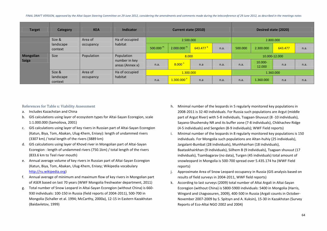
FINAL DRAFT VERSION, approved by the Altai-Sayan Steering Committee on 29 June 2012, considering the amendments and comments made during the teleconference of 29 June 2012, as described in the meetings notes
64
Target Category KEA Indicator Current state (2010) Desired state (2020)
Size & landscape context
Area of occupancy
Ha of occupied habitat
2.500.000 2.800.000
500.000 m
2.000.000 m
643.477 q n.a. 500.000 2.300.000 643.477 n.a.
Mongolian Saiga
Size Population Population number in key areas (Annex x)
8.000 10.000-12.000
n.a. 8.000 n n.a n.a. n.a.
10.000-12.000
n.a n.a.
Size & landscape context
Area of occupancy
Ha of occupied habitat
1.300.000 1.360.000
n.a. 1.300.000 n n.a n.a. n.a. 1.360.000 n.a n.a.
References for Table x: Viability Assessment
a. Includes Kazachstan and China
b. GIS calculations using layer of ecosystem types for Altai-Sayan Ecoregion, scale
1:1.000.000 (Samoilova, 2001)
c. GIS calculations using layer of key rivers in Russian part of Altai-Sayan Ecoregion
(Katun, Biya, Tom, Abakan, Ulug-Khem, Enisey): length of undammed rivers
(3307 km) / total length of the rivers (3889 km)
d. GIS calculations using layer of Khovd river in Mongolian part of Altai-Sayan
Ecoregion : length of undammed rivers (750.1km) / total length of the rivers
(833.6 km to Teel river mouth)
e. Annual average volume of key rivers in Russian part of Altai-Sayan Ecoregion
(Katun, Biya, Tom, Abakan, Ulug-Khem, Enisey; Wikipedia vocabulary
http://ru.wikipedia.org)
f. Annual average of minimum and maximum flow of key rivers in Mongolian part
of ASER based on last 70 years (WWF Mongolia freshwater department, 2011)
g. Total number of Snow Leopard in Altai-Sayan Ecoregion (without China) is 660-
930 individuals: 100-150 in Russia (field reports of 2004-2011), 500-700 in
Mongolia (Schaller et al. 1994; McCarthy, 2000a), 12-15 in Eastern Kazakhstan
(Baidavletov, 1999)
h. Minimal number of the leopards in 5 regularly monitored key populations in
2008-2011 is 32-40 individuals. For Russia such populations are Argut (middle
part of Argut River) with 5-8 individuals, Tsagaan-Shuvuut (8 -10 individuals),
Sayano-Shushensky NR and its buffer zone (7-8 individuals), Chikhachev Ridge
(4-5 individuals) and Sengelen (8-9 individuals); WWF Field reports)
i. Minimal number of the leopards in 8 regularly monitored key populations is 150
individuals. For Mongolia such populations are Altan-huhiy (25 individuals),
Jargalant-Bumbat (28 individuals), Munhhairhan (18 individuals),
Baataskhairkhan (9 individuals), Siilhem B (9 individuals), Tsagaan shuvuut (17
individuals), Tsambagarav (no data), Turgen (45 individuals) total amount of
snowleopard in Mongolia is 500-700 spread over 5.435.174 ha (WWF Field
reports)
j. Approximate Area of Snow Leopard occupancy in Russia (GIS analysis based on
results of field surveys in 2004-2011, WWF field reports)
k. According to last surveys (2009) total number of Altai Argali in Altai-Sayan
Ecoregion (without China) is 5800-5900 individuals: 5400 in Mongolia (Harris,
Wingard and Lhagvasuren, 2009), 400-500 in Russia (Argali counts in October-
November 2007-2009 by S. Spitsyn and A. Kuksin), 15-30 in Kazakhstan (Survey
Reports of Eco-Altai NGO 2002 and 2004)

FINAL DRAFT VERSION, approved by the Altai-Sayan Steering Committee on 29 June 2012, considering the amendments and comments made during the teleconference of 29 June 2012, as described in the meetings notes
65
l. Minimal number of the Argali in 6 regularly monitored key populations is 2770
individuals. For Mongolia such populations are Gulzat (500 individuals),
Myangan ugalzat (1000 individuals), Siilhem A (550 individuals), Siilhem B (200
individuals), Tsagaan shuvuut (20 individuals), Khokh serkh (500 individuals);
total amount of Argali in Mongolia is 5400 spread over 2.116.059 ha (WWF Field
reports)
m. Area occupied by Argali in Russia (Paltsyn, Lkhagvasuren, Spitsyn, Onon, Kuksin,
Munkhtogtokh, 2011)
n. WWF Field reports
o. Annual average volume of key rivers in Kazakhstan’s part of Altai-Sayan
Ecoregion (Buktarma; Kurshum; Ul’ba; Uba; Kara Ertis (Ust’ Kamenogorsk),
Water Resources Committee of the Ministry of Agriculture of the Republic of
Kazakhstan, 2011)
p. For territory of Katon-Karagaisky National Park (643477 ha), Markakolsky Game
Reserve (103000 ha), West Altaysky Game Reserve (56078 ha) (O. Loginov,
Director of the “Snow Leopard Fund” Kazakhstan:
http://www.snowleopardnetwork.org/actionplans/Kazakhstan_strategy_English
_Dec11.pdf; Snow Leopard Conservation Strategy in Kazakhstan (Ust’
Kamenogorsk, 2011)
q. Institute of zoology – Baidavletov – data of official governmental census 2011 –
Snow Leopard (7-8), Argali (subspecies Altai) (10-15)
r. Personal communication WWF-China Species department
s. S. Spitsyn, A. Kuksin. Report on results of field survey in the Russian portion of
Altai argali distribution in October-November 2007. Archives of UNDP/GEF
Project in the Russian portion of Altai-Sayan Ecoregion + G. Tsogtjargal Survey
Report «Argali sheep survey in Uvs and Bayan-Ulgii aimag boundary area»,
December 2007 + R. Harris, G. Wingard, B. Lhagvasuren. 2009 National
Assessment of Mountain Ungulates in Mongolia. Report to Mongolian Institute
of Biology Mongolian Academy of Science, Mongolian Ministry of Nature,
Environment and Tourism, World Wide Fund for Nature – Mongolia. +
Zinchenko, Bufalov, October 2004, Survey Report on Altai Argali in Eastern
Kazakhstan

FINAL DRAFT VERSION, approved by the Altai-Sayan Steering Committee on 29 June 2012, considering the amendments and comments made during the teleconference of 29 June 2012, as described in the meetings notes
66

FINAL DRAFT VERSION, approved by the Altai-Sayan Steering Committee on 29 June 2012, considering the amendments and comments made during the teleconference of 29 June 2012, as described in the meetings notes
67
Annex 5 – Threat ranking
The threat ranking table (Table 2; Chapter 3.1) provides an overview of the main
threats to the ecoregion, and it shows to what extent each biological target is
affected. Each target was assessed by a team of experts, who determined for each
target the extent of the threat on country level. Three criteria were used and each
cell in the table is thus based on a combination of
1. Scope: what % of each target is affected;
2. Severity: where the threat occurs, how much is the target affected; and
3. Irreversibility: how reversible are the impacts themselves.
The criteria are described in more detail below.
Scope
The proportion of the target that can reasonably be expected to be affected by the
threat within ten years, given the continuation of current circumstances and trends.
For ecosystems and ecological communities, measured as the proportion of the
target’s occurrence. For species, measured as the proportion of the target’s
population.
4 = Very High: The threat is likely to be pervasive in its scope, affecting the target
across all or most (71-100%) of its occurrence/population.
3 = High: The threat is likely to be widespread in its scope, affecting the target
across much (31–70%) of its occurrence/population.
2 = Medium: The threat is likely to be restricted in its scope, affecting the target
across some (11–30%) of its occurrence/population.
1 = Low: The threat is likely to be very narrow in its scope, affecting the target
across a small proportion (1-10%) of its occurrence/population.
Severity
Within the scope, the level of damage to the target from the threat that can
reasonably be expected given the continuation of current circumstances and trends.
For ecosystems and ecological communities, typically measured as the degree of
destruction or degradation of the target within the scope. For species, usually
measured as the degree of reduction of the target population within the scope.
4 = Very High: Within the scope, the threat is likely to destroy or eliminate the
target, or reduce its population by 71-100% within ten years or three
generations.
3 = High: Within the scope, the threat is likely to seriously degrade/reduce the
target or reduce its population by 31-70% within ten years or three generations.
2 = Medium: Within the scope, the threat is likely to moderately degrade/reduce
the target or reduce its population by 11-30% within ten years or three
generations.
1 = Low: Within the scope, the threat is likely to only slightly degrade/reduce the
target or reduce its population by 1-10% within ten years or three generations.
Irreversibility (Permanence)
The degree to which the effects of a threat can be reversed and the target affected
by the threat restored. It is assessed for the impact of the threat on the target, not
the threat itself.
4 = Very High: The effects of the threat cannot be reversed, it is very unlikely the
target can be restored, and/or it would take more than 100 years to achieve this
(e.g., wetlands converted to a shopping centre).
3 = High: The effects of the threat can technically be reversed and the target
restored, but it is not practically affordable and/or it would take 21–100 years to
achieve this (e.g., wetland converted to agriculture).

FINAL DRAFT VERSION, approved by the Altai-Sayan Steering Committee on 29 June 2012, considering the amendments and comments made during the teleconference of 29 June 2012, as described in the meetings notes
68
2 = Medium: The effects of the threat can be reversed and the target restored
with a reasonable commitment of resources and/or within 6–20 years (e.g.,
ditching and draining of wetland)
1 = Low: The effects of the threat are easily reversible and the target can be
easily restored at a relatively low cost and/or within 0–5 years (e.g., off-road
vehicles trespassing in wetland).
Consulted experts
The threat ranking was performed by several experts from the Altai-Sayen ecoregion,
namely:
Alexander Bondarev, Head of Altai-Sayan Ecoregional office, WWF Russia;
Batkhuyag Baldangombo, Programme Development manager, WWF
Mongolia;
Mikhail Paltsyn, Project Coordinator Altai-Sayan Programme, WWF Russia;
Onon Yondon, Species Programme Manager, WWF Mongolia.

FINAL DRAFT VERSION, approved by the Altai-Sayan Steering Committee on 29 June 2012, considering the amendments and comments made during the teleconference of 29 June 2012, as described in the meetings notes
69
Annex 6 – Conceptual model
Figure 13: Conceptual model showing the situation analysis of the ASER

FINAL DRAFT VERSION, approved by the Altai-Sayan Steering Committee on 29 June 2012, considering the amendments and comments made during the teleconference of 29 June 2012, as described in the meetings notes
70

FINAL DRAFT VERSION, approved by the Altai-Sayan Steering Committee on 29 June 2012, considering the amendments and comments made during the teleconference of 29 June 2012, as described in the meetings notes
71
Annex 7 – Results chains
Figure 14: Results chain Law enforcement strategy

FINAL DRAFT VERSION, approved by the Altai-Sayan Steering Committee on 29 June 2012, considering the amendments and comments made during the teleconference of 29 June 2012, as described in the meetings notes
72
Figure 15: Results chain Climate adaptation strategy

FINAL DRAFT VERSION, approved by the Altai-Sayan Steering Committee on 29 June 2012, considering the amendments and comments made during the teleconference of 29 June 2012, as described in the meetings notes
73
Figure 16: Results chain Econet strategy

FINAL DRAFT VERSION, approved by the Altai-Sayan Steering Committee on 29 June 2012, considering the amendments and comments made during the teleconference of 29 June 2012, as described in the meetings notes
74
Figure 17: Results chain IRBM strategy

FINAL DRAFT VERSION, approved by the Altai-Sayan Steering Committee on 29 June 2012, considering the amendments and comments made during the teleconference of 29 June 2012, as described in the meetings notes
75
Figure 18: Results chain CBNRM strategy

FINAL DRAFT VERSION, approved by the Altai-Sayan Steering Committee on 29 June 2012, considering the amendments and comments made during the teleconference of 29 June 2012, as described in the meetings notes
76
Figure 19: Results chain REILI strategy

FINAL DRAFT VERSION, approved by the Altai-Sayan Steering Committee on 29 June 2012, considering the amendments and comments made during the teleconference of 29 June 2012, as described in the meetings notes
77
Figure 20: Results chain SFM strategy

FINAL DRAFT VERSION, approved by the Altai-Sayan Steering Committee on 29 June 2012, considering the amendments and comments made during the teleconference of 29 June 2012, as described in the meetings notes
78

FINAL DRAFT VERSION, approved by the Altai-Sayan Steering Committee on 29 June 2012, considering the amendments and comments made during the teleconference of 29 June 2012, as described in the meetings notes
79
Figure 21: ASER Vision Map

FINAL DRAFT VERSION, approved by the Altai-Sayan Steering Committee on 29 June 2012, considering the amendments and comments made during the teleconference of 29 June 2012, as described in the meetings notes
80
Annex 8 - Logframe ASER Strategy
Logframe and Monitoring plan - ASER Strategy Vision statement:
Altai-Sayan Ecoregion harbors globally significant biodiversity and provides ecosystem services in an inexhaustible manner,
as well as benefits to local communities
Overarching goal: Species diversity (richness and abundance) is supported
and natural ecosystem dynamics and resilience are ensured
Conservation strategy Indicator Baseline Value (2010)
Expected Value (2020)
Methods or Source of Verification
Assumptions and Risks
Conservation goals:
Goal 1: By 2020, the area of ecosystems* in the ASER that remain unconverted* does not decrease compared to 2010, ensuring ecosystems’ biological capacity to harbor biodiversity of global significance.” *Ecosystems are: forest steppe; mountain tundra and alpine meadow; semi-desert and desert; steppe; and mountain forest. *Unconverted means that the area contains predominantly natural vegetation, even though it may be altered via grazing activities.
Area of unconverted a. forest steppe b. mountain tundra and alpine meadow c. semi-desert and desert d. steppe e. mountain forest
a. 10.551.236 km2
b. 18.096.548 km2
c. 5.910.783 km2
d. 25.037.205 km2
e. 41.296.387 km2
a. 10.551.236 km2
b. 18.096.548 km2
c. 5.910.783 km2
d. 25.037.205 km2
e. 41.296.387 km2
GIS analysis for the whole Altai-Sayan Ecoregion; every 5 years, by GIS departments of WWF offices in the area.
GIS method might improve and baseline data would become irrelevant. (Natural) vegetation cover will probably change due to climate change.
Goal 2: By 2020, the ratio ‘km of free flowing key rivers/ total km of key rivers´ is maintained at least 0,89 for Khovd river and 0.65 for Zavkhan river in Mongolian part and 0,85 in Russian part of the ASER; and the annual average flow volume for at critical locations on the key rivers in the ASER (Zavkhan, Khovd, Buyant, Katun, Biya, Tom, Abakan, Ulug-Khem and Enisey) does not change compared to 2010.
a. km of free flowing key rivers/ total km of key rivers b. annual average volume of key rivers
a. 0.85 for Russia and 0.89 for Khovd river and 0.65 for Zavkhan river for Mongolia b. Katun - 626 Biya- 477 Tom - 1100 Abakan- 381 Ulug-Khem - 589 Enisey – 3350 Zavkhan at Guulin gauge - 8.85 (min 4.04- max 56.1); Khovd at Myangad gauge 75 (min 57.9-max 318); Buyant at
a. 0.85 for Russia and 0.89 for Khovd river and 0.65 for Zavkhan river for Mongolia b. Katun - 626 Biya- 477 Tom - 1100 Abakan- 381 Ulug-Khem - 589 Enisey – 3350 Zavkhan at Guulin gauge - 8.85 (min 4.04- max 56.1); Khovd at Myangad gauge 75 (min 57.9-max 318); Buyant at
Calculations by freshwater experts for key rivers in the ASER, every 5 years.
Information and monitoring regarding e-flows is needed, to calculate freshwater viability in more detail.

FINAL DRAFT VERSION, approved by the Altai-Sayan Steering Committee on 29 June 2012, considering the amendments and comments made during the teleconference of 29 June 2012, as described in the meetings notes
81
Conservation strategy Indicator Baseline Value (2010)
Expected Value (2020)
Methods or Source of Verification
Assumptions and Risks
Khovd gauge - 5.67 (min 4.59 -max 19)
Khovd gauge - 5.67 (min 4.59 -max 19)
Goal 3: By 2020, the population size of Altai Argali in key areas* is increased by at least 8% in the Mongolian part and at least 20% in the Russian part of the ASER compared to 2010; and the area of occupied habitat by Altai Argali in the Mongolian part of the ASER is increased by at least 15% compared to 2010. * Key areas are: Sielkhem mountain range, Gulzat and Tsagaan shuvuut mountain, Khokh Serkh mountain range, Munkhkhairkhan range, Myangan Ugalzat mountain range, Sailugem, Chikchacheva Ridges, Momgun-Taiga massif and Tsagan-Shibetu Ridge.
a. population number in key areas b. occupied habitat
a. 400-500 for Russia and 2.770 in Mongolia b. 500.000 ha for Russia and 2.000.000 ha for Mongolia
a. 500-600 for Russia and 3.000-3.500 in Mongolia b. 500.000 ha for Russia and 2.300.000 ha for Mongolia
Survey and field reports by relevant organizations; at least every 3 years.
Survey methods should be executed the same to make comparison possible.
Goal 4: By 2020, the population size of Mongolian Saiga is increased by at least 25% compared to 2010 in key areas*; and the area of occupied habitat by Mongolian Saiga is increased with at least 4% compared to 2010. * Key areas are: Sharga, Khuis gobi, Chandmani Khuren tal.
a. population number in key areas b. occupied habitat
a. 8.000 b. 1.300.000 km
2 a. 10.000-12.000 b. 1.360.000 km
2
Survey and field reports by relevant organizations; at least every 3 years.
Survey methods should be executed the same to make comparison possible.
Goal 5: By 2020, the population size of Snow Leopard in key areas* remains stable in the Mongolian part and is increased by at least 25% in the Russian part of the ASER compared to 2010; and the area of occupied habitat by Snow Leopard remains stable in the Mongolian part and is increased by at least 31% in the Russian part of the ASER compared to 2010. * Key areas are: Sielkhem mountain range, Gulzat and Tsagaan shuvuut mountain, Turgen & Kharkhiraa Mountain, Altan
a. population number in key areas b. occupied habitat
a. 32-40 for Russia and 150 for Mongolia b. 1.900.000 ha for Russia and 5.400.000 ha for Mongolia
a. 64-70 for Russia and 150 for Mongolia b. 3.000.000 ha for Russia and 5.400.000 ha for Mongolia
Survey and field reports by relevant organizations; at least every 3 years.
Survey methods should be executed the same to make comparison possible.
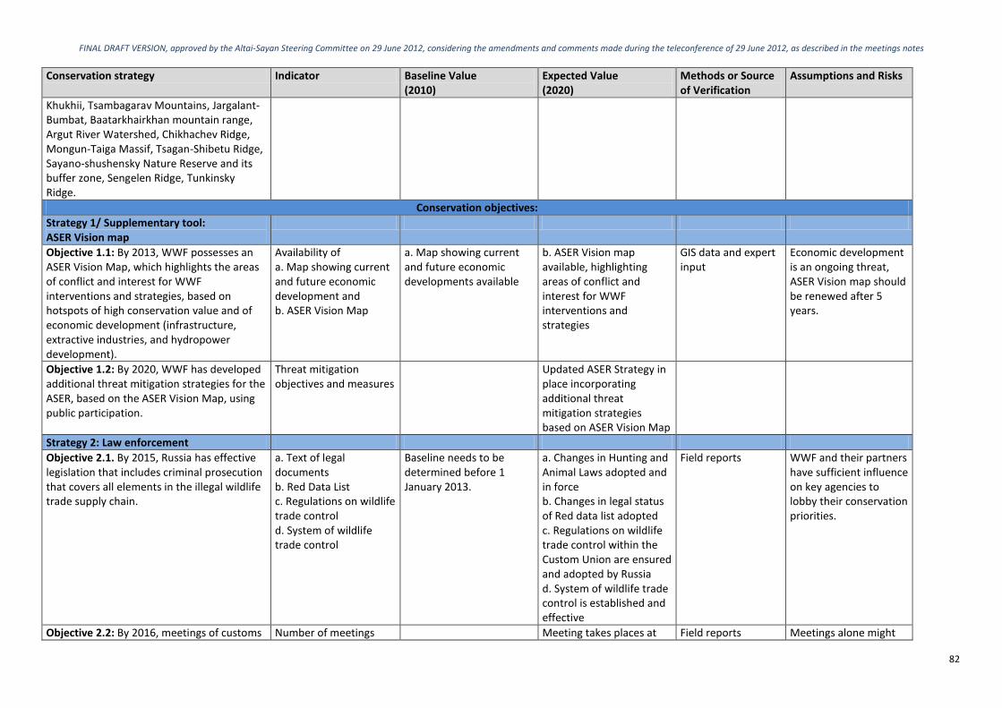
FINAL DRAFT VERSION, approved by the Altai-Sayan Steering Committee on 29 June 2012, considering the amendments and comments made during the teleconference of 29 June 2012, as described in the meetings notes
82
Conservation strategy Indicator Baseline Value (2010)
Expected Value (2020)
Methods or Source of Verification
Assumptions and Risks
Khukhii, Tsambagarav Mountains, Jargalant-Bumbat, Baatarkhairkhan mountain range, Argut River Watershed, Chikhachev Ridge, Mongun-Taiga Massif, Tsagan-Shibetu Ridge, Sayano-shushensky Nature Reserve and its buffer zone, Sengelen Ridge, Tunkinsky Ridge.
Conservation objectives:
Strategy 1/ Supplementary tool: ASER Vision map
Objective 1.1: By 2013, WWF possesses an ASER Vision Map, which highlights the areas of conflict and interest for WWF interventions and strategies, based on hotspots of high conservation value and of economic development (infrastructure, extractive industries, and hydropower development).
Availability of a. Map showing current and future economic development and b. ASER Vision Map
a. Map showing current and future economic developments available
b. ASER Vision map available, highlighting areas of conflict and interest for WWF interventions and strategies
GIS data and expert input
Economic development is an ongoing threat, ASER Vision map should be renewed after 5 years.
Objective 1.2: By 2020, WWF has developed additional threat mitigation strategies for the ASER, based on the ASER Vision Map, using public participation.
Threat mitigation objectives and measures
Updated ASER Strategy in place incorporating additional threat mitigation strategies based on ASER Vision Map
Strategy 2: Law enforcement
Objective 2.1. By 2015, Russia has effective legislation that includes criminal prosecution that covers all elements in the illegal wildlife trade supply chain.
a. Text of legal documents b. Red Data List c. Regulations on wildlife trade control d. System of wildlife trade control
Baseline needs to be determined before 1 January 2013.
a. Changes in Hunting and Animal Laws adopted and in force b. Changes in legal status of Red data list adopted c. Regulations on wildlife trade control within the Custom Union are ensured and adopted by Russia d. System of wildlife trade control is established and effective
Field reports WWF and their partners have sufficient influence on key agencies to lobby their conservation priorities.
Objective 2.2: By 2016, meetings of customs Number of meetings Meeting takes places at Field reports Meetings alone might

FINAL DRAFT VERSION, approved by the Altai-Sayan Steering Committee on 29 June 2012, considering the amendments and comments made during the teleconference of 29 June 2012, as described in the meetings notes
83
Conservation strategy Indicator Baseline Value (2010)
Expected Value (2020)
Methods or Source of Verification
Assumptions and Risks
officers and information exchange on wildlife trade takes place at least once per three years, leading to more effective cooperation.
least once per three years
not lead to more effective cooperation and additional measures will be needed.
Objective 2.3: By 2020, on average each year at least 100 inspectors* are trained in a dedicated training course in effective anti-poaching and wildlife trade prevention. *inspectors = police, governments officials, customs.
Number of trained inspectors
Baseline needs to be determined before 1 January 2013.
Min. 100 inspectors per year
Field reports
Objective 2.4: By 2020, poaching is decreased by 50%* compared to 2010 for Snow Leopard, Altai Argali and Mongolian Saiga, including transboundary territories. *Measured by three year running average.
Number of poaching instances discovered by government agencies in project areas
Baseline needs to be determined before 1 January 2013.
50% decrease compared to 2010
Official reports
Strategy 3: Climate adaptation
Objective 3.1: By 2020, climate adaptation measures are developed and in place, based on vulnerability assessments and climate change monitoring data.
a. Climate adaptation measures in place b. Availability of climate change monitoring data
a. No climate adaptation measures developed or in place b. No relevant and detailed climate monitoring in place
a. Appropriate climate adaptation measures in place, reviewed by climate experts b. Relevant and detailed climate monitoring in place
Field reports Increasing the amount of monitoring data will require additional funding and good-will.
Objective 3.2: All strategies and relevant institutions consider climate change in the normal course of their work.
Indicator needs to be determined before 1 January 2013.
Baseline needs to be determined before 1 January 2013.
Value needs to be determined before 1 January 2013.
Field report Details for monitoring this objective need to be determined.
Strategy 4: Econet strategy
Objective 4.1: By 2020, a network of protected areas (‘econet’) encompasses 20% of key biomes* in the ASER. *Key biomes include glacier, mountain tundra and alpine meadow, mountain forest, forest steppe, steppe, semi-desert and desert, riparian forest and freshwater systems (lakes and rivers).
a. Percentage of PA network covering ASER and total area (km
2)
b. Biomes area in ASER covered (in %) by PA network
a. 13,0%; 168.000 km2 a. 20%; 197.158 km
2 GIS analysis for the whole Altai-Sayan Ecoregion; every 5 years, by GIS departments of WWF offices in the area.
National and regional governments continue to prove their political support and financing for maintaining Protected Areas (PAs). WWF Russia and key WWF donors will continue to financially
b. Glacier 59,4 b. Glacier 61,7
Mountain Tundra & Alpine Meadow 22,6
Mountain Tundra & Alpine Meadow 31,7
Mountain forest 11,8 Mountain forest 17,0
Forest Steppe 7,0 Forest Steppe 9,9
Steppe 4,9 Steppe 9,5
Semi desert & desert 13,8 Semi desert & desert 18,3

FINAL DRAFT VERSION, approved by the Altai-Sayan Steering Committee on 29 June 2012, considering the amendments and comments made during the teleconference of 29 June 2012, as described in the meetings notes
84
Conservation strategy Indicator Baseline Value (2010)
Expected Value (2020)
Methods or Source of Verification
Assumptions and Risks
Riparian 14,9 Riparian 21,4 support the development of the Econet system.
Lakes and Rivers 57,9 Lakes and Rivers 62,0
Objective 4.2: By 2020, a network of protected areas (‘econet’) encompasses at least 35% of Altai Argali habitats, at least 35% of Snow Leopard habitats, and at least 20% of Mongolian Saiga habitats.
Percentage of species habitat covered by protected areas
Altai Argali 20,6% Snow Leopard 23,2% Mongolian Saiga Baseline needs to be determined before 1 January 2013.
Altai Argali 38,5 Snow Leopard 36,0 Mongolia Saiga Value needs to be determined before 1 January 2013.
Survey and field reports by relevant organizations; at least every 3 years.
National and regional governments continue to support the idea of Pas development by proving political support and financing for maintaining Protected Areas (PAs).
Objective 4.3: By 2020, three transboundary nature reserves covering at least 25.000 km
2
and with legal status have been established in the ASER.
a. Number of transboundary parks b. Area covered
a. 2 b. Baseline needs to be determined before 1 January 2013.
a. 3 b. 25.000 km
2 GIS analysis for the whole Altai-Sayan Ecoregion; every 5 years, by GIS departments of WWF offices in the area.
Russian and Mongolian governments continue to commit to the development of transboundary PAs.
Objective 4.4: By 2020, management effectiveness of the PA network is rated >66% according to the Management Effectiveness Tracking Tool (METT).
METT rate Baseline needs to be determined before 1 January 2013.
>66% Management Effectiveness Tracking Tool (METT)
Strategy 5: IRBM strategy
Objective 5.1: By 2016, the laws regulating water management and conservation are amended to ensure an adequate institutional and financing scheme for the River Basin Management Authority.
Text of legal documents No amendments to laws regulating water management and conservation
Appropriate amendments to laws regulating water management and conservation
Text of legal documents
Objective 5.2: By 2016, government officials are fully aware of climate change issues and IRBM’s role in the adaptation and mitigation of potential climate change impacts and conservation of freshwater ecosystem’s integrity.
a. Number of occasions per year where issue of climate change was discussed. b. Percentage of gov’t officials present at these occasions.
a. Baseline needs to be determined before 1 January 2013. b. Baseline needs to be determined before 1 January 2013.
a. Value needs to be determined before 1 January 2013. b. Value needs to be determined before 1 January 2013.
Field report Presence of gov’t officials at climate change events does not necessarily lead to full awareness of climate change and role of IRBM.
Objective 5.3: Water pricing system is in place in the Mongolian side of the ASER,
Presence of water pricing systems
No water pricing system in place
Water pricing system in place
Field report

FINAL DRAFT VERSION, approved by the Altai-Sayan Steering Committee on 29 June 2012, considering the amendments and comments made during the teleconference of 29 June 2012, as described in the meetings notes
85
Conservation strategy Indicator Baseline Value (2010)
Expected Value (2020)
Methods or Source of Verification
Assumptions and Risks
reflecting local developments and realities.
Objective 5.4: By 2020, nine identified river stretches* have been afforded permanent protection against additional dams. *river strechtes are Zavkhan; Khovd; Buyant; Katun; Biya; Tom; Abakan; Ulug-Khem; Enisey
Text of legal documents 0 of 9 identified river stretches have permanent protection against dams
9 out 9 identified river stretches have permanent protection against dams
River stretches need to be pinpointed and carefully defined before 1 January 2013 using ASER Vision map tool.
Objective 5.5: By 2016, climate change impacts are taken fully into consideration in the IRBM Plan of the Khar Lake-Khovd Basin using water modeling tools adapted to the region
a. Presence of IRBM plan of Khar Lake-Khovd Basin b. Presence of modeling tools adapted to the region
a. No IRBM plan for Khar Lake-Khovd Basin b. No modeling tool
a. IRBM lan for Khar Lake-Khovd Basin b. Modeling tool available
Field report
Strategy 6: CBNRM strategy
Objective 6.1: By 2015, the legal framework for CBNRM and pasture management is in place, enabling community based organizations to make diverse use of natural resources.
Legal framework Legal framework not in place
Legal framework in place Field report
Objective 6.2: By 2016, community funds of CBOs in project intervention areas have increased on average by 30 % for sustainable CBNRM and alternative income development.
Budgets of CBO’s Baseline needs to be determined before 1 January 2013.
Increase of 30% Field report
Objective 6.3: By 2020, the involvement rate (calculation method tbc) of local communities in key conservation areas, that are managing their own NR (including forestry practices) or have developed alternative income schemes/ green businesses which consider the needs of key conservation species ,has increased by at least 15% compared to 2010.
Involvement rate (calculation method tbc)
Baseline needs to be determined before 1 January 2013.
Value needs to be determined before 1 January 2013.
Field report Calculation method for the involvement rate needs to be determined before 1 January 2013.
Strategy 7: SFM strategy
Objective 7.1: By 2020, at least 5-10 medium to large sized logging companies implement the SFM principles in the ASER.
Number of logging companies that implement SFM
0 At least 5-10 medium to large sized companies
Field report
Objective 7.2: By 2020, areas of “pioneer Percentage of pioneer Baseline needs to be Decrease of 30% Field report

FINAL DRAFT VERSION, approved by the Altai-Sayan Steering Committee on 29 June 2012, considering the amendments and comments made during the teleconference of 29 June 2012, as described in the meetings notes
86
Conservation strategy Indicator Baseline Value (2010)
Expected Value (2020)
Methods or Source of Verification
Assumptions and Risks
logging” of Russian forests in the ASER have decreased up to 30%.
logging areas in the ASER.
determined before 1 January 2013.
Objective 7.3: By 2020, wood legality is ensured on 50% forest areas under lease in the ASER.
Percentage of wood where wood legality is ensured for leased forest areas in the ASER
Baseline needs to be determined before 1 January 2013.
50% Field report
Objective 7.4: By 2020, FSC certification quality in Russia ensured.
Indicator needs to be determined before 1 January 2013.
Baseline needs to be determined before 1 January 2013.
Value needs to be determined before 1 January 2013.
Field report Details for monitoring this objective need to be determined.
Objective 7.5: By 2020, have strengthened community participation with monitoring and management of forest fires in the Russian Part of the ASER.
Indicator needs to be determined before 1 January 2013.
Baseline needs to be determined before 1 January 2013.
Value needs to be determined before 1 January 2013.
Field report Details for monitoring this objective need to be determined.
Strategy 8: REILI strategy
Objective 8.1: By 2014, WWF has identified appropriate (additional) conservation actions by using its internal conservation and development Vision map as a screening tool, to identify conflict areas between conservation and EI and LI developments.
Number of additional actions and measures
0 Value needs to be determined before 1 January 2013.
Field report
Objective 8.2: By 2015, there is an improved legal framework (with public participation mechanisms in place for experts and general public) to develop and implement SEA and EIA of construction and extractive industries projects.
a. Text of legal documents; amendments to EIA/ SEA laws b. Percentage of SEA and EIA processes with public participation
a. Baseline needs to be determined before 1 January 2013. b. 0
a. Value needs to be determined before 1 January 2013. b. Value needs to be determined before 1 January 2013.
Field report
Objective 8.3: By 2016, local people’s knowledge of responsible mining, EIA, and SEA is increased, ensuring strong public monitoring of the biodiversity impacts of economic sector development.
Number of instances where public responds/ objects to EIA and SEA
Baseline needs to be determined before 1 January 2013.
Value needs to be determined before 1 January 2013.
Field report
Objective 8.4: By 2020, all EI and LI projects in the habitats of key species (argali, saiga, Snow Leopard) are developed and implemented in accordance with improved SEA and EIA.
Percentage of projects developed and implemented in accordance with improved SEA and EIA
0 Value needs to be determined before 1 January 2013.
Field report

FINAL DRAFT VERSION, approved by the Altai-Sayan Steering Committee on 29 June 2012, considering the amendments and comments made during the teleconference of 29 June 2012, as described in the meetings notes
87

FINAL DRAFT VERSION, approved by the Altai-Sayan Steering Committee on 29 June 2012, considering the amendments and comments made during the teleconference of 29 June 2012, as described in the meetings notes
88

FINAL DRAFT VERSION, approved by the Altai-Sayan Steering Committee on 29 June 2012, considering the amendments and comments made during the teleconference of 29 June 2012, as described in the meetings notes
89
Annex 9 - Key areas for species conservation
Table 5, Figure 21: Priority areas for species conservation in Mongolian part of the ASER.
Ref. Priority areas for Snow leopard, Argali sheep and Mongolian saiga conservation include trans-boundary areas
1 Sielkhem mountain range (Snow leopard & Argali)
2 Gulzat and Tsagaan shuvuut mountain (Snow leopard & Argali)
3 Khokh Serkh mountain range (Argali)
4 Munkhkhairkhan range (Argali)
5 Myangan Ugalzat mountain range (Argali)
6 Turgen & Kharkhiraa Mountain (Snow leopard)
7 Altan Khukhii, Tsambagarav Mountains (Snow leopard)
8 Jargalant-Bumbat, Baatarkhairkhan mountain range (Snow leopard)
9 Sharga, Khuis gobi, Chandmani Khuren tal (Mongolian Saiga)
Table 6. Priority areas for species conservation in Russian part of the ASER.
Ref. Priority areas for Snow leopard and Altai Argali conservation include trans-boundary areas
1 Sailugem (Argali)
2 Chikchacheva Ridges (Snow leopard & Argali)
3 Momgun-Taiga massif (Argali)
4 Tsagan-Shibetu Ridge (Snow leopard & Argali)
5 Argut River Watershed (Snow leopard)
6 Mongun-Taiga Massif (Snow leopard)
7 Sayano-shushensky Nature Reserve and its buffer zone (Snow leopard)
8 Sengelen Ridge (Snow leopard)
9 Tunkinsky Ridge (Snow leopard)

FINAL DRAFT VERSION, approved by the Altai-Sayan Steering Committee on 29 June 2012, considering the amendments and comments made during the teleconference of 29 June 2012, as described in the meetings notes
90

FINAL DRAFT VERSION, approved by the Altai-Sayan Steering Committee on 29 June 2012, considering the amendments and comments made during the teleconference of 29 June 2012, as described in the meetings notes
91
Annex 10 – A3 map Existing and Planned Infrastructure in the ASER (MottMacDonald, 2012)

FINAL DRAFT VERSION, approved by the Altai-Sayan Steering Committee on 29 June 2012, considering the amendments and comments made during the teleconference of 29 June 2012, as described in the meetings notes
92

FINAL DRAFT VERSION, approved by the Altai-Sayan Steering Committee on 29 June 2012, considering the amendments and comments made during the teleconference of 29 June 2012, as described in the meetings notes
93
Works Cited
ADB. (2005). Country Environmental Analysis Mongolia. Philippines: Asian
Development Bank.
Batima, P., Batnasan, N., & Lehner, B. (2004). Freshwater systems of the
Great Lakes Basin, Mongolia. Opportunities and challenges in the face of
climate change. Ulaanbataar: WWF Mongolia Programme Office.
Batnasan, N. (2003). Freshwater issues in Mongolia. National Seminar on
IRBM in Mongolia, (pp. 53-61). Ulaanbataar.
BirdLife Asia. (2009). Safeguarding Important Areas of Natural Habitat
alongside Economic Development. Washington D.C.: World Bank: Mongolia
Discussion Papers. East Asia and Pacific Region Sustainable Development
Department.
Blagoveshchenskii, G., Popovtsev, V., Shevtsova, Romanenkov, & Komarov.
(2006). Country Pasture/Forage Resource Profiles Russian Federation.
Retrieved November 2011, from FAO Grassland and Pasture Crops:
http://www.fao.org/ag/AGP/AGPC/doc/Counprof/Russia/russia.htm
Brukhanov, A. (2009). Environmental Assessment of Siberia Forests: Alarming
Results. WWF Russia.
CBD. (2012). List of Parties. Retrieved 2012, from Convention on Biological
Diversity: http://www.cbd.int/convention/parties/list/#tab=0
CBD. (2010). Protected areas - an overview. Retrieved 2012, from Convention
of Biological Diversity: http://www.cbd.int/protected/overview/
Chimed-Ochir, B., Hertzman, T., Batsaikhan, N., Batbold, D., Sanjmyatav, D.,
Onon, Y., et al. (2010). Filling the gaps to protect the biodiversity of
Mongolia. WWF Mongolia Programme Office.
Dagvadorj, D., Natsagdorj, L., Dorjpurev, J., & Namkha, B. (2010). Mongolia:
Assessment Report on Climate Change 2009. Ulaanbataar: Ministery of
Nature, Environment and Tourism, Mongolia.
Dagvadorj, D., Natsagdorj, L., Dorjpurev, J., & Namkhainyam, B. (2009).
Mongolia Assessment Report on Climate Change 2009. Ministery of
Environment, Nature&Tourism, Mongolia.
Davaa, G., Oyunbaatar, D., & Sugita, M. (2007, 01 22). Surface water of
Mongolio. http://raise.suiri.tsukuba.ac.jp/new/press/youshi_sugita8.pdf , pp.
55-68.
Dudley, N., & Parish, J. (2006). Closing the Gap. Creating Ecologically
Representative Protected Area Systems: A Guide to Conducting the Gap
Assessments of Protected Area Systems for the Convention on Biological
Diversity. Technical Series no. 24. Montreal: Convention on Biological
Diversity.
Enkhbat, A. (2003). Altai-Sayan Ecoregion Conservation Action Plan for
Mongolia. Ulaanbataar: WWF Mongolia.
Erdenechuluun, T. (2006). Wood Supply in Mongolia: The Legal and Illegal
Economies. Washington, D.C.: World Bank: Mongolia Discussion Papers, East
Asia and Pacific Environment and Social Development Department.
Felidae Conservation Fund. (2009). Ecological Study on Snow Leopards in
Mongolia. Retrieved November 2011, from
http://www.felidaefund.org/research/mongolia_project.html

FINAL DRAFT VERSION, approved by the Altai-Sayan Steering Committee on 29 June 2012, considering the amendments and comments made during the teleconference of 29 June 2012, as described in the meetings notes
94
GFTN Russia. (2011). Draft: Global Forest & Trade Network - Russia, Business
Plan for FY2012-2014. Moscow: GFTN Russia.
Harris, R. B., & Reading, R. (2008). Ovis ammon. Retrieved November 2011,
from IUCN Red List: http://www.iucnredlist.org/apps/redlist/details/15733/0
Institute of Geography of the Republic of Kazakhstan. (Unknown). Map on
Ecological Status.
IUCN Red List. (2011). The IUCN Red List of Threatened Species. Retrieved
November 2011, from http://www.iucnredlist.org/
Jackson, R., Mallon, D., McCarthy, T., Chundaway, R. A., & Habib, B. (2008).
Panthera uncia. Retrieved November 2011, from IUCN Red List:
http://www.iucnredlist.org/apps/redlist/details/22732/0
Jacob, A., & Tobiasen, A. (2011). Mongolia's biodiversity: status, threats, and
recommendations for conservation. USAID/ EGAT/ Biodiversity Team.
Kadota, T., & Davaa, G. (2004). Recent glacier variations in Mongolia.
Proceedings of the 3rd International Workshop on Terrestrial Change in
Mongolia, (pp. 20-22). Tsukuba, Japan.
Kokorin (ed.), A., Blyakharchuk, T., Gerasimchuk, I., Gruza, G., Kamennova, I.,
Parfenova, Y., et al. (2011). Assessment Report: Climate change and its
impact on ecosystems, populaiton and economy of the Russian portion of the
Altai-Sayan Ecoregion. Moscow: WWF Russia.
Krever, V., Stishov, M., & Onufrenya, I. (2009). National protected areas or
the Russian Federation: Gap analysis and perspective framework. Moscow:
WWF Russia.
Large Herbivore Network. (2011). Saiga Antelope - Saiga tatarica. Retrieved
2012, from Large Herbivore Network: http://www.lhnet.org/saiga-antelope/
Mallon, D. P. (2008). Saiga tatarica. Retrieved November 2011, from IUCN
Red List: http://www.iucnredlist.org/apps/redlist/details/19832/0
Maroney, R. L. (2005). Conservation of argali Ovis ammon in western
Mongolia. Biological Conservation , 231-241.
Millenium Ecosystem Assessment. (2005). Subglobal Assessment report Altai-
Sayan Ecoregion. Retrieved November 2011, from
http://www.maweb.org/en/SGA.AltaiSayan.aspx
Mongolia Ministry of Nature Environment (MNET). (2009). Mongolia´s fourth
national report. Ulaanbataar: MNET with GEF, UNDP, CBD and Mongolian
Nature and Environment Consortium.
Morrison, J., & Lombana, A. (2011). Climate Adaptation: Mainstreaming in
existing Conservation Plans (full version). WWF.
Mott MacDonald. (2008). Evaluation of the Altai-Sayan Ecoregion
Conservation Programme of WWF Russia and WWF Mongolia. Moot
MacDonald.
MottMacDonald. (2012). Report on the development of a map for the Altai-
Sayan Ecoregion. Arnhem: MottMacDonald.
Murray, M., Hunnam, P., Damjin, B.-O., Munkhtushin, G., & Olson, K. (2009).
Mid-term evaluation for UNDP Mongolia: Community-based Conservation of
Biological Diveristy in the Mountain Landscapes of Mongolia's Altai-Sayan
Eco-Region. UNDP Mongolia.
Natsagdorj, L., Batima, P., Tumursukh, D., Ulziisaikhan, B., & Mijiddorj, R.
(2011). Assessments of climate change and anthropogenic impacts into
hydrological systems of Onon, Kherlen and Khalkh river basins, Mongolia.
Ulaanbataar: WWF Mongolia.

FINAL DRAFT VERSION, approved by the Altai-Sayan Steering Committee on 29 June 2012, considering the amendments and comments made during the teleconference of 29 June 2012, as described in the meetings notes
95
Olson, D. M., & Dinerstein, E. (2002). The Global 200: Priority Ecoregions for
Global Conservation. Annals of the Missouri Botanical Garden , 89: 199-224.
Parry, M. L., Canziani, O. F., Palutikof, J. P., van der Linden, P. J., & Hanson, C.
E. (2007). Contribution of Working Group II to the Fourth Assessment Report
of the Intergovernmental Panel on Climate Change. Cambridge, United
Kingdom and New York, NY, USA: Cambridge University Press.
Salafsky, N., & Margoluis, R. (1999). Great than the sum of their parts:
Designing conservation and development programs to maximize results and
learning. Washington DC, USA: Biodiversity Support Program.
Shishikin, A., Ivanov, V., Ponomarev, E., Valendik, E., Ivanova, G., Kukavskaya,
E., et al. (2012). Fire Danger Mitigation: A strategy for Protected Areas of the
Altai-Sayan Ecoregion. Krasnoyarsk: UNDP.
Siberian Environmental Center. (2008). Plant Conservation. Retrieved
November 2011, from http://www.sibecocenter.ru/en/plants.htm
Snow Leopard Conservancy. (2011). Community-based Conservation of Snow
Leopards in Russia. Retrieved 2012, from Snow Leopard Conservancy
Conservation Program:
http://www.snowleopardconservancy.org/text/conservation/conservationRu
ssia.htm
Surazakov, A. B., Aizen, V. B., Aizen, E. M., & Nikitin, S. A. (2007). Glacier
changes in the Siberian Altai mountains, Ob river basin, (1952-2006)
estimated with high resolution imagery. Environmental Research Letters , 2:
045017.
Suttie, J. M. (2000). Country Pasture/ Forage Resource Profiles Mongolia.
Retrieved November 2011, from FAO Grassland and Pasture Crops:
http://www.fao.org/ag/AGP/AGPC/doc/Counprof/mongol1.htm#Evolution
of stock
The Conservation Measures Partnership. (2007). Open Standards for the
Practice of Conservation, version 2.0.
http://www.conservationmeasures.org/wp-
content/uploads/2010/04/CMP_Open_Standards_Version_2.0.pdf.
UNDP, Government of Rusisian Federation, & GEF. (2005). Biodiversity
Conservation in the Russian Portion of the Altai-Sayan Ecoregion - Phase 1
Full size project document. GEF, Global Environmental Facility.
UNESCO World Heritage Convention. (2012). World Heritage List. Retrieved
May 2012, from http://whc.unesco.org/en/list
Wikipedia. (2011). List of countries and outlying territories by total area.
Retrieved November 2011, from
http://en.wikipedia.org/wiki/List_of_countries_and_outlying_territories_by_
total_area
Wingard, J. R., & Zahler, P. (2006). Silent Steppe: The Illegal Wildlife Trade
Crisis in Mongolia. Washington D.C.: World Bank: Mongolia Discussion
Papers, East Asia and Pacific Environment and Social Development
Department.
World Bank. (2006). Mongolia: A review of environmental and social impacts
in the mining sector. Washington: The International Bank for Reconstruction
and Development / The World Bank.
World Wildlife Fund, & Carpenter, C. (2001b). Altai alpine meadow and
tundra (PA1001). Retrieved November 2011, from
http://www.worldwildlife.org/wildworld/profiles/terrestrial/pa/pa1001_full.
html

FINAL DRAFT VERSION, approved by the Altai-Sayan Steering Committee on 29 June 2012, considering the amendments and comments made during the teleconference of 29 June 2012, as described in the meetings notes
96
World Wildlife Fund, & Carpenter, C. (2001a). Sayan montane conifer forests
(PA0519). Retrieved November 2011, from
http://www.worldwildlife.org/wildworld/profiles/terrestrial/pa/pa0519_full.
html
World Wildlife Fund, & Devee, E. (2001a). Altai montane forest and forest
steppe (PA502). Retrieved November 2011, from
http://www.worldwildlife.org/wildworld/profiles/terrestrial/pa/pa0502_full.
html
World Wildlife Fund, & Devee, E. (2001b). Great Lakes Basin desert steppe
(PA1316). Retrieved November 2011, from
http://www.worldwildlife.org/wildworld/profiles/terrestrial/pa/pa1316_full.
html
WWF. (2011a). About Global Ecoregions. Retrieved November 2011, from
http://wwf.panda.org/about_our_earth/ecoregions/about/
WWF Global Freshwater Programme. (2005). Free-flowing rivers: economic
luxury or ecological necessity? Zeist, The Netherlands: WWF Living Planet.
WWF Global. (2000). G200 Maps (1999-2000). Retrieved May 2012, from
WWF: http://wwf.panda.org/about_our_earth/ecoregions/maps/
WWF International. (2007). The Amazon's Vicious Cycles. Gland: WWF
International.
WWF. (2011b). Know Your Flagship, Keystone, Priority and Indicator Species.
Retrieved November 2011, from
http://www.worldwildlife.org/species/flagship-species.html
WWF Mongolia. (2010b). Factsheet on Argali Wild Sheep. Retrieved
November 2011, from
http://mongolia.panda.org/en/about_mongolia/wildlife/wild_sheep/
WWF Mongolia. (2010a). Factsheet on Mongolian Saiga antelope. Retrieved
November 2011, from
http://mongolia.panda.org/en/about_mongolia/wildlife/saiga_antelope/
WWF Russia. (2003). Conservation Action Plan for the Russian Altai Sayan
Ecoregion. WWF Russia.
WWF Russia. (2012b). Draft Conservation Strategy Russia 2013-2017.
Moscow: WWF Russia.
WWF Russia. (2012a). Ecosystem type. CAP maps Altai-Sayan Ecoregion .
WWF Russia.
WWF Russia. (2009). Ensuring Long-Term Conservation of the Altai-Sayan
Ecoregion. Retrieved November 2011, from
http://m.panda.org/who_we_are/wwf_offices/russia/projects/?uProjectID=
RU0074