agenda of council meeting - 20 august 2018 · web viewto the immediate north, the subject site...
TRANSCRIPT

Council MeetingNotice PaperMonday 20 August 2018 at 7pm
Council Chamber, Malvern Town Hall,(enter off Glenferrie Road, Malvern)

Vision
Stonnington will be an inclusive, healthy, creative, sustainable and smart community.
Council’s vision will be implemented through four key pillars:
Community: An inclusive City that enhances the health and wellbeing of all residents, where people can feel safe, socially connected and engaged.
Liveability: The most desirable place to live, work and visit. Environment: A cleaner, safer and better environment for current and future
generations to enjoy. Economy: A City that will grow its premier status as a vibrant, innovative and
creative business community.
These pillars reflect the shared priorities of our community and Council, and are consistent with our history and vision for a liveable future. For each pillar, there is a framework for our strategies, actions and measures which outline the key services and projects to be delivered to our community.
The Strategic Resource Plan sets out how Council will provide the resources needed to implement strategies and actions within the Council Plan.
Councillors
Cr Steven Stefanopoulos, MayorCr Glen AtwellCr Marcia GriffinCr Jami KlisarisCr John Chandler Cr Sally DavisCr Judy HindleCr Matthew KoceCr Melina Sehr
Page 2

NOTESCouncil business is conducted in accordance with Part 4 Division 3 of the Meeting Procedure section of Council’s General Local Law 2018 (No 1). Some copies are available with the agenda or you can find a copy on Council’s website www.stonnington.vic.gov.au under local laws.
Councillors carry out the functions, powers, authorities and discretions vested with them under the Local Government Act 1989, and any other relevant legislation. Councillors impartially perform the Office of Councillor duties, in the best interests of the City of Stonnington residents to the best of their skills and judgement.
Councillors must formally declare their conflicts of interest in relation to any items listed on the agenda at the start of the meeting and immediately prior to the item being considered, in accordance with Sections 77 to 79 of the Act.
READING OF THE RECONCILIATION STATEMENT
We acknowledge that we are meeting on the traditional land of the Boonwurrung and Wurundjeri people and offer our respects to the elders past and present. We recognise and respect the cultural heritage of this land.
READING OF THE AFFIRMATION STATEMENT
We are reminded that as Councillors we are bound by our Oath of Office to undertake the duties of Councillor in the best interests of the people of the City of Stonnington and to faithfully and impartially carry out the functions, powers, authorities and discretions vested in us under the Local Government Act and any other relevant Act
Page 3

Welcome
Welcome to a Stonnington City Council meeting. These meetings are an important way to ensure that your democratically elected Councillors work for you in a fair and transparent way.
About this meeting
The first page of tonight’s agenda shows the different parts to the meeting, some of these are administrative and are required by Stonnington’s Local Law.
In the agenda you will also find a list of all the items to be discussed under ‘General Business’. Each report is written by a council officer and outlines the purpose of the report, relevant information and a recommended decision for councillors.
Council will consider the report and either accept, reject or make amendments to the recommendation. Council decisions are adopted if they receive a majority vote from the Councillors present at this meeting.
Arrangements to ensure meetings are accessible to the public
Council meetings are held at the Malvern Town Hall, corner High Street and Glenferrie Road (entry via Glenferrie Road by the door closest to the Malvern Police Station).
The Malvern Town Hall has an entrance ramp and elevators to ensure that the Council Chamber is accessible to the public. Fully accessible toilet and bathroom facilities are also available.
If you require translation, interpreting services or a hearing loop set up, please contact Council’s civic support on 03 8290 1331 to make appropriate arrangements before the meeting.
To ensure that people in the chamber can follow the meetings’ proceedings, proposed alternate resolutions, also known as ‘yellows’, are displayed on a screen and microphones are used during debate.
Live webcasting
Council meetings are webcast live via Council’s website, allowing those interested to view proceedings without attending Council meetings.
This gives people who may otherwise be unable to attend access to Council decisions and debate. A recording of the meeting is available on our website after the meeting (usually within 48 hours).
Only Councillors and Council officers seated around the Council table are visible on film. People in the public gallery will not be filmed, but if you speak, you will be recorded. Visit stonnington.vic.gov.au for more information.
Page 4

Members of the galleryIf you choose to attend a council meeting as a member of the public gallery, you should note the role of the Chairperson and your responsibilities under the City of Stonnington General Local Law 2018(1).
Extracts from the Local Law:
81. Gallery to be Silent
(1) Visitors must not interject or take part in the debate.(2) The gallery must be silent at all times during any Council Meeting.(3) The ring tones of mobile telephones and other devices must be turned off by people
in the gallery at all times.
88. Recording or Filming Proceedings
(1) A person must not operate an audio tape, mobile telephone or other recording or transmitting equipment or film ('a device') at any Council Meeting without first obtaining the consent of the Chairperson.
(2) Consent given under sub-clause (1) may be revoked by the Chairperson at any time during the course of a meeting.
(3) If a device is operated, or suspected of being operated, in contravention of sub-clause (1), the Chairperson may:(a) order the person operating, or suspected of operating, the device to produce
the device to the Chairperson; and(b) arrange for any matter that has been recorded on the device in contravention of
sub-clause (1) to be deleted, erased or otherwise removed from the device.(4) Subject to sub-clause (5), the Chairperson shall return any device that has been
produced to him or her pursuant to sub-clause (3) at the conclusion of the relevant Council Meeting.
(5) If the Chairperson has been unable to arrange for the matter that has been recorded on the device in contravention of sub-clause (1) to be deleted, erased or otherwise removed from the device, the device shall be returned to the person as soon as practicable after the deletion, erasure or removal has been carried out.
84. Removal from Chamber of a Councillor or Member of the Public
The Chairperson, or Council in the case of a suspension under clause 82, may ask any Authorised Officer or member of Victoria Police to remove from the meeting (including the gallery):(1) any person who the Chairperson has ordered to be removed under clause 82(3); or(2) any Councillor who has been suspended under clause 82 and who has not
immediately left the Council Meeting.
Page 5

50. Questions to Council from Members of the Public
(1) Questions to Council from members of the public will be considered as part of the order of business of an Ordinary Meeting only when submitted in the format outlined below:(a) Questions must be in writing and lodged at the office of the Chief Executive
Officer by 12 noon on the day of the next scheduled Ordinary Meeting.(b) A limit of five (5) questions per questioner applies.(c) Questions must include the name and address of the questioner and the date of
the question. Questions by facsimile or email are acceptable.(2) Within four (4) working days of receiving a complying question to Council from a
member of the public, the Chief Executive Officer will dispatch a notice to the member of the public who submitted the question, advising that the question has been received.
(3) At a meeting at which a question is to be considered:(a) The Chairperson will acknowledge that a question or questions have been
received from a (named) person and ask if that questioner is in the gallery. (b) If the questioner is present in the gallery, a summary of the subject matter of the
question(s) will be read out by the Chairperson and the questioner advised that a written reply to the question(s) will be issued within 14 days of that meeting date.
(c) If the questioner is not in the gallery, Council will respond to the question(s) in accordance with any standard correspondence to Council.
(4) The Chairperson has the discretion to allow a question to be asked and/or answered at the meeting that is in variance with the procedure in this Local Law.
(5) The Chairperson may refuse to acknowledge a question if, in the opinion of the Chairperson, the question is, or is potentially, defamatory, indecent, offensive, abusive, objectionable in language or substance, irrelevant, trivial, aimed at embarrassing a Councillor or a member of Council staff, outside Council’s powers or functions, has been asked at a previous Council Meeting and a reply issued, or relates to matters that come under section 89(2) of the Act.
(6) Any question relating to electoral matter during an Election Period will not be considered at any Council Meeting.
(7) A copy of the questions and responses will be tabled and inserted into the minutes of the following Council Meeting.
47. Open Meetings
(1) Subject to sub-clause (2), Council Meetings must be open to members of the public pursuant to section 89(1) of the Act.
(2) Council may resolve, under section 89(2) of the Act, that a meeting be closed to members of the public if Confidential Business is to be discussed.
Your cooperation is appreciated, we hope you enjoy the meeting.
Mayor and Councillors, Stonnington City Council
Page 6

Council MeetingNotice Paper
Monday 20 August 2018Order of Business and Index
a) Reading of the Reconciliation Statement and Affirmation Statementb) Introductionsc) Apologies d) Adoption and confirmation of minutes of previous meeting(s) in accordance with Section 63
of the Act and Clause 423 of General Local Law 2008 (No 1)1. MINUTES OF THE COUNCIL MEETING HELD ON 6 AUGUST 2018......................................................
e) Disclosure by Councillors of any conflicts of interest in accordance with Section 79 of the Act1
f) Questions to Council from Members of the Public (Clause 424 of General Local Law 2008 (No 1)
g) Correspondence – (only if related to council business)h) Questions to Council Officers from Councillorsi) Tabling of Petitions and Joint Lettersj) Notices of Motion k) Reports of Special and Other Committees; - Assembly of Councillors l) Reports by Delegates m) General Business including Other General Business
1. PLANNING APPLICATION 0498/17 - 44-46 DUKE STREET, WINDSOR - CONSTRUCTION OF A NEW DWELLING ON A LOT OF LESS THAN 300SQM IN A NEIGHBOURHOOD RESIDENTIAL ZONE AND REDUCTION TO THE CAR PARKING REQUIREMENT....................................................................
2. PLANNING APPLICATION 0309/18 - 3/11 LINCOLN PLACE, WINDSOR - EXTENSION OF AN EXISTING TWO STOREY DWELLING WITH TWO ADDITIONAL STOREYS................................................
3. PLANNING APPLICATION 0450/17 - 14 DOON STREET, PRAHRAN - CONSTRUCTION OF A DWELLING ON A LOT LESS THAN 500 SQUARE METRES IN A NEIGHBOURHOOD RESIDENTIAL ZONE AND VARIATION TO A CARRIAGEWAY EASEMENT ..................................................................
4. PLANNING APPLICATION 1351/17 - 44 CLIFTON STREET, PRAHRAN - CONSTRUCTION OF AN EIGHT STOREY BUILDING, COMPRISING OFFICES AND A DWELLING AND REDUCTION IN CAR PARKING REQUIREMENT................................................................................................................
5. PLANNING APPLICATION 1058/17 - 58 CHAPEL STREET, WINDSOR – PARTIAL DEMOLITION OF THE EXISTING BUILDING AND CONSTRUCTION OF A THREE STOREY ADDITION TO COMPRISE A DWELLING AND REDUCTION IN THE ASSOCIATED CAR PARKING REQUIREMENT.................................
6. VEHICLE CROSSING APPLICATION – 76 LANG STREET, SOUTH YARRA...........................................7. 1-3 VALETTA STREET, MALVERN - PLAQUE DESIGN....................................................................8. INFRASTRUCTURE VICTORIA - FIVE-YEAR FOCUS: IMMEDIATE ACTIONS TO TACKLE
CONGESTION..............................................................................................................................9. ROAD CONDITION MANAGEMENT AND FUNDING PRACTICES...........................................................10. CAWKWELL STREET AND MCARTHUR STREET, MALVERN - PARKING INVESTIGATION RESULTS.....
1 Note that s.79(1)(a) of the Act requires Councillors to disclose the nature of a conflict of interest immediately before the relevant consideration or discussion.
Page 7

11. HAWKSBURN ROAD, SOUTH YARRA - PROPOSAL TO INSTALL 2-HOUR PARKING RESTRICTIONS............................................................................................................................
12. PRAHRAN MARKET BOARD CHAIR - INTERVIEW PANEL.............................................................n) Urgent Businesso) Confidential Business
1. LOCAL GOVERNMENT INSURANCE RISKS AUDIT – AUDITOR-GENERAL’S REPORT TO PARLIAMENT.............................................................................................................................
Page 8

ADOPTION AND CONFIRMATION OF MINUTES OF PREVIOUS MEETINGS
20 AUGUST 2018
RECOMMENDATION
That the Council confirms the Minutes of the Council Meeting of the Stonnington City Council held on 6 August 2018 and Minutes of the Confidential Meeting of the Stonnington City Council held on 6 August 2018 as an accurate record of the proceedings.
Page 9
GENERAL BUSINESS20 AUGUST 2018
m) General Business
1. PLANNING APPLICATION 0498/17 - 44-46 DUKE STREET, WINDSOR - CONSTRUCTION OF A NEW DWELLING ON A LOT OF LESS THAN 300SQM IN A NEIGHBOURHOOD RESIDENTIAL ZONE AND REDUCTION TO THE CAR PARKING REQUIREMENT
Acting Manager Statutory Planning: Anthony De Pasquale General Manager Planning & Amenity: Stuart Draffin
PURPOSE
For Council to consider a planning application for the construction of a new dwelling on a lot of less than 300sqm in a Neighbourhood Residential Zone and reduction to the car parking requirement at 44-46 Duke Street, Windsor.
This item was considered at the Council meeting of 9 July 2018 and 6 August 2018. The application is now re-presented to Council for further consideration. The applicant has advised that they are continuing to prepare amended plans.
Executive Summary
Applicant: James Livingston PlanningWard: SouthZone: Clause 32.09 – Neighbourhood Residential Zone (Schedule 3)Overlay: N/A Neighbourhood Precinct: Inner Urban PrecinctDate lodged: 05 June 2017Statutory days: (as at council meeting date)
68
Trigger for referral to Council:
Councillor Call-upNumber of objections
Cultural Heritage Plan NoNumber of objections: 34 objections from 29 addressesConsultative Meeting: Yes – held on 23 May 2018Officer Recommendation: Notice of Decision to Grant a Planning Permit
BACKGROUND
The Proposal
The plans that form part of the basis of Council's consideration were prepared by Cook Gordon Architects and are known as Drawing No.s: A01 (rev TP04), A02 (rev TP04), A03 (rev TP03), A04 (rev TP05), A05 (rev TP05), A06 (rev TP05), A07 (rev TP06), A08 (rev TP06), A09 (rev TP06), A10 (rev TP04), A11 (rev TP04), A12 (rev TP04), A13 (rev TP04), A14 (rev TP04), A15 (rev TP04), A16 (rev TP05), A17 (rev TP02), A18 (rev TP06), A19(rev TP03), A20 (rev TP04), A21 (rev TP04), A22 (rev TP04), A23 (rev TP04), A24 (rev TP04) and Council date stamped 2 May 2018.
The application seeks permission for the construction of a double storey dwelling. Key features of the proposal are:
General
Page 11

GENERAL BUSINESS20 AUGUST 2018
Full demolition of the existing dwelling (note: a planning permit is not required for demolition)
Construction of a new double storey dwelling. The proposal has a maximum building height of 7.33m (measured from natural ground
level and shown on the proposed west elevation). Pedestrian access and entries are provided from Duke Street. No onsite car parking is provided. The proposal is to consist of a contemporary architectural style. The proposed
materials and finishes include brick, metal roof cladding, flat metal plate finish, perforated metal mesh, metal louvered screen and perforated metal mesh.
Ground Floor
To the north, the proposal provides a centrally positioned entry section which has a width of 2.91m and a depth of 1.26m. The remainder of the dwelling is to be constructed on the northern boundary.
To the south, the proposal incorporates a lightwell, which has a setback of 6.025m from Primrose Street, a length of 4.825m and a width of 1.49-1.565m. The remainder of the dwelling is to be constructed on the southern boundary.
To the west, the proposal allows for a setback of 1.29m. To the east, the proposal is setback 6.035m from the boundary. The eastern section of
the site will be used as the main area of secluded private open space. An open steel pergola (i.e. uncovered) will be installed above the rear garden.
The ground floor comprises a study, an open plan kitchen / dining / living room and service areas.
First Floor
The first floor adopts the same boundary setbacks to align with the ground floor layout. The first floor comprises a secondary living room, two bedrooms and associated
bathrooms.
The development plans that form the basis of this assessment are plans (A01 – A24, Council date stamped 2 May 2018). These plans were formally declared pursuant to Clause 57A of the Planning and Environment Act 1987 and supersede the originally advertised plans (Council date stamped 27 January 2017). The revised plans were submitted to respond to concerns raised by Council and objectors, and show the following key changes:
The introduction of a hipped roof form to the rear section The rear (i.e. eastern) setback to be increased from 4.305m to 6.035m The depth of a lightwell on the south elevation to be increased from 4.2m to 4.825m A west facing window at first floor to be modified in shape
Site and Surrounds
The subject site is located on the south eastern corner of the intersection of Duke Street and Primrose Street. It is approximately 181.1m east of the intersection with Chapel Street, and 55.8m west of the intersection with Hornby Street.
The subject site has the following significant characteristics: The land is rectangular in shape, yielding a total site area of approximately 120sqm.
Page 12

GENERAL BUSINESS20 AUGUST 2018
The land has dual frontage: to the west, it provides a frontage of 5.23m to Primrose Street; to the north, it adjoins Duke Street with a frontage of 24.51m.
The land is currently improved by a two-bedroom single storey weatherboard dwelling. Pedestrian access is provided from Duke Street. No onsite car parking arrangement is provided.
The surrounding land is predominantly residential consisting mostly of single and double storey dwellings on smaller lots, mixed with a number of double storey brick dwellings and occasionally apartment buildings. Whilst the lot size varies, the immediate context generally reflects a fine grain pattern of development.
The subject site has four interfaces, which are summarised as follows:
To the immediate south is a property at 18 Primrose Street, Windsor, which houses a double storey dwelling with a contemporary rear addition.
To the immediate north, the subject site abuts Duke Street, which is a narrow one-way street that runs from Hornby Street to Chapel Street. On the opposite side of Duke Street are properties at 39, 45, 47 and 49 Duke Street respectively. Of significance is that the four properties are affected by a Heritage Overlay (HO129), which is commonly described as a Hornby-Mary Streets Urban Conservation Area. Specifically, the land at 39 Duke Street houses an A1 graded gothic style federation building which was previously known as the Red Lion Hotel and is currently used as a dwelling. The land at 45 Duke Street is improved by an A1 graded semi-detached single storey dwelling, paired with the dwelling at 47 Duke Street. The site at 49 Duke Street contains a B-graded single storey brick dwelling with a pitched roof.
To the immediate west, the subject site abuts Primrose Street, which is a narrow two-way street that runs from Duke Street to James Street. On the other side of the street is 42 Duke Street, which houses a single storey rendered dwelling.
To the immediate east is 48 Duke Street, which is developed with a single storey, single fronted weatherboard cottage.
Previous Planning Application(s)
A search of Council records indicates no relevant planning applications for the subject site.
However, it is noted that Planning Permit No. 905/13 was issued to the southern adjoining property at 18 Primrose Street, which is relevant to the application at hand and will be discussed later in this assessment.
The Title
The site is described on Certificate of Title Volume 04691 Folio 097 / Lot 1 on Title Plan 696060H.
An easement extends to the immediate south of the subject site, with a length of approximately 9.45m and a width of approximately 0.37m. The Title also specifies that the right to use the said easement is limited to the purpose of overhanging eaves. Given the placement of this easement, a condition is recommended, requiring that notations are included on all site / floor plans, confirming that all new works will be constructed within the title boundaries on the subject site. Any subsequent amendments to the proposal should ensure that all new works (including boundary fencing) are clearly depicted within the title boundaries.
No covenants affect the land.
Page 13

GENERAL BUSINESS20 AUGUST 2018
Planning Controls
The following controls/permit triggers are considerations for this application:
ZoneClause 32.09 – Neighbourhood Residential Zone (Schedule 3)
Pursuant to Clause 32.09-5, a planning permit is required to construct or extend one dwelling on a lot of less than 300 square metres.
The application proposes to construct a new dwelling on a lot of 120 square metres. A planning permit is therefore required under the zone.
Furthermore, as stipulated in Schedule 3 to the zone, a building used as a dwelling or a residential building must not exceed a height of 9 metres. The proposed maximum building height is 7.33m and complies with the height controls.
Schedule 3 also sets out variations to requirements stipulated in Clause 54 (One Dwelling on a lot), which are stated as follows:
Standard Requirement Site coverage A5 Basements should not exceed 75% of the site area. Front fence height A20 Maximum height of 2 metres in streets in a Road
Zone, Category 1.Other streets 1.2 metres maximum height.
OverlayThe subject site is not affected by any overlays.
Particular ProvisionsClause 52.06 – Car Parking
Pursuant to Clause 52.06-1, Clause 52.06 does not apply to the construct and use of one dwelling on a lot in the Neighbourhood Residential Zone unless the zone or a schedule to zone specifies that a permit is required to construct or extend one dwelling on a lot.
As outlined above, the proposal triggers a planning permit under the zone, Clause 52.06 therefore applies to this application.
Pursuant to Table 1 at Clause 52.06-5, 2 car parking spaces are required to each three or more bedroom dwelling (with studies or studios that are separate rooms counted as a bedroom).
The proposal encompasses one study room on the ground floor and two bedrooms on the first floor; and is therefore considered a three bedroom dwelling. In accordance with Table 1, 2 car parking spaces should be provided.
Pursuant to Clause 52.06-3, a planning permit is required to reduce (including to zero) the number of car parking spaces required under Clause 52.06-5. As no onsite car parking is provided, a planning permit is required for the reduction to car parking requirement.
Clause 54 – One Dwelling on a Lot
Relevant Planning Policies
Page 14

GENERAL BUSINESS20 AUGUST 2018
21.06 Built Environment and Heritage 22.18 Stormwater Management (Water Sensitive Urban Design) Policy 22.23 Neighbourhood Character Policy 32.09 Neighbourhood Residential Zone (Schedule 3)52.06 Car Parking 54 One Dwelling on a Lot 65 Decision Guidelines
Advertising
The application has been advertised pursuant to Section 52 of the Planning and Environment Act 1987 by sending notices to the owners and occupiers of adjoining land and by placing two signs on the site. The public notification of the application has been completed satisfactorily.
4 objections (from 3 affected properties) were received in the initial public notice.
Key aspects of the objections during the initial advertising period are summarised below:
Inconsistency with the neighbourhood character Amenity impacts in relation to daylight access to north-facing windows and
overshadowing Amenity impacts in relation to overlooking Over-development Visual bulk on the Primrose Street and Duke Street Inappropriate car parking arrangement
A Consultative Meeting was held on 23 May 2018. The meeting was attended by Councillors Hindle and Sehr, representatives of the applicant, objectors and their representative, and a Council planning officer. The meeting resulted in the following changes to the advertised plans:
The introduction of a hipped roof form to the rear section The rear (i.e. eastern) setback increased from 4.305m to 6.035m The width of a lightwell on the south elevation increased from 4.2m to 4.8m A west facing window at first floor to be modified in shape
The revised plans were circulated to all objectors via email. 30 further objections were received and can be summarised as follows:
Inconsistency with the planning policy framework Inconsistency with the heritage character of Duke Street Inadequate car parking provision Overshadowing Overlooking Inappropriate material use on the southern elevation Lack of design details
No objections have been withdrawn. The total number of objections counts as 34 (from 29 addresses).
Referrals
Urban Design
Page 15

GENERAL BUSINESS20 AUGUST 2018
Comments from Council’s Urban Design Advisor on the revised plans advised that:
Scale: the proposal for a 2-storey contemporary infill development on the subject site is not an unusual scale for a corner site in this neighbourhood.
Form: the proposed building is a contemporary interpretation of a simple pitched roof-form. Visual break is introduced in the building form, together with projecting window at first floor, adds visual interest and articulates the form of the building as it presents to Duke Street.
Setbacks: given the corner lot, a zero setback to Duke Street is consistent with the character of corner buildings in the area. The small setback to Primrose Street is appropriate for this context.
Materials and colour scheme: recycled common red bricks and dark-grey colouring for the subsidiary elements are supported. The face-brickwork on the south elevation is not supported as it creates a visual conflict with the predominant material – red-brick.
Fenestration: the relatively large sizes of the first floor windows and their (horizontal) rectangular shape(s), are at odds with the predominant character of the window sizes and proportions found in the Victorian/Edwardian-era buildings in the neighbourhood. It is suggested that a more finely-scaled and vertically-proportioned window arrangement would result in a better integration of the building with the character of the neighbourhood.
KEY ISSUES
The application seeks to construct a double storey dwelling at 44-46 Duke Street, Windsor. As the permit triggers concern Clause 32.09 (Neighbourhood Residential Zone) and Clause 52.06 (Car Parking), the key issues that Council has to determine are:
Is the proposal acceptable in neighbourhood character terms? Will the proposal unreasonably affect the amenity of the adjoining properties? Does the proposal provide an adequate level of internal amenity to the occupants? Is the car parking reduction (to zero) acceptable?
The proposal is acceptable in neighbourhood character terms.
Having considered the policies, provisions and decision guidelines of the Stonnington Planning Scheme and the context of the subject site and its surrounds, the proposal is considered to be respectful and compatible with the existing neighbourhood character with the following considerations:
Consistency with the policy direction
Clause 15.01-1S seeks to create urban environments that provide good quality environments with a sense of place and cultural identify. Clause 15.01-5S also has an objective to recognise and protect neighbourhood character and sense of place and Clause 15.03-1S has an objective to ensure the conservation of places of heritage significance.
The above objectives are reiterated in the following Clauses: Clause 21.05, which identifies the subject site as part of Incremental Change Area,
where multi-unit development (2-3 storeys) to lots capable to accommodating increased policy is encouraged;
Clause 21.06-3 (Amenity), which seeks to ensure new development does not unreasonably affect the amenity of any adjoining residential properties through overlooking, overshadowing or traffic and parking associated with the use.
Page 16

GENERAL BUSINESS20 AUGUST 2018
Clause 21.06-4 (Built form Character), which seeks to provide for medium density (2-3 storey) development provided the development respects the preferred character of the precinct.
The Planning Policy Framework require the design of a development to respect the existing or preferred neighbourhood character and be appropriate for its setting. Objectors are concerned that the proposal does not respect the existing character of this neighbourhood by virtue of its height, scale and form. The proposal is considered appropriate for the following reasons: As the subject site is situated in an Incremental Change Area, the construction of a 2-
storey dwelling is responsive to housing policy provisions. The overall height of the development, at two storeys, is consistent with the scale of
many of the surrounding properties. As presented in the streetscapes of Duke Street and Primrose Street, two storey development (including single storey with first floor additions) is an emerging character of the area. On Duke Street, the land at 37 Duke Street has a visible first floor addition; and the properties at 39 Duke Street; and 67 Hornby Street are constructed with zero setback to the street. Similarly, on Primrose Street, to the immediate south, the land at 18 Primrose Street is featured by its contemporary first floor addition; and the land at 21 Primrose Street also has a visible first floor component on the street elevation. Furthermore, while the proposal presents more obviously to the streets (due to the corner site nature), it should be noted that many nearby examples possess more visual dominant features when viewed from the street. For instance, the land at 33-35 James Street (located approximately 100m south of the site) contains a four storey apartment building; and the land at 30 James Street is improved by a three-storey apartment building. As such, it is clear that the varied context would support the proposal, as the scale integrates well with the existing character of the surrounds.
The subject site is located in an area where buildings are often sited close to, or on, one or both side boundaries. This pattern of development has formed a prevailing character of this area, as it is common and reasonable to have properties constructed in very close proximity to the side boundaries of narrow sites. The proposal incorporates boundary walls on the northern and the southern boundary. This is considered a reflective response to the surrounds and consistent with the context.
The policy calls for new building in an innovative and contemporary manner and building materials that are in stark contrast with the character of the streetscape should be avoided. This proposal adopts a contemporary architectural style and incorporates recycled brickwork as a response to the dominant character of the streets. The proposal therefore is considered consistent with the policy controls and appropriate to the character of the area.
Consistency with the existing character
An objective contained at Clause 22.23 (Neighbourhood Character Policy) is to ensure that development reflects the intention of the statement of preferred neighbourhood character and design guidelines for each precinct.
The subject site is located in an Inner Urban Precinct (IU) that occupies the southern and western part of the municipality. This precinct is defined by buildings of innovative and high quality architectural styles that sit comfortably within compact streetscapes of Victorian, Edwardian and Interwar dwellings. Consistent front setbacks reinforce the building edge along the streets, and building heights and forms complement, rather than dominate, the rhythm of development.
In conjunction with the referral comments from Council’s Urban Design Advisor, the proposed design response is appropriate in this neighbourhood. With regard to the first floor
Page 17

GENERAL BUSINESS20 AUGUST 2018
component particularly, it is worth noting that two storey development has become a more common aspect of Melbourne’s built form. As the Tribunal remarked in Waylan Consulting Group v Moreland CC [2000] VCAT 1198, ‘… double storey dwellings are not two headed monsters. They are normal housing type throughout the metropolitan area’. Member Keaney also commented in Rendevski v City of Greater Geelong [1999] VCAT 1886:
Leaving aside the fact that this would not be the first two storey “intrusion” (either for a single home or multi-unit), the Tribunal would be reluctant to reject what is a perfectly normal and acceptable form of development right throughout our urban areas, except if the neighbourhood characteristics were so pristine and important so as to make a two storey proposal unacceptable.
With a view to the immediate context, double storey dwellings are not an uncommon feature of this area. For instance, the land at No. 20, 23, 28 Duke Street have visible first floor additions; and the southern adjoining property at 18 Primrose Street has distinct additions at ground and first floor levels. Given the variety in building heights and the absence of design-specific overlays (such as Heritage Overlay or Neighbourhood Character Overlay), it is considered that the proposal with a maximum height of 7.33m will not result in any unreasonable adverse impact on the character of this neighbourhood.
Built form
The proposal does not introduce a built form that is dominant or overwhelming to this neighbourhood. The 2-storey red-brick building on the corner of Duke Street and Hornby Street is one of the nearby examples on a corner site. Specifically, the said land is at 67 Hornby Street and contains a 2-storey brick dwelling built on the street frontages and the northern boundary. It is also noted that the street facades read as continuous double storey boundary walls with no break. The proposal however introduces pedestrian access and entries via Duke Street, which in return presents an articulated built form thereby reducing the dominance of double storey boundary wall to the street and providing visual interest.
Having regard to the existing context, it is considered that the proposed built form provides an acceptable response to its neighbourhood. Although the proposal is to be constructed along the northern and southern boundaries, as discussed above, the narrow and small subdivision pattern of the area has reinforced a prevailing character where buildings are often sited close to, or on, one or both side boundaries. Furthermore, the immediate context does not present a consistent pattern; rather it is featured by mixed built forms. The proposal therefore is not considered too remote or farfetched from the established mixed nature of the surrounds.
Additionally, in the wider neighbourhood, it is noted that the land at 14 White Street (located the corner of James Street and White Street) houses a contemporary example of a double storey redevelopment on a corner site of a similar size to the subject site. The development incorporates face brickworks on the ground floor; and continuous first floor boundary wall to White Street with dark grey vertical cladding.
With all the above considerations, the proposed built form is considered appropriate and will sit comfortably in its context.
Site Layout and Building Massing
Street setback
Page 18

GENERAL BUSINESS20 AUGUST 2018
With specific regard to the street setback requirements, it is noted that the site is located on a corner. Standard A3 stipulates the following preferred setbacks for developments on corner sites.
Minimum setback from front street:
If there is a building on the abutting allotment facing the front street, the same distance as the setback of the front wall of the existing building on the abutting allotment facing the front street or 9 metres, whichever is the lesser.
Minimum setback from side street
The same distance as the setback of the front wall of any existing building on the abutting allotment facing the side street or 2 metres, whichever is the lesser.
The proposed setback to the primary frontage of Duke Street will be zero, which means that a variation to the Standard is required as the eastern neighbouring property at 48 Duke Street has a setback of approximately 2m. A variation may be supported on the basis that the existing dwelling on the site is built to the northern (Duke Street) boundary. Furthermore, the existing neighbourhood character has a prevailing feature where boundary construction is common given the narrow nature of the sites in this area. In the immediate context, it is noted that two storey sheer walls constructed alongside boundaries are not uncommon. The proposal is therefore not inconsistent with the character of this neighbourhood.
The proposed setback to Primrose Street is 1.29m which generally aligns with the setback of the principle façade of the southern neighbouring property at 18 Primrose Street.
Site Coverage
Standard A5 states that the maximum site coverage is 60 per cent. The existing site coverage is 66% and the proposed site coverage is 63%. Given the reduction in the overall site coverage, the proposal is considered an improved design outcome and can be supported.
Permeability
Standard A6 requires a minimum permeability of 20 per cent. The proposed impervious surface area is 67%, which allows for 33% of the site to be permeable. The proposal therefore complies. It is however recommended that the permeable surface should be clearly outlined in the site or floor plans. A relevant condition will therefore be included.
Design detail
The design detail of the proposed dwelling are considered to be appropriate. Reasons are outlined below:
Firstly, as discussed above, the built form and the scale (of being a 2-storey property) respond to the character of the area appropriately.
Secondly, the proposed pitched roof is consistent with the nearby properties.
Thirdly, in terms of façade articulation and detailing, efforts have been made to provide a positive response to the streetscapes of Duke Street and Primrose Street. For instance, the proposed street façades incorporate windows and introduce entries to articulate the double storey walls. This approach is considered acceptable in principle. With particular respect to
Page 19

GENERAL BUSINESS20 AUGUST 2018
the window shapes, it is noted that the first floor north facing windows are of large sizes, which are at odds with the predominant character of the window sizes and proportions found in the Victorian/Edwardian-era buildings in the neighbourhood. A condition is therefore recommended, requiring a more finely-scaled and vertically-proportioned window arrangement to be provided at the first floor level on the north elevation.
Furthermore, the material palette responds to materials that are not uncommon in the neighbourhood. The proposal incorporates recycled common red bricks for the external cladding, this is considered responsive to the variety of existing red-brick buildings in the area. The proposal also incorporates dark-grey colouring for window frames, screening and roofing, which complements the red brickwork and can be supported.
Additionally, one of the objectors raised concerns regarding the white finishes to be applied on the southern elevation. As outlined in the referral comments, this treatment is not supported as a portion of this wall is visible from Primrose Street; and will likely cause a visual conflicts in material/colour with the north and west elevations of red-brick. A condition is therefore recommended, requiring the south elevation materials/colour to be consistent with the north and west elevations.
Front fence
In accordance with Standard A20, the maximum height of front fences on Duke Street and Primrose Street should not exceed 1.2m. The Objective is to ‘encourage front fence design that respects the existing or preferred neighbourhood character’. The proposal is considered to meet the objective for the following reasons:
The subject site sits in a corner, abutting Primrose Street and Duke Street. Traditionally, for corner sites, the narrow street is treated as the primary; and the other as the secondary. Primrose Street is therefore considered the frontage. On Primrose Street, the proposal incorporates a 1.5m timber paling fence. This is supported as it is consistent with other front fences along Primrose Street, in terms of the materials and colour finishes.
On Duke Street, pedestrian access and entries are proposed. The proposed pedestrian entry is enclosed with a timber paling fence with a height of less than 1.5m. This is considered responsive to the surrounds. It is also noted that at the eastern end, a 1.89m high timber paling fence is included. As shown on the proposed site plan, an additional access is provided from the rear section. The proposed north elevation however does not specifically depict the proposed additional access. A condition is therefore recommended, requiring the second access to be clearly depicted on the north elevation with dimensions and used for pedestrian access only.
For all the reasons outlined above, it is considered that the scale, massing and form of the proposal are appropriate in this locale and will assimilate well into the neighbourhood.
The proposal will not cause unreasonable amenity impacts on the adjoining properties.
This application has been assessed against the relevant requirements of Clause 54 and the section below outlines the key findings:
Side and rear setbacks
Standard A10 (side and rear setbacks) sets out numeric requirements for side and rear setbacks. The proposed extension is largely constructed along the side boundaries (refer to
Page 20

GENERAL BUSINESS20 AUGUST 2018
assessment of Standard A11 below). However, part of the first floor extension is setback from the side boundaries.
Ground Floor
To the south, the proposed wall height does not exceed 3.6m and the required minimum setback is therefore 1m. As the proposal introduces a lightwell, the section where the internal staircase is located is to be set back 1.49m (minimum) and thus complies. The remaining is to be constructed on the boundary and will be assessed under Standard A11 (Walls on boundaries) below.
To the east, the proposal allows for a setback of 6.035m to accommodate a rear garden (i.e. secluded private open space). As the proposed wall height does not exceed 3.6m, the required setback should be 1m. The proposal therefore complies.
First floor
The first floor is to be constructed to be aligned with the ground floor layout and provides for the same boundary setbacks around the building.
To the south, the proposed wall height is 5.47m and the required minimum setback therefore is 1.56m. The proposed lightwell allows for a minimum setback of 1.49m from the boundary.
To the east, the proposed building height is 5.55m and the required minimum setback therefore is 1.59m. The proposal is to be set back 6.035m from the rear boundary and thus complies.
A variation is considered appropriate for the following reasons:
1. To the south, the proposal incorporates a lightwell, which ensures daylight access to the existing north facing windows. This will be discussed in the assessment of Standard A13 (North facing window objective) below.
2. Given the narrow spacing between properties in this neighbourhood, the variation is considered to be acceptable from a character perspective.
3. The existing dwelling is constructed on the northern and southern boundaries. The proposal is not considered remote from its existing condition.
Wall on boundaries
The proposed building will be constructed along both the northern and southern boundaries. The impact of the proposal with regard to the northern (Duke Street) boundary has been assessed above. Assessment of the proposed southern wall on boundary is provided as follows:
In accordance with Standard A11, the permissible maximum length of walls on boundary is 13.63m.
Standard A11 also states a new wall should not exceed an average of 3.2m with no part higher than 3.6m. As the proposal is to be constructed on the southern boundaries at both levels, a variation to the Standard is required. It is considered that the Objective of Clause 54.04-2 is satisfied for the following reasons:
Page 21

GENERAL BUSINESS20 AUGUST 2018
To the south, the ground floor boundary wall is generally consistent with the existing boundary wall in terms of the height and the length. Consequently, any impact will be generally consistent with the existing condition. The proposal introduces a lightwell to the immediate east of the ground floor study. The dimensions of the lightwell provide daylight access to the southern adjoining land. (Note: a detailed discussion is included in the assessment against Standard A13 (North facing windows objective) below).
The existing southern boundary wall has a total length of approximately 20m and a height of more than 3m. The front section of the existing southern boundary wall is directly opposite the ground floor habitable room window contained in the property at 18 Primrose Street; and the remainder is constructed simultaneously adjacent to the neighbour’s wall. In this proposal, where the ground floor habitable room window in the southern adjoining property is located, a lightwell is introduced and enclosed with a boundary wall of 2.19m in height (maximum). As a result of the reduction in the wall height, the consequential amenity impact on the southern adjoining property will be reasonably lessened.
With regard to the southern interface, the wall on boundary will not be positioned directly opposite the main rear courtyard of 18 Primrose Street, meaning visual bulk impacts to this space will not be unreasonable.
In light of the above, the proposed boundary walls are consistent with the character of developments in this neighbourhood and will not cause detriments to the amenity of the adjoining properties.
Daylight to existing windows
To the west and the north, the subject site adjoins Primrose Street and Duke Street. The Standard does not apply.
To the east, no habitable room windows are located opposite the subject site. The Standard therefore does not apply with respect to these interfaces.
To the south, all habitable room windows except one are defined as north facing windows and an assessment will be included in the following assessment against Standard A13 (North-facing windows) below.
The one non-north facing window of the neighbouring property at No. 18 Primrose Street that is applicable in this assessment is a narrow window that is part of the access door that connects the rear open plan living / kitchen area to the northern external access path. Given the angle of this window, it is not technically defined as a north facing window and therefore must be assessed against Standard A12 under the Daylight to Existing Windows Objective.
A variation to the Standard will be required as part of the proposed building on the boundary will be positioned opposite this angled window. A variation may be supported on the basis that the proposed light court will sit just west of the angled window allowing for adequate light access into this space. It is also noted that the window already receives compromised light under its existing arrangement. Importantly, it should be noted that this angled window is not the only source of light for this open plan kitchen / dining / living room, as the floor-to-ceiling east facing glazing door / windows is used as the main source of daylight access.
North-facing windows
The North Facing Windows Objective states the following:
Page 22

GENERAL BUSINESS20 AUGUST 2018
To allow adequate solar access to existing north-facing habitable room windows.
Standard A13 applies to any neighbouring north facing habitable room window that is positioned within 3m of the property boundary. The Standard provides a numeric boundary setback requirement based on the height of the proposed wall when positioned opposite the neighbouring north facing windows.
On the southern neighbouring lot at 18 Primrose Street, there is one north facing window at ground level, which serves a bedroom and a number of north facing windows at first floor level, which serve the two bedrooms respectively. A detailed assessment of all applicable windows is provided as follows:
Assessment of the impact on the neighbouring ground floor window:
The ground floor north facing bedroom window to 18 Primrose Street is positioned opposite the proposed lightwell. The northern end of the lightwell (i.e. the internal staircase) is proposed to be 6.09m in height, which means the wall should be set back 2.49m from the boundary in order to comply with the Standard. A setback of 1.49m – 1.565m has been provided resulting in a variation to the Standard. This is supported on the basis that due to the existing wall on the boundary, and the associated eave, the affected window already receives little daylight and even less direct sunlight. It is considered that the proposal will result in an improved arrangement in relation to light access to this window, despite not complying with the Standard.
Assessment of the impact on the neighbouring first floor bedroom windows:
The upper level for 18 Primrose Street has a slightly unorthodox window arrangement where one bedroom (Bedroom 2) is served by a standard north facing window that wraps around to the western wall of this bedroom. It is also noted that both first floor bedrooms along with the first floor study are served by clerestory windows that sit higher (and further setback) from the main first floor north facing wall. Assessment against the clerestory windows is provided below.
With specific regard to the impact on the north facing Bedroom 2 window to 18 Primrose Street, it is noted that the proposal has a wall height of 5.47m and the Standard requires a setback of 2.12m. The proposal will be partly built to the boundary when positioned opposite this window and partly set back 1.49m. A variation to the Standard is supported on the basis that a majority of the window is positioned opposite the proposed light court which is set back adequately from the boundary to allow sufficient solar access. This is evident by the fact that if the ground floor levels were deleted from the calculations (which is reasonable given the affected window serves a first floor room) the light court element of the arrangement would comply with Standard A13. It is also noted that this room also benefits from unobstructed western light provided by a small west facing window.
Assessment of the impact on the neighbouring first floor clerestory windows:
The clerestory windows are set back approximately 1m from the boundary and sit higher than the main walls of all the upper level rooms in question. For the most part,
Page 23

GENERAL BUSINESS20 AUGUST 2018
the proposal will result in a wall being built on the boundary when positioned opposite these windows which technically results in a variation to Standard A13. However, given the height of these windows, the proposal will not result in any unreasonable obstruction to daylight or sunlight access to these windows.
In light of the above, the proposal can be supported.
Overshadowing
The relevant assessment mechanism for overshadowing of neighbouring areas of private open space is the Overshadowing Open Space Objective, including Standard A14. This Standard states the following:
Where sunlight to the secluded private open space of an existing dwelling is reduced, at least 75 per cent, or 40 square metres with minimum dimension of 3 metres, whichever is the lesser area, of the secluded private open space should receive a minimum of five hours of sunlight between 9 am and 3 pm on 22 September.
If existing sunlight to the secluded private open space of an existing dwelling is less than the requirements of this standard, the amount of sunlight should not be further reduced.
The Objective itself states that ‘ensure buildings do not significantly overshadow existing secluded private open space’.
As demonstrated on the submitted shadow diagrams, key findings are comprised of:
To the west, the subject site adjoins Primrose Street. No secluded private open space will be unreasonably overshadowed.
To the north, due to the orientation, the proposal will not create any overshadowing.
To the east, the subject site has a direct interface with the front section of the land at 48 Duke Street, the proposed shadow will be largely contained in the side service yard or the front setback associated with the eastern adjoining land. In the absence of any overshadowing cast onto the secluded private open space (at the rear, in the south), the proposal is considered to meet the Standard.
To the south, given the sensitivity, the following aspects are examined: At 9am, the proposed shadow falls within the existing shadow. At 10am, the proposed shadow falls within the existing shadow. At 11am, the proposed shadow falls within the existing shadow. At 12pm, the proposed shadow falls within the existing shadow. At 1pm, the proposed shadow increases the total shadowed area by 0.2sqm. At 2pm, the proposed shadow increases the total shadowed area by 1.9sqm. At 3pm, the proposed shadow increases the total shadowed area by 3.16sqm.
A variation to the Standard is required due to the size of the neighbouring open space. However, it is considered that the proposal meets the Objective considering that compliance with the Standard is achieved for the most part. The Standard requires a minimum of five hours of sunlight between 9am and 3pm on 22 September. As outlined above, from 9am to 2pm, there will be an increase of 0.2sqm at 1pm and an increase of 1.9sqm at 2pm. The increased 0.2sqm is considered minor in nature and negligible. At 2pm, although the increased shadow amounts to 1.9sqm, which is also considered a minor amount in this inner urban context,
Page 24

GENERAL BUSINESS20 AUGUST 2018
Overlooking
The key assessment tool to determine unreasonable overlooking is the Overlooking Objective, including Standard A15. The standard provides a 9m 45 degree angle arc that determines unreasonable overlooking, and windows or balconies that are located in such a position must be screened to a height of 1.7m above finished floor level accordingly.
To the west and the north, the subject site adjoins Primrose Street and Duke Street respectively. The Standard therefore does not apply.
To the east, on the ground floor, a 2m brick fence is proposed thereby preventing overlooking. On the first floor, a metal louvred privacy screening is to be installed up to 1.7m above the finished floor level and thus complies.
To the south, on the ground floor, the boundary wall has a minimum height exceeding 1.7m and thus complies.
On the first floor, no screening is proposed for the south facing stair window. Given the stair is not a habitable room, screening is not required. Screening is provided to the west facing Bed 2 window and the east facing living room window respectively in order to limit unreasonable views from these windows over the light court and into the neighbouring habitable room windows at 18 Primrose Street. Screening will be provided by way of perforated metal with a maximum transparency of 25%. A condition is recommend, requiring details of the proposed screening including certificate from manufactures.
The proposal provides an adequate level of internal amenity to the occupants.
The proposed extension benefits from its northerly aspect and will provide the occupants with the necessary components for comfortable living, including the provision of windows to all habitable rooms, clear outlook and direct solar/daylight access. In addition, the provision of private open space complies with the requirements of Standard A17. Furthermore, the relevant Building Regulations are in place to ensure the proposed development meets the relevant energy efficiency standards. As a result, the proposal will provide the occupants with an adequate level of internal amenity.
The proposed car parking reduction is acceptable.
The proposal does not include any onsite car parking spaces. This is considered acceptable with the following consideration: Pursuant to Clause 52.06, 2 car parking space should be provided to the proposal (that
comprises two bedrooms and a study room). As no onsite car parking spaces are provided, the application seeks permission for the reduction in the car parking requirement.
The subject site is located with convenient access to a wide range of public transport. It is located approximately 180m east of Chapel Street and 220m south of High Street, where numerous trams and buses are operated. It is also within walking distance to Prahran Railway Station and Windsor Railway Station. Given the location, the subject site will be well serviced by public transport.
Furthermore, off street car parking and public parking space are usually accessible, allowing for the timed car parking during daylight hours and less restricted car parking during evenings and weekends.
Policy at Clause 22.23 states that the built environment within the municipality is designed to promote the use of walking, cycling and public transport; to minimise car dependency; and to promote the use of low emissions vehicle technologies and
Page 25

GENERAL BUSINESS20 AUGUST 2018
supporting infrastructure. As such, the proposed waiver of car parking spaces responds to the Policy appropriately.
Overall, a reduction in the car parking requirement is acceptable.
Objections
The only key issue raised by the objectors that has not been discussed above concerns the existing crossover located to the north-east corner of the subject site.
With respect to the existing crossover, the applicant provided additional information on 12 June 2018, depicting the exact location and dimensions of the existing crossover. It is noted that this crossover has a total width of 5.055m and shared with the eastern adjoining property at 48 Duke Street. As the application does not include any onsite car parking space, it is recommended to remove the portion of the existing crossover associated with the subject site, so that potentially, an additional on street car parking space may be gained. A condition is therefore recommended, requiring the reinstatement of the existing crossover associated with the subject site. This conditioned reinstatement should not have any impact on the access to the land at 48 Duke Street.
Additionally, as discussed in the design detail section, it is unclear whether an additional entry is provided from the eastern end of the northern boundary. A condition will be included below, seeking clarifications.
HUMAN RIGHTS CONSIDERATION
This application has been assessed in accordance with the requirements of the Planning and Environment Act 1987 (including the Stonnington Planning Scheme), reviewed by the State Government and which complies with the Victorian Charter of Human Rights and Responsibilities Act 2006.
CONCLUSION
Having assessed the application against the relevant planning controls, it is recommended that the proposal be supported for the following reasons: The proposal provides an appropriate response to the character of this neighbourhood. The proposed extension will not unreasonably impact on the amenity of the adjoining
properties. The proposal will offer the occupants an adequate level of internal amenity. The reduction in car parking requirement is acceptable.
ATTACHMENTS
1. PA - 498-17 - 44-46 Duke Street Windsor - Attachment 1 of 1 Plans
RECOMMENDATION
Page 26

GENERAL BUSINESS20 AUGUST 2018
That a Notice of Decision to Grant a Planning Permit No: 498/17 for the land located at 44-46 Duke Street, Windsor be issued under the Stonnington Planning Scheme for the construction of a new dwelling on a lot less than 300sqm in a Neighbourhood Residential Zone and reduction to the car parking requirement subject to the following conditions:
1. Before the commencement of the development, 1 copy of plans drawn to scale and fully dimensioned, must be submitted to and approved by the Responsible Authority. The plans must be generally in accordance with the revised plans (Council date received on 2 May 2018) but modified to show:
a) The existing crossover adjacent to the site boundary is to be reinstated while maintaining appropriate access to 48 Duke Street.
b) The proposed second entry access at the eastern end of the north elevation to be clearly depicted with dimensions. Notations should be included, indicating that this access is for pedestrian only.
c) The south elevation brickworks (in white finish) amended to be consistent with the materials / colours on the north and west elevations.
d) The first floor windows on the north elevation amended to provide a more finely scaled and vertically-proportioned windows.
e) A certificate of verification from the manufacturer certifying that the proposed perforated panels are no more than 25% transparent.
f) A section plan detailing circumference of each puncture and calculation of total transparency of the proposed perforated panels.
g) All permeable surfaces to be identified on the ground floor level plan and shown to equate to a minimum of 20% of the overall site area.
h) Notations to be included on all site / floor plans, confirming that all new works will be constructed within the title boundaries on the subject site. Any subsequent amendments to the proposal to ensure that all new works (including boundary fencing) are clearly depicted within the title boundaries.
i) Any requirements in Condition 3. j) Any subsequent changes required by Condition 3.
All to the satisfaction of the Responsible Authority.
2. The layout of the site and the size, levels, design and location of buildings and works shown on the endorsed plans must not be modified for any reason without the prior written consent of the Responsible Authority.
3. Concurrent with the endorsement of any plans pursuant to Condition 1, a Water Sensitive Urban Design Response must be submitted to and approved by the Responsible Authority. The report must include, but not limited to, the following:
a) A site plan showing the location of proposed stormwater treatment measures and the location and area (square metres) of impermeable surfaces that drain to each treatment measure.
b) A report outlining how the application achieves the objectives of this policy including stormwater treatment modelling. Please note that for the modeling requirement you can use the following free program to demonstrate best practice, which is equivalent to a score of 100% or
Page 27

GENERAL BUSINESS20 AUGUST 2018
more: http://storm.melbournewater.com.auc) If any water tank is proposed the plans must indicate the tank’s capacity
in litres and what the tank is connected to (e.g. toilets). d) If any rain garden is proposed, design details must be provided including
cross sections which show details of the depth and materials for each layer of the rain garden.
e) Details of proposed maintenance measures for stormwater treatment measures including location of maintenance access to rainwater tanks if below ground.
4. The project must incorporate the Water Sensitive Urban Design initiatives detailed in the endorsed site plan and/or stormwater management report.
5. Prior to the occupation of the building, the walls on the boundary of the adjoining properties must be cleaned and finished to the satisfaction of the Responsible Authority.
6. This permit will expire if one of the following circumstances applies: a) The development is not started within two years of the date of this
permit. b) The development is not completed within four years of the date of this
permit.
In accordance with Section 69 of the Planning and Environment Act 1987, a request may be submitted to the Responsible Authority within the prescribed timeframes for an extension of the periods referred to in this condition.
NOTES:A. This permit does not constitute any authority to carry out any building works
or occupy the building or part of the building unless all relevant building permits are obtained.
B. Any crossover must be constructed to Council’s Standard Vehicle Crossover Guidelines unless otherwise approved by the Responsible Authority. Separate consent for crossovers is required from Council’s Building and Local Law Unit.
C. Nothing in this permit hereby issued shall be construed to allow the removal of, damage to or pruning of a significant tree (including the roots) without the further written approval of Council.
“Significant tree” means a tree:a) with a trunk circumference of 180 centimetres or greater measured at its
base; or b) with a trunk circumference of 140 centimetres or greater measured at 1.5
metres above its base; orc) listed on the Significant Tree Register.
Please contact the Council Arborists on 8290 1333 to ascertain if permission is required for tree removal or pruning or for further information and protection of trees during construction works.
D. At the permit issue date, Section 69 of the Planning and Environment Act 1987 stated that the Responsible Authority may extend the periods referred to if a request is made in writing within the following timeframes:
Page 28

GENERAL BUSINESS20 AUGUST 2018
i.Before or within 6 months after the permit expiry date, where the development allowed by the permit has not yet started; and
ii. Within 12 months after the permit expiry date, where the development allowed by the permit has lawfully started before the permit expires.
Page 29

GENERAL BUSINESS20 AUGUST 2018
2. PLANNING APPLICATION 0309/18 - 3/11 LINCOLN PLACE, WINDSOR - EXTENSION OF AN EXISTING TWO STOREY DWELLING WITH TWO ADDITIONAL STOREYS
Acting Manager Statutory Planning: Anthony De Pasquale General Manager Planning & Amenity: Stuart Draffin
PURPOSE
For Council to consider a planning application to construct buildings and works to an existing dwelling in an Activity Centre Zone and variations to the design requirements specified by Schedule 1 to the Activity Centre Zone at 3/11 Lincoln Place, Windsor.
Executive Summary
Applicant: Cathy O'ConnellWard: SouthZone: Clause 37.08 Activity Centre Zone - Schedule 1 (Chapel
Street)Overlay: Clause 43.03 Incorporated Plan Overlay – Schedule 3 (Late
Night Liquor Licence Trading in the Chapel Street Precinct)Neighbourhood Precinct: Windsor VillageDate lodged: 23 March 2018Statutory days: (as at council meeting date)
73
Trigger for referral to Council:
Four storeys
Cultural Heritage Plan NoNumber of objections: FourConsultative Meeting: NoOfficer Recommendation: Issue a Notice of Decision to Grant a Planning Permit
BACKGROUND
The Proposal
The plans that form part of the basis of Council's consideration were prepared by Draftmode Designs Pty Ltd and are stamped Advertised Document, June 2018 (Sheet No. 1 of 7 to 7 of 7 (inclusive) and Stormwater Assessment).
Key features of the proposal are:
The ground and first floor of the existing dwelling will be retained and extended towards the west into what is currently an open car parking area.
Two car parking spaces will be retained at the ground floor level of the extension, in their existing location. A new lounge room will be constructed above the car parking.
A new balcony will be constructed in the southeast corner of Level 1. A new second floor will provide a bedroom, study, bathroom and balcony. A new third floor will provide a multi-purpose room and terrace. The extended dwelling will have a maximum height of 13.315m. The new exterior will be finished in grey aluminium cladding. Site coverage of 88%.
Site and Surrounds
Page 31

GENERAL BUSINESS20 AUGUST 2018
The site is located at the northern end of Lincoln Place, and it is the eastern most of a three dwelling development, constructed around a central area of common property. The common property is used for vehicular and pedestrian access. Within this development, 1/11 Lincoln Place comprises a three storey rendered brick building. 2/11 Lincoln Place is currently under construction for a three level building with a roof deck. The details and history of these properties is described further below.
Lincoln Place extends north off James Street between a Council car park at 8 Lincoln Place and a public reserve, known as the James Street Reserve, at 17-21 James Street.
The site is part of the Chapel Street Activity Centre. There is recent development in this area including a four storey apartment building at 27-33 James Street and a four storey mixed use building at 9 James Street (with roof deck). On the south side of James Street is the former 'Nutlex' site, where planning permission has been granted for a six storey building. Key features of the site are as follows:
The site is an irregular shape with an area of 126sqm. The existing dwelling consists of two primary levels and a small third level deck. The existing building abuts the site's east boundary at ground floor level outside of a
small triangular courtyard in the site's southeast corner. The first floor is setback from the eastern boundary.
To the north the existing building is setback behind a carriageway easement, which is 1.26m wide. The carriageway easement extends approximately three-quarters of the way along the site’s north boundary. This easement is landlocked and the permit applicant has advised that they are in the process of claiming the land through adverse possession.
Two car parking spaces are provided to the west of the dwelling within an open area. Access to the dwelling relies on common property between the site and dwellings at
Unit 1 and 2 / 11 Lincoln Place. The common property abuts Lincoln Place.
The site also has an interface to the following properties:
4 - 6 Duke Street is located to the northwest of the site, and is developed with a three-storey mixed-use building approved in 2007 (Permit No. 1301/05). The building includes offices on the ground and first floors, and five dwellings on the second floor. There are three dwellings on the second floor that are orientated towards the south and have an interface with the subject site. Windows to the living areas of these three dwellings are setback 1.75m from the boundary with private open space (decks) constructed directly to the common boundary.
8, 10 and 12 Duke Street are located to the north and east of the site and are each developed with semi-attached dwellings. These dwellings are located in the Neighbourhood Residential Zone. In each case, the immediate interface with the subject site is to an area of private and secluded open space.
Previous Planning Application(s)
Page 32

GENERAL BUSINESS20 AUGUST 2018
11 Lincoln Place has a long and complex planning history since approval of the three townhouses in 1998. A summary of this history is provided below:
Planning Application No. 783/96 was issued in 1998 for a three-dwelling development.
Planning Application No. 432/08 was refused by the Victorian Civil and Administrative Tribunal (VCAT) on 2 April 2009. The application proposed to change the use of two of the dwellings. Specifically it sought to use the ground floor of 1/11 Lincoln Place as a cafe and retail premises, and the remainder of the two units for a medical centre with five practitioners. Review of the relevant VCAT Order identifies that the primary issue with this application concerned use of the shared driveway for access.
Planning Application No. 435/09 was refused by VCAT on 28 April 2010. This application was similar to Application No. 432/08 in that it proposed to use Unit 1 as a café and retail premises on the ground floor. A one-bedroom apartment was to be located above. The refusal of this application was also on the basis of the proposed shared use of the area of common property.
Planning Application No. 400/10 was issued on 18 June 2010. This permit originally allowed buildings and works to 1 /11 Lincoln Place to enclose the first floor south-facing balcony and extend the second floor for an expanded kitchen / living area, and the construction of a south-facing balcony. Subsequent to the issue of this permit, it has been amended several times as follows:
o A S72 Amendment was approved on 27 July 2010. The amendment modified the permit to allow for building and works to the dwellings at both 1/11 and 2/11 Lincoln Place. The building and works consisted of; an extension of the first floor living room for 2/11 Lincoln Place; deletion of a first floor balcony; extension of the second floor level and the addition of a new balcony on second floor level. At this time, both the permit address and permit preamble were amended to include 2/11 Lincoln Place.
o A S72 Amendment was approved on 22 April 2015. The amendment allowed the construction of a third floor addition at 1/11 Lincoln Place and modifications to the southern and eastern elevations of 1 and 2 / 11 Lincoln Place to allow new windows and timber battens.
o The third amendment was approved by VCAT on 17 August 2017. The amendment allowed alterations and additions to Unit 2 comprising a small addition on the ground floor, new balconies on the first and second floor, retention of the existing roof terrace, alterations to the existing façade and internal changes. At this time, no changes were proposed to Unit 1.
o A S72 amendment was approved by Council on 8 January 2018 to 2/11 Lincoln Place to show reconstruction of a number of internal/external walls and windows to match existing, and modifications to the windows/doors along the first and second floor south-elevation of 2/11 Lincoln Place.
o The most recent amendment was approved on 24 January 2018 to 2/11 Lincoln Place. The amendment allowed the construction of a roof terrace and associated pergola, balustrade, planter, retractable blinds, screening and roof. The approved terrace has a maximum height of 12.52m.
Page 33

GENERAL BUSINESS20 AUGUST 2018
Planning Application No. 764/10 lapsed as further information was not provided. This application sought approval for a shop to operate from 1 /11 Lincoln Place, though plans were never submitted to show exactly what was proposed.
Planning Application No. 653/11 was refused by Council on 23 May 2012. The application proposed to use part of 1/11 and 2/11 Lincoln Place as offices. This application was refused on the basis that access to the proposed offices was to be provided through the driveway, which was then zoned Residential 1 (where office is prohibited).
Planning Application No. 450/15 was issued on 30 June 2015. The permit allowed the re-subdivision of lots 1A and 3. The re-subdivision incorporated the car space to the west of Unit 3 into the Unit 3 title.
Planning Permit Application No. 775/14 was refused by Council and VCAT on 26 May 2016. This application proposed the construction of a new three-storey dwelling over the car space at 3/11 Lincoln Place near the central common property area.
It is also noted that as part of Amendment C172 to the Stonnington Planning Scheme, the whole of 11 Lincoln Place (i.e. the area previously subject to both the commercial and residential zoning) was rezoned to the Activity Centre Zone.
The Title
The site is described on Certificate of Title Volume 11621 Folio 478 and no covenants affect the land.
There is a carriageway easement extending part way along the site’s northern boundary, which is 1.26m wide. The easement is landlocked and the permit applicant has advised that they are in the process of claiming the land through adverse possession.
Access to the dwelling relies on common property between the site and dwellings at Unit 1 and 2 / 11 Lincoln Place. The common property abuts Lincoln Place.
Planning Controls
The following controls/permit triggers are considerations for this application:
Zone
Clause 37.08 – Activity Centre Zone - Schedule 1 (Chapel Street Activity Centre)
Pursuant to Clause 37.08-5, a permit is required to construct a building or construct or carry out works unless the schedule to this zone specifies otherwise.
Pursuant to Clause 37.08-6, (Design and Development) a schedule to the zone may include design and development requirements. A permit may be granted to construct a building or construct or carry out works which is not in accordance with any design and development requirement in the schedule to this zone unless the schedule to this zone specifies otherwise.
Section 4.4 of Schedule 1 states:
Page 34

GENERAL BUSINESS20 AUGUST 2018
A permit cannot be granted to vary a requirement specified as mandatory within this schedule, (including the Precinct Maps and Precinct Built Form Requirements at Clause 5.0).
All other requirements in this schedule are to be met unless the responsible authority is satisfied that an alternative proposal is acceptable.
The Guidelines should be met, where appropriate.
The relevant design and development requirements are listed below.
Height and Massing Requirement
The site has a preferred maximum height of 18m (5 storeys) as per the Windsor Village Built Form Requirements.
Interface Setback Requirements
ACZ1 requires building separation from side boundaries where there are adjacent lots with existing or proposed habitable room windows and balconies. Specifically, Activity Centre Zone (Schedule 1) allows a podium of three levels to be constructed on a side boundary. Above the podium a 4.5m side boundary is required up to a height of 27m. Above 27m an additional 5.5m side boundary setback is required. This is shown in the diagram below.
The Type 3 Interface Setback Requirement applies at the site’s interface to the south (both to the James Street Reserve and the Council car park, which is designated as Potential Future Open Space within Activity Centre Zone). This requirement allows for a 9.5m high wall on the boundary with upper levels setback within a 29 degree angle. This is shown in the diagram below.
Page 35

GENERAL BUSINESS20 AUGUST 2018
The Type 5 Interface Setback Requirement applies at the site’s interface to existing dwellings to the north and east. This requirement allows a 9.5m high wall on the boundary with upper levels setback within a 45 degree angle. This is shown in the diagram below.
Overshadowing Requirement
Other than in Sub-Precincts FH-1, FH-2, FH-3 and FH-4, buildings and works are not to cast shadows over footpaths along Chapel Street, south side of High Street, Malvern/Commercial Road, Greville Street, Carlton Street and Toorak Road, and the eastern side of Grattan Street between 10am and 3pm on 22 September.
Building adaptability requirements
Provide a minimum 4.0 metres floor to floor height at ground floor. Provide a minimum 3.8 metres floor to floor height at first floor on a side street.
The site is located within the Windsor Village Precinct of the Chapel Street Activity Centre. More specifically, it is located within sub-precinct WV5, and is designated for Side Street Uses in the Windsor Village Precinct Map. The Precinct Objectives for Windsor Village are as follows:
To achieve a distinctive local neighbourhood centre and urban village that retains a low scale and valued heritage streetscape, with fine grain character throughout the precinct.
To support a built form that encourages small format shop fronts at ground floor. To encourage a diverse range of creative, educational, residential and community uses
within the precinct. To improve pedestrian access and passive surveillance to Windsor Station along Bowling
Green Street and Artist Lane. To require vehicle access to Maddock Street properties from the rear laneway to create a
pedestrianised environment within the Windsor Village Square.
Page 36

GENERAL BUSINESS20 AUGUST 2018
To require laneway widening for north-south laneways behind the eastern side of Chapel Street to be provided by properties redeveloping on the eastern side of this laneway.
To demarcate the southern entry to the Activity Centre and Windsor Village Precinct with a higher built form than the rest of the Precinct at the north-east corner of Chapel Street and Dandenong Road, and improve connectivity from Dandenong Road to Chapel Street.
Overlays
Clause 43.03 – Incorporated Plan Overlay - Schedule 3 (Late Night Liquor Licence Trading in the Chapel Street Precinct – Measuring the Saturation Levels)
This Overlay is not relevant to the application since no liquor licence is sought.
Relevant Planning Policies
The following clauses of the Planning Scheme are particularly relevant to this application:
Clause 11.00 Settlement Clause 11.03 Activity Centres Clause 11.06 Metropolitan Melbourne Clause 15 Built Environment and Heritage Clause 16 Housing Clause 17 Economic Development Clause 21.01 Structure of MSS Clause 21.02 Overview Clause 21.03 Vision Clause 21.04 Economic Development Clause 21.05 Housing Clause 21.06 Built Environment and Housing Clause 22.05 Environmentally Sustainable Development Clause 22.18 Stormwater Management (Water Sensitive Urban Design)
Advertising
The application has been advertised pursuant to Section 52 of the Planning and Environment Act 1987 by sending notices to the owners and occupiers of adjoining land (and by placing one sign on the site). The public notification of the application has been completed satisfactorily.
The site is located in South Ward and objections from four different properties have been received. The grounds for objection are summarized below: Loss of privacy and daylight for dwellings at 6 Duke Street. Noise emission from plant and roof terrace. Visual bulk and shadowing of 2/11 Lincoln Place. Loss of amenity within James Street Reserve, including visual bulk and
overshadowing.
Referrals
Infrastructure
Page 37

GENERAL BUSINESS20 AUGUST 2018
EASEMENT
I believe the subject easement is for carriageway purposes and as such Council is not in a position to consent to any structure over the easement. We can only consent to build over drainage and sewerage easements under the control of Council. I believe the easement would need to be removed to allow such a structure to be built which would involve attempting to gain the agreement from the beneficiaries.
DRAINAGE
Could you please place a condition that a report for the legal point of discharge must be obtained from Council and a drainage design for the development must be prepared in accordance with all ‘recommendations’ and requirements in that report prior to a building permit being issued. Protection of the building must be provided from a 1 in 100 A.R.I. event as required by the Building Regulations and all drainage must be by means of a gravity based system.
KEY ISSUES
It is proposed to extend an existing dwelling located within the Activity Centre Zone with two additional levels. The site is part of a townhouse style development which forms the transition point between the activity centre and the adjoining Neighbourhood Residential Zone. The other two dwellings that form part of the original 11 Lincoln Place development, have been extended and now comprise of three storey buildings (one with a roof terrace).
The site faces an open, publicly owned area to the south, developed with car parking and the James Street Reserve. The edges of this public precinct are robustly developed with buildings of up to four levels. Recent developments at 9 James Street and 27-33 James Street, immediately abut the public realm. The rear of commercial buildings facing Chapel Street back onto the car park from the west. To the south, the future development of the Nutlex site will present a robust development edge to James Street featuring six levels of development.
The context of the site supports an extension to the existing two storey dwelling. Any such extension however, needs to be mindful of the site's abuttal to the Neighbourhood Residential Zone (NRZ) to the north and east, and must also continue to present an appropriate relationship to the public realm. ACZ1 provides the primary mechanism to consider development applications within this context. The following assessment considers the main components of the development against this and other relevant clauses of the Planning Scheme.
Building Height
The proposed building is four storeys and a maximum height of 13.315m. The height is consistent with the maximum preferred height set down in ACZ1 of five storeys and 18m. As described above, the context of the site includes buildings of up to six storeys, and the dwellings at 11 Lincoln Place already includes buildings of three levels (one with a rooftop terrace) in height. In principle, the building height is acceptable.
Interface Treatments
To the west, the site has an interface to 2/11 Lincoln Place, where a three level building with a roof terrace is currently under construction, and to common property shared by 1-3/ 11 Lincoln Place. The building under construction at 2/11 Lincoln Place exhibits an angled setback opposite the site and has a ground floor bedroom window within this setback line.
Page 38

GENERAL BUSINESS20 AUGUST 2018
At first and second floor level there is a partly screened balcony setback 1m from the common boundary. The roof terrace is also setback 1m from the common boundary with 3/11 Lincoln Place.
The permit applicant proposes to construct a new single storey wall on the boundary with 2/11 Lincoln Place, which is up to 4.315m high. The proposed first and second floor is to be setback 1m and the third level deck is proposed to be setback 2.083m from this interface. The relationship of the proposal to the western neighbour is generally considered to be acceptable within this activity centre context and provides an equitable design response.
The ground floor window at No. 2 looks out on to its front garden and does not wholly rely upon an open eastern interface for amenity. It also services a second bedroom, rather than a living room, which is a less sensitive space. Given the constrained siting and design of this window, it should not be used to unreasonably restrain development at the site. The proposed building setback above ground level matches the setback of the dwelling at No. 2 and represent an equitable outcome for both properties. The proposed wall on boundary is also only one level in height, although it does appear to be higher than required, since it seems to show a parapet height of around 1.1m above the roofline. The applicant has advised this wall can be reduced to a maximum height of 3.4m and this change should be affected by a condition of permit.
To the north, it is proposed to construct part of the garage wall on the boundary, but otherwise setback 890mm at ground, first and second floor level. The wall on boundary can be reduced to 3.4m, like the western wall discussed above. The proposed third level terrace and the stairs are raked away from the northern interface. Pursuant to ACZ1, the northern interface should be angled back at a 45 degree angle above a height of 9.5m. The proposed building encroaches into the setback at the top of the terrace balustrade and in the pergola. Given Level 1 and 2 are not proposed to abut the north boundary (which may be acceptable under the ACZ1) some encroach of the upper level can be supported. It is recommended however, that this encroachment be limited to only the pergola and screening, which are lightweight structures, rather than the building wall. This change should be affected by a condition of permit. With this modification, and the reduction in the garage wall, it is considered that the relationship to the north is acceptable.
To the east, the new upper levels will be setback a minimum of 2.4m from the site’s boundary and the top level angles away from the neighbouring property. At this interface, there is a minor encroachment into the Interface Treatment at the top level of the building. In this case, the encroachment is considered to be acceptable given the relatively generous setback provided at lower building levels, where there is only a (existing) single storey wall on the boundary.
To the south, the site has a relationship to the car park and James Street Reserve. It is noted that the ACZ suggests that the car park is Potential Future Open Space. Pursuant to ACZ1, the building should achieve a 9.5m street wall with upper levels setback within a 29 degree angle at this southern interface.
At present it is only the point of the triangular shaped south elevation which immediately abuts the site’s south boundary. The proposal includes two new levels above the existing form, and new balconies to the east of the frontage at first and second floor level. In this location, the overall height of the building is proposed to be increased from around 7.7m to 13.315m. In this case, considering the presentation of other buildings to the open space there is no built form justification to reduce the building envelope, since it will sit comfortably within the three to four level context. The building will not visually overwhelm the park and the introduction of the new balconies in the southeast corner will assist to soften the height and massing of the new form.
Page 39

GENERAL BUSINESS20 AUGUST 2018
Overshadowing
In terms of shadowing, it is noted that one of the Overshadowing Guidelines of the ACZ is that buildings should minimise overshadowing of existing and potential future open space at the Winter solstice. Winter shadowing diagrams prepared by the permit applicant show existing and proposed conditions. Review of these plans show that the proposal will result in some additional shadowing of the James Street Reserve and car park. The shadow created is relatively thin, and will move quite quickly across the day, rather than affect any one area for a prolonged period. The shadowing outcome is considered reasonable when balanced against the five storey building height control affecting the site and the context of existing buildings and their shadowing impact. In short, the increase in shadow is considered to be acceptable particularly noting:
The remainder of the James Street Reserve's northern interface is subject to the NRZ which limits development to two storeys. Any future development of these properties will have a limited shadowing impact.
To a large degree, new shadow will fall across existing trees and shadows created by existing vegetation.
The playground within the Reserve, which is its most frequented area, is located further south of the shadow fall and will not be affected.
A proportion of the shadow falls across the Lincoln Place road reservation, rather than the car park or Reserve. There are no known plans to close this road as part of any future park development of the car park.
On the basis of the above, it is considered that the additional shadowing is supportable.
Amenity
Largely the issue of private amenity has been addressed in the discussion above. On the basis of the foregoing it is not considered that the proposal will result in unreasonable visual implications for the site’s neighbours.
Private shadowing impacts are limited and while the frontage of 2/11 Lincoln Place will be shadowed in the morning, this space is a transitionary space, which also acts as a light court. The dwelling’s primary outdoor area is located in balconies and on the roof deck, where they will not be unreasonable affected. The rear of 12 Duke Street will not be affected by new shadowing until 3pm at the equinox. At this time shadow will fall only across the southwest corner of this property, where there is a large hedge. The useable area of private and secluded open space will not be affected. On this basis the impact is considered reasonable.
Regarding overlooking, there are some aspects which require clarification and / or screen treating. Specifically:
Further information is required to identify view lines from the east of the new balconies at Second and Third Floor level into the rear of 12 Duke Street. It is likely that these edges will require privacy screening.
On the west elevation the sill height of windows serving the new Lounge Room and Study should be annotated, and should be a minimum of 1.7m.
Ground floor windows are shown on the east elevation, which appear to immediately abut the common boundary. Unless these windows are existing, they should be deleted from the plans.
Other matters
Page 40

GENERAL BUSINESS20 AUGUST 2018
Building Adaptability – It is not considered necessary to achieve building adaptability clearances in this case, given the ground and first floor of the dwelling is for the most part existing.
Easement – There is an easement part way along the site's northern boundary. All works are clear of the easement outside of the unroofed section of the parking area and the water tank. It is considered acceptable to continue to use the easement for parking, since this replicates the existing conditions. The permit applicant has advised that a process to remove the easement is underway. Unless the easement is removed however, the water tank should be located clear of the easement.
Human Rights Consideration
This application has been assessed in accordance with the requirements of the Planning and Environment Act 1987 (including the Stonnington Planning Scheme), reviewed by the State Government and which complies with the Charter of Human Rights and Responsibilities Act 2006.
CONCLUSION
Having assessed the application against the relevant planning controls, it is recommended that the proposal be supported for the following reasons:
The proposed height and form of the building responds to the policy set down in ACZ1 and is appropriate to the site’s context; and
The building will not result in unreasonable off site amenity implications for either public or private land adjoining the site.
ATTACHMENTS
1. PA - 309-18 - 3/11 Lincoln Place Windsor - Attachment 1 of 1 Plans
RECOMMENDATION
That a Notice of Decision to Grant a Planning Permit No: 309/18 for the land located at 3/11 Lincoln Place, Windsor be issued under the Stonnington Planning Scheme to construct buildings and works to an existing dwelling in an Activity Centre Zone and variations to the design requirements specified by Schedule 1 to the Activity Centre Zone subject to the following conditions:
1. Before the commencement of the development, one electronic copy of plans drawn to scale and fully dimensioned, must be submitted to and approved by the Responsible Authority. When approved, the plans will be endorsed and will then form part of this permit. The plans must be generally in accordance with the Advertised Plans, prepared by Draftmode Designs Pty Ltd but modified to show:
a) Setback the proposed Third Level terrace from the north boundary so that any encroachment into the Type 5 Interface Setback Requirement specified by ACZ1 is limited to the vergola and / or privacy screening.
b) Reduction in the height of the proposed wall on the west and north boundary to a maximum of 3.4 metres.
Page 41

GENERAL BUSINESS20 AUGUST 2018
c) A sightline analysis in accordance with Standard A15 of Clause 54 of the Planning Scheme showing the impact of viewlines from the new First and Second Level balconies into the rear of 12 Duke Street to the east. If unreasonable views are available the deck must be screened in part or full in accordance with Standard A15.
d) The minimum sill height of west facing windows serving the new Lounge Room and Study above the finished floor level. The sill height must be a minimum of 1.7m.
e) Unless the windows shown on the East Elevation of the ground floor are existing, they are to be deleted.
f) Unless the easement extending along the north boundary of the site is removed (and evidence submitted to Council) the water tank shown within the easement is to be relocated.
g) The Stormwater Assessment Plan updated, if required, to show the water tank location.
2. The layout of the site and the size, levels, design and location of buildings and works shown on the endorsed plans must not be modified for any reason without the prior written consent of the Responsible Authority.
3. Prior to the development commencing a report for the legal point of discharge must be obtained from Council and a drainage design for the development must be prepared in accordance with all recommendations and requirements in that report prior to a building permit being issued. Protection of the building must be provided from a 1 in 100 A.R.I. event as required by the Building Regulations and all drainage must be by means of a gravity based system.
4. Prior to the occupation of the building, fixed privacy screens (not adhesive film) designed to limit overlooking as required by Standard A15 of Clause 54 in accordance with the endorsed plans must be installed to the satisfaction of the Responsible Authority and maintained to the satisfaction of the Responsible Authority thereafter for the life of the building.
5. Prior to the occupation of the building/ commencement of use, the walls on the boundary of any adjoining properties must be cleaned and finished to the satisfaction of the Responsible Authority.
6. All plant and equipment (including air-conditioning units) shall be located or screened so as not to be visible from any of the surrounding footpaths and adjoining properties (including from above) and shall be baffled so as to minimise the emission of unreasonable noise to the environment in accordance with Section 48A of the Environment Protection Act 1970 to the satisfaction of the Responsible Authority.
7. This permit will expire if one of the following circumstances applies:
a) The development is not started within two years of the date of this permit. b) The development is not completed within four years of the date of this
permit.
In accordance with Section 69 of the Planning and Environment Act 1987, a request may be submitted to the Responsible Authority within the prescribed timeframes for an extension of the periods referred to in this condition.
Page 42

GENERAL BUSINESS20 AUGUST 2018
Notes:
I. This permit does not constitute any authority to carry out any building works or occupy the building or part of the building unless all relevant building permits are obtained.
II. At the permit issue date, Section 69 of the Planning and Environment Act 1987 stated that the Responsible Authority may extend the periods referred to if a request is made in writing within the following timeframes:
a. Before or within 6 months after the permit expiry date, where the development allowed by the permit has not yet started; and
b. Within 12 months after the permit expiry date, where the development allowed by the permit has lawfully started before the permit expires
Page 43

GENERAL BUSINESS20 AUGUST 2018
3. PLANNING APPLICATION 0450/17 - 14 DOON STREET, PRAHRAN - CONSTRUCTION OF A DWELLING ON A LOT LESS THAN 500 SQUARE METRES IN A NEIGHBOURHOOD RESIDENTIAL ZONE AND VARIATION TO A CARRIAGEWAY EASEMENT
Acting Manager Statutory Planning: Anthony De Pasquale General Manager Planning & Amenity: Stuart Draffin
PURPOSE
For Council to consider a planning application for the construction of a dwelling on a lot less than 500 square metres in a Neighbourhood Residential Zone and variation to a carriageway easement at 14 Doon Street, Prahran.
Executive Summary
Applicant: McMahon and Nerlich ArchitectsWard: SouthZone: Neighbourhood Residential Zone –Schedule 3 Overlay: NilNeighbourhood Precinct: Inner UrbanDate lodged: 19 May 2017Statutory days: (as at council meeting date)
186
Trigger for referral to Council:
Councillor Call Up
Cultural Heritage Plan NoNumber of objections: Two (2)Consultative Meeting: No Officer Recommendation: Issue a Notice of Decision to Grant a Planning Permit
BACKGROUND
The Proposal
The plans that form part of the basis of Council's consideration were prepared by McMahon and Nerlich Architects dated April 17, were advertised in February 2018 and are known as the following:
Drawing No Council Date Stamped Revision NoTP110 27/7/17 TP4TP111 6/2/18 TP4TP112 6/2/18 TP9TP113 6/2/18 TP6TP115 6/2/18 TP5TP211 6/2/18 TP6TP212 6/2/18 TP5TP213 6/2/18 TP5SK214 6/2/18 TP5TP301 6/2/18 TP5TP302 6/2/18 TP4TP303 6/2/18 TP6TP401 6/2/18 TP1TP402 6/2/18 TP1
Page 45

GENERAL BUSINESS20 AUGUST 2018
Revised shadow diagrams prepared by McMahon and Nerlich Architects dated April 18 and Council date stamped 12 April 2018 also form part of the basis of Council's consideration:
Drawing No Council Date Stamped Revision NoTP403 12/4/18 TP1TP404 12/4/18 TP1TP405 12/4/18 TP1TP406 12/4/18 TP1TP407 12/4/18 TP1TP408 12/4/18 TP1TP409 12/4/18 TP1
Key features of the proposal are:
Construction of a two storey dwelling with a maximum height of 8.6 metres. A basement level with gym and car stacker pit to accommodate two on site car spaces. A single width garage, entry, bedrooms, ensuite, bathroom and small courtyard at
ground floor. A living/dining/kitchen area, pantry, powder room and terrace at first floor. A rooftop pool and rooftop terrace. Services and pool equipment are proposed to be located above the first floor roof to the
rear of the site. Construction of a new vehicle crossover to be combined with the existing crossover
located adjacent at No.16 Doon Street to form a double crossing. The double crossing will have an overall width of approximately 10.6m.
The development incorporates materials and finishes including textured finishes, red brick, and steel framed doors and windows.
Partial removal of carriageway easement along the eastern boundary of the subject site benefiting No.16 Doon Street.
The plans Council date stamped 6 February 2018 were formally submitted to Council as revised application plans. The revised plans include the following main changes:
Ground Floor
Car stacker pit and vehicle crossing relocated to east side of site. Dwelling provided with a front setback of 0.9m from Doon Street. Internal reconfigurations namely involving relocation of Bedroom 3 to front Doon Street
(in the location of the previous bathroom). Basement Gym added with light well above. Internal staircase and entry hall relocated to west side of dwelling. Additional boundary construction along western site boundary. Site coverage reduced from 83.4sqm to 81.3sqm.
First Floor
Terrace setback 0.9m from Doon Street (previously built to boundary). Southern (rear) setback increased to 0.86m (previously built to boundary). Setback of dining area from western boundary increased by 0.18m. Northern most section of dining area offset from western boundary by 1.3m (previously
built to boundary). Internal reconfigurations.
Roof
Page 46

GENERAL BUSINESS20 AUGUST 2018
Pool setback 0.95m from western boundary (previously built to boundary). Roof terrace setback an additional 0.2m from western site boundary. Roof terrace setback an additional 0.3m from eastern boundary. Roof terrace setback an additional 0.8m from southern (rear) boundary.
The applicant also submitted a manufacture specification report prepared by Levanta Park dated 27 March 2018 as well as swept path plans for discussion on 11 July 2018 to address concerns raised by Council’s Transport Department relating to access/egress from the proposed car stacker. These plans/reports show the following changes:
The swept path area for the garage door taken from 1.245m from the Doon Street site boundary. This is an increase from the existing setback by 345mm.
The swept paths show that vehicles approaching the site from the east can enter the garage in a single forwards motion, without corrective movements.
The vehicle to be parked in the garage is a B99 size. The vehicle parked opposite the site is B85 size and is shown parked 150mm away
from the kerb. Convex mirrors on both sides of the site access. Manufacture specifications for the proposed car stacker. Crossover dimensions.
The applicant also submitted plans for discussion dated 30 July 2018 (TP113, TP115, TP213, TP301, TP402, TP407, TP408, TP409) to address officer concerns relating to overshadowing and daylight to existing windows. These plans show the following changes:
First Floor
The kitchen has been setback an additional 1.27 metres from the southern rear boundary and a small curve is proposed in this area to soften the corner internal to the Kitchen.
Roof Terrace
The parapet to the southern part of the roof that previously concealed the services area has been removed, resulting in the southern wall to be lowered by 900mm.
The western balustrade to the roof terrace has been setback an additional 350mm from the western boundary.
The western edge of the pool has been setback an additional 400mm from the western boundary.
Notes about services to the roof spaces to the south of the roof terrace have been removed.
Shadow Diagrams
The revisions to the first floor, roof terrace and southern parapet to the proposal have been taken into account and an updated shadow diagram has been prepared.
The shadow diagram demonstrates that there is no shadow impact on the POS of No. 31 Charles Street at 1pm.
The shadow diagram demonstrates that at 2pm, 41.9m2 of the POS to No.31 Charles Street receives sunlight. This is a reduction by 3 square metres of shadowed area from the previous proposal.
The increased setbacks of the western balustrade to the roof terrace and the pool results in no shadow impact on the east facing windows to No. 12 Doon Street at 11am.
Page 47

GENERAL BUSINESS20 AUGUST 2018
The revised plans (Council date stamped 2 February 2018), the discussion swept path plans (Council date stamped 11 July 2018), and the discussion plans (Council date stamped 30 July 2018) will form the basis of assessment.
Site and Surrounds
The site is located on the southern side of Doon Street. The site has been developed with a single storey weatherboard dwelling with a corrugated roof and a single storey weatherboard lean in to the rear. The dwelling is setback 0.9 metres from Doon Street and is partially constructed along the western and southern site boundaries.
Doon Street is south of Greville Street and to the west of Prahran Railway Station. Doon Street is characterised with a mix of two, three and four storey buildings with minimal front setbacks, boundary to boundary development and secluded private open space areas at the rear. The neighbourhood context is strongly influenced by the presence of a range of former industrial buildings that have been converted to residential uses. The northern side of Doon Street features prominent remnant red brick historic fabric, and along its southern side features substantial new renovations and additions to dwellings.
The site and adjoining properties have the following significant characteristics:
The site is irregular in shape with a frontage to Doon Street of 9.2m, a rear southern boundary of 7.8m, an overall depth of 16.77m and an overall area of 134 square metres.
A 0.72m-1.6m wide carriageway easement benefiting No.16 Doon Street is located along the eastern boundary for a length of 13.31m.
The site is currently devoid of any vegetation. To the west (side) of the site is a single storey rendered Victorian-era dwelling at No.12
Doon Street, which has a front setback of 1.1m from the northern (front) boundary. The dwelling is setback between 0.1m-0.7m from the eastern common boundary and contains two habitable windows along its eastern façade that face the subject site. Secluded private open space is located to the south (rear) of the dwelling and no on-site car parking spaces are provided.
To the east (side) of the subject site is a double storey rendered dwelling at No.16 Doon Street which has a front setback of 3m. The dwelling is mostly constructed on the western common boundary with a small portion setback 0.7m from the common boundary. The dwelling does not contain any habitable windows that face the subject site. The site contains an area of secluded private open space to the south (rear) of the dwelling as well as an area of private open space to the north (front) of the dwelling. Vehicle access to the site is provided via a 3.6m wide crossing on the western side of Doon Street leading to a car space located within the front setback of the site.
To the south (rear) the subject site is a double storey brick and render building at No.31 Charles Street comprising of two dwellings. The property has a frontage to Charles Street, and vehicular access is provided on the northern side of Charles Street by way of a crossover and driveway. The site contains communal service area to the rear of the dwelling as well as a single storey outbuilding and single storey garage. The rear of the subject site shares a direct interface with the adjoining single storey garage which is constructed on the common southern boundary of the site.
To the north of the site and across the street is a multi-level (part three and part four storey) office building. The building features no setback from Doon Street with ground floor garages fronting the street.
The northern side of Doon Street (and 34 Burns Street located south of Doon Street) is affected by a Heritage Overlay.
The north-east section of Doon Street is located within a Mixed Use Zone. The site has a rise of approximately 0.4m from north to south (front to rear).
Page 48

GENERAL BUSINESS20 AUGUST 2018
Previous Planning Application(s)
A search of Council records indicates no relevant planning applications.
The Title
The site is described on Certificate of Title Volume 11209 Folio 332 and no covenants affect the land. There is a carriageway easement (E-1) on the eastern boundary.
Planning Controls
The following controls/permit triggers are considerations for this application:
Zone
Clause 32.09- Neighbourhood Residential Zone – Schedule 3
Pursuant to Clause 32.09-5, a permit is required to construct a dwelling on a lot less than 500 square metres, and an application must meet the requirements of Clause 54, including the varied requirements specified in Schedule 3 to the Neighbourhood Residential Zone as follows:
Standard Requirement Site Coverage A5 and B8 Basements should not exceed 75% of the site
area.
Front fence height A20 and B32 Maximum height of 2 metres in streets in a Street Zone, Category 1.
Other streets 1.2 metres maximum height.
Pursuant to Clause 32.09-4, a development must meet the mandatory minimum garden area requirements. For a lot less than 400sqm, no requirement applies. As the subject site is less than 400 square metres the minimum garden area requirement is not applicable.
Pursuant to Clause 32.09-9 and Schedule 3 to the Neighbourhood Residential Zone, a building must not be constructed for use as a dwelling that exceeds 9 metres or more than two storeys in height at any point. For the purposes of this requirement, the proposed roof terrace is not considered a storey. VCAT have upheld such an interpretation of this requirement on a number of occasions. In Eastwood v Hobsons Bay CC [2016 VCAT 662], the Tribunal considered that without a roof, a terrace did not constitute a storey. Therefore, the proposed roof terrace is not considered to constitute a storey in relation to Clause 32.09-9. This does not preclude an assessment of the merits of such an area. Nevertheless, the requirements at Clause 32.09-9 are considered to be met.
Overlay
The subject site is not affected by any overlays.
Particular Provisions
Clause 52.02 Easements, Restrictions and Reserves
Page 49

GENERAL BUSINESS20 AUGUST 2018
Pursuant to Clause 52.02 a permit is required before a person proceeds under Section 23 of theSubdivision Act 1988 to create, vary or remove an easement or restriction or vary or remove a condition in the nature of an easement in a Crown grant. The application seeks to vary the easement on the land by removing a portion of the easement that extends along the eastern boundary of the subject site which benefits No.16 Doon Street.
Clause 52.06-Car Parking
Pursuant to Clause 52.06-5, a dwelling of 3 or more bedrooms requires two car spaces, one of which must be covered. Two car spaces should therefore be provided to the proposed dwelling. A car stacker pit is proposed on the eastern side of the dwelling providing two on site car parking spaces. The development fully complies with the requirements of Clause 52.06.
Clause 54 – One Dwelling on a Lot
An application to construct one dwelling on a lot less than 500 square metres must meet the objectives of Clause 54.
Relevant Planning Policies
15.01 Built Environment 15.02 Sustainable Development 16.01 Residential Development 21.03 Vision 21.05 Housing 21.06 Built Environment and Heritage 21.08 Infrastructure22.18 Stormwater Management22.23 Neighbourhood Character Policy32.09 Neighbourhood Residential Zone – Schedule 352.02 Easements, Restrictions and Reserves52.06 Car Parking54 One Dwelling on a Lot65 Decision Guidelines
Advertising
The application has been advertised pursuant to Section 52 of the Planning and Environment Act 1987 by sending notices to the owners and occupiers of adjoining land (and by placing one sign on the site). The public notification of the application has been completed satisfactorily.
During this time, the application attracted objections from 2 properties.
The application was re-advertised following submission of the amended plans. The advertisement was undertaken pursuant to Section 52 of the Planning and Environment Act 1987 in February 2018 by sending notices to the owners and occupiers of adjoining land and previous objectors (and by placing one sign on the site). The second public notification of the application has been completed satisfactorily.
Page 50

GENERAL BUSINESS20 AUGUST 2018
During this time, the proposal attracted 1 supplementary objection from an existing objector.
The site is located in South Ward and the two (2) objections received from two (2) different properties can be summarised as follows: Walls on boundaries do not comply with Standard A11 Rear setback insufficient Overlooking Overshadowing Visual bulk New owner of 16 Doon Street should be made aware of title changes
Referrals
Infrastructure (Revised Plans)
Infrastructure considered the proposal acceptable subject to a standard condition relating to legal point of discharge and the existing footpath levels must not be lowered or altered in any way at the property line.
Planner Response:
Conditions can be imposed in any permit to issue.
Building and Local Laws-Crossover (Revised Plans)
Building and Local Laws have no objection to the proposed new crossover.
Transport & Parking (Revised Plans)
Swept path provided shows reversing movements exiting the car stacker require multiple tight movements, which is a concern.
The swept path provided showing a vehicle reversing out appears to require more than a three point turn. Transport and Parking does not support multiple corrective movements in a public road to access and egress a site.
The manoeuvring clearance of the vehicle appears to overhang the wall on the east side. This cannot be considered satisfactory.
In light of the above, it is still a concern that future user of the proposed car stacker may have difficulty accessing/exiting.
The applicant is to ensure that the proposed car stacker is installed as per the manufacturer’s specification which includes required gradient for drainage purposes.
Clarification is required if the new stacker is a dependent or independent stacker.
Transport & Parking (Discussion Plans)
The proposed car stacker unit and manufacturer specification provided shows a usable platform of 5.2m long and 2.447m wide, this can be considered satisfactory.
The plans have been revised to include convex mirror on both sides of the accessway within the property boundary. It is noted that one of the convex mirrors may not be positioned in an ideal location, however this can be revised on site.
Page 51

GENERAL BUSINESS20 AUGUST 2018
The site is relying on no parked vehicles across the vehicle crossings of the adjacent property and properties on the opposite side. 56 Greville Street is a commercial property so this may not be an issue.
This development is proposing to share a crossing with the adjacent property, and as such if access issues occur, this will need to be dealt with privately between neighbours. I note that the adjacent property has no objection with sharing a crossing as it will also assist with their access.
It is noted that the applicant has previously demonstrated that access and egress can be achieved by reversing in and reversing out. As such, in an event that neighbours do park across their driveway, they have other options to enter and exit their car stacker. The future occupier of this property is to be advised that Council will unlikely remove parking to assist private access.
The swept path shows that the 0.3m clearance on each side of the manoeuvring vehicle partially touches the parked car on either side. However, considering that the parked vehicles have been offset from the kerb this can be broadly accepted.
In light of the above, Transport and Parking Unit has no objection with the proposed access arrangement.
Planner Response:
The discussion plans submitted have offset the garage 1.245 metres from the Doon Street boundary, and as such, swept path diagrams demonstrate that vehicles are able to enter the garage in a single forward motion, without any corrective movements. The proposed access arrangement will allow for vehicles to satisfactory access and egress from the subject site. Permit conditions will require the garage to be setback 1.245 metres from Doon Street as per swept path discussion plans. The internal dimensions of the garage are to remain and any consequential changes are to be absorbed internally.
Urban Design
The neighbourhood context is strongly influenced by the presence of a range of former industrial buildings that have been converted to residential uses.
This application has been designed to complement the former industrial context and the recent new infill development at No.8 Doon Street.
A suggested condition to improve the proposal would be the relocation of the pool equipment to another location at a greater distance from the rear interface with the neighbouring property; or, an alternative means of containing the noise spill from the equipment.
Planner Response:
Conditions can be imposed in any permit to issue to address re-location of the pool equipment area.
KEY ISSUES
The key issues with the proposal include whether the proposed dwelling will have an adverse impact on residential amenity on the adjoining properties. These key issues as well as issues raised by objectors are discussed in detail below.
Proposed Scale and Neighbourhood Character
Page 52

GENERAL BUSINESS20 AUGUST 2018
The Planning Policy Framework requires the design of development to respect neighbourhood character and to be appropriate for its setting. Having regard to the policies, provisions and decision guidelines of the Stonnington Planning Scheme and the context of the subject site and its surrounds, it is considered the proposed dwelling reflects the intention of the statement of preferred neighbourhood character and design guidelines for the precinct.
Council’s Neighbourhood Character Policy, at Clause 22.23, sets out the character and design guidelines for development in different character precincts. The subject site is located within the Inner Urban Precinct. The following statement of preferred neighbourhood character is outlined for this Precinct:
The Inner Urban (IU) character precinct is defined by buildings of innovative and high quality architectural styles that sit comfortably within compact streetscapes of Victorian, Edwardian and Interwar dwellings. Consistent front setbacks reinforce the building edge along the streets, and building heights and forms complement, rather than dominate, the rhythm of development. Well-designed gardens for small spaces contribute to the softening of the streetscape. Low or permeable front fences provide views of building facades and front gardens. Where present, car parking structures are located at the rear of buildings with access from rear lanes to provide continuous, uninterrupted footpaths for pedestrian friendly streets. Areas within a Residential Growth or Mixed Use Zone or within a substantial change area will accommodate more development within a more compact setting but with space for vegetation and high quality, responsive design.
Further, the policy includes the following relevant design objectives:
To encourage the retention of intact, older dwellings that contribute to the character of the area.
To ensure new buildings and extensions do not dominate the streetscape. To encourage a high quality of building detailing that references, without mimicking, the
details of buildings in the area. To maintain and reinforce the rhythm of spacing between and around buildings. To maintain and strengthen the garden settings of buildings and the tree canopy of the
neighbourhood. To prevent the loss of front garden space and the dominance of car parking structures.
In response to the above statement and decision guidelines, it is considered that the proposed dwelling provides an innovative and high quality architectural response. The proposed development seeks to construct a new dwelling in a well serviced location within the municipality. Intensification of use and development within Doon Street is evident, given the subject sites proximity to major amenities and transport such as Chapel Street and High Street, Prahran Market, and Prahran Railway Station as well as multiple tram routes available within walking distance.
As outlined in the site and surrounds section of this report, Doon Street comprises an eclectic mix of built form comprising single, two, three, four storey built form in the street with buildings constructed on the street boundary. Land immediately abutting and to the rear of the subject land is used predominantly for residential purposes and directly opposite the subject site to the north is a Mixed Use Zone.
The dwelling is setback 0.9m from the street boundary and would be constructed almost for the entire length of the western and southern boundaries. This is consistent with the hard edge character and boundary to boundary construction of development in the surrounding area, as well as the built form of the existing dwelling on site. While the proposed garage is
Page 53

GENERAL BUSINESS20 AUGUST 2018
set close to the street (0.9m), a garage entry at street level is common within the Doon Street streetscape as evidenced at No.48-50 Greville Street, No.56 Greville Street, No.15 Doon Street and No.6-8 Doon Street. It is also noted the garage as per the discussion plans proposes to setback the garage a further 345mm from Doon Street.
Having regard to existing policy which is directed towards ensuring new buildings are not significantly higher or lower than existing buildings, the proposed height of the overall development is responsive to the scale of adjoining buildings given there is an existing three storey building built to the street frontage directly opposite the site with a fourth floor addition setback from the street frontage (No.56 Greville Street), a three storey dwelling north-east of the site built to the street frontage with the third floor addition setback from the street frontage (No.15 Doon Street), and a three storey dwelling west of the subject site with a 4.7m high wall built directly on the street frontage (No.6-8 Doon Street).
The design of the new built form is contemporary in style and introduces an interesting built form within the streetscape and surrounding street network that encompasses a variety of architectural forms. In addition the proposal incorporates materials evident within the street which include cement textured finishes, red brick and steel features (window framings and fence) which responds to the character of the building opposite at No.56 Greville Street as well as the building located west of the site at No.6-8 Doon Street.
The proposed front façade is also articulated with recessed sections to break up any potential monotony of appearance to this façade. It is considered that this represents a high quality appearance that respects the existing neighbourhood character of this precinct. The proposed roof terrace is not considered to result in unreasonable scale or form. Overall, it is considered that the proposed design response is an appropriate response to the Inner Urban neighbourhood precinct and complies with Clause 22.23 whilst also achieving Standard A1 of Clause 54.02-1 (Neighbourhood Character Objective).
Given the small scale of the site (approximately 134sqm) it is acknowledged that the development would lead to an element of non-compliance with some of the standards contained under Clause 54 (One dwelling on a lot). This is discussed further in the assessment as applicable.
Site Layout and Building Massing
Street Setback
The street setback Standard A3 indicates that a new building should be setback the average of the dwellings on either side of the subject site. No.16 Doon Street has a street setback of 3m and No.12 Doon Street has a street setback of 1.1m resulting in a prescribed setback of 2.1m. The development is setback 0.9m from Doon Street at ground and first floor, and 3m from the rooftop pool. The ground and first floor setbacks do not comply with the standard however are considered acceptable for the following reasons:
The existing dwelling is setback 0.9 metres from Doon Street. The proposed setback follows that of the existing dwelling.
It is noted the garage as per the discussion plans is proposed to be setback 1.245m from Doon Street and recessed behind the front façade of the dwelling.
The proposed setback would not unreasonably impact on the rhythm of front setbacks in the streetscape given there is an existing three storey building built to the street frontage directly opposite the site with a fourth floor addition setback from the street frontage at No.56 Greville Street, a three storey dwelling at No.15 Doon Street built to the street frontage with the third floor addition setback from the street frontage, and a
Page 54

GENERAL BUSINESS20 AUGUST 2018
three storey dwelling at No.6-8 Doon Street with a 4.7m high wall (ground floor) built directly on the street frontage.
The proposed use of materials and finishes creates visual interest within the façade and architectural features such as the stepping of the brick façade assists in breaking up the mass and reducing the visual impact of the building.
Building Height
The maximum building height is 8.6 metres above natural ground level which complies with Standard A4 and the 9 metre height limit stipulated under Schedule 3 to the Neighbourhood Residential Zone.
Site Coverage
The proposed works will result in a site coverage of 81.3%, which exceeds the 60% maximum site coverage specified in Standard A5. This results in an 11.9% increase in site coverage when compared to the existing dwelling. Given the small size of the subject site and the typically higher site coverage given its location within a dense urban environment, it is considered that higher site coverage is acceptable and meets the objective in this case. The small lots and medium density housing existing in this neighbourhood, including on either side of this site along Doon Street and opposite the subject site generally have a higher site coverage than 60%, therefore higher site coverage can be supported on this site.
The basement would have 32.6% site coverage, which complies with the varied standard to Schedule 3 of the Neighbourhood Residential Zone.
Furthermore, it is considered the proposed development provides a design response that responds to its context not result in any unreasonable impacts on the amenity of neighbouring properties which will be discussed further below.
Permeability
The proposal achieves on site permeability of 18.2%, which does not comply with the 20% minimum allowed under Standard A6.
While the proposal falls short of the numerical requirements sought by Standard A6, this is considered acceptable in this instance. The proposal has sought to reduce the amount of impermeable surfaces by using permeable paving and landscaped areas to the rear courtyard area and the carriageway easement is to incorporate permeable paving. It is noted a STORM report was submitted as part of the original application, confirming the site achieves a rating of at least 100%. The report indicates installation of a 2500 litre rainwater tank which is to collect water from 20 square metres of roof and to be connected to toilets, and the roof terrace is proposed to be treated with a 2.8sqm raingarden.
An updated WSUD has not been submitted to reflect the changes shown on the formally amended plans. It is noted the changes on the formally amended plans result in reduced site coverage and reduced roof areas. Therefore it is noted that compliance with Clause 22.05 will still be maintained.
Energy Efficiency
The application proposes a number of new windows and skylight windows which will have direct access to daylight and natural ventilation. The proposal has taken advantage of the
Page 55

GENERAL BUSINESS20 AUGUST 2018
setback from Doon Street through the incorporation of a north facing terrace at first floor and a roof terrace maximising solar access. The large north facing sliding door/windows of the first floor dining area have been recessed beneath the roof top terrace/pool which overhang the north facing windows. Therefore, the windows will not directly be affected by the sun and will still receive an acceptable amount of shading in summer. The proposal also incorporates a secondary east facing courtyard area at ground floor. The siting of the dwelling will not unreasonably reduce the energy efficiency of the adjoining dwellings which will be discussed further below.
Significant trees
The site is currently devoid of any vegetation and therefore does not propose the removal of any significant trees. A common feature within the surrounding area are sites with high site coverage and with paved areas acting as private open space.
Amenity Impacts
Side and rear setbacks
‘Eastern Interface’
At ground floor, the setback of the garage/car stacker, Bed 2 and Robe do not comply with the requirements of Standard A10 and falls 0.1m short (1 metre is required with a maximum wall height of 3 metres and 0.9m is proposed).
At first floor, the eastern facade does not comply with the requirements of Standard A10. A setback of 2.4 metres is required based on a maximum wall height of 7.3 metres. A setback of 0.9 metres is proposed with the pantry area setback 1.6 metres.
The roof terrace area results in an overall height of 8.6m, requiring a setback of 3.7 metres. A setback of 1.6 metres is proposed for the roof terrace.
It is considered the variation to the eastern side setbacks can be supported. This section of the dwelling would be constructed opposite the carriageway easement, and would not be located opposite any habitable room windows of the adjoining dwelling at No.16 Doon Street. The first floor terrace area is located opposite the car parking space of No.16 Doon Street and a reasonable distance from the front private open space area. Only a small portion of the rear section of the dwelling interfaces with the private open space area of the adjoining dwelling to the east. The area of non-compliance (associated with the first floor pantry area) extends an additional 2 metres past the footprint of the adjoining dwelling and is setback 1.6 metres from the eastern site boundary. This is not considered to have any unreasonable amenity impacts to the neighbouring dwelling to the east given the prevailing built form in the neighbourhood is characterised by buildings with minimal setbacks.
It is also noted the proposal does not result in unreasonable overshadowing impacts to the adjoining private open space area to the rear of the site, and the adjoining dwelling contains their main private open space area to the north of the site. This will be discussed further below.
‘Southern Interface (rear)’
The ground floor associated with the dwelling is proposed to be located on the boundary, with the exception of the Robe area which is proposed to be setback 4.4m from the southern boundary which complies with the requirements of Standard A10 (i.e. 1m required).
Page 56

GENERAL BUSINESS20 AUGUST 2018
Assessment of the southern wall on boundary of the dwelling at ground floor is therefore contained in Standard A11 – Walls on Boundary.
As per the advertised plans, the parapet to the Powder Room and Pantry at first floor reaches a height of 7 metres. The discussion plans have eliminated this southern parapet, reducing the overall wall height to 6.1 metres. The southern facade of the Powder Room and Pantry do not comply with the requirements of Standard A10. A setback of 1.75 metres is required based on a maximum wall height of 6.1 metres. A setback of 0.86 metres is proposed.
It is considered the variation to the southern rear setbacks at first floor can be supported. This section of the dwelling is constructed opposite the garage located at No.31 Charles Street, and is not located opposite any habitable room windows or private open space of the adjoining dwelling. It is also noted the proposal will not result in any unreasonable shadowing impacts to the communal service area of the adjoining building as will be discussed further below.
The roof terrace area results in an overall height of 8.1m, requiring a setback of 3.2 metres. A setback of 3.4 metres is proposed for the roof terrace and therefore complies with the Standard.
‘Western Interface’
The ground floor wall and first floor Powder Room/stair façade and terrace associated with the dwelling is proposed to be located on the boundary. Assessment of these areas is therefore contained in Standard A11 – Walls on Boundary.
At first floor, the western façade of the dining room does not comply with the requirements of Standard A10. A setback of 2.4 metres is required based on a maximum wall height of 7.3 metres. A setback of 1.4 metres is proposed.
The roof terrace area results in an overall height of 8.6m, requiring a setback of 3.7 metres. The discussion plans result in the western edge of the pool setback an additional 400mm from the western boundary. A minimum setback of 1.39 metres is proposed for the roof terrace as per the discussion plans.
It is considered the variation to the western side setbacks can be supported. While this section of the dwelling is constructed opposite the two habitable room windows of No.12 Doon Street, as discussed, the prevailing built form in the neighbourhood is characterised by buildings with minimal setbacks or walls constructed on boundaries, which is consistent with the nature of development within the Inner Urban precinct. Furthermore, daylight received to the adjoining habitable windows will not be unreasonably impacted as will be discussed further below.
Walls on boundaries
‘Southern Interface’
The proposed dwelling will incorporate a ground floor southern wall for a length of 6.2 metres and will have a height between 2.9m-3m above natural ground level. The length of the matches that of the existing garage boundary wall constructed opposite located at No.31 Charles Street and therefore complies with Standard A11.
‘Western Interface’
Page 57

GENERAL BUSINESS20 AUGUST 2018
The dwelling will incorporate a ground floor western boundary wall for a length of 16.9 metres and will have a height between 2.8m and 4.5m. The length and height of the wall exceeds the allowable length of 11.95m and allowable average height of 3.2m allowed under Standard A11.
The dwelling will also incorporate two first floor western boundary walls associated with the terrace and Powder Room/stair, for a total length of 16.9 metres and will have a height between 5.9m and 7.1m. The height of the walls exceeds the average height of 3.2m allowed under Standard A11. This is considered acceptable given the terrace and the Powder Room /stair are not located opposite any habitable windows or private open space of the adjoining dwelling at No.12 Doon Street. The edge of the wall on boundary associated with the stair area has been designed to align with the edge of the opposite adjoining habitable window, and then tapers away from the window.
Daylight received to the adjoining habitable windows will also not be unreasonably impacted as will be discussed further below.
Given the inner city location and the small lot sizes within Doon Street, boundary walls are a common feature of the area, as evidenced with high amount of boundary wall construction of the existing dwelling. Accordingly, it is considered that the southern boundary and western boundary walls are consistent with neighbourhood character, will not detrimentally impact the amenity of adjoining properties and complies with the objective of Clause 54.04-2.
Daylight to Existing Windows
The proposed development is located opposite two habitable room windows of the adjoining dwelling to the west at No.12 Doon Street. The setbacks of the proposed development from the existing habitable room windows opposite are assessed against the requirements of Standard A12.
The existing habitable room windows of the adjoining dwelling to the west are setback 0.8 metres from the common boundary with the subject site. The proposed dwelling will have no setback at ground floor from the common boundary. At first floor, the dwelling is setback 2.2m from the northern most habitable window, and due to the curved façade of the stair area, will be setback between 0.9m and 2.2m from the southernmost habitable window.
This will not meet the numeric requirements of the Standard, which requires the ground floor to provide a 1m by 3m light court from the adjoining windows and first floor to be setback 3.6m (based on a wall height of 7.2m) from the adjoining windows.
It is noted the light court requirements at ground floor as stipulated under Standard A12 are currently not achieved to the adjoining windows given the wall and shed of the existing dwelling are located along the western boundary, and the neighbouring habitable windows are setback 0.8m from the common boundary.
While the proposal will not meet the numerical requirements of the Standard, it is considered a variation to the standard can be supported in this instance. Drawings TP401 and TP402 have been submitted which include cross sections of both habitable windows depicting the existing and proposed shadow impact upon the windows, which can be used as a guide when assessing the daylight impact to the existing windows. Ultimately, the windows are already in full shadow at 9am and 10am.
The proposal as per the advertised plans resulted in some additional shadowing to the windows at 11am. Discussion plans have since been submitted which have increased the
Page 58

GENERAL BUSINESS20 AUGUST 2018
setback of the western balustrade to the roof terrace an additional 350mm from the western boundary and the western edge of the pool has been setback an additional 400mm from the western boundary. These changes result in no shadow impact on the east facing windows to No. 12 Doon Street at 11am as demonstrated on the cross section shadow diagram TP402 forming part of the discussion plans. For the remainder of the day, the windows will not be impacted by any shadowing of the proposed dwelling.
The 0.8m lightcourt at ground floor and setback of 0.9m-2.2m metres at first floor is considered to be acceptable as the existing windows are currently setback 0.8 metres from the 3.6 metre high boundary wall of the existing dwelling that also has an eave which encroaches past the western title boundary. As such, the window is currently restricted in terms of outlook and access to daylight. The proposed dwelling eliminates this eave and results in a lower boundary wall height opposite the windows than that of the existing (i.e. 3 metres).
Thus it is considered the proposal still allows for ‘adequate daylight to all existing habitable rooms to the adjoining dwelling’ when considering the reduced extent of outlook and access to daylight of the existing windows and given it has been demonstrated the proposal will not result in any additional shadowing of the windows throughout the day.
North facing windows
The north-facing windows standard (A13) states that it applies to any north-facing window within 3m of the boundary. No windows fit this criteria and so the standard is not considered relevant to the assessment.
Overshadowing
Standard A14 of ResCode seeks to ensure buildings do not significantly overshadow the existing secluded private open space of adjoining properties. Where sunlight to the secluded private open space of an existing dwelling is reduced, at least 40 square metres with minimum dimensions of 3 metres of the secluded private open space should receive at least five (5) hours of sunlight between 9am and 3pm at the September Equinox.
Given the inner urban character of the surrounding area characterised by dense development and boundary wall construction, it is acknowledged that the adjoining private open space areas to the subject site already experience significant overshadowing throughout the day.
It therefore needs to be determined whether at least 75%, or 40 square metres with a minimum dimension of 3 metres, whichever is the lesser area, of the neighbouring secluded private open space currently receives a minimum of five hours of sunlight between 9.00am and 3.00pm on 22 September. This will determine whether sunlight to this open space could be reduced and compliance with the Standard achieved. As such, below is an assessment of the existing shadowing conditions and proposed shadowing to the adjoining private open space areas.
‘Southern Interface’
The rear interface with No.31 Charles Street has been largely built over with an outbuilding and garage leaving a service yard with clothesline. It is unclear whether the communal service area and driveway adjacent to the service yard is utilised as secluded private open space, however, has been included for the purposes of this assessment. The adjoining secluded private open space area measures 77.8sqm, and 75% of the 77.8 square metres is 58.35 square metres, therefore it is the 40 square metres which is the relevant measure.
Page 59

GENERAL BUSINESS20 AUGUST 2018
The below assessment is based on the plans submitted for discussion Council date stamped 30 July 2018. The extent of sunlight received to the adjoining private open space (service yard/driveway) to the south is as follows:
Time of Day Existing area sunlight received Proposed area sunlight received9am 37.9sqm 37.9sqm (no change)10am 48.6sqm 48.6sqm (no change)11am 42.9sqm 42.9sqm (no change)12pm 55.3 sqm 55.3 sqm (no change)1pm 49.7sqm 49.7sqm (no change)2pm 46.2sqm 41.9 sqm (-4.3sqm)3pm 38sqm 28.7sqm (-9.3sqm)
It is noted the adjoining space already does not comply with Standard A14 at the hours of 9am and 3pm. Between the hours of 9am-1pm, the proposal will not cast any additional shadows to the driveway/communal service area of No.31 Charles Street. At 2pm, the proposal will result in an additional 4.3sqm of shadowed area, however at least 40 square metres (41.9 square metres) will still receive sunlight. At 3pm the proposal will result in an additional 9.3sqm of shadowed area, leaving 28.7 square metres which will receive sunlight. It is noted that the remaining driveway area north of the building has a minimum dimension marginally less than 3m (2.8m). If this area were to be included the total area of sunlight would result in greater than 40sqm (43.6sqm).
It is considered the objective of not causing unreasonable shadowing is met due to the relatively small amount of additional shadowing, the existing character of shadowing in the area given the dense development and tall boundary walls, and given structures on No.31 Charles Street already shadow this area throughout the day. The driveway/service area will receive at least 40sqm of sunlight between the hours of 10am-2pm. Although failing to meet the Standard by 1 hour, it is noted that the existing area of sunlight received at 9am is 37.9sqm, which is marginally less than the 40sqm required, and the proposal does not cause any additional overshadowing at 9am.
The main extent of additional shadowing to this space is at 3pm which on balance, is considered reasonable as the space is in an inner-urban neighbourhood and located to the south on a north-south oriented lot.
‘Eastern Interface’
The adjoining dwelling to the east contains two areas of secluded private open space area; a courtyard located within the front setback, and an area to the rear of the dwelling.
The courtyard located to the front of the dwelling is 14.2sqm. The area of private open space to the rear of the dwelling measures 17.9 square metres. It is acknowledged the area to the rear of the dwelling does not have a minimum dimension of 3 metres. The assessment is based on the plans submitted for discussion Council date stamped 30 July 2018.
The proposal will not result in any additional overshadowing to the courtyard located to the front of the dwelling between 9am-3pm.
The proposal will also not result in any additional overshadowing to the rear secluded private open space between the hours of 9am-12pm. The proposal will however result in an
Page 60

GENERAL BUSINESS20 AUGUST 2018
additional 1.38sqm of shadow at 1pm, 1.3sqm at 2pm and 1.37sqm at 3pm to the rear private open space.
It is acknowledged the rear secluded private open space of No.16 Doon Street is relatively modest in size (17.9sqm), and the existing conditions do not comply with the standard.
On balance, given the dwelling contains another area of secluded private open space within the front setback of the site which will not receive any additional overshadowing as a result of the proposal, and given the limited extent of additional shadows to the rear private open space area and the extent of existing shadow to this space, the inner urban character of the surrounding area needs to be considered and the proposed overshadowing is not considered unreasonable. It is also noted the adjoining property did not object to the proposal on the grounds of overshadowing.
‘Western Interface’
The adjoining secluded private open space area measures 24sqm (with a minimum dimension of 3m), and 75% of the 24 square metres is 18 square metres, therefore it is the 18 square metres which is the relevant measure.
The extent of sunlight received to the adjoining secluded private open space to the west as per the advertised plans is as follows:
Time of Day Existing area of sunlight received
Proposed area of sunlight received
9am 0sqm 0sqm (no change)10am 0sqm 0sqm (no change)11am 9.5sqm 9.45sqm (-0.05sqm)12pm 14.9sqm 14.12sqm (-0.78sqm) 1pm 10sqm 10sqm(no change)2pm 6.67sqm 6.67sqm (no change)3pm 1.5sqm 1.5sqm (no change)
As evidenced above, the proposal will have a negligible shadowing impact on the adjoining property. It is noted the existing dwelling, and garage structure located adjacent at No. 31 Charles Street already casts significant shadows to this private open space area throughout the day and the existing conditions do not comply with the standard. As such, when considering the inner urban character of the surrounding area, the existing overshadowing and the proposed minor increase in overshadowing that will occur at 11am and 12pm, on balance the shadowing impacts to the adjoining property are not considered to be unreasonable. It is also noted no objection was received from this adjoining property.
Furthermore, it is noted the discussion plans have reduced the southern parapet wall above the pantry/powder room by 900mm. An officer calculation shows this will also provide some reduction to the shadowing of the adjoining private open space at 12pm.
Overlooking
An assessment of the proposed overlooking impacts from ground floor sources do not need to be assessed against the requirements of Standard A15 due to the low finished floor levels of the development and the height of the side boundary fences.
Page 61

GENERAL BUSINESS20 AUGUST 2018
‘Western Interface’
At first floor, the dining room window has opportunity for overlooking into the neighbouring habitable room windows of No.12 Doon Street. The dining room windows will be treated with obscure glazing to the lower panes of the window. However, the height of the screening to these windows above finished floor level have not been specified, nor have the obscure panes been specified as being ‘fixed’. Therefore, permit conditions will require the dining room windows to have fixed obscured glazing up to 1.7 metres above finished floor level in accordance with Standard A15.
‘Eastern Interface’
The first floor habitable windows are not located opposite any habitable room windows of the adjoining dwelling at No.16 Doon Street. The terrace however, is located within 9 metres of the adjoining private open space within the front setback of the site. A privacy screen with planting is proposed up to 2.6m above the finished floor level to prevent overlooking. Permit conditions will however require the screen to be fixed and no more than 25% transparent to comply with Standard A15.
While the Pantry window located opposite the rear private open space area of No.16 Doon Street is technically not classified as a ‘habitable’ window, obscure glazing has been proposed to the lower panes of the windows. Permit conditions will require the window to specify obscured glazing to the window up to 1.7 metres above finished floor level.
‘Southern Interface’
At first floor, the kitchen window has opportunity for overlooking into the neighbouring private open space of No.31 Charles Street. The kitchen window will be treated with obscure glazing to the lower panes of the window. However, the height of the screening to these windows above finished floor level has also not been specified, nor have the obscure panes been specified as being ‘fixed’. Therefore, permit conditions will require the kitchen window to have fixed obscured glazing up to 1.7 metres above finished floor level in accordance with Standard A15.
The terrace at first floor also has opportunity for overlooking into the habitable window of No.12 Doon Street. A privacy screen with planting is proposed up to 1.9m above the finished floor level to prevent overlooking. Permit conditions will however require the screen to be fixed and no more than 25% transparent to comply with Standard A15.
‘Roof terrace’
A 1.2 solid cement render wall is proposed along the eastern, western and southern facades of the roof terrace. The clad wall and roof of the lower levels below however, restrict any views into the adjoining properties.
Internal Amenity
Daylight to New Windows
Each new window is provided an adequate light source of at least 3sqm (with a minimum dimension of 1m) as specified by Standard A16, with the exception of the ground floor east
Page 62

GENERAL BUSINESS20 AUGUST 2018
facing Bed 2 window and ground floor north facing Bed 3 window. A light court with a minimum dimension of 0.9m is provided to each of the windows. This is however considered acceptable as this is a minor variation to the Standard and given the orientation of the site, the east and north facing windows will still achieve adequate daylight access throughout the day. It is noted the remaining bedroom at ground floor is easily able to achieve a light court in accordance with the Standard.
Daylight access within the dwelling will be further improved with the incorporation of skylights above the hallway area, Bed 1/Ensuite and the Dining/Kitchen area. A light court area has also been provided above the gym located within the basement.
Private Open Space
The proposed main secluded private open space is located to the north at first floor in the form of a 29sqm terrace (with minimum dimensions exceeding 3sqm) which can be conveniently accessed from the main living area through large glazed doors. A secondary area of private open space is provided in the form of a 35.2sqm roof top terrace (with minimum dimensions exceeding 3sqm and excluding the pool) which is accessed by stairs leading from the dining area. A small courtyard of 7.2 sqm (with minimum dimensions of 1.6m) is also located at ground floor adjacent to Bed 1. This provides a total of 71.4 sqm of private open space in addition to the proposed pool, inclusive of 64.2sqm of secluded private open space (with a minimum dimension of 3 metres), thus exceeding the requirements of Standard A17.
Front Fences
The existing 1.7m high timber picket fence is proposed to be removed and a new 1.5m high vertical metal fence is proposed opposite Bed 3 and a new 1.8m high metal screen gate in front of the carriageway easement. Higher front fencing as well as buildings built to the edge along the street are common characteristics within Doon Street and as such, the new front fencing is consistent with the existing neighbourhood character.
Car Parking and Traffic
Pursuant to Clause 52.06-5, two car parking spaces should be provided to each three or more bedroom dwelling. The proposed dwelling is provided with two car spaces in the form of a car stacker/garage. The plans show that the garage is to have a minimum internal width of 3.4 metres and an internal length of 5.7 metres. The garage complies with the minimum dimensions as stipulated at Clause 52.06-8.
Council’s Transport Department is satisfied that access and egress can be satisfactorily achieved by reversing in and reversing out of the site and has no objection with the proposed access arrangement as per the discussion swept path plans.
Carriageway easement
A search of records indicates that the carriageway easement benefits the site located to the east of the subject site at No.16 Doon Street.
The proposal includes a reduction along the western side of the carriageway easement by 0.41-0.69 metres. The property at No.16 Doon Street currently has vehicle access via a double crossover located on the north-western side of the site leading to a paved car space within the front setback of the site. It is noted the carriageway easement is not utilised for vehicle access given the narrow width of the easement (1.59 metres). Therefore, it is
Page 63

GENERAL BUSINESS20 AUGUST 2018
considered that the easement can be safely modified without the beneficiary party suffering material detriment.
It is noted that there will be doors opening into this area at ground floor and windows proposed on the boundary of the carriageway easement at first floor. Permit conditions will require that all doors and windows along the eastern façade of the dwelling must not be openable past the site boundary.
Water Sensitive Urban Design
The STORM report was submitted as part of the original application, confirming the site achieves a rating of at least 100%. The report indicates installation of a 2500 litre rainwater tank which is to collect water from 20 square metres of roof and to be connected to toilets, and the roof terrace is proposed to be treated with a 2.8sqm raingarden.
It is noted that an updated WSUD has not been submitted to reflect the changes shown on the formally amended plans. This will be required as a condition of any permit issued along with a requirement that compliance with Clause 22.05 is maintained.
Objections
In response to the grounds of objection not already discussed in the report, the following comments are made:
New owner of 16 Doon Street to be made aware of title changes
This objection was made to the original application given there was an anticipated change of ownership for No.16 Doon Street, and the objection was received to make the new owner aware of the variation to the easement in which benefits this land. The formally amended application has since been re-advertised to the new owner of No.16 Doon Street and it is noted no objection was received.
Human Rights Consideration
This application has been assessed in accordance with the requirements of the Planning and Environment Act 1987 (including the Stonnington Planning Scheme), reviewed by the State Government and which complies with the Victorian Charter of Human Rights and Responsibilities Act 2006.
CONCLUSION
Having assessed the application against the relevant planning controls, it is recommended that the proposal be supported for the following reasons:
The design, scale, siting and built form of the proposal is consistent with the existing neighbourhood character.
The proposed development will not result in unreasonable amenity impacts to adjoining properties.
ATTACHMENTS1. PA - 450-17 - 14 Doon Street Prahran - Attachment 1 of 1 Plans
Page 64

GENERAL BUSINESS20 AUGUST 2018
RECOMMENDATION
That a Notice of Decision to Grant a Planning Permit No: 450/17 for the land located at 14 Doon Street Prahran be issued under the Stonnington Planning Scheme for construction of a dwelling on a lot less than 500 square metres in a Neighbourhood Residential Zone and variation to a carriageway easement subject to the following conditions:
1. Before the commencement of the development, 1 electronic copy of plans drawn to scale and fully dimensioned, must be submitted to and approved by the Responsible Authority. The plans must be generally in accordance with plans advertised by Council in February 2018 but modified to show:
a) Changes as per the discussion plans Council date stamped 30 July 2018.
b) The garage setback 1.245 metres from Doon Street in accordance with the swept path discussion plans Council date stamped 11 July 2018. The internal dimensions of the garage are to remain and any consequential changes are to be absorbed internally.
c) Convex mirrors and crossover dimensions in accordance with the swept path discussion plans Council date stamped 11 July 2018.
d) All doors and windows along the eastern façade of the dwelling must not be openable past the site boundary.
e) Relocation of pool equipment to another location at a greater distance from the rear neighbouring property; or, an alternative means of containing the noise spill from the equipment.
f) The first floor west facing dining room windows with fixed obscured glazing up to 1.7 metres above finished floor level in accordance with Standard A15.
g) The screen east of the first floor terrace to be fixed and no more than 25% transparent to comply with Standard A15. A certificate of verification from the manufacturer certifying that the proposed screen is no more than 25% transparent must also be provided.
h) The first floor east facing Pantry window to specify obscured glazing to the window up to 1.7 metres above finished floor level.
i) The first floor south facing kitchen window to have fixed obscured glazing up to 1.7 metres above finished floor level in accordance with Standard A15.
j) The screen south of the first floor terrace to be fixed and no more than 25% transparent to comply with Standard A15. A certificate of verification from the manufacturer certifying that the proposed screen is no more than 25% transparent must also be provided.
k) A revised STORM Rating Report demonstrating full compliance with Clause 22.18 of the Stonnington Planning Scheme.
All to the satisfaction of Council.
2. The layout of the site and the size, levels, design and location of buildings and works shown on the endorsed plans must not be modified for any reason without the prior written consent of the Responsible Authority.
Page 65

GENERAL BUSINESS20 AUGUST 2018
3. Concurrent with the endorsement of plans, a Plan of Variation of Easement, (generally in accordance with the draft Plan of Variation of Easement Council date stamped 8 February 2018) must be submitted to and approved by the Responsible Authority. When approved, this plan will be endorsed and will then form part of this permit.
4. The variation of easement as shown on the endorsed plans must not be altered without the prior written consent of the Responsible Authority.
5. The project must incorporate the Water Sensitive Urban Design initiatives detailed in the endorsed site plan and/or stormwater management report.
6. All utility services to the subject land and buildings approved as part of this permit must be provided underground to the satisfaction of the Responsible Authority by completion of the development.
7. All plant and equipment (including air-conditioning units) shall be located or screened so as to minimise visibility from any of the surrounding footpaths and from overhead views and must not be located on balconies. All plant and equipment shall be baffled so as to minimise the emission of unreasonable noise to the environment in accordance with Section 48A of the Environment Protection Act 1970 to the satisfaction of the Responsible Authority.
8. Prior to the occupation of the building, fixed privacy screens (not adhesive film) designed to limit overlooking as required by Standard A15 of Clause 54.04-6 in accordance with the endorsed plans must be installed to the satisfaction of the Responsible Authority and maintained to the satisfaction of the Responsible Authority thereafter for the life of the building.
9. Prior to the occupation of the building, the walls on the boundary of the adjoining properties must be cleaned and finished to the satisfaction of the Responsible Authority.
10. A report for the legal point of discharge must be obtained from Council and a drainage design for the development must be prepared in accordance with that report prior to a building permit being issued. All drainage must be by means of a gravity based system with the exception of any basement ramp and agricultural drains which may be pumped.
11. The existing footpath levels must not be lowered or altered in any way at the property line (to facilitate the new driveway).
12. This permit will expire if one of the following circumstances applies:
a) The development is not started within two years of the date of this permit. b) The development is not completed within four years of the date of this
permit. (c) The variation of easement is not certified under Section 6 of the
Page 66

GENERAL BUSINESS20 AUGUST 2018
Subdivision Act 1988 within two years of this permit.(d) The variation of easement is not completed within five years of the date of
certification.
In accordance with Section 69 of the Planning and Environment Act 1987, a request may be submitted to the Responsible Authority within the prescribed timeframes for an extension of the periods referred to in this condition.
NOTES
A. This permit does not constitute any authority to carry out any building works or occupy the building or part of the building unless all relevant building permits are obtained.
B. The future occupier of this property is to be advised that Council will unlikely remove parking to assist private access.
C. At the permit issue date, Section 69 of the Planning and Environment Act 1987 stated that the Responsible Authority may extend the periods referred to if a request is made in writing within the following timeframes:
i. Before or within 6 months after the permit expiry date, where the development allowed by the permit has not yet started; and ii. Within 12 months after the permit expiry date, where the development allowed by the permit has lawfully started before the permit expires.
Page 67

GENERAL BUSINESS20 AUGUST 2018
4. PLANNING APPLICATION 1351/17 - 44 CLIFTON STREET, PRAHRAN - CONSTRUCTION OF AN EIGHT STOREY BUILDING, COMPRISING OFFICES AND A DWELLING AND REDUCTION IN CAR PARKING REQUIREMENT
Acting Manager Statutory Planning: Anthony De Pasquale General Manager Planning & Amenity: Stuart Draffin
PURPOSE
For Council to consider a planning application for the use of the land for offices, construction of a mixed-use development in an Activity Centre Zone and Special Building Overlay, and reduction in the car parking requirement at 44 Clifton Street in Prahran.
Executive Summary
Applicant: Tract Consultants Pty LtdWard: SouthZone: Activity Centre Zone, Schedule 1Overlay: Special Building Overlay;
Environmental Audit Overlay; and Incorporated Plans Overlay, Schedule 3
Date lodged: 21 December 2017Statutory days: (as at council meeting date)
41 (amended plan received 18 July 2018)
Trigger for referral to Council: A building of 4 storey or greaterCultural Heritage Plan NoNumber of objections: No objectionConsultative Meeting: N/AOfficer Recommendation: Issue a Planning Permit
BACKGROUND
The Proposal
The plans that form part of the basis of Council's consideration were prepared by Designworx Architects and are known as Project No. 1728, Drawing No.s: SA01 to SA03, TP01 to TP13, Revision L, and Council date stamped 18 July 2018.
Accompanying the architectural plans, the following documents were also submitted for Council’s consideration:
Document Name Author Council Date Stamped
Sustainable Design Assessment Frater 7 March 2018Wind Impact Assessment Vipac Engineers 7 March 2018Waste Management Plan Impact Traffic Engineering 21 December 2017Traffic Impact Assessment Impact Traffic Engineering 21 December 2017Town Planning and Urban Context Report
Tract 21 December 2017
Digital 3D model Designworx Architects 16 March 2018
The proposal is for the construction of an eight storey building for the purpose of offices and a dwelling. Key features of the proposal are:
Page 69

GENERAL BUSINESS20 AUGUST 2018
Use Use of land as offices with a total leasable floor area of 768 square metres. Use of land as a dwelling (as of right) with a total of four bedrooms.
Development Demolition of the existing single storey warehouse building on site (as of right). Construction of an eight storey building. The overall building height proposed is 27.2 metres, with a street wall height of 13.16
metres. Vehicular access is via an existing crossover along the northern boundary. A total of 13
car parking spaces are provided to the rear of the site in the form of car stackers. Access to and from the car stackers by a B99 vehicle is demonstrated. Two bicycle parking spaces are also provided.
A shared pedestrian access arrangement is proposed along the southern boundary. The ground level office space also has a separate entrance adjacent to the vehicle accessway.
A building core consisting of a lift and staircase is proposed adjacent to the southern boundary, towards Clifton Street. The lift extends to Level 6 while the staircase provides access to the mezzanine.
A 1.2 by 3.35 metre light court is proposed along the northern boundary providing daylight to the office.
The proposed offices (ground to Level 3) comprises of:- A ground floor office area of 21 square metres.- Level 1 open plan office with a leasable floor area of 273 square metres.- Level 2 open plan office with a leasable floor area of 244 square metres.- All the levels above are constructed to the street boundary.- Level 3 open plan office with a leasable floor area of 230 square metres. This
level is setback 3 metres from the street for the provision of a 29 square metre west-facing terrace.
The dwelling (Level 4 to 6 and the Mezzanine) comprises of:- Three bedrooms, a gym room and a living area on Level 4.- Level 5 contains a 28 square metres west-facing terrace area adjacent to the
living and meals area. A kitchen, butler’s kitchen, study and a bedroom are located on this level.
- Level 6 will contain a retreat, a BBQ area with a second meals area. A west-facing terrace area with a swimming pool, outdoor lounge area and an outdoor deck are also proposed on this level. A glass platform is also proposed in a central location of this level providing daylight to Levels 4 and 5 below.The glass platform aligns with a void proposed at the central location of the dwelling. This void is 4.5 metre in length and 3.7 metres in width, extending to the Level 4 to provide natural daylight to the dwelling.
- A 42 square metres mezzanine level is proposed above and accessed from the second meals area on Level 6.
Site and Surrounds
The subject site forms part of the Chapel Street Activity Centre, where higher density mixed-use developments are encouraged. This precinct has undergone substantial change in recent years as approved multi-level residential and mixed-use developments take form, predominantly towards the southern end of Clifton Street. This area also forms part of the Prahran/South Yarra Major Activity Centre (according to Plan Melbourne 2017 – 2050) and has excellent access to services, facilities, infrastructure and public transport.
Page 70

GENERAL BUSINESS20 AUGUST 2018
The site is located on the eastern side of Clifton Street, approximately 29 metres south of the intersection with King Street. The site has the following significant characteristics:
A frontage of 9.45 metres, a depth of 29.57 metres and a total area of approximately 280 square metres.
The site is currently occupied by a single storey building which is used as a motor repair workshop.
Vehicular access to the site is via a crossover located at the northwest corner of the site.
The existing building is constructed to all boundaries. The subject site has a 0.42 metres fall from the rear towards Clifton Street. The subject site does not contain any vegetation.
Surrounding land uses and characteristics include:
North A double storey building known as 52 Clifton Street. The building is used as a music
school.
South A double storey building at 42 Clifton Street. The building is currently used as an indoor
recreation facility. Onsite parking is found on the ground level at the front of the site.
East A double storey building at 39 - 41 Mount Street. The building is used as an office.
Onsite undercroft parking is provided in the front setback.
West On the opposite side of Clifton Street is a single storey warehouse.
The Title
The site is described on Certificate of Title Volume 04141 Folio 091 and Title Plan 247250K and no covenants or easements affect the land.
Planning Controls
The following controls/permit triggers are considerations for this application:
Zone
Clause 37.08 – Activity Centre Zone, Schedule 1
Pursuant to Clause 37.08-2, land uses are detailed in Schedule 1. No exemptions in the schedule are relevant.
The proposed use of the land as a dwelling is a Section 1 Use (permit not required). The office component at the ground level requires a planning permit as the frontage at the ground level exceeds 2 metres.
Pursuant to Clause 37.08-5 a permit is required to construct a building or construct or carry out works unless the schedule to this zone specifies otherwise.
Pursuant to Clause 37.08-6 (Design and Development), a permit may be granted to construct a building or construct or carry out works which is not in accordance with any design and
Page 71
GENERAL BUSINESS20 AUGUST 2018
development requirement in the schedule to this zone unless the schedule to this zone specifies otherwise.
Schedule 1 to the Activity Centre Zone has the following use and design and development requirements:
Section 4.4 states:
A permit cannot be granted to vary a requirement specified as mandatory within this schedule, (including the Precinct Maps and Precinct Built Form Requirements at Clause 5.0). All other requirements in this schedule are to be met unless the responsible authority is satisfied that an alternative proposal is acceptable.
The Guidelines should be met, where appropriate.
Within Schedule 1 to the Activity Centre Zone, the subject site is located within Precinct 3 – Prahran and sub-precinct PG-1, nominated for side street uses. The precinct guidelines specify that a building should be built to the street edge.
The preferred built form requirements are listed below:
Height and massing requirementThis site has a preferred maximum height of 27 metres.
Interface setback requirementsThe built form requirements applicable to this precinct include the following:
Preferred street wall height of 12 metres. Setback 3 metres above street wall.
The interface setback requirements under Section 4.4 of Section 1 to the Activity Centre Zone is not applicable in this instance, as the adjoining properties have no habitable room window or balcony facing the subject site.
Building adaptability requirements Provide a minimum 4.0 metres floor to floor height at ground floor. Provide a minimum 3.8 metres floor to floor height at first floor and second floor of a
building. This does not apply to second floor on a side street.
Other requirements In addition to the above, the following guidelines should be met, where appropriate:
Height and massing Interface setback Overshadowing Building adaptability Heritage sites Views and landmarks Public realm interface Environmentally Sustainable Design (ESD) Materials Noise attenuation Parking Public realm and movement Open Space and landscaping
These will be discussed in more detail in the assessment section of this report.
Page 72

GENERAL BUSINESS20 AUGUST 2018
Overlays
Clause 44.05 – Special Building Overlay
Pursuant to Clause 44.05-1, a permit is required to construct a building or construct or carry out works. Furthermore, an application must be referred to the relevant floodplain management authority, being Melbourne Water, under Section 55 of the Act in accordance with Clause 44.05-5.
Particular Provisions
Clause 52.06 – Car Parking
Pursuant to Clause 52.06-2, before a new use commences the number of car parking spaces specified under Clause 52.06-5 must be provided on the land.
On 31 July 2018, Planning Scheme Amendment VC148 was gazetted which includes amendments to the car parking provision. Pursuant to Clause 52.06-5, Column B of the table under this provision applies if any part of the land is identified as being with the Principal Public Transport Network area as shown on the Principal Public Transport Network Maps (State Government of Victoria, 2018). The subject site is located within the Principal Public Transport Network area, hence the car parking rate applicable to the office is 3 spaces per 100 square metre.
In accordance with the Clause 52.06-5, a minimum of 23 car parking spaces are required to the provided to the 768 square metres of office floor space. The proposal should also provide 2 parking spaces for the dwelling. Given only 13 car parking spaces are provided as part of this proposal, a permit is required for the reduction in the standard requirement.
Other Planning Requirement
Clause 45.03 – Environmental Audit Overlay
Pursuant to Clause 45.03-1, prior to the commencement of a sensitive use (which includes residential use) or before the construction or carrying out of building and works associated with a sensitive use commences, either:
a certificate of environmental audit must be issued for the land; or an environmental audit appointed under the Environmental Protection Act 1970 must
make a statement that the environmental conditions of the land are suitable for a sensitive use in accordance with the Act.
Relevant Planning Policies
The following clauses of the Stonnington Planning Scheme, in addition to those listed above, are particularly relevant to this assessment:
Clause 9 Plan MelbourneClause 11.03 Activity Centres
Page 73

GENERAL BUSINESS20 AUGUST 2018
Clause 11.06 Metropolitan Melbourne Clause 13.02 FloodplainsClause 14.02 WaterClause 15.01 Urban EnvironmentClause 15.02 Sustainable DevelopmentClause 16.01 Residential DevelopmentClause 17.01 CommercialClause 18.02 Movement networksClause 21.03 VisionClause 21.04 Economic Development Clause 21.05 HousingClause 21.06 Built Environment and Heritage Clause 21.08 Infrastructure Clause 21.09 Reference DocumentsClause 22.05 Environmental Sustainable DevelopmentClause 22.18 Stormwater Management (Water Sensitive Urban Design)Clause 65 Decision Guidelines
Advertising
The public notification of the application has been completed satisfactorily. The application has been advertised pursuant to Section 52 of the Planning and Environment Act 1987 by sending notices to the owners and occupiers of adjoining land and by placing one sign on the site.
No objections have been received.
An amendment under Section 57A of the Act was submitted on 18 July 2018 to amend plans in response to Council Officers’ concerns.
Referrals
Melbourne Water Determining Referral Authority
Pursuant to Clause 44.05, the application was referred to Melbourne Water for comments as a determining referral authority. Melbourne Water has since provided consent to the application subject to the following conditions:
1. Prior to the development plans being endorsed, amended plans must be submitted to Council and Melbourne Water addressing Melbourne Water's conditions. Plans must be submitted with ground and floor levels to Australian Height Datum (AHD) and must be amended as follows:
a) The finished floor levels of the entire ground floor must be set no lower than 16.03 metres to AHD, which is 300mm above the applicable flood level of 15.73 metres to Australian Height Datum.
2. The entire ground floor must be constructed with finished floor levels set no lower than 16.03 metres to AHD, which is 300mm above the applicable flood level of 15.73 metres to Australian Height Datum.
Urban Design
The advertised plans were referred to Council’s Urban Designer, who provided the following comments:
A key priority in the redevelopment of Clifton Street, and the precinct as a whole, is to maximise the activation of the streets for pedestrians and small businesses. In its
Page 74

GENERAL BUSINESS20 AUGUST 2018
current form, the proposal does not achieve a reasonable degree of ground-level activation.
There maybe insufficient daylighting to the central areas of each office floor, subject to ESD officer’s comments.
Planner’s response: An amended design was submitted on 18 July 2018 in response to these matters. The advertised plans shows a reception area at the ground floor of the building and separate office and dwelling entries. The amended design includes a redesign of the ground level area with the provision of a 21 square metres office area and a combined entry. An example of ground level office in a similar layout can be found at No.10 Clifton Street. Internal amenity will be discussed following ESD Officer comments.
Environmental Sustainable Design
Council’s ESD Officer reviewed the advertised plans and has indicated that the proposal is broadly shown to comply with Council’s ESD requirements, subject to the following to be included:
BESS report to be updated to include:o commitment to a Building User Guide.o minimum water efficiency information of washing machines and urinals in
office toilets.o commitment to minimise Volatile Organic Compounds in the development.
Plans must be amended to include:o Annotation that rainwater tank to be connected to all (office and residential)
toilets within the development for flushing.o Annotation to confirm drainage areas on the roof to be connected to the
rainwater tanko Confirmation that the shading structures to the western façade and screened
glazing light-well has been included in the daylight model.o Replacement of fixed shading devices with operable screens to maximise
daylight access to the office on Levels 1 and 2.o Provision of taps and waste drains to terraces to allow future occupants to
install their own planter boxes. This would also boost the sustainability score for this development.
o Ground floor plan to be updated to show location and number of general and recycle bins to ensure that sufficient area has been set aside for general and recycle bins.
Encourage the use of alternative modes of transport by office workers thought a Green Travel Plan.
Planner’s response: These will be included as conditions should a permit be granted.
Transport and Parking
Council’s Transport Engineer reviewed the advertised plans and provided the following comments:
The provision of 13 car parking spaces (11 for office, 2 for residents) is considered acceptable.
Page 75

GENERAL BUSINESS20 AUGUST 2018
The additional traffic generated by the proposed development is not likely to significantly impact upon the existing traffic conditions.
It is preferred that an additional offset of 300mm is to be provided on either side of the acccessway where it abuts high walls as per the Australian Standards.
Annotation on plans should be added to confirm that a minimum height clearance of 2.1 metres is provided when garage door in an open position.
Revise material to show convex mirrors on both sides of the accessway will be at least 2.5 metres above the finished footpath level.
The awning projecting over the footpath must have a minimum height clearance of 2.5 metres.
Annotation on the plan to show a minimum floor grade of 1:200 within the carpark to allow for drainage.
A minimum of 10 bicycle parking spaces is recommended to be provided on site with adequate end of trip facilities.
The bicycle racks must have a spacing of 700mm. Entry and exit movements of waste collection vehicles.
Planner’s response: Conditions requiring the garage opening, convex mirrors and awning height clearances to be annotated on the plan. The requirement in relation to floor grade within the car park, bicycle rack spacing and manoeuvre of waste collection vehicle will also be included as conditions should a permit be granted.In relation to the increase in bicycle parking provision, it is not achievable due to site constraints. Furthermore, there is no statutory requirement for the provision of bicycle parking in a development of this scale.The 3 metre wide accessway, as proposed, complies with the Planning Scheme requirement. Due to the width of the site, any increase in the width of the accessway will impede on the site’s ability for the proposed building to interact with the street. After balancing the competing factors, the accessway width of 3 metres for a length of 5.5 metres is not unreasonable. Furthermore, the accessway at the site frontage is widened to 3.3 metres to improve visibility and accessibility.
Infrastructure
The application was referred to Council’s Infrastructure Engineer, who provided the following comments:
The proposed relocation of power and light pole in front of the subject site is subject to further approval of Council and relevant electricity authority.
The bi-fold windows must not be opened outwards beyond the title boundary and in particular with regard to the power pole close by.
It is also recommended that following conditions be included should a permit be issued: A report for the legal point of discharge must be obtained from Council and a
drainage design for the development must be prepared by a suitably qualified Engineer in accordance with that report prior to a building permit being issued. All drainage must be by means of a gravity based system with the exception of any basement ramp and agricultural drains which may be pumped. The drainage must be constructed in accordance with the Engineer’s design. Please do not state drainage
Page 76

GENERAL BUSINESS20 AUGUST 2018
design to satisfaction of Council, that is the responsibility of the relevant building surveyor to check and approve in accordance with the report and ‘recommendations’ for the legal point of discharge .
The existing footpath levels must not be raised or altered in any way at the property line (to facilitate the MW requirements for the SBO).
Planner’s response: Design has been amended to include a 500mm setback on Levels 1 and 2 to the street to ensure that the bi-fold windows will be within the title boundary when opened. A condition will be included requiring the applicant to seek approval from Council and relevant electricity authority in relation to the relocation of light and power pole. The recommended conditions will be included should a permit be granted.
Waste Management
Council’s Waste Engineer reviewed the advertised plans and provided the following comments:
The Waste Management Plan must be amended to be in accordance with the ‘City of Stonnington Residential Waste Management Guidelines’.
The Waste Management Plan proposes the use of a private waste collector. It must be amended to provide flexibility for future occupants to opt for Council waste collections.
Planner’s response: The above will be included as conditions should a permit be granted.
KEY ISSUES
This application seeks to redevelop the land at 44 Clifton Street for an eight storey mixed use building. Being included in an Activity Centre Zone, with close proximity to a wide range of services and facilities, there is strong strategic justification for a higher density development on the subject site.
In deciding the application, Council needs to consider the following key questions: Is there policy justification for the proposal? Will the proposal cause unreasonable off-site amenity impacts? Does the proposal offer an adequate level of internal amenity? Are the parking and traffic impacts within reasonable limits? Does the proposal meet the public realm and building adaptability requirements under
the ACZ1?
Is there policy justification for the development?
The Planning Policy recognises the importance planning has in providing for a strong and innovative economy. These are achieved by supporting and fostering economic growth and development so each district may build on its strengths and achieve economic potential.
Pursuant to Clause 17.01-1S, commercial development is encouraged to meet the communities’ need for retail, entertainment, office and other commercial services.
The subject site is located within an Activity Centre as per Planning Melbourne 2017 - 2050, where substantial change is encouraged. The proposal is a positive response to Clause 17.01 as the 768 square metres of office floor space creates employment opportunities and delivers long-term economic benefits in this established activity centre context.The proposed office space is a well-designed, subject to minor changes, which is a positive response to strategies under Clause 17.01.
Page 77

GENERAL BUSINESS20 AUGUST 2018
Clause 21.02-2 (Municipal Profile and Projections), also identifies the importance of employment in the City and the increasing demand in small and medium sized office space in the region.
The Strategic Framework Plan also identifies that the subject site is located within an Activity Centre.
Clause 21.04-1 encourages business that will provide services and employment opportunities for the local community.
The proposed use of the land as predominantly office also meets the objectives of Schedule 1 to the Activity Centre Zone. This zone seeks to provide a premier shopping, business, civic, cultural and entertainment destination in local, metropolitan and national context. It is also capable of providing a range of uses that are accessible to all and complement the role of Activity Centre.
The use of Levels 4 to 7 as a dwelling is an as of right use under Schedule 1 to the Activity Centre Zone. It also complies with the objective of accommodating housing growth and diversity by providing a range of housing types, sizes and tenure and in a mixed use development.
In light of the above, it is considered that the subject site has strong strategic support for higher density and mixed use development. It is consistent with the broad intent of providing offices to further strength the role of the Activity Centre and create employment opportunities. However, the strong policy support does not mean everything gets supported. Justifying the built form by achievement of economic benefits is only one side of the policy ledger. The subject site is included in the PG-1 sub-precinct, which has a preferred height of 27 meters (8-storey).
The proposal is to construct an 8-storey building with a maximum height of 27.2 metres, which is 0.2 metre above the preferred height. The additional height is considered acceptable in this instance as it is not a mandatory height limit and it is generally in accordance with the prefer height.
Will the proposal cause unreasonable off-site amenity impacts?
In terms of off-site amenity impacts, it is important to highlight that the subject site and the nearby land are in a substantial change area. People associated with the nearby properties cannot hold expectations of the same amenity standards as those in other areas would enjoy. Notably, as the application is not an application for the construction of apartments, Clause 58 is not applicable. The potential amenity impacts on the adjoining properties will be considered in turn below.
Daylight to windows
The buildings to the north, south and east have no habitable windows facing the subject site and are built to the common boundaries. The proposal therefore will not result in any impact to daylight access of any adjoining properties and will allow neighbouring sites to be able to develop to the height envisaged in the Activity Centre Zone.
Page 78

GENERAL BUSINESS20 AUGUST 2018
There are no existing or proposed habitable room windows facing the subject site within the adjoining lots. Therefore, the interface setback relating to separation stated under Section 4.4 of Section 1 to the Activity Centre Zone is not applicable to this application. The construction of the building on the northern and southern boundary for a height of 8 storeys is therefore considered acceptable and will allow neighbouring sites to be able to develop to the height envisioned in the Activity Centre Zone.
Visual bulk
The proposal would present a visual change. However, the height, form and scale of the proposal as shown on the plans are generally considered to be acceptable. The street wall height of 13.16 metres is generally in accordance with the 12 metres preferred height. The additional height is as a result that the proposal includes office use from ground level to Level 3, when the Activity Centre Zone only seeks such use on ground level and Level 1 in along a side street. The upper level form of Levels 3 and above are further recessed above the podium by at least 3 metres. It is considered that the proposal will not cause unreasonable visual bulk impact to the adjoining properties nor to the streetscape.
Overshadowing
The proposal will result in increased shadow to Clifton Street and the footpath on the eastern side of the road between 9am and 11am. Clifton Street is not an east-west street and there is no existing and potential future open space or urban plaza. The extent of increased shadow is compliant with that stipulated under the ACZ1.
Overlooking
As mentioned above, the subject site is surrounded by non-residential uses. Therefore, no overlooking treatment is required.
In summary, it is considered that the proposal will not cause unreasonable off-site amenity impacts on the adjoining properties.
Does the proposal offer an adequate level of internal amenity?
As shown on the plans, the proposal includes a 21 square metre office space on the ground level with direct access to the street. This office space has floor to ceiling clear glazing facing Clifton Street and will receive a good amount of daylight as it is west facing.
This office will ensure that the building interacts with the street for the majority the day. An office of a similar area is found at 10 Clifton Street, while a larger ground level office also fronts Clifton Street at No. 15. These offices are examples of street activation within a side street in an Activity Centre Zone.
On the first floor, the office has access to west facing windows with operable bi-fold screens. A north facing light court with a dimension of 3.35 by 1.2 metres is found midway along the northern boundary. As the adjoining property has a building constructed on the eastern common boundary, openable skylights are proposed to provide daylight to the rear section of the office. It is considered that with three light sources this level will enjoy reasonable daylight amenity.
Levels 2 and 3 are also equipped with full height west facing windows with operable bi-fold screens and a north facing light court. The building setbacks 3 and 4.5 metres respectively from the eastern (rear) boundary on these levels will allow the provision of full height
Page 79

GENERAL BUSINESS20 AUGUST 2018
windows. It is considered that the internal amenity of these levels will be acceptable with the three light sources.
The operable bi-fold screens to be installed on the western façade of the office floors will allow the occupants of the office to adjust the amount of daylight and heat that transmit into the space to maximise energy efficiency.
The internal amenity of the dwelling is also considered to be appropriate. Similar to the office levels below, all habitable room windows are openable and are east or west facing. An internal light well is also proposed at the central location of the dwelling to maximise daylight amenity. The openable windows will also facilitate natural ventilation.
In light of the above, the internal amenity of both the offices and dwelling is considered to be acceptable. Council’s ESD officer also confirms that the proposal broadly meets Council’s ESD requirements.
Are the parking and traffic impacts within reasonable limits?
The application includes a car park which accommodates a total of 13 car parking spaces, 2 allocated to the dwelling and 11 for the offices. The statutory parking rate is 2 for the dwelling and 23 for the offices.
The proposed parking reduction can be supported and the proposal will not cause significant traffic and parking impacts for the following reasons:
The subject site is located with an Activity Centre, with excellent access to services and facilities. Prahran Railway Station is located approximately 450 metres to the west. Trams along Chapel Street and High Street are within convenient walking distance.
The reduction of the parking provision is consistent with Council’s Sustainable Transport Policy which encourages use of more sustainable modes of transport (e.g. walking, cycling and public transport). A Green Travel Plan will be required to be submitted which encourages the use of sustainable transport modes.
On-street parking in the area is restricted and all-day parking is limited. It is unlikely that office workers will rely on private vehicles.
As Council’s Traffic Engineer commented, the proposed development is unlikely to affect the operation of the surrounding road network and intersections. Therefore, it is considered that the additional traffic would not create unacceptable traffic or amenity impacts.
For all the reasons discussed above, it is considered that the proposal will not cause unreasonable traffic and parking impacts subject to conditions.
Does the proposal meet the public realm and building adaptability requirements under the ACZ1?
The proposal has ensured that the active frontage is maximised at ground level other than where the vehicle access is proposed. Vehicular access to the site is via the existing single width crossover which is kept to a practical minimum in terms of its width. An office area is proposed on the ground level facing the street, which will provide interaction, activation and passive surveillance opportunities. The windows and terraces facing the street on the upper levels will also provide opportunities for passive surveillance to the street.
Page 80

GENERAL BUSINESS20 AUGUST 2018
The proposal ensures that all building services are located adjacent to the building entrance. The proposal also includes a continuous weather protection for pedestrians along the property frontage. It is consistent with the public realm interface guidelines under the ACZ1.
The proposed ground floor has a floor to floor height of 4.2 metres, while Level 1’s measures 3.8 metres.
The proposal is a positive response to the building adaptability, as well as the public realm and movement requirements under the ACZ1.
Waste
A Waste Management Plan (WMP) was submitted with the application and referred to Council’s Waste Management Coordinator for comment. The waste management of the proposal is acceptable, subject to the WMP to be amended to be in accordance with the ‘City of Stonnington Residential Waste Management Guidelines’ and allowing flexibility for future occupants to opt for Council waste collections,.
Environmental Sustainable Design
A Sustainable Design Assessment (SDA) was submitted as part of the original application. Council’s ESD Officer considered that modification to the SMP is required as conditions of permit. In light of the amended plans, a new SMP will be required.
A STORM Rating Report has also been submitted. The proposal includes the provision of a 5000L rainwater tank connected to a catchment area of 173.5 square metres. As a 100% STORM Rating is achieved, the proposal complies with Councils WSUD requirements.
Environmental Audit Overlay
The site is subject to an Environmental Audit Overlay. Clause 45.03 advises of requirements that must be met prior to a sensitive use, such as residential, commencing on potentially contaminated land. A condition will be included on any permit to be issued.
Human Rights Consideration
This application has been assessed in accordance with the requirements of the Planning and Environment Act 1987 (including the Stonnington Planning Scheme), reviewed by the State Government which complies with the Victorian Charter of Human Rights and Responsibilities Act 2006.
CONCLUSIONHaving assessed the application against the relevant planning controls, it is recommended that the proposal be supported for the following reasons:
There is policy justification for the proposal. The proposed land uses are appropriate. The proposal will not cause unreasonable off-site amenity impacts. The proposal offers adequate level of internal amenity. The parking and traffic impacts are within reasonable limits.
ATTACHMENTS
1. PA - 1351/17 - 44 Clifton Street Prahran - Attachment 1 of 1 Plans
Page 81

GENERAL BUSINESS20 AUGUST 2018
RECOMMENDATION
That a Planning Permit No: 1351/17 for the land located at 44 Clifton Street, Prahran be issued under the Stonnington Planning Scheme for the use of the land for office, construction of a mixed-use development in an Activity Centre Zone and Special Building Overlay, and reduction in the car parking requirement subject to the following conditions:
1. Before the commencement of the development, one (1) electronic copy of plans drawn to scale and fully dimensioned must be submitted to and approved by the Responsible Authority. The plans must be generally in accordance with the plans prepared by prepared by Designworx Architects and are known as Drawings No. TP00 to TP13 and SA01 to SA03, Revision L , Council date stamped 18 July 2018, but modified to show:
a) A minimum height clearance of 2.1 metres when garage door is in an open position.
b) The convex mirrors on both side of the accessways and the awning projecting over the footpath must have a minimum height clearance of 2.5 metres above the finished footpath level.
c) A minimum floor grade of 1:200 within the carpark for drainage purposes. d) A minimum spacing of 700mm between bicycle racks.e) Annotation that rainwater tank to be connected to all (office and
residential) toilets within the development for flushing.f) Annotation to confirm drainage areas on the roof to be connected to the
rainwater tankg) Confirmation that the shading structures to the western façade and
screened glazing light-well has been included in the daylight model.h) Replacement of fixed shading devices with operable screens to maximise
daylight access to the office on Levels 1 and 2.i) Provision of taps and waste drains to terraces to allow future occupants
to install their own planter boxes. This would also boost the sustainability score for this development.
j) Ground floor plan to be updated to show location and number of general and recycle bins to ensure that sufficient area has been set aside for general and recycle bins.
k) Any changes as required by conditions 3 (WMP), 4 (SDA), 6 (Green Travel Plan), 9 (3D Model) and 19 & 20 (Melbourne Water Conditions).
All the above must be to the satisfaction of the Responsible Authority.
2. The layout of the site and the size, levels, design and location of buildings and works shown on the endorsed plans must not be modified for any reason without the prior written consent of the Responsible Authority.
3. Concurrent within the endorsement of plans, a Waste Management Plan (WMP) must be submitted to and approved by the Responsible Authority. The WMP be generally in accordance with that submitted with the application, prepared by
Page 82
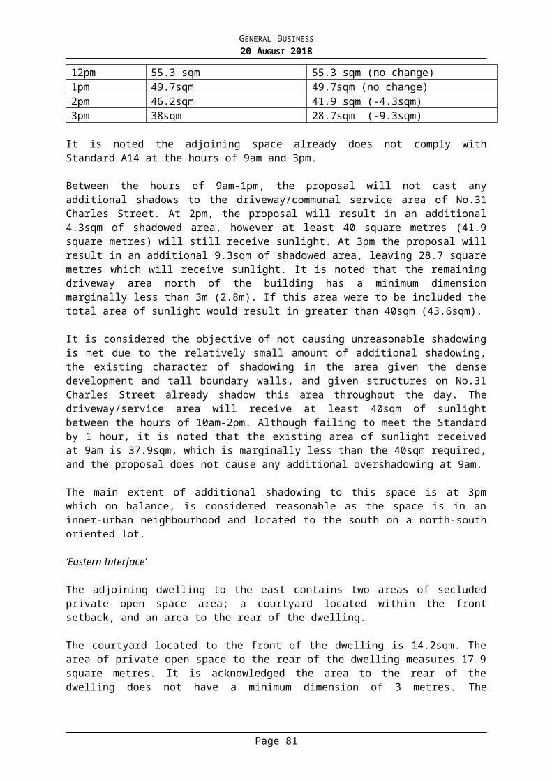
GENERAL BUSINESS20 AUGUST 2018
Impact Traffic Engineering, received by Council on 21 December 2017, but amended to:
a) Be in accordance with the ‘City of Stonnington Residential Waste Management Guidelines’
b) Provide flexibility for future occupants to opt for Council waste collections.
c) Demonstrates collection vehicles can manoeuvre safe and efficiently within the site, as well as enter and exit the site in a forward direction.
When approved, the WMP will be endorsed and form part of the permit. Waste collection from the development must be in accordance with the WMP, to the satisfaction of the Responsible Authority.
4. Concurrent with the endorsement of plans, an amended Sustainable Design Assessment (SDA) must be submitted to and approved by the Responsible Authority. Upon approval, the SDA will be endorsed as part of the planning permit and the development must incorporate the sustainable design initiatives outlined in the SDA to the satisfaction of the Responsible Authority. Amendments to the SDA must be incorporated into plan changes required under Condition 1. The report must include, but not limited to, the following:
a) Commitment to a Building User Guide.b) Minimum water efficiency information of washing machines and urinals
in office toilets.c) Commitment to minimise Volatile Organic Compounds in the
development.All works must be undertaken in accordance with the endorsed SDA to the satisfaction of the Responsible Authority. No alterations to the SDA may occur without written consent of the Responsible Authority.
5. Prior to the occupation of the building, a report from the author of the Sustainable Design Assessment, approved pursuant to this permit, or similarly qualified person or company, must be submitted to the Responsible Authority. The report must be to the satisfaction of the Responsible Authority and must confirm that all measures specified in the Sustainable Management Plan have been implemented in accordance with the approved plan.
6. Concurrent with the endorsement of plans, a Green Travel Plan must be submitted to and approved by the Responsible Authority. When approved, the Green Travel plan will be endorsed to form part of the permit. The Green Travel Plan must include actions and recommendations designed to reduce the use of cars and increase the use of alternative travel methods to the satisfaction of the Responsible Authority. The development must operate in accordance with the Green Travel Plan.
7. The project must incorporate the Water Sensitive Urban Design initiatives detailed in the endorsed plans and/or stormwater management report.
8. The use and development must be managed so that the amenity of the area is not detrimentally affected through the:a) Transport of materials, goods or commodities to or from the land.b) Appearance of any building, works or materials.c) Emission of noise, artificial light, vibration, smell, fumes, smoke, vapour,
steam, soot, ash, dust, waste water, waste products, grit or oil. d) Presence of vermin.
9. Concurrent with the endorsement of plans, the permit holder must submit an
Page 83

GENERAL BUSINESS20 AUGUST 2018
amended digital 3D massing model of the development hereby approved in accordance with the specifications of Council’s GIS Unit, to the satisfaction of the Responsible Authority.
10. Prior to the occupation of the building, the walls on the boundary of the adjoining properties must be cleaned and finished to the satisfaction of the Responsible Authority.
11. Any poles, service pits or other structures/features on the footpath required to be relocated to facilitate the development must be done so at the cost of the applicant and subject to the relevant authority’s consent.
12. All utility services to the subject land and buildings approved as part of this permit must be provided underground to the satisfaction of the Responsible Authority by completion of the development.
13. The collection of wastes and recyclables from the premises (other than normal Stonnington City Council collection) must be in accordance with Council's General Local Laws.
14. All plant and equipment (including air-conditioning units) must be located or screened so as to minimise visibility from any of the surrounding footpaths and from overhead views and must be baffled so as to minimise the emission of unreasonable noise to the environment in accordance with Section 48A of the Environment Protection Act 1970 to the satisfaction of the Responsible Authority. Ventilation systems must be designed and installed in accordance with the relevant Australian Standards.
15. A report for the legal point of discharge must be obtained from Council and a drainage design for the development must be prepared by a suitably qualified Engineer in accordance with that report prior to a building permit being issued. All drainage must be by means of a gravity based system with the exception of any basement ramp and agricultural drains which may be pumped. The drainage must be constructed in accordance with the Engineer’s design. Please do not state drainage design to satisfaction of Council, that is the responsibility of the relevant building surveyor to check and approve in accordance with the report and ‘recommendations’ for the legal point of discharge .
16. The existing footpath levels must not be raised or altered in any way at the property line (to facilitate the MW requirements for the SBO).
17. Unless otherwise agreed in writing by the Responsible Authority, before a sensitive use (residential use, child care centre, pre-school centre or primary school) commences or before the construction or carrying out of buildings and works (except for remediation) in association with a sensitive use commences, either:
a) A certificate of environmental audit must be issued for the land in accordance with Part IXD of the Environment Protection Act 1970, or
b) An environmental auditor appointed under the Environment Protection Act 1970 must make a statement in accordance with Part IXD of that Act that the environmental conditions of the land are suitable for the sensitive use.
Before the occupation of the building all the conditions of the Statement of
Page 84

GENERAL BUSINESS20 AUGUST 2018
Environmental Audit must be complied with to the satisfaction of the Responsible Authority.
18. All the conditions of the Statement of Environmental Audit must be complied with to the satisfaction of the responsible authority, prior to commencement of use of the site. Written confirmation of compliance must be provided by a suitably qualified environmental professional or other suitable person acceptable to the responsible authority. In addition, sign off must be in accordance with any requirements in the Statement conditions regarding verification of works.
Melbourne Water’s conditions
19. Prior to the development plans being endorsed, amended plans must be submitted to Council and Melbourne Water addressing Melbourne Water's conditions. Plans must be submitted with ground and floor levels to Australian Height Datum (AHD) and must be amended as follows:
a) The finished floor levels of the entire ground floor must be set no lower than 16.03 metres to AHD, which is 300mm above the applicable flood level of 15.73 metres to Australian Height Datum.
20. The entire ground floor must be constructed with finished floor levels set no lower than 16.03 metres to AHD, which is 300mm above the applicable flood level of 15.73 metres to Australian Height Datum.
End of Melbourne Water’s conditions
21. This permit will expire if one of the following circumstances applies: a) The development is not started within three years of the date of this
permit. b) The development is not completed within five years of the date of this
permit. c) The use is not commenced within six years of the date of this permit.d) The use is discontinued for a period of two years or more.In accordance with Section 69 of the Planning and Environment Act 1987, a request may be submitted to the Responsible Authority within the prescribed timeframes for an extension of the periods referred to in this condition.
NOTES:
i. This permit does not constitute any authority to carry out any building works or occupy the building or part of the building unless all relevant building permits are obtained.
ii. At the permit issue date, Section 69 of the Planning and Environment Act 1987 stated that the Responsible Authority may extend the periods referred to if a request is made in writing within the following timeframes:1) Before or within 6 months after the permit expiry date, where the
development allowed by the permit has not yet started; and 2) Within 12 months after the permit expiry date, where the development
allowed by the permit has lawfully started before the permit expires.
Page 85

GENERAL BUSINESS20 AUGUST 2018
5. PLANNING APPLICATION 1058/17 - 58 CHAPEL STREET, WINDSOR – PARTIAL DEMOLITION OF THE EXISTING BUILDING AND CONSTRUCTION OF A THREE STOREY ADDITION TO COMPRISE A DWELLING AND REDUCTION IN THE ASSOCIATED CAR PARKING REQUIREMENT
Acting Manager Statutory Planning: Anthony De Pasquale General Manager Planning & Amenity: Stuart Draffin
PURPOSE
For Council to consider a planning application for partial demolition and construction of buildings and works associated with use of the land for a dwelling and a reduction in the associated car parking requirement in an Activity Centre Zone, Heritage Overlay and Special Building Overlay at 58 Chapel Street, Windsor.
Executive Summary
Applicant: Ibis Grove Management C/- Acorn PlanningWard: SouthZone: Activity Centre Zone, Schedule 1Overlay: Heritage Overlay; Special Building Overlay; Incorporated Plan
Overlay; Date lodged: 12 October 2017Statutory days: (as at council meeting date)
100 days
Trigger for referral to Council:
4 storey building
Cultural Heritage Plan NoNumber of objections: NoneConsultative Meeting: NoOfficer Recommendation: Issue a Planning Permit
BACKGROUND
The Proposal
The plans that form part of the basis of Council's consideration were prepared by Warren J Foster Architects and are known as Drawing No’s: CO-01, DA-02, SS-03 to SS-05, EX01 to EX03, DE01 to DE03, TP01 to TP05, TP05a, TP06 to TP09, CS01 to CS04, BP01, SH01 to SH03 and Council date stamped 7/05/2018.
The key features of the proposal are:
Partial demolition to the rear of the building comprising a small portion of ground floor wall and windows facing McIlwrick Street, the first floor office, dry store and cool room located behind the primary building form, and roofing;
External alterations to the retained ground floor including new windows to McIlwrick Street;
Construction of a three storey extension above the ground floor to the rear, comprising two levels of dwelling and an associated rooftop deck, setback 14 metres from the Chapel Street façade and abutting both side and rear boundaries;
Maximum building height of 13.25 metres; Materials and finishes comprise render, painted timber, metal and Zincalume cladding;
Page 87

GENERAL BUSINESS20 AUGUST 2018
Retention of the existing restaurant use at ground and first floor; Use of the building as a three bedroom dwelling at first and second floors; A roof top terrace providing 32.4 square metres of secluded private open space for the
dwelling; The dwelling will be accessed via a stairwell from McIlwrick Street; The existing single car garage will be retained at the rear of the building and provide a
car parking space allocated to the restaurant and a bin storage area, as per existing conditions.
Site and Surrounds
The site is located on the eastern side of Chapel Street on the corner of McIlwrick Street. The site has the following significant characteristics:
The land is regular in shape with a frontage to Chapel Street of 4.5 metres and a side boundary to Mcllwrick Street of 30.48 metres, with a total lot area of approximately 137 square metres.
The site is occupied by a double storey Victorian building, currently used as a restaurant, and is constructed to all title boundaries.
Vehicle access to a single car garage is provided via a rear laneway to the east.
The subject site and surrounding properties are located within the Windsor Village precinct of the Chapel Street Activity Centre. Neighbouring properties on Chapel Street are typically commercial in nature at ground and first floor levels, with residential uses located above and behind the commercial strip. Properties to the east in McIlwrick Street comprise a mix of commercial and residential uses.
Previous Planning Application(s)
A search of Council records indicates the following relevant planning applications:
Planning Permit 460/17 issued with endorsed plans on 8 June 2017 allowing buildings and works comprising a heating system installed beneath the existing front verandah on the subject site.
Planning Permit 1103/08 issued on 21 August 2009 allowing partial demolition and subsequent buildings and works, advertising signage, car and bicycle parking dispensation and an on-premises liquor licence associated with use of the subject site as a restaurant.
The Title
The site is described on Certificate of Title Volume 5483 Folio 565 as Lot 1 on Title Plan 697690R. No covenants are registered on title. A party wall easement is located along the entire southern title boundary.
Planning Controls
The following controls/permit triggers are considerations for this application:
Zone
Clause 37.08 – Activity Centre Zone, Schedule 1
Page 88

GENERAL BUSINESS20 AUGUST 2018
Pursuant to Clause 37.08-2 a permit is required for a dwelling which is not located below the third level on land designated for Main Street Uses. The proposed dwelling is located partially below the third level, therefore a permit is required for use of the land for a dwelling.
Pursuant to Clause 37.08-5 a permit is required to construct a building or construct or carry out works.
Pursuant to Clause 37.08-6 a permit is required to construct a building or construct or carry out works which are not in accordance with any design and development requirements included in a schedule. Schedule 1 identifies the site as being located within Precinct 4 – Windsor Village. The associated built form requirements specify height and setback requirements. Applicable to this site is a preferred maximum building height of 12 metres (3 storeys), a mandatory 14.6 metre maximum height, a preferred maximum streetwall height to the side street and rear laneway of 9 metres, with a 3 metre setback required above that height. The development does not meet the preferred height or setback requirements to McIlwrick Street and the laneway, therefore a permit is required.
Overlays
Clause 43.01 – Heritage Overlay (HO126)
Pursuant to Clause 43.01-1 a permit is required for demolition and to construct a building or construct or carry out works.
Clause 43.03 – Incorporated Plan Overlay, Schedule 3
Pursuant to Clause 43.03-1 a permit is not required as the application does not propose use of the land as a licensed hotel, tavern or nightclub.
Clause 44.05 – Special Building Overlay
Pursuant to Clause 44.05-1 a permit is required to construct a building or construct or carry out works, including an alteration to an existing building where the original building footprint remains the same and floor levels are constructed to at least 300mm above flood level. The development is less than 300mm above flood level, therefore a permit is required for the buildings and works.
The application must be referred to the relevant floodplain management authority. Melbourne Water is the relevant determining authority.
Particular Provisions
Clause 52.06 – Car Parking
Pursuant to Clause 52.06-3 a new use must not commence or the floor area of an existing use must not be increased unless the number of car parking spaces required under Clause 52.06-5 is provided on the land. A permit may be granted to reduce (including reduce to zero) the required number of car parking spaces.
A permit is required to reduce the requirement for two car parking spaces associated with the three bedroom dwelling.
The area of the existing restaurant is not proposed to be increased and one car parking space will be retained on site for its use. Therefore a permit is not required to reduce the car parking associated with the restaurant.
Page 89

GENERAL BUSINESS20 AUGUST 2018
Clause 52.34 – Bicycle Parking
Pursuant to Clause 52.34-1 a new use must not commence or the floor area of an existing use must not be increased until the required bicycle facilities and associated signage has been provided on the land. A permit may be granted to vary, reduce or waive the requirements.
Pursuant to Clause 52.34-5 a dwelling requires the following bicycle parking rates:- In developments of four or more storeys, 1 to each 5 dwellings for residents;- In developments of four or more storeys, 1 to each 10 dwellings for visitors.
Given the development proposes only 1 dwelling, no bicycle parking is required.
Relevant Planning Policies
Clause 21.04 Economic DevelopmentClause 21.05 HousingClause 21.06 Built Environment and HeritageClause 22.04 Heritage PolicyClause 22.18 Stormwater Management (Water Sensitive Urban Design)
Advertising
The application has been advertised pursuant to Section 52 of the Planning and Environment Act 1987 by sending notices to the owners and occupiers of adjoining land (and by placing three signs on the site). The public notification of the application has been completed satisfactorily.
No objections have been received.
Referrals
Heritage
The proposed extent of demolition is limited to later fabric towards the rear of the site, and poses no problems from a heritage perspective.
The proposed development complies with the objectives of Council’s Heritage Policy. All the heritage fabric facing Chapel Street is to be retained, with the additions located at an appropriate setback from the Chapel Street frontage. Although the additions will be visible in oblique views down McIlwrick Street, they will sit comfortably in this streetscape and will read more as an infill development than alterations and additions. They will not be visually intrusive when viewed from Chapel Street.
The impact the proposed alterations and additions will have upon the Chapel Street Heritage Overlay Precinct is acceptable, and the proposed development can be supported in its current form.
Urban Design
Overall, the proposal is acceptable, subject to changes to reduce the visibility of the proposed stair enclosure above the roof deck.
Page 90

GENERAL BUSINESS20 AUGUST 2018
Transport and Parking
It is likely that allowing an additional residential dwelling with no off-street parking will take away parking from existing residents and will likely cause complaints. The site is located within a premier commercial precinct where future residents would be in walking distance to local facilities, however this is not sufficient justification.
Given the proposed parking shortfall and the proximity of the site to bicycle paths, it is considered beneficial to provide off-street bicycle facilities on site.
The bin location may not be convenient for residents as they will have to traverse the restaurant’s garage and there may be a potential conflict with this arrangement.
Infrastructure
The works involve the reconfiguration of the ground floor of the existing building. The existing floor level and flood level varies. The floor level towards the rear of the restaurant is above the applicable flood level and therefore has reasonable protection from flooding.
The garage and the front section of the building is partially at or below the flood level and there is a risk of the restaurant and garage being flooded. It cannot be reasonably expected that the floor level of the existing building is to be raised therefore the permit should include notes to advise of potential flood risk to the existing restaurant and garage.
Melbourne Water
Pursuant to Section 56(1) of the Planning and Environment Act 1987, Melbourne Water does not object to the proposal and does not require any conditions of permit.
KEY ISSUES
Heritage
The application has been assessed against Clause 22.04 and Council’s Heritage Design Guidelines (2017) and generally complies as outlined below.
The Heritage Policy seeks to ensure that development is respectful of built form character and is designed to have minimal impact on the significance of heritage places. This can be achieved by retaining the primary building volume and significant heritage fabric, and ensuring that new works are visually recessive to allow the original fabric to remain the dominant visual element of the site.
In commercial areas it is policy to:
Ensure retention and encourage restoration of all original or early shopfronts. Ensure that all upper level additions and alterations:
- Are set back behind the primary building volume.- Complement the height, scale and setbacks of any adjoining significant or
contributory buildings.- Result in storey heights to complement the alignment of the primary building
volume.- Are generally contained within an envelope created by projecting a sight line from
1.7 metres above ground level on the opposite side of the street.- Present minimal bulk from oblique views.
Page 91

GENERAL BUSINESS20 AUGUST 2018
- Do not obscure vistas and view lines to significant buildings.
The proposal appropriately responds to the above by way of the following:
The extent of proposed demolition is limited to non-original building fabric towards the rear of the site while the existing shopfront and roof form of the primary building volume will be retained.
The height of the proposed addition will be compatible with the scale of surrounding buildings and provide an appropriate transition between adjacent built form, noting that the three storey component is well set back on the site.
The proposed addition will be set back approximately 14 metres from the Chapel Street façade ensuring it will not visually intrude on the primary streetscape.
Although the addition will be visible from oblique views when looking down McIlwrick Street, it will sit comfortably in this streetscape as it will essentially read as two distinct forms, with the addition viewed more as a contemporary infill development at the rear, rather than alterations and additions to the original heritage building.
The siting of the proposed addition at the rear ensures it will not obscure views to other significant heritage buildings.
Built Form
Schedule 1 of the Activity Centre Zone specifies numerous requirements and design guidelines and the proposed development generally complies with the objectives.
The Windsor Village precinct calls for a preferred maximum building height of 12 metres (3 storeys) with a mandatory maximum height of 14.6 metres, a preferred minimum setback above the streetwall of 10 metres within a Heritage Overlay, and a preferred maximum streetwall height to the side street and laneway of 9 metres above which a minimum upper level setback of 3 metres is preferred.
The development essentially proposes a 3 storey addition ranging in height from 10.5 metres to 11.3 metres, with a maximum height of 13.25 metres to the top of the stairwell. The stairwell is technically considered to be a fourth storey however it comprises only a small, centrally located element of the building with the sole function of accessing the rooftop terrace. The predominant building height is under the 12 metre preferred height and well below the mandatory height requirement. The setback of approximately 14 metres from the façade to the addition exceeds the 10 metre requirement and further reduces any visual bulk. The addition will not overshadow any public footpaths or public open space areas.
The stairwell protrusion above roof level is provided with glazing to the north, east and west elevations to soften its visual appearance, however the highlight windows proposed to the front elevation could be increased in size to further alleviate any prominence of this part of the building when viewed from oblique views on Chapel Street. It is recommended this be addressed via permit condition.
The building addition is proposed to be constructed along both side boundaries and abutting the rear, with a 10.5 metre streetwall height to the rear laneway and a maximum 11.3 metre streetwall to the side street.
This exceeds the preferred streetwall height of 9 metres in the Windsor Village precinct however it is considered acceptable for the following reasons:
The building is well articulated on the McIlwrick Street elevation which provides visual interest and assists to reduce bulk and massing;
Page 92

GENERAL BUSINESS20 AUGUST 2018
The adjacent building to the south is commercial with no residential component, and beyond the laneway to the east is the front yard associated with a residential building facing McIlwrick Street;
There are no habitable room windows or balconies directly facing the site which will suffer from a reduced outlook;
The building will not overshadow any secluded private open space areas nor impact on daylight to windows;
The height is not considered to be excessive and due to the limited width of the subject site it is not practicable to reduce the width of the residential component without a significant reduction in internal amenity;
Council’s Heritage Advisor and Urban Designer are supportive of the proposed height and the absence of side and rear setbacks.
The existing ground floor to ceiling heights of 4.1 metres to the original restaurant and 3.3 metres to the rear section of the restaurant are not proposed to be altered and provide acceptable adaptability for alternative commercial purposes. Schedule 1 requires a 3.8 metre height between floors at first and second floor level. However the proposed height of 3.45 metres is considered adequate given the proposed residential use and given the dwelling fronts a side street.
The ground floor side street façade generally improves the existing level of active frontage associated with the restaurant use. The separate residential entry will be covered with an awning to provide weather protection and a prominent sense of address. The large number of windows proposed to the side street and laneway will provide good passive surveillance of the public realm while minimising overlooking of any neighbouring residential properties, noting that there are no habitable room windows or private open space areas within 9 metres of the site thus views are sufficiently restricted. As previously outlined, the proposed alterations and additions to the building are acceptable in the heritage context, and they also respond to the urban fabric and identity of the Activity Centre by way of contemporary built form incorporating materials such as rendered finishes, painted timber, metal and Zincalume cladding, and extensive glazing.
Whilst complete site coverage is proposed, this reflects the existing conditions and is a strong characteristic of the area. There is space allocated within the rooftop deck to provide some landscaping to increase the amount of vegetation within the Activity Centre.
In terms of on-site amenity for the proposed dwelling, the habitable rooms will receive ample ventilation and daylight access from the north while a 32.4sqm rooftop deck will provide generous secluded private open space with excellent solar access. It is noted the deck is setback adequately from nearby residential properties to ensure no unreasonable off-site impacts, such as overlooking.
To improve the accessibility to waste storage facilities for the dwelling, it is considered appropriate that separate bin areas be provided for the residential and commercial components. This can be achieved by relocating the commercial bin area closer to the kitchen, and providing a separate pedestrian entry from the laneway to an adjacent residential bin area. This is addressed via a recommended condition of permit.
Use
The Chapel Street activity centre provides access to a range of public transport options, infrastructure, retail uses, entertainment, goods and services. The proposed residential use is compatible with the existing restaurant use on the site, as well as nearby land which comprises a mix of commercial, retail and residential uses.
Page 93

GENERAL BUSINESS20 AUGUST 2018
Council policy supports and recognises the need for the provision of increased residential densities to meet its housing targets and to support the surrounding commercial uses. A key objective at Clause 21.05-3 is to encourage residential use in activity centres, particularly upper floors of existing buildings. Furthermore, a purpose of the Activity Centre Zone is to encourage a mixture of uses including housing, and to deliver a diversity of housing at higher densities to make optimum use of the facilities and services.
The Activity Centre Zone encourages retail and commercial uses, with residential uses at third floor and above. Although the residential component of the development is proposed at first and second floor levels, the entire ground floor and the first floor of the original building is dedicated to the commercial/restaurant use. Additionally, the dwelling entry is from the secondary site frontage on McIlwrick Street and is separated from the commercial entry on Chapel Street. The layout of the commercial and residential components make effective use of the site which is constrained by several factors including the narrow width and small lot size of only 137sqm; the three storey preferred maximum building height imposed by the zone; and the significant street setback to the upper level required to respond to the heritage controls. These combined factors result in a confined second floor footprint and thus it is considered reasonable to allow for the residential use to occupy a portion of the first floor and the second floor to maximise the internal amenity of the proposed dwelling.
Overall it is considered that the proposed use of the land for one dwelling within upper levels of the building is appropriate in this context.
Car Parking and Traffic
The site is located within an area that enjoys excellent access to public transport, including Windsor railway station approximately 55 metres to the south. Future residents will be within walking distance of a plethora of local facilities as well as employment opportunities within the surrounding commercial precinct. This enables residents to live and work without reliance on vehicle ownership, but rather use more sustainable transport options such as walking, cycling and public transport, as encouraged by local policy. A relevant strategy at Clause 21.05-3 is to encourage shop top dwellings in activity centres by accepting reduction of the car parking and/or open space requirements. The absence of residential parking on site will encourage future residents to prioritise alternative forms of transport and make use of the pedestrian friendly nature of the neighbourhood.
There is an abundance of short term parking and paid parking options in the surrounding locality for use by visitors to the site. Additionally future residents of the dwelling relying on use of a vehicle will be entitled to residential parking permits. The development proposes only one dwelling which is considered to be a very modest intensification of residential use in the area, and thus any impact on existing residential parking will be limited.
It is not considered practicable to provide residential parking on site, and it follows that any other proposed use of the land would require a car parking reduction. Given the activity centre zoning, which encourages a diversity of housing at higher densities to make optimum use of the facilities and services, a waiver of the residential parking for only one dwelling is considered to have moderate impact and is therefore acceptable.
Water Sensitive Urban Design
The submitted Water Sensitive Urban Design Response (STORM Rating Report) indicates that the development does not meet best practice requirements. Further stormwater treatment measures are required to meet the objectives of Council’s Stormwater Management policy. This can be addressed by way of permit conditions.
Page 94

GENERAL BUSINESS20 AUGUST 2018
Special Building Overlay
Melbourne Water, as a determining referral authority, have no objection to the proposed development. The site is subject to potential overland flooding from local drains, and thus it falls within Stonnington’s Special Building Overlay area. Council’s Infrastructure Unit are supportive of the proposed development, therefore it is considered the relevant decision guidelines of the overlay have been adequately considered and the proposal is acceptable in this regard.
Human Rights Consideration
This application has been assessed in accordance with the requirements of the Planning and Environment Act 1987 (including the Stonnington Planning Scheme), reviewed by the State Government and which complies with the Charter of Human Rights and Responsibilities Act 2006.
CONCLUSION
Having assessed the application against the relevant planning controls, it is recommended that the proposal be supported for the following reasons:
The proposal will not adversely impact on the significance of the heritage place; The proposal represents a design which responds to the policy direction for the area; The proposed height and built form is appropriate in this main road, activity centre
location; The design limits adverse impacts on neighbouring residential properties; The use of the upper levels for a dwelling is consistent with the purpose of the zone
and good internal amenity is provided; A reduction of the car parking requirement is appropriate as it will have minimal impact
on existing residential parking in this locality.
Page 95

GENERAL BUSINESS20 AUGUST 2018
ATTACHMENTS
1. PA - 1058-17 - 58 Chapel Street Windsor - Attachment 1 of 1 Plans
RECOMMENDATION
That a Planning Permit No: 1058/17 for the land located at 58 Chapel Street, Windsor be issued under the Stonnington Planning Scheme for partial demolition and construction of buildings and works associated with use of the land for a dwelling and a reduction in the associated car parking requirement in an Activity Centre Zone, Heritage Overlay and Special Building Overlay subject to the following conditions:
CONDITIONS
1. Before the commencement of the development, one (1) electronic copy of plans drawn to scale and fully dimensioned, must be submitted to and approved by the Responsible Authority. The plans must be generally in accordance with the plans submitted with the application (identified as Drawing No’s: DE01 to DE03, TP01 to TP05, TP05a, TP06 to TP09, CS01 to CS04 and advertised May 2018) but modified to show:
a) The western elevation of the stairwell above second floor provided with increased glazing, to be of similar proportions to the northern elevation.
b) The commercial waste storage area relocated toward the kitchen and a dedicated residential bin storage area provided with separate pedestrian access from Windsor Place.
c) A Water Sensitive Urban Design Response in accordance with condition 8.
2. The layout of the site and the size, levels, design and location of buildings and works shown on the endorsed plans must not be modified for any reason, without the prior written consent of the Responsible Authority.
3. The awning over McIlwrick Street must be constructed and maintained to the satisfaction of the Responsible Authority.
4. Prior to the occupation of the building/ commencement of use, the walls on the boundary of the adjoining properties must be cleaned and finished to the satisfaction of the Responsible Authority.
5. Adequate provision must be made for the storage and collection of wastes and recyclables within the site prior to the commencement of use or occupation of the building. This area must be appropriately graded, drained and screened from public view to the satisfaction of the Responsible Authority.
Page 96

GENERAL BUSINESS20 AUGUST 2018
6. All plant and equipment (including air-conditioning units) shall be located or screened so as to minimise visibility from any of the surrounding footpaths and from overhead views and shall be baffled so as to minimise the emission of unreasonable noise to the environment in accordance with Section 48A of the Environment Protection Act 1970 to the satisfaction of the Responsible Authority.
7. Concurrent with the endorsement of plans, the applicant must provide a Water Sensitive Urban Design Response addressing the Application Requirements of the Water Sensitive Urban Design Policy to the satisfaction of the Responsible Authority. All proposed treatments included within the Water Sensitive Urban Design Response must also be indicated on the plans.
8. The project must incorporate the Water Sensitive Urban Design initiatives detailed in the endorsed site plan and/or stormwater management report.
9. This permit will expire if one of the following circumstances applies:
a) The development is not started within two years of the date of this permit.
b) The development is not completed within four years of the date of this permit.
c) The use is not commenced within five years of the date of this permit.d) The use is discontinued for a period of two years or more.
In accordance with Section 69 of the Planning and Environment Act 1987, a request may be submitted to the Responsible Authority within the prescribed timeframes for an extension of the periods referred to in this condition.
Notes:
A. The existing floor level of the restaurant and garage may be below the flood level and is at risk of flooding. Any new works should allow for the possibility of flooding entering the building and all new electrical wiring and appliances should be at least 300mm above the existing floor level of 18.24m.
B. This permit does not constitute any authority to carry out any building works or occupy the building or part of the building unless all relevant building permits are obtained.
C. At the permit issue date, Section 69 of the Planning and Environment Act 1987 stated that the Responsible Authority may extend the periods referred to if a request is made in writing within the following timeframes:
i. Before or within 6 months after the permit expiry date, where the development allowed by the permit has not yet started; and
ii. Within 12 months after the permit expiry date, where the development allowed by the permit has lawfully started before the permit expires.
6. VEHICLE CROSSING APPLICATION – 76 LANG STREET, SOUTH YARRA
Manager Building and Local Law Services: Madeleine Grove General Manager Planning & Amenity: Stuart Draffin
Page 97

GENERAL BUSINESS20 AUGUST 2018
PURPOSE
The purpose of this report is to determine a Vehicle Crossing Application for 76 Lang Street, South Yarra.
This item was considered at the Council meeting of 6 August 2018. The application is now re-presented to Council for further consideration.
BACKGROUND
Vehicle Crossing Policy and Application
Council’s Vehicle Crossing Policy was adopted by Council on 17 September 2007.
On 25 January 2018 a complaint was made to Council regarding an unauthorised crossing/ ramp treatment which had been applied to the road on the Powell Street frontage of 76 Lang Street, to achieve a vehicle crossing to an entrance. Following investigation of this matter the owner of the site was directed to remove the ramp treatment. This direction has been complied with.
The property builder has since applied for a permanent vehicle crossing on 2 May 2018.
The applicant proposes to construct a new vehicle crossing on the Powell Street frontage of the property. The proposal is for a 2.5m wide vehicle crossing.
Planning Permit
A planning permit application was lodged in 2012, for a two storey dwelling.
Permit 876/12 approved a new three bedroom dwelling and ‘reduction in car parking’ on a lot under 500 square metres and in a Special Building Overlay at 76 Lang Street. The application was assessed under the provisions of Clause 54 (Res Code).
The endorsed plans show a double storey dwelling with a small area of private open space in the front set back and a slightly larger area at the rear of the dwelling.
A car parking space and vehicle crossing are not shown on the endorsed plans. The applicant argued that it was not necessary to provide car parking on site as there was sufficient on street parking and public transport was in close proximity.
Council agreed to waive the car parking requirement and the planning permit for the new dwelling includes “reduction in car parking” in the preamble.
It should also be noted that the land at the rear of the dwelling (the land that would serve as a car parking space if a crossing was approved) was included in the private open space calculations submitted by the applicant. Should this crossover be supported an application to amend the Planning Permit would need to be submitted to Council to change the use of this space from private open space to car parking.
Council’s Statutory Planning Department advise that the current approved plans identifies two areas of private open space and the change to provide a car parking space would mean that one area of private open space with northern orientation would be retained. The area to the north could be considered as the main area of secluded private open space as it faces north and is provided with a direct connection to the living area.
Page 98

GENERAL BUSINESS20 AUGUST 2018
DISCUSSION
In considering this application under Council’s Vehicle Crossing Policy, the following factors are relevant:
Transport and Parking Assessment
The Plans submitted to Statutory Planning show the area within the property, behind the roller door as private open space and at no point was the area assessed as a car parking space as part of the development proposal.
These omissions in the plans short circuited the required assessment process that would have, in this instance, identified insufficient space within the property to accommodate a single car garage or carport.
Infrastructure Assessment
Council’s Infrastructure Department does not support the applicant’s proposal based on Council’s standards that require a vehicle crossing width of 3m when the proposed width is 2.5m.
A number of pits would also require relocation and the applicant is responsible for seeking approval from the relevant Service Authorities to relocate these if this request was to be approved.
Removal of a Healthy Street Tree
The construction of the vehicle crossing to Council standards would by implication require the removal of a 30 year old Callery Pear tree from its present location in the footpath on the Powell Street frontage of the property (refer Attachment One).
Council’s Arborist is of the view that a successful relocation of such a substantial tree is not possible with existing equipment. As a consequence, the choice is either to retain a healthy street tree or to remove the tree to allow for the construction of the proposed vehicle crossing.
The tree is in good health with sound structural integrity and has a life expectancy of 20+ years. It is also worth noting that the tree contributes considerably to physical amenity of Powell Street as it is part of an avenue of established Callery Pear trees.
CONCLUSION
The Vehicle Crossing application for 76 Lang Street has been considered by Officers in consultation with relevant Council Departments.
It is considered that the application fails to meet Council Vehicle Crossing Policy objectives, namely:
To enable appropriately situated and constructed vehicular access between the road pavement and private property;
To control the impact of crossings on utility infrastructure, street furniture and other assets;
Page 99

GENERAL BUSINESS20 AUGUST 2018
To prevent inappropriate loss of significant street trees, vegetation and landscaping.
The outstanding factor of the space and the basis for the Officer’s refusal is the removal of the Callery Pear street tree. The vehicle crossing application is not supported as the crossing cannot be constructed on the Powell Street frontage of 76 Lang Street without the destruction of the street tree.
HUMAN RIGHTS CONSIDERATION
This recommendation complies with the Charter of Human Rights and Responsibilities Act 2006.
ATTACHMENTS
1. Vehicle Crossing Application - 76 Lang Street South Yarra - Attachment 1 Excluded
RECOMMENDATIONThat Council:1. Refuse the Vehicle Crossing Application for 76 Lang Street, South Yarra on the
basis of non-compliance with Council’s Vehicle Crossing Policy and the Urban Forest Strategy with the objective of preventing inappropriate loss of significant street trees, vegetation and landscaping
2. Advise the Applicant of Council’s decision.
Page 100

GENERAL BUSINESS20 AUGUST 2018
7. 1-3 VALETTA STREET, MALVERN - PLAQUE DESIGN
Manager Aged, Diversity, Health & Animal Management: Penny Pavlou General Manager Community & Culture: Cath Harrod
PURPOSE
The purpose of this report is to seek Council’s approval for wording on the plaque marking the completion of the building project at 1-3 Valetta Street, Malvern.
BACKGROUND
Following Council’s decision of 19 December 2016, the building upgrade of 1-3 Valetta Street, Malvern, has now been completed for the immediate tenancy of University of the Third Age (U3A) Stonnington.
U3A Stonnington currently leases from Council 578 Orrong Road, Armadale. The building at 578 Orrong Road, Armadale is nearing the end of its functional life. The building’s current condition limits the ability of U3A Stonnington to meet the increased demand and the changing needs of older residents. Council committed at the 19 December meeting to complete the building works required at 1-3 Valetta Street, Malvern in order to transfer U3A Stonnington to a more appropriate site.
The building works to 1-3 Valetta Street have included:
• Providing an accessible ramp to the entry
• Demolition of internal walls (structural and non-structural) and three fire places
• Reconfiguring existing layout to accommodate:
- Foyer / Office / Reception area with tea facilities
- Meeting rooms x3 (two of which form a lecture room)
- Lecture room with storage
- Accessible male and female toilets
- Structural stability upgrades including beams and brickwork repairs
• Installation of a heating and cooling system
• Replacement of all electrical lights and power
• Making good to existing internal walls and windows
• Painting throughout
• Replacement of floor finishes throughout.
DISCUSSION
An official opening of the building is planned for 1pm on Wednesday 29 August 2018. The official unveiling will take place with light refreshments and tour of the facility to follow.
A cast bronze plaque will be erected at the entrance of the building to recognise Council’s contribution. The plaque will prominently feature the Stonnington logo.
The plaque will read:
__________________________________________________________________________
Page 101

GENERAL BUSINESS20 AUGUST 2018
This building was opened by His Worship the Mayor, Cr Steven Stefanopoulos
29 August 2018
Cr Glen Atwell Cr John Chandler OAM Cr Sally Davis Cr Marcia Griffin
Cr Judy Hindle Cr Jami Klisaris Cr Matthew Koce Cr Melina Sehr
Chief Executive Officer, Warren Roberts
_________________________________________________________________________
POLICY IMPLICATIONS
The building improvements completed at 1-3 Valetta Street, Malvern and the relocation of U3A Stonnington as the tenants of the building will assist Council to deliver the Council Plan objective of Community and strengthen Council’s commitment to support positive ageing initiatives and supporting inclusive communities as part of the Positive Ageing Strategy 2018-2021.
CONCLUSION
Following the completion of the significant building works program Council has undertaken at 1-3 Valetta Street, Malvern, the scale and significance of this project will be recognised by installing a plaque to celebrate the official opening.
HUMAN RIGHTS CONSIDERATION
This recommendation complies with the Charter of Human Rights and Responsibilities Act 2006.
RECOMMENDATIONThat Council approves the wording of the plaque for 1-3 Valetta Street, Malvern, as follows:
This building was opened by His Worship the Mayor, Cr Steven Stefanopoulos
29 August 2018
Cr Glen Atwell Cr John Chandler OAM Cr Sally Davis Cr Marcia Griffin
Cr Judy Hindle Cr Jami Klisaris Cr Matthew Koce Cr Melina Sehr
Chief Executive Officer, Warren Roberts
Page 102
GENERAL BUSINESS20 AUGUST 2018
8. INFRASTRUCTURE VICTORIA - FIVE-YEAR FOCUS: IMMEDIATE ACTIONS TO TACKLE CONGESTION
Sustainable Transport Planner: Tom Haysom Manager Transport & Parking: Ian McLauchlanGeneral Manager Assets & Services: Simon Thomas
PURPOSE
That Council:
- Note Infrastructure Victoria’s Five-year focus: Immediate actions to tackle congestion report, and the anticipated impacts, if implemented, on the City of Stonnington.
- Endorse the proposed response to Infrastructure Victoria’s Five-year focus: Immediate actions to tackle congestion report.
BACKGROUND
Infrastructure Victoria (IV) is an independent statutory authority charged with providing expert advice to government and guiding decision-making on Victoria’s infrastructure needs and priorities. Infrastructure Victoria has three key roles:
1. Prepare a 30-year infrastructure strategy for Victoria
2. Provide advice to the Victorian Government on infrastructure matters
3. Publish research on infrastructure matters
IV’s 30-year infrastructure strategy illustrates how road congestion within Melbourne is forecast to worsen over the next 15 years and that on some parts of the network, increases in travel times and declines in reliability will be significant. While taking into account initiatives which seek to improve the performance of the road network, including major investments in road and rail projects, the 30-year infrastructure strategy identified additional measures that would manage rather than accommodate demand. A comprehensive and fair transport network pricing regime was proposed as the most efficient and effective way of managing congestion and was recommended to be implemented in 5-15 years. However this recommendation was one of the few rejected by the State Government.
To address immediate congestion issues within Melbourne, IV have now identified a package of short term actions can be implemented over the next five years and presented these to the Victorian Government in the report, Five-year focus: Immediate actions to tackle congestion, released April 2018 (attachment 2). The report presents 9 recommendations that make better use of existing infrastructure and public transport fleets, restructuring bus networks to be more efficient and managing road space to improve priority for high-occupancy public and active transport.
While IV’s report is only an advice paper to government, it should be noted that the current government has overwhelmingly supported and adopted previous IV recommendations. Out of the 137 recommendations contained within IV’s 30-year Infrastructure Strategy, 134 (98%) have been accepted in full, in part or in principle.
Government support and implementation of the recommendations contained within the IV Five-year focus: Immediate actions to tackle congestion report will have multifaceted impacts on the City of Stonnington, ranging from impacts on congestion levels, parking impacts, right through to financial implications. The impacts of the following 3 recommendations will be particularly significant, with Stonnington being identified as key implementation locations:
Recommendation 2 a - Expand the Category 2 levy area to include Richmond, South Yarra, Windsor and Prahran.
Page 103

GENERAL BUSINESS20 AUGUST 2018
Recommendation 6 b - Better allocate road space to prioritise efficiency on identified movement corridors. Ensure the list of priority initiatives is based on the Movement and Place Framework and focuses on congested movement corridors with competing uses, such as roads in the City of Yarra and City of Stonnington.
Recommendation 8 a - Prioritise active transport investments to high potential areas. Prioritise investment, which could be partly funded from the proposed changes to the car parking levy, in the following locations: Trips to inner Melbourne and Parkville from: Richmond, Brunswick, Brunswick East and Brunswick West through Carlton, South Yarra, Prahran, Windsor and Toorak.
The next section of this report will outline the anticipated transport improvements and implications to Stonnington of these 3 recommendations, with an analysis, including recommended Council position for all actions included as an attachment to this report (attachment 1):
DISCUSSION
IV’s Five-year focus: Immediate actions to tackle congestion report identifies three tools that government can use to reduce congestion over the next 5 years:
- Shifting demand
- Better use of existing infrastructure
- Invest in new networks and services
Under each of these tools IV have recommended a number of actions (9 in total) that aim to improve the performance of Melbourne’s roads while being “practical, low cost, could be delivered quickly and build on existing measures that have proven effective”.
Each recommendation, if implemented by government, will have an implication on Stonnington. A summary of the three recommendations likely to have the most significant impact on Stonnington is presented below, with an analysis, including recommended Council position for all actions included as an attachment to this report (attachment 1):
Shifting demand – Recommendation 22. Expand and increase the car parking levy
a. Expand the Category 2 levy area to include Richmond, South Yarra, Windsor and Prahran
b. Establish revenue sharing arrangements with each local council covered by the levy
c. Regularly review and increase the levy to reflect increasing congestion
The car parking levy or ‘congestion levy’ is an annual levy collected by the State Government, aimed at reducing traffic congestion in central Melbourne by encouraging more motorists to regularly use public transport.
Introduced in 2005, the congestion levy is charged each calendar year to off-street private and public car parking spaces in two specified areas.
Some exemptions and concessions apply, including residential parking (including apartment parking, as long as the car parking space used exclusively by a resident to park their car while they are at home), disabled parking, car share schemes and spaces provided free of charge for hospital visitors and patients. Council carparks that do not charge for use are also exempt under the scheme.
For public carparks, the owner and the operator of the public carpark are jointly and severally liable to pay the levy. For private carparks, the owner of premises pays the levy.
Page 104

GENERAL BUSINESS20 AUGUST 2018
Category 2 area - the levy for each non-exempt parking space is $1000, indexed annually for CPI.
This recommendation proposes to expand the category 2 levy to the area bordering Punt Road to Williams Street and the Yarra River to Dandenong Road.
Transport Improvements
The congestion levy is a successful tool at easing congestion within the CBD by reducing trips by private vehicle and encourage public transport use. A 2010 Department of Treasury and Finance review of the congestion levy found that average week day traffic volumes in the levy area reduced by around 6% between February 2005 and August 2009, despite a significant increase in employment in the City of Melbourne over that time.
Infrastructure Victoria’s analysis of the levy since 2015 found that the levy has been successful in reducing the supply of leviable car parking spaces in affected areas and this correlated with a reduction in private vehicle mode share for trips in the CBD. This is estimated to be around 3,900 vehicles off the road in the morning peak period in 2017 compared to 2015.
Shared revenue generated by the congestion levy has funded sustainable transport projects. Under the agreement between the City of Melbourne (CoM) and state government, 14% of all funds generated by the levy within the CoM is issued as a lump sum to the CoM to be spent in accordance with the Council’s transport strategy. This was approximately $7 million last financial year.
CoM projects funded by this levy have included: bridges (Yarra Pedestrian Bridge and Convention Centre Bridge), cycling treatments (Manningham Street and Albert Street) and upgrades of streetscapes including the Swanston Street redevelopment. It should be noted that no such agreement was reached with the City of Yarra (CoY) and CoPP, as a result each municipality at present receives no rebate.
Stonnington Implications
The congestion levy is an additional tax on Council. While Council carparks that do not charge for parking are exempt from the levy, Council carparks that charge for use are required to pay the levy. A calculation of Council carparks within the suggested levy area that charge for use (including expected exemptions and concessions), is 1,846 parking spaces over 9 off-street carparks (including the estimated addition of Cato Square). At the current category 2 levy rate of $1000 per parking space, the anticipated cost to Council will be around $1,846,000 per annum.
Parking costs throughout the region will rise. The levy fee can be passed on to users of the parking space, including private parking costs such as those owned and operated by the Jam Factory. An assessment of all the private operated paid carparks within the suggested levy area shows a net capacity of 3,295 leviable bays over 8 carparks (excluding exemptions and concessions). There are likely to be additional private operated paid carparks, however these are the major operators with publicly available information. At the current category 2 levy rate of $1000 per parking space, the estimated total cost to these private carpark operators is $3,295,000 per annum. Assuming each bay is fully occupied at a rate of 1 use per day (365 days a year), the minimum cost passed onto the user to offset this levy is $2.74 a day. However, as we know car parking bays are unoccupied to varying degrees, depending on the time and location of the carpark, therefore the cost passed onto the user per day will need to be higher. Without understanding the occupancy levels of these carparks we cannot accurately estimate how much parking prices are likely to rise over $2.74 a day in order to offset the proposed levy.
Council can also pass the cost of the levy onto the user to absorb the fee. Occupancy levels of all Council paid carparks are recorded allowing an analysis to determine how much
Page 105

GENERAL BUSINESS20 AUGUST 2018
Council will need to raise parking prices to offset the proposed levy. There are a number of ways this analysis can be undertaken depending on rate structures and the type of parking Council is aiming to encourage or discourage, i.e. short term parking encouraging bay turnover, in favour of long term stay parking. For the purpose of this report, the analysis is set in the context of existing carpark management.
The analysis calculated a space-hour rate for the parking levy at each of the carparks based on parking usage for each existing rate category over a 12 month period (January to December 2017 - to take into account seasonality and ensure no spill over parking resulting from the Cato Square development). This has identified an hourly rate and breakdown of the rate categories increases required to offset the proposed levy e.g. casual rates, earlybird rates or long stay and short stay rates.
Preliminary calculations based on the 2017 usage indicates the recovery rate for the levy varies, depending on carpark usage and assumptions made, but it appears an hourly rate increase across the board of the order of $1 per hour would likely be required to recover the revenue. If the levy proceeds this would likely be the starting rate which may be adjusted up or down depending on usage after the levy and Cato Square comes into operation.
However, as noted above, there are a number of ways to apportion costs, depending on usage (which can change) and the way each carpark is managed. The inherent danger in the analysis is if the price rate increases change parker’s behaviour, in terms of a decrease in either overall daily parking volumes or reduces the average duration of stay the revenue required may not be achieved and fees would need to be revised.
The impact of this fee increase may effect some of Council’s smaller fee-paying carparks to the point they become financially unviable under the levy.
The congestion levy applied to off-street business parking may have implications on attracting business to the area. While the owner of the building will be required to pay the congestion levy per parking space, the cost of the levy may be incorporated into the leasing fee charge, so that it is ultimately passed on to the end-user of the parking space. Although private business parking figures were unable to be ascertained for this report, it is feasible that any increase to business leasing fees due to the congestion levy may impact the attractiveness of the area to some businesses.
Council may not receive any shared revenue generated by the levy. While the CoM successfully negotiated a MoU with the State Government to receive a 14% rebate of the total levy generated in their municipality, it must be noted that no such agreement was reached with the City of Yarra (CoY) and CoPP, as a result each municipality at present receives a 0% rebate. Although it could not be ascertained how the figure of 14% was arrived at for the CoM rebate, a reasonable assumption is this figure is tied to the number of CoM carparks that made up the total number of carparks within the CoM levy area, i.e. Council owns 14% of all leviable carparks within the CoM levy area. On this basis, this ensures a ‘fair share’ of the revenue generated by the levy is rebated to Council.
There is no direct link between the policy rationale of the levy – to reduce traffic congestion by encouraging trips by public transport – and travel patterns within South Yarra, Windsor and Prahran. If the levy is to be successful in reducing reduce trips by private vehicle and encourage public transport use, public transport must be a viable option. According to the ABS 2016 journey-to-work data, of those travelling into Stonnington for work, 71% did so by car, with only 20% using public transport. This indicates that the current public transport network is not sufficient to cater for those travelling to work within Stonnington. Although this assessment is Stonnington wide, and the well serviced western end of the municipality would likely see a much larger rate of public transport use, further analysis is required to understand this use.
Page 106

GENERAL BUSINESS20 AUGUST 2018
Recommendation
Due to the anticipated implications of the proposed congestion levy on Stonnington, as presented above, coupled with the unknown effectiveness of the policy rationale – to reduce traffic congestion by encouraging trips by public transport – on areas outside the CBD, it is recommended that Council oppose IV’s recommendation to expand the Category 2 levy area to include South Yarra, Windsor and Prahran, until the following can be undertaken:
- A review on the impacts of the congestion levy on areas outside the CBD. The review will need to include:
o Impacts on business and employment numbers.
o A proven reduction in average week day traffic volumes.
o Impacts on smaller charged carparks, in particular the viability of such carparks under the levy.
- Prior to any levy being imposed, an agreement that a ‘fair share’ of the levy is rebated to Council for expenditure in accordance with Council’s transport strategies. The rebate should reflect the percentage of Council carparks that make up the total number of leviable carparks within the Stonnington levy area.
Better use of existing infrastructure – Recommendation 66. Better allocate road space to prioritise efficiency on identified movement corridors
a. Identify a priority list of road space allocation initiatives to be delivered over the next five years
b. Ensure the list of priority initiatives is based on the Movement and Place Framework and focuses on congested movement corridors with competing uses, such as roads in the City of Yarra and City of Stonnington.
Infrastructure Victoria has specifically identified ‘congested movement corridors’ within the City of Stonnington to be prioritised for road space allocation projects based on VicRoads Movement and Place Framework.
VicRoads Movement and Place Framework (M&P) is the adaptation of the old ‘Smart Roads’ framework. Instead of giving priority use of the road to different transport modes at particular times of the day, this new framework re-balances road priorities to include public transport, cycling, pedestrians and the surrounding environment, or ‘place’. The purpose of this classification is to identify the key user requirements for the road and surrounding land use, and prioritise this space for these uses, rather than attempting to cater for all users.
Anticipated Outcomes
Given the purpose of the M&P framework is to identify the key user requirements for the road and surrounding land use, and prioritise this space for these uses, implementation of this framework would likely prioritise various travel and place functions at the expense of on-street parking within Stonnington.
For example:- Toorak Road, which supports many functions including tram services, cars, parking
and to a lesser extent (excluding activity centres) walking and cycling. Under M&P it is likely that trams and traveling vehicles will be identified as the priority user, with the road space to be prioritised accordingly. Separated tram corridors and permanent clearways could be expected implementation tools of this framework.
Page 107

GENERAL BUSINESS20 AUGUST 2018
- High street, also supports many functions including tram services, cars, and parking however, due to High Street being identified as a ‘strategic cycling corridor’, cycling is likely to be identified as a priority user. Given this classification it is likely that that trams, traveling vehicles and bikes will be identified as the priority user with the road space to be prioritised accordingly. Separated tram corridors and cycling facilities (Copenhagen style bike lanes), at the expense of on street parking could be expected implementation tools of this framework.
Transport Improvements
Reallocation of road space to prioritise public transport operations typically leads to increases in public transport use. Prioritisation of trams through various measures (signal alterations, or separated corridors) enables more frequent and reliable services, which traditionally translates to a higher uptake in trips and reduction in car use. This has been the key rationale governing Public Transport Victoria’s Route 96 Project which seeks to separate trams from traffic from East Brunswick to St Kilda Beach. This project has shown the average speed of Route 96 during the morning peak is 13.8km/h along the unseparated north stretch of Nicholson Street compared to 29.3km/h along the separated section from St Kilda station to Southbank. Following further separation of this corridor, PTV anticipate to run additional services due the predicted additional demand generated.
Reallocation of road space to prioritise cycling offers multifaceted benefits to cyclists. Separated/protected bike lanes (ie. Copenhagen lanes) offer a higher level of comfort and safety than conventional bike lanes, leading to lower crash types such as ‘doorings’. Protected bike lanes are also attractive to a wider spectrum of the public, leading to an increased take up of cycling. This has been most evident recently in New York, where the growth of protected bike lanes have coincided with a steady increase in cycling numbers in areas they have been installed.
Pedestrian access and safety should be improved throughout shopping precincts. Under the M&P framework, pedestrians will be prioritised within local and regional shopping precincts and the surrounding space altered to reflect this. Lower speed limits, and innovative treatments such as raised platforms to lower vehicle speeds, as recommended in the draft Road Safety Strategy, would be supported under this framework.
Stonnington Implications
Reallocation of road space to prioritise travel and place functions within Stonnington is likely to come at the expense of on-street parking via clearway measures. The implementation of clearway measures is a complex issue. While these measures are proven to improve immediate vehicle travel times, in inner city areas these improvements are often very quickly offset by the induced demand. By increasing the availability to users, the demand will increase to fill that gap, thus acting as an incentive to driving. Incentivising driving is not only contrary to Councils transport policies but inconsistent with various other recommendations in IV report, which aim to encourage alternative travel behaviour and shift car trips to public and active transport modes.
Permanent clearways or dedicated cycling treatments will result in a loss of on street parking. This will be a particular issue in shopping precincts where an off-street parking shortfall already exists. However, some access to these centres may be offset by additional public transport services enabled by prioritisation measures such as dedicated road space for trams.
Page 108

GENERAL BUSINESS20 AUGUST 2018
VicRoads M&P framework has not yet been formalised so any decision based on the current framework is premature. M&P is continually being refined, with the latest adaptation basing classification scores on the future road and place aspirational function, rather than the current function. For this reason further Council input is essential to refine VicRoads M&P framework, particularly given the importance of this framework in guiding the future allocation of road space.
Recommendation
Given that the M&P framework has not yet been formalised, it is unclear what roads will be subject to road space reallocation in Stonnington and the form of this reallocation. Therefore it is recommended that Council oppose this recommendation and request that Council be consulted in any future discussion concerning the reallocation of road space and further development of the Movement and Place framework.
Invest in new networks and services – Recommendation 88. Prioritise active transport investments to high potential areas
a. Prioritise investment, which could be partly funded from the proposed changes to the car parking levy, in the following locations:
i. Trips to inner Melbourne and Parkville from: • Richmond • Brunswick, Brunswick East and Brunswick West through Carlton • South Yarra, Prahran, Windsor and Toorak
i. Trips to the Monash NEIC from Clayton, Springvale, Oakleigh and Huntingdale
ii. Trips to the La Trobe NEIC from Preston, Reservoir and Heidelberg West
This recommendation is very likely suggesting construction of separated/protected cycling facilities on Chapel Street.
Currently active transport trips to inner Melbourne and Parkville from South Yarra, Prahran, Windsor and Toorak predominately use Chapel Street and the Main Yarra Trail. This is reflected in annual cycling counts that shows Chapel Street as Councils most popular on road route within Stonnington, with 562 cyclists observed on Chapel Street (Toorak Road – Chapel Street intersection) during the 2 hour AM peek, Tuesday 6th of March 2018. VicRoads have also identified Chapel Street as a ‘strategic cycling corridor’, with the Victorian Cycling Strategy noting that the Government “will invest in high quality infrastructure for strategic cycling corridors to make cycling on them an attractive mode of transport for people of all ages” and that on these corridors “separation between cyclists and motor vehicles offers the prospect of safer, lower-stress and more direct journeys”.
Transport Improvements
Separated/protected cycling facilities on Chapel Street would address a crash history. Chapel Street has one of the highest recorded crash history for cyclists in Melbourne, with 170 reported cyclist crashes on the corridor between 2006-2015. These facilities (ie. Copenhagen lanes) offer a higher level of comfort and safety than the existing the unseparated bike lane by separating and protecting cyclists from motor traffic and parked vehicles. Globally, these style of bike lanes have led to lower crash types such as ‘doorings’. Additionally, as previously noted, separated/protected bike lanes are also attractive to a wider spectrum of the public, leading to an increased take up of cycling.
Page 109

GENERAL BUSINESS20 AUGUST 2018
Stonnington Implications
Separated/protected cycling facilities on Chapel Street will result in a loss of on-street parking. Pending the ultimate design of the cycling facility, given the space requirements of a separated/protected bike lane, on-street parking along Chapel Street, on either a single, or both sides of the street will be required to be removed.
Recommendation
Given that Chapel Street has already been identified as a ‘strategic cycling corridor’ and the Victorian Cycling Strategy advocates for separated/protected cycling facilities on these corridors, the IV recommendation is superfluous.
Further to this, Council have recently engaged independent consultants to review cycling accident data on Chapel Street and recommend a number of options to improve cycling safety on Chapel Street.
For these reason it is recommended Council take a neutral position on this recommendation until the above review is complete, and in the interim seek further clarity from IV and the Stage Government on route and facility identification.
POLICY IMPLICATIONS
The Council Plan 2017-2021 recognises the challenges associated with a growing municipality and the need for enhanced public transport services and infrastructure to meet our future travel demand and reduce car dependency. It is Council’s long-term strategic objective to advocate for improved and accessible public transport to enhance liveability and economic growth (Objective L5).
FINANCIAL AND RESOURCES IMPLICATIONS
There are no anticipated financial implications to Stonnington
CONCLUSION
To address immediate congestion issues within Melbourne, IV have identified a package of short term actions can be implemented over the next five years and presented these to the Victorian Government in the report, Five-year focus: Immediate actions to tackle congestion, released April 2018. The report presents 9 recommendations that make better use of existing infrastructure and public transport fleets, restructuring bus networks to be more efficient and managing road space to improve priority for high-occupancy public and active transport.
While IV’s report is only an advice paper to government, it should be noted that the current government has overwhelmingly supported and adopted previous IV recommendations. Out of the 137 recommendations contained within IV’s 30-year Infrastructure Strategy, 134 (98%) have been accepted in full, in part or in principle.
Government support and implementation of the recommendations contained within the IV Five-year focus: Immediate actions to tackle congestion report will have multifaceted impacts on the City of Stonnington, ranging from impacts on congestion levels, parking impacts, right through to financial implications. The anticipated outcome of each of these recommendations and a recommended Council position for each action is presented in attachment 1. However, the impacts of 3 recommendations; 2a, 6b and 8a will be particularly significant on Stonnington if implemented. These recommendations have warranted further analysis as presented within this report.
Page 110

GENERAL BUSINESS20 AUGUST 2018
HUMAN RIGHTS CONSIDERATION
This recommendation complies with the Victorian Charter of Human Rights and Responsibilities Act 2006.
ATTACHMENTS
1. Attachment 1 Excluded
2. Attachment 2 Excluded
RECOMMENDATIONThat Council:1. Note Infrastructure Victoria’s “Five-year focus: Immediate actions to tackle
congestion” report and the anticipated impacts, if implemented, on the City of Stonnington as presented in attachment 1.
2. Endorse the recommended position on Infrastructure Victoria’s “Five-year focus: Immediate actions to tackle congestion” report as presented in attachment 1.
3. Write to Michel Masson, CEO Infrastructure Victoria to advise him of Council’s position on Infrastructure Victoria’s “Five-year focus: Immediate actions to tackle congestion” report, and seek a further meeting.
4. Write to the Minister for Public Transport and Minister for Roads to advise them of Council’s position on “Infrastructure Victoria’s Five-year focus: Immediate actions to tackle congestion” report.
5. Write to local business groups and developers to make them aware of the anticipated outcomes of an extension to the category 2 parking congestion levy.
Page 111

GENERAL BUSINESS20 AUGUST 2018
9. ROAD CONDITION MANAGEMENT AND FUNDING PRACTICES
Asset Management Engineer: Tze-Sian Hor Manager Transport & Parking: Ian McLauchlanGeneral Manager Assets & Services: Simon Thomas
PURPOSE
To explain the management strategy and funding implications associated with the management and maintenance of Council road based infrastructure.
To explain the industry standards for road management, the expected levels of service of the community and how Council processes align current funding and resourcing to deliver the renewal program for road infrastructure.
To provide an explanation of contributing factors that cause the roads to deteriorate.
BACKGROUND
Stonnington Council provides varied and diverse services to the community, which are delivered through the provision of stand-alone assets and networks of infrastructure assets. Infrastructure assets are essential to daily life and contribute significantly to the community’s wellbeing. Significant initial investment is required as well as ongoing maintenance for the duration of the asset life, with most having long lives.
Council currently has approximately $2.674 billion worth of property, infrastructure, plant and equipment assets (Adopted 2018/19 Budget). The following table sets out the approximate replacement values for the property, infrastructure plant and equipment asset classes.
Asset Class Details Value, million’s•LAND •Land and Land Under Roads $1,822
•ROAD INFRASTRUCTURE •Road Surface; Road Pavement; Footpaths; Kerb and Channel; Rights of Ways.
$350
•OUTDOOR EXTRAS •Street Furniture; Signage; Street Trees
$28
•OPEN SPACE INFRASTRUCTURE
•Sportsgrounds; Parkland $65
•DRAINAGE •Pits; Pipes; Culverts $145
•BUILDINGS •Heritage Buildings; Other Buildings $195*2
OTHER INCLUDING •ART, FURNITURE, VEHICLES, EQUIPMENT, PLANT
•Art and Antiquities, Furniture and Fittings, Motor Vehicles, Plant and Machinery
$69
TOTAL VALUE $2,674
Rate capping highlights the need to effectively manage infrastructure throughout the asset lifecycle to continuously provide appropriate service levels to the community at the lowest possible cost. Failure to recognise and provide for the required costs may result in levels of
2 Fair Value has been used for buildings valuation.
Page 113

GENERAL BUSINESS20 AUGUST 2018
service diminishing to unacceptable levels or even asset failure. To achieve long-term sustainability and avoid high replacement costs, sound asset management practices and long term financial planning are needed to ensure proactive strategic expenditure throughout the asset lifecycles.
DISCUSSION
For Stonnington Council residents, businesses and visitors to go about their daily lives the road and footpath network is vital as the primary means of transportation. It is imperative that these assets are carefully managed to ensure that they continually meet safety and service standards.
The management of the road and footpath networks is a shared responsibility between Council and the state government authorities as outlined below.
The State Road Authority, VicRoads is responsible for the management of the declared arterial road network, see Figure 1. The State Rail Authority’s contractors, Metro Trains and Yarra Trams are responsible for the maintenance of rail and road reserves which include the central concrete strip, the rails/tracks and the rail safety exclusion zones immediately adjacent to the tracks, which is half a metre for tram tracks and 5 metres for train tracks.
All the footpaths, local roads and some major roads including Kooyong Road, Darling Road, Chadstone Road, Chapel Street (between Dandenong Road and Toorak Road) and Orrong Road (north of Toorak Road), are the responsibility of Stonnington Council to manage.
401 Figure 1 : Arterial Road Network throughout Stonnington
Page 114
GENERAL BUSINESS20 AUGUST 2018
401 Road infrastructure is Council’s largest asset class by replacement value, this class includes:401
401 Asset sub class 401 Quantity
401 Useful life (years)
401 Replacement Cost
401 ‘000’s
401 Road Surface 259 km 25 – 200 $44,163401 Road Base 259 km 200 $142,155401 Laneways (ROWs) 72 km 25 – 200 $43,101401 Footpaths 539 km 30-60 $58,525401 Kerb and Channel 548 km 60-80 $62,171401 Total $350,125
The annual capital budget for reconstruction and renewal of road pavement, road surface, kerb, channel, footpath, drainage and associated landscaping has been tracked in Figure 2.
Figure 2 : Annual Road Refurbishment Spend
Stonnington Council’s Assets and Services Department also have a program to remediate and repair road surfaces, which is a preventative maintenance and repair program that replaces the road seal to extend the life of the road and improve the road before it deteriorates beyond repair. The Annual Resurfacing spend has been tracked in Figure 3 below.
Page 115

GENERAL BUSINESS20 AUGUST 2018
Figure 3 : Annual Road Resurfacing Spend
Ongoing general maintenance and repair works of the road infrastructure are carried out under the physical maintenance operating budget and are part of the operational works.
The Asset Management Unit use a funding model that estimates the funding required based on the current asset values and conditions, and capital and operating expenditure (refer to the Finance and Resource Implications section of this report). The asset condition, age, replacement costs, traffic volumes and projected funding data is input into the modelling program, which then uses industry based deterioration curves to calculate the remaining useful lives of the assets and whether there is a funding gap between the proposed spend or whether the service levels can be maintained with the proposed levels of funding.
Road Infrastructure AssessmentsIn managing road assets the road authority needs to be aware of the immediate or near immediate actions required to provide safe regular use, as well as planning for renewal or upgrades before the road reaches the end of its useful life. Two separate types of assessments are undertaken to achieve these functions, these being defect inspections and condition inspections.
Defect inspections identify damage to the road infrastructure at an individual localised case, such as a raised concrete bay of footpath, a raised bluestone kerb pitcher, or a pothole in the asphalt surface of the road. Defect inspections rely on inspectors travelling the road network, locating individual issues and recording the location of the defect. Defect inspections are conducted annually to identify risks to the public and a works rectification program is carried out under maintenance operations.
Condition assessments analyse the physical characteristics of the road infrastructure using high resolution cameras, laser measuring tools and vibration sensors to measure and quantify the length of cracks, the loss of surface material and the deterioration of the structural integrity of the road infrastructure. Condition assessments are undertaken every four to five years and helps to estimate the remaining life of road infrastructure and the consequent renewal requirements. These inspections form the basis for Council’s road reconstruction program funded through Council’s Capital Works program. Road infrastructure deteriorates slowly over many years and the differences in condition should only be noticeable over a period of a few years.
Page 116

GENERAL BUSINESS20 AUGUST 2018
Road Management Plan – Annual Defect InspectionsStonnington Council has a Road Management Plan (RMP) in accordance with the Road Management Act (RMA) 2004. The RMP details the inspection frequency, defect intervention levels and the defect repair response times for all public road, footpath and kerb & channel assets in the road network. The RMP is designed to limit Council’s liability for legal action arising out of claims for damages from incidents attributable to the use of these assets. A reasonable Road Management Plan should provide a policy defence against such actions. The policy defences in the RMA limit the liability for any acts or omissions provided Council has acted in accordance with the approved policy of the municipality. The policy defences in the RMA are limited to the extent that any policy must not be so unreasonable that no municipal council in that position acting reasonably could have made that policy, which has been accomplished by benchmarking services levels with neighbouring Councils.
The inspection frequency timeframes have been compared to surrounding municipalities and the current inspection frequencies and timeframes are comparable to neighbouring councils.
Road assets are inspected at annual intervals set out in the RMP and a database has been established which is used to assess trends and test the effectiveness of the intervention and maintenance levels.
The intervention levels reflect the resourcing that Council can achieve to remain compliant with the RMP. The intervention levels for High and Low Activity Areas are comparable to surrounding municipalities and the intervention levels are similar to neighbouring councils.
Road Management – Condition InspectionsPhysical condition surveys collect information on the road assets and in conjunction with historic expected useful lives these condition based assessments are used to model the rate of deterioration of assets over time. The next condition audit will be conducted in late 2018.
The condition assessments are used to determine which roads require reconstruction, upgrade or maintenance works. The road network is divided into segments based on lengths between intersections. The imaging and measurements are quantitatively fed into an algorithm which then produces a rating score for each segment of road. These ratings are then used to recommend various roads for works based on the estimated remaining useful life.
Damage by Development Works & Service Authority WorksThe City of Stonnington is experiencing increasing volumes of damaged road infrastructure and footpath defects as a direct result of building and development activity. Building activity in the municipality has increased by 13% since 2013 and private works impacting on Council’s infrastructure has increased by over 30% according to data provided by the Victorian Building Association and Council officer inspections.
The Defect Inspection program specifically identifies defects caused by development works and these are collated and sent to the Building and Local Laws department to request rectification by the builders. Defects associated with building/development activity have increased significantly as the level of activity has increased. See Figure 4.
Page 117

GENERAL BUSINESS20 AUGUST 2018
Figure 4 : Total detected Builders Damage Defects
The Building and Local Law Services Unit is responsible for the enforcement of building sites, this includes ensuring Council assets are reinstated satisfactorily. If road openings are not reinstated satisfactorily then the pavement deteriorates faster and defects form. Building sites often require connections to a number of service authority assets located in the road reserve, including water, sewer, gas, electricity, telecommunications and storm water drainage. Service works may be organised and connected to the building site at any stage of the build, making it difficult to monitor every single service opening. Service authorities (and their agents) have the authority to undertake works on their assets within Council road reserves. For regular maintenance works, the service authorities generally notify Council, however they are authorised to undertake emergency works without Council notification.
Council’s Asset Inspection officer advises Council is often not asked to assess the quality of the reinstatement works, and if the service authority does not reinstate to Council’s standards, any sub-standard reinstatements won’t be detected until Council conducts a survey or it is reported by the public as a defect. This may then result in the works being reinstated by Council if Council cannot prove who or when the works occurred.
The City of Stonnington has two officers who are responsible for all the building sites within the municipality, and one officer who is responsible for monitoring all the service authority reinstatements. The defect surveys identify development building site reinstatements which are damaged or have failed. All reinstatements result in imperfections to the road or footpath surface and cause faster deterioration.
Overall Condition of the Road NetworkThe increased spending on road refurbishments and resurfacing works, the combined amounts are shown in Figure 5, have improved the overall condition of all Council roads. However, due to the increased levels of building activity and higher traffic volumes, the level of expenditure required to maintain the standard of the roads has also increased.
Page 118

GENERAL BUSINESS20 AUGUST 2018
Figure 5: Combined Road Renewal and Resurfacing Spend.
The condition index ratings in Figure 6, indicate that the level of funding has improved the overall condition of the road surfaces and the improvements correlate with the increased capital spends. However, the modelling does not account for builders and development works at private building sites where the builders cut into and open up the road to install services which damage the integrity of the road surface seal and causes the road condition to deteriorate at an accelerated rate. This increased building activity was reflected by the drop in condition identified in the 2014/2015 condition survey which found the overall condition had deteriorated.
Figure 6: Average Annual Pavement Condition Index
The latest State of the Assets report indicated that Stonnington ranked 18th out of the 53 Councils nationally that used the SMEC modelling system in 2014-2015. The SMEC system uses HDM3 (Highway Deterioration Model) for its modelling and is an Australian Highway standard more suited for modelling longer spans of road such as highways and freeways. For the upcoming condition survey, a more suitable modelling and benchmarking system will be requested as part of the tender specification.
Page 119

GENERAL BUSINESS20 AUGUST 2018
POLICY IMPLICATIONS
Council is obligated to review the RMP in accordance with the RMA regulations and meet the requirements that are set. Funding and resourcing need to match the needs to achieve compliance with the RMP and the expected community levels of service.
FINANCIAL AND RESOURCES IMPLICATIONS
The management of the road network is a significant part of Council’s ongoing operational costs and annual capital investment, Road Maintenance expenditure is the sum of the Footpath Repair/Renewal works and Road Safety Works operating costs. Comparing Council’s condition rating to neighbouring similar municipalities indicates whether the expenditure on road and footpath maintenance is appropriate, and Council’s condition ratings indicate the majority of the road infrastructure is in good condition. The RMP provides a public liability defence for claims within the road network and complying with the RMP provides a safe road infrastructure network, hence the cost of complying with the RMP is justifiable.
Renewal modelling indicates that the current level of funding is sufficient to renew assets to the appropriate industry standard and maintain the current levels of service to the community. The graph in Figure 7 below indicates the required level of funding (shown as predicted renewal expenditure) compared to Council’s proposed funding levels (as set out in the most recent Strategic Resource Plan for the first 5 years and averaged for the remaining years). The model predicts potential gaps in the proposed funding in the later years of the 20 year model and these will need to be addressed if the condition of the roads is to be maintained.
Figure 4 : Funding and Condition Model – potential resource gaps
Page 120

GENERAL BUSINESS20 AUGUST 2018
LEGAL ADVICE & IMPLICATIONS
It is critical for Council to rely on the statutory defences of the RMA and to receive the legislative protections that the RMA offers.Council is obligated to adhere to the RMP to provide indemnity from insurance claims and must strictly apply adhere to the RMP, which requires that: the defects recorded and fixed must meet the intervention criteria; that inspections need to be held regularly as scheduled; that works programs meet the set response time; and that sufficient resources are allocated to meet all requirements.
CONCLUSION
As outlined above increased building and development activity is having a detrimental effect on the condition of Council’s road infrastructure assets. Further the rate at which defects are occurring has been increasing which is directly related to the increased development activity.
Notwithstanding these impacts, the overall number of road infrastructure defects is trending downwards, and road condition measured generally is improving indicating that the service levels and funding for road infrastructure is sufficient for Council to meet its legal obligations under the RMP, and asset management obligations.
Overall road funding has increased annually to reach the current levels which has improved the overall condition of the road infrastructure. Ongoing condition and defect inspections will ensure that future funding requirements are identified to ensure the Council road and footpath network meets the current standards and expected service conditions.
HUMAN RIGHTS CONSIDERATION
This recommendation complies with the Victorian Charter of Human Rights and Responsibilities Act 2006.
RECOMMENDATIONThat Council:1. Note the methodology and processes implemented to ensure Council continues
to meet its regulatory and asset renewal obligations, associated with management of its footpath and road network.
2. Continues to provide adequate annual operational and capital funding to ensure Council’s road and footpath network is managed and maintained in a safe and serviceable condition.
Page 121

GENERAL BUSINESS20 AUGUST 2018
10. CAWKWELL STREET AND MCARTHUR STREET, MALVERN - PARKING INVESTIGATION RESULTS
Senior Transport Engineer: Jordan Allan Manager Transport & Parking: Ian McLauchlanGeneral Manager Assets & Services: Simon Thomas
PURPOSE
To advise Council of the results of the hourly parking survey conducted on a typical weekday in the Malvern area streets bounded by Malvern Road, Tooronga Road, High Street, and Spring Road.
BACKGROUND
At the Council meeting of 7 May 2018, the following was minuted in response to the tabling of a multi-signatory letter from residents of Cawkwell Street and McArthur Street:
“Cr Davis referred to tabled correspondence re Cawkwell Street, and petition previously tabled by Cr Atwell at Council meeting of 23 April and asked that a parking survey be conducted on Cawkwell, East, Euston and McArthur Streets and brought back to Council as based on the results Cr Davis will seek a more expansive area study of parking in this particular section off Malvern Road, as they are impacted on by the huge number of developments being constructed in Malvern Rd which is seen as an apartment ’hotspot’ which is reaching tipping point for parking in this vicinity.
This is follow up from a Planning Consultative meeting where Councillors had encouraged the petition.”
The multi-signatory letter was signed by representatives of 4 properties abutting Cawkwell Street (which includes a trader), 1 property on McArthur Street, and 1 property abutting Pryor Place, closer to the McArthur Street end.
There are approximately 72 properties abutting Cawkwell Street and approximately 61 properties abutting McArthur Street.
This report seeks to address the request for a parking study on Cawkwell Street, East Street, Euston Street, and McArthur Street.
In response to the request an independent survey was commissioned from an external survey consultant. The survey was undertaken on a typical weekday, in a week unaffected by school or public holidays. The day of the survey was Wednesday, 23 May 2018. The survey involved an inventory of all parking opportunities to develop capacity for each street. On the survey day hourly parking occupancy was recorded from 6am to 8pm. Partial license plates were recorded to allow arrivals and departures to be tracked through the day.
The survey area included all streets between Spring Road, Malvern Road, Tooronga Road, and High Street. The survey area is shown in the diagram below.
Page 123

GENERAL BUSINESS20 AUGUST 2018
The minutes of the Council meeting only specifically referred to four streets (Cawkwell Street, McArthur Street, Euston Street, and East Street), but there was also a reference to a wider study, so the opportunity was taken to survey the full area bounded by Spring Road, Malvern Road, Tooronga Road, and High Street.
The streets to the immediate west (such as Spring Road, Embling Road, and Haverbrack Avenue) had been previously surveyed as part of changes to parking restrictions on those streets.
DISCUSSION
The survey undertaken captured parking by those with parking permits and those not displaying parking permits. However, many of the streets have either no restrictions, or restrictions on one side of the street. As such, to estimate the parking which is associated with residents, it is assumed that any parking occurring at 6am is resident parking.
Page 124

GENERAL BUSINESS20 AUGUST 2018
This is too early for office staff or commuters in the most part, and is the best available way to estimate resident parking demand. Vehicles left in the street overnight or those effectively abandoned in a street would be counted as resident parking, which may lead to slight over-estimation, but this would likely be balanced out or exceeded by resident vehicles parked off-street without permits later parked on street, those away on the morning of the survey who arrive back later, or residents’ guests who arrive through the day.
In the following assessment, the above estimation method for resident parking has been used.
The below assessments are targeted to residential parking, and therefore the graphs and information provided refer to the residential sections of the streets. Those sections of the streets which abut commercial properties have not been included.
The minutes requested a parking survey of Cawkwell Street, McArthur Street, Euston Street, and East Street. Each of these is discussed below.
Cawkwell Street
Cawkwell Street is broken into 3 sections by intersecting streets (High Street to Euston Street, Euston Street to East Street, and East Street to Malvern Road). The alignment along the street is not straight, and as such can be considered separately.
High Street to Euston Street
This section of Cawkwell Street is subject to 1-HOUR parking from 9am to 6pm Monday to Friday and 9am to 1pm Saturday on the east side abutting residential property, and is covered by NO STOPPING restrictions on the west side.
The below graph shows the parking occupancy recorded for Cawkwell Street between High Street and Euston Street.
Page 125

GENERAL BUSINESS20 AUGUST 2018
The average parking occupancy for the duration of the survey was 52%. The 9am to 6pm average parking occupancy was 43%.
This graph suggests that the existing parking restrictions which cover the residential frontages are working effectively, as there are opportunities for residents to park during the day. The higher occupancies before 9am and after 6pm may indicate that some parking is occurring by non-residents from nearby apartments over-night in the side street, and as such the residents of the street may wish to seek an extension to the restriction to midnight if they find it difficult to park in the evenings. To date this has not been requested.
Euston Street to East Street
This section of Cawkwell Street is unrestricted on both sides.
The below graph shows the parking occupancy recorded for Cawkwell Street between Euston Street and East Street.
The average parking occupancy for the duration of the survey was 43%. The 9am to 6pm average parking occupancy was 45%.
The graph shows that the resident parking demand as estimated is relatively low and consistent through the day. The non-resident demand is reasonably low also, with parking opportunities available for residents through the day.
Based on this data and the profile presented, further restrictions are not considered warranted at this time.
East Street to Malvern Road
This section of Cawkwell Street is subject to 2-HOUR parking from 9am to 6pm Monday to Friday and 9am to 1pm Saturday on the east side abutting residential property, and is generally unrestricted on the residential frontages on the west side except for a short section of 2-HOUR parking operating for the same hours from #65 Cawkwell Street to the north.
Page 126

GENERAL BUSINESS20 AUGUST 2018
The below graph shows the parking occupancy recorded for Cawkwell Street between East Street and Malvern Road.
The average parking occupancy for the duration of the survey was 56%. The 9am to 6pm average parking occupancy was 61%.
The graph shows that the resident parking demand as estimated is relatively low but consistent through the day. The non-resident demand has some peaks around 9am and again around noon, but otherwise is relatively low.
Based on this data and the profile presented, further restrictions are not considered warranted at this time. The profile shows that the high demand periods are relatively short, and that to prevent this parking occurring a very strict restriction such as PERMIT ZONE would be required. The level of resident demand however is low, and therefore this may result in a street which is relatively empty, which would be a poor allocation of the public on-street parking resource.
McArthur Street
As with Cawkwell Street, McArthur Street is broken into 3 sections by intersecting streets (High Street to Euston Street, Euston Street to East Street, and East Street to Malvern Road). The alignment along the street is not straight, and as such can be considered separately.
High Street to Euston Street
This section of McArthur Street is unrestricted abutting residential property.
The below graph shows the parking occupancy recorded for McArthur Street between High Street and Euston Street.
Page 127

GENERAL BUSINESS20 AUGUST 2018
The average parking occupancy for the duration of the survey was 58%. The 9am to 6pm average parking occupancy was also 58%.
The graph shows that the resident parking demand as estimated is relatively low but consistent through the day. The non-resident demand is also reasonably consistent. There are parking opportunities generally available for residents during the day.
Based on this data and the profile presented, further restrictions are not considered warranted at this time.
Euston Street to East Street
This section of McArthur Street is unrestricted on both sides. It is noted that this takes in a section of park and Maternal and Child Health Centre frontage. The parking survey has not been split, as there are no restrictions.
The below graph shows the parking occupancy recorded for McArthur Street between Euston Street and East Street.
Page 128

GENERAL BUSINESS20 AUGUST 2018
The average parking occupancy for the duration of the survey was 43%. The 9am to 6pm average parking occupancy was 47%.
The graph shows that the resident parking demand as estimated is relatively low, dropping through the day slightly. The non-resident demand is reasonably low also, with parking opportunities available for residents through the day. There is a peak in the afternoon period, which may be related to the Maternal and Child Health Centre operations, or the adjacent public park. However, there are opportunities for parking through the day, despite these other uses.
Based on this data and the profile presented, further restrictions are not considered warranted at this time.
East Street to Malvern Road
This section of McArthur Street is subject to 2-HOUR parking from 9am to 6pm Monday to Friday and 9am to 1pm Saturday on the east side abutting residential property, and is generally unrestricted on the residential frontages on the west side.
The below graph shows the parking occupancy recorded for McArthur Street between East Street and Malvern Road.
Page 129

GENERAL BUSINESS20 AUGUST 2018
The average parking occupancy for the duration of the survey was 56%. The 9am to 6pm average parking occupancy was 59%.
The graph shows that the resident parking demand as estimated is higher at the commencement of the survey (60%), but drops through the day to a low at the end of the survey (21%). The non-resident demand peaked at 11am (42%), but was only above 30% for 3 hours (10am to 12pm). The overall occupancy in the street peaked at 11am (79% occupancy).
Based on this data and the profile presented, further restrictions are not considered warranted at this time. The profile shows that through the day there are parking opportunities available for residents in the street. Further, the demand by non-residents in the street is relatively low. The overall occupancy in the street only exceeds 67% from the 8am to 12pm surveys.
East Street
East Street has a straight alignment between Shaftesbury Avenue and Tooronga Road. There are a number of intersecting streets, but due to the straight alignment and shorter length, the parking has been considered as a single street for the following analysis.
There are no parking restrictions along East Street at present.
The below graph shows the parking occupancy recorded for East Street.
Page 130

GENERAL BUSINESS20 AUGUST 2018
The average parking occupancy for the duration of the survey was 31%. The 9am to 6pm average parking occupancy was also 31%.
The graph shows that the resident parking demand as estimated is low. The non-resident demand is reasonably low also, with parking opportunities available for residents through the day.
Based on this data and the profile presented, further restrictions are not considered warranted at this time.
Euston Street
Euston Street has a straight alignment between Alice Street and Tooronga Road, and is slightly shorter than East Street. There are a number of intersecting streets, but due to the straight alignment and shorter length, the parking has been considered as a single street for the following analysis.
There are no parking restrictions along Euston Street at present.
The below graph shows the parking occupancy recorded for Euston Street.
Page 131

GENERAL BUSINESS20 AUGUST 2018
The average parking occupancy for the duration of the survey was 48%. The 9am to 6pm average parking occupancy was 51%.
The graph shows that the resident parking demand as estimated is relatively low. The non-resident demand is reasonably low also, with parking opportunities available for residents through the day. There is a demand for some non-resident parking during the middle part of the day, but spaces are available for residents.
Based on this data and the profile presented, further restrictions are not considered warranted at this time.
Multi-Signatory Letter Streets
The multi-signatory letter was signed by representatives of 4 properties (which includes a trader) abutting the section of Cawkwell Street between Malvern Road and East Street, 1 property on the section of McArthur Street between Malvern Road and East Street, and 1 property abutting Pryor Place, closer to the McArthur Street end.
As outlined in the assessment above, each of these sections of Cawkwell Street and McArthur Street are considered to be operating reasonably at this time.
The section of Cawkwell Street had a 9am to 6pm average parking occupancy of 61%, and the section of McArthur Street had a 9am to 6pm average parking occupancy of 59%.
Restrictions are typically considered in streets without existing restrictions where any of the following 3 criteria are met: the average parking occupancy between 9am and 6pm exceeds 67% occupancy (2/3 occupied); the average parking occupancy in any 4 hour period exceeds 90%; or, in any 4 hour period there is survey evidence that residents have to walk more than 150m to a vacant parking space.
Page 132

GENERAL BUSINESS20 AUGUST 2018
Each of these streets already have parking restrictions on one side. The level of parking vacancy through the day suggests that the restrictions are effective at this time. Further restricting the parking may be beneficial to residents who typically prefer that non-residents do not park in the street. However, as there is a nearby strip shopping centre, there is a risk that installing further restrictions would be seen as unreasonable by traders and shoppers. Large areas of empty parking (which taking Cawkwell Street as an example would appear likely, given the relatively low resident demand observed) could be seen as unreasonable to the public.
FINANCIAL AND RESOURCES IMPLICATIONS
The cost to complete the parking study across the area selected was $2,990 excluding GST, and was funded from a 2017/18 Financial Year budget.
CONCLUSION
An hourly parking survey was conducted on a typical weekday between 6am and 8pm inclusive for the streets bounded by Malvern Road, Tooronga Road, High Street, and Spring Road in Malvern. The key streets identified by residents seeking further restrictions were Cawkwell Street, McArthur Street, East Street, and Euston Street.
Restrictions are typically considered in streets without existing restrictions where any of the following 3 criteria are met: the average parking occupancy between 9am and 6pm exceeds 67% occupancy (2/3 occupied); the average parking occupancy in any 4 hour period exceeds 90%; or, in any 4 hour period there is survey evidence that residents have to walk more than 150m to a vacant parking space.
Based on the survey results, the street sections surveyed do not meet the above criteria and therefore it is recommended that further restrictions not be considered at this time.
In the future if parking behaviour changes putting pressure on the parking capacity in the local area which may meet these criteria, then further surveys could be conducted on the receipt of a multi-signatory submission.
HUMAN RIGHTS CONSIDERATION
This recommendation complies with the Charter of Human Rights and Responsibilities Act 2006.
RECOMMENDATIONThat Council:1. Note the results of the hourly parking survey for the Malvern area bounded by
Malvern Road, Tooronga Road, High Street, and Spring Road.2. Write to the signatories of the multi-signatory letter advising them of the survey
outcome and why further restrictions will not be considered at this time, and that in the event that future parking behaviour puts additional pressure on parking capacity in the above area residents could again petition the Council to investigate the introduction of restrictions at that time .
Page 133

GENERAL BUSINESS20 AUGUST 2018
Page 134

GENERAL BUSINESS20 AUGUST 2018
11. HAWKSBURN ROAD, SOUTH YARRA - PROPOSAL TO INSTALL 2-HOUR PARKING RESTRICTIONS
Traffic Engineer: Naomi Absalom Manager Transport & Parking: Ian McLauchlanGeneral Manager Assets & Services: Simon Thomas
PURPOSE
To seek approval to install 2-HOUR parking restrictions operating 9am to 6pm Monday to Friday in Hawksburn Road, South Yarra on the east side between Walter Street and Cassell Street.
This matter has been referred to Council for resolution by Councillor Matthew Koce following correspondence from a resident.
BACKGROUND
Street Characteristics
Hawksburn Road, South Yarra is a local road that runs south off Toorak Road (see Fig. 1) to a dead end, with a number of intersecting streets. The abutting land use is all residential, with the dead end abutting the railway line. The south end of the street is close to Hawksburn Station.
Most properties are single dwellings however there are four higher density properties (around 10 dwellings in each) spread along the street. All properties except for 51, 53 and 71 Hawksburn Road are eligible to receive residential parking permits.
Parking Characteristics
Existing parking in the street is likely to be residential, with some infiltration from commuters using Hawksburn Station. Some properties have off-street parking however many of the properties on the east side do not. There are currently 109 residential parking permits issued to Hawksburn Road properties.
There are approximately 95 on-street parking spaces in the street.
Existing Parking Restrictions
Parking in the street is currently subject to a range of restrictions. The section between Walter Street and Cassell Street is unrestricted on the east side. The west side of the street from property 31 to the dead end is also unrestricted.
Parking is generally parallel however there are some sections of informal angle (45 degree) parking, comprising around five to nine spaces each, just south of Walter Street (on both sides of the street) and just north of Norman Avenue (on the west side of the street).
Page 135

GENERAL BUSINESS20 AUGUST 2018
Fig. 1 – current and proposed parking restrictions
Community Submission
A multi-signatory letter signed by representatives from four properties in the section of the street between Walter Street and Cassell Street was received in October 2017, requesting parking restrictions in this section to deter commuters at Hawksburn Station from parking in the street all day. Two other residents in this section also individually contacted Council with parking concerns (in December 2017 and February 2018) whilst the initial request was being reviewed.
The letter requested installation of a mix of PERMIT ZONE, and 2-HOUR and 4-HOUR parking restrictions – to accommodate residents and their visitors.
It appeared from the initial submission that some residents were not necessarily aware that they could apply for residential parking permits to exempt them from nearby time limited restrictions.
Investigation
Page 136
2P
9AM – 6PM
2P
9AM – 6PM
PROPOSED 2P
9AM – 6PM
4P
9AM – 6PM

GENERAL BUSINESS20 AUGUST 2018
The issue identified was daytime weekday parking intrusion. As such, a parking survey was undertaken by an external contractor on Wednesday 29 November 2017, as an hourly survey from 7am to 9pm. For the purposes of assessment, the street has been considered in three sections: Section 1 – Toorak Road to Walter Street, Section 2 – Walter Street to Cassell Street, and Section 3 – Cassell Street to the dead end. There is a particular focus on Section 2, as that is where the current request for restrictions relates to.
As there are many sections of unrestricted parking in the street, some vehicles associated with residents may not be displaying a permit. As such, the parking data is considered in four categories: permit holders (permit displayed during survey), assumed residents (parked in the street from 7am and displaying ‘residential behaviour’, ie, staying all day or coming and going a number of times during the day), non-residents (vehicles not in the above two categories), and vacant spaces. It should be noted that some of the assumed residents may be commuters or non-locals however some of the non-resident parking may also capture residents’ vehicles that were not initially parked on street (eg, returning from work at the end of the day).
The results indicated that parking opportunities were limited during the day, with an average occupancy of 74% in the whole street between 9am and 6pm. A summary of the parking occupancy is shown in Attachment A, breaking the street down into six sections – three on each side.
A review of the data for the unrestricted parts of Section 2 (Walter Street to Cassell Street), which was the area of interest for the residents, indicates that there is a higher proportion of non-residents parking on the east side than the west side. On average, 11% of vehicles parked in the unrestricted areas on the west side of Section 2 were non-residents compared to 33% on the east, during the 9am to 6pm period.
A summary of the parking occupancy on the east side of the full length of the street is shown in Fig. 2 below, broken down into Section 1, Section 2 and Section 3 as described above. Section 2 is unrestricted however Sections 1 and 3 are both subject to a 2-HOUR parking restriction operating 9am to 6pm Monday to Friday.
a)
Page 137

GENERAL BUSINESS20 AUGUST 2018
b)
c)
Fig. 2 – parking occupancy on the east side of Hawksburn Road in a) Section 1 (from Toorak Road to Walter Street), b) Section 2 (Walter Street to Cassell Street) and c) Section 3 (Cassell Street to the dead end).
Page 138

GENERAL BUSINESS20 AUGUST 2018
The data indicates that on the east side of the street there is a higher proportion of non-residents parking in Section 2, compared with Sections 1 and 3, and that parking availability is more limited. A comparison between the sections suggests that 2-HOUR parking restrictions on the east side of the street in Section 2 would allow better availability for residents, as demonstrated in the other two sections.
Furthermore, parking restrictions were recently approved to be installed in Oban Street (to the east, parallel to Hawksburn Road) to provide a 2 hour limit during the day instead of unrestricted parking. This may affect parking behaviour in Hawksburn Road; the new restrictions were not installed yet at the time of the survey.
Based on these results, it appears that introducing parking restrictions in the middle section of Hawksburn Road is reasonable.
Proposal Development
The residents requested all unrestricted spaces to be converted to a mixture of PERMIT ZONE (for residents), 4-HOUR and 2-HOUR (for residents’ visitors) parking restrictions. It appeared that the request for PERMIT ZONE restrictions was because the residents were not aware that a residential parking permit would exempt them from timed restrictions, as well as PERMIT ZONE restrictions. Generally it is considered too restrictive to go from unrestricted parking to PERMIT ZONE restrictions.
It was considered appropriate to propose parking restrictions in the section of Hawksburn Road between Walter Street and Cassell Street only, as this section is the only part of Hawksburn Road that is generally unrestricted on both sides (the 4-HOUR parking restriction does however extend south of Walter Street, as shown in Fig. 1, for part of this section). The east side was selected as there were more parking spaces (due to angle parking bays) and based on the parking occupancy data discussed above. This would also provide a consistent restriction between Toorak Road and the dead end.
Although a 4-HOUR parking restriction exists in some places in the street, this restriction is not usually installed due to enforcement difficulties. It is noted that the parking occupancy summary in Attachment A indicates that the areas already subject to a 4-HOUR restriction do not appear to effectively deter non-local residents.
Additional Matters
There are some angle parking spaces within the proposed parking area. The Road Rules state that vehicles must be parked parallel to the kerb unless an angle is indicated on the sign. As such, the restriction is broken at the islands at either end of the angle parking area to change between parallel and angle parking.
At the south end, the sign is proposed south of the driveway for 26 Hawksburn Road, to minimise the likelihood of motorists parking across the property access. During consultation, the resident at 26 Hawksburn Road contacted Council officers regarding motorists parking across their driveway. A proposal to install a NO STOPPING restriction across their driveway has been forwarded to them to consider.
Consultation Undertaken
A circular was distributed to all properties abutting Hawksburn Road between Walter Street and Cassell Street in February/March 2018 for a proposal to install 2-HOUR parking restrictions on the east side of the street between Walter Street and Cassell Street, operating 9am to 6pm Monday to Friday, as per Attachment B.
Page 139

GENERAL BUSINESS20 AUGUST 2018
DISCUSSION
Consultation Result
A total of 56 properties were distributed the circular with 18 replies received, equating to a 32% response rate. The responses received are shown in Table 1 below.
Table 1: Resident Response Total
Proposal Support Opposed Not Stated Total
Install 2-HOUR parking restrictions
12
(67%)
4
(22%)
2
(11%)
18 of 56
(32%)
Respondents’ Comments and Officer Response
Respondent’s Comments Officer Response
Some respondents indicated that parking restrictions should also be installed on the west side of the street.
The data indicated that at this stage restrictions on one side would be sufficient. Leaving a side unrestricted also allows for visitors to park without requiring a permit.
Some respondents indicated that they would prefer a 4 hour limit, to allow for visitors.
The 2 hour limit is considered more appropriate, as it is consistent with existing restrictions on the east side of the street. Furthermore, as discussed above, it is understood that a 2 hour limit is more practical for enforcement officers.
A number of respondents indicated that they would like the restriction to cover Hawksburn Close as well.
This could be considered after any installation of restrictions in Hawksburn Road, depending on impact. It is noted that there are no kerbs or footpaths in Hawksburn Close, with the carriageway extending between property boundaries. Parking areas are not formalised and installation of signage may necessitate alterations to the current informal parking arrangement.
Residents who objected to the proposal generally appeared to consider parking was not an issue in the street.
Council installs parking restrictions to ensure that they both address the observed parking issues and meet residents’ needs. Whilst some residents may prefer to retain the existing arrangement if they consider further parking restrictions would be more inconvenient, it is more appropriate to consider the majority opinion of the consulted affected residents.
Consultation Analysis
The response rate was 32%, which is reasonable for a consultation area of this size. Agreeing and objecting responses came from both sides of the streets, and both ends of the section proposed to be restricted; there did not appear to be any correlation of responses to a particular area.
Page 140

GENERAL BUSINESS20 AUGUST 2018
Further correspondence
After consultation with the residents had occurred, one of the respondents sent some further correspondence to the Transport and Parking Unit in early May to request parking restrictions on the west side of the street.
The issues raised were regarding transference of parking to the west side of the street. As discussed above, the data indicates that parking restrictions on one side of the street are sufficient at this stage. Although the proposal may result in higher occupancy on the west side of the street, when considering parking availability for residents, there is generally no distinction between sides of the street, ie, parking on the east side of the street is not just for residents on the east side of the street. The Transport and Parking Unit provided a response to the resident in early May 2018.
The resident then sent follow up correspondence to the North Ward Councillors in mid-June 2018. The resident had collected a number of form letters from other residents of the street, both within the area previously consulted and from further along the street, to request parking restrictions on the west side of the street. This correspondence was tabled at the Council meeting of 23 July 2018.
A review of the form letters signed by residents reveals that there are five slightly different letters signed by residents. A copy of each form letter is provided in Attachment C. The key issues are summarised below:
Letter 1 Letter 2 Letter 3 Letter 4 Letter 5
Requests 4-HOUR parking restrictions on the west side of Hawksburn Road from the dead end to number 31.
Specifically states that the proposed 2-HOUR parking restrictions on east side of the street are welcomed.
Notes that 4-HOUR parking would allow people using the nearby tennis club to park in the street.
Requests 2-HOUR parking restrictions on the west side of the street
Dated (2018) 18 April 18 April 18 April 27 April 18 May
Number of letters received 5 4 2 4 8
The form letters represent 23 properties in the street. Of these, 9 had responded to the circular and 10 had not. A further 4 letters were received from properties not initially consulted (ie, not within the affected section). Although the letters represent a request for more parking restrictions, 11 state a request for 4-HOUR parking restrictions and 12 state a request for 2-HOUR restrictions.
It is noted that Letter 2 (four signatories) does not specifically state support for the proposed 2-HOUR parking restrictions however it appears that there is no in-principle objection, provided that parking restrictions are also installed on the west side of the street.
It is noted that Letters 1 and 2 refer to a 4-HOUR restriction as being suitable for parking associated with the nearby tennis club.
Page 141

GENERAL BUSINESS20 AUGUST 2018
Although not a request, this statement indicates that residents appear to be more concerned about all-day parking rather than short-term (two to four hours) parking even if it is by non-local vehicles.
Of those who had responded to the initial consultation and signed an additional form letter, one had initially objected (providing no comments), two had not clearly stated a preference (wanted a different arrangement), and the remaining six had all been in support.
A review of the locations of the signatories shows that all letters requesting 4-HOUR restrictions came from properties on the west side of the street. Letters requesting 2-HOUR parking restrictions came from both sides of the street, generally around Hawksburn Close and Walter Street.
All signatories from the west side of the street who requested 2-HOUR restrictions are already abutting existing 4-HOUR restrictions and it is unclear if they are requesting the 4-HOUR restriction to be altered to 2-HOUR, or if they just want the existing unrestricted areas to have a 2-HOUR parking limit.
At this stage, parking restrictions on the west side of the street are not considered warranted. Furthermore, there were a number of residents who did not want the currently proposed parking restrictions and it would be inappropriate to proceed with additional restrictions without further consultation. Notwithstanding, this can be reviewed in the future.
Options for Council
In consideration the community feedback, the following options seem possible:
Abandon the proposal. The proposal could be abandoned, as the proportion of residents parking in the street is already reasonably high. Notwithstanding, given the level of support shown, residents may not view this as a reasonable course of action.
Proceed as presented. The proposal could be adopted as is, and in parking matters, the risk to Council is minimal because parking restrictions can always be changed for a low capital cost. This would not address the request made by the resident who wanted parking restrictions on the west side of the street however, as discussed above, this could be reviewed once the impact of the 2-HOUR parking restrictions is known.
Consult on additional proposal. Given the number of submissions for further parking restrictions, Council could consider the installation of parking restrictions on the west side of the street. If Council were to proceed with this option, it is recommended that residents be consulted on any proposal, as there were a number of residents previously consulted who objected to the initial proposal. A number of other considerations arise in this option:
o Whether to consult on a 2-HOUR proposal or 4-HOUR proposal (the additional submissions were split evenly between these two requests).
o The extent of any additional proposed restrictions, eg, in Section 2 only or Sections 2 and 3.
o If considering 2-HOUR restrictions, whether the existing 4-HOUR parking should be converted to 2-HOUR restrictions; as discussed above, it was noted that the existing 4-HOUR restrictions were not as effective as the 2-HOUR restrictions at deterring non-local traffic.
o Whether to proceed with the proposed 2-HOUR parking restrictions on the east side of the street in the interim, or whether to wait and install all at the same time.
Page 142

GENERAL BUSINESS20 AUGUST 2018
Officer Assessment
It is reasonable to proceed with the installation of 2-HOUR parking restrictions as consulted. On the basis of the parking survey, the restriction would likely provide sufficient spaces for residents within reasonable walking distance from their homes during the day. Resident feedback generally indicated support for parking restrictions. At this stage, further restrictions are not recommended until the impact of the currently proposed restriction is known.
FINANCIAL AND RESOURCES IMPLICATIONS
The cost to complete the parking study across the area selected was $990 excluding GST, and was funded from a 2017/18 Financial Year budget.
CONCLUSION
Restrictions are typically considered in streets without existing restrictions where any of the following 3 criteria are met: the average parking occupancy between 9am and 6pm exceeds 67% occupancy (2/3 occupied); the average parking occupancy in any 4 hour period exceeds 90%; or, in any 4 hour period there is survey evidence that residents have to walk more than 150m to a vacant parking space.
The survey results, show high occupancy rates in excess of 67%, and the section of Hawksburn Rd on the east side between Walter Street and Cassell Street, currently unrestricted also shows a high degree of non-resident parking.
On the basis of the above results residents were consulted regarding a proposal to introduce 2-HOUR parking restrictions operating 9am to 6pm Monday to Friday in this section to increase parking opportunities for residents.
The proposal was supported by a majority of respondents. It is therefore proposed that 2-HOUR parking restrictions operating 9am to 6pm Monday to Friday be installed on the east side of Hawksburn Road, South Yarra between Walter Street and Cassell Street.
HUMAN RIGHTS CONSIDERATION
This recommendation complies with the Charter of Human Rights and Responsibilities Act 2006.
ATTACHMENTS
1. Attachment A - parking occupancy summary Excluded
2. Attachment B - proposed parking restrictions Excluded
3. Attachment C - form letters Excluded
RECOMMENDATIONThat Council:1. Install 2-HOUR parking restrictions operating 9am to 6pm Monday to Friday on
the east side of Hawksburn Road, South Yarra between Walter Street and Cassell Street, as per Attachment B; and
2. Notify those previously consulted of the decision.
Page 143

GENERAL BUSINESS20 AUGUST 2018
12. PRAHRAN MARKET BOARD CHAIR - INTERVIEW PANEL
General Manager Corporate Services: Geoff Cockram Chief Executive Officer: Warren Roberts
PURPOSE
For Council to appoint interested Councillors to a panel to assess candidates seeking appointment as Chair of the Prahran Market Board.
DISCUSSION
Council at its meeting on 9 July 2018 resolved:
That:
1. Council advertise for the position of Chair, Prahran Market Pty Ltd for a four year term from 2018 AGM to 2022 AGM
2. the three current Board members of Prahran Market Pty Ltd be advised of resolution (1) above and invited to apply for the position when advertised
3. a panel of Councillors be appointed together with the CEO to conduct interviews and make a recommendation to Council on the appointment.
The recruitment process is being managed by Davidson Executive and Boards and advertisements appeared commencing 27 July 2018.
Interviews of selected candidates are proposed to be held on Monday 27 August (am) and Tuesday 28 August (pm) 2018.
It is timely for Council to now appoint a Panel to interview selected candidates and make a recommendation to Council.
HUMAN RIGHTS CONSIDERATION
This recommendation complies with the Charter of Human Rights and Responsibilities Act 2006.
RECOMMENDATIONThat Council appoints a panel comprising Councillors ________________ together with the Chief Executive Officer to interview selected candidates for appointment as Chair of Prahran Market Pt Ltd for the period 2018 AGM to 2022 AGM.
Page 145

GENERAL BUSINESS20 AUGUST 2018
o) Confidential
1. LOCAL GOVERNMENT INSURANCE RISKS AUDIT – AUDITOR-GENERAL’S REPORT TO PARLIAMENT
General Manager Corporate Services: Geoff CockramConfidential report circulated separately.
Page 147