aerosoft lelystad x · aerosoft lelystad x 1.00 page 2 index index ... the lockheed neptune and...
TRANSCRIPT

Aerosoft LLeellyyssttaadd XX

Aerosoft Lelystad X 1.00
Page 2
Index
Index ................................................................................................................................................. 2
Introduction ...................................................................................................................................... 3
System requirements ........................................................................................................................ 3
Credits ............................................................................................................................................... 3
Copyrights ......................................................................................................................................... 4
Removing the scenery ....................................................................................................................... 4
Coverage ........................................................................................................................................... 5
Compatibility with other scenery ....................................................................................................... 5
Compatibility with DX10 Preview mode ............................................................................................. 5
Settings & Frame rates ...................................................................................................................... 6
Display Settings ............................................................................................................................. 6
Scenery settings ............................................................................................................................ 7
Weather settings ........................................................................................................................... 8
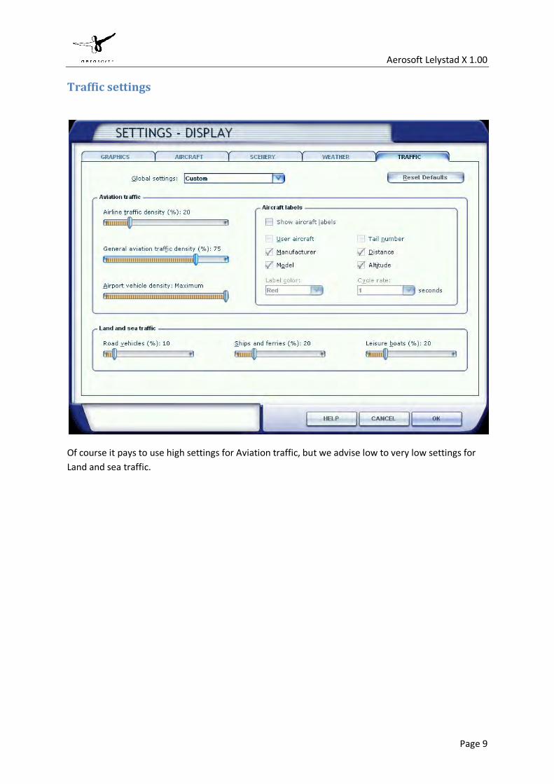
Traffic settings ............................................................................................................................... 9

Aerosoft Lelystad X 1.00
Page 3
Introduction Lelystad Airport has a short history, mainly because it is in a polder that was sea just a few decades ago. In 1973 it opened but it only got a paved runway in 1983. To this day it is a relative quiet airport, mostly used for training with three big flying schools on the airport terrain. As with most airports these days there are serious plans to enhance the airport so it can take over some of the traffic of Mainport Schiphol. A runway extension and ILS are being planned and should be accompanied with full Air Traffic Control services. This will make it a complete regional airport.
The airport also hosts the Dutch national aviation museum, the Aviodrome. It has a very nice collection and is well worth a visit. Flightsimmers know it as it is the location for arguably the largest Flight Simulation meeting every year, the FSWeekend. A few thousand flightsimmers will meet there every year.
System requirements
• Microsoft Flight Simulator FSX SP2 (or Acceleration) • Windows XP/Vista/Windows 7 (fully updated) • 2.0 GHz processor (Intel Core 2 Duo highly recommended) • 2 GB RAM internal memory • 256 MB graphic card (512 Mb highly recommended) • PDF reader for manual
Credits Concept: LimeSim, Aerosoft Programming: Sascha Normann Project Management: LimeSim, Mathijs Kok Manual, documentation: Mathijs Kok Installer: Andreas Mügge Testing: Several good folks who will all be getting a free copy Special thanks to Jan Schokker for this hospitality at the airport and Martin Schiescheck for the 3d animations.

Aerosoft Lelystad X 1.00
Page 4
Copyrights
The manual, documentation, video images, software, and all the related materials are copyrighted and cannot be copied, photocopied, translated or reduced to any electronic medium or machine legible form, neither completely nor in part, without the previous written consent of AEROSOFT. THE SOFTWARE IS FURNISHED «AS IS» AND IT DOES NOT COME FURNISHED WITH ANY GUARANTEE IMPLICIT OR EXPRESS. THE AUTHOR DECLINES EVERY RESPONSIBILITY FOR CONTINGENT MALFUNCTIONS, DECELERATION, AND ANY DRAWBACK THAT SHOULD ARISE, USING THIS SOFTWARE.
Copyright © 2009 AEROSOFT & LimeSim. All rights reserved. Windows®XP, Vista Windows 7 and Flight Simulator X are either registered trademarks or trademarks of Microsoft Corporation in the United States and/or other countries. All trademarks and brand names are trademarks or registered trademarks of the respective owners.
Copyrights are serious stuff. If you find any pirated copies of this software please notify us at [email protected]. We will make sure reports of copyrights violation are rewarded.
Aerosoft GmbH Lindberghring 12 D-33142 Büren, Germany www.aerosoft.com
Contact support
Support for this product is offered by Aerosoft. We prefer to have a support forum for the simple reason that it is fast and efficient because customers help customers when we are sleeping:
http://www.forum.aerosoft.com
and we advise the Customer Support > Scenery Discussions & Support section for any questions on this product. This should be your first stop for any support.
If you prefer support by email do accept that this could take a bit longer as it might be send from persons to person and that email support in the weekends is always slow: [email protected]. We feel strongly about support. Buying one of our products gives you the right to waste our time with questions you feel might be silly. They are not.
Removing the scenery Never remove the product manually, always used the control panel applet to do so. Failing to do so could create serious problems.

Aerosoft Lelystad X 1.00
Page 5
Coverage This scenery covers the complete airport area, the Aviodrome museum area and the immediate surroundings. The small grass strip for the Ultra Lights is included. The three car circuits located nearby are also included.
The Aviodrome museum plays an important part in the scenery. You will find all buildings and almost all the major aircraft that are on display outside. The Lockheed Neptune and Grumman S2 Tracker are not placed to keep framerates acceptable. Just consider them being overhauled in one of the hangars at the moment. The parking location in front of the old terminal is left empty as it is a perfect location to park your own aircraft. In summer time the Catalina is almost always there, waiting for the next load of enthusiast.
Compatibility with other scenery As far as we have tested this product is compatible with all existing scenery covering the same area assuming you follow information given here. Aerosoft however can only guarantee compatibility with a standard FSX. Discuss this on the forum with us if you have questions.
The car traffic on the A6 that runs close to the airport could conflict with UTX. If you use UTX you can solve this by disabling the [FSXMainFolder\Aerosoft\Lelystad X\Scenery\EHLE_Traffic.bgl file. Just move it to another folder or rename the BGL extension into something else and all car traffic on the roads will be removed.
Compatibility with DX10 Preview mode Because the scenery uses high resultion taxiways there are problems with the DX10 Preview Mode. This cannot be solved without an update for FSX, something we do not expect.
Taxiway and runway lights
Most of the taxiway and runway lights on this airport are not really lights but just reflective posts (as used a lot on roads). They reflect your landing and taxiway lights so you will only see them lit up when you get close to them. It is not possible however to detect if your lights are on, so you will see them reflecting even if your lights are off.

Aerosoft Lelystad X 1.00
Page 6
Settings & Frame rates We advice these setting for the best combination of looks and framerates. Do note that the settings are a bit different then for most scenery projects. We advice you strongly to stay in Summer season as Microsoft has a strange idea of winter in this area.
Display Settings
The Global texture setting needs to be on VERY HIGH, the other settings are not critical but because the scenery is very light on framerate it could be a great opportunity with the Lens flare and Light bloom settings that are often too demanding to use.

Aerosoft Lelystad X 1.00
Page 7
Scenery settings
This being a totally flat terrain Mesh is hardly used at all, keep it very low. Texture resolution must be at 30 cm. The area where the airport is located is a huge polder and almost completely covered with industrial farmlands. Huge fields with very little trees and buildings. We advise Water effects to be set low as the water in the scenery normally is very dark and green. Scenery complextity should be kept as high as possible. So a low Autogen density setting is actually more realistic and will make FSX a lot faster! Ground scenery shadow should better be kept on because all buildings have volumetric shdows and this makes them look MUCH better.

Aerosoft Lelystad X 1.00
Page 8
Weather settings
Weather settings are fully up to your liking but you most likely have enough framerates to use a good looking high definition setting. On most machines a max setting will be possible and the famous Dutch skies will complement the scenery!
Aerosoft Lelystad X 1.00
Page 9
Traffic settings
Of course it pays to use high settings for Aviation traffic, but we advise low to very low settings for Land and sea traffic.

Aerosoft Lelystad X 1.00
Page 10
Data ARP co-ordinates and site at AD 52°27’37”N 005°31’38”E
024 DEG GEO 435 m from TOWER
Direction and distance from (city) 3.5 NM SSE from Lelystad
Elevation / reference temperature 12 ft AMSL / 20.5°C (JUL)
MAG VAR / annual change 0° (2010) / 6'E.
Use Aerodrome available for national and international civil air traffic with all types of aircraft, including microlights.
Fuel AVGAS / Jet A1 (self service)
Taxiways Asphalt, 15 meters wide
Altimeter Checkpoint Apron, -12.6 ft AMSL
Information Lelystad Radio 123.675 MHz Lelystad Radio 123.825 MHz MLA only
AFIS Lelystad Aerodrome Information 123.675 MHz
Rwy True ° Dimensions Surface App lights PAPI TORA TODA ASAS LDA
05 47° 1250 x 30 Grass - Both 3° 1250 1250 1250 1250
23 277° 1250 x 30 Grass SALS 450m Left 3° 1250 1310 1310 1310
05 048° 430 x 50 Grass - - 320 - - 310
23 228° 430 x 50 Grass - - 310 - - 320
Type ID Freq
VOR/DME EEL 112.400 MHz
VOR/DME PAM 117.800 MHz
OR/DME RKN 116.800 MHz
VOR/DME RTM 110.400 MHz
VOR/DME SPY 113.300 MHz
NDB EHN 397 kHz
NDB LLS 326 kHz

05
23
010
020
030
040
0
050
010
00
500
1500
met
res
feet
AN
NU
AL
RA
TEO
F C
HA
NG
E 6
’ E
TRAFFIC 6
ft
TRAFFIC 6
ft
MLA
RW
Y 0
5/23
MLA
RW
Y 0
5/23
430
x 50
m
430
x 50
m
Mus
eum
Mus
eum
Avi
odro
me
Avi
odro
me
RWY 0
5/23
1
250
x 30
m
RWY 0
5/23
1
250
x 30
m
VAR 0° (2010)
SC
ALE
1 :
12 5
00
PA
PI
PA
PI
PA
PI
PA
PI
PA
PI
PA
PI
AC
L: A
PR
ON
-12.
6A
CL:
AP
RO
N -1
2.6
THR
ELE
VTH
R E
LEV
-12
ft A
MS
L-1
2 ft
AM
SL
THR
ELE
VTH
R E
LEV
-12
ft A
MS
L-1
2 ft
AM
SL
SIM
PLE
AP
PR
OA
CH
SIM
PLE
AP
PR
OA
CH
LIG
HTI
NG
SY
STE
MLI
GH
TIN
G S
YS
TEM
2323
0505
AA
BB
CC
DD
EE
GRASS
GRASS
CW
YC
WY
CW
YC
WY
TWR
TWR
AIS
/ME
TA
IS/M
ET
TER
MIN
AL
TER
MIN
AL
AR
PA
RP
52°2
7’37
’’N52
°27’
37’’N
005°
31’3
8’’E
005°
31’3
8’’E
"NO
T O
PE
RA
TIO
NA
L""N
OT
OP
ER
ATI
ON
AL"
LELY
STAD
/ LL
S-32
6LE
LYST
AD /
LLS-
326
52°2
7’46
’’N 0
05°3
1’55
’’E52
°27’
46’’N
005
°31’
55’’E
LELY
STAD
/ LS
DLE
LYST
AD /
LSD
109.
55 /
CH
.32Y
109.
55 /
CH
.32Y
52°2
7’29
’’N 0
05°3
1’14
’’E52
°27’
29’’N
005
°31’
14’’E
LOC
LOC
LSD
109
.550
LSD
109
.550
"NO
T O
PE
RA
TIO
NA
L""N
OT
OP
ER
ATI
ON
AL"
Sig
nal a
rea
Sig
nal a
rea
Hel
icop
ter
Hel
icop
ter
aim
ing
poin
tai
min
g po
int
II
IIII
IIIIII
IVIV
27 AUG 09AD 2.EHLE-ADCLELYSTAD AERODROME
AERODROME CHART
LEG
EN
DLE
GE
ND
RW
YR
WY
THR
THR
TOR
ATO
RA
AS
DA
AS
DA
TOD
ATO
DA
LDA
LDA
mmmm
mmmm
005°
30’3
9.67
’’E00
5°30
’39.
67’’E
005°
31’2
8.52
’’E00
5°31
’28.
52’’E
DIM
EN
SIO
NS
(m
)D
IME
NS
ION
S (
m)
RU
NW
AY
RU
NW
AY
STR
IPS
TRIP
CO
OR
DIN
ATE
SC
OO
RD
INA
TES
SU
RFA
CE
SU
RFA
CE
PH
YS
ICA
L C
HA
RA
CTE
RIS
TIC
SP
HY
SIC
AL
CH
AR
AC
TER
ISTI
CS
DE
CLA
RE
D D
ISTA
NC
ES
DE
CLA
RE
D D
ISTA
NC
ES
BE
AR
ING
BE
AR
ING
STR
EN
GTH
STR
EN
GTH
52°2
7’04
.12’
’N52
°27’
04.1
2’’N
0505 232352
°27’
31.4
2’’N
52°2
7’31
.42’
’N
PC
N 1
9/F/
D/W
/TP
CN
19/
F/D
/W/T
PC
N 1
9/F/
D/W
/TP
CN
19/
F/D
/W/T
1250
1250
1250
1250
1250
1250
1310
1310
1250
1250
1250
1250
1310
1310
1250
1250
DIM
EN
SIO
NS
(m
)D
IME
NS
ION
S (
m)
MA
RK
ING
AID
SM
AR
KIN
G A
IDS
DIR
EC
TIO
ND
IRE
CTI
ON
GE
OG
EO
DIR
EC
TIO
ND
IRE
CTI
ON
GE
OG
EO
MIC
RO
LIG
HT
AIR
CR
AFT
(M
LA)
In fr
ont o
f the
run
way
indi
cate
s th
e la
ndin
g di
rect
ion
In fr
ont o
f the
run
way
indi
cate
s th
e la
ndin
g di
rect
ion
com
bine
d w
ith a
LE
FTH
AN
D c
ircui
tco
mbi
ned
with
a L
EFT
HA
ND
circ
uit
In fr
ont o
f the
run
way
indi
cate
s th
e la
ndin
g di
rect
ion
In fr
ont o
f the
run
way
indi
cate
s th
e la
ndin
g di
rect
ion
com
bine
d w
ith a
RIG
HTH
AN
D c
ircui
tco
mbi
ned
with
a R
IGH
THA
ND
circ
uit
WH
ITE
WH
ITE
CA
UTI
ON
CA
UTI
ON
1250
x 3
012
50 x
30
1250
x 3
012
50 x
30
1370
x 3
0013
70 x
300
1370
x 3
0013
70 x
300
RW
YR
WY
RW
YR
WY
TOR
ATO
RA
mmLD
ALD
A mm
048°
048°
228°
228°
0505 2323by
red
con
esby
red
con
es43
0 x
5043
0 x
50
320
320
310
310
310
310
320
320
MLA
RW
Y m
arke
dM
LA R
WY
mar
ked
Vis
iting
Mic
ro L
ight
Airc
raft
shal
l ask
prio
r pe
rmis
sion
Vis
iting
Mic
ro L
ight
Airc
raft
shal
l ask
prio
r pe
rmis
sion
from
the
AD
aut
horit
y (T
EL:
032
0 28
8 32
8).
from
the
AD
aut
horit
y (T
EL:
032
0 28
8 32
8).
Taxi
hol
ding
pos
ition
mar
king
Taxi
hol
ding
pos
ition
mar
king
Win
d di
rect
ion
indi
cato
rW
ind
dire
ctio
n in
dica
tor
MIC
RO
LIG
HT
AIR
CR
AFT
MIC
RO
LIG
HT
AIR
CR
AFT
AIRAC AMDT 09/09
Gra
ss c
uttin
g m
ay ta
ke p
lace
at i
rreg
ular
tim
es.
Gra
ss c
uttin
g m
ay ta
ke p
lace
at i
rreg
ular
tim
es.
Par
ts o
f the
aer
odro
me
unus
able
due
to a
gric
ultu
ral u
se.
Par
ts o
f the
aer
odro
me
unus
able
due
to a
gric
ultu
ral u
se.
In th
e vi
cini
ty o
f the
hel
icop
ter
aim
ing
poin
t hel
icop
ter
trai
ning
flig
hts
In th
e vi
cini
ty o
f the
hel
icop
ter
aim
ing
poin
t hel
icop
ter
trai
ning
flig
hts
may
take
pla
ce b
etw
een
runw
ay a
nd b
uild
ings
on
the
aero
drom
e.m
ay ta
ke p
lace
bet
wee
n ru
nway
and
bui
ldin
gs o
n th
e ae
rodr
ome.
Hel
icop
ters
use
gra
ss a
reas
I up
to IV
for
prec
autio
nary
land
ings
.H
elic
opte
rs u
se g
rass
are
as I
up to
IV fo
r pr
ecau
tiona
ry la
ndin
gs.
AS
PH
AS
PH
AS
PH
AS
PH
AD
ELE
V -
12 f
t A
MS
L
© Air Traffic Control the Netherlands
047.
54°
047.
54°
227.
55°
227.
55°
AIP NETHERLANDS
ELE
VA
TIO
NS
IN F
EE
T A
MS
LE
LEV
ATI
ON
S IN
FE
ET
AM
SL
CH
AN
GE
: VA
R, e
dito
rial.

LELY
STA
DLE
LYS
TAD
Lars
erbo
sLa
rser
bos
Lage
Vaa
rt
Lage
Vaa
rt
Larserva
art
Larserva
art
Eenden
tocht
Eenden
tocht
Hoge
Vaa
rt
Hoge
Vaa
rt
Hoekwantto
cht
Hoekwantto
cht
Kokk
elto
cht
Kokk
elto
cht
Wiertocht
Wiertocht
Lage
Kna
rtoch
t
Lage
Kna
rtoch
t
Hoge Kna
rtoch
t
Hoge Kna
rtoch
t
Meeuw
entoch
t
Meeuw
entoch
tK
narb
osK
narb
os
Har
derb
osH
arde
rbos
Bid
ding
-B
iddi
ng-
huiz
enhu
izen
Velu
we-
mee
r
Velu
we-
mee
r
Lely
stad
-Le
lyst
ad-
have
nha
ven
Knardijk
Knardijk
Zeeb
iest
ocht
Zeeb
iest
ocht
Nat
uurp
ark
Nat
uurp
ark
Lely
stad
Lely
stad
Hol
land
se
H
out
Hol
land
se
H
out
G
LELY
STA
D /
52°2
7’46
’’NLL
S-3
2600
5°31
’55’
’E
VOR
/DM
E(P
AM
)-11
7.8/
CH
.125
X
065-
17.7
’
210 EXIT
05
EX
IT 0
5
EX
IT 2
3
EX
IT 2
3
23
05
1500
ft A
MSL
MLA
EN
TRY
MLA
RE
PO
RTI
NG
PO
INT
VIC
TOR
ATZ LELYSTAD
ATZ LELY
STAD
EN
TRY
GLI
DE
R A
CTI
VIT
IES
CA
UTI
ON
178
156
171
1500 ft AMSL
HA
P
BR
AV
Oat
700
ft
AA
L
SIE
RR
A
HO
TEL
at 5
00 f
t A
AL
HEL CIR
CUIT A
REA
319
EX
IT 0
5
EX
IT 2
3
MLA
CIR
CUIT A
REA
HE
L E
NTR
Y
CIRCUIT
AREA
246
315
316
316
316
OO
STE
LIJK
FLE
VO
LAN
DFL
060
27 AUG 09
BE
AR
ING
S A
RE
MA
GN
ETI
CD
ISTA
NC
ES
IN N
MA
LTIT
UD
ES
AN
D E
LEV
ATI
ON
SIN
FE
ET
AM
SL
HIG
HE
ST
KN
OW
N E
LEV
ATI
ON
ON
TH
IS C
HA
RT:
319
ftm50
00
1000
2000
2000
0
1000
4000
600020
00
Are
a to
be
avoi
ded
For
des
crip
tion
VFR
- p
roce
dur
esse
e E
HLE
AD
2.2
2.A
D E
LEV
-12
AD
ELE
V -
12
Vis
ual c
ircui
t mar
ker
(ora
nge
colo
ured
)
124.
300
FIC
(M
IL)
Dut
ch M
IL In
fo
AD
FIC
Am
ster
dam
Info
rmat
ion
123.
675
123.
825
132.
350
Lely
stad
Rad
io A
D In
fo
Lely
stad
Rad
io A
D In
fo(M
LA o
nly)
AD
52°
52°
30’
30’
NN
005°
25’
E00
5° 2
5’E
005°
40’
E00
5° 4
0’E
005°
30’
005°
30’
005°
35’
005°
35’
52°
52°
25’
25’
NN
AD 2.EHLE-VAC
© Air Traffic Control the Netherlands Topography © Topografische Dienst Kadaster
Hel
icop
ter
aim
ing
poin
t (H
AP
)
AIRAC AMDT 09/09
LELYSTADVISUAL APPROACH CHART
VAR 0° (2010)
CH
AN
GE
: VA
R, e
dito
rial.
AIP NETHERLANDS

DA
TE O
F S
UR
VE
Y
:
SE
P 0
8D
ATE
OF
SU
RV
EY
: S
EP
08
5050005050100
100
150
150
10100010102020303040405050
FEE
TFE
ET
ME
TRE
SM
ETR
ES
AIP NETHERLANDSAIP NETHERLANDS 22 OCT 0922 OCT 09
500
500
0050
050
010
0010
0015
0015
00
1000
1000
0010
0010
0020
0020
0030
0030
0040
0040
0050
0050
00
ME
TRE
SM
ETR
ES
FEE
TFE
ET
IDE
NTI
FIC
ATI
ON
NU
MB
ER
IDE
NTI
FIC
ATI
ON
NU
MB
ER
TRE
ETR
EE
PO
LE, T
OW
ER
, SP
IRE
, AN
TEN
NA
, CH
IMN
EY
PO
LE, T
OW
ER
, SP
IRE
, AN
TEN
NA
, CH
IMN
EY
TRA
FFIC
(IN
PLA
N)
TRA
FFIC
(IN
PLA
N)
TRA
FFIC
(IN
PR
OFI
LE)
TRA
FFIC
(IN
PR
OFI
LE)
WIN
DM
ILL
WIN
DM
ILL
BU
ILD
ING
OR
LA
RG
E S
TRU
CTU
RE
BU
ILD
ING
OR
LA
RG
E S
TRU
CTU
RE
AERODROME OBSTACLE CHART TYPE AAERODROME OBSTACLE CHART TYPE ALELYSTAD RWY 05 - 23LELYSTAD RWY 05 - 23
SC
ALE
1 :
20,0
00S
CA
LE 1
: 20
,000
SC
ALE
1 :
2,00
0S
CA
LE 1
: 2,
000
SU
RV
EY
ING
AG
EN
CY
: R
ijksw
ater
staa
t, A
dvie
sdie
nst G
eo-in
form
atie
en
ICT.
SU
RV
EY
ING
AG
EN
CY
: R
ijksw
ater
staa
t, A
dvie
sdie
nst G
eo-in
form
atie
en
ICT.
0505
2323
FURTHER NO FURTHER NO
1550
1550
1850
1850
2150
2150
2450
2450
2750
2750
3050
3050
1550
1550
1850
1850
2150
2150
2450
2450
2750
2750
3050
3050
00
5050 4040 3030 2020 1010 00
4040 3030 2020 1010 00
1.2
% S
LOP
E1.
2 %
SLO
PE
1.2
% S
LOP
E1.
2 %
SLO
PE
FURTHER ONEFURTHER ONE
OBSTACLES OBSTACLES
AS
PH
ALT
AS
PH
ALT
1250
x 3
012
50 x
30
-3.7
3-3
.73
-3.6
9-3
.69
-3.73 -3.73
-3.69 -3.69
12.3
712
.37
-3.4
6-3
.46
15.9
915
.99
6.00
6.00
ELE
V 6
5.76
ELE
V 6
5.76
OBSTACLEOBSTACLE
AD 2.EHLE-AOC-05-23AD 2.EHLE-AOC-05-23
AIRAC AMDT 11/09AIRAC AMDT 11/09© Air Traffic Control the Netherlands© Air Traffic Control the Netherlands
RW
Y 0
5R
WY
05
RW
Y 2
3R
WY
23
1250
1250
1310
1310
1310
1310
1250
1250
1250
1250
1250
1250
1250
1250
1250
1250
Take
- O
ff R
un A
vaila
ble
Take
- O
ff R
un A
vaila
ble
Take
- O
ff D
ista
nce
Ava
ilabl
eTa
ke -
Off
Dis
tanc
e A
vaila
ble
Acc
eler
ate
Sto
p D
ista
nce
Ava
ilabl
eA
ccel
erat
e S
top
Dis
tanc
e A
vaila
ble
Land
ing
Dis
tanc
e A
vaila
ble
Land
ing
Dis
tanc
e A
vaila
ble
CH
AN
GE
: VA
R, T
HR
ELE
V, e
dito
rial.
CH
AN
GE
: VA
R, T
HR
ELE
V, e
dito
rial.
DIM
EN
SIO
NS
AN
D E
LEV
ATI
ON
S IN
ME
TRE
SD
IME
NS
ION
S A
ND
ELE
VA
TIO
NS
IN M
ETR
ES
MA
GN
ETI
C V
AR
IATI
ON
: 0°
- 20
10M
AG
NE
TIC
VA
RIA
TIO
N :
0° -
2010
DIR
EC
TIO
NS
AR
E M
AG
NE
TIC
DIR
EC
TIO
NS
AR
E M
AG
NE
TIC
-1.7
3-1
.73
1.52
1.52
ELE
V 7
9.38
ELE
V 7
9.38
6560
m /
231°
6560
m /
231°
from
TH
R 2
3fro
m T
HR
23
4679
m /
046°
4679
m /
046°
from
TH
R 0
5fro
m T
HR
05

G
05
23
LELYSTAD /52°27’46’’N
LLS- 326005°31’55’’E
215°
1 min2000
025°
241°
1 min
9.5
241°
FAFPAM
048°
TO LLS
MAX 140 KT IAS
11.2
8.5 PAM
10 NM
IAF
CAUTIONDesignated operational rangeof LLS NDB: 15 NM
NOTE:1. Instrument Approach procedures only
2. Execution of the full published procedureis mandatory. Straight-in approachis not allowed.
permitted outside UDP (MON - FRI) by specialarrangement by AD authority (see EHLE AD 2.3).
BIDDINGHUIZEN
PAMPUS /117.8 /
52°20’05’’NCH.125
PAM
005°05’32’’EX
PAMPUS /117.8 /
52°20’05’’NCH.125
PAM
005°05’32’’EX
EHR 316500
GNDAGL
314
314
318
318
345
345
331
331
347 347331
331
607
636
400
AD ELEV-12
LLSMAPt
CIRCLINGNDB/DME
310 (320)
123.675AFIS Lelystad Aerodrome Information
APP 119.050(TAR)
Schiphol Approach/Departure
121.500
1705
1355
665
048°
THR 16.9
17.9
DIST RELATED TO PAM VOR/DME
INSTRUMENT APPROACH CHARTAIP NETHERLANDS
5°20’E 5°30’ 5°40’ 5°50’E
N
52°20’
N
52°30’
LELYSTAD
LIMITINGOUTBOUNDDIST 30 PAM
NDB/DME(LLS) (PAM)
A
B
C
D
TAKE-OFF
LANDING
DAY:
DAY:NA
NIGHT:
NIGHT:NA
CEILING AND VISIBILITY MINIMA
NOT ALLOWED
NOT ALLOWED
MSA BASED ON LLS NDB
NOT ALLOWED
1700
ACFTCAT
241°
TO LLS
14 15
FAF11.2 PAM
241°
035°
13
RWY 05
025°
8.5 PAM241° 215°
11.2 12
05
MNM ALT1000
MAPt : NDB (LLS)
048°
(OCH)
MLI
ITINGOUTBOUND
DIST30
PAM
TRANSITION ALTITUDE 3000 ft AMSLTRANSITION LEVEL BY ATC
TRANSITION ALTITUDE 3000 ft AMSLTRANSITION LEVEL BY ATC
TRANSITION ALTITUDE 3000 ft AMSLTRANSITION LEVEL BY ATC
BEARINGS ARE MAGNETICDISTANCES IN NMALTITUDES AND ELEVATIONSIN FEET
%3° (5.2 )
1. Missed Approach:- Track 048° MAG and climb to 2000 ft AMSL;- At 1000 ft AMSL start a right climbing turn to LLS;- Inform ATC immediately on current FREQ.
2. Missed Approach in case of communication failure:- Track 048° MAG and climb to 2000 ft AMSL;- At 1000 ft AMSL start a right climbing turn to LLS
and hold or execute the instrument approachprocedure again.
General Emergencyin Amsterdam FIR
© Air Traffic Control the Netherlands
AD 2.EHLE-IAC-05.127 AUG 09
AIRAC AMDT 09/09
ACC 128.350 Dutch MIL
VA
R 0° (2010)
100 120 140 160GS IN KT
VERTICAL SPEED 320 ft/min 425 ft/min 530 ft/min 635 ft/min 745 ft/min
60 80
850 ft/min
2000
048°
CH
AN
GE
: V
AR
, AD
ELE
V, T
HR
ELE
V, o
bsta
cles
, edi
toria
l.
THR ELEV -12
OCA ELEV THR 05: - 12.2 ft
G
05
23
LELYSTAD /52°27’46’’N
LLS- 326005°31’55’’E
PAMPUS /117.8 /
52°20’05’’NCH.125
PAM
005°05’32’’EX
PAMPUS /CH.125
PAMX
244°
048°
239°21
1°
IAF 1 min2000
EHR 316500
GNDAGL
CAT B: 2.5 min
CAT A: 3.5 m
in
CAT
A: 0
28°
CAT
B: 0
23°
MAX 140 KT IAS
10 NM
CAUTIONDesignated operational rangeof LLS NDB: 15 NM
NOTE:1. Prior permission required from Schiphol APP.2. Instrument Approach procedures only
3. Execution of the full published procedureis mandatory. Straight-in approachis not allowed.
permitted outside UDP (MON - FRI) by specialarrangement by AD authority (see EHLE AD 2.3).
BIDDINGHUIZEN
TO LLS
1 min
314
314
318
318
345
345
331
331
347 347331
331
607
636
400
AD ELEV-12
NDB
A
B
C
D
890 (900)
CIRCLINGMAPt: NDB (LLS)
NOT ALLOWED
NOT ALLOWED
NOT ALLOWED
TAKE-OFF
LANDING
DAY:
DAY:NA
NIGHT:
NIGHT:NA
CEILING AND VISIBILITY MINIMA
INSTRUMENT APPROACH CHART
5°20’E 5°30’ 5°40’ 5°50’E
N
52°20’
N
52°30’
LELYSTADRWY 05
(OCH) MSA BASED ON LLS NDB
1700
031°211°2000
1500
TO LLS
048°
NDB(LLS)
BEARINGS ARE MAGNETICDISTANCES IN NMALTITUDES AND ELEVATIONSIN FEET
ACFTCAT
CAT A: 3.5 min 239°
CAT B: 2.5 min 244°CAT A: 239°CAT B: 244°
CAT A: 028°CAT B: 023°
LLSMAPt
05 23
048°
LIMITINGOUTBOUNDDIST 30 PAM
TRANSITION ALTITUDE 3000 ft AMSL
LIMITING
OUTBOUNDDIST
30PAM
TRANSITION LEVEL BY ATC
1. Missed Approach:- Track 048° MAG and climb to 2000 ft AMSL;- At 1000 ft AMSL start a right climbing turn to LLS;- Inform ATC immediately on current FREQ.
2. Missed Approach in case of communication failure:- Track 048° MAG and climb to 2000 ft AMSL;- At 1000 ft AMSL start a right climbing turn to LLS
and hold or execute the instrument approachprocedure again.
%3° (5.2 )
123.675AFIS Lelystad Aerodrome Information
APP 119.050(TAR)
Schiphol Approach/Departure
121.500 General Emergencyin Amsterdam FIR
AIP NETHERLANDS
© Air Traffic Control the Netherlands
AD 2.EHLE-IAC-05.2
ACC 128.350 Dutch MIL
27 AUG 09V
AR
0° (2010)
OCA ELEV THR 05: - 12.2ft
100 120 140 160GS IN KT
VERTICAL SPEED 320 ft/min 425 ft/min 530 ft/min 635 ft/min 745 ft/min
60 80
850 ft/min
AIRAC AMDT 09/09
CH
AN
GE
: V
AR
, AD
ELE
V, T
HR
ELE
V, o
bsta
cles
, edi
toria
l.
THR ELEV -12

G
23
05
LELYSTAD /52°27’46’’N
LLS- 326005°31’55’’E
PAMPUS /117.8 /
52°20’05’’NCH.125
PAM
005°05’32’’EX
1 min2000
035°
FAFPAM
228°
MAX 140 KT IAS
8
23.6
PAM25.2
TO LLS
10 NM
IAF
NOTE:1. Instrument Approach procedures only
2. Execution of the full published procedureis mandatory. Straight-in approachis not allowed.
permitted outside UDP (MON - FRI) by specialarrangement by AD authority (see EHLE AD 2.3).
CAUTIONDesignated operational rangeof LLS NDB: 15 NM
BIDDINGHUIZEN
EHR 316500
GNDAGL
215°
314
314
318
318
345
345
331
331
347 347331
331
607
636
400
AD ELEV-12
NDB/DME
A
B
C
D
(470)
CIRCLING
215° 035°
228°
THR 17.6
035°
035°
17.9 19 20 21 22 23 23.6
500
835
18201490
228°
25.2 PAM
DIST RELATED TO PAM VOR/DME
TO LLS
TAKE-OFF
LANDING
DAY:
DAY:NA
NIGHT:
NIGHT:NA
CEILING AND VISIBILITY MINIMA
MSA BASED ON LLS NDB
1700
ACFTCAT
LLSMAPt
MNM ALT1160
FAF23.6 PAM
INSTRUMENT APPROACH CHART
5°20’E 5°30’ 5°40’ 5°50’E
N
52°20’
N
52°30’
LELYSTADRWY 23
LIMITINGOUTBOUNDDIST 30 PAM
NDB/DME(LLS) (PAM)
2000
(OCH)
AIP NETHERLANDS
228°
05 23
OCA
NOT ALLOWED
NOT ALLOWED
NOT ALLOWED
MAPt: NDB (LLS)
MLI
ITINGOUTBOUND
DIST30
PAM
BEARINGS ARE MAGNETICDISTANCES IN NMALTITUDES AND ELEVATIONSIN FEET
TRANSITION ALTITUDE 3000 ft AMSLTRANSITION LEVEL BY ATC
TRANSITION ALTITUDE 3000 ft AMSLTRANSITION LEVEL BY ATC
TRANSITION ALTITUDE 3000 ft AMSLTRANSITION LEVEL BY ATC
1. Missed Approach:- Track 228° MAG and climb to 2000 ft AMSL;- At 1000 ft AMSL start a right climbing turn to LLS;- Inform ATC immediately on current FREQ.
2. Missed Approach in case of communication failure:- Track 228° MAG and climb to 2000 ft AMSL;- At 1000 ft AMSL start a right climbing turn to LLS
and hold or execute the instrument approachprocedure again.
460
%3° (5.2 )
123.675AFIS Lelystad Aerodrome Information
APP 119.050(TAR)
Schiphol Approach/Departure
121.500 General Emergencyin Amsterdam FIR
AD 2.EHLE-IAC-23.1
© Air Traffic Control the Netherlands
ACC 128.350 Dutch MIL
VA
R 0° (2010)
27 AUG 09
ELEV THR 23: - 12.1 ft
AIRAC AMDT 09/09
CH
AN
GE
: V
AR
, AD
ELE
V, T
HR
ELE
V, o
bsta
cles
, edi
toria
l.100 120 140 160GS IN KT
VERTICAL SPEED 320 ft/min 425 ft/min 530 ft/min 635 ft/min 745 ft/min
60 80
850 ft/min
THR ELEV -12

G
23
05
LELYSTAD /52°27’46’’N
LLS- 326005°31’55’’E
PAMPUS /117.8 /
52°20’05’’NCH.125
PAM
005°05’32’’EX
PAMPUS /117.8 / CH.125
PAMX
IAF1 min
MAX140 KT IAS
2000
031°
037°
228°
TO LLS
CAT
B: 2
min
CAT
A: 3
min
10 NM
CAUTIONDesignated operational rangeof LLS NDB: 15 NM
NOTE:1. Prior permission required from Schiphol APP.2. Instrument Approach procedures only
3. Execution of the full published procedureis mandatory. Straight-in approachis not allowed.
permitted outside UDP (MON - FRI) by specialarrangement by AD authority (see EHLE AD 2.3).
EHR 316500
GNDAGL
BIDDINGHUIZEN211°
314
314
318
318
345
345
331
331
347 347
331331
607
636
400
314
318
318
345
345
331
331
347
607
636
400
AD ELEV-12
NDB
A
B
C
D
490 (500)
CIRCLING
031°
211°
TO LLS
CAT A: 3 min 037°CAT B: 2 min 031°
228°
PAPI 3°
TAKE-OFF
LANDING
DAY:
DAY:NA
NIGHT:
NIGHT:NA
CEILING AND VISIBILITY MINIMA
INSTRUMENT APPROACH CHART
5°20’E 5°30’ 5°40’ 5°50’E
N
52°20’
N
52°30’
LELYSTADRWY 23
(OCH) MSA BASED ON LLS NDB
1700
2000
1500
NDB(LLS)
ACFTCAT
LLSMAPt
228°
05 23
LIMITINGOUTBOUNDDIST 30 PAM
MAPt: NDB (LLS)
NOT ALLOWED
NOT ALLOWED
NOT ALLOWED
MLI
ITINGOUTBOUND
DIST30
PAM
BEARINGS ARE MAGNETICDISTANCES IN NMALTITUDES AND ELEVATIONSIN FEET
TRANSITION ALTITUDE 3000 ft AMSLTRANSITION LEVEL BY ATC
1. Missed Approach:- Track 228° MAG and climb to 2000 ft AMSL;- At 1000 ft AMSL start a right climbing turn to LLS;- Inform ATC immediately on current FREQ.
2. Missed Approach in case of communication failure:- Track 228° MAG and climb to 2000 ft AMSL;- At 1000 ft AMSL start a right climbing turn to LLS and hold
or execute the instrument approach procedure again.
123.675AFIS Lelystad Aerodrome Information
APP 119.050(TAR)
Schiphol Approach/Departure
121.500 General Emergencyin Amsterdam FIR
%3° (5.2 )
AIP NETHERLANDS
© Air Traffic Control the Netherlands
AD 2.EHLE-IAC-23.2
ACC 128.350 Dutch MIL
27 AUG 09
VA
R 0° (2010)
AIRAC AMDT 09/09
CH
AN
GE
: V
AR
, AD
ELE
V, T
HR
ELE
V, o
bsta
cles
, edi
toria
l.
OCA ELEV THR 23: - 12.1ft
100 120 140 160GS IN KT
VERTICAL SPEED 320 ft/min 425 ft/min 530 ft/min 635 ft/min 745 ft/min
60 80
850 ft/min
THR ELEV -12

3000 ft AMSL
3000 ft AMSL
3000 ft AMSL3000 ft AMSL
0523
305°
330°
181°
SPY 306
PAM 065
PAM 252
PAM
207
PAM 112
SPY 053
PAM 090
SPY 053
20.1 PAM
I J S S E L M E E R
SP
Y 185
PAM 112
SPY 101
SPY 088
GRONY
ANDIK
PAMSPY
25.219.4
52°44’22’’N015.9052.6
005°16’14’’E
ANDIK 1E
LELYSTAD / LLS - 32652°27’46’’N005°31’55’’E
NYKER 1E
NYKER17.3
52°13’49’’NPAM 111.9
005°31’44’’E
ARNEM
LEKKOPAM27.4
51°55’27’’N206.9
004°46’02’’E
INKET
SCHIPHOL /108.4 / CH.21
SPLX / ATIS PAMPUS /
117.8 / CH.125PAM
X52°19’56’’N004°45’00’’E
52°20’05’’N005°05’32’’E
PAMVALKO
48.952°04’17’’N
252.4003°50’23’’E
VALKO 1E
BERGI22.0
52°44’56’’NSPY 305.8
004°21’32’’ESPIJKERBOOR /
113.3 / CH.80SPYX
52°32’25’’N 004°51’14’’E
BERGI 1E
LEKKO 1E
5°30’
AIP NETHERLANDS
6°E
52°30’
52°N
STANDARD DEPARTURE CHART-INSTRUMENTLELYSTAD RWY 05
DISTANCES IN NMALTITUDES IN FEETDIRECTIONS ARE MAGNETIC
23 SPY 304
SIDVOR RADIALBEARING
DME SPY 23 NMVOR SPY RADIAL 304
N
52°40’
52°20’
52°10’
4°50’E 5°10’ 5°20’ 5°30’ 5°40’ 5°50’
NOTE : IFR PROCEDURES ONLY OUTSIDE U.D.P
GENERAL
5°
BELOW FL 100 : MAX 250 KT IAS
OPR HRS see EHLE AD 2.3
AVERAGE VAR 0° (2010)
123.675AFIS Lelystad Aerodrome Information
APP
121.500
119.050
General Emergencyin Amsterdam FIR
118.400
Schiphol Approach/Departure
Schiphol Arrival(TAR) 121.200
TRANSITION ALTITUDE : 3000ft AMSL
AIRAC AMDT 09/09
27 AUG 09
© Air Traffic Control the Netherlands
AD 2.EHLE-SID-05
FOR CONTINUATION OF THE ROUTESsee AD 2.EHLE-SID-OVERVIEW
ACC 128.350 Dutch MIL
CH
AN
GE
: V
AR
, edi
toria
l.

3000 ft AMSL
3000 ft AMSL
3000 ft AMSL
3000 ft AMSL
2305
SCHIPHOL /108.4 / CH.21
SPLX / ATIS
LELYSTAD / LLS - 326
PAMPUS /117.8 / CH.125
PAMX
SPIJKERBOOR /113.3 / CH.80
SPYX
ANDIK
PAMSPY
LEKKOPAM
004°
330°
181°
SPY 306
SPY 101
SPY 053
PAM 065
PAM 112
PAM 252
PAM
207
SPY 053
PAM 090
PAM 112
I J S S E L M E E R
27.451°55’27’’N
206.9004°46’02’’E
PAMVALKO
48.952°04’17’’N
252.4003°50’23’’E
52°19’56’’N 004°45’00’’E
52°20’05’’N 005°05’32’’E
52°27’46’’N005°31’55’’E
NYKER17.3
52°13’49’’NPAM 111.9
005°31’44’’E
BERGI22.0 SPY 305.8
004°21’32’’E
25.219.4
52°44’22’’N015.9052.6
005°16’14’’E
GRONY
SPY 088
SP
Y 185 INKET
52°32’25’’N 004°51’14’’E
ARNEM
ANDIK 1F
BERGI 1F
VALKO 1FNYKER 1F
LEKKO 1F
52°44’56’’N
14.7PAM
5°30’
AIP NETHERLANDS
6°E
52°10’
N
52°N
STANDARD DEPARTURE CHART-INSTRUMENTLELYSTAD RWY 23
DISTANCES IN NMALTITUDES IN FEETDIRECTIONS ARE MAGNETIC
23 SPY 304
SIDVOR RADIALBEARING
DME SPY 23 NMVOR SPY RADIAL 304
GENERAL
5°50’5°40’5°20’5°10’4°50’E
52°40’
52°20’
52°30’
NOTE : IFR PROCEDURES ONLY OUTSIDE U.D.P
5°
BELOW FL 100 : MAX 250 KT IAS
OPR HRS see EHLE AD 2.3
AVERAGE VAR 0° (2010)
TRANSITION ALTITUDE : 3000ft AMSL
© Air Traffic Control the Netherlands
AD 2.EHLE-SID-23
FOR CONTINUATION OF THE ROUTESsee AD 2.EHLE-SID-OVERVIEW
27 AUG 09
AIRAC AMDT 09/09
123.675AFIS Lelystad Aerodrome Information
APP
121.500
119.050
General Emergencyin Amsterdam FIR
118.400
Schiphol Approach/Departure
Schiphol Arrival(TAR) 121.200
ACC 128.350 Dutch MIL
CH
AN
GE
: V
AR
, edi
toria
l.

BE
RG
I
VA
LKO
NY
KE
R
AN
DIK
LEK
KO
OU
TLIN
E S
ID C
HA
RTS
see
AD
2.E
HLE
-SID
-05
and
AD
2.E
HLE
-SID
-23
(U)L
602
L602
(U)L
602
L602
(U)P1P1
(U)L
60L60
L980
(U)L
980
P20
(U)P
20P
20(U
)P20
L980
(U)L
980
(U)Y
76 Y76
L980
(U)L
980
(U)N872
(U)N872(U)N872
(U)L
620
(U)L
620
(U)L
620
(U)L
620
UP
147
UL9
80
(U)P
148
(U)P
148
(U)L
603
(U)L
603
(U)L
603
(U)L
603
(U)N
125
(U)N
125
(U)P999
(U)P999
(U)P174(U)P174
UZ7
00
UP603
(U)M
105
(U)M
105
(U)N
873
(U)N
873
(U)N
873
(U)N
873
(U)P71
P57
P57
P57
P57
SCH
IPH
OL
/10
8.4
/CH
.21
SPL
EIN
DH
OVE
N /
EHN
-39
7
LELY
STAD
/LL
S -
326
PAM
PUS
/11
7.8
/C
H.1
25PAM X
SPIJ
KER
BOO
R /
113.
3 /
CH
.80
SPY
X
INKE
T
NYK
ER
REF
SO
AND
IK
LEKK
O
BED
UM
GR
ON
Y
BER
GI
WO
OD
Y
ARN
EM
AMST
ERD
AM F
IR
BRU
SSEL
S FI
R
BREMEN FIR / CTA
AMSTERDAM FIR
L A N G E F I RN
DA M S T E R F I RA M
LONDON FIR AMSTERDAM FIR
51°2
8’04
’’N00
5°23
’42’
’E
RO
TTER
DAM
/11
0.4
/51
°58’
25’’NC
H.4
1 004°
28’5
1’’E
X / A
TIS
RTM
52°2
0’05
’’N00
5°05
’32’
’E
52°1
9’56
’’N00
4°45
’00’
’E
52°3
2’25
’’N00
4°51
’14’
’E52
°27’
46’’N
005°
31’5
5’’E
VALK
O
006°
40’0
0’’E
EELD
E /
112.
4 /
53°0
9’50
’’NC
H.7
1EE
L
ATIS
X /
SON
EB
REK
KEN
/11
6.8
/52
°08’
00’’N
CH
.115RKN
006°
45’5
0’’E
X
MIM
VA
AMG
OD
GO
RLO
ARKO
N
GR
EFI
LABI
LTE
MLU
SOM
PO
DO
BAK
DID
AM
SUPU
R
LAR
AS
KOLA
G
GO
DO
S
PEVA
DR
INIS
XAM
AN
RIM
BU
TEBR
O
X
LEKM
O ETEB
O
OKN
OG
BR
EMEN
FIR
LAN
GEN
FIR
SOPV
I OSG
OS
AIP NETHERLANDS STANDARD DEPARTURE CHART-INSTRUMENTLELYSTAD
53°
N 52°
51°
N
2°E
3°4°
5°6°
7°E
123.
675
AFI
SLe
lyst
ad A
erod
rom
eIn
form
atio
n
AP
P
121.
500
119.
050
Gen
eral
Em
erge
ncy
in A
mst
erda
m F
IR
131.
150
118.
400
121.
200
Sch
ipho
l App
roac
h/D
epar
ture
Sch
ipho
l App
roac
h/D
epar
ture
Sch
ipho
l Arr
ival
(TA
R)
23 S
PY
304
DIS
TAN
CE
S IN
NM
DIR
EC
TIO
NS
AR
E M
AG
NE
TIC
DM
E S
PY
23
NM
VO
R S
PY
RA
DIA
L 30
4
ALT
ITU
DE
S IN
FE
ET
ATS
RO
UTE
SID
RO
UTE
AS
DE
SC
RIB
ED
SID
RO
UTE
TRA
NS
ITIO
N A
LTIT
UD
E :
3000
ft A
MS
L
MA
XIM
UM
SP
EE
D :
Bel
ow F
L 10
0 : M
AX
250
KT
IAS
© Air Traffic Control the Netherlands AIRAC AMDT 09/09
27 AUG 09AD 2.EHLE-SID-OVERVIEW
AC
C12
8.35
0D
utch
MIL
CD
R
Det
aile
d in
form
atio
n co
ncer
ning
ATS
-Rou
tes
and
WP
T se
e E
NR
3, 4
and
6
CH
AN
GE
: V
AR
, edi
toria
l.
AV
ER
AG
E V
AR
0°
(201
0)
141°
17
331°
5
034°47
038°
33
018°46
065°
18
101°
25
GR
EFI
NIC
KY
VO
R /
DM
E
TWE
NTH
EN
DB
HE
LEN
IAF
EIN
DH
OV
EN
ND
B
13
TEM
LU
TOP
PA
1L
MO
LIX
1L
LAM
SO
1L
EN
KO
S 1
L
EE
LDE
1L
TEN
LI 1
L
INK
ET
1L
NIC
KY
1L
HE
LEN
1L
RE
KK
EN
1L
RE
DFA
1L
074°
53
093°
26
241°
59
289°
25
290°
20
See
EHTW
SID
s
093°
19
26
172°
44
107°
4510
0°19
118°
2410
1°
SO
NE
B 1
L
2330
5°
(U)N
125
UZ7
01(U
)N87
2
(U)P999
(U)P174
UP603
P57
LONDON FIR AMSTERDAM FIR
EELD
E /
112.
4 /C
H.7
1EE
L
SCH
IPH
OL
/10
8.4
/CH
.21
X / A
TIS
SPL
LELY
STAD
/LL
S -
326
PAM
PUS
/11
7.8
/C
H.1
25PAM X
REK
KEN
/11
6.8
/C
H.1
15RKN
X
RO
TTER
DAM
/11
0.4
/CH
.41
X / A
TIS
RTM
RO
TTER
DAM
/R
OT
-35
0.5
SPIJ
KER
BOO
R /
113.
3 /
CH
.80
SPY
X
FLEV
O29
.0SP
Y10
9.3
INKE
T14
.4R
TM13
2.3
RED
FA
TULI
P
ENKO
S16
.5SP
Y06
0.6
TEN
LI
20.2
54.3
RKN
SPY
290.
010
9.3
EHR
3 ( C
ompu
lsor
y fo
rTF
C fr
om E
HTW
)
51°5
3’51
’’N00
4°33
’16’
’E
51°5
8’25
’’N00
4°28
’51’
’E52°1
9’56
’’N00
4°45
’00’
’E
004°
51’1
4’’E
52°3
2’25
’’N 52°2
0’05
’’N00
5°05
’32’
’E
52°0
8’00
’’N00
6°45
’50’
’E
52°2
7’46
’’N00
5°31
’55’
’E
53°0
9’50
’’N00
6°40
’00’
’E
ENKO
S16
.5SP
Y
BED
UM
TOPP
A13
6.4
NIK
352.
3
MO
LIX
LAM
SO
AMG
OD
MO
NIL
55.5
97.2
PAM
NIK
298.
835
2.3
PETI
K
36.3
23.8
PAM
SPY
298.
828
2.0
X
SON
EB
EHM
SL
EHFLD
480
41A-
CEH FL
D05
541
E
MSL
FLD
055
41D
MSL
Gun
firin
g up
to48
000
ft A
MS
L
90.8
SPY
255
.5
45.5
PAM
273
.838
.0 S
PY 2
55.5
BASN
O19
.0 P
AM 2
73.8
LELYSTAD
53°
N 52°
N
3°E
4°5°
6°E
STANDARD ARRIVAL CHART - INSTRUMENT
Gun
firin
g up
to 1
6500
ft o
r 360
00 ft
AG
L.
MA
XIM
UM
SP
EE
D :
Bel
ow F
L 10
0 : M
AX
250
KT
IAS
.
HO
LDIN
G (
- IN
CL.
EN
TRY
) P
RO
CE
DU
RE
S :
Sta
ndar
d IC
AO
.
123.
675
AFI
SLe
lyst
ad A
erod
rom
eIn
form
atio
n
AP
P
121.
500
119.
050
Gen
eral
Em
erge
ncy
in A
mst
erda
m F
IR
131.
150
118.
400
121.
200
Sch
ipho
l App
roac
h/D
epar
ture
Sch
ipho
l App
roac
h/D
epar
ture
Sch
ipho
l Arr
ival
(TA
R)
TRA
NS
ITIO
N L
EV
EL
BY
ATC
TRA
NS
ITIO
N A
LTIT
UD
E :
3000
ft A
MS
L
23 S
PY
304
DIS
TAN
CE
S IN
NM
DIR
EC
TIO
NS
AR
E M
AG
NE
TIC
DM
E S
PY
23
NM
VO
R S
PY
RA
DIA
L 30
4
ALT
ITU
DE
S IN
FE
ET
ATS
RO
UTE
CD
R
STA
R
AD 2.EHLE-STAR
© Air Traffic Control the Netherlands AIRAC AMDT 09/09
27 AUG 09
AC
C12
8.35
0D
utch
MIL
EELD
E 1L
[EEL
1L]
ENKO
S 1L
[EN
KO1L
]H
ELEN
1L
[HEL
E1L]
INKE
T 1L
[LAM
S1L]
NIC
KY 1
L[N
IK1L
]M
OLI
X 1L
[MO
LI1L
]
[INKE
1L]
LAM
SO 1
L
ICA
O S
TAR
DE
SIG
NA
TOR
SA
ND
CO
RR
ES
PO
ND
ING
AR
INC
424
CO
DE
S
TEN
LI 1
L[T
ENL1
L]TO
PPA
1L[T
OPP
1L]
SON
EB 1
L[S
ON
E1L]
RED
FA 1
L[R
EDF1
L][R
KN1L
]R
EKKE
N 1
L
AV
ER
AG
E V
AR
0°
(201
0)
CH
AN
GE
: V
AR
, edi
toria
l.