aerial survey mapping drones
TRANSCRIPT
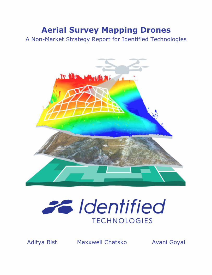
Aerial Survey Mapping Drones A Non-Market Strategy Report for Identified Technologies
Aditya Bist Maxxwell Chatsko Avani Goyal
1
Faculty Advisor and Course Instructor:
Dr. Deborah Stine
Student Analysts:
Aditya Bist (B.S. Electrical and Computer Engineering)
Maxxwell Chatsko (M.S. Materials Science & Engineering)
Avani Goyal (M.S. Civil and Environmental Engineering)
Acknowledgements
The student analysts thank Identified Technologies CEO Dick Zhang for
participating in the course project, providing a tour of the company's headquarters,
and working hard to transform Pittsburgh into a startup hub.
Finalized May 2016.
Cover art provided by Identified Technologies.
Disclaimer
Please note that the analysis conducted within this report was completed as part of a course
project and is not intended to be referenced, quoted, or used as a primary source. The work
presented was completed for our client, Identified Technologies, in the course "New Technology
Commercialization: Public Policy Strategies" offered by the Department of Engineering and
Public Policy at Carnegie Mellon University in the Spring 2016 semester.
2
Table of Contents
I. Executive Summary………………………………………………………....3
II. Technology Overview………………………………………………...……..4
III. Challenges & Opportunities…………………………………………………6
IV. Policy Context………………………………….……………………………9
V. Policy Forum…………………………………………….…………………12
VI. Range of Outcomes…………………………………………………...……13
VII. Bargaining Context………………………………………………………...16
VIII. Strategy & Argument…………………………………………………..…..21
IX. References……………………………………….…………………………22
3
Executive Summary
Identified Technologies is a Pittsburgh-based startup founded in 2013 that offers a smart drone
aerial mapping system called Boomerang, which provides continuous tracking and monitoring of
commercial construction sites. The Boomerang Drone is an unmanned aerial vehicle (UAV) that
represents a safer, cheaper, faster, and more accurate method of surveying and mapping active
projects compared to alternative methods relying on manned surveyor crews, helicopters, and/or
airplanes. Today the company’s technology platform is primarily serving end-customers in
energy and oilfield services and transportation, although expanding Boomerang’s reach through
new customer acquisition, potentially in new markets, remains the leading focus of management.
In addition to the company’s historical focus on attracting business from private commercial
construction companies, the search for new customers with the potential to represent large
revenue streams and long-term business relationships could be extended to capitalize on unique
opportunities identified within the non-market environment.
An analysis of the non-market environment facing Identified Technologies yielded the following
factors discussed within this report:
➔ Issues: Regulations imposed by the Federal Aviation Administration (FAA) on UAVs,
privacy concerns of the general public, safety of workers on commercial construction
sites, pressure to complete construction projects on time and on budget, time to project
approval.
➔ Interests: Construction companies, land surveyor unions and trade groups, general
public, competing UAV mapping platforms.
➔ Institutions: FAA, Defense Innovation Unit Experimental (DIUx), Pennsylvania
Department of Transportation (PennDOT), Federal Emergency Management Agency
(FEMA).
➔ Information: Head-to-head performance comparisons of Boomerang to alternative
surveying technologies, live field demonstrations and webinars, desires of government
agencies to foster public-private relationships, risks and responsibilities of UAV
ownership and piloting.
Targeting specific programs and projects where there is a clear alignment of incentives would
increase the potential of Identified Technologies successfully developing new channels for
customer acquisition while overcoming and leveraging factors in the non-market environment.
After careful analysis, the most effective option for Identified Technologies is to target a P3
project within PennDOT.
Recommendations: We recommend that Identified Technologies apply for highway
construction projects within the state of Pennsylvania (and perhaps nationally) through
PennDOT’s P3 program. We also highly recommend that the company’s prior experience with
large highway construction projects is presented to assigned point of contact(s) in the form of
data, results, and customer testimonies at the time of application.
4
Technology Overview
Commercial construction sites, which can span hundreds or even thousands of acres, place
logistical burdens on construction companies tasked with overseeing project development and
completion. Tracking the movement of materials and equipment, accurately analyzing the
volume of earth required to be moved and sold, and monitoring progress for estimating project
and phase completion dates creates safety, liability, monetary, and time issues for construction
companies. Despite the need for timely and accurate data, the standard methods for surveying
active construction sites rely on manned surveyor crews, helicopters, and/or aircraft. These
fallible standards unnecessarily increase the safety risks to workers, add costs and time to
projects, force stakeholders to use potentially inaccurate (earth volume estimates) or outdated
(topographical maps) data, and create barriers to sharing and analyzing project site data and
information among stakeholders.
Identified Technologies is focused on mitigating those risks and delivering value to industrial
customers through the use of its smart drone aerial mapping system called Boomerang, which
provides a scalable turnkey solution for continuous tracking, monitoring, and analysis of
commercial construction projects. The autonomous UAV-driven technology platform is capable
of creating 3-D site maps 200x faster than alternative surveying methods at significantly reduced
costs.1 The company also provides on-demand cloud-based data collection, processing, and
analysis software tools that allow stakeholders to predict progress, collaborate remotely, and
make informed decisions.
The smart drone technology platform comprises three parts:
1. LaunchPad docking station
2. Boomerang Drone
3. Cloud-based data analysis software
The LaunchPad docking station is a purpose-built device that prioritizes ease-of-use for the user
and functionality. It serves as the “home base” for the Boomerang Drone throughout the duration
of a project; swapping and charging the drone’s batteries when not in use and sending collected
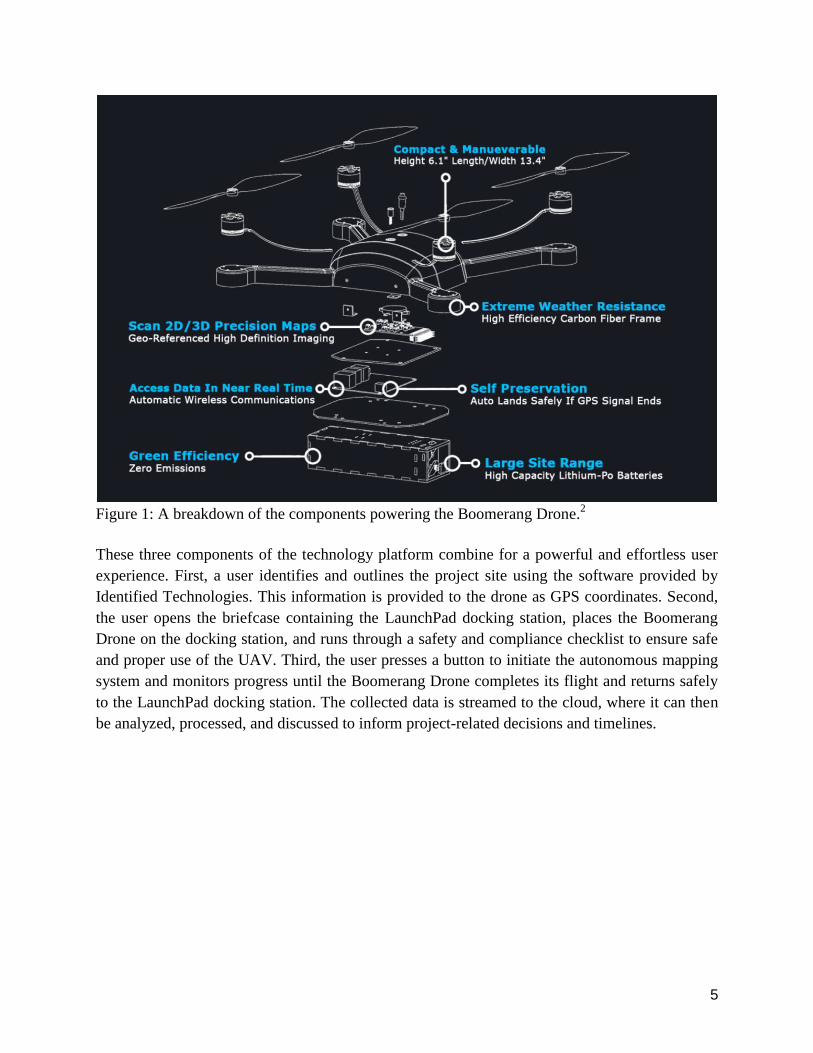
data to the cloud for customer analysis. As shown in Fig 1, the Boomerang Drone boasts a
compact design with multimodal data acquisition capabilities, in addition to built-in safety
features such as the ability to return to the LaunchPad if a GPS signal is lost. Meanwhile, the
company’s cloud-based data analysis software is compatible in mobile and PC formats and
provides various easy-to-use image and data analysis tools.
5
Figure 1: A breakdown of the components powering the Boomerang Drone.
2
These three components of the technology platform combine for a powerful and effortless user
experience. First, a user identifies and outlines the project site using the software provided by
Identified Technologies. This information is provided to the drone as GPS coordinates. Second,
the user opens the briefcase containing the LaunchPad docking station, places the Boomerang
Drone on the docking station, and runs through a safety and compliance checklist to ensure safe
and proper use of the UAV. Third, the user presses a button to initiate the autonomous mapping
system and monitors progress until the Boomerang Drone completes its flight and returns safely
to the LaunchPad docking station. The collected data is streamed to the cloud, where it can then
be analyzed, processed, and discussed to inform project-related decisions and timelines.
6
Challenges & Opportunities
Challenges
Identified Technologies’ efforts to develop additional channels for customer acquisition face
several unique challenges inherent to the use UAVs and surveying systems that require
consideration for any proposed strategy. After careful analysis and discussion these have been
identified as follows:
Privacy concerns: The general public has expressed concerns about personal privacy from prying
eyes in the sky. There exists an information gap between what data UAVs collect -- or even have
the ability to collect -- and what the public thinks is possible when an aerial drone is spotted
overhead. While privacy represents a challenge for any company leveraging UAVs, it does not
currently represent a primary challenge for Identified Technologies. The majority of commercial
construction projects completed by the company occur in areas that are not bordered by
residential buildings. In the minority of projects that have raised public concerns, Identified
Technologies has shifted the liability to the site managers, which requires them to educate the
affected public and gain proper permissions where required. This has not represented a
significant hindrance to customer acquisition to date, but may in the future as the industry
matures or the business expands.3
FAA regulations: The FAA requires any operator of a UAV used for commercial use to gain a
Commercial Exemption Authorization under Section 333 of Public Law 112-95. After achieving
authorization, operators must obtain a Certificate of Authorization that alerts local FAA Air
Traffic Control centers of proposed work and allows a full consideration of potential airspace
conflicts. Even then, only licensed pilots may operate a drone for commercial purposes
specifically outlined in the petition to the FAA. This represents a barrier to entry for companies
looking to utilize UAVs for commercial use and forces Identified Technologies to not only apply
for exemptions every two (2) years, but also to navigate regulatory pathways for its customers.4,5
Opposition from competitors: Many emerging technology companies face fierce competition
from market incumbents and other emergent innovators. Identified Technologies must compete
head-to-head with other startups and with unauthorized and “rogue” UAV operators.
Additionally, the company faces the risk of competing against established market incumbents
with vested interests in using existing surveying technologies. Although we can find no
occurrences to date, this competition has the potential to ally with key policymakers concerned
with non-market factors including personal privacy of nearby residents and job losses of workers
in incumbent industries. In a worst case scenario, such alliances could erect additional
regulations and operating requirements that are detrimental to the company.3
Communication of benefits: While not uncommon for new companies, Identified Technologies
has encountered challenges related to attracting the attention of potential customers and key
7
stakeholders and, of primary concern, convincing surveyors of the benefits to using UAVs for
aerial surveyor mapping. “Once I’m in front of a potential customer the pitch is pretty
straightforward. But our customers don’t always have full authority over the use of drones on a
project,” said CEO Dick Zhang. That’s because construction companies -- Identified
Technologies’ customers -- must earn approval from their clients -- the owner of the construction
site or highway -- before utilizing UAVs for survey and/or site mapping. Getting client approval
for commercial drone use isn’t always an issue, but it has resulted in some potentially large
projects remaining off limits to the company after site owners objected to the use of UAVs for
liability, privacy, internal policy, and other reasons. Additionally, surveyors may object to using
drones for similarly broad reasons. Identified Technologies has responded to this challenge by
creating case studies and white papers with key customers, updating its website in April 2016,
running a company blog, and holding live (and webinar) field demonstrations of Boomerang
Drones in action.3
Opportunities
Identified Technologies’ efforts to develop additional channels for customer acquisition face
several unique opportunities inherent to the use UAVs and surveying systems that require
consideration for any proposed strategy. After careful analysis and discussion these have been
identified as follows:
FAA regulations and certifications: Identified Technologies can exploit FAA regulations,
certifications, and liability coverages to acquire customers. In July 2015 the company was
granted FAA Commercial Exemption Authorization 333 with thirty-one (31) conditions and
limitations. The exemption remains current through July 2017. The company is also a registered
ISN Contractor in ISNetworld, which streamlines the process of vetting industrial contractors for
safety records, insurance information, quality reports, and regulatory exemptions. Additionally,
Identified Technologies maintains a $5 million general liability insurance policy. Together, these
combine to provide a powerful reassurance to potential customers about the ability of the
company to remain in compliance and navigate regulatory pathways.3,4,5,6,7
Safety: Annual data from the Bureau of Labor Statistics, the National Safety Council, and the
Occupational Health and Safety Administration routinely rank occupations closely affiliated with
surveying as the most dangerous jobs based on fatality rates and number of workers employed.
These include construction, logging, and extractive occupations such as mining and well drilling.
While the Occupational Health and Safety Act (OSHA) continues to improve worker safety and
reduce worker fatalities, current best practices such as wearing fluorescent vests and hard hats
and “remaining vigilant” still require workers to operate in potentially risky environments.7
These safety issues inherent to construction sites are uniquely mitigated and potentially
eliminated by the use of the company’s aerial survey mapping system. Bill Clifford, Head
Surveyor of Identified Technologies customer Kokosing Construction, strongly recommends the
8
company’s autonomous solution to safety issues, saying, “The Boomerang Drone takes workers
out of harm’s way. You can just sit back safely and watch it work.” 8
Infrastructure budget concerns: Several analyses of Department of Transportation (DOT)
projects in various states have discovered that highway and infrastructure projects are routinely
completed over budget. This is particularly worrisome considering that budget cuts have resulted
in a severe gap in available funds and required funds. In May 2015 WRAL, a local news
organization in Raleigh, North Carolina, reported that 269 of 482 DOT projects in the state were
over budget. The investigation found that one leading source of delays in the state was “the
difficulty of building roads in mountainous regions”, while moving earth represented another
delay. Similarly, a 2012 report from the office of New York Governor Andrew Cuomo found
that the state’s DOT “consistently had overruns on its projects in the range of 7% to 11%,
resulting in $530 million in total overruns over the past five years. ” As in North Carolina,
geographical challenges also played a role in the delays.9,10
Identified Technologies has experience working on highway construction projects in
mountainous terrain, namely with Kokosing Construction in an expansion project completed in
Elkhorn City, Kentucky. The project required the continuous monitoring of two 1,000 acre sites
and the extraction of 33 million cubic yard of earth. By utilizing the Boomerang Drone,
Kokosing Construction surveyed the entire site in a half day, compared to two months using
manned survey crews and aircraft, and reduced project costs for those activities by $105,000 -- a
reduction of 86% compared to traditional methods.8
Job creation: The ability of surveyors to use the Boomerang Drone in a fraction of the time of
manned survey crews allows construction companies, surveyor groups, engineers, and architects
to reduce bottlenecks in their individual workflows, save costs, and increase the number of
projects they can contribute to over a given period of time. Therefore, Identified Technologies’
technology platform could represent an opportunity to create jobs in incumbent industries by
leveraging emerging technology, which could be used as a powerful bargaining chip when
interacting with policymakers and government stakeholders. This challenges of communicating
this to surveyors remains an obstacle, however.3
The FAA requirement that UAVs used in commercial work must be operated by a licensed pilot
presents another opportunity to create jobs. Pilots that complete their initial certification often
face long wait times before becoming fully licensed to fly aircraft, while Identified Technologies
needs access to licensed pilots. Thus, the company has created an on-demand network of
intermediary pilots that can be tapped into for operating Boomerang Drones for customers.3,4
9
Policy Context
After detailing the non-market challenges and opportunities facing Identified Technologies it
was decided that targeting government projects and programs would have the greatest potential
to result in increased customer acquisition while mitigating risks from non-market challenges
and exploiting non-market opportunities. A successful relationship with a government agency
may increase the company's market penetration, develop strong allies within key political bodies
and geographical regions, help to communicate the benefits to surveyors, and reduce barriers to
adoption of the technology platform. Therefore, the neutral policy question to be examined for
the proposed strategy becomes:
What actions, if any, should Identified Technologies take to acquire government customers
that can help to expand the reach of and educate key stakeholders about the advantages
provided by its technology platform?
The following non-market strategy options were investigated for their ability to achieve an
optimal outcome for the neutral policy question above.
Option Description
Status Quo Identified Technologies continues pursuing existing channels to acquire
customers and respond to non-market factors.
Option 1 Identified Technologies engages with Defense Innovation Unit Experimental
(DIUx) office to develop channel that provides matchmaking with and access
to various Department of Defense (DoD) agencies.
Option 2 Identified Technologies applies for a P3 project with the Pennsylvania
Department of Transportation (PennDOT) to work on new highway
construction projects.
Option 3 Identified Technologies engages with the Federal Emergency Management
Administration (FEMA) by providing emergency response solutions to first
responders.
Table 2: Public policy strategy options for Identified Technologies.
These options are analyzed in more detail below.
Status Quo
As explained above, Identified Technologies is currently focus on expanding its business and
acquiring customers through existing channels, which include working with previous industrial
construction companies. In addition, the company has made a strong marketing effort with online
10
advertisements, a revamped website, media representations on TechCrunch and other platforms,
and through conference presentations. In an attempt to address certain non-market factors and
extinguish doubts, concerns, or questions about the ease of use and overall advantages of using
aerial mapping systems the company has also held several live field demonstrations and
webinars for interested parties, members of the media, and members of the general public.
Option 1 (DIUx)
The DIUx was established in summer 2015 to foster relationships between various agencies
within the DoD and innovative startups. The pilot office is located in Mountain View, California
-- near Silicon Valley -- and exists to act as the “point of contact” and “technical matchmaker”
for entrepreneurs looking to expand their business while providing solutions to technology
challenges identified by the DoD. Despite the focus in Silicon Valley, DIUx routinely engages
with startup clusters in Boston, Massachusetts and Austin, Texas, among others. Not unlike
investment-oriented startup accelerator programs, DIUx may require that a representative(s)
from a young company establish a presence at the office for a brief period of time (i.e. months)
to solidify potential relationships within the DoD.
Identified Technologies could leverage such a relationship to gain access to DoD agencies that
could benefit from its aerial survey mapping technology. For example, the U.S. Army Corps of
Engineers maintains various construction, maintenance, and restoration projects throughout the
country that require monitoring, tracking, and surveying. Additionally, the U.S. Air Force needs
to expand Eielson Air Force Base in Alaska to make room for two new squadrons of the F-35A
joint strike fighters. Construction is expected to begin in 2017, while the squadrons may arrive
by 2020. Given the controversial and significantly delayed development of the F-35A it will be
important for the Air Force to reduce any risks of further delays to the next-generation fighter’s
arrival.11
Meanwhile, CEO Dick Zhang had previously been in contact with a three star general in one
branch of the military discussing the difficulties and safety concerns of building new military
bases in conflict regions, and how the company’s Boomerang Drone could significantly reduce
those risks. Those discussions have since ceased, which means working with DIUx could
provide a way to resurrect a potential partnership.3
Option 2 (PennDOT)
As with many other state Department of Transportation offices, PennDOT has established the P3
program, which aims to foster public-private partnerships that can address technology challenges
identified by the agency. This program was established by the Public-Private Transportation
Partnerships Act of 2012. There are two groups of P3 projects 12,13
:
11
1. New Build Facilities: Adding capacity to the system by building something new.
2. Existing Facilities: Improving capacity or performance of the current system through a
P3 arrangement.
The application process can be completed by paper and online, although the decision making
process can take months or longer. However, the application process could be aided by the fact
that Identified Technologies has experience with large highway construction projects -- in
mountainous terrain -- in Kentucky. That may allow data, customer testimonies and
presentations, and other information to be submitted or presented as a case study to expedite a
decision by PennDOT.8
Option 3 (FEMA)
CEO Dick Zhang expressed that he would entertain the idea of utilizing Boomerang Drones in
emergency response applications in the future.3 As part of the Department of Homeland Security,
FEMA has various opportunities for collaborating as vendors to provide any service for
emergency response activities such as search and rescue or damage assessment operations. This
occurs simultaneously with increased use of aerial drones in emergency response events, such as
dropping supplies to stranded motorists, combatting and monitoring forest fires, and post-
response surveying tasks.3,14
There are three steps that could be taken by the company to build a partnership with FEMA.
There is an emergency management agency for each state and Identified Technologies can liaise
with Pennsylvania Emergency Management Agency to offer their services at the time of
emergencies. This partnership can be further extended to the national level given the capacity
and scale of the company.
Register the company with the System for Award Management (SAM). The free application is a
requirement to do business with federal agencies and can be completed at www.sam.gov.
FEMA has an Industry Liaison Support program that facilitates the collaboration between
industry vendors and emergency management agencies of state. It connects the company with the
FEMA projects as and when required to give timely support to the disaster impacted in
accordance with the Robert T. Stafford Disaster Relief and Emergency Assistance Act. A
completed FEMA Profile needs to be submitted to the Industry Liaison Support Center, with two
routes to completion:
1. Request a Vendor Profile Form or request a form via email.
2. Request a copy of the Program’s Fact Sheet for reference.
12
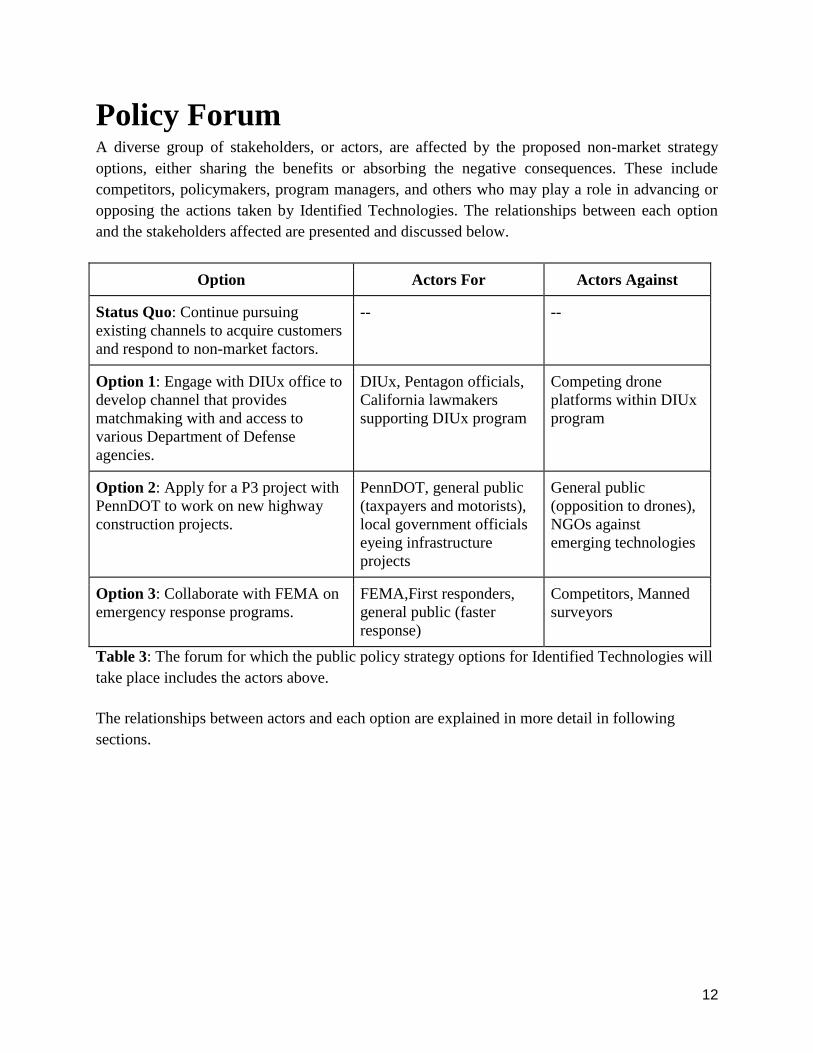
Policy Forum
A diverse group of stakeholders, or actors, are affected by the proposed non-market strategy
options, either sharing the benefits or absorbing the negative consequences. These include
competitors, policymakers, program managers, and others who may play a role in advancing or
opposing the actions taken by Identified Technologies. The relationships between each option
and the stakeholders affected are presented and discussed below.
Option Actors For Actors Against
Status Quo: Continue pursuing
existing channels to acquire customers
and respond to non-market factors.
-- --
Option 1: Engage with DIUx office to
develop channel that provides
matchmaking with and access to
various Department of Defense
agencies.
DIUx, Pentagon officials,
California lawmakers
supporting DIUx program
Competing drone
platforms within DIUx
program
Option 2: Apply for a P3 project with
PennDOT to work on new highway
construction projects.
PennDOT, general public
(taxpayers and motorists),
local government officials
eyeing infrastructure
projects
General public
(opposition to drones),
NGOs against
emerging technologies
Option 3: Collaborate with FEMA on
emergency response programs.
FEMA,First responders,
general public (faster
response)
Competitors, Manned
surveyors
Table 3: The forum for which the public policy strategy options for Identified Technologies will
take place includes the actors above.
The relationships between actors and each option are explained in more detail in following
sections.
13
Policy Option Analysis
We are evaluating policy options for Identified Technologies targeting government projects and
programs in terms of their potential to result in increased customer acquisition while mitigating
risks from non-market challenges and exploiting non-market opportunities. However, the four
options considered exhibit varying degrees of effectiveness, efficiency, equity, and ease of
political acceptability that must be evaluated for proper analysis. These are investigated below in
Range of Outcomes and Bargaining Context.
Range of Outcomes
Effectiveness is defined as the likeliness that the proposed strategy achieves its desired outcome
in the real world. Efficiency is defined as the costs of the proposed strategy weighed against the
outcome achieved. Analysis of these two metrics provides insight into an option’s ability to
address the issue at hand.
Status Quo: The status quo involves using existing channels within the company's network to
acquire customers and respond to issues in the non-market environment. This could successfully
achieve the desired outcome with relatively low monetary and time investments, but the
platform’s current strategy may require longer to gain significant traction and expand the
business that alternative strategies. In other words, the company’s growth month-to-month
growth and annual revenue run rate may attain a higher trajectory in the medium- to long-term
under alternative strategies.
Option 1: The first alternative involves developing and
subsequently leveraging a relationship with DIUx to gain
access to partners and customers within the DoD. The
mission of DIUx is to “cultivate and facilitate lasting
relationships” between new innovators and the DoD,
specifically the branches of the military and all Defense
Agencies, by serving as the “point of presence” for the
DoD. This includes a broad set of agencies representing all
branches of the military and, perhaps of significance for the
company’s aerial survey mapping technology, the U.S.
Army Corps of Engineers.
Given the alignment of incentives between Identified Technologies and DIUx, successfully
building a relationship with the office could be a very effective strategy. While this alternative
focuses on building a channel rather than pursuing a specific government customer or specific
project, DIUx would help to pair the company’s technology platform with customers that could
derive the most value from it. However, there are several potential drawbacks to this policy
14
option. DIUx is a very new concept, having only opened a pilot office in Mountain View,
California in August 2015, and appears to be primarily focused on innovation occurring within
Silicon Valley. This does not rule out the potential for Identified Technologies to engage with
DIUx, but the company will need to appoint a dedicated point of contact and may need to send a
representative to the DIUx pilot office for a period of time to coordinate projects. This partially
offsets the gains in efficiency obtained from the relatively frictionless alignment of incentives.
Option 2: The second alternative involves working with
PennDOT to work on new highway or other construction
projects. This option scores high in effectiveness for several
reasons. Acquiring projects with the PennDOT could lead to
a long-term relationship with the agency and result in a
significant new source of revenue. Additionally, Identified
Technologies could leverage PennDOT projects to build
relationships with new industrial construction companies that
previously would have been inaccessible, potentially leading
to addition future work on non-PennDOT projects. The
company’s application could be further bolstered by past
experience working on large highway construction projects
in Kentucky that can be presented as a case study.
However, the costs to acquire such a projects are relatively high. First, the company will need to
appoint a dedicated point of contact to approach PennDOT. Second, the application and
decision-making process for the public-private partnership program sponsored by PennDOT can
take a significant amount of time to complete. Thus, this would not represent an ideal short-term
strategy.
Option 3: The third alternative involves working directly
with FEMA for its emergency response activities. FEMA
can use the drone technology to assess the risks faster and
obtain more accurate information on the emergency
activity. It prevents putting lives to risk when they can
deploy drones to do a task in risk prone situations. Hence,
this policy option would be very effective for FEMA first
responders to use to deal with emergency response
situations. However, pursuing this strategy requires
developing the proper contacts and channels to gain access
to the institution. Recently FEMA has been exploring new
technologies like drones to make their response activities
more effective. The Industry Liaison Support Program
15
facilitates the connection of the companies providing the required service to the FEMA projects
at the time of need and hence improves the efficiency of this policy option. The company needs
to go through two steps to build this liaison such as getting SAM certified and register for the
liaison program. A successful liaison can prove to be beneficial to the company as the
government agencies can first hand witness the utility of the product and can go a long way in
affecting the FAA regulations to be in favor. While that may constitute some time investments to
get the required documentation work done and potentially a point of contact to facilitate
exchanges between FEMA and the company, the potentially high value to be gained from a
successful outcome result in a positive efficiency score.
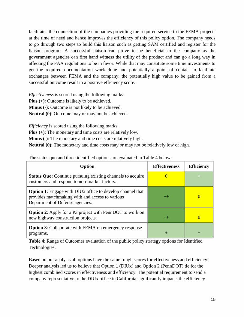
Effectiveness is scored using the following marks:
Plus (+): Outcome is likely to be achieved.
Minus (-): Outcome is not likely to be achieved.
Neutral (0): Outcome may or may not be achieved.
Efficiency is scored using the following marks:
Plus (+): The monetary and time costs are relatively low.
Minus (-): The monetary and time costs are relatively high.
Neutral (0): The monetary and time costs may or may not be relatively low or high.
The status quo and three identified options are evaluated in Table 4 below:
Option Effectiveness Efficiency
Status Quo: Continue pursuing existing channels to acquire
customers and respond to non-market factors.
0 +
Option 1: Engage with DIUx office to develop channel that
provides matchmaking with and access to various
Department of Defense agencies.
++
0
Option 2: Apply for a P3 project with PennDOT to work on
new highway construction projects.
++
0
Option 3: Collaborate with FEMA on emergency response
programs.
+
+
Table 4: Range of Outcomes evaluation of the public policy strategy options for Identified
Technologies.
Based on our analysis all options have the same rough scores for effectiveness and efficiency.
Deeper analysis led us to believe that Option 1 (DIUx) and Option 2 (PennDOT) tie for the
highest combined scores in effectiveness and efficiency. The potential requirement to send a
company representative to the DIUx office in California significantly impacts the efficiency
16
score of Option 1, offsetting the efficiency gains from using the matchmaking channel to gain
exposure and potential access to the DoD.
Meanwhile, the potential for the P3 program application to take months or longer partially
offsets benefits provided by the company’s experience in highway construction. If the company
can make a convincing case by providing data and customer testimonies, perhaps with
representatives from the Kentucky Department of Transportation, then Option 2 could have an
improved efficiency score.
While Option 3 (FEMA) has the potential to be both effective and efficient, the magnitude of the
net benefits is lower than that for Option 1 and Option 2. Even if a partnership is formed the
ability to use UAVs is dependent on the occurrence of emergency response events. Additionally,
we considered that time to response is a significant factor in emergency response efforts. That
will make it difficult from a logistical standpoint to have UAVs in the right hands at the exact
locations of emergencies at the time of the event.
Bargaining Context
Equity is defined as the consequences of the proposed strategy with respect to stakeholders. The
metric provides an answer to the question, “How fair is the proposed policy?” Ease of Political
Acceptability is defined as the likeliness that actors within the policy arena will accept or oppose
the proposed strategy. Analysis of these two metrics provides insight into the likeliness that a
proposed strategy is accepted by affected stakeholders and evaluates the amount of friction that
may be encountered by the company.
Status Quo: The status quo involves using existing channels within the company's network to
acquire customers and respond to issues in the non-market environment. Identified Technologies
has worked to mitigate the negative equity consequences from competitors by positioning the
Boomerang Drone as a value add for surveyor crews on its blog, with live demonstrations and
webinars, and through customer relationships. However, due to size, funding, and focus the
company has not engaged with policymakers about the potential advantages and benefits of its
technology platform. This extends additional benefits to and increases the importance of
acquiring a government customer, which could potentially serve as a powerful ally. Overall, and
as stated in the previous section, the lack of traction with the status quo to date makes it worth
evaluating alternative policy strategies.
17
Option 1: The first alternative involves developing and
subsequently leveraging a relationship with DIUx to gain
access to partners and customers within the DoD. If this
strategy is successfully pursued there are many fewer direct
stakeholders to consider, which are mostly concentrated in
government and the DoD. Overall, Option 3 is highly
equitable due to the alignment of incentives between DIUx
and Identified Technologies. The office will need high profile
wins to showcase, especially considering that DIUx is a new
experiment. Politicians could similarly use successful
partnerships grown from DIUx to describe how innovation is
taking place. There is no reason that equity or ease of political
acceptability would be negatively affected by from potentially
working with the company.
Option 2: The second alternative involves working with
PennDOT to work on new highway or other construction
projects. The second option is highly equitable for the
customers (PennDOT) and the public. While PennDOT
benefits from the use of drones because they save time and
money, the public also benefits because less taxpayer money
is spent on construction projects and the use of drones also
mitigates traffic issues during construction phases. Other
aerial surveying groups relying on helicopter and aircraft
would be negatively affected through loss of work, but they
are not powerful stakeholders and thus exhibit little, if any,
influence.
Option 3: The third alternative involves working directly with
the Pennsylvania state agency of FEMA for emergency
response activities. If this strategy is successfully pursued
there are numerous stakeholders to consider. It is assumed that
Identified Technologies would displace existing surveying
crews and companies, if not immediately, then at least
gradually over time. This would represent a major net benefit
to FEMA, which would acquire higher quality data at a
fraction of the cost, in a fraction of the time, and from a
greatly consolidated list of partners. Communities would
benefit from the faster and more efficient solution of analyzing
and assessing the risk of the disaster situations by getting
timely support. Additionally, since the cost would also go
18
down from using the technology platform of Identified Technologies, then taxpayers would get
monetary benefits. Since this policy option entails a broader social viewpoint of drone
technology use for risk mitigation, the competitors stand neutral on equity as the most relevant
vendor will be selected for the job as needed.
Equity is scored using the following marks:
Plus (+): The strategy represents a net benefit to stakeholder(s).
Minus (-): The strategy represents a net negative to stakeholder(s).
Neutral (0): The strategy may or may not have net consequences for stakeholder(s).
Ease of Political Acceptability is scored using the following marks:
Plus (+): The strategy is likely to be accepted by stakeholder(s).
Minus (-): The strategy is likely to be opposed by stakeholder(s).
Neutral (0): The strategy may or may not elicit a reaction from stakeholder(s).
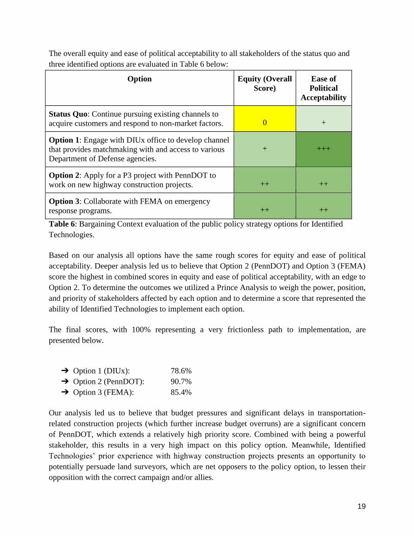
The equity with respect to specific groups of stakeholders of the status quo and three identified
options are evaluated in Table 5 below:
Option Equity
(Customers)
Equity
(Public)
Equity
(Competitors)
Status Quo: Continue pursuing existing
channels to acquire customers and respond to
non-market factors.
+
0
-
Option 1: Engage with DIUx office to develop
channel that provides matchmaking with and
access to various Department of Defense
agencies.
+++
0
0
Option 2: Apply for a P3 project with
PennDOT to work on new highway
construction projects.
+++
+
-
Option 3: Collaborate with FEMA on
emergency response programs.
++
++
0
Table 5: Equity evaluation of the public policy strategy options for Identified Technologies.
19
The overall equity and ease of political acceptability to all stakeholders of the status quo and
three identified options are evaluated in Table 6 below:
Option Equity (Overall
Score)
Ease of
Political
Acceptability
Status Quo: Continue pursuing existing channels to
acquire customers and respond to non-market factors.
0
+
Option 1: Engage with DIUx office to develop channel
that provides matchmaking with and access to various
Department of Defense agencies.
+
+++
Option 2: Apply for a P3 project with PennDOT to
work on new highway construction projects.
++
++
Option 3: Collaborate with FEMA on emergency
response programs.
++
++
Table 6: Bargaining Context evaluation of the public policy strategy options for Identified
Technologies.
Based on our analysis all options have the same rough scores for equity and ease of political
acceptability. Deeper analysis led us to believe that Option 2 (PennDOT) and Option 3 (FEMA)
score the highest in combined scores in equity and ease of political acceptability, with an edge to
Option 2. To determine the outcomes we utilized a Prince Analysis to weigh the power, position,
and priority of stakeholders affected by each option and to determine a score that represented the
ability of Identified Technologies to implement each option.
The final scores, with 100% representing a very frictionless path to implementation, are
presented below.
➔ Option 1 (DIUx): 78.6%
➔ Option 2 (PennDOT): 90.7%
➔ Option 3 (FEMA): 85.4%
Our analysis led us to believe that budget pressures and significant delays in transportation-
related construction projects (which further increase budget overruns) are a significant concern
of PennDOT, which extends a relatively high priority score. Combined with being a powerful
stakeholder, this results in a very high impact on this policy option. Meanwhile, Identified
Technologies’ prior experience with highway construction projects presents an opportunity to
potentially persuade land surveyors, which are net opposers to the policy option, to lessen their
opposition with the correct campaign and/or allies.
20
Option 3 scores highly due to the circumstances surrounding emergency response, which we
believe would result in less opposition to utilizing an emerging technology based on cognitive
biases in risk assessment. In other words, the potential benefits to using UAVs in emergency
response supersede concerns such as privacy. However, as in Range of Outcomes above, this
strategy is limited by the occurrence of emergency events and logistical limitations to
distributing Boomerang Drones.
Option 1 scores the lowest in the Prince Analysis due to several factors. Although DIUx and the
company share aligned incentives to foster a relationship, the office has no particular preference
for Identified Technologies over competitors, nor is the potential for real business guaranteed. If
the company goes into a DIUx partnership with previous experiences (discussions with the
military general) or specific projects (working with the U.S. Air Force to expand Eielson Air
Force Base in Alaska) in mind, then the score may improve. Given the power of the U.S. Air
Force and the pressure to ensure a smooth arrival for the F-35A next-generation fighter jet, this
could result in a significant increase in score.
21
Strategy & Arguments
What actions, if any, should Identified Technologies take to acquire government customers
that can help to expand the reach of and educate key stakeholders about the advantages
provided by its technology platform?
Based on the analysis and discussion presented above we recommend that Identified
Technologies take action to acquire customers and educate key stakeholders about the
advantages of its aerial survey mapping technology platform by targeting projects through
PennDOT’s P3 program. This can be initiated with several first steps:
1. Apply for a P3 project in Pennsylvania of either type:
a. New Build Facilities: Adding capacity to the system by building something new.
b. Existing Facilities: Improving capacity or performance of the current system
through a P3 arrangement.
2. CEO Dick Zhang mentioned that he was aware of several planned highway construction
projects in Pennsylvania. If these are still available and can be identified, then we
recommend making the assigned point of contact(s) within PennDOT aware of these
projects.
3. We highly recommend that the company prepare data, results, and customer testimonies
from prior highway construction projects in Kentucky with Kokosing Construction.
Additionally, it is paramount to make the assigned point of contact(s) within PennDOT
aware of this experience at the time of application.
Additionally, given that prior highway construction occurred out of state, Identified
Technologies could also apply for national P3 projects with the U.S. Department of
Transportation Federal Highway Administration (FHWA). For nationwide P3 projects, we
recommend contacting FHWA Office of Innovative Program Delivery, specifically P3 Project
Manager Patrick DeCorla-Souza at 202-366-4076 or [email protected] or Senior
Advisor Darren Timothy at 202-366-4051 or [email protected].
22
References
[1] "Why Land Mapping Drones Are a Surveyors Best Friend - Identified Technologies."
Identified Technologies. 08 Apr. 2016. Web.
[2] Identified Technologies - Tech. 15 Mar. 2016. Web.
[3] "Interview with Identified Technologies CEO Dick Zhang." Personal interview. 1 Apr. 2016.
[4] "U.S. Department of Transportation, Federal Aviation Administration Notice of Exemption
Status Regarding Section 333." Letter to Identified Technologies Legal Counsel. 20 July 2015.
[5] "White Paper: Ready for FAA Inspection?" Rev. of Identified Technologies Website.
Identified Technologies, 2015.
[6] "Contractor Management Services: Our Process." What We Do. ISN.
[7] Glassey, R. William, LS. "Developing a Safety Plan." American Surveyor Dec. 2004. Web.
[8] "White Paper: How Can Drones Stop My Projects From Going Late and Over Budget?" Rev.
of Identified Technologies Website. Identified Technologies. 2015.
[9] "Progress Report: Many NC Road Projects Are over Budget, Overdue :: WRAL.com."
WRAL.com. 12 May 2015. Web.
[10] "Governor Cuomo Announces New Reforms Designed to Keep State Highway Construction
Projects on Budget and on Time." Governor Andrew M. Cuomo. 28 Sept. 2014. Web.
[11] "Alaska Air Force Base To Get F-35s in 2020." Defense News. Web.
[12] H.R. 2012-88, 88 Cong. (2012) (enacted).
[13] "PennDOT Public-Private Partnerships." Public-Private Partnerships. Web.
[14] "Pennsylvania Emergency Management Agency." PEMA. Web.