aerial photographs aerial photographs of the project area ... · in addition, the erd record search...
TRANSCRIPT

San Ramon City Center - City of San Ramon Draft Subsequent EIR Hazards and Hazardous Materials
Michael Brandman Associates 4.6-3 H:\Client (PN-JN)\2491\24910007\DSEIR\24910007_Sec04-06 Hazardous Materials.doc
Table 4.6-1 (Cont.): Recorded Sites Near the Project Site
Name Location Database(s)
HIST UST: Historical UST Registered Database. SL: Lists includes sites from the Underground Tank Program, Hazardous Waste Generator Program & Business Plan 12185 Program. SWEEPS: Statewide Environmental Evaluation and Planning System. This underground storage tank listing was updated and maintained by a company contacted by the State Water Resources Control Board in the early 1980s but is no longer updated or maintained. Local agencies serve as contacts for SWEEPS. DRYCLEANERS: List of dry cleaner-related facilities that have EPA ID numbers, includes facilities with certain SIC codes: power laundries, family and commercial; garment pressing and cleaners’ agents; linen supply; coin-operated laundries and cleaning; dry cleaning; industrial launderers; and laundry and garment services. Source: Michael Brandman Associates, 2007.
Aerial Photographs Aerial photographs of the project area dating to 1939 were obtained as part of the Phase I ESA process. The changes that occur to the project site and surroundings are summarized in Table 4.6-2.
Table 4.6-2: Aerial Photograph Summary
Year Description
1939 The project site contains orchards. A residential structure associated with the orchards is visible north of the project site, near the present-day location of Bishop Ranch 3. An east-west dirt road connects the structure with a two-lane, north-south road that follows the general alignment of present-day San Ramon Valley Boulevard. A single-track rail line is visible along the present-day Iron Horse Trail corridor.
1946 More structures are visible near the residential north of the site. No other notable changes have occurred.
1959 No notable changes have occurred. 1965 Portions of the project site have been cleared of orchards. Interstate 680 is under construction
west of the project site. 1982 Bishop Ranch 2 is under construction. Orchards are still visible on Parcels 1A and 1B, but they
have been removed from Parcel 3A. Interstate 680 (I-680), Bollinger Canyon Road, and Alcosta Boulevard are visible. San Ramon Valley Boulevard has been re-routed around the west side of the Bollinger Canyon Road over crossing of the freeway. Streets following the present-day alignment of Bishop Drive, Camino Ramon, and Executive Parkway are being constructed. The AT&T campus is under construction. Chevron Park is under construction, and the road linking the east side of the campus with the intersection of Bollinger Canyon Road and Camino Ramon is visible. Residential construction is visible south of Chevron Park, west of I-680, and east of Alcosta Boulevard. The railroad line has been abandoned and the rails have been removed.
1993 Bishop Ranch 2, the AT&T campus, Chevron Park, Sunset Drive, Bishop Drive, Camino Ramon have been completed. Parcels 1A, 1B, and 3A are vacant. Central Park, the Market Place, and the Reflections Condominiums are visible. Residential development is visible east of Alcosta Boulevard, south of Chevron Park, and west of I-680. The Marriot Hotel is visible. The Bollinger Canyon Road interchange with I-680 is visible.
1998 Parcels 1A and 1B have been graded and the road linking the east side of Chevron Park with the intersection of Bollinger Canyon Road and Camino Ramon is no longer visible. The Bishop Ranch 1 East road is under construction. Parcel 3A is undeveloped. Bishop Ranch 3 is under construction. Iron Horse Middle School is visible.
Source: Michael Brandman Associates, 2007.

San Ramon City Center - City of San Ramon Hazards and Hazardous Materials Draft Subsequent EIR
4.6-4 Michael Brandman Associates
H:\Client (PN-JN)\2491\24910007\DSEIR\24910007_Sec04-06 Hazardous Materials.doc
Topographical Maps United States Geologic Survey 7.5-minute topographical quadrangles of the project area dating to 1912 were obtained as part of the Phase I ESA process. The changes that occur to the project site and surroundings are summarized in Table 4.6-3.
Table 4.6-3: Topographical Map Summary
Quadrangle Year Description
Mt Diablo 1912 The San Ramon branch line is visible. A road following the present day alignment of San Ramon Valley Boulevard is visible. San Ramon Creek is shown as a blue line stream.
Mt Diablo 1947 The project site is shown as being in agricultural use. The road following the present day alignment of San Ramon Valley Boulevard is noted as “21.” Roadways following the present day alignments of Norris Canyon Road and Crow Canyon Road are visible, as well as several minor east-west farm roads.
Diablo 1953 No notable changes to project site. An airstrip is shown on the west side of San Ramon Valley Boulevard. A water tank and structures are noted at a location labeled “San Ramon Siding” at the present-day Crow Canyon Road and the Iron Horse Trail.
Diablo 1968 No notable changes to project site. I-680 is visible and noted as being “3 lane.” An over crossing of the freeway is noted at the present-day location of the Bollinger Canyon Road interchange; however, the road terminates immediately east of the freeway. The Crow Canyon Road interchange with I-680 is visible. More development is shown at San Ramon Siding.
Diablo 1973 No notable changes to project site. The Twin Creeks neighborhood is shown.
Diablo 1980 No notable changes to project site. The railroad is shown as abandoned and labeled as “Old Railroad Grade.” Bollinger Canyon Road and Alcosta Boulevard are visible; both roads terminate at their intersection. Residential development is visible west of I-680 and south of present-day Chevron Park.
Source: Michael Brandman Associates, 2007.
Hazardous Building Materials The Phase I ESA assessed the potential for hazardous building materials to be present on the project site. A summary of the findings follows.
Asbestos Asbestos is the name given to a number of naturally occurring, fibrous silicate minerals mined for their useful properties, such as thermal insulation, chemical and thermal stability, and high tensile strength. Asbestos is commonly used as an acoustic insulator, thermal insulation, fireproofing, and in other building materials. Asbestos is made up of microscopic bundles of fibers that may become airborne when asbestos-containing materials are damaged or disturbed. When these fibers get into the air they may be inhaled into the lungs, where they can cause significant health problems. The California Occupational Health and Safety Administration (Cal OSHA) defines asbestos-containing materials as any material that contains 0.1 percent asbestos by weight.

San Ramon City Center - City of San Ramon Draft Subsequent EIR Hazards and Hazardous Materials
Michael Brandman Associates 4.6-5 H:\Client (PN-JN)\2491\24910007\DSEIR\24910007_Sec04-06 Hazardous Materials.doc
The Bishop Ranch 2 structures were constructed in the early 1980s. Because they were constructed after the federal ban on asbestos-containing materials was imposed, the Phase I ESA concluded that there was a very low likelihood that they are present onsite. There are no other structures onsite.
Lead Lead is a highly toxic metal that was used until the late 1970s in a number of products, most notably paint. Lead may cause a range of health effects, from behavioral problems and learning disabilities to seizures and death. Primary sources of lead exposure are deteriorating lead-based paint, lead-contaminated dust, and lead-contaminated soil.
The Bishop Ranch 2 structures were constructed in the early 1980s. Because they were constructed after the federal ban on lead-based paint and other lead-based building materials was imposed, the Phase I ESA concluded that there was a very low likelihood that they are present onsite. There are no other structures onsite.
Polychlorinated Biphenyls Polychlorinated biphenyls (PCBs) are mixtures of man-made chemicals with similar chemical structures. PCBs can range from oily liquids to waxy solids. Because of their non-flammability, chemical stability, high boiling point, and electrical insulating properties, PCBs were used in hundreds of industrial and commercial applications, including electrical, heat transfer, and hydraulic equipment; as plasticizers in paints, plastics, and rubber products; in pigments, dyes, and carbonless copy paper; and many other applications. More than 1.5 billion pounds of PCBs were manufactured in the United States prior to cessation of production in 1977.
No electrical transformers were observed on the four parcels comprising the project site. A Chevron Corporation utility corridor that contains electrical transformers is located south of Parcel 1A on the opposite side of the Bishop Ranch 1 East roadway. This utility corridor is monitored by a security camera and appeared to be good condition. Electrical transformers may contain transformer oil. Although oil is typically not highly toxic or mobile in the environment, transformer oil may contain PCBs.
Pesticides A pesticide is any substance or mixture of substances intended for preventing, destroying, repelling, or mitigating any pest. The term pesticide applies to insecticides, herbicides, fungicides, and various other substances used to control pests. The health effects of pesticides depend on the type of pesticide. Examples of health risks posed by pesticides include cancer, nervous system damage, hormone or endocrine disruption, and eye or skin irritation.
The project site contained orchards until the early 1980s. Pesticides were likely routinely applied as part of pest abatement. The orchards were removed in the early 1980s, and all four project parcels have either been developed or substantially graded since then. Moreover, it is unlikely that any
San Ramon City Center - City of San Ramon Hazards and Hazardous Materials Draft Subsequent EIR
4.6-6 Michael Brandman Associates
H:\Client (PN-JN)\2491\24910007\DSEIR\24910007_Sec04-06 Hazardous Materials.doc
pesticide residue is still present onsite 25 years after the last application. Therefore, the Phase I ESA concluded that the likelihood of pesticides being present onsite is very unlikely.
Radon Radon is a carcinogenic, radioactive gas resulting from the natural breakdown of uranium in soil, rock, and water. Radon gas enters a building through cracks in foundations and walls. Once inside the building, radon decay products may become attached to dust particles and inhaled, or the decayed radioactive particles alone may be inhaled and cause damage to lung tissue. The U.S. Environmental Protection Agency (EPA) has established a safe radon exposure threshold of 4 picocuries per liter of air (pCi/l).
Radon screening tests conducted in the site vicinity did not detect radon above 4 pCi/l at four sites tested. The EPA has rated Contra Costa County as a moderate potential radon zone (Zone 2), with an average indoor activity level of 2 to 4 pCi/l radon. Accordingly, radon does not pose a constraint to development on the project site.
High-Voltage Power Lines High-voltage power lines emit electromagnetic fields (EMFs), which have been alleged to be a cause of cancer. However, scientific research has never conclusively established a link between EMFs and cancer.
An existing 230-kilovolt (kV), high-voltage, Pacific Gas and Electric Company (PG&E) power line parallels the Iron Horse Trail in Central Park, approximately 100 feet east of Parcels 1A and 3A. The line is the “research tap” for the PG&E research facility on Crow Canyon Road and connects to a regional transmission line that traverses San Ramon east to west in the southern portion of the City.
Hydrocarbons/Aboveground and Underground Storage Tanks Petroleum hydrocarbons are derived from crude oil, which is refined into various petroleum products such as diesel, gasoline, kerosene, lubricants, and heavy fuel oils. Hydrocarbons constituents include benzene, N-heptane, and toluene, and generate health effects such as cancer, leukemia, asthmatic bronchitis, kidney damage, and eye irritation. Hydrocarbons are stored in aboveground storage tanks (ASTs) and USTs. Leaking ASTs and USTs can result in contamination of groundwater sources or fire and explosion.
The Phase I ESA indicated that no ASTs or USTs were observed on the project site during the site reconnaissance. In addition, the ERD record search found no records indicating that any ASTs or USTs are present or were formerly present on the project site.

San Ramon City Center - City of San Ramon Draft Subsequent EIR Hazards and Hazardous Materials
Michael Brandman Associates 4.6-7 H:\Client (PN-JN)\2491\24910007\DSEIR\24910007_Sec04-06 Hazardous Materials.doc
4.6.3 - Regulatory Framework Federal Resource Conservation and Recovery Act The 1976 Federal Resource Conservation and Recovery Act (RCRA) and the 1984 RCRA Amendments regulate the treatment, storage, and disposal of hazardous and non-hazardous wastes. The legislation mandated that hazardous wastes be tracked from the point of generation to their ultimate fate in the environment. This includes detailed tracking of hazardous materials during transport and permitting of hazardous material handling facilities.
The 1984 RCRA amendments provided the framework for a regulatory program designed to prevent releases from USTs. The program establishes tank and leak detection standards, including spill and overflow protection devices for new tanks. The tanks must also meet performance standards to ensure that the stored material will not corrode the tanks. Owners and operators of USTs had until December 1998 to meet the new tank standards. As of 2001, an estimated 85 percent of USTs were in compliance with the required standards.
Comprehensive Environmental Response, Compensation, and Liability Act The Comprehensive Environmental Response, Compensation, and Liability Act of 1980 introduced active federal involvement to emergency response, site remediation, and spill prevention, most notably the Superfund program. The act was intended to be comprehensive in encompassing both the prevention of, and response to, uncontrolled hazardous substances releases. The act deals with environmental response, providing mechanisms for reacting to emergencies and to chronic hazardous material releases. In addition to establishing procedures to prevent and remedy problems, it establishes a system for compensating appropriate individuals and assigning appropriate liability. It is designed to plan for and respond to failure in other regulatory programs and to remedy problems resulting from action taken before the era of comprehensive regulatory protection.
State California Health and Safety Code The California Environmental Protection Agency has established rules governing the use of hazardous materials and the management of hazardous wastes. California Health and Safety Code Sections 25531, et seq. incorporate the requirements of Superfund Amendments and Reauthorization Act and the Clean Air Act as they pertain to hazardous materials. Health and Safety Code Section 25534 directs facility owners storing or handling acutely hazardous materials in reportable quantities to develop a Risk Management Plan (RMP). The RMP must be submitted to the appropriate local authorities, the designated local administering agency, and the EPA for review and approval.

San Ramon City Center - City of San Ramon Hazards and Hazardous Materials Draft Subsequent EIR
4.6-8 Michael Brandman Associates
H:\Client (PN-JN)\2491\24910007\DSEIR\24910007_Sec04-06 Hazardous Materials.doc
Local City of San Ramon General Plan The City of San Ramon General Plan establishes the following relevant policies related to hazards and hazardous materials:
• Policy 7.5-I-2: Provide and promote opportunities to reduce waste at home and in businesses, and make possible the safe disposal of hazardous materials.
• Policy 8.6-I-5: Evaluate new commercial and industrial development for potential handling, storage, and transport of hazardous materials to minimize public exposure to toxic air contaminants.
• Policy 9.2-I-4: Promote the cooperation between police, fire, and emergency medical services, and support the required training of all personnel who may respond to an emergency involving hazardous materials.
• Policy 9.2-I-5: Support the formation of a regional hazardous materials team consisting of specially trained personnel and equipment. Require the clean up of sites contaminated with hazardous substances. Support and implement policies contained in the Contra Costa County Hazardous Waste Management Plan that encourage and assist the reduction of hazardous waste from businesses and homes in San Ramon.
• Policy 9.2-I-8: Require businesses generating hazardous waste to pay necessary costs for local implementation of programs specified in the County Hazardous Waste Management Plan, as well as the costs associated with emergency response services for a hazardous materials release.
• Policy 9.2-I-9: Establish an ordinance specifying routes for transporting hazardous materials. Contra Costa County Hazardous Materials Program Contra Costa County’s Hazardous Materials program serves area residents by responding to emergencies and monitoring hazardous materials. The 2005 Contra Costa County Hazardous Materials Area Plan is a comprehensive document that includes the identification of hazardous materials incident planning, operations, organization, and responsibilities for handling a hazardous materials incident that may impact Contra Costa County. It also provides support for hazardous materials management in Contra Costa County, including the coordination of data management, business plans, and facility inspections. The Plan is a dynamic document designed to protect human health and the environment through hazardous materials emergency planning and community right-to-know programs within the County.
The Contra Costa Health Services - Hazardous Materials Programs (CCHS-HazMat) is authorized by the California Environmental Protection Agency to be the Certified Unified Program Agency (CUPA) for all cities and unincorporated areas within Contra Costa County. As the CUPA, CCHS-HazMat is

San Ramon City Center - City of San Ramon Draft Subsequent EIR Hazards and Hazardous Materials
Michael Brandman Associates 4.6-9 H:\Client (PN-JN)\2491\24910007\DSEIR\24910007_Sec04-06 Hazardous Materials.doc
the local agency responsible for administering the six elements of the Unified Hazardous Waste and Hazardous Materials Management Regulatory Program (Unified Program).
San Ramon Emergency Response Plan The City of San Ramon adopted an Emergency Response Plan in 1998 to address potential impacts from a major earthquake, hazardous materials incident, flood, national security emergency, wildfire, landslide, and dam failure. The objectives of the plan are to reduce injury and loss of life and property through effective management of emergency forces. The plan identifies the City’s emergency planning, organizational, and response policies and procedures, integrating and coordinating these with other governmental levels when required.
4.6.4 - Methodology Michael Brandman Associates (MBA) prepared a Phase I ESA to document potential hazardous conditions on the project site and surrounding land uses. The Phase I ESA consisted of a review of local, State, and federal regulatory agency lists as compiled by EDR; a review of historic aerial photographs and topographic maps; a City and County Agency review; completion of questionnaires by the current landowners; and site reconnaissance.
MBA submitted questionnaires to Sunset Development Company and the City of San Ramon about historic uses of the four parcels comprising the project site. Responses were provided in written form. MBA personnel performed site reconnaissance of the four parcels and surrounding land uses on April 19, 2007 to document existing conditions and potential environmental hazards. MBA reviewed historic aerial photographs and topographical maps to identify past uses of the project site and its surroundings.
4.6.5 - Thresholds of Significance According to the CEQA Guidelines’ Appendix G Environmental Checklist, to determine whether hazards and hazardous materials are significant environmental effects, the following questions are analyzed and evaluated. Would the project:
a.) Create a significant hazard to the public or the environment through the routine transport, use, or disposal of hazardous materials?
b.) Create a significant hazard to the public or the environment through reasonably foreseeable upset and accident conditions involving the likely release of hazardous materials into the environment?
c.) Emit hazardous emissions or handle hazardous or acutely hazardous materials, substances, or waste within one-quarter mile of an existing or proposed school?
d.) Be located on a site which is included on a list of hazardous materials sites compiled pursuant to Government Code Section 65962.5 and, as a result, would it create a significant hazard to the public or the environment?

San Ramon City Center - City of San Ramon Hazards and Hazardous Materials Draft Subsequent EIR
4.6-10 Michael Brandman Associates
H:\Client (PN-JN)\2491\24910007\DSEIR\24910007_Sec04-06 Hazardous Materials.doc
e.) For a project located within an airport land use plan or, where such a plan has not been adopted, within two miles of a public airport or public use airport, would the project result in a safety hazard for people residing or working the project area? (Refer to Section 7, Effects Found Not To Be Significant.)
f.) For a project within the vicinity of a private airstrip, would the project result in a safety hazard for people residing or working in the project area? (Refer to Section 7, Effects Found Not To Be Significant.)
g.) Impair implementation of or physically interfere with an adopted emergency response plan or emergency evacuation plan?
h.) Expose people or structures to a significant risk of loss, injury, or death involving wildland fires, including where wildlands are adjacent to urbanized areas or where residences are intermixed with wildlands? (Refer to Section 7, Effects Found Not To Be Significant.)
4.6.6 - Project Impacts and Mitigation Measures This section discusses potential impacts associated with the development of the project and provides mitigation measures where appropriate.
Routine Transport, Use, or Disposal of Hazardous Materials/Risk of Upset
Impact HAZ-1: The proposed project would not create a significant hazard to the public or the environment through the routine transport, use, or disposal of hazardous materials or through the reasonably foreseeable upset and accident conditions.
Impact Analysis This impact is associated with hazards caused by the routine transport, use, or disposal of hazardous materials or through reasonably foreseeable upset and accident conditions involving the release of hazardous materials into the environment.
Project construction activities may involve the use and transport of hazardous materials. These materials may include fuels, oils, mechanical fluids, and other chemicals used during construction. Transportation, storage, use, and disposal of hazardous materials during construction activities would be required to comply with applicable federal, State, and local statutes and regulations. Compliance would ensure that human health and the environment are not exposed to hazardous materials. No significant impacts would occur during construction activities.
The commercial, residential, office, and civic uses envisioned by the proposed project would not be large-quantity users of hazardous materials. Small quantities of hazardous materials would be used onsite, including cleaning solvents (e.g., degreasers, paint thinners, and aerosol propellants), paints (both latex- and oil-based), acids and bases (such as many cleaners), disinfectants, and fertilizers. These substances would be stored in maintenance areas and would comply with all applicable storage, handling, usage, and disposal requirements. The potential risks posed by the use and storage of these
San Ramon City Center - City of San Ramon Draft Subsequent EIR Hazards and Hazardous Materials
Michael Brandman Associates 4.6-11 H:\Client (PN-JN)\2491\24910007\DSEIR\24910007_Sec04-06 Hazardous Materials.doc
hazardous materials are primarily limited to the immediate vicinity of the materials. Transport of these materials would be performed by commercial vendors who would be required to comply with various federal and State laws regarding hazardous materials transportation. As such, they are not expected to expose human health or the environment to undue risks associated with their use.
Project tenants would be required to submit a Hazardous Materials Business Plan to the Contra Costa Health Services Hazardous Materials Program if they intend to store 55 gallons of hazardous materials as a liquid, 500 pounds of hazardous materials as a solid, or 200 cubic feet of hazardous materials as a gas onsite. Compliance with the CUPA program is part of building permit and fire clearance review for all tenant improvements.
In summary, the proposed project would not have the potential to create a significant hazard to the public or the environment from routine transport, use, or disposal of hazardous materials or through the reasonably foreseeable upset and accident conditions. Impacts would be less than significant.
Level of Significance Before Mitigation Less than significant impact.
Mitigation Measures No mitigation is necessary.
Level of Significance After Mitigation Less than significant impact.
Prior Contamination
Impact HAZ-2: The proposed project is not located on a site that is included on a list of hazardous materials sites compiled pursuant to Government Code Section 65962.5 and, therefore, would not create a potential hazard to the public and the environment.
Impact Analysis Impact Analysis This impact assesses the proposed project’s potential to expose human health or the environment to contamination, both onsite and on nearby land uses.
Project Site The Phase I ESA record search indicated that none of the four parcels comprising the project site is listed on any federal, State, or local databases of hazardous materials sites. Site reconnaissance found that there was no evidence of contamination or potential sources of contamination (e.g., soil staining, illegal dumping, USTs, ASTs, electrical transformers). Impacts would be less than significant.
Surrounding Land Uses Several sites adjacent to or close to the project site are listed on federal, State, or local databases of hazardous materials sites. This includes Chevron Park, The Shops at Bishop Ranch, the AT&T campus, Bishop Ranch 3, San Ramon Valley Fire Protection District Station #34, the Market Place,

San Ramon City Center - City of San Ramon Hazards and Hazardous Materials Draft Subsequent EIR
4.6-12 Michael Brandman Associates
H:\Client (PN-JN)\2491\24910007\DSEIR\24910007_Sec04-06 Hazardous Materials.doc
and Bishop Ranch 1. Of these sites, only the fire station and the Valero gas station in the Market Place had documented contamination, which in both cases was from leaking USTs. Both of these sites have been abated and do not pose a threat to human health or the environment. The remaining sites are listed on databases of hazardous materials users, which only indicates that such materials are currently or may have been previously used onsite; there are no records indicating that contamination has occurred. Site reconnaissance also found that there was no evidence of contamination or potential sources of contamination (e.g., soil staining, illegal dumping, USTs, ASTs, electrical transformers). Therefore, surrounding land uses would not pose a contamination hazard to the proposed project. Impacts would be less than significant.
Regarding the significance of EMF exposure from the 230-kV PG&E power lines east of Parcels 1A and 3A, it would be speculative to make such a determination because of the scientific uncertainty that surrounds the issue. For the purposes of disclosure, the PG&E power lines pass near existing residential land uses (e.g., the Reflections Condominiums) at distances of less than 50 feet, and the proposed project’s nearest residential units would be more than 100 feet from the power lines. Given these distances, the potential for the proposed project to be exposed to EMFs would not be any greater than existing exposure levels.
Demolition Activities The proposed project would result in the demolition of Bishop Ranch 2 and the existing surface parking areas on Parcels 1A and 1B. Bishop Ranch 2 was developed in the early 1980s after the federal bans on asbestos-containing and lead-based building materials were imposed. Therefore, the Bishop Ranch 2 structures do not contain hazardous building materials and would not expose the public or environment to hazards associated with those materials. The surface parking areas on Parcels 1A and 1B consists of asphalt-paved areas with landscaped islands. The removal of these areas would also not expose the public or environment to hazards associated with hazardous building materials. Impacts would be less than significant.
Note that the Chevron Corporation utility corridor located south of Parcel 1A would not be affected by project activities, which precludes the possibility of exposure of the public or the environment to PCBs.
Level of Significance Before Mitigation Less than significant impact.
Mitigation Measures No mitigation is necessary.
Level of Significance After Mitigation Less than significant impact.

San Ramon City Center - City of San Ramon Draft Subsequent EIR Hazards and Hazardous Materials
Michael Brandman Associates 4.6-13 H:\Client (PN-JN)\2491\24910007\DSEIR\24910007_Sec04-06 Hazardous Materials.doc
Exposure of Schools to Hazardous Materials
Impact HAZ-3: The proposed project would not expose Iron Horse Middle School or Central Park to hazardous emissions, materials, substances, or waste.
Impact Analysis Iron Horse Middle School is located with 0.25 mile of Parcel 3A. The school’s physical education classes use the athletic fields in neighboring Central Park, and, therefore, the park is considered part of the school environment. The primary hazardous material issue of concern is diesel particulate matter from heavy equipment and trucks, which would be emitted during construction and operational activities.
Construction Emissions Project construction activities on Parcel 3A would occur within 100 feet of the nearest athletic field in Central Park. Construction activities would include the use of heavy diesel-power equipment (such as scrappers, graders, tractors, front-end loaders, off-road trucks) that would emit diesel particulate matter, a known carcinogen. As discussed in Section 4.2, Air Quality, adverse health effects from diesel particulate matter requires regular exposure to concentrated emissions over a sustained period. Construction activities would occur for a period of less than 18 months, with the nearest activities being 100 feet from Central Park. Most of the construction activities would occur at distances greater than 1,000 feet from the school or the park’s athletic fields. Given the temporary nature of construction activities and the distance from the source to the receptor, construction emissions of diesel particulate matter would not expose Iron Horse Middle School or Central Park to substantial emissions of hazardous materials. Impacts would be less than significant.
Operational Emissions Operational activities associated with the proposed project would result in regular truck deliveries by diesel-powered tractor-trailers. The two potential anchor retail stores, the hotel, the cinema, the in-line retail shops, Bishop Ranch 1A, and City Hall would receive regular deliveries or pick-ups from trucks. The nearest loading and unloading areas to Central Park would be at a distance of approximately 300 feet and would be associated with the cinema on Block B and the potential anchor retail store on Block H. Generally, deliveries would occur at different times during the day and would not be expected to occur more than 10 times daily for any project use. In addition, State law prohibits the idling of diesel trucks for more than 5 minutes in loading areas. Because of the distribution of deliveries throughout the day, the distance between the nearest loading docks at the nearest school-related receptor, and the prohibition on extended idling, operational emissions of diesel particulate matter would not expose Iron Horse Middle School or Central Park to substantial emissions of hazardous materials. Impacts would be less than significant.
Level of Significance Before Mitigation Less than significant impact.

San Ramon City Center - City of San Ramon Hazards and Hazardous Materials Draft Subsequent EIR
4.6-14 Michael Brandman Associates
H:\Client (PN-JN)\2491\24910007\DSEIR\24910007_Sec04-06 Hazardous Materials.doc
Mitigation Measures No mitigation is necessary.
Level of Significance After Mitigation Less than significant impact.
Conflicts with Emergency Response or Evacuation Plans
Impact HAZ-4: The proposed project would not impair implementation of or physically interfere with an adopted emergency response or evacuation plan.
Impact Analysis The proposed project consists of a large-scale, mixed-use development located in an existing urbanized part of the City of San Ramon. The project site is located in an area where existing emergency response times for police and fire meet adopted standards. The proposed project does not contain any characteristics (e.g., permanent road closures) that would impair or otherwise interfere with emergency response, evacuation, or the policies of the San Ramon Emergency Response Plan. Moreover, the proposed project includes a new, state-of-the art, 12,000- to-15,000-square-foot police department that is expected to result in improved emergency response times to all portions of the City. This is a beneficial aspect of the proposed project. Impacts would be less than significant.
Level of Significance Before Mitigation Less than significant impact.
Mitigation Measures No mitigation is necessary.
Level of Significance After Mitigation Less than significant impact.

San Ramon City Center - City of San Ramon Draft Subsequent EIR Hydrology and Water Quality
Michael Brandman Associates 4.7-1 H:\Client (PN-JN)\2491\24910007\DSEIR\24910007_Sec04-07 Hydrology.doc
4.7 - Hydrology and Water Quality
4.7.1 - Introduction This section describes the existing setting regarding hydrology and water quality and potential effects from project implementation on the site and its surrounding area. Descriptions and analysis in this section are based, in part, on information contained in the Preliminary Hydrology Report, prepared in May 2007 by RBF Consulting, included in this EIR as Appendix F.
As explained in Section 1, Introduction, this project-level Draft Subsequent Environmental Impact Report (DSEIR), where applicable, tiers off and incorporates by reference information and analysis contained in the City of San Ramon General Plan EIR and the San Ramon City Civic Center EIR, certified by the San Ramon City Council in 2001 and 2003, respectively. The General Plan EIR contemplated buildout of the General Plan at a programmatic level and concluded that all impacts related to hydrology and water quality were less than significant after mitigation in Section 4.13 of the document. The City Civic Center EIR provided project-level analysis of the smaller and less intense City Civic Center project and concluded that all impacts related to hydrology and water quality were less than significant after the implementation of mitigation in Section 4.5 of the document. This DSEIR also incorporates by reference the City of San Ramon Zoning Ordinance Final Negative Declaration and the Addendum to the City of San Ramon Zoning Ordinance Final Negative Declaration, both of which were certified by the San Ramon City Council in 2006.
This DSEIR accounts for modifications to the baseline conditions that have occurred since certification of the previous EIRs and changes that have increased the size and intensity of the proposed project. Accordingly, not all of the conclusions in the previous EIRs are applicable to the proposed project and new analysis is provided for potential impacts not previously considered in those documents.
4.7.2 - Environmental Setting Climate The site is located within the San Ramon Valley situated southeast of Mount Diablo and the Black Hills of Contra Costa County in the north-central Coastal Range of California. The climate characteristics of the site reflect the general Mediterranean climate of the eastern Bay Area region of California. According the Contra Costa County hydrologic design standards, the average annual rainfall for the site is 21.0 inches per year. According to data provided by the Western Regional Climate Center, the 10-year, 24-hour estimated maximum precipitation amount is 4.5 inches and the 100-year, 24-hour maximum precipitation amount is 6.5 inches for the project area.
Regional Hydrology A review of the Contra Costa County Watershed Atlas indicates that the project site is located within the upper portion of the South San Ramon Creek Watershed, which is part of the larger Alameda Creek Watershed. The upper basin of the Alameda Creek Watershed encompasses approximately

San Ramon City Center - City of San Ramon Hydrology and Water Quality Draft Subsequent EIR
4.7-2 Michael Brandman Associates
H:\Client (PN-JN)\2491\24910007\DSEIR\24910007_Sec04-07 Hydrology.doc
630 square miles and is divided into the Livermore and Sunol drainage units. The major streams within Livermore drainage unit are the Arroyo del Valle, Arroyo Mocho, and San Ramon and Tassajara creeks. The Arroyo del Valle and Arroyo Mocho have the largest drainage areas and converge on the floor of the Livermore-Amador Valley, south of the project area, to form the Arroyo de la Laguna.
Locally, all surface water originating from portions of the site drains into South San Ramon Creek flows in a southerly direction through the southern portion of the San Ramon Valley and into the Arroyo de la Laguna. The Arroyo de la Laguna continues to the south, roughly parallel to Interstate 680 (I-680), where it confluences with Alameda Creek near Sunol. Alameda Creek flows to the west from this location for approximately 4 miles before draining into San Francisco Bay.
Localized Drainage The project site is generally level with no prominent topographical characteristics. The southern portion of the San Ramon Valley naturally slopes to the southeast at a grade of approximately 1 percent. South San Ramon Creek is generally a channelized water feature that is piped underground at several locations to facilitate urban development. Under existing conditions, the existing developed and undeveloped portions of the project site drain into local catch basins or storm drain inlets, which enter into the City’s stormwater conveyance system. As shown in Exhibit 4.7-1, the stormwater conveyance system flows to the south and consists of a large diameter pipeline that ranges in size from 72 to 96 inches in diameter. The pipeline enters the site from the north along Camino Ramon and continues south off the site adjacent to Iron Horse Trail. This large-diameter pipeline eventually daylights to South San Ramon Creek, a large concrete lined channel, at a point near Montevideo Drive and the Iron Horse Trail.
As indicated in the Preliminary Hydrology Report, the project site has no significant existing infrastructure for stormwater detention and limited infrastructure for the enhancement of stormwater quality. Some locations contain storm drain inlets surrounded by grassy areas; however, much of the stormwater enters the collection system immediately after flowing over paved or other impermeable areas with minimal or no infiltration provided.
Soil Hydraulic Characteristics Harding Lawson Associates conducted several geotechnical investigations throughout the Bishop Ranch Business Park, including the proposed site, which is available in Appendix D of this DSEIR. These reports investigated, among other things, the soil conditions present onsite. These investigations indicate that onsite soils are generally characterized by low hydraulic conductivity or poor drainage with very low surface permeability. No percolation tests were performed as part of these investigations; however, soil percolation rates for clayey and silty substrates typically in the range of 0.001 to 0.01 centimeters per second. Note that the geotechnical investigations were performed prior to the development of certain parcels (e.g., Parcels 1A, 1B, and 2) and subsequent grading and soil engineering activities have changed the surface and subsurface conditions on those


San Ramon City Center - City of San Ramon Draft Subsequent EIR Hydrology and Water Quality
Michael Brandman Associates 4.7-5 H:\Client (PN-JN)\2491\24910007\DSEIR\24910007_Sec04-07 Hydrology.doc
sites. Therefore, the geotechnical investigation findings related to percolation should be considered in that context.
Flooding According to the most recent Federal Emergency Management Agency (FEMA) Flood Insurance Rate Maps (FIRM) for the project area, all four parcels that constitute the project site are located within the Zone X designation, which signifies locations outside the 100-year and 500-year floodplains. As a result, the project site is not at risk of flooding during a 100-year storm intensity. The FIRM panels showing the Zone X designation are available in Appendix F.
Groundwater The site is located in the San Ramon Valley Groundwater Basin as described by the San Francisco Regional Water Quality Control Board (RWQCB) Basin Plan. The Basin has limited existing municipal, domestic, and agricultural water supply use according to the RWQCB’s Basin Plan Report. Similar to the Basin Plan Report, the California Department of Water Resources published Bulletin 118 in 2003. Bulletin 118 details the groundwater basins throughout California. According to Bulletin 118, there are no historical records of groundwater elevations in the San Ramon Valley Groundwater Basin. Results from Harding Lawson Associates’ geotechnical investigations indicate that groundwater across the site ranges from 7 to 20 feet below the surface.
Water Quality Surrounding land uses largely affect surface water quality, with both point-source and nonpoint-source discharges contributing contaminants to surface waters. A majority of the surrounding land area consists of existing business parks, high-density residential developments, and scattered undeveloped lots. Pollutant sources in residential areas and business parks include streets, rooftops, exposed earth at construction sites, automobiles, and landscaped areas. Pollutants of concern in discharges from these uses include certain heavy metals, excessive sediment production from erosion, petroleum hydrocarbons from sources such as motor oil, certain pesticides associated with the risk of acute aquatic toxicity, excessive nutrient loads, and trash.
No water quality data were acquired as part of this DSEIR and, therefore, no site-specific data are available to characterize existing surface water quality conditions for the project area. However, based on numerous studies conducted by the U.S. Environmental Protection Agency (EPA) to characterize the nature of urban stormwater runoff—including the National Urban Runoff Program (NURP), the United States Geologic Survey Urban Stormwater Database and the Federal Highway Administration study of stormwater runoff loadings from highways—sufficient data exists to characterize the basic nature of stormwater discharges based on land use. More recently, University of Alabama and the Center for Watershed Protection were awarded an EPA Office of Water 104(b)3 grant in 2001 to collect and evaluate stormwater data from a representative number of NPDES municipal separate storm sewer system (MS4) stormwater permit holders. This dataset is referred to as the National Stormwater Quality Database (NSQD), which provides median event concentration

San Ramon City Center - City of San Ramon Hydrology and Water Quality Draft Subsequent EIR
4.7-6 Michael Brandman Associates
H:\Client (PN-JN)\2491\24910007\DSEIR\24910007_Sec04-07 Hydrology.doc
values for associated land use classes and typical water quality parameters. Table 4.7-1 provides a summary of the values contained in NSQD for selected land uses.
Table 4.7-1: Event Median Concentrations for Selected Parameters in the NSDQ, Version 1.
Parameter Overall Residential Commercial Freeways Open Space
Area (acres) 56.0 57.3 38.8 1.6 73.5
Percent Impervious 54.3 37.0 83.0 80.0 2.0
Precipitation Depth (inches) 0.47 0.46 0.39 0.54 0.48
Total Suspended Solid (mg/L) 58 48 43 99 51
Biological Oxygen Demand (mg/L)
8.6 9.0 11.9 8.0 4.2
Chemical Oxygen Demand (mg/L)
53 55 63 100 21
Fecal Coliform MPN/100mL) 5,081 7,750 4,500 1,700 3,100
Ammonia (NH3) (mg/L) 0.44 0.31 0.50 1.07 0.30
(Nitrite + Nitrate) (NO2 + NO3) (mg/L)
0.6 0.6 0.6 0.3 0.6
Nitrogen, Total Kjeldahl (mg/L)
1.4 1.4 1.6 2.0 0.6
Phosphorous, total (mg/L) 0.27 0.30 0.22 0.25 0.25
Cadmium, total (μg/L) 1.0 0.5 0.9 1.0 0.5
Copper, total (μg/L) 16.0 12.0 17.0 35.0 5.3
Lead, total (μg/L) 16 12 18 25 5
Nickel, total (μg/L) 8.0 5.4 7.0 9.0 ND
Zinc, total (μg/L) 116 73 150 200 39
ND = not detected, or insufficient data to present as a median value. Source: Center for Watershed Protection, 2004.
4.7.3 - Regulatory Framework Federal Clean Water Act The Clean Water Act (CWA), as amended by the Water Quality Act of 1987, is the major federal legislation governing water quality. The objective of the CWA is “to restore and maintain the chemical, physical, and biological integrity of the Nation’s waters.” Important applicable sections of the Act are as follows:
• Section 301 prohibits the discharge of any pollutant by any person, except as in compliance with Sections 302, 306, 307, 318, 402, and 404 of the CWA. Sections 303 and 304 provide water quality standards, criteria, and guidelines.

San Ramon City Center - City of San Ramon Draft Subsequent EIR Hydrology and Water Quality
Michael Brandman Associates 4.7-7 H:\Client (PN-JN)\2491\24910007\DSEIR\24910007_Sec04-07 Hydrology.doc
• Section 401 requires an applicant for any federal permit that proposes an activity which may result in a discharge to “waters of the United States” to obtain certification from the State that the discharge will comply with other provisions of the Act. Certification is provided by the RWQCBs.
• Section 402 establishes the National Pollution Discharge Elimination System (NPDES) a permitting system for the discharge of any pollutant (except for dredge or fill material) into waters of the United States. This permit program is administered by the RWQCB, and discussed in detail below.
• Section 404 establishes a permit program for the discharge of dredge or fill material into waters of the United States. This permit program is administered by the U.S. Army Corps of Engineers (USACE).
Potential impacts on jurisdictional waters and wetlands are evaluated in Section 4.3, Biological Resources.
National Flood Insurance Program FEMA administers the National Flood Insurance Program’s (NFIP) Community Rating System to provide subsidized flood insurance to communities that exceed the minimum FEMA regulations. Insurance premiums are adjusted to reflect the level of floodplain management in regards to reducing flood damage to existing buildings, limiting development in floodplains, protecting new buildings beyond the minimum NFIP protection level, assisting insurance agents obtain flood data, and helping citizens identify their flood risk though outreach and direct communication. FEMA issues flood insurance rate maps for communities participating in the NFIP that delineate flood hazard zones within the community. Executive Order 11988 (Floodplain Management) addresses floodplain issues related to public safety, conservation, and economics, and requires:
• Leadership and action to reduce the risk of flood loss and minimize the impact of floods on human safety, health, and welfare
• Consistency with the standards and criteria of the NFIP • Restoration and preservation of the natural and beneficial floodplain values
State Porter-Cologne Water Quality Control Act The State of California’s Porter-Cologne Water Quality Control Act (California Water Code Section 13000, et seq.) provides the basis for water quality regulation within California. The Act requires a “Report of Waste Discharge” for any discharge of waste (liquid, solid, or otherwise) to land or surface waters that may impair a beneficial use of surface or groundwater of the State. Waste discharge requirements (WDRs) resulting from the Report are issued by the RWQCB, as discussed further below. In practice, these requirements are typically integrated with the NPDES permitting process.
San Ramon City Center - City of San Ramon Hydrology and Water Quality Draft Subsequent EIR
4.7-8 Michael Brandman Associates
H:\Client (PN-JN)\2491\24910007\DSEIR\24910007_Sec04-07 Hydrology.doc
The State Water Resources Control Board (SWRCB) carries out its water quality protection authority through the adoption of specific Water Quality Control Plans (Basin Plans). These plans establish water quality standards for particular bodies of water. California water quality standards are composed of three parts: the designation of beneficial uses of water, water quality objectives to protect those uses, and implementation programs designed to achieve and maintain compliance with the water quality objectives.
The San Francisco Bay RWQCB is responsible for the Basin Plan that covers the portions the nine-county Bay Area region nearest to San Francisco Bay. The RWQCB implements management plans to modify and adopt standards under provisions set forth in section 303(c) of the Federal CWA and California Water Code (Division 7, Section 13240). Under Section 303(d) of the 1972 CWA, the State is required to develop a list of waters with segments that do not meet water quality standards.
Beneficial Uses and Water Quality Objectives The RWQCB is responsible for the protection of beneficial uses of water resources within the San Francisco Bay Area region. Beneficial uses are the desired resources, services, and qualities of the aquatic system that are supported by achieving and protecting high-water quality. The Regional Board adopted the most recent Basin Plan on December 22, 2006 for the 4,603-square-mile basin that sets forth the beneficial uses identified for water bodies within the region. The Basin Plan was prepared in compliance with the federal CWA and the State Porter-Cologne Water Quality Control Act. The Basin Plan establishes beneficial uses for major surface waters and their tributaries, water quality objectives that are intended to protect the beneficial uses of the Basin, and implementation programs to meet stated objectives and to protect the beneficial uses of water in the Basin.
Additionally, water quality objectives for all surface waters in the region have been set concerning bacteria, bioaccumulation, biostimulatory substances, color, dissolved oxygen, floating material, oil and grease, population and community ecology, pH, salinity, sediment, settleable material, suspended material, sulfide, tastes and odors, temperature, toxicity, turbidity, and ammonia. Objectives for specific chemical constituents are additionally regulated, depending upon the beneficial use of the water body. Specific water quality objectives and standards for surface waters are outlined in the Basin Plan.
The SWRCB has adopted a Policy for Implementation of Toxics Standards for Inland Surface Waters, Enclosed Bays, and Estuaries of California. This policy provides implementation measures for numerical criteria contained in the California Toxics Rule, promulgated in May 2000 by the U.S. EPA. When combined with the beneficial use designations in the Basin Plan, these documents establish statewide water quality standards for toxic constituents in surface waters.
Total Maximum Daily Loads A total maximum daily load (TMDL) refers to the amount of a specific pollutant a river, stream, or lake can assimilate and still meet federal water quality standards as provided in the CWA. A TMDL

San Ramon City Center - City of San Ramon Draft Subsequent EIR Hydrology and Water Quality
Michael Brandman Associates 4.7-9 H:\Client (PN-JN)\2491\24910007\DSEIR\24910007_Sec04-07 Hydrology.doc
accounts for all sources of pollution, including point sources, non-point sources, and natural background sources. Section 303(d) requires that regulatory agencies determine TMDLs for all water bodies that do not meet water quality standards, and the Section 303(d) list of impaired water bodies described earlier provides a prioritization and schedule for development of TMDLs for the State.
The SWRCB, in compliance with the Section 303(d) of the Clean Water Act [33 USC Section 1313(d)] prepared, and the EPA approved, a 2006 list of impaired water bodies in the State of California. The list includes a priority schedule for the development of TMDLs for each contaminant or “stressor” impacting the water body. Alameda Creek and the Arroyo De La Laguna are identified in the 2006 California Section 303(d) List and TMDL Priority Schedule as impaired water bodies for diazinon. The U. S. government outlawed the sale of diazinon on December 31, 2004, and, therefore, the presence of diazinon in conjunction with the project is not anticipated.
General Construction Stormwater NPDES Permit The San Francisco Bay RWQCB administers the NPDES stormwater permitting program in the nine-county Bay Area for construction activities. Construction activities disturbing 1 acre or more of land are subject to the permitting requirements of the NPDES General Permit for Discharges of Storm Water Runoff Associated with Construction Activity (General Construction Permit). For qualifying projects, the project applicant must submit a Notice of Intent (NOI) to the RWQCB to be covered by the General Construction Permit prior to the beginning of construction. The General Construction Permit requires the preparation and implementation of a Storm Water Pollution Prevention Plan (SWPPP), which must also be completed before construction begins. Implementation of the SWPPP starts with the commencement of construction and continues through the completion of the project. Upon completion of the project, the applicant must submit a Notice of Termination to the RWQCB to indicate that construction is completed.
The disturbance areas associated with construction of structures and facilities associated with the project is anticipated to exceed the threshold requiring coverage under the General Construction Permit.
Local Contra Costa Countywide NPDES Municipal Stormwater Permit The San Francisco Bay RWQCB adopted Order No. 99-058 establishing the Contra Costa County Municipal Stormwater (MS4) Permit in 1999. The City is a co-permittee on the Countywide MS4 Permit and is required to implement Provision C.3 for all new development that discharges into the City’s storm drain system. In 2003, the San Francisco Bay RWQCB adopted Order No. R2-2003-0022, which amended Provision C.3 of the permit to reduce the project size threshold to 10,000 square feet. More recently, Order No. R2-2006-0050 was adopted and presents revised flow-control requirements for direct and indirect infiltration best management practices (BMPs). The Contra Costa Clean Water Program’s (CCCWP) Stormwater C.3 Guidebook provides additional information on the permit review process and requirements for project submittals.

San Ramon City Center - City of San Ramon Hydrology and Water Quality Draft Subsequent EIR
4.7-10 Michael Brandman Associates
H:\Client (PN-JN)\2491\24910007\DSEIR\24910007_Sec04-07 Hydrology.doc
City of San Ramon General Plan The City of San Ramon General Plan establishes the following policies related to hydrology and water quality:
• Policy 8.7-G-1: Encourage the implementation of water quality and conservation programs and measures by San Ramon employers, residents, and service providers.
• Policy 8.7-I-1: Encourage State and regional agencies to monitor groundwater supplies and take steps to prevent overuse, depletion, and toxicity.
• Policy 8.7-I-2: Require new development to be equipped with water conservation devices, including the possibility of dual water systems.
• Policy 8.7-I-3: Continue to implement and enforce provisions of the Water Conservation and Landscape Ordinance 218.
• Policy 8.7-I-4: Support the application of reclaimed water to reduce the demand on municipal water supplies.
• Policy 8.7-I-5: Work with DERWA (Dublin San Ramon Services District / East Bay Municipal Utility District Recycled Water Authority) to encourage and promote water reclamation projects in the City of San Ramon.
• Policy 8.7-I-6: Continue participation in the Contra Costa Clean Water Program to reduce storm water pollution and protect the water quality of the City’s waterways.
• Policy 9.1-I-10: Control erosion of graded areas with revegetation or other acceptable methods.
• Policy 9.3-I-2: Require new development to prepare hydrologic studies to assess storm runoff impacts on the local and subregional storm drainage systems and/or creek corridors.
• Policy 9.3-I-3: Require new development to provide for the perpetual funding and ongoing maintenance of detention basins. Maintenance may be performed by the City under contract, by a private entity, or by another public agency.
• Policy 9.3-B-1: Eliminate hazards caused by local flooding through improvements to the storm drain system and/or creek corridors.
• Policy 9.3-G-1: Protect the community from risks to lives and property posed by flooding and stormwater runoff.
4.7.4 - Methodology The impact analysis analyzes the project in relation to its possible impacts on local drainage patterns, water quality, local groundwater resources, and South San Ramon Creek. The impact analysis focuses on foreseeable changes to the existing conditions described above in the context of the

San Ramon City Center - City of San Ramon Draft Subsequent EIR Hydrology and Water Quality
Michael Brandman Associates 4.7-11 H:\Client (PN-JN)\2491\24910007\DSEIR\24910007_Sec04-07 Hydrology.doc
significance criteria presented below. Impacts to hydrology are quantitatively assessed, while those for water quality are generally qualitative. Impacts of the project are identified for both the construction and operation of all project facilities, including the staging areas required for these facilities.
4.7.5 - Thresholds of Significance According to the CEQA Guidelines’ Appendix G Environmental Checklist, to determine whether hazards and hazardous materials are significant environmental effects, the following questions are analyzed and evaluated. Would the project:
a.) Violate any water quality standards or waste discharge requirements (WDRs)?
b.) Substantially deplete groundwater supplies or interfere substantially with groundwater recharge such that there would be a net deficit in aquifer volume or a lowering of the local groundwater table level (e.g., the production rate of pre-existing nearby wells would drop to a level which would not support existing land uses or planned uses for which permits have been granted?
c.) Substantially alter the existing drainage pattern of the site or area, including through the alteration of the course of a stream or river, in a manner which would result in substantial erosion or siltation on- or off-site?
d.) Substantially alter the existing drainage pattern of the site or area, including through the alteration of the course of a stream or river, or substantially increase the rate or amount of surface runoff in a manner, which would result in flooding on- or off-site?
e.) Create or contribute runoff water which would exceed the capacity of existing or planned stormwater drainage systems or provide substantial additional sources of polluted runoff?
f.) Otherwise substantially degrade water quality?
g.) Place housing within a 100-year flood hazard area as mapped on a federal Flood Hazard Boundary or Flood Insurance Rate Map or other flood hazard delineation map? (Refer to Section 7, Effects Found Not To Be Significant.)
h.) Place within a 100-year flood hazard area structures, which would impede or redirect flood flows? (Refer to Section 7, Effects Found Not To Be Significant.)
i.) Expose people or structures to a significant risk of loss, injury or death involving flooding, including flooding as a result of the failure of a levee or dam? (Refer to Section 7, Effects Found Not To Be Significant.)
j.) Inundation by seiche, tsunami, or mudflow? (Refer to Section 7, Effects Found Not To Be Significant.)
San Ramon City Center - City of San Ramon Hydrology and Water Quality Draft Subsequent EIR
4.7-12 Michael Brandman Associates
H:\Client (PN-JN)\2491\24910007\DSEIR\24910007_Sec04-07 Hydrology.doc
4.7.6 - Project Impacts and Mitigation Measures This section discusses potential impacts associated with the development of the project and provides mitigation measures where appropriate.
Short-Term Construction Water Quality
Impact HYD-1: Construction activities associated with the proposed project could adversely impact water quality.
Impact Analysis Development of the proposed project would require extensive construction and grading. During these activities, there would be the potential for surface water to carry sediment from onsite erosion and small quantities of pollutants into the stormwater system and local waterways. Soil erosion may occur along project boundaries during construction in areas where temporary soil storage is required. Small quantities of pollutants have the potential for entering the storm drainage system, thereby potentially degrading downstream water quality.
Construction of the proposed project would also require the use of gasoline and diesel-powered heavy equipment, such as bulldozers, backhoes, water pumps, and air compressors. Chemicals such as gasoline, diesel fuel, lubricating oil, hydraulic oil, lubricating grease, automatic transmission fluid, paints, solvents, glues, and other substances would be utilized during construction. An accidental release of any of these substances could degrade the water quality of the surface water runoff and add pollution into the drainage system.
The NPDES stormwater permitting programs regulate stormwater quality from construction sites. Under the NPDES permitting program, the preparation and implementation of SWPPPs are required for construction activities more than 1 acre in size. The SWPPP must identify potential sources of pollution that may be reasonably expected to affect the quality of stormwater discharges as well as identify and implement BMPs that ensure the reduction of these pollutants during stormwater discharges. BMPs for stormwater quality treatment are classified as structural and non-structural. Structural measures may include biofilters, wetlands, infiltration basins, or mechanical structures designed to remove pollutants from stormwater. Non-structural measures such as street sweeping, public education, or hazardous substance recycling centers are preventive measures intended to control the source of pollutants.
Prior to construction grading, the applicant must file an NOI to comply with the General NPDES Construction Permit issued to the RWQCB and prepare the SWPPP, which addresses the measures that would be included in the project to minimize and control construction and post-construction runoff to the “maximum extent practicable.” However, without these documents available for review as part of the DSEIR, the City is unable to determine their adequacy in achieving applicable water quality standards. For this reason, the implementation of the prescribed mitigation would be required to ensure that the project SWPPP and Grading Plan include measures necessary to minimize water quality impacts as a result of project construction.

San Ramon City Center - City of San Ramon Draft Subsequent EIR Hydrology and Water Quality
Michael Brandman Associates 4.7-13 H:\Client (PN-JN)\2491\24910007\DSEIR\24910007_Sec04-07 Hydrology.doc
Level of Significance Before Mitigation Potentially significant impact.
Mitigation Measures MM HYD-1a Prior to the issuance of grading permits, the project applicant shall prepare and
submit a SWPPP and Grading Plan to the City of San Ramon that identify specific actions and BMPs to prevent stormwater pollution from construction sources. The plans shall identify a practical sequence for site restoration, BMP implementation, contingency measures, responsible parties, and agency contacts. The applicant shall include conditions in construction contracts requiring the plans to be implemented and shall have the ability to enforce the requirement through fines and other penalties. The plans shall incorporate control measures in the following categories:
• Soil stabilization practices • Dewatering practices (if necessary) • Sediment and runoff control practices • Monitoring protocols • Waste management and disposal control practices
Once approved by the City, the applicant’s contractor shall be responsible throughout the duration of the project for installing, constructing, inspecting, and maintaining the control measures included in the SWPPP and Grading Plan.
MM HYD-1b The City shall ensure that the project SWPPP identifies pollutant sources that could affect the quality of stormwater discharges from the construction site. Control practices shall include those that effectively treat target pollutants in stormwater discharges anticipated from project construction sites. To protect receiving water quality, the SWPPP shall include, but is not limited to, the following elements:
• Temporary erosion control measures (such as fiber rolls, staked straw bales, detention basins, temporary inlet protection, check dams, geofabric, sandbag dikes, and temporary revegetation or other ground cover) shall be employed for disturbed areas.
• No disturbed surfaces will be left without erosion control measures in place during the winter and spring months.
• Sediment shall be retained onsite by a system of sediment basins, traps, or other appropriate measures. Of critical importance is the protection of existing catch basins that drain to San Ramon Creek.
• The construction contractor shall prepare Standard Operating Procedures for the handling of hazardous materials on the construction site to eliminate or reduce discharge of materials to storm drains.

San Ramon City Center - City of San Ramon Hydrology and Water Quality Draft Subsequent EIR
4.7-14 Michael Brandman Associates
H:\Client (PN-JN)\2491\24910007\DSEIR\24910007_Sec04-07 Hydrology.doc
• BMP performance and effectiveness shall be determined either by visual means where applicable (i.e., observation of above-normal sediment release), or by actual water sampling in cases where verification of contaminant reduction or elimination, (inadvertent petroleum release) is required by the RWQCB to determine adequacy of the measure.
• In the event of significant construction delays or delays in final landscape installation, native grasses or other appropriate vegetative cover shall be established on the construction site as soon as possible after disturbance, as an interim erosion control measure throughout the wet season.
Level of Significance After Mitigation Less than significant impact.
Long-Term Operational Water Quality
Impact HYD-2: Land use activities associated with the proposed project could adversely impact water quality.
Impact Analysis Development of the proposed project would create the potential for two substantial water quality effects. First, the existing vegetated pervious ground cover on undeveloped lots would be converted to impervious surfaces, including the rooftops and parking lots, which can neither absorb water nor remove pollutants. Secondly, urban development creates new pollution sources as human population density increases and brings with it proportionately higher levels of automobile use, landscaping, etc. Examples of such pollutants and their respective sources are heavy metals, such as copper from brake pad wear and zinc from tire wear; oil and grease from engines; and fertilizers and pesticides from landscaping. As a result of these two changes, the runoff leaving the developed urban area is significantly greater in volume, velocity, and pollutant load than the pre-development runoff from the same area. Further, these pollutants would be efficiently conveyed through existing drainage infrastructure and discharged into South San Ramon Creek.
In response to these concerns, the Preliminary Hydrology Report for the project (refer to Appendix F) describes a system for managing stormwater pollutants and peaks flows generated from the project on a flow-through basis. The project stormwater management system would provide an integrated management plan consisting of multiple BMPs, including green roofs, bioswales, permeable pavement, and stormwater detention within the swales. Preliminary locations for each of these facilities are provided in Exhibits 4 through 6 in Appendix F, but they require more advanced hydrologic modeling to ensure accurate sizing and facility requirements.
Rather than specifying a design storm, the MS4 permit criteria for treatment facilities target treatment of 80 percent of average annual runoff, since a large portion of annual runoff is produced by small storms that occur many times a year. Consistent with the C.3 Guidebook, the project flow-based IMP includes treatment facilities with a preliminary design to accommodate a 0.2-inch/hour design rainfall
San Ramon City Center - City of San Ramon Draft Subsequent EIR Hydrology and Water Quality
Michael Brandman Associates 4.7-15 H:\Client (PN-JN)\2491\24910007\DSEIR\24910007_Sec04-07 Hydrology.doc
intensity to ensure treatment of approximately 80 percent of the average annual runoff. Based on this design concept, it is reasonable to conclude the project would comply with applicable C.3 provisions.
However, given its preliminary nature, the Preliminary Hydrology Report does not provide a clear indication of the effectiveness of the proposed treatment measures in treating the anticipated and potential pollutants of concern generated from the project as provided in Table 4.7-1. These pollutants include pathogens, heavy metals, nutrients, pesticides, organic compounds, sediments, trash and debris, oxygen demanding substances, and oil and grease. The effectiveness of bioswales, green roofs, and permeable pavement in treating each of these pollutants varies, contingent on numerous factors, and in certain instances can result in degradation of shallow groundwater.
The treatment capacity of the proposed BMPs are in many instances not capable of providing complete treatment of each of these pollutants, even if runoff is routed through multiple BMPs. For example, the limited data that are available for bioswales suggest relatively high removal rates for some pollutants, but minimal removal for some bacteria and soluble nutrients. In addition, the removal efficiency of bioswales at reducing particulate concentrations of heavy metals is variable and may, under ideal circumstances, achieve only 50 percent removal. Less information is available regarding the treatment effectiveness of porous or permeable pavement and green roof technologies, which are most effective in minimizing peak flows.
In addition to these considerations, based on the local soil conditions present, even with the addition of up to 1.5 feet of engineered fill, it is uncertain whether the proposed bioswales will provide the level of treatment anticipated. The CCCWP uses the 0.2-inch/hour criterion to develop a consistent Countywide sizing factor for “dry” swales, planters, and bioretention areas when used for stormwater treatment only (i.e., not for flow control) and is based on facilities constructed with a specified sandy loam mix with an infiltration rate of at least 5 inches per hour. As provided in Harding Lawson Associates’ geotechnical investigations for the Bishop Ranch Business Park, the soil conditions in the upper 3 to 5 feet consist of hard, desiccated clays that transition to generally very stiff to hard silty clays in the upper 6 to 9 feet and, medium-stiff to stiff silty clays between 9 and 30 feet.
The State suggests that a percolation rate of 0.5 inch per hour or more, and a soil layer of 4 feet or more are critical for success of infiltration BMPs. As a result, the performance of infiltration BMPs may be limited by poor soil permeability, which for clayey and silty substrates may be as low as 0.001 to 0.01 centimeters per second. Therefore, using the soils as a means to percolate stormwater could be ineffective since local soils would tend to restrict vertical movement. For this reason, permeability of onsite soils must be verified. In addition, infiltration BMPs can experience reduced infiltrative capacity and even clogging due to excessive sediment accumulation, thereby potentially requiring frequent maintenance to restore the infiltrative capacity of the system.
The incorporation of infiltration technologies also carries the potential to subject local groundwater resources to urban pollutants that may be present in runoff by creating a direct, more efficient

San Ramon City Center - City of San Ramon Hydrology and Water Quality Draft Subsequent EIR
4.7-16 Michael Brandman Associates
H:\Client (PN-JN)\2491\24910007\DSEIR\24910007_Sec04-07 Hydrology.doc
conduit. Unmitigated, urban pollutants could eventually migrate laterally offsite or concentrate in the local shallow aquifer. For these reasons, the implementation of the prescribed mitigation would be required to minimize potential water quality impacts from nonpoint sources of pollution to the maximum extent practicable and a less than significant level.
Level of Significance Before Mitigation Potentially significant impact.
Mitigation Measures MM HYD-2a The applicant shall develop and implement a Landscaping Management Plan (LMP)
for landscaped areas with the goal of reducing potential discharge of herbicides, pesticides, fertilizers, and other contaminants to local waterways. All contractors involved in project-related landscaping conducted during the individual phases of development, as well as maintenance of landscaping following project completion, shall complete their work in strict compliance with the LMP. The applicant shall be responsible for ensuring that requirements of the LMP are provided to and instituted by future project tenants following project completion. The LMP shall be prepared by a licensed landscape architecture firm with experience in methods to reduce or eliminate the use of landscape chemicals that could cause adverse effects to the environment. At a minimum, this LMP shall:
1. Require that pesticides and fertilizers not be applied in excessive quantities, and only applied at times when rain is not expected for at least two weeks, in an effort to minimize leaching and runoff into the storm drainage system.
2. Encourage the use of organic fertilizers and mulching of landscaped areas to inhibit weed growth and reduce water demands.
3. Utilize native, perennial, drought-tolerant vegetation to minimize irrigation needs.
4. Specify the maintenance measures to be used (e.g., mowing) and will specify an application schedule for all fertilizer amendments and pesticide applications.
5. Identify a list of preferred herbicides and pesticides and instances in which their use would be appropriate and the associated application rate.
MM HYD-2b Prior to the issuance of a site development permit, the project applicant shall provide
supporting documentation demonstrating the effectiveness of infiltration devices for stormwater treatment and enter into a Stormwater Management Facilities Operations and Maintenance Agreement with the City of San Ramon. In accordance with RWQCB requirements, proposed infiltration devices shall meet, at a minimum, the following conditions:

San Ramon City Center - City of San Ramon Draft Subsequent EIR Hydrology and Water Quality
Michael Brandman Associates 4.7-17 H:\Client (PN-JN)\2491\24910007\DSEIR\24910007_Sec04-07 Hydrology.doc
1. Pollution prevention and source control measures shall be implemented at a City-approved level to protect groundwater quality at sites where infiltration devices are to be used.
2. Infiltration devices shall include an enforceable maintenance schedule to ensure they are adequately maintained over the long term to maximize pollutant removal capabilities.
3. Onsite percolation tests will be conducted for all sections of the project site where infiltration technologies are proposed to confirm adequate soil percolation.
4. The vertical distance from the base of any infiltration device to the seasonal high groundwater mark shall be at least 5 feet.
If, after further evaluation, the proposed infiltration devices prove to be infeasible for portions or the entirety of the project site, the applicant shall revise the plan to include one or a combination of the following stormwater treatment devices:
• Check dams with the vegetated swales • Placement of vegetated filter strips parallel to the top of the channel banks of
the bioswales • Retention/Detention ponds • Retention rooftops • Oil/grease separators for parking areas • Compost berms • Street sweeping
The project applicant shall also prepare and submit an Operations and Maintenance Agreement to the City identifying procedures to ensure that stormwater quality control measures work properly during operations.
Level of Significance After Mitigation Less than significant impact.
Groundwater
Impact HYD-3: The project may substantially deplete groundwater supplies or interfere substantially with groundwater recharge.
Impact Analysis Water service for the project would be provided via existing water mains owned and maintained by the East Bay Municipal Utility District (East Bay MUD) and, therefore, no new wells are proposed as part of the project. East Bay MUD currently holds a surplus of water in relation to existing demand; therefore, no new project-related demand for regional or local groundwater resources is anticipated.
San Ramon City Center - City of San Ramon Hydrology and Water Quality Draft Subsequent EIR
4.7-18 Michael Brandman Associates
H:\Client (PN-JN)\2491\24910007\DSEIR\24910007_Sec04-07 Hydrology.doc
As provided in the setting discussion, groundwater occurs at depths of 7 to 20 feet below the ground surface in the project area. The placement of project-related structural foundations may require construction dewatering, which could result in localized and temporary lowering of the water table in the vicinity of pumping. However, as there is no residential development reliant on well water in the immediate vicinity of the project site, any localized drawdown resulting from temporary dewatering operations would not adversely affect local wells. Further, given the minimal level of pumping expected, groundwater levels would be expected to stabilize shortly after construction. If dewatering is required, the project contractor would be required to conduct operations in accordance with RWQCB General Order No. 5-00-175 for NPDES General Permit No. CA G995001. This General Order and NPDES permit cover WDRs for dewatering and other low-threat discharges to surface water.
Onsite soils are relatively impermeable, thereby providing minimal contribution to localized groundwater recharge. In addition, the extent of existing impervious surface coverage combined with the low soil hydraulic conductivity, further act as a barrier between the surface and underlying aquifer. Given the inclusion of bioswales and porous/permeable pavement as part of the project’s integrated management plan, no substantial reduction in groundwater recharge is expected. However, the incorporation of pervious pavement and other infiltration technologies also carries the potential to subject local groundwater resources to urban pollutants that may be present in runoff by creating a direct, more efficient conduit. Unmitigated, these pollutants could become concentrated in the shallow aquifer. With the implementation of the prescribed mitigation mentioned above, this impact would be reduced to a less than significant level.
Level of Significance Before Mitigation Potentially significant impact.
Mitigation Measures MM HYD-3 Implement Mitigation Measure HYD-2b.
Level of Significance After Mitigation Less than significant impact.
Alterations to Existing Drainage Patterns
Impact HYD-4: Development of the proposed project would not create the potential for downstream flooding or substantial erosion or siltation on- or offsite as a result of alteration of drainage patterns.
Impact Analysis Development of the project site has the potential to alter the infiltration characteristics of the project site, increasing both the volume and discharge rate of stormwater runoff, which could contribute to downstream flooding or exceed the capacity of stormwater drainage systems. Site grading will also change the drainage pattern of the site. Potential locations where erosion may occur after construction include scouring at storm drain outlets.

San Ramon City Center - City of San Ramon Draft Subsequent EIR Hydrology and Water Quality
Michael Brandman Associates 4.7-19 H:\Client (PN-JN)\2491\24910007\DSEIR\24910007_Sec04-07 Hydrology.doc
The Preliminary Hydrology Report provided preliminary drainage calculations for pre- and post-development conditions, which are provided in Appendix F. The results are based on appropriately conservative assumptions in terms of flow routing, slope length, gutter flow velocity, and the application of a C-value of 0.40 for all undeveloped and existing pervious areas. Based on these factors, the proposed project’s storage requirements are conservatively estimated with the drainage area north of Bollinger Canyon Road and east of Camino Ramon, requiring the most detention at approximately 1.56 acre-ft during a 100-year event (with 50 percent contingency). The remaining sub-watershed units required a maximum of 0.5 acre of detention storage with the drainage area south of Bollinger Canyon Road having a storage requirement of less than 0.2 acre.
Based on the calculated storage requirements, the Preliminary Hydrology Report proposes that the bioswale, green roof, and permeable pavement stormwater treatment techniques be engineered to detain stormwater for the period required to curb peak flows. The primary storage capacity would be provided within the bioswales, which would be constructed at a depth of approximately 3 to 4 feet below the surrounding grade to act as a temporary storage facility during design rainfall events. Likewise, the green roofs could be designed for greater storage capacity based on engineering and best design principles rather than the typical shallow depth of 4 inches.
Based on these features, the proposed stormwater treatment facilities, primarily the bioswales, would provide sufficient onsite storage capacity to detain a 100-year rainfall event rather than requiring underground detention or open basins. With these measures in place as part of the project, it is reasonable to conclude the minimal hydromodification would occur as a result of the project’s implementation. This conclusion is supported by several factors including the pre-existence of an extensive stormwater collection system and the fact that the project outfalls into a portion of South San Ramon Creek, which is characterized as a concrete-lined trapezoidal channel. Hence, this section of the channel is armored and not susceptible to bank scour. In addition, since local regulations require that the project attenuates post-development peak flows to pre-development levels, it is reasonable to conclude that the project treatment facilities would also ensure negligible effects from flooding and bank scour at locations further downstream.
Level of Significance Before Mitigation Less than significant impact.
Mitigation Measures No mitigation is required.
Level of Significance After Mitigation Less than significant impact.

San Ramon City Center - City of San Ramon Hydrology and Water Quality Draft Subsequent EIR
4.7-20 Michael Brandman Associates
H:\Client (PN-JN)\2491\24910007\DSEIR\24910007_Sec04-07 Hydrology.doc
Exceed Capacity of Downstream Drainage Conveyance Systems
Impact HYD-5: Development of the proposed project would create or contribute runoff water that could exceed the capacity of existing or planned stormwater drainage systems.
Impact Analysis Runoff originating from the site drains to an existing 72- to 96-inch-diameter, cast-in-place concrete pipeline that is located along Camino Ramon. This pipeline eventually discharges beyond the project site to the South San Ramon Creek, which is a concrete-lined trapezoidal channel. The project would require the rerouting of the onsite portion of the pipeline to allow for the construction of the project. The proposed alignments are illustrated in Exhibit 4.7-2, and all would be 96 inches in diameter. For this reason, the project would not create a reduction in existing pipeline conveyance capacity. Further, the project will be required to detain runoff up to the 100-year design event. However, Preliminary Hydrology Report notes that special attention will be required during the final design of the pipe curvature, since the proposed pipeline alignments include curvatures of approximately 90 degrees to avoid proposed buildings. As a result, the implementation of prescribed mitigation would be required to ensure that the project would not create or contribute runoff water that would exceed the capacity of existing or planned stormwater drainage systems.
Level of Significance Before Mitigation Potentially significant impact.
Mitigation Measures MM HYD-5 Prior to issuance of site development permits for installation of the storm drain
improvements, the project applicant shall submit plans and final hydraulic analysis to the City of San Ramon Engineering Department that depict the final design and specifications of the 96-inch drainage pipe. The plans shall demonstrate that the radius of the pipe, also referred to as beveled or mitered pipe, incorporates the deflection angle in the pipe joint and does not compromise the hydraulic capacity of the drainage system. A final hydrology and hydraulic report shall be submitted to the City to assess the capacity of the new drainage system within the planned development. The City shall review and approve the storm drain improvement plans prior to issuance of site development permits.
Level of Significance After Mitigation Less than significant impact.

San Ramon City Center - City of San Ramon Draft Subsequent EIR Land Use
Michael Brandman Associates 4.8-1 H:\Client (PN-JN)\2491\24910007\DSEIR\24910007_Sec04-08 Land Use.doc
4.8 - Land Use
4.8.1 - Introduction This section describes the existing setting regarding land use and planning and potential effects from project implementation on the site and its surrounding area. Descriptions and analysis in this section are based on site reconnaissance by Michael Brandman Associates and review of the City of San Ramon General Plan and the San Ramon Zoning Ordinance.
As explained in Section 1, Introduction, where applicable, this project-level Draft Subsequent Environmental Impact Report (DSEIR) tiers off and incorporates by reference information and analysis contained in the City of San Ramon General Plan EIR and the San Ramon City Civic Center EIR, certified by the San Ramon City Council in 2001 and 2003, respectively. The General Plan EIR contemplated buildout of the General Plan at a programmatic level and concluded that all impacts on land use were less than significant after mitigation in Section 4.1 of the document. The City Civic Center EIR provided project-level analysis of the smaller and less intense City Civic Center project and concluded that all impacts related to land use were less than significant and did not require mitigation in Section 4.1 of the document. This DSEIR also incorporates by reference the City of San Ramon Zoning Ordinance Final Negative Declaration and the Addendum to the City of San Ramon Zoning Ordinance Final Negative Declaration, both of which were certified by the San Ramon City Council in 2006.
This DSEIR accounts for modifications to the baseline conditions that have occurred since certification of the previous EIRs and changes that have increased the size and intensity of the proposed project. Accordingly, not all of the conclusions in the previous EIRs are applicable to the proposed project and new analysis is provided for potential impacts not previously considered in those documents.
4.8.2 - Environmental Setting Land Use Project Site The approximately 44-acre site consists of four developed and undeveloped parcels located within the Bishop Ranch Business Park. Photographs of the parcels are shown in Exhibits 3-3a through 3-3e. Each parcel is described individually below.
Parcel 1A Parcel 1A consists of 14.27 acres of undeveloped land and surface parking areas associated with Bishop Ranch 1. The northern portion of Parcel 1A contains approximately 7.56 acres of undeveloped, City-owned, rectangular-shaped property. This land consists of ruderal vegetation, with ornamental landscaping surrounding the property on all four sides. The southern 6.71-acre portion of Parcel 1A contains surface, landscaped parking areas associated with Bishop Ranch 1. Sidewalks are present along its frontages with Bollinger Canyon Road and the Bishop Ranch 1 East roadway.

San Ramon City Center - City of San Ramon Land Use Draft Subsequent EIR
4.8-2 Michael Brandman Associates
H:\Client (PN-JN)\2491\24910007\DSEIR\24910007_Sec04-08 Land Use.doc
Parcel 1B Parcel 1B consists of approximately 3.52 acres of surface, landscaped parking areas associated with Bishop Ranch 1. Ornamental landscaping surrounds the parcel on the west, north, and east sides. Sidewalks are present along its frontages with Bollinger Canyon Road and the Bishop Ranch 1 entrance road.
Parcel 2 Parcel 2 consists of the existing 14.57-acre Bishop Ranch 2 office complex. Bishop Ranch 2 contains 194,652 square feet of office space spread among several multi-story office structures. The office complex also contains surface parking areas and ornamental landscaping within the property and along its frontages with Sunset Drive, Bishop Drive, Camino Ramon, and Bollinger Canyon Road. Sidewalks are present along its entire frontage with Sunset Drive and a portion of its frontage with Bishop Drive.
Parcel 3A Parcel 3A is an undeveloped 11.29-acre, City-owned parcel containing ruderal vegetation. A storage container surrounded by fencing is located in the eastern portion of the parcel. Ornamental landscaping is present along its frontage with Camino Ramon. Sidewalks are present along its frontages with Camino Ramon and Bollinger Canyon Road. The site is used for temporary parking and special events such as car shows and festivals.
Surrounding Area A summary of surrounding uses for each parcel is provided in Table 4.8-1. Surrounding land uses referenced in the table are discussed in greater detail below.
Table 4.8-1: Surrounding Land Use Summary
Surrounding Land Uses Parcel No. West North East South
1A Bishop Ranch 1 office structure and Bishop Ranch 1 entrance road; Parcel 1B
Bollinger Canyon Road; Parcel 3A
Iron Horse Trail; Market Place commercial uses (i.e., Marriot Residence Inn and Orchard Supply Hardware); Reflections Condominiums
Bishop Ranch 1 East roadway; Bishop Ranch 1 surface parking area; Residential uses
1B Chevron Park Bollinger Canyon Road; Parcel 2
Bishop Ranch 1 entrance road; Parcel 1A
Bishop Ranch 1 office structure; Bishop Ranch 1 surface parking areas
2 Sunset Drive; Shops at Bishop Ranch
Bishop Drive; AT&T campus
Camino Ramon; Parcel 3A Bollinger Canyon Road; Chevron Park; Parcel 1B

San Ramon City Center - City of San Ramon Draft Subsequent EIR Land Use
Michael Brandman Associates 4.8-3 H:\Client (PN-JN)\2491\24910007\DSEIR\24910007_Sec04-08 Land Use.doc
Table 4.8-1 (Cont.): Surrounding Land Use Summary
Surrounding Land Uses Parcel No. West North East South
3A Camino Ramon Bishop Ranch 3 parking structure; Bishop Ranch 3 office structure
Iron Horse Trail; Watson Canyon Drainage; Central Park
Bollinger Canyon Road; Parcel 1A; Bishop Ranch 1 office structure
Source: Michael Brandman Associates, 2007.
Bishop Ranch 1 Bishop Ranch 1 is a three-building complex totaling 747,135 square feet of office space that opened in 2004. The buildings are characterized as five-story structures with white façades and prominent glass windows, similar in appearance to Bishop Ranch 3. Surface parking areas with a total of 2,787 spaces are located on all four sides of Bishop Ranch 1. A perimeter roadway connects the west side of Bishop Ranch 1 with the southern and eastern parking lots and Bollinger Canyon Road.
Iron Horse Trail The Iron Horse Trail is a Class I, 24.47-mile trail stretching from Pleasanton to Concord along the former Southern Pacific Railroad San Ramon Branch Line right-of-way. Within the project vicinity, the concrete and asphalt trail forms the eastern boundary of the Bishop Ranch Business Park. The trail crosses Bollinger Canyon Road at grade. Landscaping and benches are located on the north and south sides of Bollinger Canyon Road. Pathways link the trail to surrounding land uses, including Central Park, Bishop Ranch 1, and Bishop Ranch 3.
Market Place The Market Place is an approximately 182,500-square-foot commercial center containing a Nob Hill Supermarket, a Marriot Residence Inn hotel, an Orchard Supply Hardware, a Long’s Drugs, a Valero gas station, the San Ramon Library, several bars and restaurants, and a variety of retail and service-oriented businesses.
Reflections Condominiums The Reflections Condominiums are located south of the Market Place, adjacent to the Iron Horse Trail. This development consists of multiple two-story residential structures. The development is separated from the Iron Horse Trail by a 6-foot-high wood fence.
Single Family Residential Uses A detached single-family residential neighborhood is located south of Bishop Ranch 1. This neighborhood consists of mostly two-story residences. A 6-foot-high wood fence marks the property line between the residences and Bishop Ranch 1.

San Ramon City Center - City of San Ramon Land Use Draft Subsequent EIR
4.8-4 Michael Brandman Associates
H:\Client (PN-JN)\2491\24910007\DSEIR\24910007_Sec04-08 Land Use.doc
Chevron Park Chevron Park is the 92-acre corporate headquarters of Chevron Corporation, a multi-national integrated energy producer. Chevron Park opened in 1984 and is characterized as a modern corporate campus. Buildings within Chevron Park are clustered in the center of the campus, and surface parking areas are located around the perimeter. A 125-foot communications tower is located in the center of the campus. Public access to the campus is restricted.
The Shops at Bishop Ranch The Shops at Bishop Ranch is an approximately 96,000-square-foot, modern commercial retail development located west of Bishop Ranch 2, south of Bishop Drive, north of Bollinger Canyon Road, and east of Interstate 680 (I-680). The retail center is owned by Keenan Land Company and features tenants such as Whole Foods, and Borders, sit-down restaurants, quick-serve restaurants, banking, health and beauty, and services. The Shops at Bishop Ranch opened in 2001. An approximately 126,000 square-foot Target Greatland store is located west of the Shops at Bishop Ranch and opened in 1994.AT&T Campus.
The AT&T Campus is the 100-acre western regional operations center for AT&T Inc., a multi-national telecommunications provider. A large, offset-cross-shaped office building with a prominent 125-foot-high white arch is located in the center of the campus with surface parking located around the perimeter. A small lake occupies the southwestern corner of the campus. Mature ornamental landscaping and a paved and unpaved path is located around the perimeter of the campus. The AT&T campus opened in 1985 and was originally tenanted by Pacific Bell. SBC Communications, Inc. acquired Pacific Bell’s corporate parent in 1997. In 2005, SBC Communications, Inc. acquired AT&T Corporation and subsequently renamed itself AT&T, Inc.
Bishop Ranch 3 Bishop Ranch 3 is a four-building complex totaling 934,696 square feet of office space that opened in 2004. The buildings are characterized as five-story structures with white façades and prominent glass windows, similar in appearance to Bishop Ranch 1. Two multi-level parking garages are part of Bishop Ranch 3, including one adjacent to Parcel 3A.
Central Park Central Park is the largest active park in the City of San Ramon. The park encompasses 35 acres and contains two soccer pitches, four multi-use athletic fields (e.g., soccer, cricket, baseball, and softball), a baseball field, volleyball courts, basketball courts, tennis courts, a skate park, a children’s playground, and picnic areas. Central Park includes the 23,000-square-foot San Ramon Community Center, which contains multi-purpose rooms, meeting venues, and offices. The Watson Canyon Drainage channel, a man-made drainage feature, delineates the western boundary of the park from the Iron Horse Trail right-of-way.

San Ramon City Center - City of San Ramon Draft Subsequent EIR Land Use
Michael Brandman Associates 4.8-5 H:\Client (PN-JN)\2491\24910007\DSEIR\24910007_Sec04-08 Land Use.doc
Land Use Designations Project Site The General Plan and Zoning Ordinance designations for the four parcels comprising the project site are provided in Table 4.8-2 and shown in Exhibits 4.8-1 and 4.8-2. The developed uses on Parcels 1A, 1B, and 2 are consistent with the General Plan and Zoning Ordinance designations. Because it is undeveloped, the existing use of Parcel 3A is also consistent with the General Plan and Zoning Ordinance. Parcel 1B was re-designated Mixed Use and City Center Mixed Use (CCMU) in 2006 in anticipation of the proposed project.
Table 4.8-2: Project Site Land Use Designation Summary
Parcel No. General Plan Designation Zoning Ordinance Designation
7.56 acres* Mixed Use City Center Mixed Use (CCMU) 1A
6.71 acres** Office Administrative Office, Height Overlay (OA-H)
1B Mixed Use City Center Mixed Use (CCMU)
2 Mixed Use City Center Mixed Use (CCMU)
3A Mixed Use City Center Mixed Use (CCMU)
* = City-owned portion ** = Sunset Development-owned portion Source: Michael Brandman Associates, 2007.
Surrounding Land Uses The General Plan and Zoning Ordinance designations for the surrounding land uses around the project site are provided in Table 4.8-3. The existing uses of these properties are consistent with the General Pan and Zoning Ordinance designations.
Table 4.8-3: Surrounding Land Use Designation Summary
Land Use General Plan Designation Zoning Ordinance Designation
Bishop Ranch 1 Office Administrative Office, Height Overlay (OA-H)
Iron Horse Trail Parks Parks (P)
Market Place Mixed Use Mixed Use (MU)
Reflections Condominiums Multiple Family - High Density Medium-High Density Residential (RMH)
Single Family Residential Uses
Single Family - Low-Medium Density
Single-Family Residential (RS-10)
Chevron Park Office Administrative Office, Height Overlay (OA-H)
Shops at Bishop Ranch Mixed Use Mixed Use (MU)


San Ramon City Center - City of San Ramon Draft Subsequent EIR Land Use
Michael Brandman Associates 4.8-11 H:\Client (PN-JN)\2491\24910007\DSEIR\24910007_Sec04-08 Land Use.doc
Table 4.8-3 (Cont.): Surrounding Land Use Designation Summary
Land Use General Plan Designation Zoning Ordinance Designation
AT&T Campus Office Administrative Office, Height Overlay (OA-H)
Bishop Ranch 3 Mixed Use Mixed Use (MU)
Central Park Parks Parks (P)
Source: Michael Brandman Associates, 2007.
4.8.3 - Regulatory Framework Local City of San Ramon General Plan The City of San Ramon General Plan was approved by the voters on March 5, 2002. The General Plan serves as a blueprint for development and land use activities within the City limits. The City of San Ramon General Plan contains the following elements:
• Economic Development • Growth Management • Land Use • Traffic and Circulation • Parks and Recreation • Public Facilities and Utilities • Open Space and Conservation • Safety • Noise • Housing
Each General Plan element contains goals and policies to guide existing and future land use and development activities.
San Ramon City Code The San Ramon City Code sets forth regulations to ensure that development and land use activities protect and promote the health, safety, comfort, convenience, prosperity, and general welfare of residents and businesses in the City. The San Ramon Municipal Code consists of all ordinances adopted by the San Ramon City Council. The Plan is divided into four titles, including General and Administration; Regulations; Construction, Development and Land Use; and Zoning. The Zoning Ordinance was updated in 2006 to reflect changes made during the General Plan update.
San Ramon Zoning Ordinance The project site parcels are zoned Administrative Office with a height overlay (OA-H) and City Center Mixed Use (CCMU). The provisions of each zoning designation are discussed below:

San Ramon City Center - City of San Ramon Land Use Draft Subsequent EIR
4.8-12 Michael Brandman Associates
H:\Client (PN-JN)\2491\24910007\DSEIR\24910007_Sec04-08 Land Use.doc
Administrative Office, Height Overlay (OA-H) The Administrative Office (OA) zone is applied to areas of the City appropriate for major office buildings, support facilities, and compatible commercial uses within landscaped environments that are protected from the more intense levels of activity associated with retail commercial development. The Administrative Office (OA) zoning provisions limit building height to 55 feet above finished grade, and the height overlay (-H) increases the allowable height to 75 feet above finished grade, provided that building architecture incorporates a varying roof plane to add variation to the structure’s appearance. The Administrative Office (OA) designation allows a Floor Area Ratio (FAR) of 0.45 for commercial buildings.
The following are allowable uses in the Administrative Office (OA) zoning district. Uses that require a Use Permit or a Minor Use Permit are noted with an asterisk (*):
• Bank, financial services* • Business support service • Child day care center*
• Conference/convention facility*
• Eating and drinking establishments (with wine and beer, with full alcoholic beverage service*, outdoor seating*)
• General retail
• Meeting facility, public or private*
• Office (accessory, business/service, government, processing*, professional/administrative)
• Parking facility, public or commercial*
• Personal services* • Public safety facility • Research and development
• Transit station* City Center Mixed Use (CCMU) The City Center Mixed Use (CCMU) zone applies to all or portions of the four parcels that comprise the project site: the City-owned portion of Parcel 1A, Parcel 1B, Parcel 2, and Parcel 3A. The Zoning Ordinance states that development in the City Center Mixed Use (CCMU) zone should reflect high-quality design, with integrated open space and recreational or cultural amenities, as well as opportunities for workforce housing. The City Center Mixed Use (CCMU) zoning provisions do not have any height limits. The City Center Mixed Use (CCMU) provisions allow a 0.70 FAR, which can be increased to 1.35 FAR if affordable housing and significant public benefits or amenities such as public art and plazas, public facilities, or a transit facility is nearby.
The following are allowable uses in the City Center Mixed Use (CCMU) zoning district. Uses that require a Use Permit or a Minor Use Permit are noted with an asterisk (*):
• Accessory retail and services
• Bank, financial services • Business support service
• Child day care center*
• Commercial recreation facility*
• Eating and drinking establishments (With wine and beer, take-out service*, full alcoholic beverage service*, live entertainment*, outdoor seating*)

San Ramon City Center - City of San Ramon Draft Subsequent EIR Land Use
Michael Brandman Associates 4.8-13 H:\Client (PN-JN)\2491\24910007\DSEIR\24910007_Sec04-08 Land Use.doc
• Farmer’s market - Ongoing*
• Fitness/health facility* • General retail
• Library, museum, art gallery (non-retail gallery)
• Live/work unit* • Mixed use project residential component
• Medical services - Doctor office
• Office (accessory, business/service, government, processing*, Professional/administrative)
• Outdoor retail sales and activities*
• Parking facility, public or commercial*
• Personal services* • Pharmacy, medical supplies
• Specialty food store • Sports and entertainment assembly facility*
• Studio - Art, dance, martial arts, music, etc.*
• Theater, movies or performing arts*
• Transit station
4.8.4 - Methodology Michael Brandman Associates (MBA) evaluated the potential for land use impacts through site reconnaissance and review of applicable land use policy documents. MBA personnel performed site reconnaissance on multiple occasions of the four parcels that constitute the project site and surrounding land uses. Photographs were taken of all four parcels and surrounding land uses to document existing conditions. MBA reviewed the City of San Ramon General Plan, the San Ramon City Code, which includes the Zoning Ordinance, and identified applicable policies and provisions that pertain to the proposed project.
4.8.5 - Thresholds of Significance According to the CEQA Guidelines’ Appendix G Environmental Checklist, to determine whether hazards and hazardous materials are significant environmental effects, the following questions are analyzed and evaluated. Would the project:
a.) Physically divide an established community?
b.) Conflict with any applicable land use plan, policy, or regulation of an agency with jurisdiction over the project (including, but not limited to the general plan, specific plan, local coastal program, or zoning ordinance) adopted for the purpose of avoiding or mitigating an environmental effect?
c.) Conflict with any applicable habitat conservation plan or natural communities conservation plan? (Refer to Section 7, Effects Found Not To Be Significant.)
4.8.6 - Project Impacts and Mitigation Measures This section discusses potential impacts associated with the development of the project and provides mitigation measures where appropriate.

San Ramon City Center - City of San Ramon Land Use Draft Subsequent EIR
4.8-14 Michael Brandman Associates
H:\Client (PN-JN)\2491\24910007\DSEIR\24910007_Sec04-08 Land Use.doc
Division of an Established Community
Impact LU-1: The proposed project would not physically divide an established community or create conflicts with neighboring land uses.
Impact Analysis The proposed project would develop and redevelop a total of approximately 2.1 million square feet of mixed uses (approximately 1.6 million net square feet above existing vested entitlement and approximately 1.9 million square feet of net additional construction above existing site conditions) on 44 acres in an existing urbanized portion of San Ramon. The potential for division of an established community is evaluated by project component.
Plaza District The Plaza District would be developed on Parcels 2 and 3A. Parcel 3A is currently undeveloped land and does not contain any structures. Parcel 2 contains the existing Bishop Ranch 2 office complex, which would be demolished to allow for development of the Plaza District. Because it does not contain residential or community-oriented uses (e.g., a public place of congregation), the demolition of Bishop Ranch 2 would not be considered the division of an established community.
Bishop Ranch 1A Bishop Ranch 1A would be developed on Parcel 1A, which contains undeveloped land and a surface parking area associated with Bishop Ranch 1. No established communities exist on this parcel.
City Hall and Transit Center The City Hall and Transit Center would be developed on Parcel 1B, which contains a surface parking area associated with Bishop Ranch 1. No established communities exist on this parcel.
Surrounding Land Uses The project site is surrounded by office space, commercial, and residential uses. Bishop Ranch 1 and Bishop Ranch 3 offices and Chevron Park would be adjacent to the proposed project to the south, north, and west, respectively. The Shops at Bishop Ranch and the Market Place shops would be adjacent to the proposed project to the west and east, respectively. The Reflections Condominiums and the single-family residential development would be adjacent to the proposed project to the east and the south, respectively. With the exception of Bishop Ranch 1 and Chevron Park and Bishop Ranch 1, the proposed project structures would be separated from surrounding land uses by roadways. Chevron Park would be separated from the City Hall and Transit Center by an existing fence line. Bishop Ranch 1A, City Hall, and the Transit Center would become integrated with Bishop Ranch 1 and would share roadways and parking facilities with the existing office complex. The development of Bishop Ranch 1A, City Hall, and the Transit Center close to Bishop Ranch 1 would not create any land use conflicts because the new structures would either contain similar uses (e.g., Bishop Ranch 1A and City Hall), or provide necessary transportation facilities and services (e.g., the parking structures and the Transit Center).

San Ramon City Center - City of San Ramon Draft Subsequent EIR Land Use
Michael Brandman Associates 4.8-15 H:\Client (PN-JN)\2491\24910007\DSEIR\24910007_Sec04-08 Land Use.doc
In summary, the development of the proposed project would not create land use conflicts with neighboring land uses because of the location of the project site and nature of the proposed project. Therefore, land conflicts would not occur, and impacts would be less than significant.
Level of Significance Before Mitigation Less than significant impact.
Mitigation Measures No mitigation is necessary.
Level of Significance After Mitigation Less than significant impact.
General Plan Consistency
Impact LU-2: The proposed project would be consistent with the City of San Ramon General Plan.
Impact Analysis The parcels comprising the project site are designated for Mixed Use and Office uses by the City of San Ramon General Plan. Below is a discussion of each project component’s consistency with these General Plan land use designations.
Plaza District Parcels 2 and 3A are designated Mixed Use by the General Plan. The Plaza District is a mixed-use development and would be consistent with the allowed uses of the Mixed Use designation.
Bishop Ranch 1A The City-owned portion of Parcel 1A is designated Mixed Use and the Sunset Development-owned portion is designated Office. The Bishop Ranch 1A office structures would be developed on the City-owned portion of Parcel 1A and is an allowed use within the Mixed Use designation. Moreover, because of its relationship to the Plaza District, Bishop Ranch 1A is consistent with the principles of mixed-use development. The Bishop Ranch 1 and the Bishop Ranch 1A parking structures would be developed on the Sunset Development-owned portion of Parcel 1A. Parking structures are an allowed use within the Office designation.
City Hall and Transit Center Parcel 1B is designated Mixed Use by the General Plan. The City Hall and the Transit Center would be public facilities, which is an allowable use within the Mixed Use land use designation. City Hall would also contain the City’s administrative offices, which is consistent with the allowable uses of the Mixed Use designation.

San Ramon City Center - City of San Ramon Land Use Draft Subsequent EIR
4.8-16 Michael Brandman Associates
H:\Client (PN-JN)\2491\24910007\DSEIR\24910007_Sec04-08 Land Use.doc
Policy Consistency The proposed project’s consistency with the applicable goals and policies of the City of San Ramon General Plan is provided in Table 4.8-4. Note that goals and policies of the General Plan that were not applicable to the proposed project were excluded from the analysis in the table.
Table 4.8-4: General Plan Consistency Analysis
Goal/ Policy No. Applicable Policy Consistency Determination
Economic Development
2.4-G-1 Foster a climate in which business can prosper.
Consistent: The proposed project would provide a net increase of approximately 1.6 million square feet of mixed-uses above existing vested entitlements, including commercial, residential, and civic and would be expected to enhance local commerce as a destination for residents and visitors.
2.4-I-5 Encourage, consistent with the Housing Element, housing for San Ramon’s resident workforce to improve the match between local employment and local workers.
Consistent: The proposed project would provide up to 487 high-density residential units ranging in size from 750 to 2,000 square feet in a mixed-use setting adjacent to the Bishop Ranch Business Park. This type of housing opportunity is consistent with the Housing Element.
2.4-I-8 Consider adjustments to development controls that allow for more efficient use of sites already developed for employment uses (e.g., through height and/or FAR increases in combination with structured parking).
Consistent: According to Policies 4.8-I-16 and 4.8-I-17, the City Center project is excluded from height restrictions (four or five stories) placed on other development within the City. This will allow more square footage to be developed on the four parcels constituting the project site and, therefore, provide more efficient use of land.
2.4-I-10 Promote, consistent with the Traffic and Circulation Element, mass transportation opportunities into the Bishop Ranch and Crow Canyon/San Ramon Valley Boulevard business areas.
Consistent: The proposed project would include a new Transit Center adjacent to City Hall. The Transit Center would enhance existing transit service in Bishop Ranch 1, as well as be within close walking distance to Chevron Park and the Shops at Bishop Ranch.
2.4-I-11 Encourage non-motorized means of transportation to business areas.
Consistent: The proposed project would promote the use of pedestrian and bicycle modes of transportation by centering the Plaza District around a large pedestrian plaza, located in front of the hotel. The plaza would be used for seasonal programs, such as farmer’s markets during the warmer months and outdoor ice-skating during the winter months. The proposed project’s location adjacent to the Iron Horse Trail would also encourage non-motorized modes of transportation.
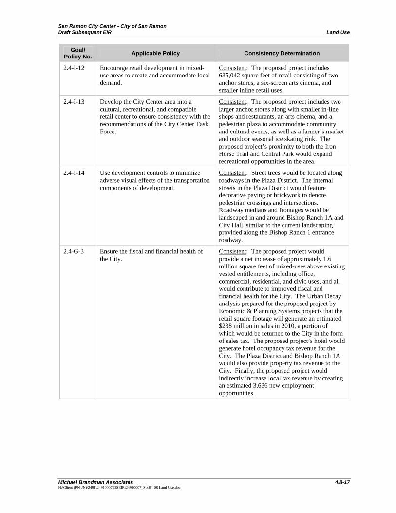
San Ramon City Center - City of San Ramon Draft Subsequent EIR Land Use
Michael Brandman Associates 4.8-17 H:\Client (PN-JN)\2491\24910007\DSEIR\24910007_Sec04-08 Land Use.doc
Goal/ Policy No. Applicable Policy Consistency Determination
2.4-I-12 Encourage retail development in mixed-use areas to create and accommodate local demand.
Consistent: The proposed project includes 635,042 square feet of retail consisting of two anchor stores, a six-screen arts cinema, and smaller inline retail uses.
2.4-I-13 Develop the City Center area into a cultural, recreational, and compatible retail center to ensure consistency with the recommendations of the City Center Task Force.
Consistent: The proposed project includes two larger anchor stores along with smaller in-line shops and restaurants, an arts cinema, and a pedestrian plaza to accommodate community and cultural events, as well as a farmer’s market and outdoor seasonal ice skating rink. The proposed project’s proximity to both the Iron Horse Trail and Central Park would expand recreational opportunities in the area.
2.4-I-14 Use development controls to minimize adverse visual effects of the transportation components of development.
Consistent: Street trees would be located along roadways in the Plaza District. The internal streets in the Plaza District would feature decorative paving or brickwork to denote pedestrian crossings and intersections. Roadway medians and frontages would be landscaped in and around Bishop Ranch 1A and City Hall, similar to the current landscaping provided along the Bishop Ranch 1 entrance roadway.
2.4-G-3 Ensure the fiscal and financial health of the City.
Consistent: The proposed project would provide a net increase of approximately 1.6 million square feet of mixed-uses above existing vested entitlements, including office, commercial, residential, and civic uses, and all would contribute to improved fiscal and financial health for the City. The Urban Decay analysis prepared for the proposed project by Economic & Planning Systems projects that the retail square footage will generate an estimated $238 million in sales in 2010, a portion of which would be returned to the City in the form of sales tax. The proposed project’s hotel would generate hotel occupancy tax revenue for the City. The Plaza District and Bishop Ranch 1A would also provide property tax revenue to the City. Finally, the proposed project would indirectly increase local tax revenue by creating an estimated 3,636 new employment opportunities.

San Ramon City Center - City of San Ramon Land Use Draft Subsequent EIR
4.8-18 Michael Brandman Associates
H:\Client (PN-JN)\2491\24910007\DSEIR\24910007_Sec04-08 Land Use.doc
Goal/ Policy No. Applicable Policy Consistency Determination
2.4-I-16 Evaluate the ability of new development to pay for its infrastructure, its share of public and community facilities, and the incremental operating costs it imposes.
Consistent: The proposed project would provide either the full cost or a pro-rata share for its necessary roadway improvements. The project would also provide development fees to public service and utility providers for capital improvements. The proposed project’s commercial and hotel uses would generate substantial amounts of tax revenue for the City that could be used to fund the operation of various City services.
2.4-I-17 Existing City development review practices assure that new development provides for the capital facilities needed to serve it. Ongoing maintenance of those facilities—generally via infrastructure landscaping and lighting districts—is also typically provided for. While the defraying of such costs by new development would normally be expected, some projects may contribute to the community in ways that compensate for a negative fiscal impact.
Consistent: Sunset Development and the City have a formal lighting maintenance agreement for the Bishop Ranch Business Park, and it would be expected that the proposed project would be covered by this agreement. Therefore, lighting maintenance costs associated with the proposed project would not pose a burden on City resources.
2.4-I-19 Encourage diverse economic growth within the City, particularly in the retail sector.
Consistent: The proposed project’s Plaza District component would provide 635,042 square feet of retail, spread among larger anchor stores, inline shops and restaurants, and a six-screen arts cinema. The Plaza District would be a “lifestyle center,” which is a type of commercial retail development that currently does not exist in San Ramon. In addition, the Plaza District would include a pedestrian plaza that would be used for seasonal outdoor retail activities such as a farmer’s market in the warmer months and holiday festivities in the winter months (e.g., ice skating).
Growth Management
3.1-G-1 Manage the City’s growth in a way that balances existing and planned transportation facilities, protection of open space and ridgelines, provision of diverse housing options and job opportunities, and the preservation of high-quality community facilities and services.
Consistent: The proposed project contains variety of uses, including mixed-uses (residential, retail, hotel, office) in the Plaza District, Class A office space in Bishop Ranch 1A, and civic uses in City Hall. The Plaza District would provide high-density residential units in a mixed-use setting, as well as

San Ramon City Center - City of San Ramon Draft Subsequent EIR Land Use
Michael Brandman Associates 4.8-19 H:\Client (PN-JN)\2491\24910007\DSEIR\24910007_Sec04-08 Land Use.doc
Goal/ Policy No. Applicable Policy Consistency Determination
cont. inclusionary workforce housing units. The project would create an estimated 3,336 jobs, ranging from part-time, entry-level to highly skilled, career opportunities. The City Hall would include a new library and police station, and would improve the delivery of library services and police protection to the community. The proposed project would also include a Transit Center that would provide four bus stalls and a waiting area for passengers. Finally, the proposed project is adjacent to the Iron Horse Trail and would be accessible for trail users. In summary, the proposed project provides balanced land uses, diverse housing options, job opportunities, multiple transportation options, and high-quality community facilities.
3.1-I-1 Allow urban development only if traffic from that development can be accommodated within acceptable traffic levels of service.
Consistent: The proposed project would implement roadway improvements to ensure that acceptable traffic level of service meets Measure C performance standards. Refer to Section 4.12, Transportation for further discussion.
3.1-I-3 Provide a variety of diverse housing options to accommodate the local employment base, including public service employees.
Consistent: The proposed project would provide up to 487 high-density residential units ranging in size from 750 to 2,000 square feet in a mixed-use setting adjacent to the Bishop Ranch Business Park in order to provide diverse housing options.
3.1-I-7 Allow urban development only within the City’s Urban Growth Boundary (see Implementing Policy 4.6-I-1) and only in accord with a plan for full urban services (police, fire, parks, water, sewer, streets and storm drainage) to which all providers are committed.
Consistent: The proposed project is located within the City’s Urban Growth Boundary. Portions of the project site have existing connections to potable water, fire water, wastewater, storm drainage, electricity, natural gas, and street lighting systems.
3.2-G-1 Ensure the attainment of public facility and service standards through the City’s development review process, Capital Improvement Program, and a variety of funding mechanisms to maintain existing facilities and help fund expansion.
Consistent: The project applicant would provide development fees to City and the San Ramon Valley Unified School District for capital improvements to public facilities. Refer to Section 4.11, Public Services and Recreation and Section 4.14, Utility and Service Systems for further discussion.
3.2-I-3 Require new development to fund public facilities and infrastructure that is deemed necessary to mitigate the impact of that new development.
Consistent: The project applicant would provide development fees to City and the San Ramon Valley Unified School District for capital improvements to public facilities and infrastructure. Refer to Section 4.11, Public Services and Recreation and Section 4.14, Utility and Service Systems for further discussion.

San Ramon City Center - City of San Ramon Land Use Draft Subsequent EIR
4.8-20 Michael Brandman Associates
H:\Client (PN-JN)\2491\24910007\DSEIR\24910007_Sec04-08 Land Use.doc
Goal/ Policy No. Applicable Policy Consistency Determination
3.2-I-4 Levy mitigation fees for public facilities and infrastructure improvements in proportion to a new development’s impact.
Consistent: The project applicant would provide development fees to City and the San Ramon Valley Unified School District to cover the proposed project’s impacts on public facilities and infrastructure. Refer to Section 4.11, Public Services and Recreation and Section 4.14, Utility and Service Systems for further discussion.
3.3-G-1 Maintain acceptable traffic level of service (equal to or better than Measure C requirements) on City streets and roadways through implementation of Transportation Demand Management (TDM), Growth Management, the Capital Improvement Program and traffic engineering operational measures.
Consistent: The proposed project would implement roadway improvements to ensure that acceptable traffic level of service meets Measure C performance standards. Refer to Section 4.12, Transportation for further discussion.
3.3-I-1 Strive to maintain traffic level of service (LOS) C or better as the standard at all intersections on streets subject to Measure C, with LOS D during no more than 3 hours of the day (a.m., p.m., and noon peaks).
Consistent: After the implementation of improvements to mitigate for the proposed project’s impacts on intersection operations, all impacted intersections would operate at the LOS identified by Measure C or better. Refer to Section 4.12, Transportation for further discussion.
3.3-I-2 Accept LOS D during two-hour peak periods (a.m. and p.m.) with the possibility of intersections at or closely approximating the limits of LOS D (Volume/Capacity < 0.90), only on arterial routes bordered by non-residential development where improvements to meet the City’s standard would be prohibitively costly or disruptive.
Consistent: After the implementation of improvements to mitigate for the proposed project’s impacts on intersection operations, all impacted intersections would operate either LOS D or better and would be consistent with Measure C performance standards. Refer to Section 4.12, Transportation for further discussion.
3.3-I-3 Require traffic impact studies for all proposed new development projected to generate 50 or more peak-hour vehicle trips.
Consistent: A traffic impact study was prepared by DMJM Harris for the proposed project. Refer to Section 4.12, Transportation for further discussion.
3.3-I-4 Proposed development expected to generate 50 or more peak-hour vehicle trips will not be approved, unless it can be shown that its impact can be mitigated and the City’s traffic and circulation standards can be maintained. As required by Measure C, the City also will not approve
Consistent: The proposed project would generate more than 100 AM and PM peak-hour trips and would be subject to the “Findings of Consistency” requirement. After the implementation of improvements to mitigate for the proposed project’s impacts on intersection operations, all impacted intersections would

San Ramon City Center - City of San Ramon Draft Subsequent EIR Land Use
Michael Brandman Associates 4.8-21 H:\Client (PN-JN)\2491\24910007\DSEIR\24910007_Sec04-08 Land Use.doc
Goal/ Policy No. Applicable Policy Consistency Determination
cont. any proposed development expected to generate over 100 peak-hour vehicle trips, unless “Findings of Consistency” can be made. Such Findings will be based on the project’s ability to maintain Measure C traffic and circulation standards, in conjunction with anticipated City-initiated capital improvements. Identify and implement circulation improvements on the basis of detailed traffic studies.
operate at LOS D or better and would be consistent with Measure C performance standards. Refer to Section 4.12, Transportation for further discussion.
3.3-I-5 Support regional and local neighborhood transit options to reduce the use of the automobile and maintain acceptable traffic levels of service.
Consistent: The proposed project would include a Transit Center adjacent to City Hall. The Transit Center would provide four bus stalls and a waiting area for passengers. In addition, the proposed project would be accessible from the Iron Horse Trail and would provide pedestrian connections to surrounding land uses, including the Shops at Bishop Ranch, Bishop Ranch 1, Bishop Ranch 3, Central Park, and The Market Place.
3.4-G-1 Utilize Transportation Systems Management (TSM) to reduce total vehicle trips on San Ramon streets, and to contribute to regional air quality improvement and effective growth management.
Consistent: The proposed project would promote trip reduction through the inclusion of a Transit Center, pedestrian and bicycle connections to the Iron Horse Trail and surrounding land uses, and locating mixed uses in an existing urbanized area within walking or biking distance of office complexes and commercial retail centers. These project features provide alternatives to single-passenger vehicle usage and is consistent with the objective of contributing to regional air quality improvement and effective growth management.
3.4-I-3 Cooperate with service providers and other jurisdictions to promote local and regional public transit service.
Consistent: The proposed project’s Transit Center would be served by County Connection bus service, which connects to regional transportation systems such as BART.
3.4-I-4 Support local feeder transit service to and from current and future regional transit lines.
Consistent: The proposed project would include a Transit Center that would be incorporated into the ground floor of the two-level, 414-space parking garage located on the south side of the City Hall. The Transit Center would provide four bus stalls and a waiting area for passengers and would support current and future regional transit lines.

San Ramon City Center - City of San Ramon Land Use Draft Subsequent EIR
4.8-22 Michael Brandman Associates
H:\Client (PN-JN)\2491\24910007\DSEIR\24910007_Sec04-08 Land Use.doc
Goal/ Policy No. Applicable Policy Consistency Determination
3.4-I-7 Improve and expand the bicycle routing system in San Ramon.
Consistent: The existing Class II bicycle facilities on Bishop Drive that terminate at Sunset Drive would be extended to Camino Ramon and then to Bollinger Canyon Road as part of the roadway improvements associated with the proposed project. The extended Class II bicycle facilities would connect with the Class I Iron Horse Trail facility, enhancing bicycle mobility in the project area.
3.5-G-1 Participate in cooperative and multi-jurisdictional transportation planning for the maintenance of regional mobility and air quality standards as required by the Measure C Growth Management Program and the Contra Costa Congestion Management Plan (CMP).
Consistent: The proposed project’s Transit Center is intended to provide a centralized and convenient location for local bus service that would serve neighboring communities, as well as the Dublin/Pleasanton and Walnut Creek BART stations. In addition, the proposed project would promote the use of pedestrian and bicycle modes of transportation through its proximity to the Iron Horse Trail and nearby office complexes and commercial centers. This is consistent with regional mobility and air quality improvement programs.
3.5-I-4 Participate in programs to mitigate regional traffic congestion, including regional traffic impact fees on new development.
Consistent: The proposed project would implement roadway improvements to ensure that acceptable traffic level of service meets Measure C performance standards. Refer to Section 4.12, Transportation for further discussion.
3.5-I-5 Emphasize regional transportation demand management and trip reduction strategies as alternatives to increased roadway capacity.
Consistent: The proposed project would employ trip reduction strategies through the inclusion of a Transit Center that would serve as a convenient, centralized location for public transit providers. It would also promote the use of pedestrian and bicycle modes of transportation and encourage trip reduction through its adjacency to the Iron Horse Trail, and its siting of residential and office uses near shopping, dining, and entertainment. These reductions would reduce the need for increased roadway capacity.
3.5-I-6 Continue to address the impacts of land use decisions on regional and local transportation facilities.
Consistent: The proposed project would implement roadway improvements to ensure that acceptable intersection and arterial roadway level of service meets adopted performance standards. Refer to Section 4.12, Transportation for further discussion.

San Ramon City Center - City of San Ramon Draft Subsequent EIR Land Use
Michael Brandman Associates 4.8-23 H:\Client (PN-JN)\2491\24910007\DSEIR\24910007_Sec04-08 Land Use.doc
Goal/ Policy No. Applicable Policy Consistency Determination
3.6-G-1 Promote the opportunity to both work and live in San Ramon.
Consistent: The proposed project would provide more than 2.1 million square feet of mixed-uses, including office, commercial, residential, and civic uses to promote the opportunity to both work and live in San Ramon. The Plaza District would contain 487 dwelling units and its retail, hotel, and flex office/retail components would provide employment opportunities.
3.6-I-1 Develop and implement housing programs that emphasize the availability of housing for people who work in local jobs.
Consistent: The proposed project would provide 487 high-density residential units ranging in size from 750 to 2,000 square feet in a mixed-use setting adjacent to the Bishop Ranch Business Park in order to implement housing programs promoting the availability of housing for local workers.
Land Use
4.6-I-10 Require residential development that employs creative site design and architectural quality that blends with the characteristics of each location and its surroundings, and incorporate a 360° design element.
Consistent: The architectural design of the residential structures in the Plaza District would incorporate contemporary design elements that balance scale, adjacency, and use mix to create a visually appealing destination. The Plaza District design emphasizes clean building exteriors and the use of glass and water.
4.6-I-11 Provide a wide range of housing opportunities for current and future residents.
Consistent: The proposed project would provide 487 high-density residential units ranging in size from 750 to 2,000 square feet in a mixed-use setting adjacent to the Bishop Ranch Business Park in order provide a wide range of housing opportunities to fill current and projected needs.
4.6-I-13 Provide high-quality public facilities, services, and other amenities close to residents.
Consistent: The proposed project would provide a net increase of 1.6 million square feet of mixed-uses above existing vested entitlements, including office, commercial, residential, and civic uses to provide public facilities near residential areas.
4.6-I-14 Ensure that all residential development provides adequate on-site parking.
Consistent: The proposed project includes 896 parking spaces reserved for the anticipated 487 residential units. These spaces are provided in five off-street parking garages within the Plaza District.
4.6-I-17 Maintain neighborhood and community shopping centers of sizes and at locations that offer both choice and convenience for shoppers and residents while sustaining a strong retail base for the City.
Consistent: The proposed project adds 635,042 square feet of retail to the area’s existing shopping areas to offer choice and convenience to residents living in the Plaza District and in existing residential areas. The larger anchor stores and smaller shops will promote a strong retail base for the City.
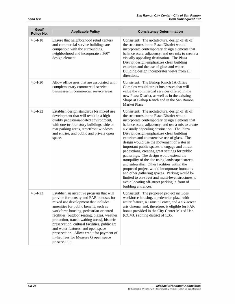
San Ramon City Center - City of San Ramon Land Use Draft Subsequent EIR
4.8-24 Michael Brandman Associates
H:\Client (PN-JN)\2491\24910007\DSEIR\24910007_Sec04-08 Land Use.doc
Goal/ Policy No. Applicable Policy Consistency Determination
4.6-I-18 Ensure that neighborhood retail centers and commercial service buildings are compatible with the surrounding neighborhood and incorporate a 360° design element.
Consistent: The architectural design of all of the structures in the Plaza District would incorporate contemporary design elements that balance scale, adjacency, and use mix to create a visually appealing destination. The Plaza District design emphasizes clean building exteriors and the use of glass and water. Building design incorporates views from all directions.
4.6-I-20 Allow office uses that are associated with complementary commercial service businesses in commercial service areas.
Consistent: The Bishop Ranch 1A Office Complex would attract businesses that will value the commercial services offered in the new Plaza District, as well as in the existing Shops at Bishop Ranch and in the San Ramon Market Place.
4.6-I-22 Establish design standards for mixed use development that will result in a high-quality pedestrian-scaled environment, with one-to-four story buildings, side or rear parking areas, streetfront windows and entries, and public and private open space.
Consistent: The architectural design of all of the structures in the Plaza District would incorporate contemporary design elements that balance scale, adjacency, and use a mix to create a visually appealing destination. The Plaza District design emphasizes clean building exteriors and an extensive use of glass. The design would use the movement of water in important public spaces to engage and attract pedestrians, creating great settings for public gatherings. The design would extend the tranquility of the site using landscaped streets and sidewalks. Other facilities within the proposed project would incorporate fountains and other gathering spaces. Parking would be limited to on-street and multi-level structures to avoid locating off-street parking in front of building entrances.
4.6-I-23 Establish an incentive program that will provide for density and FAR bonuses for mixed use development that includes amenities for public benefit, such as workforce housing, pedestrian-oriented facilities (outdoor seating, plazas, weather protection, transit waiting areas), historic preservation, cultural facilities, public art and water features, and open space preservation. Allow credit for payment of in-lieu fees for Measure G open space preservation.
Consistent: The proposed project includes workforce housing, a pedestrian plaza with water feature, a Transit Center, and a six-screen arts cinema, and, therefore, is eligible for FAR bonus provided in the City Center Mixed Use (CCMU) zoning district of 1.35.

San Ramon City Center - City of San Ramon Draft Subsequent EIR Land Use
Michael Brandman Associates 4.8-25 H:\Client (PN-JN)\2491\24910007\DSEIR\24910007_Sec04-08 Land Use.doc
Goal/ Policy No. Applicable Policy Consistency Determination
4.6-I-24 Allow for the revitalization and intensification of infill sites within the Bishop Ranch Business Park, consistent with FAR limitations, and amend the Zoning Ordinance so that they do not inhibit appropriate infill development.
Consistent: A total of 681,769 square feet of office space would be developed among three buildings in the new Bishop Ranch 1A office complex. In addition, two parking garages would be constructed for office workers. This office space and parking would replace an existing 194,652 square feet of office space in four two-level buildings and current single-level surface parking, respectively. The proposed project meets the current FAR limitation of 1.35 as a single project.
4.6-I-25 Permit a diverse mix of complementary uses within Bishop Ranch to better meet the daily needs of workers and to reduce the need to travel by automobile. Approval of a use permit would be required upon finding that such uses are compatible with the primary use and do not adversely affect the traffic-carrying capacity of adjacent streets.
Consistent: The proposed project would provide a net increase of 1.6 million square feet of mixed-uses above existing vested entitlements, including commercial, residential, office and civic. It would include a Transit Center near City Hall to promote transit ridership. The proposed project would promote the use of pedestrian and bicycle modes of transportation by centering the Plaza District around a large pedestrian plaza, located in front of the hotel. The proposed project’s location adjacent to the Iron Horse Trail would also encourage non-motorized modes of transportation. The proposed project would provide 487 high-density residential units to encourage use of adjacent office space and retail, recreational, and cultural opportunities.
4.7-I-5 Support the direction of the City Center Task Force and the City’s efforts to develop the City Center as a cohesive mix of civic, compatible retail, and open space uses with an arts and entertainment focus.
Consistent: The proposed City Center project would provide a net increase of 1.6 million square feet of mixed-uses above existing vested entitlements, including commercial and civic uses. Commercial uses include retail shops, a hotel and theater, and restaurants, while civic uses include City services and a designated area in the Plaza District for community and cultural events. This is consistent with the City Center Task Force’s vision for the proposed project.
4.8-G-1 Maintain and enhance San Ramon’s identity.
Consistent: The design of all structures within the proposed project would include high-quality architecture and landscaping consistent with the style of Bishop Ranch that will maintain and enhance the aesthetic character of the City of San Ramon. The proposed project would strengthen San Ramon and Bishop Ranch with a vibrant mix of complementary uses including retail, residential, office, hotel, and civic. The City Hall would feature a four-story City office

San Ramon City Center - City of San Ramon Land Use Draft Subsequent EIR
4.8-26 Michael Brandman Associates
H:\Client (PN-JN)\2491\24910007\DSEIR\24910007_Sec04-08 Land Use.doc
Goal/ Policy No. Applicable Policy Consistency Determination
cont. building with an attached dome-shaped Council Chambers. A cast sculpting of the City symbol--an aloft crow with extended wings--would crown the top of the dome housing the Council Chamber.
4.8-I-2 Ensure that the design, location and size of new development blends with the environment and a site’s natural features.
Consistent: The design of all structures within the proposed project would include high-quality architecture and landscaping consistent with the style of Bishop Ranch that will maintain and enhance the aesthetic character of the City of San Ramon. The extensive use of glass will maximize views of the surrounding hills and natural landscape features.
4.8-I-3 Establish citywide lighting standards to ensure appropriate illumination levels for residential, commercial, and industrial land uses, and that lighting is of a consistent character and quality while reducing light pollution.
Consistent: Mitigation is proposed that would require the project applicant to submit a lighting plan to the City identifying measures by which light will be shielded to avoid spillage onto neighboring land uses. Refer to Section 4.1, Aesthetics, Light, and Glare for further discussion.
4.8-I-5 Encourage the linkage and integration of new development with existing neighborhoods by means of open space areas, parks, and pathways as a means of enhancing pedestrian connections.
Consistent: The proposed project would be accessible to nearby land uses including Bishop Ranch 1, the Market Place, the Shops at Bishop Ranch, Central Park, and the Iron Horse Trail by sidewalks located along roadway frontages or dedicated pathways.
4.8-I-6 Seek to assure maximum public access to the Iron Horse Trail through land acquisition, licensing agreements with Contra Costa County, and incentives for dedication and improvement of land for trailhead parks and walkways.
Consistent: The proposed project’s adjacency to the Iron Horse Trail will promote the use of pedestrian and bicycle modes of transportation as well as enhance the recreational opportunities of the trail.
4.8-I-7 Require new commercial and office development to provide outdoor passive recreation areas.
Consistent: The Plaza District would contain a plaza with water features and seating for outdoor passive recreation.
4.8-I-8 Use the development review process to ensure that new development preserves and/or enhances significant views of the natural landscape.
Consistent: While some obstruction of views on the surrounding hills would occur as a result of development of the proposed project, view corridors along Bishop Drive, Center Street, and Bollinger Canyon Road would be created or enhanced by the proposed project. Refer to Section 4.1, Aesthetics, Light, and Glare for further discussion.
4.8-I-9 Continue to implement landscaping guidelines for public roadways that improve their visual character.
Consistent: All project frontages with roadways would feature landscaping to improve their visual character. Refer to Exhibits 3-9 and 3-12.

San Ramon City Center - City of San Ramon Draft Subsequent EIR Land Use
Michael Brandman Associates 4.8-27 H:\Client (PN-JN)\2491\24910007\DSEIR\24910007_Sec04-08 Land Use.doc
Goal/ Policy No. Applicable Policy Consistency Determination
4.8-I-11 Require new office and commercial development to provide outdoor art that is clearly visible to the public.
Consistent: The Plaza District would include a pedestrian plaza with a water feature. In addition, the City Council Chambers would be topped with a cast sculpting of the City symbol--an aloft crow with extended wings.
4.8-I-12 Encourage attractive, drought-tolerant landscaping on private property that is suitable for San Ramon’s climate.
Consistent: The proposed project’s conceptual landscaping plan includes the use of drought-tolerant plant and tree species, as identified by East Bay Municipal Utilities District, including the California live oak, Coast live oak, valley oak, London plane tree, cherry tree, stone pine, toyon, and glossy abelia.
4.8-I-13 Require appropriate landscape treatment for public rights-of-way in all new residential, office, and commercial development.
Consistent: Landscaping would be provided within all project components and along roadway frontages. Refer to Exhibits 3-9 and 3-12.
4.8-I-14 Ensure that businesses provide signs that are attractive and consistent with neighboring commercial uses, minimize visual clutter from roadways and other public areas, and, where possible, cannot be seen from residential neighborhoods.
Consistent: The proposed project’s signage would comply with the provisions of the City Center Mixed Use (CCMU) zoning district requirements. Signage in the Plaza District would be limited to building entrances and other appropriate locations where its appearance would be visually unobtrusive and consistent with the objective of creating an upscale entertainment destination.
4.8-I-16 Maintain the predominant low building form throughout the City.
Consistent: As stated Policy 4.8-I-17, the City Center is allowed an exception to policies related to low building heights.
4.8-I-17 Establish urban design standards in the Zoning Ordinance for large-scale office development, including: • Limitations on maximum building height
(five stories/75 feet) • Maximum vertical wall dimensions
without a minimum upper-story stepback or setback (four stories/65 feet)
• Required upper-story setbacks above four stories (1:1)
• Limitations on projections above height limits for towers, spires, and technical features, such as elevator penthouses and mechanical equipment enclosures (up to 25 percent of total roof area)
• Limitations on blank walls visible from public streets, and
• Sun access planes adjacent to public parks (1:3.5) to prevent substantial shadow impacts.
Consistent: As stated in the policy, the City Center would be excluded from the height restriction, setback, and blank wall aspects of this policy. The policy states that the sun access plane provision would apply to the City Center project. As shown in Exhibits 4.1-7a through 4.1-7d, shadows from Plaza District buildings would not extend into Central Park and, therefore, would be consistent with the sun access plane requirements. Refer to Section 4.1, Aesthetics, Light, and Glare for further discussion.

San Ramon City Center - City of San Ramon Land Use Draft Subsequent EIR
4.8-28 Michael Brandman Associates
H:\Client (PN-JN)\2491\24910007\DSEIR\24910007_Sec04-08 Land Use.doc
Goal/ Policy No. Applicable Policy Consistency Determination
cont. City Center would be excluded from these requirements, with the exception of the sun access plane requirements adjacent to public parks.
4.8-I-18 Allow encroachments into the sun access plane to provide architectural flexibility. This may be done by allowing, for example, a 15-foot vertical projection above the sun access plane for up to 25 percent of the length of the lot line opposite the public park.
Consistent: As shown in Exhibits 4.1-7a through 4.1-7d, shadows from Plaza District buildings would not extend into Central Park and, therefore, would be consistent with the sun access plane requirements.
4.8-I-21 Require all walls and fences to be designed to minimize visual monotony.
Consistent: Few walls and fences would be used in this proposed project. Instead, building façades would be the most prominent visual features and would incorporate design treatments, such as color and texture variation, the use of glass, and green roof landscaping to enhance visual aesthetics.
4.8-I-22 Encourage underground parking in new development, where feasible.
Consistent: All three project components would provide off-street parking in parking structures. The Plaza District parking structures would include below-grade parking under certain buildings.
Traffic and Circulation
5.1-G-1 Maintain acceptable levels of service and ensure that future development and the circulation system are in balance.
Consistent: The proposed project would implement roadway improvements to ensure that acceptable intersection and arterial roadway level of service meets adopted performance standards. Refer to Section 4.12, Transportation for further discussion.
5.1-I-1 Strive to maintain traffic LOS C or better as the standard at all intersections, with LOS D during no more than three peak periods of the day (a.m., p.m., and noon peaks).
Consistent: The proposed project would implement roadway improvements to ensure that acceptable intersection and arterial roadway level of service meets adopted performance standards. Refer to Section 4.12, Transportation for further discussion.
5.1-I-2 Require traffic impact studies for all proposed new developments which are projected to generate 50 or more peak-hour vehicle trips.
Consistent: DMJM Harris prepared a traffic study that analyzed the proposed project’s impacts on local roadways and intersections. Refer to Section 4.12, Transportation for further discussion.
5.1-I-3 Identify and implement circulation improvements on the basis of traffic studies.
Consistent: The DMJM Harris traffic study identified roadway improvements necessary to mitigate for the proposed project’s impacts on circulation. Refer to Section 4.12, Transportation for further discussion.