introduction to aerial photographs · introduction to aerial photographs the development of aerial...
TRANSCRIPT
69
Introduction To Aerial Photographs
Chapter 6
Introduction To AerialPhotographs
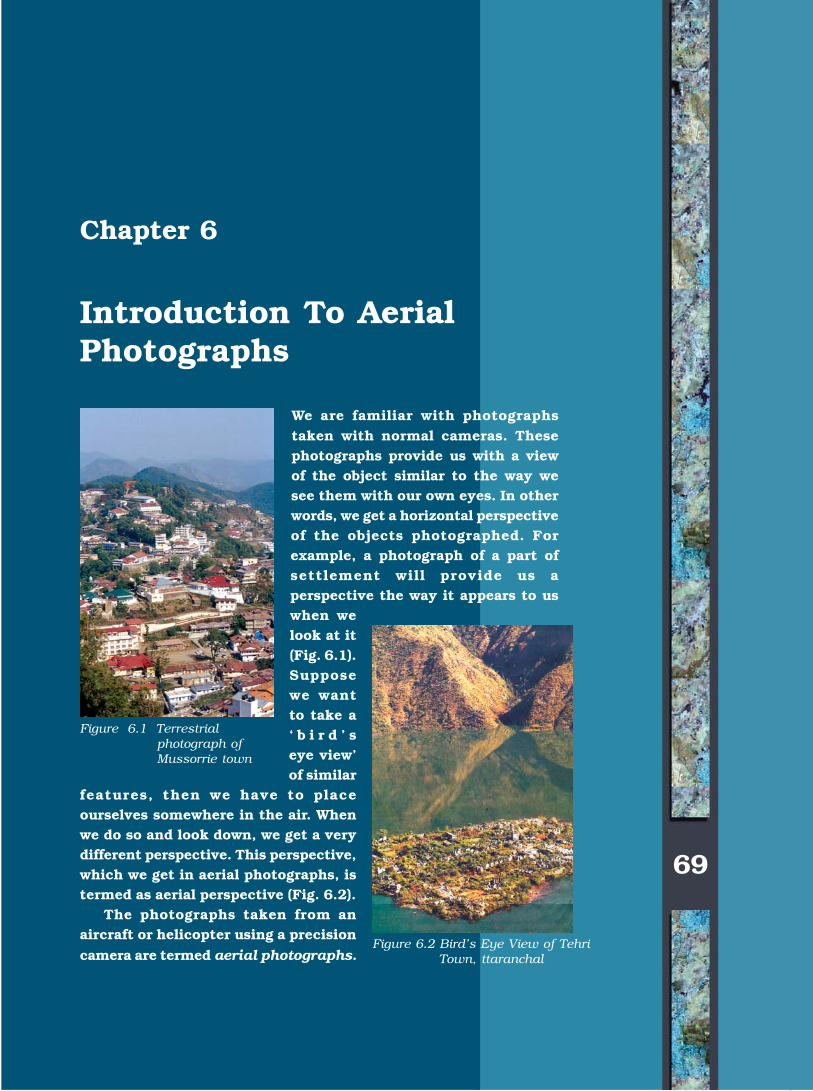
We are familiar with photographstaken with normal cameras. Thesephotographs provide us with a viewof the object similar to the way wesee them with our own eyes. In otherwords, we get a horizontal perspectiveof the objects photographed. Forexample, a photograph of a part ofsettlement will provide us aperspective the way it appears to uswhen welook at it(Fig. 6.1).Supposewe wantto take a‘ b i r d ’ seye view’of similar
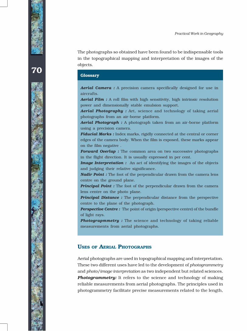
features, then we have to placeourselves somewhere in the air. Whenwe do so and look down, we get a verydifferent perspective. This perspective,which we get in aerial photographs, istermed as aerial perspective (Fig. 6.2).
The photographs taken from anaircraft or helicopter using a precision
camera are termed aerial photographs.
Figure 6.1 Terrestrialphotograph ofMussorrie town
Figure 6.2 Bird’s Eye View of TehriTown, ttaranchal
©NCERT
not to
be r
epubl
ished
70
Practical Work in Geography
USES OF AERIAL PHOTOGRAPHS
Aerial photographs are used in topographical mapping and interpretation.
These two different uses have led to the development of photogrammetry
and photo/image interpretation as two independent but related sciences.
Photogrammetry: It refers to the science and technology of making
reliable measurements from aerial photographs. The principles used in
photogrammetry facilitate precise measurements related to the length,
Glossary
Aerial Camera : A precision camera specifically designed for use in
aircrafts.
Aerial Film : A roll film with high sensitivity, high intrinsic resolution
power and dimensionally stable emulsion support.
Aerial Photography : Art, science and technology of taking aerial
photographs from an air-borne platform.
Aerial Photograph : A photograph taken from an air-borne platform
using a precision camera.
Fiducial Marks : Index marks, rigidly connected at the central or corner
edges of the camera body. When the film is exposed, these marks appear
on the film negative .
Forward Overlap : The common area on two successive photographs
in the flight direction. It is usually expressed in per cent.
Image Interpretation : An act of identifying the images of the objects
and judging their relative significance.
Nadir Point : The foot of the perpendicular drawn from the camera lens
centre on the ground plane.
Principal Point : The foot of the perpendicular drawn from the camera
lens centre on the photo plane.
Principal Distance : The perpendicular distance from the perspective
centre to the plane of the photograph.
Perspective Centre : The point of origin (perspective centre) of the bundle
of light rays.
Photograpmmetry : The science and technology of taking reliable
measurements from aerial photographs.
The photographs so obtained have been found to be indispensable tools
in the topographical mapping and interpretation of the images of the
objects.
©NCERT
not to
be r
epubl
ished
71
Introduction To Aerial Photographs
The development of aerial photography in India is briefly given in Box 6.I.
breadth and height from such photographs. Hence, they are used as the
data source for creating and updating topographic maps.
Image Interpretation: It is an art of identifying images of objects and
judging their relative significance. The principles of image interpretation
are applied to obtain qualitative information from the aerial photographs
such as land use/land cover, topographical forms, soil types, etc. A trained
interpreter can thus utilise aerial photographs to analyse the land-use
changes.
ADVANTAGES OF AERIAL PHOTOGRAPHY
The basic advantages that aerial photographs offer over ground based
observation are :
a. Improved vantage point: Aerial photography provides a bird’s
eye view of large areas, enabling us to see features of the earth surface in
their spatial context.
b. Time freezing ability: An aerial photograph is a record of the
surface features at an instance of exposure. It can, therefore, be used asa historical record.
Aerial photography in India goes back to 1920 when large-scale aerial
photographs of Agra city were obtained. Subsequently, Air Survey Party
of the Survey of India took up aerial survey of Irrawaddy Delta forests,
which was completed during 1923–24. Subsequently, several similar
surveys were carried out and advanced methods of mapping from aerial
photographs were used. Today, aerial photography in India is carried
out for the entire country under the overall supervision of the
Directorate of Air Survey (Survey of India) New Delhi. Three flying
agencies, i.e. Indian Air Force, Air Survey Company, Kolkata and
National Remote Sensing Agency, Hyderabad have been officially
authorised to take aerial photographs in India.
The procedure for indenting aerial photographs for educational
purposes could be made with APFPS Party No. 73, Directorate of Air
Survey, Survey of India, West Block IV, R. K. Puram, New Delhi.
Box 6.1 Aerial Photography in India
©NCERT
not to
be r
epubl
ished
72
Practical Work in Geography
c. Broadened Sensitivity: The sensitivity of the film used in takingaerial photographs is relatively more than the sensitivity of the humaneyes. Our eyes perceive only in the visible region of the electromagneticspectrum, i.e. 0.4 to 0.7 µm whereas the sensitivity of the film rangesfrom 0.3 to 0.9 µm.
d. Three Dimensional Perspective: Aerial photographs arenormally taken with uniform exposure interval that enables us in obtainingstereo pair of photographs. Such a pair of photographs helps us in gettinga three-dimensional view of the surface photographed.
TYPES OF AERIAL PHOTOGRAPHS
The aerial photographs are classified on the basis of the position of thecamera axis, scale, angular extent of coverage and the film used. Thetypes of the aerial photographs based on the position of optical axis andthe scale are given below :
a. Types of Aerial Photographs Based on the Position ofthe Cameral Axis: On the basis of the position of the camera axis,aerial photographs are classified into the following types :(i) Vertical photographs(ii) Low oblique photographs(iii) High oblique photographs
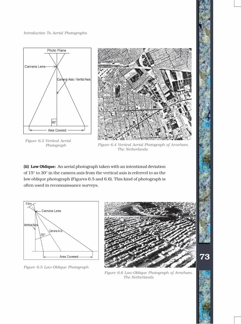
(i) Vertical Photographs: While taking aerial photographs, two distinctaxes are formed from the camera lens centre, one towards the groundplane and the other towards the photo plane. The perpendicular droppedfrom the camera lens centre to the ground plane is termed as the verticalaxis, whereas the plumb line drawn from the lens centre to the photoplane is known as the photographic/optical axis. When the photo planeis kept parallel to the ground plane, the two axes also coincide with eachother. The photograph so obtained is known as vertical aerial photograph
(Figures 6.3 and 6.4). However, it is normally very difficult to achieve
perfect parallelism between the two planes due to the fact that the aircraft
flies over the curved surface of the earth. The photographic axis, therefore,
deviates from the vertical axis. If such a deviation is within the range of
plus or minus 3o, the near-vertical aerial photographs are obtained. Any
photography with an unintentional deviation of more than 3o in the optical
axis from the vertical axis is known as a tilted photograph.
©NCERT
not to
be r
epubl
ished
73
Introduction To Aerial Photographs
(ii) Low Oblique: An aerial photograph taken with an intentional deviation
of 15° to 30° in the camera axis from the vertical axis is referred to as the
low oblique photograph (Figures 6.5 and 6.6). This kind of photograph is
often used in reconnaissance surveys.
Figure 6.3 Vertical Aerial Photograph Figure 6.4 Vertical Aerial Photograph of Arneham,
The Netherlands
Figure 6.5 Low-Oblique Photograph
Figure 6.6 Low-Oblique Photograph of Arneham, The Netherlands
©NCERT
not to
be r
epubl
ished
74
Practical Work in Geography
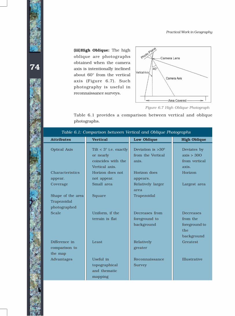
(iii)High Oblique: The high
oblique are photographs
obtained when the camera
axis is intentionally inclined
about 60° from the vertical
axis (Figure 6.7). Such
photography is useful in
reconnaissance surveys.
Attributes Vertical Low Oblique High Oblique
Optical Axis Tilt < 3° i.e. exactly Deviation is >300 Deviates by
or nearly from the Vertical axis > 30O
coincides with the axis. from vertical
Vertical axis. axis.
Characteristics Horizon does not Horizon does Horizon
appear. not appear. appears.
Coverage Small area Relatively larger Largest area
area
Shape of the area Square Trapezoidal
Trapezoidal
photographed
Scale Uniform, if the Decreases from Decreases
terrain is flat foreground to from the
background foreground to
the
background
Difference in Least Relatively Greatest
comparison to greater
the map
Advantages Useful in Reconnaissance Illustrative
topographical Survey
and thematic
mapping
Table 6.1 provides a comparison between vertical and oblique
photographs.
Figure 6.7 High Oblique Photograph
Table 6.1: Comparison between Vertical and Oblique Photographs
©NCERT
not to
be r
epubl
ished
75
Introduction To Aerial Photographs
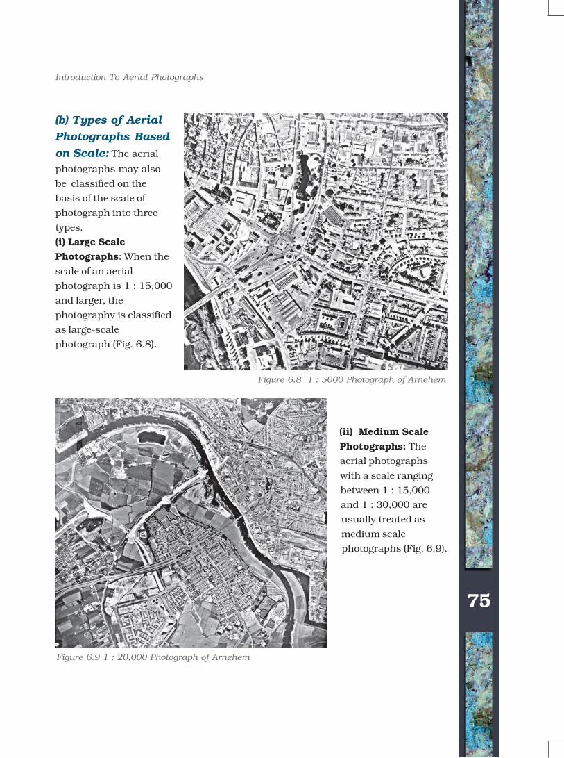
(b) Types of Aerial
Photographs Based
on Scale: The aerial
photographs may also
be classified on the
basis of the scale of
photograph into three
types.
(i) Large Scale
Photographs: When the
scale of an aerial
photograph is 1 : 15,000
and larger, the
photography is classified
as large-scale
photograph (Fig. 6.8).
(ii) Medium Scale
Photographs: The
aerial photographs
with a scale ranging
between 1 : 15,000
and 1 : 30,000 are
usually treated as
medium scale
photographs (Fig. 6.9).
Figure 6.8 1 : 5000 Photograph of Arnehem
Figure 6.9 1 : 20,000 Photograph of Arnehem
©NCERT
not to
be r
epubl
ished
76
Practical Work in Geography
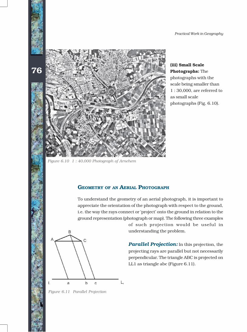
(iii) Small Scale
Photographs: The
photographs with the
scale being smaller than
1 : 30,000, are referred to
as small scale
photographs (Fig. 6.10).
GEOMETRY OF AN AERIAL PHOTOGRAPH
To understand the geometry of an aerial photograph, it is important to
appreciate the orientation of the photograph with respect to the ground,
i.e. the way the rays connect or ‘project’ onto the ground in relation to the
ground representation (photograph or map). The following three examples
of such projection would be useful in
understanding the problem.
Parallel Projection: In this projection, the
projecting rays are parallel but not necessarily
perpendicular. The triangle ABC is projected on
LL1 as triangle abc (Figure 6.11).
Figure 6.11 Parallel Projection
Figure 6.10 1 : 40,000 Photograph of Arnehem
©NCERT
not to
be r
epubl
ished
77
Introduction To Aerial Photographs
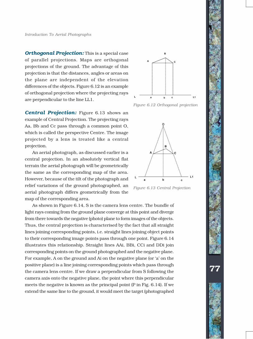
Orthogonal Projection: This is a special case
of parallel projections. Maps are orthogonal
projections of the ground. The advantage of this
projection is that the distances, angles or areas on
the plane are independent of the elevation
differences of the objects. Figure 6.12 is an example
of orthogonal projection where the projecting rays
are perpendicular to the line LL1.
Central Projection: Figure 6.13 shows an
example of Central Projection. The projecting rays
Aa, Bb and Cc pass through a common point O,
which is called the perspective Centre. The image
projected by a lens is treated like a central
projection.
An aerial photograph, as discussed earlier is a
central projection. In an absolutely vertical flat
terrain the aerial photograph will be geometrically
the same as the corresponding map of the area.
However, because of the tilt of the photograph and
relief variations of the ground photographed, an
aerial photograph differs geometrically from the
map of the corresponding area.
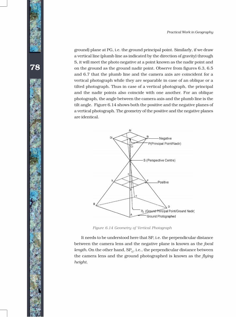
As shown in Figure 6.14, S is the camera lens centre. The bundle of
light rays coming from the ground plane converge at this point and diverge
from there towards the negative (photo) plane to form images of the objects.
Thus, the central projection is characterised by the fact that all straight
lines joining corresponding points, i.e. straight lines joining object points
to their corresponding image points pass through one point. Figure 6.14
illustrates this relationship. Straight lines AAi, BBi, CCi and DDi join
corresponding points on the ground photographed and the negative plane.
For example, A on the ground and Ai on the negative plane (or ‘a’ on the
positive plane) is a line joining corresponding points which pass through
the camera lens centre. If we draw a perpendicular from S following the
camera axis onto the negative plane, the point where this perpendicular
meets the negative is known as the principal point (P in Fig. 6.14). If we
extend the same line to the ground, it would meet the target (photographed
Figure 6.12 Orthogonal projection
Figure 6.13 Central Projection©NCERT
not to
be r
epubl
ished
78
Practical Work in Geography
ground) plane at PG, i.e. the ground principal point. Similarly, if we draw
a vertical line (plumb line as indicated by the direction of gravity) through
S, it will meet the photo negative at a point known as the nadir point and
on the ground as the ground nadir point. Observe from figures 6.3, 6.5
and 6.7 that the plumb line and the camera axis are coincident for a
vertical photograph while they are separable in case of an oblique or a
tilted photograph. Thus in case of a vertical photograph, the principal
and the nadir points also coincide with one another. For an oblique
photograph, the angle between the camera axis and the plumb line is the
tilt angle. Figure 6.14 shows both the positive and the negative planes of
a vertical photograph. The geometry of the positive and the negative planes
are identical.
It needs to be understood here that SP, i.e. the perpendicular distance
between the camera lens and the negative plane is known as the focal
length. On the other hand, SPG, i.e., the perpendicular distance between
the camera lens and the ground photographed is known as the flying
height.
Figure 6.14 Geometry of Vertical Photograph
©NCERT
not to
be r
epubl
ished
79
Introduction To Aerial Photographs
DIFFERENCE BETWEEN A MAP AND AN AERIAL PHOTOGRAPH
A map cannot be directly traced out of an aerial photograph. The reason
is that there is a basic difference in the planimetry (projection) and
perspective of a map and an aerial photograph. The difference is given in
Table 6.2.
Even vertical aerial photographs do not have a consistent scale unless
they have been taken of a flat terrain. Aerial photographs need to be
transformed from perspective view to the planimetric view before they can
be used as map substitute. Such transformed photographs are known
as orthophotos.
Table 6.2: Difference between Maps and Aerial Photographs
Aerial Photograph Map
It is a central Projection. It is an orthogonal Projection.
An aerial photograph is A map is a geometrically correct
geometrically incorrect. The representation of the part of the earth
distortion in the geometry is projected.
minimum at the centre and
increases towards the edges of the
photographs.
The scale of the photograph is The scale of the map is uniform
not uniform. throughout the map extent.
Enlargement/reduction does not Enlargement/reduction of the maps
change the contents of the involves redrawing it afresh.
photographs and can easily be
carried out.
Aerial photography holds good for The mapping of inaccessible and
inaccessible and inhospitable areas. inhospitable areas is very difficult and
sometimes it becomes impossible.
©NCERT
not to
be r
epubl
ished
80
Practical Work in Geography
SCALE OF AERIAL PHOTOGRAPH
You are already familiar with the concept of a map scale (See Chapter 2).
The concept of scale for aerial photographs is much the same as that of a
map. Scale is the ratio of a distance on an aerial photograph the distance
between the same two places on the ground in the real world. It can be
expressed in unit equivalents like 1 cm= 1,000 km(or 12,000 inches) or
as a representative fraction (1:100,000).
Scale determines what objects would be visible, the accuracy of
estimates and how certain features will appear. When conducting an
analysis that is based on air photos, it will sometimes be necessary to
make estimates regarding the number of objects, the area covered by a
certain amount of material or it may be possible to identify certain features
based on their length. To determine this dimension during air photo
interpretation, it will be necessary to make estimates of lengths and areas,
which require knowledge of the photo scale. There are three methods to
compute the scale of an aerial photograph using different sets of
information.
Method 1: By Establishing Relationship Between Photo
Distance and Ground Distance : If additional information like
ground distances of two identifiable points in an aerial photograph is
available, it is fairly simple to work out the scale of a vertical photograph.
Provided that the corresponding ground distances (Dg) are known for which
the distances on an aerial photograph (Dp) are measured. In such cases,
the scale of an aerial photograph will be measured as a ratio of the two,
i.e. Dp/ Dg.
Problem 6.1 The distance between two points on an aerial photograph is
measured as 2 centimetres. The known distance between the same two
points on the ground is 1 km. Compute the scale of the aerial photograph
(Sp).
Solution
Sp = Dp : Dg
= 2 cm : 1 km
= 2cm : 1 x 100,000 cm
= 1 : 100,000/2 = 50,000 cm
= 1 unit represents 50,000 units
Therefore, Sp = 1 : 50,000
©NCERT
not to
be r
epubl
ished
81
Introduction To Aerial Photographs
Method 2: By Establishing Relationship Between Photo
Distance and Map Distance: As we know, the distances between
different points on the ground are not always known. However, if a reliable
map is available for the area shown on an aerial photograph, it can be
used to determine the photo scale. In other words, the distances between
two points identifiable both on a map and the aerial photograph enable
us to compute the scale of the aerial photograph (Sp). The relationship
between the two distances may be expressed as under :
(Photo scale : Map scale) = (Photo distance : Map distance)
We can derive
Photo scale (Sp) = Photo distance (D
p) : Map distance (D
m) x Map
scale factor (msf)
Problem 6.2 The distance measured between two points on a map is 2
cm. The corresponding distance on an aerial photograph is 10 cm.
Calculate the scale of the photograph when the scale of the map is 1:
50,000.
Solution
Sp = Dp : Dm x msf
Or = 10 cm : 2 cm x 50,000
Or = 10 cm : 100,000 cm
Or = 1 : 100,000/10 = 10,000 cm
Or = 1 unit represents 10,000 units
Therefore, Sp = 1 : 10,000
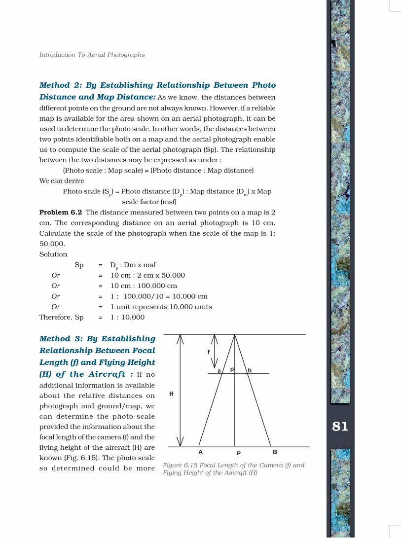
Method 3: By Establishing
Relationship Between Focal
Length (f) and Flying Height
(H) of the Aircraft : If no
additional information is available
about the relative distances on
photograph and ground/map, we
can determine the photo-scale
provided the information about the
focal length of the camera (f) and the
flying height of the aircraft (H) are
known (Fig. 6.15). The photo scale
so determined could be more Figure 6.15 Focal Length of the Camera (f) andFlying Height of the Aircraft (H)
©NCERT
not to
be r
epubl
ished
82
Practical Work in Geography
reliable if the given aerial photograph is truly vertical or near vertical and
the terrain photographed is flat. The focal length of the camera (f) and the
flying height of the aircraft (H) are provided as marginal information on
most of the vertical photographs (Box 6.2).
The Fig. 6.15 may be used to derive the photo-scale formula in the
following way :
Focal Length (f) : Flying Height(H) =
Photo distance (Dp) : Ground distance (Dg)
Problem 6.3 Compute the scale of an aerial photograph when the flying
height of the aircraft is 7500m and the focal length of the camera is 15cm.
Sp = f : H
Or Sp = 15 cm : 7,500 x 100 cm
Or Sp = 1 : 750,000/15
Therefore, Sp = 1 : 50,000
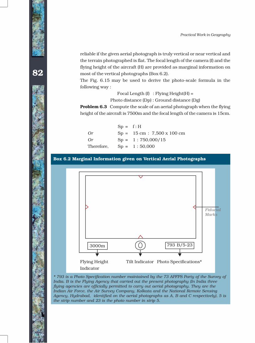
Box 6.2 Marginal Information given on Vertical Aerial Photographs
* 793 is a Photo Specification number maintained by the 73 APFPS Party of the Survey ofIndia. B is the Flying Agency that carried out the present photography (In India threeflying agencies are officially permitted to carry out aerial photography. They are theIndian Air Force, the Air Survey Company, Kolkata and the National Remote SensingAgency, Hydrabad, identified on the aerial photographs as A, B and C respectively), 5 isthe strip number and 23 is the photo number in strip 5.
FiducialMarks
3000m 793 B/5-23
Flying Height Tilt Indicator Photo Specifications*
Indicator
©NCERT
not to
be r
epubl
ished
83
Introduction To Aerial Photographs
EXERCISE
Multiple Choice Questions
1. In which of the following aerial photographs the horizon appears?
a. Vertical
b. Near-vertical
c. Low-oblique
d. High-oblique
2. In which of the following aerial photographs the Nadir and the
principle points coincide?
a. Vertical
b. Near-vertical
c. Low-oblique
d. High-oblique
3. Which type of the following projections is used in aerial photographs?
a. Parallel
b. Orthogonal
c. Central
d. None of the above.
Short Questions
1. State any three advantages that an aerial photograph offers over
ground based observations.
2. How is an aerial photograph taken?
3. Present a concise account of aerial photography in India.
4. Answer the following questions in about 125 words :
i) What are the two major uses of an aerial photograph? Elaborate.
ii) What are the different methods of scale determination?
©NCERT
not to
be r
epubl
ished