ae a eleent s chapter 17 far northeast & … · benning road minnesota ave capitol heights...
TRANSCRIPT

A R E A E L E M E N T S
Chapter 17 Far Northeast & Southeast Area Element
A R E A E L E M E N T S
EASTERN AVENUE
SOUTHERN AVENUE
NAYLO
R ROAD
Fort Dupont Park
Fort Chaplin Park
Fort Mahan Park
FAR SOUTHEAST AND SOUTHWEST
LOWER ANACOSTIAWATERFRONT/NEAR SOUTHWEST
CAPITOL HILL
Deanwood
Benning Road
Minnesota Ave
Capitol Heights
Gateway
Grant Park
Carver
Skyland
Twining
Benning
MayfairLangston
Greenway
Deanwood
Fairlawn
Trinidad
Hillsdale
Hillcrest
Burrville
Hill East
Arboretum
Kenilworth
Central NE
Fort Dupont
Penn Branch
Dupont Park
NE Boundary
Capitol View
Kingman Park
Lincoln Park
Benning Ridge
River Terrace
Naylor Gardens
Fairfax Village
Lincoln Heights
Eastland Gardens
Randle Highlands
Marshall Heights
Historic Anacostia
Knox Hill/Buena Vista
CH
AP
TE
R 1
7:
FA
R N
OR
TH
EA
ST
AN
D S
OU
TH
EA
ST
17-1F A R N O R T H E A S T & S O U T H E A S T 17-1
17
A R E A E L E M E N T SA R E A E L E M E N T S
EASTERN AVENUE
SOUTHERN AVENUE
NAYLO
R ROAD
Fort Dupont Park
Fort Chaplin Park
Fort Mahan Park
FAR SOUTHEAST AND SOUTHWEST
LOWER ANACOSTIAWATERFRONT/NEAR SOUTHWEST
CAPITOL HILL
Deanwood
Benning Road
Minnesota Ave
Capitol Heights
Gateway
Grant Park
Carver
Skyland
Twining
Benning
MayfairLangston
Greenway
Deanwood
Fairlawn
Trinidad
Hillsdale
Hillcrest
Burrville
Hill East
Arboretum
Kenilworth
Central NE
Fort Dupont
Penn Branch
Dupont Park
NE Boundary
Capitol View
Kingman Park
Lincoln Park
Benning Ridge
River Terrace
Naylor Gardens
Fairfax Village
Lincoln Heights
Eastland Gardens
Randle Highlands
Marshall Heights
Historic Anacostia
Knox Hill/Buena Vista
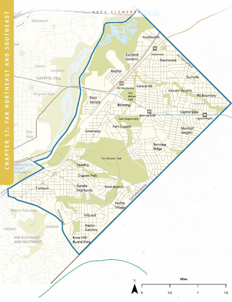
Overview 1700
The Far Northeast and Southeast Planning Area encompasses the 8.3 square miles located east of I-295 and north of Naylor Road SE. Its
boundaries are shown in the Map at left. Most of this area has historically been Ward 7 although in past decades, parts have been included in Wards 6 and 8. 1700.1
Far Northeast and Southeast is known for its stable, attractive neighborhoods and its diverse mix of housing. It includes single-family communities like Hillcrest, Eastland Gardens, and Penn Branch; row house and semi-detached housing neighborhoods such as Twining, River Terrace, and Fairlawn; and apartment communities like Naylor Gardens, Mayfair Mansions, and Lincoln Heights. The area has an excellent transportation network, including the Minnesota Avenue, Benning Road, and Deanwood Metrorail stations, Interstate 295, and several major avenues linking neighborhoods east of the Anacostia River to Central Washington. The community is home to Fort Dupont Park—one of the largest parks in the city and a center of community life for generations. It includes shopping centers like East of the River Park and Skyland, and small neighborhood commercial districts along Pennsylvania Avenue, Nannie Helen Burroughs Avenue, and other local streets and arterials. 1700.2
Far Northeast and Southeast has always had a strong sense of community spirit, due in part to a well-organized network of community associations, churches, and interest groups. These groups include non-profits like the Marshall Heights Community Development Organization, cultural organizations like the East of the River Community Arts Program, and neighborhood groups such as the Deanwood Citizens Association and the Benning Ridge Civic Association. For years, activities like Minnesota Avenue Day and the Fort Dupont Summer Concert Series have built community pride and entertained residents and visitors. Far Northeast and Southeast also has a historic tradition of being strongly connected to its natural landscape, dating back to its origins as an agricultural community. Small backyard gardens may be found throughout the community today, even in apartment complexes and public housing. 1700.3
The area is not without its challenges. Between 1990 and 2000, Far Northeast and Southeast experienced an 11 percent decline in population, an increase in its poverty rate, and an increase in its percentage of single-mother households. Its crime rate and unemployment rate are both above the city average, and many residents must travel long distances for shopping, education, and basic services. Many middle class families left the neighborhoods of Far Northeast and Southeast during the 1970s, 80s, and 90s, and schools and other community services have suffered as a consequence. 1700.4
Far Northeast & Southeast Area Element

17-217-2
17
T H E C O M P R E H E N S I V E P L A N F O R T H E N A T I O N A L C A P I T A L : D I S T R I C T E L E M E N T S
A R E A E L E M E N T S
These issues must be addressed before the Far Northeast and Southeast community can reach its full potential. And they must be addressed in a way that benefits existing residents as well as new residents who may be attracted to the area by its relatively affordable housing and other amenities. Broader prosperity in Far Northeast and Southeast should not be gained at the expense of those who have helped build and sustain the community for generations. While a high priority will be placed on bringing middle class and working families back to this community, an even higher priority must be placed on improving the quality of life for the individuals and families who live here today. 1700.5
This Planning Area has seen significant change during recent years. More than 1,000 housing units have been constructed since 2000 alone, and many more have been renovated. New developments like Fort Chaplin Woods and Dupont Commons are creating more diverse housing choices and opportunities. At the same time, demolition of former public housing projects such as East Capitol Dwellings has removed over 1,000 units from the area’s housing stock since 2000, resulting in a net loss of total households in the last five years. 1700.6
Non-residential development in Far Northeast and Southeast has lagged behind the rest of the city. In fact, most of the recent non-residential construction has consisted of reinvestment in public facilities such as schools and recreation centers. This may change in the coming years, as new shopping areas are developed at Skyland and East Capitol Gateway, and new businesses and services open along Pennsylvania Avenue SE, Minnesota Avenue, at Kenilworth-Parkside, and elsewhere in the community. 1700.7
Context
History 1701
Most of Far Northeast and Southeast was still countryside until the early 20th century. In fact, large tracts of land were farmed until as recently as the mid-1900s. Early settlements in the area included the communities of Good Hope (near Alabama Avenue and Naylor Road), Benning Heights (near Fort Dupont), and Deanwood. 1701.1
Far Northeast and Southeast took on strategic importance during the Civil War, when Fort Dupont, Fort Davis, and other encampments were built to protect the nation’s capital from attack. Woodlawn Cemetery—another local landmark—was established in 1895 to provide a site for African-American burials, which were largely prohibited at other cemeteries in the region at that time. By the late 1800s, Deanwood had emerged as a working class community of black and white families and was known for its self-reliance and strong sense of economic independence. 1701.2
Far NE/SE is home to Fort Dupont Park—one of the largest parks in the city and a center of community life for generations.

17-3F A R N O R T H E A S T & S O U T H E A S T 17-3
17
A R E A E L E M E N T SA R E A E L E M E N T S
The first large-scale urban development in the area took place during the 1920s. The pace accelerated during World War II, as defense and government workers flocked to the city. Naylor Gardens, for example, was developed for the federal government and later served as cooperative housing for returning war veterans. Rapid development continued through the 1950s, as sewers, paved streets, and sidewalks were provided to most areas. Neighborhoods like Hillcrest (originally called Summit Ridge) and Benning Ridge (originally called Bradbury Heights) date from this period. 1701.3
Following the removal of restrictive housing covenants in the late 1940s, the racial composition of the community shifted. By 1960, a majority of the area’s residents were African-American. The pace of development slowed after 1970, and the community entered a period of population decline as many families left the city for suburban Maryland and elsewhere. Despite the loss of residents, many high-quality neighborhoods remain in Far Northeast and Southeast, and today there are signs of reinvestment in nearly all parts of the community. 1701.4
Land Use 1702
Land use statistics for this Planning Area appear in Figure 17.1. Far Northeast and Southeast comprises about 5,300 acres, or about 14 percent of the city’s land area. 1702.1
The area is predominantly a residential community, with more than 35 percent of the land area developed with housing. Densities are typically lower than the citywide average, with much of the housing stock consisting of one- and two-family homes. Concentrations of more dense housing exist in Fairfax Village, Randle Highlands, Benning Ridge, Lincoln Heights, Marshall Heights, Kenilworth-Parkside, and north of Fort Dupont Park. 1702.3
Commercial uses are clustered in nodes along Minnesota Avenue, East Capitol Street, Naylor Road, Pennsylvania Avenue, and Benning Road. The area’s largest commercial centers are located near Minnesota Avenue and Benning Road, and at Skyland on Naylor Road. A small industrial area is located in the northwest corner of the area, parallel to the railroad and Kenilworth Avenue. Industrial uses, including the Pepco Power Plant, are also located north of Benning
Figure 17.1:
Land Use Composition in Far Northeast/Southeast 1702.2
Source: DC Office of Planning, 2006
Public/Institutional
4%
Rail/Utilities4% Vacant
4%
Residential 35%
Commercial/ Industrial
3%
Streets25%
Parks/Open Space25%

17-417-4
17
T H E C O M P R E H E N S I V E P L A N F O R T H E N A T I O N A L C A P I T A L : D I S T R I C T E L E M E N T S
A R E A E L E M E N T S
Road. Together, commercial and industrial uses represent just three percent of the Far Northeast and Southeast’s land area. 1702.4
Open space and parks comprise about 25 percent of the Planning Area. Much of the area’s open space, including the chain of Fort Circle Parks extending from Fort Mahon to Fort Stanton, and the Kenilworth Aquatic Gardens, is under National Park Service ownership. Two of the community’s parks—Watts Branch and Pope Branch—follow natural stream valleys and provide a unique amenity for the community. Public facilities, including local public schools, comprise about four percent of the area. Streets and public rights of way comprise 25 percent of the Planning Area. Approximately 180 acres—almost four percent of Far Northeast and Southeast—consists of vacant, unimproved land. 1702.5
Demographics 1703
Basic demographic data for Far Northeast and Southeast is shown in Table 17.1. In 2000, the area had a population of 73,800, or about 13 percent of the city’s total. Population in the area has been declining for over 40 years, although the decline was not as rapid in the 1990s as it was in the 1970s and 80s. In 2005, the population is estimated to be 69,900. Average household size in 2005 was 2.33, which was higher than the citywide average of 2.14. However, average household size has been dropping in Far Northeast and Southeast as it has in other neighborhoods across the city. This trend may reverse in the coming years as former public housing complexes are replaced by new single family homes and townhomes, and as infill development takes places on vacant land. 1703.1
Approximately 96 percent of the area’s residents are African-American, which is significantly higher than the citywide average of 60 percent. Only about one percent of the area’s residents are of Hispanic origin, and fewer than two percent are foreign born. Relative to the city as a whole, the area has higher percentages of children and seniors. About 27 percent of the residents are under 18, compared to a citywide average of 20 percent. About 14 percent are over 65, compared to the citywide average of 12 percent. 1703.2
Relative to the city as
a whole, the area has
higher percentages of
children and seniors.
About 27 percent of the
residents are under 18,
compared to a citywide
average of 20 percent.
About 14 percent are
over 65, compared to
the citywide average
of 12 percent.

17-5F A R N O R T H E A S T & S O U T H E A S T 17-5
17
A R E A E L E M E N T SA R E A E L E M E N T S
Table 17.1:
Far Northeast and Southeast at a Glance 1703.3
Basic StatisticsLand Area (square miles) 8.3Population
199020002005 (estimated)*2025 (projected)*
82,90273,78869,90083,800
Households (2005)* 29,700Household Population (2005)* (excludes group quarters) 69,200Persons Per Household (2005)* 2.33Jobs (2005)* 12,400Density (persons per sq mile) (2005)* 8,400
Year 2000 Census Data ProfileFar Northeast and Southeast
Planning Area** Citywide
Total % of Total % of TotalAge
Under 1818-65Over 65
20,30643,36910,113
27.5%58.8%13.7%
20.0%67.8%12.3%
Residents Below Poverty Level 18,233 24.7% 20.2%Racial Composition
WhiteBlackNative AmericanAsian/Pacific IslanderOtherMulti-Racial
95771,231
201216362821
1.3%96.5%0.3%0.3%0.5%1.1%
30.4%60.3%0.3%2.6%3.8%5.2%
Hispanic Origin 637 0.9% 7.9%Foreign-Born Residents 1,045 1.4% 12.9%Tenure
Owner HouseholdsRenter Households
12,41618,242
40.5%59.5%
40.7%59.3%
Population 5+ yrs in same house in 2000 as in 1995 42,005 61.2% 46.9%Housing Occupancy
Occupied UnitsVacant Units
30,6584,452
87.3%12.7%
90.4%9.6%
Housing by Unit Type 1-unit detached1-unit attached2-4 units 5-9 units 10-19 units 20-49 units 50+ units Mobile/other
6,2579,7825,0325,3745,921
9431,768
33
17.8%27.9%14.3%15.3%16.9%2.7%5%
0.1%
13.1%26.4%11.0%8.0%10.3%7.4%
23.3%0.2%
* Figures noted with an asterisk are estimates developed by the Office of Planning and the Department of Employment
Services based on a variety of data sources.** Total population of subcategories may not match 2000 Census totals due to sampling errors.
17-617-6
17
T H E C O M P R E H E N S I V E P L A N F O R T H E N A T I O N A L C A P I T A L : D I S T R I C T E L E M E N T S
A R E A E L E M E N T S
Based on land
availability, planning
policies, and regional
growth trends, Far
Northeast and Southeast
is projected to begin
adding households,
population, and jobs
during the next five
years and continue
growing through 2025.
Housing Characteristics 1704
The 2000 Census reported that 18 percent of the homes in Far Northeast and Southeast were single family detached homes, and 28 percent were single family attached homes (row houses and townhouses). These are slightly higher than the percentages for the city as a whole. Conversely, only eight percent of the area’s housing stock consists of multi-family buildings of 20 units or more, compared to 32 percent for the city as a whole. Relative to the rest of the District of Columbia, Far Northeast and Southeast has a much higher percentage of small apartment buildings. About one-third of the area’s housing units were in buildings with five to 19 units—almost twice the citywide proportion. In 2000, nearly 13 percent of the housing units in Far Northeast and Southeast were vacant. 1704.1
The 2000 Census reported that 41 percent of the households in the Planning Area were homeowners and 59 percent were renters. These percentages are identical to the city as a whole. 1704.2
Income and Employment 1705
Data from the Department of Employment Services and the Office of Planning indicates there were 12,400 jobs in Far Northeast and Southeast in 2005, primarily in local-serving businesses, public schools, and government. This represents just 1.7 percent of the city’s job base. Most employed residents in Far Northeast and Southeast commute to jobs elsewhere in the city and region, with about 34 percent commuting to Central Washington, 31 percent commuting to Maryland and Virginia, 30 percent commuting elsewhere in the District of Columbia, and only five percent working within the Far Northeast and Southeast community. As of the 2000 Census, median household income in the Planning Area was $31,507, compared to a citywide median of $45,927. 1705.1
Projections 1706
Based on land availability, planning policies, and regional growth trends, Far Northeast and Southeast is projected to begin adding households, population, and jobs during the next five years and continue growing through 2025. The Planning Area is expected to grow from 29,700 households in 2005 to 35,200 households in 2025, with an attendant 20 percent increase in population from 69,900 to 83,800. Although this is roughly the same number of residents the Area had in 1990, the addition of over 5,000 new homes (including more than 1,000 homes on former public housing sites at Capitol Gateway Estates and Eastgate Gardens, and infill development at Kenilworth-Parkside) will bring new vitality and energy to the community. Much of the growth in Far Northeast and Southeast is expected to consist of new low-density housing, particularly on vacant single

17-7F A R N O R T H E A S T & S O U T H E A S T 17-7
17
A R E A E L E M E N T SA R E A E L E M E N T S
family lots in Deanwood and Marshall Heights. Moderate-density housing and mixed use development will be concentrated around the Metro stations, on redeveloped public housing sites, and along corridor streets. 1706.1
The number of jobs is expected to increase from about 12,400 today to 16,100 in 2025. Most of the increase will take place around the Minnesota Avenue Metro station, at Kenilworth-Parkside, at the revitalized Skyland Shopping Center, and along East Capitol Street. 1706.2
Planning and Development Priorities 1707
Four Comprehensive Plan workshops took place in Far Northeast and Southeast during 2005 and 2006. These meetings provided an opportunity for residents to discuss both citywide and neighborhood planning issues. The Advisory Neighborhood Commissions and groups such as the Ward 7 Leadership Council also provided a voice for local priorities and concerns. There have also been many meetings in the community not directly connected to the Comprehensive Plan, but focusing on long-range planning issues. These meetings have covered topics such as Kenilworth Avenue road improvements, the future of Watts Branch, reuse plans for Skyland Shopping Center, and the upgrading of “Great Streets” like Pennsylvania Avenue SE. 1707.1
The community delivered several key messages during these meetings, summarized below: 1707.2
a. The low density character that typifies most Far Northeast and Southeast neighborhoods should be maintained. While it is recognized that the area contains much vacant land with the potential for infill development, this development should generally be similar in density to what exists today. This is one of the few areas in the city with opportunities to build three- and four- bedroom homes suitable for families with children. Whereas the neighborhood lost families to Prince George’s County and elsewhere in the past, it may gain families from these areas in the future if it builds appropriately designed housing, provides quality schools, and improves public services.
b. While protecting established single family neighborhoods is a priority, Far Northeast and Southeast recognizes the need to provide a variety of new housing choices. More density is appropriate on land within one-quarter mile of the Metro stations at Minnesota Avenue, Benning Road, and Deanwood, and on the District side of the Southern Avenue and Capitol Heights stations. The commercially zoned land along the Nannie Helen Burroughs, Minnesota Avenue, and Pennsylvania Avenue “Great Streets” corridors also offer opportunities for somewhat denser uses than
While protecting
established single family
neighborhoods is a
priority, Far Northeast
and Southeast recognizes
the need to provide a
variety of new housing
choices. More density
is appropriate on land
within one-quarter mile
of the Metro stations
at Minnesota Avenue,
Benning Road, and
Deanwood, and on the
District side of the
Southern Avenue and
Capitol Heights stations.

17-817-8
17
T H E C O M P R E H E N S I V E P L A N F O R T H E N A T I O N A L C A P I T A L : D I S T R I C T E L E M E N T S
A R E A E L E M E N T S
exist today. These areas may provide opportunities for apartments, condominiums, townhomes, assisted living facilities and other types of housing, provided that measures are taken to buffer adjacent lower density neighborhoods, address parking and traffic issues, and mitigate other community concerns.
c. The neighborhood is underserved by retail stores and services, including the “basics” such as sit-down restaurants, banks, hardware stores, drug stores, and movie theaters. These uses should be accommodated in the future by encouraging both public and private reinvestment in the established commercial districts. The upgrading of Skyland and development of Capitol Gateway should go a long way toward meeting these needs—but these centers are not conveniently located for everyone in the community. Neighborhoods like Deanwood and Fairlawn would benefit from additional quality retail services. The Minnesota-Benning commercial district, in particular, should evolve into a stronger, more vital shopping district in the future, attracting customers from both sides of the Anacostia River.
d. Renovation and rehabilitation of the housing stock should continue to be a priority, especially for the aging post-war apartment complexes and for developments with subsidized units. Steps should be taken to preserve affordable units in these complexes as they are renovated. In some cases, as was the case at East Capitol Dwellings and Eastgate Gardens, the best approach may be to replace deteriorated multi-family housing with new housing that better meets community needs. In other cases, the renovation of older apartments could be coupled with conversion to owner-occupancy, with provisions to help tenants become homeowners.
e. Code enforcement continues to be one of the top issues in the community. Residents are concerned about illegal dumping and unpermitted construction, inadequate notification of zoning changes, and the need for clean-up of blighted and abandoned properties. While these are operational issues that cannot be resolved through the Comprehensive Plan, the District must strive toward responsive, effective enforcement, maintenance, and customer service in the future.
f. More steps should be taken to improve environmental quality, especially along Watts Branch. Far Northeast and Southeast was impacted for years by the now defunct Benning Road incinerator and continues to face noise, air pollution, and truck traffic from I-295 and other thoroughfares. Programs to reduce these impacts, while improving physical connections to the Anacostia River, the Fort Circle Parks, and other open spaces in the area are high priorities. Indeed, much of the discussion at public meetings during the Comprehensive Plan revision focused on the need for better
Minnesota Avenue

17-9F A R N O R T H E A S T & S O U T H E A S T 17-9
17
A R E A E L E M E N T SA R E A E L E M E N T S
parks, cleaner streams, and more trees. While the community has more green space than many other parts of the District, this space has been neglected. Greater stewardship by Far Northeast and Southeast residents, coupled with more attention from the District and federal governments, will help restore the natural landscape as a place of beauty, spiritual enrichment, and diverse habitat
g. Additional improvements are needed to reduce traffic congestion, especially around the I-295/Pennsylvania Avenue intersection and along Kenilworth Avenue. Parts of Far Northeast and Southeast are more than one mile from Metrorail and need better, more reliable bus connections to Metro. The safety of pedestrians and bicyclists continues to be an issue in many neighborhoods and at many intersections.
h. Schools, libraries, recreation centers, and other public facilities in Far Northeast and Southeast must be upgraded to meet the needs of a community on the rise. The recent modernizations of Kelly Miller Middle School and Randle Highlands Elementary School are a promising start, but there is much more to accomplish. Investment in schools should take place in tandem with investment in new housing, shopping, libraries, and other services, as it is at Eastgate Gardens, to create “whole” communities and not simply tracts of homes.
i. With an unemployment rate that is twice the citywide average, more must be done to strengthen the occupational skills of the Far Northeast and Southeast labor force. Job training, adult education, and vocational education programs are an essential part of the equation. Good access to Metrorail is also critical, to connect residents to jobs Downtown and elsewhere in the region. As noted in the citywide elements of the Comp Plan, establishing a community college or branch campus of the University of the District of Columbia east of the Anacostia River would go a long way toward helping Far Northeast and Southeast youth prepare for good, quality jobs in the District economy.
j. Additional facilities and services for children and youth are needed in the Far Northeast/Southeast Area. More than one in four residents of the Planning Area are under 18. Further increases in the number of children are likely as additional family housing is completed. New and expanded recreation centers, playgrounds, child care facilities, and similar facilities are urgently needed today and will continue to be needed in the future. The District must place a high priority on investment in these facilities to create a healthy environment for children as well as adults.
With an unemployment
rate that is twice the
citywide average,
more must be done
to strengthen the
occupational skills of
the Far Northeast and
Southeast labor force. Job
training, adult education,
and vocational education
programs are an essential
part of the equation.

17-1017-10
17
T H E C O M P R E H E N S I V E P L A N F O R T H E N A T I O N A L C A P I T A L : D I S T R I C T E L E M E N T S
A R E A E L E M E N T S
Policies and ActionsFNS-1 General Policies
FNS-1.1 Guiding Growth and Neighborhood Conservation 1708
The following general policies and actions should guide growth and neighborhood conservation decisions in Far Northeast and Southeast. These policies and actions should be considered in tandem with those in the citywide elements of the Comprehensive Plan. 1708.1
Policy FNS-1.1.1: Conservation of Low Density NeighborhoodsRecognize the value and importance of Far Northeast and Southeast’s stable single family neighborhoods to the character of the local community and to the entire District of Columbia. Ensure that the Comprehensive Plan and zoning designations for these neighborhoods reflect and protect the existing low density land use pattern while allowing for infill development that is compatible with neighborhood character. 1708.2
Policy FNS-1.1.2: Development of New HousingEncourage new housing for area residents on vacant lots and around Metro stations within the community, and on underutilized commercial sites along the area’s major avenues. Strongly encourage the rehabilitation and renovation of existing housing in Far Northeast and Southeast, taking steps to ensure that the housing remains affordable for current and future residents. 1708.3
Policy FNS-1.1.3: Directing GrowthConcentrate employment growth in Far Northeast and Southeast, including office and retail development, around the Deanwood, Minnesota Avenue and Benning Road Metrorail station areas, at the Skyland Shopping Center, and along the Nannie Helen Burroughs Avenue, Minnesota Avenue, Benning Road, and Pennsylvania Avenue SE “Great Streets” corridors. Provide improved pedestrian, bus, and automobile access to these areas, and improve their visual and urban design qualities. These areas should be safe, inviting, pedestrian-oriented places. 1708.4
Policy FNS-1.1.4: Retail DevelopmentSupport the revitalization of the neighborhood commercial areas listed in Policy FNS-1.1.3 with new businesses and activities that provide needed retail services to the adjacent neighborhoods and that are compatible with surrounding land uses. 1708.5
Hillcrest

17-11F A R N O R T H E A S T & S O U T H E A S T 17-11
17
A R E A E L E M E N T SA R E A E L E M E N T S
Policy FNS-1.1.5: Prince George’s CountyWork closely with Prince George’s County and the Maryland National Capital Park and Planning Commission to guide the development of land along the Maryland/District line, especially around the Capitol Heights and Southern Avenue Metro stations. Safe pedestrian access to these stations should be provided. Given the proximity of the Naylor Road station to the District line (about 1000 feet), collaborative transit-oriented development planning around this station is also encouraged. 1708.6
Policy FNS-1.1.6: Residential RehabilitationEncourage the rehabilitation of single family homes in the Fairlawn and Twining neighborhoods, and the renovation of vacant deteriorating apartment units, especially in Marshall Heights, Lincoln Heights, Northeast Boundary, Greenway, Randle Highlands (south of Pennsylvania Avenue SE), and along 29th Street between Erie and Denver Streets. 1708.7
Policy FNS-1.1.7: Row House NeighborhoodsIn the Fairlawn and Twining neighborhoods, encourage infill housing constructed in the architectural style and materials compatible with the brick row houses and semi-detached homes that predominate in these areas. New development in these neighborhoods should be consistent with prevailing densities. 1708.8
Policy FNS-1.1.8: BufferingImprove the interface between the I-295 Freeway/rail corridor and adjacent residential uses, especially in the Fairlawn, Greenway, and Twining neighborhoods. These improvements should protect the neighborhoods from noise, odor, vibration, and other freeway impacts while also providing a more positive visual impression of the community from the highway itself. 1708.9
Policy FNS-1.1.9: Congestion ManagementRe-examine traffic control and management programs along major Far Northeast and Southeast arterial streets, particularly along Pennsylvania and Minnesota Avenues, East Capitol Street, Benning Road, Branch Avenue, and Naylor Road, and develop measures to improve pedestrian safety and mitigate the effects of increased local and regional traffic on residential streets. 1708.10
Policy FNS-1.1.10: Transit ImprovementsImprove bus service to the Metrorail stations from neighborhoods throughout Far Northeast and Southeast, particularly in the southern part of the Planning Area. 1708.11
Fairlawn

17-1217-12
17
T H E C O M P R E H E N S I V E P L A N F O R T H E N A T I O N A L C A P I T A L : D I S T R I C T E L E M E N T S
A R E A E L E M E N T S
Policy FNS-1.1.11: Anacostia Light RailCoordinate land use and transportation decisions along the alignment of the proposed light rail line on the former CSX railroad tracks, making the most of the opportunities for new transit-served development along the Minnesota Avenue corridor at Pennsylvania Avenue, Benning Road, East Capitol Street, and points in between. 1708.12
Action FNS-1.1.A: Façade ImprovementsEncourage urban design and façade improvements in the established commercial districts along Naylor Road, Minnesota Avenue, Benning Road, Branch Avenue, Alabama Avenue, Nannie Helen Burroughs Avenue, Division Avenue, and Pennsylvania Avenue SE. These improvements should respect and enhance historic structures and landmarks in these areas. 1708.13
Action FNS-1.1.B: Expansion of NCR ProgramExpand the Neighborhood Commercial Revitalization Program operated by the Marshall Heights Community Development Organization (MHCDO) to include additional neighborhood commercial areas in Far Northeast and Southeast. 1708.14
Action FNS-1.1.C: Joint Planning Agreement with Prince George’s CountyDevelop a joint planning agreement with the Maryland National Capital Park and Planning Commission/Prince George’s County to coordinate the mutual review of projects and area plans on both sides of the District/Maryland line. 1708.15
Action FNS-1.1.D: Kenilworth Avenue Transportation StudyImplement the recommendations of the Kenilworth Avenue transportation study to better manage truck traffic and to separate local traffic from through-traffic on neighborhood streets. 1708.16
FNS-1.2 Conserving and Enhancing Community Resources 1709
Policy FNS-1.2.1: Watts Branch and Pope BranchConserve and improve Watts Branch and Pope Branch as safe, healthy natural resource areas. Undertake capital improvements to acquire land, improve trails, provide recreational features, and restore water quality and natural habitat. Promote District maintenance, enforcement, and community stewardship projects to keep the streambed and parklands clean, reduce crime and illegal dumping, and ensure that the parks remain resources that the whole community can enjoy. 1709.1
Policy FNS-1.2.2: Connecting To the RiverLink the neighborhoods of Far Northeast and Southeast to the Anacostia River through trail, path, transit, and road improvements. Provide new

17-13F A R N O R T H E A S T & S O U T H E A S T 17-13
17
A R E A E L E M E N T SA R E A E L E M E N T S
amenities and facilities in the waterfront parks that meet the needs of Far Northeast and Southeast residents. 1709.2
Policy FNS-1.2.3: Fort Dupont ParkImprove access to Fort Dupont Park by providing shared parking, bicycle and pedestrian access, and public transit service. Expand outdoor recreational activities at the park to better meet community needs, and create opportunities for the expedited construction of a youth baseball academy and an expanded ice arena, which may include a multi-purpose field on the arena’s roof. 1709.3
Policy FNS-1.2.4: Soil ErosionReduce soil erosion and stabilize slopes at Far Northeast and Southeast erosion “hot spots,” particularly the Skyland/Alabama Avenue area, Blaine Street NE (in Capitol View), O Street SE, and along Watts Branch and Pope Branch. 1709.4
Policy FNS-1.2.5: View ProtectionProtect and enhance important views and vistas between Far Northeast/Southeast and Central Washington, such as the vistas of the U.S. Capitol and Washington Monument from East Capitol Street. Such views are rare in the District and should be cherished and maintained. 1709.5
Policy FNS-1.2.6: Historic ResourcesProtect and restore buildings and places of potential historic significance in Far Northeast and Southeast, including Woodlawn Cemetery, the Antioch Baptist Church, the Shrimp Boat Restaurant, the Strand Theater, the Pennsylvania Avenue Commercial District between Minnesota and Alabama Avenues, the Minnesota/Benning Commercial District, and the Deanwood and Burrville neighborhoods. 1709.6
Policy FNS-1.2.7: Health Care FacilitiesProvide additional facilities to meet the mental and physical health needs of Far Northeast and Southeast residents, including primary care facilities, youth development centers, family counseling, drug abuse and alcohol treatment facilities. Such facilities are vital to reduce crime and promote positive youth development. Specific plans for new social service and health facilities should be developed through needs assessments, agency master plans, strategic plans, and the city’s public facility planning process. All plans should be prepared in collaboration with the community, with input from local ANCs and civic associations, residents and businesses, and local community development corporations and non-profit service providers. 1709.7
Policy FNS-1.2.8: Facilities for Children and YouthDevelop additional parks, recreation centers, playgrounds, and other facilities which meet the needs of children and youth in the Far Northeast/
Watts Branch

17-1417-14
17
T H E C O M P R E H E N S I V E P L A N F O R T H E N A T I O N A L C A P I T A L : D I S T R I C T E L E M E N T S
A R E A E L E M E N T S
Southeast community. The District must recognize that children are the future of Far Northeast/Southeast, and should have a positive and healthy environment in which to live, play, and grow. 1709.8
Policy FNS-1.2.9: Kingman and Heritage IslandsRetain Kingman and Heritage Islands as natural sanctuaries. Uses should be limited to an interpretive nature center, trails, public art, passive open space, and pedestrian accessways. 1709.9
Action FNS-1.2.A: Historic SurveysConduct historical surveys in Deanwood, Burrville and Randle Highlands
(south of Pennsylvania Avenue SE). Based on the outcome, prepare nominations to the National Register, incorporating the community’s recommendations as part of the nomination process. 1709.10
Action FNS-1.2.B: Marvin Gaye ParkImplement the Plan for Marvin Gaye Park along Watts Branch, including restored habitat and natural features, trails and bridges, meadows and nature sanctuaries, and safety improvements for park visitors. 1709.11
Action FNS-1.2.C: Fort Dupont Park ImprovementsIn collaboration with the National Park Service, explore the feasibility of developing additional community-serving recreational facilities at Fort Dupont Park, including indoor swimming and tennis facilities, equestrian facilities, and an upgraded outdoor theater. 1709.12
FNS-2 Policy Focus Areas 1710
The Comprehensive Plan has identified eight areas in Far Northeast and Southeast as “policy focus areas,” indicating that they require a level of direction and guidance above that in the prior section of this Area Element and in the citywide elements. These eight areas are:
• Minnesota/Benning Business District• Deanwood• Capitol View/Northeast Boundary• Benning Road Metro• Marshall Heights/Benning Ridge• Pennsylvania Avenue SE• Skyland• Kenilworth-Parkside. 1710.1
Within Far Northeast and Southeast
2.1 Minnesota Benning Business District (see p. 17-16)
2.2 Deanwood (see p. 17-17)
2.3 Capitol View/Northeast Boundary (see p. 17-19)
2.4 Benning Road Metro (see p. 17-20)
2.5 Marshall Heights/Benning Ridge (see p. 17-21)
2.6 Pennsylvania Avenue SE (see p. 17-22)
2.7 Skyland (see p. 17-23)
2.8 Kenilworth/Parkside (see p. 17-24)
Adjacent to Far Northeast and Southeast
1 Reservation 13/RFK Stadium Area (see p. 15-28)
2 Pennsylvania Av Corridor (Capitol Hill) (see p. 15-24)
3 Barry Farm/Hillsdale/Fort Stanton (see p. 18-21)
Table 17.2: Policy Focus Areas Within and Adjacent to Far Northeast and Southeast 1710.2

17-15F A R N O R T H E A S T & S O U T H E A S T 17-15
17
A R E A E L E M E N T SA R E A E L E M E N T S
Map 17.1: Far Northeast and Southeast Policy Focus Areas 1710.3
EASTERN AVENUE
SOUTHERN AVENUE
NAY
LOR
RO
AD
Fort Dupont Park
Fort Chaplin Park
Fort Mahan Park
"M
"MDeanwood
Benning Road
Minnesota Ave
Capitol Heights
St. Elizabeth's Hospital
UPPER NORTHEAST
FAR SOUTHEAST AND SOUTHWEST
CAPITOL HILL
LOWER ANACOSTIAWATERFRONT/
NEAR SOUTHWEST
"M"M
0 0.5 1 1.5
Miles
¯Government of theDistrict of ColumbiaAnthony A. Williams, Mayor
Office of Planning ~ December 2006
FAR NORTHEAST AND SOUTHEAST POLICY FOCUS AREAS
2.1
2.2
2.32.4
2.5
2.6
2.7
2.8
1
2
3
Legend
2.1: Minnesota/Benning Business District
2.2: Deanwood
2.3: Capitol View/Northeast Boundary
2.4: Benning Road Metro Station
2.5: Marshall Heights/Benning Ridge
2.6: Pennsylvania Ave SE
2.7: Skyland
2.8: Kenilworth-Parkside
See Table 17.2 for a list of adjacent focus areas outside FNS

17-1617-16
17
T H E C O M P R E H E N S I V E P L A N F O R T H E N A T I O N A L C A P I T A L : D I S T R I C T E L E M E N T S
A R E A E L E M E N T S
Minnesota Avenue Metrorail Station
FNS-2.1 Minnesota/Benning Business District 1711
The Minnesota/Benning Business District includes the Minnesota Avenue Metro station and the shopping district to the south, extending along both sides of Minnesota Avenue to East Capitol Street. Sometimes referred to as “Downtown Ward 7”, it includes the 150,000 square foot East of the River Park Shopping Center, the Senator Square Shopping Center (anchored by the former Senator Theater), and a variety of small retail and service businesses serving Far Northeast and Southeast. While this area functions as an important community shopping district, some of its properties are underutilized and consist of empty parking lots, open storage, vacant buildings, and undeveloped land. The shopping district itself lacks the variety of retail stores needed to serve the community. It also suffers from poor design, confusing access and parking, and—with the exception of the historic Senator Theater—a lack of distinctive facades and storefronts. 1711.1
A complex of office buildings, including a 4-story Metro parking garage, and a new headquarters for the Department of Employment Services and Department of Human Services, are planned on a 10-acre area site just south of the Minnesota Avenue Station. Space for future private offices and retail stores will also be provided. The development should provide a catalyst for revitalization, and bring new revenue and a larger customer base to the adjacent shopping area. Complementary uses such as a civic space/urban plaza, public art, and cultural facilities should be strongly encouraged, and additional infill development should be supported on vacant lots and underutilized land to the south and east. 1711.2
Improvements to Minnesota Avenue are planned to maintain traffic flow, and make the area safer for pedestrians. Any development in this area should maximize Metrorail access while taking care to provide appropriate buffers and transitions to adjacent uses. 1711.3
Policy FNS-2.1.1: Minnesota/Benning RevitalizationSupport revitalization and further development of the area around the Minnesota Avenue Metro station, including the adjacent business district to the south along Minnesota Avenue. Upgrade and expand existing businesses in this area, and encourage new small business development, educational facilities, and community-based human services such as job training, health care, and child care facilities. Any new public facility in this area should contribute to its image as an attractive and vibrant community hub and should be responsive to the needs of surrounding neighborhoods. 1711.4
Policy FNS-2.1.2: Shopping Center ImprovementsImprove the East of the River Park and Senator Square shopping areas at Minnesota Avenue and Benning Road as quality shopping areas. This area should function as a single, cohesive business and mixed use district rather than a series of disconnected shopping centers. 1711.5

17-17F A R N O R T H E A S T & S O U T H E A S T 17-17
17
A R E A E L E M E N T SA R E A E L E M E N T S
Policy FNS-2.1.3: Minnesota Avenue Station Area Mixed Use DevelopmentEncourage mixed use development including medium density multi-family housing around the Minnesota Avenue Metro station, recognizing the opportunity for “transit-oriented” development that boosts neighborhood businesses, reduces the need for auto commuting, and enhances the quality of the pedestrian environment along Minnesota Avenue. 1711.6
Action FNS-2.1.A: Financial Assistance for Small BusinessesTarget the Senator Square and East of the River Park Shopping centers for District financial assistance, grants, and loans for façade improvements and small business development. 1711.7
Action FNS-2.1.B: Government CenterComplete the Government Center Office project, including the new headquarters for DOES and DHS, and the adjacent Metrorail parking garage. Undertake concurrent streetscape and landscape improvements to beautify this important gateway to Far Northeast and Southeast, improve pedestrian safety, and better connect the Metro station with the shopping district to the south. 1711.8
FNS-2.2 Deanwood 1712
Deanwood is one of Far Northeast and Southeast’s oldest communities; much of its housing stock dates from the early 20th century. Several well-known African-American architects, including W. Sidney Pittman and Howard D. Woodson, and many skilled local craftsmen designed and built many of its homes. The neighborhood was once home to Nannie Helen Burroughs, an early civil rights leader and the founder of the National Training School for Women and Girls, an independent boarding school for African-American girls founded in 1909 and located on 50th Street NE. From 1921 to 1940, Deanwood was also home to Suburban Gardens (50th and Hayes NE), a black-owned amusement park that served thousands of African-American residents during a time of racial segregation. 1712.1
Deanwood’s relatively low density, small wood-frame and brick homes, and dense tree cover give it a small town character that is unique in the District of Columbia. At the same time, there are hundreds of vacant single family lots in the community, creating the potential for future infill housing on many blocks. Some of the vacant properties have caused problems in the past, attracting crime, dumping, and neighborhood blight. Non-conforming uses, including an illegal trash transfer station, further challenge neighborhood integrity and environmental quality. 1712.2
While new housing is encouraged in the Deanwood and adjacent Burrville neighborhoods, density and design should complement prevailing
Deanwood is one
of Far Northeast and
Southeast’s oldest
communities; much of
its housing stock dates
from the early 20th
century. Several well-
known African-American
architects, including
W. Sidney Pittman and
Howard D. Woodson,
and many skilled local
craftsmen designed and
built many of its homes.

17-1817-18
17
T H E C O M P R E H E N S I V E P L A N F O R T H E N A T I O N A L C A P I T A L : D I S T R I C T E L E M E N T S
A R E A E L E M E N T S
community character. Rehabilitation of existing housing is also strongly encouraged, as much of Deanwood has suffered from disinvestment over the past 40 years. The neighborhood’s main commercial streets—Nannie Helen Burroughs Avenue and Division Avenue—have strong potential for infill and revitalization. The intersection of these two streets in particular should be strengthened as a neighborhood hub, with new retail and service businesses strongly encouraged. 1712.3
Deanwood also suffers from land use and transportation conflicts, particularly on its western edge along Kenilworth Avenue. An industrial area along the CSX line provides jobs and services, but also creates noise, truck traffic, and visual blight. Improved buffering of this area from the adjacent neighborhood and additional development around the Deanwood Metro station can reduce future conflicts while improving overall community appearance. 1712.4
Policy FNS-2.2.1: Deanwood’s Residential CharacterStrongly encourage infill development on vacant lots in the Deanwood community. This development should respect and perpetuate the low-density, single family character of the neighborhood, with new one and two-family homes that complement existing architectural traditions and community character. 1712.5
Policy FNS-2.2.2: Nannie Helen Burroughs AvenueFocus neighborhood-serving commercial development in Deanwood along the Nannie Helen Burroughs Corridor, with the intersection of Division and Nannie Helen Burroughs Avenues restored as a community hub. 1712.6
Policy FNS-2.2.3: Kenilworth Industrial AreaUpgrade and expand the commercial and industrial area along Kenilworth Avenue, particularly the Kenilworth Industrial Park, and provide for additional employment in this industrial corridor. Improve the appearance of this area through design standards, building maintenance, and public space and street improvements. Encourage local businesses and entrepreneurs to use the business incubator in this corridor in order to create increased job opportunities for area residents. 1712.7
Policy FNS-2.2.4: Deanwood Metro StationProvide for new moderate density housing in the vicinity of the Deanwood Metrorail Station, and expanded neighborhood-serving commercial uses along Kenilworth Avenue NE. Ensure that appropriate buffers are provided between new development and the adjacent residential areas. 1712.8

17-19F A R N O R T H E A S T & S O U T H E A S T 17-19
17
A R E A E L E M E N T SA R E A E L E M E N T S
Policy FNS-2.2.5: Deanwood Industrial BuffersImprove buffers between the industrial and residential uses in the Deanwood and Central Northeast neighborhoods, particularly where the proximity of these uses to one another is creating conflicts. 1712.9
Action FNS-2.2.A: Deanwood Small Area PlanPrepare a Small Area Plan for the Deanwood neighborhood, including the Metro station area, the Nannie Helen Burroughs and Division Avenue business districts, and the surrounding residential community. 1712.10
Action FNS-2.2.B: Division and Nannie Helen Burroughs CommercialExplore the option of acquiring underused land from DCPS for commercial development at the intersection of Division and Nannie Helen Burroughs Avenues NE. 1712.11
Action FNS-2.2.C: Minnesota Avenue ExtensionExtend Minnesota Avenue from Sheriff Road to Meade Street NE to improve access to the Deanwood Metrorail Station and to eliminate the private bus company’s encroachment on public space. 1712.12
FNS-2.3 Capitol Gateway Estates/Northeast Boundary 1713
Capitol View and Northeast Boundary are the easternmost neighborhoods in the District of Columbia. At the heart of the community, Capitol Gateway Estates is being constructed on a 40-acre site that formerly housed the 1,100-unit East Capitol Dwellings public housing project. Working through the federal HOPE VI program, East Capitol Dwellings was demolished in the early 2000s. The first phase of the revitalized project, consisting of 151 units of senior housing, opened in 2005. An additional 550 units of market rate and subsidized housing will be completed in the coming years. The complex also includes a new shopping district along East Capitol Street. 1713.1
Capitol Gateway holds the promise of bringing new life to adjacent neighborhoods along both side of East Capitol Street. Vacant sites in the immediate vicinity can support infill housing, with moderate densities on the blocks closest to the Capitol Heights Metro station (across the state line in Maryland) and lower densities elsewhere. A few blocks to the north, the commercial area along Dix Street can support infill commercial and residential development, providing needed services to the adjacent Northeast Boundary neighborhood. A few blocks to the west, the 190-unit Richardson Dwellings and the even larger Lincoln Heights public housing project provide essential affordable housing resources but also present the challenges of concentrated poverty, chronic unemployment, and high crime. A planned “new community” at Lincoln Heights would replace the public housing with mixed income housing—including one-for-one replacement of the subsidized units. 1713.2
Deanwood

17-2017-20
17
T H E C O M P R E H E N S I V E P L A N F O R T H E N A T I O N A L C A P I T A L : D I S T R I C T E L E M E N T S
A R E A E L E M E N T S
Improvements to Marvin Gaye Park (Watts Branch) and public facilities such as Woodson High School are an important part of revitalizing the Capitol View community. The park in particular can become a stronger source of community pride and an important link to new recreational areas along the Anacostia River. 1713.3
Policy FNS-2.3.1: Northeast Boundary NeighborhoodLeverage the development of Capitol Gateway Estates to achieve additional reinvestment in the Northeast Boundary neighborhood, particularly the rehabilitation of existing housing and the development of new mixed income family housing on vacant lots. 1713.4
Policy FNS-2.3.2: 61st and DixImprove the commercial area along Dix Street between 60th and Eastern Avenue, encouraging new retail businesses and services that benefit the adjacent community. 1713.5
Policy FNS-2.3.3: Development as a Catalyst for Marvin Gaye ParkDesign development along Marvin Gaye (Watts Branch) Park in a manner that improves park visibility, access, appearance, and security. The park should be treated as the “front door” to the adjacent neighborhood and a valued amenity for development along its perimeter. 1713.6
Action FNS-2.3.A: Land Acquisition At 61st and DixContinue to work with community development organizations in the acquisition of vacant lots at 61st and Dix Streets NE, and their development with local serving commercial uses and services. 1713.7
Action FNS-2.3.B: Lincoln Heights New CommunityPursue redevelopment of Lincoln Heights as a “new community”, replacing the existing public housing development with new mixed income housing, including an equivalent number of affordable units and additional market rate units. 1713.8
FNS-2.4 Benning Road Metro Station Area 1714
The Benning Road Metrorail station is located at the corner of Benning Road and East Capitol Street. The station, which is served by Metro’s Blue Line, opened in 1980 and currently has one of the lowest volumes of passenger traffic in the Metrorail system. Surrounding land uses include auto-oriented commercial businesses, including the Shrimp Boat restaurant, single family homes and duplexes, and small two and three-story apartment buildings. A controversial proposal to develop a five-story office building for the Court Supervision and Offender Services Administration at the station was tabled in 2005. While the proposal generated much debate, it did
New senior housing at Capitol Gateway Estates
The Shrimp Boat is considered by many to be a local landmark.
17-21F A R N O R T H E A S T & S O U T H E A S T 17-21
17
A R E A E L E M E N T SA R E A E L E M E N T S
provide an opportunity for area residents to articulate more clearly the type of development that is desired in the station area. 1714.1
The Benning Road station area should become a much more attractive community hub in the future, comprised of pedestrian-oriented housing, retail, and recreational uses. Large-scale office buildings and surface parking lots should be discouraged here; rather the site is most appropriate as a walkable neighborhood center with low-scale moderate density residential buildings containing ground floor retail, service, and similar uses. Amenities such as plazas, public art, attractive facades, and pocket parks should be provided as the area develops, and safe street crossings for pedestrians and bicyclists should be ensured. Special care should be taken to preserve the adjacent neighborhoods, improve the hazardous and confusing street intersections in the vicinity, and emphasize land uses and activities which benefit area residents. 1714.2
Policy FNS-2.4.1: Benning Road Station Area DevelopmentSupport development of the Benning Road Metro Station area as a pedestrian-oriented mixed use area, including moderate density housing, retail, service uses, and public spaces and amenities that serve adjacent neighborhoods. Future development must recognize and be consistent with the low-density, residential character of the adjacent neighborhoods. 1714.3
Action FNS-2.4.A: Benning Road Station Transit-Oriented Development PlanUndertake a community planning process for the Benning Road Metro station, defining specific land use and urban design improvements, and more clearly establishing the community’s vision for the station area. 1714.4
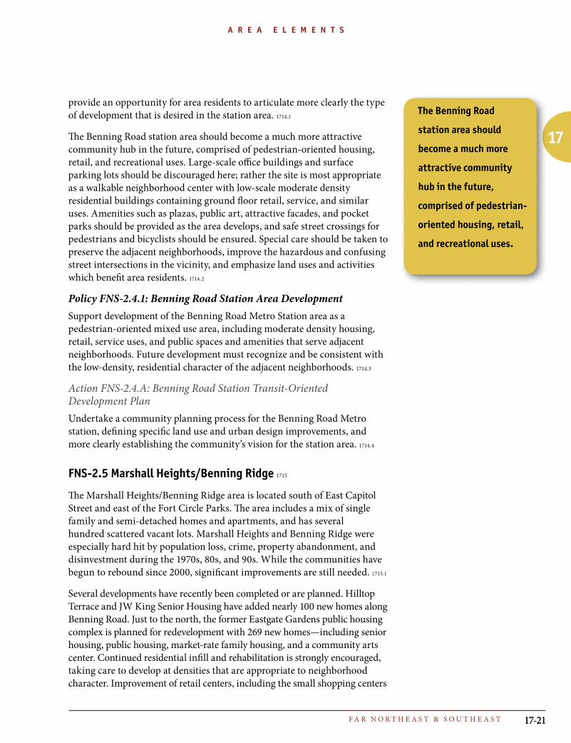
FNS-2.5 Marshall Heights/Benning Ridge 1715
The Marshall Heights/Benning Ridge area is located south of East Capitol Street and east of the Fort Circle Parks. The area includes a mix of single family and semi-detached homes and apartments, and has several hundred scattered vacant lots. Marshall Heights and Benning Ridge were especially hard hit by population loss, crime, property abandonment, and disinvestment during the 1970s, 80s, and 90s. While the communities have begun to rebound since 2000, significant improvements are still needed. 1715.1
Several developments have recently been completed or are planned. Hilltop Terrace and JW King Senior Housing have added nearly 100 new homes along Benning Road. Just to the north, the former Eastgate Gardens public housing complex is planned for redevelopment with 269 new homes—including senior housing, public housing, market-rate family housing, and a community arts center. Continued residential infill and rehabilitation is strongly encouraged, taking care to develop at densities that are appropriate to neighborhood character. Improvement of retail centers, including the small shopping centers
The Benning Road
station area should
become a much more
attractive community
hub in the future,
comprised of pedestrian-
oriented housing, retail,
and recreational uses.
17-2217-22
17
T H E C O M P R E H E N S I V E P L A N F O R T H E N A T I O N A L C A P I T A L : D I S T R I C T E L E M E N T S
A R E A E L E M E N T S
at Benning Road and H Street, and Benning Road between F and G Streets will also be pursued in order to upgrade existing businesses and provide needed services to the surrounding communities. 1715.2
Policy FNS-2.5.1: Marshall Heights InfillSupport the development of the many scattered vacant lots in the Marshall Heights community with new low density residential development, especially one- and two-family homes. This will provide ownership opportunities for area residents and housing stock needed to attract families with children back to Far Northeast and Southeast. Improve schools, parks, and other public services in Marshall Heights to meet the needs created by additional growth, and to attract families to the area. 1715.3
Action FNS-2.5.A: Eastgate GardensDevelop Eastgate Gardens as a mixed income community containing senior housing, public housing, home ownership opportunities, and a community arts center. As population increases here and elsewhere in Marshall Heights, pursue the refurbishing of shopping areas along Benning Road to better serve the surrounding community. 1715.4
Action FNS-2.5.B: Marshall Heights Zoning StudyConduct a zoning study of the Marshall Heights and Benning Ridge neighborhoods to ensure that areas that are predominantly single family in character areas are appropriately zoned. Presently, much of this area is zoned for multi-family housing, despite the fact that one and two-family homes are prevalent. 1715.5
FNS-2.6 Pennsylvania Avenue Southeast Corridor 1716
Pennsylvania Avenue SE is one of the busiest arterials in the District of Columbia, carrying 96,000 vehicles a day across the Sousa Bridge and 53,000 vehicles per day between Minnesota and Branch Avenues. For several years, a Citizens Task Force has been exploring strategies for addressing traffic congestion on the avenue while mitigating related problems such as noise, pedestrian safety, and cut-through traffic on local streets. Parallel efforts by the District have looked at land use and design issues, including the character of the street environment and the quality of the business districts in Fairlawn, Penn Branch, and Fort Davis. In 2005, plans to redesign the Sousa Bridge/ I-295 on and off-ramps were announced as part of a broader strategy to improve the corridor and invest in new sidewalks, lighting, and trees. 1716.1
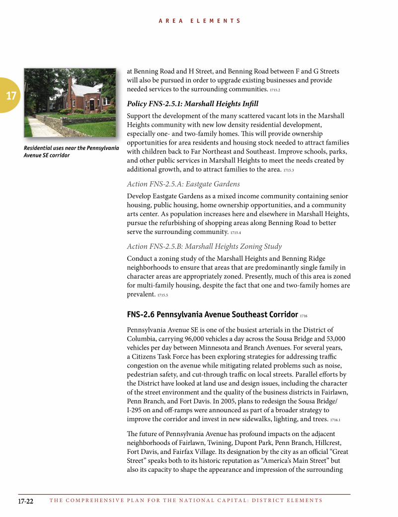
The future of Pennsylvania Avenue has profound impacts on the adjacent neighborhoods of Fairlawn, Twining, Dupont Park, Penn Branch, Hillcrest, Fort Davis, and Fairfax Village. Its designation by the city as an official “Great Street” speaks both to its historic reputation as “America’s Main Street” but also its capacity to shape the appearance and impression of the surrounding
Residential uses near the Pennsylvania Avenue SE corridor

17-23F A R N O R T H E A S T & S O U T H E A S T 17-23
17
A R E A E L E M E N T SA R E A E L E M E N T S
community. Particular emphasis should be placed on upgrading the shopping area between Fairlawn Avenue and 28th Street SE. This corridor, initially developed as a walkable shopping street, suffers from a lack of continuity, poor retail choices, many vacant storefronts, parking management issues, and traffic patterns that are dangerous for pedestrians. 1716.2
Policy FNS-2.6.1: Pennsylvania Avenue “Great Street”Plan the Pennsylvania Avenue SE corridor in a manner that reduces traffic impacts on adjacent neighborhoods, improves its role as an Far Northeast and Southeast commercial center, and restores its ceremonial importance as a principal gateway to the nation’s capital. 1716.3
Policy FNS-2.6.2: Neighborhood Shopping ImprovementsPromote a wider variety and better mix of neighborhood-serving retail shops at the shopping centers at Pennsylvania and Alabama Avenues, and Pennsylvania and Branch Avenues. 1716.4
Action FNS-2.6.A: Pennsylvania Avenue SE Transportation StudyImplement the recommendations of the Pennsylvania Avenue SE Transportation Study to improve community access and circulation. These recommendations include streetscape, signage, and parking improvements, speed controls, signal timing changes, pedestrian and bicycle safety improvements, travel lane and pavement marking adjustments, traffic calming measures to avoid cut-through traffic on local side streets, and changes to the I-295/Pennsylvania Avenue interchange. 1716.5
Action FNS-2.6.B: Great Street ImprovementsImplement the “Great Street” Plan to beautify Pennsylvania Avenue, maintaining the width of the street, landscaping the avenue from the Sousa Bridge to the Maryland border, and taking other steps to manage traffic flow and avoid negative effects and cut-through traffic on adjacent neighborhoods. 1716.6
FNS-2.7 Skyland 1717
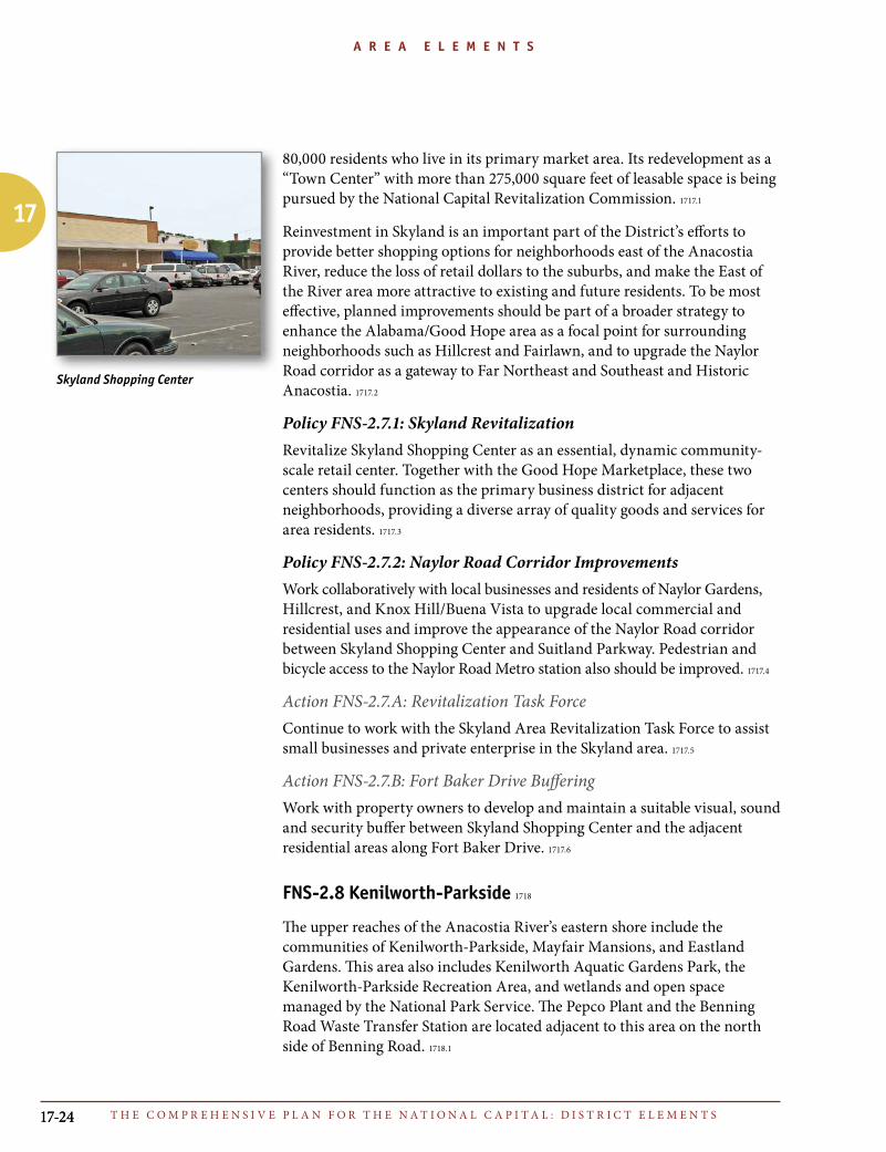
Skyland Shopping Center occupies 16 acres at the intersection of Naylor Road, Good Hope Road, and Alabama Road SE. When it was initially developed in the 1940s, the 170,000 square foot complex of free-standing retail buildings was one of the first auto-oriented shopping centers in Washington. Along with the adjacent 95,000 square foot Good Hope Marketplace, it is the principal commercial center serving the southern part of Far Northeast and Southeast. Plans to renovate and modernize Skyland have been evolving for many years. The center has not adapted to changing trends in retailing, and is not fully meeting the needs of the more than
The future of
Pennsylvania Avenue has
profound impacts on the
adjacent neighborhoods
of Fairlawn, Twining,
Dupont Park, Penn
Branch, Hillcrest, Fort
Davis, and Fairfax
Village. Its designation
by the city as an official
“Great Street” speaks
both to its historic
reputation as “America’s
Main Street” but also
its capacity to shape
the appearance and
impression of the
surrounding community.
17-2417-24
17
T H E C O M P R E H E N S I V E P L A N F O R T H E N A T I O N A L C A P I T A L : D I S T R I C T E L E M E N T S
A R E A E L E M E N T S
80,000 residents who live in its primary market area. Its redevelopment as a “Town Center” with more than 275,000 square feet of leasable space is being pursued by the National Capital Revitalization Commission. 1717.1
Reinvestment in Skyland is an important part of the District’s efforts to provide better shopping options for neighborhoods east of the Anacostia River, reduce the loss of retail dollars to the suburbs, and make the East of the River area more attractive to existing and future residents. To be most effective, planned improvements should be part of a broader strategy to enhance the Alabama/Good Hope area as a focal point for surrounding neighborhoods such as Hillcrest and Fairlawn, and to upgrade the Naylor Road corridor as a gateway to Far Northeast and Southeast and Historic Anacostia. 1717.2
Policy FNS-2.7.1: Skyland RevitalizationRevitalize Skyland Shopping Center as an essential, dynamic community-scale retail center. Together with the Good Hope Marketplace, these two centers should function as the primary business district for adjacent neighborhoods, providing a diverse array of quality goods and services for area residents. 1717.3
Policy FNS-2.7.2: Naylor Road Corridor ImprovementsWork collaboratively with local businesses and residents of Naylor Gardens, Hillcrest, and Knox Hill/Buena Vista to upgrade local commercial and residential uses and improve the appearance of the Naylor Road corridor between Skyland Shopping Center and Suitland Parkway. Pedestrian and bicycle access to the Naylor Road Metro station also should be improved. 1717.4
Action FNS-2.7.A: Revitalization Task ForceContinue to work with the Skyland Area Revitalization Task Force to assist small businesses and private enterprise in the Skyland area. 1717.5
Action FNS-2.7.B: Fort Baker Drive BufferingWork with property owners to develop and maintain a suitable visual, sound and security buffer between Skyland Shopping Center and the adjacent residential areas along Fort Baker Drive. 1717.6
FNS-2.8 Kenilworth-Parkside 1718
The upper reaches of the Anacostia River’s eastern shore include the communities of Kenilworth-Parkside, Mayfair Mansions, and Eastland Gardens. This area also includes Kenilworth Aquatic Gardens Park, the Kenilworth-Parkside Recreation Area, and wetlands and open space managed by the National Park Service. The Pepco Plant and the Benning Road Waste Transfer Station are located adjacent to this area on the north side of Benning Road. 1718.1
Skyland Shopping Center

17-25F A R N O R T H E A S T & S O U T H E A S T 17-25
17
A R E A E L E M E N T SA R E A E L E M E N T S
Kenilworth-Parkside was initially developed as low income housing in the 1940s. During the 1980s, the 464-unit public housing complex was touted by the federal government as a success story after property management responsibilities were transferred to the local tenant organization. Crime dropped dramatically, and the quality of life visibly improved. The area’s reputation as a testing ground for innovative housing policy continued through the 1990s. The public housing was sold and renovated and a “neotraditional town” was conceived on a 26-acre vacant site between Kenilworth and the Pepco Plant. About 100 affordable townhomes were constructed but most of the land remains vacant today. 1718.2
Over the next decade, buildout of the remaining area in Kenilworth-Parkside is expected. Plans call for some 1,500 units of new medium to high density housing, 250,000 to 500,000 square feet of office space, and 30,000 square feet of retail space. A reconstructed pedestrian bridge will connect this area to the Minnesota Avenue Metro station, making the area transit accessible for new residents and employees. 1718.3
The pedestrian connection will help achieve an important goal of the Anacostia Waterfront Initiative in Far Northeast DC—improved access to the shoreline for the neighborhoods east of I-295. In addition to the Kenilworth-Parkside bridge, the creation of Marvin Gaye Park along Watts Branch, development of the Minnesota Avenue government center, and improvement of Nannie Helen Burroughs Avenue as a “great street” should all help unite the community on both sides of the freeway. 1718.4
Policy FNS-2.8.1: Kenilworth-Parkside Open Space improvementsSupport federal efforts to improve and restore the Kenilworth Marsh, the Aquatic Gardens, and other parkland on the upper reaches of the Anacostia River. Coordinate these efforts with District plans to restore habitat and improve ecological conditions along Watts Branch and upgrade the Kenilworth-Parkside ballfield and recreation center. 1718.5
Policy FNS-2.8.2: Kenilworth-Parkside Transit Oriented DevelopmentSupport mixed-use residential, retail, and office development on the remaining vacant properties in the Kenilworth-Parkside neighborhood. Take advantage of this area’s proximity to the Minnesota Avenue Metrorail station and its relative isolation from the low-density single family neighborhoods to the east to accommodate medium to high density housing that is well connected to transit and the adjacent waterfront open space. 1718.6
Kenilworth-Parkside

17-2617-26
17
T H E C O M P R E H E N S I V E P L A N F O R T H E N A T I O N A L C A P I T A L : D I S T R I C T E L E M E N T S
A R E A E L E M E N T S
Policy FNS-2.8.3: Density Transitions at ParksideProvide appropriate height and scale transitions between new higher density development in the Kenilworth-Parkside neighborhood and the established moderate density townhomes and apartments in the vicinity. Buildings with greater heights should generally be sited along Kenilworth Avenue and Foote Street, and should step down in intensity moving west toward the river. 1718.7
Policy FNS-2.8.4: Buffering around ParksideMaintain sufficient buffering, screening, and separation between new development at Kenilworth-Parkside and the adjacent Pepco plant and waste transfer station. 1718.8
Policy FNS-2.8.5: Parkside Access ImprovementsImprove vehicular, pedestrian and bicycle access to the Kenilworth-Parkside area. This should include improved horizontal clearance at the railroad crossings, safer pedestrian access ways, better signage, and improvements to the Kenilworth Avenue interchanges. 1718.9
Action FNS-2.8.A: Anacostia Waterfront Framework PlanImplement the Anacostia Waterfront Framework Plan recommendations for Kenilworth-Parkside, including new gateways at the intersection of Benning Road and Kenilworth Avenue and at Watts Branch. 1718.10
Action FNS-2.8.B: Kenilworth Parkside Small Area PlanInclude the Kenilworth-Parkside neighborhood in the Small Area Plan to be developed for the Minnesota Benning and Deanwood Metro station areas. 1718.11